morphological changes on the danube delta … roumaine 58_2/gastescu_grigoras.pdf · morphological...
TRANSCRIPT
Rev. Roum. Géogr./Rom. Journ. Geogr., 58, (2), p. 135–144, 2014, Bucureşti.
MORPHOLOGICAL CHANGES ON THE DANUBE DELTA BIOSPHERE RESERVE COAST – ACTUAL SYNTHESIS
PETRE GÂŞTESCU∗, ION GRIGORAŞ∗∗
Key-words: coastal zone, Black Sea, abrasion, accumulation.
The Romanian Black Sea coastline covers 245 km. In terms of genesis and morphology, this coastline can be roughly divided into two sectors: accumulation of marine levees in the north, from Musura Stream at the Ukrainian border to Cape Midia (166 km); abrasion in the south with high cliffs, from Cape Midia to Vama Veche; the Bulgarian border (79 km). The article analyzes the northern sector corresponding to the delta front (Danube Delta Biosphere Reserve coast). This sector was created as a result of accumulation processes, the north-south coastal marine currents, moving the river alluvia blocked the river mouth forming the Danube Delta and Halmyris lagoon, the whole becoming Razim-Sinoie Lake Complex. This marine shore sector, due to the contribution of river alluvia, is characterized generally by the advance in the marine space, but the current conditions (reducing the volume of sediments from the Danube, marine minitransgression and anthropogenic interventions (by the dams raised at the mouth of the Sulina branch and Cape Midia) generate shoreline retreat in some areas. To identify portions of advancement and retreat, and setting the corresponding annual rates, existing topographic map series for a period of over 150 years, hydrographic measurements for 30 years and series of satellite images starting from 1975 were used.
Changements morphologiques de la côte d’accumulation de la Mer Noire dans le Delta du Danube. Le secteur roumain de la Mer Noire s’étend sur 245 km. Sous l’aspect génétique et morphologique, ce secteur peut être divisé, en grand, en deux sections, respectivement d’accumulation au nord (166 km) et d’abrasion au sud (79 km). Dans cet article, on analyse la section nordique qui correspond au front deltaïque du Danube. Bien que cette section se soit formée à la suite du processus d’accumulation qui a fermé les deux golfes – du Danube et d’Halmyris – pourtant, à présent ont lieu des processus d’accumulation qui déterminent un avancement dans l’espace marin, ainsi qu’une abrasion avec la retraite du rivage, au détriment de la terre ferme continentale. Pour identifier les sections d’avancement et de retraite du rivage, avec les taux annuels correspondants, on a utilisé les cartes topographiques existantes pour une période de plus de 150 ans et les mesurages faits aux bornes hydrographiques pour une période de 30 ans, aussi l’images satellites.
1. INTRODUCTION
The Black Sea coastal zone in Romania stretches over 245 km, between the secondary delta of Chilia in the North (frontierline with the Ukraine) and Vama Veche locality in the South (border point with Bulgaria).
Insofar as genesis and morphology are concerned, the coastline ca be divided into two sectors: lower, of accumulation in the North, in front of the Danube Delta Biosphere Reserve, extending along 166 km formed of strandwalls and beaches, and a higher sector, in the South, long of 79 km, formed mainly of cliffs.
Coast morphology is an important characteristic of deltas. The Danube Delta Biosphere Reserve has a complex pattern of changes in time and space. The marine currents and waves, as well as the sediment fluxes of the river arms generated a complex dynamics along the coast.
∗ Professor, Institute of Geography, Romanian Academy, Str. D. Racoviţă 12, RO-023993 Bucharest 20, [email protected].
∗∗ Senior researcher, Danube Delta National Institute for Research and Development, Str. Babadag, 165, Tulcea, 820112, [email protected].

Petre Gâştescu, Ion Grigoraş 2 136
The actual coast is a result of a combination between natural factors and human intervention. If human intervention in the 19th century had a small impact on coast changes, in the late 20th century this impact became very important.
The northern sector is characterised by an alternation of accumulation and abrasion processes, both in space (depending on the presence and orientation of different coastal sectors against the mouths of the Danube area) and in time (related to yearly seasonal variations of the Danube’s solid discharge, sea level, direction and intensity of winds) (Gâştescu, P., Driga, B., 1986).
Since 1962, measurements have been made at the beach poles (landmarks) placed between Cape Midia and Sulina harbour in order to establish changes of distance on the shoreline. These measurements have provided a general picture of the evolution of this sector, affording quantitative assessments and estimates of annual coastline retreat (abrasion) or advance (accumulation/ accretion).
This abrasion is caused by a marine minitransgression, drastic reduction of the sediments transported by the Danube and changes in the pattern of sea currents circulation in the wake of coastal engineering works.
Therefore, one can find abrasion, retreating sectors alternating with sectors of reduced accumulation (accretion). Sometimes, a relative temporal equilibrium between the two set in. Accumulation sectors occur as a rule right South of the Danube arms (Fig. 1, Table 1).
Fig.1 – Evolution of the accumulation Black Sea coast in front of the Danube between Sulina and Midia
over 1962–1985 (Gâştescu, P., Driga, B., 1986).
3 Morphological changes on Danube Delta Biosphere Reserve coast 137
Table 1
Quantitative assessments of accumulation and abrasion processes of the Romanian Black Sea coast (1962–1985)
Sector Length (km)
Type of process (km)
Affected area (ha/year)
Accumulation Abrasion Equilibrium Accumulation Abrasion Balance Sulina-Midia 134 25 89 20 +34 112 +/- 72
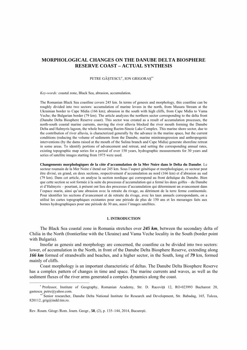
At present, coastal abrasion in the studied area is by far more extended (109 km) than accumulation (57 km). Accumulation takes place largely in front of the three main Danube mouths: Chilia, Sulina and Sfântu Gheorghe.
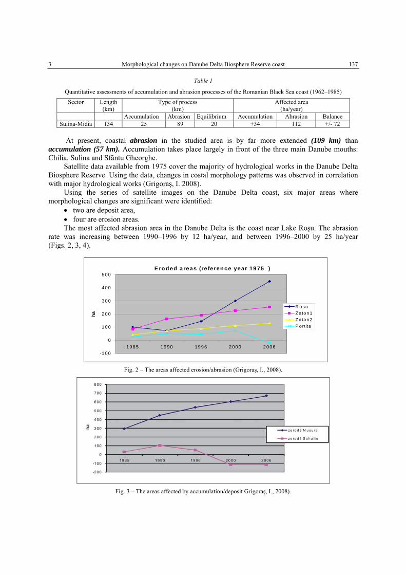
Satellite data available from 1975 cover the majority of hydrological works in the Danube Delta Biosphere Reserve. Using the data, changes in costal morphology patterns was observed in correlation with major hydrological works (Grigoraş, I. 2008).
Using the series of satellite images on the Danube Delta coast, six major areas where morphological changes are significant were identified:
• two are deposit area, • four are erosion areas. The most affected abrasion area in the Danube Delta is the coast near Lake Roşu. The abrasion
rate was increasing between 1990–1996 by 12 ha/year, and between 1996–2000 by 25 ha/year (Figs. 2, 3, 4).
E ro d ed areas (re feren ce year 1975 )
-100
0
100
200
300
400
500
1985 1990 1996 2000 2006
ha
R o suZ a ton 1Z a ton 2P ortita
Fig. 2 – The areas affected erosion/abrasion (Grigoraş, I., 2008).
Fig. 3 – The areas affected by accumulation/deposit Grigoraş, I., 2008).
Petre Gâştescu, Ion Grigoraş 4 138
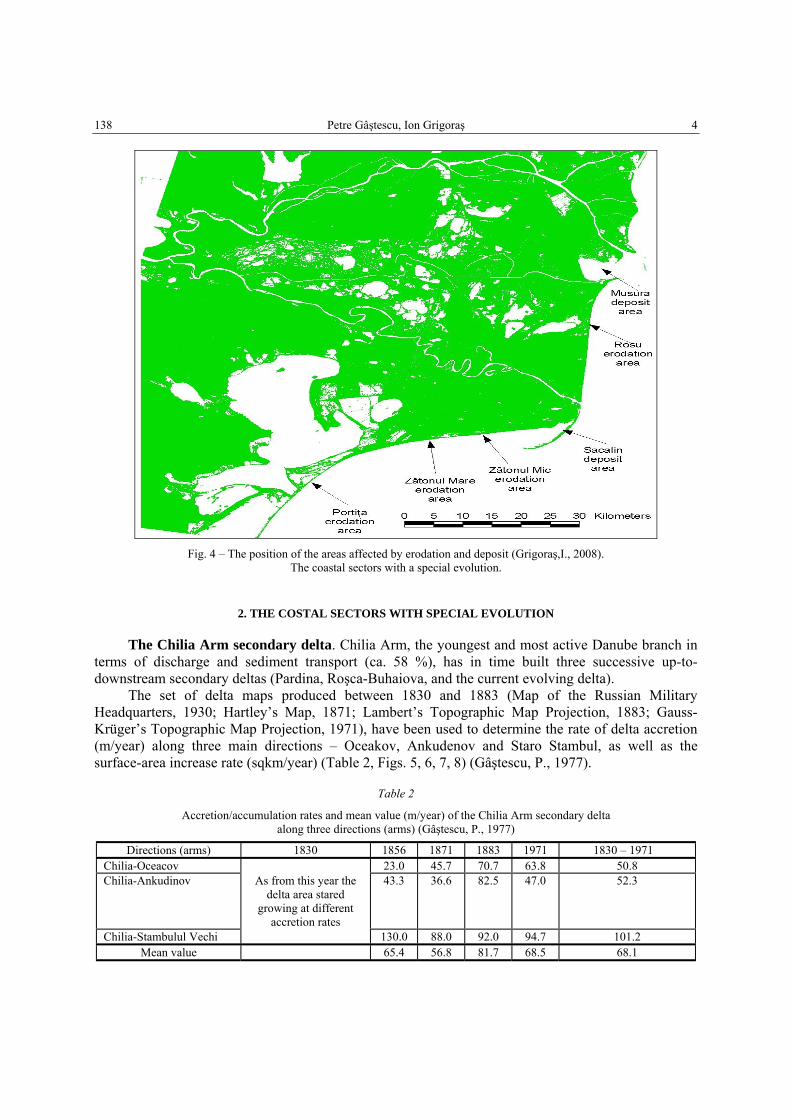
Fig. 4 – The position of the areas affected by erodation and deposit (Grigoraş,I., 2008).
The coastal sectors with a special evolution.
2. THE COSTAL SECTORS WITH SPECIAL EVOLUTION
The Chilia Arm secondary delta. Chilia Arm, the youngest and most active Danube branch in terms of discharge and sediment transport (ca. 58 %), has in time built three successive up-to-downstream secondary deltas (Pardina, Roşca-Buhaiova, and the current evolving delta).
The set of delta maps produced between 1830 and 1883 (Map of the Russian Military Headquarters, 1930; Hartley’s Map, 1871; Lambert’s Topographic Map Projection, 1883; Gauss-Krüger’s Topographic Map Projection, 1971), have been used to determine the rate of delta accretion (m/year) along three main directions – Oceakov, Ankudenov and Staro Stambul, as well as the surface-area increase rate (sqkm/year) (Table 2, Figs. 5, 6, 7, 8) (Gâştescu, P., 1977).
Table 2
Accretion/accumulation rates and mean value (m/year) of the Chilia Arm secondary delta along three directions (arms) (Gâştescu, P., 1977)
Directions (arms) 1830 1856 1871 1883 1971 1830 – 1971 Chilia-Oceacov 23.0 45.7 70.7 63.8 50.8 Chilia-Ankudinov As from this year the
delta area stared growing at different
accretion rates
43.3 36.6 82.5 47.0 52.3
Chilia-Stambulul Vechi 130.0 88.0 92.0 94.7 101.2 Mean value 65.4 56.8 81.7 68.5 68.1

5 Morphological changes on Danube Delta Biosphere Reserve coast 139
Fig. 5 – Musura Bay in 2006.
Fig. 6 – Evolution of the Chilia Arm secondary delta over 1830–1971 and satellite image 2003
(Gâştescu, P., Ştiucă, R., 2008).

Petre Gâştescu, Ion Grigoraş 6 140
New technologies available now enable a more accurate study of coastal morphologies. For the new island that is developing in front of Musura Bay, LIDAR data from 2011 can be used. Using this technology, the volume of new sediments above the water can be computed.
Fig. 7 – Musura Bay deposit area over 1975–2000 (Grigoraş, I., 2008).
Fig. 8 – New island inner Musura Bay (Grigoraş, I., 2008).
7 Morphological changes on Danube Delta Biosphere Reserve coast 141
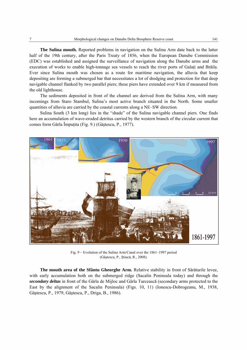
The Sulina mouth. Reported problems in navigation on the Sulina Arm date back to the latter half of the 19th century, after the Paris Treaty of 1856, when the European Danube Commission (EDC) was established and assigned the surveillance of navigation along the Danube arms and the execution of works to enable high-tonnage sea vessels to reach the river ports of Galaţi and Brăila. Ever since Sulina mouth was chosen as a route for maritime navigation, the alluvia that keep depositing are forming a submerged bar that necessitates a lot of dredging and protection for that deep navigable channel flanked by two parallel piers; these piers have extended over 9 km if measured from the old lighthouse.
The sediments deposited in front of the channel are derived from the Sulina Arm, with many incomings from Staro Stambul, Sulina’s most active branch situated in the North. Some smaller quantities of alluvia are carried by the coastal currents along a NE–SW direction.
Sulina South (3 km long) lies in the “shade” of the Sulina navigable channel piers. One finds here an accumulation of wave-eroded detritus carried by the western branch of the circular current that comes form Gârla Împuţita (Fig. 9.) (Gâştescu, P., 1977).
Fig. 9 – Evolution of the Sulina Arm/Canal over the 1861–1997 period (Gâştescu, P., Ştiucă, R., 2008).
The mouth area of the Sfântu Gheorghe Arm. Relative stability in front of Sărăturile levee, with early accumulation both on the submerged ridge (Sacalin Peninsula today) and through the secondary deltas in front of the Gârla de Mijloc and Gârla Turcească (secondary arms protected to the East by the alignment of the Sacalin Peninsula) (Figs. 10, 11) (Ionescu-Dobrogeanu, M., 1938, Gâştescu, P., 1979, Gâştescu, P., Driga, B., 1986).

Petre Gâştescu, Ion Grigoraş 8 142
Fig. 10 – Evolution of the Sacalin Island/Penisula over the 1857–1995 (Gâştescu, P., Ştiucă, R., 2008).
Fig. 11 – Evolution of the Sacalin Island/Peninsula over the 1960–2011 (Grigoraş, I., 2008).
9 Morphological changes on Danube Delta Biosphere Reserve coast 143
3. CONCERNING THE EVOLUTION OF THE SACALIN ISLAND/PENINSULA
The changes in the tendencies of natural processes became important after 1990. This is the year when a big transportation project was finished. It consisted in cutting six meanders of the Sfântu Gheorghe Arm. These works affected three closest deposit/erosion areas:
• according to analyses, till 1990 the Sacalin area was dominated by the process of deposition. After that year, the dominant process was erosion.
• if in 1990 the Peninsula’s surface-area reached 670 ha, in 1996 it decreased to 620 ha and to 450 ha in 2000. The erosion rate between 1990–1996 was of 8.3 ha/year. That rate increased to 42.5 ha/year between 1996–2000 (Grigoraş, I., 2008).
• in the 1990–2000 interval, in the most active Sacalin area, the coast was retreating by 350 m. If the actual erosion rates remain, in 10 years’ time this peninsula will disappear, and what remains will be only an island in the southern part dominated by deposition.
Processing techniques of satellite images and GIS can be used for understanding the natural morphological processes. It is also useful in observing and quantifying the disturbance caused by human activity in these processes.
The study of the Danube Delta coast morphology is very important because here are the clean brackish water habitats, essential for the survival of sturgeons and other endangered species that live and feed here when young.
Now, in the Romania Danube Delta Biosphere Reserve we have only two areas with brackish habitat: between the Sacalin Peninsula and the Danube Delta coast -Musura Bay.
Both are now in the process of undergoing a change of status. The Sacalin Peninsula will disappear so that the habitat will become a marine one. The Musura Bay will be close to the island which is growing fast and becoming a fresh water habitat
4. CONCLUSIONS
Coast morphology is an important characteristic of deltas. The Danube Delta has a complex pattern of changes in time and space. The fluxes of marine and river branches generate a complex dynamics along the coast. The actual coast is the result of a combination between natural factors and human intervention. If human intervention in the 19th century had a small impact on coast changes, in the late 20th century this impact became very important. Satellite data available from 1975 cover the majority of hydrological works made in the Danube Delta Biosphere Reserve. Using these data, changes in costal morphology patterns were observed in correlation with major hydrological works.
Using remote sensing techniques morphological changes can be analysed at low cost and good accuracy. Analysing the current morphological processes of the Romanian Black Sea it appears that the coastal accumulation zone shows a slow sea level uplift at a rate of ca 2 mm/year; a sharp quantitative decrease of the Danube-derived sediments, deposited at the seaside; the dominance of wave action over current action; man’s intervention on the coast by the construction and extension of the Sulina mouth piers.
As regards the Sacalin area, graphs show a change in the patterns of costal morphology. If until 1990, the dominant process was deposition, between 1990–2006 it was erosion. After 2006, deposition processes became again dominant. The lake-forming process, by the merging of the Sacalin Island with the coast, continues even if the island is now a peninsula (split). Morphological changes on the coast seem to indicate the possible location of the future junction. The high rate of morphological changes is related to the meanders cut in the Sfântu Gheorghe Arm, which was finished in 1990.
Petre Gâştescu, Ion Grigoraş 10 144
Therefore coastal abrasion in the studied area is by far more extended (109 km) than accumulation (57 km). Accumulation takes place largely in front of the three main Danube mouths: Chilia, Sulina and Sfântu Gheorghe.
Acknowledgements The authors would like to acknowledge the European Commission ‘‘Seventh Framework
Program’’ that funded the enviroGRIDS project (Grant Agreement no. 227640).
REFERENCES
Bondar, C., I., State, D., Cernea (1983), Date referitoare la evoluţia liniei ţărmului Mării Negre pe litoralul Deltei Dunării între anii 1962 – 1979, Studii şi cercetări, Hidrologie, L, Bucureşti.
Brătescu, C. (1942), Oscilaţiile de nivel ale apelor şi bazinului Mării Negre în cuaternar, BSRRG, LXI. Digens, E., T., Ross, D., A. (1972), Chronology of the Black Sea over the last 25,000 years, Chemical Geology, 10, 1. Gâştescu, P. (1977), Modificările ţărmului Mării Negre în dreptul Deltei Dunării în perioada 1857–1975, Stud. Cercet.
Geol., Geofiz., Geogr., Seria Geografie, XXIV. Gâştescu, P. (1979), Evoluţia ţărmului Mării Negre între braţul Sfântu Gheorghe şi grindul Perişor, Stud. Cercet. Geol.,
Geofiz., Geogr., Seria Geografie, XXVI. Gâştescu, P. (1984), Long-term evolution of the Black Sea coast in front of the Danube delta between the Sulina and Sfântu
Gheorghe arms, Rev. Roum. Géol., Géophys., Géogr., Serie Géographie, 28. Gâştescu, P., Driga, B. (1986), Morphohydrographical changes of Romanian accumulation Black Sea coastline, Rev. Roum.
Géol., Géophys., Géogr., Serie Géographie, 30. Gâştescu, P., Ştiucă, R. (editors) (2008), Delta Dunării Rezervaţie a Biosferei, Edit.CD Press, Bucureşti. Grigoraş, I. (2008), Sistem complex de aplicare a tehnicilor GIS şi Teledetecţiei în sprjinul activităţilor de gestiune integrată
a zonei costiere, Contract INC-DDD, nr. 369/2008. Ionescu-Dobrogeanu, M. (1938), Notre Sachaline. BSRRG, LII. Lehmann, A., Giuliani, G., Mancosu, E., Abbaspour, K. C., Sözen, S., Gorgan, D., Beel, A. & Ray, N. (2014), Filling the
gap between Earth observation and policy making in the Black Sea catchment with enviroGRIDS, Environmental Science & Policy.
Panin, N. (1983), Black Sea coast – line changes in the last 1,000 years. A new attempt at identifying the Danube mouths as described by the ancients, Dacia, N. S., XXXVIII, 1–2.
Vespremeanu, E. (1983), Geomorphological evolution of the Sfântu Gheorghe arm mouth (Danube Delta, North-West of the Black Sea) in the last 200 years, Rev. Roum. Géol., Géophys., Géogr., Série Géographie, 27.
Received June 10, 2014