moscou,4-9 août 2007 moscow,4-9 august 2007
TRANSCRIPT

International Cartographic Association Association Cartographique Internationale
Minutes 14th General Assembly 2007 1
Compte-rendu de la14º Assemblée Générale de l’ACI
Minutes of the14th ICA General Assembly Moscou,4-9 août 2007
Moscow,4-9 August 2007

International Cartographic Association Association Cartographique Internationale
Minutes 14th General Assembly 2007 2

International Cartographic Association Association Cartographique Internationale
Minutes 14th General Assembly 2007 3
Table of Contents
TABLE OF CONTENTS ...................................................................................................................................... 3
ORDRE DU JOUR 14º ASSEMBLEE GENERALE DE L’ACI AGENDA 14TH ICA GENERAL ASSEMBLY ............................................................................................................................................................ 5
1 OUVERTURE ET ALLOCATIONS DE BIENVENUE/ OPENING AND ADRESSES ........................ 7
2 APPEL DES MEMBRES/ ROLL CALL OF MEMBERS .......................................................................... 7
3 ADOPTION DE L’ORDRE DU JOUR/ADOPTION OF THE AGENDA ................................................ 9
4 DESIGNATION DES DEUX SCRUTATEURS/NOMINATION OF TWO SCRUTINEERS ................. 9
5 MEMBRES SUSPENDUS DE VOTE/MEMBERS INELEGIBLE TO VOTE ......................................... 9
6 EXCLUSION DE MEMBRES/WITHDRAWAL OF MEMBERSHIP ...................................................... 9
7 ADOPTION DES COMPTES-RENDU DE LA 12E ET 13E ASSEMBLÉE GÉNÉRALE, 2003, 2005/ ADOPTION OF THE MINUTES OF THE 12TH AND 13TH GENERAL ASSEMBLY, 2003, 2005 .............. 9
8 NOUVEAUX MEMBRES NATIONAUX/NEW NATIONAL MEMBERS ............................................ 10
9 NOUVEAUX MEMBRES AFFILIES/ NEW AFFILIATE MEMBERS ................................................. 10
10 RAPPORT DU PRESIDENT 2003-2007/ PRESIDENT’S REPORT 2003-2007 ................................ 10
11 RAPPORT DU SECRETAIRE GENERAL –2003-2007/ SECRETARY-GENERAL'S REPORT 2003-2007 ............................................................................................................................................................. 15
12 RAPPORT DU TRESORIER 2003-2007/TREASURER’S REPORT 2003-2007 ............................... 17
13 RAPPORT DES COMMISSAIRES AUX COMPTES/ AUDITORS’REPORT ................................. 23
14 ADOPTION DES COMPTES / ADOPTION OF THE ACCOUNTS .................................................. 23
15 BUDGET PROVISOIRE ET MONTANT DE L’UNITE DE COTISATION/ PRELIMINARY BUDGET AND SUBSCRIPTION UNIT PROPOSAL ....................................................................................... 23
15.1 BUDGET ................................................................................................................................................. 23 15.2 PROPOSITION D’INSTITUER UN FOND/ PROPOSAL FOR THE INAUGURATION OF AN ICA FUND ................. 24 15.3 PROPOSITION DE COTISATION ANNUELLE / PROPOSED ANNUAL SUBSCRIPTION ................................... 24
16 STATUTS DE L’ACI / ICA STATUTES ............................................................................................... 25
17 RAPPORT SUR LES PUBLICATIONS / PUBLICATIONS REPORT .............................................. 27
18 MOTIONS/MOTIONS ............................................................................................................................ 28
19 PRESENTATION DES ACTIVITES 2003-2007 DES COMMISSIONS ET GROUPES DE TRAVAIL/ PRESENTATION OF COMMISSIONS AND WORKING GROUP ACTIVITIES 2003-2007 ... 29
20 PROPOSITION DE COMMISSIONS 2007-2011 ; PRESENTATION DES CANDIDATURES ET DES TERMES DE REFERENCES / COMMISSION PROPOSALS 2007-2011 ; PRESENTATION OF NOMINATIONS AND TERMS OF REFERENCE ........................................................................................... 29

International Cartographic Association Association Cartographique Internationale
Minutes 14th General Assembly 2007 4
21 PRESENTATION DU PROGRAMME DE RECHERCHE DE L'ACI/ PRESENTATION OF THE ICA RESEARCH AGENDA ................................................................................................................................ 30
22 PRESENTATION DES CANDIDATURES AU COMITE EXECUTIF / PRESENTATION OF NOMINATIONS TO THE EXECUTIVE COMMITTEE .................................................................................. 30
23 PROPOSITIONS POUR LES PROCHAINES CONFERENCES/ FUTURE CONFERENCE PROPOSALS ........................................................................................................................................................ 31
24 RECOMPENSES DE L’ACI / ICA AWARDS ...................................................................................... 31
25 APPEL DES MEMBRES/ ROLL CALL OF MEMBERS (SEE ITEM 2) ........................................... 32
26 PROPOSITION FINALE DE BUDGET 2007-2011/ FINAL BUDGET PROPOSAL 2007-2011 ..... 32
27 VOTE ON THE BUDGET ..................................................................................................................... 33
28 ELECTION DU PRÉSIDENT / ELECTION OF THE PRESIDENT ................................................. 33
29 ELECTION DU SECRÉTAIRE-GÉNÉRAL / ELECTION OF THE SECRETARY-GENERAL .... 33
30 FIXATION DU NOMBRE DES VICE-PRÉSIDENTS / VOTE ON THE NUMBER OF VICE-PRESIDENTS ...................................................................................................................................................... 34
31 ELECTION DES VICE-PRESIDENTS/ ELECTION OF VICE-PRESIDENTS ............................... 34
32 ELECTION DES COMMISSAIRES AUX COMPTES 2007-2011 / ELECTION OF AUDITORS 2007-2011 ............................................................................................................................................................. 34
33 PROPOSITIONS DE COMMISSIONS 2007-2011/ COMMISSION PROPOSALS 2007-2011 ........ 35
34 PRESENTATION DE LA 24E CONFERENCE CARTOGRAPHIQUE INTERNATIONALE/ PRESENTATION OF THE 24TH INTERNATIONAL CARTOGRAPHIC CONFERENCE .......................... 35
35 SELECTION DU LIEU DE LA 15° ASSEMBLEE GENERALE ET DE LA 25° CONFERENCE CARTOGRAPHIQUE INTERNATIONALE / SELECTION OF THE PLACE OF THE 15TH GENERAL ASSEMBLY AND THE 25TH INTERNATIONAL CARTOGRAPHIC CONFERENCE .............................. 36
36 QUESTIONS DIVERS / ANY OTHER BUSINESS ............................................................................. 36
37 CLÔTURE/CLOSING ............................................................................................................................ 36
APPENDIX 1A – MINUTES 12TH GENERAL ASSEMBLY ......................................................................... 37
APPENDIX 1B – MINUTES ICA 13TH ............................................................................................................. 66
APPENDIX 2 - STATUTES FOR THE ICA FUND ........................................................................................ 72
APPENDIX 3 – ANNUAL FEES ....................................................................................................................... 74
APPENDIX 4 – STATUTES FOR ICA ............................................................................................................. 76
APPENDIX 5 – COMMISSION TERMS OF REFERENCE 2007-2011 ....................................................... 84
APPENDIX 6 – THE ICA RESEARCH AGENDA ......................................................................................... 93
APPENDIX 7 – PUBLICATIONS REPORT ................................................................................................. 106

International Cartographic Association Association Cartographique Internationale
Minutes 14th General Assembly 2007 5
Ordre du jour 14º Assemblée Générale de l’ACI Agenda 14th ICA General Assembly
Première session : samedi 4 août 2007 (9h - 18h)
First Session : Saturday 4th August 2007 9:00 – 18:00
chaired by:
1 Ouverture et allocations de bienvenue Opening and addresses President
2 Appel des membres Roll call of members Secretary General
3 Adoption de l'ordre du jour Adoption of the Agenda Secretary General
4 Désignation de deux Scrutateurs Nomination of two Scrutineers President
5 Membres suspendus de vote Members ineligible to vote President
6 Exclusion de membres Withdrawal of Membership President
7 Adoption du compte-rendu de la 12° et 13° Assemblée générale, 2003, 2005
Adoption of the minutes of the 12th and 13th General Assembly, 2003, 2005
Secretary General
8a Nouveaux membres nationaux New member nations President
9 Nouveaux membres affiliés New affiliate members President
10 Rapport du Président – 2003-2007 President's report 2003-2007 President
11 Rapport du Secrétaire général –2003-2007
Secretary General's report 2003-2007
Secretary General
12 Rapport du Trésorier – 2003-2007 Treasurer's report 2003-2007 Secretary General
13 Rapport des Commissaires aux comptes
Auditors' report H.Moellering, J.Miranda
14 Adoption des comptes Adoption of the Accounts President
15 Budget provisoire 2007-2011 montant de l'unité de cotisation
Preliminary budget 2007-2011 subscription units
Secretary General
16 Statuts de l'ACI ICA Statutes Past-President
17 Rapport sur les publications Publications report Robert McMaster
17a Rapport nationaux National reports Secretary-General
18 Motions Motions David Fairbairn
19 Présentation des activités 2003-2007 des commissions et groupes de travail
Presentation of commissions and working groups activities 2003-2007
William Cartwright
20 Proposition de commissions 2007-2011 présentation des candidatures et des termes de références
Commission proposals 2007-2011 presentation of nominations and terms of reference
Rámon Lorenzo
21 Présentation du programme de recherche de l'ACI
Presentation of the ICA research agenda
Kirsi Virrantaus
22 Présentation des candidatures au Comité exécutif
Presentation of nominations to the Executive Committee
Haggai Nyapola
23 Propositions pour les prochaines conférences
Future conference proposals Vladimir Tikunov

International Cartographic Association Association Cartographique Internationale
Minutes 14th General Assembly 2007 6
24 Récompenses de l'ACI ICA Awards President
Deuxième session : jeudi 9 août 2007 9h00 - 12h30
Second Session : Thursday 9th August 2007 9.00 - 12:30
25 Appel des membres Roll call of members Secretary General 8b Nouveaux membres nationaux New member nations President 26 Proposition finale de budget 2007-2011 Final budget proposal 2007-2011 Secretary General 27 Vote du budget 2007-2011 Vote on the 2007-2011 budget President 28 Election du Président Election of President President 29 Election du Secrétaire général et
trésorier Election of Secretary General & Treasurer
President
30 Fixation du nombre de Vice-Présidents Vote on the number of Vice-Presidents
President
31 Election des Vice-Présidents Election of Vice-Presidents President 32 Election des Commissaires aux
Comptes Election of Auditors 2007-2011 President
33 Propositions de commissions 2007-2011 Election des présidents de commissions
Commissions proposals 2007-2011 Election of Commissions Chairpersons
President
34 Présentation de la 24° Conférence Cartographique Internationale
Presentation of the 24th International Cartographic Conference
Chilean Committee
35 Sélection du lieu de la 15° Assemblée générale et de la 25° Conférence cartographique internationale
Selection of the place of the 15th General Assembly and the 25st International Cartographic Conference
Secretary General
36 Questions diverses Any other business President Clotûre Closure President

International Cartographic Association Association Cartographique Internationale
Minutes 14th General Assembly 2007 7
1 Ouverture et allocations de bienvenue/ Opening and adresses The president opened the meeting at 9.00 and welcomed delegates and observers
2 Appel des membres/ Roll call of members The Secretary-general held the roll call in order to assess the number of countries with voting rights present. The result of three roll call held is as follows:
Francais
English
Principal delegate
Deputy delegate
Postal Vote for statutes
voting right prior
to 4/8
4/8 AM
4/8 PM
9/8 voting right
Afrique du Sud
South Africa Derek Clarke Elri Liebenberg x x x x X
Albanie Albania - - - - - - O Algérie Algeria Hamid OUKACI Arezki KESRAOUI x x - x X
Allemagne Germany Doris Dransch - x x X Argentine Argentina - - - - - X Australie Australia William Cartwright x x x X Autriche Austria Wolfgang Kainz Karel Kriz x x x X Belgique Belgium Philippe de Maeyer Frank Canters - - x X
Bénin Benin - - - - - X Botswana Botswana - - - - - O*
Brésil Brazil Paolo de Menezes Claudio dos Santos x x x X Bulgarie Bulgaria Temenujka Bandrova - not valid x x x X
Cameroun Cameroon Jean-Pierre Nghonda - - x X Canada Canada Janet Mersey Eric Kramers x x x X
Chili Chile Rodrigo Barriga - x x x X Chine China MIN Yiren WANG Jiayao+3 obs x x x X
Chypre Cyprus Elikkos Elia Christos Zenonos x x x X Colombie Colombia - - - - - O
Croatie Croatia Miljenko Lapaine Ivan Landek x x x X Cuba Cuba Raul Enrique Alvarez Soler Raul Ernesto Correa
Cobas - - - X
Danemark Denmark Lars Brodersen - x x x X El Salvador El Salvador - - - - - O
Equateur Ecuador - - - - - X Espagne Spain Jaume Miranda, Fernando Aranaz Pilar Sanchez-Ortiz,
José-Luis Colomer x x x X
États-Unis d'Amérique
United States of America
Cynthia Brewer Lynn Usery x x x X
ERYDMacédoine
FYROMacedonia Zoran Buzliev Saso Dimeski - x x O*
Finlande Finland Antti Jakobsson Kirsi Virrantaus x x x X France France François LECORDIX
Jean-Michel PELLE x x x X
Ghana Ghana - - - - - O Grèce Greece Lysandros Tsoulos, Maria Pazarli Angelika Tsorlini x x x X
Guinée Guinea - - - - - O Hong-Kong Hong Kong Johanna Leung - - x X
Hongrie Hungary Laszlo Zentai, Reyes, Pokoli, Papp-Vary x x x X Inde India - x - X
Indonésie Indonesia Sukendra Martha Diah K.Kresnawati x x x X Iran Iran Babak Shamei Mohammad Arabkarami x x x X
Irlande Ireland - - - - - X Islande Iceland - - - - - O
Israël Israel - - - - - X Italie Italia Alberta Bianchini Marta Colombo x x x X
Japon Japan Takashi Morita Yohta KUMAKI x x x X Jordanie Jordan - - - - - X

International Cartographic Association Association Cartographique Internationale
Minutes 14th General Assembly 2007 8
Kazakhstan Kazakhstan Bakyt Ospanov - - x X@ Kenya Kenya Joseph Kagiri Mathenge x x x Ox
Lettonie Latvia - - - - - X Lituanie Lithuania Giedre Beconyte (9/8) Kristina Gurjanovaite (4/8) x x x X
Madagascar Madagascar - - - - - O Malaisie Malaysia Abdul Kadir Taib Ismail Yusof x x x X
Maroc Morocco - - - - - X Mexique Mexico - - - - - X
Mongolie Mongolia - - - - - O Montenègre Montenegro Gojko Nikolic Radovan Durovic - - - O*
Mozambique Mozambique - - - - - X Nicaragua Nicaragua - - - - - O
Nigéria Nigeria - - - - - Ox Norvège Norway Kristoffer Kristiansen Terje Midtbö x x x X
Nouvelle-Zélande
New Zealand Igor Drecki Geoff Aitken x x x X
Pakistan Pakistan - - - - - X Panama Panama - - - - - O
Pays-Bas The Netherlands Menno-Jan Kraak Nico Bakker x x x X Pérou Peru - - - - - O
Pologne Poland Adam Iwaniak Elzbieta Bielecka x x x X Portugal Portugal José Guedes - x x X
Qatar Qatar - - - - - O Rép. deCorée Republic of Korea MIN Tae Jung LEE Sang Tae, x x - X
République tchèque
Czech Republic Vit Vozenilek x x x X
Roumanie Romania - - - x x O Royaume-Uni United Kingdom David Forrest x x x X
Russie Russia Alexander Borodko - x x x X Serbie Serbia Ivan Nestorov - - x x
Slovaquie Slovakia Jozef Mladek - x x x X Slovénie Slovenia Dusan Petrovic Primoz Kete x x x X Soudan Sudan - - - - - O
Sri Lanka Sri Lanka - - - - - X Suède Sweden Patrik Ottoson - x x x X Suisse Switzerland Stefan Arn Lorenz Hurni - x x X
Tanzanie Tanzania - - - - - O Thaïlande Thailand x x x X
Tunisie Tunisia - - - - x O Turquie Turkey Dursun ILGIN Yavuz Selim SENGUN x x x X Ukraine Ukraine x x x X
Venezuela Venezuela - - - - - O Viêt Nam Vietnam Le Thanh An, Bui Quang Hiep - - - Ox
Yémen Yemen - - - - - O Yougoslavie Yugoslavia*** Ivan Nestorov - - - - X
Members present
39 44 49
Total membership
81 81 83* 83 84**
Total eligible to vote
58 61 65* 65 66**
58
Present eligible to vote
39 42 47
O ineligible to vote O eligible for reinstatement, accepted in point 5 .... Eligible for suspension of vote Name official delegate *) after acceptance of point 8a X@ from point 8b onwards. ***) transfered to Serbia at point 8b)

International Cartographic Association Association Cartographique Internationale
Minutes 14th General Assembly 2007 9
3 Adoption de l’ordre du jour/Adoption of the Agenda The Secretary General presented the proposed agenda of the 14th General Assembly as circulated to the national member organisation and available at the ICA home page under the heading General Assembly. The motion was seconded by Bulgaria and the agenda was adopted unanimously.
4 Désignation des deux scrutateurs/Nomination of two Scrutineers At a proposal of South Africa, seconded by the Netherlands, Dusan Petrovic (Slovenia) and Igor Drecki (New Zealand) were voted scrutineers unanimously by the General Assembly.
5 Membres suspendus de vote/Members inelegible to vote Pendant la treizième assemblée générale au Courogne, les pays suivants furent exclu de leur droit de vote: l’Albanie, Colombie, Salvador, Ghana, Guinée, l’Islande, Kenya, Madagascar, Mongolie, Nicaragua, Nigeria, Panama, Perou, Qatar, Roumanie, Soudan, Tanzanie, Tunisie, Venezuela, Vietnam, Yemen. Pour les pays qu’avaient payé leur cotisations depuis la treizième Assemblée générale (le Kenya, Nigeria et le Vietnam), le président proposait de leur rendre leurs droits de vote. Cette décision fut pris a l’unanimité par l’Assemblée générale. During the 13th General Assembly, voting rights were taken from the following member states: Albania, Colombia, El Salvador, Ghana, Guinea, Iceland, Kenya, Madagascar, Mongolia, Nicaragua, Nigeria, Panama, Peru, Qatar, Romania, Sudan, Tanzania, Tunisia, Venezuela, Vietnam and Yemen. Kenya, Nigeria and Vietnam have paid up since the 13th General assembly. The President proposed to reinstate their voting rights. This was accepted unanimously by the General assembly. 81-21=60+3=63 with voting right.
6 Exclusion de membres/Withdrawal of membership Le président indiquait que, parce qu’on a terminé la Societe Estonienne de Cartographie il y a 5 ans, il n’est plus relevant de le faire continuer comme membre. Le président demandait une proposition de le rayer, laquelle fut faite par les Etats Unis et secondée par le Royaume-Uni. Ensuite, la proposition fut acceptée à l’unanimité The president stated that, as the Estonian Chamber of Mapping has been disbanded more than 5 years ago, its membership of ICA should not continue. The president asked for a proposal to declare Estonia’s membership void. This was made by the United States and seconded by the United Kingdom. When put to the vote, all were in favour. 81-1=80 member countries; 63-1=62 with voting right.
7 Adoption des comptes-rendu de la 12e et 13e Assemblée générale, 2003, 2005/ Adoption of the minutes of the 12th and 13th General Assembly, 2003, 2005
As these minutes had been circulated to the member countries after the 12th and after the 13th General Assembly (See Appendix 1a and 1b respectively), and as no proposals had been received from member countries to change them, apart from a proposal by Mr Petrovic (Slovenia) to omit the reference to him, which was followed, the Secretary-General asked whether there was a proposal to accept these minutes. The proposal to accept the minutes was accepted unanimously by the GA.

International Cartographic Association Association Cartographique Internationale
Minutes 14th General Assembly 2007 10
8 Nouveaux membres nationaux/New national members The President proposed the following new members: -FYRO Macedonia, represented by the State Authority for Geodetic Works -Botswana, represented by its department of Surveys and Mapping -Montenegro - Association of Geodesists of Montenegro - Branch of Cartography He also asked to transfer the representation of the Yugoslav Cartographic Association for Yugoslavia to the Serbian Association of Cartographers, represented temporarily by the Republic Geodetic Authority of Serbia. This was put to the vote, and approved unanimously. There have been two changes in national member organisations:
1. The previous ICA national member organisation of Ukraine, Ukrgeodescartographia, has asked ICA to transfer national representation of Ukraine to the Ukrainian Cartographic Association.
2. The State Land Service of Latvia, which was the national ICA representative had been superseded by the Latvian Geospatial Information Agency. ICA has been requested by the former to transfer representation to the latter agency.
The general assembly ratified these changes unanimously. 80 member countries +3=83; 62+3=65 with voting right. So for the absolute majority 33 votes are needed.
9 Nouveaux membres affiliés/ New affiliate members Le président proposait les nouveaux membres affiliés suivants/The president proposed the following new affiliate members: -Dubai Municipality, United Arab Emirates -East View, Map trading firm in Minneapolis, USA -Navionics, Electronic chart producing firm from Viareggio, Italy -Bundesamt für Kartographie und Geodäsie, Frankfurt, Germany -Instituto Geografico Nacional, Madrid, Spain -University of Balamand, Tripoli, Lebanon -Faculty of Geodesy of the University of Architecture, Civil Engineering and Geodesy in Sofia, Bulgaria These were accepted unanimously by the General Assembly.
10 Rapport du Président 2003-2007/ President’s report 2003-2007 In the beginning of my Report I would like to remember all colleagues, members of ICA, who passed away in the last four years: Professor W. Scharfe, who passed away in October 2003. He had served as the President of the German Cartographic Association. Professor Oleg A. Evteev, a well-known Russian geographer and cartographer passed away on December 18, 2003. Dr. Christoph Brandenberger, lecturer and long-time associate at the Institute of Cartography at ETH Zürich, passed away on January 14, 2004. Professor Arthur H. Robinson, famous American professor and the author of a principle publication in cartography, passed away on October 10, 2004. Dr. Jacques Sipkes, geographer, cartographer and journalist, passed away on September 15, 2005.

International Cartographic Association Association Cartographique Internationale
Minutes 14th General Assembly 2007 11
Eng. Géza Apagyi, Director General of the Department of Land Administration and Geoinformation, President of Hungarian Cartographic Association, passed away on August 25, 2006. David Woodward, the leader of the University of Madison-Wisconsin history of cartography programme, which was published by the University of Chicago Press, died 25 August 2004 Honour to their memory! Thank you all – members of ICA, national representatives, members of commissions and working groups, chairs and co-chairs – for your strong support, which I have felt not only at the time of various conferences, meetings and seminars, but also during my frequent visits in the countries all over the World and in individual discussions. My very special thanks go also to members of the ICA Executive Committee, mainly to Secretary General Ferjan Ormeling. In the last 4 years, we have exchanged hundreds, may be even more than a thousand of e-mail messages, phone calls and sms’s and discussed many complicated matters. Ferjan is a unique person in the world of cartography fulfilling the great idea of Ormeling’s cartographical saga which was – and still continues to be – so important for the development of cartography on our planet. I would also like to thank to former President Bengt Rystedt for his kind support, as well as for his knowledge and experience with which he enriched the quality of our work. Among other issues, he has taken care of the award commission and realized idea of ICA Fund, prepared many new items for our Statutes and represented the ICA together with me in JBGIS. My cordial thanks belong to all members of the Executive Committee. Special thanks are going to Graciela Metternicht – Editor in Chief of the ICA News – for her excellent and patient work in its preparation and promotion of the ICA. I have tried to describe all details of my activities in each issue of the ICA News; therefore, I will not repeat all of them now, but will present a short overview of what I have accomplished. My activities can be divided into activities outside and inside of ICA. Outside of ICA, I have concentrated on the following: 1. To make ICA more visible, to promote an awareness of our association and its potential I found possibilities of closer cooperation with GIM International and opened a permanent column (edited by David Fairbairn) informing not only our members, but also the general public, about ICA activities (here I have to thank to Jacques Sipkes, as he was a person who opened the door after our discussions in Durban and Bangalore). We have been offered more from GIM International, e.g. to promote our books and publications on their web page, which is permanently visited by thousands of people from all over the world. I have also initiated close cooperation with GIS Development and other journals, such as Geoinformatics, Geoconnexions, etc. 2. To let ICA participate in the most important projects on global, regional and local levels I participated in many events, the most important being the Early Warning II and III conferences in Bonn, where I made participants realise ICA’s strong potential in solving of early warning and crises management situations by providing maps, geodata, metadata, standards, etc. Using this information, I initiated the establishment of a working group in this field led by Wilbur Otichillo, which started to work out ideas. This is a very important topic also nowadays, and if ICA will not play this role, somebody else will – ICA was only one of the GI oriented organizations participating in these events. 3. To make ICA more influential on the level of United Nations and individual continents in the process of capacity building, education, and providing solutions. I initiated the signing of a Memorandum of Understanding with the Panamerican Institute for Geography and History (PAIGH), U.N. Outer Space section in Vienna, developing ideas of Global Navigation and Satellite Systems, and GISIG. ICA also participated in activities of UNESCO, Club of Rome and CODATA, such as ‘ICT for Capacity Building: Critical Success Factors for Education and Training’. 4. To promote results of ICA research in new ways. As an example, I can mention the establishment of the ICA work team for the Week of Geoinformatics 2005 conference in Bogota, Colombia (Bandrova - Bulgaria, Colomer - Spain, Stanek, Konecny -Czech Republic), which prepared two workshops on Cartographic

International Cartographic Association Association Cartographique Internationale
Minutes 14th General Assembly 2007 12
generalization and Maps on the Web, or the ICA mission to Dubai prepared by members of the Executive Committee (Konecny, Ormeling, Tikunov) which led to the membership of GIS center of Dubai municipality in theICA and the organization of a Barbara Petchenik competition according to ICA rules in all Gulf Countries. 5. To invite new countries to ICA or incite former members to come back to us. Recent examples include Macedonia, Montenegro, Serbia and Vietnam. The University of Balamund from Lebanon wants to become an affiliate member; Middle East countries under the leadership of Maroun Khraish are planning to establish a regional organization under the ICA umbrella using our rules and principles; we have new affiliate members from Poland - the Nowa Era and Ekograf establishments - and several other countries, especially from the Gulf Region, are interested to become our members in the near future. 6. To play an important and proactive integrative role in the international initiatives of JBGIS (Joint Board of Geospatial Organizations) started by ICA in Durban (Bengt Rystedt, Michael Wood). After initial hesitation and looking for an appropriate form of existence, after first discussions in Athens with former presidents of FIG, IAG and ISPRS Magel, Beuchtel and Trinder, we found solutions and attracted presidents of other organizations to create a non-administrative body for exchange of information on our activities and attempts to find common approaches to help especially the developing countries. The first general meeting of all presidents took place during the FIG event in Cairo in 2005. From the first day of my presidency, I have also started to communicate with other sister organizations: IHO, IMTA, GSDI, Global Map, Digital Earth, and initiatives such as GNSS and INSPIRE. Inside of ICA, I have tried to fulfill the intentions I presented at the time of my election in Durban: 7. To integrate activities inside of ICA. With the help of the Executive Committee I tried to integrate the streams formulated in the ICA Strategic Plan: science, education, society, professional practice and later also art. Individual VPs take care of – and regularly inform at Executive Committee meetings – about activities in these broader fields and the roles of individual commissions in them. VPs will present speeches and comments also here during the ICC in Moscow (research – Virrantaus; education – Fairbairn; professional practice – Lorenzo; society – McMaster, Rystedt and Nyapola). We started to work in this way that is always a compromise among different viewpoints: theoretical development of our discipline, practical requests of society, human resources and financial capacities. 8. To improve the quality of ICA Proceedings and other publications. One of the most appreciated details highlighted by participants after the ICC in A Coruña and continuing here in Moscow is the fact that all submitted papers were carefully reviewed also by commission chairs. Many thanks are due to the commission chairs and co-chairs, as well as to members of the Executive Committee, for their careful evaluation and selection of these papers (the idea was initiated by VP Virrantaus). 9. To make ICA more flexible, to start new forms of our activities across the ICA. I sent several initiation letters to chairs of commissions, especially those connected with U.N. conferences and Gulf and World Map Forum missions. Two times I composed task force teams for the creation of ICA posters for the Early Warning III conference in Bonn and World Map Forum in Hyderabad. In the first case I led coordinated efforts of ICA members from all over the world, and in 3-4 days we were able to prepare an ICA poster titled ‘Cartography and Geoinformatics for Early Warning’. The poster was created in cooperation with my colleagues T. Bandrova, U. Dymon, L. Friedmannova, G. Metternicht, D. Fairbairn, G. Gartner, L. Hurni, P. Kubicek and K. Stanek. In the second case I found support especially from Joanna Bac-Bronowicz and commission chairs (Zentai, Wiegand, Cartwright, Hurni) and book authors (Peterson, Moellering, Ruas). In Hyderabad posters of the Children, Gender and Ubiquitous Mapping commissions and above mentioned poster of ICA have been presented with the kind help of Joanna Bac-Bronowicz from Poland. 10. To flexibly and sensitively react to needs and wishes of our members. The most dominant event of my term was the ICC 2005 held in A Coruña, Spain. From the distance of several months, I can appreciate the influence that this conference had on our community, as well as on other GI communities worldwide. The tremendous work of Ramon Lorenzo and his team made cartography remarkably visible amongst others world scientific events. It was also the first time in ICA’s history that we held a General Assembly within a space of two years, mainly to discuss the unfinished business of Durban, that is the addition of a subtitle to ICA’s name. A broad consensus had appeared at the 12th General Assembly in 2003 for adding a sub-title to the existing name ‘International Cartographic Association’. That subtitle would have reflected the expansion of cartography to include all manners of handling geographic information. Despite the wish among some countries not to add such

International Cartographic Association Association Cartographique Internationale
Minutes 14th General Assembly 2007 13
a sub-title, the ‘modernizers’ obtained 26 votes compared to 18 votes against, out of a total of 58 members who had voting rights. However, as the statutes require motions to have an absolute majority of voting members, i.e. those with voting rights, the motion failed. One of the basic duties of the President is to be active among ICA members in all continents and in many countries. Only during the last year, I spent 130 days outside of my country and in the last 4 years I gave 55 keynote speeches or invited speeches in many countries. Detailed information can be found in ICA News;let me give only shorter comments. According to the Strategic Plan we are trying to develop a specific and helpful policy towards Africa, Latin America and other developing countries. The African mission was taken care of especially by PP Rystedt with the help of H. Nyapola, D. Clark, A. Cooper, E. Liebenberg and W. Ottichillo. Practical courses in toponymy were given by our SG F. Ormeling. I have personally participated in the FIG Working week and GSDI-8 conference in Cairo and in the Mapping Africa conference in November 2006 and together with JBGIS we are trying to find and formulate joint approaches, such as Portal of ..... I devoted a lot of efforts to enhance cooperation with Latin America visiting and giving keynotes in conferences in La Habana, Mexico City, Bogota, Belo Horizonte, Rio de Janeiro and Caracas. Also one of our Executive Committee meetings was held in Mexico City. In this part of the world, we found a strong and capable partner with excellent activities – PAIGH led by its presidents and SG S. Borrero. On many fora, I discussed and tried to formulate the role of cartography in SDI world which is an especially hot topic just in this part of the World with strong cartography and its public and official appreciation. However, in the Latin American countries our efforts are sometimes in conflict with governments orders; for example in Colombia, organizations supported by government are not allowed to pay member fees to ICA and similar organizations from public funds (this topic will be discussed in one of the coming meeting of JBGIS in this conference), which is a paradox – we would like to help, but organizations from that country are not allowed to be our members. I am afraid that a similar situation occurs in some other developing countries. I have also visited several times North America, especially USA for Think Tank VI "Embracing Cultural Differences in GSDI" in MTI, Massachusetts, and ESRI conferences (2005 and 2007). It was one of the highlights of my presidential career to introduce a book jointly published by ICA and ESRI titled „Children Map the World: Selections from the Barbara Petchenik Children's World Map Competition.“ This book prepared by Jackie Anderson, Jeet Atwal, Patrick Wiegand, and Alberta Auringer Wood presents one hundred favourite drawings submitted by children from all around the world. The idea of the Barbara Petchenik Contest started in the era of ICA President Taylor and the idea of publishing a book during the term of President Rystedt. The book was first presented to the 12 000 participants of the ESRI Annual Conference, and had a great commercial success and we would like to develop such activities in the future. With the help of Indian colleagues around Dr. Narayan, Ravi Gusta, Sanjay Kumar and Dr. Nag, the ICA was very visible in the Middle East. The above-mentioned mission of ICA was connected with the excellent Map Middle East 2006 conference. In spite of complicated political situation, the awareness and interest to be a part of ICA is growing and should be taken care of and developed also in the following years. I have also been very active in the Balkan region. Beside the ISPRS conference in Istanbul, Turkey and an excellent meeting with Turkish cartographers organized by Necla Ulugtekin (attended also by PP Rystedt and Taylor) and a perfectly organized meeting of the Working Group on Digital Technologies in Cartographic Heritage in Thessaloniki, Greece (also attended by Rystedt and Ormeling), I visited Bulgaria several times. I participated in conferences organized by Union of Surveyors, as well as in InterGeo East exhibition and conference in Sofia. ICA also endorsed a very ambitious and successful cartographic and GIS conference in Borovets organized by the Faculty of Geodesy of the University of Architecture, Civil Engineering and Geodesy. This conference gained strongly positive responses not only from local ministeries, but also from behind the Balkan borders. In recent weeks I visited Serbia and met the executive board of their cartographic association and also had a discussion with a representative of Montenegro. Thanks to significant support of cartographers – ICA members, especially T. Bandrova, we also welcomed FYROMacedonia as a new member of ICA. Good and active cooperation is traditionally developed also with Croatia and Slovenia. I have also continued in my activities in other Asian countries, such as Malaysia, Japan, Korea (connected with Morita’s commission on Ubiquitous Cartography) and China (Wuhan, Beijing). In my speeches, I have often discussed the general problem of the position of cartography and GI in the wide ICT stream, and also the potentials role of cartography and GIS in disaster management and security, safety problems and in the activities of public administration on different hierarchical levels. I have also dealt with the role of cartography and

International Cartographic Association Association Cartographique Internationale
Minutes 14th General Assembly 2007 14
geoinformatics in the development of the Information/Knowledge-based societies. Cartography has to be able to define its own position in the Information/Knowledge-based society, adapt cartographic skills and knowledge to new conditions and come forward with its own solutions. It is very important for National Mapping Organisations or agencies to be oriented towards users, offering new digital cartographic products or user-friendly applications, often in cooperation with the private sector. In order to highlight these topics, ICA (Konecny, Lorenzo) together with General Secretary Borodko initiated an ICA-NMO event in ICC Moscow attended by experienced members of successful NMOs. My activities in Europe have also been very rich: Poland has always been tightly connected with my professional and education career and cartography in this country is traditionally very strong. I participated in several important events such as the 60th anniversary of NMO in Warsaw and conferences organized by W. Zyszkowska, and Ewa Krzywicka Blum. The „Professional Cartographers“ conference organized by Joanna Bac-Bronowicz in Polanica Zdroj was of an especially high quality. Among other issues, it investigated the relations between public and private sector in GI field. A conference of a new type was also the event Geoinformation Connecting Societies - GICON organized at the University of Vienna, Austria in July 2006, which was symbolic of cooperation among GI organizations. For the first time, representatives of large scientific societies, namely the International Cartographic Association (ICA), the International Society for Photogrammetry and Remote Sensing (ISPRS) and the International Geographical Union (IGU), as well as local associations that focus on geoinformation participated in a joint event. The conference was successfully organized by Prof. Wolfgang Kainz and his team. My last journey in 2006 led to a place which is a special favorite of mine – Spanish Galicia. I was invited to open a conference organized by Ramon Lorenzo in Santiago de Compostela. On each step, I felt positive results and responses to the successful ICC conference in the nearby A Coruña. I participated in two conferences in Southampton and Cambridge excellently organized by Vanessa Lawrence and her team. Very important was also seminar in Vilnius organized by G. Beyconite and A. Wolodtschenko, and a crisis-management oriented conference in Dresden organized by M. Buchroithner. I also participated in the Book Trade Fair in Frankfurt, Germany, and met IMTA representatives Peter Joly and J. Whitby. In early 2007, I visited Finnish cartographers who celebrated the 50th anniversary of establishing the Finnish Cartographic Association. The ceremonial conference was organized by its president Antti Jacobsson at the TU Helsinki and it was attended by VP ICA Kirsi Virrantaus and many other colleagues from Finland. Of key importance in Europe was the preparation of INSPIRE in which ICA also participated. Realization of the project will influence everyday life of cartographers and GI specialists not only in Europe. ICA was active also in Russia. I visited the 225-years anniversary of the world famous Moscow University for geodesist and cartographers – MIGAIK, and met its charismatic rector, former astronaut V.P. Savinych. I also had an opportunity to visit MGU and the exhibition of former president of ICA Prof. Salishtchev. Each time during my 3 visits to Russia in the last 4 years, I also met with the general manager of Rosskartografija A.Borodko and we discussed preparations of the ICC 2007. I am certain that our Russian colleagues will demonstrate at the ICC many new trends, approaches and the high-quality results of Russian cartography which may sometimes be somewhat hidden behind language barriers. United Nations I visited the United Nations Office for Outer Space Affairs (OOSA) in Vienna for a meeting on Global Navigation and Satellite System (GNSS). At that time, I signed a Memorandum of Understanding with UN-OOSA. ICA was asked to coordinate the participation of sister organizations in GNSS efforts. On September 2006, Vice-President V.S. Tikunov and I participated at the Seventeenth United Nations Regional Cartographic Conference for Asia & the Pacific in Bangkok called “Geo-information integration for Disaster Management and Sustainable Development in the Context of the Millennium Development Goals”. At the conference, I (in the name of ICA) presented an invited speech elaborated with the help of Vice-President Haggai Nyapola entitled Capacity Building for Geo-information Development: highlighting issues and influencing factors. The conference also included a joint PCGIAP-ICA-ISCGM Workshop: Use of Geo-information for mitigating large scale disaster and attaining sustainable development, in which the ICA participated with the following speeches: Tikunov V.S.: Geoinformation System for Developing Scenarios of Global Demographic Process, and Konecny M: Mobile and Adaptive Cartography and Geoinformatics in Early Warning and Crises Management. Even though the conference was somewhat disrupted by local disturbances, it was successful and has brought promising results. In the end, I would like to add some information about awards given to ICA members.
International Cartographic Association Association Cartographique Internationale
Minutes 14th General Assembly 2007 15
Michael Wood, the immediate Past President of the ICA received the honour of being appointed Officer of the Order of the British Empire for services to cartography in 2003. István Klinghammer, the Honorary fellow of ICA (Rector of the Eötvös Loránd University, Budapest) became a member of the Hungarian Academy of Sciences. He is the first cartographer ever in Hungary in the Academy. Christopher Board was presented with the Society Medal by the British Cartographic Society at an Award Ceremony on 11 September 2004 during the 41st Annual BCS Symposium held at the University of Durham. He was presented with the Order of the British Empire in 2006. Graciela Metternicht was nominated Fellow of the Spatial Sciences Institute of Australia Milan Konecny, president of ICA, received the Brazilian Cartographic Merit Order (OMC) at the rank of Grand-Officer. Paulo Márcio Leal de Menezes, vice president of the Brazilian Society of Cartography and head of the Department of Geography of the Federal University of Rio de Janeiro –received the Brazilian UFRJ medal at the rank of Commander Immediately after the meeting in Brno, an ICA delegation consisting of M. Konecny, R. Lorenzo, F. Ormeling, B. Rystedt and K. Virrantaus traveled to Dresden to inspect the premises where ICC 2011 could potentially take place. The visit was very well organized by M. Buchroithner and his team. The ICA delegation received detailed information about conditions for ICC hosting and will inform the General Assembly in Moscow. At the end of May, an ICA delegation consisting of M. Konecny, R. Lorenzo, F. Ormeling, and D.Fairbairn performed an inspection of the other ICC hosting candidate in Paris.
11 Rapport du Secrétaire général –2003-2007/ Secretary-General's report 2003-2007
Rapport du Secrétaire général La majeure partie de son activité a simplement visé à maintenir la communication et une circulation des informations adéquates avec les membres, les commissions, les associations sœurs et les organes des Nations Unies auxquels l’ACI apporte son expertise. Sa première tâche a été d’établir un nouvel annuaire pour la période 2003-2007 et d’en assurer la distribution. Celle-ci a pu être menée à bien grâce au soutien de la GIN, la société d’informations géographiques des Pays-Bas (Geo-Informatie Nederland), successeur de la société néerlandaise de cartographie qui avait produit la version précédente. Les informations présentées dans l’annuaire ont aussi été placées sur le site Internet de l’ACI (www.icaci.org), qui a été réalisé et tenu à jour grâce à deux de ses anciens étudiants, Martijn Storms et Nicoline McCarthy. Une section spéciale a été créée sur le site Internet pour la présente Assemblée générale et la précédente, qui s’est tenue à A Coruña, reprenant toutes les informations concernant l’ordre du jour, les candidats, les propositions de modifications des statuts et les nouveaux termes de références pour les commissions. L’organisation de deux assemblées générales à elle-même constitué un travail important. Il a eu la grande chance que Graciela Metternicht ait de nouveau accepté d’assurer l’édition du bulletin de liaison « ICA News » pour un second mandat. Elle a réalisé un travail splendide, en permettant aussi la consultation du bulletin d’information sur le réseau. Les colonnes mises à notre disposition par les éditeurs de la revue GIM International ont constitué un autre moyen excellent de promouvoir l’ACI. David Fairbairn a facilité que 40 d’entre-elles avaient été publiées jusqu’à présent, choisissant parmi nous les auteurs venant de toutes les disciplines de la cartographie. Les contacts avec les membres et les membres affiliés n’ont pas toujours été faciles, car il arrive rarement que les sociétés nationales pensent à informer le Secrétariat des changements de titulaires de fonctions ou des changements d’adresse. Lorsqu’ils ont eu lieu, ces contacts se sont traduits par une correspondance relative à la

International Cartographic Association Association Cartographique Internationale
Minutes 14th General Assembly 2007 16
participation aux conférences cartographiques internationales, aux candidatures des membres de commissions, aux bourses de voyage et à l’admission des membres. Une partie de la correspondance a été consacrée à la participation aux concours Barbara Petchenik de cartes d’enfants. Tous les dessins sélectionnés par les coordinateurs nationaux ont été rassemblés à Utrecht, photographiés et gravés sur CD afin d’être distribués aux membres du jury. Après l’avoir fait pour les conférences de Beijing, Durban et A Coruña, c’est maintenant la quatrième fois que Peter van der Krogt a réalisé ce travail pour l’ACI et le Secrétaire tient à l’en remercier. On espère qu’il continuera si le prochain Comité Exécutif y consent. Grâce à nos collègues russes, hormis le fait de fournir l’argent, nous avons eu peu de travail en ce qui concerne les bourses de voyage de cette conférence car la sélection a été assurée par le jury russe, présidé par les Prof. B.V.Yambajev et Kira Shingareva. Il y a deux ans, le Comité exécutif a soi-même sélectionné les bourses de voyage pour la conférence d’A Coruña. Comme tous les membres du Comité Exécutif, le secrétaire a eu des tâches de liaison avec des commissions et des groupes de travail. Il a eu pour responsabilité d’assurer la liaison avec la commission et les groupes de travail dans le domaine de l’histoire ; il a organisé des sessions ACI spéciales aux conférences internationales sur l'histoire de la cartographie et a assuré la liaison avec la commission ACI sur les atlas nationaux. En outre, il a représenté l’ACI aux sessions et conférences du Groupe d'experts des Nations Unies pour les noms géographiques. Dans certains cas, il a été à même de rendre visite aux membres nationaux et le Secrétaire tient à exprimer sa reconnaissance pour les invitations reçues de Grèce, de Suisse, d’Indonésie, d’Allemagne, de Dubaï, d’Inde et des Pays-Bas. Il a eu le privilège d’assister aux conférences Intercarto organisées par Vladimir Tikunov dans toute la Fédération de Russie, il a fait partie d’équipes du Comité Exécutif qui ont inspecté des sites de conférence potentiels comme A Coruña, Santiago, Moscou, Paris et Dresde et il a organisé les ordres du jour et produit les rapports des 8 réunions du Comité Exécutif qui se sont tenues durant ce mandat. En qualité d’ancien président de la commission de l’ACI sur l'enseignement et la formation, le secrétaire a contribué au programme d'enseignement de la cartographie sur l'Internet (aidé par des cartographes de Hongrie) et a organisé des cours de toponymie dans des pays en voie de développement ou à l’attention de ceux-ci (Soudan, Indonésie, Mozambique, Tunisie, Pays-Bas, Australie). Le Secrétaire tient à remercier son président pour son appui et pour la bonne coopération, ainsi que les bonnes verres de bière blonde bus ensemble. Plus d’un millier de messages ont été échangés durant ces quatre années en faveur de l’ACI. Il a bénéficié aussi de l’aide précieuse de l’ancien président Bengt Rystedt, qui disposait au sein du Comité Exécutif des plus grandes compétences pratiques en matière d’organisation de conférences. Enfin, il tient à mentionner l’appui constant de l’ancien président Michael Wood pour le remodelage des statuts et du plan stratégique. Secretary-general’s report Most of the Secretary’s work was just aimed at maintaining communication and a proper information flow to and from the members, the commissions, ICA sister societies and with UN bodies that ICA supports with its expertise. The Secretary’s first care was to produce a new directory for the 2003-2007 term, and to have that distributed. This was made possible thanks to the support of GIN, the Society for Geo-Information in the Netherlands, the successor to the Netherlands Cartographic Society, which produced the previous version in 1999. The information presented in the directory was subsequently also incorporated in the ICA website (www.icaci.org ), which was realised and kept up-to-date thanks to Martijn Storms and Nicoline McCarthy, cartography lecturers and researchers at Utrecht University. For this General Assembly and the previous one in A Coruña a special section of the website was set up with all information about the agenda, the candidates, proposed changes in statutes and new terms of reference for the commissions. Organizing the two general assemblies themselves also was a sizeable task. The secretary has been most fortunate in finding Graciela Metternicht willing again to edit ICA News for a second term; she did a splendid job, also by making the journal available through the web. Another prime way of promoting ICA was through the columns put at our disposal by the editors of the journal GIM International. David Fairbairn has seen to it that 40 of them have appeared till now, selecting the authors from our midst from all reaches of cartography.

International Cartographic Association Association Cartographique Internationale
Minutes 14th General Assembly 2007 17
Contacts with members and affiliate members were not always easy, as it seldom happens that national societies think to inform the ICA Secretariat of any changes of officers or changes in address. These contacts, when realised, consisted of correspondence about participation in the international cartographic conferences, about candidates for commission membership, travel awards and membership. Part of the correspondence referred to participation in the Barbara Petchenik Children’s map drawing contests. All entries selected by the national coordinators were collected in Utrecht, photographed and put on a CD for distribution amongst the jury members. The secretary has to thank Peter van der Krogt to have performed this job for ICA for the fourth time now, after doing it for the Beijing, Durban and A Coruña conferences. It is to be hoped he will continue if the next EC would agree to that. Thanks to our Russian colleagues, except for providing the money, this conference we had little work for the travel awards, as a Russian jury led by Prof B.VYambajev and Prof K.Shingareva saw to the selection. Two years ago, in A Coruña, the EC selected the travel fellowships itself As all members of the Executive Committee the secretary had liaison tasks with commissions and working groups. It was his responsibility to liaise with the commission and working groups in the field of history, and he organised special ICA sessions at the international conferences on the history of cartography and liaised with the ICA commission on national atlases. Apart from that he represented the ICA at the sessions and conferences of the United Nations Group of Experts on Geographical Names. In a few cases he has been able to visit national members and he has been most grateful for the invitations to do so from Greece, Switzerland, Indonesia, Germany, Dubai, India and the Netherlands. he has been privileged to attend the Intercarto conferences organised by Vladimir Tikunov all over the Russian Federation, he has been part of EC teams that inspected potential conference sites, such as A Coruña, Santiago, Moscow, Paris and Dresden, and organised the agendas and reports of the 8 EC meetings the EC held this term. As a former chair of the ICA Educational commission, he contributed to its webcourse in Cartography (built by cartographers from Hungary and Australia), and organised toponymy courses in or for developing countries (Sudan, Indonesia, Mozambique, Tunisia, Netherlands, Australia) The secretary thanks the president for the excellent support and good cooperation and the many glasses of excellent Czech beer drunk together. Over a thousand e-mail messages were exchanged between them these four years on behalf of ICA. He was also strongly supported by past president Bengt Rystedt, who in the EC had most practical expertise in organising conferences. He also wants to mention the continued support by former president Michael Wood for redrawing the statutes and strategic plan.
12 Rapport du Trésorier 2003-2007/Treasurer’s report 2003-2007 Rapport du Trésorier 2003-2007 Le Secrétaire-général indiquait que, depuis la 12e Assemblée générale de 2003, la situation financière de L’Association Cartographique Internationale a été présentée chaque année aux réunions du Comité Exécutif, aux vérificateurs aux comptes élus et à l’équipe de vérificateurs comptables professionnels. Les arriérés de paiement de cotisations ont été également présentés lors de ces réunions. Toutes les années une forme de déclaration des impôts fut préparée pour les autorités fiscales Suédoises. Parce que l’ACI est registrée en Suède comme organisation a but idéaliste n’aucuns impôts sont payés. Selon le Secretaire-général, trois jeux de documents différents ont été maintenus : - des tableaux détaillés des opérations effectuées durant la période, où chaque opération financière fut introduite avec un identificateur dans les documents comptables. Les différentes catégories de recettes étaient les suivantes : cotisations, ventes de publications, intérêts et divers ; les catégories de dépenses étaient les suivantes : frais administratifs, frais de déplacement, commissions, publications, promotion et divers. Nous avons tenu un compte en dollars et un autre eu euros, de même qu’un compte d’épargne. - des relevés généralisés des recettes et dépenses qui faisaient le bilan de la situation financière de l’Association par rapport au budget voté lors de l’Assemblée générale de 2003 - un tableau avec les cotisations des membres nationaux et affiliés. Il n’y a pas eu d’unité monétaire unique vu que des comptes ont été tenus à la fois en dollars et en euros. Afin de tenir compte des fluctuations du taux de change entre ces deux devises durant ce mandat, la société de vérificateurs comptables professionnels (qui a présenté le compte final des recettes et dépenses en dollars) a introduit une Différence de taux de change.

International Cartographic Association Association Cartographique Internationale
Minutes 14th General Assembly 2007 18
Les comptes ont été revus par cette société professionnelle de vérification des comptes pour la période s’étendant du 1er juillet 2003 au 30 juin 2007. Les possibilités financières destinées à certaines activités et aux commissions ont été réduites du fait que le Trésorier a dû commencer ce mandat 2003-2007 en payant plus de 6 000 $ pour des activités engagées par des commissions durant le mandat précédent, de même que 6 000 $ de frais de déplacement et 3 000 $ de frais de comptabilité pour la période précédente. Ces possibilités furent même réduites davantage par la création de 5 groupes de travail avec leurs créances financières. C’est pourquoi le présent budget indique clairement le passif à court terme auquel doit s’attendre le prochain Trésorier. Le Comité Exécutif a reçu et approuvé le rapport du Trésorier pour toute la période du 1er juillet 2003 au 30 juin 2007, présenté aux vérificateurs aux comptes élus et aux délégués de la 14e Assemblée générale de l’Association internationale de cartographie tenue à Moscou, Fédération de Russie : À la fin juin 2007, le relevé des recettes et dépenses indique : recettes (réelles : 225 760 $, budgétisées : 200 000 $)
• cotisations des membres : près de 20 pays n’ont pas payé pour la période 2003-2007, ce qui représente environ 23 000 $ d’arriérés de cotisations. Ceci signifie que plus de 60 pays ont payé de manière régulière et nous sommes particulièrement reconnaissants de leur soutien. Le montant des cotisations budgétisé a toutefois été approché grâce à l’arrivée de nouveaux membres affiliés.
• Vente de publications : Les recettes provenant des droits d’auteur n’ont pas encore approché le niveau des années 1980 et 1990, mais a presque triplé depuis le mandat précédent. Mis à part le livre traitant de la généralisation, il n’y a pas de nouvelles publications dans le pipeline actuellement.
dépenses (réelles : 222 847 $, par rapport à 240 000 $ de dépenses budgétisées) • Les frais administratifs ont fortement augmenté suite aux frais de traduction des modifications
envisagées des statuts, des frais de comptabilité plus élevés et du fait que les frais d’administrateur du site ont dû être payés durant une partie de ce mandat.
• Les Autres frais de déplacement se rapportent aux sommes remises aux Vice-Présidents pour assister aux réunions du Comité Exécutif (maximum 500 $ par an) et pour soutenir leurs autres déplacements pour le compte de l’ACI.
Durant la période s’étendant jusqu’à la fin de la conférence de Moscou, quelque 35 250 $ seront probablement utilisés par l’ACI pour couvrir les frais de déplacement et d’accompagnement ainsi que les frais administratifs, y compris les frais de vérification des comptes. Ces frais sont déja inclus dans le relevé des recettes et dépenses ci-dessous.
• Commissions et groupes de travail : Sur les 60 000 $ prévus au budget, seuls deux tiers ont été réellement utilisés, soit environ autant qu’au cours du mandat précédent. Le Trésorier a reçu un nombre insuffisant de créances pour utiliser ces fonds entièrement.
• Fonds de solidarité : un montant à peu près équivalent à celui du mandat précédent a été prévu pour les bourses de voyage, soit 30 000 $. La moitié a été transférée à Moscou après la vérification des comptes.
• Frais de publication : un montant à peu près équivalent à celui du mandat précédent a été utilisé pour les Nouvelles de l’ACI.
• Seule une petite partie du budget alloué aux Activités de promotion a été utilisée. • Le poste Divers est principalement constitué de cotisations payées au CIUS.
Relevé des recettes et dépenses de la période du 1er juillet 2003 au 20 juin 2007 (en dollars US) Réelles 2003-2007 Budget 2003-2007 Réelles 1999-2003 Recettes Cotisations des membres 178 490 180 000 187 290 Vente de publications 17 511 8 000 4 592 Intérêts 9 653 10 000 10 888 Emploi des réserves 0 40 000 0 Divers 0 2 000 0 Différence de taux de change 21 122 0 0 225 760 240 000 202 770
International Cartographic Association Association Cartographique Internationale
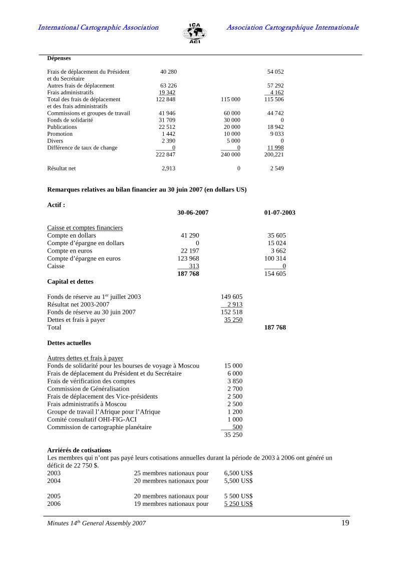
Minutes 14th General Assembly 2007 19
Dépenses Frais de déplacement du Président 40 280 54 052 et du Secrétaire Autres frais de déplacement 63 226 57 292 Frais administratifs 19 342 4 162 Total des frais de déplacement 122 848 115 000 115 506 et des frais administratifs Commissions et groupes de travail 41 946 60 000 44 742 Fonds de solidarité 31 709 30 000 0 Publications 22 512 20 000 18 942 Promotion 1 442 10 000 9 033 Divers 2 390 5 000 0 Différence de taux de change 0 0 11 998 222 847 240 000 200,221 Résultat net 2,913 0 2 549 Remarques relatives au bilan financier au 30 juin 2007 (en dollars US) Actif : 30-06-2007 01-07-2003 Caisse et comptes financiers Compte en dollars 41 290 35 605 Compte d’épargne en dollars 0 15 024 Compte en euros 22 197 3 662 Compte d’épargne en euros 123 968 100 314 Caisse 313 0 187 768 154 605 Capital et dettes Fonds de réserve au 1er juillet 2003 149 605 Résultat net 2003-2007 2 913 Fonds de réserve au 30 juin 2007 152 518 Dettes et frais à payer 35 250 Total 187 768 Dettes actuelles Autres dettes et frais à payer Fonds de solidarité pour les bourses de voyage à Moscou 15 000 Frais de déplacement du Président et du Secrétaire 6 000 Frais de vérification des comptes 3 850 Commission de Généralisation 2 700 Frais de déplacement des Vice-présidents 2 500 Frais administratifs à Moscou 2 500 Groupe de travail l’Afrique pour l’Afrique 1 200 Comité consultatif OHI-FIG-ACI 1 000 Commission de cartographie planétaire 500 35 250 Arriérés de cotisations Les membres qui n’ont pas payé leurs cotisations annuelles durant la période de 2003 à 2006 ont généré un déficit de 22 750 $. 2003 25 membres nationaux pour 6,500 US$ 2004 20 membres nationaux pour 5,500 US$ 2005 20 membres nationaux pour 5 500 US$ 2006 19 membres nationaux pour 5 250 US$

International Cartographic Association Association Cartographique Internationale
Minutes 14th General Assembly 2007 20
22 750 US$ Le Secrétaire-général disait que ceci constituait une préoccupation permanente pour le Comité Exécutif lors de la préparation du budget pour la période suivante et devrait également être une préoccupation pour les délégués de cette Assemblée générale. Raisons en faveur du passage des dollars aux euros et de la proposition d’augmentation du nombre d’unités de cotisation C’était la proposition du Comité Exécutif de faire passer a la vote de changer l’unité de cotisation à 250 € par an pour le mandat 2007-2011 au lieu de 250 $. De plus, les membres seront invités à se prononcer pour un nombre plus élevé d’unités de cotisation. L’effet de la première mesure est supposé apporter un gain net de 20 %. Le fait que la politique de ce mandat fut d’augmenter la visibilité de l’ACI et sa participation aux activités mondiales a imposé des demandes qui n’ont pu être satisfaites avec le budget actuel et qui ont de ce fait dû être en partie satisfaites par les institutions dans lesquelles travaillaient les membres du conseil d’administration. L’ACI ne peut compter sur ceci dans le futur. Bien que les livres montrent une augmentation positive réelle du capital en dollars (selon la page 2 de l’État financier et le rapport du Vérificateur aux comptes, le fonds de réserve est passé de 149 605 $ à 152 518 $) par rapport à l’euro, devise dans laquelle la majorité des activités est payée, ce résultat montre quand exprimé en euros un passage de 130 349 € à 110 733 €, soit une baisse d’environ 20 000 €. C’etait la raison pour laquelle on voterait pour changer le budget de l’ACI des dollars en euros.
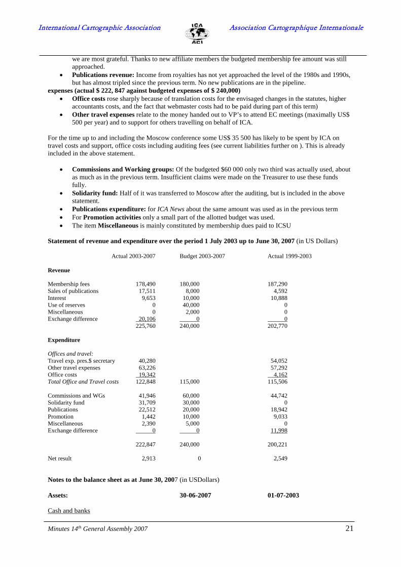
Treasurer’s report 2003-2007 The Secretary-General indicated that, since the 12th General Assembly in 2003 the financial situation of the International Association has been reported on each year at meetings of the Executive Committee, to the elected auditors and to the professional auditing firm. At these meetings the arrears in membership payments were reported as well. Annually a form for tax declaration has been provided to the Swedish Tax Authority. Since ICA is registered as an idealistic organization, no tax is paid. According to the Secretary-General, three different sets of documents were maintained: -detailed tables of operations during the period, whereby each financial operation was entered with an identifier on the accounting documents. Income categories discerned were: membership dues, publication sales, interest and miscellaneous; expenditure categories discerned were: office costs, travel, commissions, publications, promotion and miscellaneous. Both a Dollar and a Euro account were maintained, as well as a savings account. -generalised statements of receipts and expenses that reviewed the financial situation of the Association as compared to the budget voted for by the general Assembly in 2003 -a table with national and affiliate membership fees. There has not been a single currency unit as accounts have been kept in both Dollars and Euros. In order to take account of the fluctuating relationship between the two currencies during this term, the professional auditing firm (which has presented the final statement of revenue and expenditure in Dollars) has introduced an Exchange difference. The accounts have been reviewed by this professional auditing firm for the period July 1, 2003 - June 30, 2007. The fact that the treasurer had to start this 2003-2007 term with paying over $6000 for activities engaged in by commissions in the previous term, and likewise $ 6000 in travel costs and $3000 in accounting costs for the previous period restricted the financial scope for some activities, as for the commissions. The institution of 5 working groups with their financial claims restricted this even more. That is the reason why in this budget it is clearly stated what current liabilities are to be expected for the next treasurer. The Executive Committee has received and approved the Treasurer’s report for the full period July 1st 2003 to 30 June 2007, submitted to the elected auditors and to the delegates of the 14th General Assembly of the International Cartographic Association in Moscow, Russian Federation, as follows: At the end of June 2007, the statement of receipts and expenditures indicates: income (actual $ 225,760, budgeted: $ 200,000)
• membership fees: about 20 countries have not paid 2003-2007, which gives about $23 000 in membership dues. This means that over 60 countries have paid up on a regular basis for which support
International Cartographic Association Association Cartographique Internationale
Minutes 14th General Assembly 2007 21
we are most grateful. Thanks to new affiliate members the budgeted membership fee amount was still approached.
• Publications revenue: Income from royalties has not yet approached the level of the 1980s and 1990s, but has almost tripled since the previous term. No new publications are in the pipeline.
expenses (actual $ 222, 847 against budgeted expenses of $ 240,000) • Office costs rose sharply because of translation costs for the envisaged changes in the statutes, higher
accountants costs, and the fact that webmaster costs had to be paid during part of this term) • Other travel expenses relate to the money handed out to VP’s to attend EC meetings (maximally US$
500 per year) and to support for others travelling on behalf of ICA. For the time up to and including the Moscow conference some US$ 35 500 has likely to be spent by ICA on travel costs and support, office costs including auditing fees (see current liabilities further on ). This is already included in the above statement.
• Commissions and Working groups: Of the budgeted $60 000 only two third was actually used, about as much as in the previous term. Insufficient claims were made on the Treasurer to use these funds fully.
• Solidarity fund: Half of it was transferred to Moscow after the auditing, but is included in the above statement.
• Publications expenditure: for ICA News about the same amount was used as in the previous term • For Promotion activities only a small part of the allotted budget was used. • The item Miscellaneous is mainly constituted by membership dues paid to ICSU
Statement of revenue and expenditure over the period 1 July 2003 up to June 30, 2007 (in US Dollars) Actual 2003-2007 Budget 2003-2007 Actual 1999-2003 Revenue Membership fees 178,490 180,000 187,290 Sales of publications 17,511 8,000 4,592 Interest 9,653 10,000 10,888 Use of reserves 0 40,000 0 Miscellaneous 0 2,000 0 Exchange difference 20,106 0 0 225,760 240,000 202,770 Expenditure Offices and travel: Travel exp. pres.$ secretary 40,280 54,052 Other travel expenses 63,226 57,292 Office costs 19,342 4,162 Total Office and Travel costs 122,848 115,000 115,506 Commissions and WGs 41,946 60,000 44,742 Solidarity fund 31,709 30,000 0 Publications 22,512 20,000 18,942 Promotion 1,442 10,000 9,033 Miscellaneous 2,390 5,000 0 Exchange difference 0 0 11,998 222,847 240,000 200,221 Net result 2,913 0 2,549 Notes to the balance sheet as at June 30, 2007 (in USDollars) Assets: 30-06-2007 01-07-2003 Cash and banks

International Cartographic Association Association Cartographique Internationale
Minutes 14th General Assembly 2007 22
Dollar account 41,290 35,605 Dollar Savings account 0 15,024 Euro account 22,197 3,662 Euro Savings account 123,968 100,314 Cash 313 0 187,768 154,605 Equity and liabilities Reserve fund at 01-07-2003 149,605 Net result 2003-2007 2,913 Reserve fund at 30-06-2007 152,518 Liabilities and accrued expenses 35,250 Total 187,768 Current liabilities Other liabilities and accrued expenses 30/6/2007-30/8/2007 Solidarity fund for Travel awards for Moscow 15,000 Travel costs Secretary and President 6,000 Audit fees 3,850 Generalisation Commission 2,700 Office costs Moscow General Assembly 2,500 Travel costs EC 2,500 Working Group Africa for Africa 1,200 IHO-FIG-ICA Advisory Committee 1,000 Commission for Planetary Cartography 500 35,250 Membership dues arrears Members which have not paid up their annual subscription fees over the period 2003 to 2006 provide a deficit of US$ 22,750 2003 25 national members for US$ 6,500 2004 20 national members for US$ 5,500 2005 20 national members for US$ 5,500 2006 19 national members for US$ 5,250 US$22,750 The Secretary-general stated that this was an ongoing concern for the Executive Committee when preparing the budget for the next period, and also should be a concern for the delegates at this General Assembly. Reasons for changing from Dollars to Euros, and for the proposed increase in number of membership units It was the proposal of the EC to go for the 2007-2011 term for a membership unit of € 250 per year instead of $250. Apart from that members will be asked to consider opting for a higher number of membership units. The effect of the first measure is expected to bring a net 20% gain; The fact that it was this term’s policy to increase the visibility of ICA and its participation in global activities, laid a claim on the Association that was met partly by the institutions where the EC officers were working. ICA cannot count upon this for the future. Although the books show an actual positive increase of the capital in Dollars (according to page 3 of the Financial Statement and Auditor’s report, the reserve fund increased from $ 149,605 to $ 152,518), against the Euro, in which currency most of the activities are paid, this result actually shows a change of € 130,349 to € 110,409 or of a decline of about € 20 000. That is also the reason why it was proposed to vote on changing from dollars to Euros for the ICA budget. A question from the representative of the United States regarding the exchange rate between the US Dollar and the Euro was answered.
International Cartographic Association Association Cartographique Internationale
Minutes 14th General Assembly 2007 23
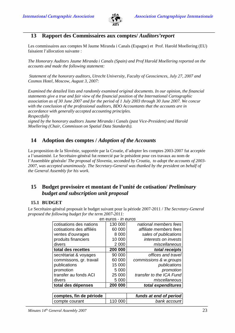
13 Rapport des Commissaires aux comptes/ Auditors’report Les commissaires aux comptes M Jaume Miranda i Canals (Espagne) et Prof. Harold Moellering (EU) faisaient l’allocution suivante : The Honorary Auditors Jaume Miranda i Canals (Spain) and Prof Harold Moellering reported on the accounts and made the following statement: Statement of the honorary auditors, Utrecht University, Faculty of Geosciences, July 27, 2007 and Cosmos Hotel, Moscow, August 3, 2007: Examined the detailed lists and randomly examined original documents. In our opinion, the financial statements give a true and fair view of the financial position of the International Cartographic association as of 30 June 2007 and for the period of 1 July 2003 through 30 June 2007. We concur with the conclusion of the professional auditors, BDO Accountants that the accounts are in accordance with generally accepted accounting principles. Respectfully signed by the honorary auditors Jaume Miranda i Canals (past Vice-President) and Harold Moellering (Chair, Commisson on Spatial Data Standards).
14 Adoption des comptes / Adoption of the Accounts La proposition de la Slovénie, supportée par la Croatie, d’adopter les comptes 2003-2007 fut acceptée a l’unanimité. Le Secrétaire-général fut remercié par le président pour ces travaux au nom de l’Assemblée générale/ The proposal of Slovenia, seconded by Croatia, to adopt the accounts of 2003-2007, was accepted unanimously. The Secretary-General was thanked by the president on behalf of the General Assembly for his work.
15 Budget provisoire et montant de l’unité de cotisation/ Preliminary budget and subscription unit proposal
15.1 BUDGET Le Secrétaire-général proposait le budget suivant pour la période 2007-2011 / The Secretary-General proposed the following budget for the term 2007-2011:
en euros - in euros cotisations des nations 130 000 national members fees cotisations des affiliés 60 000 affiliate members fees ventes d'ouvrages 8 000 sales of publications produits financiers 10 000 interests on invests divers 2 000 miscellaneous total des recettes 200 000 total receipts secrétariat & voyages 90 000 offices and travel commissons, gr. travail 60 000 commissions & w.groups publications 15 000 publications promotion 5 000 promotion transfer au fonds ACI 25 000 transfer to the ICA Fund divers 5 000 miscellaneous total des dépenses 200 000 total expenditures
comptes, fin de période funds at end of period compte courant 110 000 bank account

International Cartographic Association Association Cartographique Internationale
Minutes 14th General Assembly 2007 24
15.2 PROPOSITION D’INSTITUER UN FOND/ PROPOSAL FOR THE INAUGURATION OF AN ICA FUND
La proposition pour instituer un fonds de l ‘ACI pour appuyer la cartographie autant que la géomatique fut faite par le président sortant Bengt Rystedt/The proposal to inaugurate a fund for Supporting cartography and Geographic Information was made by Past-President Rystedt.
Proposed budget 2007-2011 fonds de l’ACI pour l’appui de la cartographie et la géomatique
ICA fund for supporting carto-graphy and geographic information
recettes income transfer du compte courant 25 000 transfer from current
account donations 20 000 donations intérêt 1 000 interest total des recettes 46 000 total receipts dépenses expenditures bourses de voyage 25 000 travel awards projets 15 000 projects divers 1 000 miscellaneous réserve 5 000 reserve total des dépenses 46 000 total expenditures
On peut trouver le règlement du Fonds de l’ACI dans l’annexe 2/ The statutes for the ICA fund can be found in appendix 2.
15.3 PROPOSITION DE COTISATION ANNUELLE / PROPOSED ANNUAL SUBSCRIPTION
Le Président-sortant indiquait que le Comité Exécutif avait discuté des niveaux de catégories et souhaiterait demander à certains membres nationaux d’augmenter leur niveau de catégorie conformément au tableau présenté dans l’annexe 3. À quelques exceptions près, le niveau de catégorie n’a pas été modifié au cours des dernières décennies. Les petites nations et les pays en voie de développement sont placés en Catégorie I. Il est recommandé aux pays européens de taille moyenne d’être membres de la Catégorie III. Les membres appartenant aux catégories supérieures sont invités à considérer une catégorie plus élevée, comme l’indique le tableau. The Past President indicated that the Executive Committee had discussed category levels and would like to ask some of the national members to upgrade their category level in accordance with the table below. With very few exceptions the category level has not been changed during the last decades. Developing and small countries are placed in Category I. Medium sized European countries are recommended to be Category III members. Members in higher categories are asked to consider a higher category as indicated in Appendix 3. Germany stated at this point that it did not intend to raise its annual membership dues beyond € 1500. Italy stated it felt comfortable with a raise to € 500 annually, and would not consider any further rise.

International Cartographic Association Association Cartographique Internationale
Minutes 14th General Assembly 2007 25
16 Statuts de l’ACI / ICA Statutes Le président-sortant disait que le Comité des Statuts sous la présidence de Michael Wood avait proposé quelques changes et amendements dans les statuts et les Arrêtés. Ces propositions ont été dévéloppés plus loin par le Comité Exécutif. Il foudrait que l’Assemblée générale y en décidait par majorité absolu. Le scrutin etait pris par bulletin de vote. Ce scrutin considerait seulement les changes principales, et pas l’expression exacte en français soit anglais. Le Comité exécutif décidera sur la version finale à base du résultat de vôte et des discussions. The Past-President said that the Statutes Committee, under the chairmanship of Michael Wood, had proposed some changes and amendments of the statutes and by-laws. The proposal has been further elaborated by the Executive Committee. The changes had to be decided by the General Assembly by an absolute majority1. Voting would be taken by ballot. Voting would consider only the main changes, not the exact wordings in French and English. Based on the result of the vote and the discussion the final wordings would be decided by the Executive Committee. Tas des amendements ont été proposés que ne changent guère la signification de lárticle. Ces changes ont le but de clarifier les statuts. On peut les discuter dans l’Assemblée générale, mais ils ne sont pas inclus dans le bulletin de vote. article amendements et explication 6 Inclusion d’un comité de soutien du Fonds d’encouragement de la
cartographie et de la géomatique de l’ACI. Voir les Statuts pour le Fonds sur le site Internet de l’ACI (sous Assemblée générale). L’intention est de transformer le Fonds en Fondation lorsque nous serons en mesure de démontrer une bonne gestion du Fonds.
12 Désignation d’un Vice-Président ou du Président sortant comme
Premier Vice-Président. De nombreuses organisations ont créé un poste de Premier Vice-Président et ont trouvé la mesure efficace pour la gestion de l’organisation. Cela ne signifie pas que le Premier Vice-Président soit le premier candidat pour devenir Président.
13 Le Président ne peut rester en fonction durant deux périodes
consécutives Le Comité Exécutif préfère trois (pas de modification) afin que la même règle s’applique à tous les membres du Comité Exécutif. Comme ce point fait l’objet de discussions, nous laissons à l’Assemblée générale le soin de décider.
24 Un président de Commission ne peut rester en fonction plus de deux
périodes consécutives. De nombreuses personnes de talent sont impliquées dans les activités de l’ACI ; en limitant la durée du mandat d’un président de commission, le Comité Exécutif pense que davantage de personnes auront la possibilité d’être en fonction durant leur période de vie active.
Arrêté 1b
Inclusion d’une catégorie no VII payant 10 unités. Les membres affiliés de la catégorie la plus élevée paient 10 unités et le Comité Exécutif propose d’introduire aussi le même niveau
1 Absolute majority means more than half of the national members that have voting rights.

International Cartographic Association Association Cartographique Internationale
Minutes 14th General Assembly 2007 26
supérieur pour les membres nationaux. Arrêté 2
La cotisation annuelle est fixée à 250 € par unité jusqu’à nouvel ordre. L’unité de cotisation doit être augmentée et les transferts internationaux en dollars américains occasionnent certaines complications.
Many amendments were proposed that did not really change the meaning of the Article. These were to clarify the Statutes and could be discussed at the General Assembly, but they were not included in the Voting Form. Article Changes and Explanation 6 Inclusion of a committee for maintaining the ICA Fund for
Supporting Cartography and Geographic Information. See the Statutes for the Fund on the ICA website (under General Assembly). The intention is to develop
the Fund to a Foundation when we can prove a good record of running the Fund.
12 Designation of a Vice-President or the Past President
to First-Vice President. Many organisations have established a position as First Vice-President and have found that efficient in running the organisation. It does not mean that the First Vice- President is the first candidate for becoming President.
13 The President may not serve for two consecutive terms.
The EC prefer three (no change) to have the same rule for all members of the EC, but knowing the discussion we give the GA the opportunity to decide. 24 A Commission chairperson may not serve for more than two
consecutive terms. There are many talented persons involved in the work of ICA and by limiting the time for being a commission chair- person the EC thinks that more persons will get an opportunity to be in charge during their active life time.
By-law 1b Inclusion of a category VII paying 10 units. Affiliate members of the highest category pays 10 units and the EC propose to have the same highest level also for national members.
By-law 2 The annual subscription is determined to be € 250 per unit until further notice. The subscription unit has to be increased and there are some complications with international transfers of US dollars
Result
Les resultats de vote etait que seulement la proposition de changer l’article 6 des statuts et les arrêtes 1b et 2 furent votés./ The results of the vote were that only the proposal to change article 6 and bylaws 1b and 2 were carried.
Article Yes No Abstention Carried 6 35 1 3 Yes 12 31 4 4 No 13 20 14 5 No 24 32 6 1 No 1b 29 6 4 Yes 2b 33 ? ? Yes

International Cartographic Association Association Cartographique Internationale
Minutes 14th General Assembly 2007 27
17 Rapport sur les publications / Publications report
fait par le president de la commission des publications Prof Robert McMaster/ made by the chair of the publications committee Prof Robert McMaster
The report details activity between July 2005 and March 2007. I have the following recommendations for the ICA Executive Committee.
1. The new President will need to select a new Publications Chair and committee. 2. The relationship between ICA and Elsevier should be reexamined. There continues to be regular
changes in personnel at Elsevier, and a lack of communication with the publications chair. Perhaps a new Chair based in Europe will help.
3. The ICA should consider publishing another Introduction to Cartography/GeoVisualization/ text, or marketing current versions (such as Kraak-Ormeling or Slocum-McMaster-Kessler-Howard) through ICA.
4. There needs to be a new set of initiatives put in place, with perhaps 2-3 new book projects launched. 5. The relationship with the three journals needs to be maintained, and perhaps 1-2 journals added.
17a. Rapports nationaux / National Reports Les pays-membres suivants ont préparés leurs rapports nationaux pour la période 2003-2007/ The following countries have prepared national reports for the 2003-2007 term:
Jusqu’a présent les pays-membres suivants ont préparés leur rapport national en forme digital/Until now the following countries have sent in a national report in digital form: • Algeria (PDF document, 1.281 Kb) • Australia (PDF document, 1.282 Kb) • Belgium (word report, 14Kb) • Czech Republic (PDF document, 372 Kb) • France (PDF document, 5.175 Kb) • Germany (PDF document, 1.726 Kb) • Hungary • Italy (Word document, 134 Kb) • New Zealand (PDF document, 354 Kb) • Portugal (PDF document, 401 Kb) • Slovakia (PDF document, 37 Kb) • Slovenia (PDF document, 837 Kb) • Switzerland (the national report will be published on the Swiss cartography website on August
1st) • Turkey (PDF document, 1231 Kb)
Une bon nombre des pays-membres est prévue d’apporter à Moscou les rapport nationaux imprimés/ A number of countries is known to bring paper copies or CDs of their national reports to Moscow:
• Canada • Chile • Chine/China • Espagne/Spain • EU/USA • Nouvelle-Zélande/New Zealand • Pays-Bas/Netherlands • Pologne/Poland The following countries brought their national report on CD:
International Cartographic Association Association Cartographique Internationale
Minutes 14th General Assembly 2007 28
• Bulgaria • Croatia • Hongrie/Hungary • Japon/Japan
18 Motions/Motions La société néo-zélandaise de cartographie (New Zealand Cartographic Society), représentée par M. Igor Drecki, proposait la motion suivante, relative à la standardisation et à la réglementation des évènements cartographiques dans le monde. Cette motion proposait d’avoir trois niveaux de conférences cartographiques appuyées par l’ACI, à savoir : Conférence cartographique internationale, Conférence cartographique régionale (facultative) et Conférence cartographique nationale. The New Zealand Cartographic Society represented by Mr Igor Drecki, proposed the following motion, on standardising and regulating the cartographic events around the world. This motion proposed to have three levels of ICA-endorsed cartographic conferences, i.e.: The International Cartographic Conference, Regional Cartographic Conference (optional) and National Cartographic Conference.
Comme il existe divers évènements, organisés chaque année, qui utilisent dans une certaine mesure la dénomination « conférence cartographique », l’idée consiste fondamentalement à désigner les conférences de l’ACI « Conférences cartographiques internationales » et d’établir un « réseau » de « Conférences cartographiques nationales » appuyées par l’ACI. Pour obtenir l’aval de l’ACI, ces conférences nationales devraient au moins inviter un délégué de l’ACI à assister et à présenter un exposé (ou un discours de fond) au sujet des « activités » de l’ACI. Ou bien, une Commission de l’ACI devrait être invitée à tenir sa réunion. Ceci donnerait à l’ACI la possibilité de se rendre « visible » à l’échelon national.
Les Conférences cartographiques régionales pourraient être considérées comme complémentaires aux conférences internationales et nationales bien établies.
Selon M.Fairbairn, le point de vue du Comité Exécutif de l’ACI etait qu’il etait d’accord avec la première partie ; par conséquent, il a déjà pris des initiatives pour breveter la dénomination « Conférence cartographique internationale » mais il apparait quíl ait trop cher pour l’effectuer. Comme il existe déjà des Conférences cartographiques régionales organisées par l’ONU en Asie, en Afrique et en Amériques, l’ACI ne souhaitait pas empiéter sur cette coutume. Pour ce qui est d’appuyer des conférences cartographiques nationales, l’ACI n’y voit pas d’inconvénient vu que la chose se pratique déjà couramment dans certaines parties du monde. La Chili commentait que la terme Conférence Cartographique Internationale fut utilisée déja la-bas, ainsi que l’URL icc.2009.cl As there are several events organised annually that - to some degree - use the term 'cartographic conference' inappropriately, the idea is basically to call ICA Conferences 'The International Cartographic Conference and to establish a 'network' of ICA-endorsed 'National Cartographic Conferences'. In order to receive ICA endorsement, these national conferences should at least invite an ICA official to be present and give a talk (or keynote address) about ICA 'business'. Alternatively, and ICA Commission should be invited to host their meeting. It would be an opportunity for the ICA to make itself 'visible' at national level. Regional Cartographic Conferences might be considered as complementary to the well established international and national conferences.

International Cartographic Association Association Cartographique Internationale
Minutes 14th General Assembly 2007 29
According to Mr Fairbairn, it was the standpoint of the ICA Executive Committee that it agreed with the first part, and therefore it had already started efforts to patent the name International Cartographic Conference. Unfortunately, it appeared to be too expensive to realise this. As there are already Regional Cartographic Conferences, organised by the UN, in Asia, Africa and the Americas, ICA did not want to encroach on this custom. As regarding endorsing national cartographic conference, ICA sees no problems here, in some parts of the world this has already become customary. The comments from Chile were that the term International Cartographic Conference was used there already, with the url www.icc2009.cl
19 Présentation des activités 2003-2007 des commissions et groupes de travail/ Presentation of commissions and working group activities 2003-2007
M.Cartwright donnait un apercu des rapports des commissions et groupes de travail sur la période 2003-2007. Les rapports déja récus etaient déja incorporés dans le website de l’ACI. La Commission sur la genéralization et la multiple representation n’avait pas déposée son rapport / Mr Cartwright gave an overview of the reports of the commissions and working groups for the 2003-2007 term. Those reports already received had been incorporated in the ICA website. No report was received from the Commission on Generalization and multiple Representation
20 Proposition de commissions 2007-2011 ; présentation des candidatures et des termes de références / Commission proposals 2007-2011 ; presentation of nominations and terms of reference
M.Lorenzo discutait les commissions proposés par les pays-membres ainsi que leur termes de référence. On peut trouver la version redigée de ces termes de référence dans l’annexe 5./Mr Lorenzo discussed the commissions proposed by the member countries as well as their terms of reference. The edited versions of these terms of reference can be found in appendix 5.

International Cartographic Association Association Cartographique Internationale
Minutes 14th General Assembly 2007 30
Nom de commission Commission name
Nom du président proposé/ Name of proposed chair
Pays-membre/ Country
Cartography & Children Nikolaj Komedchikov Russia Temenoujka Bandrova /José Jesús Reyes Bulgaria/Hungary
Digital Technologies and Cartographic Heritage Evangelos Livieratos Greece
Education & Training David Fraser Australia Generalization and Multiple Representation
William Mackaness / Sébastien Mustiere
United Kingdom/France
Geospatial Analysis and Modelling Bin Jiang Sweden Geospatial Data Standards Antony Cooper South Africa Geovisualization Gennady Andrienko Germany History of Cartography
Alexei Postnikov Russia Elri Liebenberg South Africa
Management & Economics of Map Production Philippe De Maeyer Belgium
Mapping from Satellite Imagery Graciela Metternicht Australia Map Projections Daan Strebe USA Maps and Graphics for Blind and Partially Sighted People Dan Jacobson Canada
Maps & Internet Michael Peterson USA Maps and Society Chris Perkins United Kingdom Marine Cartography Patricio Carrasco Hellwig Chile Mountain Cartography Karel Kriz Austria National & Regional Atlases Peter Jordan Austria Planetary Cartography Kira Shingareva Russia Theoretical Cartography Alexander Wolodtschenko Germany Ubiquitous Mapping Takashi Morita Japan Underrepresented Groups and Cartography Wieslawa Zyszkowska Poland
Use and User Issues Corné van Elzakker Netherlands
21 Présentation du programme de recherche de l'ACI/ Presentation of the ICA research agenda
Mme Virrantaus ensuite présentait le programme de recherche de l’ACI (voir l’annexe 6)/Ms Virrantaus presented the research agenda of the ICA (see appendix 6)
22 Présentation des candidatures au Comité exécutif / Presentation of nominations to the Executive Committee
M.Nyapola introduisait les candidats suivants pour le comité exécutif de l’ACI, en permettant chaque candidat de se présenter quelques minutes/Mr Nyapola introduced the following

International Cartographic Association Association Cartographique Internationale
Minutes 14th General Assembly 2007 31
candidats for the Executive Committee. He allowed all nominees several minutes to introduce themselves: Président/President William Cartwright Australia Ramón Lorenzo Espagne/Spain
Secrétaire-général et trésorier/Secretary General and treasurer
David Fairbairn Royaume Uni/ United Kingdom
Vice-President Derek Clarke Afrique du Sud/South Africa George Gartner Autriche/Austria Pablo Gran Chili/Chile Menno-Jan Kraak Pays Bas/Netherlands Zhilin Li Chine/China Anne Ruas France
Vladimir Tikunov Russie/Russia
Timothy Trainor Etats-Unis/USA László Zentai Hongrie/Hungary
23 Propositions pour les prochaines conférences/ Future conference proposals
M.Tikunov discutait les deux propositions pour la conférence cartographique internationale de 2011, et permettait l’Allemagne et la France de poser leur candidature, en illustrant leur venues avec une video/Mr Tikunov introduced the two proposals for the International Cartographic Conference of 2011, and allowed Germany and France to illustrate their bids with video programmes.
24 Récompenses de l’ACI / ICA Awards Le Président indiquait que le Comité pour la sélection des récipiendaires sous la présidence de M.Rystedt avait sélecté M.Jack Dangermond pour lui confier la médaille d’or Carl Mannerfelt, et avait selecté Mesdames Helen Kerfoot, Graciela Metternicht et Kira Shingareva pour leur nommer membres d’honneur de l’ACI. Le Comité exécutif a gracieusement suivi cette recommendation/ The President indicated that the Awards Committee chaired by Bengt Rystedt had selected Jack Dangermond to award him the Carl Mannerfelt Gold Medal, and had selected Mesdames Helen Kerfoot, Graciela Metternicht and Kira Shingareva to award them the ICA honorary fellowship. The Executive Committee gladly follows this recommendation. The awards will be delivered at an international event in order to give the receiver a prominent audience and ICA a high profile. The award to Dangermond will be delivered at the next ESRI User Conference, the award to Shingareva at the Opening Session of the ICC and the award to Kerfoot at the next UNGEGN in New York in August, 2007. Metternicht will receive her award at an occasion that will be decided later. The citations for these awards are appended as Appendix 7.
International Cartographic Association Association Cartographique Internationale
Minutes 14th General Assembly 2007 32
Deuxième session : jeudi 9 août 2007 9h00 - 12h30 / Second Session : Thursday 9th August 2007 9:00 - 12:30
Le Président reouvrait l’assemblée etpriait le secrétaire-général de faire l’appel des membres/The President reopened the assembly at 9.20, and asked the Secretary-General to proceed with the roll-call.
25 Appel des membres/ Roll call of members (see item 2)
8b) Nouveaux membres nationaux/New national members: The President indicated that the Agency of Land Resources Management of the Republic of Kazakstan, represented by its president, Bahyt Ospanov, had applied for ICA membership since the first part of the 14th General Assembly. He proposed to confer ICA membership on Kazakhstan. This was seconded by Bulgaria and seconded by Cyprus. Put to the vote, this was unanimously agreed to. Number of countries with voting right 65 + 1=66. Total number of countries 83+1=84
26 Proposition finale de budget 2007-2011/ Final budget proposal 2007-2011
Le Secrétaire-général proposait le budget final qu’etait preparé sous les hypothèses suivantes:
• Affectation partielle des cotisations des membres affiliés au Fonds de Promotion et de solidarité
• Change de l’unité de cotisation annuelle de 250 dollars américains à 250 euros • Augmentation limitée des cotisations payées par les membres nationaux • Maintien des produits financiers • Augmentation limitée des fonds alloués aux commissions et groupes de travail • Maintien du niveau des charges de voyage et de secrétariat
The Secretary-General proposed the final budget which had been prepared under the following assumptions:
• Allocation of part of affiliate member fees to the Promotion and solidarity fund • Change in the basic membership unit from US $ 250 a year to € 250 a year • Modest increase in the total subscriptions received from member nations • No change in the profits on investments • Modest increase in the funds allocated to commissions and working groups • No change in the funds allocated to travel and to the secretariat
L'unité de cotisation a été changée à € 250 - The fee unit had been changed to € 250.
en euros - in euros
cotisations des nations 130 000 national members fees cotisations des affiliés 60 000 affiliate members fees ventes d'ouvrages 8 000 sales of publications produits financiers 10 000 interests on invests divers 2 000 miscellaneous total des recettes 200 000 total receipts secrétariat & voyages 90 000 offices and travel commissons, gr. travail 60 000 commissions & w.groups publications 15 000 publications
International Cartographic Association Association Cartographique Internationale
Minutes 14th General Assembly 2007 33
promotion 5 000 promotion Transfer au fonds de l’ ACI 25 000 transfer to ICA fund divers 5 000 miscellaneous total des dépenses 200 000 total expenditures
comptes, fin de période funds at end of period compte courant 110 000 bank account
Après le vote pour l’arrêté 2 sous point 16/After having approved Bylaw no 2 under item 16
L'arrêté 2 des statuts de l'Association deviendrait : By-Law 2 of the ICA Statutes would become : La cotisation annuelle déterminée en application de l'article 18 pour la période 2007-2011 est fixée à € 250 par unité.
The annual subscription determined in accordance with article 18 for the period 2007 to 2011 is € 250 per unit.
27 Vote on the Budget Le budget 2007-2011 fut mis a la vote par le Secrétaire-général et fut approuvé a l’unanimité/The proposal was put to the vote by the secretary-general and was carried unanimously.
Le Secrétaire-général proposait aussi le budget suivant pour le Fonds de l’ACI pour l’appui de la cartographie et de la géomatique 2007-2011/ The Secretary-General porposed also the following budget of an ICA Fund for Supporting Cartography and Geographic Information 2007-2011.
recettes
Receipts
transfer du compte courant 25 000 transfer from current account donations 20 000 donations intérêt 1 000 interest total des recettes 46 000 total receipts Dépenses
Expenditures
bourses de voyage 25 000 travel awards projets 15 000 projects divers 1 000 miscellaneous réserve 5 000 reserve notal des dépenses 46 000 total expenditures
La proposition de voter ce budget fut faite par la Gre et secondée par l’Allemagne et la Suisse. Elle fut approuvée à l’unanimité sauf une abstention de la Suède/The proposal to put this to the vote was made by Greece and seconded by Switzerland and Germany. It was unanimously approved by theGeneral Assemby, but for one against from Sweden.
28 Election du Président / Election of the President Le Président adressait la forme de vote pour la présidence, ayant les messieurs Cartwright et Lorenzo comme candidats. Le résultat de la vote fut que William Cartwright etait élu president de l’ACI pour la période 2007-2011/The President refered to the voting form, with William Cartwright and Ramon Lorenzo as candidates. The result of the ballot was that William Cartwright was elected president of ICA for the 2007-2011 term.
29 Election du Secrétaire-général / Election of the Secretary-General
International Cartographic Association Association Cartographique Internationale
Minutes 14th General Assembly 2007 34
Le Président proposait d’avoir M.Fairbairn comme Secrétaire-général pour la période 2007-2011. Sa candidature fut faite par le Royaume Unie. M.Fairbairn fut voté à l’unanimité sauf une abstention de la part de l’Espagne. /The President presented David Fairbairn as the candidate for Secretary-General and Treasurer for the 2007-2011 term in accordance with a proposal from UK. He asked if the vote could be handled by show of hands. Put to the vote, David Fairbairn was unanimously elected, safe for an abstention from Spain.
30 Fixation du nombre des Vice-présidents / Vote on the number of Vice-Presidents
Le secretaire-general indiquait que, pour les raisons suivants on préfèrait un nombre de 7 vice-présidents: on a des précédents, et comme ca on pourra gagner une couverture presque globale. En outré on distinguee 5 terrains pour lesquels les vice-présidents sonts responsables (c’ est a dire la société, la science, la practice professionelle, l’ education et l’ art), on a besoin d’ un vice-président qui s’ en occupe des ateliers et un qui prepare les manifestations autour la cinquentaine. Une proposition d’avoir 7 vice-présidents fut faite par le Chili et secondée par le la France. Mis a la vote cette proposition fut voté à l’unanimité/ The Secretary-General indicated that for the following reasons a number of 7 vice-presidents was proposed: a) precedent, b) in this way we have as global a representation as possible, c) we have 5 fields vice-presidents are responsible for (society, science, professional practice, education, art), we need someone to coordinate the 50years celebrations and someone to coordinate workshops. There was a proposal from Chile to have 7 vice presidents, it was seconded by France. Put to the vote, it was carried unanimously.
31 Election des Vice-présidents/ Election of Vice-Presidents The Secretary-General explained the voting form for the election of the vice-presidents, and asked the delegates to fill in their forms. Together with the elections for President and Secretary General the new Executive Committee, on the basis of the filled-in election forms, is formed as follows: President: William Cartright Australia Secretary General: David Fairbairn United Kingdom Past-President: Milan Konecny Czech Republic Vice-Presidents: Derek Clark South Africa
Georg Gartner Austria Pablo Gran Chile Menno-Jan Kraak The Netherlands Zhilin Li China Anne Ruas France Timothy Trainor USA
32 Election des commissaires aux comptes 2007-2011 / Election of Auditors 2007-2011
Le président demandait des volontaires pour servir comme commissaires de compte pour la période 2007-2011, et puis proposait Nikolai Komedchikof et Harold Moellering comme commissaires de compte poyr cette période. Cette proposition fut secondée par la Croatie. Mis à la vote, l’assemblée l’approuvait à l’Unanimité/The President asked for volunteers, and then proposed Nikolay Komedchikov and Harold Moellering as auditors for the 2007-2011 period. This proposal was seconded by Croatia. Put to the vote, it was accepted unanimously.

International Cartographic Association Association Cartographique Internationale
Minutes 14th General Assembly 2007 35
33 Propositions de commissions 2007-2011/ Commission proposals 2007-2011
Italy asked what had happened to the commission on Incremental updating. It was answered that there had been no proposal for re-instating this commission, and that its subject matter would be taken up by the commissions on Management and Economics of Map Production and the commission on Geospatial Data Standards The president then proceeded to the vote; the following voting form was used: Commission/Commission Président/Chair Oui/
Yes Non/Yes
Ab.
Cartography and Children
either Temenujka Bandrova (Bulgaria) & Jesus Reyes (Hungary)
or Nikolay Komedchikov (Russia) Digital technologies in cartographic heritage
Evangelos Livieratos (Greece)
Education and Training David Fraser (Australia) Generalization and Multiple representation William Mackaness (UK) & Sébastien
Mustiere (France)
Geospatial analysis and modeling Bin Jiang (Sweden) Geovisualization Gennady Andrienko (Germany) History of Cartography
either Elri Liebenberg (South Africa) or Alexey Postnikov (Russia)
Management &Economics of map production
Philippe DeMaeyer (Belgium)
Mapping from Satellite Imagery Graciela Metternicht (Australia) Map projections Daan Strebe (USA) Maps and graphics for blind and partially sighted people
Dan Jacobson (Canada)
Maps and Society Chris Perkins (UK) Maps and the Internet Michael Peterson (USA) Marine Cartography Patricio Carrasco (Chile) Mountain cartography Karel Kriz (Austria) National and regional atlases Peter Jordan (Austria) Planetary cartography Kira Shingareva (Russia) Geospatial data standards Antony Cooper (South Africa) Theoretical cartography Alexander Wolodtschenko (Germany) Ubiquitous mapping Takashi Morita (Japan) Underrepresented groups and cartography Wiesława Żyszkowska (Poland) Use and User Issues Corné van Elzakker (Netherlands)
If a commission would have more votes against than in favour, it would be suppressed. The result of the vote was that all commissions were voted in, and that Elri Liebenberg would chair the Commission on the History of cartography, and that Temenoujka Bandrova and Jesus Reyes would co-chair the Commission on Cartography and Children. Terms of References and chairpersons are listed in Appendix 5.
34 Présentation de la 24e Conférence cartographique internationale/ Presentation of the 24th International Cartographic Conference
Le Col Rodrigo Barriga introduisait le team de ses collaborateurs pour l’organisation de la 24ieme conférence cartographique internationale/ Col Rodrigo Barriga introduced the team of organizers responsible for the 24th international cartographic conference.

International Cartographic Association Association Cartographique Internationale
Minutes 14th General Assembly 2007 36
- Rodrigo Barriga, chair, Director General of the Military Geography Institute of Chile. - Mrs. Alejandra Coll, local coordinator of the Scientific Program of ICC 2009, President of
Cartography Commission of the Pan-American Institute for Geography and History, Technological Metropolitan University, Santiago Chile.
- Mr. Fernando Pino, member of the Local Organizing Committee, Universidad de Chile. - Colonel Rolando Mercado, Director of the Aero Photogrammetry Service, Chilean Air Force. - Captain of Frigate Patricio Carrasco, Sub-Director of the Hydrographic and Oceanographic
Service, Chilean Navy, President of the ICA Commission on Marine Cartography. - Major Carlos Neira, Secretary General of ICC 2009, Military Geography Institute of Chile. After a video presentation and a dance performance he welcomed all possible participants and accompanying persons to the 24th International Cartographic Conference in Santiago de Chile, November 15-21, 2009.
35 Sélection du lieu de la 15° Assemblée générale et de la 25° Conférence cartographique internationale / Selection of the place of the 15th General Assembly and the 25th International Cartographic Conference
Le secrétaire-général adressait ensuite la forme de vote pour sélecter la lieu de la quinzième Assemblée générale et de la vingt-cinquième conférence cartographique internationale. Après avoir effectué la vote, il pouvait renseigner l’assemblée que c’etait Paris qu’avait gagné sur Dresde avec le moindre différence/The Secretary-General then proceeded to the vote for selecting the venue of the 15th General Assembly and 25th International Cartographic Conference. After the vote he could inform the assembly that Paris had won over Dresden with the smallest possible margin.
36 Questions divers / Any other business Cynthia Brewer (USA) asked how the participants that had spent money on items cancelled by Intourist could be reimbursed. As the results of the election of the commissions came in simultaneously, this question was repeated by Eric Kramers (Canada). Bengt Rystedt answered that that is a legitimate worry and that it should be handled by the new EC, where after President Cartwright stated that he was prepared to assist in putting pressure on the LOC and Intourist to reimburse both for cancelled tours and for payment for those who had to cancel their participation due to visa problems. Karel Kriz (Austria) asked whether there were any other suggestions about the date of the 24th ICC in Santiago. He was answered by the Chilean organizers that any change was feasible but had to be made quickly. The EC told him that the final date would be communicated in the afternoon after consultation (it was told during the closing session that the dates proposed since over a year (14-21 November) would be kept). The Secretary-General introduced the new editor of ICA News, Igor Drecki ([email protected]).
37 Clôture/Closing Le Président fermait l’assemblée a 12.30, en remerciant les scrutateurs ainsi que les délégués et les organisateurs/The president closed the assembly at 12.30, thanking the scrutineers, the delegates and the organisers for all their work.

International Cartographic Association Association Cartographique Internationale
Minutes 14th General Assembly 2007 37
Appendix 1a – Minutes 12th General Assembly
Minutes of the 12th General Assembly, August 10-16, 2003, Durban 1.Opening
President Rystedt opened the General Assembly and welcomed the delegates at 9.00.
2.Roll call 40 national delegates, who were members of ICA in 1999, were present, as well as two observers, from Lithuania and Kenya. 3. Adoption of the Agenda The agenda of the 12th General Assembly was adopted as circulated after a motion presented by Australia and seconded by Canada.
4. Nomination of two scrutineers
Nico Bakker, Netherlands and Patrik Ottoson, Sweden, were nominated as Scrutineers of the 12th General Assembly and elected by acclamation
5. Members ineligible to vote
Under item 5 the Executive Committee listed the following members whose voting rights have been suspended since the 11th General Assembly (Azerbaijan, Belarus, Cyprus, Indonesia, Kenya, Latvia, New Zealand, Nicaragua, Nigeria, Panama, Sudan, Tunisia). The EC proposed that voting rights be restored to Indonesia, Latvia and New Zealand, as these countries had made up their financial arrears. It also proposed to add the following to the list of countries whose voting rights have been suspended: Albania, Brazil, Estonia, Guinea, Madagascar, Nicaragua, Philippines, Qatar, Salvador, Uganda, Ukraine and Vietnam, as these countries had not paid their subscription fees for several years.
Voting on item 5 was by ballot. The proposal was approved by 30 votes in favour, one abstention and none against.
6. Membership withdrawals
Under item 6, the Executive Committee proposed the readmission of Kenya (which was withdrawn at the previous General Assembly) and the withdrawal of member nations whose voting rights had already been suspended by the 11th General assembly in 1999 and which have never answered any letter sent since that time. Those concerned were Azerbaijan, Belarus, Cyprus, Philippines and Uganda. Voting on item 6 was by ballot. The proposal was approved by 27 votes in favour, 1 against and 3 abstentions.
7. Adoption of the minutes of the 11th General Assembly, 1999 The minutes of the 11th General Assembly held in Ottawa in 1999 were circulated during the Beijing conference and again on April 20, 2003 . The minutes were adopted as circulated on a motion from Canada seconded by the United Kingdom. 8. New member nations One member nation had been admitted since the 11th General Assembly and was proposed for ratification by this General Assembly: Lithuania, represented by the Lithuanian Cartographic Society. Lithuania was adopted as a new member on a motion from the Netherlands seconded by the United States of America. 9. New affiliate members Under item 9, the Executive Committee proposed the ratification of the following affiliate members, according to article 3 of the statutes: Union of Chambers of Turkish Engineers and

International Cartographic Association Association Cartographique Internationale
Minutes 14th General Assembly 2007 38
Architects - Chamber of Survey and Cadastre Engineers (Turkey), Indian National Cartographic Association, (India), ESRI (United States), Navigation Technologies (the Netherlands). EC stated that the Hellenic Cartographic Society had become the national representative of Greece, and had therefore withdrawn as affiliate member. Elsevier Science Limited (Great Britain), Heritage Documents and Manuscripts Centre (Kuwait), Tokyo Inshokan Printing Company (Japan) and Aero Sensing (Germany) had also withdrawn as affiliate members. On a motion by Australia seconded by the United States, the ratification of UCTEA-CSCE, INCA, ESRI and NavTech as new affiliate members was accepted. 10. President’s report 1999-2003 When I took up the position as President in 1999, my three main goals were to:
• Improve the image of ICA and the value of being an ICA member. • Involve the Vice Presidents in the operations. • Improve the publications.
The Image of ICA and Membership Value The first of these goals is problematic. We really have to work on our image. Cartography has an image of being old fashioned and connected only to paper maps. Our dilemma is that so many people are interested in maps - the older the better. Many of us have experienced that and have had problems in communicating the contemporary status of cartography and mapping as being a science and profession at the forefront of research and technology. The Secretary General and I started the work on a Strategic Plan. The road to achieve a strategic plan is rather straightforward. We need to formulate a vision and set our goals and objectives with the mind to serve our members. After that we list the actions needed to reach the goals. For ICA, it is a journey together with the members of the Executive Committee, the commissions and the members. All must join and participate. The strategic plan has been on the agenda of all EC meetings during this term. In May this year all commission chairs were invited to a meeting in Budapest, where the SP was the main issue. Now it is time for the delegates of the General Assembly to contribute with their views. What do you want from ICA? Obviously, you. want more than ICA delivers today. Never before have so many members been behind in paying the membership fee. The Executive Committee In my inauguration speech in Ottawa, I promised to increase the involvement of the Vice Presidents. I want to take this opportunity to thank the members of the Executive Committee. First of all I say a thanks to all of them for the liaison work. All of us on the Executive Committee have the duty to keep in contact with two or three commissions and, if possible, attend the commission meetings. By doing that and reporting at the EC meetings we have a rather good knowledge of the commission work. My first specific words of thanks go to Ferjan Ormeling. His service as Secretary General and Treasurer has been excellent. Since ICA has no employees, it is a heavy amount of work to take care of everything that has to be done. Since we have no one with French as a native language in the EC, he has also done all translations to French. I now go to the Vice Presidents in alphabetical order. Milan Konecny has been a kind of foreign minister. He has represented ICA at a number of meetings of Global Map and Global Spatial Data Infrastructure, which also included the World Summit for Sustainable Development in Johannesburg. He has been able to cover most of the travel costs from other sources than ICA, which is especially appreciated. Li Li made a tremendous effort in the organisation of our conference in Beijing 2001. She has also promoted ICA and cartography in China and elaborated the cooperation with the International Geographical Union in an attempt to create a World Water Atlas. Elri Liebenberg has been our contact with the Local Organising Committee for ICC 2003. She has always done her best to answer our questions on the progress in the planning of the conference. Robert MacMaster has been assigned to

International Cartographic Association Association Cartographique Internationale
Minutes 14th General Assembly 2007 39
publications. He has together with me and Ferjan tried to convince Elsevier that there should be an International Cartographic Journal. The first signs from Elsevier were positive, but then they decided to reject our proposals. He has written numerous letters and held many conversations to pave the way for ICA publication ventures. Takashi Morita is now the ICA representative in the Steering Committee for Global Map. He has had the difficult task in the EC to watch the terminology. Kirsi Virrantaus has been very instrumental in the development of the Strategic Plan. Since she until last year chaired the FIG commission for Education, she has represented ICA at several FIG meetings. Alberta Auringer Wood got a special task to organise procedures for an ICA archive and to find a home for it. She has been able to get IGN of France to host the ICA archive in Paris. She has also been watching us to follow the statutes and by-laws of ICA. Thanks to her ICA scarves and ties may soon be available. Finally, we have the past president Michael Wood. He has done most of the work with the Strategic Plan. He has also been very helpful in our struggle with the English language. He has been the representative to IMTA, the International Map Trade Association, and a member in their jury when exhibited maps have been judged for prizes. Many, many thanks to all of you for your work and loyalty in helping me carry out this goal. Publications The third goal was about publications. Our science has been suffering from not having a clear channel for scientific papers. There should be an international journal for cartography and geographical information science, where both PhD students and established researchers could publish refereed papers. As you already know, Elsevier turned our proposal down. In our opinion they made a too narrow market research. Now we are going to establish a closer cooperation with some of the existing journals. The commission chairs have been encouraged to explore conference contributions and to elaborate such ones to a standard in line with academic requirements. In order to do so ICA now claims the copyright to conference papers. That means that the author is not allowed to re-publish a conference paper without consent from ICA. As you know conference proceedings are considered as grey literature and not acknowledged as refereed publications. Robert MacMaster will give you more details in the Publications Report. The Commissions The commissions form the backbone of the association. Most of the work is carried out in the commissions and the results and findings are disseminated via reports from commission meetings and seminars. Since there are 18 commissions it will be too lengthy to even make a summary of what they have achieved. There will be a session when you will get a chance to contact the commission chairs. There are also reports available at the homepage of ICA www.icaci.org To all commission chairs and commission members I convey my sincere thanks. UN Activities
UN organises regional cartographic conferences. Every 3rd year there is one for Asia and Pacific and every 4th year one for the Americas. The regional cartographic conference for Africa has changed to a meeting of CODI (Committee of Development Information) under the auspices of ECA, the Economic Commission of Africa. CODI has three sub-committees, Statistics, Information Communication Technology and Geo-Information. As president of ICA, I have been invited and presented papers at the following UN meetings: New York 2000, Kuala Lumpur 2001, Addis Ababa 2001 and 2003 and Okinawa 2003. I have also been active to give ICA a higher profile at these meetings and have asked UN to invite more ICA representatives. ICA is also a supporter of the UN Geographic Information Working Group. I really think that the UN deserves better information for their operations. Today, the Security Council has to rely on paper maps. Versatile mapping is badly needed in many fields. However, several UN organisations like FAO and UNEP are rather advanced. An important UN activity is standardisation of geographical names. The most common complaint on maps concerns place names and many of you are active in this field in your daily work.

International Cartographic Association Association Cartographique Internationale
Minutes 14th General Assembly 2007 40
National Conferences and Symposia ICA sponsors several events by allowing the organisers to use the ICA logo. The precondition for that is that one ICA representative is involved in the program committee and invited to participate. Due to limited time and travel funds we are not able to support all countries. I have myself been able to visit several countries, but regretfully I have not been able to accept all invitations. In some cases someone else on the Executive Committee or a commission chair has been able to attend. Please, invite us in good time. Our regular work must also be done and the ICA work has to fit in between projects, teaching and research. Acknowledgement In addition to my gratitude to the ICA community, I would like to thank my employers, National Land Survey and Gävle University, for office space and communication facilities. And last but not least, my wife. She is very patient with my long working days and travel. 11. Secretary-General’s report 1999-2003 According to the statutes, the Secretary General and Treasurer is responsible for the administration and the general running of the Association ; before presenting the accounts to the General Assembly of Delegates, the Secretary General and Treasurer must submit them to the two auditors for audit : the Treasurer's report is the next item in the agenda of the General Assembly. Thus the Secretary General is the permanent liaison between the Executive Committee and the ICA members : representatives of national and affiliate members and of committees, commissions and working groups. The Executive Committee produced several reference documents during the 1995-1999 period, as guidelines facilitating the activities of the association. Some of these guidelines have been modified during the 1999-2003 period. Coordinated by the Past president, the Executive Committee has added guidelines for ICA officers, including members of the Executive Committee. The Secretary-General prepared their publication, which was effected, thanks to the Netherlands Cartographic Society, in a special issue of its journal, called ICA Organizations and activities, following the practice established earlier by the previous Secretary-general Jean-Philippe Grelot In such organisations as the International Cartographic Association, a key point is to provide continuous efficient communication. I urge you to inform the Secretary General as soon as changes occur with the contact person or the contact address in your national committees. Electronic tools will help us in this respect. Much time was spent on the preparation and organization of an ICA website. This site contains, apart from the homepage, -a list of forthcoming events -a news section -the ICA News -guidelines for competing in the Barbara Petchenik contest, -the text of the Mission of the ICA -an ICA publications list -a reference section, with -the statutes and bylaws -guidelines for ICA officers
-guidelines for national committees -publication procedures -guidelines for Conferences & General Assemblies -standard call for papers (guidelines for journal/news publishers, national committees, organizing committees, etc.) -guidelines for ICA Endorsement of Conferences -guidelines for travel awards
-a section showing ICA achievements -a section showing ICA awards -a section on the ICA commissions with their terms of reference and activities -the addresses of the member countries and affiliate members

International Cartographic Association Association Cartographique Internationale
Minutes 14th General Assembly 2007 41
-the addresses of the Executive Committee -links to sister societies -other links Especially for this General Assembly a section on nominations for ICA officers and on the General Assembly itself, with the agenda and relevant items was added. The ICA website was created by the Utrecht University cartographer Ton Markus, and is maintained on a day to day basis by Martijn Storms.
The work of our ICA News editor Graciela Metternicht deserves special mention, especially so as she has been able to engage the interest and cooperation of the commission chairs for this medium in a stimulating way. All along the last eight years in the position of Secretary General of ICA, you gave me an opportunity to contribute to the development of cartography worldwide. More important, you invited me to numerous meetings and discussions: I should like to mention especially the meetings with the Greek, Indonesian, Austrian, Hungarian, Korean, Spanish, Russian, Finnish, Cuban and Dutch cartographic societies, and I would like to thank you for these opportunities. 12. Treasurer’s report 1999-2003 Since the 11th General Assembly in 1999 the financial situation of the International Cartographic Association was reported annually to meetings of the Executive Committee. At these meetings the arrears in payment of membership dues were reported as well, and the support of vice-presidents to stimulate defaulters to pay up was sought. Meanwhile the Secretary-general and treasurer maintained three sets of documents:
-detailed tables of operations during the period; each financial operation was entered here with an identifier written on the accounting documents (invoices, credit notes, bank notices, etc.), for use by the treasurer of the Association and a professional auditor ; income categories discerned ar:e fees, publications, interest and others ; expenditure categories are: office costs, travel, commissions, publications, promotion and miscellaneous. Three types of accounts are used : bank accounts (in both euro’s and dollars), a savings account, and deposit accounts in both euros and dollars. It took some time negotiating whether ICA would be enabled under Dutch law to benefit from savings and deposit accounts. Because we had no yearly general assembly we did not qualify, however. Only when the president enabled us to be registered in Sweden as a non-profit organization did we qualify for the benefits of non-profit organizations.
-generalised statement of receipts and expenditure that reviewed the financial situation of the Association as compared to the budget voted by the General Assembly in 1999;
-a table with national and affiliate member fees. There has not been a single currency unit, as accounts were kept both in dollars and euros. In order to take account of the fluctuating relationship between the two currencies during this term the professional auditing firm (which has presented the final statement of revenue and expenditure in dollars) has introduced the item ‘exchange difference’. The accounts were reviewed by a professional auditor for the period 1st September 1995 to 30 June 1999. All relevant documents were copied to the Elected Auditors. The Executive Committee received and approved the Treasurer's Report for the full period 1st July 1999 to 30 June 2003. This was submitted to the Elected Auditors and to the Delegates of the 12th General Assembly of the International Cartographic Association in Durban, South Africa, 16 August 2003 as follows. At the end of June 2003, the statement of receipts and expenditures indicates : income (actual : US $ 202,770 ; budget : US $ 202,000) • national members subscriptions were 6 % lower than budgeted : $117,000 against $123,000 ; • affiliate members subscriptions were 70 % higher than budgeted : $70,000 against $41,000 ; this is because
one major affiliate member paid up its dues after 8 years • sales of publications are only a third of the amount budgeted : $4,600 against $15,000;

International Cartographic Association Association Cartographique Internationale
Minutes 14th General Assembly 2007 42
• interests on investments has been only half the amount budgeted : $10,800 against $20,000 ; interest rates decreased dramatically, and we had problems in gaining recognition as a non-profit organisation
• miscellaneous: no income was generated that could not be entered under one of the previous items. expenditures (actual : US $200,221 ; budget : US $212,000) ; • Secretary’s office expenditure was higher than in the previous term : $4,162 against $2,425 (postage could
not be paid by Utrecht University) • Total office costs and travel are almost in line with the budget : $115,500 against $112,000 ; there has been
a sizeable increase in travel costs. Vice presidents received $2500 each as travel budget and the ICA attendance at UN meetings and participation in other new initiatives such as GSDI and Global Map strained the travel budget.
• Part of the Offices and travel expenses has in fact been spent on the travel awards. This Executive committee allocated altogether $30,488 to travel awards for the Beijing and Durban conferences during the term from July 1999 to June 2003. Since then some US$5000 has been added.
• Commissions and working groups have used 75 % of their revised budget : $45,000 against $60,000 ; a number of commissions have announced that they will present outstanding claims within the budgets allotted to them in Durban ;
• Publications, here almost $19,000 was used of a budgeted $25,000. Of this amount $12,500 was used for the ICA News. Seminars and conferences, promotion and miscellaneous are on line with budget : $55,550 against $67,000.
• ICA funds available at the end of period (30/6/2003) amount to $149,000 ($147,00 at 01/07/1999). Statement of revenue and expenditure over the period 1 July 1999 up to 30 June 2003 (in US dollars)

International Cartographic Association Association Cartographique Internationale
Minutes 14th General Assembly 2007 43
Actual Budget Actual 1999-2003 1999-2003 1995-1999 Revenue National member fees 117,000 123,000 100,000 Affiliate member fees 70,000 41,000 35,600 Sales of publications 4,592 15,000 21,800 Interest 10,888 20,000 19,350 Miscellaneous 0 2,000 10,000 202,770 202,000 186,863 Expenditure Travel expenses primaries 54,052 21,432 Other travel expenses 57,292 38,798 Office costs 4,162 2,425 Total offices and travel 115,506 112,000 62,655
Commissions and WGs 44,742 60,000 46,396 Publications 18,942 25,000 22,460 Promotion 9,033 10,000 23,406 Miscellaneous 0 5,000 4,497 Exchange difference 11,998 0 24,123 200,221 212,000 185,537 Net result 2,549 -10,000 1,326
Notes to the balance sheet as at 30 June 2003 (in US dollars) Assets 30-06-2003 Cash and banks
Dollar account 35,605 Dollar deposit account 15,024 Euro account 3,662 Euro savings account 100,314
154,605
Equity and liabilities
Reserve fund at 01-07-1999 147,056
Net result 2,549
Reserve fund at 30-06-2003 149,605
Membership dues arrears Members who have not paid their annual subscription fees over the period 1992 to 2002 account for a 'deficit' of US $ 42,250 : $ 40,000 from national members and $ 2,500 from one affiliate members : • • 1994 : 7 national members for US $ 1750 ; • 1995 : 9 national members for US $ 2250 ; • 1996 : 11 national members for US $ 2750 ;

International Cartographic Association Association Cartographique Internationale
Minutes 14th General Assembly 2007 44
• 1997 : 12 national members for US $ 3000 ; • 1998 : 16 national members for US $ 4000. • 1999: 17 national members for US $ 4250. • 2000: 20 national members for US $ 5000. • 2001: 28 national members for US $ 7000. • 2002: 39 national members for US $ 9750 • 2002: 1 affiliate member for US $ 2500 This has been an ongoing concern for the Executive Committee when preparing the budget for the 2003-2007 period. But despite this, funds available at the end of the 1999-2003 period would be $80,000+$30,000 = $110,000. This means more than twice the yearly costs of operation of the Association, and two times the amount recommended by the International Council of Scientific Unions. It is our hope to involve vice-presidents more in the day to day affairs of the ICA by making them responsible for specific fields identified in the strategic plan (education, science, professional practice, society). This would require a larger budget for them to cover travel expenses. At present, in view of the reserves, there seems to be no immediate need to increase the basic membership unit (now at US $250). In 2007 an increase will probably be necessary.
13. Auditors’ report
Statement of the honorary auditors
Hilton hotel, ICC Durban August 9, 2003 We examined the detailed lists and randomly examined original documents. In our opinion, the financial statements give a true and fair view of the financial position of the International Cartographic Association as of 30 June 2003 and for the period of 1 July 1999 through 30 June 2003. We concur with the conclusion of the professional auditors, BDO Accountants, that the accounts are in accordance with generally accepted accounting principles. Respectfully Signed by the honorary auditors
Jaume Miranda, Judy Olson 14. Adoption of the accounts The accounts were adopted on a motion by South Africa, seconded by Israel, which was passed unanimously. 15. Preliminary budget 2003-2007 The preliminary budget has been prepared under the following assumptions:
• Allocation of affiliate member fees to the Promotion and solidarity fund • No change in the basic membership unit which is still set at US $ 250 a year • No change in the total subscriptions received from member nations • No change in the profits on investments • No change in the total amount allocated to commissions and working groups • No change in the funds allocated to travel and to the secretariat
Preliminary budget 2003-2007 - in US $
cotisations des nations 120 000 national members fees cotisations des affiliés 60 000 affiliate members fees ventes d'ouvrages 8 000 sales of publications produits financiers 10 000 interest on invests vente des cravates 40 000 sales of ties and scarves divers 2 000 miscellaneous total des recettes 240 000 total receipts secrétariat & voyages 115 000 offices and travel commissons, gr. travail 60 000 commissions & w.groups publications 20 000 publications promotion 10 000 promotion bourses de voyage 30 000 travel Awardees

International Cartographic Association Association Cartographique Internationale
Minutes 14th General Assembly 2007 45
production des cravates 35 000 production of ties and scarves divers 5 000 miscellaneous total des dépenses 275 000 total expenditures
comptes, fin de période funds at end of period compte courant 80 000 bank account fonds de promotion et de solidarité
30 000
promotion & solidarity fund
In this proposal there is a $35 000 deficit, to be paid from the reserves. Technically and financially, this will not create a problem as the reserves of the Association are significantly higher than the recommendation made by the International Council for Science, ICSU, for non-governmental, scientific organisations. The decision by the Executive Committee not to recommend an increase in the subscription unit, is meant to deliver a strong message to the member nations. It is the reponsibility of national delegates to the General Assembly to commit themselves and all member nations to pay the annual fees if they want to have an active and sound ICA.
The provision in the budget for a stock of ICA ties and scarves was questioned by the UK, because it tied up capital. Israel was in favour of assessing the demand for ICA scarves and ties, while Australia considered that there would be many commercial firms outside North America who could offer lower prices and carry the risk.
Prior to the discussion on the final budget proposal Australia moved that in any case the deficit should not surpass US$40 000. This was seconded by the United States, and all were in favour, except for Israel which abstained.
President then adjourned the Assembly for lunch. He asked delegates to look at the posters put up by the commission chairs in the room where lunch was served, showing their activities for the past four years. The Assembly resumed after lunch.
16. Statutes
At this point the number of delegates present and eligible to vote had increased to 42, while postal votes had been received from Belgium, Latvia, Romania, Slovakia, Venezuela and Yugoslavia. As Belgium was present in the General Assembly, this brought the number of eligible members voting on this issue to 47. Under agenda items 5 and 6 the number of members eligible to vote had been reduced to 62, and as changes in the statutes require an absolute majority of the voting members of the Association (article 28), the necessary number of votes to accept the proposed changes was 32.
Proposals for changes in the statutes (item 16) have been circulated on April 20, 2003. A form for voting by correspondence on these proposals was circulated in June 2003, according to article 28 of the statutes. These proposed changes are based on the following considerations: -the wish to allow for personal members -the wish that the statutes reflect the increased emphasis on GIScience -the wish to have new categories of affiliate members -the wish to give non-paying members observer status instead of being struck from the membership list, and their voting rights to be reinstated when they pay up, to be determined by EC. The proposed changes were highlighted as follows:
Statutes of the International Cartographic Association, the International Society for Cartography and Geographical Information Science (ICA)
Article 1a and 1b Aims of the Association
The ICA has the following aims :
a) The advancement of the study of cartographic or geographic information science (GIS)
problems. In particular it is concerned with the processing, storage and analysis of source material
and the design, construction, reproduction and display techniques of maps and associated forms of

International Cartographic Association Association Cartographique Internationale
Minutes 14th General Assembly 2007 46
graphic communications. To this end, co-operation with different branches of geodetic,
geographic and other scientific research is desirable.
b) The initiation and co-ordination of cartographic and GIS research involving co-operation between different nations, the exchange of ideas and documents, the furtherance of training in cartography and GIS; and the encouragement of the spreading of cartographic and GIS knowledge.
Article 3 National representation and membership of associations Any nation which pursues a cartographic or GIS activity can be accepted as a member of the ICA provided that it agrees to participate financially in supporting the Association and in collaborating actively in its scientific and technical activities. Each nation can only be represented as a member by one single organisation which should preferably be the national society or committee for cartography or GIS. The ICA can accept requests for affiliation from international, national scientific, technical or other organisations made for the purpose of collaborating in its activities, and without compromising the principle of single representation of each nation in the official functioning of the Association or affecting the methods of voting as described in Articles 4, 26 and By-Law 5. Application for national or affiliate membership shall be made by letter to the Secretary General and Treasurer and may be approved by the Executive Committee subject to ratification at the next General Assembly of Delegates. Article 5 Activities and reports
The task of each national or affiliate member organisation is to facilitate and co-ordinate in its nation the study and development of the different aspects of cartography and/or geographic information science. Every national or affiliate member organisation either individually or in conjunction with one or more of the member nations can submit to the Association questions which are appropriate to the Association for discussion. Each member nation agrees to send a written or printed report on its cartographic activities to each General Assembly of Delegates. Article 9 Meetings of the General Assembly The General Assembly of Delegates will normally meet every4 years. The time and place of the next meeting will be decided upon at the previous General Assembly, or, if this is impractical by the Executive Committee. In special circumstances, with the agreement of the Executive Committee, the President has the right to call an extraordinary General Assembly. The President is also obliged to do so, if one third of the member nations demand it. As a rule, the General Assemblies will be held in conjunction with a Conference Article 20 Payment of subscriptions In each member nation, the national representative organisation which adheres to the Association is responsible for the contribution. If a nation has not paid its dues for three consecutive years the Executive Committee may decide that it shall cease to form part of the Association.

International Cartographic Association Association Cartographique Internationale
Minutes 14th General Assembly 2007 47
The Executive Committee can institute individual ICA membership at a later date, to be regulated by the by-laws Article 23 Joint meetings Special meetings, called 'joint meetings', may be organised. These shall consist of a small number of qualified research-specialists, who are to be recommended or invited by the members of the Executive Committee. The Executive Committee decides in each case on the time, place and working programme of such joint meetings.
Article 27 Publications All publications of the Association require the approval of the Executive Committee. The Executive Committee will arrange for the publication of a bulletin or newsletter concerning the activities of the Association and its members, and facilitate the publication of papers on cartography and GIS. For consideration of other publications, the Executive Committee shall appoint a Publications Committee consisting of a Chairperson and three members, only one of these four may be a member of the Executive Committee. The President and the Secretary General and Treasurer shall be additional members ex officio. The tenure of office of the Committee shall be the same as the Executive Committee, but may be re-appointed. The Publications Committee will examine proposals for publications (including commission Reports), approve plans in terms of production, format and style, budgets and expenditure and arrangement for distribution. Article 30 Dissolution of Association A decision to dissolve the Association is valid only if at least two-thirds of the member countries consent. In all respects, the regulations of Article 28 are valid. In case of dissolution, the funds of the Association will be placed by the General Assembly of Delegates or the Executive Committee at the disposal of one or several international scientific organisations whose aims are closely related to cartography or GIScience.
BY-LAWS By-Law 1 a) Each member subscription to the ICA shall be expressed in 'subscription units'. All adhering
members are divided into categories, numbered I to VI, and will pay annually the number of subscription units specified in that category.
b) The categories and subscription units shall be as follows : Category No I II III IV V VI No of subscription units 1 2 3 4 6 8
c) Each member shall select into which category it wishes to be classed. The Executive Committee may refuse a specification if the category chosen is believed to be manifestly inappropriate.
d) The amount of the subscription unit and the currency or currencies in which the subscription will be made will be determined by the General Assembly on recommendation of the Executive Committee.

International Cartographic Association Association Cartographique Internationale
Minutes 14th General Assembly 2007 48
e) The subscription for Affiliates as defined in By-Law 5(a) is set as a minimum of one subscription unit for categories (1) and (2), a minimum for two subscription units for category (3) and (4) and a minimum of ten subscription units for category (5).
By-Law 5
(a) For the purpose of affiliation as described in Article 3 the following categories shall apply:
(1) (International) Educational establishments (2)National cartographic or GIS societies other than the national ICA representative body
(3) National Scientific Organisations and Technical Organisations. These include academic, research or technical institutes or other scientific or technical bodies, governmental or autonomous, that are users of cartographic data and are demonstrably devoted to the discipline of cartography to the satisfaction of the Executive Committee.
(4) Nationally operating private firms/companies engaged in the development, production or manufacture of cartographic or allied equipment or products and are committed to supporting the interests of the discipline of cartography and/or GIScience to the satisfaction of the Executive Committee.
(5) Internationally operating private firms/companies These include such organisations that are engaged in the development, production or manufacture of cartographic or allied equipment or products and are committed to supporting the interests of the discipline of cartography and GIScience to the satisfaction of the Executive Committee.
(b) Application for affiliation in category (a)(2) is to be submitted to the Executive Committee supported by a letter from the member nation.
(c) Application for affiliation in categories (a)(1) or (a)(3) to (a)(5) is to be submitted to the Executive Committee in writing.
By-Law 6
ICA member nations and affiliates shall be entitled to the following services : • Invitation to all ICA conferences. • One free copy of all ICA publications including the ICA Newsletter. • Free copies of National Reports presented to ICA General Assemblies. Free copies of the
published collection of presented conference papers when made available, posted to members and affiliates unable to be present at the conference.
• Free subscription to one cartographic journal of international repute offered by the ICA. • Training courses from time to time as the need is demonstrated and finance is available. • Preferential treatment in exhibitions of ICA. Upon request the ICA may assist in sponsoring conferences, seminars and symposia in member countries or in conjunction with affiliates. Assistance may consist of : • a financial contribution conditional on due recognition being given to the ICA and/or • the support of a member of the Executive Committee of ICA to attend and participate in the
meeting.
Bylaw 7
All national and affiliate members may propose one representative for each commission.
The foregoing Statutes and By-laws are as amended by the 12th ICA General Assembly held in Durban on 10 and 16 August 2003

International Cartographic Association Association Cartographique Internationale
Minutes 14th General Assembly 2007 49
The Secretary General
and Treasurer The President
Ferjan Ormeling Bengt Rystedt The Executive committee had proposed a clarification of the name of the ICA by adding ‘The international society for cartography and geographical information science ‘ as a subtitle. Against this there was a counterproposal from Finland to change the name altogether to “International Society for Cartography and Geographical Information Science”, leaving the unchanged abbreviation of ‘ICA’. As this Finnish proposal had been rendered incorrectly on the postal voting form on the statutes by the Secretary-General, the President ruled that the vote on the subtitle and on the change of the name of ICA had to be postponed to the next General Assembly. In the meantime a commission would be appointed to investigate the issue. There had been a proposal from Poland to change the number of ICA vice-presidents from 5-7 (to be determined by the General Assembly) to 3. The Polish proposal to reduce the number of vice-presidents to three was not carried, as there were 14 votes in favour, 1 abstention and 32 votes against. The proposal by the executive committee to change the statutes was carried by 34 votes in favour, no abstentions and 13 votes against, and was therefore adopted. 17. Strategic plan A proposal for a strategic plan had been circulated in June 2003. It was addressed by Past President Wood, who elucidated it and highlighted its main objectives. It would be discussed also during the meeting of the national delegates with the Executive Committee on August 13, 2003,prior to the second part of the 12th General Assembly on August 16, 2003. 17a.Publications report Robert McMaster, chair of the Publications Working group, presented the following report: International Cartographic Association (ICA) Publications Report for 1999-2003
Published Books
Maps and the Internet (2003). Edited by Michael Peterson Proceedings
Cartography and Children (2002). Proceedings of the conference held August 4-6, at the Instituto de Geociências, Universidade Federal de Minas Gerais, Diamantina, Brazil. Teaching Maps for Children: Theories, Experiences and Perspectives for the Beginning of the 3rd Millennium (2001). Proceedings of the conference held September 6-8, at Eötvös Lorand University, Department to Cartography Budapest, Hungary. Discovering Basic Mapping Concepts: Exploring How Elementary Children can Discover Concepts Basic to the Understanding of Maps and their Usage for Inventory, Analysis and Discussion (2000). ISBN: 0-9687014-0-X. Proceedings of the Seminar held, August 10-12, 1999, at Concordia University, Department of Geography, Montreal, Quebec, Canada. The Selected Problems of Theoretical Cartography 2000 Edited by Alexander Wolodtschenko. Proceedings of the Seminar held in Dresden, Germany 14-15 October 2000, published in 2001 The Selected Problems of Theoretical Cartography Edited by Alexander Wolodtschenko Proceedings of the Seminar held in Gdansk, Poland 20-21 July 2002, published in 2003. Proceedings, 2002 ICA Mountain Cartography Workshop, Edited by Thomas Patterson “Geomatics and Coastal Environment” Proceedings of the Coast GIS 99 Conference in Brest.

International Cartographic Association Association Cartographique Internationale
Minutes 14th General Assembly 2007 50
Proceedings of the Session on Teaching Cartography and GIS for Environmental Mapping, held during Intercarto IV, Barnaul, 1999. Proceedings of the Seminars on Developing the ICA-CET Internet Cartography Course held at Budapest (Hungary), February 4-5, 2000 and Apatity (Russia), August 22-24, 2000 published in 2001.
Proceedings of the Seminars on Developing the ICA-CET Internet Cartography Course held at Beijing (China), August 9, 2001 and Helsinki (Finland), May 28, 2002 published in 2003. Special Issues of Journals Sponsored by the ICA Commission on Mountain Cartography Special Issue of Cartographica on “ICA Commission on Mountain Cartography”, Edited by Lorenz Hurni, Karel Kriz, Tom Patterson, and Roger Wheate (2001) Sponsored by the ICA Commission on Visualization “Geovisualization”. Special Issue of Cartography and Geographic Information Science. Edited by Alan MacEachren and Menno-Jan Kraak. Vol. 28, No. 1. Maps
Map of Mars: 1:25,000,000, Edited by B.V. Krasnopevtseva and K. Shingareva. Map of Venus: 1:45,000,000. Report ICA Strategic Plan for 2003-2011. Book Projects In Progress: Incremental Updating and Versioning. Edited by Antony Cooper, CSIR, Pretoria, South Africa and Ammatzia Peled, University of Haifa, Haifa, sponsored by the Incremental Updating and Versioning Commission Exploring GeoVisualization. Edited by Jason Dykes, Menno-Jan Kraak, and Alan MacEachren.
Map Generalization. Edited by Tiina Sarjakowski, William Mackaness, Diane Richardson, and Anne Ruas.
World Spatial Metadata Standards, Edited by Harold Moellering.
Mapping from Satellite Data, by Serge Le Blanc.
Compendium on Cartographic Techniques, by Sjef van der Steen. 18. Presentation of the activities of commissions and working groups 1999-2003 All chairpersons of commissions and working groups presented their main activities during the 1999-2003 period, including seminars and publications during the lunch break, with posters, except for the commissions on Census Cartography, Mapping from Satellite Imagery and Maps and Graphics for Blind and Visually Impaired People. All commissions except for the latter three had also sent in reports beforehand, that had been added to the ICA website. All commission chairs were exhorted to incorporate their achievements during the 1999-2003 term to the ICA website as well. 19. Commission proposals 2003-2007, presentation of nominations and terms of reference. For the 2003-2007 term three new commissions were proposed: a Commission on Map Projections (by USA), a Commission on Incremental Updating and Versioning of Spatial Data Bases (by South Africa and Israel) and a Commission on Ubiquitous Mapping (by Japan).

International Cartographic Association Association Cartographique Internationale
Minutes 14th General Assembly 2007 51
The existing commissions whose chairs had been renominated without opposition were:
Commission on Gender and Cartography: Eva K.Blum (Poland)
Commission on Marine Cartography : Ron Furness (Australia) Commission on Mountain Cartography: Lorenz Hurni (Switzerland) Commission on Mapping from Satellite Imagery: Serge LeBlanc (France) Commission on Visualization and Virtual Environments: Alan MacEachren (USA) Commission on Spatial Data Standards: Harold Moellering (USA) Commission on Maps and the Internet: Michael Peterson (USA) Commission on Planetary Cartography: Kira Shingareva (Russian Federation) Commission on National and Regional Atlases:Timothy Trainor (USA) Commission on Theoretical Cartography: Alexander Wolodtschenko (Germany) Apart from the commission chairs that were proposed to extend their term, the following new commission chairs had been proposed: Commission on Generalization: Anne Ruas (France) and William Mackanness (United Kingdom) as co chairs; Commission on Education and Training: Laszlo Zentai (Hungary), Vic Vozenilek (Czech Republic) and Liu Yaolin (China); Commission on Map Production: Philippe De Maeyer (Belgium) and Zhang Qingpu (China); Commission on the History of Cartography:Alexei Postnikov (Russian Federation); Commission on Incremental Updating: Ammatzia Peled (Israel) and Antony Cooper (South Africa) as co-chairs; Commission on Cartography and Children: Patrick Wiegand (United Kingdom); Commission on Map Projections: Daan Strebe (USA); Commission on Ubiquitous Cartography: Takashi Morita (Japan); Commission on Census Cartography: Donald Wokoma (Nigeria)*, Commission on Maps and Graphics for Blind and Visually impaired People: Jonathan Rowell (United Kingdom) *) as this proposal was received after the deadline it was decided not to incorporate it in the final proposal to the General Assembly. Those terms of reference, that had been proposed by the commissions or by member countries, had been incorporated on the ICA website in advance, as well as the CV’s of the proposed candidates and their vice-chairs and the reports for the 1999-2003 term. 20. Presentation of nominations to the Executive Committee As a result of the calls for nominations, the nominees for the Executive Committee for the term 2003-2007 were:
• For the presidency, Milan Konecny (Czech Republic) and Bengt Rystedt (Sweden) • For secretary-general and treasurer, Ferjan Ormeling (the Netherlands) • For vice-presidents, Olayinka Balogun* (Nigeria), Temenoujka Bandrova (Bulgaria), William
Cartwright (Australia), David Fairbairn (United Kingdom), Wolfgang Kainz (Austria), Li Li (China), Elri Liebenberg (South Africa), Ramon Lorenzo (Spain), Robert McMaster (United States of America), Takashi Morita (Japan), Pritvish Nag (India), Haggai Nyapola (Kenya), Vladimir Tikunov (Russian Federation), and Kirsi Virrantaus (Finland).
*)As this nomination had been sent in too late it was not deemed acceptable by the Executive Committee. 21. Future conference proposal One bid has been made for the place of the 13th General Assembly of the ICA and 23rd International Cartographic Conference, Moscow, Russian Federation. This venue had been visited by members of the Executive Committee prior to the 12th General Assembly. 22. ICA Awards The president presented two ICA honorary fellowships with the following citations: Dr. Harold Moellering is professor of geography at the Ohio State University in Columbus, Ohio, where he is Director of the Numerical Cartography Laboratory. He has served on many national committees including the U.S. National Committee for ICA and the U.S. National Academy of Sciences/National Research Council Committee on Cartography . He has also served on editorial boards for cartography and GIS journals. His research specialties include numerical, analytical and dynamic cartography, and geographic information systems.

International Cartographic Association Association Cartographique Internationale
Minutes 14th General Assembly 2007 52
Prof. Moellering’s central contribution to ICA has been as chair of what is now the Commission on Spatial Data Standards. He has chaired the Commission for several terms and has overseen numerous productive workshops and Commission meetings in a wide variety of venues. During his tenure, the Commission has produced three books, all published by Elsevier: Spatial Database Transfer Standards: Current International Status (1991), Spatial Database Transfer Standards 2: Characteristics for Assessing Standards and Full Descriptions of the National and International Standards in the World (1997), and World Spatial Metadata Standards, currently in press. He has also served on numerous other standards committees, both national and international, has presented many papers at ICA and other professional meetings, and has published in and edited special issues of cartography and GIS journals. For his contribution to ICA as chair of the Standards commission and for his furtherance of standards in the international digital cartographic community, Prof. Moellering is awarded an ICA Honorary Fellowship. Mr. Sjef van der Steen is a “Praktijkdocent” on the instructional staff at ITC in Enschede, the Netherlands, where he has enjoyed a reputation for excellent teaching and where he will soon become the institution’s Alumni Co-ordinator. In ICA, Mr. van der Steen has been the Chair of the ICA Commission on Map Production Technology since 1995. He is a staunch supporter of one of ICA’s most important objectives: the exchange and dissemination of cartographic knowledge. As part of the international network of people interested in aspects of map production technology, he has made several presentations on his work with map production flow diagrams. As commission chair he has organized numerous seminars and workshops, some in cooperation with other ICA commissions, in venues such as Cuba, Indonesia, Chile, Thailand, and Turkey. Under his leadership, the knowledge generated by his Commission was not just disseminated in lectures and exercises at the seminars and workshops but also in proceedings and other outlets. He has led the Commission through rapid technological changes in our discipline, has provided good new direction toward geo-information production management, and has demonstrated excellent networking and team playing skills. For his special contributions to ICA through his leadership on the Commission on Map Production, and for his role in teaching and communicating in the field of cartography, Sjef van der Steen is awarded an ICA Honorary Fellowship. The General Assembly was adjourned at this point and resumed August 16, 2003-09-02 Opening and addresses The President opened the meeting on August 16, 2003 at 9.00 Derek Clarke, Chair of the Organizing Committee, addressed the meeting on the security issue. He described all the measures taken to ensure a safe conference environment, the daily meetings with the police, and how these dealt with incidents. He urged all victims to immediately report their mishaps. 1. Roll call of members 40 members were present at the beginning; Sri Lanka, Mozambique (no voting right), Cameroun (no voting right) and Jordan came in later during the session. This brought the number of countries eligible to vote to 42.
4. Nomination of two scrutineers As Patrik Ottoson, one of the scrutineers of the first half of the General Assembly, had joined an excursion, the President proposed Nico Bakker (Netherlands) and Peter Keller (Canada) as scrutineers for this second half of the General Assembly; on a motion by Israel, seconded by Australia, this was accepted by the floor by general acclamation. 5. Members ineligible to vote SG announced that Brazil had paid its membership arrears since the first session of the General Assembly, and proposed that its voting rights be reinstated, agreed by general acclamation. This brought the number of countries present eligible to vote to 43. 6. Withdrawal of membership

International Cartographic Association Association Cartographique Internationale
Minutes 14th General Assembly 2007 53
President announced that no communication had been received from the 5 countries excluded from membership since the first half of the General Assembly. He stated that from now on, however ICA will continue to send information to ex-member nations, which will, in a sense, be considered as dormant. 8. New member nations President proposed the acceptance of Mozambique as a new member nation. This, moved by Australia and seconded by Sweden, was agreed. The President welcomed Mozambique as a new member of ICA. He also proposed as new members Ecuador and Cameroun (conditional on the reception of a formal letter requesting membership from the Instituto Oceanografico de la Armada and the University of Yaoundé respectively). The acceptance of Cameroun was moved from the floor by the United States and seconded by South Africa, and accepted by acclamation, with one country abstaining. The acceptance of Ecuador was moved by Australia and seconded by Chile and approved with one abstention and one against. The addition of Mozambique brought the total number of countries eligible to vote to 44. 9. New affiliate members President proposed ratification of the following new affiliate members: The RCMRD (Regional Centre for Mapping of Resources for Development) in Nairobi, Kenya, and RECTAS (Regional Center for Training in Aerospace Surveys), Ile Ife , Nigeria; this proposal was moved by India and seconded by the Netherlands, and adopted by acclamation. 22. ICA Awards President announced the following recipients of the ICA Honorary Fellowship: Ciołkosc (Poland), Freitag (Germany), Klinghammer (Hungary) and Liao Ke (China). The following citations were read: Prof. Dr. Andrzej Ciołkosz is an outstanding cartographer whose activities centered on the application of air photography and satellite images in cartography. He was an organizer and head of the Polish National Remote Sensing Centre in the Institute of Geodesy and Cartography, whose mission is the use of remotely sensed data in thematic cartography. He is the author of some two hundred papers, reports, and maps. He is a member of the Polish Association of Cartographers. Prof. Ciołkosz was a Vice-President of the International Cartographic Association from 1978 to 1984 and was Chair and Deputy Chair of the ICA Commission on Thematic Mapping with the Aid of Satellite Imagery. He contributed to Annotated Bibliography on Application of Satellite Images to Thematic Mapping and to the guidebook Thematic Mapping from Satellite Imagery published on behalf of ICA by the University of Waterloo (Canada) and Elsevier Science. He was Chair of the Local Organizing Committee for the ICA conference that was held in Warsaw in 1982. Prof. Ciołkosz is still very active in research and teaching in remote sensing and cartography at Warsaw University and Nicholas Copernicus University in Torun. For his many contributions to ICA and to the application of remotely sensed imagery in cartography, Prof Ciołkosz is awarded an ICA Honorary Fellowship. Dr. Ulrich Freitag is professor emeritus in the Institute of Geographical Science, Berlin Free University. His research interests include the theory of cartography, cartographic information processing, and the application of cartographic models. He has published more than 30 articles and books just in the last decade. An active member of the German Geographic Society, he served as its chair from 1987-1995. He enjoys great prestige in the field of cartography in Germany and worldwide, as evidenced in such appointments as Advisory Board for Exploratory Essays on the History of Cartography in the Twentieth Century, part of the multivolume History of Cartography project. Prof. Freitag has been involved in many ICA activities over the years including active participation in the Working Group to Define the Main Theoretical Issues in Cartography, for which he wrote materials on map function. He was closely involved in bringing ICA to Germany (Cologne) in 1993, and his involvement was key to the success of that conference. At least as important as his direct involvement in ICA, he has been a promoter of ICA in the very large German cartographic community, and he has been an active “ambassador” for ICA in South Asia, especially in Thailand.

International Cartographic Association Association Cartographique Internationale
Minutes 14th General Assembly 2007 54
For his many services to ICA and for his rich contributions to the field of cartography, Professor Ulrich Freitag is awarded an ICA Honorary Fellowship. Prof Dr Istvan Klinghammer is director of the Eötvös Lorand University Institute of Cartography. In that position he has had a decisive influence on the modernization of cartographic education in Hungary and in the establishment of a cartographic educational network over Europe. He has published in German, Russian and Hungarian. He has collaborated with ICA’s Commission on Education and Training and was one of the prime contributors to the ICA manual series Basic Cartography. He contributed to the series of successful joint commission meetings that were held in Hungary 10 years apart – 1983 and 1993 (the famous electronic atlases meeting, for which he also edited the proceedings), and which culminated in the joint ICA Executive Committee and commission chairs meeting held in Budapest in Spring 2003, where through the acceptance of the strategic plan a new course was set. Prof. Klinghammer has been an influential in the decision to have Budapest as venue for the International Conference on the History of Cartography in 2005. Over the years he has encouraged his younger colleagues to participate as much as possible in ICA. In addition to director of its Institute of Cartography, Prof. Klinghammer is currently Rector of Eötvös Lorand University. He is probably the only cartographer worldwide to serve in this function. For his many contributions to ICA and for his excellent ambassadorship for cartography in his own country and beyond, Prof Klinghammer is awarded an ICA Honorary Fellowship. Prof. Liao Ke is a researcher in the Institute of Geographic Sciences and Natural Resources Research, CAS, and Director of the Cartography and GIS Committee in the Chinese Geographic Society. His interests include thematic and complex mapping, mapping with remote sensing, computer cartography, map use and cartographic theory, and the role of cartography in modern Society and in sustainable development. He is editor in chief of “National Physical Atlas of China” and “Atlas of Qinghai-Xizang Plateau”. He is also co-editor of “National Economic Atlas of China,” “The Population Atlas of China,” and “Atlas of Ecological Environment in the Beijing-Tianjin Area.” He has published more than 100 articles and 4 monographs, has edited 8 books, and has received many national and local honors. The “National Physical Atlas of China” won a prize for excellence in the international maps exhibition of the ICA.
Professor Liao Ke has attended all ICA conferences since 1980. He has been a member of the Commission on National and Regional Atlases, for which he successfully organized a seminar in China and two Chinese atlas exhibitions in Beijing. He took an active part in the work of preparing for 20th ICC in Beijing and has served on the ICA Awards Committee.
For his contributions to ICA and for his many contributions to cartography, Prof. Liao Ke is awarded an ICA Honorary Fellowship.
Professor Liao Ke received his award at the Conference Dinner in the evening of August 14. A suitable occasion for awarding Ciołkosz, Freitag and Klinghammer will be found after the conference.. 23. Final budget proposal 2003-2007 SG proposes the following budget for the 2003-2007 term:
Proposed final budget ICA 2003-2007 en dollars américains - in US $
cotisations des nations 120 000 national members fees cotisations des affiliés 60 000 affiliate members fees ventes d'ouvrages 8 000 sales of publications produits financiers 10 000 interests on invests Utilisation des reserves 40 000 Use of reserves divers 2 000 miscellaneous total des recettes 240 000 total receipts secrétariat & voyages 115 000 offices and travel commissons, gr. travail 60 000 commissions & w.groups publications 20 000 publications

International Cartographic Association Association Cartographique Internationale
Minutes 14th General Assembly 2007 55
promotion 10 000 promotion bourses de voyage 30 000 Travel Awardees divers 5 000 miscellaneous total des dépenses 240 000 total expenditures
comptes, fin de période funds at end of period compte courant 80 000 bank account
In this proposal no provision had been made for the purchase of ties and scarves, as had originally been suggested. In the budget the use of reserves had been made more explicit. The budget was based on the assumption that the subscription unit remained at US$250 a year. 24. Vote on the 2003-2007 budget including the subscription unit (by-law no 2) The proposal to keep the basic membership unit for the term 2003-2007 at US$250 was moved by Australia, and seconded by Slovenia. There were no votes against, and one abstention, so the motion was carried, and the basic membership unit set at US$250 for the term 2003-2007.
The budget was subsequently put to the vote, by ballot. There were 41 votes in favour of the budget, 1 opposed with no abstention. The budget was consequently accepted. 25. Election of President Past president Michael Wood directed the procedures for the election of the president and explained the voting form. He asked the delegates to prepare their forms. 26. Election of Secretary-General and Treasurer While the scrutineers were collecting the voting forms, the president directed the election of the Secretary-General. In the absence of an opponent, he proposed the election of the present SG Ferjan Ormeling for another term. This was moved by Greece and seconded by Croatia, and accepted by general acclamation. 27. Vote on the number of Vice-Presidents According to the statutes, the General Assembly had to set the number of vice-presidents between 5 and 7. President proposed to have 7 vice presidents. This was moved by South Africa, seconded by USA and India, and accepted while 5 countries voted against and four abstaining. 28. Election of vice-presidents The President explained the voting form, on which the nominated candidates for the seven posts had been listed in alphabetical order. Everyone had been able to see the CVs of the candidates (in the Nominations book handed out at the first half of the General Assembly), and their views on implementing the strategic plan, distributed August 14, 2003. He indicated that according to the statutes the candidate from Nigeria had not been included by the EC on the form because his nomination came in too late. He asks the delegates to prepare their voting form 29. Election of auditors 2003-2007 The President proposes that the same auditors Judy Olson (USA) and Jaume Miranda (Spain) continue their work for the next term. This was moved by Germany, seconded by Australia and carried by acclamation. 30.Commission proposals 2003-2007/Election of commission chairpersons The President explained why the terms of reference for the Commission on the History of Cartography circulated earlier to national delegates had not been incorporated after all in the final document. The reason for the withdrawal are that the terms of reference worked out during the week could not be confirmed by the proposed chair and that ICA cannot hold a duly proposed chair to terms of reference drawn up without his knowledge. To ensure the continuity of the commissions whose chairs were not present and had no vice-chair proposed as yet, (Commission on the History of Cartography and Commission on Mapping from Satellite Imagery), vice-chairs were listed on the voting forms. Germany protested against the voting form. It wanted to have the terms of reference for the Commission on the History of Cartography, as circulated earlier, included in the conference agenda. The President apologized for the earlier lapse but indicated why this could not be changed back. The United Kingdom asserted that, although there was a legitimate and proper proposal for the commission chair from Russia, there were no terms of reference provided. It was pointed out that the statutes did not require terms of reference to be given to the General Assembly. Israel indicated that ICA was a bottom-up society, and that this should be respected by the delegates.

International Cartographic Association Association Cartographique Internationale
Minutes 14th General Assembly 2007 56
President acknowledged this, but was unable to go against the statutes. The work of the members of the Commission on the History of Cartography present in Durban was acknowledged, and safeguarded by the proposal for a vice-chair on the ballot paper. President then put the terms of reference to the vote, as a block. This proposal was moved from the floor and carried, with 4 abstentions and 5 votes against. President then asked the delegates to fill in their voting forms for the chairpersons of the commissions, and adjourned the meeting for the tea break.
Break After the break the President communicated the results of the various ballots. He announced that Milan Konecny had been voted President, and congratulated him. The following vice-presidents had been voted by the General Assembly: William Cartwright (Australia) David Fairbairn (United Kingdom) Ramon Lorenzo (Spain) Robert McMaster (United States of America) Haggai Nyapola (Kenya) Vladimir Tikunov (Russian Federation) Kirsi Virrantaus (Finland). Bengt Rystedt would serve as past-president.
For the commissions the following chairs had been elected:
Commission Commission chair(s) Vice-chair(s)
Maps and the Internet Michael Peterson Georg Gartner
Visualization and virtual environments Alan MacEachren Menno-Jan Kraak
Maps and Graphics for Blind and partially sighted people Jonathan Rowell to be announced
Generalization and multiple representations Anne Ruas and William Mackaness
Cartography and Children Patrick Wiegand to be announced
Ubiquitous mapping Takashi Morita to be announced
Theoretical cartography Alexander Wolodtschenko to be announced
Spatial data standards Harold Moellering to be announced Mapping from satellite imagery Serge LeBlanc Graciela Metternicht
Map projections Daan Strebe Frank Canters Management and economics of map production Philippe Demaeyer to be announced
Planetary cartography Kira Shingareva James Zimbelman
National and regional atlases Timothy Trainor Peter Jordan
Mountain Cartography Lorenz Hurni Karel Kriz
Marine cartography Ron Furness David Green
Incremental Updating and Versioning of Spatial data bases Antony Cooper and Ammatzia Peled
Education and Training Laszlo Zentai Wolfgang Meissner and David Fraser
Gender and Cartography Ewa K.Blum to be announced
History of Cartography Alexei Postnikov

International Cartographic Association Association Cartographique Internationale
Minutes 14th General Assembly 2007 57
Australia moved to have all voting forms be destroyed after the voting, and the scrutineers thanked for their labours. This was seconded and carried by the majority, 10 countries abstaining and one country against. Germany and Austria then asked for the exact number of ballots that voted for and against the proposals. This was seconded by the United Kingdom. Australia claimed as a point of order that as the meeting had just agreed to have the voting ballots destroyed, these exact numbers could not be given. This was so ruled by the President. 31. Presentation of the 22th International Cartographic Conference
President gave the floor to Ramon Lorenzo, chairman of the Spanish Organizing Committee for the presentation of the ICC 2005 in A Coruña, which was carried out with the help of a power point presentation. The dates selected are July 9-16, 2005. The conference venue’s website is: www.icc2005.org
32 Selection of the place of the 13th General Assembly and the 23rd International Cartographic Conference
SG mentioned that the President and he himself visited Moscow in June 2003, and stayed in the proposed conference hotel (Hotel Cosmos) and conference venue; they visited the proposed technical and social excursion destinations (and made an exciting visit to Star City, training ground of the Russian cosmonauts). He stated that the President and he were most confident that the Russian Federation would organize a conference and general assembly that would at least equal the 1976 success. Russia is a cartographic world power offering many possibilities for interesting technical visits in its capital. He therefore proposed Moscow as the venue for the 2007 13th ICA General Assembly and 23rd International Cartographic Conference. This proposal was moved by Australia, and seconded by Germany and Slovenia. There were no votes against, and one abstention.
..
33. Any other business
Strategic Plan – Past president Michael Wood opened the discussion again on the strategic plan. He described it as a document that rather than exactly describing the blueprints for the future, showed the right directions ICA should move into, on the basis of the right priorities. He proposed a motion to accept the plan in this spirit. This was moved by New Zealand and Mozambique, and seconded by India, Australia and Chile. The motion was carried with no votes against and no abstentions.
Name – Poland asked what was to happen with the society’s name during the next term. Would the old name or the proposed name be used?
President answered the old name would be used. A working group would prepare a proposal on the name issue for the next General Assembly.
National reports: The United Kingdom announced that its national reports had arrived and had been distributed. President referred to the list of national reports received, contained in the Agenda for the second half of the General Assembly.
Durban Statement. South Africa referred to the Durban statement, which aimed at mapping Africa for Africa, drawn up after a full day meeting with African NMA leaders and submitted it to the ICA. He requested ICA to set up a commission or Working Group for this purpose. President acknowledged the importance of this statement and indicated ICA would comply with the request.
Vote of thanks: The representative of the United Kingdom thanked the organizing committee on behalf of the delegates for so capably organizing the conference, and moved a vote of thanks, which was seconded and accepted with general acclamation.
Ferjan Ormeling
ICA Secretary-General
Utrecht, September 3, 2003 (gratefully acknowledging the grammatical corrections made by Chris Board and Michael Wood)
International Cartographic Association Association Cartographique Internationale
Minutes 14th General Assembly 2007 58
Appendix 1: National reports handed in by member nations In paper form: Australia Belgium Canada Chile China Croatia Cuba Finland France Germany Hungary Iran Japan Korea, republic of Netherlands New Zealand Poland Portugal Russian federation Slovakia South Africa Spain Sweden Turkey United Kingdom USA
Plus in CD form Belgium Hungary Portugal
On websites only Austria Iran Switzerland
Only on CD Indonesia
The printed National report of the Czech Republic was sent in time but could not be distributed, as it was not delivered.

International Cartographic Association Association Cartographique Internationale
Minutes 14th General Assembly 2007 59
Appendix 2: Terms of reference of the Commissions Commission on the History of cartography No terms of reference received Commission on Education and Training 1. To produce an ICA-sponsored Internet cartography teaching programme (modules), with regional workshops for training the teachers. 2. To produce an ICA-sponsored Internet programme for continuing education, with regional workshops for teacher training. 3. To promote integration by establishing linkage with the committees on education of sister surveying and mapping disciplines, by producing a list of institutions providing cartography course programmes, and interact as much as possible with other ICA commissions and working groups (organize joint meetings). 4. To encourage and support the involvement of student cartographers in the commission's activities to make the cartographic education and training more effective. 5. To run a "refereed" seminar on the latest developments in cartographic education and training at each international cartographic conference.
- Commission on Gender and Cartography 1) To serve as a resource on issues related to Gender and cartography
a) by encouraging and supporting women and other under-represented groups to take an active role in professional activities and/or associations at national and international level;
b) by preparing papers for presentation at conferences and publications in cartographic journals; c) by maintaining the Gender and Cartography website 2) To facilitate professional contacts with women and younger cartographers:
a) by updating the Gender and Cartography Commission web-based directory on women cartographers b) b) by conducting cooperation with the commissions of sister organizations (i.e. IGU, FIG, ISPRS,
WBU, WHO and others) having similar goals 3) To continue cooperation with other commissions within the ICA;
a) by organizing workshops with Education and training to improve education and skills of women cartographers
b) b) by actively participating in technical commissions 4) To promote the production of gender issues oriented atlases of various regions of the world;
a) by encouraging scientific institutions and cartographic organizations to produce similar atlases similar to the demographic atlas produced by the commission for Poland;
b) b) by presenting the cartographic methods used in the gender |commission’s demographic atlas to the international community;
c) By preparing guidelines and specifications for mapping of the issues related to gender and under-represented groups at regional and global levels.
Commission on Incremental Updating and Versioning of Spatial Data Bases
1. To serve as a focal point for research into the incremental updating and versioning of digital spatial data bases and the implementation of solutions. Research issues include: bi-directional, multi-level, historical and temporal updating, planning for future changes, data base maintenance, feature identifiers, modularity (dimension, context, layer, theme and size), inconsistent updating and simultaneous updating by field teams;
2. To identify those individuals and organizations interested in the problems of incremental updating and versioning who are willing to contribute, and to support networking between them;
3. To foster and further inter-society cooperation with ISPRS, EuroGeographics and Other Geo-Societies on incremental updating and versioning;

International Cartographic Association Association Cartographique Internationale
Minutes 14th General Assembly 2007 60
4. To finish the literature study and publish the overview of the current state of the art of the incremental updating and versioning of digital spatial data bases, especially for protecting the integrity and spatial referencing of value-added data and topology, as was specified in the proposal submitted to ICA Executive Committee during the 20th Congress, Beijing, 2001;
5. To organize seminars and/or workshops in conjunction with International Cartographic Conferences and other events, leading to:
(a) A conceptual model of incremental updating and versioning of digital spatial data bases; and
(b) The publication of a reference manual (cookbook) focusing on the definition of the problem, the setting of further research goals and efforts, and identifying best practices;
6. To define algorithms for modular and/or application-oriented incremental updating and versioning;
Commission on Marine Cartography
1.Promotion of marine cartography - Facilitate the networking of those member nations representatives on the commission as a resource through which marine cartography can be promoted - Establish and maintain routine and higher profile liaison with kindred scientific bodies such as the International Hydrographic Organisation (IHO), the Hydrographic Society, Federation Internationale des Geomètres (FIG), the International Association of Geodesy (IAG), the International Geographical Union (IGU), and the International Society for Photogrammetry and Remote Sensing (ISPRS). - Encourage authors writing in the general area of marine cartography and provide contacts and assistance in the accessing of resources and material represent and promote the work of ICA at appropriate fora - Respond to issues referred by the ICA Executive Committee for advice and information.
2.Promotion of ICA and cartography as major contributors in the field of coastal zone management - Continue to conduct, in conjunction with the IGU Commission on Coastal Systems, the CoastGIS series of symposia - Explore opportunities for training and workshops in GIS applications to the Coastal Zone within developing nations.
3.Encouragement of publications in the areas of marine cartography and, in particular, publications dealing with the coastal zone - Publish proceedings for all symposia/conferences/workshops organized by the commission - Encourage and where needed, seek out the preparation of articles in the area of coastal zone cartography, and target leading experts to publish an authoritative volume dealing with cartography and GIS within the coastal zone (planned in conjunction with IGU).
4.Ongoing Cooperative Activities - Support initiatives aiming to promote training of nautical cartographers. Provide two active members representing ICA on the FIG/IHO/ICA advisory panel on standards of competence for Hydrographic Surveyors and Nautical cartographers suitably qualified to participate fully in the work of that panel - Provide any proposed change to IHO Publication S-23 (Limits of Oceans and Seas) and to the Undersea feature names gazetteers (following the guidelines stated in IHO Publication B
Commission on Mountain Cartography
To further define the topics of Mountain Cartography and to promote the methods and knowledge of mountain cartography among scientists and professionals in cartography and related fields
by providing - an updated, attractive web-site with information about Commission activities, links to other events and theme-specific knowledge - an updated web-based compendium with links to related web-sites and bibliographic information by continuing the well-established workshop series and by promoting publication activities (proceedings, web-proceedings, journal articles and special issues) and common research activities

International Cartographic Association Association Cartographique Internationale
Minutes 14th General Assembly 2007 61
Commission on National and Regional Atlases
1. Promote and support the design, production and use of atlases and atlas information systems by:
- demonstrating design and production applications of national and regional atlases; - conducting workshops and/or seminars that present recent and potential atlas developments and innovations; - documenting guidelines and procedures for the design and production of global, national, and regional atlases via the Internet and, where applicable, CD-ROM, DVD, and printed proceedings.
2. Explore and develop new tools for atlas design, creation and dissemination by:
- encouraging exploration and implementation of new atlas design concepts; - recognizing static, interactive, multimedia and animated approaches for accessing and disseminating geographic information; - evaluating the use of the Internet, CD-ROMs, DVDs, and other formats for dissemination of integrated geographic data.
3. Encourage efforts for integrating data for the development of electronic atlases and national and regional atlas information systems by:
- acknowledging requirements for diverse geographic and temporal data themes; - identifying and exploring various options and issues for data integration.
Commission on Planetary Cartography
1). Continuation on the documentation and analysis of the status of planetary cartography within the international community, to aid in determining both global resources and needs. The next analyses will be done during the following two years.
2). Preparation on the next version of a multilingual glossary of planetary cartographic terms.
3). Continuation on the series of multilingual maps in two parallel directions; namely, to organize and print existing maps for new groups of languages, and to compile and print maps of other Solar System Bodies (for example, Mercury final version, Phobos and Deimas, some of giant-planets’ moons).
4). A new project (discussed in Beijing in 2001) includes the construction of a Specialized Planetary Cartography Date base. It will be an international project through the participation of Russia, Germany, and Hungary at first, with other countries added in the future. The structure of this database is in development.
5). The electronic version on the Atlas of terrestrial planets and their moons is in development as the first stage for this information. The DB will be involved in the GIS System named ESS (Electronic Solar System).
6) Discussion on the role of planetary cartography in the development on the geography of extraterrestrial territories, especially in connection with the global education process. Compiling and printing of textbook “Geography of Extraterrestrial Territories” is considered as an output of this activity.
Commission on Management and Economics of Map Production Scope: the commission will deal with aspects of economics, planning and organisation, production guide lines, quality assurance/ management for mapping organisations, with emphasis on cartography and visualisation. Objectives: - to produce publications on management of map production - to handle topics dealing with the practical execution of the management on the level of production execution - to give employers a guide for production overview - to produce and explain tools for appropriate production management - to introduce economic aspects for map production management - to apply aspects of quality control, quality assurance, quality management Terms of reference

International Cartographic Association Association Cartographique Internationale
Minutes 14th General Assembly 2007 62
New proposed terms to be established: - The establishment of Workflow Management in mapping organisations - Guidance on market orientation: Economics in map production - The introduction and development of Quality Management - An on-demand publication on cartographic map production techniques Minimum deliverables: - Organisation of regional seminars in: Africa (Tanzania), Latin America (Colombia/Mexico), Asia (Malaysia) - Presentations in seminars and congresses. - Publications for website and paper publications. - Guidelines for both managers and operators
Commission on Map Projections
1)establishment of a repository of knowledge on map projections 2)promotion of map projections within all disciplines
3)providing a platform to promote research and a common language in the field of map projections 4)encourage collaboration between researchers within the field of mapping sciences as well as across disciplines
The first two-year plan accounts for establishment of a membership database, a website, a survey of map projection terminology, a survey of projection names, a survey of map projection use and a survey of map projection research
Commission on Mapping from Satellite Imagery
1) To analyse the various types of existing and forthcoming satellite imagery in view of their potential inputs for producing and updating topographic and thematic maps and databases ;
2) To continue with the inventory and analysis of the cartographic capabilities of different remote sensing systems;
3) To research the state of the art of cartographic standards (e.g.. legend, symbology, etc) for remote sensing based mapping of different domains : a) urban areas ; b) land cover, c) forestry ; d) environment
4) To study and report on methods and techniques for satellite-based change detection and its cartographic representation (e.g. temporal cartography) ;
5) To organize, wherever possible, seminars/workshops jointly with other ICA commissions, to disseminate the findings related to the cartographic potential and limitations of satellite imagery for thematic and topographic mapping
Commission on Spatial Data Standards
1) To develop a conceptual model of the Spatial Data Infrastructure (SDI) using the UML modeling language and associated modeling concepts, working in the areas of science, technology and standards, at the Global, Regional and National levels. 2) To define the technical characteristics of the SDI, and concepts for appropriate data sets for the SDI. 3) To participate at the scientific level of the SDI in several organizations active in that area. This work will be closely coordinated with the ICA Executive Committee. 4) To develop a report on this developing area, or to hold a specialist meeting on this topic. 5) To organize reporting sessions on the Commission's activities at the 2005 and 2007 ICA meetings. 6) To organize and hold full Commission meetings in the summers of 2004 and 2006. 7) To continue to serve as a Category A Scientific Liaison with ISO/TC211 Committee on Geographic Information/Geomatics, and begin liaison with various GSDI organizations. 8) To exchange information and reports by the lCA member countries and relevant bodies concerning the development standards for the transfer of digital spatial data, metadata and the SDl. 9) To collect and distribute in the Commission copies of all spatial data standards published in ICA countries and by relevant international bodies.

International Cartographic Association Association Cartographique Internationale
Minutes 14th General Assembly 2007 63
10) To serve as a focal point of information concerning digital spatial data transfer, metadata, and SDI developments throughout the world. 11) To identify research and education needs that arise from the standards and SDI process.
Commission on Theoretical Cartography
1) To study selected topics of theoretical interest such as general and applied cartosemiotics, map language, mapping and map use as cognitive processes and terminology. 2) To study aspects of theoretical cartography which relate to problem-solving and decision-making
3) To conduct workshops or symposia about selected aspects of theoretical cartography. 4) To compile and publish a report and collected papers on topics of interest to the Commission and to maintain the Commission’s website, providing bibliographic reference
Commission on Ubiquitous Mapping
This proposed commission is about the ‘well-mapped society’: many societies are moving towards the time when maps will be available anywhere, anytime. Today the number of ways maps and geo-spatial information are likely to be employed is very large and diverse. As the individual gains the ability to access relevant information, on demand, this will influence human behaviour. As opposed to the Maps and the Internet commission this commission will focus mainly on theoretical issues. The proposed terms of reference are:
1.to organize regional workshop including site observation to comprehend contemporary situation of mobile and car-navigation mapping 2. to clarify similarity and difference in comparing variant systems to establish an evaluation scheme 3. to place the notion of Ubiquitous Mapping in the domain of Theoretical Cartography 4. to compile and publish the report and/or collected paper to disseminate the ideas
Commission on Visualization and Virtual Environments
1. To study and report on the changing and expanding role of maps in science, decision-making, policy formulation, and society in general due to the continuing technological and conceptual advances that enable new map forms used as visual thinking/decision-support tools. During this term, particular attention will be directed to four cross-cutting themes identified in research agenda setting activities of the Commission during its previous term. These cross-cutting themes will serve as a starting point for work – with Commission activities over the four years expected to progress beyond initial goals. The themes and the initial target problem within each are: (1) leveraging advances in display and interface technology for cartographic representation – to develop the understanding and integrated technologies that make it possible to take advantage of the potential offered by increasingly experiential representation technologies; (2) developing and extending geovisualization methods and tools to support knowledge construction – to develop extensible methods and tools that enable understanding of, and insight to be derived from, the increasingly large and complex geospatial data sets becoming available. (3) supporting multi-user geovisualization – To develop a new generation of geovisualization methods and tools that support group work; (4) understanding geovisualization users and meeting their needs – to develop a human-centered approach to geovisualization.
2. To investigate and report on the links among cartographic visualization and related developments in information visualization, scientific visualization, computer graphics, virtual reality, exploratory data analysis, human-computer interaction, and computer-supported cooperative work and continue to facilitate exchange of ideas between cartographers and others working on problems in visualization and virtual environment design.
3. To organize workshops and/or seminars for exploring the issues cited above and facilitate development and transfer of cartographic visualization principles and technology at the international level.
4. To produce appropriate publications for dissemination of results of the above efforts.
Commission on Cartography and Children The commission aims, internationally, to:
• promote the use and enjoyment of maps by children and young people; • increase understanding of children and young people’s engagement with maps. • raise the standard of maps and atlases produced for children and young people;
International Cartographic Association Association Cartographique Internationale
Minutes 14th General Assembly 2007 64
In 2003-2007 it will further these aims by:
1. disseminating the outcomes of research into map use by children and young people (deliverable: an enhanced set of online bibliographic research tools)
2. developing stronger links between the ICA and relevant international educational organisations (deliverable: a joint international conference with the Commission for Geography Education of the International Geographical Union)
3. stimulating a debate on design and realisation of maps and atlases for children (deliverable: a collection of papers on case studies in educational cartography)
4. promoting the use of digital cartography and GIS in schools (deliverable: an international conference and associated publication)
5. providing consultative support to the ICA executive in relation to the rules and judging of the Barbara Petchenik Children’s World Map Competition (deliverable: appropriate support as required)
Commission on Maps and the Internet 1. To focus attention on the dissemination of maps and spatial data through distributed electronic networks. Product: Oral or published report. 2. To organize workshops and/or seminars to promote the exchange of information about Internet cartography for an international audience. Product: Annual meetings and workshops. 3. To address Internet map user issues to better serve user needs. Examine Internet map usage and project future areas of growth. Product: Oral or published report 4. To address developments in mobile related applications. Examine mobile related applications usage and project future areas of growth. Product: Oral or published report. 5. Promote instruction on Internet mapping through workshops and collaboration/coordination with other ICA commissions. Product: Materials to be used in workshops.
Commission on Generalization and Multiple Representations
1.To foster research and practical experience in multi-scale issues and automated map generalization and to form a network and focal point for researchers and practitioners in this domain.
2.To develop and evolve a critical mass of expertise able to provide support, guidance and constructive criticism to new researchers in the field.
3.To foster and maintain a liaison with related commissions within the ICA as well as in related national and international organizations (e.g. ISPRS, IGU, EuroSDR), including: • identification of contact persons, • timely mutual updating on planned activities, • organization of joint conference sessions and/or workshops.
4.To maintain a World Wide Web site for electronic dissemination of research on multi-scale issues and map generalization, including: • a membership database, • a bibliographic database, • examples of research projects and test data, • a 'last news' section advertising for workshops, recent books and articles related to generalization and multi-
scale
5.To organize sessions and meetings for exploring the issues named above, including: • workshops held every two years in conjunction with international cartographic conferences • workshops in alternate years between ICA meetings, where possible, associated with conferences in the
GeoSciences (such as ISPRS or Spatial Data Handling). • special sessions and/or panel sessions at international cartographic conferences, in collaboration with local
organizers
International Cartographic Association Association Cartographique Internationale
Minutes 14th General Assembly 2007 65
• one day outreach workshop every two years in conjunction with generalization workshop and the ICC, seeking to broaden the community by highlighting main generalization and multi-scale principles and results.
6.To produce publications for dissemination of the above efforts, including one special issue of a peer-reviewed scientific journal or a book every two years.
Commission on Maps and Graphics for Blind and Partially Sighted People The commission aims to further enhance communication and education in the design, production and use of maps and graphics for blind and partially sighted people by: 1. sharing, exchanging and disseminating information on design and developing new production technologies
appropriate to user’s needs; 2. providing guidance on and encouraging good practice in the design, production and use of tactile images; 3. developing cooperation with organizations representing blind and partially sighted people involved in
cartography, communication, and welfare particularly the International Council on English Braille; 4. creating accessible databases as sources of information about tactile symbols and tactile production; 5. investigating user perspectives and the implications these will have for tactile mp design; 6. formulating appropriate responses to moves towards standardization

International Cartographic Association Association Cartographique Internationale
Minutes 14th General Assembly 2007 66
Appendix 1b – Minutes ICA 13th Minutes 13th General Assembly ICA, A Coruña July 16, 2005 1. Opening President opens the General Assembly at 9.00 and welcomes all delegates 2. Roll call Secretary-General performs the roll call
forme courte short form Principal delegate Deputy delegate present
Afrique du Sud South Africa Victor Mowara Mariana French x Albanie Albania - Algérie Algeria Mohamed Abdebou Djilani
Benadrabou x
Allemagne Germany Tumasch Reichenbacher x Argentine Argentina Alfredo Stahlschmidt -)X Australie Australia William Cartwright Ron Furness x Autriche Austria Karel Kriz Alexander Pucher x Belgique Belgium Philippe De Maeyer Frank Canters x
Bénin Benin - Brésil Brazil Paulo de Menezes Celia Fernandez x
Bulgarie Bulgaria Temenoujka Bandrova Neli Dimitrova - Canada Canada Janet Mersey Eric Kramers x
Chili Chile Luis Alegria Matta- x Chine China WANG Jiayao LIU Ruomei x
Chypre Cyprus Elykkos Elia x Colombie Colombia Alberto Boada-Rodriguez -
Corée du Sud South Korea - Croatie Croatia Ivan Landek x
Cuba Cuba Tatiana Delgado x Danemark Denmark Hanne Brande-Lavridsen x Equateur Ecuador - Espagne Spain Jaume Miranda Fernando Aranaz x
Estonie Estonia - États-Unis d'Amérique United States of America Cindy Brewer Amy Lobson x
Finlande Finland Antti Jakobsson Kirsi Virrantaus x France France Anne Ruas x Ghana Ghana Emmanuel Odoi-Yemo x Grèce Greece Lysandros Tsoulos x
Guinée Guinea - Hong-Kong Hong Kong LEUNG Kwok-Hung x
Hongrie Hungary Arpad Papp-Vary Bela Pokoly x Inde India -
Indonésie Indonesia Sukendra Martha Diah Kresnawati x Iran Iran Mohammad Sarpoulaki Babak Shamei x
Irlande Ireland - Islande Iceland Agust Gylfason -
Israël Israel Tamar Soffer - Italie Italia Alberta Bianchin Andrea Cantile x
Japon Japan Takashi Morita Koji Hasegawa x Jordanie Jordan Mohammed Odtalla Saliem Khalifeh x
Kenia Kenya Kombo Mwero Joseph K.Mathenge
x
Lettonie Latvia Aivars Ratkevics x Lituanie Lithuania Giedre Beconyte x
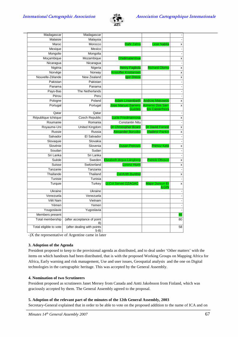
International Cartographic Association Association Cartographique Internationale
Minutes 14th General Assembly 2007 67
Madagascar Madagascar - Malaisie Malaysia -
Maroc Morocco Dafir Zahra Licer Nabila x Mexique Mexico -
Mongolie Mongolia - Moçambique Mozambique Chidimatembue x
Nicaragua Nicaragua - Nigéria Nigeria Henry Fagbola Richard Olomo x
Norvège Norway Kristoffer Kristiansen x Nouvelle-Zélande New Zealand Igor Drecki x
Pakistan Pakistan - Panama Panama -
Pays-Bas The Netherlands - Pérou Peru -
Pologne Poland Adam Linsenbarth Andrzej Makowski x Portugal Portugal Jose Manuel Barreiro
Guedes Armenio Dos San-
tos Castanheira x
Qatar Qatar - République tchèque Czech Republic Lucie Friedmannova x
Roumanie Romania Constantin Nitu - Royaume-Uni United Kingdom Dr Christopher Board Dr David Forrest x
Russie Russia Alexander Borodko Vladimir Pankin x Salvador El Salvador -
Slovaquie Slovakia - Slovénie Slovenia Dusan Petrovic Primoz Kete x Soudan Sudan -
Sri Lanka Sri Lanka - Suède Sweden Elizabeth Argus Längberg Patrick Ottoson x Suisse Switzerland Lorenz Hurni x
Tanzanie Tanzania - Thaïlande Thailand Col.Krith Bunthid x
Tunisie Tunisia - Turquie Turkey Lt.Col Servet OZAGAC Major Dursun Er
ILGIN x
Ukraine Ukraine - Venezuela Venezuela -
Viêt Nam Vietnam - Yémen Yemen -
Yougoslavie Yugoslavia - Members present 46 Total membership (after acceptance of point
8) 80
Total eligible to vote (after dealing with points 5-8)
58
-)X the representative of Argentine came in later 3. Adoption of the Agenda President proposed to keep to the provisional agenda as distributed, and to deal under ‘Other matters’ with the items on which handouts had been distributed, that is with the proposed Working Groups on Mapping Africa for Africa, Early warning and risk management, Use and user issues, Geospatial analysis and the one on Digital technologies in the cartographic heritage. This was accepted by the General Assembly. 4. Nomination of two Scrutineers President proposed as scrutineers Janet Mersey from Canada and Antti Jakobsson from Finland, which was graciously accepted by them. The General Assembly agreed to the proposal. 5. Adoption of the relevant part of the minutes of the 12th General Assembly, 2003 Secretary-General explained that in order to be able to vote on the proposed addition to the name of ICA and on

International Cartographic Association Association Cartographique Internationale
Minutes 14th General Assembly 2007 68
the proposed change to article 24 of the statutes, the number of members with voting rights had to be determined first. This was dealt with partly in items 5, 6 and 8 of the provisional minutes of the 12th General Assembly held in Durban August 10 and 16, 2003. Secretary asked for a proposal to accept this part of the minutes. This proposal came from New Zealand and was seconded by Norway and Finland. Secretary asked for a vote; there were no abstentions and no votes against, so this part of the provisional minutes was accepted. So Albania, El Salvador, Estonia, Guinea, Madagascar, Nicaragua, Nigeria, Panama, Qatar, Sudan, Tunisia, Ukraine and Vietnam were still without voting right. This meant that of the 78 ICA members, 13 had no voting rights, and this results in 65 countries with voting right. As Ukraine had paid up since, its voting right was restored, and this resulted in 66 countries with voting rights. 6. Members ineligible to vote Secretary-General indicated that the following countries had not paid up their membership dues for more than 3 years: Colombia, Ghana, Iceland, Kenya, Mongolia, Peru, Romania, Tanzania, Venezuela and Yemen. According to the statutes the Executive Committee had the right to suspend the voting rights of these members. Secretary-General asked for the support of the General Assembly for this proposal, it was proposed by Spain and seconded by the United Kingdom. A majority supported the proposal, no votes against and one abstention (Hungary). So the proposal was accepted. This left the number of members with voting rights at 66 less 10 i.e. 56. 7. Withdrawal of Membership There were no proposals for withdrawal of membership 8. New member nations There were applications from two member nations, who both had paid their membership dues: Cyprus, represented by the Dept of Lands and Surveys, and Benin, represented by the Association Béninoise de Cartographie. President first asked for a proposal to have Cyprus as a new member, this was done by Greece. There was one vote against this proposal (Turkey), and 1 abstention (Slovenia) but all other countries agreed to the proposal. Turkey than handed in a declaration regarding the new membership. President then asked for a proposal to accept Benin as a member which, when put to the vote, was accepted by general acclamation. President congratulated the two new members, especially Mr Elykkos Elia, the representative of Cyprus who attended the general assembly. The addition of these two members resulted in an increase of the number of members with voting rights to 58. 9. New affiliate members President stated that since the 12th General Assembly at Durban two companies had applied for affiliate membership, both from Poland. These were PPWK, the national mapping organization, and Eko-Graf which produces road maps and tourist guides. The first opted for two membership units and the second for one. President asked the general assembly to ratify this application, which was agreed by acclamation. President then welcomed the new affiliate members. 10. ICA Statutes Past President then put to the vote the proposal to change the statutes and modify the name of ICA by adding the subtitle International Association for Cartography and Geographic Information. Following a request made at the national delegates meeting during the week, the ballot now allowed for separate votes on the two issues. As both proposals would result in changes to the statutes, they could only be accepted when more than half of the members with voting rights (that is more than half of 58, or more than 29) accepted the proposal. Before the ballots were handed out, Lorenz Hurni, the delegate from Switzerland, read a statement in which he advised to keep to the old name (see appendix).

International Cartographic Association Association Cartographique Internationale
Minutes 14th General Assembly 2007 69
The scrutineers reported the results of the ballot in which 46 votes had been received. The president announced the results as follows: 42 members had voted for accepting the change in article 24 of the statutes, with no abstentions and 4 votes against. 26 members had voted for the addition of the subtitle to the name of ICA, 2 had abstained and 18 had voted against. As this number of 26 was below the required number of more than half the members with voting rights, this second proposal to add the subtitle to the name was not accepted; the name would remain without a subtitle. Awards While the votes were being counted, President invited Dr David Rhind, to come forward, and presented him with the Carl Mannerfelt Gold Medal, and Past-President Bengt Rystedt did likewise with Prof Ernst Spiess. Their respective citations were read and the diplomas handed over, and they were congratulated by the EC members and the General Assembly at large. Venue of 2009 conference Mr Luis Alegria Matta showed a DVD on Santiago and Chile, after President had announced that Santiago in Chile had been selected as venue for the 2009 international cartographic conference. The images of Chile were much appreciated and President thanked Chile for its willingness to organise this conference.
11. Any other business - 11.1 WG on Mapping Africa for Africa The Executive Committee had informed the previous General Assembly in Durban about the institution of a working group on Mapping Africa for Africa, to be headed by Haggai Nyapola. It now also submitted the terms of reference that had been drawn up for this working group. EC Liaison is Bengt Rystedt. Kenya suggested that Haggai Nyapola should not longer be a member of the Executive Committee as he ceased working for the Survey of Kenya. President answered that he had been elected as vice-president by the General Assembly in his personal capacity and not as Surveyor-General of Kenya. Past-President added that Mr Nyapola had also been designated by the Executive Committee as chair of the Working Group on Mapping Africa for Africa because of his personal qualities, and that he was doing an excellent job in that capacity. 11.2 WG on early warning and risk management The EC submitted the terms of reference of this working group established by the EC since Durban, chaired by Wilbur Ottichilo (Kenya) and with Ute Dymon (USA) as a vice-chair. EC liaison is Bengt Rystedt. 11.3 WG on Use and user issues The EC submitted the terms of reference of this new Working Group chaired by Corné van Elzakker (Netherlands), established by the EC in A Coruña. EC Liaison is Ferjan Ormeling. 11.4 WG on Geospatial analysis and Modeling The EC submitted the terms of reference of this working group, established in A Coruña, chaired by Bin Jiang (Sweden). EC Liaison is Kirsi Virrantaus 11.5 WG on Digital technologies in cartographic heritage The EC had established this working group in A Coruña, with Evangelos Livieratos (Greece) as chair, and now submitted its terms of reference. EC Liaison is Ferjan Ormeling. Alberta Bianchin from Italy asked whether it was indeed wise to establish this working group because of two considerations: In the first place in Durban a debate questioned the desirability of continuing work on the history of cartography within ICA now that the international conferences on the history of cartography covered that field

International Cartographic Association Association Cartographique Internationale
Minutes 14th General Assembly 2007 70
satisfactorily. This debate is ongoing. In the second place she warned against a working group that would concentrate on the digital analysis of old maps, because for old maps the cultural context in which they have been produced is just as important, if not even more so, than the geometrical aspects. Therefore it might be counterproductive to have a separate group to look at the digital analysis of the geometrical aspects. Secretary-General answered that in his opinion every discipline needs its history, and therefore to leave our history to another body would be a mistake. An impressive amount of work has been done within the commission on the history of cartography, when chaired by Robinson, Wallis and Pelletier, and that had been possible because of the special commission structure ICA has and which is lacking in the ICHC group, and which allows experts to work together on specified projects, like the book on innovations in cartography. It would have been better if the working group established now would have been part of the commission on the history of cartography, but that had not been possible. Mme Ruas from France asked on what principles Working Groups were started. Secretary-General answered that this was a rather subjective procedure. The Executive Committee discerns gaps in the activities of the commissions or identifies new groups of scholars prepared to collaborate, and uses the instrument of the working group in order to see whether the results these groups come up with merits the proposal to turn them into a commission. 11.6 Commission on Geovisualization and Virtual environments President stated that at the request of the current chair, the chair and the vice-chair of the Commission on Geovisualization and Virtual Environments would change places. Menno-Jan Kraak would now chair the commission henceforward until the Moscow Conference. 11.7.Commission on Cartography from satellite imagery President stated that the chair and the vice-chair of the Commission on Cartography from Satellite Imagery would also change places. Graciela Metternicht (Australia) will chair the commission until 2007. It is for the very reason that if commission chairs are impeded to do their work, their vice-chairs can take over, that the post of commission vice-chair has been established (see ICA Directory, Duties and responsibilities of ICA officers, Commissions and Working Groups). 11.8 - Other matters -Mr Emmanuel Odoi-Yemo from Ghana stated that participation from Ghana was minimal, because of problems with visa and costs. He asked what the Executive Committee could do to improve this situation for future conferences. President answered that steps would be taken, by sending lists of potential participants to embassies in advance, to establish the bona fides of those asking for visa. -Mr Adam Linsenbarth from Poland remarked that national committees should be more proactive to get ICA affiliate members, in order to improve the financial situation. He also complained that ICA’s official documents were not coherent; he had sent in a list of potential corrections to the statutes. -President answered that his letter was passed on to the ad-hoc commission working on a proposal to amend the statutes in time for the General Assembly in 2007. -The representative from Poland also argued for the rights of national and affiliate members to propose persons as members of commissions. -Secretary-General answered that that right existed, but that the final say in accepting commission members rested with the commission chair, who was responsible for realizing the targets stated in his/her commission’s terms of reference. -Mr Karel Kriz from Austria asked Commissions to help African countries -Mme Anne Ruas from France asked how the EC proposed to deal with the ‘no shows’ in future.

International Cartographic Association Association Cartographique Internationale
Minutes 14th General Assembly 2007 71
-Vice-President Lorenzo explained, that the no shows in A Coruña consisted of people that had paid their registration costs and even had arrived in A Coruña. It was then very difficult to prevent that they would not turn up when their papers were due. -Christopher Board from the UK proposed to have a number of reserve papers, as had been the case in earlier conferences. This would necessitate having adequate notices advertising programme changes. No response was noted. 12. Closure No other matters being raised, the president closed the General Assembly at 11.15, thanking all national delegates for their cooperation and support. Ferjan Ormeling ICA Secretary-General Utrecht, November 3, 2006 (gratefully acknowledging the grammatical corrections made by Chris Board) Appendix 1: Statement from Switzerland regarding the vote on the name of ICA ICA General Assembly A Coruña, Aug. 16 2005 Statement of the Swiss Society of Cartography concerning the change of the name of ICA presented by Lorenz Hurni Dear colleagues Since ICA was founded 46 years ago in Berne, the Swiss Society of Cartography feels somehow obliged to let you know its opinion about the change of the name of ICA. We think that instead of discussing formal aspects we should rather concentrate on contents in ICA. ICA lives through well selected papers presented in well organised and well navigated conferences and commission workshops. Furthermore we should use our strength to influence organisations and institutions who actually lead the agenda in GI science such as OGC, ISO, INSPIRE etc. etc. This conference has shown that the technological hype of the last ten years is now lowered to a reasonable level. We can now concentrate again on our core business, the application of our cartographic know-how to all kind of old and new media. And we are sure that our knowledge is more appreciated than ever. ICA is a well-known brand. We therefore ask you to keep a name which properly fits the brand: International Cartographic Association. Thank you!
International Cartographic Association Association Cartographique Internationale
Minutes 14th General Assembly 2007 72
Appendix 2 - Statutes for the ICA Fund
ICA Fund for Supporting Cartography and Geographic Information §1 Establishment and Purpose The ICA Executive Committee decides to establish the ICA Fund for Supporting Cartography and Geographic Information with the purpose to support students and professionals in cartography and geographic information, and to propagate cartography and geographic information preferably in developing countries, which are member nations of the ICA. The fund is established in accordance with the Swedish Law for Idealistic Organisations and Foundations (SKV 324, 14th edition, July 2006). §2 Contributions Annually, part of the ICA budget will be transferred to the Fund by the ICA Treasurer. Donations from any organisation or individual in the cartographic and GI science community are welcome, but may be denied if the donor has claims that contradict the values of ICA as a scientific or non-governmental organisation. §3 Maintenance The capital of the Fund is maintained by a committee with three members. One of these shall be the ICA Treasurer and the other two appointed by the ICA Executive Committee. The other two appointed may not be members of the ICA Executive Committee. The Treasurer shall not chair the committee but have the authority to effect transactions decided by the committee. The capital may be invested in shares, bonds or revenue funds with the purpose to get good and safe return. The Executive Committee may specify policy on investments. §4 Applications Applications for scholarship, travel awards or other actions for competence development shall be addressed to the Secretary General of ICA and decided by the ICA Executive Committee. The application shall contain the name, address and recognised merits of the applicant as well as purpose and expected effects on the personal development or enhancement of cartography and GI science. A written report of how the award has been used is required from the recipient. Any unused part of the award must be repaid. Applications for scholarships or travel awards are open for cartographers and GI scientists, preferably from developing countries (as defined by the UN). Guidelines for travel awards can be found in the ICA Reference Documents (www.icaci.org). §5 Accounting and Auditing The ICA Treasurer shall handle the accounts in such way that incoming and outgoing contributions, as well as the result of the financial maintenance of the fund, can be reported separately from the main accounts of the Association. The committee as indicated in §3 shall prepare an annual report showing the activities and economic result. The report shall be
International Cartographic Association Association Cartographique Internationale
Minutes 14th General Assembly 2007 73
lodged with the auditors by the end of February each year. The committee is also responsible for completing a tax declaration in accordance with the regulations of the relevant tax authority. §6 Endorsement The EC decision to establish the Fund and these statutes are endorsed by the 14th ICA General Assembly of Delegates, Moscow August 4, 2007.

International Cartographic Association Association Cartographique Internationale
Minutes 14th General Assembly 2007 74
Appendix 3 – Annual Fees
Pays-membre/ MemberCountry
Cotisation actuelle/Current fee
Proposed addition New fee Category
Number of units
Albania 250 250 1 1 Algeria 250 250 1 1 Argentina 250 250 1 1 Australia 750 250 1000 4 4 Austria 500 250 750 3 3 Benin 250 250 1 1 Belgium 250 500 750 3 3 Brazil 250 250 500 2 2 Bulgaria 250 250 1 1 Cameroun 250 250 1 1 Canada 1500 1500 5 6 Chile 250 250 1 1 China 1000 500 1500 5 6 Colombia 250 250 1 1 Croatia 250 250 1 1 Cuba 250 250 1 1 Cyprus 250 250 1 1 Czech Republic 250 250 1 1 Denmark 250 250 500 2 2 Ecuador 250 250 1 1 Estonia 250 250 1 1 Finland 250 250 500 2 2 France 1500 500 2000 6 8 Germany 1500 500 2000 6 8 Ghana 250 250 1 1 Greece 500 500 2 2 Guinee 250 250 1 1 Hong Kong 250 250 500 2 2 Hungary 500 500 2 2 Iceland 250 250 1 1 India 1000 1000 4 4 Indonesia 250 250 500 2 2 Iran 750 750 3 3 Ireland 250 250 500 2 2 Israel 250 250 500 2 2 Italy 250 500 750 3 3 Japan 1000 500 1500 5 6 Jordan 250 250 1 1 Kenya 250 250 1 1 Korea 250 250 500 2 2 Lithuania 250 250 1 1 Mocambique 250 250 1 1 Latvia 250 250 1 1 Madagascar 250 250 1 1 Malaysia 250 250 1 1 Mexico 250 250 500 2 2 Mongolia 250 250 1 1 Morocco 250 250 1 1

International Cartographic Association Association Cartographique Internationale
Minutes 14th General Assembly 2007 75
Netherlands 500 250 750 3 3 New Zealand 250 250 1 1 Nicaragua 250 250 1 1 Nigeria 250 250 1 1 Norway 250 250 500 2 2 Pakistan 250 250 1 1 Panama 250 250 1 1 Peru 250 250 1 1 Poland 500 250 750 3 3 Portugal 250 250 500 2 2 Qatar 250 250 1 1 Romania 250 250 1 1
Russian Federation 1000 500 1500 5 6 Salvador 250 250 1 1 Slovakia 250 250 1 1 Slovenia 250 250 1 1 South Africa 750 750 3 3 Spain 750 250 1000 4 4 Sri Lanka 250 250 1 1 Sudan 250 250 1 1 Sweden 500 250 750 3 3 Switzerland 500 250 750 3 3 Tanzania 250 250 1 1 Thailand 250 250 1 1 Tunisia 250 250 1 1 Turkey 500 500 2 2 Ukraine 250 250 1 1 United Kingdom 1000 500 1500 5 6 USA 2000 500 2500 7 10 Venezuela 250 250 1 1 Total 78 countries 31750 9000 40750 167 Category I II III IV V VI VII 44 14 9 3 5 2 1
International Cartographic Association Association Cartographique Internationale
Minutes 14th General Assembly 2007 76
Appendix 4 – Statutes for ICA THE STATUTES A) Aims of the Association
Article 1. The International Cartographic Association (ICA) has the following aims:
a) Advancing the study of cartographic or geographic information (GI) science issues In particular it is concerned with the processing, storage and analysis of source material and the design, construction, reproduction and display techniques of maps and associated forms of graphic communications. To this end, co-operation with different branches of geodetic, geographic and other scientific research disciplines is desirable.
b) Initiating, fostering and co-ordinating research in cartography and GI science, involving the co-operation between different nations, the exchange of ideas and documents, the furtherance of education and training in cartography and GI science, and encouraging the dissemination of cartographic and GI science knowledge.
c) Organising international and regional conferences, meetings, exhibitions and outreach programmes, etc., and participation in similar meetings facilitated by other organisations.
d) Establishing commissions and working groups to work on issues of particular interest to cartography and GI science.
e) Promoting and ensuring equity in all matters and at all levels of responsibility within the Association and amongst its members.
The ICA subscribes to the 1958 declaration of the 8th General Assembly of the International Council for Science (ICSU) concerning non-discrimination on the basis of politics, nationality, religion, race or gender.
B) Incorporation into an existing international scientific organisation Article 2.
The ICA may be affiliated with other international organisations.
C) National representation Article 3. National representation and membership of the Association.
Any nation which pursues a cartographic or GI science activity can be accepted as a member nation of the ICA provided that it agrees to participate financially in supporting the Association and in collaborating actively in its scientific and technical activities. Each nation can only be represented by one single organisation, which should preferably be the national society or committee for cartography or GI science. Thus, a member nation is represented by a national member organisation such as one of these. Furthermore, the ICA can accept requests for affiliated membership from international or national scientific, technical or other organisations made for the purpose of collaborating in its activities, and without compromising the principle of single representation of each nation in the official functioning of the Association or affecting the methods of voting as described in Articles 4, 26 and By-law 5. Application to become a member nation or affiliate member shall be made by letter to the Secretary General and Treasurer and may be approved by the Executive Committee subject to ratification at the next General Assembly of Delegates. Article 4. Delegates and voting rights Every member nation has the right to one vote in the General Assembly of Delegates. For this purpose, each member nation is represented at the General Assemblies of the Association by a principal delegate and by a deputy, who may vote in the absence of the principal delegate. However, at the request of the Executive Committee, the General Assembly may withdraw the right to vote from member nations which have not paid their contribution for the previous three years.

International Cartographic Association Association Cartographique Internationale
Minutes 14th General Assembly 2007 77
Article 5. Activities and reports The task of each national member organisation is to facilitate and co-ordinate, within in its nation, the study and development of the different aspects of cartography and GI science. Every member nation or affiliate member, either individually or in conjunction with one or more of the other member nations or other affiliate members, can submit motions (see Article 10) to the Association which are appropriate to the Association for discussion. Each national member organisation agrees to send a report to each General Assembly on the cartographic and GI science activities in the country during the previous four years. D) Official Organisations of the Association Article 6. Official organisations of the Association are:
• the General Assembly of Delegates (See Articles 7-11),
• the Executive Committee (See Articles 12-14),
• the Office of the Secretary General and Treasurer (or Secretariat) (See Article 16),
• Commissions and Working Groups (see Article 24),
• the Publication Committee (See Article 27),
• the Statutes and By-laws Committee (See Article 28),
• the Selection of Award Recipients Committee (See By-law 4),
• the ICA Fund for Supporting Cartography and Geographic Information Committee.
E) The General Assembly of Delegates Article 7. Composition of the General Assembly of Delegates
The General Assembly of Delegates is formed from the principal delegates of each national member organisation and their deputies, who are able to attend, and the members of the Executive Committee. If the Executive Committee so permits, additional delegates may attend the General Assembly of Delegates as observers. A member nation, which is represented on the Executive Committee, can nominate that committee member as its principal delegate with the right to vote. Normally, the President of the Association will preside at the General Assembly. Article 8. Authority of the General Assembly of Delegates
The General Assembly of Delegates
• decides on the policy and Statutes and By-laws of the Association,
• ratifies the membership of new members, which have been considered and approved by the Executive Committee,
• elects the President, the Secretary General and Treasurer, the Vice-Presidents and two auditors,
• receives the reports of the Executive Committee and the Commissions and Working Groups for the previous period of office,
• decides on the budget and the resources available for the following (four-year) period,
• determines the programme of activities in general and decides, in principle, on planned activities or meetings, including the next meeting of the General Assembly.,

International Cartographic Association Association Cartographique Internationale
Minutes 14th General Assembly 2007 78
• establishes Commissions, elects the chairpersons of Commissions and approves the terms of reference, subject to the provisions of Article 24.
Article 9. Meetings of the General Assembly of Delegates
The General Assembly of Delegates will normally meet every four years. At each General Assembly the time and place of the next meeting will be decided or, if this is impractical, the decision will be made by the Executive Committee. In special circumstances, with the agreement of the Executive Committee, the President has the right to call an Extraordinary General Assembly. The President is also obliged to do so if one third of the member nations demand it. As a rule, the General Assembly will be held in conjunction with an International Cartographic Conference (ICC).
Article 10. Agenda
The agenda of every General Assembly of Delegates is decided upon by the Executive Committee. It will be communicated to the representative of each member nation three months before the General Assembly of Delegates takes place. In order to make this feasible, national member organisations, who want to bring an issue to the agenda, must propose a motion on that issue in writing to the Secretary General and Treasurer at least five months before the date of the General Assembly. See also By-law 8. Motions not listed on the agenda cannot be brought to that Assembly for a decision. However, the President is entitled to accept such motions, but for discussion only.
Article 11. Voting
Decisions at the General Assembly shall be taken by a show of hands and by a simple majority vote, of those delegates present, who have the right to vote. However, if at least two delegates make a request, the vote shall be taken by ballot. Should there be an equal division of vote, the President shall cast the deciding vote. Voting by proxy will not be permitted and no delegate shall represent or vote for any other member nation. Voting by correspondence will be permitted only in accordance with Articles 28 and 30.
F) The Executive Committee Article 12. Composition of the Executive Committee
The Executive Committee of the Association consists of the following members:
• The President of the Association, who presides over all regular and extraordinary General Assemblies, the meetings of the Executive Committee, International Cartographic Conferences and acts as the main representative of the Association.
• A Past President, who shall serve for one term following the term of President. The office of Past President may remain vacant.
• Five to seven Vice-Presidents, the exact number to be decided at the General Assembly of Delegates. They assist the President in the performance of his or her different duties.
• A Secretary General and Treasurer, who is responsible for the administration and the general running of the Association.
The duties to be conducted by Executive Committee members are specified in the reference document DUTIES AND RESPONSIBILITIES OF ICA OFFICERS.
Article 13. Election of the Executive Committee
No member nation may have more than one representative on the Executive Committee. The President, the Vice-Presidents and the Secretary General and Treasurer shall be elected by the General Assembly of Delegates and shall hold office until the end of the following General Assembly. They can be re-elected, but with the following restrictions:

International Cartographic Association Association Cartographique Internationale
Minutes 14th General Assembly 2007 79
• the President may not serve for three consecutive terms,
• the Vice-Presidents and the Secretary General and Treasurer may not serve for three consecutive terms.
In the event of a vacancy arising in the Executive Committee in the period between two General Assemblies, the Executive Committee, after consultation with the member nation which the person represented, will appoint a replacement from the same member nation to serve until the next General Assembly at which a new Executive Committee is elected. If a vacancy arises in the Presidency, an Acting President will be elected by the Executive Committee. The Secretary General and Treasurer shall organise the election as soon as possible following the vacancy.
Article 14. Authority of the Executive Committee
The Executive Committee is responsible for the general functioning of the Association and represents it wherever necessary. A quorum of half the members of the Executive Committee, plus one, is required to validate decisions of the Committee. It prepares and organises the General Assembly of Delegates, oversees the International Cartographic Conferences and other meetings, and compiles reports on them. It may form Working Groups. It prepares guidelines and rules for the formation and operation of Commissions and Working Groups, including their functioning and reporting, and the managing of funds allocated for their support. It examines and, if necessary, modifies proposed terms of reference, in discussion with the proposed Commission chairpersons before presentation to the General Assembly for decision.
As a rule, it meets once a year, but may meet whenever deemed necessary, at the invitation of the President or by request from at least three of its members. The members of the Executive Committee perform their duties without remuneration. The time and place of the International Cartographic Conference between General Assemblies may be determined by the Executive Committee.
Article 15. Domicile of the Association
The domicile of the Association is determined by the President.
Article 16. Secretariat
A secretariat may be installed, either at the meeting place of the General Assembly of Delegates or at the domicile of the President or of the Secretary General and Treasurer. Such a secretariat may have paid employees, whose salaries are to be determined by the Secretary General and Treasurer with the approval of the Executive Committee.
Article 17. Auditors
The Auditors are elected by the General Assembly of Delegates for the period between two successive General Assemblies. The Secretary General and Treasurer submits to them, in good time, all necessary documents to enable them to render to the General Assembly, a complete report on the accounts, and on the financial position of the Association. This report has to be presented to the Executive Committee before the Delegates meet. The Auditors have, at all times, the right to carry out any checks and inspections which seem necessary to them. They perform their duties without remuneration. They can be re-elected.
G) Budgets, Funds Article 18. Budget
The amount of the annual subscription unit will be determined periodically by the General Assembly of Delegates by means of a by-law (By-law 2). This subscription provides the operating budget for the Association
Article 19. Use of funds The income of the Association is to be devoted to paying for:
• the cost of administration,
• travel costs within the limits decided by the President and/or the Secretary General and Treasurer,

International Cartographic Association Association Cartographique Internationale
Minutes 14th General Assembly 2007 80
• the remuneration of any paid staff in the office of the Secretary General and Treasurer,
• any purchase designed to achieve the general purposes of the Association as approved by the General Assembly,
• scholarships, travel awards and other contributions from the ICA Fund for Supporting Cartography and Geographic Information.
Article 20. Payment of subscriptions
Each national member organisation and affiliate member is responsible for paying the annual subscription. If a national member organisation has not paid its subscription for three consecutive years, the Executive Committee may decide that it shall be given observer status until payment is made. If they refuse to pay they will cease to form part of the Association by a decision taken by the General Assembly of Delegates. The Executive Committee can institute individual membership of ICA. This will be introduced at a later date and regulated by the By-laws.
H) Organisation of activities Article 21. Execution of activities
According to Articles 1, 5, 8 and 14 the Association organises different types of activities in order to achieve its aims. The details of such activities are to be decided by the Executive Committee. However, major events should be endorsed by the General Assembly of Delegates.
Article 22. International Cartographic Conferences
International Cartographic Conferences (ICC) may be called by the Executive Committee independently of the regular General Assemblies of Delegates, but preferably they should, if possible, be co-ordinated with them regarding time and location (see Article 9). The General Assembly of Delegates entrusts, to one of the member nations, the organisation of an ICC. The host nation shall decide the programme subject to the approval of the Executive Committee.
Article 23. Joint meetings
Special meetings, called 'joint meetings', may be organised together with other organisations. The Executive Committee decides, in each case, on the time, place and working programme of such joint meetings.
Article 24. Commissions, Working Groups and Task Forces The General Assembly of Delegates may establish commissions for the execution of important cartographic and GI science tasks. The tenure of office of a Commission is limited to the period between two General Assemblies, but may be extended for another period by a vote at a General Assembly of Delegates. A Commission is chaired by an individual, who is to be elected at each General Assembly. The General Assembly shall, at the same time, approve terms of reference for that Commission. A commission also includes a number of other members invited by its chairperson. A number of corresponding members may also be selected. In the event of a vacancy in the chair of a Commission occurring between General Assemblies, a new chairperson shall be appointed by the Executive Committee having regard to the recommendations of the members of the Commission. After approval of the Executive Committee a Commission may allocate a part of its work to a national institution, official or private, or to individual persons. Between two successive General Assemblies the Executive Committee may form Working Groups, whose chairpersons it appoints and whose mandate it defines. Commissions and Working Groups are required to present reports of their work to each General Assembly of Delegates. The General Assembly may authorize participation by the Association in formal joint Working Groups with other international organisations. The President may set up Task Forces for solving special tasks or projects that have to be performed urgently.
Article 25. Invitation of additional persons as observers

International Cartographic Association Association Cartographique Internationale
Minutes 14th General Assembly 2007 81
The President of the Association is entitled to invite to General Assemblies, International Cartographic Conferences, Symposia or Joint Meetings, suitable additional persons as observers or guests, including persons who are not from a member nation of the ICA.
Article 26. Voting at meetings other than General Assemblies
At Commission and Working Group meetings, all participants have the right to vote on purely scientific or technical questions. But if the issue is on the general conduct or on the administration or financial matters of the Association, it should be handled by General Assemblies. Meetings at which decisions are made shall be documented by minutes. Conferences, symposia and joint meetings may adopt resolutions. All participants have the right to one vote each in the adoption of a resolution.
Article 27. Publications All publications of the Association require the approval of the Executive Committee. The Executive Committee will arrange for the publication of a bulletin or newsletter concerning the activities of the Association and its member nations, and facilitate the publication of papers on cartography and GI science. For consideration of other publications, the Executive Committee shall appoint a Publications Committee consisting of a Chairperson and three members, only one of these four may be a member of the Executive Committee. The President and the Secretary General and Treasurer shall be additional members ex officio. The tenure of office of the Committee shall be the same as the Executive Committee, but the members may be re-appointed. The Publications Committee will examine proposals for publications (including commission reports), approve plans in terms of production, format and style, budgets and expenditure and distribution arrangements. I) Changes to the Statutes, duration and dissolution of the Association.
Article 28. Changes in the Statutes
Motions concerning changes in the Statutes must be received in writing by the Executive Committee at least five months before the General Assembly of Delegates. Provided this is done, the Executive Committee must present to the General Assembly any motion for changes in Statutes and include the motion on the agenda for the General Assembly (see also Article 10). The Executive Committee may itself propose motions for changes in the Statutes and the adoption, modification or rescinding of By-laws to be included on the agenda for the General Assembly of Delegates. The Executive Committee may establish a Committee on Statutes and By-laws for advice. In order for a motion to be accepted, an absolute majority of the voting member nations of the Association is necessary, voting in person or by correspondence. For votes on changes to the Statutes, a member nation, not represented at a General Assembly, may forward its vote to the President of the Association by letter. For such a vote to be valid it must be received by the Secretary General ten days before the motion is presented to the General Assembly of Delegates. Changes in Statutes are effective immediately after the General Assembly at which they are adopted.
Article 29. By-laws
Within the framework of these Statutes, the General Assembly of Delegates shall have the power to adopt By-laws. These may be adopted, modified or rescinded by a simple majority of votes expressed by the principle delegates attending the General Assembly. Changes in By-laws take effect immediately after the General Assembly at which they are adopted.
Article 30. Dissolution of the Association
A decision to dissolve the Association is only valid with the consent of at least two-thirds of the member nations. In the case of dissolution, the funds of the Association will be placed, by the General Assembly of Delegates or the Executive Committee, at the disposal of one or several international scientific organisations, whose aims are closely related to cartography or GI science. K) Official Languages Article 31. Languages
The official languages are French and English. Other additional languages may be used if the necessary translation facilities can be provided.
Article 32. Decisive Language

International Cartographic Association Association Cartographique Internationale
Minutes 14th General Assembly 2007 82
In cases of doubt on the interpretation of the statutes the French text only shall be used in deciding the meaning given to the Articles.
THE BY-LAWS By-law 1
a) Each member nation subscription to the ICA shall be expressed in 'subscription units'. All adhering member nations are divided into categories, numbered I to VI, and will pay annually the number of subscription units specified in that category.
b) The categories and subscription units shall be as follows :
o Category Number / Number of subscription units
I 1 II 2 III 3 IV 4 V 6 VI 8 VII 10
c) Each member nation shall select the category into which it wishes to be classed. The Executive Committee may refuse a specification if the category chosen is believed to be inappropriate.
d) The amount of the subscription unit, and the currency or currencies in which the subscription will be made, will be determined by the General Assembly on recommendation by the Executive Committee.
e) The subscription for Affiliate members, as defined in By-law 5(a), is set as a minimum of one subscription unit for categories (1) and (2), a minimum for two subscription units for category (3) and (4) and a minimum of ten subscription units for category (5).
By-law 2
The annual subscription is determined to be € 250 per unit until further notice.
By-law 3
The ICA may grant to outstanding cartographers such awards and honours as are approved by the Executive Committee upon the recommendation of a Committee for the Selection of Award Recipients.
By-law 4 The President shall appoint a Committee for the Selection of Award Recipients after each General Assembly to serve until the next General Assembly. The Committee shall consist of five representatives, each from a different member nation. No more than two representatives can hold concurrent membership of the Executive Committee.
By-law 5 (a) For the purpose of affiliation as described in Article 3 the following categories shall apply : (1) (International) Educational establishments (2) National cartographic or GI science societies other than the national member organisation (3) National scientific organisations and technical organisations
These include academic, research or technical institutes or other scientific or technical bodies, governmental or autonomous, that are users of cartographic data and are demonstrably devoted to the discipline of cartography and GI science to the satisfaction of the Executive Committee.
(4) Nationally operating private firms/companies
These include such organisations that are engaged in the development, production or manufacture of cartographic or allied equipment or products and are committed to supporting the interests of the discipline of cartography and GI science to the satisfaction of the Executive Committee.

International Cartographic Association Association Cartographique Internationale
Minutes 14th General Assembly 2007 83
(5) Internationally operating private firms/companies
These include such organisations that are engaged in the development, production or manufacture of cartographic or allied equipment or products and are committed to supporting the interests of the discipline of cartography and GI science to the satisfaction of the Executive Committee.
(b) Application for affiliation in category (a)(2) must be submitted to the Executive Committee with a letter of support from the member nation.
(c) Application for affiliation in categories (a)(1) to (a)(5) must be submitted to the Executive Committee in writing.
By-law 6
ICA member nations and affiliates shall be entitled to the following services:
• Invitation to all ICA International Cartographic Conferences.
• One free copy of all ICA publications including the ICA newsletter.
• Free copies of National Reports presented to ICA General Assemblies. Free copies of the published collection of presented conference papers when made available, posted to members and affiliates unable to be present at the conference.
• Training courses, from time to time, as the need is demonstrated and finance is available.
• Preferential treatment in exhibitions of ICA.
Upon request, the ICA may assist in sponsoring conferences, seminars and symposia in member nations or in conjunction with affiliates. Assistance may consist of:
• a financial contribution conditional on due recognition being given to the ICA and/or
• support of a member of the Executive Committee of ICA to attend and participate in the meeting.
By-law 7 All national and affiliate members may propose one representative for each commission for consideration by the chairperson of that commission.
By-law 8
Nominations for President, Secretary General and Treasurer, and Vice-President of the Executive Committee, and nominations of chairpersons of commissions, duly proposed by their respective member nations, must be received by the Secretary General at least five months prior to the date determined for the General Assembly of Delegates. Such nominations must be accompanied by an indication in writing from the candidate that he/she is willing to serve, supported by a brief CV.
The foregoing Statutes and By-laws are as amended by the 14th General Assembly held in Moscow on the 4th and 9th of August 2007.
International Cartographic Association Association Cartographique Internationale
Minutes 14th General Assembly 2007 84
Appendix 5 – Commission Terms of Reference 2007-2011 Commission on Cartography and Children by Temenujka Bandrova and José Jesús Reyes
1. Disseminate the outcomes of research into map use by children and young people. Deliverable: an enhanced set of online bibliographic tools and web links on cartography and children.
2. Develop stronger links between the ICA and relevant international and regional organizations. Deliverable: a joint international conference within the EU, other regional organization or worldwide.
3. Stimulate a debate on all aspects of cartography for children with the aim of collecting and publishing the research results (in digital or/and printed format). Deliverable: a collection of papers on case studies in educational cartography.
4. Promote the use of digital cartography and GIS in schools. Deliverable: an international (and/or regional) conference and associated publication.
5. Provide consultative support in relation to the rules and judging of the Barbara Petchenik Children's World Map Competition. Deliverable: appropriate support as required.
Commission on Digital Technologies and Cartographic Heritage by Evangelos Livieratos Aim of the commission is the study and research on the possibilities of applying new information and communication technologies (ICT) on issues related to the cartographic heritage, focused on the following Terms of Reference:
1. Support transformation of old maps, globes and cartographic documents into digital form.
2. Apply digital techniques in the study of old maps.
3. Develop digital tools for assisting the work of map curators and the functionality of map libraries networking and access to cartographic heritage.
4. Apply digital support for the preservation and restoration of old maps, atlases and globes.
5. Foster ICTs in teaching and diffusing history of cartography and maps to the public.
Commission on Education and Training by David Fraser
1. Work for reaching the general aims conceived in the ICA Statutes.
2. Develop the existing ICA-sponsored Internet cartography teaching programme (modules), with regional workshops for training the teachers.
3. Produce an ICA-sponsored Internet programme for continuing professional development, with regional workshops for training the teachers.
4. Support cartography and cartographic education in developing nations by holding seminars in these nations.
5. Promote integration by establishing linkage with the committees on education of sister surveying and mapping disciplines, by maintaining the list of institutions providing cartography course programmes, and interact as much as possible with other ICA commissions and working groups (organize joint meetings).

International Cartographic Association Association Cartographique Internationale
Minutes 14th General Assembly 2007 85
6. Produce appropriate publications for dissemination of results of the above efforts and publish it in proceedings or on the CET website according to the IOF publication policy.
7. Promote joint project cooperation between participating nations represented on the commission.
8. Contribute to international forums where applicable.
9. Develop mapping awareness competitions.
10. Investigate the role of emerging technologies for use in education and training.
Commission on Generalisation and Multiple Representation by William Mackaness and Sebastien Mustiere
1. Foster research and practical experience in multi-scale issues and automated map generalisation and to form a network and focal point for researchers and practitioners in this domain.
2. Foster and maintain a liaison with related commissions and working groups within the ICA as well as in related national and international organisations (e.g. ISPRS, IGU, EuroSDR), including : -identification of contact persons -timely mutual updating on planned activities -organisation of joint conference sessions and/or workshops
3. Maintain a World Wide Web site for electronic dissemination of research on multi-scale issues and map generalisation, including : -a membership database, -a bibliographic database, -examples of research projects and test data, -links to related web sites,
4. Organise sessions and meetings for exploring the issues named above, including : - workshops held every two years in conjunction with international cartographic conferences - special sessions and/or panel sessions at international cartographic conferences, in collaboration with local organisers
5. Produce publications for dissemination of the above efforts, including one special issue of a peer-reviewed scientific journal or a book every two years.
Commission on Geospatial Analysis and Modeling by Bin Jiang
1. Network cartographers, geographic information scientists, and other researchers involved in geospatial analysis and modeling;
2. Facilitate the interaction and communication between the computational community and cartographic community for creation of geographic knowledge;
3. Foster a new research community centered on visual geospatial analysis and modeling;
4. Organise ICC sessions and ICA workshops on geospatial analysis and modeling;
5. Edit and publish geospatial analysis and modeling related reports, books, and special issues with some scientific journals.

International Cartographic Association Association Cartographique Internationale
Minutes 14th General Assembly 2007 86
Commission on Geospatial Data Standards by Antony Cooper
1. Continue the work on developing conceptual models of the Spatial Data Infrastructure (SDI) using various modelling techniques, working in the areas of science, technology and standards, at the Global, Regional and National levels.
2. Explore research in the area of spatial semantics, ontologies and standards, in collaboration with other ICA Commissions.
3. Participate at the scientific level with other organizations active in standards and SDIs. This work will be closely coordinated with the ICA Executive Committee.
4. Develop reports, conference presentations and/or journal articles on our work, or hold specialist meetings on these topics.
5. Help to arrange workshops on standards and present tutorials at such workshops.
6. Organize reporting sessions on the Commission's activities at the 2009 and 2011 ICA meetings.
7. Organize and hold full Commission meetings in the summers of 2008, 2009, 2010 and 2011.
8. Organise and hold mini-meetings of the Commission at suitable conferences and meetings being attended by members of the Commission.
9. Continue to serve as a Category A Scientific Liaison with ISO/TC211, Geographic Information/Geomatics, and establish liaisons with various SDI organizations.
10. Exchange information and reports by the ICA member countries and relevant bodies concerning the development standards for the transfer of digital spatial data, metadata and SDIs.
11. Maintain the Commission World Wide Web Home Page.
12. Identify research and education needs that arise from the standards and SDI processes.
Commission on Geovisualization by Gennadi Andrienko
1. Promote, develop and report upon the use of cartography in its widest sense in the exploration and analysis of spatial information through interactive visual interfaces;
2. Define short and medium term research goals that address key issues associated with this work and its application;
3. Encourage a multi-disciplinary and international approach to this work that draws upon and contributes to the efforts of relevant stakeholders (such as international and national organisations promoting and coordinating research), cognate disciplines and ICA commissions and working groups.
Outline of Activities:
• expert workshops for defining key issues, promising research directions, and opportune goals and, on this basis, planning further activities of the Commission;
• annual meetings focusing on particular discipline / theme /objective hosted in different countries in conjunction with international research conferences;
• committed co-chairs and key committee members - each to coordinate one such meeting;
• developing and publishing research presented at these meetings through peer-reviewed papers where appropriate;
International Cartographic Association Association Cartographique Internationale
Minutes 14th General Assembly 2007 87
• a web-log of activities, research undertaken and related research / activity.
Commission on the History of Cartography by Elri Liebenberg:
1. Investigate the impact of technological innovations (printing methods, topographical surveying, aerial photography, satellite imagery and geographical information systems) on cartography during the last two centuries;
2. Document the recent history of GI science in general and computer-aided mapping and Geographical Information Systems in particular;
3. Examine the changing role of maps worldwide as cartographical (as opposed to historical) documents in history during the 19th and 20th centuries;
4. Examine the significance of the cartographical work undertaken during the 19th and 20th centuries by the traditional colonial powers and all countries which extended their sovereignty over territory beyond their borders;
5. Compile a list of useful sources on the history of cartography since 1800, which do not as yet appear in published catalogues or electronic databases;
6. Maintain a dedicated website to act as a database for interested researchers;
7. Hold annual meetings/conferences to discuss and monitor research work undertaken;
8. Publish research findings in accredited journals and on the Commission website.
Commission on Management and Economics of Map Production by Philippe deMaeyer
1. Extend Production Management knowledge in economics, planning and organizing, cost calculations, guidelines for production, quality assurance and quality control.
2. Complete publications: Compendium of Cartographic Techniques, Flow Charting - Tools for Managing and Education, Surveys of software and hardware.
3. Investigate (new) channels for publication with emphasis on technical, managerial and financial aspects. This includes also map publishing. Amongst all matters like Printing-on-demand- Webpublishing and Archiving should be researched.
Commission on Mapping from Satellite Imagery by Graciela Metternicht
1. Maintain and improve the digital repository of the Commission on topics related to: a) analysis of existing and forthcoming satellite imagery in view of their potential inputs for producing and updating topographic and thematic maps and databases; b) cartographic capabilities of different remote sensing systems.
2. Produce a special edition the ICC theme 'Cartography and satellite imagery for the management of natural resources and the environment, early warning and natural disasters mitigation' with papers to be presented at ICC2009 or ICC 2011, in a scholarly journal of remote sensing, or a book on Mapping from Satellite Imagery.
3. Develop closer links with international organisations concerned with the use of satellite imagery (e.g. UNOOSA, UNEP, PAIGH), in view of strengthening ICA's presence, and to produce joint courses or seminars on cartographic applications of satellite imagery.
International Cartographic Association Association Cartographique Internationale
Minutes 14th General Assembly 2007 88
4. Promote knowledge transfer at fundamental and advanced levels on the use of satellite imagery for cartographic applications related to natural and built environments, early warning and natural disaster mitigation.
5. Prepare promotional materials reflecting the Commission's terms of reference and activities that can be used to support ICA presence at international forums (e.g. World Map, Map Middle East, meetings of Joint Societies, UN meetings, other regional conferences). Outcomes: posters, fact sheets, booklets.
6. Network with ISPRS and other ICA commissions with similar interests in applications of satellite imagery. Such networking would be in view of producing joint workshops or seminars within the period 2007-2011.
Commission on Map Projections by Daan Strebe
1. Establish a repository of knowledge on map projections
2. Promote map projections within all disciplines
3. Provide a platform to promote research and a common language in the field of map projections
4. Encourage collaboration between researchers within the field of mapping sciences as well as across disciplines
Commission on Maps and Graphics for Blind and Partially Sighted People by Dan Jacobson
1. Exchange and disseminate information on the design of and production technologies for maps and graphics for blind and partially sighted people.
2. Study and evaluate developing and appropriate technologies and resources for the improvement of maps and graphics for blind and visually-impaired people.
3. Explore the potential value of maps and graphics designed for blind and visually-impaired people to other user groups (e.g. children and those with learning difficulties).
4. Develop closer links with the World Blind Union and to extend this co-operation to the International Mobility Conference and other appropriate organizations to further world-wide co-operation, communication and education in the use of maps and graphics by blind and visually-impaired people.
5. Integrate the workings of this commission more closely with other ICA commissions.
6. Disseminate, as appropriate, results of the above efforts.
Commission on Maps and Society by Chris Perkins This Commission would have parallel academic and practical rationales. These aim to facilitate and encourage the use of social scientific and critical approaches to mapping and to encourage a more active engagement between cartographers and other groups in society engaged in mapping activities. In 2007-2011 we would
1. Develop a Maps and Society web site to act as a clearinghouse and one stop shop for researchers and practitioners in this area

International Cartographic Association Association Cartographique Internationale
Minutes 14th General Assembly 2007 89
2. Sponsor and organise sessions at future ICA conferences
3. Organize two specialist workshops on topics related to Maps and Society These would be local meetings to generate increased ICA participation from groups in different global contexts
4. Encourage publication in this area, specifically publication of an issue of The Cartographic Journal in 2008/09 arising from this theme and publication of a research monograph
5. Collaborate and participate with representatives of other disciplines in meetings and seminars
6. Hold joint meetings with specific mapping communities focusing upon different mapping encounters. In the first four years these might focus upon, artistic practice, participatory community mapping and graphic designer practice.
Commission on Maps and the Internet by Michael Peterson
1. Focus attention on disseminating maps and spatial data through distributed electronic networks including wireless networks. Product: Books, journal articles and web pages.
2. Examine Internet and mobile Internet map usage and project future areas of growth. Product: Oral or published report.
3. Examine Internet and mobile Internet map user issues to better serve user needs. Product: Oral or published report.
4. Promote the exchange of information about effective Internet mapping for an international audience. Product: Workshop(s) and web pages.
5. Promote instruction on Internet mapping through collaboration /coordination with other ICA commissions and other cartographic institutions.
6. Produce materials to be used in workshops.
Commission on Marine Cartography by Patricio Carrasco
1. Promotion of marine cartography - Facilitate the networking of those member nations representatives on the commission as a resource through which marine cartography can be promoted. - Establish a home page for marine cartography on the WWW. - Establish and maintain routine and higher profile liaison with kindred scientific bodies such as the International Hydrographic Organization (IHO), the Hydrographic Society, Fédération Internationale des Géomètres (FIG), the International Association of Geodesy (IAG) and the International Geographical Union (IGU) and the International Society for Potogrammetry and Remote Sensing (ISPRS). - Encourage authors writing in the general area of marine cartography and provide contacts and assistance in the accessing of resources and material. - Represent and promote the work of ICA at appropriate fora. - Respond to issues referred by the ICA Executive Committee for advice and information.
2. Promotion of ICA and cartography as major contributors in the field of coastal zone management - Continue to conduct, in conjunction with the IGU Commission on Coastal Systems, the CoastGIS series of symposia. - Explore opportunities for training and workshops in GIS applications to the Coastal Zone within developing nations.
3. Encouragement of publications in the areas of marine cartography and, in particular, publications dealing with the coastal zone - Publish proceedings for all symposia/conferences/workshops organized by the commission. Encourage and where needed, seek out the preparation of articles in the area of coastal zone cartography.

International Cartographic Association Association Cartographique Internationale
Minutes 14th General Assembly 2007 90
- Target leading experts publishing an authoritative volume dealing with cartography and GIS within the coastal zone (planned in conjunction with IGU).
4. Ongoing co-operative activity - Provide a list of special features, objects and attributes relating to the coastal zone to IHO and to the Digital Geographic Information Working Group (DGIWG) for consideration. - Provide any proposed change to IHO Publication S-23 (Limits of Oceans and Seas) and to the Undersea feature names gazetteers (following the guidelines stated in IHO Publication B6).
Commission on Mountain Cartography by Karel Kriz
1. Further define the topics of Mountain Cartography and promote the methods and knowledge of mountain cartography among scientists and professionals in cartography and related fields
2. Provide an updated, attractive web-site with information about Commission activities, links to other events and theme-specific knowledge
3. Provide an updated web-portal with links to related web-sites and bibliographic information
4. Emphasise cartographic design issues and map related representations in large scale topographic mapping
5. Continue the well-established workshop series
6. Promote publication activities (proceedings, web-proceedings, journal articles and special issues) and common research activities.
Commission on National and Regional Atlases by Peter Jordan
1. Produce a cookbook for the production of (digital) national and regional atlases
2. Promote and support the design, production and use of national, regional, city and thematic atlases and atlas information systems
3. Conduct workshops and/or seminars that present recent and potential atlas developments and innovations
4. Document guidelines and procedures for the design, production and use of national, regional, city and thematic atlases
5. Elaborate and maintain an electronic inventory of national, regional, city and thematic atlases containing the main characteristics of these map works as well as relevant addresses in order to support information exchange between atlas editors as well as to disseminate information on atlases to a wider public
6. Maintain a commission website and update it regularly with the major aims of providing for information exchange between commission members and disseminating information on activities in this field to a wider public
7. Encourage efforts for integrating data for the development of electronic atlases and national and regional atlas information systems by - evaluating metadata standards as they apply to atlas design, creation and dissemination - acknowledging requirements for diverse geographic and temporal data themes - identifying and exploring various alternatives to data integration issues

International Cartographic Association Association Cartographique Internationale
Minutes 14th General Assembly 2007 91
Commission on Planetary Cartography by Kira Shingareva
1. Continue the documentation and analysis of the planetary cartography status within the international community.
2. Prepare and print the multilingual Glossary of planetary cartographic terms after necessary correction and reduction (in 5 languages).
3. Continue the series of multilingual maps in two parallel directions; i.e. to organize and print existing maps for new groups of languages, and to compile and print maps of other Solar System Bodies. In the next series the moons of the giant-planets will be included. The Io map is in progress.
4. Conduct a new project on construction of a Specialized Planetary Cartography GIS.
5. Discuss the role of planetary cartography in the development of the Extraterrestrial Territory Geography, especially in connection with the global education process.
6. Publish an Education Program and a Textbook on this field.
Commission on Theoretical Cartography by Alexander Wolodtschenko
1. Study selected topics of theoretical interest such as - general and applied cartosemiotics - map language and cartographic conceptions - mapping as a cognitive process - cartographic ontology - terminology
2. Compare and contrast theoretical structures in cartography
3. Publish a cartosemiotic glossary
4. Conduct workshops or symposia about selected aspects of theoretical cartography
5. Compile and publish a report and collected papers about the work of the commission
6. Continue to develop the commission web homepage
Commission on Ubiquitous Mapping by Takashi Morita
1. Organize regional workshop including site observation to comprehend contemporary situation of ubiquitous and pervasive mapping
2. Clarify similarity and difference in comparing variant systems to establish an evaluation scheme
3. Place the notion of Ubiquitous Mapping in the domain of Theoretical Cartography
Commission on Underrepresented Groups and Cartography by Wiesława Żyszkowska
1. Encourage representatives of under-represented groups to participate in all ICA activities
2. Serve as a resource on issues related to gender and other under-represented groups problems and cartography by: - preparing papers for presentation at conferences or for publication in cartographic journals; - preparing and disseminating on the Web a basic, working bibliography on publications (professional
International Cartographic Association Association Cartographique Internationale
Minutes 14th General Assembly 2007 92
papers, atlases, maps) related to gender and under-represented groups problems that are of interest to cartography;
3. Contribute to the understanding and solution of under-represented groups problems through the use of cartography in decision-making processes by: - holding the debate and distribute the professional knowledge concerning the making and use of maps presenting spatial distribution of different problems relating the under-represented groups;
4. Prepare a guide for the production and use of maps presenting the different problems of under-represented groups in the most effective way;
5. Organise a conference on „Using popular computer software for visualizing problems connected to under-represented groups”.
6. Continue the cooperation with other ICA Commissions and Working Groups, and with corresponding commissions or working groups of ICA sister societies.
Commission on Use and User Issues by Corné van Elzakker
1. Maintain an on-line bibliographical database with a bibliography on the user, usability (including User Centered Design and methods and techniques of user research) and improvement of user abilities.
2. Maintain a database of individuals working on, or with expertise in, the various use and user issues and denote it with keywords (similar to the category listings used in the bibliography) to stimulate exchange of information.
3. Produce a major publication on use and user issues in cartography and geoinformation processing and dissemination (either a special issue or a refereed journal or a text book).
4. Foster and stimulate other publications on use and user issues in cartography and geoinformation processing and dissemination.
5. Organize sessions on use and user issues at future ICA conferences.
6. Organize a specialist workshop in 2008 on a focused topic related to use and user issues in cartography and geo-information processing and dissemination.
7. Participate in / contribute to other workshops / seminars organized by representatives of other disciplines (e.g. computer science) or by other ICA Commissions / Working Groups.
International Cartographic Association Association Cartographique Internationale
Minutes 14th General Assembly 2007 93
Appendix 6 – The ICA Research Agenda
ICA Research Agenda on Cartography and GI Science
Kirsi Virrantaus, David Fairbairn Helsinki University of Technology
Department of Surveying Geoinformation and Positioning Technology
PO Box 1200, FIN-02015 HUT Finland University of Newcastle upon Tyne
School of Civil Engineering and GeoSciences NE1 7RU England
[email protected] , [email protected]
Background to the ICA Research Agenda Maps and Geographic Information (GI) have special power through their ability to connect and integrate data sets by the inherent geographical location, and present the information contents in a user-friendly and understandable visual and tactual way. Such ability has long been recognised as an intrinsic property of the map artefact, as well as contemporary geodatabases. The power of maps and geographic data handling has been recently recognized in many real world applications and strategic decision making situations related to current topics like crisis management, early warning systems, efforts for supporting sustainability and decreasing global poverty. The International Cartographic Association (ICA), as a globally well represented and internationally visible organization, has a special position and role as a promoter of the development of Cartography and GI Science. Research and development in ICA aim in general to create theory and methods for Cartography and GI handling. By applying theories and methods to various applications, new tools can be created for cartographic and GI practice. Such topics are addressed at the main work-forums of ICA, its Commissions. These organizations are formally established by vote at the quadrennial ICA General Assemblies, although interim Working Groups can also be established between General Assemblies by the ICA Executive Committee (EC) to address specific short-term issues. The idea of the ICA Research Agenda on Cartography and GI Science was initially considered at ICA Executive Committee meetings during the 1990s but the specific decision to work on a structured Research Agenda was taken at the London EC meeting in 2001, with a plan to organize a session on the issue at the International Cartographic Conference in Beijing in 2001. This session included several valuable presentations (including those from Professors Gruenreich, Meng, Mullen and Ormeling). The work plan for the Research Agenda development was made during the Mexico City EC meeting in 2005. It was realized that several ICA Commissions had overlapping research concerns while some new, challenging topics were outside of any Commission’s field. A formal Research Agenda would have a significant role in informing Commission members, General Assembly Delegates and ICC
International Cartographic Association Association Cartographique Internationale
Minutes 14th General Assembly 2007 94
attendees, of the integrated nature of research activity in Cartography and GI Science, the expanding scope of research and the role of ICA in promoting such activity. The Goal of the Research Agenda The goal of this agenda is primarily to give some guidelines for the Commissions' work as well as to lead to tighter co-operation between Commissions. The agenda can also support the development of the flexible Commission structure of ICA. From a practical point of view the agenda may outline the future contents of the proposed International Yearbook for Cartography and Geographic Information Science. More widely, the agenda is written in order to show ICA's actual and potential contribution to scientific research within our global society, and to serve as a moderator for discussions in that forum. In order to implement its own strategic mission, “to ensure that geospatial information is employed to maximum effect for the benefit of science and society” (ICA Strategic Plan, 2003), ICA must have a clear agenda for research covering all fields and topics under the title Cartography and GI Science. This agenda, therefore, documents current research activity in these fields, suggests areas where more intensive or renewed effort is required, and also discusses the methods by which some of this research can be undertaken – within ICA Commissions, through international collaboration with sister societies, and under suggested programmes of integrated research stimulated, we hope, by the presentation of this summary.
Process of Developing the Research Agenda The first preliminary study on research topics within the remit of ICA was made in the 2003 Budapest meeting of the EC and Commission chairs, who tried to outline the topics of interest to each Commission. The work was continued in 2005 in the Mexico City EC meeting as well as in A Coruña in 2005 in two brainstorming sessions for Commission and Working Group chairs and co-chairs, and the first draft documents outlining the research interests of Commissions were created. In the meetings the Mind Map technique was used and, based on that work, the first draft document was written, presented to the 2006 Moscow EC meeting, discussed and subsequently sent to the Commissions for comments. Commissions have been asked to provide additional text with relevant literature references on the topics that they feel important. The second draft was discussed in the EC meeting in Brno in 2007 and the plan for finalizing the agenda as well as publishing it in the Moscow ICC Proceedings was made. Before presentation, another round of comments among the Commission chairs has been organized.
The Structure of the Research Agenda The scope of the agenda is wide including both Cartographic and GI Science issues. Depending on the background of the interested researcher, the entire field can be approached by several ways. It is impossible to make a generic structure of the topics that fits all opinions.

International Cartographic Association Association Cartographique Internationale
Minutes 14th General Assembly 2007 95
It is also impossible to create a non-overlapping hierarchy of research topics. What has been done on the basis of common discussions has now been organized under subtitles or keywords. The definitions as presented by ICA (2003), have also influenced the scope of this agenda – a primary intention is to ensure that the topics discussed here fall within the accepted extent of Cartography and GI Science, and that we can also see synergies with closely related fields, notably in spatial data collection and handling.
Keywords The keywords have been extracted from the mind maps produced in the brainstorming sessions referred above. Short discussion on the keywords has been added in order to explain the role and/or meaning of each keyword. In the following text the important research topics are in bold. References to supporting fields of science or technologies are written in italic. It must be kept in mind that the topics cannot be organized totally hierarchically under the main keywords, but there are several topics that could be linked to more than one keyword. The keywords are:
1) Geographic Information, GI (We have decided to mainly use ‘Geographic Information’ in this document. Geospatial Information is considered as a synonym, and Geospatial is used in contexts where it is commonly used) 2) Metadata and SDIs (In the text spatial data infrastructures (SDI) has a synonym of ‘geospatial data infrastructure’; by adding the geo- prefix we can emphasize the real contents of the data in question) 3) Geospatial Analysis and Modelling (The emphasis is on the extraction of added value from the processing of spatial data on maps and the use of analysis and modelling techniques to initiate, support and supplement the mapping process)
4) Usability (This keyword covers a range of issues which connect the human user of spatial data with its representation, its processing, its modelling and its analysis) 5) Geovisualization, Visual Analytics (Here the visual representation of spatial data, in map and in other forms, is discussed, along with methods of using such representations) 6) Map production (This keyword stands for the numerous stages in mapping and map production as technical processes, but also production of various map types from Atlases to Internet maps.) 7) Cartographic Theory (The fundamental concepts which form the basis of all our spatial data handling are incorporated under this keyword) 8) History of Cartography and GI Science (The importance of the development of methods and practices throughout history was recognised in the brainstorming session: all current-day activity is informed by detailed accounts of such development) 9) Education (To ensure a valid and viable future for our current activity, we need to research and implement methods to educate and train future generations: methods of doing this fall under this research heading) 10) Society (A dominant research topic throughout has been the examination of how such spatial data handling is grounded in societal structures and how it is undertaken by different groups of people).

International Cartographic Association Association Cartographique Internationale
Minutes 14th General Assembly 2007 96
1. Geographic Information Geographic Information (GI) is the core of both Cartography/Mapping and GI Science/GI Systems applications. GI can be studied from various points of view: modelling, storing, processing and semantics. GI represents the natural and man-made, tangible and intangible world. Two main established models are used to represent various phenomena: discrete objects and field models. In addition to precise, crisp data, GI can also be imprecise and imprecise information needs special modelling approaches. Thus, it is important to consider research into imprecise geospatial data models, such as fuzzy models and rough sets. GI needs to be stored and handled as data in databases. The main methods of storage involve raster and vector organization. Spatial databases tend to be huge and spatial queries need to be supported by adequate spatial indexing. Some solutions already exist – like quad-trees and R-trees – but the topic is still relevant for further study in the context of GI. The dimensionality of spatial data – 2, 3 and sometime 4 dimensional in nature – adds to the complexity of handling such data. Advanced indexing methods exist but they need to be applied to the context of geographic information (see also Geospatial Analysis and Modelling). Databases need to be continuously updated and the techniques for updating are problematic. Basically two main approaches exist: 1) continuous updating, usually used when maps are derived from larger scale maps (e.g. detailed municipal large scale maps), and supplemented by other updating methods such as field-based methods, 2) updating based on digital images by using change detection methods or replacing maps entirely by newly interpreted ones. Thus research is needed to address incremental updating and versioning of vector format geographic databases and updating of map databases by using digital images and change detection methods on images. Geographical databases themselves are huge, and via the Internet one can reach even more information in integrated databases than is possible to manage. By using new methods of spatial data mining and visual data mining users can create new information and knowledge from the stored data. Satellite images as well as other gridded data products can also be mined and novel information and knowledge can be extracted from them by image mining and automated knowledge extraction. Satellite data and orthophotos are often used without interpretation as additional information in image maps. When combining interpreted, usually vector, and non-interpreted, usually raster, information together, problems of scales and granularities appear. The distribution of geospatial data across the Internet is becoming widespread, but there are many barriers to simple and effective access to geospatial data. OGC standards for serving data (Open Geospatial Consortium www.opengeospatial.org) are designed to assist, but they are not universally applied: there are implications of the contemporary geobrowser (e.g. Google Earth) model for cartographers to address, in handling, compiling and presenting geospatial data.
International Cartographic Association Association Cartographique Internationale
Minutes 14th General Assembly 2007 97
The semantics of geographic information links research to various application fields with related taxonomies of concepts. Ontology is an approach that aims to produce a common framework for different terminologies. Toponymy is related to geographic information in the sense of semantics as well. These topics affect attribute tagging, name (including geographical name) determination and processing flow lines in geodatabases. 2 Metadata and SDIs
Complete geospatial data infrastructures (SDIs) consist of contemporary, comparable and integrated geographic information at global, regional or national levels along with services that enable an efficient use of the information. There are numerous research issues associated with the design, implementation and use of SDIs. SDI policy including the political and administrative procedures required to initiate and maintain SDIs can be studied in order to enhance their utility. In practical terms there are problems such as copyright and pricing policies. Harmonization of databases can be based on appropriately applied ontology schemas and developed similarity measures. The fact that detailed geographic data are collected at different levels (municipal, regional, national) means that SDIs are likely to contain multiple representations in order to obtain the vertical integration. Effective generalization of maps as well as organization of multiple representations in databases could rationalize the production of topographic maps and assist in updating of databases. Such generalization requires significant consideration of conceptual schema, geometrical and spatial properties and visual appearance. It can be undertaken in real time (on-the-fly generalization) and it has links with Geovisualization and with the modelling described in the next section. Metadata is the key for geospatial data infrastructures at both national and global levels, and the derivation, storage, scope and use of metadata have been addressed through mature national and ISO standards on metadata of geographic information (ISO 19115:2003) as well as its extension to gridded and imagery data (ISO 19115-2:2007). A special part of metadata describes quality information. There is also an ISO standard on geographic data quality (ISO 19113:2002) with definitions of quality elements and measures to be used. However, the uncertainty issues are not solved only by publishing standards and by forcing the data producers to document metadata of the produced datasets. The users need to be able to evaluate also the uncertainty of the results of the analyses in which they combine several datasets of different quality. Thus evaluation of the uncertainty of the GI analysis results and estimating the risks of subsequent decision-making are further research issues of importance. Metadata is inherently multivariate and metadata representation by multivariate visualization methods, along with the usability of such visualizations needs to be examined. The linkages among metadata, data quality and visualization are potentially valuable. The metadata standard for gridded and imagery data, for example, introduces the ‘two-dimensional quality coverage concept’ and the ‘spatially varying quality concept’. These could be used for other data set types as well.

International Cartographic Association Association Cartographique Internationale
Minutes 14th General Assembly 2007 98
The visualization of data quality in general, and such spatially varying quality in particular, are examples of how map quality - including generalization quality - can be addressed.
3. Geospatial Analysis and Modelling By using geospatial analysis we try to describe, explain and predict geographical phenomena. Theories and methods adopted from mathematics, statistics, computer graphics and information theory have been integrated with GI Science approaches to yield a mature and useful toolbox for such analysis.
Spatial statistics represents one of the most important and core methodologies. Although not a new area in GI Science, there is scope to expand its applications considerably. In spatial data mining it is one of the core techniques and specific topics such as geostatistics, spatial autoregressive processes, and point processes deliver techniques of considerable interest. When applied to multivariate analysis, further specialist methods such as traditional principal components analysis and factor analysis, or more recent self-organizing maps (SOM) and k-means clustering analysis can be used. The development of realistic geospatial process models and those which incorporate time (spatio-temporal models) in a realistic manner will lead to improved representations of the real world. The models themselves must be understandable, applicable to a range of data sets and situations and must be capable of integration with others in processing workflows: geospatial process ontology needs development to ensure compatibility and interoperability. Several computational methods can be used in implementing these geospatial modelling and analysis methods. Intelligent agents, cellular automata, neural networks and fuzzy logic are examples of geocomputational methods, which have not yet been adopted as standard computational solutions in GI applications. Algorithm development is often undertaken on an ad hoc basis for specific tasks, but it may well use particular spatial data structures, such as Voronoi and TIN models, or use particular approaches, such as data compression (e.g. wavelets) or network analysis based on graph theory. The latter, in particular its extensions (e.g. labelling and weighting of graphs), has not been researched and applied enough in spatial problem solving. All these techniques to get spatial information and create spatial knowledge, related to data quality and risk issues, can be implemented to support spatial decision-making. 4. Usability of Maps and GI The starting point in the study of usability is the users themselves. These may be professional users such as administrative personnel and planners; some important groups of dedicated map users including children, the visually impaired, tourists, military, mass media, Internet users, ubiquitous/mobile users; along with occasional and amateur users.
Because of the large number and variation of users, map design should always be user oriented (user-centred design) and be based on good knowledge about the elements of usability. Today, maps are most often digital and interactive and thus users are able to

International Cartographic Association Association Cartographique Internationale
Minutes 14th General Assembly 2007 99
dynamically retrieve data for display and analysis from data bases. The representation of information needs to be different for different user groups. The previous situation, where maps were graphical presentations, with limited data contents that needed interpretation no longer applies. The limitation of the map now is more often the small size of the screen in the display equipment. The design of map interfaces for Internet, mobile devices etc. create a most demanding design problem. The special users of maps like visually impaired people would enjoy also various forms of interaction using tactual and audio interfaces to maps. For navigation and way finding applications even more exciting interfaces have been developed like augmented realities in helmets and intelligent clothes. The creation of usability tests – both qualitative and quantitative - for new maps and other visualizations, for example multivariate visualization techniques, is a challenging field.
Understanding cartographic communication is the starting point for both map design and usability analysis. Cognition and visual perception have been analysed in order to get theoretical basis for map design rules. Perception of maps leads to information acquisition and learning about the topic. Research in psychology and physiology, which cartographers should be aware of, continuously reveals new knowledge about the human perception processes: it would seem valuable to follow this and ensure that visual perception, as well as audio and tactual perception is taken into account. Learning theories based on contemporary approaches to perceptual studies also support map design and map use research. The users themselves are finding, querying, reading and applying maps in different ways than before. Research into methods of data assimilation and use of maps and geospatial data in particular situations (e.g. personal navigation) is necessary to assess the impact of contemporary displays in, for example, satellite navigation systems, public map displays and through unconventional media such as mobile devices. The role and meaning of mental maps, cartoids and cartograms is emphasized among researchers of cartographic communication. The skill of spatial thinking and spatial understanding of problems must be kept as the basis of map design. It is clear that an increasingly large number of map users are accessing cartographic products through mobile and position-enabled devices. It is absolutely essential that such forms of map use, here related to the broad field of Location Based Services (LBS), are effectively undertaken, and both the technology and the use of LBS are areas of prime concern to cartographic researchers. Adaptive maps modify themselves according to their location as well as the preferences and situation of the user. Contemporary research on navigation systems, satellite systems like the Global Navigation Satellite System (GNSS) and other positioning methods should be carefully examined by cartographers to detect synergies. 5. Geovisualization and Visual analytics Because there will always be a demand for paper mapping, studies of the effectiveness of static two-dimensional products, as well as (for example) three-dimensional scale models products are always needed. But Geovisualization techniques have extended the map medium to embrace dynamic, three- and four-dimensional data representation using methods which are interactive, capable of being supplemented by augmented and virtual realities, integrated with geodatabases, and flexible in application, platform, scale and content. In

International Cartographic Association Association Cartographique Internationale
Minutes 14th General Assembly 2007 100
many cases these involve multi-dimensional and multivariate representations such as parallel coordinates plots and star diagrams, along with interactive techniques such as brushing. A research agenda for Geovisualization was published by the ICA Commission on Visualization in 2001, and progress since then has addressed research areas such as representation methods (including virtual environments), database linkages for visualization, and cognitive issues in Geovisualization and knowledge acquisition through visualization. The more recent subject of ‘visual analytics’ extends the Geovisualization metaphor further to embrace integrated data mining and the development of decision making techniques through spatial thinking, visualization, analytical reasoning and knowledge engineering. Further new visualization developments in the field of games and simulators can be profitably examined in order to adopt novel and effective tools and methods for Geovisualization. Visualization is tightly linked to analysis by the means of explorative analysis. The importance of collaborative decision making supported by spatial representations and data sets is growing in many areas of human activity. For example, instead of one planner and decision maker there is a group of people at the same time around the same planning/decision-making task or accessing the same representation. Collaborative methods try to support these kinds of situations. In collaborative visualization instead of one person, there is a group of persons who are able to see the visualizations at the same time. This can happen in one space (for example, on a large or multi-screen or in a virtual reality CAVE) or in many places. By using the Internet it is possible to transfer both the visualization and the interactions of several users to allow for remote collaboration. There are technical issues such as updates, synchronisation of the data transfers and management of conflicts, which need to be solved. Collaborative tools as well as single user tools enjoy the existence of multi-media. It is important to realise that the focus of research in Geovisualization is not on the technical execution of the representation (although this is fundamental to the process), but is more directed to the data management to enable this, to possible tasks and application areas, and most notably to the role of the user in the visualization process. Thus, the impact of the visualization on knowledge acquisition (does the map present unknown information, or is it used to display and confirm previously known information?), its role as an investigative tool (is the map for private study, or is it part of a more public decision making process?), and its didactic capabilities (is the map being used interactively or is being read passively?) can be researched through models of visualization. 6. Map Production
Map production has long been a core practice of Cartography. Based on geodetic, photogrammetric, remote sensing or laser scanning based methods, topographic map production is a part of the surveying process. In each country, topographic mapping has its own traditions, including selection of the map projections and datum. Nowadays in many countries the geocentric WGS84 based systems are applied, but it is still an important part of Cartography to know the properties and applications of various projections and manage their application and the conversions between them. In practice many GIS software tools offer transformations from projections and coordinate systems to others, whilst mobile and ubiquitous applications might sometimes require transformations on the fly. Map

International Cartographic Association Association Cartographique Internationale
Minutes 14th General Assembly 2007 101
projections and transformations, along with associated mathematical studies of distortion, are valid areas of cartographic research. It is noteworthy that it is not only topographic mapping which must address these issues: the importance of reference frames to mobile applications, and the study of transformations of raster imagery (from satellite, aerial platforms and ground-based) are also essential, as is the reference system adopted within GI layers. Map production technology is a rapidly developing field. The new mapping technologies of satellite remote sensing, laser-scanning technologies and advanced GNSS technologies offer both fast and accurate acquisition of topographic data. However they also give new challenges for research and development as well as innovations for several application areas. A continuously developing range of field and remote data collection techniques ensures that map production flow lines must be able to handle spatial data varying in source, format, scale, quality, reliability and area of coverage. The role of cartographic knowledge as applied to map production is still important. Map design, already mentioned in connection with usability, covers issues such as symbolisation, text and label placement, generalization, colour selection and layout design. Such tasks always require understanding of the data compilation, the information compatibility and skills for aesthetic design. In cases of multi-lingual countries and production of printed maps, label placement is a challenging subtask in map design. Collection and standardisation of place names as such is an important part of map production and has important links to ontology and information management issues. The applications of map production processes and their development are core topics for public and private mapping organizations. There is a continuous interest in rationalizing and modernizing the production of maps and geospatial data sets. Such processes can differ depending on the map type: topographic or thematic, large or small scale, printed or digital. In topographic map production processes, the actual problems can come from quality management and harmonization needs, which may themselves be guided by the requirements of geospatial data infrastructures. In many countries there are attempts to rationalize and synchronize municipal and national mapping by trying to harmonize the data contents and take care about the quality management of production. Quality models, up-to date metadata descriptions, and associated process documentation are central issues. An enormous number of different categories of maps can be, and are, produced by a variety of methods. Thematic maps address particular concerns and portray specific data. Each category may have research issues associated with it. Some examples from specific ICA Commissions include: mountain maps, which must efficiently portray three-dimensional representations; marine charts, which must incorporate ongoing developments in electronic nautical charting (ENC); environmental maps, which are valuable contributors to risk mapping for early warning applications; military mapping, which can also assist in civil crisis management, but is also responsible for planning and execution of complex, technologically advanced military manoeuvres and campaigns, both in real-time and in simulators. Examples of other thematic map categories which could benefit from applied research work include tourist maps, orienteering maps, advertising maps, artistic maps, fantasy maps, geological and geophysical maps, cadastral maps, personalised maps, aeronautical maps, poverty maps, maps in text books, and mass media maps. Some thematic maps have global relevance because of the application: maps supporting scientific investigations into immediate problems, such as climate change and sea-level rise, are amongst the most important of these.

International Cartographic Association Association Cartographique Internationale
Minutes 14th General Assembly 2007 102
Other mapping functions for which production (perhaps as well as compilation and design) is a major issue include atlases and atlas information systems. The future of atlases has been debated for a long time, since the first versions of digital and interactive atlases were introduced. Multimedia atlases came soon after and now the concepts of Atlas Information Systems and web-atlases have been introduced and supplemented, supported by geobrowsers such as Google Earth and Wikipedia. Technologies to support the cartographic and GI data handling requirements of such products have to develop. Tactile and audio maps need special design and production technology; they cannot be side products of regular maps and are often not easily derived from the data. The established tasks of map production, in addition to being subject to variability in data handled, method of representation and application area, are subject to over-riding practical issues such as economic, legal and security matters (including confidentiality). Legal issues include copyright, privacy, liability and illegal use detection (using cartographic traps). Economic issues which can be researched include production models and map marketing. Finally, once the maps have been produced or the databases have been implemented, there is a need to manage the archive which they represent. This covers areas such as archiving, updating, metadata extraction and recording and further librarianship issues. As unique documents which need specialist curators and library resources for acquisition, storage and consultation, the role of maps in the contemporary library is changing. And as spatial data becomes increasingly available in non-standard media, the role of the curator must expand to incorporate new skills. 7. Cartographic Theory Fundamental cartographic theory has been addressed by the ICA Commission on Theoretical Cartography over many years, recognising that from a methodological point of view, conceptual analysis in Cartography is very important. Various structural models of Cartography (or its parts) have attempted to describe the process of mapping as a science, an academic discipline, a technology, or an inherent human impulse. Further, the tasks of cartographic design can be deconstructed, and the map artefact itself (e.g. is it a model, a language, a communication channel, a decoration or an archive?) can be examined. Since the mid-1990s, cartosemiotics has undergone development. It has general (theoretical) and applied (user-oriented) subdivisions, the latter encountered in both cartographic and non-cartographic traditions. Outside of the cartographic tradition, cartosemiotics may be applied in biology, geography, ecology, geology, linguistics, etc. The map semiotic approach to Cartography allows us to examine map syntactics (which links the graphical representation with aesthetics and other parameters of design), map semantics with map sigmatics (indeed this can form the basis of many studies of cartographic ontology) and map pragmatics (which attempts to cover the entire area of human experiences with maps, from perception and cognition, through use for navigation, to employment in artistic, cultural and literary works). Such investigation can improve the effectiveness of representations and data modelling. There are various communication and visualization models as presentation forms in Cartography. Further, cartographic representation entails conceptual modelling of the world

International Cartographic Association Association Cartographique Internationale
Minutes 14th General Assembly 2007 103
and can thus itself be studied as a cognitive process. The new term ’conception-analytical approach’ is a research area which has significant links to diverse conceptual models and spatial data handling in GI systems. More properly allied to spatial analysis, analytical cartography makes use of the spatial representations which cartography produces in order to examine patterns, trends and measures in the data. Analysis transforms geospatial data into knowledge. The nature of such map/cartographic/geospatial knowledge must be recognized, along with methods for describing and managing that knowledge. Cartographic theory may also assist in producing cartographic ontologies, which can be fundamental to the exploitation of cartographic databases and their applications. Terminology within cartographic fields themselves can be identified and developed: for example, glossaries of definitions and terms used in specialist areas. 8. History Cartography and the visualization of geographic information have a long and well-documented history. Considerable research is ongoing into a range of issues which can be regarded as dealing with the history of Cartography. These include the impact of map-making skills in societies throughout history, the way in which maps and geographic information have been used (both practically and for political and symbolic purposes), and the development of methods of production and the effect of changing technology. In addition, historical studies have examined ‘progress’ in mapping (e.g. increasing accuracies, scale, content, reliability throughout history – although not necessarily uni-directional) and have also been concerned with the preservation of the artefacts themselves. Within these broad approaches, specific issues can be identified. The history of printing technology is of considerable interest; the role of colonial cartography has been immense, especially in the 19th and 20th centuries; the dichotomy between private and government mapmaking has been fluid over many centuries. Such specific issues can be added to by considering the way in which recent and contemporary history of cartography is being addressed. It is important to document the rapidly changing, and artefact-poor, recent history of GI science and digital cartography. In addition to the history of Cartography as a discipline, the role of cartography in history has been researched by cartographers. Here the task of mapping, the role of maps, the propensity to map and the resultant impact of maps on a wide range of other human activities have all been recorded. Perhaps the most active research area currently which has links to this section is considering maps as cultural heritage, part of the patrimony and cultural inheritance of a society. But such maps are more than artistic relics – they are working documents which can be used for cultural investigation over a wide range of fields (including history, genealogy, archaeology, politics, architecture, sociology and geography). There are significant applications in this field for the application of contemporary digital techniques, and specialist geospatial databases have been created based on historical data, but capable of being examined using modern scientific cartographic analysis. 9. Education
International Cartographic Association Association Cartographique Internationale
Minutes 14th General Assembly 2007 104
From a practical viewpoint, it is clear that many of the highly skilled operations associated with Cartography and GI handling require training and experience. This, itself, is an area of concern for ICA. In the research context, however, education can be divided into scientific education in universities, education at schools and continuous education as a part of the profession (the latter also includes training and practical ‘on-the-job’ knowledge acquisition). Research in these areas has examined curricula, practices in distance learning, e-learning and professional updating, access to maps and spatial data, use of maps to promote attitudes and behaviours (e.g. spatial thinking), and establishment of a profile for Cartography which allows it to be applied and integrated with other subjects at school and in society. University curricula have been changed during the past years: it is clear that GI systems and GI science has taken over a place in the classroom from Cartography. The impact of new technologies and political pressures, such as the introduction of the Bologna pattern of study at European universities, has lessened the appeal of Cartography. However, Cartography is a subject which can and should play a larger role in curricula at many schools and universities. Curricula need continuous updating because of the rapidly developing technology and increasing methodology and theoretical knowledge. ICA must follow the developments at universities and also try to influence the development of educational programs. Universities in less developed countries could enjoy distance learning and virtual education, as long as the methods and content match research findings in this general area. Cartography and GI science as school subjects have taken some space in school teaching mainly in the geography and environmental programs. ICA should also try to influence to this change, particularly in developing countries. Schools should be able to enjoy Internet datasets and free software. Especially in elementary school education, spatial thinking and learning enhanced by using maps are interesting topics. These topics are related with more general research into pedagogic learning, but could be recognized more in cartographic research as well. 10. Society
Society is one of the five main ‘areas of operation’ of ICA and it also offers many interesting research topics from legal issues (including copyright and privacy questions) to ethics, democracy and equity. However, accessibility to cartographic and geographic datasets and GI services is a global problem – not all members of society with an interest or need to access geospatial data are in front of a desktop computer. Access problems for many make it impossible to get information and participate in the developing digital society. Gender problems together with other problems of under-represented groups and equity issues are a continuous topic. Within ICA these topics have been long recognized and from the research point of view it could be interesting to analyse the effects of the development of virtual services in an e-government context on the equity of individuals. Virtual geographies might also develop people’s ability in spatial thinking. Modelling the world, either in an individual or on a collective basis, is one example of social impacts that should be seriously studied.

International Cartographic Association Association Cartographique Internationale
Minutes 14th General Assembly 2007 105
The heading ‘Society’ covers the collection, handling and representation of many highly varied socio-economic spatial datasets which can be studied using Cartography and GI methods. Particularly important areas which are subject to significant contemporary mapping and geospatial data handling activity and research include health, unemployment, literacy, public services, cultures, age and human rights. As a globally visible and well represented organization, ICA can support and enhance the use of such geospatial datasets in the research of social questions at a global scale. Such approaches need the support and co-operation of national and international institutions and organizations, including national mapping agencies, global non-governmental organizations (NGOs) and world development bodies, including United Nations bureaux.
With the help of the Internet, maps are now distributed to users in very different ways than they were only a decade ago. This has introduced a host of research questions related to use of electronic networks for map distribution and the influence of the medium on the message of maps. In addition, the question arises as to which medium should properly be used in Cartography to assure the distribution of maps to the broadest possible audience. Likewise, questions must be asked about copyright and licensing of maps that are distributed through the Internet and how sophisticated online map servers will be maintained. This question has links to SDI as well. From the audience point of view it is most important that the research results are delivered equally to the users, whoever they may be or wherever they are.
Concluding remarks: How to implement the Research Agenda?
The purpose of this research agenda has been to identify and briefly elucidate some current and potential research issues which fall under the terms of reference of ICA and individuals and groups who work under its remit. Primarily this includes the Commissions of ICA each of which is charged with undertaking research work in their area. This agenda is intended to encourage the Commissions to consider their research areas, and to examine possible overlaps and co-operation possibilities with other Commissions. Further, it will assist in identifying those areas of Cartographic research which are not currently covered by any Commission and which need further encouragement. Finally, this document should disseminate the agenda of ICA to other organizations, both those with which we can undertake research collaboratively and those for whom the results of ICA sponsored research will be of value.
Clearly, therefore, we believe that this research agenda should be reflected upon by the constituent Commissions of ICA. One of the major responsibilities of the elected chairs of the Commissions is to develop a ‘Terms of Reference’ document which should explicitly list the deliverables expected over the four-year period of the Commission’s existence (the Commissions can be re-elected). Such deliverables should yield valid research results. A further duty of a Commission chair is to invite and manage a group of expert and interested individuals to achieve the deliverables. The work programme can be completed through focused research meetings and conferences (which can be during and around the time of biennial International Cartographic Conferences or at other times), through ongoing communications within the Commission, and through collaboration with Commissions in
International Cartographic Association Association Cartographique Internationale
Minutes 14th General Assembly 2007 106
sister societies. Alternatively it is hoped that this agenda can be used in a positive way by those individuals who are submitting proposals for funding to regional, national and international organizations.
In all cases, ICA expects the results of research to be widely disseminated for the benefit of itself, the wider cartographic community and society in general. The presentation of a Commission report is required at each quadrennial ICA General Assembly of Delegates and the opportunities to present research findings in the conference arena exist. Publication of research work in academic and scientific journals would also be expected, along with more informal communication through Commission websites.
Reference
“A Strategic Plan for the International Cartographic Association for 2003-2011 as Adopted by the ICA General Assembly, 2003-08-16” http://www.icaci.org/en/ICA_Strategic_Plan_2003-08-16.pdf).
Appendix 7 – Publications Report
International Cartographic Association (ICA) Publications Report March 2007
Robert B. McMaster Publications Chair
The following report details activity between July 2005 and March 2007. Three major volumes have been published (or will be shortly) including the standards, Childrens’ Map and generalization books. There was also a reprinting of the Internet book by Springer. Several commissions also published special issues of journals and proceedings. I have the following recommendations for the ICA Executive Committee.
1. The new President will need to select a new Publications Chair and committee. 2. The relationship between ICA and Elsevier should be reexamined. There continues to be regular
changes in personnel at Elsevier, and a lack of communication with the publications chair. Perhaps a new Chair based in Europe will help.
3. The ICA should consider publishing another Introduction to Cartography/GeoVisualization/ text, or marketing current versions (such as Kraak-Ormeling or Slocum-McMaster-Kessler-Howard) through ICA.
4. There needs to be a new set of initiatives put in place, with perhaps 2-3 new book projects launched. 5. The relationship with the three journals needs to be maintained, and perhaps 1-2 journals added.
Completed Books ''Generalisation of geographic information: cartographic modelling and applications" W. Mackaness, A. Ruas, L.T. Sarjakosky (ed.) should be delivered by the printer to Elsevier the 2nd April 2007. "World Spatial Metadata Standards". Elsevier. Harold Moellering, editor "International Perspectives on Maps and the Internet". 2007. Springer
International Cartographic Association Association Cartographique Internationale
Minutes 14th General Assembly 2007 107
Anderson, J.M., Atwal, J., Wiegand, P.A. and Wood, A.A. (Eds.) (2005) Children Map the World: Selections from the Barbara Petchenik Children's World Map Competition, Redlands, CA: ESRI Press. Journal Articles/Conference Proceedings Reyes, J (2006) ICA Commission on Cartography and Children: The First Ten Years. A selection of conference papers. CD. Proceedings of 1st International Workshop of the ICA WG on Digital Technologies in Cartographic Heritage, held in Thessaloniki Greece, May 18-19, 2006 (paperback,incl. 36 presented papers, E. Livieratos, Ed., ISBN 960-7999-18-5) http://cartography.web.auth.gr/Maplibrary/New/ICA_Heritage/Workshop/Proceedings.htm, order: [email protected] (15 Euros + post). Also in CD-Rom (10 Euros + post). The WG is going to have its 2nd International Workshop in Athens, Greece (May 18-19, 2007), see the announcement: http://cartography.web.auth.gr/2ndW/Index.htm and the relevant Proceedings will be also published in order to be ready (hopefully) for Moscow. The ICA Spatial Data Standards Commission recently had a scientific journal article accepted for publication in the International Journal for GIScience. They are still working on the final manuscript. Other Projects A.Wolodtschenko "Atlas cartosemiotics" (in Russsia). Verlag TU Dresden 2006, 100p. ISBN 978-3-86005-565-8 Special Issue of Cartographica on Geovisualization based on the Auto-Carto Conference. Menno Jan Kraak, editor. I have also written a piece on the relationship between ICA and journals for GIMM International that David Fairbairn is editing. The text follows: The ICA establishes a relation with three international cartographic journals. Over the past four years, the International Cartographic Association has established a relationship with three of world’s top cartographic journals. These three, Cartography and Geographic Information Science, The Cartographic Journal, and Cartographica have become “official journals of the ICA”. Since the 1960s, the global cartographic community has seen the growth of our professional literature. In addition to the many teaching and research books that have been published a series of nationally-based cartographic journals have been established. These include Cartography and Geographic Information Science (The United States), The Cartographic Journal (The United Kingdom), Cartographica (Canada), Kartographische Nachrichten (Germany), and Cartography (Australia). Initially, three of these journals expressed an interested in affiliating with the ICA.
The Cartographic Journal is sponsored by the British Cartographic Society, and published by Maney Publishing, Hudson Road, Leeds. As described on their web site (http://www.cartography.org.uk/), The British Cartographic Society (BCS) is a dynamic association of individuals and organisations dedicated to exploring and developing the world of maps. Membership includes Mapping companies, publishers, designers, academics, researchers, map curators, individual cartographers, GIS specialists and ordinary members of the public with an interest in maps. The Cartographic Journal, published twice each year, is free to members and on subscription to others in more than 50 countries. The journal contains authoritative articles and international papers on all aspects of cartography, the science and technology of presenting, communicating and analysing spatial relationships by means of maps and other geographical representations of the Earth's surface and includes coverage of related

International Cartographic Association Association Cartographique Internationale
Minutes 14th General Assembly 2007 108
technologies where appropriate, for example, remote sensing, geographical information systems (GIS), the internet and global positioning systems.
Cartographica is sponsored by the Canadian Cartographic Association. The Association, founded in 1975, has the goals of promoting interest in maps and related cartographic materials, furthering the understanding and knowledge of maps by encouraging research in the field of cartography, both historical and current, and providing for the exchange of ideas and information and for the discussion of mutual concerns, through meetings and by publications. See their website at http://www.cca-acc.org/about.asp. Cartographica (http://www.utpjournals.com/carto/carto.html) is dedicated to publishing articles on all aspects of cartographic and geovisualization research while also maintaining its tradition of publishing material on cartographic thought, the history of cartography, and cartography and society. Increasingly, Cartographica also plans to consolidate its trend towards publishing research contributions that focus primarily on geographic information. Cartographica is published quarterly with two or three regular issues and one or two single-topic monographs. The monographs, accommodating book-length manuscripts, focus on one particular area of cartography. The current editors are Roger Wheate, University of Northern British Columbia and Clifford Wood of Ilderton, Ontario.
The journal Cartography and Geographic Information Science (CaGIS) is affiliated with the Cartography and Geographic Information Society, a Member Organization of the American Congress on Surveying and Mapping. The Cartography and Geographic Information Society (http://www.cartogis.org/) supports research, education, and practices that improve the understanding, creation, analysis, and use of maps and geographic information. The society serves as a forum for the exchange of original concepts, techniques, approaches, and experiences by those who design, implement, and use geospatial technologies through the publication of authoritative articles and international papers.
The journal CaGIS, formerly The American Cartographer, is quarterly and publishes papers in basic cartography, analytical cartography, and geographic information systems/science (http://www.cartogis.org/publications). Every four years, the United States ICA national Report is published as a special issue. The Editor of CaGIS is Dr. Elisabeth Nelson, associate professor of geography at the University of North Carolina at Greensboro.
Each of these three journals will work with the ICA to publish their best work, and to offer the possibilities of special issues when possible. It is anticipated that other journals will become official ICA journals in the near future.

International Cartographic Association Association Cartographique Internationale
Minutes 14th General Assembly 2007 109
Appendix 2 Règlement du Fonds de l’ACI /The rules for the ICA fund I asked Bengt
Appendix 3: Agenda de recherche/Research agenda (asked Kirsi to send it again)