mosier - oregon.gov · mayor of the dalles. ... and continues beneath the columbia river into...
TRANSCRIPT

Historic Columbia River Highway Community Cycling Hubs
Mosier
March 2015
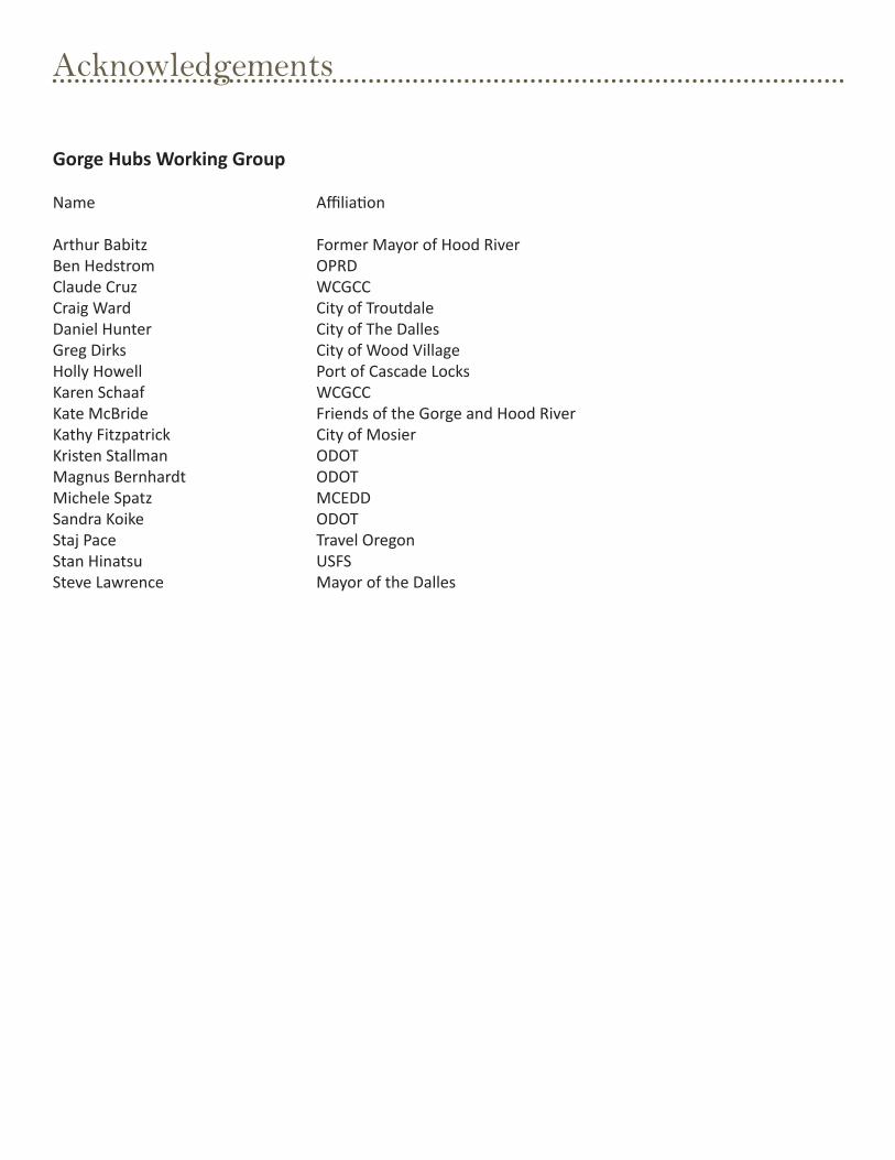
Acknowledgements
Gorge Hubs Working Group
Name
Arthur BabitzBen HedstromClaude Cruz Craig WardDaniel HunterGreg DirksHolly Howell Karen SchaafKate McBride Kathy FitzpatrickKristen StallmanMagnus BernhardtMichele Spatz Sandra KoikeStaj PaceStan HinatsuSteve Lawrence
Affiliation
Former Mayor of Hood RiverOPRDWCGCCCity of TroutdaleCity of The DallesCity of Wood VillagePort of Cascade LocksWCGCCFriends of the Gorge and Hood RiverCity of MosierODOTODOTMCEDDODOTTravel OregonUSFSMayor of the Dalles

Page | 3
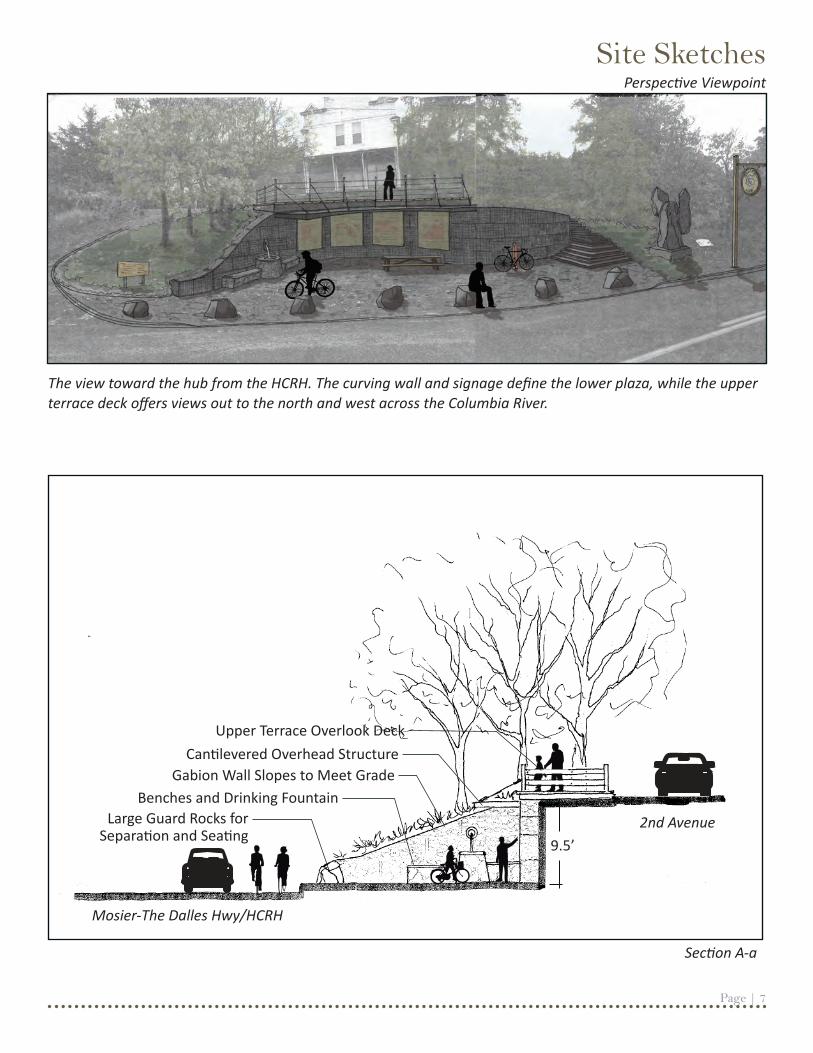
The Mosier hub is located directly along the Historic Columbia River Highway (HCRH) where it intersects with Oregon Street. Compared to other community sites, Mosier’s hub site is fairly undeveloped. The site was historically a tavern and a service station, and offers dramatic views of the Columbia River to the north. The site slopes steeply up from the highway to 2nd Avenue. The design takes advantage of this, creating two levels of use: an upper terrace provides an overlook and a great place for picnics, while the lower plaza area includes more user services like informational and wayfinding signage, a drinking fountain, additional seating, bike parking, and a bike fix-it station. The two levels are separated by a curving gabion-style retaining wall, and are connected by concrete steps. The gabion wall face could include details to evoke the famous Syncline geologic feature, which is seen from the site (looking north) and continues beneath the Columbia River into Mosier. Within the lower plaza, basalt guard rocks are used to define the hub edge and Highway. A roof structure over the signage panels provides another vertical element and shade from the summer sun. Wooden picnic tables and concrete benches are included for seating. As with other hubs, the site could be used to display local artwork, and a location for art has been specified west of the steps. Rather than use new concrete paving, the ground plane could be created using recycled concrete as irregular pavers for the lower plaza, and a wood deck is proposed for the upper terrace. The standard hub sign is placed near the site entrance along the Highway.
Amenities include--
Core amenities (common to all hubs):• Drinking fountain (new)• Signage, including informational/wayfinding and hub identifier (new)• Shelter structure (new)• Seating (new) • Paving (new)• Wayfinding maps (new)• Bike Racks (new)• Bike Fix-it Station (new)
Additional amenities: • Art (new)• Picnic tables (existing)• Overlook deck (new)
Design Description

Page | 4
Historic Columbia River Highway Precedent Imagery
Along the Historic Columbia River Highway, a palette of materials and details displays the timeless craftsmanship first established with the highway’s construction. This has since become an iconic element of traveling through the gorge. Some of these details, including stone-faced walls, drinking fountains, concrete benches, and white guardrail posts have been
incorporated into the hub design concepts, to provide a sense of connection to the HCRH and provide continuity along the state trail. In doing so, the user’s experience will remain connected to the HCRH and the gorge whether they visit a bike hub in Troutdale, Wood Village, Cascade Locks, Hood River, The Dalles or Mosier.
Page | 5
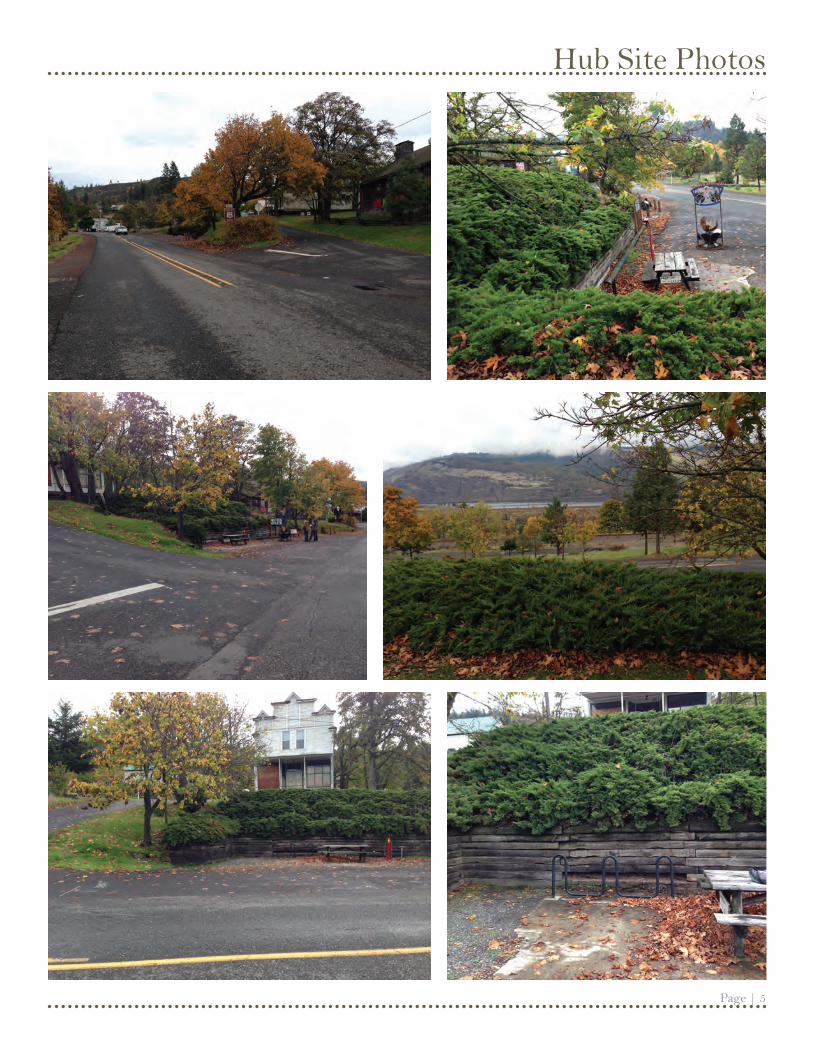
Hub Site Photos

Boulders for Separation and Informal Seating
Upper Viewing Terrace Deck
Section A-a
Steps Down
Recycled Concrete Pavers
Cantilevered Overhead Structure
Bike Parking
Bike Fix-It Station
Re-Vegetate Slopes with Native Plantings
Location for Public Art
Informational and Wayfinding Signage (Accessed from Lower Plaza)
Concrete Bench
Water Fountain
Existing Trees to Remain
Gabion Retaining Wall, with Syncline Motif
HCRH Identifier Sign
Standard Hub Sign
Conceptual PlanMosier Hub 0 10 20N 40
Perspective Viewpoint
Page | 7
Site Sketches
The view toward the hub from the HCRH. The curving wall and signage define the lower plaza, while the upper terrace deck offers views out to the north and west across the Columbia River.
Section A-a
Mosier-The Dalles Hwy/HCRH
Gabion Wall Slopes to Meet GradeCantilevered Overhead Structure
Benches and Drinking Fountain
Upper Terrace Overlook Deck
2nd AvenueLarge Guard Rocks for Separation and Seating 9.5’
Perspective Viewpoint

Page | 8
This page intentionally left blank
Page | 9
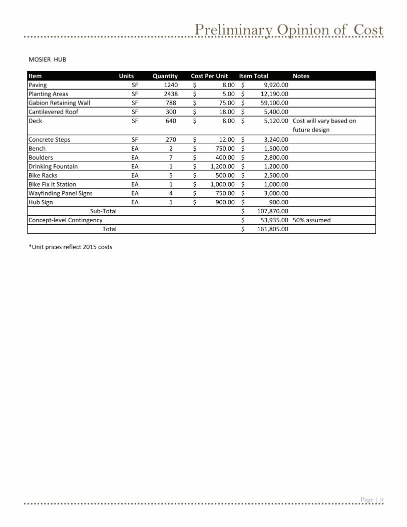
Preliminary Opinion of Cost
Item Units Quantity Cost Per Unit Item Total NotesPaving SF 1240 8.00$ 9,920.00$ Planting Areas SF 2438 5.00$ 12,190.00$ Gabion Retaining Wall SF 788 75.00$ 59,100.00$ Cantilevered Roof SF 300 18.00$ 5,400.00$ Deck SF 640 8.00$ 5,120.00$ Cost will vary based on
future designConcrete Steps SF 270 12.00$ 3,240.00$ Bench EA 2 750.00$ 1,500.00$ Boulders EA 7 400.00$ 2,800.00$ Drinking Fountain EA 1 1,200.00$ 1,200.00$ Bike Racks EA 5 500.00$ 2,500.00$ Bike Fix It Station EA 1 1,000.00$ 1,000.00$ Wayfinding Panel Signs EA 4 750.00$ 3,000.00$ Hub Sign EA 1 900.00$ 900.00$
Sub-Total 107,870.00$ Concept-level Contingency 53,935.00$ 50% assumed
Total 161,805.00$
*Unit prices reflect 2015 costs
MOSIER HUB

Historic Columbia River Highway Community Cycling Hubs