motor vehicle use map 2015
TRANSCRIPT

Motor Vehicle Use Map 2015George Washington and Jefferson National Forests
America's Great Outdoors VIRGINIA / WEST VIRGINIA - 2015
Forest ServiceUnited States Department of Agriculture FS-873-808

George Washington and JeffersonNational Forests
5162 Valleypointe ParkwayRoanoke, Virginia 24019-3050
Phone: (540) 265-5100Toll Free: 1-888-265-0019
PROHIBITIONS It is prohibited to possess or operate a motorvehicle on National Forest System lands on theGeorge Washington and Jefferson NationalForests other than in accordance with thesedesignations (36 CFR 261.13). Violations of 36 CFR 261.13 are subject to a fineof up to $5,000 or imprisonment for up to 6 months orboth (18 U.S.C. 3571(e)). This prohibition appliesregardless of the presence or absence of signs. This map does not display nonmotorized uses,over-snow uses, or other facilities and attractions onthe George Washington and Jefferson NationalForests. Obtain a forest visitor map for more Designated roads, trails, and areas may also besubject to temporary, emergency closures, andvisitors must comply with signs notifying them of suchrestrictions. A national forest may issue an order toclose a road, trail, or area on a temporary basis toprotect the life, health, or safety of forest visitors orthe natural or cultural resources in these areas. Suchtemporary and/or emergency closures are consistentwith the Travel Management Rule (36 CFR 212.52(b); 36 CFR 261 subpart B). The designation "road or trail open to all motorvehicles" does not supersede vehicle size or weightlimits imposed through State traffic law.
The U.S. Department of Agriculture (USDA)prohibits discrimination in all its programs andactivities on the basis of race, color, nationalorigin, age, disability, and where applicable, sex,marital status, familial status, parental status,religion, sexual orientation, genetic information,political beliefs, reprisal, or because all or part ofan individual's income is derived from any publicassistance program. (Not all prohibited basesapply to all programs.) Persons with disabilitieswho require alternative means for communicationof program information (Braille, large print,audiotape, etc.) should contact USDA's TARGETCenter at (202) 720-2600 (voice and TDD). To filea complaint of discrimination, write to USDA,Director, Office of Civil Rights, 1400Independence Avenue, S.W., Washington, D.C.20250-9410, or call (800) 795-3272 (voice) or(202) 720-6382 (TDD). USDA is an equalopportunity provider and employer.
OPERATOR RESPONSIBILITIES Operating a motor vehicle on National ForestSystem roads, National Forest System trails, and inareas on National Forest System lands carries agreater responsibility than operating that vehicle in acity or other developed setting. Not only must themotor vehicle operators know and follow allapplicable traffic laws, but they also need to showconcern for the environment as well as other forestusers. The misuse of motor vehicles can lead to thetemporary or permanent closure of any designatedroad, trail, or area. Operators of motor vehicles aresubject to State traffic law, including Staterequirements for licensing, registration, and operationof the vehicle in question. Motor vehicle use, especially off-highway vehicleuse, involves inherent risks that may cause propertydamage, serious injury, and possibly death toparticipants. Riders should drive cautiously andanticipate rough surfaces and features such as snow,mud, vegetation, and water crossings common toremote driving conditions. Participants voluntarilyassume full responsibility for these damages, risks,and dangers. Motor vehicle operators should takecare at all times to protect themselves and thoseunder their responsibility. Much of the George Washington and JeffersonNational Forests is remote, and medical assistancemay not be readily available. Cellular telephones donot work in many areas of the George Washingtonand Jefferson National Forests. Operators shouldtake adequate food, water, first aid supplies, andother equipment appropriate for the conditions andexpected weather. ALWAYS REMEMBER TO RESPECT PRIVATELAND! PROTECT YOUR PRIVILEGE. STAY ONDESIGNATED ROADS, TRAILS, AND INDESIGNATED AREAS. Read and understand this map in its entirety. Ifyou have questions, please contact the GeorgeWashington and Jefferson National Forests forclarification. Road, trail, and area users must comply with thismap, as well as all Federal, State, and local laws andregulations. Compliance with these rules is theresponsibility of the user.
CONTACT INFORMATION
Roads Open to Highway Legal Vehicles Only:These roads are open only to motor vehicleslicensed under State law for general operation on allpublic roads within the State.
Roads Open to All Vehicles:These roads are open to all motor vehicles,including smaller off highway vehicles that may notbe licensed for highway use (but not to oversize oroverweight vehicles under state traffic law).
Trails Open to All Vehicles:These trails are open to all motor vehicles, includingboth highway legal and non highway legal vehicles.
Trails Open to Vehicles 50" or Less in Width:These trails are open only to motor vehicles lessthan 50 inches in width at the widest point on thevehicle.
Trails Open to Motorcycles Only:These trails are open only to motorcycles. Sidecarsare not permitted.
Special Vehicle Designation:This symbol indicates that the road or trail is open toclasses of vehicles other than those listed above.Refer to the Seasonal and Special DesignationTable for further instructions.
Seasonal Designation:This symbol, used in conjunction with one of theother road or trail symbols, indicates that the road ortrail is open only during certain portions of the year.Refer to the Seasonal and Special DesignationTable for further instructions.
Motorized Trail Access:
This symbol indicates a trail head for access to amotorized route. Not all motorized routes have trailheads and those that do may range from primitive todeveloped.
EXPLANATION OF LEGEND ITEMS
( ( ( ( ( ( (
!E
THE PURPOSE AND CONTENTSOF THIS MAP
This map dated 01/01/2015 shows the National Forest System roads, National Forest System trails, and the areas on National Forest System lands in the George Washington and Jefferson National Forests that are designated for motor vehicle use pursuant to 36 CFR 212.51. The map contains a list of those designated roads, trails, and areas that enumerates the types of vehicles allowed on each route and in each area and any seasonal restrictions that apply on those routes and in those areas. Designation of a road, trail, or area for motorvehicle use by a particular class of vehicle under 36CFR 212.51 should not be interpreted asencouraging or inviting use, or to imply that the road,trail, or area is passable, actively maintained, or safefor travel. Motor vehicle designations include parkingalong designated routes and at facilities associatedwith designated routes when it is safe to do so andwhen not causing damage to National Forest Systemresources. Seasonal weather conditions and naturalevents may render designated roads and trailsimpassable for extended periods. Designated areasmay contain dangerous or impassable terrain. Manydesignated roads and trails may be passable only byhigh-clearance vehicles or four-wheel drive vehicles.Maintenance of designated roads and trails willdepend on available resources, and many mayreceive little maintenance. This motor vehicle use map identifies those roads,trails, and areas designated for the motor vehicle useunder 36 CFR 212.51 for the purpose of enforcingthe prohibition at 36 CFR 261.13. This is a limitedpurpose. The other public roads are shown forinformation and navigation purposes only and are notsubject to designation under the Forest Service travelmanagement regulation. These designations apply only to NationalForest System roads, National Forest Systemtrails, and areas on National Forest System lands.
Motor Vehicle Use Map 2015

George Washington & Jefferson NF’s Supervisor’s Office 5162 Valleypointe Parkway Roanoke, VA 24019-3050 (540) 265-5100
Clinch Ranger District 9416 Darden Drive Wise, VA 24293 (276) 328-2931
Eastern Divide Ranger District (HQ) 110 Southpark Drive Blacksburg, VA 24060 (540) 552-4641 Eastern Divide Ranger District (New Castle) P. O. Box 246 New Castle, VA 24127 (540) 864-5195 Flatwoods Civilian Conservation Center Route 1, Box 211 Coeburn, VA 24230 (276) 395-3384
Glenwood/Pedlar Ranger District 27 Ranger Lane Natural Bridge Station, VA 24579 (540) 291-2188
James River Ranger District 810A Madison Ave. Covington, VA 24426 (540) 962-2214 Lee Ranger District 95 Railroad Avenue Edinburg, VA 22824 (540) 984-4101 Mount Rogers National Recreation Area 3714 Highway 16 Marion, VA 24354 (276) 783-5196 North River Ranger District 401 Oakwood Drive Harrisonburg, VA 22801 (540) 432-0187 Warm Springs Ranger District 422 Forestry Road Hot Springs, VA 24445 (540) 839-2521
Virginia Co. Sheriff’s Offices Alleghany County 268 West Main Street Covington, Virginia 24426 (540) 965-1770 Amherst County 115 Taylor Street Amherst, Virginia 24521 (434) 946-9385 Augusta County 127 Lee Highway Verona, Virginia 24482 (540) 245-5015 Bath County Post Office Box 218 Warm Springs, Virginia 24484 (540) 839-2331 Bedford County 1345 Falling Creek Road Bedford, Virginia 24523 (540) 586-4800
Bland County 612 Main Street Bland, Virginia 24315 (276) 688-6150 Botetourt County 205 North Roanoke Street Fincastle, Virginia 24090 (540) 473-8230 Carroll County 605 Pine Street Hillsville, Virginia 24343 (276) 730-3020 Craig County Post Office Box 266 New Castle, Virginia 24127 (540) 864-5127 Dickenson County Post Office Box 339 Clintwood, Virginia 24228 (276) 926-1603
Frederick County 1080 Coverstone Drive Winchester, VA 22602 (540) 662-6168
Giles County 503 Wenonah Avenue Pearisburg, Virginia 24134 (540) 921-3842 Grayson County 122 Davis Street Independence, Virginia 24348 (276) 773-3241
Highland County Post Office Box 485 Monterey, Virginia 24465 (540) 468-2210
Lee County Hwy 58 & Hill Street Jonesville, Virginia 24263 (276) 346-1131
Montgomery County 16 South Franklin Street Christiansburg, Virginia 24073 (540) 382-2951 Nelson County 94 Courthouse Square Lovingston, Virginia 22949 (434) 263-7050 Page County 108 South Court Street Luray, Virginia 22835 (540) 743-6571 Pulaski County 86 E. Main Street Pulaski, Virginia 24301 (540) 980-7800 Roanoke County 401 East Main Street Salem, Virginia 24153 (540) 387-6140 Rockbridge County 258 Greenhouse Road Lexington, Virginia 24450 (540) 463-7328
Rockingham County 25 South Liberty Street Harrisonburg, Virginia 22801 (540) 564-3800
Russell County 53 East Main Street Lebanon, Virginia 24266 (276) 889-8286 Scott County Post Office Box 369 Gate City, Virginia 24251 (276) 386-7679 Shenandoah County 109 W. Court Street Woodstock, Virginia 22664 (540) 459-6100 Smyth County 111 West Court Street Marion, Virginia 24354 (276) 782-4056
Tazewell County 104 Court Street Tazewell, Virginia 24651 (276) 988-5966
Warren County 23 East Jackson Street Front Royal, VA 22630 (540) 635-7243
Washington County 20281 Rustic Lane Abingdon, Virginia 24210 (276) 676-6000 Wise County 224 Water Street Wise, Virginia 24293 (276) 328-9647
Wythe County 245 South 4th Street Wytheville, Virginia 24382 (276) 223-6001
Kentucky Co. Sheriff’s Offices Letcher County 156 Main Street Whitesburg, Kentucky 41858 (606) 633-2293 Pike County 25320 US Hwy 119 North Belfry, Kentucky 41514 (606) 353-7551
West Virginia Co. Sheriff’s Offices Hampshire County 66 North High Street, Room 2 Romney, WV 26757 (304) 822-3894 Hardy County 204 Washington Street Moorefield, West Virginia 26836 (304) 530-0222 Monroe County 216 Main Street Union, West Virginia 24983 (304) 772-3018 Pendleton County 100 South Main Street Franklin, West Virginia 26807 (304) 358-2214
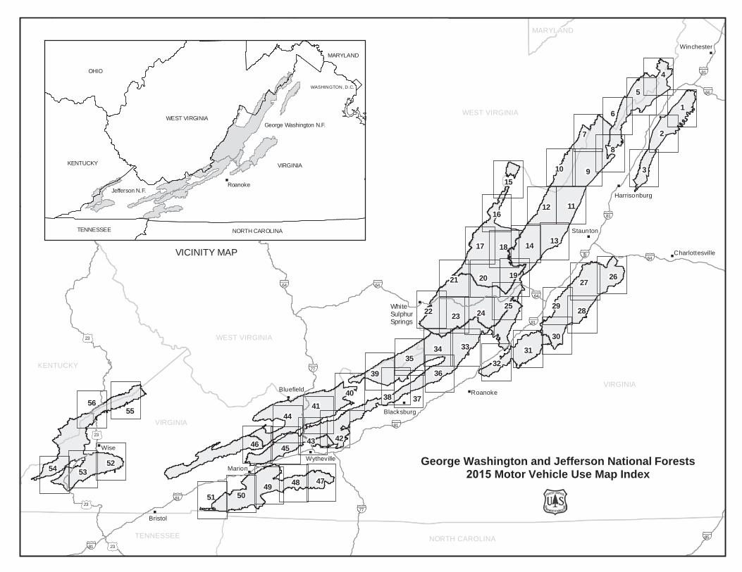
VICINITY MAP
"
"
"
"
"
"
"
"
"
"
"
"
WZ64
WZ81
WZ77
WZ79
WZ85
WZ66WZI77
WZI64WZI64WZI64
WZI79
WZI64
WZ64
WZ81
WZ8164
WZ81
WZI77
WZ64
WZ77
WZ81
WZI64
WZ79
WZ81
WZ81
WZ64
./23
./23
./23
./23
./23
./23
VIRGINIA
WEST VIRGINIA
KENTUCKY
OHIO
NORTH CAROLINATENNESSEE
MARYLAND
WEST VIRGINIA
VIRGINIA
Wise
Bristol
Roanoke
Winchester
Harrisonburg
Charlottesville
Blacksburg
Wytheville
Staunton
Marion
Bluefield
White Sulphur Springs
7
6 1
2
9
8
5
3
4
11
252422 23
303133
3639
40 38
50
42
44
46
54
55
21 20
12
49
52
15
16
27
18
26
3234
35
4748
41
53
43
14
19
2829
51
37
17 13
10
45
56
"
George Washington N.F.
Jefferson N.F.
VIRGINIA
WEST VIRGINIA
KENTUCKY
OHIO
NORTH CAROLINATENNESSEE
MARYLAND
WASHINGTON, D.C.
Roanoke
George Washington and Jefferson National Forests 2015 Motor Vehicle Use Map Index

!E
!E
!E
!E
!E
1702
66
273
1716
236
1723
4236
259
1686
409
1711
1869
408
340
359
272
4004
1350
374G
1859
1685
515
1686A
516
540
477
4021
1952
479
1958
517
475474
473
476
4071852
357
372
1712
4014
433
553
457
493
474
498
494
553(A&
B)
497
495 553(C
-P)
493
493
553
1702
./340
OP678
OP678
OP55
OP675
OP623
OP55
OP678
OP769
OP771
OP600 OP747
OP601
OP665
OP619
OP758 OP613
OP770
OP650
OP717
OP675
OP653OP651
OP648 OP744OP618
OP803
OP840
OP616
OP684
OP775
OP770
OP717
./340
./11
WZ81WZ81
Bentonville
78°22'30"W
78°22'30"W
78°30'0"W
78°30'0"W
38°52'30"N38°52'30"N
720000
720000
730000
730000
4300000 4300000
4310000 4310000
0 1 2 3 4Miles
Motor Vehicle Use Map 2015
North American Datum 1983 (NAD 83)Projection and 10,000-meter grid: UTM Zone 17
±
LEGEND
InterstateOther Public Roads
!E Motorized Trail AccessForest or Unit Boundary
WildernessLakes
Non-National Forest System Lands
Roads Open to Highway Legal Vehicles OnlyRoads Open to All VehiclesTrails Open to Vehicles 50" or Less in WidthTrails Open to Motorcycles Only
( ( ( ( Special Vehicle Designation (See Table)Seasonal Designation (See Table) {Used along with road or trail listed above}
The forest visitor should read and understand this map in itsentirety. If you have questions please contact this National ForestUnit for clarification. This map takes precedence over any on theground signs. Road, trail and area users must comply with thismap as well as all federal, state, and local laws and regulations.Compliance with these rules are the responsibility of the user.These designations apply to National Forest Lands and NationalForest roads, trails and areas under National Forest jurisdiction.
Important
Map 1

!E
!E
!E
274
1702
374 1716
236
1723
259
1686
1711
274A
340
359
272
4004374G
1685
1686A
244
1958
295
4071852
357
1712
410
247
433
553
457
493
499
474
498
494
553(A&
B)
497
495 553(C
-P)
493
493
55317
02
274
OP42
OP678
OP678
./340
./211
OP675
./11
OP698
OP615
OP684
OP678
OP620
OP769
OP675
OP730
OP826
OP770
OP830
OP699
OP803
OP758
OP840
OP717
OP775
OP615
OP675
./11
./340
./211
WZ81
WZ81
Luray
Hamburg
Edinburg
78°30'0"W
78°30'0"W
78°37'30"W
78°37'30"W
38°45'0"N38°45'0"N
38°37'30"N38°37'30"N
710000
710000
720000
720000
4280000 4280000
4290000 4290000
4300000 4300000
0 1 2 3 4Miles
Motor Vehicle Use Map 2015
North American Datum 1983 (NAD 83)Projection and 10,000-meter grid: UTM Zone 17
±
LEGEND
InterstateOther Public Roads
!E Motorized Trail AccessForest or Unit Boundary
WildernessLakes
Non-National Forest System Lands
Roads Open to Highway Legal Vehicles OnlyRoads Open to All VehiclesTrails Open to Vehicles 50" or Less in WidthTrails Open to Motorcycles Only
( ( ( ( Special Vehicle Designation (See Table)Seasonal Designation (See Table) {Used along with road or trail listed above}
The forest visitor should read and understand this map in itsentirety. If you have questions please contact this National ForestUnit for clarification. This map takes precedence over any on theground signs. Road, trail and area users must comply with thismap as well as all federal, state, and local laws and regulations.Compliance with these rules are the responsibility of the user.These designations apply to National Forest Lands and NationalForest roads, trails and areas under National Forest jurisdiction.
Important
Map 2
65
274
375
65A
1613
410
247
274
./211
./340./340
OP685
./340./620
./11
OP620
OP259
OP602
OP724 OP722
OP637
OP685
OP636
OP42
OP615
./11
./340
./211
WZ81WZ81
New Market
Shenandoah
Timberville
Tenth Legion
78°37'30"W
78°37'30"W
78°45'0"W
78°45'0"W
38°37'30"N38°37'30"N
38°30'0"N38°30'0"N
700000
700000
710000
710000
4260000 4260000
4270000 4270000
4280000 4280000
0 1 2 3 4Miles
Motor Vehicle Use Map 2015
North American Datum 1983 (NAD 83)Projection and 10,000-meter grid: UTM Zone 17
±
LEGEND
InterstateOther Public Roads
!E Motorized Trail AccessForest or Unit Boundary
WildernessLakes
Non-National Forest System Lands
Roads Open to Highway Legal Vehicles OnlyRoads Open to All VehiclesTrails Open to Vehicles 50" or Less in WidthTrails Open to Motorcycles Only
( ( ( ( Special Vehicle Designation (See Table)Seasonal Designation (See Table) {Used along with road or trail listed above}
The forest visitor should read and understand this map in itsentirety. If you have questions please contact this National ForestUnit for clarification. This map takes precedence over any on theground signs. Road, trail and area users must comply with thismap as well as all federal, state, and local laws and regulations.Compliance with these rules are the responsibility of the user.These designations apply to National Forest Lands and NationalForest roads, trails and areas under National Forest jurisdiction.
Important
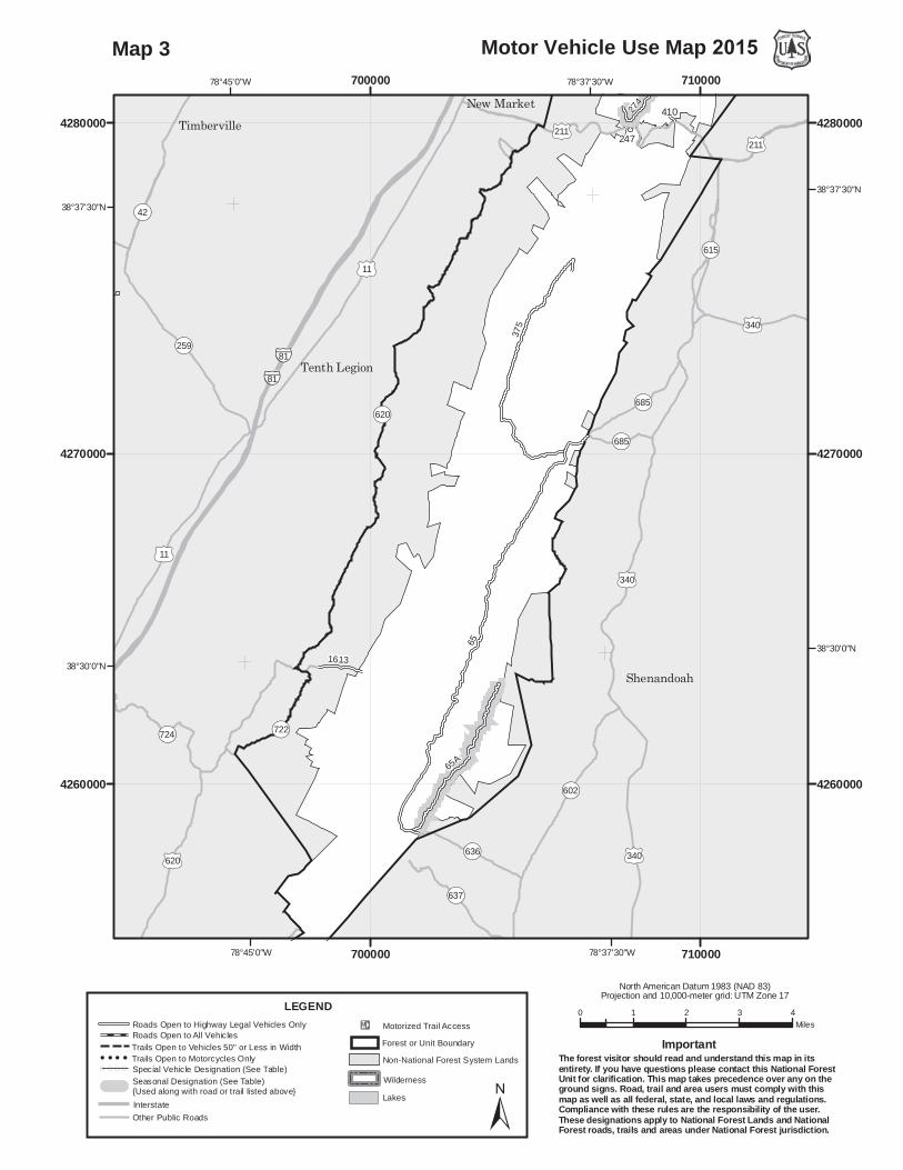
Map 3

93
92
88
1719
WV502
1863
1725
1857
WV347
371
88A
WV539
WV1614
93E
408
WV1018
WV1575
459WV1574
1859
WV502C
WV1000
4021
WV520
WV1612
WV522
WV347A
WV531
93
93G
WV519
WV1712
WV509
WV344
WV344B
1719
OP55
OP600
OP55
OP746
OP55
OP55
OP55
OP623
OP603
OP259
OP16
OP23-10
OP5
OP713
OP600
OP55
OP746
OP5/1
OP23/12
OP609
OP601
OP3
OP16/1
OP603
OP259
OP23-10
./11
WZ81
WZ81
Wardensville
Capon Springs
78°30'0"W
78°30'0"W
78°37'30"W
78°37'30"W
39°7'30"N39°7'30"N
39°0'0"N39°0'0"N
710000
710000
720000
720000
4320000 4320000
4330000 4330000
0 1 2 3 4Miles
Motor Vehicle Use Map 2015
North American Datum 1983 (NAD 83)Projection and 10,000-meter grid: UTM Zone 17
±
LEGEND
InterstateOther Public Roads
!E Motorized Trail AccessForest or Unit Boundary
WildernessLakes
Non-National Forest System Lands
Roads Open to Highway Legal Vehicles OnlyRoads Open to All VehiclesTrails Open to Vehicles 50" or Less in WidthTrails Open to Motorcycles Only
( ( ( ( Special Vehicle Designation (See Table)Seasonal Designation (See Table) {Used along with road or trail listed above}
The forest visitor should read and understand this map in itsentirety. If you have questions please contact this National ForestUnit for clarification. This map takes precedence over any on theground signs. Road, trail and area users must comply with thismap as well as all federal, state, and local laws and regulations.Compliance with these rules are the responsibility of the user.These designations apply to National Forest Lands and NationalForest roads, trails and areas under National Forest jurisdiction.
Important
Map 4

93
WV344
92
88
252
1719
1863
1725
371
1628
88AWV1687
WV1614
426
1318
WV50
0
WV355
408
WV1018
WV1575
459WV1574
1859
WV17
24
WV500(A-C)
1570
WV1000
WV520
WV1612
WV1713
WV522
WV531
295
WV519
WV1712
WV509
WV344
WV344B
1719
OP55
OP259/5
OP717
OP42OP691
OP675
./11
OP55
OP675
OP42OP611
OP259/5
OP55
OP717
OP23-10
OP23/7
OP691
OP59
OP259
OP605
OP720
OP681
OP749OP623
OP608
OP5/1
OP783
OP59/2
OP701
OP23/12
OP713
OP789
OP681
OP605
WZ81
Baker
78°37'30"W
78°37'30"W
78°45'0"W
78°45'0"W
39°0'0"N39°0'0"N
38°52'30"N38°52'30"N
700000
700000
710000
710000
4310000 4310000
4320000 4320000
0 1 2 3 4Miles
Motor Vehicle Use Map 2015
North American Datum 1983 (NAD 83)Projection and 10,000-meter grid: UTM Zone 17
±
LEGEND
InterstateOther Public Roads
!E Motorized Trail AccessForest or Unit Boundary
WildernessLakes
Non-National Forest System Lands
Roads Open to Highway Legal Vehicles OnlyRoads Open to All VehiclesTrails Open to Vehicles 50" or Less in WidthTrails Open to Motorcycles Only
( ( ( ( Special Vehicle Designation (See Table)Seasonal Designation (See Table) {Used along with road or trail listed above}
The forest visitor should read and understand this map in itsentirety. If you have questions please contact this National ForestUnit for clarification. This map takes precedence over any on theground signs. Road, trail and area users must comply with thismap as well as all federal, state, and local laws and regulations.Compliance with these rules are the responsibility of the user.These designations apply to National Forest Lands and NationalForest roads, trails and areas under National Forest jurisdiction.
Important
Map 5

302
252
302A
WV16
84
482
1628
WV343
WV1687
1318
WV50
0
WV355
1701
424
444C
WV1575
WV1680
WV17
24
WV500(A-C)
302
301
4019
302
OP259/5
OP717
OP820
OP259
OP259
OP612
OP18
OP259
OP42OP726
OP20/3
OP611
OP612
OP263OP822
OP826
OP723
OP720
OP59/1
OP20
OP610
OP717
OP59
OP259/5
OP820
OP865
OP59/2
OP823
OP20/2 OP701
OP666
OP691
OP611
OP42
Basye
Mathias
Bergton
78°45'0"W
78°45'0"W
78°52'30"W
78°52'30"W
38°52'30"N38°52'30"N
38°45'0"N38°45'0"N
680000
680000
690000
690000
4290000 4290000
4300000 4300000
4310000 4310000
0 1 2 3 4Miles
Motor Vehicle Use Map 2015
North American Datum 1983 (NAD 83)Projection and 10,000-meter grid: UTM Zone 17
±
LEGEND
InterstateOther Public Roads
!E Motorized Trail AccessForest or Unit Boundary
WildernessLakes
Non-National Forest System Lands
Roads Open to Highway Legal Vehicles OnlyRoads Open to All VehiclesTrails Open to Vehicles 50" or Less in WidthTrails Open to Motorcycles Only
( ( ( ( Special Vehicle Designation (See Table)Seasonal Designation (See Table) {Used along with road or trail listed above}
The forest visitor should read and understand this map in itsentirety. If you have questions please contact this National ForestUnit for clarification. This map takes precedence over any on theground signs. Road, trail and area users must comply with thismap as well as all federal, state, and local laws and regulations.Compliance with these rules are the responsibility of the user.These designations apply to National Forest Lands and NationalForest roads, trails and areas under National Forest jurisdiction.
Important
Map 6

87
85-2
151
423
232
302439
597
152
1117
1280
151G
232B
302A
235
85-1
153
151H
423B240A
424
444C
151B
731
423A
151M
232C
152D
232A
1117B
1124
302
72727272
240 423
302
85-2
151
526
87
OP820OP865
OP3
./33
OP7/2
OP826
OP3
OP822
OP3/1
OP823
OP865
OP818
OP824 OP820
OP3/2
OP3/4
OP666
OP631
OP826
Milam
Bergton
79°0'0"W
79°0'0"W
79°7'30"W
79°7'30"W
38°45'0"N38°45'0"N
660000
660000
670000
670000
4280000 4280000
4290000 4290000
4300000 4300000
0 1 2 3 4Miles
Motor Vehicle Use Map 2015
North American Datum 1983 (NAD 83)Projection and 10,000-meter grid: UTM Zone 17
±
LEGEND
InterstateOther Public Roads
!E Motorized Trail AccessForest or Unit Boundary
WildernessLakes
Non-National Forest System Lands
Roads Open to Highway Legal Vehicles OnlyRoads Open to All VehiclesTrails Open to Vehicles 50" or Less in WidthTrails Open to Motorcycles Only
( ( ( ( Special Vehicle Designation (See Table)Seasonal Designation (See Table) {Used along with road or trail listed above}
The forest visitor should read and understand this map in itsentirety. If you have questions please contact this National ForestUnit for clarification. This map takes precedence over any on theground signs. Road, trail and area users must comply with thismap as well as all federal, state, and local laws and regulations.Compliance with these rules are the responsibility of the user.These designations apply to National Forest Lands and NationalForest roads, trails and areas under National Forest jurisdiction.
Important
Map 7

((
(((
((
(
(
((
(
((
(
(
(
(
!E
72
240
423
232
302
422
502
439
1117
547
1280
232B
302A
1279 230
235
482
423B
555
546
492
1701
240A
549A
731
423A
1279B
232A
1117B
302
301
72
426
422
240 423
426
4019
302
72B
OP820
OP259OP612
OP865
OP763OP612
OP259
OP612
OP613
./11
OP763
OP42
OP613
OP612
OP259
OP818
OP817
OP813
OP610
OP611
OP819
OP921
OP815OP816
OP631
OP812
OP817OP612
OP612
Broadway
Fulks Run
78°52'30"W
78°52'30"W
79°0'0"W
79°0'0"W
38°37'30"N38°37'30"N
680000
680000
690000
690000
4270000 4270000
4280000 4280000
4290000 4290000
0 1 2 3 4Miles
Motor Vehicle Use Map 2015
North American Datum 1983 (NAD 83)Projection and 10,000-meter grid: UTM Zone 17
±
LEGEND
InterstateOther Public Roads
!E Motorized Trail AccessForest or Unit Boundary
WildernessLakes
Non-National Forest System Lands
Roads Open to Highway Legal Vehicles OnlyRoads Open to All VehiclesTrails Open to Vehicles 50" or Less in WidthTrails Open to Motorcycles Only
( ( ( ( Special Vehicle Designation (See Table)Seasonal Designation (See Table) {Used along with road or trail listed above}
The forest visitor should read and understand this map in itsentirety. If you have questions please contact this National ForestUnit for clarification. This map takes precedence over any on theground signs. Road, trail and area users must comply with thismap as well as all federal, state, and local laws and regulations.Compliance with these rules are the responsibility of the user.These designations apply to National Forest Lands and NationalForest roads, trails and areas under National Forest jurisdiction.
Important
Map 8
(((((((
(
(
((
((
((
(((
((
(
(
((
(
((
(
(
(
(
!E
72
87
85-2
151
101
240
227225
423
422
502
85A
304
597
72C
1117
539
549
1197
85-4
547
151G
225B
225C
1279 230
235
85-1
85-6
WV68
924
151H
348
423B
555
546
492
WV532
240A
549A
227A
151B
731
423A
1279B
151M
232C 1117B
WV379
62A
85-2
227I
72
72727272
426
422
240 423
426
85-2
151
72B
85A
85-5 62
62
87
OP763OP612
./33
./33
OP613
./33
./33
Switzer Dam
OP613OP924
OP612
OP732
OP818
OP731 OP742
OP933
OP257
OP604
OP631
OP847
OP901
OP818
OP604
./33
Briery Branch
Rawley Springs
79°0'0"W
79°0'0"W
79°7'30"W
79°7'30"W
38°37'30"N38°37'30"N
38°30'0"N38°30'0"N
660000
660000
670000
670000
4260000 4260000
4270000 4270000
4280000 4280000
0 1 2 3 4Miles
Motor Vehicle Use Map 2015
North American Datum 1983 (NAD 83)Projection and 10,000-meter grid: UTM Zone 17
±
LEGEND
InterstateOther Public Roads
!E Motorized Trail AccessForest or Unit Boundary
WildernessLakes
Non-National Forest System Lands
Roads Open to Highway Legal Vehicles OnlyRoads Open to All VehiclesTrails Open to Vehicles 50" or Less in WidthTrails Open to Motorcycles Only
( ( ( ( Special Vehicle Designation (See Table)Seasonal Designation (See Table) {Used along with road or trail listed above}
The forest visitor should read and understand this map in itsentirety. If you have questions please contact this National ForestUnit for clarification. This map takes precedence over any on theground signs. Road, trail and area users must comply with thismap as well as all federal, state, and local laws and regulations.Compliance with these rules are the responsibility of the user.These designations apply to National Forest Lands and NationalForest roads, trails and areas under National Forest jurisdiction.
Important
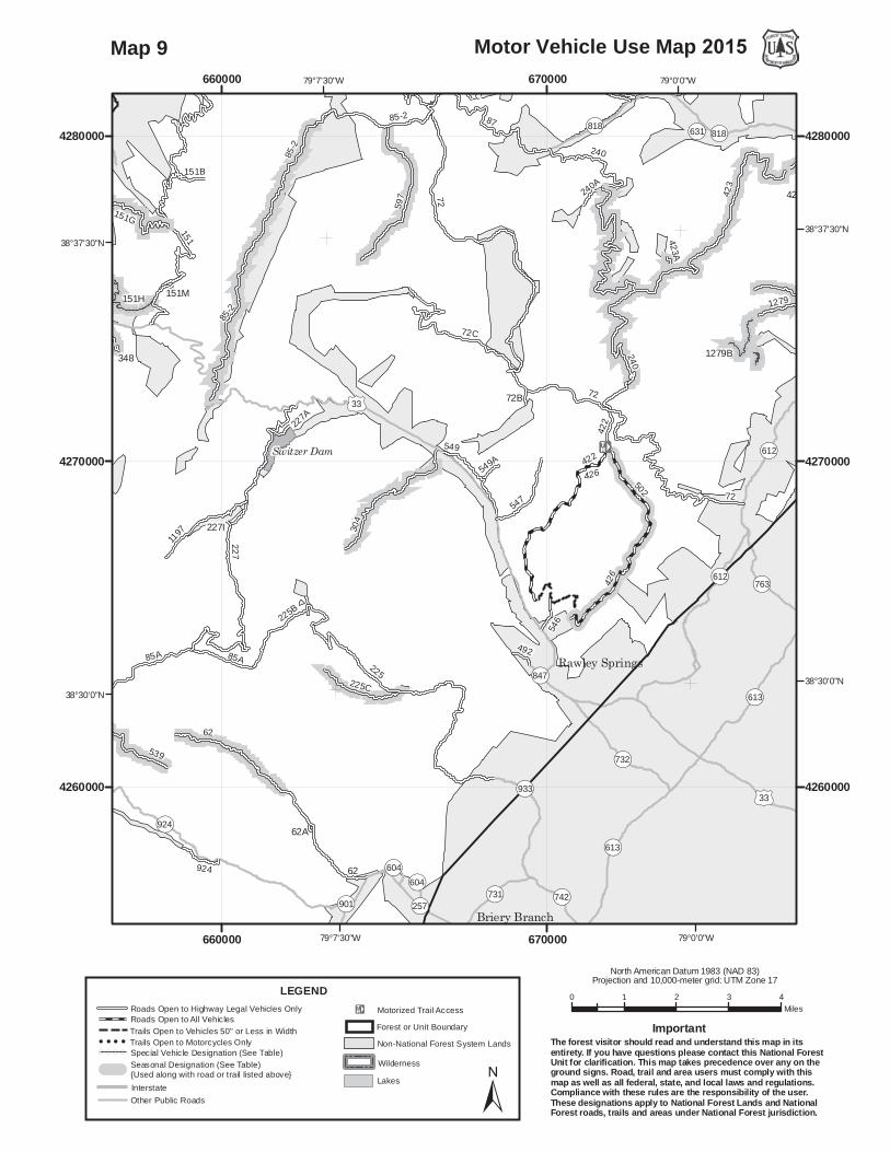
Map 9

(((((((
(
(
((
((
85-5
151
101
227
WV61
WV166
85A
WV61G
539
34
1197
85-4
151G
225B
85-6
WV68
924
151H
348
31
WV532WV61F
227A
151B
151M
85B
1775B
WV33
WV379
62A
85-2
227I
85-2
151
427
85A
85-5 62
WV61
64
WV61
85-5
./33
./33
OP25
OP21
OP21
OP25
OP21/1
OP924
OPUSNR
OP24
OP21/5
OP21/6
OP21/3
OP30
OP5/12
OPOLD 30
OP3
OPOLD 30
./33
Franklin
Brandywine
Sugar Grove
79°15'0"W
79°15'0"W
79°22'30"W
79°22'30"W
38°37'30"N38°37'30"N
38°30'0"N38°30'0"N
640000
640000
650000
650000
660000
660000
4260000 4260000
4270000 4270000
4280000 4280000
0 1 2 3 4Miles
Motor Vehicle Use Map 2015
North American Datum 1983 (NAD 83)Projection and 10,000-meter grid: UTM Zone 17
±
LEGEND
InterstateOther Public Roads
!E Motorized Trail AccessForest or Unit Boundary
WildernessLakes
Non-National Forest System Lands
Roads Open to Highway Legal Vehicles OnlyRoads Open to All VehiclesTrails Open to Vehicles 50" or Less in WidthTrails Open to Motorcycles Only
( ( ( ( Special Vehicle Designation (See Table)Seasonal Designation (See Table) {Used along with road or trail listed above}
The forest visitor should read and understand this map in itsentirety. If you have questions please contact this National ForestUnit for clarification. This map takes precedence over any on theground signs. Road, trail and area users must comply with thismap as well as all federal, state, and local laws and regulations.Compliance with these rules are the responsibility of the user.These designations apply to National Forest Lands and NationalForest roads, trails and areas under National Forest jurisdiction.
Important
Map 10
95
85-5
101
64
96
WV166
95A
536
425
WV61G
1269
95B
348A
85C
95
493
466
924
535
451
533
348B
WV61F
506
348.1
1177
95
536E
425A
536B
85B
95D
523A523
77H
62A
427
WV61
62
101B
95
64
300
WV61
85-595
./250
OP728
OP42
RAMSEYS DRAFTWILDERNESS
OP764
OP42OP728
OP730
OP715
OP629
OP924
OP720
OP30
OP725
OP32
OP257
OP718
OP604OPOLD 30
OP901
OP922
./250
Stokesville
Churchville
79°7'30"W
79°7'30"W
79°15'0"W
79°15'0"W
38°22'30"N38°22'30"N
38°15'0"N38°15'0"N
650000
650000
660000
660000
4240000 4240000
4250000 4250000
0 1 2 3 4Miles
Motor Vehicle Use Map 2015
North American Datum 1983 (NAD 83)Projection and 10,000-meter grid: UTM Zone 17
±
LEGEND
InterstateOther Public Roads
!E Motorized Trail AccessForest or Unit Boundary
WildernessLakes
Non-National Forest System Lands
Roads Open to Highway Legal Vehicles OnlyRoads Open to All VehiclesTrails Open to Vehicles 50" or Less in WidthTrails Open to Motorcycles Only
( ( ( ( Special Vehicle Designation (See Table)Seasonal Designation (See Table) {Used along with road or trail listed above}
The forest visitor should read and understand this map in itsentirety. If you have questions please contact this National ForestUnit for clarification. This map takes precedence over any on theground signs. Road, trail and area users must comply with thismap as well as all federal, state, and local laws and regulations.Compliance with these rules are the responsibility of the user.These designations apply to National Forest Lands and NationalForest roads, trails and areas under National Forest jurisdiction.
Important
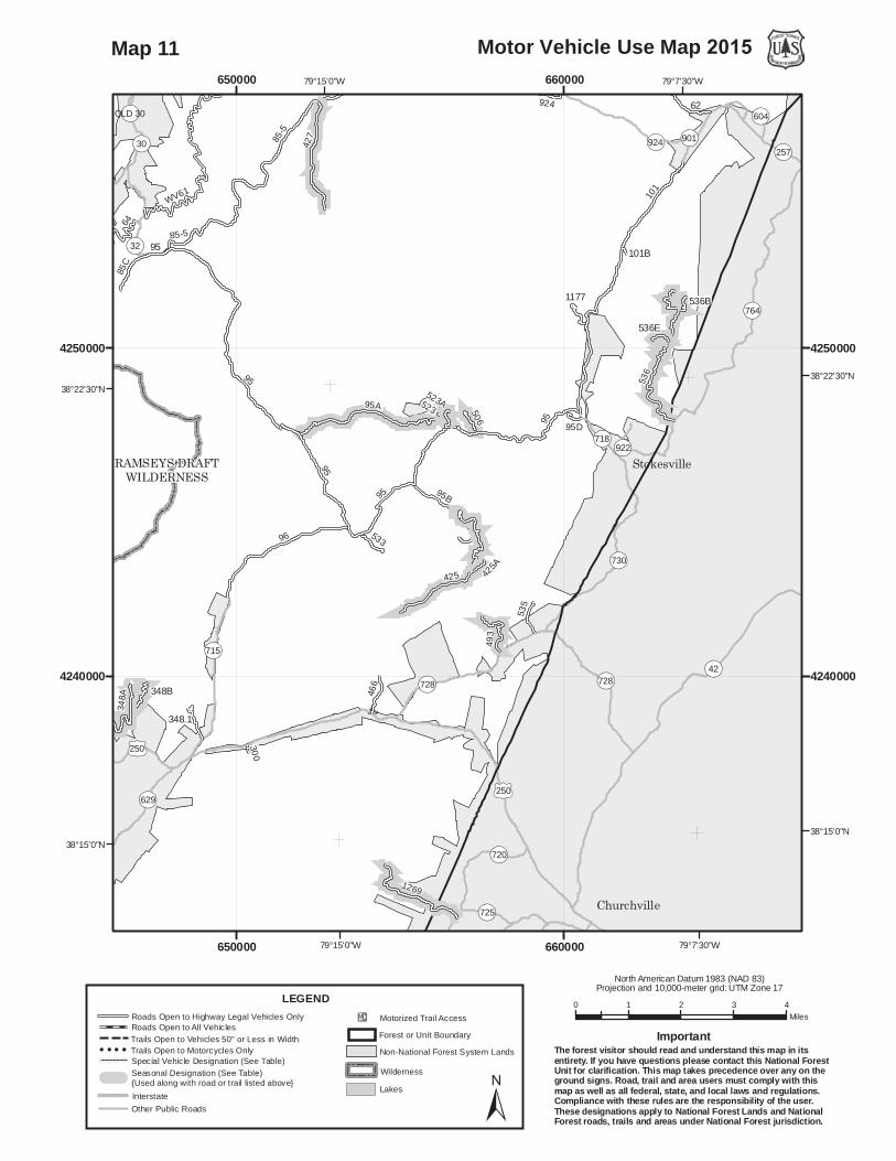
Map 11

85-5
64
96
173
81
WV166
396
395
WV61G
255
501
394B
348A
85C
395
395A
77L
348B
348.1
68
396D
395E
393
395N
77H
394 173
173.2
WV61
95
64
300
WV61
85-595
7005
395
OP21
./250OP614OP616
OP629
./250
RAMSEYS DRAFTWILDERNESS
OP614
OP716
OP21
OP620
OP616
OP30
OP629
OP689
OP688
OP32
./250
Doe Hill
McDowell
Palo Alto
West Augusta
79°22'30"W
79°22'30"W
79°30'0"W
79°30'0"W
38°22'30"N38°22'30"N
38°15'0"N38°15'0"N
630000
630000
640000
640000
4240000 4240000
4250000 4250000
0 1 2 3 4Miles
Motor Vehicle Use Map 2015
North American Datum 1983 (NAD 83)Projection and 10,000-meter grid: UTM Zone 17
±
LEGEND
InterstateOther Public Roads
!E Motorized Trail AccessForest or Unit Boundary
WildernessLakes
Non-National Forest System Lands
Roads Open to Highway Legal Vehicles OnlyRoads Open to All VehiclesTrails Open to Vehicles 50" or Less in WidthTrails Open to Motorcycles Only
( ( ( ( Special Vehicle Designation (See Table)Seasonal Designation (See Table) {Used along with road or trail listed above}
The forest visitor should read and understand this map in itsentirety. If you have questions please contact this National ForestUnit for clarification. This map takes precedence over any on theground signs. Road, trail and area users must comply with thismap as well as all federal, state, and local laws and regulations.Compliance with these rules are the responsibility of the user.These designations apply to National Forest Lands and NationalForest roads, trails and areas under National Forest jurisdiction.
Important
Map 12
82
77
382
173
81
381398
255399B
399
126915
76
383C
1133
395A
291
45177L
77N
347
430
82A
396D
77K
162577G
387
393
77H
173
82
61
1042
382
OP629
OP600
OP42
OP687
OP600
OP42
OP689
OP600
OP629
OP688
OP692
OP1102
OP720
OP845
OP724
OP688
DeerfieldBuffalo Gap
Craigsville
Augusta Springs
79°15'0"W
79°15'0"W
79°22'30"W
79°22'30"W38°15'0"N
38°7'30"N38°7'30"N
640000
640000
650000
650000
4210000 4210000
4220000 4220000
4230000 4230000
0 1 2 3 4Miles
Motor Vehicle Use Map 2015
North American Datum 1983 (NAD 83)Projection and 10,000-meter grid: UTM Zone 17
±
LEGEND
InterstateOther Public Roads
!E Motorized Trail AccessForest or Unit Boundary
WildernessLakes
Non-National Forest System Lands
Roads Open to Highway Legal Vehicles OnlyRoads Open to All VehiclesTrails Open to Vehicles 50" or Less in WidthTrails Open to Motorcycles Only
( ( ( ( Special Vehicle Designation (See Table)Seasonal Designation (See Table) {Used along with road or trail listed above}
The forest visitor should read and understand this map in itsentirety. If you have questions please contact this National ForestUnit for clarification. This map takes precedence over any on theground signs. Road, trail and area users must comply with thismap as well as all federal, state, and local laws and regulations.Compliance with these rules are the responsibility of the user.These designations apply to National Forest Lands and NationalForest roads, trails and areas under National Forest jurisdiction.
Important
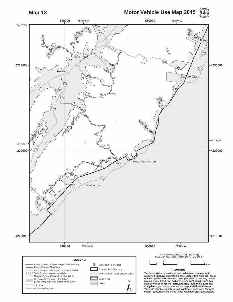
Map 13
61
394
17339
1
387
381
255
399B
399
281
433
1576
1303
394B
392
1144
1133
6282
468
385
391D
430
387
393
394 173
173.2
82
61
382
394
OP600
OP687
OP614
OP629
OP629
OP600
OP678
OP678
OP39
OP42
OP633OP640
OP678
OP625
OP614
OP629
OP600
OP42
OP627
OP39
OP641
OP609
OP39/42
OP624
OP628
OP678OP614
OP600
Green Valley
Williamsville
79°30'0"W
79°30'0"W
79°37'30"W
79°37'30"W
38°7'30"N38°7'30"N
620000
620000
630000
630000
4210000 4210000
4220000 4220000
4230000 4230000
0 1 2 3 4Miles
Motor Vehicle Use Map 2015
North American Datum 1983 (NAD 83)Projection and 10,000-meter grid: UTM Zone 17
±
LEGEND
InterstateOther Public Roads
!E Motorized Trail AccessForest or Unit Boundary
WildernessLakes
Non-National Forest System Lands
Roads Open to Highway Legal Vehicles OnlyRoads Open to All VehiclesTrails Open to Vehicles 50" or Less in WidthTrails Open to Motorcycles Only
( ( ( ( Special Vehicle Designation (See Table)Seasonal Designation (See Table) {Used along with road or trail listed above}
The forest visitor should read and understand this map in itsentirety. If you have questions please contact this National ForestUnit for clarification. This map takes precedence over any on theground signs. Road, trail and area users must comply with thismap as well as all federal, state, and local laws and regulations.Compliance with these rules are the responsibility of the user.These designations apply to National Forest Lands and NationalForest roads, trails and areas under National Forest jurisdiction.
Important
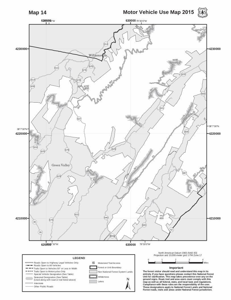
Map 14

457
142
OP19
OP642
OP106
./250
./250
OP640
OP19
OP28
OP642
OP600
OP57
OP601
OP54 OP106
OP60
OP58
OP435
OP818
OP50
OP644
./250
./220
Hightown
Monterey
79°37'30"W
79°37'30"W
79°45'0"W
79°45'0"W
38°30'0"N38°30'0"N
610000
610000
620000
620000
4250000 4250000
4260000 4260000
4270000 4270000
0 1 2 3 4Miles
Motor Vehicle Use Map 2015
North American Datum 1983 (NAD 83)Projection and 10,000-meter grid: UTM Zone 17
±
LEGEND
InterstateOther Public Roads
!E Motorized Trail AccessForest or Unit Boundary
WildernessLakes
Non-National Forest System Lands
Roads Open to Highway Legal Vehicles OnlyRoads Open to All VehiclesTrails Open to Vehicles 50" or Less in WidthTrails Open to Motorcycles Only
( ( ( ( Special Vehicle Designation (See Table)Seasonal Designation (See Table) {Used along with road or trail listed above}
The forest visitor should read and understand this map in itsentirety. If you have questions please contact this National ForestUnit for clarification. This map takes precedence over any on theground signs. Road, trail and area users must comply with thismap as well as all federal, state, and local laws and regulations.Compliance with these rules are the responsibility of the user.These designations apply to National Forest Lands and NationalForest roads, trails and areas under National Forest jurisdiction.
Important
Map 15

121
258
6003
141
401
258A
121B
1747
121
OP614
./250
./220
OP55
OP600
Va Power
Va Power
OP55
OP607
OP600
OP84
OP603
./220
79°37'30"W
79°37'30"W
79°45'0"W
79°45'0"W
38°22'30"N38°22'30"N
38°15'0"N38°15'0"N
600000
600000
610000
610000
620000
620000
4230000 4230000
4240000 4240000
4250000 4250000
0 1 2 3 4Miles
Motor Vehicle Use Map 2015
North American Datum 1983 (NAD 83)Projection and 10,000-meter grid: UTM Zone 17
±
LEGEND
InterstateOther Public Roads
!E Motorized Trail AccessForest or Unit Boundary
WildernessLakes
Non-National Forest System Lands
Roads Open to Highway Legal Vehicles OnlyRoads Open to All VehiclesTrails Open to Vehicles 50" or Less in WidthTrails Open to Motorcycles Only
( ( ( ( Special Vehicle Designation (See Table)Seasonal Designation (See Table) {Used along with road or trail listed above}
The forest visitor should read and understand this map in itsentirety. If you have questions please contact this National ForestUnit for clarification. This map takes precedence over any on theground signs. Road, trail and area users must comply with thismap as well as all federal, state, and local laws and regulations.Compliance with these rules are the responsibility of the user.These designations apply to National Forest Lands and NationalForest roads, trails and areas under National Forest jurisdiction.
Important
Map 16

121
194
241
358
617
364
124
6003
141
1736
401
194C
1742
6006
1745
1918
1744
226
6020
121B
1750
1738
1747
241A
1733
1737
1735
1740
1843
619619A
121
6020A
481241D
358
1732
1730A
1749A1749B
OP39
./220
OP55
OP600
OP39
OP39
OP55
OP600
./220
OP39
./220
OP629
Va Power
Lake Moomaw
Va Power
OP600
OP601
OP55
OP603
OP39
OP607
OP621
OP687
OP615
OP614
OP623
OP618
OP622
OP693
OP39
OP600
./220
Bacova
Warm Springs
Mountain Grove
Minnehaha Springs
79°45'0"W
79°45'0"W
79°52'30"W
79°52'30"W
38°7'30"N 38°7'30"N
590000
590000
600000
600000
610000
610000
4210000 4210000
4220000 4220000
4230000 4230000
0 1 2 3 4Miles
Motor Vehicle Use Map 2015
North American Datum 1983 (NAD 83)Projection and 10,000-meter grid: UTM Zone 17
±
LEGEND
InterstateOther Public Roads
!E Motorized Trail AccessForest or Unit Boundary
WildernessLakes
Non-National Forest System Lands
Roads Open to Highway Legal Vehicles OnlyRoads Open to All VehiclesTrails Open to Vehicles 50" or Less in WidthTrails Open to Motorcycles Only
( ( ( ( Special Vehicle Designation (See Table)Seasonal Designation (See Table) {Used along with road or trail listed above}
The forest visitor should read and understand this map in itsentirety. If you have questions please contact this National ForestUnit for clarification. This map takes precedence over any on theground signs. Road, trail and area users must comply with thismap as well as all federal, state, and local laws and regulations.Compliance with these rules are the responsibility of the user.These designations apply to National Forest Lands and NationalForest roads, trails and areas under National Forest jurisdiction.
Important
Map 17
121
394
194
241
358
465
391
364
124
6003
281401
1144
194C
6282
468
3851325
60061745
1918
637
391D
6020
121B
462
1747
241A
1312
637G
1843
619619A
121
6020A
481241D
358
394
OP614
OP629
./220
./220
OP39
OP678
OP678
./220
OP39
OP42
OP633
OP629
Va Power
OP625
OP633OP678
OP629
OP39
OP609
OP39/42
OP627
OP614
OP607
OP624
OP600
OP630
OP621
OP623
OP634
OP683
OP622
OP629
OP678
OP39
./220
Bath Alum
Green Valley
Warm Springs
Williamsville
Millboro Springs
79°37'30"W
79°37'30"W
79°45'0"W
79°45'0"W
38°7'30"N38°7'30"N
38°0'0"N38°0'0"N
610000
610000
620000
620000
4210000 4210000
4220000 4220000
0 1 2 3 4Miles
Motor Vehicle Use Map 2015
North American Datum 1983 (NAD 83)Projection and 10,000-meter grid: UTM Zone 17
±
LEGEND
InterstateOther Public Roads
!E Motorized Trail AccessForest or Unit Boundary
WildernessLakes
Non-National Forest System Lands
Roads Open to Highway Legal Vehicles OnlyRoads Open to All VehiclesTrails Open to Vehicles 50" or Less in WidthTrails Open to Motorcycles Only
( ( ( ( Special Vehicle Designation (See Table)Seasonal Designation (See Table) {Used along with road or trail listed above}
The forest visitor should read and understand this map in itsentirety. If you have questions please contact this National ForestUnit for clarification. This map takes precedence over any on theground signs. Road, trail and area users must comply with thismap as well as all federal, state, and local laws and regulations.Compliance with these rules are the responsibility of the user.These designations apply to National Forest Lands and NationalForest roads, trails and areas under National Forest jurisdiction.
Important
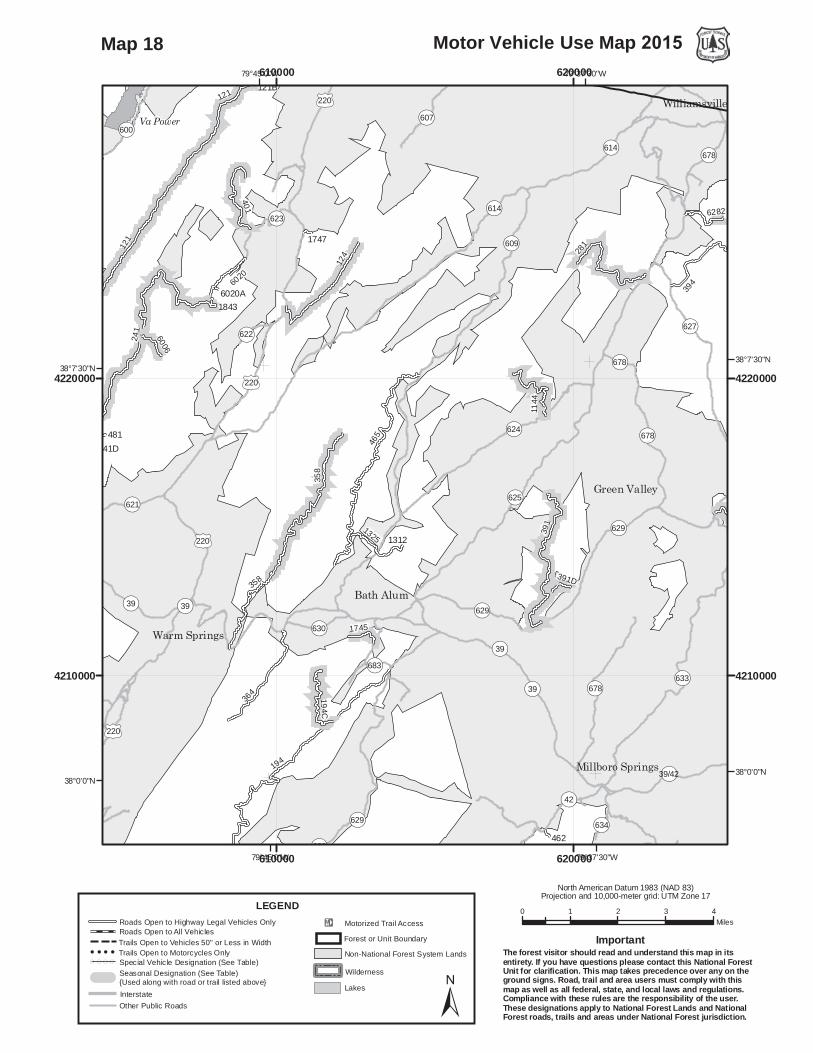
Map 18

194
129
447
362
364
328
333
6021
334
582
328A
361
1303108
194C
385
271D
1325
1745
637
391D
334A
430
637A
361A
462
1312
637G
3548
3505
358
35333547
3525
OP39
OP42
WZ64WZ64
WZ64
OP633
OP629
OP777
OP633
OP39
OP39
OP42
RICH HOLEWILDERNESS
ROUGH MOUNTAINWILDERNESS
OP633
OP629
OP678 OP640
OP42
OP780
OP646
OP39
OP39/42
OP600
OP649OP638
OP643
OP635
OP631
OP630
OP632
OP639
OP634
OP770
OP683
OP615
OP369
OP636
OP642
OP665OP637
OP777 OP644
OP625 OP629
OP39/42
OP637
OP629
OP39/42OP39
OP629
OP629
./60
WZ64WZ64
Nimrod Hall
Millboro Springs
79°30'0"W
79°37'30"W
79°37'30"W
38°0'0"N38°0'0"N
37°52'30"N37°52'30"N
620000
620000
630000
630000
4190000 4190000
4200000 4200000
4210000 4210000
0 1 2 3 4Miles
Motor Vehicle Use Map 2015
North American Datum 1983 (NAD 83)Projection and 10,000-meter grid: UTM Zone 17
±
LEGEND
InterstateOther Public Roads
!E Motorized Trail AccessForest or Unit Boundary
WildernessLakes
Non-National Forest System Lands
Roads Open to Highway Legal Vehicles OnlyRoads Open to All VehiclesTrails Open to Vehicles 50" or Less in WidthTrails Open to Motorcycles Only
( ( ( ( Special Vehicle Designation (See Table)Seasonal Designation (See Table) {Used along with road or trail listed above}
The forest visitor should read and understand this map in itsentirety. If you have questions please contact this National ForestUnit for clarification. This map takes precedence over any on theground signs. Road, trail and area users must comply with thismap as well as all federal, state, and local laws and regulations.Compliance with these rules are the responsibility of the user.These designations apply to National Forest Lands and NationalForest roads, trails and areas under National Forest jurisdiction.
Important
Map 19
194
125
342
617
364
1324
125 333
1736
6021
582
361
338
125D
339
446
338A
194C
172
125A
271D
601
1742
1745
1918
602
637
587
226
637A
603
361A
1750
1738
1733
637G
603A
1737
342A
3505
1735
601A
337
358
336
125342
1732
1730A
1749A1749B
3001
3014
303
OP55
OP600
./220
OP39
OP703
OP629
./220
OP629
OP606
OP687
./220
WZ64
OP687
OP42
ROUGH MOUNTAINWILDERNESS
Lake Moomaw
OP605
OP703
OP687
OP603
OP42
OP635
OP629
OP607
OP630
OP606
OP615
OP600
OP640
OP208
OP618
OP669
OP691
OP636
OP637
OP646
OP670
OP659
OP623
OP693
OP774
./220
./60WZ64
Ashwood
Nicelytown
Hot Springs
Clifton Forge
Healing Springs
79°45'0"W
79°45'0"W
79°52'30"W
79°52'30"W
38°0'0"N 38°0'0"N
37°52'30"N 37°52'30"N
600000
600000
610000
610000
4190000 4190000
4200000 4200000
4210000 4210000
0 1 2 3 4Miles
VMotor ehicle Use Map 2015
North American Datum 1983 (NAD 83)Projection and 10,000-meter grid: UTM Zone 17
±
LEGEND
InterstateOther Public Roads
!E Motorized Trail AccessForest or Unit Boundary
WildernessLakes
Non-National Forest System Lands
Roads Open to Highway Legal Vehicles OnlyRoads Open to All VehiclesTrails Open to Vehicles 50" or Less in WidthTrails Open to Motorcycles Only
( ( ( ( Special Vehicle Designation (See Table)Seasonal Designation (See Table) {Used along with road or trail listed above}
The forest visitor should read and understand this map in itsentirety. If you have questions please contact this National ForestUnit for clarification. This map takes precedence over any on theground signs. Road, trail and area users must comply with thismap as well as all federal, state, and local laws and regulations.Compliance with these rules are the responsibility of the user.These designations apply to National Forest Lands and NationalForest roads, trails and areas under National Forest jurisdiction.
Important
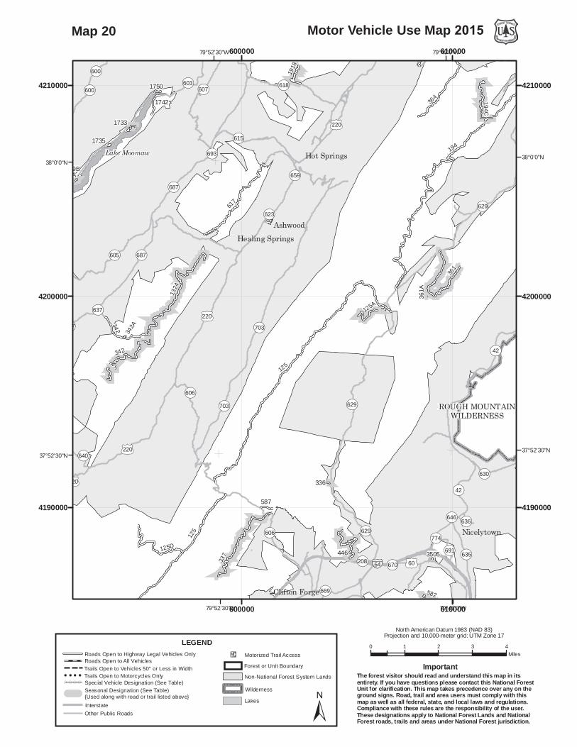
Map 20

345
342
69
600
125366
1736
192
339
601
1742
604
602
603
1750
1738
1733
366A
603A
1737
604A
3015342
A
1741
1735
1740
601A
342
1732
1730A
1749A1749B
3001
3014
303
OP55
OP600
./220
OP661
OP600
OP687
./220
WZ64
WZ64
OP687
Lake Moomaw
OP600
OP666
OP640
OP661
OP687
OP781
OP605
OP641
OP603
OP721
OP55
./220WZ64
Falling Spring
80°0'0"W
80°0'0"W
80°7'30"W
80°7'30"W
38°0'0"N 38°0'0"N
37°52'30"N 37°52'30"N
580000
580000
590000
590000
4190000 4190000
4200000 4200000
4210000 4210000
0 1 2 3 4Miles
Motor Vehicle Use Map 2015
North American Datum 1983 (NAD 83)Projection and 10,000-meter grid: UTM Zone 17
±
LEGEND
InterstateOther Public Roads
!E Motorized Trail AccessForest or Unit Boundary
WildernessLakes
Non-National Forest System Lands
Roads Open to Highway Legal Vehicles OnlyRoads Open to All VehiclesTrails Open to Vehicles 50" or Less in WidthTrails Open to Motorcycles Only
( ( ( ( Special Vehicle Designation (See Table)Seasonal Designation (See Table) {Used along with road or trail listed above}
The forest visitor should read and understand this map in itsentirety. If you have questions please contact this National ForestUnit for clarification. This map takes precedence over any on theground signs. Road, trail and area users must comply with thismap as well as all federal, state, and local laws and regulations.Compliance with these rules are the responsibility of the user.These designations apply to National Forest Lands and NationalForest roads, trails and areas under National Forest jurisdiction.
Important
Map 21
350
351
5036
345
69
600
277
107
366
456
277A
175
3503
440
366A
BARBOURS CREEK
WILDERNESS
3502
561
456B
3562
176
5036
350
OP661
WZ64
OP50
OP8
OP311
OP311
OP159
OP18
OP600
OP658
WZ64
OP600
OP50
OP159
OP8OP610
OP661
OP18
OP604
OP603
OP607
OP613
OP311 OP608
OP782
OP50/1
OP650
OP616
OP602
OP601
OP665
OP717
OP198
OP277
OP661
OP602
OP661
WZ64
Hematite
Jordan Mines
White Sulpher Springs
80°7'30"W
80°7'30"W
80°15'0"W
80°15'0"W
37°45'0"N 37°45'0"N
560000
560000
570000
570000
4170000 4170000
4180000 4180000
4190000 4190000
0 1 2 3 4Miles
Motor Vehicle Use Map 2015
North American Datum 1983 (NAD 83)Projection and 10,000-meter grid: UTM Zone 17
±
LEGEND
InterstateOther Public Roads
!E Motorized Trail AccessForest or Unit Boundary
WildernessLakes
Non-National Forest System Lands
Roads Open to Highway Legal Vehicles OnlyRoads Open to All VehiclesTrails Open to Vehicles 50" or Less in WidthTrails Open to Motorcycles Only
( ( ( ( Special Vehicle Designation (See Table)Seasonal Designation (See Table) {Used along with road or trail listed above}
The forest visitor should read and understand this map in itsentirety. If you have questions please contact this National ForestUnit for clarification. This map takes precedence over any on theground signs. Road, trail and area users must comply with thismap as well as all federal, state, and local laws and regulations.Compliance with these rules are the responsibility of the user.These designations apply to National Forest Lands and NationalForest roads, trails and areas under National Forest jurisdiction.
Important
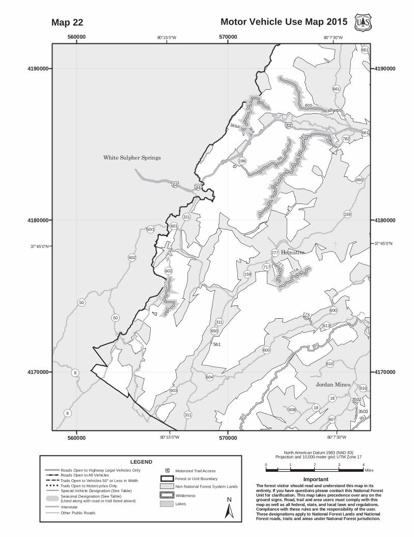
Map 22

179
350
184
351
5036
229
176
345
69
600
5020
125
179
277
366
456
125D
277A
440A
339
5058
275
351A
175
3503
440
20
366A
50561
5080
3015
679
501(A-E)
5079
505515050
BARBOURS CREEK
WILDERNESS
3502
180
456B
3562
445
3509
176
5036
350
180229
OP661
OP159
OP18
OP615
OP600
OP600
OP658
WZ64
WZ64
OP818
OP615
OP159
OP615
OP620
OP614OP616
OP18
OP610
OP600
OP618
OP661
OP657
OP625
OP607
OP617
OP1104
OP613
OP619
OP608
OP782 OP683
OP817
OP687
OP609
OP704
OP665
OP706OP705
OP277
OP797
OP64
OP615
OP613
OP704
OP616
OP683
OP704OP704
OP613
OP661
OP616
OP607
OP661
./220
WZ64
Hematite
Callaghan
Covington
Jordan Mines
Boiling Spring
80°0'0"W
80°0'0"W
80°7'30"W
80°7'30"W
37°45'0"N 37°45'0"N
37°37'30"N 37°37'30"N
580000
580000
590000
590000
4170000 4170000
4180000 4180000
0 1 2 3 4Miles
Motor Vehicle Use Map 2015
North American Datum 1983 (NAD 83)Projection and 10,000-meter grid: UTM Zone 17
±
LEGEND
InterstateOther Public Roads
!E Motorized Trail AccessForest or Unit Boundary
WildernessLakes
Non-National Forest System Lands
Roads Open to Highway Legal Vehicles OnlyRoads Open to All VehiclesTrails Open to Vehicles 50" or Less in WidthTrails Open to Motorcycles Only
( ( ( ( Special Vehicle Designation (See Table)Seasonal Designation (See Table) {Used along with road or trail listed above}
The forest visitor should read and understand this map in itsentirety. If you have questions please contact this National ForestUnit for clarification. This map takes precedence over any on theground signs. Road, trail and area users must comply with thismap as well as all federal, state, and local laws and regulations.Compliance with these rules are the responsibility of the user.These designations apply to National Forest Lands and NationalForest roads, trails and areas under National Forest jurisdiction.
Important
Map 23
!E
184
125
354
5020
125
582
338
125D
353
339
5058
446
338A
50871
305
354A
1629
587
373
1629B
3543
740
20
3013
1629D
1629A
338B
5080
3015
3505
501(A-E)
502(A-F)
184
5079
337
180
3509
229
OP606
OP615
WZ64
OP633
OP818
./220
OP615
OP622
OP743
OP615
OP620
OP616
OP633
OP726
OP625
OP818
OP1107
OP1104
OP687
OP18
OP688
OP707
OP682
OP669
OP681
OP621
OP683
OP817
OP1109
OP619
OP655OP706
OP704
OP208
OP693
OP685
OP612OP684
OP692
OP696
OP623
OP606
OP43
OP731
OP686
OP705
OP699
OP718
OP736
OP745
OP629
OP672
OP810
OP797
OP662
OP725
OP670
OP690
OP704
OP681
OP685
OP705
OP683
OP704 OP704
OP687
OP683
./220
./60
./220
WZ64
Hipes
Strom
Horton
Covington
Clifton Forge
79°52'30"W
79°52'30"W
37°45'0"N 37°45'0"N
37°37'30"N 37°37'30"N
590000
590000
600000
600000
4170000 4170000
4180000 4180000
0 1 2 3 4Miles
Motor Vehicle Use Map 2015
North American Datum 1983 (NAD 83)Projection and 10,000-meter grid: UTM Zone 17
±
LEGEND
InterstateOther Public Roads
!E Motorized Trail AccessForest or Unit Boundary
WildernessLakes
Non-National Forest System Lands
Roads Open to Highway Legal Vehicles OnlyRoads Open to All VehiclesTrails Open to Vehicles 50" or Less in WidthTrails Open to Motorcycles Only
( ( ( ( Special Vehicle Designation (See Table)Seasonal Designation (See Table) {Used along with road or trail listed above}
The forest visitor should read and understand this map in itsentirety. If you have questions please contact this National ForestUnit for clarification. This map takes precedence over any on theground signs. Road, trail and area users must comply with thismap as well as all federal, state, and local laws and regulations.Compliance with these rules are the responsibility of the user.These designations apply to National Forest Lands and NationalForest roads, trails and areas under National Forest jurisdiction.
Important
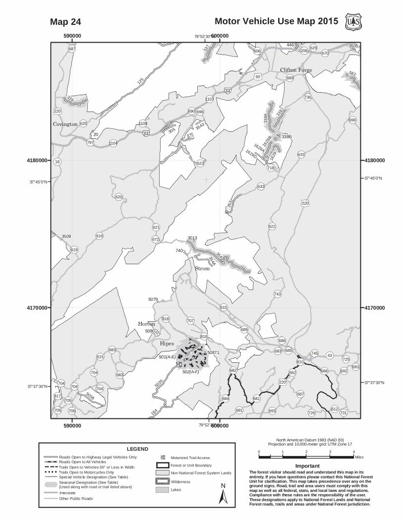
Map 24
129
447
362
271
328
333
6021
334582
328A
108
338
446
172
125A
271D
3079
1629 3200162
9B
334A
271C
271A
338B
3548
3505
35333547
3525
336
WZ64
OP629
OP655
OP777
OP612
OP633
OP42
RICH HOLEWILDERNESSROUGH MOUNTAIN
WILDERNESS
OP611
OP629
OP646
OP662
OP770
OP655
OP657
OP634
OP635
OP667
OP42
OP649
OP644
OP654
OP658
OP612
OP633
OP777
OP659
OP630
OP251
OP672
OP650
OP660
OP780
OP691
OP636
OP807
OP699
OP776
OP696
OP656
OP637
OP208OP670
OP774OP629
OP636
OP657OP644
OP646
OP633
OP644./220
./60
./220
WZ64
Oakdale
Nicelytown
Collierstown
79°37'30"W
79°37'30"W
79°45'0"W
79°45'0"W
37°52'30"N37°52'30"N
37°45'0"N37°45'0"N
610000
610000
620000
620000
4180000 4180000
4190000 4190000
0 1 2 3 4Miles
Motor Vehicle Use Map 2015
North American Datum 1983 (NAD 83)Projection and 10,000-meter grid: UTM Zone 17
±
LEGEND
InterstateOther Public Roads
!E Motorized Trail AccessForest or Unit Boundary
WildernessLakes
Non-National Forest System Lands
Roads Open to Highway Legal Vehicles OnlyRoads Open to All VehiclesTrails Open to Vehicles 50" or Less in WidthTrails Open to Motorcycles Only
( ( ( ( Special Vehicle Designation (See Table)Seasonal Designation (See Table) {Used along with road or trail listed above}
The forest visitor should read and understand this map in itsentirety. If you have questions please contact this National ForestUnit for clarification. This map takes precedence over any on theground signs. Road, trail and area users must comply with thismap as well as all federal, state, and local laws and regulations.Compliance with these rules are the responsibility of the user.These designations apply to National Forest Lands and NationalForest roads, trails and areas under National Forest jurisdiction.
Important
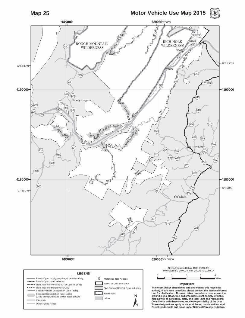
Map 25

42
162
91
1823
52162B 1237
599
91B
1175
91C
162C 91E 91F91H
91G91A
91J
162
OP56
OP151
OP151
OPBRP
OP664
OPBRPOP610
./250
OP608
THREE RIDGESWILDERNESS
THE PRIESTWILDERNESS
OP151
OP680
OP814
OP624
OP610
OPBRP
OP664
OP627
OP608
OP660
OP633
OP623
OP56
OP855
OP683 OP682
OP767OP814
OP610
./250
./340 WZ64WZ64
Sherando
Greenfield
Stuarts Draft
78°52'30"W
78°52'30"W
79°0'0"W
79°0'0"W
38°0'0"N38°0'0"N
37°52'30"N37°52'30"N
680000
680000
690000
690000
4190000 4190000
4200000 4200000
4210000 4210000
0 1 2 3 4Miles
Motor Vehicle Use Map 2015
North American Datum 1983 (NAD 83)Projection and 10,000-meter grid: UTM Zone 17
±
LEGEND
InterstateOther Public Roads
!E Motorized Trail AccessForest or Unit Boundary
WildernessLakes
Non-National Forest System Lands
Roads Open to Highway Legal Vehicles OnlyRoads Open to All VehiclesTrails Open to Vehicles 50" or Less in WidthTrails Open to Motorcycles Only
( ( ( ( Special Vehicle Designation (See Table)Seasonal Designation (See Table) {Used along with road or trail listed above}
The forest visitor should read and understand this map in itsentirety. If you have questions please contact this National ForestUnit for clarification. This map takes precedence over any on theground signs. Road, trail and area users must comply with thismap as well as all federal, state, and local laws and regulations.Compliance with these rules are the responsibility of the user.These designations apply to National Forest Lands and NationalForest roads, trails and areas under National Forest jurisdiction.
Important
Map 26

42
63
162
91
263
104
41
246
162A
52162B 1237
1176
1171
91B1816
1602
104A
1175
91C
596
162C
1626
91E 91F91H
91G91A
91J
162
63
1876A 1879
42
41
OP56
OPBRP
OP664
OP608
OP608
OP608
./11
OPBRP
OP56
OP605
OP608
ST. MARYSWILDERNESS
THE PRIESTWILDERNESS
THREE RIDGESWILDERNESS
OPBRP
OP814
OP603
OP687
OP608
OP56
OP667
OP686
OP605
OP610
OP685
OP666
OP706
OP660
OP606
OP81
OP683 OP682
OP826
OP690
OP680
OP814
OP667
OP686
./11
WZ81
WZ81
Montebello
Steeles Tavern
79°0'0"W
79°0'0"W
79°7'30"W
79°7'30"W
38°0'0"N38°0'0"N
37°52'30"N37°52'30"N
660000
660000
670000
670000
4190000 4190000
4200000 4200000
0 1 2 3 4Miles
Motor Vehicle Use Map 2015
North American Datum 1983 (NAD 83)Projection and 10,000-meter grid: UTM Zone 17
±
LEGEND
InterstateOther Public Roads
!E Motorized Trail AccessForest or Unit Boundary
WildernessLakes
Non-National Forest System Lands
Roads Open to Highway Legal Vehicles OnlyRoads Open to All VehiclesTrails Open to Vehicles 50" or Less in WidthTrails Open to Motorcycles Only
( ( ( ( Special Vehicle Designation (See Table)Seasonal Designation (See Table) {Used along with road or trail listed above}
The forest visitor should read and understand this map in itsentirety. If you have questions please contact this National ForestUnit for clarification. This map takes precedence over any on theground signs. Road, trail and area users must comply with thismap as well as all federal, state, and local laws and regulations.Compliance with these rules are the responsibility of the user.These designations apply to National Forest Lands and NationalForest roads, trails and areas under National Forest jurisdiction.
Important
Map 27
39
63
315
48
38
520
263
76
1167
246
1286
507
310
1176
594
494
1575
1171
315C
1157
315A
1602
1175
596
1626
63
16011876A 1879
1878
39
OP56
./60
OP621
OP605OPBRP
./60
OP634
OP608
OP603
OP635
OP607
OP610
THE PRIESTWILDERNESS
OP778
OPBRP
OP621
OP630
OP636
OP629
OP666
OP627
OP605
OP635
OP625
OP632
OP633
OP631
OP827
OP749
OP634
OP637
OP686
OP640
OP603
OP698
OP617
OP745
OP755
OP723
OP636OP637
OP635
./60
Forks of Buffalo
79°7'30"W
79°7'30"W
79°15'0"W
79°15'0"W
37°45'0"N37°45'0"N
37°37'30"N37°37'30"N
660000
660000
670000
670000
4170000 4170000
4180000 4180000
0 1 2 3 4Miles
Motor Vehicle Use Map 2015
North American Datum 1983 (NAD 83)Projection and 10,000-meter grid: UTM Zone 17
±
LEGEND
InterstateOther Public Roads
!E Motorized Trail AccessForest or Unit Boundary
WildernessLakes
Non-National Forest System Lands
Roads Open to Highway Legal Vehicles OnlyRoads Open to All VehiclesTrails Open to Vehicles 50" or Less in WidthTrails Open to Motorcycles Only
( ( ( ( Special Vehicle Designation (See Table)Seasonal Designation (See Table) {Used along with road or trail listed above}
The forest visitor should read and understand this map in itsentirety. If you have questions please contact this National ForestUnit for clarification. This map takes precedence over any on theground signs. Road, trail and area users must comply with thismap as well as all federal, state, and local laws and regulations.Compliance with these rules are the responsibility of the user.These designations apply to National Forest Lands and NationalForest roads, trails and areas under National Forest jurisdiction.
Important
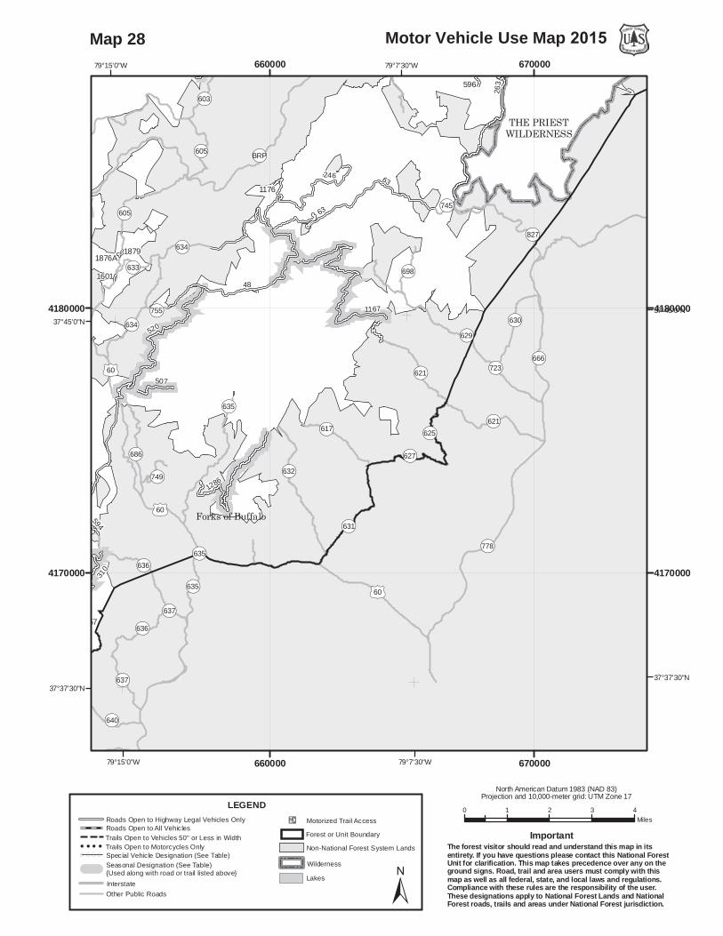
Map 28

39
315
48
38
520
76
311
104
1881
12861183
317
1241
507310
1176
1283
594
1830164
494
1575
1171
105
315C
1157
76D
315A
1602
104A
1173
1241A
164A
7616011876A 1879
1878
39
./60
./60
OP608
./60
OP605./11
OPBRP
OPBRP
./60./60
OP634
OPBRP
./501
OP608
OP603
./11
OP635
OP607
./501
Lynchburg Reservoir
OP39
OP716
OP663
OP608
OP607
OP636
OPBRP
OP704
OP605
OP757
OP714
OP635
OP633
OP603
OP749
OP634
OP686
OP699
OP631
OP700
OP706
OP697
OP678
OP671
OP733
OP13TH
OP745
OP755
OP735
OP792
OP637
OP700 OP608
OP716
OP635
./11
./60
./501
WZ81
WZ64
WZ81
Cornwall
Buena Vista
Forks of Buffalo
79°15'0"W
79°15'0"W
79°22'30"W
79°22'30"W
37°52'30"N37°52'30"N
37°45'0"N37°45'0"N
640000
640000
650000
650000
4170000 4170000
4180000 4180000
4190000 4190000
0 1 2 3 4Miles
Motor Vehicle Use Map 2015
North American Datum 1983 (NAD 83)Projection and 10,000-meter grid: UTM Zone 17
±
LEGEND
InterstateOther Public Roads
!E Motorized Trail AccessForest or Unit Boundary
WildernessLakes
Non-National Forest System Lands
Roads Open to Highway Legal Vehicles OnlyRoads Open to All VehiclesTrails Open to Vehicles 50" or Less in WidthTrails Open to Motorcycles Only
( ( ( ( Special Vehicle Designation (See Table)Seasonal Designation (See Table) {Used along with road or trail listed above}
The forest visitor should read and understand this map in itsentirety. If you have questions please contact this National ForestUnit for clarification. This map takes precedence over any on theground signs. Road, trail and area users must comply with thismap as well as all federal, state, and local laws and regulations.Compliance with these rules are the responsibility of the user.These designations apply to National Forest Lands and NationalForest roads, trails and areas under National Forest jurisdiction.
Important
Map 29

!E!E
39
315
36
38
311
35
318
36E
1881
951
12861183
317
593320
323
54
1241
507
318B
310
594
1830
36D
164
565
322
1575
105
319
315C1157
46
315A
564
1173
1241A
3093
164A
800
806
805
802
804
801
39
803
800
54A
./60
OPBRP
./60./60
OPBRP
./501 OP635
OP607
OP610
OP647
./501
OPBRP
JAMES RIVER FACEWILDERNESS
Lynchburg Reservoir
OP663
OP647
OP607
OP644
OP122
OP643
OP637
OP636
OP635
OPBRP
OP640
OP613
OP130
OP610
OP749
OP608
OP602
OP686OP678
OP641
OP727
OP814
OP671
OP699
OP600
OP638
OP812
OP615
OP792
OP772
OP636
OP643
OP671
OP637
OP637
./60
./501
Snowden
Big Island
Forks of Buffalo
79°15'0"W
79°15'0"W
79°22'30"W
79°22'30"W
37°37'30"N37°37'30"N
37°30'0"N37°30'0"N
640000
640000
650000
6500004150000 4150000
4160000 4160000
4170000 4170000
0 1 2 3 4Miles
Motor Vehicle Use Map 2015
North American Datum 1983 (NAD 83)Projection and 10,000-meter grid: UTM Zone 17
±
LEGEND
InterstateOther Public Roads
!E Motorized Trail AccessForest or Unit Boundary
WildernessLakes
Non-National Forest System Lands
Roads Open to Highway Legal Vehicles OnlyRoads Open to All VehiclesTrails Open to Vehicles 50" or Less in WidthTrails Open to Motorcycles Only
( ( ( ( Special Vehicle Designation (See Table)Seasonal Designation (See Table) {Used along with road or trail listed above}
The forest visitor should read and understand this map in itsentirety. If you have questions please contact this National ForestUnit for clarification. This map takes precedence over any on theground signs. Road, trail and area users must comply with thismap as well as all federal, state, and local laws and regulations.Compliance with these rules are the responsibility of the user.These designations apply to National Forest Lands and NationalForest roads, trails and areas under National Forest jurisdiction.
Important
Map 30

81259
45
36
35
280
951
3101
3068
765
768
3034
54
3099
190
316
635
3251
3105
907
782
36D
3076
815
681
3038
780
46
898
3044
774
780A
302776
5
3048
3093
955
3059
815A
54A
812
3055
./501
OPBRPOPBRP
OP614
OP618
OP614
OP608
OP130./11
OP759
OP608
OPBRP
OP43
JAMES RIVER FACEWILDERNESS
THUNDER RIDGEWILDERNESS
OP639 OP637
OPBRP
OP608
OP122
OP708
OP638
OP614
OP643
OP609
OP760
OP766
OP642
OP43
OP640
OP687
OP688
OP676
OP622
OP759
OP675
OP602
OP790
OP680
OP610
OP782
OP685OP693 OP130
OP814
OP781
OP641
OP694
OP674
OP749
OP764
OP623
OP850
OP765
OP699
OP714
OP849
OP692
OP773OP684
OP799
OP620
OP619
OP637OP850
OP622
OP693
OP638
OP639
OP622
./501
./11
WZ81
Reba
Acadia
GlasgowRed MillsSpringfield
Natural Bridge
Gilemore MillsNational Bridge Station
79°30'0"W
79°30'0"W
79°37'30"W
79°37'30"W
37°37'30"N37°37'30"N
37°30'0"N37°30'0"N
620000
620000
630000
630000
640000
640000
4150000 4150000
4160000 4160000
0 1 2 3 4Miles
Motor Vehicle Use Map 2015
North American Datum 1983 (NAD 83)Projection and 10,000-meter grid: UTM Zone 17
±
LEGEND
InterstateOther Public Roads
!E Motorized Trail AccessForest or Unit Boundary
WildernessLakes
Non-National Forest System Lands
Roads Open to Highway Legal Vehicles OnlyRoads Open to All VehiclesTrails Open to Vehicles 50" or Less in WidthTrails Open to Motorcycles Only
( ( ( ( Special Vehicle Designation (See Table)Seasonal Designation (See Table) {Used along with road or trail listed above}
The forest visitor should read and understand this map in itsentirety. If you have questions please contact this National ForestUnit for clarification. This map takes precedence over any on theground signs. Road, trail and area users must comply with thismap as well as all federal, state, and local laws and regulations.Compliance with these rules are the responsibility of the user.These designations apply to National Forest Lands and NationalForest roads, trails and areas under National Forest jurisdiction.
Important
Map 31

4008
634.2
191
634.3
3068
635
3251
3078
186-1
681
3038
186-2634
.1
3048
3411A
3059 3055
OPBRP
OP614
OP614
./11
OP640
OPBRP
OP43
OP697
WZ81
OP717
OP606
OP625
OP43
OPBRP
OP635
OP638
OP692
OP695
OP640
OP681
OP642
OP641
OP680
OP630
OP650
OP607
OP634
OP643
OP686
OP799
OP716
OP751
OP636
OP614
OP698
OP637
OP616
OP661
OP694OP677
OP628
OP693
OP1413
OP651
OP617
OP699
OP629
OP676
OP631
OP639
OP644 OP645
OP813
OP812
OP679
OP670
OP603
OP611
OP724
OP660
OP657
OP711
OP730
OP771
OP746
OP652
OP780
OP691
OP741
OP646
OP658
OP696
OP1510
OP801
OP647
OP738
OP805
OP798
OP776
OP721
OP689
OP806
OP729
OP820
OP605
OP723
OP715
OP768
OP1406
OP807
OP680
OP680
OP607
OP640
OP638
OP638 OP625
OP691
OP680
OP698
OP636
OP616
OP681
OP741
OP607
OP625
OP812
OP606
OP634
OP637
OP643
OP607
./460
./220
./11
./220
WZ81
WZ81
Lithia
Montvale
Buchanan
Villamont
SpringwoodKyles Mills
79°45'0"W
79°45'0"W
79°52'30"W
37°30'0"N37°30'0"N
37°22'30"N37°22'30"N
600000
600000
610000
610000
620000
620000
4140000 4140000
4150000 4150000
0 1 2 3 4Miles
Motor Vehicle Use Map 2015
North American Datum 1983 (NAD 83)Projection and 10,000-meter grid: UTM Zone 17
±
LEGEND
InterstateOther Public Roads
!E Motorized Trail AccessForest or Unit Boundary
WildernessLakes
Non-National Forest System Lands
Roads Open to Highway Legal Vehicles OnlyRoads Open to All VehiclesTrails Open to Vehicles 50" or Less in WidthTrails Open to Motorcycles Only
( ( ( ( Special Vehicle Designation (See Table)Seasonal Designation (See Table) {Used along with road or trail listed above}
The forest visitor should read and understand this map in itsentirety. If you have questions please contact this National ForestUnit for clarification. This map takes precedence over any on theground signs. Road, trail and area users must comply with thismap as well as all federal, state, and local laws and regulations.Compliance with these rules are the responsibility of the user.These designations apply to National Forest Lands and NationalForest roads, trails and areas under National Forest jurisdiction.
Important
Map 32

!E
179184
351
224
5036
229
183
267
5020
179
5027
191
181
5058
5012
5064
50871
351A
182742
5026
3503
5061
5012
A
50561
5080
679
648
229A
501(A-E)
502(A-F)
184
505515050
BARBOURS CREEK
WILDERNESS
3502
180
181A181B
179
5036
678
180229
OP311
OP615
OP818
OP666
OP600
OP600
OP606
OP685
OP615
OP615
OP615OP606
OP311
OP779
OP670
OP666
OP665
OP611
OP600OP606
OP630
OP655OP618
OP672
OP615
OP635
OP668
OP712
OP651
OP677
OP602
OP681
OP673
OP669
OP643
OP640
OP679
OP609
OP683
OP817
OP617
OP612
OP676
OP616
OP613
OP686
OP706
OP717
OP614
OP704
OP748
OP684
OP678
OP667
OP682
OP721
OP247
OP705
OP657
OP766
OP670
OP779
OP681
OP704
OP666
OP665
OP779
OP666OP676
OP704
OP681
OP635
OP683
OP704
OP612
OP779
OP606
OP655
OP681
OP606 OP630
./220
WZ81
Given
Trinity
Mt Union
Amsterdam
Fincastle
Glebe Mills
Marshalltown
Howell Mills
Haymakertown
Barbours Creek
Virginia Mineral Springs
79°52'30"W
79°52'30"W
80°0'0"W
80°0'0"W
37°37'30"N 37°37'30"N
37°30'0"N 37°30'0"N
580000
580000
590000
590000
600000
600000
4150000 4150000
4160000 4160000
0 1 2 3 4Miles
Motor Vehicle Use Map 2015
North American Datum 1983 (NAD 83)Projection and 10,000-meter grid: UTM Zone 17
±
LEGEND
InterstateOther Public Roads
!E Motorized Trail AccessForest or Unit Boundary
WildernessLakes
Non-National Forest System Lands
Roads Open to Highway Legal Vehicles OnlyRoads Open to All VehiclesTrails Open to Vehicles 50" or Less in WidthTrails Open to Motorcycles Only
( ( ( ( Special Vehicle Designation (See Table)Seasonal Designation (See Table) {Used along with road or trail listed above}
The forest visitor should read and understand this map in itsentirety. If you have questions please contact this National ForestUnit for clarification. This map takes precedence over any on theground signs. Road, trail and area users must comply with thismap as well as all federal, state, and local laws and regulations.Compliance with these rules are the responsibility of the user.These designations apply to National Forest Lands and NationalForest roads, trails and areas under National Forest jurisdiction.
Important
Map 33
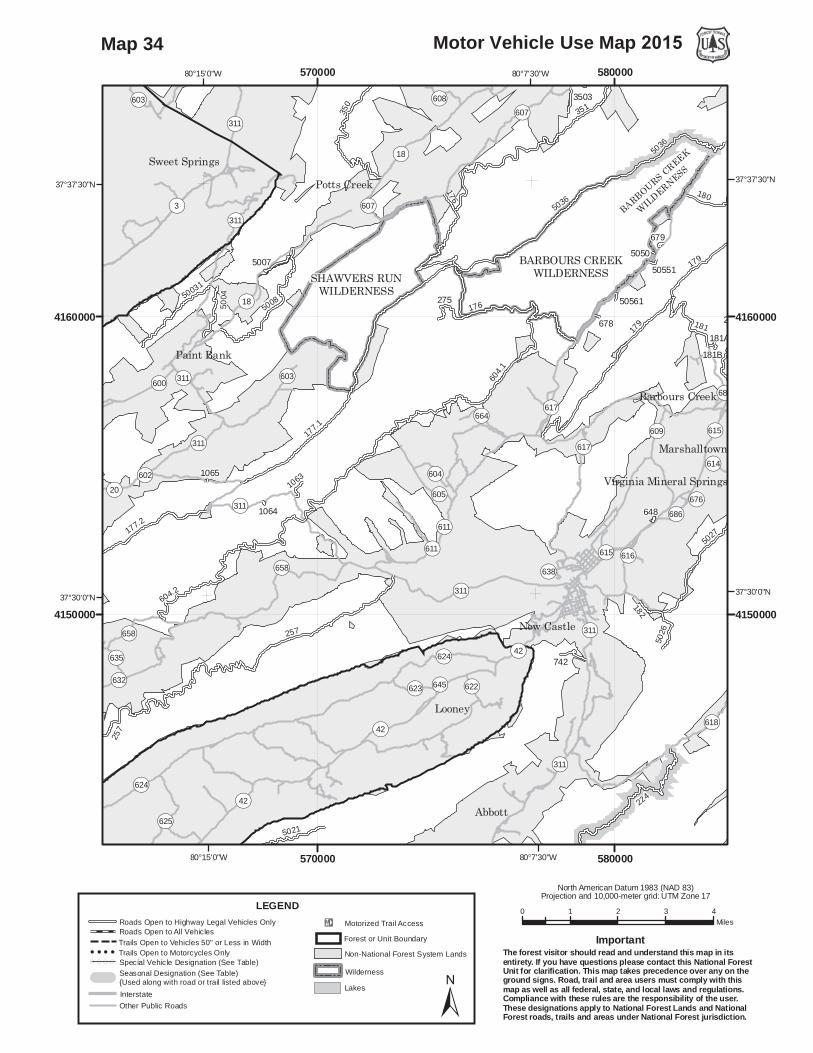
257
179
351
224
5036
229
177.1
604.1
176
183
604.2
177.2209
179
5027
5008
181
50031
5023
5004
209
275
351A
182
74250
26
3503
5007
1063
5023
50561
257
679
648
229A
505515050
BARBOURS CREEK
WILDERNESS
3502
176
181A181B
179
5036
350
678
5021
1064
1065
180
OP311
OP311
OP42
OP18
OP600
OP685
OP615
OP615
OP311
OP311
OP311
OP311
OP611
OP624
OP658
OP42
OP600
OP621
OP42
OP18
OP311
BARBOURS CREEKWILDERNESSSHAWVERS RUN
WILDERNESS
OP624
OP311 OP607
OP617
OP658
OP18
OP618
OP611
OP3
OP42
OP608
OP664
OP625
OP609
OP623
OP616
OP603
OP686OP605
OP615
OP604
OP600
OP622OP632
OP614
OP635
OP676
OP638
OP602
OP645
OP20
OP603
OP617
OP607
Abbott
Looney
New Castle
Paint Bank
Potts Creek
Marshalltown
Sweet Springs
Barbours Creek
Virginia Mineral Springs
80°7'30"W
80°7'30"W
80°15'0"W
80°15'0"W
37°37'30"N 37°37'30"N
37°30'0"N 37°30'0"N
570000
570000
580000
580000
4150000 4150000
4160000 4160000
0 1 2 3 4Miles
Motor Vehicle Use Map 2015
North American Datum 1983 (NAD 83)Projection and 10,000-meter grid: UTM Zone 17
±
LEGEND
InterstateOther Public Roads
!E Motorized Trail AccessForest or Unit Boundary
WildernessLakes
Non-National Forest System Lands
Roads Open to Highway Legal Vehicles OnlyRoads Open to All VehiclesTrails Open to Vehicles 50" or Less in WidthTrails Open to Motorcycles Only
( ( ( ( Special Vehicle Designation (See Table)Seasonal Designation (See Table) {Used along with road or trail listed above}
The forest visitor should read and understand this map in itsentirety. If you have questions please contact this National ForestUnit for clarification. This map takes precedence over any on theground signs. Road, trail and area users must comply with thismap as well as all federal, state, and local laws and regulations.Compliance with these rules are the responsibility of the user.These designations apply to National Forest Lands and NationalForest roads, trails and areas under National Forest jurisdiction.
Important
Map 34

734
630
279
604.2
177.2
5031
10491
50031
11060
5023
10631
645
5004
209
10522
5048
5032A
5007
50111
10981
5023
50041
257
645A645B
1065
10521
OP42
OP311
OP311
OP311
OP624
OP658
OP632
OP42
OP29
OP15
OP3
OP17
OP600
OP20
OP621
OP601
OP42
OP18
OP311
MOUNTAIN LAKEWILDERNESS
OP20
OP8
OP15
OP4
OP17
OP632
OP3
OP658
OP641
OP627
OP636
OP601
OP625
OP15/3
OP11
OP626
OP311
OP42
OP628
OP600
OP635
OP629
OP633
OP639
OP15/4
OP15/5
OP602
OP662
OP658
OP632
OP311
OP15/3
OP658OP632
OP632
Keenan
Maggie
Gap Mills
Waiteville
Paint Bank
Laurel Branch
Sinking Creek
Crimson Springs
Blue Healing Springs
80°22'30"W
80°22'30"W
37°30'0"N 37°30'0"N
37°22'30"N 37°22'30"N
550000
550000
560000
560000
4140000 4140000
4150000 4150000
4160000 4160000
0 1 2 3 4Miles
Motor Vehicle Use Map 2015
North American Datum 1983 (NAD 83)Projection and 10,000-meter grid: UTM Zone 17
±
LEGEND
InterstateOther Public Roads
!E Motorized Trail AccessForest or Unit Boundary
WildernessLakes
Non-National Forest System Lands
Roads Open to Highway Legal Vehicles OnlyRoads Open to All VehiclesTrails Open to Vehicles 50" or Less in WidthTrails Open to Motorcycles Only
( ( ( ( Special Vehicle Designation (See Table)Seasonal Designation (See Table) {Used along with road or trail listed above}
The forest visitor should read and understand this map in itsentirety. If you have questions please contact this National ForestUnit for clarification. This map takes precedence over any on theground signs. Road, trail and area users must comply with thismap as well as all federal, state, and local laws and regulations.Compliance with these rules are the responsibility of the user.These designations apply to National Forest Lands and NationalForest roads, trails and areas under National Forest jurisdiction.
Important
Map 35

257
224
630
183
114
604.2
177.2
209
5027
11060
209
182742
5026
5028
10981
5023
257
648
5021
1064
OP311
OP311
OP42 OP600
OP311
OP311
OP611
OP624
OP658
OP42
OP621
OP624
OP621
OP42
OP785
OP622
OP624
OP618
OP697
OP311
OP643
OP727
OP779
OP630
OP620 OP864
OP42
OP625
OP650
OP701
OP619
OP621
OP623
OP600
OP658
OP890
OP698
OP704
OP640
OP632
OP616
OP651
OP645
OP851
OP927
OP624
OP311
OP622
WZ81
Salem
Abbott
Looney
Catabaw
Bradshaw
Webbs Mill
Mason Cove
New Castle
McDonalds Mill
80°7'30"W
80°7'30"W
80°15'0"W
80°15'0"W
37°30'0"N 37°30'0"N
37°22'30"N 37°22'30"N
570000
570000
580000
580000
4130000 4130000
4140000 4140000
4150000 4150000
0 1 2 3 4Miles
Motor Vehicle Use Map 2015
North American Datum 1983 (NAD 83)Projection and 10,000-meter grid: UTM Zone 17
±
LEGEND
InterstateOther Public Roads
!E Motorized Trail AccessForest or Unit Boundary
WildernessLakes
Non-National Forest System Lands
Roads Open to Highway Legal Vehicles OnlyRoads Open to All VehiclesTrails Open to Vehicles 50" or Less in WidthTrails Open to Motorcycles Only
( ( ( ( Special Vehicle Designation (See Table)Seasonal Designation (See Table) {Used along with road or trail listed above}
The forest visitor should read and understand this map in itsentirety. If you have questions please contact this National ForestUnit for clarification. This map takes precedence over any on theground signs. Road, trail and area users must comply with thismap as well as all federal, state, and local laws and regulations.Compliance with these rules are the responsibility of the user.These designations apply to National Forest Lands and NationalForest roads, trails and areas under National Forest jurisdiction.
Important
Map 36

188
269
734
630
114
113
11060
645
209
5048
10791
808
1079
10981
645A645B
10763
OP42
./460
OP42
OP613
OP632
OP42
OP621
OP806
./460
./460
OP624
OP601
OP42
OP601
MOUNTAIN LAKEWILDERNESS
OP657OP619 OP603
OP621
OP655
OP639
OP685
OP648
OP628
OP737
OP777
OP659
OP651
OP804
OP601
OP721
OP42
OP624
OP641
OP627
OP806
OP785
OP662
OP658
OP649
OP629
OP626
OP602
OP630
OP810
OP1103
OP698
OP622
OP631
OP642
OP633
OP815
OP614
OP770
OP663
OP1102
OP652
OP723OP650
OP643
OP730
OP778
OP628
OP630
OP624
OP785
OP657OP624
./460
Huffman
Newport
Mt Tabor
Merrimac
Blacksburg
Prices Fork
Kanodes Mill
Simmonsville
Bennetts Mill
McDonalds Mill
80°22'30"W
80°22'30"W
80°30'0"W
80°30'0"W
37°22'30"N 37°22'30"N
37°15'0"N 37°15'0"N
550000
550000
560000
560000
4120000 4120000
4130000 4130000
4140000 4140000
0 1 2 3 4Miles
Motor Vehicle Use Map 2015
North American Datum 1983 (NAD 83)Projection and 10,000-meter grid: UTM Zone 17
±
LEGEND
InterstateOther Public Roads
!E Motorized Trail AccessForest or Unit Boundary
WildernessLakes
Non-National Forest System Lands
Roads Open to Highway Legal Vehicles OnlyRoads Open to All VehiclesTrails Open to Vehicles 50" or Less in WidthTrails Open to Motorcycles Only
( ( ( ( Special Vehicle Designation (See Table)Seasonal Designation (See Table) {Used along with road or trail listed above}
The forest visitor should read and understand this map in itsentirety. If you have questions please contact this National ForestUnit for clarification. This map takes precedence over any on theground signs. Road, trail and area users must comply with thismap as well as all federal, state, and local laws and regulations.Compliance with these rules are the responsibility of the user.These designations apply to National Forest Lands and NationalForest roads, trails and areas under National Forest jurisdiction.
Important
Map 37

188
177.4
269
734
714
945
113
10570
10631
645942
10522
5048
10791
808
1079
10550
645A645B
189
10763
177.4
714
261
./460
OP42
OP613
OP632
OP806
./460
./460
OP624
OP601
OP42
OP601
MOUNTAIN LAKEWILDERNESS
OP700
OP621
OP655
OP625
OP639
OP685
OP635
OP608
OP648
OP613
OP777
OP651
OP601
OP781
OP721
OP603
OP778
OP607
OP708
OP657
OP42
OP806
OP632
OP718
OP714
OP785
OP662
OP730
OP658
OP649
OP602
OP606
OP605
OP624
OP783
OP630
OP629
OP810
OP762
OP1103
OP698
OP694OP631
OP604
OP696
OP804
OP642
OP725
OP636
OP774
OP633
OP815
OP614
OP744
OP770
OP1102
OP663
OP740
OP765
OP723OP650
OP705
OP730
OP624
OP657
OP777
OP778
OP604
./460
Maggie
Huffman
Newport
Mt Tabor
Maybrook
Blacksburg
Prices Fork
Kanodes Mill
Simmonsville
Mountain Lake
80°22'30"W
80°22'30"W
80°30'0"W
80°30'0"W
37°22'30"N 37°22'30"N
37°15'0"N 37°15'0"N
540000
540000
550000
550000
4120000 4120000
4130000 4130000
4140000 4140000
0 1 2 3 4Miles
Motor Vehicle Use Map 2015
North American Datum 1983 (NAD 83)Projection and 10,000-meter grid: UTM Zone 17
±
LEGEND
InterstateOther Public Roads
!E Motorized Trail AccessForest or Unit Boundary
WildernessLakes
Non-National Forest System Lands
Roads Open to Highway Legal Vehicles OnlyRoads Open to All VehiclesTrails Open to Vehicles 50" or Less in WidthTrails Open to Motorcycles Only
( ( ( ( Special Vehicle Designation (See Table)Seasonal Designation (See Table) {Used along with road or trail listed above}
The forest visitor should read and understand this map in itsentirety. If you have questions please contact this National ForestUnit for clarification. This map takes precedence over any on theground signs. Road, trail and area users must comply with thismap as well as all federal, state, and local laws and regulations.Compliance with these rules are the responsibility of the user.These designations apply to National Forest Lands and NationalForest roads, trails and areas under National Forest jurisdiction.
Important
Map 38

177.4
734
714
945
113
10491
10570260
645942
10522
808
1079
10550
645A645B
189
10521
177.4
714
261
./460
OP42
./460
OP635
OP613
./460
OP100
OP29
./460
OP601
OP601
OP635 MOUNTAIN LAKEWILDERNESS
PETERS MOUNTAINWILDERNESS
OP15
OP700OP626
OP625
OP635
OP608
OP219
OP29
OP613
OP17
OP694
OP772 OP601OP603
OP627
OP778
OP607
OP9
OP623OP753
OP714
OP688
OP766
OP615
OP730
OP634
OP723
OP720
OP622
OP602
OP27
OP628
OP783OP617
OP762OP684
OP686OP685
OP25
OP604
OP796OP42
OP1506
OP636OP637
OP777OP745
OP780
OP774
OP678
OP614OP803
OP699
OP740
OP765OP771
OP701
OP705
OP612
OP616
OP682
OP626
OP626
OP622
OP623
OP622
OP604OP626
OP15
OP613
./460
Olean
Newport
Pembroke
Interior
Goldbond
Lindside
Maybrook
Rock Camp
Mountain Lake
Crimson Springs
80°30'0"W
80°30'0"W
80°37'30"W
80°37'30"W
37°30'0"N 37°30'0"N
37°22'30"N 37°22'30"N
530000
530000
540000
540000
4130000 4130000
4140000 4140000
4150000 4150000
0 1 2 3 4Miles
Motor Vehicle Use Map 2015
North American Datum 1983 (NAD 83)Projection and 10,000-meter grid: UTM Zone 17
±
LEGEND
InterstateOther Public Roads
!E Motorized Trail AccessForest or Unit Boundary
WildernessLakes
Non-National Forest System Lands
Roads Open to Highway Legal Vehicles OnlyRoads Open to All VehiclesTrails Open to Vehicles 50" or Less in WidthTrails Open to Motorcycles Only
( ( ( ( Special Vehicle Designation (See Table)Seasonal Designation (See Table) {Used along with road or trail listed above}
The forest visitor should read and understand this map in itsentirety. If you have questions please contact this National ForestUnit for clarification. This map takes precedence over any on theground signs. Road, trail and area users must comply with thismap as well as all federal, state, and local laws and regulations.Compliance with these rules are the responsibility of the user.These designations apply to National Forest Lands and NationalForest roads, trails and areas under National Forest jurisdiction.
Important
Map 39
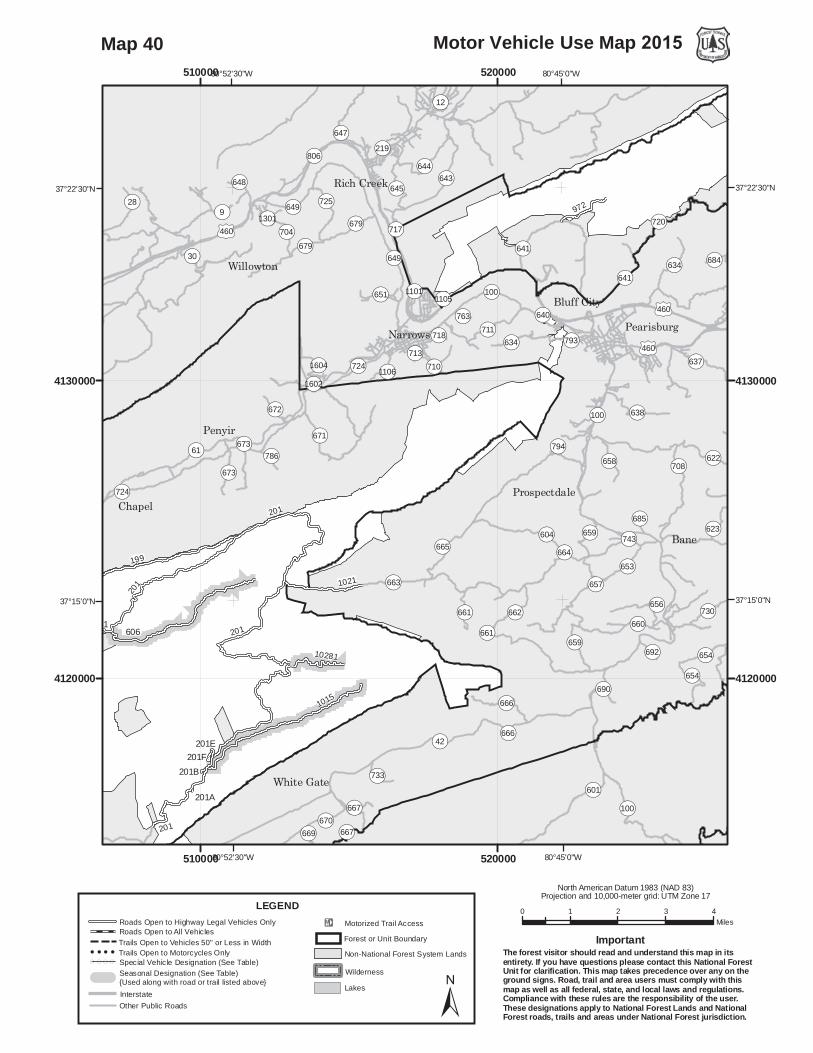
199
201606
1015
1021
972
10281
201E
201A
201B
201
201
201
201F
./460
OP635
./460
./460
OP100
OP100
201
OP641
OP677
OP42
OP720
OP649
OP806
OP666
OP100
OP724
OP644
OP634
OP662
OP643
OP665
OP638
OP645
OP663
OP61
OP641
OP671
OP659
OP704
OP656
OP653
OP711
OP654
OP658OP673
OP30
OP670
OP661 OP730
OP667
OP623OP604
OP725
OP708
OP647
OP733
OP690
OP1604
OP672
OP743
OP28
OP622
OP601
OP219
OP679
OP786
OP660
OP9
OP651
OP684
OP669
OP648
OP12
OP793
OP717
OP794
OP637
OP657
OP718
OP710
OP763
OP692
OP685
OP640
OP1602
OP1105
OP713
OP1106
OP1301
OP664
OP1101
OP673
OP659
OP679
OP661
OP654
OP724
OP667
OP634
OP649
OP666
./460
Bane
Penyir
Chapel
Narrows
Willowton
White Gate
Rich Creek
Bluff CityPearisburg
Prospectdale
80°45'0"W
80°45'0"W
80°52'30"W
80°52'30"W
37°22'30"N 37°22'30"N
37°15'0"N 37°15'0"N
510000
510000
520000
520000
4120000 4120000
4130000 4130000
0 1 2 3 4Miles
Motor Vehicle Use Map 2015
North American Datum 1983 (NAD 83)Projection and 10,000-meter grid: UTM Zone 17
±
LEGEND
InterstateOther Public Roads
!E Motorized Trail AccessForest or Unit Boundary
WildernessLakes
Non-National Forest System Lands
Roads Open to Highway Legal Vehicles OnlyRoads Open to All VehiclesTrails Open to Vehicles 50" or Less in WidthTrails Open to Motorcycles Only
( ( ( ( Special Vehicle Designation (See Table)Seasonal Designation (See Table) {Used along with road or trail listed above}
The forest visitor should read and understand this map in itsentirety. If you have questions please contact this National ForestUnit for clarification. This map takes precedence over any on theground signs. Road, trail and area users must comply with thismap as well as all federal, state, and local laws and regulations.Compliance with these rules are the responsibility of the user.These designations apply to National Forest Lands and NationalForest roads, trails and areas under National Forest jurisdiction.
Important
Map 40

206
640
199
606
707
6031
286
692
2021023
6661
61471
6055A
201E
6551
61504
201A
6055B
201B
201
201
201F
288
206
OP42
WZ77
WZ77
201
OP600
OP601
./52
OP677
OP608
OP608
KIMBERLING CREEKWILDERNESS
OP656
OP606
OP61
OP42
OP678
OP608
OP600
OP612
OP605
OP604
OP738
OP611
OP607
OP616
OP658
OP645
OP602
OP601
OP676
OP613
OP640
OP617
OP650
OP724
OP642
OP631OP629
OP627
OP677
OP634
OP632
OP609
OP644
OP662
OP98OP651
OP664
OP760
OP42
OP604
OP608
./52
./52
./52
WZ77
Bland
Niday
Crandon
South Gap
Rocky Gap
Long Spur
North Gap
Kimberling
Hicksville Holly Brook
Mechanicsburg
Point Pleasant
Pumpkin Center
81°0'0"W
81°0'0"W
81°7'30"W
81°7'30"W
37°15'0"N 37°15'0"N
37°7'30"N 37°7'30"N
490000
490000
500000
5000004100000 4100000
4110000 4110000
4120000 4120000
0 1 2 3 4Miles
Motor Vehicle Use Map 2015
North American Datum 1983 (NAD 83)Projection and 10,000-meter grid: UTM Zone 17
±
LEGEND
InterstateOther Public Roads
!E Motorized Trail AccessForest or Unit Boundary
WildernessLakes
Non-National Forest System Lands
Roads Open to Highway Legal Vehicles OnlyRoads Open to All VehiclesTrails Open to Vehicles 50" or Less in WidthTrails Open to Motorcycles Only
( ( ( ( Special Vehicle Designation (See Table)Seasonal Designation (See Table) {Used along with road or trail listed above}
The forest visitor should read and understand this map in itsentirety. If you have questions please contact this National ForestUnit for clarification. This map takes precedence over any on theground signs. Road, trail and area users must comply with thismap as well as all federal, state, and local laws and regulations.Compliance with these rules are the responsibility of the user.These designations apply to National Forest Lands and NationalForest roads, trails and areas under National Forest jurisdiction.
Important
Map 41

707
6031
692
202
6661
208
6861
201E
201A
201B201F
OP42
201
OP600
OP610
OP610
OP647
OP601
OP608
OP608
OP738
OP738
OP604
OP640
OP42
OP670
OP608
OP610
OP601
OP600
OP667
OP614
OP652
OP712
OP643
OP701
OP611
OP607
OP726
OP641
OP654
OP613
OP645
OP602
OP669
OP710
OP612
OP606
OP737OP634
OP674
OP619
OP639
OP711
OP121OP709
OP631OP629
OP713
OP650
OP101
OP671
OP632
OP662
OP716
OP762
OP646
OP604
OP608
OP42
OP762
OP640
OP667
OP710
OP634
OP738
OP669
OP667
./11WZ81
Weldon
Crandon
Mt Oliver
Long Spur
White Gate
Empire Mine
Max Meadows
Gunton Park
Alum Springs
Mechanicsburg
Point Pleasant
80°52'30"W
80°52'30"W
81°0'0"W
81°0'0"W
37°7'30"N 37°7'30"N
37°0'0"N 37°0'0"N
500000
500000
510000
510000
4100000 4100000
4110000 4110000
0 1 2 3 4Miles
Motor Vehicle Use Map 2015
North American Datum 1983 (NAD 83)Projection and 10,000-meter grid: UTM Zone 17
±
LEGEND
InterstateOther Public Roads
!E Motorized Trail AccessForest or Unit Boundary
WildernessLakes
Non-National Forest System Lands
Roads Open to Highway Legal Vehicles OnlyRoads Open to All VehiclesTrails Open to Vehicles 50" or Less in WidthTrails Open to Motorcycles Only
( ( ( ( Special Vehicle Designation (See Table)Seasonal Designation (See Table) {Used along with road or trail listed above}
The forest visitor should read and understand this map in itsentirety. If you have questions please contact this National ForestUnit for clarification. This map takes precedence over any on theground signs. Road, trail and area users must comply with thismap as well as all federal, state, and local laws and regulations.Compliance with these rules are the responsibility of the user.These designations apply to National Forest Lands and NationalForest roads, trails and areas under National Forest jurisdiction.
Important
Map 42

206
668
288
707
2861023
6661
208289
6055A
817
6551
61504
6055B
773
288
206
6142
OP42
WZ77
OP600
OP610
WZ77
OP647
OP603
OP601
OP615
./52
OP608
./52
OP42
OP656
OP649
OP42
OP647
OP640
OP608
OP612
OP605
OP659
OP604
OP712
OP610
OP710
OP603
OP601
OP667
OP615
OP600
OP717
OP632
OP664OP121
OP696
OP616
OP658
OP661
OP645
OP602
OP611
OP662
OP731
OP617
OP634OP663 OP720
OP660
OP655
OP680
OP654
OP98
OP716
OP651
OP633
OP636
OP4TH Street
OP42
OP42
OP656
OP661
OP663
OP615
OP658
OP656
OP600
OP656
OP600
./52
./21
WZ81
WZ77
WZ81
WZ81
WZ77
WZ81
Bland
Haven
Cline
Shupe
Carnot
Crandon
Petunia
Kegleys
Fairview
Long Spur
Springtown
Sutherland
Wytheville
Stones Mill
Point Pleasant
81°0'0"W
81°0'0"W
81°7'30"W
81°7'30"W
37°7'30"N 37°7'30"N
37°0'0"N 37°0'0"N
490000
490000
500000
500000
4090000 4090000
4100000 4100000
4110000 4110000
0 1 2 3 4Miles
Motor Vehicle Use Map 2015
North American Datum 1983 (NAD 83)Projection and 10,000-meter grid: UTM Zone 17
±
LEGEND
InterstateOther Public Roads
!E Motorized Trail AccessForest or Unit Boundary
WildernessLakes
Non-National Forest System Lands
Roads Open to Highway Legal Vehicles OnlyRoads Open to All VehiclesTrails Open to Vehicles 50" or Less in WidthTrails Open to Motorcycles Only
( ( ( ( Special Vehicle Designation (See Table)Seasonal Designation (See Table) {Used along with road or trail listed above}
The forest visitor should read and understand this map in itsentirety. If you have questions please contact this National ForestUnit for clarification. This map takes precedence over any on theground signs. Road, trail and area users must comply with thismap as well as all federal, state, and local laws and regulations.Compliance with these rules are the responsibility of the user.These designations apply to National Forest Lands and NationalForest roads, trails and areas under National Forest jurisdiction.
Important
Map 43

206
668
221
288
610
727
61471
723
6361B
61461
6531
289
6055A
817
6551
61504
6361C
221A
6055B
288
206
6142
WZ77
./52
OP614OP61
OP615
./52
OP42
./52
OP42
OP625
OP666
OP623
OP61
OP727
OP622
OP615
OP667
OP686
OP662
OP614
OP646
OP717
OP621
OP616
OP618
OP624
OP42
OP617
OP626
OP659
OP642
OP648OP657 OP636
OP625
OP42
OP625
OP666
OP622
./52
./52
./52
WZ77
WZ77
WZ77
Ceres
Effna
Suiter
Gose Mill
Hicksville
Clear Fork
Cove Creek
Little Town
Shannandale
Shawver Mill
Burkes Garden
Sharon Springs
81°15'0"W
81°15'0"W
37°7'30"N 37°7'30"N
37°0'0"N 37°0'0"N
470000
470000
480000
480000
4100000 4100000
4110000 4110000
0 1 2 3 4Miles
Motor Vehicle Use Map 2015
North American Datum 1983 (NAD 83)Projection and 10,000-meter grid: UTM Zone 17
±
LEGEND
InterstateOther Public Roads
!E Motorized Trail AccessForest or Unit Boundary
WildernessLakes
Non-National Forest System Lands
Roads Open to Highway Legal Vehicles OnlyRoads Open to All VehiclesTrails Open to Vehicles 50" or Less in WidthTrails Open to Motorcycles Only
( ( ( ( Special Vehicle Designation (See Table)Seasonal Designation (See Table) {Used along with road or trail listed above}
The forest visitor should read and understand this map in itsentirety. If you have questions please contact this National ForestUnit for clarification. This map takes precedence over any on theground signs. Road, trail and area users must comply with thismap as well as all federal, state, and local laws and regulations.Compliance with these rules are the responsibility of the user.These designations apply to National Forest Lands and NationalForest roads, trails and areas under National Forest jurisdiction.
Important
Map 44

206
221
288
644
727
6261
723
6361B
6531
289
6055A
817
6551
61504
6361C
221A
6055B
773
206
WZ77
OP615
./52
WZ81
OP42
OP670
OP625
./52
OP42
OP623
OP625
OP664
OP615
OP727
OP616
OP622
OP667
OP654
OP652
OP686
OP699
OP673
OP668
OP665
OP666
OP600
OP717
OP690
OP653
OP621
OP683 OP674
OP680
OP670
OP675
OP662
OP624
OP749
OP663
OP682
OP617
OP42
OP735
OP626
OP669
OP771OP681
OP602
OP715
OP679OP729 OP709OP679
OP616
OP625
OP683
OP681
OP663
OP615
OP679
OP674
OP616
OP682 OP667
OP626
OP625
OP625
OP625
OP653
OP683
OP622
./52
./11
./21
./52
WZ81WZ81
Ceres
Effna
Cline
Shupe
Wilson
KegleysFavonia
Crockett
Blessings
Blacklick
Groseclose
Sutherland
Copenhavers
Old Mt Airy
Murpheyville
Burkes Garden
Rural Retreat
Sharon Springs
Staley Crossroads
81°15'0"W
81°15'0"W
81°22'30"W
81°22'30"W
37°0'0"N 37°0'0"N
36°52'30"N 36°52'30"N
470000
470000
480000
480000
4090000 4090000
4100000 4100000
0 1 2 3 4Miles
Motor Vehicle Use Map 2015
North American Datum 1983 (NAD 83)Projection and 10,000-meter grid: UTM Zone 17
±
LEGEND
InterstateOther Public Roads
!E Motorized Trail AccessForest or Unit Boundary
WildernessLakes
Non-National Forest System Lands
Roads Open to Highway Legal Vehicles OnlyRoads Open to All VehiclesTrails Open to Vehicles 50" or Less in WidthTrails Open to Motorcycles Only
( ( ( ( Special Vehicle Designation (See Table)Seasonal Designation (See Table) {Used along with road or trail listed above}
The forest visitor should read and understand this map in itsentirety. If you have questions please contact this National ForestUnit for clarification. This map takes precedence over any on theground signs. Road, trail and area users must comply with thismap as well as all federal, state, and local laws and regulations.Compliance with these rules are the responsibility of the user.These designations apply to National Forest Lands and NationalForest roads, trails and areas under National Forest jurisdiction.
Important
Map 45

222
644
618
880
6202
614
6261
878
6251
631
61011
878A
61102
OP16
OP16
OP622
WZ81
OP42
OP42
BEARTOWNWILDERNESS
OP16
OP622
OP602
OP624
OP604 OP727
OP625
OP621
OP742
OP620
OP617
OP629
OP606
OP601
OP619
OP610
OP689
OP611
OP761
OP42
OP683
OP687
OP682
OP667
OP713
OP666OP91
OP626
OP716
OP763
OP685
OP703
OP623
OP694
OP766
OP348
OP754
OP16 OP620
OP682
OP626
OP602
OP16
OP602
OP622
OP610
OP604
./11
Nebo
Ceres
Benbow
Asberrys
Ridgedale
Frog Level
Chatham Hill
Thompson Valley
81°22'30"W
81°22'30"W
81°30'0"W
81°30'0"W
37°0'0"N 37°0'0"N
36°52'30"N 36°52'30"N
450000
450000
460000
460000
4090000 4090000
4100000 4100000
0 1 2 3 4Miles
Motor Vehicle Use Map 2015
North American Datum 1983 (NAD 83)Projection and 10,000-meter grid: UTM Zone 17
±
LEGEND
InterstateOther Public Roads
!E Motorized Trail AccessForest or Unit Boundary
WildernessLakes
Non-National Forest System Lands
Roads Open to Highway Legal Vehicles OnlyRoads Open to All VehiclesTrails Open to Vehicles 50" or Less in WidthTrails Open to Motorcycles Only
( ( ( ( Special Vehicle Designation (See Table)Seasonal Designation (See Table) {Used along with road or trail listed above}
The forest visitor should read and understand this map in itsentirety. If you have questions please contact this National ForestUnit for clarification. This map takes precedence over any on theground signs. Road, trail and area users must comply with thismap as well as all federal, state, and local laws and regulations.Compliance with these rules are the responsibility of the user.These designations apply to National Forest Lands and NationalForest roads, trails and areas under National Forest jurisdiction.
Important
Map 46

((
(
(
(( (( (
((
((( (
(
(
( ((
((
((
(
(
690270
49681
667497
10
4052
4029
49790
4054
14A
14
4052B
737A
737E737F
OP602OP602
OP619
OP94
OP619OP602
OP94
OP94
OP94
OP652
OP654
OP607
OP649
OP619
OP635
OP642
OP695
OP740
OP650
OP739
OP631
OP736
OP645
OP793
OP733
OP646
OP721
OP758
OP634
OP660
OP69
OP655
OP849
OP735
OP638 OP641
OP653
OP732
OP605
OP742
OP94
OP639
OP602
OP690
OP643
OP805
OP636
OP737
OP845
OP604
OP694
OP726
OP644
OP640
OP741
OP606
OP637
OP729
OP713
OP651
OP843
OP630
OP648
OP751
OP692
OP759
OP691
OP647
OP810
OP857
OP738
OP1001
OP770
OP855
OP777
OP792
OP930
OP851OP878
OP773
OP925
OP887
OP717
OP815
OP869OP833
OP658
OP601
OP949
OP768
OP776OP818
OP756
OP816
OP874
OP850
OP858
OP814
OP882
OP745
OP779
OP643
OP604
OP742
OP605
OP650
OP634
OP643
OP602
OP640
OP635
OP644
OP740
OP606
OP646
OP639
OP739
OP642
OP751
OP640
OP692OP654
OP607OP739
OP640
OP636
OP737
OP619
OP649
OP642 OP654
OP646
OP645
OP694
./52
Galax
Fries
Henley
Huddle
Galena
BethanyIvanhoe
Hilltown
Raketown
Flatwood
Riverside
Fairville
Riverhill
Oak Grove
Clito Mill
Providence
Sheep Town
West Piney
Carsonville
Austinville
Collin Cove
Hickory Flat
Spring Valley
81°0'0"W
81°0'0"W
36°52'30"N 36°52'30"N
36°45'0"N 36°45'0"N
490000
490000
500000
500000
510000
510000
4060000 4060000
4070000 4070000
4080000 4080000
0 1 2 3 4Miles
Motor Vehicle Use Map 2015
North American Datum 1983 (NAD 83)Projection and 10,000-meter grid: UTM Zone 17
±
LEGEND
InterstateOther Public Roads
!E Motorized Trail AccessForest or Unit Boundary
WildernessLakes
Non-National Forest System Lands
Roads Open to Highway Legal Vehicles OnlyRoads Open to All VehiclesTrails Open to Vehicles 50" or Less in WidthTrails Open to Motorcycles Only
( ( ( ( Special Vehicle Designation (See Table)Seasonal Designation (See Table) {Used along with road or trail listed above}
The forest visitor should read and understand this map in itsentirety. If you have questions please contact this National ForestUnit for clarification. This map takes precedence over any on theground signs. Road, trail and area users must comply with thismap as well as all federal, state, and local laws and regulations.Compliance with these rules are the responsibility of the user.These designations apply to National Forest Lands and NationalForest roads, trails and areas under National Forest jurisdiction.
Important
Map 47
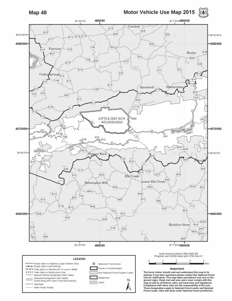
!
!!
!
!!
!
! ! ! !!
!!
!
!
!
!!
!
!!
!! !
!
!
!!
!!
!
!!
!! ! !
!
!
!!
!
!!
!! !
!!
!
!!
!
!
!
!!
!
!
!
!
!
!!
! !! !! !!
!
!
! !!
!
! !!
!
!!
!!
!
!
!
! ! ! !
!!
!
!!!!!!! !
!
!
!
!
!
!!!
!
!
!!
! ! !
!
!
!!
! !!
!!
!
!
!!
!
!!
!!
! !
!
!
!
!
!
!
! ! !
!
!
!
!!
!
!! !
! !! !
! ! ! !!
! ! ! !
!
!!
((
(
(
(( (( (
((
(((
((
(
( ((
((
((
(
(
16
14
57
49681
781
728
4052
57B
4061
411
14A
14
57A 57G4505
337
337
4962
OP619
OP612
OP672
./21
./21
OP619OP602
./21
OP612
OP612OP675
OP670
OP614
OP614 OP749
LITTLE DRY RUNWILDERNESS
OP654
OP707
OP669
OP655
OP672
OP684
OP709
OP678
OP792
OP749
OP665
OP664
OP625 OP602
OP668
OP670
OP652
OP673
OP663
OP677
OP675
OP662OP674
OP615
OP658
OP798
OP690
OP660
OP696
OP656
OP679
OP659
OP611
OP671
OP691
OP695
OP764
OP651
OP612
OP646
OP692
OP708
OP657
OP619
OP791
OP729
OP604
OP694
OP857
OP843
OP773
OP653
OP680
OP831
OP740
OP805
OP650
OP614
OP728
OP717
OP601
OP839
OP721
OP818
OP666
OP872
OP756
OP825
OP814
OP689
OP830
OP667
OP692
OP673
OP670OP671
OP673
OP651
OP662
OP684
OP673
OP669
OP614
OP674
OP728
OP673
OP668
OP805
OP671
OP654
OP670
OP672
OP677
OP675
OP690OP646
OP662
OP674
OP673
./21
Henley
Crockett
Fairview
Elk Creek
Fairville
SimmermanSpeedwell
Comers Rock
Cedar Springs
Hacklers Store
Lower Elk CreekBennington Mill
81°7'30"W
81°7'30"W
81°15'0"W
81°15'0"W
36°52'30"N 36°52'30"N
36°45'0"N 36°45'0"N
480000
480000
490000
490000
4060000 4060000
4070000 4070000
4080000 4080000
0 1 2 3 4Miles
Motor Vehicle Use Map 2015
North American Datum 1983 (NAD 83)Projection and 10,000-meter grid: UTM Zone 17
±
LEGEND
InterstateOther Public Roads
!E Motorized Trail AccessForest or Unit Boundary
WildernessLakes
Non-National Forest System Lands
Roads Open to Highway Legal Vehicles OnlyRoads Open to All VehiclesTrails Open to Vehicles 50" or Less in WidthTrails Open to Motorcycles Only
( ( ( ( Special Vehicle Designation (See Table)Seasonal Designation (See Table) {Used along with road or trail listed above}
The forest visitor should read and understand this map in itsentirety. If you have questions please contact this National ForestUnit for clarification. This map takes precedence over any on theground signs. Road, trail and area users must comply with thismap as well as all federal, state, and local laws and regulations.Compliance with these rules are the responsibility of the user.These designations apply to National Forest Lands and NationalForest roads, trails and areas under National Forest jurisdiction.
Important
Map 48

!
!!
!
!!
!
! ! ! !!
!!
!
!
!
!!
!
!!
!! !
!
!
!!
!!
!
!!
!! ! !
!
!
!!
!
!!
!! !
!!
!
!!
!
!
!
!!
!
!
!
!
!
! !
! !
!
!!
!!
!
!
! !!
!
! !!
!
!!
!!
!
!
!
! ! ! !
!!
!
!!!!!!
! !
!
!
!
!
!
!!!
!
!
!!
! ! !
!
!
!!
! !!
!!
!
!
!!
!
!!
!!
! !
!
!
!
!
!!
! ! !
!
!
!
!!
!
!! !
! !! !
! ! ! !!
! ! ! !
! ! ! !
!
!!
! !!
!! !
!
!
!
! ! !
!
! ! !
!
!
!!
!!
!
!!
((
((
((
(
(((((((
((((
(
(((((((
(((
((((((
(
(
((
(
16
86
644
243
49352
613
857
781
4104
865
243C
57B
4101
60031
4061
49340
411
4025
60031B
84A
49352A
416
60031A
1502
57A4505
859
863
337
337
337
4102
844624
417
OP612
OP672
OP612
OP612OP675
OP601
OP16
OP603
OP16
OP16
OP16
OP16
OP670
OP614
OP614 OP749
OP650
OP603
LITTLE WILSON CREEKWILDERNESS
OP676
OP672
OP678
OP731
OP603
OP675
OP686
OP679
OP733
OP674
OP658
OP736
OP673OP690
OP798
OP677
OP768
OP668
OP714
OP699OP671
OP16
OP691
OP662
OP612
OP615
OP614
OP650
OP688
OP680
OP692
OP622
OP601
OP689
OP749
OP793
OP734
OP846
OP737
OP762OP732
OP794
OP670
OP741
OP739
OP745
OP740
OP730
OP775
OP738
OP695
OP728
OP704
OP708
OP719
OP839
OP701
OP724
OP836
OP764
OP858
OP837
OP683OP778
OP601
OP680
OP676
OP678
OP601OP675
OP738
OP675
OP739
OP675OP676
OP673
OP603
OP740
OP728
OP673
OP689
OP673
OP16
OP673
OP739
OP671
OP679
OP676
OP676
OP677
OP691
OP674
OP675
OP674
OP673
OP662
OP689
./11
WZ81
WZ81
Teas
Summit
Atkins
Attoway
Fairview
Troutdale
Mt Carmel
Flat Ridge
Sugar Grove
Cedar Springs
Barton Crossroad
81°22'30"W
81°22'30"W
36°45'0"N 36°45'0"N
460000
460000
470000
470000
4060000 4060000
4070000 4070000
4080000 4080000
0 1 2 3 4Miles
Motor Vehicle Use Map 2015
North American Datum 1983 (NAD 83)Projection and 10,000-meter grid: UTM Zone 17
±
LEGEND
InterstateOther Public Roads
!E Motorized Trail AccessForest or Unit Boundary
WildernessLakes
Non-National Forest System Lands
Roads Open to Highway Legal Vehicles OnlyRoads Open to All VehiclesTrails Open to Vehicles 50" or Less in WidthTrails Open to Motorcycles Only
( ( ( ( Special Vehicle Designation (See Table)Seasonal Designation (See Table) {Used along with road or trail listed above}
The forest visitor should read and understand this map in itsentirety. If you have questions please contact this National ForestUnit for clarification. This map takes precedence over any on theground signs. Road, trail and area users must comply with thismap as well as all federal, state, and local laws and regulations.Compliance with these rules are the responsibility of the user.These designations apply to National Forest Lands and NationalForest roads, trails and areas under National Forest jurisdiction.
Important
Map 49
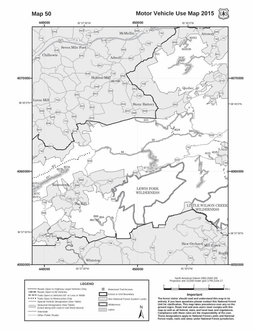
!
!
!!!
!
!
!!
!!!
!!!!!
!!
!!
!
!
!!
!!
!
!!
!!
!!!
!!!
!!
!
!
!
!
!
!
!
!!
!
!!!
!
!
!!!
!!
(
(
(((((((
(((((((((
(
84
643
837
615
243
613
89
832
90
828
4104865
835
243C
49100
4101
60031
977
49451
4025
89A
837C
60031B
84A
416
837A
837D1
84
60031A
89C89B
977B
1502
977C 977A
611
863
837B
837D1A837D
4102
844624
301
417
615
837C1
OP16
OP603
OP16
OP16
./58OP726
OP604
OP650
OP600
OP600
OP603
WZ81
OP604
OP730
OP605
OP604
LEWIS FORKWILDERNESS
LITTLE WILSON CREEKWILDERNESS
OP362
OP600
OP750
OP797
OP648
OP661
OP657
OP643
OP645
OP656
OP859
OP653
OP784
OP650
OP783
OP660
OP726
OP654
OP662
OP755
OP604
OP721
OP606
OP603
OP742
OP762
OP741
OP638OP658
OP728
OP743
OP672
OP649
OP718
OP605
OP689
OP720
OP669
OP817
OP709
OP756
OP777
OP602
OP725
OP779
OP601
OP16
OP729
OP707
OP655
OP663
OP899
OP765
OP670
OP644
OP774OP730
OP652
OP668
OP608
OP889
OP732
OP671OP678
OP862
OP888
OP701
OP760
OP659
OP650/658
OP739
OP673
OP885 OP806
OP740OP734
OP605
OP650OP648
OP645
OP653
OP606
OP16
OP885
OP658
OP600
OP755
OP604
OP649
./58
./11
./11
WZ81
Rugby
Quebec
Adwolf
Attoway
Whitetop
Big Hill
McMullin
Konnarock
Chilhowie
Mill Creek
Loves Mill
Haw Orchard
Holston Mill
Stony Battery
Seven Mile Ford
81°30'0"W
81°30'0"W
81°37'30"W
81°37'30"W
36°45'0"N 36°45'0"N
36°37'30"N 36°37'30"N
440000
440000
450000
4500004050000 4050000
4060000 4060000
4070000 4070000
0 1 2 3 4Miles
Motor Vehicle Use Map 2015
North American Datum 1983 (NAD 83)Projection and 10,000-meter grid: UTM Zone 17
±
LEGEND
InterstateOther Public Roads
!E Motorized Trail AccessForest or Unit Boundary
WildernessLakes
Non-National Forest System Lands
Roads Open to Highway Legal Vehicles OnlyRoads Open to All VehiclesTrails Open to Vehicles 50" or Less in WidthTrails Open to Motorcycles Only
( ( ( ( Special Vehicle Designation (See Table)Seasonal Designation (See Table) {Used along with road or trail listed above}
The forest visitor should read and understand this map in itsentirety. If you have questions please contact this National ForestUnit for clarification. This map takes precedence over any on theground signs. Road, trail and area users must comply with thismap as well as all federal, state, and local laws and regulations.Compliance with these rules are the responsibility of the user.These designations apply to National Forest Lands and NationalForest roads, trails and areas under National Forest jurisdiction.
Important
Map 50

!!
!
!
! !
!
! !
!
!!
!!
!
!
!!
!!!!
!!
!!
!!
!
!!!
!!
!!
!!
!
!!
!!
!
!!
!!
!!
!!
!!
!
!
!
!
!!
!
!
!!!
!!
!!!!
!!!!!
!
!!
!!
!!
!!
!!
!!!
!!!
!!
!
!
!!
!
!
!
!
!
!
!!
!
!
837
615
832
90
32 (OLD)
287
835
49100
4042
837C49510
4040
837A
837D1
837B
837D1A837D
301
615
837C1301
4552
OP726
OP604
OP600
OP730
OP605
OP604
OP91
OP605
OP712
./58
./58
OP133
OP608
OP714
OP91
OP736
OP762
OP607
OP734OP694 OP871
OP708
OP80
OP720
OP715
OP605
OP722
OP719
OP609
OP731
OP859
OP733
OP735
OP788OP712
OP604
OP724
OP744
OP725
OP707
OP606
OP642
OP803
OP740
OP723
OP711
OP849
OP728
OP726
OP649
OP757
OP709
OP706
OP721
OP713
OP732
OP810OP718
OP767
OP789
OP32
OP801
OP899
OP754
OP1324
OP751
OP758
OP858
OP648
OP901
OP774
OP737
OP741
OP727OP716
OP783
OP786
OP907
OP863
OP773
OP851
OP736
OP712
OP762
OP649
OP767
OP607
OP737
OP736
OP735
OP740
OP721
OP608
OP722
OP714
OP604
OP91
OP91 OP708
OP740
./58
./11
./11
WZ81
Lodi
Emory
Delmar
Roetown
Osceola
Unknown
Damascus
Damascus
Mock Mill
Greenville
Cedarville Loves Mill
Price Hill
Murrayfield
Sugar Creek
Meadow View
De Busk Mill
Backbone Rock
Taylors Valley
Laurel Bloomery
Old Glade Spring
81°45'0"W
81°45'0"W
81°52'30"W
81°52'30"W
36°45'0"N 36°45'0"N
36°37'30"N 36°37'30"N
430000
430000
440000
440000
4050000 4050000
4060000 4060000
4070000 4070000
0 1 2 3 4Miles
Motor Vehicle Use Map 2015
North American Datum 1983 (NAD 83)Projection and 10,000-meter grid: UTM Zone 17
±
LEGEND
InterstateOther Public Roads
!E Motorized Trail AccessForest or Unit Boundary
WildernessLakes
Non-National Forest System Lands
Roads Open to Highway Legal Vehicles OnlyRoads Open to All VehiclesTrails Open to Vehicles 50" or Less in WidthTrails Open to Motorcycles Only
( ( ( ( Special Vehicle Designation (See Table)Seasonal Designation (See Table) {Used along with road or trail listed above}
The forest visitor should read and understand this map in itsentirety. If you have questions please contact this National ForestUnit for clarification. This map takes precedence over any on theground signs. Road, trail and area users must comply with thismap as well as all federal, state, and local laws and regulations.Compliance with these rules are the responsibility of the user.These designations apply to National Forest Lands and NationalForest roads, trails and areas under National Forest jurisdiction.
Important
Map 51

238704
293
700
776
2610247
7
292
701
2560
619
2512
233
2531
238C
805
994 2513
238B238A
233A
994A994B
993
2560A
2444
238
./58
OP706
OP72
OP72
OP706
./58
OP66
OP653
OP72
OP646
OP699
OP822
OP650
OP652
OP682
OP660
OP658
OP646
OP657
OP671
OP608
OP716
OP683
OP66
OP654
OP684
OP659
OP619
OP643
OP714
OP644
OP681
OP72
OP699
OP651
OP685
OP625
OP706
OP607
OP612
OP902
OP787
OP680
OP649
OP653
OP624
OP661
OP677
OP754
OP662
OP640
OP610
OP728
OP822
OP753
OP818
OP757
OP755
OP74
OP647
OP686
OP704
OP664
OP723
OP663
OP636
OP1421
OP1414
OP71
OP815
OP1129
OP1412
OP1121
OP656
OP737
OP823
OP72
OP684
OP680
OP660
OP682
OP684OP818
OP685
OP680
OP66
OP706
OP619
OP653
OP660
OP680
OP659
OP680
OP658
OP671
OP651
OP654
OP680
./58
./23
Lano
Wise
Carfax
Banner
Herald
TacomaRamsey Coeburn
Dry Fork
Stephens
Flatwoods
Dungannon
Toms CreekCranes Nest
Crab Orchard
Fort Blackmore
82°30'0"W
82°30'0"W
82°22'30"W
37°0'0"N
36°52'30"N36°52'30"N
360000
360000
370000
370000
4080000 4080000
4090000 4090000
0 1 2 3 4Miles
Motor Vehicle Use Map 2015
North American Datum 1983 (NAD 83)Projection and 10,000-meter grid: UTM Zone 17
±
LEGEND
InterstateOther Public Roads
!E Motorized Trail AccessForest or Unit Boundary
WildernessLakes
Non-National Forest System Lands
Roads Open to Highway Legal Vehicles OnlyRoads Open to All VehiclesTrails Open to Vehicles 50" or Less in WidthTrails Open to Motorcycles Only
( ( ( ( Special Vehicle Designation (See Table)Seasonal Designation (See Table) {Used along with road or trail listed above}
The forest visitor should read and understand this map in itsentirety. If you have questions please contact this National ForestUnit for clarification. This map takes precedence over any on theground signs. Road, trail and area users must comply with thismap as well as all federal, state, and local laws and regulations.Compliance with these rules are the responsibility of the user.These designations apply to National Forest Lands and NationalForest roads, trails and areas under National Forest jurisdiction.
Important
Map 52

294
238
237
704
621
239
293
2610
292
619
2790
233
238C238B238A
2741
233A
239
2444
238
641
642
./58
OP653
OP646
OP655
./23
./23
./23
./23
./23
OP611
OP653
OP619
OP602
OP66
OP657
OP717
OP722
OP610
OP777OP656
OP612
OP603
OP803
OP654
OP621
OP655
OP614
OP68
OP649
OP160
OP728
OP652
OP609
OP790
OP600
OP785
OP668
OP775
OP604
OP78
OP74
OP608
OP659
OP616
OP613
OP622
OP686
OP781
OP677
OP827OP797
OP725
OP683OP750
OP1322OP1305OP601
OP708
OP617
OP846
OP744
OP1327
OP1333
OP674
OP1008
OP619/653
OP1005
OP718
OP702
OP619
OP602
OP717
OP722
OP608
OP619
OP603
OP653
OP612
OP610
OP610
OP602
OP66OP722
./58
./23
./23
./23
./58
Lano
Mabe
Ramsey
Oreton
NortonAndover
Cox Place
Josephine
EsservilleDorchester
Duncan Mill
Stanleytown
Buffalo Gap
Cracker Neck
Fort Blackmore
East Stone Gap
Little Stone Gap
82°37'30"W
82°37'30"W
82°45'0"W
82°45'0"W
36°52'30"N36°52'30"N
36°45'0"N36°45'0"N
340000
340000
350000
350000
4070000 4070000
4080000 4080000
4090000 4090000
0 1 2 3 4Miles
Motor Vehicle Use Map 2015
North American Datum 1983 (NAD 83)Projection and 10,000-meter grid: UTM Zone 17
±
LEGEND
InterstateOther Public Roads
!E Motorized Trail AccessForest or Unit Boundary
WildernessLakes
Non-National Forest System Lands
Roads Open to Highway Legal Vehicles OnlyRoads Open to All VehiclesTrails Open to Vehicles 50" or Less in WidthTrails Open to Motorcycles Only
( ( ( ( Special Vehicle Designation (See Table)Seasonal Designation (See Table) {Used along with road or trail listed above}
The forest visitor should read and understand this map in itsentirety. If you have questions please contact this National ForestUnit for clarification. This map takes precedence over any on theground signs. Road, trail and area users must comply with thismap as well as all federal, state, and local laws and regulations.Compliance with these rules are the responsibility of the user.These designations apply to National Forest Lands and NationalForest roads, trails and areas under National Forest jurisdiction.
Important
Map 53

641
294
239
2790
1072
2741
239
2897
1072A
641
1072B
642
OP655
./23
./23
./23
./58
./23
./23
OP611
OP38
OP68
OP621
OP160
OP612
OP766
OP606
OP619
OP876
OP622
OP620
OP605
OP654
OP655
OP751
OP624
OP642
OP753
OP604
OP629
OP871
OP630
OP879
OP638
OP611OP787
OP628
OP623
OP608
OP726 OP752
OP803
OP743
OP828
OP632
OP728
OP863
OP767
OP677
OP773
OP708
OP763
OP868
OP843
OP824
OP625
OP78
OP775
OP626
OP739
OP750
OP1322
OP765
OP727
OP781
OP601
OP603
OP722
OP796
OP845
OP718
OP805
OP1327
OP794
OP798
OP825
OP849
OP800
OP700
OP808
OP803
OP743
OP619
OP604
OP622
OP606
OP624
./23
./58
./58
./23
Tito
Hardy
Sigma
Oreton
Jasper
ExeterKeokee
Calvin
Dryden
Olinger
Duffield
Seminary
Fraleytown
Appalachia
Pattonville
Darnell Town
82°52'30"W
82°52'30"W
83°0'0"W
83°0'0"W
36°52'30"N36°52'30"N
36°45'0"N36°45'0"N
330000
330000
340000
340000
4070000 4070000
4080000 4080000
0 1 2 3 4Miles
Motor Vehicle Use Map 2015
North American Datum 1983 (NAD 83)Projection and 10,000-meter grid: UTM Zone 17
±
LEGEND
InterstateOther Public Roads
!E Motorized Trail AccessForest or Unit Boundary
WildernessLakes
Non-National Forest System Lands
Roads Open to Highway Legal Vehicles OnlyRoads Open to All VehiclesTrails Open to Vehicles 50" or Less in WidthTrails Open to Motorcycles Only
( ( ( ( Special Vehicle Designation (See Table)Seasonal Designation (See Table) {Used along with road or trail listed above}
The forest visitor should read and understand this map in itsentirety. If you have questions please contact this National ForestUnit for clarification. This map takes precedence over any on theground signs. Road, trail and area users must comply with thismap as well as all federal, state, and local laws and regulations.Compliance with these rules are the responsibility of the user.These designations apply to National Forest Lands and NationalForest roads, trails and areas under National Forest jurisdiction.
Important
Map 54

616
2031
OP611
OP611
OP770
OP611
OP611OP80
OP80
OP80
OP197
OP195
OP197
John W. Flannagan Reservoir
OP197
OP80
OP614
OP83
OP63
OP1373
OP611
OP689
OP739
OP195
OP664
OP621
OP652
OP770
OP631 OP607
OP754
OP637
OP669
OP679
OP670
OP668 OP722
OP663
OP622
OP615
OP638
OP620
OP737
OP636
OP702
OP80/460
OP707
OP667
OP728
OP661
OP683
OP72
OP612
OP80/83
OP700
OP1004OP765
OP733
OP653
OP744
OP610
OP729
OP768
OP691
OP743
OP750
OP633
OP1002
OP730
OP751
OP726
OP742
OP718
OP671
OP706
OP735
OP672
OP616
OP686
OP609
OP630 OP704
OP755
OP675
OP720
OP701
OP748
OP647
OP759
OP696OP1001 OP727
OP664/652
OP80
OP63
OP664
OP611
OP744
OP739
OP607
OP664
Isom
TandyHaysi
Tivis
Tarpon
Breaks
Ashcamp
Hellier
Lookout
Venters DraffinBelcher
SteinmanClinchco
Dry Fork
Honeycamp
Edgewater
Rockhouse
Mikegrady
Big BranchHenry Clay
Marrowbone
Ramey Flats
Flemingtown
Blowing Rock
Elkhorn CityBeaver Bottom
82°22'30"W
82°22'30"W
82°30'0"W
82°30'0"W
37°15'0"N37°15'0"N
37°7'30"N37°7'30"N
370000
370000
380000
380000
4110000 4110000
4120000 4120000
4130000 4130000
0 1 2 3 4Miles
Motor Vehicle Use Map 2015
North American Datum 1983 (NAD 83)Projection and 10,000-meter grid: UTM Zone 17
±
LEGEND
InterstateOther Public Roads
!E Motorized Trail AccessForest or Unit Boundary
WildernessLakes
Non-National Forest System Lands
Roads Open to Highway Legal Vehicles OnlyRoads Open to All VehiclesTrails Open to Vehicles 50" or Less in WidthTrails Open to Motorcycles Only
( ( ( ( Special Vehicle Designation (See Table)Seasonal Designation (See Table) {Used along with road or trail listed above}
The forest visitor should read and understand this map in itsentirety. If you have questions please contact this National ForestUnit for clarification. This map takes precedence over any on theground signs. Road, trail and area users must comply with thismap as well as all federal, state, and local laws and regulations.Compliance with these rules are the responsibility of the user.These designations apply to National Forest Lands and NationalForest roads, trails and areas under National Forest jurisdiction.
Important
Map 55

2261
2027
2029
2028
2027A
OP631
OP630./23
./23
./23
OP197
OP671OP671
North Fork of Pound Lake
OP631
OP275
OP633
OP805 OP630
OP638
OP671
OP343
OP317
OP620
OP632
OP707
OP703
OP83
OP113
OP197
OP827
OP803
OP932
OP693
OP624
OP788
OP623
OP627
OP666
OP679
OP678 OP689 OP742
OP3406
OP634
OP748
OP700
OP779OP797
OP752
OP667
OP840
OP672
OP632/638
OP705OP832
OP836
OP1469
OP3400
OP3405
OP749
OP3086
OP1862
OP208
OP850
OP3409
OP834
OP675
OP624/631
OP20272
OP666
OP343
OP632
OP624
OP3409
OP631
./23
Neon
Kona
MeadeBaden
Dewey
Pound
Almira
Hylton
Dunham
Norland
AdamsonFleming
Jenkins
Beefhide
Hemphill
Whitaker
Flat Gap
Payne Gap
Shelby Gap
Haddonfield
Osborns GapEast JenkinsPotters ForkTolliver Town
82°37'30"W
82°37'30"W82°45'0"W
37°15'0"N37°15'0"N
37°7'30"N37°7'30"N
350000
350000
360000
360000
4110000 4110000
4120000 4120000
0 1 2 3 4Miles
Motor Vehicle Use Map 2015
North American Datum 1983 (NAD 83)Projection and 10,000-meter grid: UTM Zone 17
±
LEGEND
InterstateOther Public Roads
!E Motorized Trail AccessForest or Unit Boundary
WildernessLakes
Non-National Forest System Lands
Roads Open to Highway Legal Vehicles OnlyRoads Open to All VehiclesTrails Open to Vehicles 50" or Less in WidthTrails Open to Motorcycles Only
( ( ( ( Special Vehicle Designation (See Table)Seasonal Designation (See Table) {Used along with road or trail listed above}
The forest visitor should read and understand this map in itsentirety. If you have questions please contact this National ForestUnit for clarification. This map takes precedence over any on theground signs. Road, trail and area users must comply with thismap as well as all federal, state, and local laws and regulations.Compliance with these rules are the responsibility of the user.These designations apply to National Forest Lands and NationalForest roads, trails and areas under National Forest jurisdiction.
Important
Map 56

Route Number Special Vehicle Designation Dates Allowed Beginning Mile Post
Ending Mile Post
1015Roads open to highway legal
vehicles only, with Seasonal Designation
Seasonal Designation 10/01-01/10 0.000 3.100
10281Roads open to highway legal
vehicles only, with Seasonal Designation
Seasonal Designation 10/01-01/10 0.000 1.540
104ARoads open to highway legal
vehicles only, with Seasonal Designation
Seasonal Designation 04/01-01/10 0.000 0.300
10631Roads open to highway legal
vehicles only, with Seasonal Designation
Seasonal Designation 10/01-01/10 0.190 2.000
107Roads open to highway legal
vehicles only, with Seasonal Designation
Seasonal Designation 10/01-01/10 0.000 2.630
1072Roads open to highway legal
vehicles only, with Seasonal Designation
Seasonal Designation 03/24-01/10 0.000 0.344
1072ARoads open to highway legal
vehicles only, with Seasonal Designation
Seasonal Designation 03/24-01/10 0.000 0.485
1072BRoads open to highway legal
vehicles only, with Seasonal Designation
Seasonal Designation 03/24-01/10 0.000 0.090
108Roads open to highway legal
vehicles only, with Seasonal Designation
Seasonal Designation 04/01-01/10 1.329 2.160
1133Roads open to highway legal
vehicles only, with Seasonal Designation
Seasonal Designation 10/01-01/10 0.000 2.250
1144Roads open to highway legal
vehicles only, with Seasonal Designation
Seasonal Designation 01/01-01/31,04/01-05/31,09/01-12/31 0.000 2.380
1158Roads open to highway legal
vehicles only, with Seasonal Designation
Seasonal Designation 04/01-01/10 1.960 2.590
Seasonal and Special Vehicle DesignationsLegend

Route Number Special Vehicle Designation Dates Allowed Beginning Mile Post
Ending Mile Post
Seasonal and Special Vehicle DesignationsLegend
1167Roads open to highway legal
vehicles only, with Seasonal Designation
Seasonal Designation 04/01-01/10 0.000 6.730
1171Roads open to highway legal
vehicles only, with Seasonal Designation
Seasonal Designation 04/01-01/10 0.000 0.922
1183Roads open to highway legal
vehicles only, with Seasonal Designation
Seasonal Designation 04/01-01/10 0.000 3.200
1199Roads open to highway legal
vehicles only, with Seasonal Designation
Seasonal Designation 09/01-01/10 0.000 0.140
121Roads open to highway legal
vehicles only, with Seasonal Designation
Seasonal Designation 01/01-01/31,04/01-05/31,09/01-12/31 0.000 14.400
121BRoads open to highway legal
vehicles only, with Seasonal Designation
Seasonal Designation 01/01-01/31,04/01-05/31,09/01-12/31 0.000 0.500
1237Roads open to highway legal
vehicles only, with Seasonal Designation
Seasonal Designation 10/01-01/10 0.000 1.300
124Roads open to highway legal
vehicles only, with Seasonal Designation
Seasonal Designation 01/01-01/31,04/01-05/31,09/01-12/31 0.000 3.780
1241Roads open to highway legal
vehicles only, with Seasonal Designation
Seasonal Designation 04/01-01/10 0.000 0.720
1241ARoads open to highway legal
vehicles only, with Seasonal Designation
Seasonal Designation 04/01-01/10 0.000 0.920
125ARoads open to highway legal
vehicles only, with Seasonal Designation
Seasonal Designation 01/01-01/31,04/01-05/31,09/01-12/31 0.000 1.200
1269Roads open to highway legal
vehicles only, with Seasonal Designation
Seasonal Designation 01/01-02/11,04/08-05/13,10/01-12/31 0.000 2.094

Route Number Special Vehicle Designation Dates Allowed Beginning Mile Post
Ending Mile Post
Seasonal and Special Vehicle DesignationsLegend
1279Roads open to highway legal
vehicles only, with Seasonal Designation
Seasonal Designation 10/01-01/10 0.000 2.620
1279BDisabled Hunter
Access, with Seasonal Designation
Seasonal Designation 10/01-01/10 0.000 0.800
1286Roads open to highway legal
vehicles only, with Seasonal Designation
Seasonal Designation 04/01-01/10 1.290 4.700
1303Roads open to highway legal
vehicles only, with Seasonal Designation
Seasonal Designation 10/01-01/10 0.190 1.650
1324Roads open to highway legal
vehicles only, with Seasonal Designation
Seasonal Designation 01/01-01/31,04/01-05/31,09/01-12/31 0.000 3.800
141Roads open to highway legal
vehicles only, with Seasonal Designation
Seasonal Designation 01/01-01/31,04/01-05/31,09/01-12/31 0.730 1.850
1502Roads open to highway legal
vehicles only, with Seasonal Designation
Seasonal Designation 04/01-01/10 0.000 0.300
151GRoads open to highway legal
vehicles only, with Seasonal Designation
Seasonal Designation 10/01-01/10 0.000 2.450
151HDisabled Hunter
Access, with Seasonal Designation
Seasonal Designation 10/01-01/10 0.000 1.750
152Roads open to highway legal
vehicles only, with Seasonal Designation
Seasonal Designation 10/01-01/10 0.000 6.500
152DRoads open to highway legal
vehicles only, with Seasonal Designation
Seasonal Designation 10/01-01/10 0.000 0.500
1575Roads open to highway legal
vehicles only, with Seasonal Designation
Seasonal Designation 04/01-01/10 0.000 0.480

Route Number Special Vehicle Designation Dates Allowed Beginning Mile Post
Ending Mile Post
Seasonal and Special Vehicle DesignationsLegend
1576Roads open to highway legal
vehicles only, with Seasonal Designation
Seasonal Designation 10/01-01/10 0.000 2.020
1602Roads open to highway legal
vehicles only, with Seasonal Designation
Seasonal Designation 10/01-01/10 0.000 0.300
162Roads open to highway legal
vehicles only, with Seasonal Designation
Seasonal Designation 04/01-01/10 0.000 10.200
1628Roads open to highway legal
vehicles only, with Seasonal Designation
Seasonal Designation 10/01-01/10 0.260 0.800
1629Roads open to highway legal
vehicles only, with Seasonal Designation
Seasonal Designation 04/01-06/30,10/01-12/31 0.230 1.220
1629ARoads open to highway legal
vehicles only, with Seasonal Designation
Seasonal Designation 04/01-06/30,10/01-12/31 0.500 0.800
1629BRoads open to highway legal
vehicles only, with Seasonal Designation
Seasonal Designation 04/01-06/30,10/01-12/31 0.000 0.600
162ARoads open to highway legal
vehicles only, with Seasonal Designation
Seasonal Designation 04/01-01/10 0.000 2.000
162BRoads open to highway legal
vehicles only, with Seasonal Designation
Seasonal Designation 04/01-01/10 0.000 1.500
162CRoads open to highway legal
vehicles only, with Seasonal Designation
Seasonal Designation 04/01-01/10 0.000 0.200
1702
Roads open to highway legal
vehicles and ATV's, with Seasonal Designation
Seasonal Designation 03/14-01/31 0.000 8.300
1716
Roads open to highway legal
vehicles and ATV's, with Seasonal Designation
Seasonal Designation 01/01-01/31,03/19-12/31 0.000 3.200
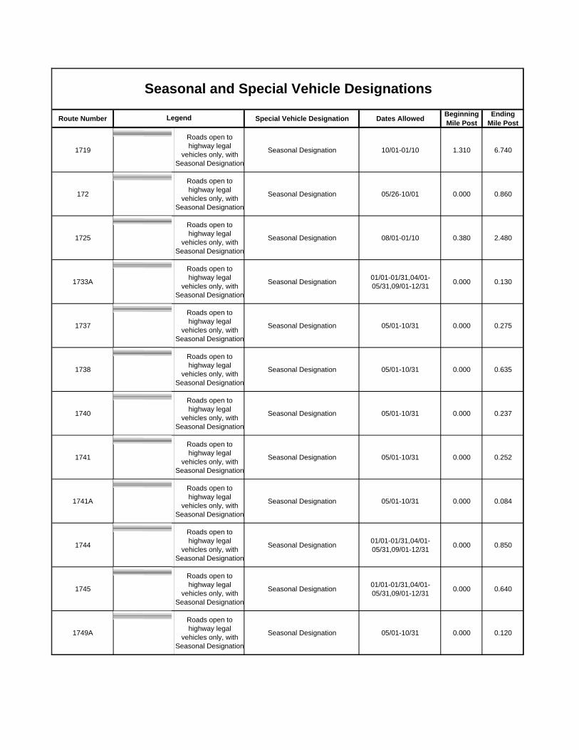
Route Number Special Vehicle Designation Dates Allowed Beginning Mile Post
Ending Mile Post
Seasonal and Special Vehicle DesignationsLegend
1719Roads open to highway legal
vehicles only, with Seasonal Designation
Seasonal Designation 10/01-01/10 1.310 6.740
172Roads open to highway legal
vehicles only, with Seasonal Designation
Seasonal Designation 05/26-10/01 0.000 0.860
1725Roads open to highway legal
vehicles only, with Seasonal Designation
Seasonal Designation 08/01-01/10 0.380 2.480
1733ARoads open to highway legal
vehicles only, with Seasonal Designation
Seasonal Designation 01/01-01/31,04/01-05/31,09/01-12/31 0.000 0.130
1737Roads open to highway legal
vehicles only, with Seasonal Designation
Seasonal Designation 05/01-10/31 0.000 0.275
1738Roads open to highway legal
vehicles only, with Seasonal Designation
Seasonal Designation 05/01-10/31 0.000 0.635
1740Roads open to highway legal
vehicles only, with Seasonal Designation
Seasonal Designation 05/01-10/31 0.000 0.237
1741Roads open to highway legal
vehicles only, with Seasonal Designation
Seasonal Designation 05/01-10/31 0.000 0.252
1741ARoads open to highway legal
vehicles only, with Seasonal Designation
Seasonal Designation 05/01-10/31 0.000 0.084
1744Roads open to highway legal
vehicles only, with Seasonal Designation
Seasonal Designation 01/01-01/31,04/01-05/31,09/01-12/31 0.000 0.850
1745Roads open to highway legal
vehicles only, with Seasonal Designation
Seasonal Designation 01/01-01/31,04/01-05/31,09/01-12/31 0.000 0.640
1749ARoads open to highway legal
vehicles only, with Seasonal Designation
Seasonal Designation 05/01-10/31 0.000 0.120
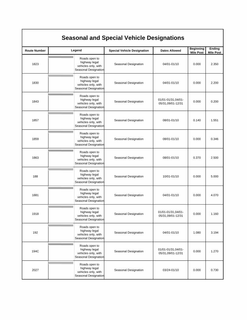
Route Number Special Vehicle Designation Dates Allowed Beginning Mile Post
Ending Mile Post
Seasonal and Special Vehicle DesignationsLegend
1823Roads open to highway legal
vehicles only, with Seasonal Designation
Seasonal Designation 04/01-01/10 0.000 2.350
1830Roads open to highway legal
vehicles only, with Seasonal Designation
Seasonal Designation 04/01-01/10 0.000 2.200
1843Roads open to highway legal
vehicles only, with Seasonal Designation
Seasonal Designation 01/01-01/31,04/01-05/31,09/01-12/31 0.000 0.200
1857Roads open to highway legal
vehicles only, with Seasonal Designation
Seasonal Designation 08/01-01/10 0.140 1.551
1859Roads open to highway legal
vehicles only, with Seasonal Designation
Seasonal Designation 08/01-01/10 0.000 0.346
1863Roads open to highway legal
vehicles only, with Seasonal Designation
Seasonal Designation 08/01-01/10 0.370 2.500
188Roads open to highway legal
vehicles only, with Seasonal Designation
Seasonal Designation 10/01-01/10 0.000 5.000
1881Roads open to highway legal
vehicles only, with Seasonal Designation
Seasonal Designation 04/01-01/10 0.000 4.070
1918Roads open to highway legal
vehicles only, with Seasonal Designation
Seasonal Designation 01/01-01/31,04/01-05/31,09/01-12/31 0.000 1.160
192Roads open to highway legal
vehicles only, with Seasonal Designation
Seasonal Designation 04/01-01/10 1.080 3.194
194CRoads open to highway legal
vehicles only, with Seasonal Designation
Seasonal Designation 01/01-01/31,04/01-05/31,09/01-12/31 0.000 1.270
2027Roads open to highway legal
vehicles only, with Seasonal Designation
Seasonal Designation 03/24-01/10 0.000 0.730

Route Number Special Vehicle Designation Dates Allowed Beginning Mile Post
Ending Mile Post
Seasonal and Special Vehicle DesignationsLegend
2027ARoads open to highway legal
vehicles only, with Seasonal Designation
Seasonal Designation 03/24-01/10 0.000 1.000
2029Roads open to highway legal
vehicles only, with Seasonal Designation
Seasonal Designation 03/24-01/10 0.000 0.332
208Roads open to highway legal
vehicles only, with Seasonal Designation
Seasonal Designation 10/01-01/10 1.220 1.530
224Roads open to highway legal
vehicles only, with Seasonal Designation
Seasonal Designation 01/01-01/10,04/01-05/21,07/01-12/31 0.000 9.000
225CRoads open to highway legal
vehicles only, with Seasonal Designation
Seasonal Designation 09/01-01/10 0.000 2.000
230Roads open to all
Vehicles, with Seasonal Designation
Seasonal Designation 04/01-01/10 0.610 1.680
233Roads open to highway legal
vehicles only, with Seasonal Designation
Seasonal Designation 03/24-01/10 0.000 1.120
233ARoads open to highway legal
vehicles only, with Seasonal Designation
Seasonal Designation 03/24-01/10 0.000 0.581
236Roads open to highway legal
vehicles only, with Seasonal Designation
Seasonal Designation 10/01-01/10 0.320 1.580
238Roads open to highway legal
vehicles only, with Seasonal Designation
Seasonal Designation 03/24-01/10 4.622 5.182
238BRoads open to highway legal
vehicles only, with Seasonal Designation
Seasonal Designation 03/24-01/10 0.000 0.350
238CRoads open to highway legal
vehicles only, with Seasonal Designation
Seasonal Designation 03/24-01/10 0.000 0.740
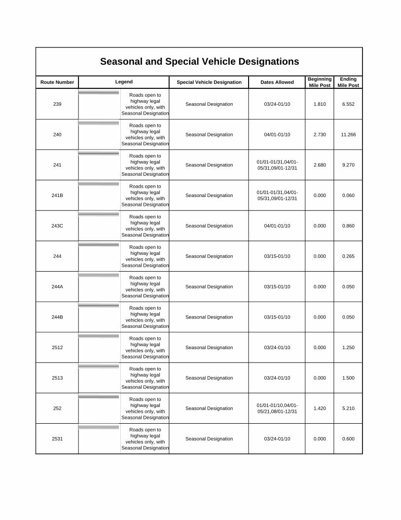
Route Number Special Vehicle Designation Dates Allowed Beginning Mile Post
Ending Mile Post
Seasonal and Special Vehicle DesignationsLegend
239Roads open to highway legal
vehicles only, with Seasonal Designation
Seasonal Designation 03/24-01/10 1.810 6.552
240Roads open to highway legal
vehicles only, with Seasonal Designation
Seasonal Designation 04/01-01/10 2.730 11.266
241Roads open to highway legal
vehicles only, with Seasonal Designation
Seasonal Designation 01/01-01/31,04/01-05/31,09/01-12/31 2.680 9.270
241BRoads open to highway legal
vehicles only, with Seasonal Designation
Seasonal Designation 01/01-01/31,04/01-05/31,09/01-12/31 0.000 0.060
243CRoads open to highway legal
vehicles only, with Seasonal Designation
Seasonal Designation 04/01-01/10 0.000 0.860
244Roads open to highway legal
vehicles only, with Seasonal Designation
Seasonal Designation 03/15-01/10 0.000 0.265
244ARoads open to highway legal
vehicles only, with Seasonal Designation
Seasonal Designation 03/15-01/10 0.000 0.050
244BRoads open to highway legal
vehicles only, with Seasonal Designation
Seasonal Designation 03/15-01/10 0.000 0.050
2512Roads open to highway legal
vehicles only, with Seasonal Designation
Seasonal Designation 03/24-01/10 0.000 1.250
2513Roads open to highway legal
vehicles only, with Seasonal Designation
Seasonal Designation 03/24-01/10 0.000 1.500
252Roads open to highway legal
vehicles only, with Seasonal Designation
Seasonal Designation 01/01-01/10,04/01-05/21,08/01-12/31 1.420 5.210
2531Roads open to highway legal
vehicles only, with Seasonal Designation
Seasonal Designation 03/24-01/10 0.000 0.600
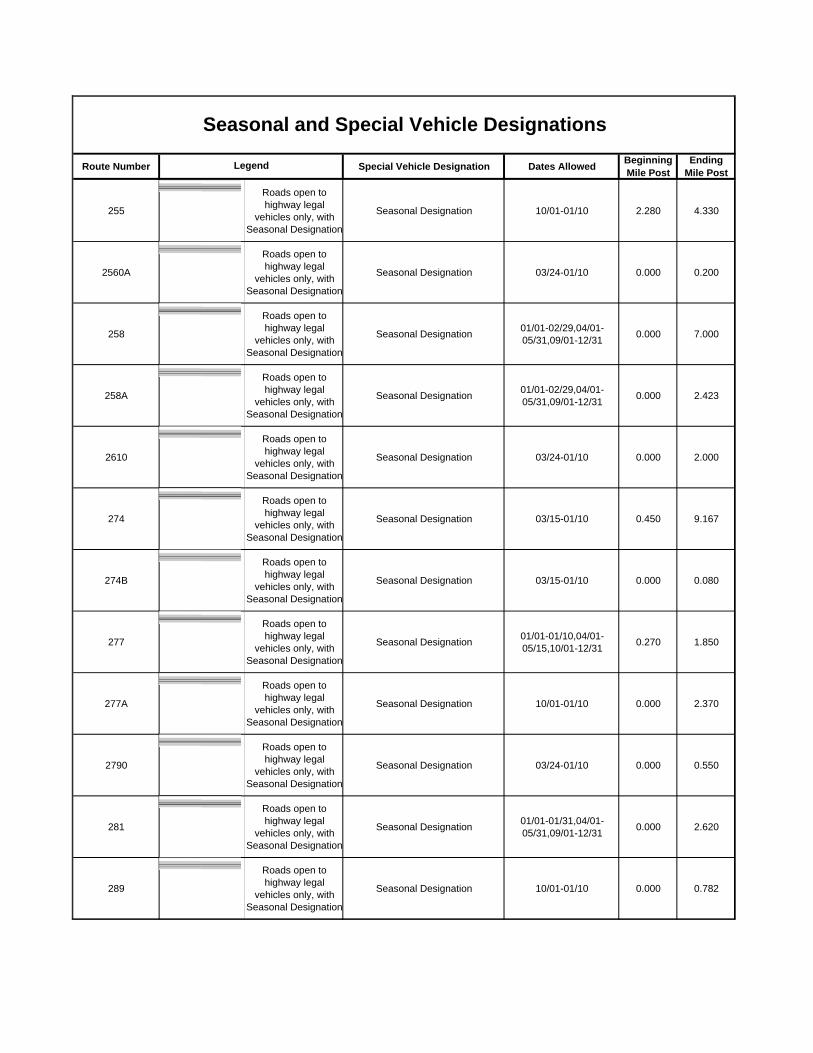
Route Number Special Vehicle Designation Dates Allowed Beginning Mile Post
Ending Mile Post
Seasonal and Special Vehicle DesignationsLegend
255Roads open to highway legal
vehicles only, with Seasonal Designation
Seasonal Designation 10/01-01/10 2.280 4.330
2560ARoads open to highway legal
vehicles only, with Seasonal Designation
Seasonal Designation 03/24-01/10 0.000 0.200
258Roads open to highway legal
vehicles only, with Seasonal Designation
Seasonal Designation 01/01-02/29,04/01-05/31,09/01-12/31 0.000 7.000
258ARoads open to highway legal
vehicles only, with Seasonal Designation
Seasonal Designation 01/01-02/29,04/01-05/31,09/01-12/31 0.000 2.423
2610Roads open to highway legal
vehicles only, with Seasonal Designation
Seasonal Designation 03/24-01/10 0.000 2.000
274Roads open to highway legal
vehicles only, with Seasonal Designation
Seasonal Designation 03/15-01/10 0.450 9.167
274BRoads open to highway legal
vehicles only, with Seasonal Designation
Seasonal Designation 03/15-01/10 0.000 0.080
277Roads open to highway legal
vehicles only, with Seasonal Designation
Seasonal Designation 01/01-01/10,04/01-05/15,10/01-12/31 0.270 1.850
277ARoads open to highway legal
vehicles only, with Seasonal Designation
Seasonal Designation 10/01-01/10 0.000 2.370
2790Roads open to highway legal
vehicles only, with Seasonal Designation
Seasonal Designation 03/24-01/10 0.000 0.550
281Roads open to highway legal
vehicles only, with Seasonal Designation
Seasonal Designation 01/01-01/31,04/01-05/31,09/01-12/31 0.000 2.620
289Roads open to highway legal
vehicles only, with Seasonal Designation
Seasonal Designation 10/01-01/10 0.000 0.782
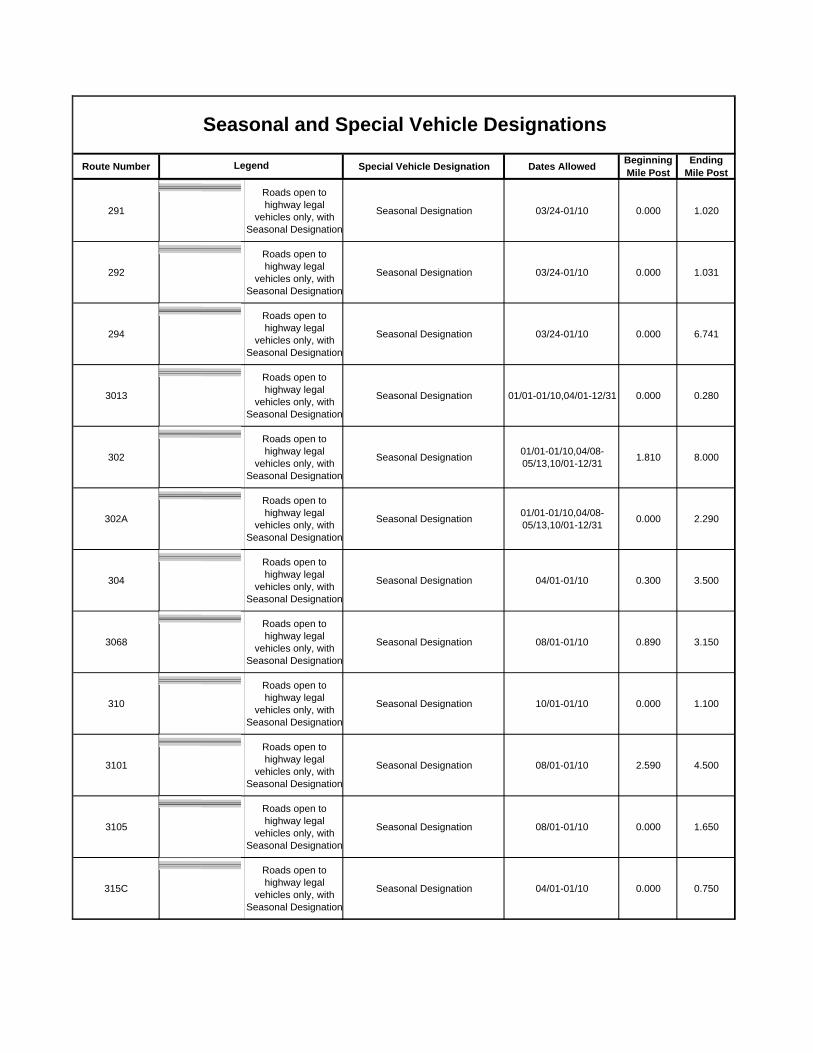
Route Number Special Vehicle Designation Dates Allowed Beginning Mile Post
Ending Mile Post
Seasonal and Special Vehicle DesignationsLegend
291Roads open to highway legal
vehicles only, with Seasonal Designation
Seasonal Designation 03/24-01/10 0.000 1.020
292Roads open to highway legal
vehicles only, with Seasonal Designation
Seasonal Designation 03/24-01/10 0.000 1.031
294Roads open to highway legal
vehicles only, with Seasonal Designation
Seasonal Designation 03/24-01/10 0.000 6.741
3013Roads open to highway legal
vehicles only, with Seasonal Designation
Seasonal Designation 01/01-01/10,04/01-12/31 0.000 0.280
302Roads open to highway legal
vehicles only, with Seasonal Designation
Seasonal Designation 01/01-01/10,04/08-05/13,10/01-12/31 1.810 8.000
302ARoads open to highway legal
vehicles only, with Seasonal Designation
Seasonal Designation 01/01-01/10,04/08-05/13,10/01-12/31 0.000 2.290
304Roads open to highway legal
vehicles only, with Seasonal Designation
Seasonal Designation 04/01-01/10 0.300 3.500
3068Roads open to highway legal
vehicles only, with Seasonal Designation
Seasonal Designation 08/01-01/10 0.890 3.150
310Roads open to highway legal
vehicles only, with Seasonal Designation
Seasonal Designation 10/01-01/10 0.000 1.100
3101Roads open to highway legal
vehicles only, with Seasonal Designation
Seasonal Designation 08/01-01/10 2.590 4.500
3105Roads open to highway legal
vehicles only, with Seasonal Designation
Seasonal Designation 08/01-01/10 0.000 1.650
315CRoads open to highway legal
vehicles only, with Seasonal Designation
Seasonal Designation 04/01-01/10 0.000 0.750

Route Number Special Vehicle Designation Dates Allowed Beginning Mile Post
Ending Mile Post
Seasonal and Special Vehicle DesignationsLegend
317Roads open to highway legal
vehicles only, with Seasonal Designation
Seasonal Designation 04/01-01/10 0.000 0.560
318Roads open to highway legal
vehicles only, with Seasonal Designation
Seasonal Designation 04/01-01/10 0.000 4.460
318BRoads open to highway legal
vehicles only, with Seasonal Designation
Seasonal Designation 04/01-01/10 0.000 1.900
319Roads open to highway legal
vehicles only, with Seasonal Designation
Seasonal Designation 04/01-01/10 0.000 0.360
320Roads open to highway legal
vehicles only, with Seasonal Designation
Seasonal Designation 04/01-01/10 0.000 2.320
3251Roads open to highway legal
vehicles only, with Seasonal Designation
Seasonal Designation 08/01-01/10 0.000 2.320
328Roads open to highway legal
vehicles only, with Seasonal Designation
Seasonal Designation 01/01-01/10,04/01-05/15,10/01-12/31 0.000 3.488
328ARoads open to highway legal
vehicles only, with Seasonal Designation
Seasonal Designation 01/01-01/10,04/01-05/15,10/01-12/31 0.000 2.272
333Roads open to highway legal
vehicles only, with Seasonal Designation
Seasonal Designation 04/01-01/10 0.000 3.100
334Roads open to highway legal
vehicles only, with Seasonal Designation
Seasonal Designation 10/01-01/10 0.150 1.832
334ARoads open to highway legal
vehicles only, with Seasonal Designation
Seasonal Designation 10/01-01/10 0.000 0.360
336Roads open to highway legal
vehicles only, with Seasonal Designation
Seasonal Designation 01/01-01/10,04/01-05/15,10/01-12/31 0.000 0.140

Route Number Special Vehicle Designation Dates Allowed Beginning Mile Post
Ending Mile Post
Seasonal and Special Vehicle DesignationsLegend
337Roads open to highway legal
vehicles only, with Seasonal Designation
Seasonal Designation 04/01-01/10 0.280 4.000
338Roads open to highway legal
vehicles only, with Seasonal Designation
Seasonal Designation 09/01-01/10 0.000 1.830
338ARoads open to highway legal
vehicles only, with Seasonal Designation
Seasonal Designation 09/01-01/10 0.000 1.600
338BRoads open to highway legal
vehicles only, with Seasonal Designation
Seasonal Designation 09/01-01/10 0.560 0.890
338CRoads open to highway legal
vehicles only, with Seasonal Designation
Seasonal Designation 09/01-01/10 0.000 0.130
339Roads open to highway legal
vehicles only, with Seasonal Designation
Seasonal Designation 10/01-01/10 0.000 1.432
34Roads open to highway legal
vehicles only, with Seasonal Designation
Seasonal Designation 04/01-01/10 0.000 1.620
342Roads open to highway legal
vehicles only, with Seasonal Designation
Seasonal Designation 01/01-01/10,04/01-12/31 1.690 5.200
345Roads open to highway legal
vehicles only, with Seasonal Designation
Seasonal Designation 01/01-01/10,04/01-05/15,10/01-12/31 0.180 9.120
348Roads open to highway legal
vehicles only, with Seasonal Designation
Seasonal Designation 10/01-01/10 0.170 1.090
348ARoads open to highway legal
vehicles only, with Seasonal Designation
Seasonal Designation 01/01-02/11,04/08-05/13,10/01-12/31 0.000 2.350
348BRoads open to highway legal
vehicles only, with Seasonal Designation
Seasonal Designation 01/01-02/11,04/08-05/13,10/01-12/31 0.000 0.770
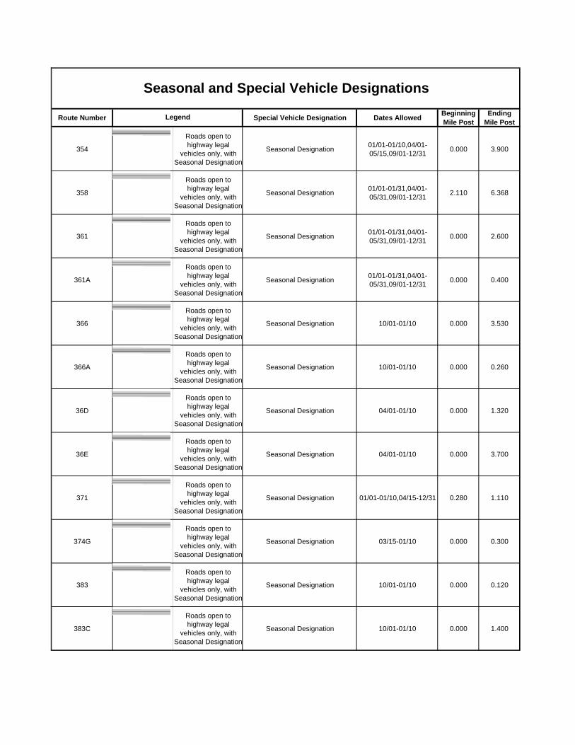
Route Number Special Vehicle Designation Dates Allowed Beginning Mile Post
Ending Mile Post
Seasonal and Special Vehicle DesignationsLegend
354Roads open to highway legal
vehicles only, with Seasonal Designation
Seasonal Designation 01/01-01/10,04/01-05/15,09/01-12/31 0.000 3.900
358Roads open to highway legal
vehicles only, with Seasonal Designation
Seasonal Designation 01/01-01/31,04/01-05/31,09/01-12/31 2.110 6.368
361Roads open to highway legal
vehicles only, with Seasonal Designation
Seasonal Designation 01/01-01/31,04/01-05/31,09/01-12/31 0.000 2.600
361ARoads open to highway legal
vehicles only, with Seasonal Designation
Seasonal Designation 01/01-01/31,04/01-05/31,09/01-12/31 0.000 0.400
366Roads open to highway legal
vehicles only, with Seasonal Designation
Seasonal Designation 10/01-01/10 0.000 3.530
366ARoads open to highway legal
vehicles only, with Seasonal Designation
Seasonal Designation 10/01-01/10 0.000 0.260
36DRoads open to highway legal
vehicles only, with Seasonal Designation
Seasonal Designation 04/01-01/10 0.000 1.320
36ERoads open to highway legal
vehicles only, with Seasonal Designation
Seasonal Designation 04/01-01/10 0.000 3.700
371Roads open to highway legal
vehicles only, with Seasonal Designation
Seasonal Designation 01/01-01/10,04/15-12/31 0.280 1.110
374GRoads open to highway legal
vehicles only, with Seasonal Designation
Seasonal Designation 03/15-01/10 0.000 0.300
383Roads open to highway legal
vehicles only, with Seasonal Designation
Seasonal Designation 10/01-01/10 0.000 0.120
383CRoads open to highway legal
vehicles only, with Seasonal Designation
Seasonal Designation 10/01-01/10 0.000 1.400

Route Number Special Vehicle Designation Dates Allowed Beginning Mile Post
Ending Mile Post
Seasonal and Special Vehicle DesignationsLegend
385Roads open to highway legal
vehicles only, with Seasonal Designation
Seasonal Designation 01/01-01/10,04/08-05/13,10/01-12/31 0.000 1.579
387Roads open to highway legal
vehicles only, with Seasonal Designation
Seasonal Designation 01/01-01/10,04/08-05/13,10/01-12/31 0.000 4.214
387Roads open to highway legal
vehicles only, with Seasonal Designation
Seasonal Designation 01/01-01/10,04/08-05/13,10/01-12/31 11.864 12.579
391Roads open to highway legal
vehicles only, with Seasonal Designation
Seasonal Designation 01/01-01/10,04/08-05/13,10/01-12/31 0.000 4.500
391DRoads open to highway legal
vehicles only, with Seasonal Designation
Seasonal Designation 01/01-01/10,04/08-05/13,10/01-12/31 0.000 0.591
392Roads open to highway legal
vehicles only, with Seasonal Designation
Seasonal Designation 10/01-01/10 0.000 1.960
393Roads open to highway legal
vehicles only, with Seasonal Designation
Seasonal Designation 10/01-02/11 0.125 2.000
394BRoads open to highway legal
vehicles only, with Seasonal Designation
Seasonal Designation 10/01-01/10 0.000 2.320
395Roads open to highway legal
vehicles only, with Seasonal Designation
Seasonal Designation 10/01-01/10 1.236 5.400
395ARoads open to highway legal
vehicles only, with Seasonal Designation
Seasonal Designation 10/01-01/10 0.000 2.000
395ERoads open to highway legal
vehicles only, with Seasonal Designation
Seasonal Designation 10/01-01/10 0.000 0.250
395NRoads open to highway legal
vehicles only, with Seasonal Designation
Seasonal Designation 10/01-01/10 0.000 0.193

Route Number Special Vehicle Designation Dates Allowed Beginning Mile Post
Ending Mile Post
Seasonal and Special Vehicle DesignationsLegend
396Roads open to highway legal
vehicles only, with Seasonal Designation
Seasonal Designation 10/01-01/10 0.110 3.580
396DRoads open to highway legal
vehicles only, with Seasonal Designation
Seasonal Designation 10/01-01/10 0.000 0.215
399BRoads open to highway legal
vehicles only, with Seasonal Designation
Seasonal Designation 01/01-01/10,04/08-05/13,10/01-12/31 1.630 5.100
401Roads open to highway legal
vehicles only, with Seasonal Designation
Seasonal Designation 01/01-01/31,04/01-05/31,09/01-12/31 0.000 1.940
4052ARoads open to highway legal
vehicles only, with Seasonal Designation
Seasonal Designation 07/01-01/10 0.000 0.050
4061Roads open to highway legal
vehicles only, with Seasonal Designation
Seasonal Designation 09/24-01/10 0.000 0.400
417Roads open to highway legal
vehicles only, with Seasonal Designation
Seasonal Designation 04/01-01/10 0.000 0.050
423Roads open to highway legal
vehicles only, with Seasonal Designation
Seasonal Designation 04/01-01/10 1.190 7.311
423ARoads open to highway legal
vehicles only, with Seasonal Designation
Seasonal Designation 04/01-01/10 0.000 0.500
425Roads open to highway legal
vehicles only, with Seasonal Designation
Seasonal Designation 09/01-01/10 0.000 4.200
425ARoads open to highway legal
vehicles only, with Seasonal Designation
Seasonal Designation 09/01-01/10 0.000 1.500
426Roads open to highway legal
vehicles only, with Seasonal Designation
Seasonal Designation 10/01-01/10 0.000 0.700

Route Number Special Vehicle Designation Dates Allowed Beginning Mile Post
Ending Mile Post
Seasonal and Special Vehicle DesignationsLegend
427Roads open to highway legal
vehicles only, with Seasonal Designation
Seasonal Designation 09/01-01/10 0.000 2.560
433Trails open to ATV's,
with Seasonal Designation
Seasonal Designation 01/01-01/31,03/19-12/31 0.000 7.731
433Roads open to highway legal
vehicles only, with Seasonal Designation
Seasonal Designation 01/01-02/11,04/08-05/13,10/01-12/31 0.490 2.660
440Roads open to highway legal
vehicles only, with Seasonal Designation
Seasonal Designation 10/01-02/15 0.000 0.520
440ARoads open to highway legal
vehicles only, with Seasonal Designation
Seasonal Designation 10/01-02/15 0.000 2.000
446Roads open to highway legal
vehicles only, with Seasonal Designation
Seasonal Designation 10/01-01/10 0.000 2.266
45Roads open to highway legal
vehicles only, with Seasonal Designation
Seasonal Designation 08/01-01/10 2.970 5.080
4505Trails open to
motorcycles, with Seasonal Designation
Seasonal Designation 10/01-04/01 0.000 0.280
456Roads open to highway legal
vehicles only, with Seasonal Designation
Seasonal Designation 10/01-01/10 0.000 2.080
456BRoads open to highway legal
vehicles only, with Seasonal Designation
Seasonal Designation 10/01-01/10 0.000 0.100
457Trails open to ATV's,
with Seasonal Designation
Seasonal Designation 01/01-01/31,03/19-12/31 0.000 2.893
459Roads open to highway legal
vehicles only, with Seasonal Designation
Seasonal Designation 10/01-01/10 0.000 0.300

Route Number Special Vehicle Designation Dates Allowed Beginning Mile Post
Ending Mile Post
Seasonal and Special Vehicle DesignationsLegend
468Roads open to highway legal
vehicles only, with Seasonal Designation
Seasonal Designation 01/01-01/10,04/08-05/13,10/01-12/31 0.000 1.095
474Trails open to ATV's,
with Seasonal Designation
Seasonal Designation 01/01-01/31,03/19-12/31 0.000 0.882
48Roads open to highway legal
vehicles only, with Seasonal Designation
Seasonal Designation 04/01-01/10 2.390 4.400
482Roads open to highway legal
vehicles only, with Seasonal Designation
Seasonal Designation 08/01-01/10 0.270 1.320
493Roads open to highway legal
vehicles only, with Seasonal Designation
Seasonal Designation 09/01-01/10 0.000 2.300
493Trails open to ATV's,
with Seasonal Designation
Seasonal Designation 01/01-01/31,03/19-12/31 0.000 6.037
49352Disabled Hunter
Access, with Seasonal Designation
Seasonal Designation 01/01-01/10,04/01-05/21,09/01-12/31 0.000 5.600
49352ADisabled Hunter
Access, with Seasonal Designation
Seasonal Designation 01/01-01/10,04/01-05/21,09/01-12/31 0.000 0.300
493ATrails open to ATV's,
with Seasonal Designation
Seasonal Designation 01/01-01/31,03/19-12/31 0.000 0.288
494Roads open to highway legal
vehicles only, with Seasonal Designation
Seasonal Designation 04/01-01/10 0.000 0.920
494Trails open to ATV's,
with Seasonal Designation
Seasonal Designation 01/01-01/31,03/19-12/31 0.000 0.525
495Trails open to ATV's,
with Seasonal Designation
Seasonal Designation 01/01-01/31,03/19-12/31 0.000 0.294

Route Number Special Vehicle Designation Dates Allowed Beginning Mile Post
Ending Mile Post
Seasonal and Special Vehicle DesignationsLegend
49510Roads open to highway legal
vehicles only, with Seasonal Designation
Seasonal Designation 04/01-01/10 0.000 0.340
49681Disabled Hunter
Access, with Seasonal Designation
Seasonal Designation 01/01-01/10,04/01-05/21,09/01-12/31 0.000 2.700
497Trails open to ATV's,
with Seasonal Designation
Seasonal Designation 01/01-01/31,03/19-12/31 0.000 0.188
49710Roads open to highway legal
vehicles only, with Seasonal Designation
Seasonal Designation 01/01-01/10,04/01-05/21,09/24-12/31 0.000 1.050
498Trails open to ATV's,
with Seasonal Designation
Seasonal Designation 01/01-01/31,03/19-12/31 0.000 0.784
499Trails open to ATV's,
with Seasonal Designation
Seasonal Designation 01/01-01/31,03/19-12/31 0.000 1.633
501Roads open to highway legal
vehicles only, with Seasonal Designation
Seasonal Designation 01/01-02/11,04/08-05/13,10/01-12/31 0.000 1.000
501Trails open to ATV's,
with Seasonal Designation
Seasonal Designation 01/01-03/15,06/16-09/30,12/08-12/31 0.000 2.364
501ATrails open to ATV's,
with Seasonal Designation
Seasonal Designation 01/01-03/15,06/16-09/30,12/08-12/31 0.000 1.006
501BTrails open to ATV's,
with Seasonal Designation
Seasonal Designation 01/01-03/15,06/16-09/30,12/08-12/31 0.000 0.766
501CTrails open to ATV's,
with Seasonal Designation
Seasonal Designation 01/01-03/15,06/16-09/30,12/08-12/31 0.000 1.333
501DTrails open to ATV's,
with Seasonal Designation
Seasonal Designation 01/01-03/15,06/16-09/30,12/08-12/31 0.000 0.448

Route Number Special Vehicle Designation Dates Allowed Beginning Mile Post
Ending Mile Post
Seasonal and Special Vehicle DesignationsLegend
501ETrails open to ATV's,
with Seasonal Designation
Seasonal Designation 01/01-03/15,06/16-09/30,12/08-12/31 0.000 0.671
502
Roads open to highway legal
vehicles and ATV's, with Seasonal Designation
Seasonal Designation 04/01-01/10 0.000 4.200
502Trails open to ATV's,
with Seasonal Designation
Seasonal Designation 01/01-03/15,06/16-09/30,12/08-12/31 0.000 1.802
5028Roads open to highway legal
vehicles only, with Seasonal Designation
Seasonal Designation 01/01-01/10,04/01-05/21,07/01-12/31 0.000 0.720
502ATrails open to ATV's,
with Seasonal Designation
Seasonal Designation 01/01-03/15,06/16-09/30,12/08-12/31 0.000 0.772
502BTrails open to ATV's,
with Seasonal Designation
Seasonal Designation 01/01-03/15,06/16-09/30,12/08-12/31 0.000 1.005
502CTrails open to ATV's,
with Seasonal Designation
Seasonal Designation 01/01-03/15,06/16-09/30,12/08-12/31 0.000 1.300
502DTrails open to ATV's,
with Seasonal Designation
Seasonal Designation 01/01-03/15,06/16-09/30,12/08-12/31 0.000 0.717
502ETrails open to ATV's,
with Seasonal Designation
Seasonal Designation 01/01-03/15,06/16-09/30,12/08-12/31 0.000 1.772
502FTrails open to ATV's,
with Seasonal Designation
Seasonal Designation 01/01-03/15,06/16-09/30,12/08-12/31 0.000 1.826
5036Roads open to highway legal
vehicles only, with Seasonal Designation
Seasonal Designation 04/01-01/10 0.350 2.820
506Roads open to highway legal
vehicles only, with Seasonal Designation
Seasonal Designation 09/01-01/10 0.000 0.560

Route Number Special Vehicle Designation Dates Allowed Beginning Mile Post
Ending Mile Post
Seasonal and Special Vehicle DesignationsLegend
507Roads open to highway legal
vehicles only, with Seasonal Designation
Seasonal Designation 04/01-01/10 0.000 1.000
50871
Roads open to highway legal
vehicles and ATV's, with Seasonal Designation
Seasonal Designation 01/01-01/10,04/01-05/15,09/01-12/31 0.000 1.900
50873Roads open to highway legal
vehicles only, with Seasonal Designation
Seasonal Designation 01/01-01/10,04/01-05/15,09/01-12/31 0.000 0.020
515Roads open to highway legal
vehicles only, with Seasonal Designation
Seasonal Designation 03/15-01/10 0.000 0.331
520Roads open to highway legal
vehicles only, with Seasonal Designation
Seasonal Designation 04/01-01/10 0.000 5.470
523Roads open to highway legal
vehicles only, with Seasonal Designation
Seasonal Designation 04/01-01/10 0.180 0.500
523ARoads open to highway legal
vehicles only, with Seasonal Designation
Seasonal Designation 04/01-01/10 0.000 0.400
523BRoads open to highway legal
vehicles only, with Seasonal Designation
Seasonal Designation 04/01-01/10 0.000 0.100
523CRoads open to highway legal
vehicles only, with Seasonal Designation
Seasonal Designation 04/01-01/10 0.000 0.150
536Roads open to highway legal
vehicles only, with Seasonal Designation
Seasonal Designation 01/01-01/10,04/08-05/13,09/01-12/31 0.000 4.100
536BRoads open to highway legal
vehicles only, with Seasonal Designation
Seasonal Designation 09/01-01/10 0.000 0.500
536ERoads open to highway legal
vehicles only, with Seasonal Designation
Seasonal Designation 09/01-01/10 0.000 0.400
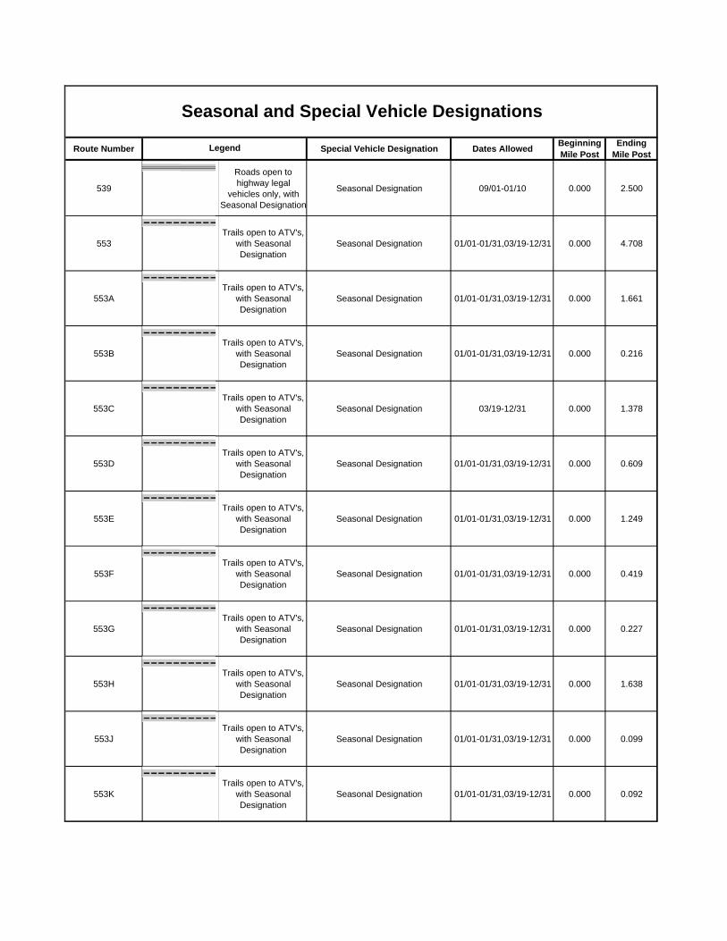
Route Number Special Vehicle Designation Dates Allowed Beginning Mile Post
Ending Mile Post
Seasonal and Special Vehicle DesignationsLegend
539Roads open to highway legal
vehicles only, with Seasonal Designation
Seasonal Designation 09/01-01/10 0.000 2.500
553Trails open to ATV's,
with Seasonal Designation
Seasonal Designation 01/01-01/31,03/19-12/31 0.000 4.708
553ATrails open to ATV's,
with Seasonal Designation
Seasonal Designation 01/01-01/31,03/19-12/31 0.000 1.661
553BTrails open to ATV's,
with Seasonal Designation
Seasonal Designation 01/01-01/31,03/19-12/31 0.000 0.216
553CTrails open to ATV's,
with Seasonal Designation
Seasonal Designation 03/19-12/31 0.000 1.378
553DTrails open to ATV's,
with Seasonal Designation
Seasonal Designation 01/01-01/31,03/19-12/31 0.000 0.609
553ETrails open to ATV's,
with Seasonal Designation
Seasonal Designation 01/01-01/31,03/19-12/31 0.000 1.249
553FTrails open to ATV's,
with Seasonal Designation
Seasonal Designation 01/01-01/31,03/19-12/31 0.000 0.419
553GTrails open to ATV's,
with Seasonal Designation
Seasonal Designation 01/01-01/31,03/19-12/31 0.000 0.227
553HTrails open to ATV's,
with Seasonal Designation
Seasonal Designation 01/01-01/31,03/19-12/31 0.000 1.638
553JTrails open to ATV's,
with Seasonal Designation
Seasonal Designation 01/01-01/31,03/19-12/31 0.000 0.099
553KTrails open to ATV's,
with Seasonal Designation
Seasonal Designation 01/01-01/31,03/19-12/31 0.000 0.092

Route Number Special Vehicle Designation Dates Allowed Beginning Mile Post
Ending Mile Post
Seasonal and Special Vehicle DesignationsLegend
553LTrails open to ATV's,
with Seasonal Designation
Seasonal Designation 01/01-01/31,03/19-12/31 0.000 0.080
553MTrails open to ATV's,
with Seasonal Designation
Seasonal Designation 01/01-01/31,03/19-12/31 0.000 0.068
553NTrails open to ATV's,
with Seasonal Designation
Seasonal Designation 01/01-01/31,03/19-12/31 0.000 0.075
553PTrails open to ATV's,
with Seasonal Designation
Seasonal Designation 01/01-01/31,03/19-12/31 0.000 0.037
582Roads open to highway legal
vehicles only, with Seasonal Designation
Seasonal Designation 10/01-01/10 0.000 1.530
593Roads open to highway legal
vehicles only, with Seasonal Designation
Seasonal Designation 04/01-01/10 0.000 1.260
597Roads open to highway legal
vehicles only, with Seasonal Designation
Seasonal Designation 09/01-01/10 0.000 3.000
599Roads open to highway legal
vehicles only, with Seasonal Designation
Seasonal Designation 10/01-01/10 0.350 2.400
600Roads open to highway legal
vehicles only, with Seasonal Designation
Seasonal Designation 01/01-01/10,04/01-05/15,10/01-12/31 0.680 3.000
6006Roads open to highway legal
vehicles only, with Seasonal Designation
Seasonal Designation 01/01-01/31,04/01-05/31,09/01-12/31 0.000 0.468
6021Roads open to highway legal
vehicles only, with Seasonal Designation
Seasonal Designation 01/01-01/31,04/01-05/31,09/01-12/31 0.000 1.430
603Roads open to highway legal
vehicles only, with Seasonal Designation
Seasonal Designation 05/01-10/31 0.000 0.830

Route Number Special Vehicle Designation Dates Allowed Beginning Mile Post
Ending Mile Post
Seasonal and Special Vehicle DesignationsLegend
6031Roads open to highway legal
vehicles only, with Seasonal Designation
Seasonal Designation 10/01-01/10 0.000 2.800
603ARoads open to highway legal
vehicles only, with Seasonal Designation
Seasonal Designation 05/01-10/31 0.000 0.300
6055BRoads open to highway legal
vehicles only, with Seasonal Designation
Seasonal Designation 10/01-01/10 0.000 0.064
606Roads open to highway legal
vehicles only, with Seasonal Designation
Seasonal Designation 10/01-01/10 0.000 3.900
61011Roads open to highway legal
vehicles only, with Seasonal Designation
Seasonal Designation 09/24-01/10 0.000 1.000
613Roads open to highway legal
vehicles only, with Seasonal Designation
Seasonal Designation 04/01-01/10 3.580 4.400
61461Roads open to highway legal
vehicles only, with Seasonal Designation
Seasonal Designation 10/01-01/10 0.000 1.300
61471Roads open to highway legal
vehicles only, with Seasonal Designation
Seasonal Designation 10/01-01/10 0.000 1.550
615Roads open to highway legal
vehicles only, with Seasonal Designation
Seasonal Designation 04/01-01/10 2.270 3.280
616Roads open to highway legal
vehicles only, with Seasonal Designation
Seasonal Designation 03/24-01/10 0.000 4.800
616BRoads open to highway legal
vehicles only, with Seasonal Designation
Seasonal Designation 03/24-01/10 0.000 0.115
62Roads open to highway legal
vehicles only, with Seasonal Designation
Seasonal Designation 04/01-01/10 2.670 5.250

Route Number Special Vehicle Designation Dates Allowed Beginning Mile Post
Ending Mile Post
Seasonal and Special Vehicle DesignationsLegend
6202Roads open to highway legal
vehicles only, with Seasonal Designation
Seasonal Designation 09/24-01/10 0.000 7.000
621Roads open to highway legal
vehicles only, with Seasonal Designation
Seasonal Designation 03/24-01/10 0.000 5.095
6261Roads open to highway legal
vehicles only, with Seasonal Designation
Seasonal Designation 09/24-01/10 0.000 2.090
6282Roads open to highway legal
vehicles only, with Seasonal Designation
Seasonal Designation 05/25-09/04 0.630 0.830
634.2Roads open to highway legal
vehicles only, with Seasonal Designation
Seasonal Designation 08/01-01/10 0.170 4.258
634.3Roads open to highway legal
vehicles only, with Seasonal Designation
Seasonal Designation 08/01-01/10 0.000 3.342
6361BRoads open to highway legal
vehicles only, with Seasonal Designation
Seasonal Designation 10/01-01/10 0.000 1.500
6361CRoads open to highway legal
vehicles only, with Seasonal Designation
Seasonal Designation 10/01-01/10 0.000 0.400
64Roads open to highway legal
vehicles only, with Seasonal Designation
Seasonal Designation 10/01-01/10 5.270 5.800
641Roads open to highway legal
vehicles only, with Seasonal Designation
Seasonal Designation 03/24-01/10 0.000 9.605
644Roads open to highway legal
vehicles only, with Seasonal Designation
Seasonal Designation 01/01-01/10,04/01-05/21,09/24-12/31 0.840 9.622
645Roads open to highway legal
vehicles only, with Seasonal Designation
Seasonal Designation 10/01-01/10 0.000 1.095

Route Number Special Vehicle Designation Dates Allowed Beginning Mile Post
Ending Mile Post
Seasonal and Special Vehicle DesignationsLegend
645ARoads open to highway legal
vehicles only, with Seasonal Designation
Seasonal Designation 10/01-01/10 0.000 0.243
645BRoads open to highway legal
vehicles only, with Seasonal Designation
Seasonal Designation 10/01-01/10 0.000 0.320
6531Roads open to highway legal
vehicles only, with Seasonal Designation
Seasonal Designation 10/01-01/10 0.000 0.750
6551Roads open to highway legal
vehicles only, with Seasonal Designation
Seasonal Designation 10/01-01/10 0.100 0.410
65ARoads open to highway legal
vehicles only, with Seasonal Designation
Seasonal Designation 08/01-01/10 0.160 3.300
66Roads open to highway legal
vehicles only, with Seasonal Designation
Seasonal Designation 03/15-01/10 0.010 2.320
6661Roads open to highway legal
vehicles only, with Seasonal Designation
Seasonal Designation 10/01-01/10 0.000 3.023
667Roads open to highway legal
vehicles only, with Seasonal Designation
Seasonal Designation 07/01-01/10 0.000 2.700
69Roads open to highway legal
vehicles only, with Seasonal Designation
Seasonal Designation 01/01-01/10,04/01-05/15,10/01-12/31 0.440 3.667
700Roads open to highway legal
vehicles only, with Seasonal Designation
Seasonal Designation 03/24-01/10 0.000 4.870
701Roads open to highway legal
vehicles only, with Seasonal Designation
Seasonal Designation 03/24-01/10 0.000 1.005
701ARoads open to highway legal
vehicles only, with Seasonal Designation
Seasonal Designation 03/24-01/10 0.000 0.030

Route Number Special Vehicle Designation Dates Allowed Beginning Mile Post
Ending Mile Post
Seasonal and Special Vehicle DesignationsLegend
704Roads open to highway legal
vehicles only, with Seasonal Designation
Seasonal Designation 03/24-01/10 0.000 5.670
737ERoads open to highway legal
vehicles only, with Seasonal Designation
Seasonal Designation 01/01-01/10,04/01-05/21,09/24-12/31 0.000 0.330
737FRoads open to highway legal
vehicles only, with Seasonal Designation
Seasonal Designation 01/01-01/10,04/01-05/21,09/24-12/31 0.000 0.230
776Roads open to highway legal
vehicles only, with Seasonal Designation
Seasonal Designation 07/01-01/10 0.000 5.170
780Roads open to highway legal
vehicles only, with Seasonal Designation
Seasonal Designation 08/01-01/10 0.000 1.250
780ARoads open to highway legal
vehicles only, with Seasonal Designation
Seasonal Designation 08/01-01/10 0.000 0.600
780BRoads open to highway legal
vehicles only, with Seasonal Designation
Seasonal Designation 08/01-01/10 0.000 0.120
781Roads open to highway legal
vehicles only, with Seasonal Designation
Seasonal Designation 09/24-01/10 0.000 0.670
800Trails open to ATV's,
with Seasonal Designation
Seasonal Designation 04/01-11/30 0.000 10.274
801Trails open to ATV's,
with Seasonal Designation
Seasonal Designation 04/01-11/30 0.000 0.561
802Trails open to ATV's,
with Seasonal Designation
Seasonal Designation 04/01-11/30 0.000 0.577
803Trails open to ATV's,
with Seasonal Designation
Seasonal Designation 04/01-11/30 0.000 1.804

Route Number Special Vehicle Designation Dates Allowed Beginning Mile Post
Ending Mile Post
Seasonal and Special Vehicle DesignationsLegend
804Trails open to ATV's,
with Seasonal Designation
Seasonal Designation 04/01-11/30 0.000 2.609
805Roads open to highway legal
vehicles only, with Seasonal Designation
Seasonal Designation 03/24-01/10 0.000 0.440
805Trails open to ATV's,
with Seasonal Designation
Seasonal Designation 04/01-11/30 0.000 1.031
806Trails open to ATV's,
with Seasonal Designation
Seasonal Designation 04/01-11/30 0.000 0.873
81Roads open to highway legal
vehicles only, with Seasonal Designation
Seasonal Designation 01/01-02/11,04/08-05/13,10/01-12/31 0.110 2.230
816Roads open to highway legal
vehicles only, with Seasonal Designation
Seasonal Designation 08/01-01/10 0.000 0.060
817Roads open to highway legal
vehicles only, with Seasonal Designation
Seasonal Designation 10/01-01/10 0.000 0.160
828Roads open to highway legal
vehicles only, with Seasonal Designation
Seasonal Designation 04/01-01/10 0.000 2.562
832Roads open to highway legal
vehicles only, with Seasonal Designation
Seasonal Designation 01/01-01/10,04/01-05/21,09/01-12/31 0.000 2.000
835Roads open to highway legal
vehicles only, with Seasonal Designation
Seasonal Designation 04/01-01/10 0.000 0.800
837Roads open to highway legal
vehicles only, with Seasonal Designation
Seasonal Designation 04/01-01/10 0.740 4.050
837ARoads open to highway legal
vehicles only, with Seasonal Designation
Seasonal Designation 04/01-01/10 0.000 0.500

Route Number Special Vehicle Designation Dates Allowed Beginning Mile Post
Ending Mile Post
Seasonal and Special Vehicle DesignationsLegend
837BRoads open to highway legal
vehicles only, with Seasonal Designation
Seasonal Designation 04/01-01/10 0.000 0.400
837CRoads open to highway legal
vehicles only, with Seasonal Designation
Seasonal Designation 04/01-01/10 0.000 0.400
837C1Roads open to highway legal
vehicles only, with Seasonal Designation
Seasonal Designation 04/01-01/10 0.000 0.110
837DRoads open to highway legal
vehicles only, with Seasonal Designation
Seasonal Designation 04/01-01/10 0.000 0.360
837D1Roads open to highway legal
vehicles only, with Seasonal Designation
Seasonal Designation 04/01-01/10 0.000 0.200
837D1ARoads open to highway legal
vehicles only, with Seasonal Designation
Seasonal Designation 04/01-01/10 0.000 0.200
84ARoads open to highway legal
vehicles only, with Seasonal Designation
Seasonal Designation 04/01-01/10 0.000 0.562
85-2Roads open to highway legal
vehicles only, with Seasonal Designation
Seasonal Designation 10/01-01/10 3.040 9.602
859Roads open to highway legal
vehicles only, with Seasonal Designation
Seasonal Designation 04/01-01/10 0.000 0.278
863Roads open to highway legal
vehicles only, with Seasonal Designation
Seasonal Designation 04/01-01/10 0.000 0.210
865Roads open to highway legal
vehicles only, with Seasonal Designation
Seasonal Designation 04/01-01/10 0.000 0.930
878Roads open to highway legal
vehicles only, with Seasonal Designation
Seasonal Designation 09/24-01/10 1.490 2.400

Route Number Special Vehicle Designation Dates Allowed Beginning Mile Post
Ending Mile Post
Seasonal and Special Vehicle DesignationsLegend
88Roads open to highway legal
vehicles only, with Seasonal Designation
Seasonal Designation 10/01-01/10 0.310 3.200
88ARoads open to highway legal
vehicles only, with Seasonal Designation
Seasonal Designation 10/01-01/10 0.000 1.100
91Roads open to highway legal
vehicles only, with Seasonal Designation
Seasonal Designation 04/01-01/10 0.960 2.740
91ARoads open to highway legal
vehicles only, with Seasonal Designation
Seasonal Designation 04/01-01/10 0.000 0.190
91CRoads open to highway legal
vehicles only, with Seasonal Designation
Seasonal Designation 04/01-01/10 0.000 0.600
91ERoads open to highway legal
vehicles only, with Seasonal Designation
Seasonal Designation 04/01-01/10 0.000 0.160
91FRoads open to highway legal
vehicles only, with Seasonal Designation
Seasonal Designation 04/01-01/10 0.000 0.160
91HRoads open to highway legal
vehicles only, with Seasonal Designation
Seasonal Designation 04/01-01/10 0.000 0.180
92Roads open to highway legal
vehicles only, with Seasonal Designation
Seasonal Designation 10/01-01/10 0.000 7.050
92CRoads open to highway legal
vehicles only, with Seasonal Designation
Seasonal Designation 10/01-01/10 0.000 0.100
93Roads open to highway legal
vehicles only, with Seasonal Designation
Seasonal Designation 01/01-01/10,04/01-05/19,07/01-12/31 0.200 5.080
93ERoads open to highway legal
vehicles only, with Seasonal Designation
Seasonal Designation 01/01-01/10,04/01-05/19,09/01-12/31 0.000 0.410
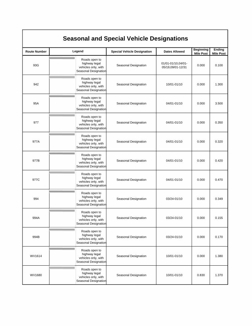
Route Number Special Vehicle Designation Dates Allowed Beginning Mile Post
Ending Mile Post
Seasonal and Special Vehicle DesignationsLegend
93GRoads open to highway legal
vehicles only, with Seasonal Designation
Seasonal Designation 01/01-01/10,04/01-05/19,09/01-12/31 0.000 0.100
942Roads open to highway legal
vehicles only, with Seasonal Designation
Seasonal Designation 10/01-01/10 0.000 1.300
95ARoads open to highway legal
vehicles only, with Seasonal Designation
Seasonal Designation 04/01-01/10 0.000 3.500
977Roads open to highway legal
vehicles only, with Seasonal Designation
Seasonal Designation 04/01-01/10 0.000 0.350
977ARoads open to highway legal
vehicles only, with Seasonal Designation
Seasonal Designation 04/01-01/10 0.000 0.320
977BRoads open to highway legal
vehicles only, with Seasonal Designation
Seasonal Designation 04/01-01/10 0.000 0.420
977CRoads open to highway legal
vehicles only, with Seasonal Designation
Seasonal Designation 04/01-01/10 0.000 0.470
994Roads open to highway legal
vehicles only, with Seasonal Designation
Seasonal Designation 03/24-01/10 0.000 0.349
994ARoads open to highway legal
vehicles only, with Seasonal Designation
Seasonal Designation 03/24-01/10 0.000 0.155
994BRoads open to highway legal
vehicles only, with Seasonal Designation
Seasonal Designation 03/24-01/10 0.000 0.170
WV1614Roads open to highway legal
vehicles only, with Seasonal Designation
Seasonal Designation 10/01-01/10 0.000 1.380
WV1680Roads open to highway legal
vehicles only, with Seasonal Designation
Seasonal Designation 10/01-01/10 0.830 1.370
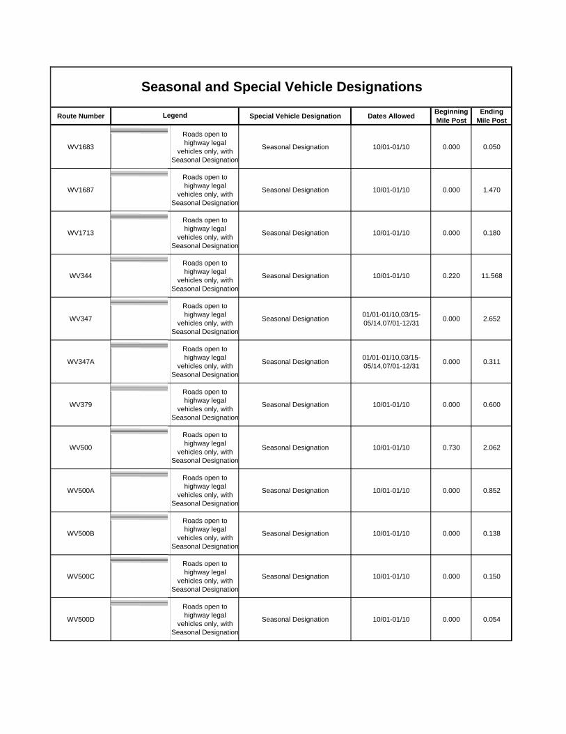
Route Number Special Vehicle Designation Dates Allowed Beginning Mile Post
Ending Mile Post
Seasonal and Special Vehicle DesignationsLegend
WV1683Roads open to highway legal
vehicles only, with Seasonal Designation
Seasonal Designation 10/01-01/10 0.000 0.050
WV1687Roads open to highway legal
vehicles only, with Seasonal Designation
Seasonal Designation 10/01-01/10 0.000 1.470
WV1713Roads open to highway legal
vehicles only, with Seasonal Designation
Seasonal Designation 10/01-01/10 0.000 0.180
WV344Roads open to highway legal
vehicles only, with Seasonal Designation
Seasonal Designation 10/01-01/10 0.220 11.568
WV347Roads open to highway legal
vehicles only, with Seasonal Designation
Seasonal Designation 01/01-01/10,03/15-05/14,07/01-12/31 0.000 2.652
WV347ARoads open to highway legal
vehicles only, with Seasonal Designation
Seasonal Designation 01/01-01/10,03/15-05/14,07/01-12/31 0.000 0.311
WV379Roads open to highway legal
vehicles only, with Seasonal Designation
Seasonal Designation 10/01-01/10 0.000 0.600
WV500Roads open to highway legal
vehicles only, with Seasonal Designation
Seasonal Designation 10/01-01/10 0.730 2.062
WV500ARoads open to highway legal
vehicles only, with Seasonal Designation
Seasonal Designation 10/01-01/10 0.000 0.852
WV500BRoads open to highway legal
vehicles only, with Seasonal Designation
Seasonal Designation 10/01-01/10 0.000 0.138
WV500CRoads open to highway legal
vehicles only, with Seasonal Designation
Seasonal Designation 10/01-01/10 0.000 0.150
WV500DRoads open to highway legal
vehicles only, with Seasonal Designation
Seasonal Designation 10/01-01/10 0.000 0.054

Route Number Special Vehicle Designation Dates Allowed Beginning Mile Post
Ending Mile Post
Seasonal and Special Vehicle DesignationsLegend
WV502Roads open to highway legal
vehicles only, with Seasonal Designation
Seasonal Designation 01/01-01/10,03/15-05/14,07/01-12/31 0.000 3.690
WV532Roads open to highway legal
vehicles only, with Seasonal Designation
Seasonal Designation 10/01-01/10 0.000 1.310
WV68Roads open to highway legal
vehicles only, with Seasonal Designation
Seasonal Designation 10/01-01/10 0.200 2.540