mrb integrated management & development master plan
TRANSCRIPT

MRB INTEGRATED MANAGEMENT & DEVELOPMENT MASTER PLAN

ORDER OF PRESENTATION Background
Status of the Master Plan Presented problem in the MRB Objective of Project Study Project Deliverables & Status
Master Plan Organization of the Report The Plan Overview Guiding Principles, Strategy, Vision The MRB Situation/Condition The Assessment of the Situation
Master Plan (cont’d) The Initial Proposal
The Way to Implement the Plan
The Cost of Plan Implementation
Next Milestones

Approved on October 24, 2012 Steering Committee Meeting
PRESENTED PROBLEM IN THE MRB
Increased incidence & severity of flooding
Wide-spread deforestation (large-scale transformation to agricultural use)
Severe soil erosion
Siltation of rivers and reservoir
Diminishing groundwater resource/decreasing supply of potable water
Erratic stream flow
Pollution
Salt-water intrusion
Intensifying water usage competition
Inappropriate land use practices
OBJECTIVES OF STUDY
Conduct a detailed hydrology and basin simulation study as
bases for the preparation of water resource development and
flood hazard management plan;
Identify development issues and concerns affecting the MRB
and recommend appropriate development policies, strategies
and program/project interventions;
OBJECTIVES OF STUDY
Conduct feasibility studies for high impact project identified;
Recommend an appropriate institutional arrangement for
coordinated basin-wide resource management & other
development programs; and,
Improve linkages & institutional capability of concerned
stakeholders in plan preparation process & other related
activities.

Context Water as social and economic good Water as beneficial and malevolent
Principles Integrated Water Resource Development & Management (IWRM) Water for All: Food, People, Industries, Nature
Strategy for MRB/MBRB Integrated River Basin Development and Management IRBM is IWRM in a river basin environment Trans-boundary, cross-sector, integrated, focused, multi-stakeholder
GUIDING PRINCIPLES, STRATEGY, VISION
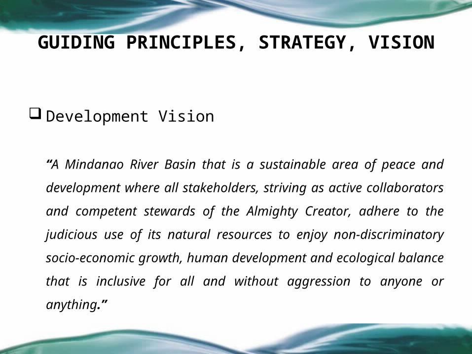
Development Vision
“A Mindanao River Basin that is a sustainable area of peace and
development where all stakeholders, striving as active collaborators and
competent stewards of the Almighty Creator, adhere to the judicious use
of its natural resources to enjoy non-discriminatory socio-economic
growth, human development and ecological balance that is inclusive for all
and without aggression to anyone or anything.”
GUIDING PRINCIPLES, STRATEGY, VISION

Development Goal
“To ensure the focused, comprehensive and integrated
development and management of the Mindanao River Basin
that would prevent, mitigate and protect its inhabitants and
stakeholders from any calamities and disaster risks, and
facilitate the attainment of sustainable development.”
GUIDING PRINCIPLES, STRATEGY, VISION

Development Objectives On Watershed Management
On Wetland Resource Management
On Water Use and Resource Management
On Disaster Risk Reduction & Management
On Human Development
On Institutional Framework & Structure (and Development)
Alignment with Other Development Initiatives MTPDP
MSDF
MDG
HDPP-ARMM
GUIDING PRINCIPLES, STRATEGY, VISION
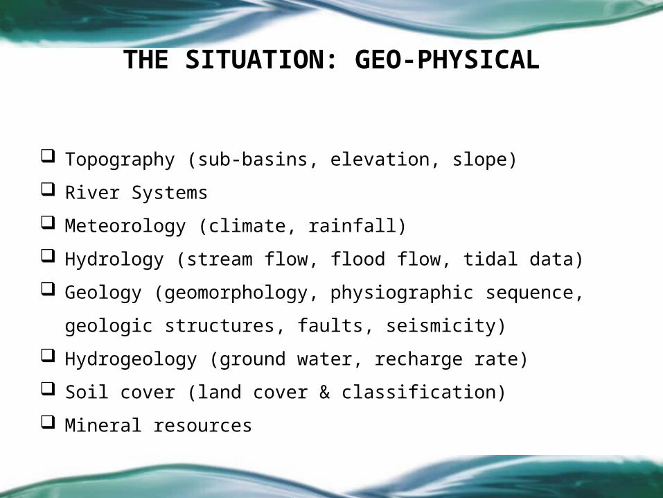
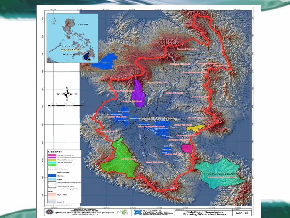
Topography (sub-basins, elevation, slope)
River Systems
Meteorology (climate, rainfall)
Hydrology (stream flow, flood flow, tidal data)
Geology (geomorphology, physiographic sequence, geologic structures,
faults, seismicity)
Hydrogeology (ground water, recharge rate)
Soil cover (land cover & classification)
Mineral resources
THE SITUATION: GEO-PHYSICAL

Air environment (air, pollution, water)
Water environment (quality, saline intrusion)
Biological environment (forest-watershed resources,
protected areas
Biodiversity (flora, fauna)
THE SITUATION: ENVIRONMENTAL

Supports agriculture and fisheries
Major lakes are: Lake Sebu, Lake Seloton, Lake Lahit, Lake Maughan (all
found in Ala River Sub-basin with estimated total area of 787 has.) and
Lake Buluan (largest with a total of 6,300 has. & found within Buluan
Sub-basin)
Ligawasan Marsh (a conglomerate of 3 marshes:Ligawasan, Ebpanan &
Libungan) with total area of ≈280,000 has.
THE SITUATION: WETLAND

Forest land around 1,048,648 has (≈45% of MRB 2,312,293 has)• ≈19% with closed canopy covering >50 percent;• ≈18% open canopy covering <50 percent;• ≈63% converted into various land uses.
Closed- and open-canopy forests gradually being transformed into other uses: agriculture, commercial forestry, road construction & rural development.
THE SITUATION: WATERSHED
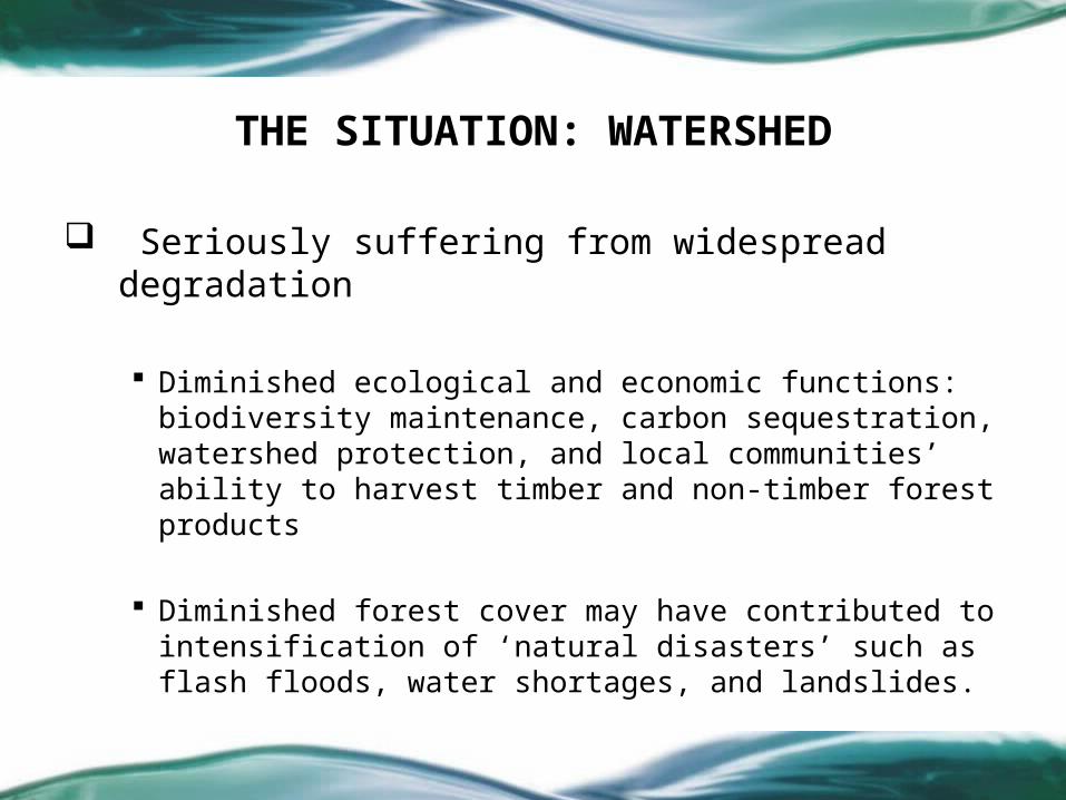
Seriously suffering from widespread degradation
Diminished ecological and economic functions: biodiversity maintenance, carbon sequestration, watershed protection, and local communities’ ability to harvest timber and non-timber forest products
Diminished forest cover may have contributed to intensification of ‘natural disasters’ such as flash floods, water shortages, and landslides.
THE SITUATION: WATERSHED
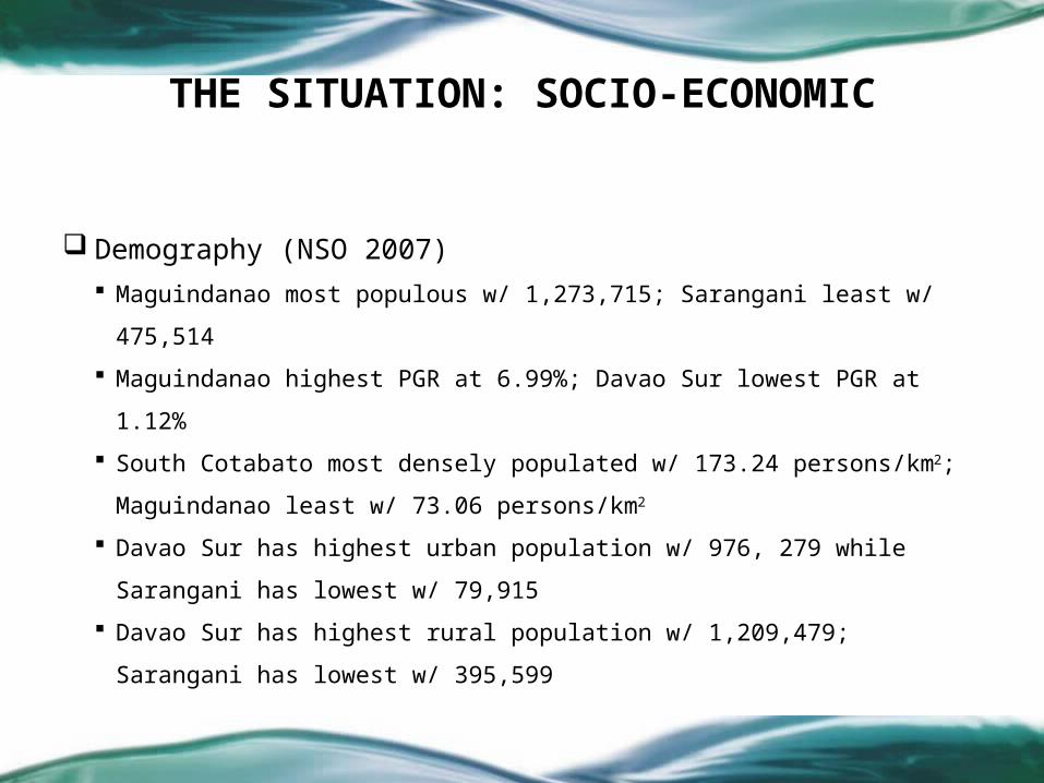
Demography (NSO 2007) Maguindanao most populous w/ 1,273,715; Sarangani least w/ 475,514
Maguindanao highest PGR at 6.99%; Davao Sur lowest PGR at 1.12%
South Cotabato most densely populated w/ 173.24 persons/km2;
Maguindanao least w/ 73.06 persons/km2
Davao Sur has highest urban population w/ 976, 279 while Sarangani
has lowest w/ 79,915
Davao Sur has highest rural population w/ 1,209,479; Sarangani has
lowest w/ 395,599
THE SITUATION: SOCIO-ECONOMIC
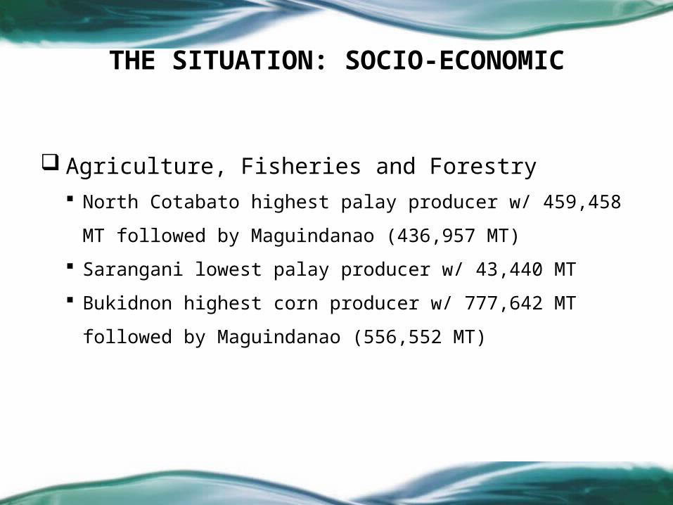
Agriculture, Fisheries and Forestry North Cotabato highest palay producer w/ 459,458 MT followed by
Maguindanao (436,957 MT)
Sarangani lowest palay producer w/ 43,440 MT
Bukidnon highest corn producer w/ 777,642 MT followed by
Maguindanao (556,552 MT)
THE SITUATION: SOCIO-ECONOMIC
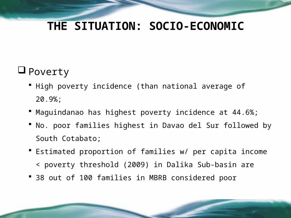
Poverty High poverty incidence (than national average of 20.9%;
Maguindanao has highest poverty incidence at 44.6%;
No. poor families highest in Davao del Sur followed by South Cotabato;
Estimated proportion of families w/ per capita income < poverty threshold
(2009) in Dalika Sub-basin are
38 out of 100 families in MBRB considered poor
THE SITUATION: SOCIO-ECONOMIC

Human Development Maguindanao has lowest HDI at 0.461, Lanao Sur has 0.464
Lanao Sur has NER higher than national average at 127.09%
Maguindanao has lowest NER for primary education w/ 56.08%
Bukidnon has lowest NER for secondary education w/ 24.07%
IMR in all sub-basins below national rate of 9.3 deaths per 1000 live births w/ municipalities
w/i M’lang Sub-basin lowest IMR w/ 2.31
Municipalities w/i Banga Sub-basin has highest IMR w/ 5.24
Half of all sub-basin areas has high MMR than national of 63.3 maternal deaths per 100K
with municipalities w/i Dalika Sub-basin w/ highest MMR at 79.45
Municipalities w/i MRB & MBRB have low professionally-delivered livebirths w/ only 50/100
THE SITUATION: SOCIO-ECONOMIC

Access to safe potable water 14 out of 20 MRB sub-basins have access to safe potable water higher than
the national average of 82% (2008 FHSIS-DOH) However, areas w/i Dalika Sub-basin recorded only 67% of its household with
access to safe water supply. In MBRB, 86.55% have access to safe water supply which is also higher than
the national average
Access to sanitary toilet Low proportion of households in all sub-basins compared to 77% national level Areas w/i Banga Sub-Basin has highest proportion of household with sanitary
toilet w/ 74.6%
THE SITUATION: SOCIO-ECONOMIC

On Water Use & Resources: 32 agencies involved in regulation
On Watershed: DENR lead on policy; LGUs lead in protection
On DRRM/CCA: NDRRMC lead, NEDA coordination, LGU
implementation
On MRB: PTFMRBRD lead in coordination w/ DENR, DPWH, NEDA
THE SITUATION: POLICIES

On Watershed Management Land use conflict between agricultural lands (Alienable and Disposable Lands)
and forest lands
Deforestation has undermined livelihoods of upland communities by
accelerating erosion on upper agricultural lands & reducing forest product flows
Denudation & degradation of forest causes soil erosion resulting in severe
siltation, exacerbated downstream flooding and sedimentation leading to
destruction of ecologically important areas like marshes & other wildlife
sanctuaries.
THE ASSESSMENT
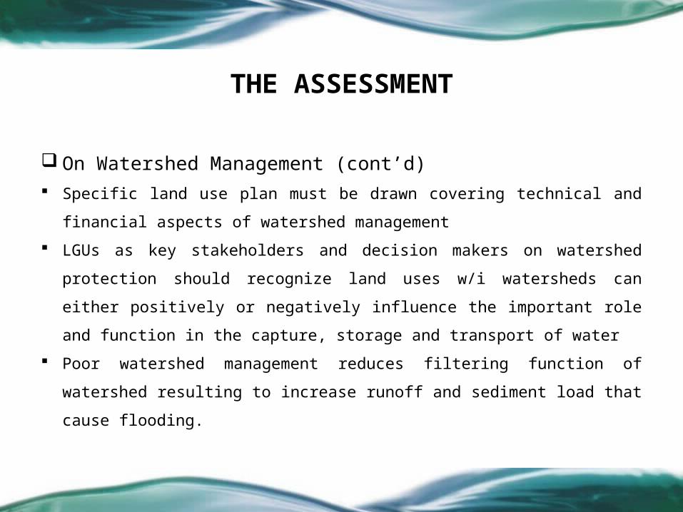
On Watershed Management (cont’d) Specific land use plan must be drawn covering technical and financial
aspects of watershed management
LGUs as key stakeholders and decision makers on watershed protection
should recognize land uses w/i watersheds can either positively or
negatively influence the important role and function in the capture,
storage and transport of water
Poor watershed management reduces filtering function of watershed
resulting to increase runoff and sediment load that cause flooding.
THE ASSESSMENT

On Wetland Management No clear, unitary policy on wetland management Unstable Peace and Order Conditions (specific for the marshes) Insufficient Information and Appreciation of the Wetland Functions Siltation and Sedimentation Encroachment of Human Settlement Absence of Institutional Mechanisms to Protect and Manage Wetlands
THE ASSESSMENT
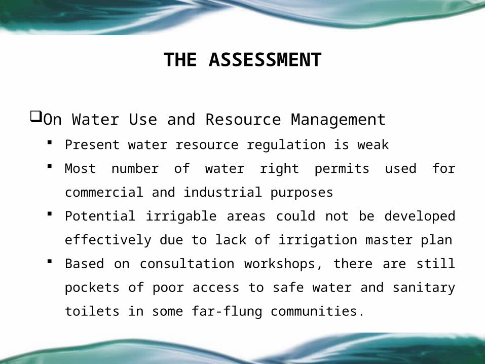
On Water Use and Resource Management Present water resource regulation is weak
Most number of water right permits used for commercial and
industrial purposes
Potential irrigable areas could not be developed effectively due to lack
of irrigation master plan
Based on consultation workshops, there are still pockets of poor access
to safe water and sanitary toilets in some far-flung communities.
THE ASSESSMENT

On Human Development Extreme and lingering poverty Social conflict Further reduce infant mortality High Maternal Mortality Low schooling rate Need for more access to safe potable water & sanitary toilet
THE ASSESSMENT

On Institutional Development
No single organization managing the MRB/MBRB
No clear, unitary policy on river basin management at national & local
level
Sector approach within administrative and geo-political boundaries
Need for a new institutional arrangement to manage the entire
MRB/MBRB wholistically and as a unitary unit
THE ASSESSMENT

On Watershed ManagementRehabilitation of all degraded and critical watersheds in the project area
Implementation of protection works for all those remaining (including
degraded) healthy watersheds
Implementation of proper land and water management practices
Updating of plans for Proclaimed Watersheds (WFR) & Protected Landscape
Conduct of community organizing, IEC campaign including watershed
management training to watershed key stakeholders
Provide livelihood projects for watershed communities
THE PROPOSED SOLUTION-THE PLAN

On Wetland Management
Improve Peace and Order Conditions in the Marsh Areas Resource Assessment and Valuation of the Wetland Areas Wetland Rehabilitation Prevent Further Human Encroachment in the Wetland Areas Institutionalize Wetland Protection and Management
THE PROPOSED SOLUTION- THE PLAN

On Water Use & Resource Management Focus on the development of national irrigation system (NIS)
LGUs should assist thru communal irrigation system (CIS)
Watershed should be protected, rehabilitated and maintained
Strengthen LGU water and sanitation program
THE PROPOSED SOLUTION- THE PLAN
On Flooding & Other Hazards Disaster risk reduction prioritized by LGUs & other instrumentalities (line
agencies, coordinative bodies and other formations) at all levels (from
barangay to basin).
Risks properly assessed & early warning systems for multi-hazards established
at all levels (barangay to basin).
A culture of safety and resilience prevails among the MRB populace.
Compounding risk factors are reduced.
Disaster preparedness is strengthened at all levels (barangay to basin).
THE PROPOSED SOLUTION- THE PLAN

On Human Development Expand enrolment to Pantawid Pamilyang Pilipino Program (4Ps)
Food for School Program
Promotion of Technical and Vocational Education / Job fitting
Improve Access and Delivery of Health Services
Income Augmentation / Livelihood Programs
Water People’s Organization and Cooperative Development
Advocacy and Social Marketing
THE PROPOSED SOLUTION- THE PLAN

On Institutional Development Establish a Mindanao River Basin Authority (MRBA) thru legislation
MRBA to be chaired by MinDA head & co-chaired by ARMM Gov
Institutionalize stakeholder participation by integrating into MRBA
Strengthen the MRBA as a basin-level RBO thru the Sub-basin field offices
Establish and strengthen knowledge management for the MRB/MBRB
Advocacy and Social Marketing
THE PROPOSED SOLUTION- THE PLAN

2010EO creating MRBA Support Office; Approval of the MRB Integrated Management & Development Master Plan & RA for the MRBA
PROJECT IMPLEMENTATION TIMELINE5 Years
2011 2012 2013 2014
Institutional Development
Watershed Management
Wetland Management
Water Resource Development
Disaster Risk Reduction & Management
Human Development
Nursery Development; Plantation establishment; Regeneration/ rainforestation; Trail construction; Forest protection; Community IEC; WSCreation of Bantay Ligawasan; NRA; Wetlands database; IEC campaign; Dregding; Hydrologic studies; Water quality monitoring; Wetland zoning; etc.
Irrigation FS; Irrigation development
Organize Disaster Forum; Resource devt plan; Risk assessment; Multi-hazard/risk map; IEC campaign; Organize & train DRRM in-house advisers/experts
Expansion of 4Ps; FFS; Training of traditional medicine practioners & BHWs; SM&Ad; TVET; Livelihood Programs

2015 2016 2017 2018 2019 2020 2021 2022 2023 2024
10 Years PROJECT IMPLEMENTATION TIMELINE
Institutional Development
Watershed Management
Wetland Management
Water Resource Development
Disaster Risk Reduction & Management
Human Development
Expansion of 4Ps; FFS; Training of traditional medicine practioners & BHWs; SM&Ad; TVET; Livelihood ProgramsExpansion of 4Ps; FFS; Training of traditional medicine practioners & BHWs; SM&Ad; TVET; Livelihood Programs
Nursery Development; Plantation establishment; Regeneration/ rainforestation; Trail construction; Forest protection; Community IEC; WS
Institutional strengthening, implementation of MRBIMDMP, Monitoring & evaluation
Creation of Bantay Ligawasan; NRA; Wetlands database; IEC campaign; Dregding; Hydrologic studies; Water quality monitoring; Wetland zoning;; mangrove reforestation; Alternate livelihood; Resettlement; Buffer zones
Irrigation FS; Irrigation development
Organize Disaster Forum; Resource devt plan; Risk assessment; Multi-hazard/risk map; IEC campaign; Organize & train DRRM in-house advisers/experts; DRRM implementation

2025-28
PROJECT IMPLEMENTATION TIMELINE15 Years
2029-31 2032-34 2035-37 2038-40
Institutional Development
Watershed Management
Wetland Management
Water Resource Development
Disaster Risk Reduction & Management
Human Development
Nursery Development; Plantation establishment; Regeneration/ rainforestation; Trail construction; Forest protection; Community IEC; WS
Institutional strengthening, implementation of MRBIMDMP, Monitoring & evaluation
Creation of Bantay Ligawasan; NRA; Wetlands database; IEC campaign; Dregding; Hydrologic studies; Water quality monitoring; Wetland zoning;; mangrove reforestation; Alternate livelihood; Resettlement; Buffer zones
Irrigation FS; Irrigation development
Organize Disaster Forum; Resource devt plan; Risk assessment; Multi-hazard/risk map; IEC campaign; Organize & train DRRM in-house advisers/experts; DRRM implementation
Expansion of 4Ps; FFS; Training of traditional medicine practioners & BHWs; SM&Ad; TVET; Livelihood ProgramsExpansion of 4Ps; FFS; Training of traditional medicine practioners & BHWs; SM&Ad; TVET; Livelihood Programs

SUMMARY OF INVESTMENT(in ’000)
Watershed Management Watershed Management
Wetland Management Wetland Management
Water Use & Resource Development Water Use & Resource Development
Flood & Other Hazards Management Flood & Other Hazards Management
Human DevelopmentHuman Development
Institutional DevelopmentInstitutional Development
INVESTMENT REQUIREMENT PHP118,753.4 INVESTMENT REQUIREMENT PHP118,753.4
81,783.481,783.4
466.3466.3
20.320.3
54.4 54.4
36,400.1 36,400.1
29.0 29.0
Priority ProjectsPriority Projects 00.000.0
Presentation/Approval of the Master Plan by concerned Regional Development Council (RDC)
Creation/Mobilization of River Basin Organization (RBO)
NEXT MILESTONES

Daghang
Daghang Salama
tSalama
t Po…Po…