ms. carrie ferguson department of environmental...
TRANSCRIPT
Yates Petroleum Corporation: 2009/February/13/Renewal/1009020208/WY005455/Page 1
February 13, 2009
Ms. Carrie Ferguson Department of Environmental Quality Herschler Building 122 West 25th Street Cheyenne, Wyoming 82002 RE: Renewal for Yates Petroleum Corporation WYPDES Permit WY0054551 Dear Ms. Ferguson: On behalf of Yates Petroleum Corporation (Yates), WWC is submitting the following materials for WYPDES permit WY0054551 (Embudo).
• WYPDES permit renewal application
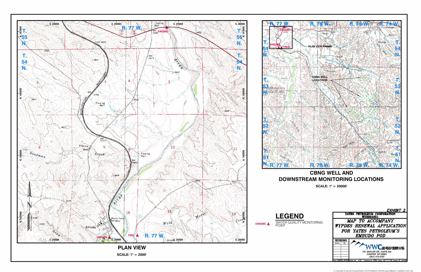
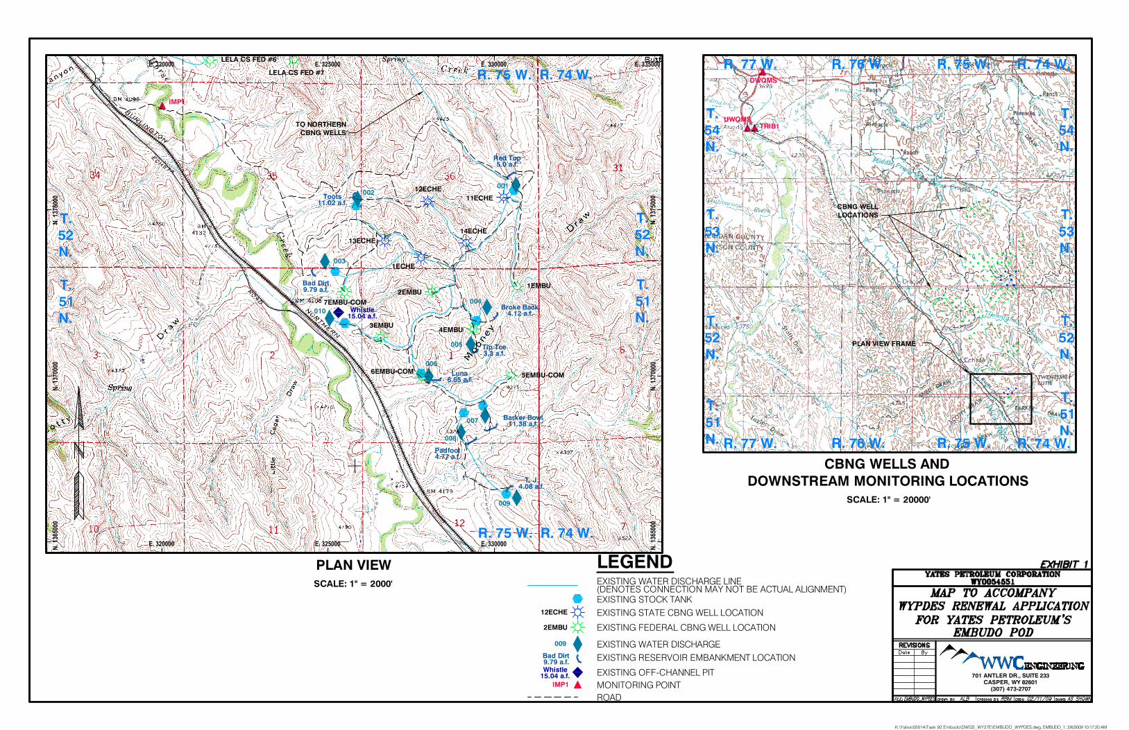
• Two topographic maps (Exhibit 1 & Exhibit 2) showing Coal Bed Natural Gas (CBNG) wells, water connections, monitoring locations, and discharge points
• Water quality analyses
• A CD with all of the submitted materials in digital format
Yates is applying for renewal of existing WYPDES permit WY0054551, an Option 2 facility, located in northwestern Campbell County. WYPDES permit WY0054551 currently authorizes the discharge of 0.40 MGD of CBNG produced waters from 12 wells to 9 on-channel reservoirs located in the Powder River watershed. The permitted outfalls and reservoirs are located in Sections 35-36, Township 52 North, Range 75, and Sections 1, 2, and 12, Township 51 North, Range 75 West. WY0054551 is permitted under Option 2 of the coal bed methane permitting options. All CBNG produced water will be contained in on-channel reservoirs during normal “dry” operating conditions. Downstream irrigation is present along Wild Horse Creek prior to its confluence with the Powder River. The downstream irrigation has been documented in the 2005 Section 20 Compliance Analysis for Proposed Discharges by Petro-Canada to Wild Horse Creek, Campbell County, Wyoming and the 2007 Supplemental Information for the Section 20 Analysis for Proposed CBNG Produced Water Discharges, Wild Horse Creek, Campbell County, Wyoming. Both assessments were prepared by KC Harvey, LLC. Yates respectfully requests that the afore mentioned Section 20 compliance analysis be used to establish discharge limits in the renewed permit.
Ms. Carrie Ferguson February 13, 2009 Page 2 of 2
Yates Petroleum Corporation: 2009/February/13/Renewal/1009020208/WY005455/Page 2
With this permit renewal application Yates is proposing to add 142 wells to WYPDES permit WY0054551. All the wells being added to this permit are also permitted to discharge to other WYPDES permits. Yates will manage the reservoirs in this permit such that they will not overtop during dry weather operations by adjusting discharges between permits. As such, Yates does not anticipate that current discharge limits will be exceeded with the addition of the new wells. The new wells proposed in this application are permitted in various coal seams between the Felix or Smith and Pawnee coal seams. These seams include the Felix, Smith, a local seam simply called Stray, Anderson, Upper and Lower Canyon, Wall, and Pawnee coal seams. Most of the wells are multiple completion wells and produce water from one or more of the coal seams listed above. The commingled sample included with this application is expected to be representative of the produced water. As mentioned above Yates plans to operate the reservoirs within the Embudo POD such that there will be no intentional reservoir releases. Furthermore, Yates does not plan to have intentional reservoir releases from this facility in the future. On several of the WYPDES permits Yates has recently renewed there was language within the permits essentially stating that containment is required unless prior written authorization is granted for a reservoir release in association with the use of assimilative capacity credits. Since Yates does not plan to intentionally release water from the reservoirs, they are requesting that this language be removed from the final permit. By removing this language from the permit, Yates anticipates that there may be less opposition to this permit from downstream landowners who may find the language confusing and assume the permit allows reservoir releases. Yates requests WY0054551 be renewed with updated effluent limits reflecting current standards for the Wild Horse Creek watershed. Yates also requests that copies of any public comments received regarding this permit be forwarded to Lisa Norton and Ray Moores. Please send these copies to the contact addresses listed in the permit application.
If you have any questions or comments, please contact us at (307) 672-0761.
Thank you,
Crystal Lesmeister, P.E. Project Engineer
ckl Enclosures: as noted cc: Lisa Norton K:\Yates\05014\Task 92 Embudo\Corre\Embudo_WYPDES_Letter_2-13-09.doc
Yates Petroleum Corporation: 2009/February/13/Renewal/1009020208/WY0054551 Page 1 of 19
SUBMIT ONE HARD COPY AND ONE ELECTRONIC COPY
WYOMING POLLUTANT DISCHARGE ELIMINATION SYSTEM
APPLICATION FOR PERMIT TO SURFACE DISCHARGE PRODUCED WATER FROM COAL BED METHANE NEW DISCHARGES, RENEWALS, OR MAJOR
MODIFICATIONS
Revised: 06-22-06 Revised form last updated: 9-03-08 PLEASE PRINT OR TYPE (Submission of illegible materials will result in return of the application to the applicant) 1. Check the box corresponding to the type of application being applied for:
New CBM permit
CBM permit renewal Permit number WY0054551 Expiration Date: December 31, 2009 CBM permit major modification Permit number _____________ Expiration Date: ________________ 2. Identify the river basin in which the discharge will occur:
Belle Fourche Cheyenne Powder Little Powder Tongue
Other (identify) _________________________________________
3. Select permit option(s): if more than one option is selected, the applicant must describe which option applies to which outfall.
Option 1A – Discharge is contained within an off-channel pit (class 4C) capable of containing all effluent plus up to a 50-year / 24-hour storm event. For existing permits only, Option 1A also applies to discharges that are contained within a headwater reservoir situated within a class 4 channel and capable of containing all effluent plus up to a 50-year/24-hour storm event, provided that the discharge was permitted for 50-year/24-hour containment prior to June 24th, 2008.
Option 1B – Discharge is contained within a natural closed basin or playa lake (class 3A). For existing permits only, Option 1B also applies to discharges that are contained within a headwater reservoir situated within a class 3 channel and capable of containing all effluent plus up to a 50-year/24-hour storm event, provided that the discharge was permitted for 50-year/24 hour storm containment prior to June 24th, 2008. Option 1B headwater reservoirs shall not be located within alluvial deposits or the floodplain of any perennial, intermittent or ephemeral stream. Option 1B headwater reservoirs less than 50 acre feet in capacity shall not be located within 500 feet of such features; reservoirs greater than 50 acre feet in capacity shall not be located within ¼ mile (1320 feet) of such features.
Option 2 – This option includes any on-channel discharge (including discharge into an on-channel reservoir) that does not meet the impoundment requirements specified in options 1A or 1B above.
4. General Facility Location: Township(s) 51-52 North Range(s) 75 West
Immediate Receiving Stream(s) ephemeral tributaries to Wild Horse Creek
5. Name of the facility producing the discharge (this is the facility name that will appear on the WYPDES permit) Embudo POD 6. Company, Contact Name, mailing address, e-mail address, and telephone number of the individual or company which
owns the facility producing the discharge, and the person (consultant) responsible for permit submission. Company Contact Name Lisa Norton
Consultant Contact Name Ray Moores
For Agency Use Only
Application Number WY00_______________
Date Received:
__________________
(mo/day/yr)
Yates Petroleum Corporation: 2009/February/13/Renewal/1009020208/WY0054551 Page 2 of 19
Company Name Yates Petroleum
Company Name WWC Engineering
Mailing Address 105 South 4th Street
Mailing Address 1849 Terra Avenue
City, State, and Zip Code Artesia, New Mexico 88210
City, State, and Zip Code Sheridan, WY 82801
Telephone Number (575) 748-4185
Telephone Number (307) 672-0761
E-Mail Address [email protected]
E-Mail Address [email protected]
7.a. If applying for outfalls under Option 2, are any of the proposed Option 2 outfalls DIRECT DISCHARGES*that
would require the use of assimilative capacity credits for salt and sodium in the Powder River?
Yes No
If “yes”, please complete Table 5.
*DIRECT DISCHARGE means those discharges that are not or are only partially contained within reservoirs. Discharges to reservoirs that only overtop and spill during storm events are not subject to assimilative capacity requirements. Direct discharges that can meet Powder River ambient concentrations for TDS and sodium are also not subject to assimilative capacity requirements.
7.b. If applying for outfalls under Option 2, is it possible that INTENTIONAL RESERVOIR RELEASES* will be requested for any of the reservoirs receiving CBM discharges under this permit?
Yes No Recently issued permits contain language outlining the ability and procedure for an operator to use their Powder River assimilative capacity credit allocation (ASCAP) for intentional reservoir releases. Yates Petroleum Corporation does not plan to intentionally release water from reservoirs using their ASCAP. As such, Yates requests that all language pertaining to “intentional releases” be removed from the Embudo POD WYPDES permit.
*INTENTIONAL RESERVOIR RELEASE means purposeful and intentional reservoir releases (opening a valve or pumping out a reservoir) to provide freeboard within a reservoir. Discharges that occur solely in response to storm events are not considered intentional reservoir releases, and do not require assimilative capacity credits. Intentional reservoir releases are authorized on a case-by-case basis and require WDEQ approval above and beyond a WYPDES surface discharge permit (authorization application form available on WDEQ website).
8. If submitting a major modification or permit renewal, please describe all requested permit modifications (i.e. add 2 outfalls, add 23 wells, move outfall 001 500 feet…):
1. Add one outfall. 2. Add one off-channel reservoir. 3. Update outfall latitudes and longitudes. 4. Add 142 wells. (add additional lines as necessary)
*NOTE: Major modification applications requesting to increase the permitted flow for a facility will be processed as RENEWALS. Major modification applications for permits within six months of their expiration date will also be processed as RENEWALS.
9. Name(s) and mailing address(es) of owner(s) of the surface rights on whose land the discharge occurs (in cases where
the land is owned by the state or federal government but surface rights are leased to a private individual, provide lessee’s name and address)
Yates Petroleum Corporation: 2009/February/13/Renewal/1009020208/WY0054551 Page 3 of 19
Landowner #1 Name Eaton Brothers Inc.
Landowner #2 Name Margaret Ann Hladky, et al. Contact: Allan Mooney
Mailing Address 270 Eaton Ranch Road
Mailing Address 1985 West Echeta Road
City, State, and Zip Code Wolf, WY 8284
City, State, and Zip Code Gillette, WY 82716
(additional spaces may be added as necessary)
10a. Please provide the maximum anticipated discharge rate, in million gallons per day (MGD), from this facility: The maximum anticipated discharge rate for this facility is 0.40 MGD. 10b. Does this facility rely on containment in reservoirs (of any type) as part of the water management strategy?
YES NO
10c. If NO is checked above, please proceed to item #11. If YES is checked above, the permittee is required to conduct an internal evaluation of the ability of the reservoir(s) at this facility to contain discharges. Based on the results of this evaluation, please describe the ability of the reservoir(s) at this facility to contain effluent and surface run-off from precipitation events. If there are multiple reservoirs at this facility which have different reservoir containment capabilities, please describe separately, identifying reservoirs using reservoir name. For example, “Reservoir A will contain all effluent and will only overtop during a storm event of any magnitude; Reservoir B will contain all effluent plus surface run-off from up to the 50 year/24 hour storm event, etc…”:
The Red Top, Toots, Bad Dirt, Broke Back, Tip Toe, Luna, Barker Bowl, Padfoot, and T.J. Reservoirs as well as off-channel reservoir Whistle will contain all effluent and may only overtop during a storm event of any magnitude. The internal evaluation does NOT need to be submitted to the WYPDES Program as part of this application. By completing item 10b and signing this application, the permittee certifies that the reservoirs at this facility are capable of meeting the containment abilities which have been provided. The WYPDES Program will use the information provided above to determine the appropriate reservoir containment requirements that will be established in the permit. If reservoir containment requirements established in the permit are not met, this may constitute a violation of the permit, which is subject to full enforcement by the WYPDES Program. 11. Attach a description and a clear, legible, detailed topographic map of the discharging facility. Include the following:
a. A legend – Please refer to Exhibits 1 and 2. b. Well locations – Please refer to Exhibit 1. c. Ponds – N/A. Facility does not utilize ponds. d. Reservoirs – Please refer to Exhibit 1. e. Stock tanks – Please refer to Exhibit 1. f. Discharge points (outfalls) – Please refer to Exhibit 1. g. Immediate receiving streams – Please refer to Exhibit 1. h. Water quality monitoring stations – Please refer to Exhibits 1 and 2. i. Irrigation monitoring points – Please refer to Exhibit 1. j. Location of nearest downstream irrigator. – N/A. Please refer to Section 20 described in Question 23. k. Section, Township, and Range information – Please refer to Exhibits 1 and 2. l. If proposing to use class 4C off-channel pits (option 1A), include footprint outline of the proposed pits. To denote
setback distance, include a distance marker from closest side of pit to the nearest water feature, floodplain, or stream alluvium. Identify latitude and longitude in decimal degrees (using a minimum of 6 decimal places) for each end point of the setback distance marker. – N/A. Facility does not utilize Option 1A outfalls.
m. If proposing discharge to a headwater reservoir or to a playa lake (option 1B), include footprint outline of the proposed impoundment(s). See page 1 of the application form for option 1B impoundment siting requirements. To denote setback distance from alluvial floodplain areas, include a distance marker from closest side of the impoundment to the nearest floodplain, or stream alluvium. Identify latitude and longitude in decimal degrees (using a minimum of 6 decimal places) for each end point of the setback distance marker. N/A. Facility does not utilize Option 1B outfalls.
If any of the above are not applicable please indicate in the description and include a brief explanation as to why the item is not applicable)
Yates Petroleum Corporation: 2009/February/13/Renewal/1009020208/WY0054551 Page 4 of 19
12. Describe the control measures that will be implemented to prevent significant damage to or erosion of the receiving water channel at the point of discharge.
Discharge points are be located in areas of minimal slope near the channel bottoms. Energy dissipation devices are also utilized at the discharge locations to minimize erosion.
13. Describe the control measures that will be implemented to achieve water quality standards and effluent limits. If
proposing to utilize a treatment process, provide a description of the treatment process.
Water quality is good and will meet water quality standards and effluent limits. Limited treatment may occur at the energy dissipation devices. The devices will be constructed of rip-rap to which precipitants will adhere to prior to reaching the receiving channel.
14. Outfall locations must be established as part of a preliminary field reconnaissance survey using GPS or conventional
survey equipment and documented in Table 1. Please document the type of equipment used, the expected accuracy of your measurements, and a brief rationale for locating the outfalls at the requested sites below.
A hand held GPS was utilized to determine location of the outfalls, with an accuracy of approximately +/- 50 ft. Rationale for determination of outfall locations was suitable sites that limit erosional potential and still meet landowner requests for discharge.
15. Complete the attached Table 1. Provide all the information requested in the table for each proposed discharge point or
monitoring point. If proposing changes (a major modification) to an existing facility, clearly indicate the desired changes on the table. Additional tables may be attached. Use the format provided. Option 2 permits, except those located in the Belle Fourche or Cheyenne River Basins, must include water quality monitoring station locations. Option 1B headwater reservoir discharges (reservoirs other than playa lakes capable of 50 year, 24 hour stormwater runoff containment) must include flow monitoring station locations. Option 1A and 1B permits must include containment unit monitoring station locations. Information related to reservoirs is only required if the facility’s water management plan includes reservoir containment. Please see Table 1.
16. Complete the attached Table 2. Provide all the information requested in the table for each well associated with this
proposed discharge authorization. If proposing changes (a major modification) to an existing facility, clearly indicate the desired changes on the table. Additional tables may be attached. Use the format provided. Please see Table 2.
17. Complete the attached Table 3. Provide all the information requested in the table for each reservoir proposed for
containment of CBM produced water. Specified locations refer to the approximate center of the reservoir. If proposing changes (a major modification) to an existing facility, clearly indicate the desired changes on the table. Additional tables may be attached. Use the format provided. Information related to reservoirs is only required if the facility’s water management plan includes reservoir containment. Please see Table 3.
18. Complete the attached Table 4. Provide all information requested in the table related to reservoir bonding requirements
for each reservoir proposed for the containment of CBM produced water. If proposing any changes (a major modification) to an existing facility, clearly indicate the desired changes on the table. Additional tables may be attached. Use the format provided. Information related to reservoirs is only required if the facility’s water management plan includes reservoir containment. Please see Table 4.
19. Provide the results of water analyses for a sample collected from a location representative of the quality of the water
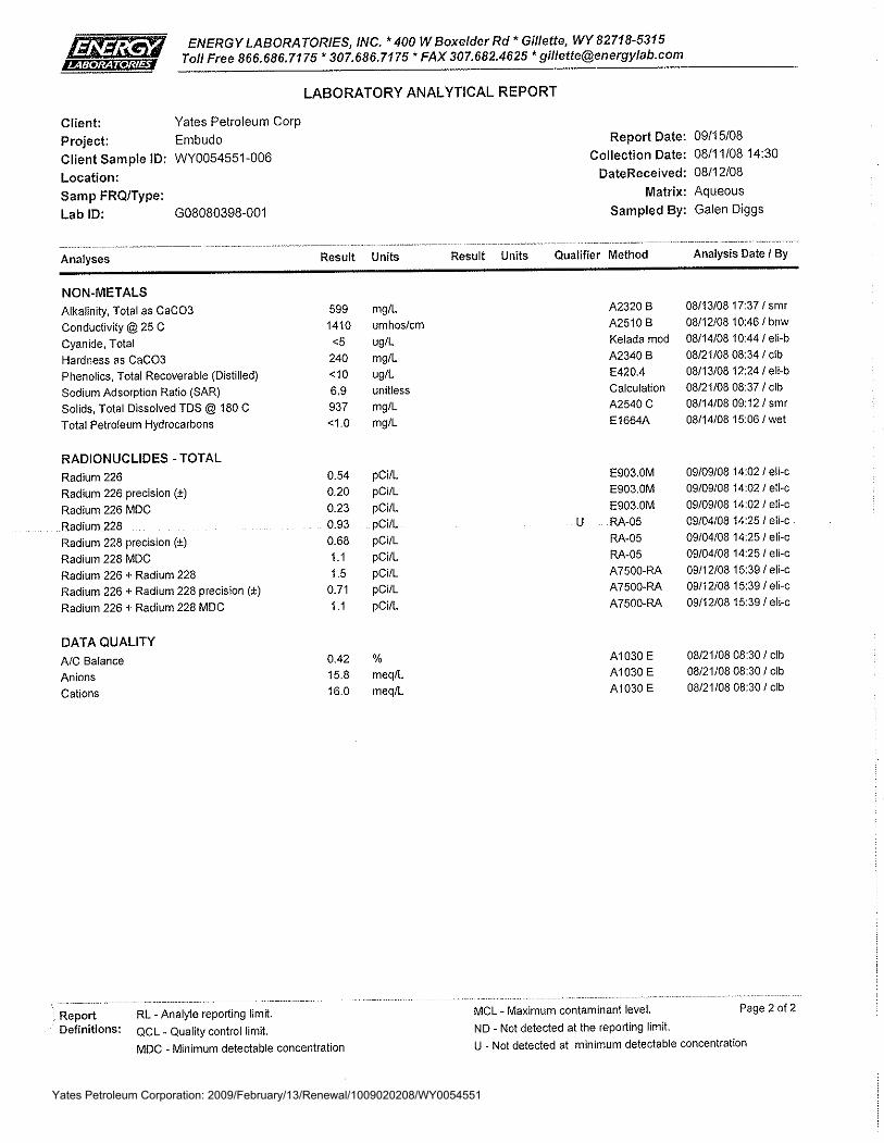
being proposed for discharge for all of the chemical parameters listed in the table below. The sample must be collected from well(s) or outfall(s) within a twenty mile radius of the proposed facility’s location, and from the same coal formation(s) and the same approximate depth(s) as proposed in this application. If filing an application for a permit renewal or modification, the representative sample must be collected from the facility being proposed for renewal or modification. Explain why this sample is representative of the produced water to be discharged. See attached water quality sample collected from outfall 006 of this permit (WY0054551). This sample is representative of the water to be discharged from wells included in this permit because it is from this facility.
Yates Petroleum Corporation: 2009/February/13/Renewal/1009020208/WY0054551 Page 5 of 19
Samples from co-mingled coal seams are acceptable as long as the sample(s) meet the following criteria:
A. all of the coal seams being proposed for development are represented in the co-mingled sample, with no contribution from coal seams not being proposed for development at the new facility.
B. the ratio of each coal seam’s contribution is approximately the same in the sample and the proposed development, C. documentation is provided to verify the criteria listed in A. and B.
The analyses must be conducted in accordance with approved EPA test procedures (40 CFR Part 136). Include a signed
copy of your lab report that includes the following:
a. detection limits b. results of each of the chemical parameters at the chemical state given below c. quarter/quarter, section, township and range of the sample collection location d. Time and date of sample collection e. Time and date of analysis for each parameter f. Analyst’s initials for each parameter g. Detection limit for each parameter as achieved by the laboratory h. WYPDES permit number and outfall number, where the sample was collected. i. Origin of produced water (coal seam and legal location of sample collection location)
If more than one coal seam is being proposed for development, the permittee must submit a lab analysis and complete information characterizing water quality from each coal seam being proposed for development. If the permittee is proposing to include discharges from a coal seam not previously developed at this facility, the permittee must submit a lab analysis and complete information characterizing water quality from the new coal seam being proposed for development. A mixing analysis may be required if the representative water quality analysis from the new coal seam indicates that the inclusion of the new effluent source may result in degradation of existing effluent quality. Analyses must be provided in the units listed below.
Parameter* (See notes following the table on chemical states)
Required Detection Limits and Required Units
Alkalinity, Total 1 mg/l as CaCO3
Aluminum, Dissolved 50 μg/l Arsenic, Total Recoverable 1 μg/l Barium, Total Recoverable 100 μg/l Bicarbonate 10 mg/l Cadmium, Dissolved 5 μg/l Calcium, Dissolved 50 μg/l, report as mg/l Chlorides 5 mg/l Copper, Dissolved 10 μg/l Dissolved Solids, Total 5 mg/l Fluoride, Dissolved 100 µg/l Hardness, Total 10 mg/l as CaCO3
Iron, Dissolved 50 μg/l Lead, Dissolved 2 μg/l Magnesium, Dissolved 100 μg/l, report as mg/l Manganese, Dissolved 50 μg/l Mercury, Dissolved 1 μg/l pH to 0.1 pH unit Radium 226, Total Recoverable 0.2 pCi/l
Radium 228, Total Recoverable** 0.2 pCi/l
Selenium, Total Recoverable 5 μg/l Sodium Adsorption Ratio Calculated as unadjusted ratio
Yates Petroleum Corporation: 2009/February/13/Renewal/1009020208/WY0054551 Page 6 of 19
Parameter* (See notes following the table on chemical states)
Required Detection Limits and Required Units
Sodium, Dissolved 100 μg/l, report as mg/l Specific Conductance 5 micromhos/cm Sulfates 10 mg/l Zinc, Dissolved 50 μg/l
*Discharges into drainages other than the Powder River geologic basin may require analysis of additional parameters, please contact the WDEQ for a separate list.
**This parameter is only required for those discharges located within one stream mile of a class 2 water.
20. For new facilities, provide the expected (estimated) flow volume from each well in gallons per day, and provide the rationale behind the flow volume estimate. For existing facilities, provide actual flow data from all wells within the last six months.
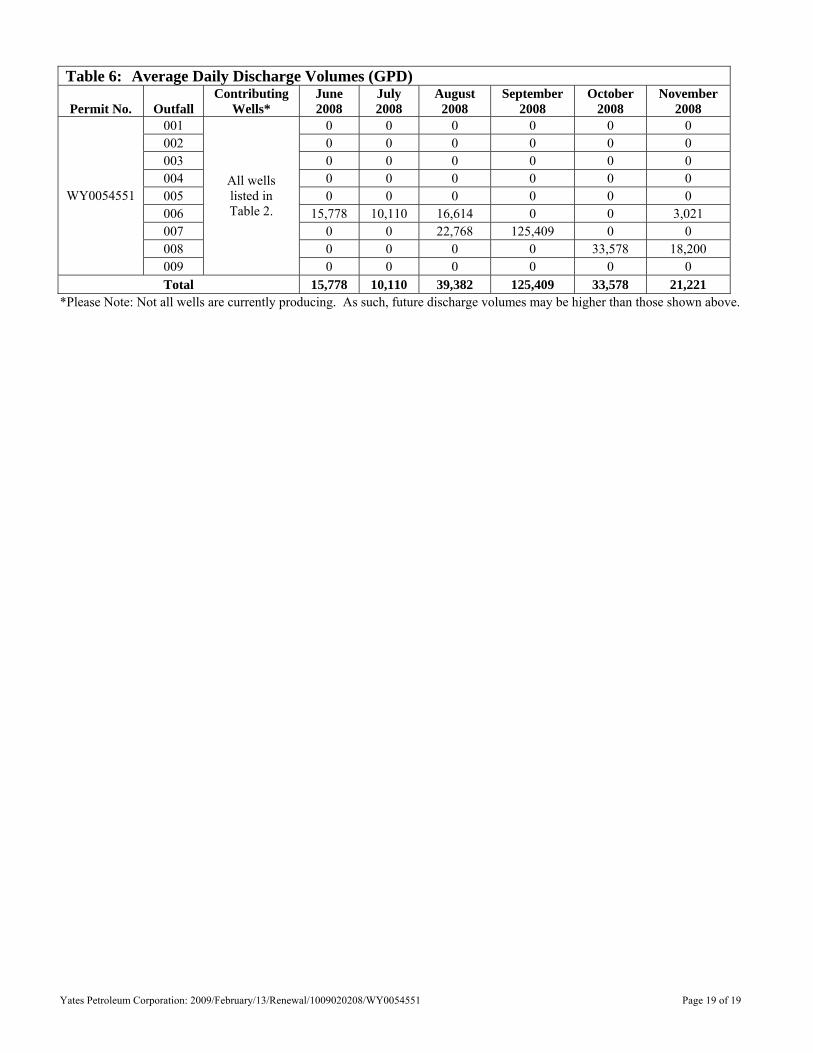
Flow rates over the previous six months have ranged from 10,110 gal/day to 125,409 gal/day. Please refer to Table 6 for additional details.
21. For applications for new facilities, are any of the required chemical constituents in the laboratory analysis present in
concentrations above Wyoming Water Quality Standards? N/A. Existing facility.
YES NO
If the answer to question # 21 is yes, answer 21.a. – 21.b below. If no, proceed to question 23.
a. Which constituents?
b. Has this constituent been addressed in the response to question 13? 22. For applications for existing facilities, has the facility ever exceeded permit limits or water quality standards? If the
facility has never discharged or has not yet been constructed, please indicate below.
YES NO
If the answer to question 22 is yes, answer 22.a. – 22.c. If no, proceed to question 23.
a. Which constituents? TDS
b. Has the exceedance been addressed? Yes.
c. Describe how the exceedance was addressed. The one exceedance occurred in a sample collected 10/3/08. A sample collected on 11/20/08 did not exceed permit limits. Yates believes the sample collected on 10/3/08 was an anomaly. This assumption is further supported by the fact that of the 10 samples collected from WY0054551 outfalls in 2008 only one of them exceeded permit limits for TDS and it was almost twice as high as any of the other samples. As such, Yates anticipates that samples collected in the future will be within the permit limits.
23. Is there active irrigation in the drainage downstream of the discharge? (Please note that this response includes both
artificially and naturally irrigated bottomlands as defined in the Draft Agricultural Use Protection Policy for the interpretation and implementation of Chapter 1, Section 20 of the Wyoming Water Quality Rules and Regulations ).
YES NO
Please refer to the 2005 Section 20 Compliance Analysis for Proposed Discharges by Petro-Canada to Wild Horse Creek, Campbell County, Wyoming and the 2007 Supplemental Information for the Section 20 Analysis for Proposed CBNG Produced Water Discharges, Wild Horse Creek, Campbell County, Wyoming. Both assessments were prepared by KC Harvey, LLC and are available on the WDEQ website.
Yates Petroleum Corporation: 2009/February/13/Renewal/1009020208/WY0054551 Page 7 of 19
If yes, at a minimum, the WYPDES Program requires submission of the following information:
1. Location(s) of irrigation diversions and/or sub-irrigated acreage; 2. Type(s) of Crops grown under irrigation; 3. Description of Irrigation Practices 4. A topographic map showing irrigated acreage, any structures, ownership of irrigated acreage. In addition to the minimum information described above, the WYPDES Program may require additional information should the permittee request site-specific effluent limits protective of irrigation uses. Contact the WYPDES Program for more information regarding requirements for site-specific SAR, TDS, and EC limits.
24. Provide name(s) and address(es) for all downstream irrigators between the outfalls and the mainstem.
Irrigator #1 Name Kenny Clabaugh
Irrigator #2 Name Floyd Land & Livestock
Mailing Address P.O. Box 12
Mailing Address 2600 Echeta Road
City, State, and Zip Code Arvada, WY 82831
City, State, and Zip Code Gillette, WY 82716
(additional spaces may be added as necessary)
25. Provide a listing of all active permits or construction approvals received or applied for by the applicant for the site described in this permit application in accordance with Chapter 2, Section 5.T. of the Wyoming Water Quality Rules and Regulations.
Wells have also been permitted to discharge to outfalls permitted under WY0055549. Please refer to Table 3 for a list of all SEO permits associated with this facility.
I certify under penalty of law that this document and all attachments were prepared under my direction or supervision in accordance with a system designed to assure that qualified personnel properly gather and evaluate the information submitted. Based on my inquiry of the person or persons who manage the system, or those persons directly responsible for gathering the information, the information submitted is to the best of my knowledge and belief, true, accurate, and complete. I am aware that there are significant penalties for submitting false information, including the possibility of fine and imprisonment for knowing violations. I am requesting 10 (fill in number) outfalls in this application.
Lisa Norton
Environmental Division Director
Printed Name of Person Signing* Title
Signature* Date
*All permit applications must be signed in accordance with Section 14, Chapter 2 of the Wyoming Water Quality Rules and Regulations, “for” or “by” signatures are not acceptable.
Section 35-11-901 of Wyoming Statutes provides that:
Any person who knowingly makes any false statement, representation, or certification in any application ... shall upon conviction be fined not more than $10,000 or imprisoned for not more than one year, or both. Permittees are required to retain records of all data used to complete permit applications in accordance with Chapter 2, Section 5, Part 5.V.vii of the Wyoming Water Quality Rules and Regulations.
Yates Petroleum Corporation: 2009/February/13/Renewal/1009020208/WY0054551 Page 8 of 19
Mail this application to:
WYPDES Permits Section Department of Environmental Quality/WQD 122 West 25th Street, Herschler Building, 4W Cheyenne, WY 82002 Permits issued under the WYDPES Program are subject to an annual $100 permit fee for as long as permit is active. The annual billing cycle is based on the calendar year. There is no need to pay the fee with the application. All permit fees are invoiced after January 1st of each year.
Yates Petroleum Corporation: 2009/February/13/Renewal/1009020208/WY0054551 Page 9 of 19
TABLE 1: Outfall, Water Quality Monitoring Station, Containment Unit, and Flow Monitoring Station Location Information
Desired Changes (modifications and renewals
only)
Discharge Point
(Outfall) #
Immediate Receiving
Stream
Mainstem (closest
perennial water)
Distance from
outfalls to mainstem
Quarter/ Quarter Section Township Range
Latitude (NAD 83, decimal degrees
accurate to a minimum of 5 decimal
places)
Longitude (NAD 83, decimal degrees
accurate to a minimum of 5
decimal places)
County Reservoir Name and
Type
Update lat./long. proposed location. 001
UET to Rough Creek
Powder 41.20 NESE 36 52 75 44.43996 -105.81561 Campbell Red Top (Option 2)
Update lat./long. proposed location. 002
UET to Wild Horse
Creek Powder 41.87 NESE 35 52 75 44.43871 -105.83385 Campbell Toots
(Option 2)
Update lat./long. proposed location. 003
UET to Wild Horse
Creek Powder 42.04 SESE 35 52 75 44.43351 -105.83753 Campbell Bad Dirt
(Option 2)
Update lat./long. proposed location. 004
UET to Mooney
Draw Powder 45.20 NWNE 1 51 75 44.42986 -105.81883 Campbell Broke Back
(Option 2)
Update lat./long. proposed location. 005
UET to Mooney
Draw Powder 44.90 SWNE 1 51 75 44.42677 -105.82065 Campbell Tip Toe
(Option 2)
Update lat./long. to as-built location.
006 UET to Mooney
Draw Powder 44.55 NESW 1 51 75 44.42410 -105.82545 Campbell Luna
(Option 2)
Update lat./long. to as-built location.
007 UET to Barker Draw Powder 45.61 SWSE 1 51 75 44.42088 -105.81895 Campbell Barker Bowl
(Option 2)
Update lat./long. to as-built location.
008 UET to Barker Draw Powder 45.46 SWSE 1 51 75 44.41951 -105.82163 Campbell Padfoot
(Option 2)
Update lat./long. proposed location. 009 UET to
Barker Draw Powder 45.63 SENE 12 51 75 44.41412 -105.81522 Campbell T. J. (Option 2)
Add Outfall. 010 UET to
Wild Horse Creek
Powder 42.36 SENE 2 51 75 44.42882 -105.83695 Campbell Whistle (Option 2)
Yates Petroleum Corporation: 2009/February/13/Renewal/1009020208/WY0054551 Page 10 of 19
TABLE 1: Outfall, Water Quality Monitoring Station, Containment Unit, and Flow Monitoring Station Location Information
Desired Changes (modifications and renewals
only)
Station Name Station Description Quarter/
Quarter Section Township Range Latitude (decimal degrees)
Longitude (decimal degrees)
Notes regarding water quality monitoring station types
UWQMS Upstream mainstem water quality monitoring station
SWSE 16 54 77 44.6506 -106.1300
DWQMS Downstream mainstem water quality monitoring station
NWSE 34 55 77 44.6973 -106.1130
TRIB1 Tributary water quality monitoring station SWSW 15 54 77 44.65110 -106.12140
Only required for Option 2 outfalls in drainages other than the Belle Fourche and Cheyenne Rivers, facility may require more than one TRIB station
CU1 Containment unit water quality monitoring station
CU2 Containment unit water quality monitoring station
N/A. Option 2 facilities. Only required for option 1A and Option 1B permits Separate containment unit monitoring stations are required for each containment unit
FM1 Flow monitoring station
FM2 Flow monitoring station
N/A. Option 2 facilities.
Only required for Option 1A discharges that are not into off-channel pits (i.e. 50 yr/24 hour containment in on-channel reservoirs located in Class 4 drainages) and forOption 1B reservoirs that are not playa lakes.Separate flow monitoring stations are required for each containment unit
IMP1 Irrigation monitoring point NENE 34 52 75 44.44620 -105.85640
Only required for Option 2 discharges located upstream of irrigation. IMP(s) must be located downstream of discharging outfalls but upstream of the irrigation activity.
Please note that not all station types may be applicable for a particular facility. Additional spaces/pages may be added if necessary. Use the format provided. Please denote reservoir type(s) – on channel, off-channel, playa, headwater Option 1B – in the appropriate column. Please note that reservoir information is not required if reservoir containment is not part of the facility’s water management plan – for instance, information about existing “incidental” downstream reservoirs is not required. Please use North American Datum 1983 (NAD 83) when reporting latitudes and longitudes. UET = Unnamed ephemeral tributary.
Yates Petroleum Corporation: 2009/February/13/Renewal/1009020208/WY0054551 Page 11 of 19
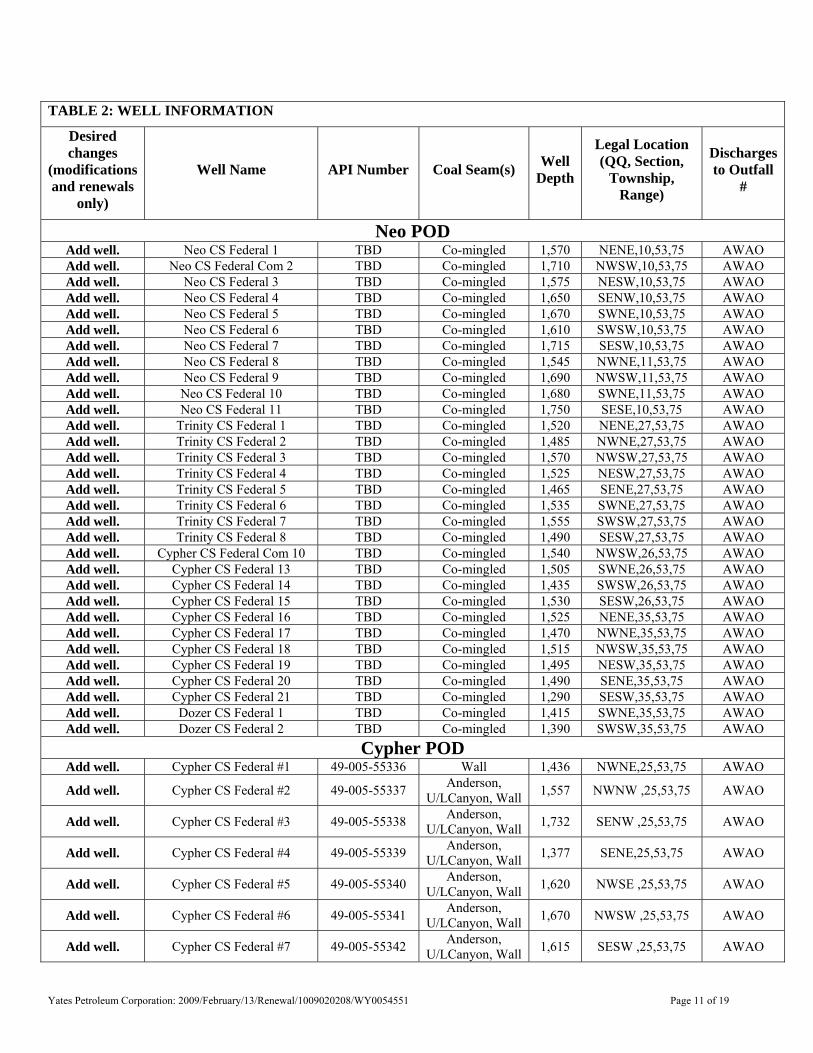
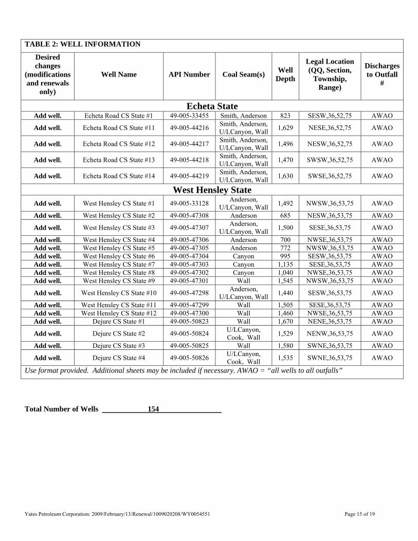
TABLE 2: WELL INFORMATION
Desired changes
(modifications and renewals
only)
Well Name API Number Coal Seam(s) Well Depth
Legal Location (QQ, Section,
Township, Range)
Discharges to Outfall
#
Neo POD Add well. Neo CS Federal 1 TBD Co-mingled 1,570 NENE,10,53,75 AWAO Add well. Neo CS Federal Com 2 TBD Co-mingled 1,710 NWSW,10,53,75 AWAO Add well. Neo CS Federal 3 TBD Co-mingled 1,575 NESW,10,53,75 AWAO Add well. Neo CS Federal 4 TBD Co-mingled 1,650 SENW,10,53,75 AWAO Add well. Neo CS Federal 5 TBD Co-mingled 1,670 SWNE,10,53,75 AWAO Add well. Neo CS Federal 6 TBD Co-mingled 1,610 SWSW,10,53,75 AWAO Add well. Neo CS Federal 7 TBD Co-mingled 1,715 SESW,10,53,75 AWAO Add well. Neo CS Federal 8 TBD Co-mingled 1,545 NWNE,11,53,75 AWAO Add well. Neo CS Federal 9 TBD Co-mingled 1,690 NWSW,11,53,75 AWAO Add well. Neo CS Federal 10 TBD Co-mingled 1,680 SWNE,11,53,75 AWAO Add well. Neo CS Federal 11 TBD Co-mingled 1,750 SESE,10,53,75 AWAO Add well. Trinity CS Federal 1 TBD Co-mingled 1,520 NENE,27,53,75 AWAO Add well. Trinity CS Federal 2 TBD Co-mingled 1,485 NWNE,27,53,75 AWAO Add well. Trinity CS Federal 3 TBD Co-mingled 1,570 NWSW,27,53,75 AWAO Add well. Trinity CS Federal 4 TBD Co-mingled 1,525 NESW,27,53,75 AWAO Add well. Trinity CS Federal 5 TBD Co-mingled 1,465 SENE,27,53,75 AWAO Add well. Trinity CS Federal 6 TBD Co-mingled 1,535 SWNE,27,53,75 AWAO Add well. Trinity CS Federal 7 TBD Co-mingled 1,555 SWSW,27,53,75 AWAO Add well. Trinity CS Federal 8 TBD Co-mingled 1,490 SESW,27,53,75 AWAO Add well. Cypher CS Federal Com 10 TBD Co-mingled 1,540 NWSW,26,53,75 AWAO Add well. Cypher CS Federal 13 TBD Co-mingled 1,505 SWNE,26,53,75 AWAO Add well. Cypher CS Federal 14 TBD Co-mingled 1,435 SWSW,26,53,75 AWAO Add well. Cypher CS Federal 15 TBD Co-mingled 1,530 SESW,26,53,75 AWAO Add well. Cypher CS Federal 16 TBD Co-mingled 1,525 NENE,35,53,75 AWAO Add well. Cypher CS Federal 17 TBD Co-mingled 1,470 NWNE,35,53,75 AWAO Add well. Cypher CS Federal 18 TBD Co-mingled 1,515 NWSW,35,53,75 AWAO Add well. Cypher CS Federal 19 TBD Co-mingled 1,495 NESW,35,53,75 AWAO Add well. Cypher CS Federal 20 TBD Co-mingled 1,490 SENE,35,53,75 AWAO Add well. Cypher CS Federal 21 TBD Co-mingled 1,290 SESW,35,53,75 AWAO Add well. Dozer CS Federal 1 TBD Co-mingled 1,415 SWNE,35,53,75 AWAO Add well. Dozer CS Federal 2 TBD Co-mingled 1,390 SWSW,35,53,75 AWAO
Cypher POD Add well. Cypher CS Federal #1 49-005-55336 Wall 1,436 NWNE,25,53,75 AWAO
Add well. Cypher CS Federal #2 49-005-55337 Anderson, U/LCanyon, Wall 1,557 NWNW ,25,53,75 AWAO
Add well. Cypher CS Federal #3 49-005-55338 Anderson, U/LCanyon, Wall 1,732 SENW ,25,53,75 AWAO
Add well. Cypher CS Federal #4 49-005-55339 Anderson, U/LCanyon, Wall 1,377 SENE,25,53,75 AWAO
Add well. Cypher CS Federal #5 49-005-55340 Anderson, U/LCanyon, Wall 1,620 NWSE ,25,53,75 AWAO
Add well. Cypher CS Federal #6 49-005-55341 Anderson, U/LCanyon, Wall 1,670 NWSW ,25,53,75 AWAO
Add well. Cypher CS Federal #7 49-005-55342 Anderson, U/LCanyon, Wall 1,615 SESW ,25,53,75 AWAO
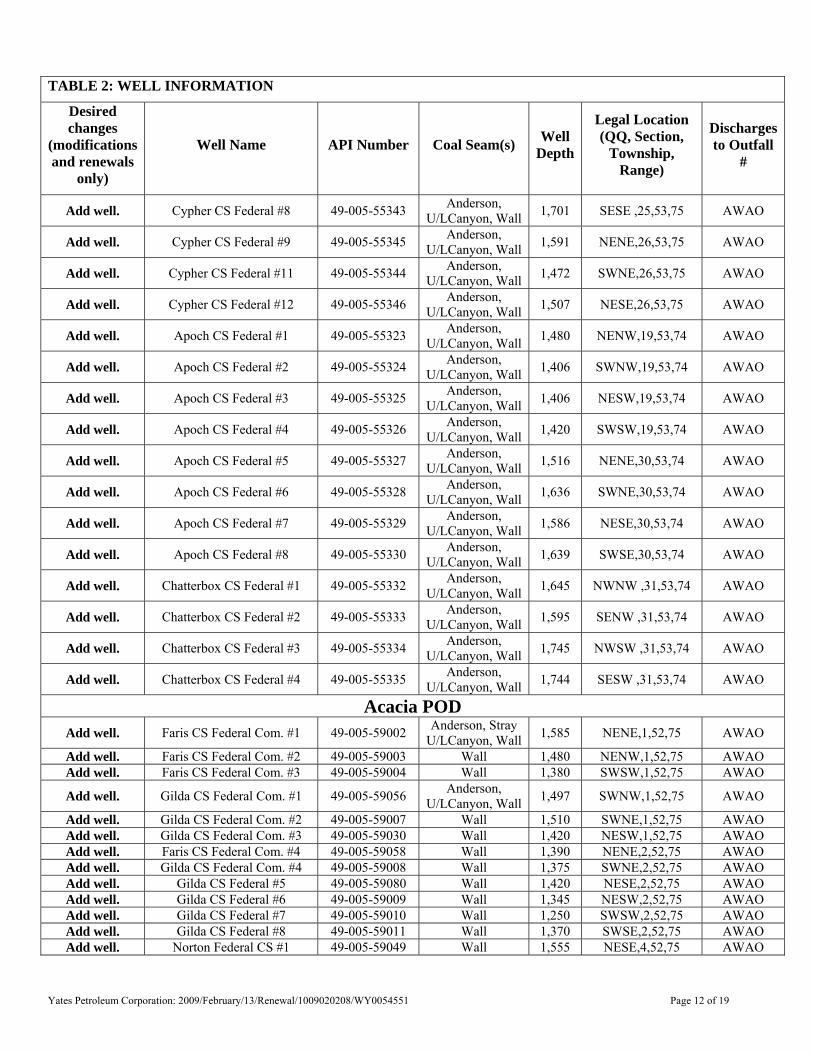
Yates Petroleum Corporation: 2009/February/13/Renewal/1009020208/WY0054551 Page 12 of 19
TABLE 2: WELL INFORMATION
Desired changes
(modifications and renewals
only)
Well Name API Number Coal Seam(s) Well Depth
Legal Location (QQ, Section,
Township, Range)
Discharges to Outfall
#
Add well. Cypher CS Federal #8 49-005-55343 Anderson, U/LCanyon, Wall 1,701 SESE ,25,53,75 AWAO
Add well. Cypher CS Federal #9 49-005-55345 Anderson, U/LCanyon, Wall 1,591 NENE,26,53,75 AWAO
Add well. Cypher CS Federal #11 49-005-55344 Anderson, U/LCanyon, Wall 1,472 SWNE,26,53,75 AWAO
Add well. Cypher CS Federal #12 49-005-55346 Anderson, U/LCanyon, Wall 1,507 NESE,26,53,75 AWAO
Add well. Apoch CS Federal #1 49-005-55323 Anderson, U/LCanyon, Wall 1,480 NENW,19,53,74 AWAO
Add well. Apoch CS Federal #2 49-005-55324 Anderson, U/LCanyon, Wall 1,406 SWNW,19,53,74 AWAO
Add well. Apoch CS Federal #3 49-005-55325 Anderson, U/LCanyon, Wall 1,406 NESW,19,53,74 AWAO
Add well. Apoch CS Federal #4 49-005-55326 Anderson, U/LCanyon, Wall 1,420 SWSW,19,53,74 AWAO
Add well. Apoch CS Federal #5 49-005-55327 Anderson, U/LCanyon, Wall 1,516 NENE,30,53,74 AWAO
Add well. Apoch CS Federal #6 49-005-55328 Anderson, U/LCanyon, Wall 1,636 SWNE,30,53,74 AWAO
Add well. Apoch CS Federal #7 49-005-55329 Anderson, U/LCanyon, Wall 1,586 NESE,30,53,74 AWAO
Add well. Apoch CS Federal #8 49-005-55330 Anderson, U/LCanyon, Wall 1,639 SWSE,30,53,74 AWAO
Add well. Chatterbox CS Federal #1 49-005-55332 Anderson, U/LCanyon, Wall 1,645 NWNW ,31,53,74 AWAO
Add well. Chatterbox CS Federal #2 49-005-55333 Anderson, U/LCanyon, Wall 1,595 SENW ,31,53,74 AWAO
Add well. Chatterbox CS Federal #3 49-005-55334 Anderson, U/LCanyon, Wall 1,745 NWSW ,31,53,74 AWAO
Add well. Chatterbox CS Federal #4 49-005-55335 Anderson, U/LCanyon, Wall 1,744 SESW ,31,53,74 AWAO
Acacia POD Add well. Faris CS Federal Com. #1 49-005-59002 Anderson, Stray
U/LCanyon, Wall 1,585 NENE,1,52,75 AWAO
Add well. Faris CS Federal Com. #2 49-005-59003 Wall 1,480 NENW,1,52,75 AWAO Add well. Faris CS Federal Com. #3 49-005-59004 Wall 1,380 SWSW,1,52,75 AWAO
Add well. Gilda CS Federal Com. #1 49-005-59056 Anderson, U/LCanyon, Wall 1,497 SWNW,1,52,75 AWAO
Add well. Gilda CS Federal Com. #2 49-005-59007 Wall 1,510 SWNE,1,52,75 AWAO Add well. Gilda CS Federal Com. #3 49-005-59030 Wall 1,420 NESW,1,52,75 AWAO Add well. Faris CS Federal Com. #4 49-005-59058 Wall 1,390 NENE,2,52,75 AWAO Add well. Gilda CS Federal Com. #4 49-005-59008 Wall 1,375 SWNE,2,52,75 AWAO Add well. Gilda CS Federal #5 49-005-59080 Wall 1,420 NESE,2,52,75 AWAO Add well. Gilda CS Federal #6 49-005-59009 Wall 1,345 NESW,2,52,75 AWAO Add well. Gilda CS Federal #7 49-005-59010 Wall 1,250 SWSW,2,52,75 AWAO Add well. Gilda CS Federal #8 49-005-59011 Wall 1,370 SWSE,2,52,75 AWAO Add well. Norton Federal CS #1 49-005-59049 Wall 1,555 NESE,4,52,75 AWAO
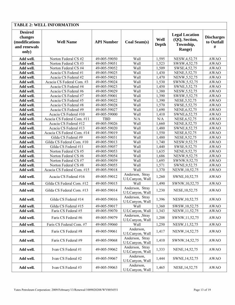
Yates Petroleum Corporation: 2009/February/13/Renewal/1009020208/WY0054551 Page 13 of 19
TABLE 2: WELL INFORMATION
Desired changes
(modifications and renewals
only)
Well Name API Number Coal Seam(s) Well Depth
Legal Location (QQ, Section,
Township, Range)
Discharges to Outfall
#
Add well. Norton Federal CS #2 49-005-59050 Wall 1,595 NESW,4,52,75 AWAO Add well. Norton Federal CS #3 49-005-59051 Wall 1,523 SWSW,4,52,75 AWAO Add well. Norton Federal CS #4 49-005-59052 Wall 1,509 SWSE,4,52,75 AWAO Add well. Acacia CS Federal #1 49-005-59025 Wall 1,430 NENE,5,52,75 AWAO Add well. Acacia CS Federal #2 49-005-59021 Wall 1,470 NENW,5,52,75 AWAO Add well. Acacia CS Federal Com. #3 49-005-59024 Wall 1,530 SWNW,5,52,75 AWAO Add well. Acacia CS Federal #4 49-005-59023 Wall 1,450 SWNE,5,52,75 AWAO Add well. Acacia CS Federal #6 49-005-59029 Wall 1,380 NESW,5,52,75 AWAO Add well. Acacia CS Federal #7 49-005-59001 Wall 1,390 SWSW,5,52,75 AWAO Add well. Acacia CS Federal #5 49-005-59022 Wall 1,390 NESE,5,52,75 AWAO Add well. Acacia CS Federal #8 49-005-59028 Wall 1,570 SWSE,5,52,75 AWAO Add well. Acacia CS Federal #9 49-005-59027 Wall 1,690 NENE,6,52,75 AWAO Add well. Acacia CS Federal #10 49-005-59000 Wall 1,410 SWNE,6,52,75 AWAO Add well. Acacia CS Federal Com. #11 TBD N/A N/A NESE,6,52,75 AWAO Add well. Acacia CS Federal #12 49-005-59026 Wall 1,660 NENE,8,52,75 AWAO Add well. Acacia CS Federal #13 49-005-59020 Wall 1,480 SWNE,8,52,75 AWAO Add well. Acacia CS Federal Com. #14 49-005-59019 Wall 1,550 NESE,8,52,75 AWAO Add well. Gilda CS Federal #9 49-005-59031 Wall 1,480 NESE,9,52,75 AWAO Add well. Gilda CS Federal Com. #10 49-005-59013 Wall 1,740 NESW,9,52,75 AWAO Add well. Gilda CS Federal #11 49-005-59057 Wall 1,440 SWSE,9,52,75 AWAO Add well. Norton Federal CS #5 49-005-59053 Wall 1,635 NENE,9,52,75 AWAO Add well. Norton Federal CS #6 49-005-59054 Wall 1,686 NENW,9,52,75 AWAO Add well. Norton Federal CS #7 49-005-59059 Wall 1,695 SWNW,9,52,75 AWAO Add well. Norton Federal CS #8 49-005-59055 Wall 1,571 SWNE,9,52,75 AWAO Add well. Acacia CS Federal Com. #15 49-005-59018 Wall 1,370 NENW,10,52,75 AWAO
Add well. Acacia CS Federal #16 49-005-59012 Anderson, Stray U/LCanyon, Wall 1,260 SWNE,10,52,75 AWAO
Add well. Gilda CS Federal Com. #12 49-005-59015 Wall 1,490 SWNW,10,52,75 AWAO
Add well. Gilda CS Federal Com. #13 49-005-59014 Anderson, Stray U/LCanyon, Wall 1,230 NESE,10,52,75 AWAO
Add well. Gilda CS Federal #14 49-005-59016 Anderson, Stray U/LCanyon, Wall 1,396 NESW,10,52,75 AWAO
Add well. Gilda CS Federal #15 49-005-59017 Wall 1,360 SWSW,10,52,75 AWAO Add well. Faris CS Federal #5 49-005-59070 U/LCanyon, Wall 1,343 NENW,11,52,75 AWAO
Add well. Faris CS Federal #6 49-005-59079 Anderson, ,Stray U/LCanyon, Wall 1,208 SWNW,11,52,75 AWAO
Add well. Faris CS Federal Com. #7 49-005-59060 Wall 1,250 NESW,11,52,75 AWAO
Add well. Faris CS Federal #8 49-005-59061 Anderson, U/LCanyon, Wall 1,417 NENW,14,52,75 AWAO
Add well. Faris CS Federal #9 49-005-59068 Anderson, Stray U/LCanyon, Wall 1,410 SWNW,14,52,75 AWAO
Add well. Ivan CS Federal #1 49-005-59062 Anderson, Stray U/LCanyon, Wall 1,333 NENE,14,52,75 AWAO
Add well. Ivan CS Federal #2 49-005-59067 Anderson, U/LCanyon, Wall 1,444 SWNE,14,52,75 AWAO
Add well. Ivan CS Federal #3 49-005-59063 Anderson, U/LCanyon, Wall 1,465 NESE,14,52,75 AWAO
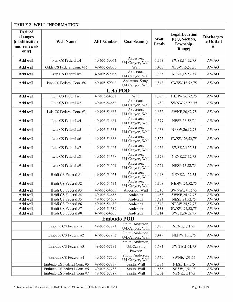
Yates Petroleum Corporation: 2009/February/13/Renewal/1009020208/WY0054551 Page 14 of 19
TABLE 2: WELL INFORMATION
Desired changes
(modifications and renewals
only)
Well Name API Number Coal Seam(s) Well Depth
Legal Location (QQ, Section,
Township, Range)
Discharges to Outfall
#
Add well. Ivan CS Federal #4 49-005-59064 Anderson, U/LCanyon, Wall 1,565 SWSE,14,52,75 AWAO
Add well. Gilda CS Federal Com. #16 49-005-59006 Wall 1,400 NESW,15,52,75 AWAO
Add well. Ivan CS Federal #5 49-005-59065 Anderson, U/LCanyon, Wall 1,385 NENE,15,52,75 AWAO
Add well. Ivan CS Federal Com. #6 49-005-59066 Anderson, Stray, U/LCanyon, Wall 1,545 SWSW,15,52,75 AWAO
Lela POD Add well. Lela CS Federal #1 49-005-54661 Wall 1,625 NENW,26,52,75 AWAO
Add well. Lela CS Federal #2 49-005-54662 Anderson, U/LCanyon, Wall 1,480 SWNW,26,52,75 AWAO
Add well. Lela CS Federal Com. #3 49-005-54663 Anderson, U/LCanyon, Wall 1,632 SWNE,26,52,75 AWAO
Add well. Lela CS Federal #4 49-005-54664 Anderson, U/LCanyon, Wall 1,579 NESE,26,52,75 AWAO
Add well. Lela CS Federal #5 49-005-54665 Anderson, U/LCanyon, Wall 1,466 NESW,26,52,75 AWAO
Add well. Lela CS Federal #6 49-005-54666 Anderson, U/LCanyon, Wall 1,527 SWSW,26,52,75 AWAO
Add well. Lela CS Federal #7 49-005-54667 Anderson, U/LCanyon, Wall 1,656 SWSE,26,52,75 AWAO
Add well. Lela CS Federal #8 49-005-54668 Anderson, U/LCanyon, Wall 1,526 NENE,27,52,75 AWAO
Add well. Lela CS Federal #9 49-005-54669 Anderson, U/LCanyon, Wall 1,559 NESE,27,52,75 AWAO
Add well. Heidi CS Federal #1 49-005-54653 Anderson, U/LCanyon, Wall 1,448 NENE,24,52,75 AWAO
Add well. Heidi CS Federal #2 49-005-54654 Anderson, U/LCanyon, Wall 1,508 NENW,24,52,75 AWAO
Add well. Heidi CS Federal #3 49-005-54655 Anderson, Wall 1,540 SWNW,24,52,75 AWAO Add well. Heidi CS Federal #4 49-005-54656 Anderson 1,458 SWNE,24,52,75 AWAO Add well. Heidi CS Federal #5 49-005-54657 Anderson 1,424 NESE,24,52,75 AWAO Add well. Heidi CS Federal #6 49-005-54658 Anderson 1,542 NESW,24,52,75 AWAO Add well. Heidi CS Federal #7 49-005-54659 Anderson 1,535 SWSW,24,52,75 AWAO Add well. Heidi CS Federal #8 49-005-54660 Anderson 1,514 SWSE,24,52,75 AWAO
Embudo POD Embudo CS Federal #1 49-005-57793 Smith, Anderson,
U/LCanyon, Wall 1,466 NENE,1,51,75 AWAO
Embudo CS Federal #2 49-005-57792 Smith, Anderson, U/LCanyon, Wall 1,449 NENW,1,51,75 AWAO
Embudo CS Federal #3 49-005-57791 Smith, Anderson,
U/LCanyon, Pawnee
1,684 SWNW,1,51,75 AWAO
Embudo CS Federal #4 49-005-57790 Smith, Anderson, U/LCanyon, Wall 1,640 SWNE,1,51,75 AWAO
Embudo CS Federal Com. #5 49-005-57789 Smith, Wall 1,583 NESE,1,51,75 AWAO Embudo CS Federal Com. #6 49-005-57788 Smith, Wall 1,536 NESW,1,51,75 AWAO Embudo CS Federal Com #7 49-005-57787 Smith, Wall 1,502 NENE,2,51,75 AWAO
Yates Petroleum Corporation: 2009/February/13/Renewal/1009020208/WY0054551 Page 15 of 19
TABLE 2: WELL INFORMATION
Desired changes
(modifications and renewals
only)
Well Name API Number Coal Seam(s) Well Depth
Legal Location (QQ, Section,
Township, Range)
Discharges to Outfall
#
Echeta State Add well. Echeta Road CS State #1 49-005-33455 Smith, Anderson 823 SESW,36,52,75 AWAO
Add well. Echeta Road CS State #11 49-005-44216 Smith, Anderson, U/LCanyon, Wall 1,629 NESE,36,52,75 AWAO
Add well. Echeta Road CS State #12 49-005-44217 Smith, Anderson, U/LCanyon, Wall 1,496 NESW,36,52,75 AWAO
Add well. Echeta Road CS State #13 49-005-44218 Smith, Anderson, U/LCanyon, Wall 1,470 SWSW,36,52,75 AWAO
Add well. Echeta Road CS State #14 49-005-44219 Smith, Anderson, U/LCanyon, Wall 1,630 SWSE,36,52,75 AWAO
West Hensley State Add well. West Hensley CS State #1 49-005-33128 Anderson,
U/LCanyon, Wall 1,492 NWSW,36,53,75 AWAO
Add well. West Hensley CS State #2 49-005-47308 Anderson 685 NESW,36,53,75 AWAO
Add well. West Hensley CS State #3 49-005-47307 Anderson, U/LCanyon, Wall 1,500 SESE,36,53,75 AWAO
Add well. West Hensley CS State #4 49-005-47306 Anderson 700 NWSE,36,53,75 AWAO Add well. West Hensley CS State #5 49-005-47305 Anderson 772 NWSW,36,53,75 AWAO Add well. West Hensley CS State #6 49-005-47304 Canyon 995 SESW,36,53,75 AWAO Add well. West Hensley CS State #7 49-005-47303 Canyon 1,135 SESE,36,53,75 AWAO Add well. West Hensley CS State #8 49-005-47302 Canyon 1,040 NWSE,36,53,75 AWAO Add well. West Hensley CS State #9 49-005-47301 Wall 1,545 NWSW,36,53,75 AWAO
Add well. West Hensley CS State #10 49-005-47298 Anderson, U/LCanyon, Wall 1,440 SESW,36,53,75 AWAO
Add well. West Hensley CS State #11 49-005-47299 Wall 1,505 SESE,36,53,75 AWAO Add well. West Hensley CS State #12 49-005-47300 Wall 1,460 NWSE,36,53,75 AWAO Add well. Dejure CS State #1 49-005-50823 Wall 1,670 NENE,36,53,75 AWAO
Add well. Dejure CS State #2 49-005-50824 U/LCanyon, Cook, Wall 1,529 NENW,36,53,75 AWAO
Add well. Dejure CS State #3 49-005-50825 Wall 1,580 SWNE,36,53,75 AWAO
Add well. Dejure CS State #4 49-005-50826 U/LCanyon, Cook, Wall 1,535 SWNE,36,53,75 AWAO
Use format provided. Additional sheets may be included if necessary. AWAO = “all wells to all outfalls”
Total Number of Wells 154

Yates Petroleum Corporation: 2009/February/13/Renewal/1009020208/WY0054551 Page 16 of 19
TABLE 3: RESERVOIR INFORMATION
Legal Location (QQ, Section Township, Range)
Geographic Location (Latitude and Longitude,
Decimal Degrees)
Desired Changes
(modifications and renewals
only)
Reservoir Name
Reservoir Storage Volume
(acre/feet)
SEO Permit #
SEO Reservoir Requirements
Quarter-Quarter Section Township Range Latitude Longitude
Red Top 5.0 P18106S Low-Level Outlet SENE 36 52 75 44.440846 -105.816162
Toots 11.0 P18404S Low-Level Outlet NESE 35 52 75 44.438905 -105.834299
Bad Dirt 9.79 Pending Pending NENE 2 51 75 44.432556 -105.838970
Broke Back 4.12 P18401S Low-Level Outlet SENE 1 51 75 44.429128 -105.817734
Tip Toe 3.3 P17994S Low-Level Outlet SWNE 1 51 75 44.423795 -105.820123
Luna 6.65 P17992S Low-Level Outlet NESW 1 51 75 44.423795 -105.824691
Barker Bowl 11.38 P17991S Low-Level
Outlet SWSE 1 51 75 44.419765 -105.818261
Padfoot 4.77 P17993S Low-Level Outlet SWSE 1 51 75 44.418683 -105.820365
T.J. 4.08 P17995S Low-Level Outlet SENE 12 51 75 44.414954 -105.820365
Add Reservoir. Whistle 15.04 Pending Pending NENE 2 51 75 44.429295 -105.835953
Additional spaces/tables may be included as necessary. Use the format provided. Please note that reservoir information is not required if reservoir containment is not part of the facility’s water management plan – for instance, information about existing “incidental” downstream reservoirs is not required.

Yates Petroleum Corporation: 2009/February/13/Renewal/1009020208/WY0054551 Page 17 of 19
Table 4: Bonding Information Table
Please check only one “reservoir reclamation volume” box for each reservoir.
Desired Changes
(modifications and renewals
only)
Reservoir Name
Reservoir Bonding
Authority (BLM,
WDEQ, WOGCC, or
OSLI)
Reservoir Reclamation Volume* less
than 5000 cubic yards?
Reservoir Reclamation
Volume* between 5000 and 10, 000
cubic yards?
Reservoir Reclamation
Volume* greater than 10, 000 cubic
yards?
Reservoir constructed prior to September 1,
2005?
Bond currently posted with bonding
authority?
Red Top WYDEQ X No Yes
Toots WYDEQ X No Yes
Bad Dirt BLM X No No
Broke Back BLM X No No
Tip Toe BLM X No Yes
Luna BLM X No Yes
Barker Bowl BLM X No Yes
Padfoot BLM X No Yes
T.J. WYDEQ X No No
Add Reservoir. Whistle BLM X No No
*”Reservoir reclamation volume” is the volume of backfill and/or topsoil needed to fill reservoir upon reclamation, in cubic yards. This can also be measured in the amount of material that was excavated to create the reservoir. Please note that reservoir information is not required if reservoir containment is not part of the facility’s water management plan – for instance, information about existing “incidental” downstream reservoirs is not required.
Yates Petroleum Corporation: 2009/February/13/Renewal/1009020208/WY0054551 Page 18 of 19
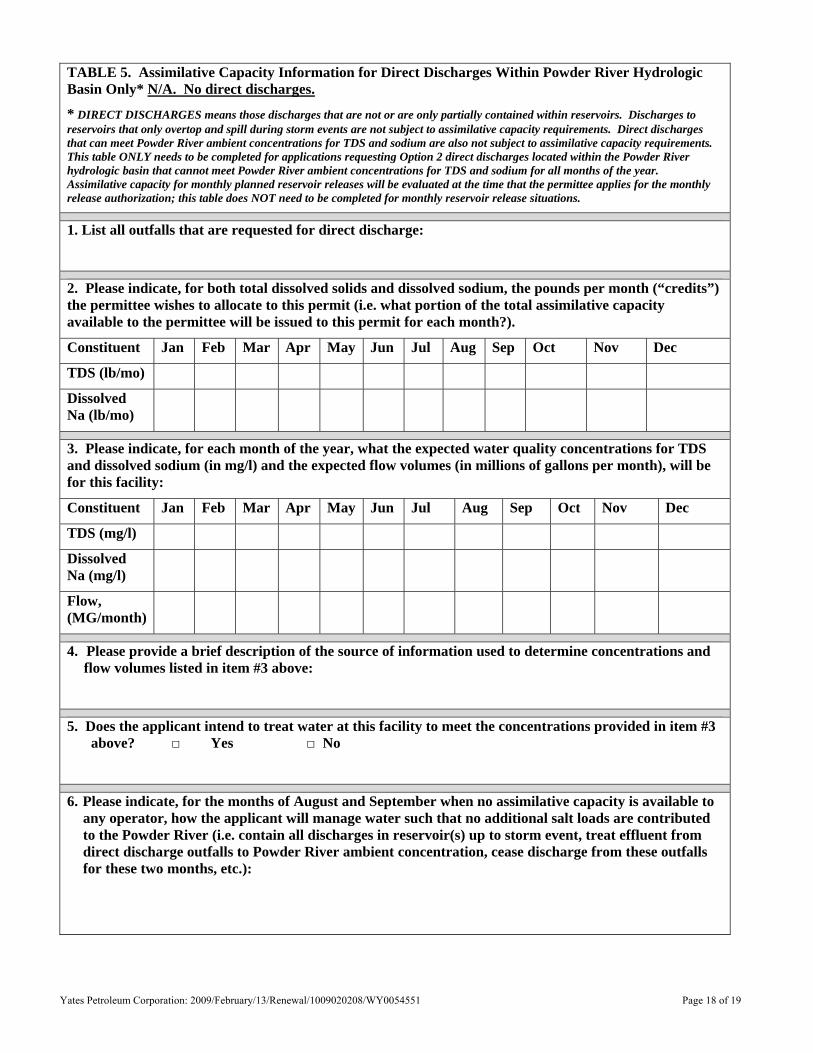
TABLE 5. Assimilative Capacity Information for Direct Discharges Within Powder River Hydrologic Basin Only* N/A. No direct discharges.
* DIRECT DISCHARGES means those discharges that are not or are only partially contained within reservoirs. Discharges to reservoirs that only overtop and spill during storm events are not subject to assimilative capacity requirements. Direct discharges that can meet Powder River ambient concentrations for TDS and sodium are also not subject to assimilative capacity requirements. This table ONLY needs to be completed for applications requesting Option 2 direct discharges located within the Powder River hydrologic basin that cannot meet Powder River ambient concentrations for TDS and sodium for all months of the year. Assimilative capacity for monthly planned reservoir releases will be evaluated at the time that the permittee applies for the monthly release authorization; this table does NOT need to be completed for monthly reservoir release situations.
1. List all outfalls that are requested for direct discharge:
2. Please indicate, for both total dissolved solids and dissolved sodium, the pounds per month (“credits”) the permittee wishes to allocate to this permit (i.e. what portion of the total assimilative capacity available to the permittee will be issued to this permit for each month?).
Constituent Jan Feb Mar Apr May Jun Jul Aug Sep Oct Nov Dec
TDS (lb/mo)
Dissolved Na (lb/mo)
3. Please indicate, for each month of the year, what the expected water quality concentrations for TDS and dissolved sodium (in mg/l) and the expected flow volumes (in millions of gallons per month), will be for this facility:
Constituent Jan Feb Mar Apr May Jun Jul Aug Sep Oct Nov Dec
TDS (mg/l)
Dissolved Na (mg/l)
Flow, (MG/month)
4. Please provide a brief description of the source of information used to determine concentrations and flow volumes listed in item #3 above:
5. Does the applicant intend to treat water at this facility to meet the concentrations provided in item #3 above? □ Yes □ No
6. Please indicate, for the months of August and September when no assimilative capacity is available to any operator, how the applicant will manage water such that no additional salt loads are contributed to the Powder River (i.e. contain all discharges in reservoir(s) up to storm event, treat effluent from direct discharge outfalls to Powder River ambient concentration, cease discharge from these outfalls for these two months, etc.):
Yates Petroleum Corporation: 2009/February/13/Renewal/1009020208/WY0054551 Page 19 of 19
Table 6: Average Daily Discharge Volumes (GPD)
Permit No. Outfall Contributing
Wells* June 2008
July 2008
August 2008
September 2008
October 2008
November 2008
001 0 0 0 0 0 0 002 0 0 0 0 0 0 003 0 0 0 0 0 0 004 0 0 0 0 0 0 005 0 0 0 0 0 0 006 15,778 10,110 16,614 0 0 3,021 007 0 0 22,768 125,409 0 0 008 0 0 0 0 33,578 18,200
WY0054551
009
All wells listed in Table 2.
0 0 0 0 0 0 Total 15,778 10,110 39,382 125,409 33,578 21,221
*Please Note: Not all wells are currently producing. As such, future discharge volumes may be higher than those shown above.

Yates Petroleum Corporation: 2009/February/13/Renewal/1009020208/WY0054551
Yates Petroleum Corporation: 2009/February/13/Renewal/1009020208/WY0054551

6EMBU-COM
2EMBU7EMBU-COM
13ECHE14ECHE
12ECHE11ECHEToots
11.02 a.f.
Tip Toe3.3 a.f.
Red Top5.0 a.f.
Broke Back4.12 a.f.
Bad Dirt9.79 a.f.
Barker Bowl11.38 a.f.
Luna6.65 a.f.
T. J.4.08 a.f.
Padfoot4.77 a.f.
1EMBU
3EMBU
5EMBU-COM
4EMBU
1ECHE
002001
003
004
005
006
007
008
009
Whistle15.04 a.f.
010
IMP1
E. 320000 E. 325000 E. 330000
N. 13
7500
0N.
1370
000
N. 13
6500
0
E. 320000 E. 325000 E. 330000 E. 335000N.
1375
000
N. 13
7000
0N.
1365
000
T.52N.
T.51N.
R. 75 W. R. 74 W.
R. 75 W. R. 74 W.
T.52N.
T.51N.
LELA CS FED #6
LELA CS FED #7
TO NORTHERNCBNG WELLS
EXISTING WATER DISCHARGE LINE(DENOTES CONNECTION MAY NOT BE ACTUAL ALIGNMENT)
LEGEND
EXISTING STATE CBNG WELL LOCATION
EXISTING WATER DISCHARGEEXISTING RESERVOIR EMBANKMENT LOCATION
EXISTING OFF-CHANNEL PIT
EXISTING FEDERAL CBNG WELL LOCATION2EMBU
12ECHE
MONITORING POINTIMP1
Whistle15.04 a.f.
Bad Dirt9.79 a.f.
EXISTING STOCK TANK
009
ROAD
UWQMSTRIB1
DWQMS
R. 77 W.
T.54N.
T.53N.
T.52N.
T.51N.
R. 76 W. R. 75 W. R. 74 W.
R. 77 W. R. 76 W. R. 75 W. R. 74 W.
T.54N.
T.53N.
T.52N.
T.51N.
CBNG WELLS ANDDOWNSTREAM MONITORING LOCATIONS
SCALE: 1" = 20000'
PLAN VIEWSCALE: 1" = 2000'
CASPER, WY 82601(307) 473-2707
701 ANTLER DR., SUITE 233
CBNG WELLLOCATIONS
PLAN VIEW FRAME
K:\Yates\05014\Task 92 Embudo\DWGS_WY27E\EMBUDO_WYPDES.dwg, EMBUDO_1, 2/6/2009 10:17:20 AM
UWQMSTRIB
DWQMST.55N.
T.54N.
R. 77 W.
T.55N.
T.54N.
R. 77 W.
R. 77 W.
E. 245000 E. 250000 E. 255000 E. 260000N.
1455
000
N. 14
6000
0N.
1465
000
N. 14
7000
0
E. 245000 E. 250000 E. 255000 E. 260000N.
1455
000
N. 14
6000
0N.
1465
000
N. 14
7000
0
LEGENDWATER QUALITY MONITORINGPOINTDWQMS
UWQMSTRIB1
DWQMS
R. 77 W.
T.54N.
T.53N.
T.52N.
T.51N.
R. 76 W. R. 75 W. R. 74 W.
R. 77 W. R. 76 W. R. 75 W. R. 74 W.
T.54N.
T.53N.
T.52N.
T.51N.
CBNG WELL ANDDOWNSTREAM MONITORING LOCATIONS
SCALE: 1" = 20000'
PLAN VIEWSCALE: 1" = 2000' CASPER, WY 82601
(307) 473-2707
701 ANTLER DR., SUITE 233
CBNG WELLLOCATIONS
PLAN VIEW FRAME
K:\Yates\05014\Task 92 Embudo\DWGS_WY27E\EMBUDO_WYPDES.dwg, EMBUDO_2, 2/6/2009 10:18:21 AM
6EMBU-COM
2EMBU7EMBU-COM
13ECHE14ECHE
12ECHE11ECHEToots
11.02 a.f.
Tip Toe3.3 a.f.
Red Top5.0 a.f.
Broke Back4.12 a.f.
Bad Dirt9.79 a.f.
Barker Bowl11.38 a.f.
Luna6.65 a.f.
T. J.4.08 a.f.
Padfoot4.77 a.f.
1EMBU
3EMBU
5EMBU-COM
4EMBU
1ECHE
002001
003
004
005
006
007
008
009
Whistle15.04 a.f.
010
IMP1
E. 320000 E. 325000 E. 330000
N. 13
7500
0N.
1370
000
N. 13
6500
0
E. 320000 E. 325000 E. 330000 E. 335000N.
1375
000
N. 13
7000
0N.
1365
000
T.52N.
T.51N.
R. 75 W. R. 74 W.
R. 75 W. R. 74 W.
T.52N.
T.51N.
LELA CS FED #6
LELA CS FED #7
TO NORTHERNCBNG WELLS
EXISTING WATER DISCHARGE LINE(DENOTES CONNECTION MAY NOT BE ACTUAL ALIGNMENT)
LEGEND
EXISTING STATE CBNG WELL LOCATION
EXISTING WATER DISCHARGEEXISTING RESERVOIR EMBANKMENT LOCATION
EXISTING OFF-CHANNEL PIT
EXISTING FEDERAL CBNG WELL LOCATION2EMBU
12ECHE
MONITORING POINTIMP1
Whistle15.04 a.f.
Bad Dirt9.79 a.f.
EXISTING STOCK TANK
009
ROAD
UWQMSTRIB1
DWQMS
R. 77 W.
T.54N.
T.53N.
T.52N.
T.51N.
R. 76 W. R. 75 W. R. 74 W.
R. 77 W. R. 76 W. R. 75 W. R. 74 W.
T.54N.
T.53N.
T.52N.
T.51N.
CBNG WELLS ANDDOWNSTREAM MONITORING LOCATIONS
SCALE: 1" = 20000'
PLAN VIEWSCALE: 1" = 2000'
CASPER, WY 82601(307) 473-2707
701 ANTLER DR., SUITE 233
CBNG WELLLOCATIONS
PLAN VIEW FRAME
K:\Yates\05014\Task 92 Embudo\DWGS_WY27E\EMBUDO_WYPDES.dwg, EMBUDO_1, 2/6/2009 10:17:20 AM

UWQMSTRIB
DWQMST.55N.
T.54N.
R. 77 W.
T.55N.
T.54N.
R. 77 W.
R. 77 W.
E. 245000 E. 250000 E. 255000 E. 260000N.
1455
000
N. 14
6000
0N.
1465
000
N. 14
7000
0
E. 245000 E. 250000 E. 255000 E. 260000N.
1455
000
N. 14
6000
0N.
1465
000
N. 14
7000
0
LEGENDWATER QUALITY MONITORINGPOINTDWQMS
UWQMSTRIB1
DWQMS
R. 77 W.
T.54N.
T.53N.
T.52N.
T.51N.
R. 76 W. R. 75 W. R. 74 W.
R. 77 W. R. 76 W. R. 75 W. R. 74 W.
T.54N.
T.53N.
T.52N.
T.51N.
CBNG WELL ANDDOWNSTREAM MONITORING LOCATIONS
SCALE: 1" = 20000'
PLAN VIEWSCALE: 1" = 2000' CASPER, WY 82601
(307) 473-2707
701 ANTLER DR., SUITE 233
CBNG WELLLOCATIONS
PLAN VIEW FRAME
K:\Yates\05014\Task 92 Embudo\DWGS_WY27E\EMBUDO_WYPDES.dwg, EMBUDO_2, 2/6/2009 10:18:21 AM