mullinax ford -...
TRANSCRIPT

February 03, 2014
Mullinax FordScott Nicolas, General Manager1210 NorthlakeLake Park, FL 33403Client Phone: 561.845.2900
Michael RitzWest Palm Beach Division609 Hunter StWest Palm Beach, FL 33405Mobile: 954.205.6640Email: [email protected]

WEST PALM BEACH-FT. PIERCELOCATION #: 013746DESCRIPTION: I-95 0.2 mi N/O Gateway Blvd WSCITY: Boynton BeachZIP: 33426FACING: Facing: SouthSIZE: 14' x 48'TOTAL 18+ IMPS: 327,962 (Weekly)TAB PANEL ID: 595950
This bulletin targets northbound traffic heading to the affluent north Palm Beach residential and tourist areas.
¨
High R
idge R
d
NW 2n
d St
Ocean Pkwy
NE 1s
t Ln
Miner Rd
NE 1s
t Ct
Spruce St Arthur Ct
NE 27th Ave
Commerce Rd
Oran
ge St
Industrial Way
NW 7t
h St
NW 28th Ave
NW 21st Ave
Miner Rd
Gateway Blvd E Gateway Blvd
§§̈¦95
Latitude: 26.55595 Longitude: -80.07082
Interstate 95 is traveled heavily throughout the day.
Traffic flows into central Palm Beach County, Palm Beach International Airport and the exclusive communities of northern Palm Beach County.
The TAB Out of Home Ratings™ data is proprietary intellectual property owned by the Traffic Audit Bureau for Media Measurement, Inc. and is to be used only by the recipient solely and exclusively for its planning and /or buying of out-of-home media advertisements. © Copyright 2013, All Rights Reserved
© Clear Channel Outdoor

WEST PALM BEACH-FT. PIERCELOCATION #: 013866DESCRIPTION: Lake Worth Rd 0.55 mi E/O Military Tr SSCITY: West Palm BeachZIP: 33461FACING: Facing: EastSIZE: 14' x 48'TOTAL 18+ IMPS: 96,358 (Weekly)TAB PANEL ID: 595979
This bulletin is located in a heavy retail and commercial district with heavy traffic through out the day.
¨
Kirk R
d
Davis
Rd
Lakewood Rd
Gulfs
tream
Rd
Foss
Rd
Urqu
hart S
t
Coco
nut R
d
Corrig
an C
t
Patio
Ct
Ixora
Cir
Lilac
Cir
A St
Beve
rly D
r
Serub
i Ave
Selberg Ln
2nd Ave N
Luzon Ave
Kirk Ln
43rd
DrCo
oley C
t
Adco
ck Ln
42nd
Way
S
Keny
on R
d
Olss
on Te
r
Marlin St
Kirk
Rd
Davis
Rd
OP802OP802
Latitude: 26.61765 Longitude: -80.10443
Military Trail is a major north/south artery in Palm Beach County.
This display targets students, commuters and tourists.
The TAB Out of Home Ratings™ data is proprietary intellectual property owned by the Traffic Audit Bureau for Media Measurement, Inc. and is to be used only by the recipient solely and exclusively for its planning and /or buying of out-of-home media advertisements. © Copyright 2013, All Rights Reserved
© Clear Channel Outdoor

WEST PALM BEACH-FT. PIERCELOCATION #: 013867DESCRIPTION: Lake Worth Rd 0.55 mi E/O Military Tr SSCITY: West Palm BeachZIP: 33461FACING: Facing: WestSIZE: 14' x 48'TOTAL 18+ IMPS: 125,855 (Weekly)TAB PANEL ID: 595980
This bulletin is located in a heavy retail and commercial district with heavy traffic through out the day.
¨
Kirk R
d
Davis
Rd
Lakewood Rd
Gulfs
tream
Rd
Foss
Rd
Urqu
hart S
t
Coco
nut R
d
Corrig
an C
t
Patio
Ct
Ixora
Cir
Lilac
Cir
A St
Beve
rly D
r
Serub
i Ave
Selberg Ln
2nd Ave N
Luzon Ave
Kirk Ln
43rd
DrCo
oley C
t
Adco
ck Ln
42nd
Way
S
Keny
on R
d
Olss
on Te
r
Marlin St
Kirk
Rd
Davis
Rd
OP802OP802
Latitude: 26.61765 Longitude: -80.10445
Military Trail is a major north/south artery in Palm Beach County.
This display targets students, commuters and tourists.
The TAB Out of Home Ratings™ data is proprietary intellectual property owned by the Traffic Audit Bureau for Media Measurement, Inc. and is to be used only by the recipient solely and exclusively for its planning and /or buying of out-of-home media advertisements. © Copyright 2013, All Rights Reserved
© Clear Channel Outdoor
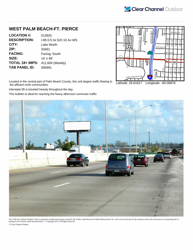
WEST PALM BEACH-FT. PIERCELOCATION #: 013920DESCRIPTION: I-95 0.5 mi S/O 10 Av WSCITY: Lake WorthZIP: 33461FACING: Facing: SouthSIZE: 14' x 48'TOTAL 18+ IMPS: 411,600 (Weekly)TAB PANEL ID: 595991
Located in the central part of Palm Beach County, this unit targets traffic flowing to the affluent north communities.
¨
N E S
t
N B S
t
N D
StN
C St
N A St
S A St
3rd Ave N2nd Ave N
S E St
S C St
S D St
6th Ave N
Boutw
ell R
d
Barne
tt Ln
Lake Osborne Dr
Erie
St
Finn S
t
Indus
trial S
t
Cypre
ss D
r
Grov
e Park
Dr
Detro
it St
Gree
n St
Circle
Dr
S Buff
alo St
Colle
ge St
Holiday Dr
2nd Ave N
§§̈¦95
OP802
OP802
Latitude: 26.61817 Longitude: -80.06876
Interstate 95 is traveled heavily throughout the day.
This bulletin is ideal for reaching the heavy afternoon commuter traffic.
The TAB Out of Home Ratings™ data is proprietary intellectual property owned by the Traffic Audit Bureau for Media Measurement, Inc. and is to be used only by the recipient solely and exclusively for its planning and /or buying of out-of-home media advertisements. © Copyright 2013, All Rights Reserved
© Clear Channel Outdoor

WEST PALM BEACH-FT. PIERCELOCATION #: 013921DESCRIPTION: I-95 0.5 mi S/O 10 Av WSCITY: Lake WorthZIP: 33461FACING: Facing: NorthSIZE: 14' x 48'TOTAL 18+ IMPS: 537,600 (Weekly)TAB PANEL ID: 595992
Located in the central part of Palm Beach County, this unit targets traffic flowing from the affluent north communities.
¨
N E S
t
N B S
t
N D
StN
C St
N A St
S A St
3rd Ave N2nd Ave N
S E St
3rd Ave S
S C St
S D St
6th Ave N
Boutw
ell R
d
Barne
tt Ln
Lake Osborne Dr
Erie
St
Finn S
t
Indus
trial S
t
Cypre
ss D
r
Grov
e Park
Dr
Detro
it St
Gree
n St
Circle
Dr
S Buff
alo St
Colle
ge St
Holiday Dr
2nd Ave N
§§̈¦95
OP802 OP802
Latitude: 26.61819 Longitude: -80.06876
Interstate 95 is traveled heavily throughout the day.
This bulletin is ideal for reaching the heavy morning commuter traffic.
The TAB Out of Home Ratings™ data is proprietary intellectual property owned by the Traffic Audit Bureau for Media Measurement, Inc. and is to be used only by the recipient solely and exclusively for its planning and /or buying of out-of-home media advertisements. © Copyright 2013, All Rights Reserved
© Clear Channel Outdoor

WEST PALM BEACH-FT. PIERCELOCATION #: 014010DESCRIPTION: Forest Hill Blvd 475 ft W/O Florida-Mango Rd SSCITY: West Palm BeachZIP: 33406FACING: Facing: EastSIZE: 14' x 48'TOTAL 18+ IMPS: 109,026 (Weekly)TAB PANEL ID: 596004
This bulletin reaches westbound traffic originating from I-95 and eastern Intracoastal communities.
¨Prair
ie Rd
W La
ke D
rFlorid
a Man
go R
d
Clarke
Rd
Carandis RdMelaleuca Dr
Creek Rd
Laurel LnGregory RdExuma Rd
Seminole Rd
Acklins Rd
Antigua Rd
Palm
Rd
Carissa Rd
Prairie LnLaura Ln
Oak Dr
Cherokee Ct
W La
ke D
r
Florid
a Man
go R
d
OP807
Latitude: 26.65041 Longitude: -80.08153
This display is ideal for tourists, commuters and residential traffic.
Traffic flows to central and western Palm Beach County and the affluent Wellington community.
The TAB Out of Home Ratings™ data is proprietary intellectual property owned by the Traffic Audit Bureau for Media Measurement, Inc. and is to be used only by the recipient solely and exclusively for its planning and /or buying of out-of-home media advertisements. © Copyright 2013, All Rights Reserved
© Clear Channel Outdoor

WEST PALM BEACH-FT. PIERCELOCATION #: 014012DESCRIPTION: Forest Hill Blvd 475 ft W/O Florida-Mango Rd SSCITY: West Palm BeachZIP: 33406FACING: Facing: WestSIZE: 14' x 48'TOTAL 18+ IMPS: 142,401 (Weekly)TAB PANEL ID: 596006
This bulletin reaches eastbound traffic originating from central and western Palm Beach County.
¨
Prair
ie Rd
W La
ke D
rFlorid
a Man
go R
d
Clarke
Rd
Carandis RdMelaleuca Dr
Creek Rd
Laurel LnGregory RdExuma Rd
Seminole Rd
Acklins Rd
Antigua Rd
Palm
Rd
Carissa Rd
Prairie LnLaura Ln
Oak Dr
Cherokee Ct
W La
ke D
r
Florid
a Man
go R
d
OP807
Latitude: 26.65041 Longitude: -80.08155
This unit is ideal for reaching tourists, commuters and residential traffic.
Traffic flows to I-95 and the Intracoastal communities of eastern West Palm Beach.
The TAB Out of Home Ratings™ data is proprietary intellectual property owned by the Traffic Audit Bureau for Media Measurement, Inc. and is to be used only by the recipient solely and exclusively for its planning and /or buying of out-of-home media advertisements. © Copyright 2013, All Rights Reserved
© Clear Channel Outdoor
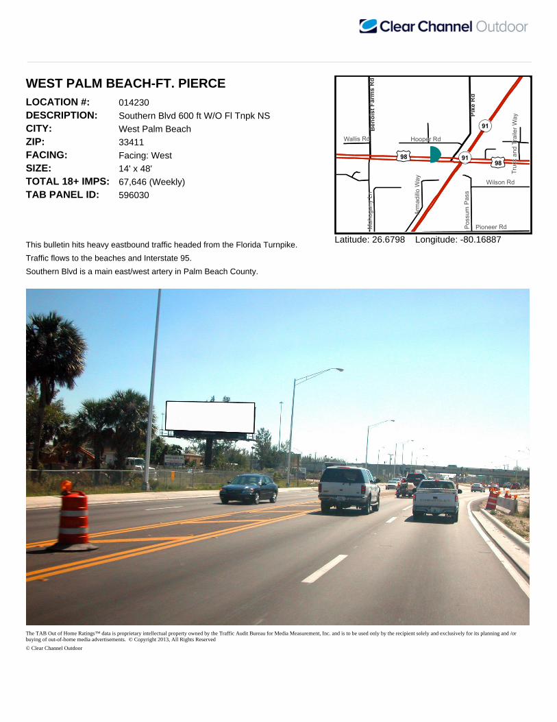
WEST PALM BEACH-FT. PIERCELOCATION #: 014230DESCRIPTION: Southern Blvd 600 ft W/O Fl Tnpk NSCITY: West Palm BeachZIP: 33411FACING: Facing: WestSIZE: 14' x 48'TOTAL 18+ IMPS: 67,646 (Weekly)TAB PANEL ID: 596030
This bulletin hits heavy eastbound traffic headed from the Florida Turnpike.
¨
Pioneer Rd
Hooper Rd
Wilson Rd
Poss
um Pa
ss
Maho
gany
Ln
Arma
dillo
Way
Wallis Rd
Truck
and T
railer
WayPik
e Rd
Beno
ist Fa
rms R
d
OP91
OP91
£¤98£¤98
Latitude: 26.6798 Longitude: -80.16887
Traffic flows to the beaches and Interstate 95.
Southern Blvd is a main east/west artery in Palm Beach County.
The TAB Out of Home Ratings™ data is proprietary intellectual property owned by the Traffic Audit Bureau for Media Measurement, Inc. and is to be used only by the recipient solely and exclusively for its planning and /or buying of out-of-home media advertisements. © Copyright 2013, All Rights Reserved
© Clear Channel Outdoor
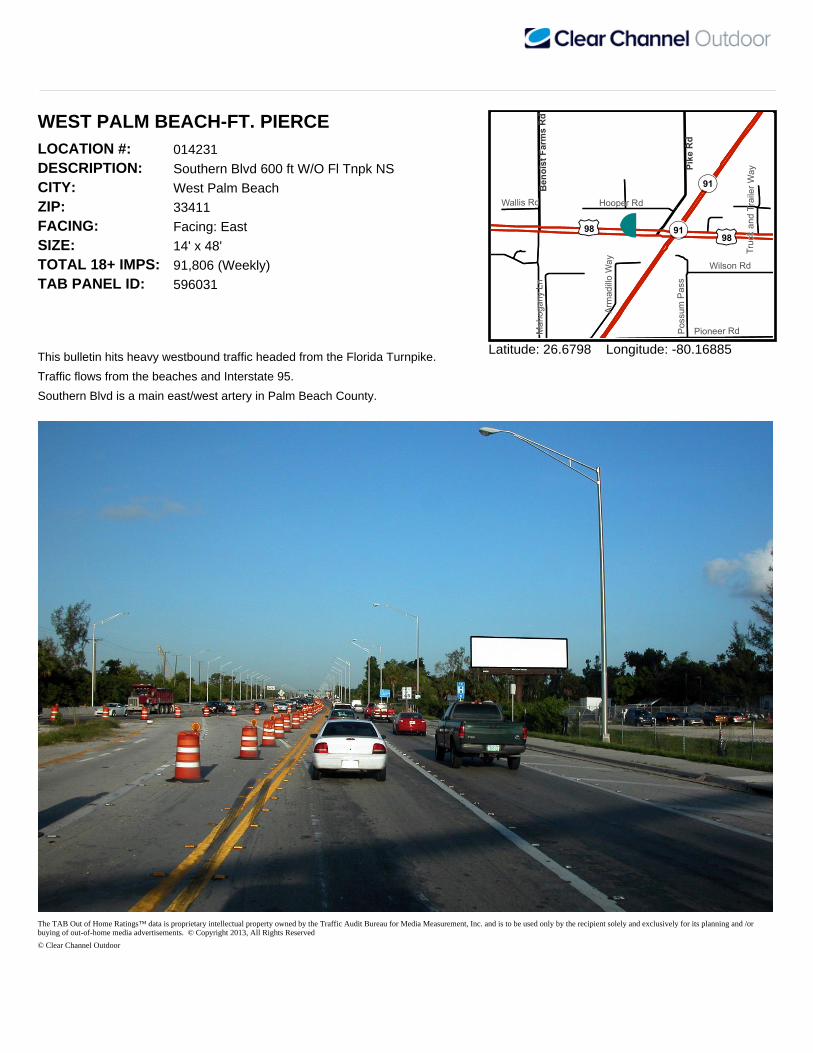
WEST PALM BEACH-FT. PIERCELOCATION #: 014231DESCRIPTION: Southern Blvd 600 ft W/O Fl Tnpk NSCITY: West Palm BeachZIP: 33411FACING: Facing: EastSIZE: 14' x 48'TOTAL 18+ IMPS: 91,806 (Weekly)TAB PANEL ID: 596031
This bulletin hits heavy westbound traffic headed from the Florida Turnpike.
¨
Pioneer Rd
Hooper Rd
Wilson Rd
Poss
um Pa
ss
Maho
gany
Ln
Arma
dillo
Way
Wallis Rd
Truck
and T
railer
WayPik
e Rd
Beno
ist Fa
rms R
d
OP91
OP91
£¤98£¤98
Latitude: 26.6798 Longitude: -80.16885
Traffic flows from the beaches and Interstate 95.
Southern Blvd is a main east/west artery in Palm Beach County.
The TAB Out of Home Ratings™ data is proprietary intellectual property owned by the Traffic Audit Bureau for Media Measurement, Inc. and is to be used only by the recipient solely and exclusively for its planning and /or buying of out-of-home media advertisements. © Copyright 2013, All Rights Reserved
© Clear Channel Outdoor

WEST PALM BEACH-FT. PIERCELOCATION #: 014890DESCRIPTION: Okeechobee Blvd 350 ft E/O Biscayne Rd SSCITY: West Palm BeachZIP: 33409FACING: Facing: WestSIZE: 14' x 48'TOTAL 18+ IMPS: 237,339 (Weekly)TAB PANEL ID: 596123
This bulletin targets eastbound traffic originating from the western communities of Royal Palm Beach, Wellington and West Palm Beach.
¨Ind
ian R
d
Myla Ln
Schall Rd
Bisca
yne B
lvd
Vilma Ln
Scott
Ave
Sharon Rd
Donn
ell R
d
Saginaw Ave
Nokomis Ave
Columbia
Dr
Quail
Dr
Spaff
ord Av
e
Genessee Ave
Exchange Ct
Zip C
ode P
l
Hibiscus St8th Ave6th Ave
Quail Lake Dr
Gardenia St
Westgate Ave
OP809 OP704
OP809
Latitude: 26.70653 Longitude: -80.10671
Okeechobee Blvd. is the main east/west artery in the West Palm Beach communities.
Traffic flows into downtown West Palm Beach, the I-95 interchange and the ultra exclusive Palm Beach Island.
The TAB Out of Home Ratings™ data is proprietary intellectual property owned by the Traffic Audit Bureau for Media Measurement, Inc. and is to be used only by the recipient solely and exclusively for its planning and /or buying of out-of-home media advertisements. © Copyright 2013, All Rights Reserved
© Clear Channel Outdoor
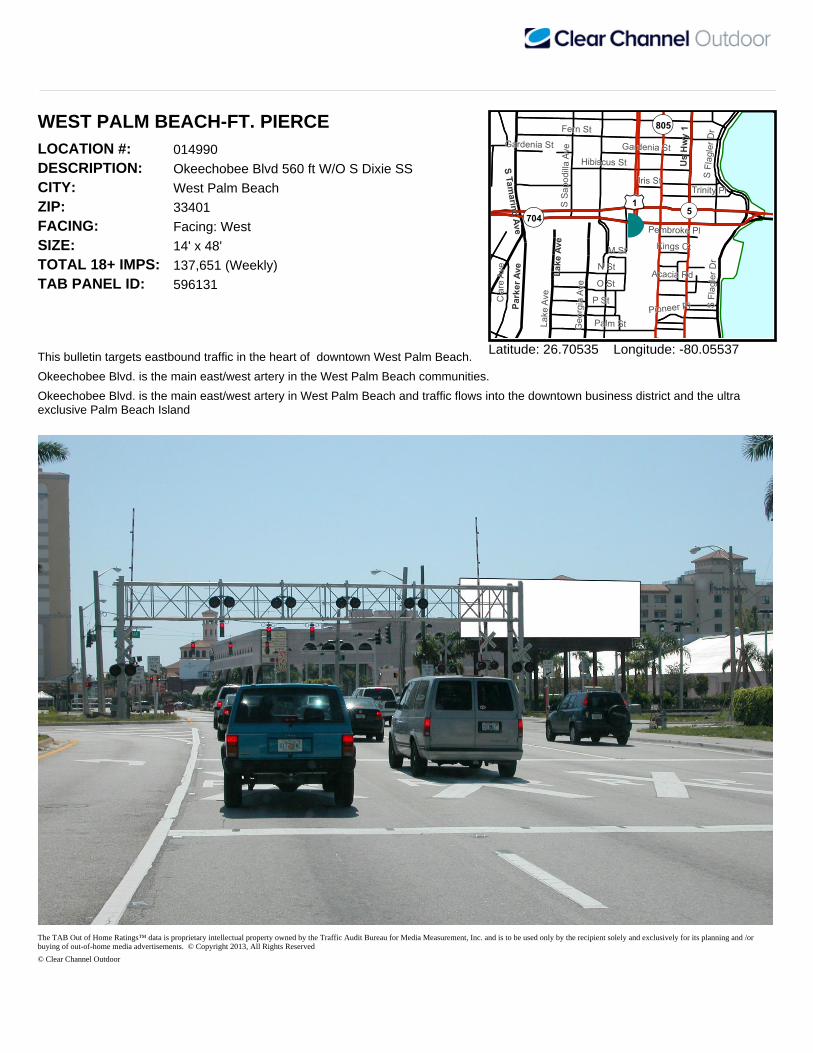
WEST PALM BEACH-FT. PIERCELOCATION #: 014990DESCRIPTION: Okeechobee Blvd 560 ft W/O S Dixie SSCITY: West Palm BeachZIP: 33401FACING: Facing: WestSIZE: 14' x 48'TOTAL 18+ IMPS: 137,651 (Weekly)TAB PANEL ID: 596131
This bulletin targets eastbound traffic in the heart of downtown West Palm Beach.
¨
Fern St
N St
Palm St
S Flag
ler D
r
Hibiscus St
O St
Trinity Pl
Clare
Ave
Gardenia St
Lake
Ave P St
S Sap
odilla
Ave
Georg
ia Av
e
Iris St
M St Kings Ct
Pioneer Pl
Acacia Rd
Pembroke Pl
Gardenia St
S Flag
ler D
r
Lake
Ave
Parke
r Ave
Us H
wy 1
S Tamarind Ave
OP5£¤1
OP805
OP704
Latitude: 26.70535 Longitude: -80.05537
Okeechobee Blvd. is the main east/west artery in the West Palm Beach communities.
Okeechobee Blvd. is the main east/west artery in West Palm Beach and traffic flows into the downtown business district and the ultra exclusive Palm Beach Island
The TAB Out of Home Ratings™ data is proprietary intellectual property owned by the Traffic Audit Bureau for Media Measurement, Inc. and is to be used only by the recipient solely and exclusively for its planning and /or buying of out-of-home media advertisements. © Copyright 2013, All Rights Reserved
© Clear Channel Outdoor

WEST PALM BEACH-FT. PIERCELOCATION #: 015020DESCRIPTION: N Dixie Hwy 150 ft N/O 7th St WSCITY: West Palm BeachZIP: 33401FACING: Facing: SouthSIZE: 12'6" x 48'TOTAL 18+ IMPS: 48,058 (Weekly)TAB PANEL ID: 596133
This bulletin is in the heart of downtown West Palm Beach and shows to northbound traffic.
¨
3rd St
9th St
N Flagler Dr
8th St7th St
6th St
N Sa
podil
la Av
e
11th St10th St
Doug
lass A
ve
5th St4th St
2nd St
13th St
Henri
etta A
ve
W Railroad Ave
Banyan Blvd
5th St
13th St
6th St7th St
2nd St
N Flag
ler Dr
Banyan BlvdOP5
£¤1
Latitude: 26.72013 Longitude: -80.05355
This unit also hits the tourists and beach traffic.
An ideal location to target downtown businesses and Good Samaritan Hospital.
The TAB Out of Home Ratings™ data is proprietary intellectual property owned by the Traffic Audit Bureau for Media Measurement, Inc. and is to be used only by the recipient solely and exclusively for its planning and /or buying of out-of-home media advertisements. © Copyright 2013, All Rights Reserved
© Clear Channel Outdoor

WEST PALM BEACH-FT. PIERCELOCATION #: 015340DESCRIPTION: Blue Heron Blvd 80 ft W/O Garden Rd NSCITY: Riviera BeachZIP: 33404FACING: Facing: EastSIZE: 14' x 48'TOTAL 18+ IMPS: 163,325 (Weekly)TAB PANEL ID: 596153
This bulletin shows to westbound traffic originating in Singer Island and Riviera Beach.
¨
Garde
n Rd
Z Ter
Byron Dr
N Co
ngres
s Ave
W 28th St
Seab
ird W
ay
Industrial Dr S
E Industrial Way
Carve
lle D
r
Alicante Ct
N Con
gress
Ave
§§̈¦95
§§̈¦95
OP708
Latitude: 26.78335 Longitude: -80.09232
Target tourists and families with this display.
Traffic flows to the I-95 Interchange and central Palm Beach.
The TAB Out of Home Ratings™ data is proprietary intellectual property owned by the Traffic Audit Bureau for Media Measurement, Inc. and is to be used only by the recipient solely and exclusively for its planning and /or buying of out-of-home media advertisements. © Copyright 2013, All Rights Reserved
© Clear Channel Outdoor

WEST PALM BEACH-FT. PIERCELOCATION #: 015414DESCRIPTION: FL Tnpk 78 ft S/O Beeline Hwy WSCITY: West Palm BeachZIP: 33412FACING: Facing: SouthSIZE: 14' x 48'TOTAL 18+ IMPS: 173,984 (Weekly)TAB PANEL ID: 596189
This bulletin targets northbound tourist, business and local resident traffic.
¨
N Jo
g Rd
Steeplechase Dr
Man-O
-War
Rd
Sea Biscuit Rd
Jog R
d
Nativ
e Dan
cer R
d E
OP91
OP91
OP710
Latitude: 26.79545 Longitude: -80.1321
This unit also targets afternoon commuters.
Traffic flows to the affluent communities of north Palm Beach, the PGA Mall and the resort areas of Singer Island and Juno Beach.
The TAB Out of Home Ratings™ data is proprietary intellectual property owned by the Traffic Audit Bureau for Media Measurement, Inc. and is to be used only by the recipient solely and exclusively for its planning and /or buying of out-of-home media advertisements. © Copyright 2013, All Rights Reserved
© Clear Channel Outdoor

WEST PALM BEACH-FT. PIERCELOCATION #: 015416DESCRIPTION: FL Tnpk 78 ft S/O Beeline Hwy WSCITY: West Palm BeachZIP: 33412FACING: Facing: NorthSIZE: 14' x 48'TOTAL 18+ IMPS: 223,225 (Weekly)TAB PANEL ID: 596190
This bulletin targets southbound traffic originating from the affluent north Palm Beach residential and tourist areas.
¨
N Jo
g Rd
Steeplechase Dr
Man-O
-War
Rd
Jog R
d
Nativ
e Dan
cer R
d E
Valid A
ppeal R
d
OP91
OP91OP710
OP710
Latitude: 26.7955 Longitude: -80.13208
This unit also targets morning commuters.
Traffic flows to West Palm Beach, Palm Beach International Airport, Boca Raton and the Ft. Lauderdale/Miami area.
The TAB Out of Home Ratings™ data is proprietary intellectual property owned by the Traffic Audit Bureau for Media Measurement, Inc. and is to be used only by the recipient solely and exclusively for its planning and /or buying of out-of-home media advertisements. © Copyright 2013, All Rights Reserved
© Clear Channel Outdoor

WEST PALM BEACH-FT. PIERCELOCATION #: 015465DESCRIPTION: I-95 0.2 mi S/O 45 St ESCITY: West Palm BeachZIP: 33407FACING: Facing: NorthSIZE: 14' x 48'TOTAL 18+ IMPS: 431,909 (Weekly)TAB PANEL ID: 596204
This bulletin targets southbound traffic originating from the affluent north Palm Beach residential and tourist areas.
¨ Pinehurst Dr
37th St
Corpo
rate W
ayWa
verly
Dr
E Tiffany Dr
Haden A
ve
Shelley Rd N
W Tif
fany D
r
Hiltonia Cir
Boardman AveTemple St
Heath Cir S
7th W
ay
45th St
Cong
ress A
ve
Village Blvd
45th St
Village Blvd
§§̈¦95
§§̈¦95
Latitude: 26.7551 Longitude: -80.08942
Interstate 95 is traveled heavily throughout the day.
Traffic flows to West Palm Beach, Palm Beach International Airport, Boca Raton and the Ft. Lauderdale/Miami area.
The TAB Out of Home Ratings™ data is proprietary intellectual property owned by the Traffic Audit Bureau for Media Measurement, Inc. and is to be used only by the recipient solely and exclusively for its planning and /or buying of out-of-home media advertisements. © Copyright 2013, All Rights Reserved
© Clear Channel Outdoor

WEST PALM BEACH-FT. PIERCELOCATION #: 015482DESCRIPTION: I-95 0.4 mi N/O Blue Heron ESCITY: Riviera BeachZIP: 33404FACING: Facing: NorthSIZE: 14' x 48'TOTAL 18+ IMPS: 353,065 (Weekly)TAB PANEL ID: 596211
This bulletin reaches southbound traffic originating from the affluent north Palm Beach residential and tourist areas.
¨
Garde
n Rd
Leo Ln
Byron Dr
Fiscal Ct
Prospect Ave
Z Ter
Rose
gate
Blvd
74th St N
Shares Pl
Enter
prise
Dr
S Four Seasons Rd
Woods Edge Cir
43rd
Ter N
74th Rd NE Industrial Way
Winter Park Ln
Reese AveCentral Industrial Dr N
43rd
Way N
§§̈¦95
§§̈¦95
Latitude: 26.79022 Longitude: -80.09821
Interstate 95 is traveled heavily throughout the day.
Traffic flows to West Palm Beach, Palm Beach International Airport, Boca Raton and the Ft. Lauderdale/Miami area.
The TAB Out of Home Ratings™ data is proprietary intellectual property owned by the Traffic Audit Bureau for Media Measurement, Inc. and is to be used only by the recipient solely and exclusively for its planning and /or buying of out-of-home media advertisements. © Copyright 2013, All Rights Reserved
© Clear Channel Outdoor
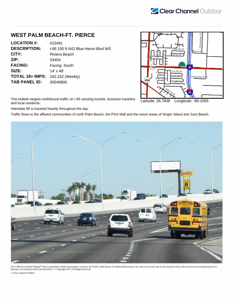
WEST PALM BEACH-FT. PIERCELOCATION #: 015491DESCRIPTION: I-95 150 ft N/O Blue Heron Blvd WSCITY: Riviera BeachZIP: 33404FACING: Facing: SouthSIZE: 14' x 48'TOTAL 18+ IMPS: 242,152 (Weekly)TAB PANEL ID: 30549800
This bulletin targets northbound traffic on I-95 carrying tourists, business travelers and local residents.
¨
42nd
Way
N
70th Ct N
Byron Dr
68th St N
74th St N
Enter
prise
Dr
70th Rd N 70th Ln N
74th Rd N
Industrial Dr S
44th
Trl N
71st Rd N71st Pl N
43rd
Dr N
§§̈¦95
§§̈¦95
OP708
OP809
Latitude: 26.7838 Longitude: -80.1005
Interstate 95 is traveled heavily throughout the day.
Traffic flows to the affluent communities of north Palm Beach, the PGA Mall and the resort areas of Singer Island and Juno Beach.
The TAB Out of Home Ratings™ data is proprietary intellectual property owned by the Traffic Audit Bureau for Media Measurement, Inc. and is to be used only by the recipient solely and exclusively for its planning and /or buying of out-of-home media advertisements. © Copyright 2013, All Rights Reserved
© Clear Channel Outdoor

WEST PALM BEACH-FT. PIERCELOCATION #: 015570DESCRIPTION: I-95 0.3 mi S/O PGA Blvd ESCITY: Palm Beach GardensZIP: 33410FACING: Facing: NorthSIZE: 14' x 48'TOTAL 18+ IMPS: 329,835 (Weekly)TAB PANEL ID: 596223
This 14'X48' bulletin targets southbound traffic originating from the affluent north Palm Beach residential and tourist areas.
¨
Burns Rd
Rca Blvd
E Park Dr
Rivers
ide D
r
Tanglewood NTanglewood S
Salin
as D
r
Legacy
Ave
Buckeye St
Vision
Dr
Burns Rd
§§̈¦95
§§̈¦95
OP811
OP809
OP786
OP811
OP809
OP786
Latitude: 26.8356 Longitude: -80.0985
Traffic flows to West Palm Beach, Palm Beach International Airport and Boca Raton.
Interstate 95 is traveled heavily throughout the day.
The TAB Out of Home Ratings™ data is proprietary intellectual property owned by the Traffic Audit Bureau for Media Measurement, Inc. and is to be used only by the recipient solely and exclusively for its planning and /or buying of out-of-home media advertisements. © Copyright 2013, All Rights Reserved
© Clear Channel Outdoor
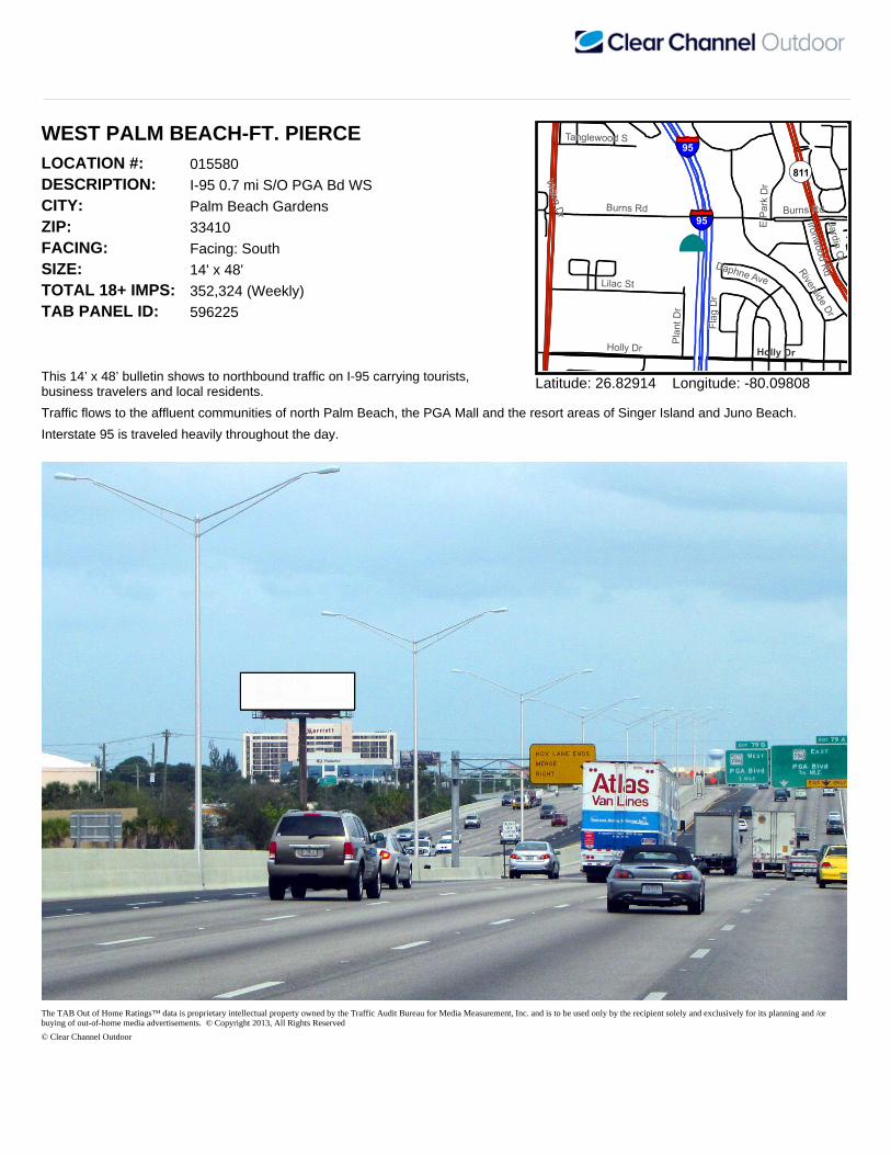
WEST PALM BEACH-FT. PIERCELOCATION #: 015580DESCRIPTION: I-95 0.7 mi S/O PGA Bd WSCITY: Palm Beach GardensZIP: 33410FACING: Facing: SouthSIZE: 14' x 48'TOTAL 18+ IMPS: 352,324 (Weekly)TAB PANEL ID: 596225
This 14’ x 48’ bulletin shows to northbound traffic on I-95 carrying tourists, business travelers and local residents.
¨
Holly Dr
Burns Rd
Riverside Dr
Lilac StDaphne Ave
E Park
Dr
Plant
Dr
Ironwood Rd
Tanglewood S
Flag D
r
Jardin Ct
Vision Dr Burns Rd
Holly Dr
§§̈¦95
§§̈¦95
OP811
Latitude: 26.82914 Longitude: -80.09808
Traffic flows to the affluent communities of north Palm Beach, the PGA Mall and the resort areas of Singer Island and Juno Beach.
Interstate 95 is traveled heavily throughout the day.
The TAB Out of Home Ratings™ data is proprietary intellectual property owned by the Traffic Audit Bureau for Media Measurement, Inc. and is to be used only by the recipient solely and exclusively for its planning and /or buying of out-of-home media advertisements. © Copyright 2013, All Rights Reserved
© Clear Channel Outdoor

WEST PALM BEACH-FT. PIERCELOCATION #: 015581DESCRIPTION: I-95 0.7 mi S/O PGA Bd WSCITY: Palm Beach GardensZIP: 33410FACING: Facing: NorthSIZE: 14' x 48'TOTAL 18+ IMPS: 464,768 (Weekly)TAB PANEL ID: 596226
This 14' x 48' bulletin shows to southbound traffic originating from the affluent north Palm Beach residential and tourist areas.
¨
Holly Dr
Burns Rd
Riverside Dr
Lilac StDaphne Ave
E Park Dr
Plant
Dr
Ironwood Rd
Tanglewood S
Flag D
r
Jardin Ct
Vision Dr Burns Rd
Holly Dr
§§̈¦95
§§̈¦95
Latitude: 26.82917 Longitude: -80.09808
Traffic flows to West Palm Beach, Palm Beach International Airport, Boca Raton and the Ft. Lauderdale/Miami area.
Interstate 95 is traveled heavily throughout the day.
The TAB Out of Home Ratings™ data is proprietary intellectual property owned by the Traffic Audit Bureau for Media Measurement, Inc. and is to be used only by the recipient solely and exclusively for its planning and /or buying of out-of-home media advertisements. © Copyright 2013, All Rights Reserved
© Clear Channel Outdoor

WEST PALM BEACH-FT. PIERCELOCATION #: 015671DESCRIPTION: US 1 210 ft N/O PGA Blvd WSCITY: West Palm BeachZIP: 33408FACING: Facing: NorthSIZE: 14' x 48'TOTAL 18+ IMPS: 121,052 (Weekly)TAB PANEL ID: 596228
This bulletin targets southbound traffic originating from the affluent residential and resort areas of Jupiter and Juno Beach.
¨
Elliso
n Wilso
n Rd
Holman Dr
Smith Dr
Kathy Ln
Land
ing Pl
Lake
Shore
PlRedbank Rd
Seder Ln
Canal Rd
Twelv
e Oaks
Way
Teach Rd
Vitex Ln
Lewis Ln
Idlewild Ct
£¤1
£¤1
OP703
Latitude: 26.8448 Longitude: -80.06137
This unit targets beach traffic and residents.
Traffic flows to the PGA Shopping Mall and north Palm Beach County.
The TAB Out of Home Ratings™ data is proprietary intellectual property owned by the Traffic Audit Bureau for Media Measurement, Inc. and is to be used only by the recipient solely and exclusively for its planning and /or buying of out-of-home media advertisements. © Copyright 2013, All Rights Reserved
© Clear Channel Outdoor