multi touch control · wireless · timezero™ · digital ... · an air gap between the lcd and the...
TRANSCRIPT


Multi Touch Control · Wireless · TimeZero™ · Digital Revolution
P i n c h - T o - Z o o m
NavNet TZtouch brings you pinch-to-zoom capability, as well as other multi touch gestures for the most intuitive navigation experience.
See Page 7 for details
1

NMEA2000Certified
2012/2013*/2014*
* TZT14
T a b l e t & S m a r t p h o n e A p p s
Custom apps allow you to wirelessly view and control TZtouch from iOS and Android™ *.
W i r e l e s s H o t s p o t C o n n e c t i v i t y
TZtouch has wireless connectivity to hotspots, enabling the ability to download useful updates, such as real-time weather data, via the Internet.
See Page 8 for detailsSee Page 8 for details
2

Today's NavNet has come a long way from the first multi function display. Take one look and you will
see just how far. A generous 9" or 14.1" display with edge-to-edge glass makes for a clean and stylish
installation. The LED backlighting pushes light through every pixel on the screen for remarkable
brightness. Anti-reflective glass coating is visible under any lighting condition. Configure the displays
with a wide variety of sensors to build a navigation suite that meets your individual requirements.
With the NavNet TZtouch, model TZTBB, the display unit is selectable from virtually any size of wide
or non-wide monitor supporting multi touch controls.
Bonded LCD - Clear Readability
Our bonded LCDs offer a fog-free structural design that has been applied to both the TZT9 and TZT14. This ensures the display will never be affected by water condensation, caused by an air gap between the LCD and the front cover plate.
Polarized Friendly - Clearly Remarkable
NavNet TZtouch TZT9 and TZT14 have an LCD screen that does not "black out" when wearing polarized sunglasses, providing clear visibility from virtually any angle.
T Z t o u c h D e l i v e r s A H u g e S t e p F o r w a r d
I n T o u c h S c r e e n T e c h n o l o g y
14.1" Multi Function Display
Resolution: WXGA (1280 x 800 pixels)Brightness: 900 cd/m2 (typical)
9" Multi Function Display
Resolution: WVGA (800 x 480 pixels)Brightness: 900 cd/m2 (typical)
ViewableBlack out
Conventional
3

Multi Function Display Black Box
Supports both wide and non-wide resolutions:1280 x 720 (16:9), 1280 x 800 (16:10), 1280 x 960 (4:3), 1280 x 1024 (5:4)
Remote Control Unit
Take control of your NavNet TZtouch series with a remote controller.
Photo: Multi-touch marine display*
with TZTBB processor (model MPU-002) * Local supply
NEW
4
Network Fish FinderDFF1-UHD/DFF1/DFF3/BBDS1
Multi Beam SonarDFF-3D
Ultra High Definition Radar Sensors
TIMEZEROMarine Software
IP Camera
Network Satellite Weather and Radio ReceiverBBWX3 Marine Entrtainment System
MS750 Series
R AA DDDD AAAA RRR
F I S H FF II NNNN DDD EEEE RRR
A I SS
SiriusXM weather coverage is currently available only
in U.S. and Canada. Sirius subscription required.
Class-B AIS Transponder
FA-50
Class-A AIS Transponder
FA-170
AIS Receiver
FA-30
PPPP CC
CCCCC AAAA MMMMM EEE RR AA
SSSS IIIII RRRRRR III UUUUUUUUU SSSSSSSS
AA UU DD II OO
(DFF1-UHD)
NEW
NEW
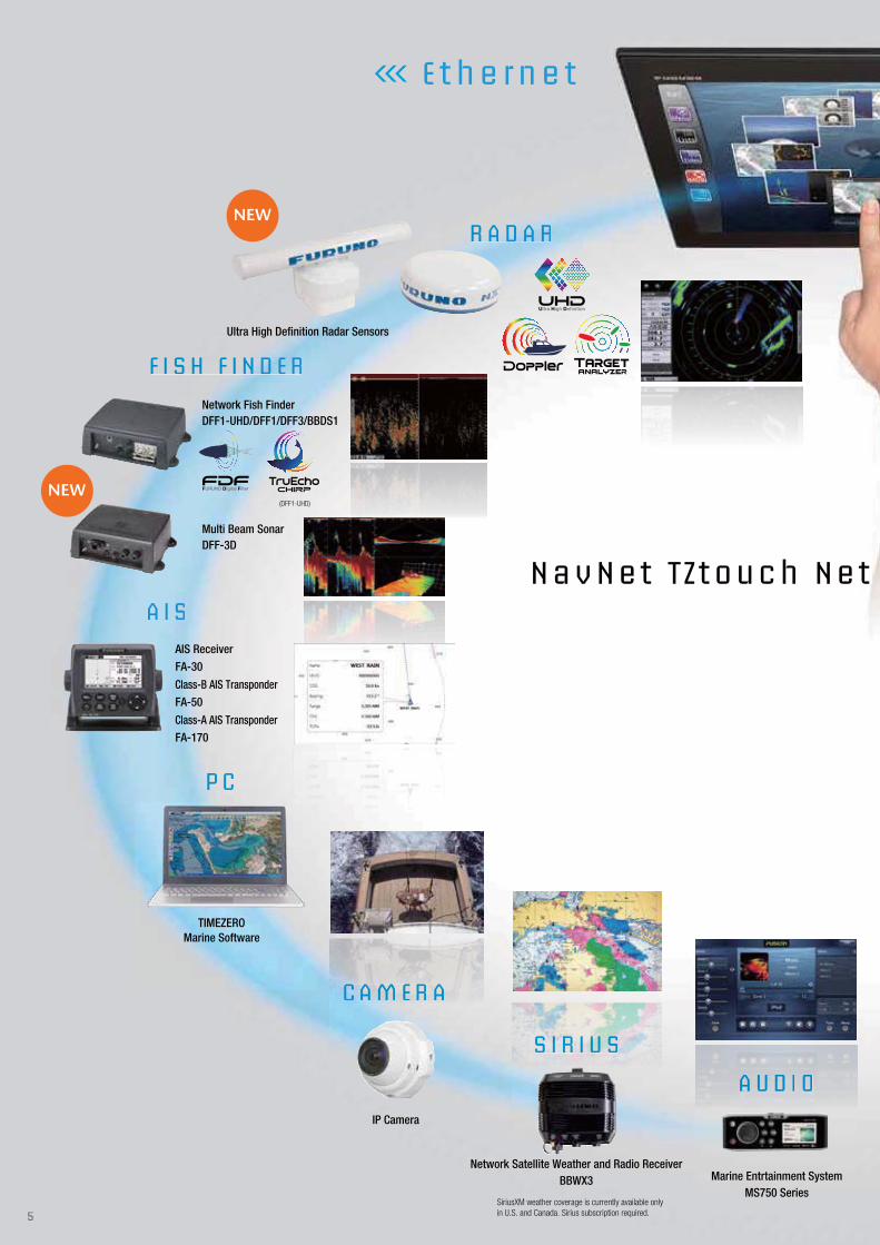
E t h e r n e t
NavNet T Z touch Net
5

I N S TT RR UU MM E N T
A U T O P I LL OO TTT
C OO MM PP AA SS SS
R E MM OO TTT EEE DD I S P L AA YY
S E NN SS OO RR SSS
Integrated Heading Sensor
PG-700
Depth/Speed/Temp Sensor
Airmar DST-800
GPS NavigatorGP-33
GPS AntennaGP-330B
Satellite Compass
SC-30
Remote DisplayRD-33
G P S
FI-70
NAVpilot-700 Series
NMEA0183 to CAN bus converter available
The optional IF-NMEA2K2 converts NMEA0183 sentences to FURUNO CAN bus PGNs, enabling conventional NMEA0183 navigation devices to be incorporated into the NavNet TZtouch network.
NavNet TZtouch is built on an Ethernet network, allowing you to add as few or as many
components as you desire, along with up to six displays, as well as CAN bus and
NMEA2000 devices, to create your perfect navigation suite.
The NavNet TZtouch system is built upon the most advanced chart plotter technology.
Add to this a UHD™ Doppler Radar and an FDF™ Fish Finder, along with your choice
from a wide variety of sensor options. It is easy to see how a NavNet TZtouch chart plotter
display is the genesis to begin building the most sophisticated navigation suite available.
*All stated CAN bus devices can be incorporated into the NMEA2000 network.
C A N b u s
work: Bu i ld ing B lock So lut ion
6

With NavNet TZtouch's high-sensitivity, touch screen interface, total control is at your fingertips. Navigation is
simplified by using your fingers to zoom and pan around the chart. As soon as your fingers touch the display,
taps, pinches and swipes are instantly transformed into action. You will learn your controls so quickly that
you'll be up and running in no time. To make operation even easier while underway, adjustments such as
range and gain are easily made from either the on-screen touch menu or our patented RotoKey™.
Multi Touch Control
Furuno elevates marine touch screen technology to an entirely new level with the industry's first multi touch MFD. The use of multi touch technology opens the door to a wide variety of gesture-based commands.
T h e W o r l d ' s M o s t A d v a n c e d
M u l t i T o u c h N a v i g a t i o n I n t e r f a c e
Touch... and Go Menu Selection
Be more hands-on with our easy-to-understand touch screen interface. You'll have full control of each component connected to the network right at your fingertips.
RotoKey™
NavNet’s revolutionary RotoKey™ now merges the power and versatility of touch screen control with an easy-to-use rotary knob. One turn of the RotoKey™ gives you instant access to full control of NavNet TZtouch.For the Blackbox model, the RotoKey™ menu will appear with one tap on the display.
Home Key
By simply pressing the Home key, you'll gain immediate access to your carousel of customized display configurations. The Home screen is where you can find, select, and custom build the presentation modes you want to display. For TZTBB, Home icon is displayed on the screen.
Dual SD Card Slot
RotoKey™ menu on TZTBB
7

Engineered to utilize the latest technology, NavNet TZtouch opens the door to cutting edge
wireless LAN features, such as tablet and smartphone apps, real time weather data, software
updates and more.
Visit the Apple App Store to download these FREE apps to view and control NavNet TZtouch.
G e t C o n n e c t e d
W i t h O u r W i r e l e s s I n t e r f a c e
NavNet Viewer App
Conveniently view information shared wirelessly by the NavNet TZtouch network on your mobile products. As one of the features, you can flick through instrument pages to view key navigational information, such as Depth, Temp, Wind, COG, Fish Finder display and much more.
NavNet Remote App
Take full control of your NavNet in a whole new way. The TZtouch Remote app allows you to operate your system remotely with a smart device wireless LAN, when connected to the network.
NavNet Remote App is available for tablets (more than 7 inches) only.
NavNet Controller AppWirelessly control any NavNet TZtouch MFD with touch controls. With a scroll pad, cursor pad and dedicated keys within the app, controlling NavNet TZtouch is simple and straightforward.
Marine Weather Forecast
The weather tool is completely free and easy to use, giving you unlimited access to weather forecasts worldwide 24 hours a day provided by NavCenter. Select geographic coverage, data type, period of time, and then choose how to receive the file. NavNet TZtouch provides up to 16 days of weather forecasting.
8

NavNet TZtouch employs revolutionary real-time digital auto Gain/Sea controls to deliver a crystal clear radar presentation. With this new technology, NavNet TZtouch computes and applies an adaptive omni-directional anti-clutter filter with variable intensity according to bearing.
Real-Time Dual Range Radar Presentation with
Dual Progressive Scan
Target Tracking/AIS
Real-Time Digital Auto Gain/Sea Controls
R a d a r
Automatic radar plotting utility is one of the standard features of the NavNet TZtouch radar. Up to 30 targets can be simultaneously acquired and tracked for heading and speed. AIS target tracking is accomplished when interfaced with a FA-30/50/170 AIS unit.
NavNet TZtouch’s simultaneous scanning technology allows dual progressive scan to display and update two radar pictures, both long and short range, at the same time as opposed to alternate update methods of typical conventional dual range radar. Autonomous control over gain and anti-clutter can be performed on each radar presentation.
Auto Gain/Sea Controls Off
Auto Gain/Sea Controls On
NavNet TZtouch Radar Sensor Options
Scan above code for more details about Radar.
Output Power
Size
Antenna Type
Beam Width
Max. Range
48 rpm Capability
Functions
Dual Range Scanning
ARPA
System version reguired
Horizontal
Vertical
Sensor LineupDRS4D-NXT
Solid-state, 25 kW
24 inch
Radome
3.9°
25°
36 nm
Head-up, North-up*, Echo Trail,
Target Analyzer, Bird mode,
Fast Target Tracking, AIS
4.21
DRS4DL
4 kW
19 inch
Radome
5.2°
25°
36 nm
–
Head-up,
North-up*
–
–
4.11
DRS6A X-Class
6 kW
3.5 ft/4 ft/6 ft
Open
2.3°/1.9°/1.4°
22°/22°/22°
96 nm
Head-up, North-up*,
Echo Trail, Bird mode,
Fast Target Tracking, AIS
4.21
DRS12A X-Class
12 kW
4 ft/6 ft
Open
1.9°/1.4°
22°/22°
96 nm
Head-up, North-up*,
Echo Trail, Bird mode,
Fast Target Tracking, AIS
5.01
DRS25A X-Class
25 kW
4 ft/6 ft
Open
1.9°/1.4°
22°/22°
96 nm
Head-up, North-up*,
Echo Trail, Bird mode,
Fast Target Tracking, AIS
5.01
* Heading input required. ** Not available for 12 V.The radar antenna complies with IEC62252 Ed. 1:2004 (Clauses 4.33, 5,33, Annex D) relevant to radio characteristic.
Not available for NavNet 3D.
NEW
NEW
NEWNEW
NEW
9

Fast Target Tracking™
It only takes a few seconds after a target has been selected until a speed and course vector is displayed. With accurate tracking information, estimation of other vessel's course and speed is greatly simplied.
With Fast Target Tracking™ activated, any vessel approaching yours will automatically display a target vector, as well as sound an alarm*. Up to 100 targets can be displayed simultaneously.
Radar-Chart Overlay
A Radar image can be overlaid onto the chart screen. Not only is this possible with the conventional 2D chart format, but it can also be projected onto a 3D chart presentation. Radar range scales in the radar chart overlay entirely depend on the range scales in the chart presentation, allowing you to view the radar image on the chart information at any magnification level you desire.(An appropriate heading sensor is required.)
X-Class series a whole new class of Radar
Pushing the boundaries of what is possible with conventional Radar technology, X-Class series mark yet another leap forward for FURUNO. Improved in almost all aspects, X-Class Radar features improved short range detection as well as an impressive long range detection of up to 96 nautical miles. And that's not all, the new "Bird Mode" gives you incredible bird detection performance.
*1 TZtouch version 4.21 or later is required.*2 Bird mode is also available with DRS4D-NXT.
*CPA/TCPA alarm setting required.
* DRS X-Class Series
Bird mode and navigation mode can both be displayed via a simultaneous dual mode scanning. Possibility to track the birds while navigating safely
The radar detects and distinguishes several small yatchs with high accuracy.
DRS4D-NXT, the NXT step in Radar technology
Solid-State Radar with pulse compression, Target Analyzer and Fast Target Tracking™ utilizing Doppler technology. Combined with FURUNO exclusive RezBoost™ technology for echo sharpening, DRS4D-NXT packs the performance of an open array radar, in a compact 24” radome.
Target Tracking™ automatically show you hazardous targets by displaying them in bright red. Stationary targets are displayed in green.
With Target Analyzer, hazardous targets are displayed in red
Approaching vessel with target vector
* TZtouch version 4.21 or later is required.
New Target Analyzer function*
Bird Mode*
Vessel heading toward flocks
Two flocks of birds
10
model DFF1
model BBDS1
model DFF1-UHD
model DFF3
model DFF-3D
Bottom Discrimination Display
- BBDS1/DFF1-UHD
Scan above code for more details about Fish Finder.
Frequency
Range Scale
ACCU-FISH™
Bottom Discrimination
TruEcho CHIRP
Display Mode
Power Supply
Transducers
DFF1 BBDS1
Dual frequency50 kHz and 200 kHz
Available
Auto (Fishing/Cruising/Manual), Bottom Zoom, Bottom Lock, A-Scope
600 W/1 kW
165 kHz
Up to 1,200 m
N/A
N/A
N/A
Triple/Single Beam Sounder,Side Scan, Cross Section,3D history
800 W
Dual frequency50±20 and 200±25 kHz
Available
Available
1 kW
The synthesized transducerworks with dual frequencies
between 28 and 200 kHz
Customized upto 1,500 m
N/A
N/A
1, 2 or 3 kW
DFF3 DFF-3D
Customized upto 1,200 m
N/A
N/A
Available
N/A
12-24 VDC
DFF1-UHD
FURUNO Digital Filter (FDF™) Fish Finder
F i s h F i n d e r
Sensor Lineup
NEW
NEW
ACCU-FISH™ (Fish Size Analyzer)
FURUNO’s award winning network fish finders offer a unique fish size analyzer function, ACCU-FISH™.
The ACCU-FISH™ algorithm analyzes echo returns to compute individual fish size and display it on the screen.
Utilizing input from the Network Fish Finders BBDS1 or DFF1-UHD, the bottom discrimination display will be shown in the following four categories; "Rocks", "Gravel", "Sand" and "Mud", either in dedicated graphics or colors with corresponding probability. This information is helpful in spotting rich fishing grounds where you can boost your catch of the day.
FURUNO Digital Filter (FDF™) Fish Finder
FURUNO Digital Filter (FDF™) fish finders feature advanced filtering capabilities and digital auto tuning, which eliminates noise. FURUNO FDF™ fish finders deliver the ability to spot individual fish with clarity, accuracy and detail. Whether in shallow or deep water, FURUNO FDF™ fish finders give you what you would expect from a fish finder at all times.
11

Find More Fish With TruEcho CHIRP™ Fish Finder
An advanced technology for both professional and enthusiast fishermen. Designed to operate across a wide range of frequencies utilizing a broadband transducer, the TruEcho CHIRP™ network fish finder delivers significant advantages in signal clarity and target definition. Due to the constant sweep of frequencies the TruEcho CHIRP™ network fish finder is capable of gathering more and higher quality data than a traditional single frequency fish finder. The clear presentation marks individual game fish and bait fish, even when tightly schooled together.
Multi Beam Sonar
Innovative tool for exploring a wide range of water column and seabed
New Multi Beam Sonar model DFF-3D gives you real-time 120 port-starboard view of the water column and seabed up to 200m depth*. The DFF-3D allows you to explore fishing spots and find fish in deep water by far faster than conventional single beam sounders. On the other hand, the main beam penetrate right under the boat at a depth of approximately 300 m*. Installation is made easy, thanks to a compact transducer design. The built-in motion sensor gives you clear images under your boat even in rough water.
High Frequency CHIRP Low Frequency CHIRP
Up to 10 times sharper image than conventional FDF*2
3D history Side Scan
Triple Beam Sounder+Cross Section+3D historyScanning image of Multi Beam Sonar
*2 TruEcho CHIRP™ performance may vary depending on depth, range and signal frequency used.
* Maximum depth dependent on installation, bottom type and water conditions.
12

The Only Acceptable Wait Time is Zero:
TimeZero™ Technology Changes Your Perspective on Chart Redraw
Equipped with powerful TimeZero™ technology,NavNet TZtouch will completely transform the way you navigate. You can scroll, pan, zoom in/out with a smooth, fast and seamless graphics engine. Navigating in a ful ly 3D environment offers you a true perspective and wider area of view around the ship, which allows you to better plan your routes, while TimeZero™ technology updates the information on your screen with virtually no redraw.
NavNet TZtouch TimeZero™ technology delivers chart processing like you’ve never seen before – seamless chart handling, zooming and panning without the screen disappearing. TimeZero™ technology redefines the meaning of stress-free operation by smoothing out your chart handling actions.
N o t h i n g I s F a s t e r T h a n T i m e Z e r o ™
13

2D Vector 3D Raster with Satellite Photo
The tank level display also available on the instrument page.
2D Raster
NavNet TZtouch is the only chart plotter on the market that provides users the ability to choose from official NOAA raster and vector charts, or optional “C-Map” and “Datacore by Navionics” vector cartography, etc. Fully integrating a cutting-edge data algorithm with a high-resolution image processing technique, MapMedia delivers digital navigation charts and satellite photography with absolute clarity. MapMedia vector and raster charts are built upon 3D architecture, which is smoothly integrated with NavNet’s TimeZero™ technology.
C h a r t P l o t t e r
Satellite PhotoFusion™
Scan above code for more details about Chart Plotter.
You can load any two ultra-wide high-resolution satellite photo areas at your convenience. Land areas (zero depth) are completely opaque, so these areas are displayed as high-resolution satellite photos on the chart. As the depth increases, the satellite photography becomes more transparent. This allows you to see where the shallows end and the deeper water begins, while still allowing the raster or vector chart to be visible.
Screen Capture With Event
When an event is entered on the plotter display, a screen capture image can be saved with the point. Tapping the saved point, a screenshot appears in a pop-up window. Any screenshots (ex. Fish Finder, Radar) can be included to customize with your own plotter information.
Fuel Max Range
When a route is activated, NavNet TZtouch will display a pump icon at the spot on the route, where it is predicted that the fuel supply will be exhausted.
14

293 11.5"
326 12.8"
17 0.7"
42 1.7"
100 3.9"162 6.4"
151 5.9"29 1.1"
16
2
6.4
"
24
0
9.4
"
19
6
7.7
"
293 11.5"
24 0.9"
42 1.7"
7 0.3"
100 3.9"
284 11.2" 4-R13
144 5.7"
16
2
6.4
"
15
3
6.0
"
Multi Function Display (Table-top Mount) TZT94.7 kg 10.4 lb
Multi Function Display (Flush Mount) TZT94.5 kg 9.9 lb
Multi Function Display TZT9DISPLAY UNITType Color TFT multi touch LCD
Screen Size 9" wide
Screen Resolution WVGA 800 x 480
Screen Brightness 900 cd/m2 (typical)
LanguageChinese (simplified Chinese chracters), Danish, English (US & UK), Finnish, French, German, Greek,
Italian, Japanese, Norwegian, Portuguese, Russian, Spanish, Swedish
CHART PLOTTERCartography MapMedia mm3d chart (C-MAP/Navionics/NOAA)
Memory Capacity
30,000 user points
30,000 points for ship's tracks
200 planned routes (500 points per route)
Alarms Anchor Watch, XTE, Proximity, Depth, Temperature, Speed, etc.
RADARDisplay Modes Head-up, North-up* *Heading input required.
Echo Trail Interval: 15 s, 30 s, 1 min, 3 mins, 6 mins, 15 mins, 30 mins and continuous
Target Tracking 30 Targets* *Heading input required.
INTERFACECAN bus 1 Port
LAN 1 Port (100 BASE-TX)
USB 1 Port (USB2.0)
Video Output 1 Port (DVI-D)
Video Input 2 Ports (NTSC/PAL)
SD Card Slot 2 Slots (SDXC card - supports upto 128GB)
ENVIRONMENTTemperature (IEC60945) -15°C to + 55°C
Waterproofing IP56 (with connector cover), IP22 (with connector boot)
POWERPower Supply 12-24 VDC
Power Consumption 42 W (3.5 A - 1.8 A)
S p e c i f i c a t i o n s
15

428 16.9"
150 5.9"
130 5.1"66 2.6"
42 1.7"
17 0.7"
24
5
9.6
"
27
3
10
.7"
29
6
11
.7"
395 15.6"
100 3.9"
395 15.6"
24 0.9"
386 15.2"42 1.7"
123 4.8”
7 0.3"
24
5
9.6
"
23
6
9.3
"
100 3.9"
4-R13
Multi Function Display (Table-top Mount) TZT148.0 kg 17.6 lb
Multi Function Display (Flush Mount) TZT147.1 kg 15.6 lb
Multi Function Display TZT14DISPLAY UNITType Color TFT multi touch LCD
Screen Size 14.1" wide
Screen Resolution WXGA 1280 x 800
Screen Brightness 900 cd/m2 (typical)
LanguageChinese (simplified Chinese chracters), Danish, English (US & UK), Finnish, French, German, Greek,
Italian, Japanese, Norwegian, Portuguese, Russian, Spanish, Swedish
CHART PLOTTERCartography MapMedia mm3d chart (C-MAP/Navionics/NOAA)
Memory Capacity
30,000 user points
30,000 points for ship's tracks
200 planned routes (500 points per route)
Alarms Anchor Watch, XTE, Proximity, Depth, Temperature, Speed, etc.
RADARDisplay Modes Head-up, North-up* *Heading input required.
Echo Trail Interval: 15 s, 30 s, 1 min, 3 mins, 6 mins, 15 mins, 30 mins and continuous
Target Tracking 30 Targets* *Heading input required.
INTERFACECAN bus 1 Port
LAN 3 Ports (100 BASE-TX)
USB 1 Port (USB2.0)
Video Output 1 Port (DVI-D)
Video Input 2 Ports (NTSC/PAL)
SD Card Slot 2 Slots (SDXC card - supports upto 128GB)
ENVIRONMENTTemperature (IEC60945) -15°C to + 55°C
Waterproofing IP56 (with connector cover), IP22 (with connector boot)
POWERPower Supply 12-24 VDC
Power Consumption 60 W (5.0 A - 2.5 A)
16

4x 20
97 3.8"97 3.8"
80 3.1"
86 3.4"
10 0.4"
10
0
.4"
95
3
.7"
60 2.4"7 0.3"
15 0.6" 15 0.6"
127 5.0"
9.7
0.4"
10
6
4.2
"
Fixing hole
395 15.6"
20
9
8.2
"
100 3.9" 100 3.9"
8 0.3"
35
0
13
.8"
33
0
13
"
30
0
11
.8"
10
0
.4"
30
1
.2"
240 9.4"
59 2.3" 7 0.3"
20 0.8"
24 0.9"
10
0.4"
11
5
4.5
"
77 3.0" Fixing hole 64 2.5"
31 1.2"
66 3.0"
7.5 0.3"
54 2.1" 26 1.0"
17
5
6.9
"
16
2
6.4
"
16
4
6.5
"
12
9
5.1
" 35
Multi Function Display Black Box TZTBB MPU-0028 kg 17.6 lb
Switch Box PSD-0020.75 kg 1.7 lb
Remote Control Unit MCU-002 (option)0.14 kg 0.3 lb
Remote Control Unit MCU-004 (option)0.4 kg 0.9 lb
Multi Function Display Black Box TZTBBDISPLAY UNITType Custom multi touch monitor of your choice
Screen Size —
Screen ResolutionSupports both wide and non-wide resolutions:
1280 x 720 (16:9), 1280 x 800 (16:10), 1280 x 960 (4:3), 1280 x 1024 (5:4)
Screen Brightness —
LanguageChinese (simplified Chinese chracters), Danish, English (US & UK), Finnish, French, German, Greek,
Italian, Japanese, Norwegian, Portuguese, Russian, Spanish, Swedish
CHART PLOTTERCartography MapMedia mm3d chart (C-MAP/Navionics/NOAA)
Memory Capacity
30,000 user points
30,000 points for ship's tracks
200 planned routes (500 points per route)
Alarms Anchor Watch, XTE, Proximity, Depth, Temperature, Speed, etc.
RADARDisplay Modes Head-up, North-up* *Heading input required.
Echo Trail Interval: 15 s, 30 s, 1 min, 3 mins, 6 mins, 15 mins, 30 mins and continuous
Target Tracking 30 Targets* *Heading input required.
INTERFACECAN bus 1 Port
LAN 3 Ports (100 BASE-TX)
USB 6 Ports (USB2.0)
Video Output 2 Ports (DVI-D)
Video Input 2 Ports (NTSC/PAL)
SD Card Slot 2 Slots (SDXC card - supports upto 128GB)
ENVIRONMENTTemperature (IEC60945) -15°C to + 55°C
WaterproofingProcessor unit: IP22
Switch box: IP56 (front panel)
POWERPower Supply 12-24 VDC
Power Consumption 43.2 W (3.6 A - 1.8 A - including switch box)
S p e c i f i c a t i o n s
17

Whenever you require any information about NavNet series, just
visit our web site (www.navnet.com), solely dedicated to current
and prospective users of NavNet series.
At NavNet.com, you can access the contents with in-depth
product information from various angles, including
demonstration videos, introduction to the product, product
specifications, training videos, user interviews, and much more!
Since the product's debut in February 2012, many accolades have been
awarded to NavNet TZtouch all over the world, in recognition of its design
excellence. Here is a list of the awards that NavNet TZtouch has won.
P r o d u c t A w a r d s
Special Mention of the DAME award - Design Award METS CompetitionCategory: Marine electronics & Marine related software
November 2012, the Netherlands
"Product of the Year" by British Marine Electronics Association (BMEA)October 2012, The UK
Chuck Husick Technology Award by Ocean Navigator magazineOctober 2012, The US
National Marine Electronics Association (NMEA) awardCategory: The "Best Navigation" and the "Best Radar"
2012, 2013, 2014, The US
The "Connex Most Innovative International Product" awardJune 2012, The New Zealand

FURUNO ELECTRIC CO., LTD.Japan www.furuno.com
FURUNO U.S.A., INC.U.S.A. www.furunousa.com
FURUNO PANAMA S.A.Republic of Panama www.furuno.com.pa
FURUNO (UK) LIMITEDU.K. www.furuno.co.uk
FURUNO NORGE A/SNorway www.furuno.no
FURUNO DANMARK A/S Denmark www.furuno.dk
FURUNO SVERIGE ABSweden www.furuno.se
FURUNO FINLAND OYFinland www.furuno.fi
FURUNO POLSKA Sp. Z o.o.Poland www.furuno.pl
FURUNO DEUTSCHLAND GmbHGermany www.furuno.de
FURUNO FRANCE S.A.S.France www.furuno.fr
FURUNO ESPAÑA S.A.Spain www.furuno.es
FURUNO ITALIA S.R.L.Italy www.furuno.it
FURUNO HELLAS S.A.Greece www.furuno.gr
FURUNO (CYPRUS) LTDCyprus www.furuno.com.cy
FURUNO EURUS LLCRussian Federation www.furuno.ru
FURUNO SHANGHAI CO., LTD.China www.furuno.com/cn
FURUNO CHINA CO., LTD.Hong Kong www.furuno.com/cn
FURUNO SINGAPORESingapore www.furuno.sg
PT FURUNO ELECTRIC INDONESIAIndonesia www.furuno.id
11-K-1708PDFCatalogue No. CA000001148
www.furuno.com
Beware of similar products
Apple, Apple logo, are trademarks of Apple Inc., registered in the U.S. and other countries.
App Store is a service mark of Apple Inc.
Android and Google play logo are trademarks of Google Inc.