multispectral remote sensing systems landsat spot weather satellites - goes - avhrr high-resolution...
TRANSCRIPT

Multispectral Remote Sensing SystemsMultispectral Remote Sensing Systems
LandsatSPOTWeather satellites - GOES - AVHRRHigh-resolution satellite - IKONOSHyper-spectral sensor - AVIRISEOS-Terra instruments - ASTER - MODIS
LandsatSPOTWeather satellites - GOES - AVHRRHigh-resolution satellite - IKONOSHyper-spectral sensor - AVIRISEOS-Terra instruments - ASTER - MODIS

Landsat ProgramLandsat Program
Originally called (ERTS) - Earth Resources Technology Satellite.
First satellite launched in 1972Broad scale repetitive surveys of the landscapeVisible, NIR spectral bands (Landsats 1,2,3), and MIR and
Thermal (Landsats 4 and 5)Sensors:
Multispectral scanner (MSS)Return beam vidicon (RBV)Thematic Mapper (TM)Enhanced Thematic Mapper Plus (ETM+)

Chronological Launch and Retirement History of the Landsat Satellite SeriesChronological Launch and Retirement History of the Landsat Satellite Series

Landsat Multispectral Scanner (MSS)Landsat Multispectral Scanner (MSS)
Attitude-control subsystem
Wideband recorder electronics
Attitude measurement
sensor
Multispectral Scanner (MSS)Return Beam
Vidicon (RBV) cameras (3)
Data collection
antenna
Solar array
Attitude-control subsystem
Wideband recorder electronics
Attitude measurement
sensor
Multispectral Scanner (MSS)Return Beam
Vidicon (RBV) cameras (3)
Data collection
antenna
Solar array

Inclination of the Landsat Orbit to Maintain A Sun-synchronous Orbit
Inclination of the Landsat Orbit to Maintain A Sun-synchronous Orbit
Inclination = 98.2degree

Landsat Multispectral Scanning System (MSS) OrbitLandsat Multispectral Scanning System (MSS) Orbit
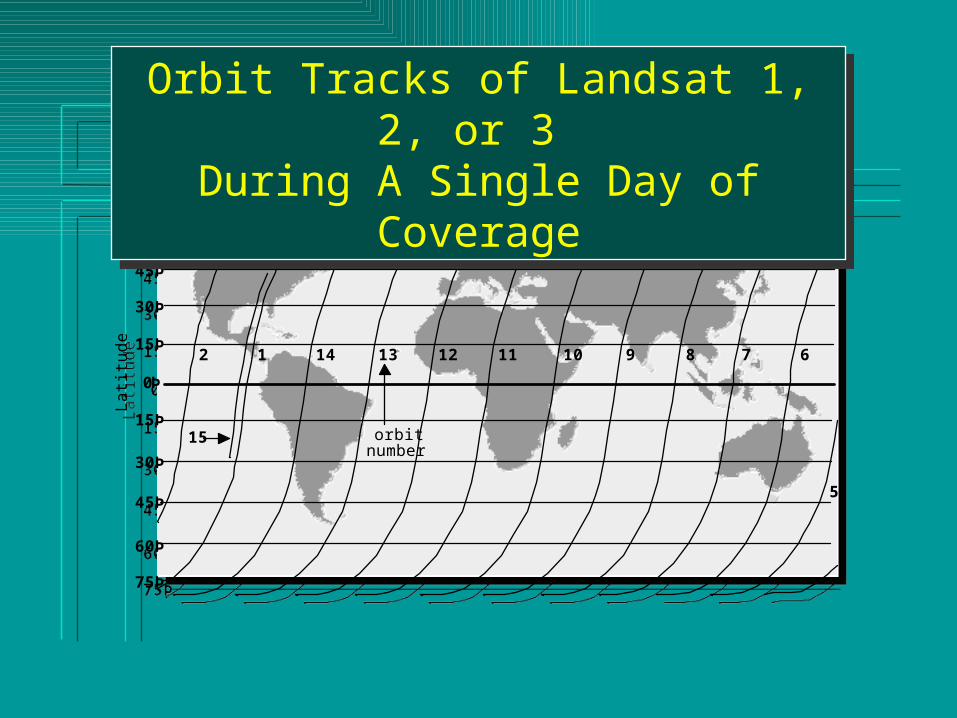
14 13 12 11 10 9 8 7 6
5
4
3
12
75Þ
60Þ
45Þ
30Þ
15Þ
75Þ
60Þ
45Þ
30Þ
15Þ
0Þ
orbit number
Lat
itude
15
14 13 12 11 10 9 8 7 6
5
4
3
12
75Þ
60Þ
45Þ
30Þ
15Þ
75Þ
60Þ
45Þ
30Þ
15Þ
0Þ
orbit number
Lat
itude
15
Orbit Tracks of Landsat 1, 2, or 3 During A Single Day of Coverage
Orbit Tracks of Landsat 1, 2, or 3 During A Single Day of Coverage

Landsat 4 and 5 Worldwide Reference System(WRS)
Landsat 4 and 5 Worldwide Reference System(WRS)

Landsat 4 and 5 Platform with Associated Sensor and Telecommunication Systems
Landsat 4 and 5 Platform with Associated Sensor and Telecommunication Systems
High-gain antenna
Multispectral Scanner (MSS)
Solar array panel
Thematic Mapper
(TM)
Global positioning system antenna
Attitude control module
Propulsion module
Power module
High-gain antenna
Multispectral Scanner (MSS)
Solar array panel
Thematic Mapper
(TM)
Global positioning system antenna
Attitude control module
Propulsion module
Power module
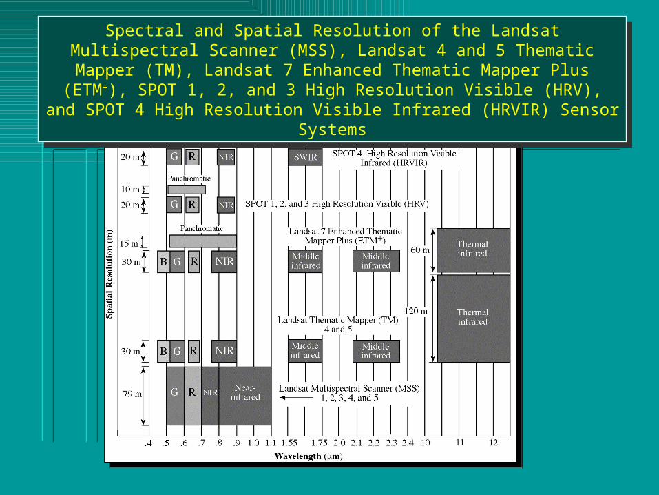
Spectral and Spatial Resolution of the Landsat Multispectral Scanner (MSS), Landsat 4 and 5 Thematic Mapper (TM), Landsat 7 Enhanced Thematic Mapper Plus (ETM+),
SPOT 1, 2, and 3 High Resolution Visible (HRV), and SPOT 4 High Resolution Visible Infrared (HRVIR) Sensor Systems
Spectral and Spatial Resolution of the Landsat Multispectral Scanner (MSS), Landsat 4 and 5 Thematic Mapper (TM), Landsat 7 Enhanced Thematic Mapper Plus (ETM+),
SPOT 1, 2, and 3 High Resolution Visible (HRV), and SPOT 4 High Resolution Visible Infrared (HRVIR) Sensor Systems

Seven Bands of Landsat Thematic Mapper Data of
Charleston, SC, Obtained on February 3, 1994
Seven Bands of Landsat Thematic Mapper Data of
Charleston, SC, Obtained on February 3, 1994

Landsat 7 Enhanced Thematic Mapper PlusLandsat 7 Enhanced Thematic Mapper Plus

Landsat 7 Image of Palm Spring, CA
30 x 30 m (bands 4,3,2 = RGB)
Landsat 7 Image of Palm Spring, CA
30 x 30 m (bands 4,3,2 = RGB)

Landsat 7 Image of Palm Spring, CA
30 x 30 m (bands 7,4,2 = RGB)
Landsat 7 Image of Palm Spring, CA
30 x 30 m (bands 7,4,2 = RGB)

Landsat 8 --- 11 bands
OLI- Operational Land Imager
TIRS - Thermal InfraRed Sensor

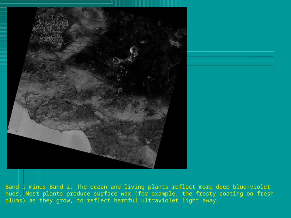
Band 1 minus Band 2. The ocean and living plants reflect more deep blue-violet hues. Most plants produce surface wax (for example, the frosty coating on fresh plums) as they grow, to reflect harmful ultraviolet light away.

• Band 9 (covering only a tiny slice of EMR) is just for clouds! Here it’s picking up fluffy cumulus clouds, but it’s designed especially for cirrus clouds.

Chronological Launch History of the SPOT SatellitesChronological Launch History of the SPOT Satellites
Sensor:
SPOT 1,2,3: HRV (High Resolution Visible)
SPOT 4: HRVIR(High Resolution Visible and Infrared)

SPOT NADIR ViewSPOT NADIR View
60 km swath width
Equator
117 km total width
3 km overlap
HRV or HRVIR
instruments
Bus
Solar panel
Orbit
SPOT Nadir Viewing
60 km swath width
Equator
117 km total width
3 km overlap
HRV or HRVIR
instruments
Bus
Solar panel
Orbit
SPOT Nadir Viewing
60 km swath width
3 km overlap
117 km total width

SPOT Off -NADIR ViewSPOT Off -NADIR View
Nadir data collection
Off-Nadir Viewing
Off-nadir data
collection
Orbital track at nadir
Nadir data collection
Off-Nadir Viewing
Off-nadir data
collection
Orbital track at nadir

SPOT Off -NADIR Revisit CapabilitiesSPOT Off -NADIR Revisit Capabilities
One pass on days: D+10 D+5 D D-5
Swath observed
60 km
One pass on days: D+10 D+5 D D-5
Swath observed
60 km
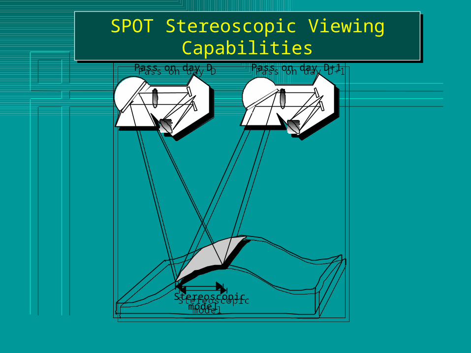
SPOT Stereoscopic Viewing CapabilitiesSPOT Stereoscopic Viewing Capabilities
Stereoscopic model
Pass on day D Pass on day D+1
Stereoscopic model
Pass on day D Pass on day D+1
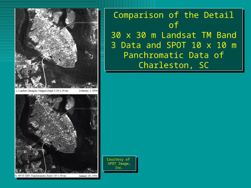
Comparison of the Detail of30 x 30 m Landsat TM Band 3 Data and SPOT 10 x 10 m Panchromatic
Data of Charleston, SC
Comparison of the Detail of30 x 30 m Landsat TM Band 3 Data and SPOT 10 x 10 m Panchromatic
Data of Charleston, SC
Courtesy of SPOT Image, Inc.
Courtesy of SPOT Image, Inc.

Geographic Coverage of the SPOT HRV and Landsat Thematic Mapper Remote Sensing Systems
Geographic Coverage of the SPOT HRV and Landsat Thematic Mapper Remote Sensing Systems

SPOT Pan Image Orlando FL SPOT Pan Image Orlando FL


Weather Satellites and Sensors
• Examples:• (1) GOES (Geostationary Operational
Environmental Satellite) • (2) NOAA AVHRR (Advanced Very High
Resolution Radiometer)

GOES Hurricane Image
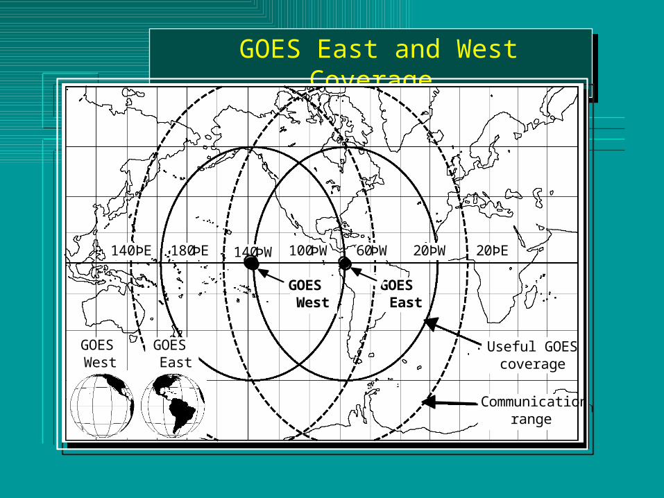
GOES East and West Coverage GOES East and West Coverage
140ÞE 180ÞE 20ÞE
Useful GOES coverage
Communication range
GOES West
GOES East
140ÞW 100ÞW 60ÞW 20ÞW
GOES West
GOES East
140ÞE 180ÞE 20ÞE
Useful GOES coverage
Communication range
GOES West
GOES East
140ÞW 100ÞW 60ÞW 20ÞW
GOES West
GOES East

GOES East Coverage GOES East Coverage
GOES East Infrared
August 25, 1989
GOES East Infrared
August 25, 1989
GOES East Visible
August 25, 1989
GOES East Visible
August 25, 1989

Advanced Very High Resolution Radiometer (AVHRR) Data Acquisition Characteristics
Advanced Very High Resolution Radiometer (AVHRR) Data Acquisition Characteristics
• Visible, NIR, Thermal• 1.1 km Resolution - local area coverage (LAC)• 4 km Resolution - global area coverage (GAC)• Used for meteorological studies• Vegetation pattern analysis• Gaining popularity for global modeling• Broad spectral bands• Not ideally suited for vegetation but used to determine
general patterns.

Advanced Very High Resolution Radiometer (AVHRR) Mosaic of the Conterminous United States
Advanced Very High Resolution Radiometer (AVHRR) Mosaic of the Conterminous United States

Global Normalized Difference Vegetation Index (NDVI) Image Produced Using Advanced Very High
Resolution Radiometer (AVHRR) Imagery
Global Normalized Difference Vegetation Index (NDVI) Image Produced Using Advanced Very High
Resolution Radiometer (AVHRR) Imagery

IKONOS Panchromatic Images
of Washington, DC
IKONOS Panchromatic Images
of Washington, DC
1 x 1 m spatial resolution1 x 1 m spatial resolution
High Spatial Resolution Sensor: IKONOS
http://www.spaceimaging.com
Panchromatic: 1m
MX: 4m

IKONOS Panchromatic Stereopair of Columbia, SC AirportIKONOS Panchromatic Stereopair of Columbia, SC Airport
November 15, 2000November 15, 2000

IKONOS Imagery of Columbia, SC Obtained on October 28, 2000IKONOS Imagery of Columbia, SC Obtained on October 28, 2000
Panchromatic 1 x 1 mPanchromatic 1 x 1 m Pan-sharpened multispectral 4 x 4 mPan-sharpened multispectral 4 x 4 m

Hyper-spectral Remote Sensing:Imaging Spectrometry
Hyper-spectral Remote Sensing:Imaging Spectrometry

Hyper-spectral SensorNASA AVIRIS: Airborne Visible Infrared Imaging Spectrometer
Hyper-spectral SensorNASA AVIRIS: Airborne Visible Infrared Imaging Spectrometer

Hyperspectral Crop Classification Using
AVIRIS Data
Hyperspectral Crop Classification Using
AVIRIS Data

Earth Observing System - Terra InstrumentsEarth Observing System - Terra Instruments
ASTER - Advanced Spaceborne Thermal Emission and Reflection RadiometerCERES - Clouds and the Earth’s Radiant Energy SystemMISR - Multi-angle Imaging SpectroradiometerMODIS - Moderate-resolution Imaging SpectroradiometerMOPITT - Measurement of Pollution in the Troposphere
ASTER - Advanced Spaceborne Thermal Emission and Reflection RadiometerCERES - Clouds and the Earth’s Radiant Energy SystemMISR - Multi-angle Imaging SpectroradiometerMODIS - Moderate-resolution Imaging SpectroradiometerMOPITT - Measurement of Pollution in the Troposphere

Earth Observing System - Terra Instruments Earth Observing System - Terra Instruments
MODIS - Moderate-resolution Imaging Spectroradiometer
Spectral Range 0.4 - 14.4 mmSpatial Resolution 250 m (2 bands), 500 m (5 bands), 1000 m (29 bands)
MODIS - Moderate-resolution Imaging Spectroradiometer
Spectral Range 0.4 - 14.4 mmSpatial Resolution 250 m (2 bands), 500 m (5 bands), 1000 m (29 bands)
ASTER - Advanced Spaceborne Thermal Emission and Reflection Radiometer
Spectral Range VNIR 0.4 - 14.4 mm, SWIR 1.6 - 2.5 mm, TIR 8 - 12 mmSpatial Resolution 15 m (VNIR : 3 bands)
30 m (SWIR: 6 bands) 90 m (TIR: 5 bands)
ASTER - Advanced Spaceborne Thermal Emission and Reflection Radiometer
Spectral Range VNIR 0.4 - 14.4 mm, SWIR 1.6 - 2.5 mm, TIR 8 - 12 mmSpatial Resolution 15 m (VNIR : 3 bands)
30 m (SWIR: 6 bands) 90 m (TIR: 5 bands)

• EOS Data Gateway (Free data)
http://edcimswww.cr.usgs.gov/pub/imswelcome/