multivariate statistical analyses of groundwater surrounding fortymile wash paper 7191 presented at:...
TRANSCRIPT

Multivariate Statistical Analyses of Groundwater Surrounding
Fortymile WashPaper 7191 Presented at:
Waste Management 07’ SymposiumTuesday, February 25 - March 1, 2007
Session 29:Performance Assessment of Geological Disposal Systems
Tuesday, February 27, 2007: 8:30 AMTucson Convention Center Room: Coconino
By:
Arturo Woocay and John C. Walton Environmental Science and Engineering
The University of Texas at El Paso

Acknowledgement
This work was funded by the Nye County, Nevada, Nuclear Waste Repository ProjectOffice through cooperative research grant DE-FC28-02RW12163 from the U.S. Department of Energy, Office of Civilian Radioactive Waste Management

February 27, 2007
Woocay-Walton: Multivariate Statistical Analyses of Groundwater Surrounding Fortymile Wash 3
Overview
• Introduction• Yucca Mountain Region
• Amargosa Desert Region Water Levels
• Geochemical Data from the Region
• Previous Work
• Introduction to Multivariate Statistical Methods (MSM)
• Correspondence analysis (CA)
• k-means Cluster Analysis (KMCA)

February 27, 2007
Woocay-Walton: Multivariate Statistical Analyses of Groundwater Surrounding Fortymile Wash 4
Overview (Cont’d)
• MSM Results• Nine separate hydrochemical facies
• At least two potential flowpaths
• Very distinct flowpath under Fortymile Wash
• Corroborating Isotopic Data• Oxygen-18
• Hydrogen-2
• Hydrogen-2 vs Oxygen-18 compared to GMWL
• Conclusions
February 27, 2007
Woocay-Walton: Multivariate Statistical Analyses of Groundwater Surrounding Fortymile Wash 5
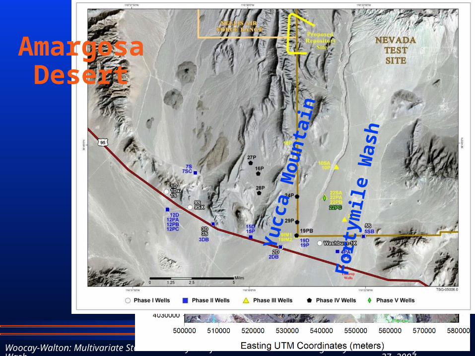
Amargosa Desert
Yu
cca
Mo
un
tain
Fo
rtym
ile W
ash

February 27, 2007
Woocay-Walton: Multivariate Statistical Analyses of Groundwater Surrounding Fortymile Wash 6
Amargosa Desert Region
Water
Levels
460000 480000 500000 520000 540000 560000 580000
3940000
3960000
3980000
4000000
4020000
4040000
4060000
4080000
4100000
D eathValley
D eathValley
Tim berM ountain
AshM eadows
Am argosa D esert
Southern Extentof
Am argosa R iver
CraterF lat
JackassFlat
Hw y 95
Hw y 95
Am argosaFlat
ShoshoneM ounta in
460000 480000 500000 520000 540000 560000 580000
3940000
3960000
3980000
4000000
4020000
4040000
4060000
4080000
4100000
Easting UTM Coordinates (m eters)
Nor
thin
g U
nive
rsal
Tra
nsve
rse
Mer
cato
r (U
TM) C
oord
inat
es (m
eter
s)
460000 485000 510000 535000 560000
3950000
3975000
4000000
4025000
4050000
4075000
4100000
Easting U TM Coordinates (m eters)
Nor
thin
g U
nive
rsal
Tra
nsve
rse
Mer
cato
r (U
TM) C
oord
inat
es (m
eter
s)

February 27, 2007
Woocay-Walton: Multivariate Statistical Analyses of Groundwater Surrounding Fortymile Wash 7
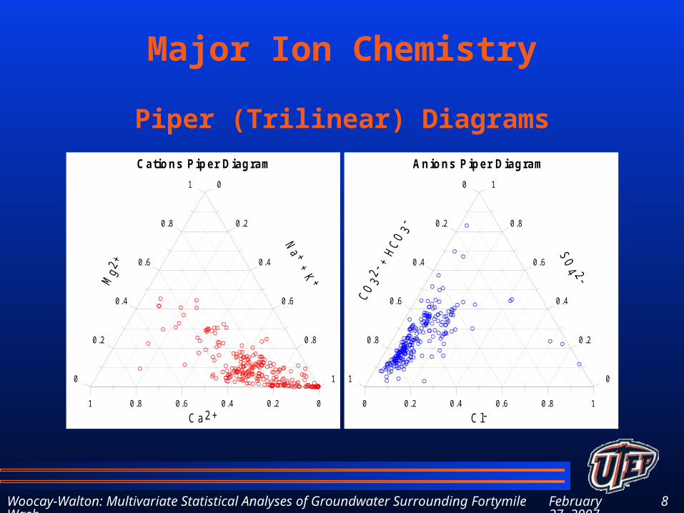
Major Ion Chemistry from the Amargosa Desert Region
Major IonspH
Ca2+ (mg/L)
Mg2+ (mg/L)
Na+ (mg/L)
K+ (mg/L)
Cl- (mg/L)
SO42- (mg/L)
Total Alkalinity (CaCO3 mg/L)
• 211 wells/springs
• Use MSM:
CA & KMCA
February 27, 2007
Woocay-Walton: Multivariate Statistical Analyses of Groundwater Surrounding Fortymile Wash 8
Major Ion Chemistry
Piper (Trilinear) Diagrams
1 0.8 0.6 0.4 0.2 0
Ca2+
0
0.2
0.4
0.6
0.8
10
0.2
0.4
0.6
0.8
1
Cations Piper Diagram
0 0.2 0.4 0.6 0.8 1
Cl-
1
0.8
0.6
0.4
0.2
01
0.8
0.6
0.4
0.2
0
Anions Piper Diagram

February 27, 2007
Woocay-Walton: Multivariate Statistical Analyses of Groundwater Surrounding Fortymile Wash 9
Introduction to MSM
• MSM are powerful tools for:• Investigating large complex data sets
• Identifying parameters that describe a system and its behavior
• Discovering patterns and relationships

February 27, 2007
Woocay-Walton: Multivariate Statistical Analyses of Groundwater Surrounding Fortymile Wash 10
Introduction to MSM (Cont’d)
• Some types of MSM:• Principal Component Analysis
• Canonical Correlation Analysis
• Factor Analysis
• Correspondence Analysis (CA)
• Cluster Analysis• k-means Cluster Analysis (KMCA)

February 27, 2007
Woocay-Walton: Multivariate Statistical Analyses of Groundwater Surrounding Fortymile Wash 11
Correspondence Analysis
• A weighted Principal Component Analysis (PCA) of a contingency table
• Transforms correlated data into mutually orthogonal dimensions
• Each successive dimension includes decreasing amounts of variation
• Better that PCA for finding and interpreting nonlinearity in the system
• Reduce number of dimensions of the system
February 27, 2007
Woocay-Walton: Multivariate Statistical Analyses of Groundwater Surrounding Fortymile Wash 12
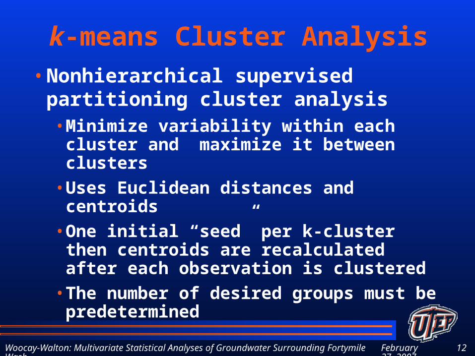
k-means Cluster Analysis
• Nonhierarchical supervised partitioning cluster analysis • Minimize variability within each cluster
and maximize it between clusters
• Uses Euclidean distances and centroids
• One initial “seed” per k-cluster then centroids are recalculated after each observation is clustered
• The number of desired groups must be predetermined

February 27, 2007
Woocay-Walton: Multivariate Statistical Analyses of Groundwater Surrounding Fortymile Wash 13
MSM Results
• Using Major Ion data from 211 wells/springs in the Amargosa Desert Region
• CA conducted in Statistica 7• Reduce the number of variables
• Detect relationships between variables
• k-means Cluster Analysis (CA)• Nonhierarchical supervised partitioning CA
• Empirically determined 9 groups
• Analyze the first 3 CA dimensions

February 27, 2007
Woocay-Walton: Multivariate Statistical Analyses of Groundwater Surrounding Fortymile Wash 14
Interpretation of CA Dimensions
Dimensions Coordinates for Major Ion Data
Dim 1 Dim 2 Dim 3
pH -0.328 0.057 -0.145
Ca2+ 0.319 0.293 -0.207
Mg2+ 0.576 0.594 0.210
Na+ -0.169 -0.179 0.028
K+ 0.117 0.089 -0.199
Cl- 0.233 -0.348 -0.281
SO42- 0.360 -0.118 0.104
Alkalinity -0.146 0.102 0.013
Explained Variation %
50.3 28.6 9.6
• Dimension 1: • Separation of pH, Alkalinity &
Na+ from Ca2+ & Mg2+ and Cl- & SO4
2-
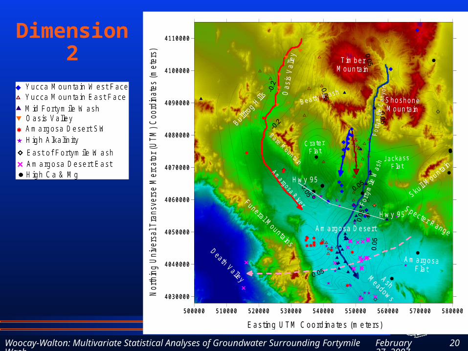
• Dimension 2: • Separation of Ca2+ & Mg2+ from
Cl-, Na+ & SO42-
• Dimension 3:• Explains less than 10% of
variation
February 27, 2007
Woocay-Walton: Multivariate Statistical Analyses of Groundwater Surrounding Fortymile Wash 15
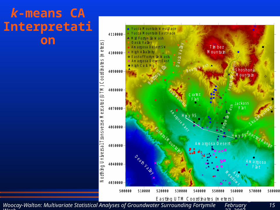
k-means CA Interpretation
500000 510000 520000 530000 540000 550000 560000 570000 580000
4030000
4040000
4050000
4060000
4070000
4080000
4090000
4100000
4110000
500000 510000 520000 530000 540000 550000 560000 570000 580000
4030000
4040000
4050000
4060000
4070000
4080000
4090000
4100000
4110000
Am argosa D esert
C raterF lat
JackassF lat
For
tym
ile W
ash
Amargosa R iver
Bare Mounta in
For
tym
ille
Can
yon
Oas
is V
alle
y
Beatty W ash
Hw y 95
Hw y 95
Skull Mountain
Specter RangeBullfr
og Hills
Am argosaFlat
ShoshoneM ountain
Death Valley
T im berM ounta in
Funeral Mountains
AshM
eadows
Easting U TM Coordinates (m eters)
Nor
thin
g U
nive
rsal
Tra
nsve
rse
Mer
cato
r (U
TM) C
oord
inat
es (m
eter
s)
Yucca M ountain W est FaceYucca M ountain East FaceM id Fortym ile W ash
East of Fortym ile W ashAm argosa Desert East
Am argosa Desert SWO asis Valley
H igh Ca & M g
High A lkalin ity

February 27, 2007
Woocay-Walton: Multivariate Statistical Analyses of Groundwater Surrounding Fortymile Wash 16
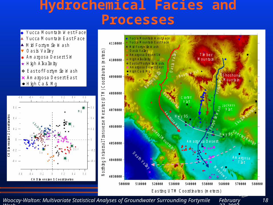
Biplot of Dimension 1 - Dimension 2
Can Identify 9 Separate Groups with Cluster Analysis

February 27, 2007
Woocay-Walton: Multivariate Statistical Analyses of Groundwater Surrounding Fortymile Wash 17
Summary of Major Ions by Group
Group Name pHCa2+
(mg/L)Mg2+
(mg/L)Na+
(mg/L)K+
(mg/L)Cl-
(mg/L)SO4
2-
(mg/L)
Alkalinityas CaCO3
(mg/L)
TDS (mg/L)
Yucca Mountain West Face 8.5 2.7 0.2 88 2.4 7.4 26 160 315
Yucca Mountain East Face 7.8 13 1.2 62 4.0 11 26 125 270
Mid Fortymile Wash 7.8 22 2.5 41 6.3 8.7 25 110 230
Oasis Valley 8.1 11 0.8 123 6.0 42 77 160 455
Amargosa Desert SW 7.8 46 8.9 128 10 56 157 195 645
High Alkalinity 7.9 26 9.2 91 9.8 16 69 215 485
East ofFortymile Wash 8.2 16 3.2 114 6.6 23 115 145 455
Amargosa Desert East 7.7 40 13 97 12 25 130 205 570
High Ca & Mg 7.7 56 28 70 7.8 18 110 255 600
February 27, 2007
Woocay-Walton: Multivariate Statistical Analyses of Groundwater Surrounding Fortymile Wash 18
500000 510000 520000 530000 540000 550000 560000 570000 580000
4030000
4040000
4050000
4060000
4070000
4080000
4090000
4100000
4110000
500000 510000 520000 530000 540000 550000 560000 570000 580000
4030000
4040000
4050000
4060000
4070000
4080000
4090000
4100000
4110000
Am argosa D esert
C raterF lat
JackassF lat
For
tym
ile W
ash
Amargosa R iver
Bare Mounta in
For
tym
ille
Can
yon
Oas
is V
alle
y
Beatty W ash
Hw y 95
Hw y 95
Skull Mountain
Specter RangeBullfr
og Hills
Am argosaF lat
ShoshoneM ountain
Death Valley
T im berM ounta in
Funeral Mountains
AshM
eadows
Easting UTM Coordinates (m eters)
Nor
thin
g U
nive
rsal
Tra
nsve
rse
Mer
cato
r (U
TM) C
oord
inat
es (m
eter
s)
Yucca M ountain W est FaceYucca M ountain East FaceM id Fortym ile W ash
East of Fortym ile W ashAm argosa Desert East
Am argosa Desert SWOasis Valley
H igh Ca & M g
High A lkalinity
Hydrochemical Facies and Processes

February 27, 2007
Woocay-Walton: Multivariate Statistical Analyses of Groundwater Surrounding Fortymile Wash 19
Dimension 1
500000 510000 520000 530000 540000 550000 560000 570000 580000
4030000
4040000
4050000
4060000
4070000
4080000
4090000
4100000
4110000
500000 510000 520000 530000 540000 550000 560000 570000 580000
4030000
4040000
4050000
4060000
4070000
4080000
4090000
4100000
4110000
Am argosa D esert
C raterF lat
JackassF lat
For
tym
ile W
ash
Amargosa R iver
Bare Mounta in
For
tym
ille
Can
yon
Oas
is V
alle
y
Beatty W ash
Hw y 95
Hw y 95
Skull Mountain
Specter Range
Bullfrog H
ills
Am argosaF lat
ShoshoneM ountain
Death Valley
T im berM ounta in
Funeral Mountains
AshM
eadows
Easting UTM Coordinates (m eters)
Nor
thin
g U
nive
rsal
Tra
nsve
rse
Mer
cato
r (U
TM) C
oord
inat
es (m
eter
s)
February 27, 2007
Woocay-Walton: Multivariate Statistical Analyses of Groundwater Surrounding Fortymile Wash 20
500000 510000 520000 530000 540000 550000 560000 570000 580000
4030000
4040000
4050000
4060000
4070000
4080000
4090000
4100000
4110000
500000 510000 520000 530000 540000 550000 560000 570000 580000
4030000
4040000
4050000
4060000
4070000
4080000
4090000
4100000
4110000
Am argosa D esert
C raterF lat
JackassF lat
For
tym
ile W
ash
Amargosa R iver
Bare Mounta in
For
tym
ille
Can
yon
Oas
is V
alle
y
Beatty W ash
Hw y 95
Hw y 95
Skull Mountain
Specter RangeBullfr
og Hills
Am argosaF lat
ShoshoneM ountain
Death Valley
T im berM ounta in
Funeral Mountains
AshM
eadows
Easting UTM Coordinates (m eters)
Nor
thin
g U
nive
rsal
Tra
nsve
rse
Mer
cato
r (U
TM) C
oord
inat
es (m
eter
s)
Dimension 2

February 27, 2007
Woocay-Walton: Multivariate Statistical Analyses of Groundwater Surrounding Fortymile Wash 21
MSM Conclusions
• GW chemistry reflects prominent surface features more that contemporary water levels
• GW chemistry below Oasis Valley and following the Amargosa River
• GW below Yucca Mountain different from Fortymile Wash
• Some connection between Amargosa Valley and Death Valley
• Possible upwelling from carbonate aquifer
• Very distinct signature around Fortymile Wash

February 27, 2007
Woocay-Walton: Multivariate Statistical Analyses of Groundwater Surrounding Fortymile Wash 22
Corroborating Isotopic Data
• Oxygen-18
• Hydrogen-2
• Hydrogen-2 vs Oxygen-18 compared to GMWL

February 27, 2007
Woocay-Walton: Multivariate Statistical Analyses of Groundwater Surrounding Fortymile Wash 23
500000 510000 520000 530000 540000 550000 560000 570000 580000
4030000
4040000
4050000
4060000
4070000
4080000
4090000
4100000
4110000
500000 510000 520000 530000 540000 550000 560000 570000 580000
4030000
4040000
4050000
4060000
4070000
4080000
4090000
4100000
4110000
Am argosa D esert
C raterF lat
JackassF lat
For
tym
ile W
ash
Amargosa R iver
Bare Mounta in
For
tym
ille
Can
yon
Oas
is V
alle
y
Beatty W ash
Hw y 95
Hw y 95
Skull Mountain
Specter RangeBullfr
og Hills
Am argosaF lat
ShoshoneM ountain
Death Valley
T im berM ounta in
Funeral Mountains
AshM
eadows
Easting UTM Coordinates (m eters)
Nor
thin
g U
nive
rsal
Tra
nsve
rse
Mer
cato
r (U
TM) C
oord
inat
es (m
eter
s)δ18O

February 27, 2007
Woocay-Walton: Multivariate Statistical Analyses of Groundwater Surrounding Fortymile Wash 24
δ2H
500000 510000 520000 530000 540000 550000 560000 570000 580000
4030000
4040000
4050000
4060000
4070000
4080000
4090000
4100000
4110000
500000 510000 520000 530000 540000 550000 560000 570000 580000
4030000
4040000
4050000
4060000
4070000
4080000
4090000
4100000
4110000
Am argosa D esert
C raterF lat
JackassF lat
For
tym
ile W
ash
Amargosa R iver
Bare Mounta in
For
tym
ille
Can
yon
Oas
is V
alle
y
Beatty W ash
Hw y 95
Hw y 95
Skull Mountain
Specter RangeBullfr
og Hills
Am argosaF lat
ShoshoneM ountain
Death Valley
T im berM ounta in
Funeral Mountains
AshM
eadows
Easting UTM Coordinates (m eters)
Nor
thin
g U
nive
rsal
Tra
nsve
rse
Mer
cato
r (U
TM) C
oord
inat
es (m
eter
s)

February 27, 2007
Woocay-Walton: Multivariate Statistical Analyses of Groundwater Surrounding Fortymile Wash 25
Deviation form the GMWL
http://www.sahra.arizona.edu

February 27, 2007
Woocay-Walton: Multivariate Statistical Analyses of Groundwater Surrounding Fortymile Wash 26
δ2H vs. δ18O• Cold (7oC)
• S = 6.1
• More humid and colder climate than contemporary
(Clark and Fritz 1997, p. 49 after Gat, 1980)
Craig 8 10 1961,
Int At Engy Agy (IAEA) global network 8.13 10.8
IAEA World Met Org (WMO) 8.17 11.27 true

February 27, 2007
Woocay-Walton: Multivariate Statistical Analyses of Groundwater Surrounding Fortymile Wash 27
δ 2H vs. δ18O
• Down Fortymile Wash
• Following the Amargosa River
• Mixing with Amargosa River

February 27, 2007
Woocay-Walton: Multivariate Statistical Analyses of Groundwater Surrounding Fortymile Wash 28
Conclusions• Distinct signature along Fortymile Wash
• Closely follows topography• Lower TDS than adjacent water• Younger than adjacent groundwater
• Implying: focused infiltration in the past of colder surface water in the wash that decreased as runoff events diminished
• Runoff events diminished as climate became warmer and dryer
• Contemporary groundwater flow may be slower than currently predicted

February 27, 2007
Woocay-Walton: Multivariate Statistical Analyses of Groundwater Surrounding Fortymile Wash 29
500000 510000 520000 530000 540000 550000 560000 570000 580000
4030000
4040000
4050000
4060000
4070000
4080000
4090000
4100000
4110000
500000 510000 520000 530000 540000 550000 560000 570000 580000
4030000
4040000
4050000
4060000
4070000
4080000
4090000
4100000
4110000
Am argosa D esert
C raterF lat
JackassF lat
For
tym
ile W
ash
Amargosa R iver
Bare Mountain
For
tym
ille
Can
yon
Oas
is V
alle
y
Beatty W ash
Hw y 95
Hw y 95
Skull Mounta in
Specter Range
Bullfrog H
ills
Am argosaFlat
ShoshoneM ountain
Death Valley
T im berM ounta in
Funera l Mountains
AshM
eadows
Easting U TM Coordinates (m eters)
Nor
thin
g U
nive
rsal
Tra
nsve
rse
Mer
cato
r (U
TM) C
oord
inat
es (m
eter
s)
Yucca M ountain W est FaceYucca M ountain East FaceM id Fortym ile W ash
East of Fortym ile W ashAm argosa Desert East
Am argosa Desert SWOasis Valley
H igh Ca & M g
High A lkalinity
Questions?

February 27, 2007
Woocay-Walton: Multivariate Statistical Analyses of Groundwater Surrounding Fortymile Wash 30
Predicted Saturated Zone Particle Trajectories from Yucca Mountain
From:
Technical Basis Document No 11:
Saturated Zone Flow and Transport Revision 2
February 27, 2007
Woocay-Walton: Multivariate Statistical Analyses of Groundwater Surrounding Fortymile Wash 31
ISIP Background• The Nuclear Waste Policy Act (NWPA) in 1983 directed DOE to develop
a geologic repository to dispose of the nation’s spent nuclear fuel and high-level waste.
• In 1987, Congress amended the NWPA and designated Yucca Mountain as the only site to be considered.
• The NWPA authorizes Nye County as the "site" jurisdiction and host county, to conduct on-site representation at Yucca Mountain.
• In 1987 Nye County Board of Commissioners creates the Nye County Nuclear Waste Repository Project Office (NWRPO) to monitor and assess the federal effort to find a repository site.
• In 1993, the County hired a full-time on-site representative and the Independent Scientific Investigations Program (ISIP) is established.
• Though ISIP the County gathers data for independent analysis of geologic and hydrologic conditions and monitors and reviews DOE's scientific characterization of Yucca Mountain
• ISIP activities involve drilling and instrumenting boreholes, analyzing the geology and geochemistry of drill cuttings, instrumenting tunnels and drifts, monitoring, data analysis, and numerical modeling activities to address the concerns of Nye County.

February 27, 2007
Woocay-Walton: Multivariate Statistical Analyses of Groundwater Surrounding Fortymile Wash 32
ISIP Background• The Nuclear Waste Policy Act (NWPA) in 1983 directed DOE to develop
a geologic repository to dispose of the nation’s spent nuclear fuel and high-level waste.
• In 1987, Congress amended the NWPA and designated Yucca Mountain as the only site to be considered.
• The NWPA authorizes Nye County as the "site" jurisdiction and host county, to conduct on-site representation at Yucca Mountain.
• In 1987 Nye County Board of Commissioners creates the Nye County Nuclear Waste Repository Project Office (NWRPO) to monitor and assess the federal effort to find a repository site.
• In 1993, the County hired a full-time on-site representative and the Independent Scientific Investigations Program (ISIP) is established.
• Though ISIP the County gathers data for independent analysis of geologic and hydrologic conditions and monitors and reviews DOE's scientific characterization of Yucca Mountain
• ISIP activities involve drilling and instrumenting boreholes, analyzing the geology and geochemistry of drill cuttings, instrumenting tunnels and drifts, monitoring, data analysis, and numerical modeling activities to address the concerns of Nye County.
February 27, 2007
Woocay-Walton: Multivariate Statistical Analyses of Groundwater Surrounding Fortymile Wash 33
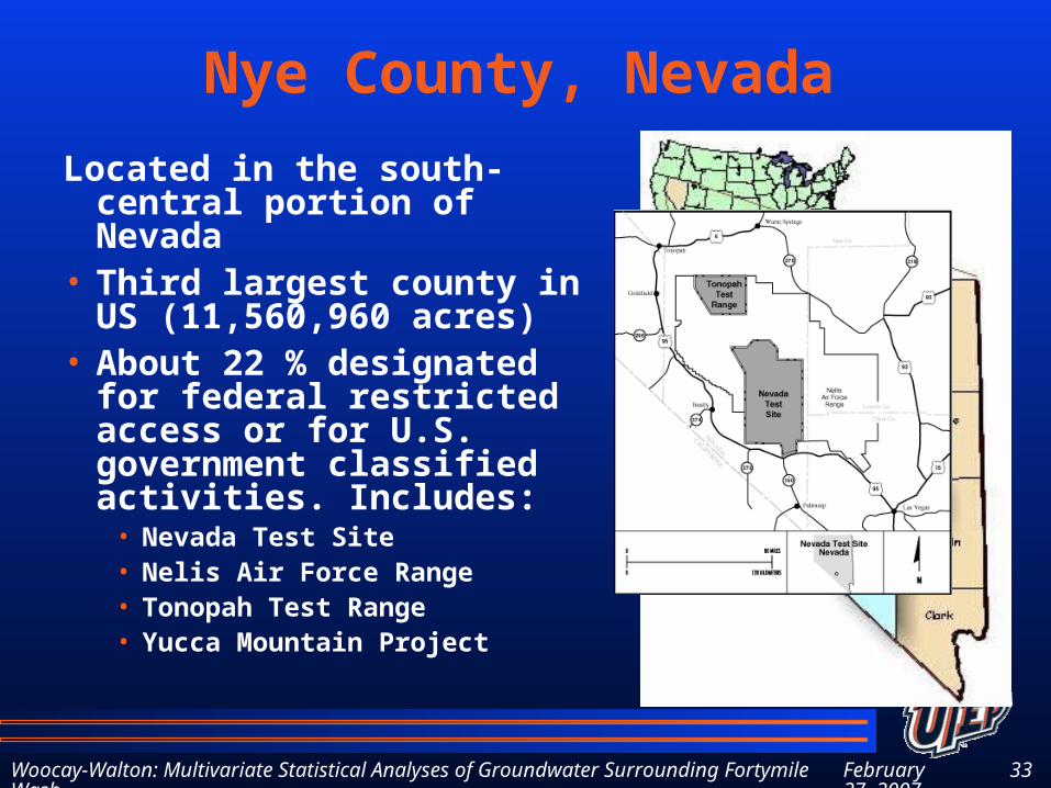
Nye County, Nevada
Located in the south-central portion of Nevada
• Third largest county in US (11,560,960 acres)
• About 22 % designated for federal restricted access or for U.S. government classified activities. Includes:
• Nevada Test Site• Nelis Air Force Range• Tonopah Test Range• Yucca Mountain Project