municipal code title 16 - development code
TRANSCRIPT

Municipal Code Title 16 - Development Code
WALDPORT MUNICIPAL CODE
TITLE 16 – DEVELOPMENT CODE
Chapters:
16.04 Introductory Provisions and Definitions
16.08 Basic Provisions
16.12 Residential Zone R-1
16.16 Residential Zone R-2
16.20 Residential Zone R-3
16.24 Residential Zone R-4
16.28 Retail Commercial Zone C-1
16.32 General Commercial Zone C-2
16.36 Planned Industrial Zone I-P
16.44 Marine Waterway Zone M-W
16.48 Planned Marine and Recreation Zone M-P
16.52 Public Facilities Zone P-F
16.56 Single-Wide Mobile Home Overlay Zone S-W
16.60 Planned Development Zone P-D
16.64 Coastal Shorelands Overlay Zone C-S
http://www.waldport.org/Waldport_Municipal_Code_files/title_16_text.htm (1 of 121)12/29/2005 6:48:05 AM

Municipal Code Title 16 - Development Code
16.68 Flood Hazard Overlay Zone
16.70 Significant Natural Resources Overlay Zone
16.72 Supplementary Regulations
16.76 Signs
16.80 Exceptions
16.84 Conditional Uses
16.88 Nonconforming Uses
16.92 Variances
16.96 Development Guidelines
16.100 Land Division
16.104 Amendments
16.108 Administrative Provisions
16.112 Remedies
16.116 Effect
(Adopted by the Waldport City Council on September 6, 2001 by Ordinance No. 676.)
Chapter 16.04
INTRODUCTORY PROVISIONS AND DEFINITIONS
Sections:16.04.010 Title.
http://www.waldport.org/Waldport_Municipal_Code_files/title_16_text.htm (2 of 121)12/29/2005 6:48:05 AM

Municipal Code Title 16 - Development Code
16.04.020 Purpose.16.04.030 Definitions.16.04.040 Interpretations.16.04.050 Limitation.16.04.060 Effects on other ordinances.
16.04.010 Title. The code provisions of this title revise and replace the existing provisions of the city of Waldport development code and shall be referred to as the Waldport Development Code.
16.04.020 Purpose. The purpose of the code is to promote the public health, safety and general welfare and to assist in the implementation of the comprehensive plan for the city of Waldport.
16.04.030 Definitions. As used in this code the following words and phrases shall mean: "Access" means the way or means by which pedestrians and/or vehicles enter and leave property. "Accessory structure or use" means a structure or use incidental and subordinate to the main use of a property and located on the same lot as the main use. "Airport" means a tract of land or water that is maintained for the landing and take-off of aircraft and for receiving and discharging passengers and cargo and the repair, storage and supplying of aircraft. "Alley" means a public way, providing a secondary means of access to property. "Alter" means to change any of the supporting members of a building or structure, such as: bearing walls, columns, beams or girders. "Aquaculture" means the raising, feeding, planting and harvesting of fish, shellfish or marine plants, including facilities necessary to engage in the use. "Automobile" means: 1. "Repair garage" means a use providing for the major repair and maintenance of motor vehicles and includes major mechanical and body work, straightening of body parts, painting, welding or storage of motor vehicles not in operating condition. 2. "Service station" means any premise used for supplying gasoline, oil, accessories and services, and auto repair work; excluding body and fender repair except on an emergency basis, at retail direct to the customer and where inoperative car storage is limited to thirty (30) days. 3. "Wrecking yard" means any property where two or more vehicles not in
http://www.waldport.org/Waldport_Municipal_Code_files/title_16_text.htm (3 of 121)12/29/2005 6:48:05 AM
Municipal Code Title 16 - Development Code
running condition, or the parts thereof, are stored in the open and are not being restored to operation; or any land, building or structure used for the wrecking or storing of such motor vehicles or the parts thereof. "Auto detail shop" includes the following uses: (1) Shampooing and cleaning of carpet and seats, (2) complete interior cleaning, (3) cleaning and vacuuming trunks, (4) cleaning and treatment of vinyl and rubber surfaces, (5) machine buffing and waxing of exterior and chrome, (6) hand washing exterior, (7) cleaning and polishing tires and wheels, (8) engine and compartment cleaning (steam cleaning machines must be approved by the Public Works Director for inspection of sludge removal), and (9) decal and paint striping. "Base flood (one hundred (100) year flood)" means a flood having a one percent chance of being equaled or exceeded in any given year. "Basement" means a portion of a building which has less than one•half of its height measured from finished floor to finished ceiling above the average grade of the adjoining ground, and not deemed a story unless the ceiling is six (6) feet or more above the grade. "Bed and breakfast inns" means an owner-occupied or resident operated single-family dwelling, in a portion of which lodging and breakfast are provided for compensation in accordance with all conditional use provisions for bed and breakfast inns. "Blocks" means that property abutting on one side of a street and lying between the two nearest intersecting or intercepting streets and railroad right-of-way, unsubdivided acreage, watercourse or body of water. "Boarding house" means a building or portion thereof containing a single dwelling unit where a group of five (5) or less unrelated persons may live, where meals or lodging or both are provided for profit. "Breakaway walls" means walls which are not part of the structural support of the building and which are designed to break away under flood conditions without damage to the structural integrity of the building or any building to which they might be carried by flood waters. "Buildable area" includes property not subject to wetland and riparian zone restrictions contained in this title; or required to prevent erosion from progressive deterioration of the property. "Building" means a structure built or assembled for the support, shelter, or enclosure of persons, animals or personal property. "Building height" means the vertical distance from grade (see definition of "grade level") to the highest point of the roof, measured on each side of the building, and averaged together. "Carport" means a structure used to shelter a vehicle, having no enclosed uses overhead, and which is entirely open on two or more sides.
http://www.waldport.org/Waldport_Municipal_Code_files/title_16_text.htm (4 of 121)12/29/2005 6:48:05 AM

Municipal Code Title 16 - Development Code
"Chief Administrative Officer (CAO)" means the City Manager, City Administrator or other Chief Executive Officer as designated by the City Council, or his or her designee (e.g. City Planner). "Church/place of worship" means a building, together with its accessory building or uses, where persons regularly assemble for worship; and which building, together with its accessory buildings and uses, is maintained and controlled by a religious body organized to sustain public worship, and meets tax exemption status as prescribed in Chapter 307 of the Oregon Revised Statutes. "City planner" means the Waldport City Planner or other designated representative appointed by the Chief Administrative Officer or the City Council. "Clear vision area" means a triangular area at an intersection; the space being defined by a line across the corner of a lot, the ends of which are on the street lines or alley lines, an equal and specified distance from the corner. "Clinic" means a building utilized by persons licensed in the State of Oregon to treat or analyze medical or surgical needs of humans on an out-patient basis. "Coastal high hazard flood zone" means areas subject to high velocity ocean waters, including but not limited to storm surge or tsunamis. Coastal flood zones are identified on the FIRM maps as "V" zones. "Commission" means the Waldport Planning Commission. "Common Property" means a parcel of land, together with any improvements that are to be used, maintained and enjoyed by the owners and occupants of the individual building units or sites in subdivisions with common open space, planned developments or planned unit subdivisions. "Community Center" means a facility owned and operated by a governmental agency or a non-profit community organization, provided that the primary purpose of the facility is for recreation, social welfare, community improvement, or public assembly, and further provided that no permanent commercial eating or drinking facilities shall be operated. "Comprehensive plan" means the adopted comprehensive plan for Waldport as defined in ORS 197.015(4). "Conditional Use" means those uses as may be permitted after review and approval by the Planning Commission. "Condominium" means a system of ownership under which one may own an individual unit in an apartment or other building complex and share in the ownership of common elements such as the land; also refers to the buildings that are owned under such a system. "Convalescent Home" see "Nursing Home". "Council" means the City Council of Waldport. "Day care facility" means a facility accommodating fewer than 13 children for the purposes of day care in the provider's home, or meeting the definition and standards as
http://www.waldport.org/Waldport_Municipal_Code_files/title_16_text.htm (5 of 121)12/29/2005 6:48:05 AM

Municipal Code Title 16 - Development Code
contained in ORS 418. The provider's children are included for the purposes of this definition. Deck, Enclosed. "Enclosed deck" means a covered attached or unattached structure accessory to the main use of the property, having no components necessary to the structural support of the main use. Deck, Unenclosed. "Unenclosed deck" means a non•covered attached or unattached structure accessory to the main use of the property, having no components necessary to the structural support of the main use. "Density" means the number of dwelling units within a specified land area. "Development" means any man•made change or improvement involving buildings, structures, mining, dredging, filling, grading, paving, excavation, drilling, partitioning or subdividing. "Dwelling" means any building which contains one or two "dwelling units" used, intended, or designed to be built, used, rented, leased, let or hired out to be occupied, or which are occupied for living purposes. Dwelling, Multi-Family. "Multi-family dwelling" means a building consisting of three (3) or more dwelling units, with a common roof and common foundation, designed and used exclusively for the occupancy of three or more families. Dwelling, Single-Family. "Single-family dwelling" means a detached dwelling designed or used exclusively for the occupancy of one family and having housekeeping facilities for one family. Dwelling, Two-Family (Duplex). "Two-family dwelling (duplex)" means a building consisting of two separate dwelling units with a common roof and common foundation, designed and used exclusively for the occupancy of two families living independently of each other, and having housekeeping facilities for each family. "Dwelling unit" means a single unit providing complete independent living facilities for one or more persons including permanent provisions for living, sleeping, eating, cooking and sanitation. "Easement" a non-profitable interest in land owned by another that entitles its holder to a specified limited use or enjoyment. "Factory built dwelling" means a dwelling unit built substantially or entirely at a place other than the residential site, including prefabricated or modular homes, inspected and certified as having been constructed in accordance with the requirements of the Uniform Building Code and city regulations, but excluding mobile homes. "Family" means an individual, or two or more persons related by blood, marriage, adoption or legal guardianship, living together, with not more than three additional persons. "Family day care provider" means a day care provider who regularly provides day care in the provider's home in the family living quarters, except schools. "Fence" means an unroofed barrier or an unroofed enclosing structure such as
http://www.waldport.org/Waldport_Municipal_Code_files/title_16_text.htm (6 of 121)12/29/2005 6:48:05 AM
Municipal Code Title 16 - Development Code
masonry, ornamental iron, woven wire, wood pickets of solid wood or any other material used as an unroofed barrier to light, sight, air or passage. Fence, Sight-Obscuring. "Sight-obscuring fence" consists of either a continuous fence, wall, evergreen planting, or combination thereof, constructed and/or planted so as to effectively screen the particular use from view. "F.I.R.M." means flood insurance rate maps adopted by the City that delineate both the area of "special flood hazard" and risk premium zones. "Flag lot" means a lot, the major portion of which has access to a road or street by means of a narrow strip of land called the "staff". The staff shall have a minimum width and frontage of not less than 25 feet. The staff portion of a flag lot shall not be used in computing lot size for zoning and building purposes. "Flood/Flooding" means a general and temporary condition of partial or complete inundation of normally dry land areas from: 1. The overflow of inland or tidal waters; and/or 2. The unusual and rapid accumulation of runoff or surface waters from any source. "Flood hazard area" means areas of one hundred (100) year flood but not subject to high velocity ocean waters; base flood hazards have been determined. (See coastal high hazard flood zone and shallow flooding definitions for comparison). "Floodplain" means the area shown on zoning maps for the City as being subject to inundation by delineation of a base flood as determined by the U.S. Army Corps of Engineers or other means; or in absence of such delineation, subject to inundation by the highest flood of record in the area as determined by the City. "Floodplain cross section" means a profile of the ground surface perpendicular to the center line of a stream or tidal estuary. "Floodplain development" means any man-made change or improvement involving buildings, structures, mining, dredging, filling, grading, paving, excavation or drilling that alters in any way the floodplain. "Flood insurance study" means the official report provided by the Federal Insurance Administration that includes flood profiles, the Flood Boundary-Floodway Map, and the water surface elevation of the base flood. "Garage" means a building or place to shelter motor vehicles. "Grade level" means the finished ground elevation adjacent to the wall of a building. For the purposes of measuring building height, grade level shall be defined as the average height of grade along a given side of a building. "Habitable floor" means any floor usable for working, sleeping, eating, cooking, recreation or other living purpose. Height of building. See "building height" definition in this section. "High water line or mark" means the high water elevation as shown on the County Assessor's records, or as determined by the County Surveyor, based upon the
http://www.waldport.org/Waldport_Municipal_Code_files/title_16_text.htm (7 of 121)12/29/2005 6:48:05 AM

Municipal Code Title 16 - Development Code
line where normal high water elevation results in a pronounced change in vegetation characteristics. "Home occupation" means an occupation carried on within a dwelling or an accessory structure by a resident of the dwelling, where such occupation is secondary to the main use of the property as a residence and subject to the provisions of this Code. "Homeowner's Association" means an incorporated, non-profit organization operating under recorded land agreement through which (1) each lot owner in a Planned Unit Subdivision or other described land area is automatically a member, and (2) each lot is automatically subject to charge for a proportionate share of the expenses for the organization's activities such as maintaining a common property. "Hospital" means an establishment which provides sleeping and eating facilities to persons receiving medical, obstetrical or surgical care with nursing service on a continuous basis. "Hotel" means a building or portion thereof other than a single family dwelling of more than five (5) sleeping rooms designed or used for occupancy of individuals who are lodged with or without meals, and in which no provision is made for cooking in any individual room or suite. "Junk yard" means any property utilized for breaking up, dismantling, sorting, storing, distributing, buying, or selling of any scrap waste material, junk or used equipment or machinery of any nature. "Kennel" means a lot or building which provides for the keeping of four or more dogs, cats or animals at least four months of age, where such animals are kept commercially for board, propagation, training or sale. "Landscaping" means a compatible combination of natural and/or introduced vegetation and materials which provide visual enhancement to a development. "Landscaping plan" means a schematic or plot plan which indicates: 1. Areas of landscaping, including percent of lot area; 2. Type(s) of vegetation and/or materials; 3. Maintenance type and schedule, i.e. irrigation method. "Livestock" means domestic animals and fowl or types customarily raised or kept on farms for profit or other purposes. This definition does not include household pets such as dogs or cats. "Loading Space" means an off-street space or berth on the same lot or parcel with a building or use, or contiguous to a group of building or uses, for the temporary parking of a vehicle while loading or unloading persons, merchandise or materials, and which space or berth abuts on a street, alley or other appropriate means of access. "Lot" means a parcel or tract of land which is occupied or may be occupied by a structure or a use, together with yards and other open space and meets the definition of "lot of record". "Lot area" means the total horizontal area within the lot lines of a lot, exclusive of
http://www.waldport.org/Waldport_Municipal_Code_files/title_16_text.htm (8 of 121)12/29/2005 6:48:05 AM

Municipal Code Title 16 - Development Code
streets or easements of access to other property. The staff portion of a flag lot shall not be used in computing the size or area of the lot for zoning or building purposes. Lot, Corner. "Corner Lot" means a lot abutting on two or more streets other than an alley, at their intersection. A lot abutting on a curved street or streets shall be considered a corner lot if straight lines drawn from the foremost points of the side lot lines to the foremost point of the lot meet at an interior angle of less than 135 degrees. "Lot coverage" means the percentage of lot total area covered by buildings of more than one hundred twenty (120) square feet. "Lot Depth" means the average horizontal distance between the front lot line and the rear line. Lot Frontage. The front of a lot shall be construed to be the portion nearest the street. For the purpose of determining yard requirements on corner lots and through lots, all sides of a lot adjacent to a street other than an alley shall be considered frontage, and yards shall be provided as indicated in this section. Lot, Interior. "Interior lot" means a lot other than a corner lot with only one frontage on a street. "Lot Line" means the property line bounding a lot. Lot Line, Front. "Front lot line" means the property line separating the lot from the street, other than an alley. In the case of a corner lot, the shortest property line along a street, other than an alley; or, in a case where the lot does not front directly upon a public street, that lot line toward which most houses in the immediate area face. Lot Line, Rear. "Rear lot line" means the lot line or lines opposite and most distant from the front lot line. In the case of an irregular, triangular or other shaped lot, a line ten (10) feet in length within the lot parallel to and at a maximum distance from the front lot line. Lot Line, Side. "Side lot line" means any lot line or lines not a front or rear lot line. An interior side lot line is a lot line common to more than one lot or to the lot and an alley; an exterior side lot line is a lot line common to the lot and a street other than an alley. "Lot of Record" means any unit of land created as follows: 1. A lot in a platted subdivision; 2. A lot created by partitioning; 3. A unit of land described by a conveyed deed or land sales contract established prior to requirements for partitions. Lot of Record, Non-Conforming. "Non-conforming lot of record" means a parcel of land which lawfully existed as a lot in compliance with all applicable ordinances and laws at the time of creation, but which, because of the application of a subsequent zoning ordinance, no longer conforms to the lot dimension requirement for the zoning district in which it is located. Lot, Through. "Through lot" means an interior lot abutting on streets, other than
http://www.waldport.org/Waldport_Municipal_Code_files/title_16_text.htm (9 of 121)12/29/2005 6:48:05 AM

Municipal Code Title 16 - Development Code
an alley, on both of the opposite, exterior lot lines. "Lot Width" means the average horizontal distance between the side lot lines, ordinarily measured parallel to the front lot line. "Lowest Floor" for floodplain management purposes, means the lowest enclosed area (including basement). An unfinished or flood resistant enclosure, usable solely for parking of vehicles, building access or storage, in an area other than a basement area, is not considered a building's lowest floor, provided such enclosure is not built so as to render the structure in violation of the applicable non•elevation design requirements of this title. "Manager/caretaker residence" means a residence, secondary to the main use of the property, for the sole purpose of providing living quarters for the owner, operator or caretaker of a new or ongoing commercial or industrial enterprise. Manufactured Home. For construction classification purposes, "manufactured home" means a structure with a Department of Housing and Urban Development (HUD) label certifying that the structure is constructed in accordance with National Manufactured Housing Construction and Safety Standards Act of 1974 (42 U.S.C. Sections 5401 et seq.), as amended on August 22, 1981. "Manufactured home park or subdivision" for floodplain management purposes, means a parcel (or contiguous parcels) of land divided into two or more manufactured home lots for rent or sale. "Marina" means a commercial boat launch, moorage or similar facility which may include dry or wet boat storage, boat houses and related commercial activities. MHHW. The "mean higher high water (MHHW) line" is established at 7.7' of elevation within Alsea Bay. (Hatfield Marine Science Center, NOAA Tide Table for the west coast). "Mean sea level (M.S.L.)" means the average height of the surface of the sea for all stages of the tide. "Mine (quarry)" means premises from which any rock, sand, gravel, stone, topsoil, clay, mud, peat, or other mineral is removed or excavated as an industrial or commercial operation, and exclusive of excavating and grading for streets and roads and process of grading a lot preparatory to the construction of a building for which a permit has been issued by a public agency. "Mobile Home" means a detached single-family dwelling unit designed to be towed to a placement site on its own wheels and meeting the current definition requirements of ORS 446.003 (17); or 1. Residential trailers constructed before January 1, 1962; 2. Mobile houses constructed between January 1, 1962 and June 15, 1976 which met Oregon construction requirements then in effect; 3. Manufactured homes constructed to federal standards: a. "Single-wide" means a mobile home constructed and transported as a
http://www.waldport.org/Waldport_Municipal_Code_files/title_16_text.htm (10 of 121)12/29/2005 6:48:05 AM

Municipal Code Title 16 - Development Code
single frame unit. A single-wide may have extensions or tilt-out areas, but remains a single frame unit after set up. b. "Multi-wide" means a mobile home constructed and transported as two or more frame units which are structurally connected on site to form one or more dwelling units. "Mobile home park" means any place where four or more mobile homes are located within five hundred 500 feet of one another on a lot, tract or parcel of land under the same ownership, the primary purpose of which is to rent or lease space or mobile homes for a charge or fee paid of to be paid for the rental, lease or use of facilities or to offer space free in connection with securing the trade or patronage of such person. "Motel" means a building other than a single-family dwelling or series of buildings in which lodging only is offered for compensation and which may have more than two (2) sleeping rooms or units for this purpose. A motel is distinguished from a hotel primarily by providing direct independent access to and adjoining parking for each rental unit and where cooking facilities may be allowed in rooms. "New construction" means structures for which the start of construction commenced on or after the effective date of this title. "Non-conforming structure/use" means use of structure or land, or structure and land in combination which was lawfully established in compliance with all applicable ordinances and laws, but which because of the application of a subsequent zoning ordinance (1) no longer conforms to the setback, height, maximum lot coverage or other building development requirements of this title, or (2) is clearly designed and intended for uses other than any use permitted in the zoning district in which it is located. "Nursing home" means any home, place or institution which operates and maintains facilities providing convalescent or nursing care, or both, for a period exceeding twenty-four (24) hours for two or more ill or infirm patients not related to the nursing home administrator, or owner, by blood or marriage. Convalescent care may include, but need not be limited to, the procedures commonly employed in nursing and caring for the sick. A nursing home includes rest homes, convalescent homes, and assisted living facilities, but does not include a boarding home for the aged, a residential home, a residential facility, a retirement home, hotel, hospital or a licensed chiropractic facility. "Owner" means the owner of a record of real property as shown on the tax rolls of the County, or a person who is purchasing a parcel of property under contract. "Parcel" means a unit of land that is created by a partitioning of land. "Park" means an open or enclosed tract of land set apart and devoted for the purposes of pleasure, recreation, ornament, light and air for the general public. "Parking space" means an off-street enclosed or unenclosed surfaced area of not less than twenty (20) feet by nine (9) feet, exclusive of maneuvering and access area, permanently reserved for the temporary storage of one automobile, connected with
http://www.waldport.org/Waldport_Municipal_Code_files/title_16_text.htm (11 of 121)12/29/2005 6:48:05 AM

Municipal Code Title 16 - Development Code
a street or alley which affords access for automobiles. "Partition" means either an act of partitioning land or an area or tract of land partitioned as defined in O.R.S. Chapter 92.010 (see following definition). "Partition land" means to divide an area or tract of land into two or three parcels within a calendar year. "Partition Land" does not include any adjustment of a lot line by the relocation of a common boundary where an additional parcel is not created and where the existing parcel reduced in size by the adjustment is not reduced below the minimum lot size established by any applicable zoning ordinance. "Partition land" does not include a sale or grant by a person to a public agency or public body for state highway, county road, city street or other right of way purposes provided that such road or right of way complies with the applicable comprehensive plan and also does not include the sale of a lot in a recorded subdivision, even though the lot may have been acquired prior to the sale with other contiguous lots or property by a single owner. "Partition plat" includes a final map and other writing containing all the descriptions, locations, specifications, provisions and information concerning a partition. "Performance agreement" means a bond executed by a surety company licensed in the State of Oregon, or other security acceptable to the City, to insure completion of the conditions of partition approval. "Permitted outright" means allowed to be built or used without special permits or conditions. "Person" means a natural person, the heirs, executors, administrators, or assigns, or a firm, partnership, corporation, or limited liability company, its heirs, successors or assigns, or the agent of any of the aforesaid, or any political subdivisions, agency, board or bureau of the State. "Pier" means a fixed moorage facility constructed outward from the shoreline. "Planned development" means a development in which the applicable code restrictions, other than density requirements, may be modified and/or applied to the development as a whole rather than to each individual lot. A planned development involving the subdividing of property is a "planned unit development". "Planned unit subdivision" means a subdivision of land in which the individual building sites may be reduced in size but are compensated by area used in common for recreational or other open space purposes. Planned unit subdivisions involving dwelling or commercial units may incorporate detached, semi- detached, attached, single-story or multi-storied units or any combination of the afore-mentioned. Such projects may also involve religious, cultural, recreational and commercial uses and purposes. "Planning commission" means the planning commission of the City of Waldport. "Plat" means a final subdivision plat, replat or partition plat. "Principal use" means the intended and primary use of a structure or parcel of land. "Public utility" means any corporation, company, individual, association of
http://www.waldport.org/Waldport_Municipal_Code_files/title_16_text.htm (12 of 121)12/29/2005 6:48:05 AM

Municipal Code Title 16 - Development Code
individuals, or its lessees, trustees or receivers, that owns, operates, manages or controls all or any part of any plant or equipment for the conveyance of telegraph, telephone messages with or without wires, for the transportation as common carriers, or for the production, transmission, delivery or furnishing of heat, light, water or power, directly or indirectly to the public. "Public utility workshop" means a building used for the repair and/or maintenance of public utility vehicles, machinery or other equipment. "Recreation vehicle (R.V.)" means a temporary dwelling, for travel and recreation purposes, and licensed as a Motor Home, Camper or Travel Trailer. "Recreation vehicle park" means a development designed primarily for transient service in which travel trailers, pick•up campers, tent trailers and self propelled motorized vehicles are parked and used for the purpose of supplying to the public a temporary location while traveling, vacationing or recreating. "Replat" includes a final map of the reconfiguration of lots and easements of a recorded subdivision or partition plat and other writings containing all the descriptions, location, specifications, dedications and provisions and information concerning a recorded subdivision. "Residential home" means a residence, except nursing homes, operated as a group home for mentally or physically handicapped persons which may require the assistance of on-site care givers. "Road (Street)" means a public or private way created to provide vehicular and pedestrian access to one or more lots, parcels, areas or tracts of land, excluding a private way that is created to provide access to such land in conjunction with its use for forestry, mining, or agricultural purposes. 1. "Arterial or major highway" means a street designed to carry traffic from one community to another, to carry traffic to and from major traffic generators and to carry through traffic. 2. "Collector or secondary street" means a street designed to carry traffic between minor streets and the arterial system, to function as primary traffic carriers within a neighborhood, to carry traffic to local traffic generators, and in commercial and industrial areas, to provide access to commercial and industrial properties. 3. "Cul-de-sac or dead end street" means a minor street with only one outlet which provides a vehicular turnaround. 4. "Minor street" means a street designed to provide access to abutting residential property with only incidental service to through traffic. 5. "Private road" means a road created by easement. 6. "Public road" means a road dedicated for public use. "School" means any institution for learning, whether public or private, meeting State of Oregon accreditation standards. "Setback" means the horizontal distance measured perpendicular from the lot
http://www.waldport.org/Waldport_Municipal_Code_files/title_16_text.htm (13 of 121)12/29/2005 6:48:05 AM

Municipal Code Title 16 - Development Code
line to the nearest point of any structure on the lot or parcel. "Shallow flooding" means areas where the base flood depth is between one to three feet, a clearly defined channel does not exist and the path of flooding is not determinable. Areas of shallow flooding are identified on the F.I.R.M. maps as zone "A-O". "Sign" means an identification, description, illustration, or device which is affixed to or represented, directly or indirectly, upon a building, structure or land, and which directs attention to a product, place, activity, person, institution or business. Each display surface of a sign other than two surfaces splayed less than 45% and back to back on the same structure other than a building shall be considered a sign. "Special flood hazards" means areas in the floodplain subject to a one percent (1%) or greater chance of flooding in any given year. "Start of construction" includes substantial improvement, and means the date the building permit was issued, provided the actual start of construction, repair, reconstruction, placement, or other improvement was within one hundred eighty (180) days of the permit date. The actual start means either the first placement of permanent construction of a structure on-site, such as the pouring of slabs or footings, the installation of piles, the construction of columns, or any work beyond the stage of excavation; or the placement of a manufactured home on a foundation. Permanent construction does not include land preparation, such as clearing, grading and filling; nor does it include the installation of streets and/or walkways; nor does it include excavation for a basement, footings, piers, or foundations or the erection of temporary forms; nor does it include the installation on the property of accessory buildings, such as garages or sheds not occupied as dwelling units or not part of the main structure. "Step backwater analysis" means an engineering analysis developed by the Army Corps of Engineers to evaluate hydrostatic and hydrodynamic forces and titled HEC-2 "Water Surface Profiles, Generalized Computer Profile". "Story" means that portion of a building included between a floor and the ceiling next above it, exclusive of a basement. Street. (See definition for "road"). "Structural alteration" means any change to the supporting members of a building including foundations, bearing walls, or partitions, columns, beams or girders, or any structural change in the roof or in the exterior walls. "Structure" means something constructed or built and having a fixed base on, or fixed connection to, the ground or another structure. "Structure (floodplain)" as used in the Floodplain Overlay Zone, means a walled and roofed building, including a gas or liquid storage tank, that is principally above ground, as well as a mobile home. "Structure" for insurance coverage purposes, means a walled and roofed building, other than a gas or liquid storage tank, that is principally above ground and affixed to a permanent site, as well as a mobile home on a
http://www.waldport.org/Waldport_Municipal_Code_files/title_16_text.htm (14 of 121)12/29/2005 6:48:05 AM

Municipal Code Title 16 - Development Code
foundation. For the latter purpose, the term includes a building while in the course of construction, alteration or repair, but does not include building materials or supplies intended for use in such construction, alteration or repair unless such materials or supplies are within an enclosed building on the premise. "Subdivided land" means an area or tract of land divided into four or more lots within a calendar year when such an area or tract of land exists as a unit of contiguous units of land under a single ownership at the beginning of a year. "Subdivision" means an area or tract of land divided into four or more lots within a calendar year. A preliminary diagram, drawing, or other writing showing the general design of the proposed subdivision together with such additional information regarding the proposed division as may be required. "Subdivision plat" includes a final map and other writing containing all the descriptions, locations, specifications, dedications, provisions and information concerning a subdivision. "Substantial improvement" means any repair, reconstruction or improvement of a structure which exceeds fifty percent (50%) or more of the true cash value of the structure. "Tentative plan" means an approved diagram showing the design of a proposed partition or subdivision, together with any other writing and information that may be required. "Town house" means a single-family dwelling unit constructed in a row of attached units, separated by property lines and with open space on at least two sides. "Unit of ownership" means an area or tract of land described by a deed or by metes and bounds as a single entity. "Use" means the purpose for which a structure is designed, arranged or intended; or for which land is maintained or occupied. "Water-dependent" means a use or activity which can be carried out only on, in or adjacent to water areas because the use requires access to the water body for water-borne transportation, recreation, energy production or source of water. "Water related" means uses which are not directly dependent upon access to a water body, but which provide goods or services that are directly associated with water-dependent land or waterway use, and which, if not located adjacent to water, would result in a public loss of quality in the goods or services offered. Except as necessary for water•dependent or water-related uses or facilities, residences, parking lots, spoil and dump sites, roads and highways, restaurants, businesses, factories and trailer parks are not generally considered dependent on or related to water location needs. "Wetlands" means land where water is the dominant factor determining the nature of soil development and the types of plant and animal communities living in the soil and on its surface, but excluding an area of privately owned land that otherwise satisfies the definition of a wetland or wetlands created by human activity directly or
http://www.waldport.org/Waldport_Municipal_Code_files/title_16_text.htm (15 of 121)12/29/2005 6:48:05 AM

Municipal Code Title 16 - Development Code
indirectly as part of an approved development project subsequent to the original adoption of the City's Acknowledged Comprehensive Plan and Implementing Ordinances. The exclusion does not include areas developed directly or indirectly as part of an approved mitigation project under ORS 541, or areas which require a permit under Section 404 under the Federal Water Pollution Control Act. "Yard" means an open, unoccupied space other than a court on a lot which is unobstructed from the ground to the sky, except as otherwise provided in this code. 1. Court. A space open and unobstructed to the sky, located at or above grade level on a lot and bounded on three or more sides by walls or a building. 2. Front. A yard between side lot lines and measured horizontally at right angles to the front line from the front lot line to the nearest point of a building. Any yard meeting this definition and abutting on a street other than an alley, shall be considered a front yard. 3. Rear. A yard between side lot lines and measured horizontally at right angles to the rear lot line from the rear lot line, or the mean high water line when applicable, to the nearest part of the main building. 4. Side. A yard between the front and rear yard measured horizontally and at right angles from the side lot line to the nearest point of the main building. 5. Street Side. A yard adjacent to a street between the front yard and the rear lot line measured horizontally and at right angles from the side lot line to the nearest point of a building.
16.04.040 Interpretation. When the conditions imposed by any provision of this code are less restrictive than comparable conditions imposed by any other provisions of this code or of any other ordinance, resolution or regulation, the provisions which are more restrictive shall govern.
16.04.050 Limitation. No application of a property owner for an amendment to the text of this code or to the zone map shall be considered by the Planning Commission within a one year (1) period immediately following a previous denial of such a request, except the Planning Commission may permit a new application, if in the opinion of the Planning Commission, new evidence or a change of circumstances warrant it.
16.04.060 Effects on other ordinances. To the extent any provision of this title conflicts with other provisions of the Waldport Code, the provisions of this title shall govern.
Title Page
http://www.waldport.org/Waldport_Municipal_Code_files/title_16_text.htm (16 of 121)12/29/2005 6:48:05 AM
Municipal Code Title 16 - Development Code
Top of Chapter
Home
Chapter 16.08
BASIC PROVISIONS
Sections:16.08.010 Compliance with code provisions.16.08.020 Classification of zones.16.08.030 Location of zones.16.08.040 Zoning maps.16.08.050 Zoning boundaries.16.08.060 Zone descriptions.
16.08.010 Compliance with code provisions. A. A lot may be used and a structure or part of a structure may be constructed, altered, occupied or used only as this code permits. B. No lot area, yard, off•street parking or loading area, or other open space existing on or after the effective date of this code shall be reduced below the minimum required for it. C. No lot area, yard, off•street parking or loading area, or other required open space for one use shall be used as the required lot area, yard, off-street parking or loading area, or other required open space for another use.
16.08.020 Classification of zones. For the purpose of this code, the following zones are hereby established in the city:Map Designations and Abbreviations A. Residential Zones: 1. Residential R-1 2. Residential R-2 3. Residential R-3 4. Residential R-4 B. Commercial Zones: 1. Retail Commercial C-1 2. General Commercial C-2 C. Industrial Zones:
http://www.waldport.org/Waldport_Municipal_Code_files/title_16_text.htm (17 of 121)12/29/2005 6:48:05 AM
Municipal Code Title 16 - Development Code
1. Planned Industrial I-P D. Marine Zones: 1. Marine Waterway M-W 2. Planned Marine and Recreation M-P E. Public Facility Zones: 1. Public Facilities P-F F. Special Zones: 1. Single-Wide Mobile Home Overlay S-W 2. Planned Development Overlay P-D 3. Coastal Shorelands Overlay C-S 4. Floodplain Overlay Zones: a. Flood Hazard Zones A-1, A-2 b. Shallow Flooding Zone A-O c. Coastal High Hazard Zone V-2
16.08.030 Location of zones. The boundaries for the zones listed above are appended hereto as an appendix to this code and marked as such with the area or areas of every zone, particularly described and, except for the Coastal Shorelands and Floodplain Overlay Zones, are also indicated on the map entitled "Waldport, Oregon Zoning". The Coastal Shorelands Overlay Zones are shown on the H.U.D. Flood Insurance Rate Maps (F.I.R.M.) for the City of Waldport. Official Maps are on file at City Hall in a book or place kept for that purpose and open to public inspection. Said maps are hereby incorporated into and made part of this code.
16.08.040 Zoning maps. Maps of zones or amendments to location of zones adopted pursuant to Section 16.104.020 of this title shall be prepared by authority of the City of Waldport to the map amendment so prepared. The map or amendment shall be dated with the effective date of the ordinance that adopts the amendment.
16.08.050 Zoning boundaries. Unless otherwise specified, zone boundaries (not including flood zones and overlay zones) are section line, subdivisions, lot lines, center-lines or road rights-of-way, or such lines extended or other similar lines.
16.08.060 Zone descriptions. A. Residential R-1. Devoted to single-family dwellings from which are
http://www.waldport.org/Waldport_Municipal_Code_files/title_16_text.htm (18 of 121)12/29/2005 6:48:05 AM

Municipal Code Title 16 - Development Code
excluded business and multiple-dwelling structures but does allow certain public non-profit uses as conditional uses, as well as home occupations. This zone was established to promote public health and safety in numerous ways, including protection of living conditions, better light for homes, improvement of the atmosphere, prevention of accumulation of trash and play areas for children. B. Residential R-2. Created to allow single-family dwelling, two family dwelling, and multi-wide mobile homes. Intended for residential use at a moderate density and to utilize existing subdivided lots with affordable housing. Allows conditional uses permitted in an R-1 zone, plus bed and breakfast facilities with standards provided by Section 16.84.070(L)(1-12) of this title. C. Residential R-3. Intended for residential use as a high density residential district allowing some conditional uses with standards provided by Section 16.20.020 of this title. D. Residential R-4. Created for residential use but permits mixed use development under conditional use procedures such as a hotel, motel or resort together with accessory commercial uses with standards provided by Section 16.24.020 of this title. E. Commercial C-1. Intended for certain commercial uses as well as residential uses. This zone is determined to be economically and socially desirable and intended for office, service, and retail uses primarily conducted inside the building. F. Commercial C-2. Designed for a mixture of office, retail, service, wholesale storage areas, lumber sales plus residential uses. C-2 was created to promote the most productive capacity of property. G. Planned Industrial I-P. Created for the expansion of industrial uses as well as allowing agricultural and forestry uses with standards to protect adjacent properties under conditional use procedures. H. Marine Waterway M-W. Intended to protect the unique environmental economic and social values of each estuary and its associated wetland area and to provide for an orderly and efficient use of the marine waterway areas. I. Planned Marine and Recreation Zone M-P. Marine type facilities are allowed to encourage recreational facilities and improve the Waldport area for business opportunities for economic development as well as to meet the recreational needs of citizens and visitors. J. Public Facilities Zone P-F. Created to allow governmental uses, including public schools, and allowing them to expand as outright uses. K. Single-Wide Mobile Home Overlay Zone S-W. The Single-Wide Mobile Home overlay zone is intended to allow placement of single•wide mobile homes on individual lots in subdivisions which were platted prior to 1975, developed specifically to allow mobile homes, and where single•wide homes comprise at least 20% of the current housing units.
http://www.waldport.org/Waldport_Municipal_Code_files/title_16_text.htm (19 of 121)12/29/2005 6:48:05 AM

Municipal Code Title 16 - Development Code
L. Planned Development Zone P-D. A P-D zone may be used in combination with another zone. The purpose of the Planned Development overlay zone is to permit the application of new technology and greater freedom than may be possible under a strict interpretation of the provisions of the code. M. Coastal Shorelands Overlay Zone C-S. The purpose of the Coastal Shorelands Overlay Zone is to recognize the value of coastal shorelands for protection and maintenance of water quality, fish and wildlife habitat, water-dependent uses, economic resources, recreation and aesthetics. N. Floodplain Overlay Zones A-1, A-2, A-O, V-2. It is the purpose of these zones to promote the public health, safety and general welfare and to minimize public and private losses from periodic flood conditions in specific areas.
Title Page
Top of Chapter
Home
Chapter 16.12
RESIDENTIAL ZONE R-1
Sections:16.12.010 Uses permitted outright.16.12.020 Conditional Uses Permitted16.12.030 Standards.
16.12.010 Uses permitted outright. In an R-1 zone, the following uses and their accessory uses are permitted outright subject to the applicable provisions of Chapters 16.72, 16.76, 16.80 and 16.96 of this title: A. A one-family dwelling built on site; B. A factory built dwelling; C. A manufactured home, subject to the siting standards of Section 16.72.140 of this title; D. Agricultural use of land provided that no livestock shall be raised or kept on the premises and provided further that no commercial structure shall be constructed or maintained on the premises; E. A travel trailer or recreation vehicle stored unoccupied on a lot in
http://www.waldport.org/Waldport_Municipal_Code_files/title_16_text.htm (20 of 121)12/29/2005 6:48:05 AM

Municipal Code Title 16 - Development Code
combination with an approved dwelling (see Chapter 10.12 of this code); F. Residential Homes; and G. Family Day Care.
16.12.020 Conditional uses permitted. In an R-1 zone, the following uses and their accessory uses may be conditionally permitted subject to the applicable provisions of Chapters 16.72, 16.76, 16.80 , 16.84 and 16.96 of this title: A. Cemetery; B. Church, non-profit religious or philanthropic institution; C. Community Center; D. Nursery school, Kindergarten or similar facility; E. Governmental structure or use of land for necessary public utility facilities; F. Home Occupation, subject to meeting all applicable standards listed in Section 16.84.070 of this title; G. Golf course or country club, but not a miniature golf course or similar type of amusement facility; H. Private, non-commercial recreation club such as tennis, swimming or archery club, but not commercial amusement or recreation enterprises; I. Public park, playground, golf course, swimming pool or similar recreation use; J. Public school or private school offering curriculum similar to public school; K. Temporary real estate offices offering residential property within a specific subdivision or development for sale, rent or lease; L. Residential Day Care Facility as defined in ORS 197.680;
16.12.030 Standards. In addition to standards provided in Chapters 16.72, 16.76, 16.80 , 16.84 and 16.96 of this title, in an R-1 zone, the following standards shall apply: A. Lot Size and Dimensions. The following minimum lot size and dimensions will apply in the R-1 zone: 1. The minimum lot area shall be six thousand (6,000) square feet for a one-family dwelling with public water and sewer; fifteen thousand (15,000) square feet with public water only. 2. The minimum lot width shall be sixty (60) feet for an interior lot and sixty-five (65) feet for a corner lot, except flag lots, which require a minimum of twenty-five (25) feet of frontage. 3. The minimum lot depth shall be eighty (80) feet.
http://www.waldport.org/Waldport_Municipal_Code_files/title_16_text.htm (21 of 121)12/29/2005 6:48:05 AM

Municipal Code Title 16 - Development Code
4. No lot area, yard, off-street parking or loading area, or other required open space for one use shall be used as the required lot area, yard, off street parking or loading area, or other required open space for another use. 5. Lot area, for ocean and bay front lots or lots with intervening ownership which does not prevent coastal erosion from progressive deterioration of the property shall be determined by the amount of area from the mean higher high water line to the landward extent of the property. B. Yards. The minimum yard requirements in the R-1 zone shall be as follows: 1. The front yard shall be a minimum of twenty (20) feet. 2. Each side yard shall be a minimum of five (5) feet, but any part of a building exceeding fifteen (15) feet in height must have a setback from a side property line equal to or greater than one-third the height of that part. (Height is measured from grade level adjacent to the wall which is closest to the side property line.) 3. The street side yard shall be a minimum of twenty (20) feet, except on lots fifty (50) feet wide or less the street side yard shall be ten (10) feet. 4. The rear yard shall be a minimum of ten (10) feet except; a. An accessory structure not used for human habitation, not higher than fifteen (15) feet, and separated from the main building may be located no closer than five (5) feet from a rear property line, and b. On a corner lot, the set back required from the rear property line shall be the same as required for side yards. 5. No structure shall be located closer than sixty (60) feet from the centerline of any arterial street nor forty (40) feet from the centerline of any collector street. 6. All new single-family homes are required to have a garage or carport constructed of like materials. C. Special Set-Back Requirements. 1. Clubs, lodges, fraternal organizations, community swimming pools, and buildings housing recreational facilities in residential zones shall be located no closer than thirty feet (30) from any other lot in a residential zone. 2. General provisions regarding accessory uses, Section 16.72.050 of this title and exceptions to the building code, Section 16.80.010 should be reviewed. D. Decks: Unenclosed decks, unroofed landings, porches and stairs may project into any required yard, providing the following conditions are met: 1. No portion except the guard rails shall extend above the floor level of a habitable room; 2. No such projection shall obstruct a stairway; and 3. No such projection shall extend into the required yard more than one-third the distance of the setback required.
http://www.waldport.org/Waldport_Municipal_Code_files/title_16_text.htm (22 of 121)12/29/2005 6:48:05 AM

Municipal Code Title 16 - Development Code
E. Drainage. A plan shall be submitted showing width, depth, and direction of flow of all drainage channels on property. In addition, the location, size and type of conduit used in drainage channels and drive way accesses shall be clearly delineated. Water from roof drains and other nonimpervious surfaces shall not be concentrated and directed so as to cause damage to other properties, and shall be directed towards the street or to an on-site dry well. Pipes draining water from roof drains and other nonimpervious surfaces shall not be allowed to connect to any sanitary sewer facilities. F. Excavation/Fill. A plan shall be submitted showing cubic yards removed or filled and a final elevation certified by a registered professional engineer for the removal of more than fifty (50) cubic yards. G. Building Height. No building in the R-1 zone shall exceed a height of thirty (30) feet. H. Lot Coverage. Buildings including accessory structures and garages shall not occupy more than forty-five (45) percent of the total lot area. I. Distance Between Buildings. A minimum distance of six (6) feet shall be maintained between a building designed for dwelling purposes and other buildings on the same lot. J. Any property identified as a geological natural hazard area as listed in Section 16.96.020 of this title or any property that has a twelve (12) percent slope or greater, as defined by a 3:1 ratio; 3 horizontal, 1 vertical, shall require a geotechnical analysis of the property in accordance with Section 16.96.030(D)(4) of this title.
Title Page
Top of Chapter
Home
Chapter 16.16
RESIDENTIAL ZONE R-2
Sections:16.16.010 Uses permitted outright.16.16.020 Conditional uses permitted.16.16.030 Standards.
16.16.010 Uses permitted outright.
http://www.waldport.org/Waldport_Municipal_Code_files/title_16_text.htm (23 of 121)12/29/2005 6:48:05 AM

Municipal Code Title 16 - Development Code
In an R-2 zone, the following uses and their accessory uses are permitted outright, subject to the applicable provisions of Chapters 16.72, 16.76, 16.80 and 16.96 of this title: A. A use permitted outright in the R-1 zone; B. Two-family dwelling, subject to Section 16.80.020 of this title; C. A manufactured home, subject to the siting standards of Section 16.72.140 of this title; D. Residential Homes; and E. Family day care provider.
16.16.020 Conditional uses permitted. In an R-2 zone, the following uses and their accessory uses may be conditionally permitted subject to the applicable provisions of Chapters 16.72, 16.76, 16.80, 16.84 and 16.96 of this title: A. A use permitted as a conditional use in the R-1 zone; and B. Bed and Breakfast Inns.
16.16.030 Standards. In addition to the standards required in Chapters 16.72, 16.76, 16.80, 16.84 and 16.96 of this title, in an R-2 zone, the following standards apply: A. Lot Size and Dimensions. In an R-2 zone the following shall apply: 1. The minimum lot area shall be five thousand (5,000) square feet for a one- or two-family dwelling with public water and sewer and fifteen thousand (15,000) square feet per dwelling unit with public water only. 2. The minimum lot width shall be fifty (50) feet for an interior lot and fifty-five (55) feet for a corner lot, except flag lots, which require a minimum of twenty-five (25) feet of frontage. 3. The minimum lot depth shall be eighty (80) feet. 4. Lot area for ocean and bay front lots with intervening ownership which does not prevent coastal erosion from progressive deterioration of the property shall be determined by the amount of area from the line of mean higher high water to the landward extent of the property. B. Yards. The yard requirements applicable in the R-1 zone shall apply in the R-2 zone. C. Building Height. No building in the R-2 zone shall exceed a height of thirty-five (35) feet. D. Lot Coverage. Buildings shall not occupy more than forty-five (45) percent of the total lot area. E. Drainage: The drainage requirements applicable in the R-1 zone shall
http://www.waldport.org/Waldport_Municipal_Code_files/title_16_text.htm (24 of 121)12/29/2005 6:48:05 AM

Municipal Code Title 16 - Development Code
apply in the R-2 zone.
Title Page
Top of Chapter
Home
Chapter 16.20
RESIDENTIAL ZONE R-3
Sections:16.20.010 Uses permitted outright.16.20.020 Conditional uses permitted.16.20.030 Standards.
16.20.010 Uses permitted outright. In an R-3 zone, the following uses and their accessory uses are permitted outright, subject to the applicable provisions of Chapters 16.72, 16.76, 16.80 and 16.96 of this title: A. A use permitted outright in the R-1 zone; B. Two-family dwelling, subject to Section 16.80.020 of this title; C. Multi-family dwelling, subject to Section 16.80.020 of this title; D. A manufactured home, subject to the siting standards of Section 16.72.140 of this title; E. Residential homes; F. Family day care provider; and G. Residential facility as defined in ORS 197.660.
16.20.020 Conditional uses permitted. In an R-3 zone, the following uses and their accessory uses may be conditionally permitted subject to the applicable provisions of Chapters 16.72, 16.76, 16.80, 16.84 and 16.96 of this title: A. A use permitted as a conditional use in the R-2 zone; B. Mobile home park; C. Club, lodge or fraternal organization; D. Professional office;
http://www.waldport.org/Waldport_Municipal_Code_files/title_16_text.htm (25 of 121)12/29/2005 6:48:05 AM
Municipal Code Title 16 - Development Code
E. Clinic; F. Small animal hospital; and G. Hospital, nursing home, retirement home, convalescent care facility or similar facility.
16.20.030 Standards. In addition to standards required in Chapters 16.72, 16.76, 16.80, 16.84 and 16.96 of this title, in an R-3 zone, the following standards shall apply: A. Lot Size Dimensions. In the R-3 zone the following shall apply: 1. Minimum lot area: a. The minimum lot area for a one- or two-family dwelling shall be 5,000 square feet for a lot served by both public water and public sewer. b. For multi-family dwellings, a lot must exceed five thousand (5000) square feet. Multi-family units shall then be allowed at a density of one unit per each additional one thousand two hundred fifty (1250) square feet for a lot served by both public water and public sewer. c. For a lot served by only public water, minimum lot size shall be fifteen thousand (15,000) square feet per dwelling unit. 2. The minimum average lot width shall be fifty (50) feet for an interior lot and fifty-five (55) feet for a corner lot. 3. The minimum lot depth shall be eighty (80) feet. 4. Lot area for ocean and bay front lots or lots with intervening ownership which does not prevent coastal erosion from progressive deterioration of the property shall be determined by the amount of area from the line of mean higher high water to the landward extent of the property. 5. Flag lots shall require a minimum frontage of twenty-five (25) feet. B. Lot Coverage. Buildings shall not occupy more than forty-five (45) percent of the total lot area. C. Yards. The yard requirements applicable in the R-1 zone shall apply in the R-3 zone. D. Building Height. No building in the R-3 zone shall exceed a height of thirty-five (35) feet. E. Drainage. The drainage requirements applicable in the R-1 zone shall apply in the R-3 zone.
Title Page
Top of Chapter
http://www.waldport.org/Waldport_Municipal_Code_files/title_16_text.htm (26 of 121)12/29/2005 6:48:05 AM

Municipal Code Title 16 - Development Code
Home
Chapter 16.24
RESIDENTIAL ZONE R-4
Sections:16.24.010 Uses permitted outright.16.24.020 Conditional uses permitted.16.24.030 Standards
16.24.010 Uses permitted outright. In an R-4 zone uses permitted outright in the R-3 zone and their accessory uses are permitted outright, subject to the applicable provisions of Chapters 16.72, 16.76, 16.80 and 16.96 of this title.
16.24.020 Conditional uses permitted. In an R-4 zone, the following uses and their accessory uses may be conditionally permitted, subject to the applicable provisions of Chapters 16.72, 16.76, 16.80, 16.84 and 16.96 of this title: A. A use permitted as a conditional use in the R-3 zone; B. Hotel, motel or resort with accessory commercial uses provided that: 1. They are located within the main building; 2. They are limited to gift shops, eating and drinking establishments and similar facilities; and 3. They do not exceed ten (10) percent of the total floor area of the main use. C. Private museum, art gallery or similar facility; D. Vacation or travel trailer park;
16.24.030 Standards. In addition to standards required in Chapters 16.72, 16.76, 16.80, 16.84 and 16.96 of this title, in the R-4 zone the following standards shall apply: A. Lot Size and Dimensions. In the R-4 zone the following shall apply: 1. Minimum lot area: a. The minimum lot area for a one- or two-family dwelling shall be 5,000 square feet for a lot served by both public water and public sewer. b. For multi-family dwellings, a lot must exceed five thousand (5000) square feet. Multi-family units shall then be allowed at a density of one unit per each
http://www.waldport.org/Waldport_Municipal_Code_files/title_16_text.htm (27 of 121)12/29/2005 6:48:05 AM

Municipal Code Title 16 - Development Code
additional one thousand two hundred fifty (1250) square feet for a lot served by both public water and public sewer. c. For a lot served by only public water, minimum lot size shall be fifteen thousand (15,000) square feet per dwelling unit. d. Motels, hotels or resorts in a R-4 zone shall have a minimum lot area per guest unit of one thousand five hundred (1,500) square feet if at the time application is made, the property is served by both a public or community water supply system and sewage disposal system; two thousand five hundred (2,500) square feet if the property is served by a public or community sewage disposal system; and twelve thousand (12,000) square feet if the property is not served by a public or community water supply system. 2. The minimum lot width shall be fifty (50) feet for an interior lot and fifty-five (55) feet for a corner lot. 3. The minimum lot depth shall be eighty (80) feet. 4. Lot area for ocean and bay front lots or lots with intervening ownership which does not prevent coastal erosion from progressive deterioration of the property shall be determined by the amount of area from the line of mean higher high water to the landward extent of the property. 5. Flag lots require a minimum of twenty-five (25) feet of frontage. B. Yards. The minimum yard requirements applicable in the R-1 zone shall apply in the R-4 zone except that the front yard shall be a minimum of ten (10) feet. C. Building Height. No building in the R-4 zone shall exceed a height of thirty-five (35) feet. D. Lot Coverage. Buildings shall not occupy more than fifty (50) percent of the total area. E. Drainage: The drainage requirements applicable in the R-1 zone shall apply in the R-4 zone.
Title Page
Top of Chapter
Home
Chapter 16.28
RETAIL COMMERCIAL ZONE C-1
Sections:
http://www.waldport.org/Waldport_Municipal_Code_files/title_16_text.htm (28 of 121)12/29/2005 6:48:05 AM

Municipal Code Title 16 - Development Code
16.28.010 Uses permitted outright.16.28.020 Conditional uses permitted.16.28.030 Standards.
16.28.010 Uses permitted outright. In a C-1 zone, the following uses and their accessory uses are permitted outright, subject to the applicable provisions of Chapters 16.72, 16.76, 16.80, and 16.96 of this title: A. A use permitted outright in the R-3 zone; B. Retail store or shop, such as food store, drug store, apparel store, hardware store, furniture store or similar establishment; C. Repair shop for the type of goods offered for sale in retail trade establishments permitted in a C-1 zone, provided all repair and storage shall occur entirely within an enclosed building; D. Personal or business service establishments such as barber or beauty shop, tailor shop, laundry or drycleaning establishment, or similar establishment; E. Clinic; F. Club, lodge or fraternal organization; G. Financial institution; H. Hotel, motel or resort; I. Indoor commercial amusement or recreation establishment such as bowling alley, theater or pool hall; J. Mortuary; K. Newspaper office, print shop; L. Office; M. Private museum, art gallery or similar facility; N. Signs, advertising; O. Restaurant, bar or tavern; P. Laundromat; Q. Retail sale of sporting goods or bait; R. Gift shop; and S. Automobile service station including minor repair, providing it is conducted entirely within an enclosed building.
16.28.020 Conditional uses permitted. In a C-1 zone, the following uses and their accessory uses may be conditionally permitted, subject to the applicable provisions of Chapters 16.72, 16.76, 16.80, 16.84 and 16.96 of this title: A. A use permitted as a conditional use in the R-2 zone;
http://www.waldport.org/Waldport_Municipal_Code_files/title_16_text.htm (29 of 121)12/29/2005 6:48:05 AM

Municipal Code Title 16 - Development Code
B. Recreation vehicle park; C. Outdoor commercial amusement or recreation establishment such as miniature golf course or drive-in theater, but not including uses such as race track or automobile speedway; D. A use permitted in the C-1 zone with drive-in service facilities such as an automobile service station or a drive•in restaurant; E. Boat or marine equipment sales, service, storage, rental or repair; F. Cabinet or similar woodworking shop; G. Lumber or building materials sales or storage; H. Plumbing, heating, electrical, or paint contractors storage, repair or sales shop; I. Upholstery shop; J. Mini-warehouse; K. Processing and packaging of non-explosive chemical materials and non-environmentally hazardous materials; L. Car wash; M. Auto detail shop; and N. Convalescent home.(Ord. 685 § 1, 2002)
16.28.030 Standards. In addition to standards required in Chapters 16.72, 16.76, 16.80, 16.84 and 16.96 of this title, in any C-1 zone, the following standards shall apply: A. Residential uses shall be subject to lot size, dimension, coverage, yard and building height standards of the R-4 zone, except that residential uses located above commercial businesses are not subject to these requirements. B. All yards abutting a residential zone shall be a minimum of ten (10) feet. C. No structure shall be located closer than sixty (60) feet from the centerline of any arterial, nor thirty (30) feet from the centerline of any collector street. D. No building in the C-1 zone shall exceed a height of thirty-five (35) feet. E. Outdoor storage shall be screened with either a sight-obscuring fence or a buffer strip of vegetation. F. Landscaping Required. At the time a business is erected, enlarged, or the use is changed to the point of requiring additional approval from the City, landscaping shall be provided. Where landscaping is required, the property owner or applicant shall submit a landscaping plan at the time of application for development in the C-1 or C-2 zone. The landscaping required shall conform to the following: 1. Landscaping shall be provided in at least two (2) areas of the property, one of which shall be visible from the front of the lot; 2. A minimum of five (5) percent of the total lot area shall be landscaped;
http://www.waldport.org/Waldport_Municipal_Code_files/title_16_text.htm (30 of 121)12/29/2005 6:48:05 AM

Municipal Code Title 16 - Development Code
3. Where soils are no longer available due to paving or building construction, planters, boxes or similar landscaping devices are allowed; 4. Landscaping shall be permanently and adequately maintained; 5. Hedges or trees used as visual buffers for parking requirements shall be included in the area requirements for landscaping; and 6. All front yards exclusive of accessways and other permitted intrusions are required to be landscaped in accordance with this section within one (1) year of building occupancy. G. Distance from side and rear property line. In areas where a side or rear yard is not required and a new structure is to be erected it shall be set back at least three (3) feet from the property line. H. Drainage: A plan shall be submitted showing width, depth, and direction of flow of all drainage on and from the property. In addition, the location, size and type of conduit used in drainage channels and driveway accesses shall be clearly delineated. Water from roof drains and other nonimpervious surfaces shall not be concentrated and directed so as to cause damage to other properties. Pipes draining water from roof drains and other nonimpervious surfaces shall not be allowed to connect to any sanitary sewer facilities.
Title Page
Top of Chapter
Home
Chapter 16.32
GENERAL COMMERCIAL ZONE C-2
Sections:16.32.010 Uses permitted outright.16.32.010 Conditional uses permitted.16.32.030 Standards.
16.32.010 Uses permitted outright. In a C-2 zone, the following uses and their accessory uses are permitted outright, subject to the applicable provisions of Chapters 16.72, 16.76, 16.80 and 16.96 of this title: A. A use permitted outright in the C-1 zone;
http://www.waldport.org/Waldport_Municipal_Code_files/title_16_text.htm (31 of 121)12/29/2005 6:48:05 AM

Municipal Code Title 16 - Development Code
B. Automobile, truck or trailer sales, service, storage, rental or repair; C. Boat or marine equipment sales, service, storage, rental or repair; D. Cabinet or similar woodworking shop; E. Cold storage or ice processing plant; F. Feed or seed store; G. Implement, machinery or heavy equipment sales, service, storage or rental; H. Laboratory or equipment; I. Lumber or building materials sales and storage; J. Machine, welding, sheet metal, or similar metal working shop; K. Outdoor commercial amusement or recreation establishment such as miniature golf course or drive-in theater, but not including uses such as race track or automobile speedway; L. Plumbing, heating, electrical or paint contractors storage, repair or sales shop; M. Processing, packing or storage of food or beverage, excluding those products involving distillation, fermentation, rendering of fats or oils, or slaughtering; N. Tire retreading or vulcanizing; O. Truck terminal, freight depot; P. Upholstery shop; Q. Warehouse or storage area; R. Wholesale establishment; and S. Car wash.
16.32.020 Conditional uses permitted. In a C-2 zone, the following uses and their accessory uses may be conditionally permitted subject to the applicable provisions of Chapters 16.72, 16.76, 16.80, 16.84 and 16.96 of this title: A. A use permitted as a conditional use in the R-3 zone, except uses permitted outright in the C-1 zone; B. Recreation vehicle park; C. Kennel; D. Animal hospital;
16.32.030 Standards. In addition to standards required in this section and in Chapters 16.72, 16.76, 16.80, 16.84 and 16.96 of this title, the standards applicable in the C-1 zone shall apply in the C-2 zone: A. All yards abutting a lot in a residential zone shall be a minimum of
http://www.waldport.org/Waldport_Municipal_Code_files/title_16_text.htm (32 of 121)12/29/2005 6:48:05 AM

Municipal Code Title 16 - Development Code
twenty (20) feet. B. Outdoor storage abutting or facing a street or highway or a residential zone shall be screened with either a sight obscuring fence or a buffer strip of vegetation. C. Drainage: The drainage requirements applicable in the C-1 zone shall apply in the C-2 zone.
Title Page
Top of Chapter
Home
Chapter 16.36
PLANNED INDUSTRIAL ZONE I-P
Sections:16.36.010 Uses permitted outright.16.36.020 Conditional uses permitted.16.36.030 Prohibited uses.16.36.040 Standards.
16.36.010 Uses permitted outright. In an I-P zone, the following uses and their accessory uses are permitted outright, subject to the applicable provisions of Chapters 16.72, 16.76, 16.80 and 16.96 of this title: A. Residences for caretaker or night watchman; B. Owner/manager residence.
16.36.020 Conditional uses permitted. In an I-P zone, the following uses and their accessory uses may be conditionally permitted, subject to the applicable provisions of Chapters 16.72, 16.76, 16.80, 16.84 and 16.96 of this title: A . A use involving manufacture, research, repair, assembly, processing, fabricating, packing, distribution, warehousing, wholesaling or storage; provided that the use does not create a public nuisance or an unreasonable hazard to health or property because of excessive noise, smoke, odor or dust, or because it constitutes a fire, explosion or other physical hazard; B. Airport and related uses, including accommodations;
http://www.waldport.org/Waldport_Municipal_Code_files/title_16_text.htm (33 of 121)12/29/2005 6:48:05 AM
Municipal Code Title 16 - Development Code
C. Animal hospital; D. Automobile, truck or trailer sales, service, storage, rental or repair; E. Automobile speedway, race track; F. Automobile wrecking yard, junkyard; G. Boat launching or moorage facility, marina, boat charter service; H. Boat or marine equipment sales, service, storage, rental or repair; I. Extraction and processing of rock, sand and gravel or other earth product; J. Governmental structure or use of land; K. Implement, machinery, heavy equipment sales, service, storage, rental or repair; L. Kennel; M. Lumber or building materials sales and storage; N. Newspaper office, printing shop; O. Plumbing, heating, electrical or paint contractor's storage, repair or sales shop; P. Public park, playground, golf course or similar recreation area; Q. Public utility facility; R. Restaurant, bar or tavern; S. Radio or television transmitter tower; T. Solid waste disposal area utilizing sanitary landfill, landfill, or other method approved by the Lincoln County Health Department; solid waste disposal transfer station; U. Tire sales, repair, retreading, or vulcanizing; V. Signs, advertising; W. Agricultural use of land; and X. Forestry, including the management, production and harvesting of forest products and of related natural resources in forest areas, and including rock extraction and processing for use in forest access roads.
16.36.030 Prohibited uses. The following uses are prohibited in the I-P zone: A. Cement, lime, gypsum or plaster of paris manufacture; B. Explosive storage or manufacture; C. Fertilizer manufacture; D. Gas manufacture; E. Glue manufacture; F. Petroleum or petroleum products refining; G. Pulp mill; H. Rendering plant;
http://www.waldport.org/Waldport_Municipal_Code_files/title_16_text.htm (34 of 121)12/29/2005 6:48:05 AM

Municipal Code Title 16 - Development Code
I. Slaughterhouse, stockyard; J. Smelting or refining of metallic ore; and K. Other uses similar to the above.
16.36.040 Standards. In addition to standards required in Chapters 16.72, 16.76, 16.80, 16.84 and 16.96 of this title, in the I-P zone the following standards shall apply: A. All yards abutting a residential zone shall be a minimum of twenty (20) feet. B. All structures shall be located in such a manner that subsurface sewage disposal systems are located at least fifty (50) feet measured horizontally from all points along the elevation of any normal high water line. C. No structure shall be located closer than sixty (60) feet from the centerline of any state highway, nor thirty (30) feet from the centerline of any collector or arterial street. D. No building in the I-P zone shall exceed a height of forty-five (45) feet. E. Outdoor storage abutting or facing a street or highway or a lot in a residential zone shall be screened with a sight-obscuring fence or a buffer strip of vegetation. F. Drainage: The drainage requirements applicable in the C-1 zone shall apply in the I-P zone.
Title Page
Top of Chapter
Home
Chapter 16.44
MARINE WATERWAY ZONE M-W
Sections:16.44.010 Uses permitted outright.16.44.020 Conditional uses permitted.16.44.030 Special standards.
16.44.010 Uses permitted outright. In an M-W zone, a permitted use as specified in the Waldport estuary
http://www.waldport.org/Waldport_Municipal_Code_files/title_16_text.htm (35 of 121)12/29/2005 6:48:05 AM

Municipal Code Title 16 - Development Code
management plan and their accessory uses are permitted outright, subject to the applicable provisions of Chapters 16.72, 16.76, 16.80 and 16.96 of this title.
16.44.020 Conditional uses permitted. In an M-W zone, a conditional use as specified in the Waldport estuary management plan and their accessory uses may be conditionally permitted subject to the applicable provisions of Chapters 16.72, 16.76, 16.80, 16.84 and 16.96 of this title.
16.44.030 Special Standards. In taking action on a conditional use application, the planning commission shall determine that: A. The use is compatible with the management objective and policies of the management unit classification; B. The use complies with all policies specific to the individual management unit; and C. Any additional conditions shall be required to insure compatibility of the proposed use with existing and future development in the surrounding area.
Title Page
Top of Chapter
Home
Chapter 16.48
PLANNED MARINE AND RECREATION ZONE M-P
Sections:16.48.010 Uses permitted outright.16.48.020 Conditional uses permitted.16.48.030 Standards.16.48.040 Special standards.
16.48.010 Uses permitted outright. In an M-P zone, the following uses and their accessory uses are permitted outright, subject to the applicable provisions of Chapters 16.72, 16.76, 16.80 and 16.96 of this title: A. Boat launching, marine ways;
http://www.waldport.org/Waldport_Municipal_Code_files/title_16_text.htm (36 of 121)12/29/2005 6:48:05 AM

Municipal Code Title 16 - Development Code
B. Moorage facilities; C. Marina; D. Dry dock facilities for boat repair and maintenance; E. Laboratory for experiment or research of marine life; F. Marine loading and unloading facilities; G. Owner/manager residence.
16.48.020 Conditional uses permitted. In an M-P zone, the following uses and their accessory uses may be conditionally permitted subject to the applicable provisions of Chapters 16.72, 16.76, 16.80, 16.84 and 16.96 of this title: A. Restaurant; B. Seafood market; C. Commercial fishing gear storage; D. Boat storage; E. Recreational vehicle park; F. Public park, playground or similar recreation area; G. Bait and tackle shop; H. Marine fuel sales; I. Boat charter services; and J. Marine supply sales.
16.48.030 Standards. In addition to standards required in Chapters 16.72, 16.76, 16.80, 16.84 and 16.96 of this title, in the M-P zone, the following standards shall apply: A. Yards. All yards abutting a residential zone shall be a minimum of twenty (20) feet. B. Setbacks. No structure shall be located closer than thirty (30) feet from the right of way of any state highway or any collector or arterial street. C. Height. No building in the M-P zone shall exceed a height of forty-five (45) feet. D. Fencing. Outdoor storage abutting or facing a street, highway or a residential zone shall be screened with a sight-obscuring fence or a buffer strip of vegetation.
16.48.040 Special Standards. In taking action on a conditional use application, the planning commission shall determine that: A. The conditional use does not preempt any water-dependent outright uses from direct access to the estuarine waters; and
http://www.waldport.org/Waldport_Municipal_Code_files/title_16_text.htm (37 of 121)12/29/2005 6:48:05 AM

Municipal Code Title 16 - Development Code
B. The conditional use is compatible with an established water-dependent use or is requested in conjunction with a proposed outright use.
Title Page
Top of Chapter
Home
Chapter 16.52
PUBLIC FACILITIES ZONE P-F
Sections:16.52.010 Uses permitted outright.16.52.020 Conditional uses permitted.
16.52.010 Uses permitted outright. In a P-F zone, expansion of any existing conditional use listed below that would not substantially increase overall capacity and their accessory uses are permitted outright, subject to the applicable provisions of Chapters 16.72, 16.76, 16.80 and 16.96 of this title.
16.52.020 Conditional uses permitted. In a P-F zone, the following new uses or additions to existing uses that would substantially increase overall capacity are conditionally permitted, subject to the applicable provisions of Chapters 16.72, 16.76, 16.80, 16.84 and 16.96 of this title: A. Public parks and playgrounds, swimming pools, golf courses or a similar recreational facility intended for use by the public; B. Public schools and associated facilities; C. Hospitals; D. Government use; E. Solid waste disposal facility; F. Public community centers and facilities; and G. Public museums and information centers.
Title Page
Top of Chapter
http://www.waldport.org/Waldport_Municipal_Code_files/title_16_text.htm (38 of 121)12/29/2005 6:48:05 AM

Municipal Code Title 16 - Development Code
Home
Chapter 16.56
SINGLE-WIDE MOBILE HOME OVERLAY ZONE S-W
Sections:16.56.010 Purpose.16.56.020 Established.16.56.030 Placement of single-wide mobile homes.
16.56.010 Purpose. The Single-Wide Mobile Home overlay (SW) zone is intended to allow placement of single-wide mobile homes on individual lots, only in subdivisions which were platted prior to 1975, were developed specifically to allow mobile homes, and where single-wide mobile homes comprise at least twenty (20) percent of the current housing units.
16.56.020 Establishment. A SW zone may be established in conjunction with any zone. All conditions, standards and restrictions of the underlying zone shall apply. An approved SW zone shall be designated on the zoning map with the symbol "S.W." Each SW zone shall have a contiguous area of not less than one (1) acre.
16.56.030 Placement of single-wide mobile homes. A single-wide mobile home may be placed on an individual lot in a SW zone as an outright permitted use, subject to the following provisions: A. A mobile home placement permit must be obtained prior to the placement of the home on the lot; B. The home must bear a seal certifying that it is built in compliance with the Federal Manufacturing Housing Construction and Safety Standards and Safety Standards Code, effective June 15, 1976; C. The home must be completely enclosed with skirting of a non-decaying and corrosion-resistant material extending to ground level; D. The home must have a minimum of six hundred (600) square feet of occupied space in a single, double, expando or multi-section unit (including those with add-a-room units); and E. All manufactured homes shall be placed on a permanent foundation and shall be anchored to resist flotation, collapse and lateral movement by providing tie
http://www.waldport.org/Waldport_Municipal_Code_files/title_16_text.htm (39 of 121)12/29/2005 6:48:05 AM

Municipal Code Title 16 - Development Code
downs and anchoring as specified in OAR 814•23•065, and shall meet FEMA placement requirements.
Title Page
Top of Chapter
Home
Chapter 16.60
PLANNED DEVELOPMENT ZONE P-D
Sections:16.60.010 Purpose.16.60.020 General requirements.16.60.030 Preliminary plan.16.60.040 Final plan.
16.60.010 Purpose. The purpose of the planned development procedure is to encourage and promote creativity and innovation in site planning, design and development through the application of flexible land development standards. Application of the planned development procedure is intended to: A. Allow for and encourage development designs which provide suitable recognition of the physical, topographic, cultural, historical and natural resource values and constraints present on a particular site; B. Permit greater flexibility in the siting of buildings and other physical improvements and in the mixing of housing types and other compatible non-residential uses in order to accomplish desirable design objectives; and C. Ensure that development occurs in a manner consistent with the intent and purpose of the goals and policies of the Comprehensive Plan.
16.60.020 General Requirements. The following requirements shall govern planned developments: A. Notwithstanding the provisions of the applicable use zone or zones, on land subject to an approved planned development, only those uses, structures and other forms of development which have been set forth and authorized in a preliminary development plan approved in accordance with the provisions of this section may be
http://www.waldport.org/Waldport_Municipal_Code_files/title_16_text.htm (40 of 121)12/29/2005 6:48:05 AM

Municipal Code Title 16 - Development Code
established. B. A planned development may include any uses permitted outright or conditionally in any zone, except that uses permitted only in an I-P or M-P zone shall not be permitted in an R-1, R-2, R-3, R-4, C-1 or C-2 zone. C. Minimum size required for a planned development shall be one-half acre. D. Overall residential density shall be as provided for in the applicable use zone or zones. Density shall be computed based on the total gross land area of the subject property, excluding area devoted to commercial or other nonresidential uses. E. No building shall exceed a height which is fifty (50) percent greater than that of the maximum building height limitation of the zone in which the planned development is proposed. F. For a planned development in a residential zone, the total land area devoted to commercial uses, including required off-street parking, other than hotels, motels, trailer parks, resorts, and similar accommodations, shall not exceed five (5) percent of the total land area of the development. Any commercial uses shall be directly related in purpose and function to the remainder of the planned development. G. In a residential zone, where commercial uses are being developed in conjunction with residential uses, construction of the commercial uses shall not be initiated until twenty-five (25) percent of the residential units have been developed. H. Yards, setbacks, lot area, lot coverage and similar dimensional requirements may be reduced, adjusted or otherwise modified consistent with the design objectives of the proposed development. I. The City may require easements necessary for orderly extension of public utilities to future adjacent developments. J. Lands and structures not dedicated to the public but reserved for use by owners or tenants and their guests must be subject to an association of owners or tenants created to form a non-profit corporation under the laws of the State of Oregon. Said association shall be formed and continued for the purpose of maintaining such common areas and structures. K. In the event of a conflict between any applicable use zone provision and the allowances, limitations or requirements of an approved preliminary plan, the approved preliminary plan shall control.
16.60.030 Preliminary plan. The initial step in the establishment of a planned development shall be the submission of a preliminary plan, which shall be reviewed and acted upon in accordance with the provisions of this section: A. Preliminary plan review procedure. The procedure for application and review of a preliminary plan of a planned development shall be as set forth in Section
http://www.waldport.org/Waldport_Municipal_Code_files/title_16_text.htm (41 of 121)12/29/2005 6:48:05 AM

Municipal Code Title 16 - Development Code
16.108.020 of this title. B. Content of the preliminary plan. Application for preliminary plan approval of a planned development shall include, in addition to the forms prescribed by the City, a preliminary plan consisting of the following: 1. A site plan map or maps depicting all proposed residential and nonresidential land uses, including typical architectural detail, and also including location of all proposed lot or parcel boundaries; if the proposal involves a division of land, all proposed roads and pedestrian access; proposed grading and drainage patterns; location of significant natural features such as wetlands, stream courses, environmental hazards, and fish and wildlife habitat areas; location of any proposed open space including a plan for landscaping; recreation areas or other common elements; and approximate topography with contour intervals of not more than ten (10) feet. 2. A written narrative describing the character of the proposed development, the manner in which it has been designed to conform to the purpose of the planned development procedure, including detailed discussion of how the proposal conforms to the requirements of paragraph (C) of this subsection; proposed methods of providing sewer, water and other utility services; the method proposed for ownership and maintenance of private common areas, buildings, structures, roads or other facilities; proposed covenants, restrictions and bylaws of any homeowners association; and the proposed time schedule of development, including plans for phasing, if any. 3. Other maps or narrative materials needed to determine compliance with any applicable provisions of this chapter, as determined by the city planner or planning commission. C. Preliminary plan approval criteria. Approval by the planning commission of a preliminary plan of a planned development shall be based on findings that the following criteria are satisfied: 1. All of the applicable general requirements in Section 16.60.020 of this title are met. 2. The proposed development will not be inconsistent with the comprehensive plan provisions or zoning objectives for the area. 3. The proposed development will provide the following amenities or protections at a higher level than would otherwise be provided under conventional land development procedures: Protection of significant natural and cultural features and resources, such as historical scientific and cultural resources, fish and wildlife habitats, stream corridors, riparian areas, and wetlands; maintenance, enhancement or establishment of natural vegetation, especially indigenous plant communities; protection of scenic and aesthetic qualities; and creation of a high quality built environment which harmonizes with the natural and physical features of the site and includes design features such as suitably located open space, recreation facilities, and other public and common facilities, and also includes pedestrian oriented development which reduces
http://www.waldport.org/Waldport_Municipal_Code_files/title_16_text.htm (42 of 121)12/29/2005 6:48:05 AM

Municipal Code Title 16 - Development Code
reliance on automobile travel, provision of solar access or similar measures to promote energy conservation, or avoidance of risks and costs associated with environmental hazards. 4. In considering a development proposal, the planning commission shall seek to determine that the development will not overload the streets outside the planned development area; and that the proposed utility and drainage facilities are adequate for the population densities and type of development proposed and will not create a drainage or pollution problem outside the planned area. 5. In acting to approve a preliminary plan, the commission may impose any conditions or limitation it finds necessary to achieve compliance with any provisions of this chapter. D. Time limit on preliminary plan approval. Approval of a preliminary plan in accordance with this section is valid for a period of two (2) years, unless a longer period of time is specifically authorized by the commission. E. Time extension on preliminary plan approval. Approval of a preliminary plan of a planned development may be extended beyond the two (2) year or other approved period upon request. Requests for time extensions shall be made on a form prescribed by the city. Requests for time extensions shall be considered and acted upon in accordance with Section 16.108.020(A) of this title or may be submitted to the planning commission for their decision. In considering a request for a time extension, the city planner or the commission may consider to what extent any required improvements have been constructed or completed, whether there have been any changes in circumstances or in applicable code or statutory requirements which could have affected the original approval, and whether additional conditions or requirements could be imposed on the preliminary plan approval which would satisfactorily address any deficiencies resulting from changed circumstances or code or statutory requirements. In granting a request for a time extension, the city planner or the planning commission may impose such additional conditions or requirements as are considered appropriate. A time extension shall be for a period of one year. Not more than three time extensions of a preliminary plan approval may be granted.
16.60.040 Final Plan. Upon completion of all conditions and requirements of a preliminary plan of a planned development, application may be made for final plan approval, in accordance with the provisions of this section: A. Final plan review procedure. When the city planner determines that all of the certifications set forth below have been met and that the plat conforms in all respects to the tentative plan as approved, consideration of the plat will be placed on the next practical scheduled meeting of the planning commission for determination that all requirements have been met. The commission shall then approve, disapprove or, when
http://www.waldport.org/Waldport_Municipal_Code_files/title_16_text.htm (43 of 121)12/29/2005 6:48:05 AM

Municipal Code Title 16 - Development Code
further information is required, postpone a decision on the plat. B. Certifications required for final plan approval. Requests for final plan approval of a planned development shall be accompanied by the following certifications: 1. A certified copy of all covenants and restrictions; 2. Certified copies of legal documents required for dedication of public facilities or for the creation of a homeowner's association; 3. The certification, performance agreement or statement regarding the availability of water and sewerage services; 4. As-built certifications for all required roads and utilities unless otherwise guaranteed by a performance agreement; 5. If the planned development involves a division of land, the certifications required by Section 16.100.050(H) of this title; and 6. Other certifications required as a condition of the preliminary plan approval. C. Final plan approval criteria. The commission shall approve a final plan of a planned development, provided that: 1. The submitted final plan is in substantial conformance with the approved preliminary plan; and 2. All of the certifications required by paragraph (B) of this subsection have been submitted in proper form.
Title Page
Top of Chapter
Home
Chapter 16.64
COASTAL SHORELANDS OVERLAY ZONE C-S
Sections:16.64.010 Purpose.16.64.020 Application.16.64.030 Permitted uses.16.64.040 Procedures.16.64.050 Standards.
16.64.010 Purpose.
http://www.waldport.org/Waldport_Municipal_Code_files/title_16_text.htm (44 of 121)12/29/2005 6:48:05 AM

Municipal Code Title 16 - Development Code
The purpose of the coastal shorelands overlay zone is to recognize the value of coastal shorelands for protection and maintenance of water quality, fish and wildlife habitat, water-dependent uses, economic resources, recreation and aesthetics. The C-S zone, in conjunction with various underlying zones, implements the coastal shorelands policies contained in the Waldport comprehensive plan.
16.64.020 Application. The provisions of the C-S zone shall apply to all areas identified to be within the coastal shorelands boundary on the Waldport comprehensive plan and zoning maps. The provisions of the C-S zone are to be applied in conjunction with the provisions of the underlying zone. Where the provisions of the C-S zone and the underlying zone conflict, the more restrictive provisions shall apply.
16.64.030 Permitted Uses. In a C-S overlay zone, any of the outright or conditional uses authorized in the underlying zone may be permitted, subject to the applicable provisions of Chapters 16.72, 16.76, 16.80, 16.84 and 16.96 of this title and the additional provisions of this section.
16.64.040 Procedures. Applicants requesting approval for land use actions within the areas subject to the provisions of the C-S zone shall submit the following with any application: A. A detailed site plan and/or written statement demonstrating how the proposed activities will conform to each of the standards contained in the C-S zone. B. A recorded survey establishing "mean higher high water line" (MHHW) and designation of 50 feet landward measured on the existing grade certified by a registered professional engineer or architect. C. Provide a copy of any required state agency permits. The planning commission's review of such applications shall proceed in accordance with the applicable provisions of Chapters 16.84, 16.88, 16.92, 16.96, 16.104 and 16.108 of this title.
16.64.050 Standards. The following standards will be applied in reviewing an application for a land use action in the C-S zone: A. Riparian Vegetation. 1. Permanent removal of riparian vegetation shall be permitted only in conjunction with a use which requires direct access to water. 2. Except as provided in subsection (A)(1) of this section, no development which would result in a permanent destruction of riparian vegetation shall be located
http://www.waldport.org/Waldport_Municipal_Code_files/title_16_text.htm (45 of 121)12/29/2005 6:48:05 AM

Municipal Code Title 16 - Development Code
within the zone of riparian vegetation as defined below. 3. Temporary removal of riparian vegetation may be permitted subject to a revegetation plan approved by the city which specifies: a. Temporary stabilization methods; and b. The method and timing of permanent revegetation with native species. 4. Definitions: Zone of Riparian Vegetation a. Ocean and Estuary. The area between the point of mean higher high water and fifty (50) feet landward measured on the existing grade. b. Inland streams. The area between ordinary high water and fifty (50) feet landward measured on the existing grade. B. Historic and Archaeological Sites. 1. Development on identified archaeological sites shall be conducted in a manner so as to minimize site disturbances and prevent irreversible loss of archaeological resources. 2. Development of historic sites, as identified in the comprehensive plan inventory, shall not diminish the value of such sites as historic resources. 3. Alteration to identified historic structures shall be conducted in a manner so as to maintain the historic value of such structures. C. Exceptional Aesthetic Resources. 1. Development in areas of exceptional aesthetic quality, as identified in the comprehensive plan inventory, shall not substantially alter the scenic character of the area. 2. Development of areas considered to be of scenic value shall not substantially alter the scenic character of the area.
Title Page
Top of Chapter
Home
Chapter 16.68
FLOOD HAZARD OVERLAY ZONE
Sections:16.68.010 Purpose.16.68.020 Area affected.16.68.030 Uses.
http://www.waldport.org/Waldport_Municipal_Code_files/title_16_text.htm (46 of 121)12/29/2005 6:48:05 AM

Municipal Code Title 16 - Development Code
16.68.040 Permits.16.68.050 City records.16.68.060 Development standards FIRM zones A, A1-30, A-O.16.68.070 Development standards FIRM zones V, V1-20.16.68.080 Floodway requirements.16.68.090 Procedure when base flood elevation data is not available.16.68.100 Utilities16.68.110 Watercourse relocation.
16.68.010 Purpose. The purposes of the flood hazard zone are to promote the public health, safety and general welfare and to minimize public and private losses due to flood conditions in specific areas, in accordance with LCDC Statewide Planning Goal 7 and the City of Waldport comprehensive plan natural hazard policies. The regulation of uses within this zone is intended to: A. Protect human life and health; B. Protect property and structures; C. Minimize public costs for flood control projects; D. Minimize public costs of rescue and relief efforts associated with flooding; E. Minimize business interruptions due to flooding; F. Minimize damage to public facilities and utilities, including water and gas mains, electric, telephone and sewer lines, streets and bridges located in flood hazard areas; G. Maintain a stable tax base by providing for appropriate use and development of areas of flood hazard; H. Make the designation of property subject to flood hazards a matter of public record; and I. Qualify the city of Waldport for participation in the National Flood Insurance Program.
16.68.020 Area affected. The provisions of this chapter shall apply to all areas of special flood hazards within the one hundred (100) year flood boundary within the jurisdiction of the city of Waldport. The areas of special flood hazard identified by the Federal Insurance Administration in a scientific and engineering report, entitled "The Flood Insurance Study For The City of Waldport", dated March 15, 1979, with accompanying flood insurance maps, is hereby adopted by reference and declared to be a part of the code. The flood
http://www.waldport.org/Waldport_Municipal_Code_files/title_16_text.htm (47 of 121)12/29/2005 6:48:06 AM

Municipal Code Title 16 - Development Code
insurance study is on file at the Waldport City Hall.
16.68.030 Uses. In areas subject to the provisions of this chapter, all uses permitted under the provisions of the underlying district may be permitted, subject to the additional requirements and limitations of this chapter.
16.68.040 Permits. A. No structure or manufactured home shall be erected, located, altered, improved or enlarged and no new development within the one hundred (100) year flood boundary, including fill, grading, mining, and excavation shall be allowed without approval from the city's planner to ensure compliance with the floodplain development regulations. B. The following shall be submitted to obtain approval for development involving structures: 1. A survey showing the elevation, in relation to mean sea level, of a permanent bench mark placed upon the property. (A survey bench mark is not required in an A-O zone). 2. Building plans which shall indicate: a. Elevation, (in relation to mean sea level, or in an A-O zone, the highest adjacent grade) of the lowest floor, including basement, for all proposed structures. b. Elevation, (in relation to mean sea level, or in A-O zone, the highest adjacent grade) to which any proposed nonhabitable structure will be floodproofed. c. Excavation plan showing cubic yards removed or filled and final elevation certified by a registered professional engineer. 3. Certification by a registered professional engineer or architect that the floodproofing methods for any nonhabitable structure meet the floodproofing criteria as set forth in Flood Proofing Regulations, EP 1165-2-314 and 44 CFR Section 60.3 (a)(3) of the Federal Register. C. When changes have occurred which may have affected the base flood elevation, the city shall use the best information available to administer the requirements of this article. D. Application, review and appeals for floodplain development permits shall be initiated and conducted in the manner provided for in Section 16.108.020 (A) of this title and shall also include evaluation to determine that all necessary permits have been obtained from federal, state and local governmental agencies from which prior approval is required.
16.68.050 City records. A. The CAO shall obtain and maintain on file the actual elevation (in
http://www.waldport.org/Waldport_Municipal_Code_files/title_16_text.htm (48 of 121)12/29/2005 6:48:06 AM

Municipal Code Title 16 - Development Code
relation to the "National Geodetic Vertical Datum " (NGVD)) of the lowest floor, including basement, of all new or substantially improved structures in areas subject to the provisions of this section. B. For all new or substantially improved floodproofed structures in areas subject to the provisions of this chapter, the CAO shall obtain and maintain on file the actual elevation (in relation to NGVD) of the floodproofing and also shall maintain the floodproofing certifications required pursuant to Section 16.68.060(C)(3) of this chapter. C. Notwithstanding (A) and (B) above, there shall be no requirement to obtain and maintain on file the actual elevation of the lowest floor or of floodproofing measures for new or substantially improved structures in areas where specific base flood elevations are not known.
16.68.060 Development standards FIRM zones A, A1-30, A-O. The following standards shall apply to all new construction, substantial improvement or other development in areas within FIRM zones, A, A1-30 and A-O: A. All new construction and substantial improvements shall be constructed in accordance with Oregon State Building Codes, and shall be anchored to prevent flotation, collapse, and lateral movement of the structure, and shall be constructed with flood resistant materials, utilizing methods and practices to minimize flood damage. B. All new and substantially improved residential structures, including manufactured homes, shall have the lowest floor, including basement, elevated to one (1) foot above the base flood elevation. In FIRM zone A-O, the base flood elevation shall be defined as twelve (12) inches above the highest adjacent grade. Except as otherwise provided in Section 16.68.050(C) of this chapter, elevation of the lowest floor shall be documented with a survey certified by a State of Oregon registered professional engineer or land surveyor. For the purposes of this section, an unfinished garage (either attached or detached) may be considered a nonresidential structure. C. New construction and substantial improvement of any commercial, industrial or other nonresidential structure shall either have the lowest floor, including basement, elevated to one (1) foot above the base flood elevation, with proper documentation as set forth in subsection (B) above, or, together with attendant utility and sanitary facilities, shall: 1. Be floodproofed so that below the base flood level the structure is substantially impermeable to the passage of water In FIRM zone A-O, base flood elevation is defined as twelve (12) inches above the highest adjacent grade ; and 2. Have structural components capable of withstanding hydrostatic and hydrodynamic loads, effects of buoyancy, flood depths, pressures, velocities and other factors associated with the base flood; and 3. Be certified by a registered professional engineer or architect that the
http://www.waldport.org/Waldport_Municipal_Code_files/title_16_text.htm (49 of 121)12/29/2005 6:48:06 AM

Municipal Code Title 16 - Development Code
standards of this subsection are satisfied. D. Nonresidential structures utilizing floodproofing methods which permit the entry of floodwaters may be authorized provided the following requirements are met: 1. The contents and interior finish materials of the structure shall be of types which are neither hazardous nor vulnerable to loss under conditions of flooding; and 2. The structure shall have structural components capable of withstanding hydrostatic and hydrodynamic loads, effects and buoyancy, flood depths, pressures, velocities and other factors associated with the base flood; and 3. The structure shall be designed to allow for the automatic entry and exit of floodwaters in accordance with subsection (H) of this section. E. All manufactured homes shall be placed on a permanent foundation and shall be anchored to resist flotation, collapse and lateral movement by providing tie downs and anchoring as specified in OAR 814-23-065, and shall meet current FEMA placement requirements. F. Recreational vehicles (RV's) parked longer than one hundred eighty (180) days or not highway ready are subject to FEMA placement requirements. G. Electrical, heating, ventilation, plumbing and air conditioning equipment and other service facilities shall be designed and/or located so as to prevent water from entering or accumulating within components during conditions of flooding. H. For all new construction and substantial improvements that are elevated, fully enclosed areas below the lowest floor that are subject to flooding are prohibited, or shall be designed to automatically equalize hydrostatic flood forces on exterior walls by allowing for the entry and exit of floodwaters. Fully enclosed areas below the lowest floor of elevated building are usable solely for the parking of vehicles, building access, or storage in an area other than a basement. Designs for meeting this requirement must either be certified by a registered professional engineer or architect or must meet or exceed the following minimum criteria: A minimum of two (2) openings having a total net area of not less than one (1) square inch for every square foot of enclosed area subject to flooding shall be provided. The bottom of all openings shall be no higher than one (1) foot above grade. Openings may be equipped with screens, louvers, or other coverings or devices provided that they permit the automatic entry and exit of floodwaters. I. Land may be exempted from the requirements of Section 16.68.050 of this chapter upon review and approval by the CAO of an acceptable elevation survey, certified by a State of Oregon Registered Professional Engineer or Land Surveyor, which demonstrates that the subject land is above the base flood level. J. Within the A-O zone, adequate drainage paths around structures shall be provided to guide floodwaters around and away from proposed structures in such a manner that will not cause runoff to and/or damage to surrounding properties.
http://www.waldport.org/Waldport_Municipal_Code_files/title_16_text.htm (50 of 121)12/29/2005 6:48:06 AM

Municipal Code Title 16 - Development Code
16.68.070 Development standards FIRM zones V, V1-30. The following standards shall apply to all new construction, substantial improvements and other development in areas within FIRM zones V and V1-30: A. All buildings or structures shall be located landward of the mean high tide. B. All new or substantially improved structures shall be elevated on pilings or columns so that the bottom of the lowest horizontal structural member of the lowest floor, (excluding pilings or columns) is elevated to one (1) foot above the base flood level. C. Pile or column foundations and structures attached thereto shall be anchored to resist flotation, collapse, and lateral movement due to the effects of wind and water loads acting simultaneously on all building components. Wind and water loading values shall each have a one percent chance of being equaled or exceeded in any given year (one hundred (100) year mean recurrence interval). D. A registered professional engineer or architect shall develop or review the structural design, specifications and plans for the construction, and shall certify that the design and methods of construction to be used are in accordance with accepted standards of practice for meeting the provisions of subsections (B) and (C) above. E. All space below the lowest floor shall be either free of obstruction to the free flow of water or constructed with nonsupporting breakaway walls, open wood lattice work or insect screening intended to collapse under wind and water loads without causing collapse, displacement or other structural damage to the elevated portion of the building or supporting foundation systems. For purposes of this section, breakaway walls shall have a design safe loading resistance of not less than ten (10) and no more than twenty (20) pounds per square foot. Use of breakaway walls which exceed a design safe loading resistance of twenty (20) pounds per square foot may be permitted only if a registered engineer or architect certifies that the designs meet the following conditions: 1. Breakaway wall collapse shall result from a water load less than that which occurs during the base flood; and 2. The elevated portion of the building and supporting foundation system shall not be subject to collapse, displacement or other structural damage due to the effects of wind and water loads acting simultaneously on all building components (structural and nonstructural). Maximum wind and water loading values to be used in this determination shall each have a one percent chance of being equaled or exceeded in any given year (one hundred (100) year mean recurrence interval). F. All space below the lowest floor shall be used solely for parking of vehicles, building access or storage. G. No fill shall be used for structural support. H. Sand dunes shall not be altered so as to increase potential flood damage.
http://www.waldport.org/Waldport_Municipal_Code_files/title_16_text.htm (51 of 121)12/29/2005 6:48:06 AM
Municipal Code Title 16 - Development Code
16.68.080 Floodway requirements. In areas identified as floodway on the flood boundary and floodway maps, the following restrictions, in addition to the requirements of Section 16.68.050 of this chapter, shall apply: No development shall be permitted that would result in any measurable increase in base flood levels. Encroachment is prohibited, including fill, new construction, substantial improvement and other development, unless a detailed step backwater analysis, certified by a registered professional engineer, is provided which demonstrates that the proposed encroachment will cause no measurable increase in flood levels (water surface elevations) during a base flood discharge.
16.68.090 Procedure when base flood elevation data is not available A. For the purposes of administering the provisions of this section in areas where detailed base flood elevation data has not been provided by FEMA, the CAO shall obtain, review and utilize any base flood elevation and floodway data available from federal, state or local sources and may exercise local judgement based on historical data. B. In areas where detailed base flood elevation has not been provided by FEMA, all proposals for subdivisions or other new developments greater than fifty (50) lots or five (5) acres, whichever is less, shall provide detailed base flood elevation data and floodway data.
16.68.100 Utilities A. All new and replacement water supply systems shall be designed to minimize or eliminate infiltration of flood waters into the systems; B. New and replacement sanitary sewage systems shall be designed to minimize or eliminate infiltration of flood waters into the systems, and discharge from the systems, into flood waters; C. On-site waste disposal systems shall be located to avoid impairment of the systems, or contamination from the systems, during flooding.
16.68.110 Watercourse Relocation: A. Prior to approving any relocation or substantial alteration of a watercourse, the CAO shall provide mailed notice of the proposal to adjoining communities and to the Department of Land Conservation and Development Floodplain Coordinator. Copies of such notice shall also be provided to the Federal Insurance Administration. B. No relocation or substantial alteration of a watercourse shall be permitted unless a detailed hydraulic analysis, certified by a registered professional
http://www.waldport.org/Waldport_Municipal_Code_files/title_16_text.htm (52 of 121)12/29/2005 6:48:06 AM

Municipal Code Title 16 - Development Code
engineer, is provided which demonstrates that: 1. The flood carrying capacity for the altered or relocated portion of the watercourse will be maintained; 2. The area subject to inundation by the base flood discharge will not be increased; and 3. The alteration or relocation will cause no measurable increase in base flood levels.
Title Page
Top of Chapter
Home
Chapter 16.70
SIGNIFICANT NATURAL RESOURCES OVERLAY ZONE
Sections:16.70.010 Purpose.16.70.020 Definitions.16.70.030 Applicability16.70.040 General Development Standards16.70.050 Natural Resource Enhancement16.70.060 Variances16.70.070 Mitigation Standards16.70.080 Plan Amendment Option
16.70.010 Purpose. The Significant Natural Resources Overlay Zone is intended to provide protection for identified significant natural resources within the City of Waldport as designated under Statewide Planning Goal 5 and Goal 17. For the purpose of this overlay zone, significant natural resources are designated as Significant Wetlands and Riparian Corridors under Goal 5, and Major Marshes and Riparian Vegetation under Goal 17. These resources have been inventoried within the City of Waldport according to procedures, standards and definitions established under Goal 5 and Goal 17 and are identified on the Significant Natural Resources Map as adopted in the Comprehensive Plan. The Significant Natural Resources Overlay Zone is intended to ensure
http://www.waldport.org/Waldport_Municipal_Code_files/title_16_text.htm (53 of 121)12/29/2005 6:48:06 AM

Municipal Code Title 16 - Development Code
reasonable economic use of property while protecting valuable natural resources within the City of Waldport's Urban Growth Boundary. This title establishes clear and objective standards to protect these resources. Significant wetlands and riparian areas provide valuable fish and wildlife habitat, including habitat for anadromous salmonids; improve water quality by regulating stream temperatures, trapping sediment, and stabilizing streambanks and shorelines; provide hydrologic control of floodwaters; and provide educational and recreational opportunities. It is recognized that not all resources will exhibit all of these functions and conditions.
16.70.020 Definitions. As used in this section the following words and phrases shall mean: "Bankfull Stage" means the elevation at which water overflows the natural banks of the stream. "Bioengineering" means a method of erosion control and landscape restoration using live plants, such as willows. "Building Envelope" means the land area, outside of all required setbacks, which is available for construction of a primary structure on a particular property. "Delineation" means an analysis of a resource by a qualified professional that determines its boundary according to an approved methodology. "Excavation" means removal of organic or inorganic material (e.g. soil, sand, sediment, muck) by human action. "Fill" means deposition of organic or inorganic material (e.g. soil, sand, sediment, muck, debris) by human action. "Impervious Surface" means any material (e.g. rooftops, asphalt, concrete) which reduces or prevents absorption of water into soil. "Lawn" means grass or similar materials usually maintained as a ground cover of less than 6 inches in height. For purposes of this title, lawn is not considered native vegetation regardless of the species used. "Major Marsh" means a wetland designated as significant under Statewide Planning Goal 17. "Mitigation" means a means of compensating for impacts to a Significant Natural Resource or its buffer including: restoration, creation, or enhancement. Some examples of mitigation actions are construction of new wetlands to replace an existing wetland that has been filled, replanting trees, removal of nuisance plants, and restoring streamside vegetation where it is disturbed. "Native Vegetation" means plants identified as naturally occurring and historically found within the City of Waldport. "Natural Resource Enhancement" means a modification of a natural resource to improve its quality.
http://www.waldport.org/Waldport_Municipal_Code_files/title_16_text.htm (54 of 121)12/29/2005 6:48:06 AM
Municipal Code Title 16 - Development Code
"Natural Resource Overlay" means a designation given to all Significant Wetlands and Riparian Corridors indicated on the Significant Natural Resources Map. "Non-conforming" means a structure or use that does not conform to the standards of this title but has been in continuous existence from prior to the date of adoption of this title up to the present. Non-conforming uses are not considered violations and are generally allowed to continue, although expansion, reconstruction, or substantial improvements are regulated. "Non-Significant Wetland" means a wetland mapped on the City of Waldport Local Wetlands Inventory which does not meet the primary criteria of the Oregon Division of State Lands Administrative Rules, OAR Chapter 141 (July, 1996 or as amended), for Identifying Significant Wetlands. For additional criteria information please refer to Statewide Planning Goal 5 and Goal 17, City of Waldport Periodic Review Report Task 2C, pages 22 and 25. "Qualified Professional" means an individual who has proven expertise and vocational experience in a given natural resource field. A qualified professional conducting a wetland delineation must have the delineation approved by the Oregon Division of State Lands. "Review Authority" means the City of Waldport. "Riparian Area" means the area adjacent to a river, lake, or stream, consisting of the area of transition from an aquatic ecosystem to a terrestrial ecosystem. For purposes of this title, riparian areas are identified on the Significant Natural Resource Overlay Zone Map # 8-1664, as set forth by the Statewide Planning Goal 5 and Goal 17 City of Waldport Periodic Review Report Task 2C, pages 22 and 25. "Riparian Corridor" means a Goal 5 Resource that includes the water areas, fish habitat, adjacent riparian areas, and wetlands within the riparian area boundary. For purposes of this title, riparian corridors are identified on the Significant Natural Resource Overlay Zone Map #8-1664, as set forth by the Statewide Planning Goal 5 and Goal 17 City of Waldport Periodic Review Report Task 2C, pages 22 and 25, and incorporated by this reference. "Riparian Boundary" means an imaginary line that is a certain distance upland from the top bank and encompasses everything within the area between the wetland and the upper edge of the riparian area. The City of Waldport has adopted safe harbor setback methodology for identification. "Shrubs" means woody vegetation usually greater than 3 feet but less than 20 feet tall, including multi-stemmed, bushy shrubs and small trees and saplings. "Significant Natural Resources" means Significant Wetlands and Riparian Corridors, Major marshes and Significant Riparian Vegetation within the City of Waldport Urban Growth Boundary and designated on the Significant Natural Resources Map. "Significant Wetland" means a wetland mapped on the City of Waldport Local Wetlands Inventory which meets the primary criteria of the Oregon Division of State
http://www.waldport.org/Waldport_Municipal_Code_files/title_16_text.htm (55 of 121)12/29/2005 6:48:06 AM

Municipal Code Title 16 - Development Code
Lands Administrative Rules, OAR Chapter 141 (July 1996 or as amended), for Identifying Significant Wetlands. For additional criteria information refer to Statewide Planning Goal 5 and Goal 17 City of Waldport Periodic Review Report Task 2C, Pages 22 and 25. "State and Federal Natural Resource Agency" means Oregon Division of State Lands, Oregon Department of Fish and Wildlife, U.S. Army Corps of Engineers, U.S. Department of Agriculture Natural Resources Conservation Service, U.S. Fish and Wildlife Service, U.S. Environmental Protection Agency, and Department of Environmental Quality. "Stream" means a channel such as a river or creek that carries flowing surface water, including perennial streams and intermittent streams with defined channels, and excluding man-made irrigation and drainage channels. For purposes of this title, streams are identified on the Significant Natural Resource Overlay Zone Map #8-1664, as set forth by the Statewide Planning Goal 5 and Goal 17 City of Waldport Periodic Review Report Task 2C, pages 22 and 25 and incorporated by this reference. "Structure" means a building or other major improvement that is built, constructed or installed, not including minor improvements, such as fences, utility poles, flagpoles, or irrigation system components that are not customarily regulated through zoning ordinances. "Substantial Improvement" means any repair, reconstruction, or improvement of a structure, the cost of which equals or exceed 50 percent of the market value of the structure either: (a) Before the improvement or repair is started, or (b) If the structure has been damaged and is being restored, before the damage occurred. For the purposes of this definition "substantial improvement" is considered to occur when the first alteration of any wall, ceiling, floor, or other structural part of the building commences, whether or not that alteration affects the external dimensions of the structure. The term does not, however, include either: (c) Any project for improvement of a structure to comply with existing state or local health, sanitary, or safety code specifications which are solely necessary to assure safe living conditions, or (d) Any alteration of a structure listed on the National Register of Historic Places or a State Inventory of Historic Places. "Tree" means a woody plant 5 inches or greater in diameter at breast height and 20 feet or taller. "Top of Bank" means a distinct break in slope between the stream bottom and the surrounding terrain which corresponds with the bankfull stage (the elevation at which water overflows the natural banks) of the stream. "Variance" means a grant of relief from the requirements of this title which permits activity in a manner that would otherwise be prohibited by this title.
http://www.waldport.org/Waldport_Municipal_Code_files/title_16_text.htm (56 of 121)12/29/2005 6:48:06 AM

Municipal Code Title 16 - Development Code
"Wetland" means those areas that are inundated or saturated by surface or ground water at a frequency and duration sufficient to support, and that under normal circumstances do support, a prevalence of vegetation typically adapted for life in saturated soil conditions. Based on the above definition, three major factors characterize a wetland: hydrology, substrate, and biota. For purposes of this title, wetlands are identified on the Significant Natural Resource Overlay Zone Map #8-1664, as set forth by the Statewide Planning Goal 5 and Goal 17 City of Waldport Periodic Review Report Task 2C, pages 22 and 25, and incorporated by this reference. "Wetland Boundary" means the edges of a wetland as delineated by a qualified professional.
16.70.030. Applicability. A. Affected Property: The procedures and requirements of the Significant Natural Resources (SNR) Overlay Zone: 1. Apply to any parcel designated as having a Significant Natural Resource as mapped in the comprehensive plan; 2. Apply in addition to the standards of the property's underlying zone; 3. Supersede the property's underlying zone where the underlying zone does not provide the level of Significant Natural Resource protection afforded by the SNR Overlay Zone. B. Activities Subject To Review: Activities subject to the review shall include all development on properties outlined in 3 (A) and not specifically exempted from review as outlined in Section 3 (C), including: 1. Partitioning and subdividing of land; 2. New structural development; 3. Exterior expansion of any building or structure, or increase in impervious surfaces or storage areas; 4. Site modifications including grading, excavation or fill (as regulated by the Oregon Division of State Lands and the Army Corps of Engineers), installation of new above or below ground utilities, construction of roads, driveways, or paths; 5. Removal of trees or the cutting or clearing of any native vegetation within the Significant Natural Resource beyond that required to maintain landscaping on individual lots existing on the effective date of this title, and removal of diseased or damaged trees that pose a hazard to life or property; 6. Planting of native plants only within the Significant Natural Resource Area and related setbacks. A list of native plants can be obtained at City Hall and/or from a source approved by the Waldport Planning Commission. C. Exemptions: Activities exempt from this title include: 1. The sale of property; 2. Temporary emergency procedures necessary for the safety or protection
http://www.waldport.org/Waldport_Municipal_Code_files/title_16_text.htm (57 of 121)12/29/2005 6:48:06 AM

Municipal Code Title 16 - Development Code
of property; 3. Commercial forest practices regulated by the Oregon Forest Practices Act; 4. Normal and accepted farming practices other than the construction of buildings, structures, or paved roads; 5. All water-related and water-dependent uses as described respectively in Section 16.44 and Section 16.48 of the Waldport Municipal Code. D. Agency Review: Decisions made by the City of Waldport under this title do not supersede the authority of the state or federal agencies which may regulate or have an interest in the activity in question. It is the responsibility of the landowner to ensure that any other necessary state or federal permits or clearances are obtained. In particular, state and federal mitigation requirements for impacts associated with approved water-related or water-dependent uses may still be required.
16.70.040. General Development Standards A. The City of Waldport has adopted safe harbor setback methodology for the identification of the wetland riparian boundary. Wetlands that are hydrologically connected to streams have setbacks from the wetland riparian area a certain distance upland from the top bank and encompasses everything within the area between the wetland and the upper edge of the riparian area. Properties adjacent to significant Riparian Areas/Corridors and Riparian Wetlands are subject to setback requirements. The property owner is responsible for having a qualified professional do a delineation to determine the riparian and riparian wetland boundary. It will only be the riparian and riparian-related wetlands that safe harbor setbacks apply to. Riparian and riparian-related wetlands have been identified on the Significant Natural Resource Overlay Zone Map #8-1664, as set forth by the Statewide Planning Goal 5 and Goal 17 City of Waldport Periodic Review Report Task 2C, Pages 22 and 25, and incorporated by this reference. Significant and Non-significant non-riparian wetlands are not subject to a safe harbor setback. Property owners are responsible for having a qualified professional identify the wetland boundary interfacing their property. Figure One below is a cross section illustrating terms used in discussion of wetland riparian setbacks as defined by Oregon Statewide Planning Goal 5.
http://www.waldport.org/Waldport_Municipal_Code_files/title_16_text.htm (58 of 121)12/29/2005 6:48:06 AM
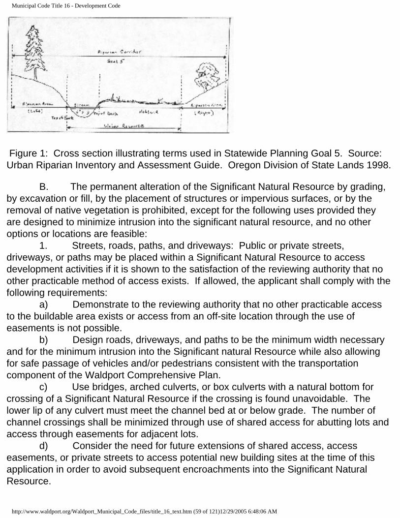
Municipal Code Title 16 - Development Code
Figure 1: Cross section illustrating terms used in Statewide Planning Goal 5. Source: Urban Riparian Inventory and Assessment Guide. Oregon Division of State Lands 1998.
B. The permanent alteration of the Significant Natural Resource by grading, by excavation or fill, by the placement of structures or impervious surfaces, or by the removal of native vegetation is prohibited, except for the following uses provided they are designed to minimize intrusion into the significant natural resource, and no other options or locations are feasible: 1. Streets, roads, paths, and driveways: Public or private streets, driveways, or paths may be placed within a Significant Natural Resource to access development activities if it is shown to the satisfaction of the reviewing authority that no other practicable method of access exists. If allowed, the applicant shall comply with the following requirements: a) Demonstrate to the reviewing authority that no other practicable access to the buildable area exists or access from an off-site location through the use of easements is not possible. b) Design roads, driveways, and paths to be the minimum width necessary and for the minimum intrusion into the Significant natural Resource while also allowing for safe passage of vehicles and/or pedestrians consistent with the transportation component of the Waldport Comprehensive Plan. c) Use bridges, arched culverts, or box culverts with a natural bottom for crossing of a Significant Natural Resource if the crossing is found unavoidable. The lower lip of any culvert must meet the channel bed at or below grade. The number of channel crossings shall be minimized through use of shared access for abutting lots and access through easements for adjacent lots. d) Consider the need for future extensions of shared access, access easements, or private streets to access potential new building sites at the time of this application in order to avoid subsequent encroachments into the Significant Natural Resource.
http://www.waldport.org/Waldport_Municipal_Code_files/title_16_text.htm (59 of 121)12/29/2005 6:48:06 AM
Municipal Code Title 16 - Development Code
e) During construction, no stockpiling of fill materials, parking, or storage of equipment shall be allowed within the Significant Natural Resource. f) Erosion control measures, such as silt fences and biofilter bags, shall be used to reduce the likelihood of sediment and untreated stormwater entering the Significant Natural Resource. g) Permanent alteration of the Significant Natural Resource by the placement of public or private streets, driveways, or paths is subject to the mitigation requirements of Section 6. 2. Utilities and drainage facilities: Public and private utilities or drainage facilities may be placed within a Significant Natural Resource when it is shown to the satisfaction of the review body that no other practicable alternative location exists. If a utility or drainage facility is allowed within a Significant Natural Resource the following standards shall apply: a) Demonstrate to the reviewing authority that no other practicable access exists or access from an off-site location through the use of easements is not possible. b) The corridor necessary to construct utilities shall be the minimum width practical to minimize intrusion into the Significant Natural Resource. Removal of trees and native vegetation shall be avoided unless absolutely necessary. The existing grade of the land shall be restored after construction. Native vegetation shall be used to restore the vegetative character of the construction corridor. c) No stockpiling of fill materials, parking, or storage of equipment shall be allowed within the Significant Natural Resource. 3. Replacement of existing structures with structures in the same location that do not disturb additional surface area. 4. Structures or other non-conforming alterations existing fully or partially within the Significant Natural Resource may be expanded provided the expansion occurs outside of the Significant Natural Resource. Substantial improvement of a non-conforming structure in the Significant Natural Resource shall require compliance with the standards of this title. 5. Existing lawn within the Significant Natural Resource may be maintained, but not expanded within the limits of the Significant Natural Resource. Development activities shall not justify replacement of native vegetation, especially riparian vegetation, with lawn. 6. Existing shoreline stabilization and flood control structures may be maintained. Any expansion of existing structures or development of new structures shall be evaluated by the Planning department and appropriate state or federal natural resource agency. Such alteration of Significant Natural Resources shall be approved only if less-invasive or non-structural methods, such as bioengineering, will not adequately meet stabilization or flood control needs. C. Removal of vegetation from the Significant Natural Resource is
http://www.waldport.org/Waldport_Municipal_Code_files/title_16_text.htm (60 of 121)12/29/2005 6:48:06 AM

Municipal Code Title 16 - Development Code
prohibited, except for: 1. Removal of non-native vegetation and replacement with native plant species. The replacement vegetation shall cover, at a minimum, the area from which vegetation was removed, shall maintain or exceed the density of the removed vegetation, and shall maintain or improve the shade provided by the vegetation. 2. Removal of vegetation necessary for the development of approved water-related or water-dependent uses or for the continued maintenance of dikes, drainage ditches, or other stormwater or flood control facilities. Vegetation removal shall be kept to the minimum necessary. 3. Trees in danger of falling and thereby posing a hazard to life or property may be removed, following consultation and approval from the Community Development Director. If no hazard will be created, the department may require these trees, once felled, to be left in place in the Significant Natural Resource. 4. The control or removal of nuisance plants should primarily be by mechanical means (e.g. hand-pulling). If mechanical means fail to adequately control nuisance plant populations, a federally approved herbicide technology for use in or near open water is the only type of herbicide that can be used in a Significant Natural Resource area. Pre-emergent herbicides or auxin herbicides that pose a risk of contaminating water shall not be used. Herbicide applications are preferred to be made early in the morning or during windless periods at least 4 hours before probable rainfall. Any herbicide use must follow the label restrictions, especially the cautions against use in or near open water.
16.70.050. Natural Resource Enhancement. Enhancement of natural resources, such as riparian enhancement, in-channel habitat improvements, non-native plant control, and similar projects which propose to improve or maintain the quality of a Significant Natural Resource is encouraged, however, no enhancement activity requiring the excavation or filling of material in a wetland shall be allowed unless all applicable State and Federal wetland permits have been granted.
16.70.060. Variances. A variance to the provisions of this title is permitted only as a last resort and is only considered necessary to allow reasonable economic use of the subject property. The property must be owned by the applicant and not created after the effective date of this title. A. A variance shall only apply to: 1. Lots on which the location of a Significant Natural Resource results in a building area depth for a single-family dwelling of 50 feet or less or a building envelope of 1600 square feet or less.
http://www.waldport.org/Waldport_Municipal_Code_files/title_16_text.htm (61 of 121)12/29/2005 6:48:06 AM

Municipal Code Title 16 - Development Code
2. Lots where strict adherence to the standards and conditions of Section 6 would effectively preclude a use of the parcel that could be reasonably expected to occur in the zone, and that the property owner would be precluded a substantial property right enjoyed by the majority of landowners in the vicinity. B. Permanent alteration of the Significant Natural Resource by an action requiring a variance is subject to the procedures and criteria of Chapter 16.92 and the mitigation requirements of Section 16.70.070.
16.70.070. Mitigation Standards When approved impacts to any identified Significant Natural Resource occurs, mitigation will be required. For impacts to Significant Wetlands or Major Marshes, the standards and criteria of Section 16.70.070 (A) shall apply. For impacts to Riparian Corridors or Riparian Vegetation, the standards and criteria of Section 16.70.070 (B) shall apply. A. When mitigation for impacts to a Significant Wetland or a Major Marsh is proposed, the mitigation plan shall comply with all Oregon Division of State Lands and U.S. Army Corps of Engineers wetland regulations. The City may approve a development but shall not issue a building permit until all applicable State and Federal wetland permit approvals have been granted and copies of those approvals have been submitted to the City. B. When mitigation for impacts to a non-wetland riparian area is proposed, a mitigation plan prepared by a qualified professional shall be submitted to the review authority. The mitigation plan shall meet the following criteria: 1. Mitigation for impacts to a non-wetland riparian area shall require a minimum mitigation area ratio of 1:1; 2. The mitigation plan shall document the location of the impact, the existing conditions of the resource prior to the impact, the location of the proposed mitigation area, a detailed planting plan of the proposed mitigation area with species and density, and a narrative describing how the resource will be replaced; 3. Mitigation shall occur on-site and as close to the impact area as possible. If this is not feasible, mitigation shall occur within the same drainage basin as the impact. 4. All vegetation planted within the mitigation area shall be native to the region. Species to be planted in the mitigation area shall replace those impacted by the development activity; 5. Trees shall be planted at a density of not less than 5 per 1000 square feet. Shrubs shall be planted at a density of not less than 10 per 1000 square feet.
16.70.080. Plan Amendment Option Any owner of property affected by the SNR Overlay Zone within the Goal 5
http://www.waldport.org/Waldport_Municipal_Code_files/title_16_text.htm (62 of 121)12/29/2005 6:48:06 AM

Municipal Code Title 16 - Development Code
planning area, as designated in the comprehensive plan, may apply for a quasi-judicial comprehensive plan amendment. This amendment must be based on a specific development proposal. The effect of the amendment would be to remove the SNR Overlay Zone from all or a portion of the property. The applicant shall demonstrate that such an amendment is justified by completing an Environmental, Social, Economic and Energy (ESEE) consequences analysis prepared in accordance with OAR 660-23-040. If the application is approved, then the ESEE analysis shall be incorporated by reference into the Waldport Comprehensive Plan, and the Waldport Significant Natural Resources Map shall be amended to remove the Significant Natural Resource Overlay Zone from the inventory. The ESEE analysis shall adhere to the following requirements: A. The ESEE analysis must demonstrate to the ultimate satisfaction of the Waldport City Council that the adverse economic consequences of not allowing the conflicting use are sufficient to justify the loss, or partial loss, of the resource. The City should confer with the Department of Land Conservation and Development prior to making their ultimate decision. B. The ESEE analysis must demonstrate why the use cannot be located on buildable land outside of the Significant Natural Resource and that there are no other sites within the City of Waldport that can meet the specific needs of the proposed use. C. The ESEE analysis shall be prepared by a qualified professional experienced in the preparation of Goal 5 ESEE analyses, with review by DLCD.
Title Page
Top of Chapter
Home
Chapter 16.72
SUPPLEMENTARY REGULATIONS
Sections:16.72.010 Clear vision areas.16.72.020 Off-street parking and off-street loading requirements.16.72.030 Exterior lighting.16.72.040 General provisions regarding accessory uses.
http://www.waldport.org/Waldport_Municipal_Code_files/title_16_text.htm (63 of 121)12/29/2005 6:48:06 AM

Municipal Code Title 16 - Development Code
16.72.050 RV conversions.16.72.060 Building permit approvals.16.72.070 Authorization of similar uses.16.72.080 Purpose of temporary use permits.16.72.090 Permitted temporary uses.16.72.100 Conditional approval of temporary use permits.16.72.110 Issuance of permits.16.72.120 Siting standards for manufactured homes.
16.72.010 Clear vision areas. A clear vision area shall be maintained on the corners of all property at the intersection of two streets. A. A clear vision area shall consist of a triangular area, two sides of which are lot lines measured from the corner intersection of the street lot lines for a distance specified in this regulation, or, where the lot lines have rounded corners, the lot lines extended in a straight line to a point of intersection so measured, and the third side of which is a line across the corner of the lot joining the non•intersecting end of the other two sides. B. A clear vision area shall contain no planting, fence, wall, structure or temporary or permanent obstruction exceeding 2.5 feet in height measured from the top of the curb, or, where no curb exists, from the established street center line grade, except that trees exceeding this height may be located in this area, provided that all branches and foliage are removed to a height of eight (8) feet above grade. 1. In a residential zone, the minimum distance shall be thirty (30) feet, or at intersections including an alley, ten (10) feet. 2. In all other zones the minimum distance shall be fifteen (15) feet, or, at intersections including an alley, ten (10) feet, except that when an angle of intersections between streets, other than an alley, is less than thirty (30) degrees, the distance shall be twenty-five (25) feet.
16.72.020 Off-street parking and off-street loading requirements. At the time a new structure is erected, the use of an existing structure is enlarged, or the category of use is changed, off-street parking spaces, loading areas and access thereto shall be provided as set forth in this section unless greater requirements are otherwise established. If such facilities have been provided in connection with an existing use, they shall not be reduced below the requirements of this code. A. Requirements for types of buildings and uses not specifically listed herein shall be determined by the planning commission, based upon the requirements of
http://www.waldport.org/Waldport_Municipal_Code_files/title_16_text.htm (64 of 121)12/29/2005 6:48:06 AM

Municipal Code Title 16 - Development Code
comparable uses listed. B. In the event several uses occupy a single structure or parcel of land, the total requirements shall be the sum of the requirements of the several uses computed separately. C. Owners of two or more uses, structures or parcels of land may agree to utilize jointly the same parking and loading spaces when the hours of operation do not overlap, provided that satisfactory legal evidence is presented to the planning commission in the form of deeds, leases or contracts to establish the joint use. D. Off-street parking spaces shall be located on the same lot or on an adjoining lot unless otherwise approved by the planning commission. E. Required parking spaces shall be available for the parking of operable passenger automobiles of residents, customers, patrons and employees only, and shall not be used for storage of vehicles or materials or for the parking of trucks used in conducting the business or use. F. Areas used for standing and maneuvering of vehicles shall have durable and dustless surfaces improved to minimum public road standards, maintained adequately for all•weather use, and be so drained as to avoid the flow of water across public sidewalks. G. Except for parking to serve dwelling uses, parking and loading areas adjacent to or within residential zones shall be designed to minimize disturbances of residents by the erection between the uses, of a sight-obscuring fence or vegetative buffer, of not less than five (5) feet in height, except where vision clearance is required. H. Artificial lighting which may be provided for parking areas shall not create or reflect substantial glare in a residential zone, on any adjacent building, or on any street or highway. I. Required off-street parking shall not be provided in the required front or street side-yard areas in a residential zone. J. Groups of more than four parking spaces shall be served by a driveway so that no backing movements or other maneuvering within a street, other than an alley, will be required and shall be enclosed or defined by a curb or bumper rail at least four inches high and set back a minimum of four and one•half (4 ½) feet from the property line. K. Passenger Loading. A driveway designated for continuous forward flow of passenger vehicles for the purpose of loading and unloading children shall be located on the site of any school having a capacity of greater than twenty-five (25) students. L. Loading of Merchandise, Materials or Supplies. Buildings or structures which receive and distribute materials or merchandise by truck shall provide and maintain off-street loading berths in sufficient numbers and size to adequately handle the needs of the particular use. M. Off-street parking areas used to fulfill the requirements of the code may
http://www.waldport.org/Waldport_Municipal_Code_files/title_16_text.htm (65 of 121)12/29/2005 6:48:06 AM

Municipal Code Title 16 - Development Code
be used for loading and unloading operations during periods of the day when not required to take care of parking needs. N. Compact parking spaces may be permitted at a ratio of one (1) space to every three (3) full-sized spaces (See "Parking Space" definition under Section 16.04.030 of this title for dimension requirements). O. Except for parking intended to serve dwelling uses, parking spaces shall be clearly delineated through striping or some other means. P. Requirements for types of buildings and uses not specifically listed herein shall be determined by the planning commission, based upon the requirements of comparable uses listed. Q. Required off-street parking must be provided when the category of use of an existing structure is changed, except under the following circumstances: 1. The number of parking spaces required by the code for the new use will be equal to or less than the code requirements for the previous use, and there will be no reduction in the number of parking spaces, or 2. No additional area is available for new parking spaces and at least seventy-five (75) percent of the number of spaces required for the new use will be provided, with no reduction in the number of parking spaces. R. For the purpose of calculating the number of off-street parking spaces required, the total floor area of a structure shall be used. S. Off-street parking requirements. 1. Dwelling. One (1) space for each dwelling unit. 2. Mobile Home Park. Two (2) spaces for each mobile home space. 3. Motel, Hotel or Resort. One (1) space for each accommodation. 4. Hospital. Three (3) spaces for each two (2) beds. 5. Nursing home or similar institution. One (1) space for each three (3) beds. 6. Church, club or similar place of assembly. One (1) space for each six (6) seats, or one (1) space for each fifty (50) square feet of floor area used for assembly. 7. Library. One (1) space for each three hundred (300) square feet of floor area. 8. Skating rink, or similar commercial amusement enterprise. One (1) space for each one hundred (100) square feet of floor area. 9. Bowling alley. Five (5) spaces for each alley. 10. Retail Store: One (1) space for each three hundred (300) square feet of floor area. 11. Eating and drinking establishments. One (1) space for each four (4) seats. 12. Service or repair shop, retail store handling bulky merchandise such as automobiles and furniture. One (1) space for each six hundred (600) square feet of floor
http://www.waldport.org/Waldport_Municipal_Code_files/title_16_text.htm (66 of 121)12/29/2005 6:48:06 AM

Municipal Code Title 16 - Development Code
area. 13. Bank, office. One (1) space for each six hundred (600) square feet of floor area. 14. Instructional classes, such as martial arts or dance studios. One (1) space for each instructor plus one (1) space for each one hundred (100) square feet of floor area. 15. Schools: a. Pre-school, Kindergarten, Elementary and Junior High: Two (2) spaces per classroom. b. High School: Five (5) spaces per classroom. 16. Bed and breakfast establishments: One (1) off-street parking space for owners/operators with one (1) additional space for each authorized guest room. 17. Personal services establishment (i.e. barber, beauty shops). Two (2) off-street parking spaces per each operator station. 18. Multi-family dwellings. One and one-half (1.5) spaces per dwelling unit.
16.72.030 Exterior Lighting. Exterior lighting for uses in commercial and industrial zones shall be located in such a manner so as not to face or shine directly onto a lot in a residential zone, street or highway.
16.72.040 General Provisions Regarding Accessory Uses. An accessory use shall comply with all requirements for a principal use, except as the code specifically allows to the contrary, and shall comply with the following limitations: A. An accessory structure not used for human habitation and separated from the main building may be located to within five (5) feet of a rear property line if the structure is no more than fifteen (15) feet in height. Structures over fifteen (15) feet must meet the standard setbacks. B. Fences, hedges and walls limited to six (6) feet in height may be located within required yards, but shall not exceed three and one•half (3 ½) feet in height in any required yard setback which abuts a street other than an alley, and two and one-half (2½) feet in a clear vision area as stipulated in Section 16.72.010 of this chapter. Exceptions to the height limitation or use of electrified, barbed wire, or razor wire for fencing shall have prior approval of the planning commission. The planning commission shall use the authority and procedure for conditional uses as set forth in Chapter 16.84 of this title. C. Unenclosed decks, unroofed landings, porches and stairs may project into any required yard providing the following conditions are met: 1. No portion except for guard rails shall extend above the floor level of a
http://www.waldport.org/Waldport_Municipal_Code_files/title_16_text.htm (67 of 121)12/29/2005 6:48:06 AM
Municipal Code Title 16 - Development Code
habitable room. 2. No such projection shall obstruct a stairway. 3. No such projection shall extend into a required yard no more than one-third the distance of the required setback. D. Manager/Caretaker Residence. In the M-P, and I-P Zones, a residence secondary to the main use of the property for the sole purpose of providing living quarters for the owner, operator or caretaker of a new or ongoing commercial or industrial enterprise is allowed, provided that: 1. The living space shall be located on the same property as the commercial or industrial operation and is justified by the requirement of twenty-four (24) hour attendance; 2. Non-owner/manager inhabitation of the living space is prohibited; and 3. The planning commission shall review annually each approval granted under the provisions of this section unless determined otherwise by the planning commission.
16.72.050 RV conversions. Recreational vehicles cannot be utilized for a commercial business on a permanent basis. Temporary placement may be authorized by the planning commission using the authority and procedure for conditional uses as set forth in Chapter 16.84 of this title.
16.72.060 Building permit approvals.
No building or structure shall be erected, enlarged, altered, re•built, remodeled or moved unless in conformance with the requirements of all State and local laws and regulations applicable to the structure and the land upon which it is proposed.
16.72.070 Authorization of undefined uses. An undefined use may be authorized by the planning commission at a public hearing in accordance with the requirements of Section 16.108.020 of this title, provided that the commission establishes that the proposed use meets the following criteria: A. The use is not listed specifically in any zone. B. The use is similar in character, scale and performance to one or more of the permitted or conditional uses listed in the zone in which it is proposed. C. The use is not of the same general type or similar to any uses specifically listed in another zone. Any undefined use authorized by the planning commission shall conform to the applicable standards and requirements of the zone in which it is located, including any requirement for conditional use review.
http://www.waldport.org/Waldport_Municipal_Code_files/title_16_text.htm (68 of 121)12/29/2005 6:48:06 AM
Municipal Code Title 16 - Development Code
16.72.080 Purpose of temporary use permits. Subject to Sections 16.72.090-16.72.110, below, a temporary use permit may be approved to allow limited use of structures or activities which are temporary or seasonal in nature and do not conflict with the zoning district in which they are located. No temporary use permit shall be issued which would have the effect of permanently rezoning or granting a special privilege not shared by other properties in the same zoning district. No temporary use permit shall be issued in an M•W zone.
16.72.090 Permitted temporary uses. Temporary structures, activities or uses may be permitted as necessary to provide for housing of personnel, storage and use of supplies and equipment, or to provide for temporary sales offices for uses permitted in the zoning district. Other uses may include temporary signs, outdoor gatherings, short term uses, roadside stands, or other uses not specified in this section and not so recurrent as to require a specific or general regulation to control them. Notwithstanding these and other provisions for temporary uses, a recreational vehicle or other approved temporary housing to be used for dwelling purposes during the construction of a single-family residential dwelling unit for which a building permit has been issued shall be allowed. The use shall not exceed a period of six (6) months. An extension may be considered by the planning commission.
16.72.100 Conditional approval of temporary use permits. A. Conditions may be imposed in connection with approval of the temporary permit to minimize the potential impact of the proposed use upon other uses in the vicinity. Guarantees or evidence may be required that such conditions will be or are being complied with. Such conditions may include, but are not limited to: 1. Special yards and spaces; 2. Fences or walls; 3. Control points of vehicular ingress and egress; 4. Special provisions on signs; 5. Landscaping and maintenance thereof; 6. Maintenance of grounds; 7. Control of noise, odors or other nuisances; 8. Limitation of time for certain activities; and 9. Restoration or reclamation of site. B. Any temporary permit shall clearly set forth the conditions under which the permit is granted and shall clearly indicate the time period for which the permit is issued. No temporary permit shall be transferable to any other owner or occupant. C. All structures for which a temporary permit is issued:
http://www.waldport.org/Waldport_Municipal_Code_files/title_16_text.htm (69 of 121)12/29/2005 6:48:06 AM

Municipal Code Title 16 - Development Code
1. Shall meet all other requirements of the zoning district in which they are located; 2. Shall meet all applicable health and sanitation requirements; 3. Shall meet all applicable building code requirements; and 4. Shall be removed upon expiration of the temporary permit or used in conjunction with a permitted use.
16.72.110 Issuance of permits. A. Temporary permits shall be issued by the city council for the time period specified after review of the application by the planning commission in accordance with Section 16.108.020 of this title if all applicable conditions can be met. In no case shall a temporary permit be issued for a period exceeding one (1) year, unless the temporary permit is renewed. B. Renewal of a temporary permit shall follow the same procedure as the initial application.
16.72.120 Siting standards for manufactured homes. The following standards shall be required for siting of manufactured homes on all property within the city of Waldport, except for existing mobile home parks: A. Except for property within single-wide overlay zones, the manufactured home shall be multisectional and enclose a space of not less than one thousand (1,000) square feet. B. The manufactured home shall be placed on an excavated and back-filled continuous foundation that is enclosed at the perimeter. C. The manufactured home shall have a pitched roof at least two (2) feet in height for each (12) twelve feet in width. D. The manufactured home shall have no bare metal siding or roofing. E. The manufactured home shall be certified by the manufacturer to have an exterior thermal envelope meeting the performance standards which reduce levels equivalent to the performance standards required of single-family dwellings constructed under the State Building Code as defined in ORS 455.010. F. General Provisions. 1. Label of Compliance. Approval for installation of any manufactured dwelling is limited to units manufactured after June 15, 1976 and bearing a label from the Department of Housing and Urban Development (H.U.D.) indicating compliance with electrical, plumbing and structural standards as set forth by H.U.D. 2. State Standards. Installation of manufactured dwellings are to follow State of Oregon standards adopted and administered by the State Building Code Agency. See OAR 814-34-050 to 814-23-080. These state standards are summarized as follows:
http://www.waldport.org/Waldport_Municipal_Code_files/title_16_text.htm (70 of 121)12/29/2005 6:48:06 AM
Municipal Code Title 16 - Development Code
a. Support blocking shall be installed according to the manufacturers' instructions approved by the State Building Codes Agency and, unless higher loading requirements are justified by soils analysis, the blocking shall support the manufactured dwellings on a soil with a bearing capacity of one thousand five hundred (1,500) pounds per square foot. (OAR 814-23-060.) b. Plumbing, electric and gas service connections shall be made according to the instructions approved by the State Building Codes Agency. (OAR 814-23-050.) c. A single-wide manufactured dwelling in certain listed areas along the coast and the Columbia River shall be tied down with devices that meet federal standards as approved by the State Building Codes agency. (OAR 814-23-065.) d. Manufactured dwelling accessory buildings and structures shall comply with state construction and installation standards. (OAR 814-23-070.) Manufactured dwelling accessory structures are skirting, some porches and steps, awnings, cabanas and some carports. In the manufactured dwelling field, an awning is not a sunshade for a window, but is any structure with a roof and not more than one wall. A structure is a manufactured dwelling accessory structure if it depends in part on the manufactured dwelling for its structural support. Accessory structures are not required by the state, but must meet standards if installed. e. A building or other structure associated with a manufactured dwelling that is not a manufactured dwelling accessory structure must comply with state building code standards for ramadas to relate the ramada to the manufactured dwelling. (OAR 814-23-0[3]70.) A ramada is primarily a roof built over a manufactured dwelling but is not supported by the manufactured dwelling. 3. Tie-Down requirements (to exclude manufactured dwellings attached to basements). a. Minimum tie-down requirements shall conform to standards established by the State Building Codes Agency. b. Minimum number of tie-downs required: 1) Single-wide. As specified by state code plus cross tie-downs at no greater than twelve (12) foot intervals; 2) Double-wide: One at each corner plus cross tie-downs at no greater than twelve (12) foot intervals; and 3) Triple-wide: Three per side on outside units plus cross tie-downs at no greater than twelve (12) foot intervals. c. Tie-down Materials. Steel straps or cables that have been treated to make them weather resistant must be used for ties and shall meet the following standards: 1) Steel straps 1.025" x .035" commercially available; 2) Steel cable at least three-eighths inch in diameter; and 3) Turnbuckles shall be at least one-half inch in diameter with closed or
http://www.waldport.org/Waldport_Municipal_Code_files/title_16_text.htm (71 of 121)12/29/2005 6:48:06 AM

Municipal Code Title 16 - Development Code
welded eyes. d. Anchors. Anchors must have a rod made of steel not less than five-eighths inch in diameter, and must have a tensioning head or a drop-forged, closed eye for use with a turnbuckle. In addition, it must be able to withstand a pull of at least four thousand eight hundred (4.800) pounds without failure. All anchors should be installed as nearly vertically as possible. The heads of the anchors should come to rest on top of the concrete, and should be directly below the "I" beam of the manufactured dwelling frame. 4. Grade. The portion of the lot on which the manufactured dwelling shall rest must be levelled to a +/-3" variance from the mean elevation. This levelling shall expose an area of bearing soil or fill material so compacted as to receive approval by a soil engineer as meeting state requirements. 5. Supports. Bearing weight of manufactured dwellings shall be supported by one of the following: a. Types. 1) Placement on a permanent concrete or block basement, or perimeter foundation. Standard floor beams shall be used across the width of the foundation. "I" beams of the manufactured dwelling floor shall be secured by lag bolts at each juncture of an "I" beam with foundation floor beams. 2) Placing upon concrete block piers, each of which rests upon a continuously poured concrete ribbon six (6) inches in depth and sixteen (16) inches in width extending the full length of the manufactured dwelling, less one foot. Each ribbon must contain a minimum of two metal reinforcing bars of at least one-half inch in diameter. One ribbon is required under each longitudinal "I" beam member of the manufactured dwelling's floor frame structure. b. Support Placement. 1) A manufactured dwelling pier shall be limited to thirty-two (32) inches above the levelled site. 2) Piers, when used, shall be no more than ten (10) feet apart under each "I" beam, and end piers should be no further than five (5) feet from the ends of the manufactured dwelling. 6. Extensions. a. Cabanas, expando units, patio awnings, carports and other manufactured dwelling extensions shall be considered part of the manufactured dwelling in determining setbacks. b. All manufactured dwelling extensions shall be installed in accordance with plans approved by the State Building Codes Agency. 7. Skirting. a. Skirting shall be weather resistant, noncombustible or not more combustible than three-eighths inch exterior grade plywood.
http://www.waldport.org/Waldport_Municipal_Code_files/title_16_text.htm (72 of 121)12/29/2005 6:48:06 AM

Municipal Code Title 16 - Development Code
b. Untreated wood shall not be nearer than six inches to any earth, unless separated by three inches of metal or concrete. EXCEPTION: For metal skirting, supporting members of untreated lumber shall be separated from the ground by not less than two inches. c. Adequate access shall be provided. d. Ventilation openings shall be provided for each twenty-five (25) linear feet of skirting. e. Each opening shall have a minimum net area of thirty-six (36) square inches and shall be located within two feet of the external covers of the manufactured dwelling and shall have a corrosion resistant louver or mesh cover. f. Skirting shall be completed within ninety (90) days after placement of the manufactured dwelling.
Title Page
Top of Chapter
Home
Chapter 16.76
SIGNS
Sections:16.76.010 Scope.16.76.020 Definitions.16.76.030 Permits required.16.76.040 General sign requirements.16.76.050 Zone requirements.16.76.060 Advertising signs.16.76.070 Temporary signs.16.76.080 Nonconforming signs.16.76.090 Maintenance and appearance of signs.16.76.100 Abandoned signs.
16.76.010 Scope. Every sign erected, altered or relocated within the city of Waldport shall conform to the provisions of this chapter. It does not regulate traffic and street signs erected and
http://www.waldport.org/Waldport_Municipal_Code_files/title_16_text.htm (73 of 121)12/29/2005 6:48:06 AM

Municipal Code Title 16 - Development Code
maintained by a road authority as defined in ORS 801.445, trespass signs posted in accordance with ORS 164.245 to 164.270, holiday decorations, temporary interior window signs, or the display of the national or state flag.
16.76.020 Definitions. "Accessory sign" means a sign which is accessory to and in conjunction with an established main use of land. "Advertising sign" means a sign which depicts the main use of the lot or parcel on which it is located and is not accessory to or in conjunction with any other use. "Free standing sign" means a sign which is supported by a separate independent structure and is not attached to or supported by any other building or structure. "Nonconforming sign" means a sign which was erected legally but which does not comply with currently applicable sign restrictions and regulations. "Projecting sign" means a sign which is attached to the wall or roof of a building and which projects above the lowest part of the roof or more than twelve (12) inches beyond the surface of the wall of the building to which it is attached. "Sign" means an identification, description, illustration, or device which is affixed to or represented, directly or indirectly, upon a building, structure or land, and which directs attention to a product, place, activity, person, institution or business. "Temporary sign" means any sign which is not permanently installed to or affixed to any sign structure or building, and is accessory to an event, election, lease, rental or sale of limited, fixed duration. "Size" means the aggregate area of all sign display surfaces located on a single structure, but excluding posts and base that are without attached identification, description or illustration. Two surfaces parallel and back to back on the same structure shall be considered a single display surface. "Wall sign" means a sign attached to or painted on a wall of a building with a display surface which projects no more than twelve (12) inches from the surface of the wall and not higher than the lowest roof edge above the building wall to which it is attached.
16.76.030 Permits required. A. Except as herein provided, no sign shall be erected, replaced, altered or relocated without the property owner first obtaining a sign permit demonstrating that the sign is or will be in compliance with all provisions of this chapter. B. Permits are issued for specific property only. Permits may transfer with ownership provided the signage is not altered or moved except to bring it into compliance with this section. C. Fees for sign permits shall be established by resolution of the city council, and shall be paid prior to the sign being placed or altered.
http://www.waldport.org/Waldport_Municipal_Code_files/title_16_text.htm (74 of 121)12/29/2005 6:48:06 AM

Municipal Code Title 16 - Development Code
D. Signs conforming to the current code that are damaged by acts of nature, vandalism or accident shall not be assessed a new sign permit fee when repaired to the pre-damaged condition. The owner of such signs shall be required to obtain a building permit prior to construction. E. A building permit shall be required of all signs as provided for in the Oregon Structural Specialty Code, which shall be issued prior to sign placement, construction, or alteration.
16.76.040 General Sign Requirements. A. No permanent sign shall be placed in or extend over a required side yard or street right-of-way or within ten (10) feet of the front property line in a required front yard. B. There shall be no moving or flashing signs, excepting time and temperature signs which are part of the principal sign. C. Light from a sign shall be directed away from a residential use or zone and shall not be located so as to distract motorists. D. Where it can be demonstrated that directional signs are needed for directing or controlling vehicular access, or where such signs are required as a condition of approval for public safety, such signs may be permitted in addition to any other signs permitted by this section. Such signs shall be placed at each motor vehicle entrance or exit, shall not exceed nine (9) square feet in size and six (6) feet in height, and shall not restrict required site distances or pedestrian and vehicular flow. E. Roof signs painted directly on the roof surface, or on a surface attached flush to the roof surface, are prohibited. F. A banner and/or a pennant shall be prohibited as a permanent sign and are limited to a display duration of fifteen (15) consecutive days in a six (6) month period. G. Protruding or free-standing signs located within an area used for pedestrian or customer traffic shall maintain a vertical clearance of no less than seven and one-half (7 ½) feet. H. Signs classified by the State of Oregon as off-premise signs shall be allowed subject to the requirements of this article provided that the applicant has obtained approval from the issuing state agency and meets the requirements of this Article. I. Electrical service to free-standing signs shall be underground.
16.76.050 Zone Requirements. A. In the R-1, R-2, and R-3 zones: one (1) accessory sign shall be allowed and shall be limited to the following sizes and restrictions: 1. A sign not exceeding two (2) square feet in size accessory to a single-family dwelling or a home occupation, or six (6) square feet for a bed and breakfast inn.
http://www.waldport.org/Waldport_Municipal_Code_files/title_16_text.htm (75 of 121)12/29/2005 6:48:06 AM

Municipal Code Title 16 - Development Code
2. A sign not exceeding twenty-four (24) square feet in size accessory to any other permitted or conditional use in the zone. 3. No projecting or free-standing signs shall be allowed in the R-1, R-2 and R-3 zones. B. In the R-4, C-1, C-2, M-P, I-P and P-F zones: accessory signs are allowed. Not more than one projecting sign or free-standing sign may be permitted per lot. The sign or signs shall not exceed a total aggregate area of one hundred twenty (120) square feet or one square foot for every foot of lot frontage along streets, other than alleys, whichever is less. No sign shall exceed twenty-five (25) feet in height measured from the adjacent road level, and display surfaces shall not be greater than twelve (12) feet in height, nor twenty-five (25) feet in width. C. In the M-W zone, only signs in conjunction with an existing or approved activity are allowed, provided the sign is constructed such that it meets the requirements of Chapter 16.68, Flood Hazard Overlay Zone.
16.76.060 Advertising signs. In the C-1, C-2 and I-P zones, advertising signs may be allowed by the planning commission as a conditional use. In addition to the applicable requirements of Chapter 16.84 of this title, advertising signs must conform to the following standards: 1. Signs must be at least five hundred (500) feet apart on the same side of a road and at least two hundred fifty (250) feet apart on opposite sides of a road; and 2. Signs shall not exceed twenty-five (25) feet in height measured from the adjacent road level, and display surfaces shall not be greater than twelve (12) feet in height nor twenty-five (25) feet in width.
16.76.070 Temporary Signs. A. In addition to the allowances for signs provided by this section, not more than two temporary signs of not more than twelve (12) square feet each may be established on any lot or parcel for a period of not more than ninety (90) days in any single calendar year, or for any period of time during which the property is for sale, lease or rent. B. All such signs shall be maintained as provided for in Section 16.76.090 of this title. C. Portable A-frame and wheeled signs shall be allowed only in conjunction with a specific event, and shall not obstruct the safe and free flow of pedestrians and vehicular traffic. Such signs may be licensed for a period of five (5) consecutive days, after which a new sign permit must be obtained. D. All temporary signs shall be removed by the sponsoring person, institution, group or company within three (3) days after the conclusion of the event.
http://www.waldport.org/Waldport_Municipal_Code_files/title_16_text.htm (76 of 121)12/29/2005 6:48:06 AM
Municipal Code Title 16 - Development Code
16.76.080 Nonconforming Signs. A. A nonconforming sign or sign structure shall not be moved, structurally altered or enlarged in any manner unless such movement, alteration or enlargement would bring the sign into conformity with the requirements of this Chapter. B. Any nonconforming sign or sign structure must be maintained to meet the requirements of Section 16.76.090 of this title.
16.76.090 Maintenance and Appearance of Signs. All signs, together with all of their supports, braces, guys and anchors, shall be kept in good repair and maintained in a safe condition. All signs shall be maintained in a neat, clean and attractive condition.
16.76.100 Abandoned Signs. Any sign shall be removed within fourteen (14) days of when the associated land use has been discontinued or completed, or when the sign is no longer properly repaired or maintained as required by this Chapter.
Title Page
Top of Chapter
Home
Chapter 16.80
EXCEPTIONS
Sections:16.80.010 Projections from buildings.16.80.020 General exceptions to lot size requirements.16.80.030 General exceptions to yard requirements.16.80.040 General exceptions to building height limitations.
16.80.010 Projections from buildings. Architectural features such as cornices, eaves, canopies, sunshades, gutters, signs, chimneys and flues shall not project more than eighteen (18) inches into a required yard.
16.80.020 General exceptions to lot size requirements.
http://www.waldport.org/Waldport_Municipal_Code_files/title_16_text.htm (77 of 121)12/29/2005 6:48:06 AM

Municipal Code Title 16 - Development Code
If a lot or the aggregate of contiguous lots held in a single ownership as recorded in the office of the county clerk at the time of passage of this code has an area or dimension which does not meet the lot size requirements of the zone in which the property is located, the holding(s) may be occupied by a use permitted in the zone, subject to the other requirements of the zone, provided that, if there is an area deficiency, residential use shall be limited to a single-family dwelling.
16.80.030 General exceptions to yard requirements. The following exceptions to the front yard requirement for any structure are authorized for a lot in any zone. A. The required front or rear yard for a structure may be based on existing or probable average of the front or rear yards of dwellings/garages on all lots within one hundred (100) feet of both sides of the proposed structure. On vacant parcels within one hundred (100) feet, standard requirements shall be used in establishing the average. B. Special set-back requirements. Under certain circumstances the following special set•back requirements shall apply: 1. Buildings and pens, which are part of kennels and animal hospitals, and active recreation use areas which are a part of outdoor commercial amusement or recreation establishments shall be located no closer than seventy-five (75) feet from a residential zone. 2. Clubs, lodges, fraternal organizations, community swimming pools, and buildings housing recreational facilities in residential zones shall be located no closer than thirty feet (30) from any other lot in a residential zone.
16.80.040 General exceptions to building height limitations. Projections such as chimneys, spires, domes, elevator shaft housings, towers, aerials, flagpoles and other similar objects not used for human occupancy which exceed the maximum building height allowable in the zone by no more than five (5) feet are not subject to the building height limitations of this title. Such projections that exceed that height may be approved by the planning commission upon a finding that the structure will not result in an adverse impact to the neighboring properties.
Title Page
Top of Chapter
Home
Chapter 16.84
http://www.waldport.org/Waldport_Municipal_Code_files/title_16_text.htm (78 of 121)12/29/2005 6:48:06 AM

Municipal Code Title 16 - Development Code
CONDITIONAL USES
Sections:16.84.010 Purpose.16.84.020 Authorization to grant or deny conditional use permit.16.84.030 Procedure for taking action on a conditional use application.16.84.040 Building permit for an approved conditional use.16.84.050 Time limit of a conditional use permit.16.84.060 Revocation of a conditional use permit.16.84.070 Standards and procedures governing conditional uses.
16.84.010 Purpose. Certain types of uses require special consideration prior to their being permitted in a particular zone. The reasons for such special consideration include, the size of the area required for the full development of such uses, the nature of the traffic problems incidental to operation of the uses, and the effect such uses have on any adjoining land uses and on the growth and development of the city as a whole.
16.84.020 Authorization to grant or deny conditional use permit. Conditional uses listed in this code may be permitted, enlarged, or altered upon authorization by the planning commission in accordance with the standards and procedures set forth in this chapter. A. In taking action on a conditional use permit application, the planning commission may either permit or deny the request. If a request is denied, the action must be based on reasons related to orderly development and best interests of the surrounding area or the city as a whole. Mobile home parks are exempt from 16.84.020(A) and 16.84.070(A)(2) of this chapter. B. In permitting a conditional use or the modification of a conditional use, the planning commission may impose, in addition to those standards and requirements expressly specified by this code, additional conditions which are considered necessary to protect the best interest of the surrounding area of the city as a whole. These conditions may include, but are not limited to, the following: 1. Increasing the required lot size or yard dimensions; 2. Limiting the height of buildings; 3. Controlling the location and number of vehicle access points; 4. Increasing the street width; 5. Increasing the number of required off-street parking spaces; 6. Limiting the number, size, location, and lighting of signs; 7. Requiring fencing, screening, landscaping, diking, or other facilities to
http://www.waldport.org/Waldport_Municipal_Code_files/title_16_text.htm (79 of 121)12/29/2005 6:48:06 AM

Municipal Code Title 16 - Development Code
protect adjacent or nearby property; 8. Designating sites for open space; 9. Regulating the hours of operation; and 10. Setting a time limit for which the conditional use is approved. In the case of conditional uses which provide for needed housing types, these conditions shall be limited to the following: controlling the location and number of off-street parking and loading spaces required, limiting the number, size and location of signs, and requiring fencing, diking, screening and landscaping. Conditions applied to needed housing types shall not unreasonably increase costs or reduce densities. If at any time the standards or requirements for conditional use approval are not followed, a zoning violation will be considered to exist. C. In the case of a use existing prior to the effective date of this code and classified as a conditional use or a non-conforming use, a change in use or in lot area or an alteration of structure shall conform with the conditional use requirements. D. Modifications of standards listed for each conditional use may be granted if: 1. The planning commission determines that a hardship would result to an applicant from the application of the standards. 2. The modifications will not result in the use being detrimental to properties in the surrounding area or in the City as a whole. 3. The purposes of this code are fulfilled. E. The planning commission may require that the applicant furnish the city with a performance bond of up to the value of the cost of the improvement, plus administrative costs and amounts for inflation not to exceed twenty (20) percent of the value of the cost of the improvement(s), to be guaranteed by such bond in order to assure that the conditional use is completed according to the plans approved by the planning commission.
16.84.030 Procedure for taking action on a conditional use application. The procedure for taking action on an application for a conditional use shall be as follows: A. A property owner may initiate a request for a conditional use or the modification of a conditional use by filing an application with the city. The planning commission may require other drawings or information necessary to provide an understanding of the proposed use and its relationship to surrounding properties. B. Before the planning commission may act on a request, it shall hold a public hearing as prescribed in Chapter 16.108 of this title. C. The planning commission's decision is final unless it is appealed as prescribed in Chapter 16.108 of this title.
http://www.waldport.org/Waldport_Municipal_Code_files/title_16_text.htm (80 of 121)12/29/2005 6:48:06 AM

Municipal Code Title 16 - Development Code
16.84.040 Building permit for an approved conditional use. Building permits for all or any portion of a conditional use shall be issued only on the basis of the plan as approved by the planning commission. Any substantial change in the approved plan shall be submitted to the planning commission as a new application for a conditional use.
16.84.050 Time limit of a conditional use permit. Authorization of a conditional use shall be void after two (2) years or such lesser time as the authorization may specify unless substantial construction pursuant thereto has taken place. However, the planning commission may extend authorization for an additional period not to exceed one (1) year. A maximum of two extensions can be granted.
16.84.060 Revocation of a conditional use permit. Any permit granted hereunder shall be subject to denial or revocation by the planning commission if it is ascertained thereby that the application includes or included any false information, or if the conditions of approval are not complied with or are not being maintained, or the conditional use becomes detrimental to public health, safety, or welfare. A. In order to consider revocation of a conditional use permit, the planning commission shall hold a public hearing as prescribed in Chapter 16.108 of this title. The permit holder shall be required to show cause as why such permit should not be revoked. B. If the planning commission finds that the conditions of permit approval have not been complied with or are not being maintained, a reasonable time shall be given for correction. If corrections are not made within the specified time, revocation of the permit shall become effective. C. Reapplication for a conditional use permit cannot be made within one (1) year after revocation except that the planning commission may allow a new application if, in its opinion, new evidence or a change in circumstances warrant it.
16.84.070 Standards and procedures governing conditional uses. A. General Standards. In addition to the other applicable standards of this section, all conditional uses shall comply with the following requirements: 1. The site under consideration is suitable for the proposed use, considering: a. The size, design and operating characteristics of the use; b. The adequacy of transportation access to the site; and c. The natural and physical features of the site such as general topography, natural hazards, natural resource values, and the like. 2. The proposed use is compatible with the existing and projected uses on surrounding lands, considering the factors of subsection (A)(1), above. Mobile home
http://www.waldport.org/Waldport_Municipal_Code_files/title_16_text.htm (81 of 121)12/29/2005 6:48:06 AM

Municipal Code Title 16 - Development Code
parks are exempt from Sections 16.84.020(A) and 16.84.070(A)(2) of this chapter. B. Special set-back requirements: 1. Buildings and pens, which are a part of kennels and animal hospitals, and active recreation use areas which are a part of outdoor commercial amusement or recreation establishments shall be located no closer than seventy-five (75) feet from a residential zone. 2. Clubs, lodges, fraternal organizations, community swimming pools, and buildings housing recreational facilities in residential zones shall be located no closer than thirty (30) feet from any other lot in a residential zone. C. Public utilities facilities such as an electric substation or transformer, public or community domestic water supply reservoir or pumping station, or public or community sewage disposal plant or pumping station or a radio or television tower or transmitter shall meet the following standards: 1. In a residential zone, all equipment storage shall be within an enclosed building; 2. Public utility workshop facilities shall not be permitted in a residential zone; 3. Public utility facilities shall be screened and/or provided with landscaping; and 4. Minimum lot size requirements may be waived on finding that the waiver will not result in noise or other detrimental effect to adjacent or nearby property. D. Home Occupations. 1. Providing it meets all other applicable standards listed below, a home occupation that involves no customer traffic, retail sales, signs or any other outward appearance of a business shall be exempt from the conditional use process. 2. The home occupation shall be secondary to the main use of the property as a residence. 3. The home occupation shall be limited to either an accessory structure or not be over twenty-five (25) percent of the floor of the dwelling. If located within an accessory structure, the home occupation shall not utilize over four hundred (400) square feet of floor area. 4. Any structural alteration shall be approved by the Planning Commission and shall not detract from the outward appearance of the property as a residential use. 5. No persons other than residents of the subject property shall be engaged in the home occupation and in no event shall the number of residents engaged in the home occupation exceed five (5). 6. No window display and no sample commodities displayed outside the building shall be allowed. 7. No on-site sale of products shall be allowed in an R-1 zone. 8. No materials or mechanical equipment shall be used which is detrimental
http://www.waldport.org/Waldport_Municipal_Code_files/title_16_text.htm (82 of 121)12/29/2005 6:48:06 AM

Municipal Code Title 16 - Development Code
to the residential use of the dwelling or adjoining dwellings because of vibration, noise, dust, smoke, odor, interference with radio or television reception or other factors. 9. No materials or commodities shall be delivered to or from the residence which create undesirable traffic or congestion. 10. No on-street parking of customer's vehicles shall be allowed. 11. No outside storage of goods, commodities or waste materials associated with the home occupation shall be permitted. 12. No outward appearance of a business is allowed in an R-1 zone. 13. Home occupations permitted in residential zones shall be limited to the following types, subject to applicable standards: a. Professional office or clinic; b. Personal service establishment such as barber, beautician, tailor, cobbler, gunsmith, or the like; c. Home appliance or electronic service or repair; d. Artist or craft studio; e. Except as prohibited in subsection 14, below, small-scale manufacture or assembly; and f. Other uses similar in character, scale and performance to the above. 14. The following uses are specifically prohibited from being established as home occupations in residential zones: a. Storage, service or repair of automobiles, trucks, trailers, heavy equipment, boats or marine equipment. b. Machine, welding, sheet metal or similar metal working shop. c. Cabinet or woodworking shop. d. Plumbing, building, electrical or paint contractors storage or repair shop. e. Auto wrecking yard or other salvage yard. E. Standards for mobile home parks. A mobile home park may be permitted as a conditional use when it meets all applicable requirements of Chapter 446, Oregon Revised Statutes, Chapter 814 of the Oregon Administrative Rules Dept. of Commerce and the standards of the Oregon State Board of Health. In addition, the following minimum standards shall apply: 1. Minimum size of mobile home park: one (1) acre; 2. Minimum size of each space: three thousand five hundred (3,500) square feet; 3. Minimum width of space: thirty-five (35) feet; 4. Minimum distance between mobile home and street right of way: twenty (20) feet; 5. Minimum distance between mobile home and all other property lines: ten (10) feet; 6. Minimum distance between mobile homes: ten (10) feet;
http://www.waldport.org/Waldport_Municipal_Code_files/title_16_text.htm (83 of 121)12/29/2005 6:48:06 AM

Municipal Code Title 16 - Development Code
7. Minimum distance between mobile homes and community or service buildings: twenty (20) feet; 8. Each access road connecting with a public street shall have a surface width of at least thirty (30) feet for a distance of forty (40) feet as measured from the intersection of the public road. All other roads shall have a minimum surface width of at least twenty (20) feet for two-way traffic if parking is prohibited and thirty (30) feet for two-way traffic if parking is allowed on one side; 9. Developed recreation areas shall be required in parks where mobile home spaces are less than four thousand (4,000) square feet and children under 14 are permitted. Play areas shall have at least one hundred (100) square feet per mobile home space, but regardless of the number of mobile home spaces, shall be no less than two thousand five hundred (2,500) square feet. Play areas shall be restricted to that use and protected from all streets, driveways and parking areas by a fence, or the equivalent thereof, of at least thirty (30) inches in height; 10. All areas not used for mobile home spaces, motor vehicles, parking, traffic circulation or service or community buildings shall be completely and permanently landscaped. The landscaping shall be maintained in good condition; 11. Each mobile home space shall have clearly defined boundaries marked by a fence, planting or other suitable means; 12. Each mobile home space shall have a minimum of two (2) parking spaces; 13. Each mobile home space shall have electricity, potable water and an approved means of sewage disposal; 14. Each mobile home space shall have a maximum lot coverage of seventy-five (75) percent; 15. Accessory buildings or structures including community and service buildings, carports, cabanas and ramadas intended for community use, but excluding signs and fences, shall be at least twenty-five (25) feet from public street right-of-ways; 16. Screening consisting of a sight-obscuring fence and/or buffer strip of vegetation may be required along all property lines. F. Standards for Recreational Vehicle Parks. A recreational vehicle park may be permitted as a conditional use when it meets the requirements of Chapter 446, Oregon Revised Statutes, and the standards of the Oregon State Board of Health and the Administrative Rules of the State of Oregon (OAR Chapter 333). In addition, the following minimum standards shall apply: 1. Minimum size of R.V. park: one (1) acre; 2. Minimum size of each space: one thousand two hundred (1,200) square feet; 3. Minimum width of space: twenty (20) feet; 4. Minimum distance between R.V. and street right-of-way: ten (10) feet;
http://www.waldport.org/Waldport_Municipal_Code_files/title_16_text.htm (84 of 121)12/29/2005 6:48:06 AM

Municipal Code Title 16 - Development Code
5. Minimum distance between R.V. and all other property lines: ten (10) feet; 6. Minimum distance between R.V.'s: ten (10) feet; 7. Minimum distance between R.V.'s and community or service buildings: twenty (20) feet; 8. Each access road connecting with a public street shall have a surface width of at least thirty (30) feet for a distance of forty (40) feet as measured from the intersection of the public road. All other roads shall have a minimum surface width of at least twenty (20) feet, for two-way traffic if parking is prohibited and thirty (30) feet for two-way traffic if parking is allowed on one side. All access roads and parking areas shall be surfaced to minimum City standards and be well-drained and maintained in good condition. Walkways not less than three (3) feet wide will be required to be provided from trailer spaces to community and service buildings. All access roads and walkways shall be well-lighted; 9. Developed recreation areas may be required to be provided which contain a minimum of two thousand five hundred (2,500) square feet or two hundred (200) square feet per trailer space, whichever requirement is the greater; 10. All areas not used for R.V. spaces, motor vehicles, parking, traffic circulation or service or community buildings shall be completely and permanently landscaped. The landscaping shall be maintained in good condition; 11. A sight-obscuring fence and/or buffer strip of vegetation may be required on every side of an R.V. park; 12. Tent spaces shall be permitted, provided State-approved sanitary facilities are present; 13. Garbage service shall be provided to the occupants of an R.V. park; G. Auto wrecking yards/junk yards. In addition to meeting the requirements of ORS Chapters 481 and 377, the following standards shall apply: 1. The auto wrecking yard or junk yard shall be fully enclosed by a sight•obscuring fence, free of advertising, maintained in good condition, not less than six (6) feet in height, and of a design approved by the planning commission. 2. All automobiles, wrecked or otherwise, shall be kept inside the fenced area at all times, except that vehicles belonging to customers may be parked outside the fence while at the establishment on business. 3. All sales, display, storage, repair, or other handling of products, merchandise, equipment, and other articles shall occur from within an enclosed building or from within the fenced area. H. Solid waste disposal sites. In addition to meeting the requirements of ORS Chapter 459 the following standards shall apply: 1. Submitted plans and specifications shall contain sufficient information to allow the planning commission to set standards pertaining to:
http://www.waldport.org/Waldport_Municipal_Code_files/title_16_text.htm (85 of 121)12/29/2005 6:48:06 AM

Municipal Code Title 16 - Development Code
a. Appropriate use of the land; b. Set-backs from the property line; c. Location on vehicular access points; d. Protection of pedestrians and vehicles through the use of fencing; e. Rehabilitation of the land upon termination of the operation; and f. A copy of the application submitted to the Department of Environmental Quality shall be submitted with the application. 2. All solid waste disposal areas shall meet standards as established by the Department of Environmental Quality and the Lincoln County Health Department. 3. Only the sanitary landfill, or other method approved by the Lincoln County Health Department shall be utilized at the solid waste disposal area. 4. Access to the site shall be by a well-maintained all-weather road. I. Extraction and processing of rock, sand, gravel, or other earth products: 1. Submitted plans and specifications shall contain sufficient information to allow the planning commission to set standards pertaining to: a. The most appropriate use of the land; b. Set-back from the property line; c. Location of vehicular access points; d. Protection of pedestrians and vehicles through the use of fencing; e. Prevention of the collection and stagnation of water at all stages of the operation; and f. Rehabilitation of the land upon termination of the operation. 2. Any processing of earth products commonly associated with the excavation of minerals, rocks, sand or gravel, such as the use of crushing, sorting, or washing equipment, shall not be permitted in commercial, residential or marine zones. 3. Mining equipment and access roads shall be constructed, maintained, and operated in such a manner as to eliminate, as far as is practicable, noise, vibration, or dust which are injurious or substantially annoying to persons living in the vicinity. J. Uses and activities involving construction, addition, or reconstruction of a pier, dock, bulkhead, boathouse, or similar facility shall be subject to the standards set forth in the city's estuary management plan. K. Uses and activities involving filling, dredging, draining, disposal of dredging spoils, and similar activities within or adjacent to the estuary shall be subject to the standards set forth in the city's estuary management plan. L. Bed and breakfast inns: 1. All bed and breakfast inns shall be managed by a resident of the dwelling; 2. Bed and breakfast inns shall be restricted to single-family residences; 3. No materials or commodities shall be delivered to or from the residence which are of such bulk or quantity as to create congestion; 4. The exterior of the building must maintain a residential appearance if
http://www.waldport.org/Waldport_Municipal_Code_files/title_16_text.htm (86 of 121)12/29/2005 6:48:06 AM

Municipal Code Title 16 - Development Code
located in a residential zone. Any changes to the buildings exterior must be approved by the city of Waldport planning commission prior to issuance of a building permit; 5. The bed and breakfast inn must be operated in such a manner so as not to cause any unreasonable disturbance to area residents; 6. Only one on-premise ground or wall non-illuminated wood sign of six (6) square feet maximum size shall be allowed if the bed and breakfast inn is located in a residential zone; 7. Breakfast shall be the only meal served to inn guests; 8. Bed and breakfast inns renting out more than two (2) sleeping rooms for guests must be licensed by the County Health Department; 9. The duration of each guest's stay shall be limited to no more than fifteen (15) nights in a thirty (30) day period; 10. No more than five (5) sleeping rooms shall be available for the accommodation of inn visitors; 11. Any increase in occupancy capability shall be subject to review by the Waldport planning commission as an expansion of a conditional use permit; and 12. One (1) off-street parking space shall be provided for owners/operators with one (1) additional space for each authorized guest room. Off-street parking shall be provided in accordance with standards set forth in Section 16.72.020 of this title.
Title Page
Top of Chapter
Home
Chapter 16.88
NONCONFORMING USES
Sections:16.88.010 Definitions.16.88.020 Continuation.16.88.030 Alteration.16.88.040 Restoration and replacement.16.88.050 Interruption and abandonment.
16.88.010 Definitions. As used in this section:
http://www.waldport.org/Waldport_Municipal_Code_files/title_16_text.htm (87 of 121)12/29/2005 6:48:06 AM
Municipal Code Title 16 - Development Code
"Non-Conforming Use" means the use of any building, structure or land which was lawful at the time of the enactment of any zoning ordinance, regulation or amendment thereto, and is not permitted by the zoning ordinance, regulation or amendment. "Alteration" of a non-conforming use or structure means: A. A change in the use, or B. A change in the structure or physical improvements which does not constitute normal maintenance. "Normal maintenance" means activities necessary to maintain a non-conforming use or associated physical improvements in good repair, and may include painting, siding, roofing, dry rot repair, window replacement, repaving of access roads, replacement of landscape elements, and similar activities. Normal maintenance does not include significant change in use or structural alterations or additions.
16.88.020 Continuation. Non-conforming uses may be continued. Changes in ownership, control or occupancy shall be permitted. Normal maintenance shall be permitted. Continuation of a non-conforming use shall be limited to the existing lot(s) or parcel(s) upon which the use is established. Expansion to other lots or parcels is an alteration.
16.88.030 Alteration. A. Alteration of a non-conforming use shall be permitted when necessary to comply with any lawful requirement for alteration in the use or structure. No conditions may be imposed upon any alteration of a non-conforming use necessary to comply with a lawful requirement. B. Alteration of a non-conforming use not required by law may be permitted subject to: 1. Application and review pursuant to Sections 16.84.020 and 16.108.020(B) of this title; 2. A finding that the proposed alteration will be of no greater adverse impact to the neighborhood; and 3. Any conditions or limitations imposed by the planning commission necessary to assure that the alteration will be of no greater adverse impact to the neighborhood. C. Notwithstanding the above, the replacement of a non-conforming single-wide manufactured home may be approved administratively following the process in Section 16.108.020(A) of this title, provided the replacement dwelling meets all requirements contained in this Code.
16.88.040 Restoration and Replacement.
http://www.waldport.org/Waldport_Municipal_Code_files/title_16_text.htm (88 of 121)12/29/2005 6:48:06 AM

Municipal Code Title 16 - Development Code
Restoration or replacement of any non-conforming use shall be permitted when made necessary by fire, other casualty or natural disaster, and shall be commenced within one year from the occurrence of the fire, casualty or natural disaster. For purposes of this provision, "commenced" means that application has been made for building permits required for restoration, or that the non-conforming use has been resumed if no such approvals are required. Restoration or replacement of a non-conforming use under this provision shall be limited to re-establishment of the use and physical improvements as lawfully established prior to the fire or other casualty or natural disaster.
16.88.050 Interruption and Abandonment. A non-conforming use interrupted or abandoned for a period of more than one (1) year may not be resumed.
Title Page
Top of Chapter
Home
Chapter 16.92
VARIANCES
Sections:16.92.010 Authorization to grant or deny variances.16.92.020 Circumstances for granting a variance.16.92.030 Variance procedure.16.92.040 Time limit on a variance.
16.92.010 Authorization to grant or deny variances. The planning commission may authorize variances from non-procedural requirements of Chapters 16.12 through 16.96 of this title where it can be related to a specific piece of property and strict application of this title would cause undue or unnecessary hardship. No variance shall be granted under the following conditions: A. To allow the use of property for a purpose not authorized within the zone in which the proposed use would be located; B. To increase building height more than ten (10) percent higher than is otherwise permitted in this title, except to complete a story of which more than half falls
http://www.waldport.org/Waldport_Municipal_Code_files/title_16_text.htm (89 of 121)12/29/2005 6:48:06 AM

Municipal Code Title 16 - Development Code
within the allowable height limit of that zone, or to allow construction of a structure one story higher than the finished ground elevation of the highest side of the structure. In granting a variance the planning commission may attach conditions which it finds necessary to protect the best interests of the surrounding property or neighborhood and otherwise achieve the purposes of this code.
16.92.020 Circumstances for granting a variance. A variance may be granted only in the event that either subsection A or B of this section applies and each of subsections C, D and E of this section applies: A. Exceptional or extraordinary circumstances apply to the property which do not apply generally to other properties in the same zone or vicinity, and result from lot size or shape, legally existing prior to September 6, 1973; or B. The variance is necessary for the preservation of a property right of the applicant substantially the same as owners of other property in the same zone or vicinity possess; and C. The variance would not be materially detrimental to the purpose of this title, or to property in the zone or vicinity in which the property is located, or otherwise conflicts with the objectives of any city plan or policy; D. The hardship is not self-imposed and the variance requested is the minimum variance which would alleviate the hardship; and E. The hardship asserted as a basis for the variance does not arise from a violation of the City code or other regulations. F. Flood Plain Variance: A request for a variance to the flood plain standards contained in Chapter 16.68, Flood Hazard Overlay Zone, in addition to being subject to subsections A through E of this section, above, shall conform to the following: 1. A variance may be granted for the reconstruction, rehabilitation or restoration of structures listed on the National Register of Historic Places or the Oregon Statewide Inventory of Historic Sites and Buildings without regard to subsections B through E of this section, above; 2. A variance shall not be issued within any designated floodway if any increase in flood levels during the base flood discharge would result; 3. A variance may be issued for new construction or substantial improvement to be erected on a lot of one-half acre or less in size which is contiguous to and surrounded by lots with existing structures constructed below the base flood level; 4. The variance shall only be issued upon: a. A showing of good and sufficient cause; b. A determination that failure to grant the variance would result in exceptional hardship to the applicant; c. A determination that the granting of the variance will not result in increased flood heights, additional threats to public safety, extraordinary public expense,
http://www.waldport.org/Waldport_Municipal_Code_files/title_16_text.htm (90 of 121)12/29/2005 6:48:06 AM

Municipal Code Title 16 - Development Code
create nuisances, cause fraud on or victimization of the public, or conflict with local laws and ordinances; and d. A determination that the variance is the minimum necessary, considering the flood hazard, to afford relief; 5. If a variance is issued under the provisions of subsection F, except under provision 4.a. of this section, above, which allows construction below the base flood level, then the CAO shall: a. Notify the applicant in writing that the issuance of a variance to construct a structure below the base flood level will result in increased premium rates for flood insurance as high as twenty-five (25) dollars for one hundred (100) dollars of insurance coverage; and b. that such construction below the base flood level increase risks to life and property; and 6. Variances as interpreted in the National Flood Insurance Program are based on the general zoning law principle that they pertain to a physical piece of property; they are not personal in nature and do not pertain to the structure, its inhabitants, economic or financial circumstances. They primarily address small lots in densely populated residential neighborhoods. As such, the grant of a variance from the flood elevations is quite rare.
16.92.030 Variance procedure. The following procedures shall be followed in applying for and acting on a variance: A. A property owner may initiate a request for a variance by filing an application with the city. The application shall be accompanied by a site plan drawn to scale showing the standard or condition to be varied and the dimensions and arrangement of the proposed development. The planning commission may request other drawings or materials essential to an understanding of the variance request. B. Before the planning commission may act on a request for a variance, it shall hold a public hearing per Chapter 16.108 of this title, following the procedure for notice of public hearing.
16.92.040 Time limit on a variance. Authorization of a variance shall be void after one (1) year unless substantial construction pursuant thereto has taken place. The Planning Commission may extend authorization for one additional period not to exceed one (1) year, on request.
Title Page
Top of Chapter
http://www.waldport.org/Waldport_Municipal_Code_files/title_16_text.htm (91 of 121)12/29/2005 6:48:06 AM

Municipal Code Title 16 - Development Code
Home
Chapter 16.96
DEVELOPMENT GUIDELINES
Sections:16.96.010 Intent.16.96.020 Scope.16.96.030 Natural hazard areas.
16.96.010 Intent. The intent of development guidelines is to provide procedures necessary to secure the desirable attributes of the city from depletion, and to protect against hazardous or otherwise undesirable development activities.
16.93.020 Scope. Development guidelines shall apply to those areas of concern delineated on the city of Waldport zoning map and in its comprehensive plan and plan inventories or any area determined potentially hazardous by the planning commission and shall also apply to any property that has a 30% slope or greater as defined by a (3:1) ratio, 3 horizontal: 1 vertical. Development guidelines do not apply to development limitations within the coastal shorelands overlay zone and federally designated flood hazard areas, which are discussed in Chapters 16.64 and 16.68 of this title, respectively.
16.96.030 Natural hazard areas. The following development guidelines are applicable to hazards identified above and in the State Department of Geology and Mineral Industries, Bulletin 81, Environmental Hazard Inventory, Coastal Lincoln County, Oregon, RNKR Associates, 1978. The above documents and mapping are referenced and adopted as a part of the comprehensive plan and available in the office of the CAO. A. Purpose. Various geological formations in the city have different characteristics with respect to suitability for development because of landslide potential, high groundwater and other characteristics. The following development guidelines have been prepared in order that geological hazards will be recognized and the losses resulting therefrom will be lessened. B. Areas of Concern. The primary areas of concern are those with active and potential landslides, high groundwater, weak foundation soils, coastal recession,
http://www.waldport.org/Waldport_Municipal_Code_files/title_16_text.htm (92 of 121)12/29/2005 6:48:06 AM

Municipal Code Title 16 - Development Code
and steep slopes. C. Considerations. The most important consideration with respect to natural hazard factors are: 1. That development approved is not hazardous to buildings, structures or the inhabitants thereof; 2. That notice to unsuspecting purchasers of property having natural hazards is provided; and 3. That unjustified expenditure of public funds or losses incurred due to natural hazards resulting in damage to development is prevented. D. Standards. The following shall be required in identified hazard areas: 1. Oceanfront/Bayfront lots. A site specific geotechnical analysis by a qualified registered professional geologist or engineering geologist except when the only known or suspected hazard is coastal recession and minor slope sloughing which can be compensated for by using the established minimum setbacks as set forth in the Environmental Hazard Inventory; RNKR (page 35). Rates of coastal erosion are identified on the comprehensive plan hazard maps. Deviations from required shore front setbacks may be permitted upon submission of a site specific geotechnical analysis prepared and stamped by a professional geologist or certified engineering geologist which specifies adequate safeguards to compensate for the reduced setback. 2. Geologically recent landslide areas. A site specified geotechnical analysis by a qualified professional geologist or engineering geologist including all property outside of the known or suspected hazard that is within one hundred (100) feet. The geotechnical analysis, which shall be stamped by the professional geologist or certified engineering geologist, shall identify the nature and extent of the hazard or hazards present and shall provide specific recommendations for measures adequate to safeguard the proposed development from the identified hazard or hazards. 3. Weak foundation soils. In areas known to have weak foundation soils for construction of buildings and roads, a detailed soils analysis shall be made by a qualified soils expert. The analysis shall include recommendations to overcome identified limitations prior to development approval. 4. Slopes greater than twenty (20) percent with weak foundation soils and all slopes greater than thirty (30) percent. A site specified geotechnical analysis by a qualified professional geologist or engineering geologist is required. The analysis, which shall be stamped by the professional geologist or certified engineering geologist, shall determine the suitability of the site for development and shall recommend specific measures which may be required to safeguard life and property.
Table 16.96.030
ESTABLISHED MINIMUM STANDARDS TO COMPENSATE FOR COASTAL
http://www.waldport.org/Waldport_Municipal_Code_files/title_16_text.htm (93 of 121)12/29/2005 6:48:06 AM

Municipal Code Title 16 - Development Code
EROSION
Severe 20 2.75' to 1' of Bank HeightBank Height/TAN 20Bank Height/ .36397
Moderate 25 2.15' to 1' of Bank HeightBank Height/TAN 25Bank Height/ .46631
Slight 45 1' to 1' of Bank HeightBank Height/TAN 45Bank Height 1
Title Page
Top of Chapter
Home
Chapter 16.100
LAND DIVISION
Sections:16.100.010 Purposes.16.100.020 Approval of partitions.16.100.030 Approval of subdivisions.16.100.040 General requirements and minimum standards of design development.16.100.050 Procedure for subdividing, partitioning or replatting land.16.100.060 Plat requirements.16.100.070 Standards and procedures for property line adjustments.16.100.080 Property line adjustments in subdivisions and partitions.16.100.090 Modifications.16.100.100 Street width and improvement standards.16.100.110 Dedication of public streets.16.100.120 Procedure for insuring completion of streets and utilities.
http://www.waldport.org/Waldport_Municipal_Code_files/title_16_text.htm (94 of 121)12/29/2005 6:48:06 AM

Municipal Code Title 16 - Development Code
16.100.010 Purposes. As authorized by law, including ORS Chapter 92 and Chapter 215, the following requirements and standards relating to the division of land apply to all land within the city of Waldport. These regulations have the following objectives: A. To provide for the proper location of utilities; B. To specify the width, location and improvement standards for streets; C. To provide for adequate sewage disposal facilities; D. To provide for adequate water supplies; E. To provide for adequate stormwater drainage facilities.
16.100.020 Approval of partitions. A. No map of a partition of land in Waldport shall be recorded or have any validity unless and until it has the approval of the Waldport planning commission or the Waldport city council on appeal. B. A person may offer or negotiate to sell any parcel in a partition prior to the approval of the tentative plan for such partition, but no person may dispose of, transfer, sell or agree to sell any parcel in a partition prior to final approval. C. No building permits shall be issued for any parcel in a partition until the partition has been granted final approval. D. If it is determined that continuous partitioning of a tract of land may occur in subsequent years which may result in the need for a new road(s), utilities, or stormwater drainage facilities to be constructed, thereby impacting city services and surrounding property, the application shall be referred to the planning commission for a determination as to whether the development should be subject to the subdivision requirements of this article.
16.100.030 Approval of subdivisions. A. No plat or replat of a subdivision of land shall be recorded or have any validity unless and until it has the approval of the city council, as provided for in this article. B. No person shall negotiate to sell any lot in any subdivision until a tentative plan of that subdivision has been approved. C. No person shall dispose of, transfer, or sell any lot in any subdivision until final approval is obtained and the plat of that subdivision is recorded.
16.100.040 General requirements and minimum standards of design development. The following are the minimum requirements and standards to which subdivisions and partitions must conform: A. Conformity to the comprehensive plan. All subdivisions and partitions
http://www.waldport.org/Waldport_Municipal_Code_files/title_16_text.htm (95 of 121)12/29/2005 6:48:06 AM

Municipal Code Title 16 - Development Code
shall conform with all applicable portions of the comprehensive plan and development regulations for the city. B. Performance agreement. If all improvements required by the city and this code are not completed according to specifications as required herein prior to the time the plat or map is duly submitted for consideration and approval, the City may accept in lieu of said completion of improvements a performance agreement bond, or other assurance equal to the value of the cost of the improvements, plus administrative costs and inflation amounts not to exceed the amount of twenty (20) percent of the value of the cost of the improvements, executed by the subdivider/partitioner and any surety company, conditioned upon faithful performance and completion of all such improvements within a period of time stated in such performance agreement, pursuant to Section 16.100.010 of this chapter. 3. Relation to adjoining street system. A subdivision or partition shall provide for the continuation of existing and projected streets. If physical conditions make such continuation impractical, exceptions may be made. All new subdivisions will be required to construct public streets to city standards. 4. Access. a. A subdivision or partition shall provide each lot or parcel, by means of a public street or private road, satisfactory vehicular access to an existing street. b. A subdivision or partition shall consider vehicular access to the parcel off existing or proposed streets that addresses traffic congestion, speed, stop signs and turn lanes for the orderly development of traffic accessing the area. c. The subdivider/partitioner shall be solely responsible for constructing all necessary or required street(s) or road(s), whether public or private, to city requirements as stated herein to serve each and every lot or parcel created by the subdivision or partition. d. All public or private streets or roads established for the purpose of subdividing, partitioning or replatting land shall be surveyed and monumented. e. All plans and specifications for street and road improvements, whether public or private, shall be prepared by a civil engineer licensed in the State of Oregon. Street improvements, including grades, paving, drainage and centerline radii on curves, shall at a minimum meet the applicable requirements of this title and standards set forth in the American Association of State Highway and Transportation Officials (AASHTO) manual or other design principles and construction specifications consistent with generally accepted engineering practices which are acceptable to the planning commission. 5. Private Roads. a. Private roads shall provide access only to abutting lots. No road providing access to other roads or to areas not abutting such streets shall be approved as a private road.
http://www.waldport.org/Waldport_Municipal_Code_files/title_16_text.htm (96 of 121)12/29/2005 6:48:06 AM

Municipal Code Title 16 - Development Code
b. The establishment of a private road shall not be allowed if it will deny the public access to public areas such as beaches or parks. c. No private road shall be approved unless the Planning Commission is satisfied that such road is not presently needed as a public street nor will it ever be extended through to adjacent property or is necessary for public street purposes in the normal growth of the area. d. Yard setbacks shall be determined from the road right-of-way or access easement line in instances where private roads are considered. e. Private road rights-of-way may be approved of less than fifty (50) feet in width but in no instance shall the road right-of-way be less than thirty (30) feet except that a private road to two lots may be twenty (20) feet in width. In instances where the road access to more than three lots is less than fifty (50) feet in width utility/slope easements may be required. f. Private road improvement standards shall be the same as those for public streets. In residential zones, roads providing access to no more than three lots shall be exempt from standards for improvements and shall be regarded as private driveways. g. An approved turn-a-round shall be provided on all dead-end streets as required by the fire department. 6. Public Street Standards. a. Street Widths: The right-of-way and surface widths shall conform to the widths as specified in Section 16.100.100 of this chapter unless a modification is granted pursuant to Section 16.100.090 of this chapter. b. Street Design and Improvements. 1) The layout of streets shall give suitable recognition to surrounding topographical conditions in accordance with the purpose of this code. c. Street Intersections. 1) Streets shall intersect one another at an angle as near to a right angle as is practical considering the topography of the area and previous adjacent layout. 2) Intersections shall be designed so that no danger to the traveling public is created as a result of staggered intersections and in no case shall intersections be offset less than one hundred (100) feet. 3) Any intersection that accesses an arterial street shall provide an additional turn lane access. d. Cul-de-Sacs and Turn-a-Rounds. 1) In general, dead end (cul-de-sac) streets in partitions or subdivisions should not exceed four hundred (400) feet in length and must terminate in a turn-a-round with a minimum property line radius of forty•five (45) feet or other type of turn-a-round approved by the planning commission. 2) Approved turn-a-rounds shall be provided on all dead end streets.
http://www.waldport.org/Waldport_Municipal_Code_files/title_16_text.htm (97 of 121)12/29/2005 6:48:06 AM

Municipal Code Title 16 - Development Code
7. Public Access Ways: When necessary for public convenience and safety, the City may require a subdivider to dedicate to the public access ways ten (10) to twenty (20) feet in width to connect cul-de-sacs, to pass through oddly shaped or unusually long blocks, to provide for networks of public paths according to adopted plans or to provide access to schools, parks, beaches or other public areas, and be of such design and location as reasonably required to facilitate public use. 8. Lots and Parcels. a. Every lot/parcel shall abut a public street or private road. A flag lot with the staff that does not comply with the required minimum lot widths for the zone it is located in is permitted but shall not be less than twenty-five (25) feet minimum frontage. b. Each side line shall be as close to perpendicular to the adjacent street/road or radial to a curved street/road as possible. c. Lots/parcels with double frontage shall not be permitted unless, in the opinion of the city, it is unavoidable. d. The staff portion of a flag lot shall not be used in computing lot size for zoning and building purposes. 9. Utility Easements: Where alleys are not provided, easements of not less than ten (10) feet in width may be required on side or rear lines if determined to be necessary for utility lines, wires, conduits, storm and sanitary sewers, gas and water. Easements of the same or greater widths may be required along boundary lines or across lots where necessary for the extension of utility lines, waterways, and walkways, and to provide necessary drainage ways or channels. 10. Water Service: All lots/parcels shall be served by water service provided by the City or others unless the City has received and accepted: a. Certification that water service has been provided to the boundary line of each lot/parcel, and utility location maps are furnished to the City; or b. Certification by the owner or superintendent of a state certified public or privately owned domestic water supply system that water service has been installed to the boundary line of each lot/parcel; or c. A performance agreement, bond, contract or other assurance that water service will be provided to the boundary line of each lot/parcel. 11. Sewer: No plat of a subdivision or parcel in a partition shall be approved unless the City has received and accepted: a. Certification that city sewer service has been provided to the boundary line of each lot/parcel and utility location maps are furnished to the city; or b. Certification by the county sanitarian for septic approval of each lot/parcel; or c. A performance agreement, bond, or contract or other assurance that sewer service will be provided to the boundary line of each lot/parcel. When septic approval has been obtained, the property owner will be required to
http://www.waldport.org/Waldport_Municipal_Code_files/title_16_text.htm (98 of 121)12/29/2005 6:48:06 AM

Municipal Code Title 16 - Development Code
waive objection to the formation of an LID for the purpose of providing sewer to the property. In the event that sewer becomes available to the lot/parcel, replacement of a septic system will not be allowed. Parcels with adequate septic systems will not be required to hook up to sewer until such time as replacement of the septic system is necessary. 12. Drainage: No plat of a subdivision or parcel in a partition shall be approved unless the City has received and accepted: a. Width, depth and direction of flow of all drainage channels on the property; b. Names, depth and direction of flow of all drainage and approximate grade of all streets within and abutting the subdivision; c. Location, size and type of conduit used in drainage channels and driveway accesses; d. Inspection and approval of dry-wells installed on the property by the public works director. e. Inspection and approval of drainage disposal by the public works director. B. The following shall apply to subdivisions only: 1. Parks and Open Space. In subdivisions or planned developments the city shall require the subdivider to pay a park assessment fee based on the size of the subdivision. The city council shall determine by resolution, from time to time, the amount of the park assessment fee to be charged to the subdivider under this section. 2. Block Length. Blocks shall be no longer than one thousand two hundred (1,200) feet in length between street lines. 3. Partial Development. If a proposed subdivision area includes only part of the tract owned by the subdivider, the city may require a sketch of the tentative layout of streets in the remainder of that tract. 4. Phase Development. A developer of a subdivision may file a plat on a portion or phase of the approved tentative plan. If the subdivision is submitted for plat approval in phases, each phase must be able to qualify in all respects to the applicable requirements of approval of the tentative plan as well as any changes or additions to the code which may have occurred subsequent to the approval of the tentative plan. If the subdivision is a planned unit subdivision, each phase must be able to qualify for approval independently from the balance of the approved tentative plan. 5. Duplication of names: The name of a tentative plan of a proposed subdivision must not duplicate the name used in any other legally recorded subdivision in Lincoln County, except for the words "town", "city", "place", "court", "addition", or similar words, unless the land platted is contiguous to and platted by the same party that platted the subdivision bearing that name or unless the party files and records the consent of the party that platted the subdivision bearing that name. All plats must continue the block numbers of the plat of the same name last filed.
http://www.waldport.org/Waldport_Municipal_Code_files/title_16_text.htm (99 of 121)12/29/2005 6:48:06 AM

Municipal Code Title 16 - Development Code
6. Planned unit subdivisions. The tentative plan and plat application procedures for planned unit subdivisions are the same as for other subdivisions. A planned unit subdivision is subject to all applicable provisions contained in the Planned Development (P-D) overlay zone section of this title (Chapter 16.60). 7. Underground utilities. In any subdivision which includes the construction of new public or private streets, underground utilities shall be provided to city standards. Where a subdivision is proposed to front on existing streets which contain existing utility construction, underground utilities shall not be required unless the affected utility companies have adopted a schedule for the construction of underground utilities for the area. 8. Other street improvements. a. In any subdivision which includes the construction of new private or public streets, concrete curbs, gutters, and sidewalks shall be provided. These improvements shall be of a design and location acceptable to the city for the purpose of pedestrian use and drainage control. b. Residential and service driveways shall conform to standards established under city code or any amendments or other standards as established by the city council. 9. Time Extensions. If all phases are not completed within the required two year time period for tentative approval, a time extension must be applied for subject to provisions contained in Section 16.100.050(F) of this chapter. 10. Fire Protection. All proposals for a partition or subdivision shall be sent to the Central Oregon Coast Fire and Rescue District ("COCFRD" or "fire district") for review and comment. If, in the opinion of the fire district, a fire hydrant(s) is necessary for the protection of life and property on the new parcel(s) or lot(s) created by a subdivision or partition, the subdivider/partitioner shall provide the same together with the required water line at its sole expense to the location requested on the subject property by the fire district.
16.100.050 Procedure for subdividing, partitioning or replatting land. A. Pre-Application Conference. Prior to submitting a tentative plan of a subdivision, partition, or replat, the applicant shall confer with the city planner regarding the requisites of the tentative plan application and the applicable standards and criteria of this chapter. B. Tentative plan requirements. The submitted tentative plan for a subdivision, partition, or replat shall contain all of the information listed in the applicable city of Waldport application form. If the proposal includes new access from a State highway, the applicant shall submit documentation that the Oregon Department of Transportation is willing to issue the requested road approach permits. C. Tentative plan application and review for subdivisions and partitions. The procedure for application and review of the tentative plan of a subdivision shall be as set
http://www.waldport.org/Waldport_Municipal_Code_files/title_16_text.htm (100 of 121)12/29/2005 6:48:06 AM

Municipal Code Title 16 - Development Code
forth in Section 16.108.020(C) of this title. The procedure for application and review of the tentative plan for a partition shall be as set forth in Section 16.108.020(B) of this title. D. Tentative plan application and review for replats. 1. If the proposed replat involves three (3) lots or less and is for the purpose of lot boundary changes only, procedure for review and approval of the tentative plan shall be as set forth in Section 16.108.020(B) of this title. 2. If the proposed replat involves four (4) lots or more or includes changes to street right-of-ways, utilities, or any other features besides boundary lines, procedure for review and approval of the tentative plan shall be as set forth in Section 16.108.020(C) of this title. 3. For replats of previously recorded partition plats, procedure for review and approval of the tentative plan shall be as set forth in Section 16.108.020(B) of this title. E. Time limit on tentative approval. Approval of a tentative plan of a partition, subdivision or replat is valid for a period of two (2) years from the effective date of the approval. If no request for final approval or time extension has been received within this two year period, the tentative plan approval shall expire. F. Time extension of tentative approval. Approval of a tentative plan may be extended beyond the two year period upon request. Requests for time extensions shall be made to the city planner on a form prescribed by the city. Requests for time extensions shall be considered and acted upon in accordance with Section 16.108.020(A) of this title. A time extension shall be for a period of one (1) year. Not more than three (3) one-year time extensions of a tentative approval may be granted. In considering a request for time extension, the city planner or commission may consider the following: 1. To what extent any required improvements have been constructed or completed; 2. Whether there have been any changes in circumstances or in applicable code or statutory requirements which would render the original approval inappropriate or non-conforming; 3. Whether additional conditions or requirements could be imposed on the tentative plan approval which would satisfactorily address any deficiencies resulting from changed circumstances or code or statutory requirements. In granting a request for a time extension, the city planner or the commission may impose such additional conditions or requirements as are considered appropriate. G. Revision of tentative plan. If an approved tentative plan of a partition or administrative replat is to be substantially revised, such revision shall be filed as a new application for tentative plan approval. If an approved tentative plan for a subdivision or replat described in subsection (D)(2) of this section is revised in any way, the planning commission shall review the proposed revision to determine if a new application for
http://www.waldport.org/Waldport_Municipal_Code_files/title_16_text.htm (101 of 121)12/29/2005 6:48:06 AM

Municipal Code Title 16 - Development Code
tentative approval will be required. H. Certifications required for final approval. Requests for final approval of a subdivision, partition or replat shall be accompanied by the following: 1. A copy of all covenants and restrictions; 2. Copies of legal documents required for dedication of public facilities or for the creation of a homeowner's association; 3. The certification, performance agreement or statement regarding the installation of water and sewerage services; 4. As-built certifications for all required roads and/or utilities unless otherwise guaranteed by a performance agreement; 5. A plat and one exact copy meeting the requirements of Section 16.100.060 of this chapter and ORS 92.050-92.100. 6. When access from a State highway or County road is proposed, a copy of the approach road permit issued by the Oregon Department of Transportation or the Lincoln County Road Department. 7. A preliminary title report, lot book report, subdivision guaranty report or equivalent documentation of the ownership of the subject property, issued not more than thirty (30) days prior to the date the final plat is submitted for final approval. Such a report shall also identify all easements of record. 8. Such other information as is deemed necessary by the city planner or commission to verify conformance with the conditions of tentative approval. I. Procedure for final approval of partitions. 1. The procedure for application and review of a request for final approval of a partition or replat of a partition shall be as set forth in Section 16.108.020(A) of this title. All such applications shall be accompanied by the certifications set forth in subsection G of this section. 2. Upon the granting of final approval, the city planner shall sign the plat and its exact copy. 3. Upon signing, the city planner shall deliver the plat and its exact copy to Lincoln County. The county surveyor shall review the plat for conformance with the requirements of Section 16.100.060 of this chapter and the provisions of ORS 92.050-92.100. 4. Upon approval of the county surveyor, partition plats shall be delivered to the county clerk for recording. 5. The signature of the city planner on a final partition plat shall be valid for a period of one (1) year. If a plat has not been recorded within one (1) year of the date of the city planner's signature, the final approval of the plat by the city planner, in accordance with subsection H of this section shall expire, and a new request for final approval shall be required. J. Procedure for final approval of replats.
http://www.waldport.org/Waldport_Municipal_Code_files/title_16_text.htm (102 of 121)12/29/2005 6:48:06 AM

Municipal Code Title 16 - Development Code
1. If the proposed replat involves three (3) lots or less and is for the purpose of lot boundary changes only, the procedure for review of final approval shall be as set forth in Section 16.108.020(A) of this title. 2. If the proposed replat involves four (4) lots or more or includes changes to street right-of-ways, utilities, or any other features besides boundary lines, procedures for review of the final approval shall be as set forth in subsection K of this section. 3. Following the signature of the city planner or planning commission chairperson, the city shall deliver the replat and its exact copy to the Lincoln County surveyor. The county surveyor shall review the plat for conformance with the requirements of subsection H of this section and the provisions of ORS 92.050-92.080. 4. Upon approval of the county surveyor, subdivision replats shall be circulated for signing to the required officials and delivered for recording as required in subsections (K)(4) through (6) of this section. K. Procedure for final approval of subdivisions. 1. When the city planner determines that all of the certifications set forth in subsection H of this section have been met and that the plat conforms in all respects to the tentative plan as approved, consideration of the plat will be placed on the next scheduled meeting of the planning commission for determination that all requirements have been met. The commission shall then approve, disapprove for cause, or, when further information is required, postpone a decision on the plat. 2. Unless appealed in accordance with Section 16.108.020(H) of this title, the decision of the planning commission shall become effective fifteen (15) days after the decision is rendered, in accordance with Section 16.108.020(F) of this title. When the approval becomes effective, the planning commission chairperson shall sign the plat and its exact copy. 3. Following the planning commission chairperson's signature, the city shall deliver the plat and its exact copy to the Lincoln County Surveyor. The county surveyor shall review the plat for conformance with the requirements of subsection H of this section and the provisions of ORS 92.050-92.080. 4. Upon approval of the county surveyor, subdivision plats shall be circulated for signing to the following officials: a. The county treasurer, whose signature shall certify that all taxes on the property have been paid; b. The county assessor, whose signature shall certify that the plat is signed by the owner or owners of record. 5. Upon signing by the county treasurer and county assessor, subdivision plats shall be delivered to the county clerk for recording. 6. The signature of the chairperson on a final subdivision plat shall be valid for a period of one (1) year. If a plat has not been recorded within one (1) year of the date of the signature, the final approval of the plat by the director, in accordance with
http://www.waldport.org/Waldport_Municipal_Code_files/title_16_text.htm (103 of 121)12/29/2005 6:48:06 AM

Municipal Code Title 16 - Development Code
subsection J of this section shall expire, and a new request for final approval shall be required.
16.100.060 Plat requirements. A. Requirements of survey plat. The surveys and plats of all subdivisions, partitions, and replats shall be made by a registered professional land surveyor and shall conform to the requirements of ORS 92.050-92.100 and ORS 209.250. B. Exceptions. 1. Parcels created in excess of eighty (80) acres need not be shown on a partition plat; and 2. Parcels in excess of ten (10) acres created by partition plat need not be surveyed or monumented.
16.100.070 Standards and procedures for property line adjustments. A. Tentative approval. 1. The procedure for application, review and tentative approval of property line adjustments shall be as set forth in Section 16.108.020(A) of this title. 2. A property line adjustment shall be tentatively approved by the city planner, if: a. No additional lots or parcels will be created; b. The subject lots, parcels, or tracts of land will not be reduced in size to below the minimum area required by the applicable use zone; c. The proposed lots, parcels or other tracts of land as adjusted will comply with any required minimum width requirement as set forth in the applicable use zone; d. The proposed property line adjustment will not reduce any yard or other setback below that required under applicable zoning; e. The proposed property line adjustment will not reduce the street or road frontage of the subject lots or parcels to below that required by this title; f. The proposed property line adjustment will not reduce any setback for an existing on-site sewage disposal system or approved replacement area below the required minimum; and g. The proposed property line adjustment shall not increase the degree of non-conformity on vacant lots, parcels, or tracts that do not conform to lot size, width, or depth requirements, or on developed lots if the increase in non-conformity results in adjacent property becoming further dividable. A proposed property line adjustment shall not increase the degree of non-conformity for required yards. 3. Notwithstanding the above, an existing lot or parcel may be reduced in area or building setbacks through a property line adjustment provided that: a. The lot or parcel to be reduced in area is developed with residential, commercial or industrial structural improvements; or
http://www.waldport.org/Waldport_Municipal_Code_files/title_16_text.htm (104 of 121)12/29/2005 6:48:06 AM

Municipal Code Title 16 - Development Code
b. The reduction in area is necessary to resolve a boundary discrepancy, hiatus or encroachment; or, c. The reduction in area is necessary to comply with an applicable setback or other dimensional standard established by this chapter or other applicable law; or, d. The reduction in area results from acquisition or condemnation for right-of-way or other public purpose. 4. Tentative approval of a property line adjustment is valid for a period of one (1) year. If no request for a time extension is received by the city within one year of the date of tentative approval, the tentative approval shall expire. A tentative approval may be extended by the city planner for a period of one (1) year upon request of the applicant. B. Final Approval. 1. The procedure for application, review and final approval of property line adjustments shall be as set forth in Section 16.108.020(A) of this title. 2. Final approval of a property line adjustment shall be granted upon submittal of the following: a. A copy of a filed survey of the property line adjustment in accordance with ORS 92.060(7) which is in substantial conformance with the tentative approval, except that property line adjustments where all lots, tracts or parcels affected are greater than ten (10) acres need not be surveyed or monumented; b. Copies of recorded conveyances conforming to the tentatively approved property line adjustment and containing the names of the parties together with proper acknowledgment. c. Such other documentation as may be required by the city planner to verify conformance with any requirements or conditions of the tentative approval.
16.100.080 Property line adjustments in subdivisions and partitions. A. Except as provided for herein, all property line adjustments within recorded plats shall be accomplished by replatting in accordance with Section 16.100.050 of this chapter. B. Property lines within a recorded plat may be adjusted in accordance with the procedure for property line adjustments set forth in Section 16.100.070 of this chapter rather than by replatting, when the city planner determines that: 1. The property line or lines to be adjusted will not result in a substantial reconfiguration of the affected lots or parcels; and 2. The property line or lines to be adjusted will not result in an increase in lots. 3. All of the other requirements for property line adjustments set forth in Section 16.100.070(B) of this chapter will be met.
http://www.waldport.org/Waldport_Municipal_Code_files/title_16_text.htm (105 of 121)12/29/2005 6:48:06 AM

Municipal Code Title 16 - Development Code
16.100.090 Modifications. A. If the council finds that a hardship to the developer will result from strict compliance with these regulations, it may modify them provided that the following exists: 1. The city's purposes of this code and comprehensive plan will be fulfilled without a strict application of these regulations; and 2. The modification will not be detrimental to property in the surrounding area. B. No modifications may be granted to the procedural requirements of this article. C. In granting modifications, the planning commission may recommend to the council such conditions as will, in its judgment, secure substantially the objectives of the standards or requirements so modified. D. Requests for modifications shall be made in writing at the time of application for tentative approval.
16.100.100 Street width and improvement standards. A. Street Widths.
Type of Street Right-of-Way Width
Surface Width+
1. Collector streets and all business streets other than arterials:
60' - 80' ++ 36' - 48' ++
2. Local streets in single family dwelling density areas:
a. Streets which will not be more than two thousand four hundred feet (2400') in length and which will have a relatively even division of traffic to two or more exits:
b. Other such streets:
50'
60'
28'
36'
http://www.waldport.org/Waldport_Municipal_Code_files/title_16_text.htm (106 of 121)12/29/2005 6:48:06 AM

Municipal Code Title 16 - Development Code
3. Cul-de-sacs: 50' 28'
Type of Street (Cont.) Right-of-Way Width
Surface Width+
4. Circular ends of cul-de-sacs:
90' +++ 70' +++
5. Hammerheads: ++++
6. All streets not specifically provided for above:
60' 40'
Notes:+ Measured from face to face of curbs or shoulders.++ The City may require a width within the limits shown based upon adjacent physical conditions, safety of the public and the traffic needs of the community.+++ Measured by diameter of circle constituting circular end.++++ Hammerheads will be of such width and length as to allow for adequate turn•a•round of all emergency vehicles as determined by the public works director.
B. Improvements. Improvements shall have the following minimum standards unless increased at the request of the city engineer: 1. Street lighting. Adequate street lighting shall be provided and arranged in cooperation with the Central Lincoln P.U.D.; and 2. Streets, sidewalks and service driveways shall conform to standards established under city code or resolution adopted by the city council.
16.100.110 Dedication of public streets. A. Any person wishing to create a public street shall make written application to the city council. The application shall consist of a letter addressed to the council requesting acceptance of the dedication, a deed with exact description of the proposed dedication signed by all owners of the property being dedicated, and a map showing the proposed street and property intended to be served by the street. The city council may refer the application to the following: 1. The city engineer and public works director, who shall check the proposal for grade and conformance to acceptable street standards; 2. The county or other surveyor, who shall check the description for accuracy; 3. The county assessor's office, which shall determine that the taxes are paid on the property being dedicated; and 4. The city planning commission which shall determine that the street is not
http://www.waldport.org/Waldport_Municipal_Code_files/title_16_text.htm (107 of 121)12/29/2005 6:48:07 AM
Municipal Code Title 16 - Development Code
in conflict with the city comprehensive plan nor any adjacent approved tentative plans, plats or maps. B. These reports shall be forwarded to the Waldport city council. If the council approves the dedication, the executed dedication document shall then be recorded. A public street will not be maintained by the city unless that street is accepted by the city for maintenance.
16.100.120 Procedure for insuring completion of streets and utilities. A. The developer's engineer shall prepare cost estimates on completion of streets and/or utilities. Street cost estimates shall be based on street standards as designated in Section 16.100.100 of this chapter. Sewer and water estimates shall be based upon designs approved by the State Board of Health or other authorized state agency. All cost estimates shall be stamped or sealed by the engineer who prepared them. B. All estimates shall be submitted to the Waldport CAO. Copies of street and sewer and/or water service estimates shall be reviewed by the city engineer and approved or modified. C. Following city engineer review, the CAO shall notify the developer as to the amount of the bond or other performance agreement required and as to any changes necessary for bond acceptance. D. The developer shall submit the bond or performance agreement to the city council for approval. E. Upon completion of construction of streets and utilities, the applicant's engineer shall certify that such improvements are built to the standards approved. This certification of completion shall be submitted prior to the release of any bond performance agreement.
Title Page
Top of Chapter
Home
Chapter 16.104
AMENDMENTS
Sections:16.104.010 Authorization to initiate amendments.
http://www.waldport.org/Waldport_Municipal_Code_files/title_16_text.htm (108 of 121)12/29/2005 6:48:07 AM

Municipal Code Title 16 - Development Code
16.104.020 Amendment procedure.16.104.030 Findings.16.104.040 Intent to rezone, purpose and procedure.
16.104.010 Authorization to initiate amendments. The purpose of this chapter is to describe general requirements and criteria to be considered in reviewing an application for an amendment to the provisions of this code. An amendment may be made to the text of the code or to the zoning maps in either a legislative or quasi•judicial manner as follows: A. Legislative amendments may be made only for the establishment of policy. Such an amendment may be initiated only by the planning commission or city council. A person may petition the commission or council but may not initiate the amendment by making direct application. Such amendments shall be made only after a public hearing has been held pursuant to Section 16.108.020(D) of this title. B. Quasi-judicial amendments may be only for the application of established policy to specific properties in the city. Such an amendment may be initiated by the planning commission, by the city council, or by the application of an owner of land or agent thereof. An application for an amendment by an owner or agent shall be in accordance with the application procedure specified in Section 16.108.010 of this title. All quasi•judicial amendments shall be subject to the public hearing requirements of Section 16.108.020(D) and (E) of this title.
16.104.020 Amendment procedure. A. Legislative Amendments. 1. A legislative amendment shall be made by the city council after review and recommendation by the planning commission and after a public hearing held pursuant to Section 16.108.020 of this title. Proceedings initiated by the city council shall be by resolution and shall be referred first to the planning commission for public hearing. The city planner shall set the date for the hearing and provide for notice pursuant to Section 16.108.020 of this title. The commission shall make a recommendation to the council upon completion of a public hearing. 2. Proceedings initiated by the planning commission shall be by resolution directing the city planner to set the date of the public hearing before the commission and provide for notice as provided in Section 16.108.020 of this title. The commission shall make a recommendation to the city council upon completion of the hearing. 3. Findings required to be made by the planning commission and city council for legislative amendments are as follows: a. Establish that the amendment will be consistent with the comprehensive plan goals and policies;
http://www.waldport.org/Waldport_Municipal_Code_files/title_16_text.htm (109 of 121)12/29/2005 6:48:07 AM

Municipal Code Title 16 - Development Code
b. Establish that there is a public need for the requested change and that the public need will be met by the change. c. Establish that the amendment will be consistent with all other provisions of this Chapter and in conformance with the statewide planning goals and all other applicable statutes and regulations. B. Quasi-Judicial amendments. A quasi-judicial amendment to the comprehensive plan and zoning maps may be authorized provided that the proposal satisfied all applicable requirements of the code and also provided that the applicant, in a quasi-judicial hearing, demonstrates the following: 1. That the amendment will be consistent with all other provisions of this code and applicable statutes and regulations and in conformance with the statewide planning goals; and 2. That there has been a substantial change in the character of the area since zoning was adopted and which warrants changing the zone; or 3. That the zoning previously adopted for the area was in error; or 4. That there is a public need for the change being sought and the subject property is suitable to meet that need and will not impair the actual or legally designated uses of surrounding properties.
16.104.030 Findings. Findings made by the decision-making body in justification of any action authorized pursuant to this code shall be made in writing and shall be provided to the applicant and to parties establishing testimony on the record of any hearing. Findings shall be made which are consistent and in conformance with the applicable regulations of this code.
16.104.040 Intent to rezone, purpose and procedure. It is the purpose and intent of this section to provide additional procedures for small tract zone map amendments to insure the public interest is considered as certain developments occur. These provisions may be invoked at any time during zone change hearings and appeal process. A. Resolution of Intent to Rezone. If, after consideration of the findings and recommendations of the planning commission, the city council determines that the public interest will be best served by this rezoning or any portion thereof, the council may indicate its approval in concept of the rezoning by the adoption of a "resolution of intent to rezone" said property. This resolution may include any conditions, stipulations, or limitations the council feels necessary to insure the public interest. b. Resolution of Intent Binding. The adoption of this resolution of intent to rezone by the governing body shall make this as a binding commitment on the city. C. Site Development and Operation. Other than for residential development,
http://www.waldport.org/Waldport_Municipal_Code_files/title_16_text.htm (110 of 121)12/29/2005 6:48:07 AM

Municipal Code Title 16 - Development Code
property proposed to be developed under a resolution of intent to rezone shall be managed to insure compliance with the following conditions: 1. That storage of merchandise and supplies be contained entirely within a building; 2. That the proposed use continuously meets State D.E.Q. standards for air and water quality and noise emissions; 3. That vehicle parking and maneuvering areas be hard surfaced and maintained dust free; 4. That on-site drainage be designated to protect adjoining properties and public rights•of•way from increased storm runoff; and 5. Any other conditions that the Council feels necessary to protect the public interest. D. Site Plan. The council may require under a resolution of intent to rezone a site plan which shall be binding upon the property. Upon approval of the council, property having an approved site plan under these provisions shall be plainly marked as "subject to approved site plan" on the official zoning map of Waldport. Any approved site plan may be amended or a variance therefrom obtained, or the property may be released from the restrictions of such site plan by resolution of the council on recommendation from the planning commission after a public hearing as set forth in Section 16.108.020 of this title. No other changes shall be made constituting a departure from the approved site plan except by amendment or variance as herein provided unless the property has been released from the site plan. E. Site Plan Composition. Where a site plan is required pursuant to this section, it shall include: 1. Location of existing property boundaries, existing and proposed buildings, structures, accesses, off-street parking and loading spaces, and landscaping; 2. Topography, existing and proposed; 3. Architectural perspective, layout and all elevations drawn without exaggeration, except where noted including locations, area and design of signs and all landscaping. 4. Mechanical roof-mounted equipment of subject property. F. Change of Zone. The fulfillment of all conditions, stipulations and limitations contained in the resolution of intent to rezone on the part of the applicant, shall be required prior to the governing body effecting the ordinance change. Upon completion of compliance action by the applicant, the council shall enact the ordinance changing the zone. G. Resolution of Intent Void upon Failure to Comply. The failure of the applicant to substantially meet any or all conditions, stipulations or limitations contained in a resolution of intent to rezone, including the time limit placed in the resolution, shall render said resolution null and void, unless an extension is granted by the council upon
http://www.waldport.org/Waldport_Municipal_Code_files/title_16_text.htm (111 of 121)12/29/2005 6:48:07 AM

Municipal Code Title 16 - Development Code
recommendation of the planning commission.
Title Page
Top of Chapter
Home
Chapter 16.108
ADMINISTRATIVE PROVISIONS
Sections:16.108.010 Application forms required.16.108.020 Review procedures.16.108.030 Fees.16.108.040 One hundred twenty day limit of final action.16.108.050 Ex-Parte contact.
16.108.010 Application forms required. All requests for action under this code shall be on forms as prescribed by the city. Applications shall be accompanied by plans, specifications and such other information as specified on the application form. An application shall be deemed complete thirty (30) days after receipt by the city, unless the applicant receives prior written notice from the city that the application is incomplete. The application shall be deemed complete upon receipt by the city of the missing information. If the applicant refuses to submit the missing information, the application shall be deemed complete for this section on the thirty-first day after the city received the application. An applicant may apply at one time for all approvals and amendments required by this chapter. City action on a consolidated application is subject to the time limitations provided in ORS 227.178 and Section 16.108.040 of this chapter. If an applicant for an action is not the property owner, the application shall be accompanied by a notarized letter from the property owner which authorizes action.
16.108.020 Review procedures. The review of applications received under the provisions of this title shall be conducted according to the following procedures: A. Procedure for action by the city planner on applications not subject to notification requirements :
http://www.waldport.org/Waldport_Municipal_Code_files/title_16_text.htm (112 of 121)12/29/2005 6:48:07 AM

Municipal Code Title 16 - Development Code
1. The property owner or authorized agent shall submit an application to the city planner. 2. Upon determination that the application is complete, the city planner may refer the application to affected districts, local, state or federal agencies for comments. 3. Within ten (10) days of determining an application complete, or such longer period mutually agreed to by the city planner and the applicant, the city planner shall approve, disapprove or, at the city planner's discretion, refer the application to the planning commission for consideration. 4. The applicant shall be notified in writing of the city planner's action. 5. All actions of the city planner may be appealed to the commission pursuant to subsection E of this section. B. Procedure for city planner action on applications subject to property owner notification requirements: 1. The property owner or authorized agent shall submit an application to the city planner. 2. Upon determination that the application is complete, the city planner may refer the application to affected districts, local, state or federal agencies for comments. 3. Within thirty (30) days of determining an application complete, or such longer period mutually agreed to by the planner and the applicant, the planner shall approve, disapprove or, at the planner's discretion, refer the application to the planning Commission for consideration at a public hearing. 4. The applicant and the owners of record of property on the most recent tax assessment roll of Lincoln County within two hundred and fifty (250) feet of the boundaries of the subject property shall be notified in writing of the city planner's action. The notification requirement shall be deemed met when the city can provide an affidavit or other certification that such notice was given. Said notice shall also be provided to any neighborhood or community organization recognized by the city council and whose boundaries include the subject property. Such notification shall: a. Explain the nature of the decision and the use or uses which could be authorized; b. List the applicable criteria from this code that apply to the subject decision; c. Set forth the street address or other easily understood information identifying the location of the subject property; d. State that a copy of the application, all documents relied upon by the applicant, and the applicable criteria are available for inspection at the city office at no cost and can be provided at a reasonable cost; e. State that a copy of the city planner's staff report and record of decision is available for inspection at no cost and can be provided at a reasonable cost; f. Provide the name and telephone number of the city planner to contact for
http://www.waldport.org/Waldport_Municipal_Code_files/title_16_text.htm (113 of 121)12/29/2005 6:48:07 AM

Municipal Code Title 16 - Development Code
additional information; g. Provide an explanation of the procedure and deadline for appealing the decision to the planning commission or designated hearings body for a public hearing. C. Procedure for Commission action on applications or appeals subject to public hearing requirements: 1. The property owner, agent or other party shall submit an application or appeal to the city planner. 2. Within five (5) working days of determining the application or appeal complete, the city planner shall schedule the matter for public hearing before the commission or designated hearing body. 3. Upon determination that the application or appeal is complete, the city planner may refer the application to affected districts, and local, state or federal agencies for comments. 4. Notice for, and conduct of, public hearings provided for in this section shall be in accordance with subsections D and E of this section. 5. Decisions of the planning commission or designated hearing body may be appealed to the city council pursuant to subsection H of this section. D. Notice of Public Hearing. 1. Legislative Hearing. Each notice of a public hearing on a legislative item shall be published at least two (2) times in a newspaper of general circulation in the City during the three (3) weeks prior to the hearing. In addition, notice shall be provided in accordance with ORS 197.610 and ORS 227.186. 2. Quasi-Judicial Hearing. Notice of a public hearing shall be published in a newspaper of general circulation in the city at least ten (10) days prior to the date of the hearing. In addition, at least twenty (20) days prior to the hearing date, the applicant and the owners of record of property on the most recent tax assessment roll of Lincoln County within two hundred and fifty (250) feet of the subject property shall be notified in writing of the city planner's action. Said notice shall also be provided to any neighborhood or community organization recognized by the city council and whose boundaries include the subject property. Such notification shall: a. Explain the nature of the decision and the use or uses which could be authorized; b. List the applicable criteria from this code that apply to the subject application; c. Set forth the street address or other easily understood information identifying the location of the subject property; d. State the date, time and location of the hearing; e. State that a copy of the application, all documents and evidence submitted by or on behalf of the applicant, and the applicable criteria are available for inspection at the city office at no cost and can be provided at a reasonable cost;
http://www.waldport.org/Waldport_Municipal_Code_files/title_16_text.htm (114 of 121)12/29/2005 6:48:07 AM

Municipal Code Title 16 - Development Code
f. State that a copy of the city planner's staff report is available for inspection at no cost and can be provided at a reasonable cost seven (7) days prior to the hearing; g. Provide the name and telephone number of the city planner to contact for additional information; h. Include a general explanation of the requirements for submission of testimony and the conduct of hearings; and i. State that failure to raise an issue in the hearing, either in person or in writing, or failure to provide statements or evidence sufficient to afford the hearings body an opportunity to respond to the issue precludes appeal to the State Land Use Board of Appeals on that issue. 3. The failure of a property owner to receive notice as provided for in this section shall not invalidate the subject hearing proceeding provided that the city can demonstrate by affidavit that such notice was given. 4. Notice of Exception to Statewide Planning Goals. Action involving the consideration of exceptions to the Statewide Planning Goals shall be subject to the notice and hearing requirements of this section and subsection E of this section. In addition, the required notice of public hearing shall specifically note the exceptions to be considered and shall summarize the issues in an understandable manner. 5. Notice to Mobile Home Parks. If an application changes the zone of property which includes all or part of a mobile home park, the City shall give written notice by first class mail to each existing mailing address for occupants of the mobile home park at least twenty(20) days but not more than forty (40) days before the date of the first hearing on the application. For the purposes of this section, the occupant's name and address as listed by the owner or manager of the park shall be used for notification. E. Conduct of Quasi-Judicial Public Hearings. Any quasi-judicial public hearing required by or provided for in this code shall be conducted in accordance with the following requirements: 1. Staff Report. At least seven (7) days prior to the hearing, the city planner shall provide to the hearings body and make available to the public for inspection or purchase a report detailing the nature of the request and the applicable criteria of this code. 2. Application Materials. All application materials, documents or other evidence submitted by or on behalf of the applicant or any land use approval shall be provided to the city planner and made available to the public. If additional documents or evidence are provided by any party following the receipt of an application determined to be complete, the city may allow a continuance or leave the record open to allow the parties a reasonable opportunity to respond. Any continuance or extension of the record requested by an applicant shall result in a corresponding extension of the time
http://www.waldport.org/Waldport_Municipal_Code_files/title_16_text.htm (115 of 121)12/29/2005 6:48:07 AM

Municipal Code Title 16 - Development Code
limitations of ORS 227.178 and Section 16.108.040 of this title. 3. Pre-Hearing Statement. At the commencement of the hearing, a statement shall be made by the hearing body or staff to those in attendance that: a. Lists the applicable substantive criteria; b. States that testimony and evidence must be directed toward the criteria described in paragraph (1) of this subsection or other criteria in this code the party believes to apply to the subject request; and c. States that failure to raise an issue accompanied by statements or evidence sufficient to afford the hearings body and the parties an opportunity to respond to the issue precludes appeal to the State Land Use Board of Appeals on that issue. 4. Presentation of Testimony. Unless otherwise provided for by the hearings body, the order of presentation of testimony shall be as follows: a. Staff report; b. Presentation by the applicant or, in the case of an appeal of a prior decision, the appellant; c. Additional testimony by other parties in support of the application or appeal; d. Testimony by opponents or, in the case of an appeal, the respondent; e. Applicant's or, in the case of an appeal, appellant's rebuttal. 5. Continuances. The hearing body may continue any hearing as deemed necessary to receive additional arguments or testimony or for further consideration of any evidence or testimony. A continuance may be provided for by the hearing body on its own motion or may be requested by a party. If the hearings body grants a continuance, the hearing shall be continued to a date, time and place certain at least seven days from the date of the initial evidentiary hearing. An opportunity shall be provided at the continued hearing for persons to present and rebut new evidence and testimony. If new written evidence is presented at the continued hearing, any person may request, prior to the conclusion of the continued hearing, that the record be left open for at least seven days to submit additional written evidence or testimony for the purpose of responding to the new written evidence. No additional notice need be given of the continued hearing. 6. Holding Open the Hearing Record. Prior to the conclusion of the initial evidentiary hearing, any participant may request an opportunity to present additional evidence or testimony regarding the application. The hearings body shall grant such a request by continuing the hearing pursuant to subsection (E)(5) of this section or leaving the record open for additional written evidence or testimony. If the record is left open for additional written evidence or testimony, the record shall be left open for at least seven days. any participant may file a written request with the city planner for an opportunity to respond to new evidence or testimony submitted during the period the record was left open. If such a request is filed, the hearings body shall reopen the record pursuant to
http://www.waldport.org/Waldport_Municipal_Code_files/title_16_text.htm (116 of 121)12/29/2005 6:48:07 AM

Municipal Code Title 16 - Development Code
subsection (E)(7) of this section. 7. Reopening the Hearing Record. The hearings body may, on its own motion, or upon request of a party, reopen the record of any hearing previously concluded. When a hearing record is reopened to admit new evidence or testimony, any person may raise new issues which relate to the new evidence, testimony, or criteria for decision-making which apply to the subject application or appeal. 8. Time Limitations of ORS 227.178 and Section 16.108.040. Any continuance or extension of the record shall be subject to the time limitations of ORS 227.178 and Section 16.108.040 of this title, unless the continuance or extension is requested or agreed to by the applicant. 9. Final Arguments. Unless waived by the applicant, the hearings body shall allow the applicant at least seven days after the record is closed to all other parties to submit final written arguments in support of the application. The applicant's final submittal shall be considered part of the record, but shall not include any new evidence. 10. Definitions. For purposes of this section: "Argument" means assertions and analysis regarding the satisfaction or violation of legal standards or policy believed relevant by the proponent to a decision. "Argument" does not include facts. "Evidence" means facts, documents, data or other information offered to demonstrate compliance or noncompliance with the standards believed by the proponent to be relevant to a decision by the hearings body. F. Appeals. The hearing body may retain authority to dismiss an appeal for failure to follow the requirements of this chapter. 1. Appeals of Decisions of the City Planner. Where it is alleged that there is an error in any procedure or decision of the city planner, an appeal may be made therefrom to the commission or such other hearings body as may be designated by order of the city council. an appeal of a ministerial decision of the city planner made pursuant to subsection (A) of this section shall be filed within ten (10) days of the effective date of the decision. An appeal of a decision of the city planner on a permit made pursuant to subsection (B) of this section shall be filed within fifteen (15) days of the effective date of the decision. In the event that the final day for the filing of an appeal falls on a Saturday, Sunday or legal holiday, the period for the filing of an appeal shall be extended through the next working day. An appeal of a city planner decision shall be filed with the city clerk and shall be accompanied by a written statement of the grounds for the appeal and any required filing fee. In the event that the party filing the appeal prevails at the initial hearing or upon subsequent appeal, the fee for the initial appeal of the city planner decision shall be refunded. Fees required for the filing of appeals of decisions of the city planner shall not apply to the Department of Land Conservation and Development nor to neighborhood or community groups recognized by the city council and whose boundaries include the property subject to the decision.
http://www.waldport.org/Waldport_Municipal_Code_files/title_16_text.htm (117 of 121)12/29/2005 6:48:07 AM

Municipal Code Title 16 - Development Code
Upon receipt of an appeal, the city planner shall schedule a public hearing before the commission or other hearings body as designated by order of the city council. Public notice of the hearing shall be in accordance with subsection (D) of this section. H. Appeals of Commission or Hearing Body Decision. Where it is alleged that there is an error in any procedure or decision made by the commission or hearings body, an appeal therefrom may be made to the city council. Such an appeal shall be filed with the city clerk within fifteen (15) days of the subject decision of the commission or hearings body. In the event that the subject decision falls on a Saturday, Sunday or legal holiday, the period for the filing of an appeal shall be extended through the next working day. An appeal of a commission or hearings body decision subject to review by the city council pursuant to this section shall be filed on a form prescribed by the city and shall be accompanied by any required filing fee. When an appeal is filed, within ten (10) days of such filing, the city planner shall provide to the city council the record of the proceedings and a decision of the commission or hearings body. The city council shall hold a public hearing on the appeal. I. City Council Review. Review by the city council at a public hearing shall be accomplished in accordance with its own adopted rules of procedure and the requirements of this chapter. The city council may continue its hearing to gather additional evidence or to consider the application more completely pursuant to this chapter. Appeals will be heard de novo by the city council and allow the introduction of new evidence and testimony. The presentation of such testimony and evidence shall be governed by the procedures applicable to the presentation of such matters as provided in the city council's rules of procedure. The decision of the city council on an appeal shall be recorded within forty-five (45) days of receiving the record of the subject decision, unless a longer period of time is stipulated to by the parties. J. City Council Action. 1. The city council may affirm, modify or reverse all or part of the action of the commission or may remand the matter for additional review or information. 2. The city council may, on its own motion, review any decision of the city planner or the commission pursuant to the review procedures in subsections (I) to (K) of this section. Such motion shall be made within fifteen (15) days of the effective date of the decision to be reviewed. 3. An appeal of the city council's decision to the State Land Use Board of Appeals shall be pursuant to ORS 197.830-845. K. Effective Date of Decision. The effective date of a decision of the city planner is the date of the letter notifying the applicant of the city planner's decision. The effective date of a decision of the planning commission is the date of adoption of findings of fact. The effective date of a decision of the city council is the date of the entering or signing of the final order and findings of fact. L. Notification of Decision.
http://www.waldport.org/Waldport_Municipal_Code_files/title_16_text.htm (118 of 121)12/29/2005 6:48:07 AM

Municipal Code Title 16 - Development Code
1. Legislative Hearing Decisions. Not later than five (5) working days after the final decision, the city shall mail or otherwise submit notice to persons who participated in the proceedings leading to the adoption of the amendment to the comprehensive plan, the land use regulation, or the new land use regulations, and that requested of the city in writing that they be given such notice. The notice shall describe briefly the action taken by the city; state the date of the decision; state the place where and time when the amendment to the plan or regulation, and the findings, may be reviewed; and, explain the requirements for appealing the action of the city under ORS 197.830 to 197.845. 2. Quasi-Judicial Hearing Decisions. Within seven (7) working days after a decision has been rendered by the planning commission or city council following the completion of a public hearing process, the city shall provide the applicant and any person who submitted written comments during the proceedings with written notice of the approval or denial of the request. The notice of decision shall include an explanation of appeal rights.
16.108.030 Fees. Fees for land use actions shall be established by the city council from time to time by resolution.
16.108.040 One hundred twenty day limit of final action. A. The City shall take final action on an application for permits or zone changes, including resolution of all appeals under Section 16.108.020(B) of this chapter within one hundred twenty (120) days after the application has been determined to be complete. B. The application is determined to be complete if all items specified in Section 16.108.010 of this chapter or on the application form as provided at the time of application are accomplished and/or provided. C. If the application is incomplete, it shall be processed as provided for in Section 16.108.010 of this chapter. D. The one hundred twenty (120) day period set in subsection (A) of this section may be extended for a reasonable period as requested or agreed to by the applicant. E. The one hundred twenty (120) day period set forth in this section shall only apply to decisions wholly within the authority and jurisdiction of the city. F. Notwithstanding subsection (E) above, the one hundred twenty (120) day period set in subsection (A) of this section does not apply to an amendment to an acknowledged comprehensive plan or land use regulation or adoption of a new land use regulation that was forwarded to the Director of the Department of Land Conservation and Development under ORS 197.610(1).
http://www.waldport.org/Waldport_Municipal_Code_files/title_16_text.htm (119 of 121)12/29/2005 6:48:07 AM

Municipal Code Title 16 - Development Code
16.108.050 Ex-Parte Contact. A. No decision or action by the planning commission or city council shall be invalid due to ex-parte contact or bias resulting from ex-parte contact with a member of the planning commission or city council if the member of the decision-making body receiving the contact: 1. Places on record the substance of any written or oral ex-parte communications concerning the decision or action; and 2. Makes an announcement of the content of the contact or communications, and of the parties' right to rebut the substance of the contact, is made at the first hearing following the communication where action will be considered or taken on the subject to which the communication pertains. B. A communication between city staff (including consultants for legal, engineering, planning and other services) and the planning commission or city council shall not be considered an ex-parte contact.
Title Page
Top of Chapter
Home
Chapter 16.112
REMEDIES
Sections:16.112.010 Violation - Penalty.16.112.020 Alternative remedy.
16.112.010 Violation - Penalty. Any person who violates any of the provisions of this code, as now constituted or hereafter amended or revised, commits a Class A civil infraction and shall be subject to the procedures and penalties of the Chapter 1.08 of this code, as now constituted or hereafter amended or revised.
16.112.020 Alternative remedy. In case a structure is, or is proposed to be, located, constructed, maintained, repaired, altered or used, or land is, or is proposed to be, used in violation of this title,
http://www.waldport.org/Waldport_Municipal_Code_files/title_16_text.htm (120 of 121)12/29/2005 6:48:07 AM

Municipal Code Title 16 - Development Code
the structure or land thus in violation shall constitute a nuisance. The city may, in addition to and as an alternative to other remedies that are legally available for enforcing this title, institute injunction, mandamus, abatement or other appropriate proceedings to prevent, enjoin temporarily or permanently, abate or remove the unlawful locations, construction, maintenance, repair, alteration or use.
Title Page
Top of Chapter
Home
Chapter 16.116
EFFECT
Section(s): 16.116.010 Effects on other code provisions.
16.116.010 Effects on other code provisions. To the extent any provision of this title conflicts with the provisions of the Waldport Municipal Code, the terms of this title shall govern.
(Development Code adopted by the Waldport City Council on September 6, 2001 by Ordinance No. 676.)
Title Page
Top of Chapter
Home
http://www.waldport.org/Waldport_Municipal_Code_files/title_16_text.htm (121 of 121)12/29/2005 6:48:07 AM