municipality of angat - bulacan.gov.ph · chapel site / church site 920 700 600 550 educational...
TRANSCRIPT

Municipality of ANGAT
1st Class 2nd Class 3rd Class 4th Class 5th Class
Government
Cemetery Site 920 600
Provincial Road 920 700 600
Brgy Hall Site 920 700 600 550
Municipal Hall Site 920
Religious
Chapel Site / Church Site 920 700 600 550
Educational
School Site 920 700 600 550
Residential
Residential Lot 920 700 550 390
Subdivision Lot 950 700 550
Roadlot 920 700 550 390
Agricultural
Riceland Irrigated 55 45 35 28
Riceland Unirrigated 50 40 30 25
Agro-Industrial 90 70 68
Bacood 70 68 40 30
Mangoland 65 60 55
Piggery Site 70 68 40 38
Poultry Site 70 68 40 38
Cornland 65 60 40 30
Pastureland 50 45 30 25
Fishpond 65
Cogonland 55 35 30 25
Tumanal 70 68 40 30
Riverbed 23
Commercial
Commercial Lot 1200 1100 900
Memorial Site/ Cemetery Site 950 900 850
Industrial
Industrial Lot 1200 1100 900 700
Mineral
StoneQuarry 55 50 45 25
Gravel & Sand 55 50 45 25
Special
Cooperative Sites 920 700
Local Water District 920 700 550NPC Powerline
Prepared and Submitted by:
ENGR. RUBEN C. SARMIENTO
Municipal Assessor
note: values in red-colored font were added through addendum
Classification Actual Use2012 Base Unit Value (per Square Meter)
original signed

Municipality of BALAGTAS
1st Class 2nd Class 3rd Class 4th Class 5th Class
Government
Cemetery Site 1000
Provincial Road 560
Municipal Road 500
Barrio Road 500
Brgy Hall Site 1000
Municipal Hall Site 1000
Government Hospital 1000
Market Site 1800
NIA Road 400
MNDR 600
Dumpsite 1000
Railroad (PNR) 1000
Transmitter Site 1500
Slaughter House 1800
National Road 600
Religious
Chapel Site / Church Site 1000
Educational
School Site 1000
Residential
Residential Lot 1332 1106 922
Subdivision Lot 1548 1286 1032
Residential - Vacant 1332 1106 922
Open Space 1332 1106 922
Right of Way 550 450
Alley 550 450
Easement 550 450
Road Widening 550 450
Roadlot 550 450
Agricultural
Riceland Irrigated 138 104 75
Agri- Vacant 409 348 289
Bacood 100 70 50
Mangoland 120 100 80
Piggery Site 100 80 60
Poultry Site 100 80 60
Fishpond 110 90 70
Irrigational Canal 138 104
Irrigational Ditch 138 104
Alley 550 450
Easement 550 450
Road Widening 550 450
Roadlot 550 450 100
Commercial
Commercial Lot 1784 1540 1296
Memorial Site 1295 1065
Gas Station 1400 1300
Cell Site 1400 1300
Alley 550 450
Easement 550 450
Road Widening 550 450
Roadlot 550 450
2012 Base Unit Value (per Square Meter)Classification Actual Use

Municipality of BALAGTAS
1st Class 2nd Class 3rd Class 4th Class 5th Class
2012 Base Unit Value (per Square Meter)Classification Actual Use
Industrial
Industrial Lot 1092 946 810
Industrial-Vacant 1092 946 810
Factory Site 1092 946 810
Alley 550 450
Easement 550 450
Road Widening 550 450
Roadlot 550 450
Special
Hospital 1000
Road Widening 1000
Local Water District 1000
Prepared and Submitted by:
Municipal Assessor
ENGR. REYNALDO G. AJOSE
original signed
note: values in red-colored font were added through addendum

Municipality of BALIWAG
1st Class 2nd Class 3rd Class 4th Class 5th Class
Government
Cemetery Site 400
Protection Dike 180 120
Provincial Road 180 120
Municipal Road 180 120
Barrio Road 180 120
Brgy Hall Site 3000 1200 730 480
Municipal Hall Site 3000 1200 730 480
Government Hospital 3000 1200 730 480
Market Site 5000 2000 1300 600
NIA Road 180 120
Railroad (PNR) 180 120
Road lot 180 120
Barangay Outpost 3000 1200 730 480
National Road 180 120
Religious
Chapel Site / Church Site 3000 1200 730 480
Religious Site 3000 1200 730 480
Educational
School Site 3000 1200 730 480
Charitable
Orphanage Site 3000 1200 730 480
Rehabilitation Center 3000 1200 730 480
Daycare Center 3000 1200 730 480
Residential
Residential Lot 3000 1200 730 480
Subdivision Lot 4000 2000 1500 1000
Residential - Vacant 3000 1200 730 480
Open Space 4000 2000 1500 1000
Right of Way 180 120
Alley 3000 1200 730 480
Easement 180 120
Road Widening 180 120
Roadlot 180 120
Canal 180 120
Agricultural
Riceland Irrigated 200 80 60 40
Riceland Vacant 250 200 180
Agri- Vacant 300 200 100
Bacood 200 80 60 40
Mangoland 200 80 60
Piggery Site 300 200 100
Poultry Site 300 200 100
Duck Pen 300 200 100
Orchard 300 200 100
Cornland 150 100 50
Pastureland 90
Fishpond 200 80 60 40
Bambooland 200 80 60
Tumanal 150 100 50
Citrusland 90
Vegetable Lot 150 100 50
Creek / Irrigational Canal 180 120
Irrigation Ditch 180 120
Classification Actual Use2012 Base Unit Value (per Square Meter)

Municipality of BALIWAG
1st Class 2nd Class 3rd Class 4th Class 5th ClassClassification Actual Use
2012 Base Unit Value (per Square Meter)
Irrigation Road 180 120
Riverbed 180 120
Alley 180 120
Easement 180 120
Road Widening 180 120
Roadlot 180 120
Right of Way 180 120
Dumpsite 300 200 100
Commercial
Commercial Lot 5000 2000 1300 600
Garden Lot 5000 2000 1300 600
Golf Course / Driving Range 5000 2000 1300 600
Memorial Site / Cemetery Private 3000 2000 850
Open Space 3000 2000 850
Gas Station 5000 2000 1300 600
Cell Site 5000 2000 1300 600
Alley 180 120
Easement 180 120
Road Widening 180 120
Roadlot 180 120
Industrial
Industrial Lot 5000 2000 1300 600
Industrial-Vacant 2500 1600 800 600
Factory Site 2500 1600 800 600
Alley 180 120
Easement 180 120
Road Widening 180 120
Roadlot 180 120
Mineral
StoneQuarry 50 25
Gravel & Sand 50 25
Alley 180 120
Easement 180 120
Road Widening 180 120
Roadlot 180 120
Special
Cultural 3000 1200 730 480
Scientific 3000 1200 730 480
Hospital 3000 1200 730 480
Alley 180 120
Easement 180 120
Road Widening 180 120
Road Lot 180 120
Local Water District 3000 1200 730 480
Local Water District (Subd) 4000 2000 1500 1000
Swamp Shore 3000 1200 730 480
Artesian Well 3000 1200 730 480
Clinic Site (Subd) 4000 2000 1500 1000
Diversion Road 180 120
Drainage 3000 1200 730 480
Health Center 3000 1200 730 480
Motorpool Site 3000 1200 730 480
Park 3000 1200 730 480
Playground 3000 1200 730 480
Railways 3000 1200 730 480

Municipality of BALIWAG
1st Class 2nd Class 3rd Class 4th Class 5th ClassClassification Actual Use
2012 Base Unit Value (per Square Meter)
Right of Way 180 120
Roadlot 180 120
Water System 3000 1200 730 480
Water Tank Site 3000 1200 730 480
Prepared and Submitted by:
original signed
MR. JUANITO M. PASCUAL
Municipal Assessor
note: values in red-colored font were added through addendum

Municipality of BOCAUE
1st Class 2nd Class 3rd Class 4th Class 5th Class
Government
Cemetery Site 1270 1050 680
Provincial Road 1270 1050 680
Municipal Road 1270 1050 680
Barrio Road 1270 1050 680
Brgy Hall Site 1270 1050 680
Municipal Hall Site 1270 1050 680
Market Site 1270 1050 680
NIA Road 1270 1050 680
MNDR 1270 1050 680
Artesian Well 1270 1050 680
Dumpsite 1270 1050 680
NPC Powerline 1270 1050 680
Railroad (PNR) 1270 1050 680
Transmitter Site 1270 1050 680
Religious
Chapel Site / Church Site 1270 1050 680
Educational
School Site 1270 1050 680
Residential
Residential Lot 1270 1050 680
Subdivision Lot 1370 1260 1140
Residential - Vacant 1270 1050 680
Open Space 1270 1050 680
Right of Way 1270 1050 680
Alley 1270 1050 680
Easement 1270 1050 680
Road Widening 1270 1050 680
Roadlot 1270 1050 680
Agricultural
Riceland Irrigated 100 85 70
Riceland Unirrigated 100 85 70
Agri- Vacant 150 135 120
Bacood 150 135 120
Mangoland 100 85 65
Piggery Site 150 135 120
Poultry Site 150 135 120
Orchard 150 135 120
Cornland 100 85 65
Pastureland 120 100 85
Fishpond 100 90 70
Bambooland 100 85 65
Cogonland 120 100 85
Tumanal 150 135 120
Rawland 100 85 65
Forestland 150 135 120
Alley 100 85 70
Easement 100 85 70
Road Widening 100 85 70
Roadlot 100 85 70
Mangrove 100 90 70
Classification Actual Use2012 Base Unit Value (per Square Meter)

Municipality of BOCAUE
1st Class 2nd Class 3rd Class 4th Class 5th ClassClassification Actual Use
2012 Base Unit Value (per Square Meter)
Commercial
Commercial Lot 1700 1450 1350
Memorial Site / Cemetery Private 1700 1450 1350
Gas Station 1700 1450 1350
Dumpsite 1700 1450 1350
Cell Site 1700 1450 1350
Alley 1700 1450 1350
Easement 1700 1450 1350
Road Widening 1700 1450 1350
Roadlot 1700 1450 1350
Industrial
Industrial Lot 1600 1350 1250
Industrial-Vacant 1600 1350 1250
Alley 1600 1350 1250
Easement 1600 1350 1250
Road Widening 1600 1350 1250
Roadlot 1600 1350 1250
Special
Hospital 1700 1450 1350
Local Water District 1700 1450 1350
NPC Powerline 1700 1450 1350
Prepared and Submitted by:
original signed
MR. BENJAMIN F. ISIDRO
Municipal Assessor
note: values in red font were added through addendum
Municipality of BULAKAN
1st Class 2nd Class 3rd Class 4th Class 5th Class
Government
Cemetery Site 950 738
Barrio Road 950
Brgy Hall Site 950
Brgy Multi Purpose 950
Municipal Hall Site 950
City Hall Site 950
Government Hospital 950
Market Site 950
Artesian Well 950 738 633
Dumpsite 100
Religious
Chapel Site / Church Site 950 738 633
Educational
School Site 950 738 633
Charitable
Rehabilitation Center 950 738 633
Daycare Center 950
Residential
Residential Lot 950 738 633
Subdivision Lot 1500 1170 763
Residential - Vacant 950 738 633
Right of Way 950 738 633
Alley 950 738 633
Road Widening 950 738 633
Roadlot 950 738 633
Roadlot-Subd 1500
Drainage 633
Agricultural
Riceland Irrigated 100 75 64
Riceland Unirrigated 64 55 50
Agri- Vacant 320
Agri-Subdivision 320
Bacood 153 140 125
Mangoland 153 140 125
Piggery Site 75 62 50
Poultry Site 75 62 50
Orchard 153 140 125
Cornland 153
Pastureland 100 75
Sugarland 153
Fishpond 55 44 33
Bambooland 153 140 125
Tumanal 153 140 125
Coconutland 153 140 125
Nipaland 55
Creek 64
Saltbed 55 44 33
Underwater 100
Waterway 100
Roadlot 100 75
Dumpsite 100
Irrigation Dike 64
Irrigation Ditch 100
Irrigation Canal 100 75 64
Mangrove 153
Classification Actual Use2012 Base Unit Value (per Square Meter)

Municipality of BULAKAN
1st Class 2nd Class 3rd Class 4th Class 5th ClassClassification Actual Use
2012 Base Unit Value (per Square Meter)
Commercial
Commercial Lot 1127 1047 633
Memorial Site / Cemetery Private 950 738 633
Gas Station 1127 1047 633
Cell Site 1127 1047 633
Water Refilling Station 1127 1047 633
Transmitter Site/ Radio Station Site 1127 1047 633
Resort 1127 1047 633
Cooperative 1127 1047 633
Industrial
Industrial Lot 1144 1012 682
Special
Cultural 950 738 633
Scientific 950 738
Hospital 950 738
Cooperative Site 950 738 633
Center 950
Plaza/Park 950
Shrine 738
Local Water District 950 738
Prepared and Submitted by:
MR. RAMON JACINTO M. RODRIGO
Municipal Assessor
note: values in red-colored font were added through addendum
original signed

Municipality of BUSTOS
1st Class 2nd Class 3rd Class 4th Class 5th Class
Government
Cemetery Site 617 560 510
Provincial Road 950 767 700
Municipal Road 950 767 700
Barangay Road 950 767 700
NIA Road 950 767 700
Brgy Hall Site 950 767 700
Municipal Hall Site 950 767 700
Market Site 1100 900 800
Public Park/ Plaza 950 767 700
Religious
Chapel Site / Church Site/ Mosque 950 767 700
Educational
School Site 950 767 700
Charitable
Orphanage Site 950 767 700
Rehabilitation Center 950 767 700
Daycare Center 950 767 700
Residential
Residential Lot 950 750 700
Subdivision Lot 1050 900 825
Residential - Vacant 950 750 700
Open Space 420
Right of Way 950 750 700
Alley 950 750 700
Easement 950 750 700
Road Widening 950 750 700
Roadlot 950 750 700
Agricultural
Riceland Irrigated 49 41 39
Riceland Unirrigated 38 36 32
Agri- Vacant 415
Bacood 47 39 34
Mangoland 39 37
Piggery Site 140 110
Poultry Site 110 86
Orchard 39 37
Cornland 47 39 34
Pastureland 34 31
Sugarland 47 39 34
Fishpond 49 41 39
Bambooland 34 31
Cogonland 34 31
Tumanal 47 39 34
Upland 36 32
Citrusland 39 37
Farmlot 570 430 265
Creek / Irrigational Canal 34
Riverbed 34 31
Underwater 34 31
Alley 49 41 39
Easement 49 41 39
Road Widening 49 41 39
Roadlot 49 41 39
Agr'l Subdivision 570 430 265
Memorial Undeveloped 49 31
E X E M P T
T A X A B L E
Classification Actual Use
T A X A B L E
2012 Base Unit Value (per Square Meter)
E X E M P T

Municipality of BUSTOS
1st Class 2nd Class 3rd Class 4th Class 5th ClassClassification Actual Use
2012 Base Unit Value (per Square Meter)
Commercial
Commercial Lot 1100 900 800
Memorial Site / Cemetery Private 520 500 450
Gas Station 1100 900 800
Cell Site 1100 900 800
Resort Site 1100 900 800
Alley 1100 900 800
Easement 1100 900 800
Road Widening 1100 900 800
Roadlot 1100 900 800
Industrial
Industrial Lot 1100 900 800
Industrial-Vacant 1100 900 800
Factory Site 1100 900 800
Alley 1100 900 800
Easement 1100 900 800
Road Widening 1100 900 800
Roadlot 1100 900 800
Mineral
StoneQuarry 90 76
Gravel & Sand 90 76
Alley 90 76
Easement 90 76
Road Widening 90 76
Roadlot 90 76
Special
Cultural 950 767 700
Scientific 950 767 700
Hospital 950 767 700
Alley 950 767 700
Easement 950 767 700
Roadlot/Road Widening 950 767 700
Local Water District 950 767 700
Recreational 950 767 700
Cooperative Site 950 767 700
Prepared and Submitted by:
original signed
MR. LAURO R. SANTOS
Municipal Assessor
note: values in red font were added through addendum

Municipality of CALUMPIT
1st Class 2nd Class 3rd Class 4th Class 5th Class
Government
Cemetery Site 810 410 360
Protection Dike 810 410 360
Provincial Road 810 410 360
Municipal Road 810 410 360
Barrio Road 810 410 360
Brgy Hall Site 810 410 360
Municipal Hall Site 810 410 360
Government Hospital 810 410 360
Market Site 810 410 360
Labangan Channel 810 410 360
NIA Road 40
Artesian Well 810 410 360
NPC Powerline 810 410 360
Railroad (PNR) 810 410 360
Transmitter Site 810 410 360
Eco-Center 810 410 360
National Park 810 410 360
Plaza/Park 810 410 360
Recreational Park 810 410 360
Road Dike 810 410 360
Access Road 810 410 360
Religious
Chapel Site / Church Site 810 410 360
Educational
School Site 810 410 360
Charitable
Orphanage Site 810 410 360
Rehabilitation Center 810 410 360
Daycare Center 810 410 360
Residential
Residential Lot 810 410 360
Subdivision Lot 1810 1670 1280 760
Residential - Vacant 810 410 360
Open Space 810 410 360
Right of Way 810 410 360
Alley 810 410 360
Easement 810 410 360
Road Widening 810 410 360
Roadlot 810 410 360
Subd. Road Lot 1810 1670 1280 760
Agricultural
Riceland Irrigated 40 25
Riceland Unirrigated 40 25
Agri- Vacant 40 25
Bacood 40 25
Mangoland 40 25
Piggery Site 70
Poultry Site 70
Orchard 40 25
Cornland 40 25
Pastureland 40 25
Sugarland 40 25
Fishpond 40 25
Classification Actual Use2012 Base Unit Value (per Square Meter)

Municipality of CALUMPIT
1st Class 2nd Class 3rd Class 4th Class 5th ClassClassification Actual Use
2012 Base Unit Value (per Square Meter)
Bambooland 30 25
Cogonland 40 25
Tumanal 40 25
Coconutland 40
Creek / Irrigational Canal 40
Riverbed 40
Roadlot 40
Vegetableland 40 25
Commercial
Commercial Lot 1970 1550 1010 760
Garden Lot 620 400 320 250
Memorial Site / Cemetery Private 620 400 320 250
Gas Station 1970 1550 1010 760
Right of Way 1970 1550 1010 760
Cell Site 1970 1550 1010 760
Alley 1970 1550 1010 760
Easement 1970 1550 1010 760
Road Widening 1970 1550 1010 760
Roadlot 1970 1550 1010 760
Pottery 869 616 374 248
Industrial
Industrial Lot 1430 1000 650
Industrial-Vacant 1430 1000 650
Factory Site 1430 1000 650
Alley 1430 1000 650
Easement 1430 1000 650
Road Widening 1430 1000 650
Roadlot 1430 1000 650
Special
Cultural 810 410 360
Scientific 810 410 360
Hospital 810 410 360
Alley 810 410 360
Easement 810 410 360
Road Widening 810 410 360
Local Water District 810 410 360
NPC Powerline 810 410 360
Prepared and Submitted by:
ENGR. FERDINAND D. CRUZ
Municipal Assessor
note: values in red-colored font were added through addendum
original signed

Municipality of DRT
1st Class 2nd Class 3rd Class 4th Class 5th Class
Government
Cemetery Site 12 11
Brgy Hall Site 280 240 170 120
Government Hospital 280 240 170 120
Market Site 280
Nursery Site 280
Municipal Hall 280
Health Center 280 240 170 120
Religious
Church /Chapel Site /Mosque 280
Educational
School Site 280 240 170 120
Charitable
Rehabilitation Center 280
Daycare Center 280 240 170 120
Residential
Residential Lot 275 230 165 110
Residential - Vacant 110 90 70 45
Roadlot 275 230 165 110
Agricultural
Riceland Irrigated 19 17 15
Riceland Unirrigated 17 15 12
Bacood 17 15 12
Mangoland 19 17 14
Piggery Site 42 36 30
Poultry Site 42 36 30
Orchard 19 17 14
Cornland 17 15 12
Pastureland 11 10 7
Fishpond 42
Bambooland 12 11 8
Cogonland 12 11 8
Tumanal 17 15 12
Upland 17 15 12
Citrusland 19 17 14
Forestland 11 10 7
Coconutland 12 11 8
Farmlot 42
Watershed 9
Roadlot 17 15 12
Agr'l Subd. 42
Commercial
Commercial Lot 360
Gas Station 360
Cell Site 275
Resort Site 360
2012 Base Unit Value (per Square Meter)Classification Actual Use
Municipality of DRT
1st Class 2nd Class 3rd Class 4th Class 5th Class
2012 Base Unit Value (per Square Meter)Classification Actual Use
Industrial
Industrial Lot 360
Roadlot 360
Mineral
StoneQuarry 30 24 18
Gravel & Sand 30 24 18
Marble 55 48 42
Prepared and Submitted by:
MR. ROBERTO V. PILE
Municipal Assessor
note: values in red-colored font were added through addendum
original signed
Municipality of GUIGUINTO
1st Class 2nd Class 3rd Class 4th Class 5th Class
Government
Cemetery Site 1550 1150 765
Provincial Road 1550 1150 765
Municipal Road 1550 1150 765
Barrio Road 1550 1150 765
Brgy Hall Site 1550 1150 765
Municipal Hall Site 1550 1150 765
Government Hospital 1550 1150 765
NIA Road 1550 1150 765
MNDR 1550 1150 765
Railroad (PNR) 1550 1150 765
Center Site 1550 1150 765
Cooperative 1550 1150 765
River 1550 1150 765
Religious
Chapel Site / Church Site 1550 1150 765
Educational
School Site 1550 1150 765
Charitable
Orphanage Site 1550 1150 765
Daycare Center 1550 1150 765
Residential
Residential Lot 1550 1150 765
Subdivision Lot 3000 2100 1415
Residential - Vacant 1550 1150 765
Open Space 3000 2100 1415
Right of Way 1550 1150 765
Alley 3000 2100 1415
Easement 3000 2100 1415
Road Widening 1550 1150 765
Roadlot 1550 1150 765
Subdivision Roadlot 3000 2100 1415
Agricultural
Riceland Irrigated 190 93 33
Agri- Vacant 420 294 206
Bacood 210 147 103
Mangoland 210 147 103
Piggery Site 350 245 172
Poultry Site 350 245 172
Orchard 210 147 103
Rawland 420 294 206
Creek / Irrigational Canal 190 133 93
Alley 190 133 93
Easement 190 133 93
Road Widening 290 203 142
Roadlot 210 147 103
Fishpond 190 133 93
Classification Actual Use2012 Base Unit Value (per Square Meter)

Municipality of GUIGUINTO
1st Class 2nd Class 3rd Class 4th Class 5th ClassClassification Actual Use
2012 Base Unit Value (per Square Meter)
Commercial
Commercial Lot 2100 1490 1185
Memorial Site / Cemetery Private 2100 1490 1185
Gas Station 2100 1490 1185
Alley 2100 1490 1185
Easement 2100 1490 1185
Road Widening 2100 1490 1185
Roadlot 2100 1490 1185
Industrial
Industrial Lot 1800 1410 1135
Industrial-Vacant 1800 1410 1135
Factory Site 1800 1410 1135
Alley 1800 1410 1135
Easement 1800 1410 1135
Road Widening 1800 1410 1135
Roadlot 1800 1410 1135
Special
Cultural 1550 1150 765
Scientific 1550 1150 765
Hospital 2100 1490 1185
Prepared and Submitted by:
original signed
MS. GUILLERMA DL. GARRIDO
Municipal Assessor
note: values in red-colored font were added through addendum
Municipality of HAGONOY
1st Class 2nd Class 3rd Class 4th Class 5th Class
Government
Cemetery Site 1467
Protection Dike 900 700 500
Provincial Road 925 883 850
Municipal Road 925 883 850
Barrio Road 925 883 850
Brgy Hall Site 1400 1150 850
Municipal Hall Site 1467 1183 850
Government Hospital 1667
Market Site 1667
Labangan Channel 925 883 850
NIA Road 925 883 850
Artesian Well 1400 1150 850
NPC Powerline 1000 800 500
Transmitter Site 2000 1800 1550
Religious
Chapel Site / Church Site 1467 1183 850
Educational
School Site 1467 1183 850
Charitable
Rehabilitation Center 1800 1500 850
Daycare Center 1400 1150 850
Residential
Residential Lot 1051 697 398
Subdivision Lot 1608 1580
Residential - Vacant 1051 697 398
Open Space 1051 697 398
Right of Way 1051 697 398
Alley 1051 697 398
Easement 1051 697 398
Road Widening 1051 697 398
Roadlot 1051 697 398
Agricultural
Riceland Irrigated 65 46
Riceland Unirrigated 59 55 50 47
Agri- Vacant 201 83
Agro-Industrial 60 55
Bacood 68 50
Mangoland 39 34 25
Piggery Site 57 52
Poultry Site 57 52
Orchard 15 13
Cornland 58 46 30
Pastureland 65 50 30
Sugarland 68 40
Fishpond 57 52 45
Bambooland 43 30
Cogonland 50 45
Tumanal 75 45
Citrusland 50 45
Gardenlot / Bermuda Garden 69 52
Nipaland 44
Breeding Farm 50 45
Creek / Irrigational Canal 52 46
2012 Base Unit Value (per Square Meter)Classification Actual Use
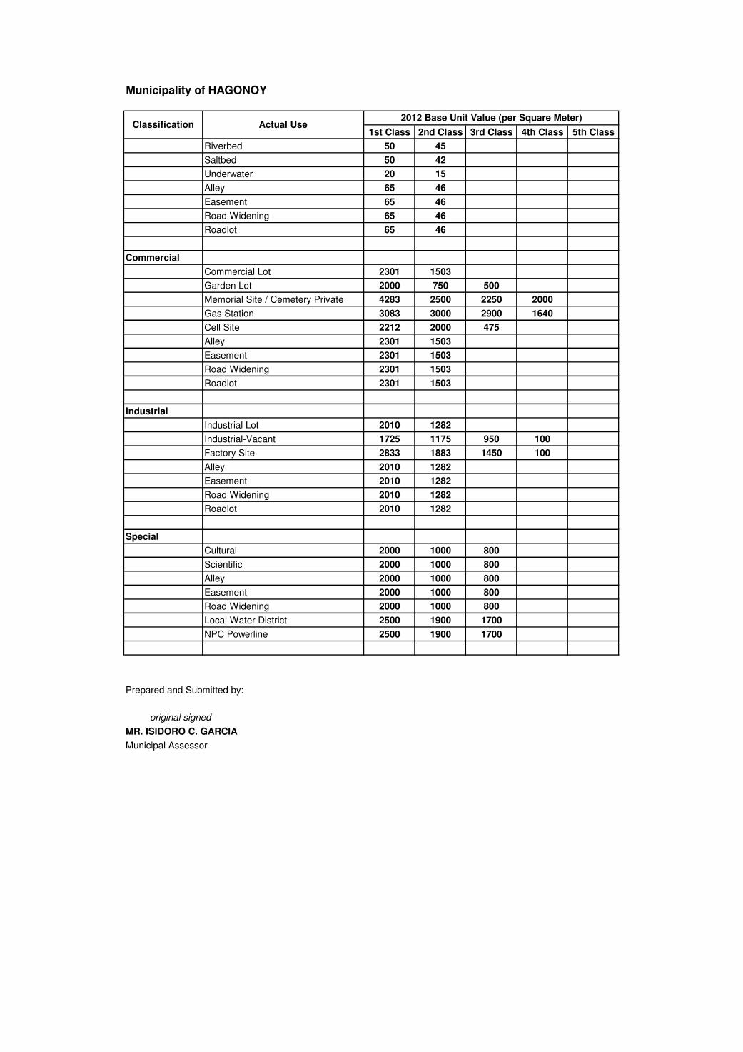
Municipality of HAGONOY
1st Class 2nd Class 3rd Class 4th Class 5th Class
2012 Base Unit Value (per Square Meter)Classification Actual Use
Riverbed 50 45
Saltbed 50 42
Underwater 20 15
Alley 65 46
Easement 65 46
Road Widening 65 46
Roadlot 65 46
Commercial
Commercial Lot 2301 1503
Garden Lot 2000 750 500
Memorial Site / Cemetery Private 4283 2500 2250 2000
Gas Station 3083 3000 2900 1640
Cell Site 2212 2000 475
Alley 2301 1503
Easement 2301 1503
Road Widening 2301 1503
Roadlot 2301 1503
Industrial
Industrial Lot 2010 1282
Industrial-Vacant 1725 1175 950 100
Factory Site 2833 1883 1450 100
Alley 2010 1282
Easement 2010 1282
Road Widening 2010 1282
Roadlot 2010 1282
Special
Cultural 2000 1000 800
Scientific 2000 1000 800
Alley 2000 1000 800
Easement 2000 1000 800
Road Widening 2000 1000 800
Local Water District 2500 1900 1700
NPC Powerline 2500 1900 1700
Prepared and Submitted by:
Municipal Assessor
note: values in red font were added through addendum
original signed
MR. ISIDORO C. GARCIA

Municipality of MARILAO
1st Class 2nd Class 3rd Class 4th Class 5th Class
Government
Cemetery Site 2230
Provincial Road 1380 1090 980 880
Municipal Road 1380 1090 980 880
Barrio Road 1380 1090 980 880
Brgy Hall Site 2980 2270 1860 1460
Municipal Hall Site 2980 2270 1860 1460
Market Site 2100 1860 1020 970
MNDR 1380 1090 980 880
Railroad (PNR) 1380 1090 980 880
Health Center Site 2980 2270 1860 1460
Religious
Chapel Site / Church Site 1880 1570 1450 1060
Columbary Site 1880 1570 1450 1060
Parsonage Site 1880 1570 1450 1060
Educational
School Site 2010 1830 1500 980
Charitable
Daycare Center 2010 1830 1500 980
Residential
Residential Lot 2800 2580 2120 1770
Subdivision Lot 3060 2740 2510 1940
Residential - Vacant 2800 2580 2120 1770
Open Space 1380 1090 950 880
Right of Way 1380 1090 950 880
Alley 1380 1090 950 880
Easement 2800 2580 2120 1770
Road Widening 2800 2580 2120 1770
Roadlot 1380 1090 950 880
Canal Site/ Creek Site 1380 1090 950 880
Drainage Site/ River Site 1380 1090 950 880
Parks and Playground 1380 1090 950 880
Community Facilities 1380 1090 950 880
Multi Purpose Hall Site 1380 1090 950 880
Agricultural
Riceland Irrigated 260 220 180
Riceland Unirrigated 220 180 140
Agri- Vacant 470 420 370
Bacood 970 700 400
Mangoland 1000 700 400
Piggery Site 1700 1200 700
Poultry Site 1700 1200 700
Orchard 970 700 400
Pastureland 1000 700 400
Fishpond 450 340 230
Bambooland 1070 700 400
Cogonland 930 700 400
Tumanal 970 700 400
Rawland 470 420 370
Citrusland 970 700 400
Forestland 990 700 400
Swampy Land 220 180 140
Alley 430 340 230
Roadlot 430 340 230
Classification Actual Use2012 Base Unit Value (per Square Meter)

Municipality of MARILAO
1st Class 2nd Class 3rd Class 4th Class 5th ClassClassification Actual Use
2012 Base Unit Value (per Square Meter)
Commercial
Commercial Lot 3570 3160 2840 2540
Memorial Site / Cemetery Private 3570 3160 2840 2540
Gas Station 3570 3160 2840 2540
Cell Site 3570 3160 2840 2540
Crematory Site 3570 3160 2840 2540
Alley 1380 1090 950 880
Easement 3570 3160 2840 2540
Road Widening 3570 3160 2840 2540
Roadlot 1380 1090 950 880
Garden Lot 3570 3160 2840 2540
Industrial
Industrial Lot 3840 2680 2270 1880
Industrial-Vacant 3840 2680 2270 1880
Factory Site 3840 2680 2270 1880
Alley 1380 1090 950 880
Easement 3840 2680 2270 1880
Road Widening 3840 2680 2270 1880
Roadlot 1380 1090 950 880
Drying Area 3840 2680 2270 1880
Mineral
StoneQuarry 610 450 290
Alley 430 340 230
Easement 610 450 290
Road Widening 610 450 290
Roadlot 430 340 230
Special
Hospital 3420 3000 2810 2440
Recreational 3420 3000 2810 2440
Alley 1380 1090 950 880
Easement 3420 3000 2810 2440
Road Widening 3420 3000 2810 2440
Clinic Site/Lying-in Site 3420 3000 2810 2440
Cooperative Site 3420 3000 2810 2440
Firing Range Site 3420 3000 2810 2440
Water Pumping Station Site 3420 3000 2810 2440
Electric Power Station Site 3420 3000 2810 2440
Prepared and Submitted by:
Municipal Assessor
note: values in red-colored font were added through addendum
original signed
MR. MARCOS S. SANTOS

Municipality of NORZAGARAY
1st Class 2nd Class 3rd Class 4th Class 5th Class
Government
Cemetery Site 1164 957 778
Municipal Road 820 621 502
Barrio Road 820 621 502
Brgy Hall Site 952 780 643
Municipal Hall Site 952 780 643
Government Hospital 952 780 643
Market Site 2157 1678 1000
Artesian Well 900 780 643
Dumpsite 51 41 35
NPC Powerline 346 273 196
Religious
Chapel Site / Church Site 900 780 657
Educational
School Site 900 780 657
Charitable
Orphanage Site 900 780 657
Residential
Residential Lot 1180 796 532
Subdivision Lot 1606 1044 732
Residential - Vacant 1180 796 532
Open Space 1180 796 532
Right of Way 613 550 481
Road Widening 613 550 481
Roadlot 613 550 481
Agricultural
Riceland Irrigated 80 60 45
Riceland Unirrigated 55 42 34
Agri- Vacant 911 799 693
Bacood 63 48 30
Mangoland 72 53 39
Piggery Site 65 55 49
Poultry Site 65 55 49
Cornland 61 46 33
Pastureland 113 78 51
Sugarland 80 70 60
Fishpond 25 20
Bambooland 72 58 42
Cogonland 104 77 53
Tumanal 98 76 54
Rawland 57 49
Coconutland 115 95 80
Vegetableland 50 40 30
Commercial
Commercial Lot 2549 1817 1398
Golf Course / Driving Range 2549 1817
Memorial Site / Cemetery Private 1300 1089 900
Industrial
Industrial Lot 2936 1986 1103
Factory Site 2128 1614 1105
Road Widening 613 550 481
Roadlot 613 550 481
Classification Actual Use2012 Base Unit Value (per Square Meter)

Municipality of NORZAGARAY
1st Class 2nd Class 3rd Class 4th Class 5th ClassClassification Actual Use
2012 Base Unit Value (per Square Meter)
Mineral
StoneQuarry 74 67 56
Gravel & Sand 56 53 45
Special
Hospital 884 652 529
Road Widening 552 447 313
Local Water District 1046 805 661
NPC Powerline 556 454 322
Prepared and Submitted by:
MS. DOLORES C. REYES
Municipal Assessor
note: values in red-colored font were added through addendum
original signed

Municipality of OBANDO
1st Class 2nd Class 3rd Class 4th Class 5th Class
Government
Cemetery Site 1300 910
Brgy Hall Site 1020
Municipal Hall Site 1320
Government Hospital 1320
Market Site 1320
Transmitter Site 1300 1020
Religious
Chapel Site / Church Site 1320 1020
Educational
School Site 1320 1020 740
Charitable
Daycare Center 1020 910
Residential
Residential Lot 1320 1020 740 640
Residential - Vacant 1300 1020 740 640
Open Space 1300 1020 740 640
Right of Way 120
Alley 120
Easement 910 740
Road Widening 1320 1020
Roadlot 120
Agricultural
Riceland Unirrigated 44 40
Agri- Vacant 44
Agro-Industrial 1320 1020
Bacood 44 20
Fishpond 55 33 22
Underwater 22 20
Mangroove 20 18
Commercial
Commercial Lot 1900 1480 1230
Memorial Site / Cemetery Private 1750 1480 1230
Gas Station 1850 1480 1230
Cell Site 1900 1480 1230
Alley 120
Easement 910
Road Widening 1900 1480 1230
Roadlot 120
Dumpsite 1750 1480 1230
E X E M P T
Classification Actual Use2012 Base Unit Value (per Square Meter)
E X E M P T

Municipality of OBANDO
1st Class 2nd Class 3rd Class 4th Class 5th ClassClassification Actual Use
2012 Base Unit Value (per Square Meter)
Industrial
Industrial Lot 1750 1480 1230
Industrial-Vacant 1480 1230
Factory Site 1750 1480 1230
Alley 120
Easement 910
Road Widening 1900 1230
Roadlot 120
Special
Hospital 1500
Local Water District 1320
Prepared and Submitted by:
MR. NESTOR M. ANSELMO
Municipal Assessor
note: values in red-colored font were added through addendum
original signed

Municipality of PANDI
1st Class 2nd Class 3rd Class 4th Class 5th Class 6th Class 7th Class
Government
Cemetery Site 1400 1200
Provincial Road 700
Municipal Road 650
Barrio Road 650
Brgy Hall Site 1000 900 800 750 700 650 550
Municipal Hall Site 1000 900 800 750 700 650 550
Market Site 1000 900 800 750 700
NIA Road 250 220 180
MNDR
Dumpsite 700 600 500 400 300
Health Center Site 1000 900 800 750 700
Hospital Site 1000 900 800 750 700
Slaughter Site 1000 900 800 750 700
Dam/Pritel 100 90
Monument Site 1000 900 800 750 700
Religious
Chapel Site / Church Site 1000 900 800 750 700 650 550
Convent Site 1000 900
Retreat House 1000 900
Educational
School Site 1000 900 800 750 700 650 550
Daycare Center 1000 900 800 750 700
School Canteen Site 1000 900
Charitable
Orphanage Site 1000 900
Rehabilitation Center 1000 900 800 750 700 650 550
Residential
Residential Lot 1000 900 800 750 700
Subdivision Lot 1200 1100 900
Residential - Vacant 800 700
Open Space 1200 1100 900 800 700
Road Right of Way 650
Alley 650
Easement 650
Road Widening 650
Roadlot 650
Excluded Area 650
Drainage 650
Agricultural
Riceland Irrigated 100 90
Riceland Unirrigated 70 60
Agri- Vacant 80 60
Agro-Industrial 300 250
Bacood 80 70
Mangoland 80 70
Piggery Site 300 250 200 130
Poultry Site 300 250 200 130
Orchard 80 70
Cornland 80 70
Pastureland 80 70
Fishpond 100 90
Bambooland 60 50
Cogonland 60 50
Rawland 250 200 150
Forestland 60 50
T A X A B L E
Classification Actual Use
T A X A B L E
2012 Base Unit Value (per Square Meter)

Municipality of PANDI
1st Class 2nd Class 3rd Class 4th Class 5th Class 6th Class 7th ClassClassification Actual Use
2012 Base Unit Value (per Square Meter)
Creek / Irrigational Canal 140 110

Municipality of PANDI
1st Class 2nd Class 3rd Class 4th Class 5th Class 6th Class 7th ClassClassification Actual Use
2012 Base Unit Value (per Square Meter)
Alley 60 50
Right of Way 140 110 90
Vegetableland 70 50
Road Right of Way 140 110
Easement 140 110
Roadlot 140 110
Road widening 140 110
Commercial
Commercial Lot 1400 1200 1000 900
Resort 1300 1100 900
Market Site 1400 1200 1000 900
Memorial Site / Cemetery Private 1300 1100 900
Gas Station 1400 1200 1000 900
Cell Site 1400 1200 1000 900
Alley 1200 1000 900 800
Cooperative Site 1400 1200 1000 900
Road Widening 650
Roadlot 650
Industrial
Industrial Lot 1200 1000 900 800
Industrial-Vacant 1000 900 700 600
Factory Site 1400 1200
Easement 650
Road Widening 650
Roadlot 650
Mineral
StoneQuarry 60 50
Whiteclay 60 50
Special
Hospital 1000 900 800 750 700 650 550
Recreational 1000 900 800 750 700 650 550
Roadlot 650
Road Widening 650
Local Water District 1000 900 800 750 700 650 550
Cooperative site 1400 1200 1000 900
NPC Powerline 1400 1200
Prepared and Submitted by:
MS. VALENTINA F. SAN PEDRO
Municipal Assessor
note: values in red-colored font were added through addendum
original signed

Municipality of PAOMBONG
1st Class 2nd Class 3rd Class 4th Class 5th Class
Residential
Residential Lot 1777 1358 1008
Subdivision Lot 1850 1536
Residential - Vacant 1544 1231 912
Right of Way 1375 1038 866
Road Widening 1352 927 722
Roadlot 1267 894 732
Garden land 1469 1144
Agricultural
Riceland Irrigated 96 63
Bacood 80
Mangoland 90
Fishpond 86 70
Gardenlot / Bermuda Garden 64 50
Nipaland 79
Commercial
Commercial Lot 2297 1990
Memorial Site / Cemetery Private 2583
Gas Station 2000 1550
Cell Site 3250
Road Widening 1917
Roadlot 1917
Industrial
Industrial Lot 1290
Prepared and Submitted by:
Classification Actual Use2012 Base Unit Value (per Square Meter)
original signed
ENGR. MARCIANO C. REYES
Municipal Assessor
note: values in red-colored font were added through addendum

Municipality of PLARIDEL
1st Class 2nd Class 3rd Class 4th Class 5th Class 6th Class 7th Class
Government
Protection Dike 354
Educational
School Site 2368 1944 1781
Residential
Residential Lot 2528 2157 1398
Subdivision Lot 2906 2632 2047
Residential - Vacant 2528 2157 1398
Open Space 2528 2157 1398
Protection Dike-Res'l 2528 2157 1398
Easement 2528 2157 1398
Alley 2528 2157 1398
Road Widening 2528 2157 1398
Roadlot 2528 2157 1398
Railroad-Res'l 2528 2157 1398
Agricultural
Riceland Irrigated 480 354 292
Riceland Unirrigated 354 292 261
Agri- Vacant 754 480 354
Bacood 480 354 292
Mangoland 754 480 354
Piggery Site 754 480 354
Poultry Site 754
Orchard 480 354 292
Cornland 261
Pastureland 354 292 261
Sugarland 292
Fishpond 354 292 261
Bambooland 354 292 261
Cogonland 354 292 261
Tumanal 292
Citrusland 480 354 292
Coconutland 354
Nipaland 292
Irrigational Canal 223
Riverbed 47
Underwater 223
Vegetableland 292
Tobacco land 292
Creek 47
Roadlot 480 354 292
Protection Dike-Agr'l 354 292 261
Easement 354 292 261
Alley 354 292 261
Road widening 354 292 261
Commercial
Commercial Lot 5592 3950 3139
Memorial Site / Cemetery Private 15000 8000 5000
Gas Station 5592 3950 3139
Cell Site 5592 3950 3139
Commercial Lot (undev.) 250
2012 Base Unit Value (per Square Meter)Classification Actual Use

Municipality of PLARIDEL
1st Class 2nd Class 3rd Class 4th Class 5th Class 6th Class 7th Class
2012 Base Unit Value (per Square Meter)Classification Actual Use
Industrial
Industrial Lot 4161 2950 1312
Industrial - Undeveloped 1312 850 462
Roadlot 354 292 261
Vacant 2950 1312 462
Mineral
Gravel & Sand 1000 600 200
Special
Cultural 2157 2000 1000
Scientific 3000 2157 1398
Recreational 3500 2632 2250
Hospital 4292 2157 1250
Church/ Chapel Site 2368 1944 1781
Public Cemetery 2528 2157 1398
Brgy. Health Center 2528 2157 1398
Brgy. Hall Site 2528 2157 1398
Cooperative 2528 2157 1398
River 2528 2157 1398
Prepared and Submitted by:
MS. ROSALINDA S. RAMOS
note: values in red-colored font were added through addendum
original signed
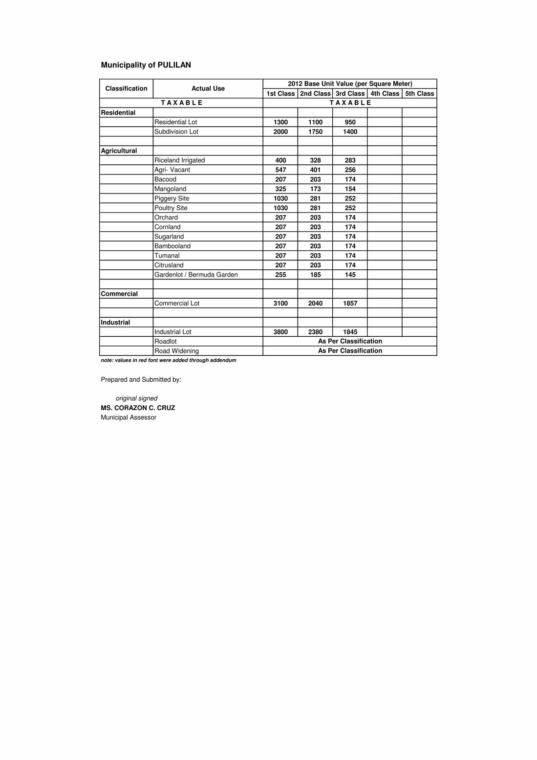
Municipality of PULILAN
1st Class 2nd Class 3rd Class 4th Class 5th Class
Residential
Residential Lot 1300 1100 950
Subdivision Lot 2000 1750 1400
Agricultural
Riceland Irrigated 400 328 283
Agri- Vacant 547 401 256
Bacood 207 203 174
Mangoland 325 173 154
Piggery Site 1030 281 252
Poultry Site 1030 281 252
Orchard 207 203 174
Cornland 207 203 174
Sugarland 207 203 174
Bambooland 207 203 174
Tumanal 207 203 174
Citrusland 207 203 174
Gardenlot / Bermuda Garden 255 185 145
Commercial
Commercial Lot 3100 2040 1857
Industrial
Industrial Lot 3800 2380 1845
Roadlot
Road Widening
Prepared and Submitted by:
MS. CORAZON C. CRUZ
Municipal Assessor
note: values in red font were added through addendum
As Per Classification
T A X A B L E
As Per Classification
2012 Base Unit Value (per Square Meter)Actual UseClassification
T A X A B L E
original signed

Municipality of SAN ILDEFONSO
1st Class 2nd Class 3rd Class 4th Class 5th Class
Government
Cemetery Site 1700
Brgy Hall Site 1150 720 520 260 200
Municipal Hall Site 1150
Market Site 1400
Artesian Well 1150 720 520 260 200
Dumpsite 15
NPC Powerline
Railroad (PNR)
Transmitter Site
Municipal Park 1150
Religious
Chapel Site / Church Site
Educational
School Site
Charitable
Daycare Center
Residential
Residential Lot 1150 720 520 260 200
Subdivision Lot 1400 1120
Residential - Vacant 500 350 250 150 100
Open Space
Right of Way
Alley
Easement
Road Widening
Roadlot
Agricultural
Riceland Irrigated 38 33
Riceland Unirrigated 33
Agro-Industrial 156
Bacood 26
Mangoland 90
Piggery Site 156
Poultry Site 156
Orchard 90 70 54
Pastureland 15
Fishpond 45
Cogonland 15
Upland 20
Lowland 14
Creek / Irrigational Canal
Riverbed
Alley
Easement
Road Widening
Roadlot
Riceland - Upland 20
Riceland - Lowland 14
Agricultural - Vacant 35
Duck Pen Site 156
Warehouse 1400 1050 710
The same unit value of the adjoining lots.
The same unit value of the adjoining lots.
The same unit value of the adjoining lots.
The same unit value of the adjoining lots.
The same unit value of the adjoining lots.
The same unit value of the adjoining lots.
The same unit value of the adjoining lots.
The same unit value of the adjoining lots.
The same unit value of the adjoining lots.
The same unit value of the adjoining lots.
The same unit value of the adjoining lots.
The same unit value of the adjoining lots.
The same unit value of the adjoining lots.
The same unit value of the adjoining lots.
The same unit value of the adjoining lots.
The same unit value of the adjoining lots.
The same unit value of the adjoining lots.
2012 Base Unit Value (per Square Meter)Classification Actual Use
The same unit value of the adjoining lots.

Municipality of SAN ILDEFONSO
1st Class 2nd Class 3rd Class 4th Class 5th Class
2012 Base Unit Value (per Square Meter)Classification Actual Use
Commercial
Commercial Lot 1400 1050 710
Memorial Site / Cemetery Private 1700
Gas Station 1400 1050 710 450 280
Alley
Easement
Road Widening
Roadlot
Cell Site 1400 1050 710 450 280
Resort 1400 1050 710 450 280
Cooperative 1400
Ricemill Site 1400 1050 710 450 280
Warehouse Site 1400 1050 710 450 280
Lodging House Site 1400 1050 710 450 280
Commercial Complex 1400 1050 710
Store/Stall Site 1400 1050 710 450 280
Clinic 1400 1050 710 450 280
Cockpit Arena 1400 1050 710
Apartment 1400 1050 710 450 280
Hardware Site 1400 1050 710 450 280
Funeral Parlor Site 1400 1050 710 450 280
Tailoring Shop 1400 1050 710 450 280
Water Refilling Station 1400 1050 710 450 280
Gas Refilling Plant 1400 1050 710
Industrial
Industrial Lot 730 595 480 300 160
Factory Site 730 595 480 300 160
Alley
Easement
Road Widening
Roadlot
Industrial - Undev. 140
Mineral
StoneQuarry 95
Gravel & Sand 28
Silica 30
Marble 98
Limestone 20
Adobe 28
Whiteclay 30
Alley
Easement
Road Widening
Roadlot
The same unit value of the adjoining lots.
The same unit value of the adjoining lots.
The same unit value of the adjoining lots.
The same unit value of the adjoining lots.
The same unit value of the adjoining lots.
The same unit value of the adjoining lots.
The same unit value of the adjoining lots.
The same unit value of the adjoining lots.
The same unit value of the adjoining lots.
The same unit value of the adjoining lots.
The same unit value of the adjoining lots.
The same unit value of the adjoining lots.

Municipality of SAN ILDEFONSO
1st Class 2nd Class 3rd Class 4th Class 5th Class
2012 Base Unit Value (per Square Meter)Classification Actual Use
Special
Local Water District
NPC Powerline
Hospital 1400
Health Center
Cooperative 1400 1050 710
Housing Project 1150 720 520 260 200
Prepared and Submitted by:
original signed
ENGR. MARILYN V. SANCHEZ
Municipal Assessor
note: values in red-colored font were added through addendum
The same unit value of the adjoining lots.
The same unit value of the adjoining lots.
The same unit value of the adjoining lots.

Municipality of SAN MIGUEL
1st Class 2nd Class 3rd Class 4th Class 5th Class
Government
Cemetery Site 800
Provincial Road 180
Municipal Road 180
Barrio Road 180
Brgy Hall Site 800
Municipal Hall Site 800
Government Hospital 800
Market Site 1600
NIA Road 180
Dumpsite 185
Railroad (PNR) 180
Nursery Site 800
Military Camp 800
Public Park/ Plaza 800
National Road 800
Health Center Site 800
Slaughter House 800
Road Widening 200
Religious
Chapel Site / Church Site/Mosque 800
Pastoral House 800
Convent 800
Educational
School Site 800
Charitable
Daycare Center 800
Cooperatives
Cooperative Sites 1600
Residential
Residential Lot 974 787 509 293 218
Subdivision Lot 2629 984 958
Residential - Vacant 910 780 500 288 215
Open Space 218
Right of Way 218
Alley 218
Easement 218
Road Widening 218
Roadlot 218
Agricultural
Riceland Irrigated 72 50 34
Riceland Unirrigated 53 40 30
Riceland Upland 35 30 25
Riceland Lowland 35 30 24
Agro-Industrial 141 116 99
Bacood 20 18 15
Mangoland 101 80 70
Piggery Site 95 84 74
Poultry Site 95 84 74
Orchard 20 18 15
Classification Actual Use2012 Base Unit Value (per Square Meter)

Municipality of SAN MIGUEL
1st Class 2nd Class 3rd Class 4th Class 5th ClassClassification Actual Use
2012 Base Unit Value (per Square Meter)
Cornland 30 25 20
Pastureland 18 16 14
Sugarland 25 20 15
Fishpond 60 52 45
Bambooland 25 20 15
Cogonland 18 16 14
Tumanal 20 18 14
Citrusland 25 20 14
Forestland 12 10 8
Coconutland 25 22 20
Farmlot 97 86 73
Creek / Irrigational Canal 49 45 40
Riverbed 50 40 30
Alley 50 40 30
Easement 50 40 30
Road Widening 50 40 30
Roadlot 50 40 30
Sampaguita 25 20 15
Water Reservoir 45 40 30
Duck Pen Site 75 65 56
Subdivision 97 90 81
Commercial
Commercial Lot 1655 1297 1110
Memorial Site / Cemetery Priv 1005
Gas Station 1655 1297 1110
Cell Site 1866
Alley 950
Easement 950
Road Widening 950
Roadlot 950
Industrial
Industrial Lot 1500 1000 750
Industrial-Vacant 918 820 750
Alley 750
Easement 750
Road Widening 750
Roadlot 750
Mineral
StoneQuarry 35
Gravel & Sand 30
Marble 40
Gravel & Sand Quarry Site 35
Marble Quarry Site 45
StoneQuarry Site 40
Alley 30
Easement 30
Road Widening 30
Roadlot 30

Municipality of SAN MIGUEL
1st Class 2nd Class 3rd Class 4th Class 5th ClassClassification Actual Use
2012 Base Unit Value (per Square Meter)
Timberland
Water Reservoir 50
Special
Cultural 802
Hospital 802
Alley 200
Easement 200
Roadlot 200
Road Widening 200
Recreational 802
Local Water District 802
NPC Powerline 802
Prepared and Submitted by:
original signed
MR. OSCAR G. PELAYO
Municipal Assessor
note: values in red-colored font were added through addendum

Municipality of SAN RAFAEL
1st Class 2nd Class 3rd Class 4th Class 5th Class
Government
Cemetery Site 1000 661
Provincial Road 714 472
Barrio Road 182
Brgy Hall Site 1000 660 491 339
Municipal Hall Site 1000 660 491 339
Market Site 1091 721 536 369
Artesian Well 1000 661 491 339
Mil Camp Site 491
Nursery Site 1000 661 491 339
Plaza Park 661
Hospital Site 1000
Alley 714 472 351 242
Roadlot 714 472 351 242
Right of Way 714 472 351 242
Easement 714
Religious
Chapel Site / Church Site 1000 661 491
Retreat House 1000 660 491 339
Educational
School Site 1000 660 491 339
Daycare Center Site 1000 660 491 339
Education 661 491
Charitable
Orphanage Site 1000 660 491 339
Residential
Residential Lot 1000 662 493 339
Subdivision Lot 1155 832 582 410
Residential - Vacant 1000 662 493 339
Open Space 714 472 351 242
Right of Way 714 472 351 242
Alley 714 472 351 242
Easement 714 472 351 242
Road Widening 714 472 351 242
Roadlot 714 472 351 242
Reserved Area 714 472 351 242
Roadlot (subd) 714 472 351 242
Excluded Area 714 472 351 242
Agricultural
Riceland Irrigated 42 36 32
Riceland Unirrigated 32 27 23 20
Agri- Vacant 42 36 32
Agro-Industrial 200 150 100 50
Bacood 32
Mangoland 78
Piggery Site 105 78 32
Poultry Site 105 78 32
Orchard 78
Cornland 42
Pastureland 17
Fishpond 53
Bambooland 42 36 32
Classification Actual Use2012 Base Unit Value (per Square Meter)

Municipality of SAN RAFAEL
1st Class 2nd Class 3rd Class 4th Class 5th ClassClassification Actual Use
2012 Base Unit Value (per Square Meter)
Cogonland 17
Tumanal 42
Creek / Irrigational Canal 301
Riverbed 23
Underwater 30 23
Watershed 30 20
Water Bed 23
Right of Way 50 27 23 20
Road Widening 50
Roadlot 50 27 23 20
Agri-Subd 661
Provincial Road 714 472
Barrio Road 182
Commercial
Commercial Lot 1320 950 564
Golf Course / Driving Range 1242 1035 621
Memorial Site / Cemetery Priv 1015
Cell Site 1320 950 564
Recreation Site 1320 950 564
Ricemill 1320 950 564
Industrial
Industrial Lot 1320 950 564
Factory Site 1314 966 560
Mineral
StoneQuarry 46 35
Gravel & Sand 42
Roadlot 180 180 180
Provincial Road 180
Barrio Road 180
Special
Recreational Site 1000 660 491 339
Transmission Line 1000 660 491 339
Local Water District 1000 660 491 339
Prepared and Submitted by:
MS. TERESA G. PEREZ
Municipal Assessor
note: values in red-colored font were added through addendum
original signed

Municipality of STA. MARIA
1st Class 2nd Class 3rd Class 4th Class 5th Class
Government
Cemetery Site 2600 1500 1195 900 747
Provincial Road 1089 847 605 363 242
Municipal Road 1089 847 605 363 242
Barrio Road 1089 847 605 363 242
Brgy Hall Site 1089 847 605 363 242
Municipal Hall Site 1089 847 605 363 242
Government Hospital 1089 847 605 363 242
Market Site 2016 1584 1296
Artesian Well 1089 847 605 363 242
Dumpsite 40 29
NPC Powerline 40 29
Transmitter Site 1089 847 605 363 242
Jail Site 1089 847 605 363 242
Religious
Chapel Site / Church Site 1089 847 605 363 242
Educational
School Site 1089 847 605 363 242
Charitable
Orphanage Site 1089 847 605 363 242
Rehabilitation Center 1089 847 605 363 242
Daycare Center 1089 847 605 363 242
Residential
Residential Lot 2600 1500 1195 900 747
Subdivision Lot 2340 1420 1163
Residential - Vacant 1500 1195 900 747 500
Open Space 143 105
Right of Way 143 105
Alley 143 105
Easement 750 563
Road Widening 143 105
Roadlot 143 105
Canal 143 105
Parks/Playground 143 105
Water Tank Site 143 105
Agricultural
Riceland Irrigated 250 179
Riceland Unirrigated 200 148 100
Agri- Vacant 303 200 120
Agro-Industrial 500 350 200
Bacood 149 101
Mangoland 349 300
Piggery Site 400 255
Poultry Site 400 255
Classification Actual Use2012 Base Unit Value (per Square Meter)

Municipality of STA. MARIA
1st Class 2nd Class 3rd Class 4th Class 5th ClassClassification Actual Use
2012 Base Unit Value (per Square Meter)
Orchard 149 101
Cornland 149 101
Pastureland 101 53
Sugarland 149 101
Bambooland 130 81
Cogonland 101 53
Tumanal 149 101
Upland 303 200
Lowland 303 200
Rawland 303 200 120
Citrusland 130 81
Forestland 149 101
Coconutland 130 81
Farmlot 400 255
Breeding Farm 400 255
Creek / Irrigational Canal 250 179
Underwater 149 101
Alley 100 75
Easement 100 75
Road Widening 100 75
Roadlot 100 75
Vegetableland 130 81
Right of Way 100 75
Canal 143 105
River 143 105
Commercial
Commercial Lot 5020 2300 1650
Memorial Site / Cemetery Private 5020 2300 1650
Gas Station 5020 2300 1650
Dumpsite 5020 2300 1650
Cell Site 5020 2300 1650
Alley 100 75
Easement 1650 990
Road Widening 100 75
Roadlot 100 75
Memorial Park-Exempt 5020 2300 1650
Industrial
Industrial Lot 2350 1900 1370
Industrial-Vacant 1900 1370
Dumpsite 2350 1900 1370
Factory Site 2350 1900 1370
Alley 100 75
Easement 1375 825
Road Widening 100 75
Roadlot 100 75
Industrial - Undev. 100
Mineral
StoneQuarry 180 100 75
Gravel & Sand 180 100
Adobe 180 100
Alley 100 75

Municipality of STA. MARIA
1st Class 2nd Class 3rd Class 4th Class 5th ClassClassification Actual Use
2012 Base Unit Value (per Square Meter)
Easement 100 75
Road Widening 100 75
Roadlot 100 75
Special
Cultural 1089 847 605 363 242
Scientific 1089 847 605 363 242
Hospital 1089 847 605 363 242
Recreational 2016 1584 1296
Alley 143 105
Easement 143 105
Roadlot 143 105
Road Widening 143 105
Local Water District 1089 847 605 363 242
NPC Powerline 40 29
Slaughter House 2600 1500 1195 900 747
Special-Clinic 1089 847 605 363 242
Canal 143 105
Communal Well 143 105
Brgy Clinic 1089 847 605 363 242
Coop-Residential 1089 847 605 363 242
Prepared and Submitted by:
original signed
MR. MARINO R. LIZASO III
Municipal Assessor
note: values in red-colored font were added through addendum