(n ow hle copn (n cultural resources series … · (n ow hle copn ~ (n cultural resources series...
TRANSCRIPT

(N OW HlE COPN ~(NCULTURAL RESOURCES SERIES
Report Number: COELMN/PD - 88/10
g US Army Corpsof EngineersNew Orleans District
A CULTURAL RESOURCES SURVEYOF THE ST. CHARLES PARISHHURRICANE PROTECTION LEVEE,ST. CHARLES PARISH, LOUISIANA
Final Report
September 1988
DTICifELECTE3
Coastal Environments, Inc. kDEC 2 1198 81260 Main StreetBaton Rouge, Louisiana 70802 H
Prepared for
U.S. Army Corps of EngineersNew Orleans DistrictP.O. Box 60267New Orleans, LA 70160-0267
UNCLASSIFIED. Distribution is unlimited." -
Is'1, -- 4

UnclassifiedSECURITY CLASSIFICATION OF THIS PAGE ('When Date Entered)
REPORT DOCUMENTATION PAGE READ INSTRUCTIONSBEFORE COMPLETING FORM
1. REPORT NUMBER 2. GOVT ACCESSION NO. 3. RECIPIENT'S CATALOG NUMBER
COELXN/PD-88/ 10
4. TITLE (and Subtitle) S. TYPE OF REPORT & PERIOD COVERED
A Cultural Resources Survey of the St. Charles Final ReportParish Hurricane Protection Levee, St. Charles
Parish, Louisiana 6. PERFORMING ORG. REPORT NUMBER
AR-2377. AUTHOR(e) 8. CONTRACT OR GRANT NUMBER(.)
Thurston Hahn, IlII and Charles E. Pearson DACW29-86-D-0092Delivery Order 4
9. PERFORMING ORGANIZATION NAME AND ADDRESS 10. PROGRAM ELEMENT. PROJECT. TASKAREA a WORK UNIT NUMBERS
Coastal Environments, Inc.
1260 Main Street
Baton Rouge, LA 70802
II. CONTROLLING OFFICE NAME AND ADDRESS 12. REPORT DATE
Department of the Army. New Orleans September 1988District, Corps of En' ineers 13. NUMBEROF PAGES
P.O. Box 60267, New Orleans, LA 70160-0267 8914. MONITORING AGENCY NAME & ADDRESS(If different irom Controlling Office) IS. SECURITY CLASS. (of thie report)
Unclassified: Distributionis unlimited
15. OECLASSIFICATION/OOWNGRAOINGSCHEDULE
16. DISTRIBUTION STATEMENT (of tlie Report)
Appro,,ed for Public Release: Distribution is Unlimited
17. DISTRIBUTION STATEMENT (of the abstract entered In Block 20, It different from Report)
S ame
IS. SUPPLEMENTARY NOTES
IS. KEY WORDS (Continue on reveree olde if neceeary and identify by block number)
Aricultural Drainage Mississippi RiverArchaeology Pontchartrain Basin
Bayou Trepagnier St. Charles Parish(;eologyLou i s iana
24L AWTRACr (1C'rItm~e reree efd t N a--, sd IdonIfy by block nmwber)
Cultural resources surveys of five areas along the proposed Hurricane
Protection Levee on the east bank of St. Charles Parish, Louisiana, were
uonducted in October and November 1987. Fieldwork within these areas located
three archaeological sites (16 SC 65, 16 SC 66 and 16 SC 67). All threesites represent late-nineteenth to early-twentieth century, field drainage
stations. None of these properties are considered significant in terms of
National Register criteria. A series of geological cores made along the
project right-of-way were used to assess and reconstruct the recent geological
DD " "' W3 EornDw or, Io NOV GS OLETIEJI J 73 7Unclassified
SECURITY CLASSIFICATION OF THIS PAGE (When Dete Entered)

UnclassifiedSECURITY CLASSIFICATION OF THIS PAGE(WhMen Data Enteroer)
history of the area. A previously identified natural levee feature, buriedapproximately 12 ft below the surface, was studied. Radiocarbon dates obtainedon samples taken from the cores indicate this buried levee dates circa 2000 to3400 B.P. and could contain archaeological sites.
Accessiol For..........
D72TAA E
. . . .- 4 . , . . .
UnclassifiedSECURITY CLASSIFICATION OF THIS PAGE(1P1nm Data RlonmE)

DEPARTMENT OF THE ARMYNEW ORLEANS DISTRICT CORPS OF ENGINEERS
P0 BOX 60267
NEW ORLEANS, LOUISIANA 70160-0267
REPLY TOSrTEN TION OF
Planning DivisionEnvironmental Analysis Branch
To The Reader:
This cultural resources effort was designed,funded and guided by the U.S. Army Corps of Engineers,New Orleans District as part of our cultural resourcesmanagement program. The effort documented in thisreport was a cultural resources survey of the proposedright-of-way of the St. Charles Parish Levee, afeature of the Lake Pontchartrain Hurricane Protectionproject.
We concur with the Contractor's findings andrecommendations. Therefore, no further culturalresource studies of this project feature are planned.
MichalE SttAuthorized Representativeof the Contracting Officer
R. H. Schroeder, Jr.Acting Chief, Planning Division
- " . .il l i I I I I I

ACKNOWLEDGEMENTS
Fieldwork for this project was conducted by Charles E. Pearson; Thurston Hahn, IIl; XuJingxuan; and Stephanie Perrault. Geological interpretations were developed byCharles Pearson with the assistance of Sherwood Gagliano. Figures for the reportwere prepared by Curtis Latiolais, Don Hunter, and Thurston Hahn, I1. Kim Smith andRamona Mayer typed the report, and Linda Abadie edited the final version.
3

TABLE OF CONTENTS
Letter of Transmittal ..................................................... 1
Acknowledgements ....................................................... 3
List of Figures ........................................................... 7
List of Tables ........................................................... 9
Chapter : Introduction .................................................. 11
Chapter 2: Environmental Setting ......................................... 12Geology .................................................. 12
Age of the Levee System ................................. 21
Chapter 3: Previous Archaeological Research andregional Culture History ....................................... 25
Occupational History ....................................... 25Aboriginal Occupation ................................... 25European Occupation .................................... 30
Chapter 4: Field Investigations........................................... 41AreaA A.................................................. 41Area B ............................................... 42Area C ............................................... 43Area D ............................................... 44Area E ............................................... 44
Chapter 5: Results of Field Survey ........................................ 46Prospect Plantation Drainage Machine ........................ 46Almedia or Patterson Plantation Drainage Machine ............. 46Fairview Plantation Drainage Machine ........................ 46
Chapter 6: Historical Research ........................................... 53Prospect Plantation ........................................ 58Almedia or Patterson Plantation ............................. 62Fairview Plantation ........................................ 66
Chapter 7: Summary and Recommendations ................................. 75
References .............................................................. 77
Appendix ................................................................ 83
5

LIST OF FIGURES
I. Five study areas within the right-of-way of theSt. Charles Parish Hurricane Protection Levee .......................... 12
2. East bank of Cross Bayou in Study Area C .............................. 14
3. View of drainage canals in Study Area E from theback levet Vf Fairview Plantation ..................................... 14
4. Geological Cross Section A-A' ...................................... 16
5. Geological Cross Sections B-B' and C-C' .. . . . . . . . . . . . . . . . . . . . . . . . . . . . . . . 17
6. Locations of geological cross sections ................................. 18
7. Location of hand auger borings along BayouTrepagnier ......................................................... 21
8. Profiles of selected hand auger borings placedalong Bayou Trepagnier .............................................. 22
9. Archaeological sites in the vicinity of theright-of-way of the St. Charles ParishHurricane Protection Levee .......................................... 29
10. Circa 1723 Carte Particulier du flueve St. Louisshowing St. Charles Parishk area, the early Germansettlements and Cannes Brulees ....................................... 33
11. Plantations of St. Charles Parish as depicted on"Norman's Chart" of 1858 ................ ........................... 37
12. Northern view of Prospect Plantationdrainage machine ................................................. 42
13. Remains of tram road on west bank of Cross Bayou ...................... 43
14. Remains of Almedia Plantation drainage machine ....................... 44
15. Northwesterly view of Fairview Plantation drainagemachine on Walker Canal .......................................... 45
16. Northeasterly view of Prospect Plantation drainagemachine ........................................................... 47
17. Plan view of the foundation remains of ProspectPlantation drainage machine .......................................... 48
18. Plan view showing the extent of rubble associatedwith the remains of the Almedia Plantation drainagem achine ........................................................... 49
7

19. Inlet of Fairview Plantation drainage machine .......................... 50
20. Plan view of the foundation remains of FairviewPlantation drainage machine .......................................... 51
21. Belair Plantation drainage machine and mill ............................ 54
22. Side view of scoop wheel of a drainage machine ......................... 55
23. Frontal view of scoop wheel of drainage machineshowing track which paddles pass through, pillars(spacers) seperating rings of the scoop wheel,and details of arm of scoop wheel ..................................... 56
24. 1894 Mississippi River Commission map depictingcultural features of Almedia and Fairview Plantationswithin and around Study Area E ....................................... 57
25. 1894 Mississippi River Commission Map of ProspectPlantation ......................................................... 59
26. Projected location of Prospect Plantation drainagemachine on 1860 plat inap ............................................ 61
27. Projected location of Almedia Plantation and FairviewPlantation drainage machines on 1860 plat map ......................... 65
28. 1910 map of the rear of Almedia Plantation showing the"Old Pumping station" ............................................... 67
29. 1912 map of the northwest quadrant of AlmediaPlantation showing drainage station structure .......................... 68
30. 1938 U.S.G.S. 7.5-minute Luling, Louisiana, mapdepicting roads leading to drainage machines ofAlmedia and Fairview Plantations ..................................... 69
8

LIST OF TABLES
1. Coastal Louisiana Culture Seqiuence and Chronology ..................... 26
2. Title Succession for Township 12 South, Range 8 East,Section 7 of Prospect Plantation, 1855-1901 ............................ 60
3. Title Succession for Township 12 South, Range 9 East,Section 40 of Almedia or Patterson Plantation,1853-1912 .......................................................... 64
4. Title Succession for Township 12 South, Range 9 East,Section 39 of Fairview Plantation, 1850-1915 ........................... 71
9

CHAPTER 1: INTRODUCTION
This report presents the results of cultural resources surveys of five areas within theright-of-way of the proposed Hurricane Protection Levee on the east bank ofSt. Charles Parish, Louisiana (Figure 1). The research was conducted by CoastalEnvironments, Inc. (CEI) under contract to the U.S. Army Corps of Engineers kUSACE),New Orleans Distric"t. Fieldwork was earried out between 28 October 1987 and7 November 1987. Analysis of the collected data and report preparation took place inDecember 1987 and January 1988.
Although the hurricane protection levee is to be continuous, limited access reducedthe study area to those five areas (Figure ) that offered the greatest probability ofcontaining cultural materials. Those five areas are as follows:
1. Bayou Trepagnier Area - natural levees of approximately 200 ft onboth banks of the bayou for a distance of 2,500 ft beginning at thenorthern border of the Norco sewage disposal plant, covering an areaof approximately 23 ac;
2. Good Hope Oil and Gas Field - 800-ft-wide corridor 12,000 ft longvhere several roadways and waterways cross the levee right-of-way,
covering a survey area of approximately 40 ac;
3. Cross Bayou and Cross Bayou Canal - 800-ft-wide corridor where thebayou and canal intersect the levee right-of-way, containiing about20 ac;
4. Pipeline Canal - 800-ft-wide by 500-ft-long corridor where the canalintersects the levee right-of-way, containing about 9 ac; and
5. Almedia to St. Charles-Jefferson Parish Boundary - 800-ft-wide13,200-ft-long corridor, includes numerous canals, existing leveesystems, roadways, and landfills, covering approximately 242 ac ofarea.
While these areas were selected for study primarily for their accessibility, both theBayou Trepagnier and Almedia areas also offered excellent chances of archaeologicalsite recognition.
All five survey areas are located north of U.S. Highway 61 (Airline Highway) betweenthe Bonnet Carre Spillway and the St. Charles-Jefferson Parish boundary. These fivesurvey areas fall within the backswamps of the area and have seen little recentcultural activity that would have resulted in construction. The field survey of thesefive areas located the remains of three field drainage machines, one each on theforner lands of Prospect Plantation; Almedia, or Patterson Plantation; and FairviewPlantation.
11

'NNA'N
..74 / p
* k4 ~.Are A!( r
f .' k ~ ~ -
/ -. ' -~ ~*a- SL< .4 ~ *~,A
7 rr
A0 Area A
FiueI iesuyaeswti the rih --way -fteS.CalsPrs
Hurcn Prtcto Levee. I
N12

CHAPTER 2: ENVIRONMENTAL SETTING
About 20% of the land area of St. Charles Parish consists of firm, loamy, and clayeysoils laid down by the Mississippi River and its distributaries (McDaniel 1987:1). Theremaining lands of the parish consist of mucky and clayey soils of marshes and swampsthat are often ponded and frequently flooded (McDaniel 1987:1). Most of the undrainedswamps of the area range in elevation from sea level to approximately 1-ft above sealevel (McDaniel 1987:1).
Area A, along Bayou Trepagnier, consists of small, frequently flooded natural levees15 to 30 cm high. The soils of these levees are composed of Sharkey clays(McDaniel 1987:Plates 4, 5), a fertile but poorly aereated soil. Upper story growth,flooding and poor aereation of the soil has kept undergrowth to a minimum in thisarea. Although the lack of undergrowth allowed easy surface surveying, thick depositsof humus greatly reduced ground visibility. Wastes from the nearby oil and chemicalrefineries, as well as the sewage disposal plant, have had a considerable impact on thearea. Soils at or below the water table along the bayou have a distinct petrochemicalodor. Visible amounts of petrochemicals were often encountered 10 to 210 cm deepduring auger testing of the area.
Area B, an intermittent area through the Good Hope Oil and Gas Field, is generallyunder standing water except for several roads and a few small areas of exposed groundsurface. Soils of this area consist of Fausse clays and Barbary muck(McDaniel 1987:Plates 5, 9). These very poorly drained soils are generally found infrequently flooded areas and support only those plants and trees that are water-tolerant.
Area C (Figure 2), around Cross Bayou Canal, and Area D, along Pipeline Canal, arevirtually all under standing water. Only minor amounts of exposed natural landsurfaces may be found in these areas. Bankline spoil, however, does offer some refugefrom the surrounding water. The soils ot this area are primarily Barbary mucks(McDaniel 1987:Plate 9). As with Area B, the amount of standing water precluded anytype of surface survey over large portions of the study areas.
Much of Area E (Figure 3), between Almedia and the St. Charles-Jefferson Parishboundary, was under standing water at the time of the survey. Generally, the onlyportions of this area that could be traversed were the smaU levees built aroundagricultural fields and several abandoned roadways and paths. The natural soils of thisarea are Sharkey clays (McDaniel 1987:Plate 10). A large landfill, approximately 5 mhigh, has been created in this area over and along both sides of Walker Canal. Thislandfill, covered with a layer of sterile sand, represents the majority of the exposedland in this area.
Geology
The St. Charles Parish Hurricane Protection Levee project area is located within thefloodplai: of the modern Mississippi River at the southern edge of what is known asthe Pontcartrain Basin (Saucier 1963). The geology of this area is dominated by theMississippi River, its past deltaic processes, and the present fluvial activitiesassociated with natural levee accretion and lateral channel migration. Over the past30 years an extensive amount of geological research that provides the framework forunderstanding the geologic history and setting of the project area has been conductedin the region (e.g. Russell 1936; Fisk 1944; Kolb and van Lopik 1958; Frazier 1967;Kolb, Smith, and Silva 1975; and, especially, Saucier 1963). Of particular relevance
13

Figure 2. East bank of Cross Bayou in Study Area C.
r--
Figure 3. View of drainage canals in Survey Area E from the back levee ofFairview Plantation.
14

has been Roger Saucier's work (1963) on the geomorphic history of the PontchartrainBasin. His study provides basic information on the geological sequence and chronologypertinent to the project area. Saucier's concepts have generally been followed bysubsequent researchers; however, the utilization of different lines of evidence havelead to some variability in interpretation of the specific sequence and age of criticalgeological events. The present study offered an opportunity to examine the specificgeology and geomorphology of the project area through examination of the cores andcore logs from a series of borings made by the New Orleans District, USACE along thealignment of the proposed levee. The Scope of Services for this study required thatfour samples be selected from the borings for radiocarbon dating and that the analysisshould attempt a "geomorphic reconstruction for tile project area" and develop a"time-depth" estimate that could be related to the potential for archaeological siteoccurience at or near the ground surface in the study area.
Three geological cross sections, shown as Figures 4 and 5, were derived from the core-log data. Interpretations were developed primarily by the USACE, with only minormodifications by the authors. The locations of these cross sections are shown inFigure 6. Sections A-A' and C-C' essentially parallel the modern course of theMississippi River, while the short section labelled "B-B' is perpendicular to the river.These profiles serve to guide the following discussions.
The deepest and oldest facies encountered in the cores is the Pleistocene-age PrairieTerrace formation (Figures 4 and 5). The Prairie formation represents the youngestof four coastwise-trending Pleistocene terraces identified in Louisiana. Saucier(1974:16) argues that the Prairie Terrace was formed over a long period of aggradationand progradation during the Sangamon Interglacial Stage and dates from about 80,000to at least 100,000 years B.P. This surface was subareally exposed prior to Holocenemarine transgression, which occurred in the project area probably about 7,000 to 8,000years B.P. The boring logs indicate that the Pleistocene surface consists of welloxidized, stiff-to-very-stiff clays to silty and sandy clays. One characteristic thatdistinguishes these sediments from overlying deposits is their low water content.
The Pleistocene surface was encountered during coring at a depth of just over 50 ftbelow mean sea level. This surface, which correlates with the "First PleistoceneHorizon" identified by Kolb et al. 1975, slopes generally to the south in this region. InCross Section A-A' (Figure 4), the Pleistocene surface begins to slope steeply towardthe southeast and it was beneath the reach of the downriver-most cores along this line.This particular slope probably reflects a drop into a channel entrenched into thePleistocene surface which Saucier (1963:Figure 14) and Kolb et al. (1975:Plate 6)locate in the vicinity of Kenner, just downriver of the project area.
Immediately above the Pleistocene surface are bay/sound sediments laid down duringHolocene marine transgression. Much of the sediment in this deposit was locallyderived from the underlying Pleistocene surface during transgression. In the projectarea the bay/sound sediments are variable, but generally consist of medium to verysoft, silty-to-sandy clays containing scattered shell fragments. As seen in Figures 4and 5, bay/sound deposits range from 5 ft to over 20 ft in thickness in the project area.
Initial formation of the Pontchartrain Embayment began when large barrier beachesformed along the southeastern shoreline of the later developing Lake Pontchartrain.These beaches, derived in part from the bay/sound sediments, formed a large barrierspit that extended from near the mouth of the Pearl River into northern OrleansParish. Known as the Pine Island Beach trend, this feature partially encompassed what
15

I SJ K
cc
U-r
I.-2
LU0
LOO
00cc l,
FNJ -
w0
0
+0
aT I
16

ww(n al
cm It n
-BA31 V3SM01391J333
IL-
bw
D Lo
0 CI0 nO
133 03 M63133h
- -17

.. .. ....
-AX
.E
Lf -M ftbi-2 h
C .NJ-
171A

later became Lake Pontchartrain, eventually allowing for the development of brackishwater conditions within the embayment. The subsurface configuration of the PineIsland Beach trend has been mapped in detail (Saucier 1963) and its extreme westernend extends into northeastern Jefferson Parish, several miles east of the project area.
A stratum identified as prodelta deposits rests above the bay/sound sediments. Thesebecome thinner toward the southern end of the project area, as shown in CrossSection A-A' (Figure 4). These prodelta deposits represent sediments derived from theoutflow of the Mississippi River when the river mouth was a considerable distancefrom this location, possibly in the area of present-day Baton Rouge. A wedge ofidentified lacustrine deposits lies above the prodelta stratum; these also get thinnertoward the south (Figure 4). These lacustrine sediments consist of very soft to softclays, silty clays and silts and contain scattered shell fragments. It should be notedthat these deeper sections of the cores were not examined by the authors and theidentification of the deposits as lacustrine is derived from the USACE. Roger Saucier(personal communication 1988) suggests these deposits are probably better identifiedas estuarine rather than lacustrine sediments. A careful examination of the shellspecies in these sediments could help clarify their environment of deposition. Ifcorrectly identified as lacustrine, these sediments represent the end of marineconditions and the beginning development of conditions associated with LakePontchartrain. Lacustrine conditions were dependent upon the closure, or partialclosure, of the Pontchartrain Embayment by the progradation of deltaic deposits intothis area. The thick interdistributary deposits shown between Cores 31-GSC and 42-GSC in Cross Section A-A' (Figure 4), may represent some of the deposits whicheventually closed the embayment. However, Saucier (1963), in a series of cores takennear Reserve, Louisiana, about 12 mi north of the project area, identified no lacustrinedeposits and his reconstructions of past configurations of Lake Pontchartrain all placeits shoreline to the east of the present project area. If the identification of lacustrinedeposits is correct, they represent a very early period in the development of LakePontchartrain.
Above the lacustrine (or estuarine) stratum is a zone of interdistributary deposits.While somewhat variable in composition, they consist primarily of bands of soft tovery soft silts and clays, often containing sand. These sediments are generally gray incolor but are commonly oxidized, suggesting shallow water deposition and/or somesubaerial exposure.
A natural levee feature overlies these interdistributary deposits (Figures 4 and 5).This natural levee and the underlying interdistributary deposits are associated with theprogradation of an early Mississippi River deltaic system into this area. This systemhas been termed the Cocodrie by Saucier (1963) and part of the St. Bernard Deltacomplex by Frazier (1967). Saucier, through an assessment of radiocarbon dates andprehistoric site occurrences, suggested that the major development of this buriedlevee feature occurred between about 3800 and 4000 B.P. (Saucier 1963:61-62). Duringthe development of this deltaic system the trunk channel of the Mississippi Riverwould have been near its present position in this area. It is known that expansion ofthe St. Bernard Delta complex continued after 3800 years B.P. (Frazier 1967:Figure 2),and it is presumed that upper portions of this levee feature date later than Saucier hadoriginally suggested. The temporal position of this buried natural levee, especially inrelation to archaeology, is more extensively discussed below.
These natural levee deposits consist of silty to slightly sandy clays with someinterbedded silt and sandy silt strata. They contain wood fragments and roots and tendto be oxidized. Saucier (1963:55) indicates that these buried natural levee sedimentshave a firm to stiff consistency, while the Corps of Engineers' core logs developed for
19

this study indicate these deposits are commonly soft or very soft. The reasons forthese differences are unknown.
As shown in Figure 4, the thickness of the buried natural levee is about 5 ft, and this isrelatively consistent. A sand-filled, relict stream channel, incised into these leveedeposits, was encountered in Core 28-GSC (Figure 4). The natural levee is missing inCores 31-GSC and 35-GSC, suggesting that the line of cores in this cross section isnear the backslope of the natural levee and is crossing areas of backswamp.
Marsh/swamp deposits overlie the buried natural levee feature (Figures 4 and 5).These sediments consist of clays and silty clays, often containing wood fragments androots. These soils developed over the now-buried natural levee as it subsided and/ordeteriorated. Subsidence would have occurred as active aggradation of the leveeended or lessened. Presumably, this coincided with the development of the LafourcheDelta complex, when significant Mississippi River flow was diverted down present-dayBayou Lafourche. Stream flow down the channel near the project area would havedecreased and levee formation would have lessened or ceased. Weinstein and Gagliano(1985:123) have suggested that the Lafourche Delta system became active after 2000B.P. and Frazier (1967:Fig. 12) also noted that significant flow was diverted downBayou Lafourche after 2000 B.P., although he argued that this flow started by about4300 B.P.
The uppermost deposits in the stratigraphic sequence are related to the modernnatural levee (Figures 4 and 5). These sediments consist of clays and silty clays whichare commonly oxidized in the upper sections. The thickness and presence of themodern levee feature varies considerably within the project area, as shown inFigures 4 and 5. This variability is a reflection of the position of the cores in relationto the main channel of the river. At either end of Cross Section A-A', the cores arecloser to the main channel and are near cut-bank areas where overbank crevassedeposits are most extensive and thickest. The central portion of this line of corescrosses an area of backswamp located behind the present natural levee.
The modern levee is also thickened in the vicinity of Bayou Trepagnier, a stream whichtoday extends from the backslope of the natural levee to Lake Pontchartrain(Figure 5). Apparently, Bayou Trepagnier was once a crevasse channel off theMississippi River and it, or the crevasse or the crevasse event, have produced theextensive and deep levee deposits shown in the vicinity of the stream in Cross SectionC-C,.
In an effort to more carefully examine the natural levees adjacent to BayouTrepagnier, a series of 38 hand auger borings were placed along both sides of the bayouduring this study. The natural levees of the bayou are considered to have a highpotential for containing buried prehistoric archaeological sites and the augering wasused as a technique for locating sites. Each line of auger holes was placedapproximately 2.5 m from the edge of the bayou and borings were placed at 40-mintervals in an offset pattern along the two lines (Figure 7). A 1-in-diameter soilauger was used and all borings were taken to a minimum depth of 2 m. Information onsoil texture, content and color was recorded for the entire length of each auger hole,except in several instances where the presence of petrochemicals in the sedimentsprevented the determination of soil'color and texture.
All of the auger borings exhibited a generally similar stratigraphy (Figure 8). Fromthe ground surface down, this consisted of a 10-cm-thick humus zone underlain by a50- to 80-cm-thick stratum of dark gray to gray (10 YR 4/1-10 YR 5/1), heavily
20

BONNET CARRE SPILLWAY
Existing Levee: " ; : ' Ii q ii k l l~ l l ; : k '! ! ! ! l I II L l~l'I iii! l l l l l l l ll~ r t l l l l H
Drainage Canal-'
Bayou Tropagn.r
8~.2 13 14I2"6 229 q ; -2 s1
Norco Swage. 1 Hurrlcana ProtectionDisposal Pln \ Levee Centerline
0 300
meter 1 .
Figure 7. Location of hand auger borings along Bayou Trepagnier.
oxidized clay. Below this, and extending to the base of all of the auger holes(circa 200 cma), sediment consisted of gray (10 YR 5/1) clay containing numerous rootand wood fragments. This organic material sometimes existed as thin lenses. Inseveral of the auger borings, thin strata (less than 5 cm thick) of silts and silty clayswere encountered at depths of 150 to 200 cm.
The stratigraphy of the hand auger borings suggests that all are entirely within naturallevee deposits. No cultural remains (e.g. Ragi cuneata, ceramics, etc.) wereencountered during the augering. It should be noted that in most of the borings, thesediment had a very "?oily"? feel and smell. This segment of the study area is directlybehind the Norco Refinery and it appears that chemical by-products have beenreleased into the backswamp during the 50 or so years the refinery has been inoperation. The auger borings indicated that th -se chemicals had penetrated to depthsof at least 210 cm.
Age of the Levee System
One objective of this study, as noted earlier, was to establish a geomorphic history of
the project area and relate it to the archaeological potential of identified landforms.The natural levee features are of critical concern, because they are the only landformslikely to contain archaeological sites.
The buried natural levee feature identified in the core logs is assumed to be related tothe early St. Bernard Delta system, as identified by Frazier (1967), or the Cocodrie, asidentified by Saucier (1963). In order to try to more carefully define the age of this
21
(circa 200 cnm ), sedme cnisted of griay (1 IR51 lycnann ueosru

HAND AUGER BORINGS
No. 20 No. 10 No. 38
0 -Ground Surface
40
80I/
12 120
E
a160".,
200
240
" I Humus (very dark gray, 10YR3/1)
280 E2 Oxidized clay (gray to dark gray,10YR4/1-5/1)
[] Clay (gray to dark gray, 10YR4/1-5/1)
[] Silty clay (dark gray, Gley, N4/)
Clay with organics (gray, Gley, N5/)
[] Silty clay with organics (dark gray,Gley, N4/)
Figure 8. Profiles of selected hand auger borings placed along BayouTrepagnier. (See Figure 7 for auger locations.)
22

underlying feature and its archaeological potential, four samples were submitted tothe Center for Applied Isotope Studies, University of Georgia, for radiocarbon dating.The intent was to select samples that would "bracket" the lower levee feature;however, none of the core samples available from immediately beneath this leveefeature contained organics suitable for dating. The four samples finally selected fordating consisted of the following: two from Core 11-SCU, one from the top of theburied rqtural levee feature at a depth of 16.7 ft and one from the overlyingmarsh/swamp deposit at a depth of 9.8 ft; one sample from the marsh/swamp depositin Core 3-SCU at a depth of 10.2 ft; and one sample from within the buried naturallevee feature in Core 14-GSC at a depth of 17.8 ft.
The one radiocarbon sample from the overlying marsh/swamp deposit at a depth of9.8 ft in Core i1-SCU produced a date of 1715 +/- 105 B.P. (UGA 5751) (see Figure 5,Transect B-B'). Two dates were obtained from within the upper portion of buried leveefeature. One of these, also from Core 11-SCU, provided an age of 1699 + 129 B.P.(UGA 5747); the other, from Core 14-GSC, produced an age of 1916 + 293 B.P.kUGA 5748) (see Figures 4 and 5). These two determinations may be dating organicmaterial derived from vegetation associated with the immediately overlyingmarsh/swamp deposits rather than with the levee itself. Presumably, however, thesedates provide a terminus ante quem for the underlying levee of approximately 1700years B.P. This suggests that this buried levee feature represents deposition occurringthrough all but the last stage of Frazier's St. Bernard Delta complex(Frazier 1967:Figure 12) or through what Weinstein and Gagliano (1985) have termedthe La Loutre Delta.
The other radiorarbon date was obtained from Core 3-SCU on organics within themarsh/swamp deposits which overlie the buried natural levee. This sample provided anage of 2869 + 61 B.P. (UGA 5750), or about 1000 years earlier than the other twosamples, despite the fact that it is stratigraphically above those samples (see
Figure 4). The differences in these dates make it difficult to establish with confidencea terminal date for the buried levee feature. It could be as late as 1700 B.P. or asearly as 2800 B.P. Saucier (1963:56) indicates that average subsidence rates in thearea are 0.39 ft per century. The lower levee feature is approximately 12 ft belowpresent sea level, suggesting about 31 centuries of subsidence. This line of evidencesupports the pre-2800 B.P. date for the buried natural levee.
No date for the initial formation of the buried levee feature was obtained in thisstudy. Following Saucier (1963), however, the early date could be approximately 4300years B.P.
The postulated age of this buried levee indicates that it could contain archaeologicaldeposits dating from the late Archaic period (circa 4000 years B.P.) into the PovertyPoint period (circa 2500 years B.P.) or, if the late date is accepted, into the EarlyMarksville period (circa 1700 years B.P.). Saucier (1963) presents some archaeologicalevidence which bears on the question of the age of this feature. He associates theBayou Jasmine site (16 SJB 2) with buried natural levees of his Cocodrie Delta(Saucier 1963:59-60). These are, presumably, partially contemporary with the buriednatural levee feature in the project area. The early occupation at the Bayou Jasminesite is associated with the Bayou Jasmine phase of the Poverty Point period, datingcirca 2900 to 3400 years B.P. Later occupations, dating from Tchefuncte throughPlaquemines times, are, however, also reported from the site. The data from theBayou Jasmine site support a pre-3500 year B.P. date for the establishment of theburied levee system in the project area. They are however, inconclusive as to theterminal date for this feature.
23

Another archaeological site that was of use in addressing the question of the age ofthe buried natural levee is the Bayou Trepagnier site (16 SC 10), located along BayouTrepaganier about 3.2 km north of the project area. This site, a Rangia cuneata shellmidden, is totally subsided and was originally discovered in dredge spoil removed fromBayou Trepagnier. Ceramics recovered from the site suggest an initial occupationduring the Pontchartrain phase of the Tchefuncte culture (circa 2200-2400 years B.P.),with later occupations occurring during Baytown and Coles Creek periods (Weinstein etal. 1977:44). Auger borings made at the site in the 1950s encountered Rangia shell toat least 13 ft, the limit of augering. There is a possibility that this shell was slumpedinto a channel and may not reflect the actual depth of in situ material (SherwoodGagliano, personal communication 1987).
A critical question is whether or not Bayou Trepagnier is associated with the buriednatural levee encountered in the project area. The cores taken closest to the bayou,shown in Cross Section C-C' (Figure 5), indicate a period of marsh/swamp developmentbetween the two levee features. Thus, if this interpretation is accepted, it seems tosuggest that Bayou Trepagnier is associated only with the modern (upper) leveesystem. This, however, does not correlate with the information suggested by two ofthe radiocarbon dates. The two youngest dates indicate that the modern natural leveeis less than about 1700 years in age, much younger than the earliest archaeologicalcomponent identified at the Bayou Trepagnier site. Following this line of evidence, itwould appear that Bayou Trepagnier, when originally formed, was a distributary off ofthe buried natural levee system. The present-day bayou has reoccupied or, possibly,has continuously occupied the old course.
This later interpretation seems to be the most reasonable in view of the availableevidence. A suggestion that the channel has been reoccupied rather than continuouslyoccupied is provided by the lack of Marksville period (circa 1900-1500 years B.P.)ceramics at the Bayou Trepagnier site. It is possible that a site was established on thenatural levees of Bayou Trepagnier, then a distributary off of the main channel of theSt. Bernard Delta system, during Tchefuncte times or about 2400 years B.P. At about2000 B.P. a significant portion of the flow down the Mississippi River diverted toBayou Lafourche, thereby causing an end or decrease of sedimentation in the vicinityof the project area. The natural levees of the main channel and of the ancestral BayouTrepagnier course began to subside during this period. Eventually, those natural leveesalong the bayou may have become uninhabitable. It was not until about 1500 B.P. thatsettlement again appeared at the Bayou Trepagnier site (i.e. Baytown period).Reoccupation of the site suggests increased flow in the trunk channel related to thelate St. Bernard or the Plaquemine Delta complex with concomitant flow and leveedevelopment along Bayou Trepagnier.
This model seems reasonable in light of the available data; however, the examinationof other lines of evidence may be needed to more carefully define the exact sequenceof events. Questions about the geological and archaeological history of BayouTrepagnier can probably best be addressed through study of the Bayou Trepagnier siteitself.
24

CHAPTER 3: PREVIOUS ARCHAEOLOGICAL RESEARCH ANDREGIONAL CULTURE HISTORY
Although several prehistoric sites in the immediate vicinity of the project area werefirst recorded in the early 1950s, very little prehistoric archaeology has beenconducted in the area, with the exception of several surface collections. The mostextensive survey and review of area prehistoric sites was conducted by Weinstein,Burden, and Gagliano (1977). Only a few historical sites in the area have beenextensively studied archaeologically. The most extensive historical archaeology of thearea was conducted by The University of New Orleans at Destrehan Plantation(Lamb 1983), by Richard Beavers, Eugene Cizek, and the Louisiana ArchaeologicalSociety at Destrehan Plantation (16 SC 18) in 1984-1986; by Franks et al. (1986) atMontz; and by Yakubik et al. (1988) at the Bonnet Carre Floodway. Additionaldiscussions of sites and surveys in the area include Mclntire (1958, 1976, 1979a, 1979b,1979c), Saucier (1963), Phillips (1978), Neuman (1973, 1977), Price (1977), andWeinstein (1980).
Occupational History
Based on known geologic history (see Chapter 2) and the presence of other sites withinthe vicinity of the project area, it appears that this area of Louisiana may have beenoccupied for up to 3000 years.
Aboriginal Occupation
Although aboriginal populations have been residing in Louisiana since the Paleo-lndianPeriod (Table 1), the earliest known archaeological remains in the region surroundingthe project area date to the Poverty Point Period (1500 B.C.-500 B.C.).Characteristics of the Poverty Point Period include distinctive baked clay balls,microlith and lapidary industries, and earthworks. While the nearby Bayou Jasminesite (16 SJB 2), in St. John the Baptist Parish, has a Poverty Point component, as wellas later components, any Poverty Point sites located in the project area may be toodeeply buried to be encountered in shovel or auger testing. The possibility of thepresence of buried Poverty Point sites within the project area, however, should beacknowledged even though they may be too deeply buried to be discovered duringarchaeological testing or during levee construction.
Because of the fluvial geomorphology of the project area and the antiquity of knownarea sites, the earliest aboriginal sites expected to be found at or near the surface inthis area would date to no earlier than the Tchula Period (ca. 500 B.C.-A.D. 1)Tchefuncte culture. The project area has the potential for containing archaeologicalremains from the Tchula and all later periods. Pottery with a laminated andapparently untempered paste is the most diagnostic artifact of the Tchefuncte culture.This culture may also be evidenced by the cultivation of squash, bottle gourd, andpossibly knotweed (Byrd and Neuman 1978:11-13), which was used as an agriculturalbase. Mound building is a dominant theme in the Tchefuncte culture, as well as inlater cultures.
Following the Tchula Period is the Marksville Period (A.D. 1-400). Cultures of thisperiod may have developed out of intermittent Tchefuncte contact with Illinois RiverValley cultures (Toth 1977:470-477). The Marksville Period is characterized bywidespread trading patterns that brought diverse goods from other areas of thecountry into the Lower Mississippi Valley.
25

Table 1. Coastal Louisiana Culture Sequence and Chronology.
0 TIME PHASES4 PERIOD CULTURE-INTERVAL
U) Eastern Area Central Area Western Area
PRESENT ___Various Tribes -
Historic Various Cultures A.D. 1750 ......Little Pecan
A.D. 1700Petite Anse
Delta
A.D. 1600 Natchezan .......................
A.D. 1500 ............ . ,Mississippi Medora Bayou Chene
Burk Hill
MississippianBarataria:
Plaquemine
A.D. 1200
Transitional
Coles Creek St. Gabriel Three Bayou Holly Beach
. A .D . 1000 ...................... ...................... ......................
E Coles Creek Morgan
0 Bayou Ramos Jeff DevisLA.D. 900 .......................
Coles Creek A.D. 860
Bayou Cutler White Lake Welsh
A.D. 700
Baytown Troyvllle-Ilke Whitehall ? Roanoke
A.D. 400GunboatLending
0%4 Veazey Lake Arthur
Morksville M arkovilie A.D. 200 .................... ............................................
SmithfieldJefferson
Island Lacoesine
LeBranche
A.D. IBeau Mire
Tchula Tchofuncto 260 B.C. ...................... Lafayelt Grand Lake
Pontchartrain600 B.C.
26

Table I concluded.
W TIME PHASES
PERIOD CULTURE INTERVALEastern Are* Central Area Western AreaU,
500 B.C.
Beau RivageOarcia
Poverty Point Poverty Point 1000 B....................... ?
Bayou Jasmine
•Rabbit island
1600 B.C.
Late Archaic Pearl River Copell Bayou Blue
' "3000 B.C.h.4[.
Monte Sano
Archaic
Middle Archaic Banana Bayou ?
Amite River
5000 B.C.
Early Archaic St. Helena 7
6000 ..,.C.
Late Paieo Jones Creek Vatican Strohe
Paleo-indlan 8000 B.C.
Early Palso 7 Avery Island ?-l
10,000 B.C.
Pro-Projectlle 7 ? ? ?
Point
27
The Baytown Period (A.D. 400-700) saw the introduction of two new, painted potterycomplexes (Belmont and Williams 1981) and the use of the bow and arrow. Theintroduction of the bow and arrow is evidenced by the use of small arrow points,replacing larger dart points. The Baytown Period was replaced by the Coles CreekPeriod (A.D. 700-1200) and is characterized by the use of ceramic vessels with incised,stamped, and punctated designs largely limited to a band around the rim of the vessel.
The Mississippi Period (A.D. 1200-1700) cultures were based on an intensiveagriculture of maize, beans, and squash. The Mississippian culture, the predominantculture of the period, is most characterized by their shell-tempering ceramic industry.This period extends until 1700 even though European exploration of the area began in1542 when the survivors of the De Soto expedition passed through on their way toTexas. It was not until the late-seventeenth and early-eighteenth centuries thatextensive European contact with native Americans occurred in Louisiana.
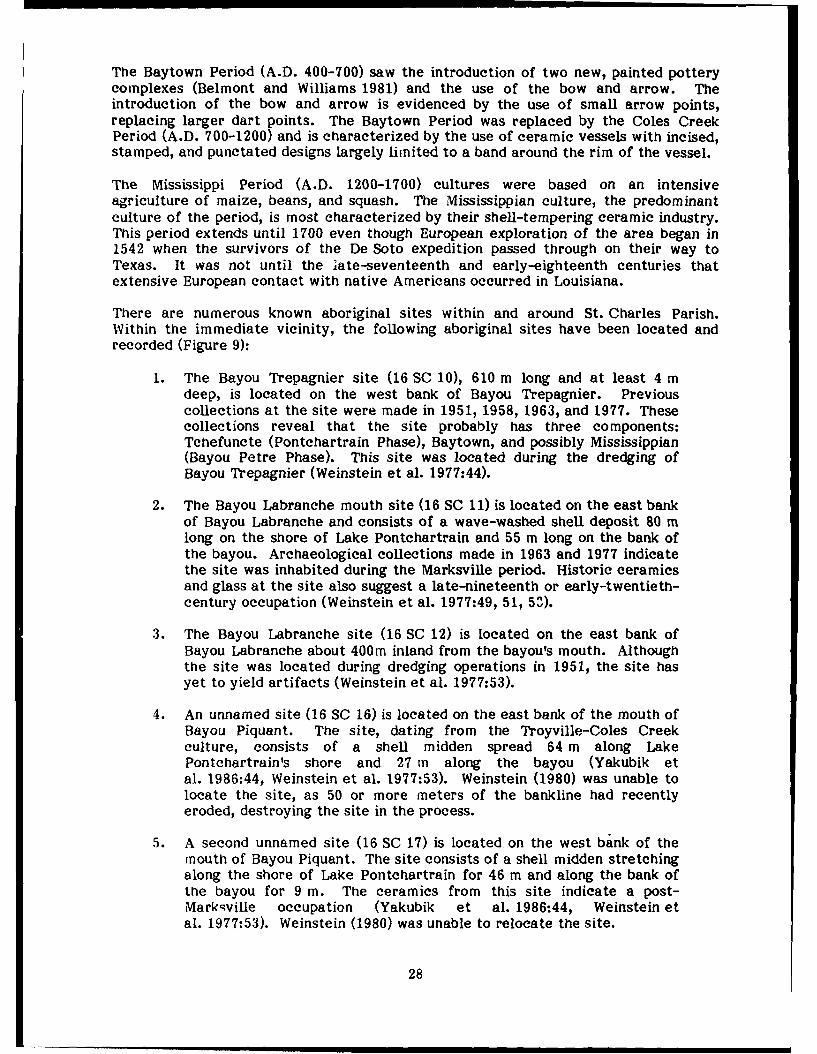
There are numerous known aboriginal sites within and around St. Charles Parish.Within the immediate vicinity, the following aboriginal sites have been located andrecorded (Figure 9):
1. The Bayou Trepagnier site (16 SC 10), 610 m long and at least 4 mdeep, is located on the west bank of Bayou Trepagnier. Previouscollections at the site were made in 1951, 1958, 1963, and 1977. Thesecollections reveal that the site probably has three components:Tchefuncte (Pontchartrain Phase), Baytown, and possibly Mississippian(Bayou Petre Phase). This site was located during the dredging ofBayou Trepagnier (Weinstein et al. 1977:44).
2. The Bayou Labranche mouth site (16 SC 11) is located on the east bankof Bayou Labranche and consists of a wave-washed shell deposit 80 mlong on the shore of Lake Pontchartrain and 55 m long on the bank ofthe bayou. Archaeological collections made in 1963 and 1977 indicatethe site was inhabited during the Marksville period. Historic ceramicsand glass at the site also suggest a late-nineteenth or early-twentieth-century occupation (Weinstein et al. 1977:49, 51, 53).
3. The Bayou Labranche site (16 SC 12) is located on the east bank ofBayou Labranche about 400m inland from the bayou's mouth. Althoughthe site was located during dredging operations in 1951, the site hasyet to yield artifacts (Weinstein et al. 1977:53).
4. An unnamed site (16 SC 16) is located on the east bank of the mouth ofBayou Piquant. The site, dating from the Troyville-Coles Creekculture, consists of a shell midden spread 64 m along LakePontchartrain's shore and 27 m along the bayou (Yakubik etal. 1986:44, Weinstein et al. 1977:53). Weinstein (1980) was unable tolocate the site, as 50 or more meters of the bankline had recentlyeroded, destroying the site in the process.
5. A second unnamed site (16 SC 17) is located on the west bank of themouth of Bayou Piquant. The site consists of a shell midden stretchingalong the shore of Lake Pontchartrain for 46 m and along the bank ofthe bayou for 9 m. The ceramics from this site indicate a post-Markqville occupation (Yakubik et al. 1986:44, Weinstein etal. 1977:53). Weinstein (1980) was unable to relocate the site.
28

ui
he A Cc .)~~11 0~ .
<4-
4- W) - 2.- -1 ' AZU ~ (,. VA
CA~ ~~~ IC~ D '. v1 0- 41.*. 4
*' 4 J 4.X iL~~~~~~ 0~ 4 -
E
-. A. 'No
//~~~~ > ~4~\7;CA~L (3).
4
* ~rY ~ b4
- r', S . .j. - .,.

Weinstein (1980:5-3) also recorded a possible prehistoric site on the west bank of themouth of Fall Canal, but determined that the wave-washed shells may have beendredged into the area to dam access canals built during the construction ofInterstate 10 (1-10). These canals were originally excavated to allow constructionequipment to be barged to the highway site but also allowed saltwater to intrude intoarea swamps. To prevent further land loss, the canals were closed by shellembankments and sheet pilings after construction of 1-10 was completed(Weinstein 1980:1-1). Weinstein (1980) postulated that the same types of constructionmay also have been the case for the formation of 16 SC 16 and 16 SC 17. Althoughthere are no other known aboriginal sites in the area, their existence may be concealedfrom surface observations due to the degree of subsidence and inundation present inthe area. Sites 16 SC 16, 16 SC 17, and the possible site on Fall Canal have since beenlargely destroyed by recent levee construction projects to replace earlier saltwaterintrusion dams and/or by erosion.
Historic aboriginal groups have also been documented as living along the MississippiRiver in the general vicinity of the project area. The Quinipissa were recorded asliving in a village adjacent to the Mississippi River, probably in or around present-dayGood Hope and Destrehan, by La Salle in 1682. The Quinipissa apparently abandonedthe village by 1700 as Iberville and Sauvole recorded the village deserted in that year(Yakubik et al. 1986:53).
European Occupation
Rene Robert Cavelier, Sieur de La Salle, and a small group of French explorers werethe first Europeans to pass through the area of what would eventually becomeSt. Charles Parish. La Salle, intent on finding a trade route from Canada to China,travelled down the Mississippi River to its mouth where he arrived on 7 April 1682.After exploring the delta region, La Salle claimed the entire Mississippi River valleyfor France in a ceremony held on 9 April 1682. Although he had made plans toestablish a settlement at the mouth of the Mississippi River, La Salle's plans fellthrough and no further exploration of the area was made until 1699. In that year,Pierre le Moyne, Sieur d'Iberville, and Jean Baptiste le Moyne, Sieur de Bienville,formed a French settlement on Biloxi Bay and began exploration of the lowerMississippi River in earnest. While exploration of the St. Charles area continued intothe early-eighteenth century, followed shortly thereafter by land claimants, it was notuntil circa 1719 that settlement of the region began.
French Colonial Period
The actual settlement of the east bank of St. Charles Parish is very complex since itwas eventually settled by two distinct groups of people moving into the area fromopposite directions. From the upriver side came the Germans from the area ofpresent-day Edgard in St. John the Baptist Parish. The German settlers were primarilysmall-farm owners who sold their vegetables and other farm goods to New Orleansconsumers and merchants (Davis 1971:71). From the downriver side came the wealthyplantation-owning French whose land holdings in Cannes Brulees were often quite vastas compared to the German farms. Although St. Charles Parish came to be known aspart of the German Coast because of the number of Germans residing there, theFrench plantation owners held the real wealth and power of the parish and, indeed, thewhole colony of New Orleans.
30

German Coast
The settlement of the German Coast is closely tied to the career of John Law, aScottish financier. Law organized the General Bank of Finance in 1716 afterconvincing Philippe, Duc d'Orleans, that France would become a very wealthy countryby printing paper money. In 1717 Law's paper money became accepted in France andhis bank was made the Royal Bank of France the following year. During this sameperiod, Law also organized the Company of the West in order to use some of the bankdeposits to develop the French colony of Louisiana. In 1717 the Company of the Westwas given the proprietorship of Louisiana in return for the settling of the territory atthe company's expense (Davis 1971:52,53).
In order to attract settlers of good character, the Company of the West and itssuccessor, The Company of the Indies, sent pamphlets and handbills throughoutGermany and the surrounding areas extolling the virtues of Louisiana. The Germansresponded positively to the advertisements, and in 1719 many made their way to thecolony. Thousands of these eager immigrants died enroute to French ports andthousands more died during their oceanic voyage to the Louisiana territory(Deiler 1969:17,17). Once in Louisiana, thousands of the surviving Germans died ofdisease and hunger after being disembarked in New Biloxi (Davis 1971:58;McWilliams 1953:235).
Many of the surviving Germans who arrived in 1719 settled in an area that soonbecame known as the German Coast and later as St. John the Baptist and St. CharlesParishes. The first settlement in this area, "Le premier ancien village allemand," wasfounded in 1719, only one year after the establishment of New Orleans (Adams inGianeUoni 1965:ix, O'Neil et al. 1984:21). This village, about 30 mi above NewOrleans, was located about 1.5 mi inland on the west bank of the Mississippi River.The German immigrants were given this land on the west bank as the French believedit to be mostly worthless swamp (Maudel 1972:vii). The remainder of the 1719 Germanimmigrants were settled on John Law's concession in Arkansas.
When news reached Europe that Louisiana was not as rich as had been advertised andthat life was not at all as idyUic as had been promised, French businessmen beganwithdrawing their holdings from the Royal Bank of France. Gold and silver becamescarce, paper money flooded the market, and the French government was forced todevalue their paper money. A run began on the bank, which soon collapsed. Law wasforced to flee France for his life in December 1720 (Davis 1971.61).
Shortly after the bank's collapse, a second group of Germans arrived in Louisiana underthe leadership of Karl Friederich D'arensbourg. D'arensbourg and his fellow colonistssettled near "Le premier ancien village allemand," except 3/4 mi closer to the river(Deiler 1969:52). The two villages later became known collectively as "Karlstein."Both villages were abandoned in 1721 in favor of higher ground nearer the river(Figure 10) after a September hurricane innundated the area by pushing the waters ofarea bayous and lakes into it (Deiler 1969:51).
The size of the German settlement on the German Coast grew rapidly in 1722 with thearrival of the German colonists from the abandoned Arkansas settlement. By 1722 theArkansas Germans realized that their fate as a colony was doomed without thefinancial support of John Law. In early 1722 they descended the river to New Orleansand requested that Governor Jean Baptiste Le Moyne, Sieur de Bienville, give themreturn passage to Europe. Bienville was able to persuade the Arkansas Germans,however, to join their compatriots on the German coast rather than returning to
31

Europe. These German engages settled along the banks of the river amongst theearlier settlers (Figure 10). By May 1722 the population of the German coast consistedof 257 individuals (Deiler 1969:37,38,74).
In 1724 the German coast consisted of approximately 185 inhabitants (Yakubik etal. 1986:57), a cemetery, and a church on the habitation of "Le Sassier", later known asTrinity Plantation (Deiler 1969:63). When the census of 1724 was taken, there wereonly seven cows, each with a different owner, and no horses in all of the German Coast(Deiler 1969:58). This situation remained much the same until after 1731(Davis 1971:74).
All of the Germans were apparently still residing on the west bank of the river whenthe 1724 census was taken. It was not until after 1728 that the east bank of theGerman Coast began to be settled. Prior to 1728 a number of large concessions hadbeen made along the Mississippi River to individuals who were to improve and settletheir property. The concessionaires in many places, however, failed to improve theirlands. In response to this, a royal edict was passed in 1728 that cancelled many of thelarge unimproved concessions along the Mississippi River between Bayou Manchac andthe Gulf of Mexico (Deiler 1969:76). This measure was undertaken as a means offorcing landholders to improve their holdings and of breaking up large, unimprovedholdings. It was hoped that this would result in increasing the number of settlers inthe colony, thereby dissuading the Spanish and English from encroaching on Frenchlands. The 1728 edict effectively opened the east bank up for settlement and by 1731there were several German habitations on its shores along the German Coast(Deiler 1969:76,77).
The growth of German settlements on the east bank of the river, however, washampered by sporadic Indian attacks that continued until the mid-eighteenth century.In April 1747 a Choctaw raid resulted in the killing of one German settler and thekidnapping of seven others. French troops were sent to the area to protect thecolonists but were soon removed. The Germans, fearing for their welfare, fled to thewest bank for safety. A similar raid occurred on 9 November 1748 when twoFrenchmen and two negroes were killed on the east bank of the river(Deiler 1969:60,61).
Cannes Brulees
The settlement of Cannes Brulees, present-day Kenner and surrounding area, is alsoclosely tied to John Law and the Company of the West. When the Company of theWest received the proprietorship of Louisiana in 1717, it also acquired the right togrant land to settlers. By 1720 two grants were made in Canes Brulees, one to Countd'Artagnon and the other to Monsieur d'Artiguette (McWilliams 1953:242,243,Swanson 1975:66). Monsieur d'Artiguette's concession was managed by his brother,Monsieur Diron d'Artiguette, the inspector general of Louisiana troops(Mc Williams 1953:243).
By the time the circa 1723 map Carte Particulier du Fleuve St. Louis... (Figure 10) wasmade, several other concessions were made in Cannes Brulees. Ascending the riverfrom the habitation of Monsieur Diron d'Artiguette were the habitations of Countd'Artagnon, Chantreau de Beaumont, Sieur de La Coste, and the concession of DenisFerandon. These five tracts of land are shown as abutting one another and are locatedin present-day Kenner and the eastern portions of St. Rose in St. Charles Parish.Farther upriver, in an area called Ance aux Outardes, was the habitation of Sieur
32

Lake Pontchartrain
Figure 10. Circa 1723 Carte Particulier du flueve St. Louis showing St. CharlesParish area (center), the early German settlements (lower left), and theCannes Brulees (upper right).
33

Sanson, near present-day Montz and Norco. No other land holdings are shown to existin or around the project area at that time.
The 1724 census adds several landholders to the above list. Ascending the river fromDiron d'Artiguette are the lands of d'Artagnon, Beaumont, Jean Pujeau, JosephHarasse, Claude Merand, and finally Ferandon (Conrad 1970:19,20). Above Ferandonare the lands of Francois Moyne, Edme Dounon, Sebastien Bouette, Francois Cheval,Rene Chesneau dit Duchesne, Philippe Dauny, Pierre Brout, two unknown families, andPierre Cezard (Conrad 1970:19,20). Unfortunately, the exact position of the landholdings of these last ten families on the riverbank is unknown, although they areknown to have resided in the area between Reserve in St. John the Baptist Parish andSt. Rose.
By 1731 the lands of the Cannes Burlees area had changed hands in many instances.Extending upward from d'Artiguette's lands in 1731 were Andre Crespe, Jean Barre ditLionnis, -luet dit Dulude, Noyon, Sanson, St. Amant, Antoine Roux, Favrot, and Mace(Conrad 1970:53,59). Mace is recorded as the last resident of Cannes Brulees beforereaching the lands of Rousseau and La Coste at Ance Aux Outardes (Conrad 1970:59).Based on the census data it does not appear that the Sanson of the 1731 census is thesame person as is depicted on the circa 1723 Carte Particular.... If these two Sansonsare the same person, he had apparently moved at some point in time prior to 1731.
While the German Coast residents were primarily engaged in truck farming, theCannes Brulees plantations were primarily engaged in cultivation of cash crops such asindigo and tobacco, and, to a lesser degree, silk and candleberry tree (Davis 1971:73).This is not to say that food crops were not produced; both corn and rice were grownthroughout the area. Rice agriculture was developed in Louisiana very early in thecolony's history, as corn, a native cultigen, was not particularly favored by theEuropeans. Le Page Du Pratz reported that rice was introduced into the colonyshortly after 1712 (Davis 1971:72). Rice was competing with corn as a staple crop inthe young color; by 1720 even though rice mills weren't introduced until the 1740s(Davis 1971:72).
While Cannes Brulees residents were generally more wealthy than their Germancounterparts and were of different heritages, it did not stop them from intermingling.The only church in the New Orleans area during the early colonization effort waslocated at present-day Killona on the west bank of St. Charles Parish (Baudier 1972:71;Bezou 1979:26). The church at Killona, which was established in 1723, continued to bethe only church in the New Orleans area until the completion of the first St. LouisCathedral in New Orleans in 1727 (Baudier 1972:56, 71, 118). A church was built atthe Chapitoulas (Tchoupitoulas) in 1729 but was abandoned in the 1740s because it wasunpopular (Baudier 1922:118, 143). In 1740, St. Charles Borromeo Church wasestablished on the east bank in present-day Destrehan (Bezou 1979:26). The lack ofarea churches and the difficulty of travel made St. Charles Borromeo Church veryattractive to the residents of Cannes Brulees and the even more distant Chapitoulasarea (Bezou 1979:56). Throughout the French colonial period, and into the Spanishcolonial period, Cannes Brulees residents often attended church services at St. CharlesBorromeo for baptisms, marriages, and burials (Bezou 1979:56).
In 1732 Cannes Brulees along with the rest of Louisiana, reverted to the French crownas the Company of the Indies found that it could no longer support the colony. By the1750s France had realized that Louisiana was a financial burden and that there hadbeen little return for the millions of livres spent on the development and supply of thecolony. In 1762 France ceded Louisiana and the Isle of Orleans to Spain in the secret
34

Treaty of Fountainbleau. While France saw Louisiana as a financial drain, Spain sawthe colony as a defensive mechanism against British expansionism. Although the legaltransfer of the colony took place in November 1762, it was not until October 1764 thatthe colonists actually found out that the transfer had taken place (Davis 1971:61, 62,69, 70).
Spanish Colonial Period
Although the transfer of Louisiana from France to Spain occurred in 1762 and wasmade public in 1764, it was not until March 1766 that Don Antonio Ulloa, the firstSpanish governor of Louisiana, arrived in the colony to formally take possession of theterritory. The French and Francopniled German residents of the colony did not wanttheir government transferred to Spain and hoped that the slow transfer reflected lackof Spanish resolve in taking over the colony. In October 1768 Nicholas Chauvin deLafreniere, attorney general of the province, presented a list of grievances toGovernor UUoa (Moore 1976:149) which had been signed by many of the German Coastand Cannes Brulees settlers. In October 1768 approximately 500 Germans andAcadians arrived in New Orleans to express their dissatisfaction with Governor Ulloa.The Acadians had been falsely told that Ulloa was withholding specie that was to beused to redeem their worthless Acadian script and the Germans had been informedthat Ulloa had no intention of paying them for their goods that had already beenshipped to New Orleans (Moore 1976:151). In truth, Ulloa had no specie for exchangeand had sent Gilbert de St. Maxent to the German Coast to pay off Spanish debts(Moore 1976:150, 151). St. Maxent, however, had been abducted by cohorts ofLafreniere and was unable to make the payment (Moore 1976:150).
Once in New Orleans the Acadians and Germans were convinced to support theSuperior Council in an effort to rid the colony of Governor Ulloa. Realizing that hehad little popular support, Ulloa was forced to evacuate Spanish civil authorities fromNew Orleans on 1 November 1768 (Moore 1976:163) Although this temporarily rid thecolony of Spanish authority, a new Spanish Governor, General Alejandro O'Reilly,arrived in the colony in August 1769 to to take formal possession of the colony forSpain. O'Reilly found Lafreniere and five of his cohorts guilty of conspiracy and hadfive of them executed by firing squad, the sixth had already died of natural causes.
By the 1770s most of the land facing Lne Mississippi River in the German Coast hadbeen claimed (Conrad 1981:vii). While many grants in the project area extended as faras Lake Pontchartrain, some had a depth of only 40 arpents. While some of thesesmaler landholders had second depth grants of 40 arpents made by the Spanishgovernment, it was not a common practice until the American period(Conrad 1981:vii). Some of the larger landholdings in the German coast began to breakup in the 1770s, as the original owners began to divide their holdings among theirchildren (Conrad 1981:vii).
German Coast planters continued to grow vegetable crops for sale in New Orleans astheir primary crops until the end of the eighteenth century (Conrad 1981:viii).Francisco Bouligny's 1776 account of the area notes that most planters cultivated onlythe 600 to 800 varas nearest the river and reserved the rest for pasture and timber(Din 1977:45). After a 1793 St. Dominique slave revolt, many residents of the islandmoved to Louisiana, bringing an interest in sugarcane agriculture with them(Conrad 1981:viii). In 1795 Etienne de Bore recognized the need to grow cane on alarge-scale to make the venture of producing granulated sugar a profitable enterprise.By planting large quantities of cane, de Bore was able to produce the first profitablegranulated sugar in Louisiana during the 1795 growing season. De Bore, a resident of
35

Tchoupitoulas at the time of his discovery, once owned much of what is now present-day St. Rose.
Indigo, the predominant cash crop during the 1760s in Cannes Brulees, becameunprofitable to grow in Louisiana during the 1790s because of high production costs,soil exhaustion, and pollution (Holmes 1967:346-348). De Bore's introduction of aprofitable method of growing sugar cane along with Antoine Morin's refinement of thegranulation process allowed large landholders to begin large-scale production ofsugarcane. An 1802 account of the colony by Berguin-Duvallon noted that by thattime indigo was only rarely grown, while sugar and cotton were the main cash crops(Davis 1806:131).
American Period
Louisiana remained under Spanish control only until 10 October 1800 when theunprofitable colony was returned to France under the Treaty of San gdefonso. On 2May 1803 Louisiana was transferred from France to the United States in the LouisianaPurchase even though France did not take formal possession of the colony until 30November 1803. The Americans took formal possession of Louisiana on 20 December1803.
The east bank of St. Charles Parish at the time of the Louisiana Purchase wasconsidered to be part of the Isle of Orleans. In 1805, the Orleans territory was dividedinto twelve counties, one of which was the County of the German Coast. The Countyof the German Coast, consisting of the present-day east banks of St. Charles and St.John the Baptist Parishes, remained in existence from 1805 until 1807. St. CharlesParish was one of nineteen parishes formed in May 1807.
The agriculture of the newly formed parish remained similar to what it had beenduring the earlier colonial period, although sugarcane became increasingly importantas time passed. As sugarcane was such a lucrative crop, many planters sought to formsugar plantations. Economically viable sugar plantations, however, require a greatdeal of land; many smaller farms in St. Charles Parish were gradually consolidated intolarger and larger plantations (Figure 11).
Rice continued to be grown well into this period and St. Charles Parish became amajor rice producer in the state. C. C. Robin's early-nineteenth-century account ofrice agriculture on the German Coast notes that the rice fields were flooded duringhigh river stages by trenches cut through the river levee (Robin 1966:112). Thesetrenches, while providing necessary irrigation for the fields, represented weak spots inthe river levee system and were the culprit of many crevasses during the eighteenthand nineteenth centuries.
While several small Civil War skirmishes were fought in St. Charles Parish, alloccurred on the west bank. Numerous buildings, however, were destroyed on bothsides of the river by Union gunships (Yoes 1973:79, 80). Other buildings, includingseveral in the vicinity of the project area, were confiscated for use by the Uniongovernment. The closest the east bank of the parish came to fighting was during aminor Civil War skirmish in August 1862 which took place near present-day Hahnvilleafter Federal troops learned of a Confederate attempt to gather cattle on the eastbank of the river (Yoes 1973:80).
Sugar production fell off during the Civil War and Reconstruction as planters lost theirfinancial resources and their labor supply (Ginn 1940:34) In response to these
36

bO
9AOJ J# ;
UO 0
0_______ L
.................................. .. ..... ..
37e

difficulties, area sugar planters turned their attention increasingly towards ricecultivation, as it was less expensive and less labor-intensive than sugar cultivation.The rice industry expanded so rapidly during the early post-beUum years that it rapidlybecame the most important crop of the state (Ginn 1940:35).
Rice production in St. Charles Parish increased from 800,000 pounds in 1840 to2,238,200 pounds in 1870 and was second in Louisiana rice production only toPlaquemines Parish throughout this period (Ginn 1940:43). Rice production inSt. Charles Parish fell off to only 609,943 pounds in 1880 but increased to 2,925,000pound, in 1890 and to 3,372,992 pounds in 1900 (Ginn 1940:43). Although sugarproduction remained important to the St. Charles Parish economy into the twentiethcentury, there were only four sugar plantations on the east bank of St. Charles Parishin 1890 (Bouchereau 1892) and only three in 1900 (Bouchereau 1902). ProspectPlantation was the last sugar plantation on the east bank of St. Charles to producecane, ceasing production in 1912 (Bouchereau 1917:47).
The east bank of St. Charles Parish underwent a great deal of change during the earlyyears of the twentieth century. Plantations and truck farms began to give way toindustrial complexes, particularly those related to petroleum, during the seconddecade of the century. Destrehan Plantation became the home of the MexicanPetroleum Company in 1914 -ithough production did not commence at the plant until1916 (Grey 1936). The Mexican Petroleum Company was later taken over by the Pan-American Petroleum Company and continued operations until 1958. In 1920 thePetroleum Import and Export Corporation began construction of a refinery in St. Rose.The St. Rose refinery was opened in 1921 and was later taken over by Cities ServicesOil Company (Elfer 1936:8).
What was to become the largest refinery in the parish began with the construction ofthe Marine Terminal, a refinery of several 55,000-barrel storage tanks, near the townof Sellers in 1916. This facility, built by the Roxana Petroleum Company, beganoperations in 1918. Following World War I, an asphalt refinery was built by the NewOrleans Refining Company near the Marine Terminal. This refinery came to be soimportant to the local economy that the town of Sellers was renamed Norco, theacronym of the New Orleans Refining Company. In the spring of 1929, ShellPetroleum Corporation (formerly Roxana Petroleum Company) took over the Norcoplant and began modernizing the facility. The plant resumed operations in 1930 with650 workers (Dawson 1936).
During the middle of the twentieth century, the Good Hope Oil and Gas Field, north ofthe town of Good Hope, was established as a major oil field. Expansion of the oilindustry during this period brought an increased need for oil and chemical refineries,several of which were built along both banks of the Mississippi River in St. CharlesParish.
Several historic sites have been recorded in the vicinity of the project area (seeFigure 9), all of which are located along the banks of the Mississippi River. They areas follows:
1. Scatter B (16 SC 54) is a nineteenth-century scatter of artifacts on thewestern boundary of the Bonnet Carre Floodway (Yakubik etal. 1986:284-286).
2. Kugler Cemetery (16 SC 51) is an abandoned cemetery located in theBonnet Carre Floodway (Yakubik et al. 1986:244-282).
38

3. Scatter A (16 SC 53) is a brick scatter in the Bonnet Carre Floodway(Yakubik et al. 1986:283-286).
4. Roseland Sugar House site (16 SC 52), the remains of a nineteenth-century sugar house, is located on the eastern side of the Bonnet CarreFloodway (Yakubik et al. 1986:198-206).
5. Kenner Cemetery (16 SC 50) is an abandoned cemetery located on theeastern edge of the Bonnet Carre Floodway (Yakubik et al. 1986:207-243).
6. Ormond Plantation (16 SC 24) is located immediately west ofDestrehan. No archaeological work has been conducted at the site todate (Yakubik et al. 1986:47).
7. Little Red Church (16 SC 23), located in Destrehan, consists of anineteenth-century church and cemetery (Yakubik et al. 1986:47).
8. Destrehan Plantation (16 SC 18), a renovated late-eighteenth-centuryplantation, is located in Destrehan. Archaeological work wasconducted on the plantation in 1983 (Lamb 1983) and 1984-1986(Yakubik et al. 1986:45).
9. La Garconniere (16 SC 25), an early-nineteenth-century residence, waslocated in St. Rose. The site was reported as being destroyed in 1978(Yakubik et al. 1986:47).
As noted earlier, the lands of St. Charles Parish were consolidated into large holdingsduring the early-nineteenth century for the establishment of sugar plantations. By themid-nineteenth century there were 16 large plantations (Figure 11), as well as anumber of smaller landholdings on the east bank of St. Charles Parish. The five surveyareas of this study fell into the former lands of six of these plantations. Beginning atthe upstream side of the parish, these six plantations were: Good Hope, Prospect,Victoria, Destrehan, Almedia or Patterson and Fairview. As it was not feasible toconduct in-depth research into each individual landholding, research was limited tothose areas that produced signifioant cultural remains.
Background research for the fielc survey indicated that late-nineteenth-centurystructures were located within th- project area on the former lands of Almedia orPatterson Plantation and Fairview O lantation. The ensuing field survey located onestructure on the lands of each of iese plantations and a third structure on the formerlands of Prospect Plantation. A tore in-depth history of these three plantations isprovided in Chapter 6.
39

CHAPTER 4: FIELD INVESTIGATIONS
A field survey of the right-of-way for the St. Charles Parish Hurricane ProtectionLevee, St. Charles Parish, Louisiana, was conducted between 28 October 1987 and7 November 1987. Much of the project area is in a continually inundated backswampsetting, thereby limiting the study area to those places which were accessible by boator by foot. Because of limited accessibility, the study area within the much largerproject area was confined to the five areas (see Figure 1) that offered the greatestprobability of containing cultural materials.
The main purpose of the field survey was to locate possible cultural remains within theproject area. Prior to the initiation of the fieldwork, a brief geomorphological,archaeological, and historical background study was conducted in an attempt topinpoint areas of potential cultural remains. This ba-kground survey indicated thatthere was a relatively high potential for locating aboriginal remains at or belowpresent land surfaces along Bayou Trepagnier in Area A. The review of historicalrecords indicated that a late-nineteenth century drainage machine was located withinthe right-of-way in area E on a canal serving as the boundary between Sections 40 and41, Township 12 South, Range 9 East and that another drainage machine possiblyexisted within the right-of-way on Walker Canal. This brief background historicalstudy also indicated that numerous roadways, canals, and levee systems existedthroughout the project area in the nineteenth and twentieth centuries.
During the field investigations, an attempt was made to locate cultural remains in allfive areas through surface surveying, shovel testing, probing, and auger testing.Although the lack of rainfall in the weeks prior to the field work had considerablyreduced the water level within the backswamps of the project area, much of the areawas still impassable due to the continued presence of standing water and soft soils.Surface surveying was conducted in all five areas wherever there was an exposedground surface. Systematic shovel testing was conducted at 20-m intervals whereverfield conditions permitted. In areas that were extensively inundated, however, shoveltesting was conducted wherever possible. Probing was done primarily in an effort todelineate the boundaries of cultural remains located through surface surveying andshovel testing. Auger testing, at 40-m intervals, was conducted only along BayouTrepagnier. As survey conditions-and hence, techniques-varied from area to area, adetailed account of the field investigations and conditions is provided for each, alongwith a brief overview of the cultural remains found within each area.
Area A
Area A, consisting of a 2,500-ft stretch of Bayou Trepagnier with the southernboundary abutting the Norco sewage disposal plant, was surface surveyed along itsnatural levees and hand-augered in 40-m intervals in an offset pattern (see Figure 7).As at least 95% of this area was elevated above water, the pedestrian survey was ableto cover approximately 22 ac of the 23 ac included in this area. The pedestrian surveyof Area A proved to be fruitless, as surface visibility was hampered by accumulatedleaf clutter. Although the remaining 5% of this area was under standing water, it wasvisually surveyed. The only cultural remains found during the pedestrian and visualsurvey of this area were the remains of a mid-twentieth-century, tin-roofed buildingon the east bank of Bayou Trepagnier, 30 m from the rear of the Norco sewagedisposal plant.
Auger testing of the natural levees of the bayou was accomplished through the use of a1-in diameter soil auger. A total of 38 borings were taken approximately 2.5 m from
41

the edge of the bayou to a depth of 210 to 300 cm. Augering was halted in severalinstances as the ground was so saturated with petroleum by-products that Munsell soil-color readings and grain-size determination were not possible. Carbon dating oforganic material recovered during augering was not feasible because of thesecontaminants. The natural levees of the bayou appear to be relatively intact as spoilfrom the dredging of the bayou was deposited 10 to 12 m from its western bank.
Area B
Area B, an 800-ft-wide by 12,000-ft-long corridor through the Good Hope Oil and GasField, was surface surveyed wherever the levee right-of-way crossed oil field roadsand canals. As only certain portions of this area were subject to survey, only 40 of the220 ac of this area were surveyed. Of these 40 ac, approximately 95% was understanding water and was subjected only to a visual inspection rather than a pedestriansurvey. Because of the amount of standing water, systematic shovel testing proved tobe impossible. Therefore, shovel testing was conducted wherever possible. Petroleumwaste in some portions of this area, however, prevented the digging of shovel testsaltogether. The pedestrian and visual survey and shovel testing near roadways and oncanal banks in this area yielded no cultural remains other than the remains of adrainage machine (16 SC 65) of Prospect Plantation (Figure 12), located near thesouthern boundary of the right-of-way on the western edge of Shell Oil Company'smain roadway into the oil field.
Figure 12. Northern view of Prospect Plantation drainage machine.
42

Area C
Area C (see Figure 2), an 800-ft-wide corridor where the right-of-way intersects CrossBayou Canal and Cross Bayou, was surveyed by boat and, where possible, by foot. Theonly land in this 20-ac area consisted of a tram road on the dredge spoil on the westbank of Cross Bayou (Figure 13) and dredge spoil on the east bank of Cross BayouCanal. Those areas that were not amenable to pedestrian or boat survey were visuallyinspected. Shovel testing of the area consisted of a single line of shovel tests at aninterval of 20 to 30 m, where possible. No cultural remains were located during thesurface survey or shovel testing of this area.
Figure 13. Remains of tram road on west bank of Cross Bayou.
43

AreaD
Area D, an 800-ft-wide by 500-ft-long corridor along Pipeline Canal, was surveyed byboat and, where possible, by foot. As over 90% of the 9 ac in this area was understanding water, shovel testing was limited to any exposed land surface that wasencountered during the pedestrian survey. Those areas that were not accessible byboat or by foot were visually inspected. The survey of this area yielded no culturalremains.
Area E
Area E, an 800-ft-wide by 13,200-ft-long corridor between Almedia and theSt. Charles-Jefferson Parish boundary, was surveyed by foot wherever water and soilconditions permitted. Although much of this area had once been used as agriculturalfields, swamp growth has since reclaimed all portions of the area that are not incurrent use. Over 70% of the 242 ac in this area was under standing water at the timeof the survey (see Figure 3). Most of the 65 to 70 ac of visible land surface consistedof spoil piles, roadways, old levee systems, and modern landfills. Shovel testing ofArea E was limited to those few areas that offered amenable conditions. Visualinspection was conducted in those areas that were not accessible to pedestrian survey.
The remains of two drainage stations were located within the right-of-way of Area E.The first drainage station (16 SC 66) was found immediately south of the leveecenterline along a canal that extends northwestward from Louisiana 50 (Almedia Road)in Almedia (Figure 14). The remains of the second drainage station (16 SC 67) were
Figure 14. Remains of Almedia Plantation drainage machine.
44

found on Walker Canal, north of the levee centerline, and abutting a modern landfill(Figure 15). Shovel testing and probing were conducted at both drainage stations in aneffort to delineate their boundaries and features. No other cultural remains werelocated in the survey of this area.
-A'
Figure 15. Northwesterly view of Fairview Plantation drainage machine on WalkerCanal. (Canal is in foreground.)
45

CHAPTER 5: RESULTS OF FIELD SURVEY
Several roadways and numerous canals and levees were surveyed during this project.Although these remains, both historic and modern, are a cultural residue of past andpresent human activity, they are not of such significance as to warrant furtherdiscussion. Although one modern landfill was also visited during this survey, it is of nosignificance other than its possible impact on nearby and underlying cultural features.One mid-twentieth-century structure of wood and tin was found on Bayou Trepagnier.The remains of this modern structure, 12 by 24 m in extent, are not of culturalsignificance, as they are less than 50 years old and have no historical importance.
The only potentially significant cultural features located on this survey were thepreviously unrecorded archaeological remains of three nineteenth- and early-twentieth-century drainage stations. These structures are described in more detailbelow.
Prospect Plantation Drainage Machine (16 SC 65)
The remains of the Prospect Plantation drainage machine in the Good Hope Oil andGas Field (Figures 12, 16, and 17) covers an area of approximately 10 by 14 m andstands approximately 250 cm above water surface. This drainage station, located inSection 7 of Township 12 South, Range 8 East, may once have been much larger, asthere is scattered brick in the spoil bank of a small pond that immediately abuts thenorthwest edge of the visible remains. Construction of a rangia roadbed and aboveground pipes immediately adjacent to the southeast edge of the remains may have alsoimpacted them, although no evidence of such a disturbance was found on the surface.Extensive probing of the area failed to reveal additional brick features and was usefulonly in delineating the extent of the northwest portion of the foundation. The onlyartifacts recovered from this drainage station were two complete bricks from the ponddredge spoil impressed with the mark of "Evens and Howard/St. Louis" and one brickfragment.
Almedia or Patterson Plantation Drainage Machine (16 SC 66)
The remains of the Almedia or Patterson Plantation drainage machine (Figures 14, 18)near Almedia consist of scattered brick covering an area of approximately 39 by 24 m.None of the remains of this drainage station remain above ground surface. The lack ofabove ground structures and the lack of complete bricks in the area suggest that thebuilding may have been disassembled for reuse of the bricks. Two spoil piles withinthe area of brick rubble and several spoil piles to the north of the area suggest thatsurrounding canal systems had been dredged after use of the structure ceased. Fourshovel tests were excavated to determine the depth of the remains of the structure(Figure 18). These shovel tests revealed that a dense lease of coal slag extends from 5to 10 cm below ground surface to a depth of 65 to 70 cm. Within this coal slag lensewere brick fragments as well as lesser amounts of unburned coal. Three completebricks were also recovered from this area.
Fairview Plantatioe')rainage Machine (16 SC 67)
The Fairview Plantation drainage machine (Figures 15, 19, 20) on Walker Canalappeared to be the most complete and least disturbed drainage machine of the threethat were located during this survey. The remains of this structure, covering an areaof approximately 20 by 20 m, consist of numerous brick foundations and an earthenmound approximately I m high. Although much of the structure was visible on the
46

E
IV
47

water -
C.,
bricks IleonI II I
surface r-i pipes aboveground
X>,IIII
-II
I RangiaI / ro ad--dI*
I IedgeII
Limits of scattered II Isurface bricks and ""road
bricks encountered I "Iiaduring probing bolta ulMto
I bolts I U.S. 61
_, water
EDGE OFSPOIL BANK
Elevation of Brick Course*~above water surface
N 234 em
1.0 M45c
Figure 17. Plan view of the foundation remains of Prospect Plantation drainage
machine.
ground surface, extensive probing and shovel scraping were necessary to delineate thelimits of several brick features. Although it appears that a landfill to the immediateeast of the structure merely abuts the drainage machine, it may, in actuality, haveencroached enough so as to cover some of the structure's brick features. As nocomplete bricks were present, except those mortared to the structure, only brickfragments were collected. In addition to three brick fragments, three pieces of coaland a I-in-diameter bolt 5 in long with a nut stil attached were recovered.
48
" mmm I nI I I nII

APPROXIMATE EXTENTOF BRICK RUBBLE
SWAMP EXPOSED'000 BRICK
ST. 1 4
ST. 3 SOL..
ST. 2 "t
BRICK ICANAL '
CANALCANA TRAIL
A A
SHOIELIESI I.
I2.0 m
Figure 18. Plan view showing the extent of rubble associated with the remains of theAlmiedia Plantation drainage machine.
49

Figure 19. Inlet of Fairview Plantation drainage machine (Walker Canal in
foreground).
50

APPROXIMATE EXTENTOF RUBBLE AND EARTHEN
MOUND
/ I-__
pV'tree W
(PAXi ;tree iI ii
I ii; , I-'l/i.ltsbolts
I Ii
N I
S Limits of scattered,..surface bricks and
P bricks encountered "during probing
II broken
Iout
bofts
0 - IIinsetsmetal *
*I pipe
0000
water
Elevation of Brick
Courses abovewater surface
175cm150 cm
-126 cm1. m 120cm
96cm
Figure 20. Plan view of the foundation remains of Fairview Plantation drainagemachine.
51

CHAPTER 6: HISORICAL RESEARCH
Although south Louisiana plantations were generally built along relatively high naturallevees, they were still subject to periodic flooding during the high-water periods ofwhatever stream they were bordering. Hence, man-made levees were built along thestreams to prevent the flooding of the plantation lands. Crevasses and high waterfrom rain and high tides also required the construction of side and back levees in manyareas in order to keep agricultural lands reasonably dry and tillable.
The east bank of St. Charles Parish has been subjected to numerous floods resultingfrom overflows of the Mississippi River. Prior to the construction of artificial levees,beginning in 1727 at New Orleans and extending to Baton Rouge by 1812(Saucier 1963:88), flooding of the project area would have been a relatively commonoccurrence. Even after the construction of levees, crevasses continued to flood thearea as the Mississippi River overpowered the man-made levees. During the historicperiod, crevasses have been noted at bonnet Carre near LaPlace for the years 1718,1735, 1770, 1782, 1785, 1791, 1796, 1799, 1809, 1811, 1813, 1815, 1816, 1823, 1824,1828, 1844, 1849, 1850, 1857, 1858, 1859, 1867, 1871, and 1874-1882 (Yakubik etal. 1986:31, Saucier 1963:Fig. 33). Other crevasses in the area include the 1892Anchor crevasse near the St. John the Baptist-St. Charles Parish boundary, the 1892Prospect crevasse in Good Hope, and the 1892 Sarpy crevasse in New Sarpy (Saucier1963:Fig. 33). It was not until the construction of the Bonnet Carre Floodway in 1929-1931 that the area became relatively safe from the effects of crevasse flooding. Sincethe Bonnet Carre was completed in 1931, its floodgates Lave been opened in 1937,1945, 1950, 1973, 1975, 1979 and 1983.
While the levees kept the surrounding water at bay, drainage systems were stillrequired within the diked area for irrigation and flood control. Generally, the maincanals of the plantation would run along the plantation's side levees. The location ofthese canals was regulated primarily by the need of fill for building the side levees.Smaller canals, parallel to the main canals, were often interspersed through largerfields in an effort to promote better water flow from the highlands of the natuiallevee to the lower backswamps. These canals were fed by water flowing from ditchesthat ran perpendicular to the canals. These ditches were fed, in turn, by smallerditches that ran parallel to the canals (Holmes 1986:83).
The gentle slope of the natural levees and occasional high water in the backswampsgenerally precluded rapid drainage of agricultural lands. To aid drainage, manyplantation owners found it necessary to construct drainage machines and pumps at theintersection of the main canals and back levees to force water out into the surroundingarea (Sitterson 1953:129) Drainage machines, which were water wheels originallypowered by horse and later by coal and/or wood-fired steam engines, could be quiteextensive in size (Figure 21) and expensive to operate (De Bow 1847:66).
Drainage machines could also be used along the banks of the Mississippi River to throwwater from the river into irrigation canals when the river was too low to provide freeflowing water into the intake canals (Wilkinson 1854:537). This procedure allowed cropirrigation during periods of drought and low water on the river. Water wheels used forthis purpose did not have to be very large. Wilkinson (1854:537) states that a 6- to8-ft-diameter wheel powered by two horses or mules was sufficient to irrigate anyfield then under cultivation. The cost of a one-horse machine capable of draining50 ac or irrigating 170 to 200 ac would have been between $150 and $250 in 1854(Wilkinson 1854:537).
53

0
43
'0
C3
540

American farmers, seeking to utilize their lowlands, began inspecting Europeandrainage machines in the 1840s in an effort to design better drainage systems for theirown land (Sitterson 1853:129). The English, who previously used windmills fordrainage, were successfully using steam-powered drainage machines by at least 1825(De Bow 1847:77). Maunsel White's description of English drainage machines in 1847(De Bow 1847:68-80) provides an in-depth view of their operating principles andconstruction.
White found that drainage machines worked best when the water in the ditches waskept 18 in below the surface of the agricultural field and that the drainage outfall wasnever higher than within 4 or 5 ft of the axis of the water wheel (De Bow 1847:73, 74).The water wheels (Figure 22), which could be up to 35 ft in diameter, were generallymade of cast iron with wooden floatboards placed at an angle of 450 from horizontal atthe point that they delivered the water (De Bow 1847:71, 74). Each floatboard of a28-ft diameter wheel was 5.5 ft high and 5 ft wide (De Bow 1847:75). The floatboardsmoved through a track of stone or masonry (Figure 23) at a rate of about 6 ft persecond for best results (DeBow 1847:74). According to White, a good drainage machineshould be able to lift and discharge 3,168 cu ft (19,800 gallons) of water to a height of10 ft per horse power, per hour (De Bow 1847:74).
E
Figure 22. Side view of scoop wheel of a drainage machine(De Bow 1847:72).
As the water wheel and accompanying machinery could be quite heavy (a 35-ftdiameter wheel welgiied 64 tons [De Bow 1847:78] ), the construction of substantialfoundations was an obvious requirement in the swamps of Louisiana as it was in thefens of England. In Louisiana, foundations were generally of bricks, similar to thosefound during the field survey for the hurricane protection levee.
55

3 I
Fi S
AT -
/
Figure 23. Clockwise from left: frontal view of scoopwheel of drainage machine showing track whichpaddles pass through, pillars (spacers) seperatingrings of the scoop wheel, details of arm of scoopwheel (De Bow 1847:73).
In addition to the three drainage machines located in this survey, two others, locatedon the east bank of St. Charles Parish, are depicted on the 1894 Mississippi RiverCommission map, one at Destrehan Plantation and another at Fairview Plantation.The archaeological remains of similar drainage machines have also been recorded atWaterford Plantation on the west bank of St. Charles Parish (Castille 1980:29, 30) andat Christmas Plantation and Pecan Grove Plantation in Jefferson Parish(Holmes 1986:79, 80, 100,.173).
As noted earlier, there were a number of plantations and smaller landowners along theeast bank of the Mississippi River in St. Charles Parish whose landholdings extendedinto the backswamps as far as the project area and even to the shores of LakePontchartrain. As it was not feasible to conduct in-depth historical research of eachplantation, each of which was comprised of several tracts of land, only thoseplantations showing evidence of improvements within the project area were studiedprior to the field survey. This procedure, based largely on an examination of historicmaps, particularly the 1894 Mississippi River Commission map (Figure 24), resulted inthe study of Almedia or Patterson Plantation and Fairview Plantation.
56

IN P.I C
00J f! A: £ - S.v- I .
-f-
o 4j - -f
~4-A
--
444
ri, N4 I
t4 Ir 4.. k
757

The results of the field survey, as anticipated, generally supported the expectationsderived from the cartographic research. One drainage machine was found on each ofthe plantations. Both of these structures had been recorded on the historic mapsexamined. The field survey also located the remains of a previously unknown drainagemachine on the former lands of Prospect Plantation. Because the lands of ProspectPlantation were not developed into the backswamps prior to 1894 (Figure 25), thisdrainage machine probably was not constructed until a. that date.
A brief historical sketch of each of the three plantations whose drainage machineswere located within the right-of-way is presented below. As these machines wereprobably not constructed until the mid- or late-nineteenth century and ceasedoperation in the early-twentieth century, each historical sketch will focus on theperiod 1850 to 1910, although some information is -'rovided for the early ownership ofthe land.
Prospect Plantation
The first known owner of the lands that would eventually become part of ProspectPlantation was Bernard Bernoudy, who was residing there by 1804 (Conrad 1974:405).Bernoudy's 23-arpent front plantation was primarily used for sugar and corn cultivation(Conrad 1974:405) and was the home for himself and Marie-Jeanne Robin de Longy, hiswife (Conrad 1981:82). Although it did not occur within the study area, a slave revoltbegan in January 1811 at Manuel Andry's plantation and was dispersed on BernardBernoudy's plantation (Conrad 1981:100-101). Over 60 slaves were killed during the-evolt and 75 were brought to trial (Conrad 1981:101). At least 33 slaves wereexecuted for their participation in the revolt (Conrad 1981:102, 106, 108-110). Also ofinterest is that Jean-Noel Destrehan, the owner of nearby Destrehan Plantation, wasBernoudy's brother-in-law (Conrad 1974:382), and Adelard Fortier, the owner ofAlmedia or Patterson Plantation, was Bernoudy's son-in-law (Conrad 1981:107).
By 1828 the plantation had been acquired by Drausin Labranche (Degelos 1892:67).After Drausin Labranche's death, the land became the property of his wife(Champomier 1845:4). Mrs. Drausin Labranche apparently shared ownership of theproperty with Constance Deblanc at this time, as she is listed as an owner at the timeof the 1855 succession sale of the property (Table 2) to E. F. Labranche and AdelineLabranche (Widow Norbert Fortier), Drausin Labranche's children (COB B, 349). Thename "Prospect Plantation" was apparently first applied to the property at this time(Champomier 1856:18) by E. F. Labranche.
A survey of the area in 1858 by Theodore Gillespie (Figure 26) found that the fields ofthe property gave way to woods 92.00 chains (6072 ft) from the river along its upriver.,e and 51.00 chains (3366 ft) from the river along its downriver side
(Gillespie 1858:61, 64), well short of the survey area. Gillespie also notes that thewoods gave way to cypress swamps at 164.40 chains (10,850.40 ft) along the upriverborder and 120 chains (7920 ft) along its downriver border (Gillespie 1858:61, 64). Thiswould indicate that the future location of the drainage machine was on the boundarybetween the woods and the swamp.
The ownership of the plantation apparently passed on solely to Adeline Labranche inthe early 1860s as Leon Sarpy acquired the land from her through a Sheriff's Sale in1867 (COB C, 386) Sarpy later acquired Good Hope Plantation, the plantationimmediately upriver from Prospect, as well as lands immediately below Prospect.Both plantations passed into the hands of his wife and children upon his death in 1889(COB 1, 132). During Sarpy's ownership of Prospect Plantation, its sugarcane
58

0 1 km Zr.;JjT :t: VUK E, -- Ifu
£~~~~~~j -~'t9 T1 4 */'&1,
* *9f * 4 1$t
4C- 4
xv . ;vU
t-. "A i- !:&
0. ..
UI-wig.t4.
B.-
&A 'r~. ALI~
Sol.. L4 * 9 -. * -
den ~ ~ ~ . VIL ad ' tI $
A ~. k~t*, i, 9. ~-isFigureW.44k) 25 189 Missip iewomsinMpo rsetPatto
107 Ma9

Table 2. Title Succession for Township 12 South, Range 8 East, Section 7 ofProspect Plantation, 1855-1901.
Succession-Le dame Constance Deblanc and Widow Drausin Labranche 1855
to E. F. Labranche and Widow Norbert Fortier (Adeline Labranche)
Sheriff's Sale-Widow Norbert Fortier to Leon Sarpy 1867
Succession-Leon Sarpy to Mrs. Leon Sarpy (Marie Anna 1889de Vesine Lavue), Mrs. Gustave V. Soniat (Marie Sarpy),Edward Sarpy, Lydia Sarpy, Pierre Lestang Sarpy, Mrs. Marie L. Henry
Mrs. Marie Soniat (Marie Anna de Vesine Lavue) to Edward Sarpy 1890
Lydia Sarpy and Jeanne Sarpy (Marie Sarpy?) to Edward Sarpy, 1901Henry Sarpy and Pierre Lestang Sarpy
References: COB 'B', Folio 49 (1855)COB 'C', Folio 386 (1867)COB 'r1, Folio 132 (1889)COB '1', Folio 217 (1890)COB 'L', Folio 379 (1901)
production became one of the greatest in the parish. Sarpy was also the first to beginrice cultivation on thp plantation, the first crop being harvested in the 1886-1887season (Bouchereau 1887:37).
Edward Sarpy, one of Leon Sarpy's children, evidently became the prime motivator ofthe plantation as he was agent for the plantation in 1890 (Bouchereau 1892:91). In1890 Edward Sarpy purchased Marie Anna de Vessine Lavue's (Edward's mother) shareof the plantation (COB I, 217). Apparently Edward Sarpy shifted the produce of theplantation from rice and sugar back to sugar, as no rice was cultivated in the 1888-1889 season (Bouchereau 1889:48). Sugar output, on the other hand, increased from931,439 lbs in 1888-1889 (Bouchereau 1889:48) to 1,580,000 lbs in 1890-1891(Bouchereau 1892:91). Sugar output of the plantation remained high throughout thelate-nineteenth century and early-twentieth century except for 1892. In 1892,abnormally high water on the Mi3sissippi River caused crevasses to occur at ProspectPlantation, and another at Sarpy, near present-day New Sarpy (Saucier 1963:88).These two crevasses caused the loss of all sugar crops on the plantation(Bouchereau 1893:27).
In 1901, Edward Sarpy, along with his brothers Hcnry and Pierre Lestang, purchased histwo sisters' shares of the plantation (COB L, 379). A few months later Edward, Henry,and Pierre Lestang formed a copartnership to run the plantation (COB L, 388). By thistime, Prospect was one of only three sugar plantations operating on the east bank ofSt. Charles Parish. The two other plantations were Destrehan and Fairview.
60

,Prospect PlantationDrainage Machine
0 1 km
Figure 26. Projected location of Prospect Plantation drainage machine on 1860plat map (LDNR-DSL).
61
• n~n~mmum U~ I I~nnI li

The Sarpy brothers sold numerous small parcels of their land during ownership ofProspect. Because of this, it is very difficult to determine exactly which partypurchased which portion of land. In 1906 the plantation was owned by the ProspectPlantation Company, Ltd. (Bouchereau 1909:47). By 1907, however, Ernest Vicknairhad obtained possession of the plantation (Bouchereau 1910:47). Whether or not thearea of the drainage machine was included in these two transfers is presently unknown.
The last sugar crop produced at Prospect Plantation was during the 1911-1912 growingseason (Bouchereau 1917:47). By this time Prospect was owned by the CoffeeInvestment Company (Bouchereau 1917:47). The plantation changed hands again thefollowing year when August Lasseigne became the owner (Bouchereau 1916:47).Prospect Plantation was the last operating sugar plantation on the east bank ofSt. Charles Parish.
While the 1936 USGS 7.5-minute Hahnville, Louisiana map does not show a structure atthe location of the drainage machine, it does show the canal on which it was built andclearings along the canal in the area of the drainage machine. Although the usagedates of the drainage machine are unknown, it may be surmised that it was notconstructed until very late in the nineteenth century or very-enrly-twentieth-century,as the canal that fed the drainage machine was not depicted on the 1894 MississippiRiver Commission map (see Figure 25). As crops ceased to be grown on the plantationin 1911 it may be assumed that the drainage machine was no longer of use at thatdate. Today, the town of Good Hope lies in the northern half of Prospect and the townof New Sarpy in the southern half.
Almedia or Patterson Plantation
Louis-Augustin Meullion, one of the wealthiest men on the German Coast, was thefirst known owner ,,f what would eventually become Almedia Plantation and laterPatterson Plantation. Although the plantation changed shape several times during itsexistence, its front primarily consisted of Section 40, Township 12 South, Range 9East, and extended all the way to Lake Pontchartrain. Although it is not known whenMeullion first acquired the property, he had ownership of it by the time the census of1763 was taken (Voorhies 1973:65). Meullion was involved in a number of landtransactions until the time of his death in 1810. Because of this it is difficult todetermine when his plantation increased from a 12-arpent front in 1763(Voorhies 1973:65) to a 15 2 /3-arpent front in 1804 (Conrad 1974:402). The increasemay have resulted when, in 1782, Meullion purchased Francois Scimar de Bellisle'splantation immediately downriver from his own plantation (Conrad 1974:100).Meullion was the husband of Marie-Jeanne Piseros, the sister of Jean-Francois Piseros(Conrad 1974:225). Piseros was Meullion's next-door neighbor.
In 1770 Meullion's plantation had 41 slaves and produced corn and beans(Voorhies 1973:263). In 1804 the plantation's produce included sugar, molasses, tafia,rice, corn, and peas and was the home for 72 slaves. The 1811 sale of Meullion'shousehold objects following his death in 1810 did not conform to a previous inventoryof the estate, as the plantation was burned and pillaged during the previouslymentioned 1811 slave revolt (Conrad 1981:102, 104). Still, the sale of the property andslaves generated over $130,000 (Conrad 1981:104, 110).
Unfortunately, it is not known exactly what happened to the property immediatelyfollowing the death of Meullion. Apparently, Adelard Fortier purchased the lands fromMeullion's heirs in 1811. Following Fortier's death in the second decade of the
62

nineteenth century, the plantation became the property of H. Bernoudy, his wife(COB A, 203). In 1820 Mrs. Fortier sold a share of the plantation to her brother NoelClairville Bernoudy (COB A, 203). The plantation remained in their hands until about1830 when Mrs. Fortier died and left her share of the property to her heirs (COB A,203, Degelos 1892:66).
In 1831 Jean-Francois Piseros purchased the property, and retained possession of ituntil his death, which occurred about 1852 (COB A, 203). Piseros left the land to hiswife Adelaine Labranche who immediately sold it (Table 3) to Augusta A. Walker(COB A, 203). Walker added these lands to the lands of Fairview Plantation which hehad purchased the preceding year (COB A, 148). Walker ran both plantations as oneand included both crops under the name Fairview Plantation.
In 1857 Walker sold both plantations, Fairview going to Henry Frelisen (COB B, 254)and Almedia to Thomas A. Bisland (COB B, 263). The plantation changed hands severaltimes during the next decade. Bisland lost the property in a Sheriff's sale to RobertPatterson in 1858 (COB B, 353). Patterson immediately sold the property to George R.Price (COB B, 253). A survey of the Township made in 1858 (Figure 27) by TheodoreGillespie (1858:17, 20) found that Price's back levee along its lower border was 88.88chains (5866.08 ft) from the river and 94.00 chains (6204 ft) on its upper side. ThePatterson or Almedia Plantation drainage machine located during this survey waslocated at the intersection of the back levee Gillespie describes along the lower lineand a canal running perpendicular to the Mississippi River. As both the levee andcanal were both constructed by the 1860s, it is highly probable that some sort ofdrainage station was erected at their intersection by the 1860s. Without datableartifacts from the site, however, it is not possible to substantiate this statement.
When Price died in 1866, Patterson regained possession of the plantation in a Sheriff'ssale (COB C, 360). Patterson retained the property until 1883 when he sold it to HenryBaldwin, Pierre Edward St. Martin, and Theophile Perret (COB G, 251). It was duringPatterson's second ownership of the property that it became known as AlmediaPlantation. The sugar yield of the plantation was relatively low throughout most ofthe period of Patterson's ownership. Although Patterson grew rice crops in 1869 and1870 (Bouchereau 1869:19, Bouchereau 1870:37), rice agriculture lapsed on theplantation until 1884 (Bouchereau 1884:45).
Baldwin, St. Martin, and Perret ran the plantation under the auspices of St. Martin,Baldwin and Company until 1884 when Baldwin sold his share of the plantation toSt. Martin and Perret (COB G, 651). St. Martin and Perret continued growing rice onthe plantation until they sold it in 1891; sugar production was halted in 1885(Bouchereau 1885:47).
St. Martin and Perret sold the 20 1/2 arpent-front plantation in 1891 to OscarChampagne, Paul Hymel, and Robert E. Torregossa (COB I, 597). Included in this salewere six scythe blades, one lot of rice straw, one thresher, assorted rice irrigationpipes, and one complete draining machine with a 2-cylinder steam engine and drainagewheel (COB 1, 597). The drainage machine described in this transfer is undoubtedly theone located during the field survey, as the 1894 Mississippi River Commission mapdepicts a structure at its location (see Figure 22). Although sugar was no longer grownon the plantation at this time, rice production appears to have utilized the majority ofthe arable lands of the plantation.
Champagne, Hymel and Torregossa lost the plantation in a sheriff's sale to Henry D.Forsythe in 1896 (COB K, 13). Although Forsythe bought the land and most of its
63

Table 3. Title Succesmion for Township 12 South, Range 9 East, Section 40 ofAlemedia or Patterson Plantation, 1853-1912.
Mrs. Jean F. Piseros (Adelaine Labranche) to Augusta W. Walker 1853
Augusta W. Walker to Thomas A. Bisland 1857
Sheriff's Sale-Thomas A. Bisland to Robert Patterson 1858
Robert Patterson to George Reagan Price 1858
Succession-Geroge Reagan Price to Robert Patterson 1866
Robert Patterson to Henry Baldwin, Pierre Edward St. Martin 1883and Theophile Perret
Henry Baldwin, Pierre Edward St. Martin and Theophile Perret to 1884Pierre Edward St. Martin and Theophile Perret
Pierre Edward St. Martin and Theophile Perret to Oscar Champagne 1891Paul Hymel and Robert E. Torregossa
Sheriff's Sale-Oscar Champagne, Paul Hymel and Robert E. Torregossa 1896to Henry D. Forsythe
Henry D. Forsythe to Thomas Landeche, Lezin Landeche and 1897Henry Landeche
Thomas Landeche, Lezin Landeche, and Henry Landeche to 1910Charles A. Duchamp
Charles A. Duchamp to Almedia Truck Garden and 1910Development Company
Almedia Truck Garden Development Company to Joseph W. Sheldon 1912
References: COB 'A', Folio 203 (1853)COB 'B', Folio 263 (1857)COB 'B', Folio 349 (1858)COB 'B', Folio 353 (1858)COB 'C', Folio 360 (1866)COB 'G', Folio 251 (1883)COB 'G', Folio 651 (1884)COB T1', Folio 597 (1891)COB 'K', Folio 13 (1896)COB 'K', Folio 362 (1897)COB 'P', Folio 101 (1910)COB 'P', Folio 119 (1910)COB 'Q', Folio 158 (1912)
64
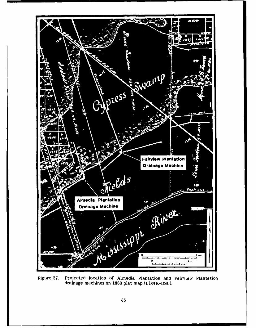
Fiur 2.Prjete ocin fAlmedia PlantationanFirewPntio
drainage machines on 1860 plat map (LDNR-DSL).
65

movables, St. Martin and Perret purchased several items at the sheriff's sale also(COB K, 13). Forsythe owned Almedia for only one year before selling it to Thomas,Lezin, and Henry Landeche (COB K, 362). The Landeches retained possession of theproperty until 1910 when they sold the plantation to Charles A. Duchamp (COB P,101). Duchamp immediately sold the land to the Almedia Truck Garden andDevelopment Company (COB P, 119).
The Almedia Truck Garden and Development Company planned to develop the higherlands of the plantation and subdivided it into numerous smaller tracts of land whichwere to be sold individually. A map of a portion of Almedia Plantation was made in1910 showing the individual tracts of land, the dit-hes, canals, levees, and the "oldpumping station" (Figure 28). The old pumping st ion is the same drainage stationthat is depicted on the 1894 Mississippi River Comm,sion map (see Figure 22) and thesame one that was located during the field survey.
In 1912 the Almedia Truck Garden and Development Company sold a portion ofAlmedia Plantation to Joseph W. Sheldon (COB Q, 158). Another map of the area wasmade at that time showing the various land lots near the drainage station and astructure at the location of the drainage machine (Figure 29). It is doubtful that thedrainage machine was still in use at that time, as its operations would have requiredfairly large outlays of cash that would have been prohibitive for an owner of non-agricultural land. Because of the breakup of the plantation beginning in 1910, it isvery difficult to track land ownership of the property after that date.
The 1938 USGS 7.5-minute Luling map (Figure 30) does not indicate a structure at thelocation of the Almedia Plantation drainage machine but does show a private roadextending to its actual location. This road is still present today, although it primarilyserves as a trail for area hunters. This drainage machine, or another in the samelocation, probably began operation by the 1860s. Operation of the machine presumablyhad ceased at approximately the same time that the plantation stopped producingagricultural goods, probably during the first decade of the twentieth century. Today,the remains of the drainage machine are spread over a relatively wide area and areslowly being reclaimed by area swamps.
Fairview Plantation
The first known owner of the lands of Fairview Plantation was Francois Scimar deBellisle. Although Bellisle, the commandant of La Cote des Allemands from 1770 to1782, was the owner of the property, he apparently did not reside there during theentire time of his ownership, which began sometime before 1763 (Voorhies 1973:65).Bellisle's residence, at least in 1763 and 1770, was in St. John the Baptist Parish(Voorhies 1973:65, 264). Shortly after Bellisle was replaced by Jacques Massicot, thecommandant of La Cote des Allemands from 1782 to 1794, Bellisle sold the property toLouis-Augustin Meullion (Conrad 1974:100). The farm at that time was 40 arpentswide and extended back to Lake Pontchartrain (Conrad 1974:100). Meullion, formercaptain of the First Company of the militia of La Cote des Allemands(Robichaux 1973:70), added this property to his holdings immediately upriver fromBellisle, which he had acquired sometime prior to 1763 (Voorhies 1973:65).
Meullion, one of the wealthiest men on the German Coast, owned several tracts ofland on both sides of the river. Meullion apparently resided on the tract of land nextto Bellisle even after he acquired Bellisle's farm (Conrad 1974:402), on which M.Medre's family resided, at least in 1804, and acted as overseers for the production ofsugar, molasses, corn, tafia, and rice (Conrad 1974:402). The plantation in 1804consisted of a 34 3 /4-arpent front (Conrad 1974:402).
66

46?
0
- 4 -4
.4 .4C
OC
* I l1~.
* I m
K' . ;j'ij _ _ _ _ 6 7

meSaIo center~e
Drainage Machine L
i1~, _1-WIII ______
9Q~L
~L~ I
J; U
4m.~
d OA-'l
19L' -npo h otws qar-to lei
Plnainshwn ring ttonsrcue
Hurrcaneproectin lvee entelin hasbee
addedA~ (COBQt 58)
68

0 " ...... ..
F2r 7.5-m a d
leadngg m n of A a a
hsfaigur 30.o 1938an an S 7.5-minuted L0lvsring its a fields(181 rMaduscrp
Censu, t Ch laatios. Psiton ofdeu hiurriane roecin eveeisanRegimnt an ex-eterlne Gosvern addUper iinpaetydismtm
bet106eeul18on sod 128 apnts oefts3 rpnso the farmrt to Zeon Trudeau,so
(Census, St.:87 Charelarsh) Z8 Gen881.Rn Trudeau, apiueatcooerntevousianah
manager of his father's farm, married Celestine Destrehan, daughter of Jean-NoelDestrehan and Marie-Claude Elenore de Longy (Conrad 1981:87).
69
.... .. mu muuuu m umuum 0n

By 1944 the plantation was in the hands of Edmond Fortier, Jr. and Company(Champomier 1845:4). Edmond Fortier, Jr. was a cousin of Adelard Fortier and was adescendant of, and married into, the Labranche family (Arthur and Kernion 1971:45).Fortier and Dame R. Labranche retained possession of the plantation until 1850(COB A, 57) when Babyles and Victoria Labranche acquired it (Table 4). TheLabranches retained possession of the property for only two years before selling it toAugusta W. Walker (COB A, 148). A year later Walker added the lands of AlmediaPlantation to his holdings, it was at this time that Fairview Plantation received itsname (Champomier 1854:19). Walker ran both Fairview and Almedia as one plantationunder the name of Fairview during his ownership of the property. In 1857 Walker soldboth plantations separately, Fairview going to Henry Frellsen (COB B, 263). Frellsenlost the plantation in a sheriff's sale to Daniel Fairex in 1863 (COB C, 132) butregained ownership of it in 1872 following the death of Fairex (COB D, 270).
An 1858 survey of the upriver boundary of the property made during Frellsen's firstownership, found that Frellsen's back levee at that time was 81.70 chains (5392.2 ft)from the river (Gillespie 1858:17). This back levee is still in existence, immediatelynorth of the center line of the hurricane protection levee. The Fairview Plantationdrainage machine (see Figure 27) located during the field survey is located on theintersection of the canal associated with the back levee and Walker Canal (thenFrellsen's Canal). The swamp at this time was 8.30 chains (547.8 ft) north of Freilsen'sback levee (Gillespie 1858:18).
As Walker Canal was constructed, at least in part, during Walker's ownership of theproperty (1852-1857) and the back levee of the property was in place in 1861, it ishighly probable that a drainage machine was constructed at their intersection duringthis period. Walker Canal would have provided the major drainage of the area,extending all the way from the natural levee to Lake Pontchartrain.
During Frelisen's second ownership of the plantation, Freilsen kept a Plantation Diary,covering the years 1878 until his death in 1884. The diary makes numerous commentsabout the drainage machine, pumps, and other daily activities on the plantation. Asthere was a second structure possibly representing a drainage machine on the property(see Figure 24), it is not possible to distinguish between the two in Frellsen'sPlantation Diary. The diary does, however, provide insight into the operation of Lhemachines. Several excerpts of the diary are provided below:
January 1878 "Finished ditching. Hauled boilers to draining machineand Garrow commenced putting them up...Boughtengine for $600 also 3000 bricks."
17 March 1878 "Adolph putting up engine at draining machine."
12 May 1878 "Hauled some coal to draining machine."
18 January 1880 "...draining daily with small pump and every other daywith wheel."
26 December 1880 "Engaged Jean Marie as earpenter and to run drainingmachines at $50 per month."
22 January 1881 "Draining wheel broke down on the twenty-first."
70

Table 4. Title Succession for Township 12 South, Range 9 East, Section 39 ofFairview Plantation, 1850-1915.
Dame R. Labranche and Edmond Fortier, Jr. to H. Babyles Labranche 1850
and Victoria Labranche
H. Babyles Labranche and Victoria Labranche to Augusta W. Walker 1852
Augusta W. Walker to Henry Frellsen 1857
Sheriff's Sale-Henry Frelisen to Daniel Fairex 1863
Succession-Daniel Fairex to Henry Freilsen 1872
Succesion-Henry Frelisen to Helena E. Frelisen, Mrs. Edward Page 1885 (1911)(Kate Frelisen), Mrs. Henry Gibbs Morgan (Laura Frelisen),Mrs. George Mather (Louise Frelisen), Joseph Walker Frellsen,and Katie B. Freilsen
Helena E. Frelisen, Mrs. George Mather, Mrs Henry Gibbs Morgan 1886and Mrs. Edward Page to Joseph Walker Freilsen
Sheriff's Sale-Joseph Walker Frellsen to Henry Gibbs Morgan 1893
Henry Gibbs Morgan to Herbert Wadsworth 1910
Herbert Wadsworth to J. N. Colomb 1910
J. N. Colomb to Fairview Land Company 1911
Fairview Land Company to H. McCullough 1915
References: COB 'A', Folio 57 (1850)COB 'A', Folio 148 (1852)COB 'B', Folio 254 (1857)COB 'C', Folio 132 (1863)COB 'D', Folio 270 (1872)COB '1', Folio 112 (1885)1COB '' Folio 61 (1886)COB 'J', Folio 38 (1893)COB '0', Folio 456 (1910)COB '0', Folio 668 (1910)COB 'Q', Folio 109 (1911)COB 'S', Folio 239 (1915)
Notes: 1. Although transfer occured in 1885, it was not registered until 1911.
71

5 February 1881 "Engineers repairing draining machine."
26 February 1881 "Engineer Schmidt and carpenters at draining wheel."
19 March 1881 "Bricklayer at boiler on draining machine."
19 February 1882 "...back levees leaking very .inuch-draining day andnight, except two days when draining wheel broke..."
Frelisen, who resided in New Orleans and only paid weekly visits to Fairview, begangrowing rice at Fairview on a commercial basis in 1883 for the first time since at least1869. The first mention of rice production in the plantation diary is on 24 December1881 when Frellsen wrote, "...one load lumber for rice flume and gutters." The firstcrop, however, was not planted until April 1883 when Frelisen had at least 65 ac ofrice planted. The growing of rice in 1882 may have been abandoned following theflooding of the plantation that occurred when the plantation's front levee gave way toa crevasse on 30 January 1882 (Frellsen 1884). During the years of the plantationdiary, Frellsen planted corn, sugarcane, rice, and peas. When water conditionspermitted, Frellsen also exploited the lumber resources of his land, making numerouscomments in his plantation diary concerning the timbering of the areas to the rear ofthe plantation near the drainage machine.
Following Frellsen's death in 1884, the plantation was taken over by his heirs (COB Q,112). In 1886 Joseph W. l rellsen, Henry Frellsen's son, bought his mother's andsiblings' shares of the property (COB H, 61). The younger Frelisen apparentlycontinued rice agriculture on the plantation, as sugar production remained relativelylow during his ownership, which lasted until 1893. In 1893 Frellsen lost the plantationat a Sheriff's Sale, possibly as a result of area floods that may have wiped out his 1892crops. At the time of the Sheriff's seizure of the property, there were numerousmortgages and promissory notes standing against the plantation with crop yields ofvarious years put up for collateral (COB J, 38).
Henry Gibbs Morgan took over the plantation in 1893 (COB J, 38) and quickly increasedthe sugar output from 476,008 lbs in 1894 (Bouchereau 1894:29) to 1,500,000 lbs in1898 (Bouchereau 1898:35). Sugar output of the plantation remained high until at least1907, Presumably, the high sugar output indicates a reduction in land devoted to riceagriculture. Morgan continued to exploit the backswamps of the plantation, sellinglumbering rights on all of Fairview "...lying between the present Drainage Machine andLake Pontchartrain..." to Southerland Innes Co., Ltd. (COB M, 554) in 1904.
In 1910 the plantation was sold to Herbert Wadsworth (COB 0, 456). Ownership of thelands adjacent to the drainage station becomes unclear at this time as the propertybegan to be broken up. Apparently J. N. Colomb purchased the property fromWadsworth later in 1910 (COB Q, 668) and resold it a year later to the Fairview LandCompany (COB Q, 109). The last sugar cane crop was grown on the plantationsometime between 1907 and 1912 (Bouchereau 1910:47, Bouchereau 1917:47).
The 1938 USGS 7.5-minute Luling map (see Figure 30) does not show a structure at thelocation of the drainage machine, however, it does depict a private road extending tothis locale. The dates of operation of the drainage wheel are unknown, but, it may besurmised that a drainage structure was built at this location during Walker's ownershipof the property (1852-1857). Whether or not such a structure would have been
72

replaced at a later date is unclear. By 1878, however, it is clear that a drainagemachine was constructed on Walker Canal and was still in existence, if not inoperation, until at least 1894 (see Figure 24). Since the plantation ceased operationslate in the first decade of the twentieth century, the drainage machine was probablynot used after 1910. Today the site of the drainage machine is on the edge of anencroaching landfill and it may already be partially buried. The town of St. Rose nowincorporates all of the lands of Fairview Plantation along the Mississippi River.
73

CHAPTER 7: SUMMARY AND RECOMMENDATIONS
Summary
In late October and early November 1987 a cultural resources survey of the right-of-way of the Hurricane Protection Levee on the east bank of St. Charles Parish,Louisiana was conducted by Coastal Environments, Inc. Five areas within the right-of-way were examined by pedestrian survey, shovel testing, probing, and hand augering.In addition, background research that established the prehistoric and historic setting ofthe area was conducted.
As a result of the survey procedures, three previously unrecorded late-nineteenth-century or early-twentieth-century drainage machines were located within the right-of-way. These drainage machines, which were essentially steam-poweredwaterwheels, were found on the former grounds of Prospect Plantation, Almedia orPatterson Plantation, and Fairview Plantation. Although excavations were notconducted, detailed drawings of the drainage machines were made. Since the right-of-way lies largely within the backswamps of the Mississippi River, it is unlikely thatadditional structures are located in this area.
Borings made by the Corps of Engineers along the right-of-way and hand-auger boringsby Coastal Environments, Inc. along Bayou Trepagnier were used to study the geologyof the area. This study concluded that prehistoric sites may exist on a buried naturallevee feature located within the area. This buried levee feature is interpreted as anelement of the St. Bernard Delta complex. Based on radiocarbon dates from the coresand on correlations with archaeological site data, it is argued that this buried naturallevee dates from circa 2000 to 3400 years B.P. The data collected in this study alsosuggests that Bayou Trepagnier originally formed as a crevasse distributary of the nowburied fluvial system (i.e. St. Bernard Delta system) and has been reoccupied orcontinuously occupied since that time.
Recommendations
While the remains of the drainage machines that were located during this study are ofinterest in understanding land use in late-nineteenth-century St. Charles Parish, it isunlikely that they would yield any significant archaeological, architectural, orhistorical information beyond what has already been gathered. Both the ProspectPlantation drainage machine and the Almedia or Patterson Plantation drainagemachine have been severely impacted by cultural activity postdating theirabandonment. While the foundation of the Fairview Plantation drainage machine isrelatively intact, the lack of machinery or rubble suggests that the building wasdismantled for reuse at another location or for scrap. In light of the above, noadditional archaeological work relative to these structures is recommended.
75

REFERENCES
Arthur, Stanley C. and George C.H. de Kernion1971 Old Families of Louisiana. Claitors, Baton Rouge.
Baudier, Roger1972 The Catholic Church in Louisiana. Louisiana Library Association, Public
Library Section. Originally published 1939, Roger Baudier, New Orleans.
Begnaud, Allen1980 The Louisiana Sugar Cane Industry: An Overview. Green Fields: Two
Hundred Years of Louisiana Sugar. The Center for Louisiana Studies,University of Southwestern Louisiana, Lafayette.
Bezou, Monsignor Henry C.1979 Metairie: A Tongue of Land to Pasture. Pelican Publishing Company,
Gretna.
Bouchereau, Alcee1878- Statement of the Sugar and Rice Crops Made in Louisiana. Various1917 Publishers, New Orleans.
Byrd, Kathleen M. and Robert W. Neuman1978 Archaeological Data Relative to Prehistoric Subsistence in the Lower
Mississippi River Alluvial Valley. Geoscience and Man 19:9-21.
Castille, George J.1980 Cultural Resources Evaluation of the Waterford 3 Electric Generating Plant,
St. Charles Parish, Louisiana. Coastal Environments, Inc., Baton Rouge.
Champomier, P. A.1845 Statement of Sugar Made In Louisiana In 1844. Cook, Young and Company,
New Orleans.
Conrad, Glenn R.1970 The First Families of Louisiana, Volume I. Claitor's Publishing Division,
Baton Rouge.
1974 St. Charles: Abstracts of the Civil Records of St. Charles Parish, 1770-1803. University of Southwestern Louisiana, Lafayette.
1981 The German Coast: Abstracts of the Civil Records of St. Charles and StJohn the Baptist Parishes, 1804-1812. University of Southwestern Louisiana,Lafayette.
Davis, Edwin A.1971 Louisiana: A Narrative History. Claitor's Publishing Division, Baton Rouge.
Davis, John1806 Travels in Louisiana and the Floridas in the Year 1802, Giving a Correct
Picture of Those Countries. I. Riley, New York.
77

De Bow, J. D. B.1847 Drainage. The Commercial Review of the South and West 4:66-80.
Degelos, Pierre A.1892 Statement of Sugar Made In Louisiana in 1828 and 1829. The Louisiana
Planter and Sugar Manufacturer 9(4):66.
Deiler, J. Hanno1969 The Settlement of the Geman Coast of Louisiana and the Creoles of German
Descent. Reprinted. Genealogical Publishing Company, Inc., Baltimore.Originally Published 1909.
De Ville, Winston (editor)1974 First Settlers of Pointe Coupee. Polyanthos, New Orleans.
Din, Gilbert C. (editor)1977 Louisiana in 1776: A Memoir of Francisco Bouligney, Louisiana Collection
Series III, New Orleans.
Fisk, H.N.1944 Geological Investigation of the Alluvial Valley of the Lower Mississippi
River. Mississippi River Commission, Vicksburg.
Franks, Herschel A., Jill-Karen Yakubik, Jeffrey E. Treffinger, R. ChristopherGoodwin, and Paul C. Armstrong
1986 Cultural Resources Inventory of the Montz Freshwater Diversion ProjectCorridor, St. Charles Parish, Louisiana. R. Christopher Goodwin &Associates, Inc. Submitted to the Department of the Army, New OrleansDistrict Corps of Engineers, New Orleans.
Frazier, David E.1967 Recent Deltaic Deposits of the Mississippi River. Transactions No. 17:287-
315.
Gianelloni, E. B.1965 Calender of Louisiana Colonial Documents, vol 3. Louisiana State Archives
and Records Commission, Baton Rouge.
Ginn, Milred K.1940 A History of Rice Production in Louisiana to 1896. The Louisiana Historical
Quarterly 23(2).
Holmes, Barbara1986 Historic Resourcs Study: The Barataria Unit of Jean Lafitite National
Historic Park. Southwest Cultural Resources Center, Santa Fe.
Holmes, Jack D.1967 Indigo in Colonial Louisiana and the Floridas; Louisiana HiSt 2r 8:329-349.
Kolb, Charles R., Fred L. Smith, and Robert C. Silva1975 Pleistocene Sediments of the New Orleans-Lake Pontchartrain Area.
Technical Report S-75-6. Waterways Experiment Station, U.S. Army Corpsof Engineers, Vicksburg.
78

Kolb, C.R. and J.R. van Lopik1958 Geology of the Mississippi Deltaic Plain, Southeastern Louisiana. Technical
Report 3-483. Waterways Experiment Station, U.S. Army Corps ofEngineers, Vicksburg.
Lamb, Theresia1983 Preliminary Archaeological Reconnaissance and Assessment of Destrehan
Plantation, St. Charles Parish, Louisiana. Department of Anthropology andGeography, University of New Orleans.
Maudel, Charles R.1972 The Census Tables for the French Colony of Louisiana from 1699 through
1732. Geneological Publishing Company, Ltd., Baltimore.
McDaniel, Donald1987 Soil Survey of St. Charles Parish, Louisiana. United States Department of
Agriculture, Soil Conservation Service. U.S. Government Printing Office,Washington, D.C.
Mclntire, William G.1958 Prehistoric Indian Settlements of the Changing Mississippi River Delta.
Coastal Studies Series, Report No. 1. Louisiana State University, BatonRouge.
1976 Archaeological and Historical Sites. Appendix A in EnvironmentalAssessment of 10-Inch Ethylene Line from Norco to Sorrento, Louisiana.Report prepared for Shell Pipe Line Corporation. Dames and Moore,Atlanta.
1979a Cultural Resources Survey, Shell Pipe Line Corporation's Proposed Norco toMarathon 24"? Pipeline. On file, Louisiana Department of Culture,Recreation and Tourism, Baton Rouge.
1979b Cultural Resources Survey, Shell Pipe Line Corporation's Norco to Dupont 4"Butadiene Pipe Line. On file, Louisiana Department of Culture, Recreationand Tourism, Baton Rouge.
1979c Cultural Resources Survey, Shell's Proposed Pipe Line from Clovelly Oil andGas Field to Norco, Louisiana. On file, Louisiana Department of Culture,Recreation and Tourism, Baton Rouge.
McWilliams, Richebourg G.1953 Fleur de Lys and Calumet. Louisiana State University Press, Baton Rouge.
Moore, John P.1976 Revolt in Louisiana: The Spanish Occupation 1766-1770. Louisiana State
University Press, Baton Rouge.
Neuman, Robert W.1973 Archaeological Assessment of Water Resource Planning Areas 9 and 10,
Louisiana. Report submitted to the National Park Service, Tallahassee.
79

Neuman, Robert W.1977 An Archaeological Assessment of Coastal Louisiana. Melanges, No. 11,
Baton Rouge.
O'Neil, Charles E., Joe G. Taylor, William Ivy Hair, Mark T. Carleton and Michael L.Kurtz
1984 Louisiana: A History. The Forum Press, Inc., Arlington Heights, Ill.
Phillips, Philip1970 Archaeological Survey in the Lower Yazoo Basin, Mississippi, 1949-1955.
Papers of the Peabody Museum of Archaeology and Ethnology, HarvardUniversity, 60. 2 parts. Cambridge.
Price, G.R. Dennis1977 A Cultural Resource Survey and Evaluation of the Big Three Industries
Pipeline Corridor - Geismer to Norco, Louisiana. Report on file at theLouisiana Department of Culture, Recreation and Tourism, Baton Rouge.
Robin, Claude C.1966 Voyage to the Interior of Louisiana, 1802-1806. Translated by Stuart 0.
Landry, Jr., New Orleans.
Russell, R.J.1936 Physiography of the Lower Mississippi River Delta. Bulletin of Louisiana
Geological Survey. Baton Rouge.
Saucier, Roger T.1963 Recent Geomorphic History of the Pontchartrain Basin, Louisiana.
Techinical Report No. 16. Coastal Studies Institute. Louisiana StateUniversity, Baton Rouge.
1974 Quaternary Geology of the Lower Mississippi Valley, Research Series No. 6.Arkansas Archeological Survey.
Sitterson, J. C.1953 Sugar Country: The Cane Sugar Industry in the South 1753-1950. University
of Kentucky Press, Lexington.
Swanson, Betsy1975 Historic Jefferson Parish from Shore to Shore. Pelican Publishing Company,
Gretna, Louisiana.
Swanton, John R.1911 Indian Tribes of the lower Mississippi Valley and adjacent coasts of the Gulf
of Mexico. Bureau of American Ethnology Bulletin 42.
Toth, Edwin A.1977 Early Marksville Phases in the Lower Mississippi Valley: A Study of Culture
Contact Dynamics. Unpublished PhD dissertation, Department ofAnthropology, Harvard University, Cambridge.
80

Voorhies, Jacqueline K.1973 Some Late Eighteenth Century Louisianians. Census, Records of the
Colony, 1758-1796. University of Southwestern Louisiana, Lafayette.
Weinstein, Richard A.1980 Cultural Resources Survey of Six Proposed Levee Closures, St. Charles
Parish, Louisiana. Coastal Environments, Inc., Baton Rouge. Submitted toDawson Engineers, Inc.
Weinstein, Richard A., Eileen K. Burden, and Sherwood M. Gagliano1977 Cultural Resource Survey of Interstate 410, St. Charles Parish, Louisiana.
Coastal Environments, Inc. Baton Rouge. Submitted to the LouisianaDepartment of Transportation, Office of Highways.
Weinstein, Richard A. and Sherwood M. Gagliano1985 The Shifting Deltaic Coast of the Lafourche Country and its Prehistoric
Settlement. In The Lafourche Country: The People and the Land, edited byPhilip D. Uzee, pp.122-149. Center for Louisiana Studies, University ofSouthwestern Louisiana, Lafayette.
Wilkinson, J.B.1854 Rice - It's Uses and Production. De Bows Review and Industrial Resources,
Statistics, etc. 16:535-538.
Yakubik, Jill-Karen, Herschel A. Franks, R. Christopher Goodwin, and Carol J. Poplin1986 Cultural Resources Inventory of the Bonnet Carre Spillway, St. Charles
Parish, Louisiana. R. Christopher Goodwin & Associates, Inc. Submitted tothe Department of the Army, New Orleans District Corps of Engineers, NewOrleans.
Yoes, Henry E., Ill1973 A History of St. Charles Parish to 1973. St. Charles Herald Publishers,
Norco, Louisiana.
Archival Sources
Anonymous1723 Carte Particuliere du Flevue St. Louis dix lieves au deffus et au deffous de
la Nouvelle Orleans ou font marque des habitations et les Terrains Concedesa plufieurs Particuliers au Mississipy. On file, Coastal Environments, Inc.,Baton Rouge.
Dawson, L. W.1936 Personal correspondence to Melba Elfer dated 2 December 1936. In A Case
Study of St. Charles Parish by Melba Elfer (1936).
Elfer, Melba1936 A Case Study of St. Charles Parish. Term Paper for Tulane University
School of Social Work. On file, Louisiana and Lower Mississippi ValleyCollections, Louisiana State University.
81

Frellsen, Henry1884 Fairview Plantation, Saint Rose, Saint Charles Parish, Louisiana. Plantation
Diary of Henry Frellsen 1878-1884. On file, Louisiana and Lower MississippiValley Collections, Louisiana State University
Gillespie, Theodore1858 Field notes of Theodore Gillespie, Southeast District. On file, Division of
State Lands, Louisiana Department of Natural Resources.
Grey, W. F.1936 Personal correspondence to Melba Elfer dated 8 December 1936. In A Case
Study of St. Charles Parish by Melba Elfer (1936).
Louisiana Department of Natural Resources, Division of State Lands (LDNR-DSL)1860 Official Plat Map of Township 12 south, Range 8 East, Southeastern
District, Louisiana.
1860 Official Plat Map of Township 12 South, Range 9 East, Southeasern District,Louisiana.
Mississippi River Commission1894 Survey of the Mississippi River, Chart Number 74 and 75.
Persac's Map1967 Plantations on the Mississippi River from Natchez to New Orleans, 1858.
Pelican Publishing Co.
St. Charles Parish Conveyance Records (COB)Office of the Clerk of Court, St. Charles Parish, Louisiana.
St. Charles Parish MapsWard 5. On file at Office of Clerk of Court. St. Charles Parish.
United States Geological Survey1938 Luling, Louisiana, 7.5' topographic quandrangle map. U. S. Government
Printing Office.
United States Geological Survey1969 Bonnet Carre, Louisiana, 15' topographic quadrangle map. U. S. Government
Printing Office.
1969 Hahnville, Louisiana, 15' topographic quadrangle map. U. S. GovernmentPrinting Office.
United States Manuscript Census: St Charles Parish1810 Census of Population. Microfilm collection, Baton Rouge Public Library.1820
82

APPENDIX
Scope of Services
83

CELMN-PD-RA 20 July 1987SCOPE OF SERVICES
Cultural Resources Survey of theSt. Charles Levee, LP&V HP Project
St. Charles Parish, Louisiana
1. Introduction. The St. Charles Parish Levee is an authorized feature ofthe Lake Pontchartrain and Vicinity Hurricane Protection Project. Thisfeature provides for the construction of a new levee parallel to andimmediately north of U.S. Highway 61 (Airline Highway), between the leveealong the Jefferson-St. Charles Parishes boundary and the east BonnetCarre' Spillway guide levee. Four drainage structures will be providedthrough the earthen levee at locations where there is drainage throughAirline Highway. The drainage structures would remain open to maintainexisting drainage patterns and would be closed only during the threat of ahurricane. The new levee would provide protection to existing developedareas on the east bank of St. Charles Parish.
2. Study Area. The study area consists of designated portions of theconstruction right-of-way as shown on Attachment 1 and listed below:
a. Bayou Trepagnier area - both banks of the bayou for a distance of2,500 feet lakeward from the sewage disposal plant at Norco;
b. Good Hope Oil and Gas Field - various locations where roads andcanals cross the right-of-way;
c. Cross Bayou Canal - where it crosses the levee alignment;
d. Pipeline Canal - where it crosses the levee alignment; ande. Almedia to St. Charles-Jefferson Parish boundary - the portions of
this reach which are not inundated.
Except for the Bayou Trepagnier area, the survey corridor is 800 feetwide, centered on the levee centerline.
3. Background Information. A cultural resources study of interest to thisproject is the 1977 study by Coastal Environments, Inc., entitled "CulturalResources Survey of Interstate 410, St. Charles Parish, Louisiana." Thisstudy provides a general overview and update of the known culturalresources in the vicinity of the study area.
The proposed levee alignment is located primarily in a cypress swampenvironment. The only exceptions to this situation are cultural intrusionsand the eastern portion of the right-of-way (east of Almedia) where thelevee alignment approaches the Mississippi River. From west to east themodern cultural features in the right-of-way include:
85

a. Good Hope Oil and Gas Fieldb. several canalsc. two St. Charles Parish landfill sitesd. a dump site, low levee system, and clearings in
the area east of Almedia.
Geologic profiles of the right-of-way obtained from soil borings shownatural levee deposits at the surface (with depths ranging from 10 to 4feet) for most of the project length. The central portion of the alignment(between the Ormond Subdivision and the parish landfill sites) consists ofswamp and marsh deposits at the surface. Thus, the soils informationindicates that the western and eastern portions of the project are locatedon the subsiding edge of the Mississippi trunk stream natural levee. Themajority of this depositional environment has subsided below water leveland is now occupied by swamp vegetation.
Helicopter reconnaissance of the alignment revealed that most of theright-of-way is inundated and, therefore, not feasible for terrestrialsurvey. Review of the soil borings does not indicate the presence ofdistributaries or crevasse channels near the surface which would warrant asubsurface testing program. For these reasons, the survey is limited tothose portions of the right-of-way which have a high potential for sites(Bayou Trepagnier), or provide subsurface information in their spoil banks(canals and roads), or are amenable to pedestrian survey methods (portioneast of Almedia).
4. General Nature of the Work. The study will consist of backgroundresearch, intensive cultural resources survey of selected portions of thelevee alignment, geomorphological analysis of the study area, and dataanalysis and report preparation. The geomorphology portion of the studywill include the radiocarbon dating of several organic samples from
undisturbed borings obtained by the Corps of Engineers.
5. Study Requlrements. The study will be conducted utilizing currentprofessional standards and guidelines including, but not limited to:
the National Park Service's draft standards entitled, "How to Apply theNational Register Criteria for Evaluation," dated June 1, 1982;
the Secretary of the Interior's Standards and Guidelines for Archeology
and Historic Preservation as published in the Federal Register onSeptember 29, 1983;
Louisiana's Comprehensive Archeological Plan dated October 1, 1983; and
The Advisory Council on Historic Preservation's regulation 36 CFR Part800 entitled, "Protection of Historic Properties."
The study will be conducted in four phases: Background Research, IntensiveSurvey, Geomorphological Analysis, and Data Analysis and ReportPreparation.
86
A. Phase 1 Background Research. The study will begin wfth research of
available literature and records necessary to predict the nature of theresource base in the project area and refine the survey methodology. Thisbackground research will include a literature review, review of thegeomorphology, and research of historic records.
A brief, interim report will be prepared at the conclusion of this phaseand submitted to the Contracting Officer's Representative (COR). Thereport will specifically include the following:
(1) a brief description of the study area's geomorphology, prehistory,and history as they relate to the location, identification, and evaluationof archeological resources;
(2) predictive statements of the geomorphological and archeologicalexpectations based on the background research, and
(3) refinements in the survey methodologies as necessitated by thesepredictions.
The report shall be submitted within 3 weeks after delivery order award forreview and approval. All review comments will be resolved or incorporatedwithin 1 week after submittal.
B. Phase 2 Intensive Survey. Upon approval of the Phase 1 report by theCOR, the Contractor shall initiate the fieldwork. The survey shall be acombination of boat survey and intensive pedestrian survey with shoveltesting. The boat survey will be utilized in those portions of the studyarea which are accessible by water. This will involve visual inspection ofthe stratigraphic profile of the exposed banklines as well as shoveltesting at 20 meter intervals along the banks. Due to the high potentialfor buried archeological sites along Bayou Trepagnier, auger testing to aminimum depth of 2 meters will be substituted for shovel testing on thisfeature. The intensive pedestrian survey will utilize lane spacing of 20meters and a shovel testing interval of 50 meters in an offset pattern.
Shovel tests will be approximately 30x30 cm in the horizontal plane andapproximately 25-50 cm deep, i.e., to sterile subsoil. The excavated soilwill be screened through 1/4 inch wire mesh. This systematic procedurewill be supplemented with judgmental shovel testing based upon thebackground research.
Stata site forms will be completed and state-assigned site numbers willbe utilized for all archeological sites located by the survey. All siteslocated in the survey corridors will be sketch-mapped, photographed, andbriefly tested using shovel, auger, and limited controlled surfacecollection to determine depth of deposit, site boundaries, stratigraphy,and cultural association. Any pre-World War II standing structures locatedin the survey transects will be recorded on Louisiana state standingstructure forms and will include a minimum of three clear black and whitephotographs. For structures located in the survey transects, thecontractor shall also address the archeological component of the site.
87

C. "hase 3: Geomorphological Analysis. This phase involves the analysesof radiocarbon dates, the Corps' geologic profile of the alignment,literature on the geology of the study area, survey observations, andavailable information on archeological sites in the project vicinity. Theradiocarbon dates will be obtained from four organic samples taken fromundisturbed borings of the project alignment and will be selected throughconsultation between the Contractor, the COR, and Corps geologists. Thepurpose of the analyses is to provide a geomorphic reconstruction for thestudy area (i.e., the east bank of St. Charles Parish), develop time-depthestimates for the study area, and, most significantly, relate this to thepotential for archeological sites at or near the surface (i.e., surface to-30 feet NGVD).
D. Phase 4: Data Analyses and Report Preparation. All data will beanalyzed using currently acceptable scientific methodology. The Contractorshall catalog all artifacts, samples, specimens, photographs, drawings,etc., utilizing the format currently employed by the Louisiana StateArcheologist. The catalog system will include site and proveniencedesignations. All cultural resources located by the survey will beevaluated against the National Register criteria contained in Title 36 CFRPart 60.4 and within the framework of the historic setting to assess thepotential eligibility for inclusion in the National Register. TheContractor will classify each site as either eligible for inclusion in theNational Register, potentially eligible, or not eligible. The Contractorshall fully support his recommendations regarding site significance.
The analyses will be fully documented. Methodologies and assumptionsemployed will be explained and justified. Inferential statements andconclusions will be supported by statistics where possible. Additionalrequirements for the draft report are contained in Section 6 of this Scopeof Services.
6. Reports:
a. Phase 1 Report. Two copies of the report on the results of thePhase 1 investigations will be submitted to the COR within 3 weeks afterwork item award for review qnd approval. This report will present indetail the proposed field methodology.
b. Draft and Final Reports (Phase 1-4). Eight copies of the draftreport integrating all phases of this investigation will be submitted tothe COR for review and comment within 16 weeks after work item award.Along with the draft reports, the Contractor shall submit three copies ofthe National Register Registration Forms for each site recommended aseligible for inclusion in the National Register. This documentation willcontain all of the data required by NPS National Register Bulletin 16:Guidelines for Completing National Register of Historic Places Forms. TheContractor shall also provide recommendations for mitigation for any sitesrecommended as eligible. As an appendix to the draft report, theContractor shall submit the state site forms. The written report shallfollow the format set forth in MIL-STD-847A with the following exceptions:
88

(1) separate, soft, durable, wrap-around covers will be used instead of
self covers; (2) page size shall be 8-1/2 x II inches with 1-inch margins;
(3) the reference format of American Antiquity will be used. Spellingshall be in accordance with the U.S. Government Printing Office StyleManual dated January 1973. The COR will provide all review comments to the
Contractor within 8 weeks after receipt of the draft reports (24 weeksafter work item award). Upon receipt of the review comments on the draftreport, the Contractor shall incorporate or resolve all comments and submitone prelimirary copy of the final report to the COR within 4 weeks (28weeks after work item award). Upon approval of the preliminary finalreport by the COR, the Contractor will submit 30 copies and onereproducible master copy of the final report to the COR within 30 weeksafter work item award. Included as an appendix to the Final Report will bea complete and accurate listing of cultural material and associateddocumentation recovered and/or generated. In order to preclude vandalism,
the final report shall not contain specific locations of archeologicalsites. Site specific information, including one set of project mapsaccurately delineating si~e locations, site forms, black and whitephotographs and maps, shall be included in an appendix separate from themain report.
7. Attachments.
1. Map of Study Area
89