name: date: class period: georgia in the north america continent chapter...
TRANSCRIPT

Name:_______________________________Date:_________Class Period:_________
1
Georgia in the North America Continent Chapter 1
Directions: Although you know your home is in Georgia, you are also part of North America. On the mapbelow, complete the following activities.
1. Indicate and shade in the location of Georgia on your map.2. Indicate and shade in and label the Atlantic Ocean and the Gulf of Mexico.3. Put directional symbols on your map to indicate North, South, East, and West.
Directions: Use the map and the Internet to find answers to the following questions.
4. In what country in North America do you live? __________________________________Mark that country on the map.
5. What ocean is located on the western side of our country? __________________________Label that ocean on your map.
6. What country is directly north of the United States? ______________________________ Label it on your map.
7. Are there students in your class who are from any of the areas of North America other than the United States? If so, label those areas and write in the name of the classmate on lines drawn from the area.
CHAPTER ONE
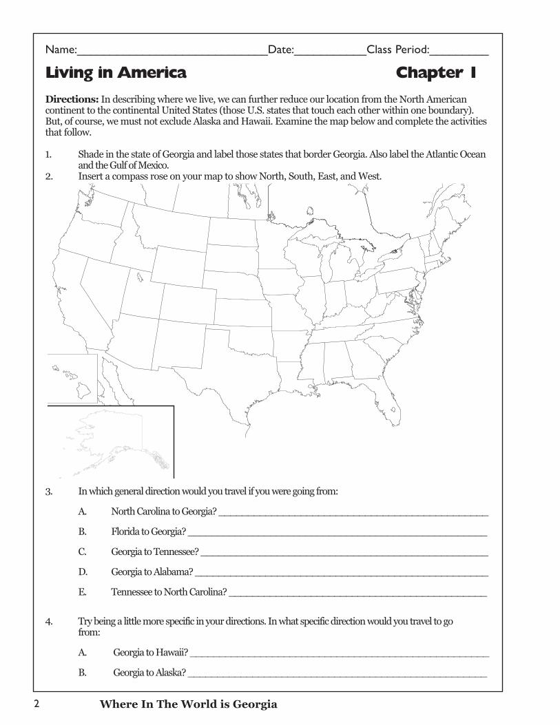
Name:_____________________________Date:___________Class Period:_________
2
Living in America Chapter 1
Directions: In describing where we live, we can further reduce our location from the North Americancontinent to the continental United States (those U.S. states that touch each other within one boundary). But, of course, we must not exclude Alaska and Hawaii. Examine the map below and complete the activitiesthat follow.
1. Shade in the state of Georgia and label those states that border Georgia. Also label the Atlantic Ocean and the Gulf of Mexico.
2. Insert a compass rose on your map to show North, South, East, and West.
3. In which general direction would you travel if you were going from:
A. North Carolina to Georgia? ______________________________________________
B. Florida to Georgia? ___________________________________________________
C. Georgia to Tennessee? _________________________________________________
D. Georgia to Alabama? __________________________________________________
E. Tennessee to North Carolina? ____________________________________________
4. Try being a little more specific in your directions. In what specific direction would you travel to go from:
A. Georgia to Hawaii? ___________________________________________________
B. Georgia to Alaska? ___________________________________________________
Where In The World is Georgia
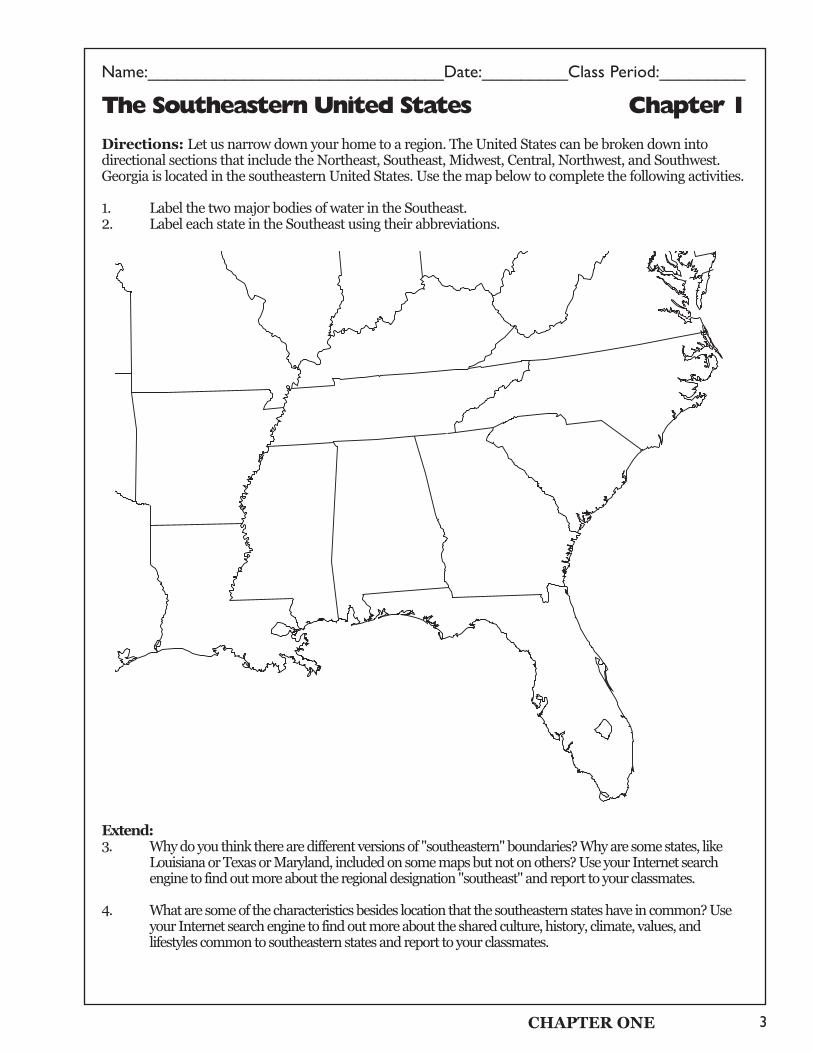
Name:_______________________________Date:_________Class Period:_________
3
The Southeastern United States Chapter 1
Directions: Let us narrow down your home to a region. The United States can be broken down intodirectional sections that include the Northeast, Southeast, Midwest, Central, Northwest, and Southwest.Georgia is located in the southeastern United States. Use the map below to complete the following activities.
1. Label the two major bodies of water in the Southeast. 2. Label each state in the Southeast using their abbreviations.
Extend:3. Why do you think there are different versions of "southeastern" boundaries? Why are some states, like
Louisiana or Texas or Maryland, included on some maps but not on others? Use your Internet search engine to find out more about the regional designation "southeast" and report to your classmates.
4. What are some of the characteristics besides location that the southeastern states have in common? Use your Internet search engine to find out more about the shared culture, history, climate, values, and lifestyles common to southeastern states and report to your classmates.
CHAPTER ONE
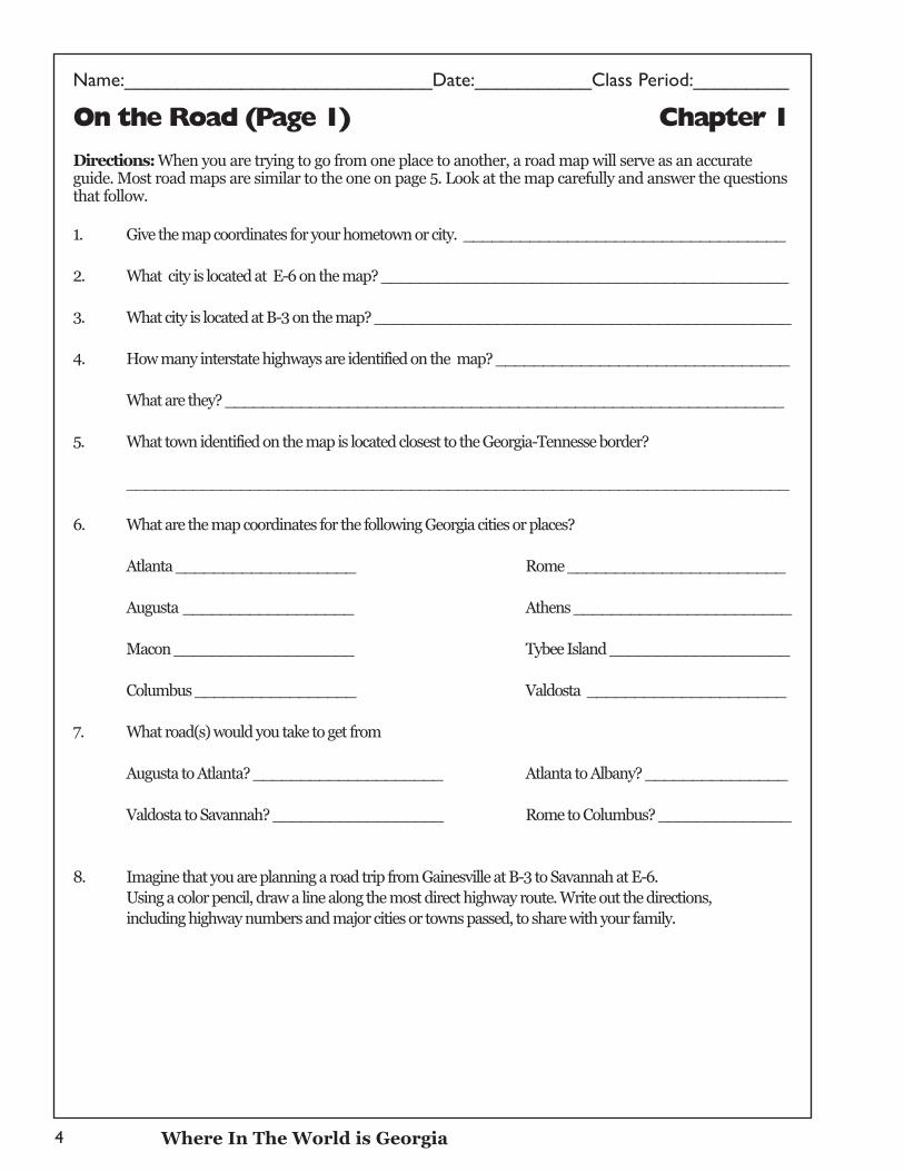
Name:_____________________________Date:___________Class Period:_________
4
On the Road (Page 1) Chapter 1
Directions: When you are trying to go from one place to another, a road map will serve as an accurateguide. Most road maps are similar to the one on page 5. Look at the map carefully and answer the questionsthat follow.
1. Give the map coordinates for your hometown or city. __________________________________
2. What city is located at E-6 on the map? ___________________________________________
3. What city is located at B-3 on the map? ____________________________________________
4. How many interstate highways are identified on the map? _______________________________
What are they? ___________________________________________________________
5. What town identified on the map is located closest to the Georgia-Tennesse border?
______________________________________________________________________
6. What are the map coordinates for the following Georgia cities or places?
Atlanta ___________________ Rome _______________________
Augusta __________________ Athens _______________________
Macon ___________________ Tybee Island ___________________
Columbus _________________ Valdosta _____________________
7. What road(s) would you take to get from
Augusta to Atlanta? ____________________ Atlanta to Albany? _______________
Valdosta to Savannah? __________________ Rome to Columbus? ______________
8. Imagine that you are planning a road trip from Gainesville at B-3 to Savannah at E-6.Using a color pencil, draw a line along the most direct highway route. Write out the directions, including highway numbers and major cities or towns passed, to share with your family.
Where In The World is Georgia
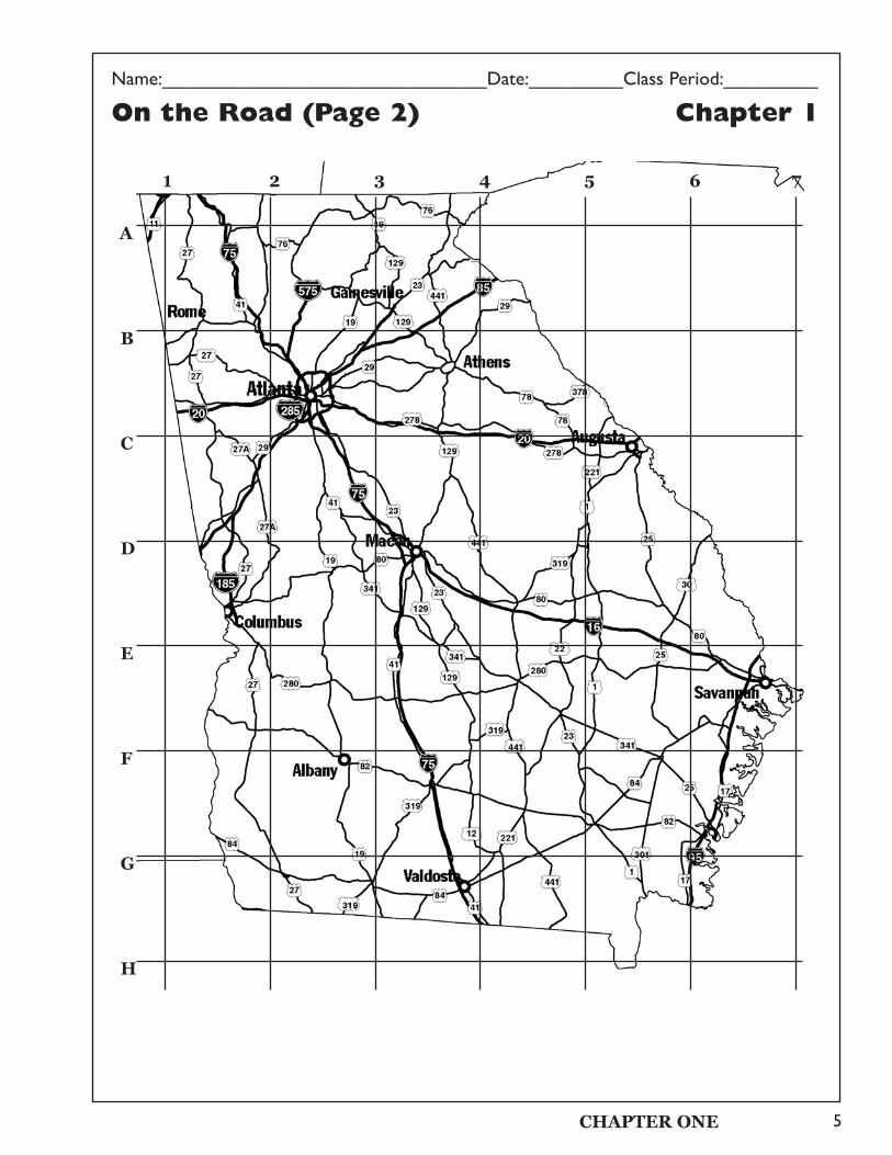
On the Road (Page 2) Chapter 1
1 2 3 4 5 6 7
A
B
C
D
E
F
G
H
Name:_______________________________Date:_________Class Period:_________
5CHAPTER ONE
Name:_____________________________Date:___________Class Period:_________
6
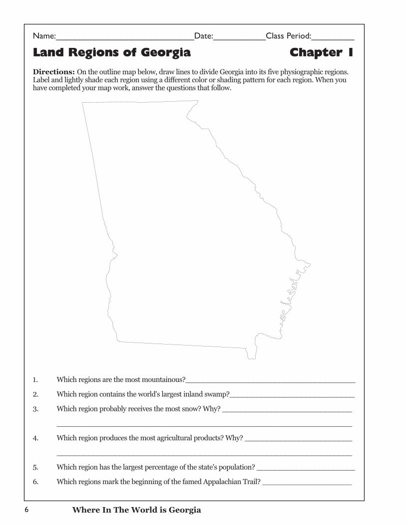
LLaanndd RReeggiioonnss ooff GGeeoorrggiiaa CChhaapptteerr 11
Directions: On the outline map below, draw lines to divide Georgia into its five physiographic regions.Label and lightly shade each region using a different color or shading pattern for each region. When youhave completed your map work, answer the questions that follow.
1. Which regions are the most mountainous?______________________________________
2. Which region contains the world's largest inland swamp?____________________________
3. Which region probably receives the most snow? Why? _____________________________
__________________________________________________________________
4. Which region produces the most agricultural products? Why? ________________________
__________________________________________________________________
5. Which region has the largest percentage of the state's population? ______________________
6. Which regions mark the beginning of the famed Appalachian Trail? ____________________
Where In The World is Georgia
Name:_______________________________Date:_________Class Period:_________
7
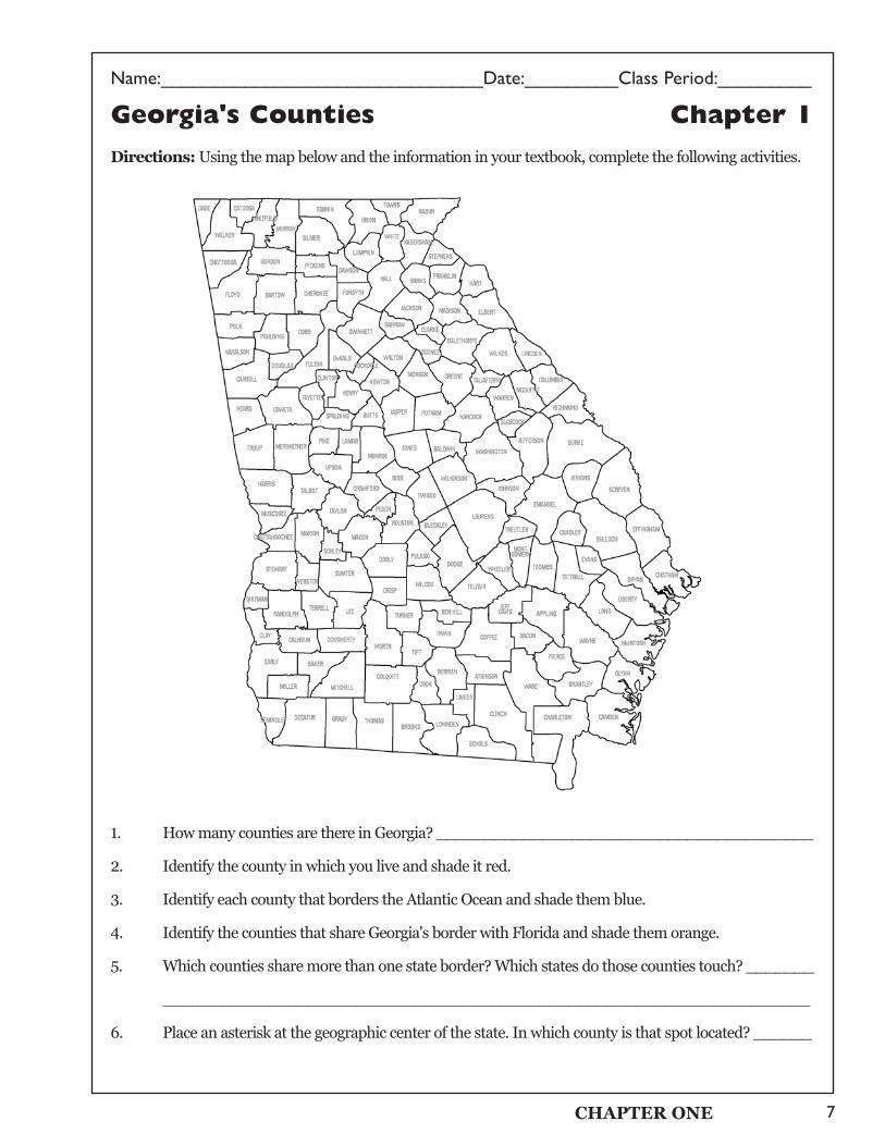
Georgia's Counties Chapter 1
Directions: Using the map below and the information in your textbook, complete the following activities.
1. How many counties are there in Georgia? _______________________________________
2. Identify the county in which you live and shade it red.
3. Identify each county that borders the Atlantic Ocean and shade them blue.
4. Identify the counties that share Georgia's border with Florida and shade them orange.
5. Which counties share more than one state border? Which states do those counties touch? _______
___________________________________________________________________
6. Place an asterisk at the geographic center of the state. In which county is that spot located? ______
CHAPTER ONE
Name:_____________________________Date:___________Class Period:_________
8
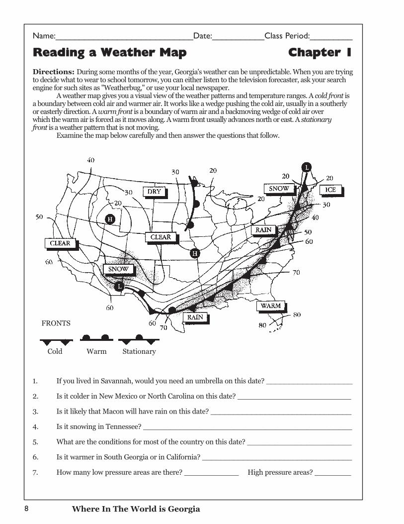
RReeaaddiinngg aa WWeeaatthheerr MMaapp CChhaapptteerr 11
Directions: During some months of the year, Georgia's weather can be unpredictable. When you are tryingto decide what to wear to school tomorrow, you can either listen to the television forecaster, ask your searchengine for such sites as "Weatherbug," or use your local newspaper.
A weather map gives you a visual view of the weather patterns and temperature ranges. A cold front isa boundary between cold air and warmer air. It works like a wedge pushing the cold air, usually in a southerlyor easterly direction. A warm front is a boundary of warm air and a backmoving wedge of cold air over which the warm air is forced as it moves along. A warm front usually advances north or east. A stationaryfront is a weather pattern that is not moving.
Examine the map below carefully and then answer the questions that follow.
1. If you lived in Savannah, would you need an umbrella on this date? ___________________
2. Is it colder in New Mexico or North Carolina on this date? _________________________
3. Is it likely that Macon will have rain on this date? _______________________________
4. Is it snowing in Tennessee? ______________________________________________
5. What are the conditions for most of the country on this date? _______________________
6. Is it warmer in South Georgia or in California? _________________________________
7. How many low pressure areas are there? ____________ High pressure areas? ________
Where In The World is Georgia
FRONTS
Cold Warm Stationary
Name:_______________________________Date:_________Class Period:_________
9
Reading with Purpose: Chapter 1Excerpts from "The Marshes of Glynn" (Page 1)
Directions: Between the city of Brunswick and the barrier islands of St. Simons and Jekyll is a naturalfour- to eight-mile wide separation called a marsh. These beautiful areas are a mixture of saltwater andfresh water dressed with smooth cordgrass that grows from a few inches to six feet in height. Salt-tolerantplants called glasswort join the cordgrass to become home to numerous types of crabs, mussels, snails,and fish. Salt marshes, like the ocean beyond them, change dramatically during low and high tides, andtheir colors change throughout the day as the sunlight varies.
The marsh intrigued Sidney Lanier, Georgia's best known poet. Whenever he visited family andfriends in Brunswick, he would often sit under an old oak tree on the road to St. Simons Island and gazeout over the expanse of marsh. It was this view, and other similar ones, that inspired the poet to pen hismost famous poem. To see through his eyes, read excerpts from the poem "The Marshes of Glynn," whichhe wrote in 1878. Then answer the questions that follow.
1. From Lanier's view, how did the marsh change during the day?
2. In what ways did the marsh effect Lanier's emotions?
3. What color imagery does Lanier use in this section of his poem? How many colors does he detailin his marsh description?
4. Who does Lanier talk to, or address, in the poem?
Now, go a bit further. After reading the excerpts, use a Haiku formula and write your own thoughts aboutthe marshes of our coastline. Haiku, a traditional Japanese form of poetry, consists of five, seven, andfive syllables respectively in three units. It is a seventeen-syllable verse form.
CHAPTER ONE
Name:_____________________________Date:___________Class Period:_________
10
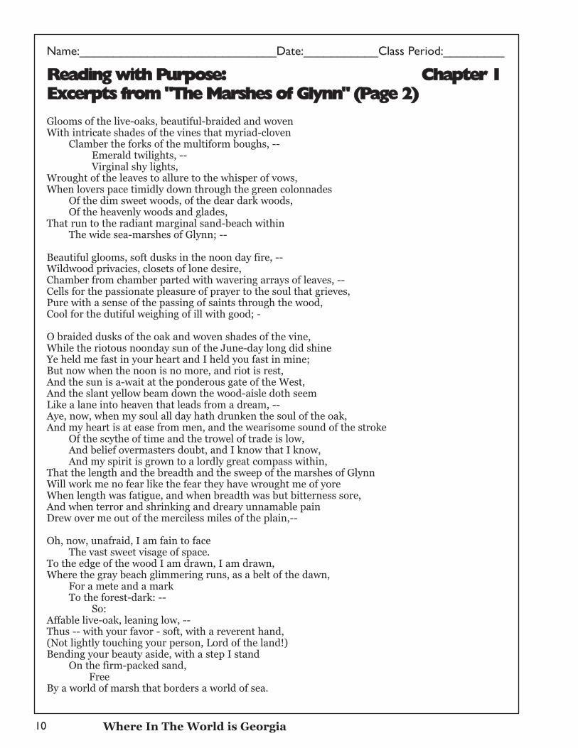
RReeaaddiinngg wwiitthh PPuurrppoossee:: CChhaapptteerr 11EExxcceerrppttss ffrroomm ""TThhee MMaarrsshheess ooff GGllyynnnn"" ((PPaaggee 22))
Glooms of the live-oaks, beautiful-braided and woven With intricate shades of the vines that myriad-cloven
Clamber the forks of the multiform boughs, -- Emerald twilights, -- Virginal shy lights,
Wrought of the leaves to allure to the whisper of vows, When lovers pace timidly down through the green colonnades
Of the dim sweet woods, of the dear dark woods, Of the heavenly woods and glades,
That run to the radiant marginal sand-beach within The wide sea-marshes of Glynn; --
Beautiful glooms, soft dusks in the noon day fire, -- Wildwood privacies, closets of lone desire, Chamber from chamber parted with wavering arrays of leaves, -- Cells for the passionate pleasure of prayer to the soul that grieves, Pure with a sense of the passing of saints through the wood, Cool for the dutiful weighing of ill with good; -
O braided dusks of the oak and woven shades of the vine, While the riotous noonday sun of the June-day long did shine Ye held me fast in your heart and I held you fast in mine; But now when the noon is no more, and riot is rest, And the sun is a-wait at the ponderous gate of the West, And the slant yellow beam down the wood-aisle doth seem Like a lane into heaven that leads from a dream, -- Aye, now, when my soul all day hath drunken the soul of the oak, And my heart is at ease from men, and the wearisome sound of the stroke
Of the scythe of time and the trowel of trade is low, And belief overmasters doubt, and I know that I know, And my spirit is grown to a lordly great compass within,
That the length and the breadth and the sweep of the marshes of Glynn Will work me no fear like the fear they have wrought me of yore When length was fatigue, and when breadth was but bitterness sore, And when terror and shrinking and dreary unnamable pain Drew over me out of the merciless miles of the plain,--
Oh, now, unafraid, I am fain to face The vast sweet visage of space.
To the edge of the wood I am drawn, I am drawn, Where the gray beach glimmering runs, as a belt of the dawn,
For a mete and a mark To the forest-dark: --
So: Affable live-oak, leaning low, -- Thus -- with your favor - soft, with a reverent hand, (Not lightly touching your person, Lord of the land!) Bending your beauty aside, with a step I stand
On the firm-packed sand, Free
By a world of marsh that borders a world of sea.
Where In The World is Georgia
Name:_______________________________Date:_________Class Period:_________
11
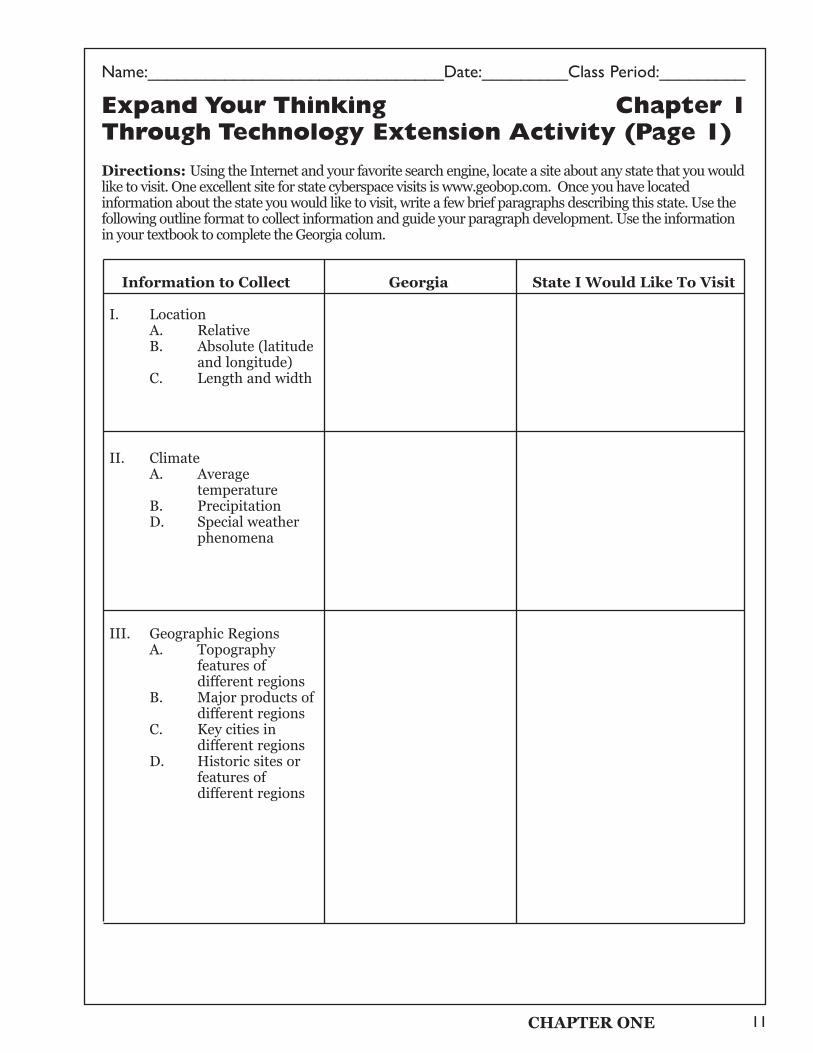
Expand Your Thinking Chapter 1Through Technology Extension Activity (Page 1)
Directions: Using the Internet and your favorite search engine, locate a site about any state that you wouldlike to visit. One excellent site for state cyberspace visits is www.geobop.com. Once you have locatedinformation about the state you would like to visit, write a few brief paragraphs describing this state. Use thefollowing outline format to collect information and guide your paragraph development. Use the informationin your textbook to complete the Georgia colum.
Information to Collect Georgia State I Would Like To Visit
I. LocationA. RelativeB. Absolute (latitude
and longitude)C. Length and width
II. ClimateA. Average
temperatureB. PrecipitationD. Special weather
phenomena
III. Geographic RegionsA. Topography
features of different regions
B. Major products of different regions
C. Key cities in different regions
D. Historic sites or features of different regions
CHAPTER ONE
Name:_____________________________Date:___________Class Period:_________
12
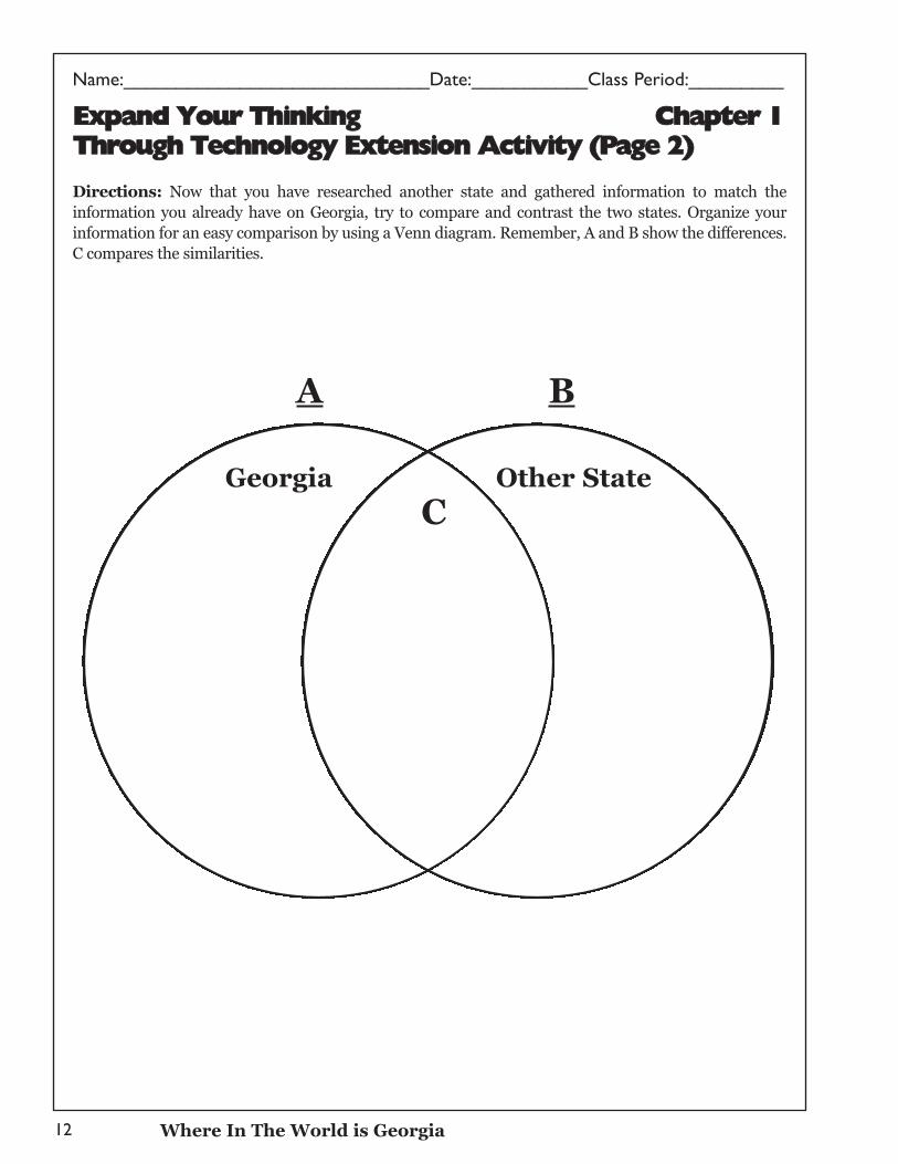
EExxppaanndd YYoouurr TThhiinnkkiinngg CChhaapptteerr 11TThhrroouugghh TTeecchhnnoollooggyy EExxtteennssiioonn AAccttiivviittyy ((PPaaggee 22))
Directions: Now that you have researched another state and gathered information to match theinformation you already have on Georgia, try to compare and contrast the two states. Organize yourinformation for an easy comparison by using a Venn diagram. Remember, A and B show the differences.C compares the similarities.
A B
Where In The World is Georgia
CGeorgia Other State
Name:_______________________________Date:_________Class Period:_________
13
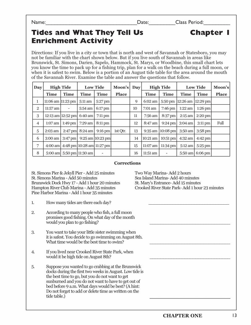
Tides and What They Tell Us Chapter 1Enrichment Activity
Directions: If you live in a city or town that is north and west of Savannah or Statesboro, you maynot be familiar with the chart shown below. But if you live south of Savannah in areas likeBrunswick, St. Simons, Darien, Sapelo, Hammock, St. Marys, or Woodbine, this small chart letsyou know the time to pack up for a fishing trip, plan for a walk on the beach during a full moon, orwhen it is safest to swim. Below is a portion of an August tide table for the area around the mouthof the Savannah River. Examine the table and answer the questions that follow.
Day High Tide Low Tide Moon's Day High Tide Low Tide Moon’s
Time Time Time Time Place Time Time Time Time Place
1 11:06 am 11:23 pm 5:11 am 5:27 pm 9 6:02 am 5:50 pm 12:26 am 12:29 pm
2 11:57 am - 5:54 am 6:17 pm 10 7:01 am 7:46 pm 1:22 am 1:26 pm
3 12:13 am 12:52 pm 6:40 am 7:11 pm 11 7:56 am 8:37 pm 2:15 am 2:20 pm
4 1:07 am 1:49 pm 7:29 am 8:11 pm 12 8:47 am 9:24 pm 3:04 am 3:11 pm Full
5 2:03 am 2:47 pm 8:24 am 9:16 pm 1st Qtr. 13 9:35 am 10:08 pm 3:50 am 3:58 pm
6 3:00 am 3:47 pm 9:25 am 10:23 pm 14 10:21 am 10:51 pm 4:32 am 4:42 pm
7 4:00 am 4:48 pm 10:28 am 11:27 pm 15 11:07 am 11:34 pm 5:12 am 5:25 pm
8 5:00 am 5:50 pm 11:30 am - 16 11:51 am - 5:50 am 6:06 pm
Corrections
St. Simons Pier & Jekyll Pier - Add 25 minutes Two Way Marina- Add 2 hoursSt. Simons Marina - Add 50 minutes Sea Island Marina- Add 40 minutesBrunswick Dock Hwy 17 - Add 1 hour 20 minutes St. Mary’s Entrance- Add 15 minutesHampton River Club Marina - Add 35 minutes Crooked River State Park- Add 1 hour 23 minutesPine Harbor Marina - Add 1 hour 35 minutes
1. How many tides are there each day? ______________________________
2. According to many people who fish, a full moon promises good fishing. On what day of the month would you plan to go fishing? ______________________________
3. You want to take your little sister swimming when it is safest. You decide to go swimming on August 8th. What time would be the best time to swim? ______________________________
4. If you lived near Crooked River State Park, when would it be high tide on August 8th? ______________________________
5. Suppose you wanted to go crabbing at the Brunswick docks during the first two weeks in August. Low tide isthe best time to go, but you do not want to get sunburned and you do not want to have to get out of bed before 9 a.m. What days would be best? (A hint: Do not forget to add or delete time as written on the tide table.) _________________
CHAPTER ONE
Name:_____________________________Date:___________Class Period:_________
14
CChhaapptteerr 11 TTeesstt ((PPaaggee 11))
Directions: Identify the letter of the choice that best completes the statement or answers the question. Writeyour answer in the space provided.
____ 1. Which states touch Georgia's borders? A. Alabama, Florida, South Carolina, North Carolina, and MississippiB. Alabama, South Carolina, Florida, Tennessee, and North CarolinaC. South Carolina, North Carolina, Alabama, and TennesseeD. Florida, Tennessee, Alabama, Mississippi, and South Carolina
____ 2. Which physiographic regions of Georgia are part of the Appalachian Mountain chain?A. Ridge and Valley, Appalachian Plateau, and PiedmontB. Appalachian Plateau, Piedmont, and Blue RidgeC. Coastal Plain, Blue Ridge, and Appalachian PlateauD. Blue Ridge, Ridge and Valley, and Appalachian Plateau
____ 3. Which area of Georgia receives the most precipitation annually?A. Northern mountain region C. Central Piedmont areaB. Eastern Coastal Plain area D. Southern flatland region
____ 4. Which physiographic region grows most of the state's agricultural products? A. Blue Ridge region C. Coastal Plain regionB. Piedmont region D. Ridge and Valley region
____ 5. How do barrier islands protect Georgia's mainland?A. By blocking storms, such as hurricanes or nor'easters, from reaching the mainlandB. By blocking much of the wind, sands, and water that could cause erosionC. By channeling saltwater away from mainland rivers, creeks, and marshesD. By preventing saltwater from mixing with fresh water
____ 6. Which storms feature strong, cyclonic winds spinning counterclockwise? A. Hurricanes C. Thunderstorms with lightningB. Nor'easters D. Tornadoes
____ 7. Which of the following is not an advantage of Georgia's mild climate? A. Four distinct seasons of the year C. Low heating and air conditioning costs B. Long growing seasons for agriculture D. Minimum weather-related absences
from work or school
____ 8. What are the imaginary lines running north to south on Earth's surface called? A. Prime meridians C. MeridiansB. Equators D. Parallels
____ 9. Why did early settlers build settlements near the Fall Line? A. The Fall Line marked the end of the fertile soil for growing crops.B. The waterfalls of the Fall Line were difficult to cross.C. They wanted to remain separate from American Indian settlements.D. All of the above.
____ 10. Dalton and neighboring towns produce most of the world's supply of what product? A. Pulp and paper C. ChickensB. Kaolin D. Carpet
Where In The World is Georgia
Name:_______________________________Date:_________Class Period:_________
15
Chapter 1 Test (Page 2)
Directions: Complete each sentence with the most appropriate word or phrase. Write your answer in thespace provided.
11. __________________ location describes one's location in terms of proximity, or nearness, to
some other place or area.
12. At close to 5,000 feet above sea level, __________________ is the highest peak in Georgia.
13. _________________ is the pattern of warmer-than-normal Pacific Ocean surface temperatures.
14. Along the coastline is the __________________ , which is, literally, the edge of our continent.
15. A(n) __________________ is a low-lying land area where water lies close to the surface creating
sloughs, swamps, bogs, ponds, and marshes.
16. __________________ climate refers to mountainous terrain that influences temperatures and
causes higher elevations to have colder weather.
17. The geographic center of Georgia is located in __________________ County.
18. The __________________ is the natural boundary separating the state's hilly and mountainous
areas from the coastal plain areas.
19. The __________________ region is best known for pulp production, timber, and naval stores.
20. The __________________ region of Georgia is a maze of limestone caves, rock formations, and
deep canyons.
21. _________________ is an absolute measurement north or south, while ________________
is an absolute measurement east or west.
22. The dominant soil found in the Piedmont region is __________________.
23. Day-to-day conditions and changes in the atmosphere is called __________________.
24. __________________, one of Georgia's barrier islands, is a national seashore.
25. Georgia's __________________ is the nation's largest freshwater wetland.
26. Georgia's highest mountains are found in the __________________ region.
27. Over one-half of Georgia's population today lives in the __________________ region.
28. The __________________ is the symbol on maps and globes that shows cardinal and
intermediate directions.
29. The equator lies at __________________ degrees latitude.
Directions: On a separate sheet of paper, write a paragraph response to the following question. Be sure to
use complete sentences.
30. Describe the value of Georgia's barrier islands to the state.
CHAPTER ONE