nanaimo waterfront walkway draft implementation report · nanaimo waterfront walkway draft...
TRANSCRIPT
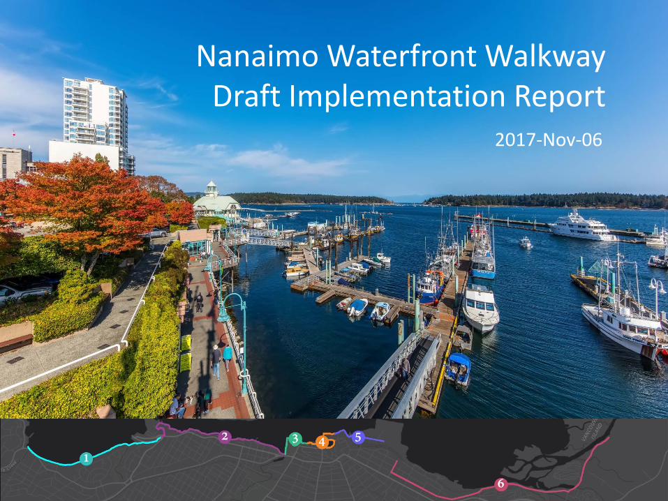
Nanaimo Waterfront WalkwayDraft Implementation Report
2017-Nov-06

Tonight• Project Overview• Community Engagement• Draft Alignment and Route• Implementation• Next Steps

Tonight• Project Overview• Community Engagement• Draft Alignment and Route• Implementation• Next Steps

Departure Bay
Newcastle Channel
Downtown
SFN
Estuary
The vision is to create a
“
”.

Goals & Objectives• Create a continuous, uninterrupted & accessible
waterfront trail/connection from Departure Bay to the Nanaimo River Estuary
• Support businesses that rely on the waterfront for marine industries, transportation connections, entertainment & tourism
• Enhance public access & use of the waterfront walkway
• Protect view corridors to the waterfront
• Protect & enhance marine habitat

Background Research
• Review of supporting policy documents
• Review of previous plans
• Prepare overview reports:– Environment– Geotechnical– Archaeological
• Consult Stakeholders
Supporting Documents

Tonight• Project Overview• Community Engagement• Draft Alignment and Route• Implementation• Next Steps

Community Engagement• Council provided the vision of creating a continuous
waterfront walkway from Departure Bay to the Estuary.
• Details, such as what the walkway may look like, how it would be used, and what sections should be priority, were left to the public.
• We reached out to the community through:
• 5 Open Houses (over 1,400 attendees)
• 2 Public Surveys (over 2,600 respondents)
• 1 Design Workshop (over 25 community participants)
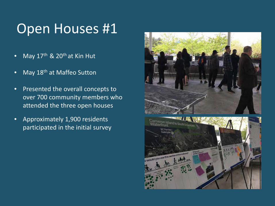
Open Houses #1
• May 17th & 20th at Kin Hut
• May 18th at Maffeo Sutton
• Presented the overall concepts to over 700 community members who attended the three open houses
• Approximately 1,900 residents participated in the initial survey

16%
13%
7%
11%22%
31%
Survey 1 – Key FindingsMajority of respondents want Sections 1 and 2 developed first
Section 1(Departure Bay to BC Ferries)
Section 2 (BC Ferries to Millstone River)
89% of respondents want new sections built before upgrading existing sections
In reviewing the comments, six key themes were identified:
• Signage, pavement markings, public education,• Modes and uses,•Amenities,•Parking, •Environment •Accessibility

Design Workshop• June 22 at the VICC
• Invitees included:• Council• Snuneymuxw First Nation• Government agencies • Business Owners• Neighbourhood Associations • Special Interest Groups
• The public was invited to attend afterthe workshop for information sharing and additional input
• We obtained input on: • vision,• route alignment,• walkway treatments and design,
priorities, and• other items important to attendees

Open Houses #2 • September 28th & 30th at Maffeo Sutton
• Draft plans and details were presented to ensure the material was consistent with the previous feedback received
• Approximately 700 residents participated in the second survey
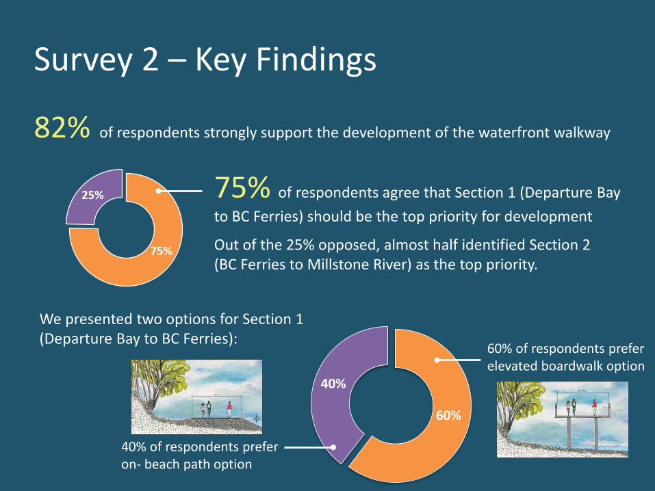
Survey 2 – Key Findings
82% of respondents strongly support the development of the waterfront walkway
60%
40%
60% of respondents prefer elevated boardwalk option
40% of respondents preferon- beach path option
We presented two options for Section 1 (Departure Bay to BC Ferries):
75%
25% 75% of respondents agree that Section 1 (Departure Bay to BC Ferries) should be the top priority for development
Out of the 25% opposed, almost half identified Section 2 (BC Ferries to Millstone River) as the top priority.

Tonight• Project Overview• Community Engagement• Draft Alignment and Route• Implementation• Next Steps

Considerations Issues
•Two options along Cilaire Section:Elevated Walkway or On-Beach Path
• Allow for access & maintenance of RDN sanitary sewer• Walkway beside BC Ferries could be widened in future• Consistent with Departure Bay Neighbourhood Plan
•Work with property owners to secure riparian rights•Path to be offset from toe of Cilaire Bluff to protect path and users from instability and erosion of bluff
1C 1D1A 1B
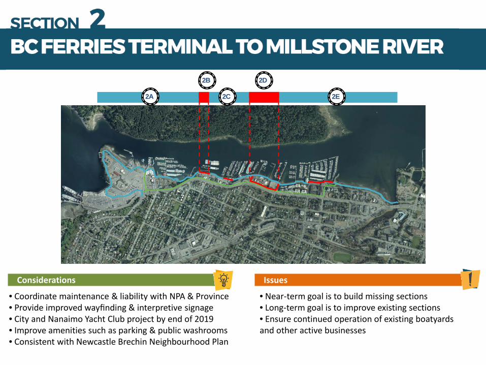
Considerations Issues
• Coordinate maintenance & liability with NPA & Province• Provide improved wayfinding & interpretive signage • City and Nanaimo Yacht Club project by end of 2019• Improve amenities such as parking & public washrooms• Consistent with Newcastle Brechin Neighbourhood Plan
• Near-term goal is to build missing sections• Long-term goal is to improve existing sections• Ensure continued operation of existing boatyards and other active businesses
2A
2B 2D
2C 2E

Considerations Issues
• Coordinate walkway with Maffeo Sutton Park Improvement Plan, update plan as required• Consider walkway use and events• Maffeo Sutton Park as a trail head for the walkway
• Lions bridge needs to be replaced in the future and should be widened• Connect cyclists through the park in a safe manner to Front Street
3

Considerations Issues
• Potential to provide additional & enhanced amenities to reflect high value of downtown public space• Work with BC Ferries to establish link across property as part of terminal redevelopment plan•Leverage redevelopment of 10 Front Street with the Georgia Park walkway
• Congested areas with businesses & narrow walkway • Cyclists required to dismount & walk in many areas• Geotechnical challenges in boat basin• Interim pathway detours around BC Ferries terminal
4A
4B

Considerations Issues
•Develop a safe walkway crossing at railway loading ramp•Coordinate with South Downtown Waterfront access•Work with Port Authority to connect walkway to cruise ship terminal• Consistent with South End Neighbourhood Plan.
• Develop safe interim walkway route that allows for redevelopment opportunities of South Downtown Waterfront • Final walkway to be built in conjunction with redevelopment of site
5A
5B

Considerations Issues
•Walkway aligned through residential neighbourhood•Provide safe separation between road/rail and walkway•New viewpoints could added to view estuary• Crime Prevention Through Environmental Design (CPTED)• Consistent with South End Neighbourhood Plan• Consistent with Chase River Neighbourhood Plan
• Haliburton Street has narrow ROW, driveways, utilities, steep slopes and is a truck route• Parking in residential areas would be revised • Walkway needs a safe crossing at Coastland Wood •Nanaimo Estuary & Chase River Riparian Zone are home to sensitive fish and wildlife habitat
6A 6B

Tonight• Project Overview• Community Engagement• Draft Alignment and Route• Implementation• Next Steps

Year Segment Estimated Cost
2018/2019 • BC Ferries to White Eagle• 1 Port Drive• Newcastle Channel Gaps• Shipyard Bypass• Boat Basin• Nanaimo Yacht Club Upgrade
$3,400,000$1,000,000$500,000$100,000$2,000,000$1,200,000
2020/2021 • White Eagle to Battersea• Battersea to Kin Hut• Gabriola Ferry Terminal Redevelopment
$14,000,000$500,000$ BC Ferry cost
2022/2024 • Haliburton to Nanaimo River Estuary $9,750,000
2024/2027 • Maffeo Sutton Park Upgrade• Georgia Park Upgrade• South Downtown Waterfront Secondary Access
$1,250,000$Developer Cost$ With road project
2027+ • Widening of interim segments as traffic warrants• Esso and former Lafarge Concrete site
$Unknown
Implementation Phasing Plan
denotes Timing is dependent on development denotes cost share with partner
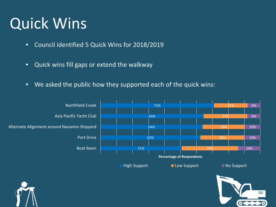
Quick Wins• Council identified 5 Quick Wins for 2018/2019
• Quick wins fill gaps or extend the walkway
• We asked the public how they supported each of the quick wins:
51%
62%
64%
64%
71%
35%
28%
26%
27%
21%
14%
10%
10%
8%
8%
Boat Basin
Port Drive
Alternate Alignment around Nanaimo Shipyard
Asia Pacific Yacht Club
Northfield Creek
Percentage of Respondents
High Support Low Support No Support


Tonight• Project Overview• Community Engagement• Draft Alignment and Route• Implementation• Next Steps

Next Steps• Refer Draft Plan to:
• Community Planning & Development Committee• Parks, Recreation & Wellness Committee• Public Works & Engineering Committee
• Provide Public with opportunity to comment, put Draft Plan on Website
• Final Changes, return to Council for approval (January 2018)
• Continue design work on Quick Win projects for construction in 2018/2019