naramata bear conflict management plan 2013 · addition, the local conservation officer service;...
TRANSCRIPT
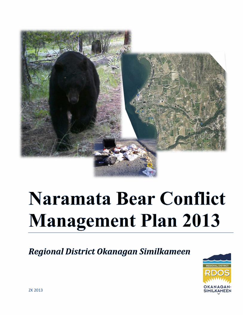
Naramata Bear Conflict Management Plan 2013
0
ZK 2013
Naramata Bear Conflict Management Plan 2013
1
Contents Acknowledgements................................................................................................................................ 2
Executive Summary ................................................................................................................................ 2
Introduction and Study Area .................................................................................................................. 3
Map 1. Naramata and surrounding area ................................................................................................... 3
Vision Statement ................................................................................................................................... 4
Mission Statement ................................................................................................................................. 4
Goals and Objectives .............................................................................................................................. 4
Roles and Responsibilities .............................................................................................................................. 5
Strategies to Address Conflict ................................................................................................................. 6
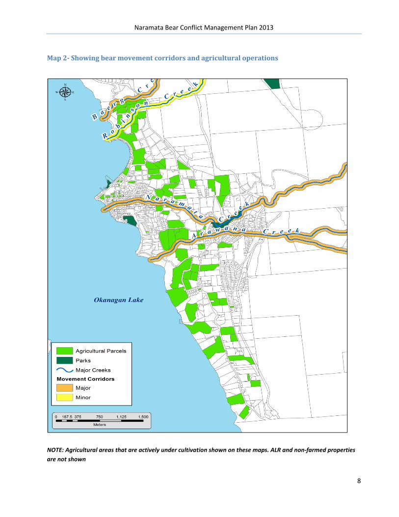
Map 2- Showing bear movement corridors and agricultural operations .................................................. 8
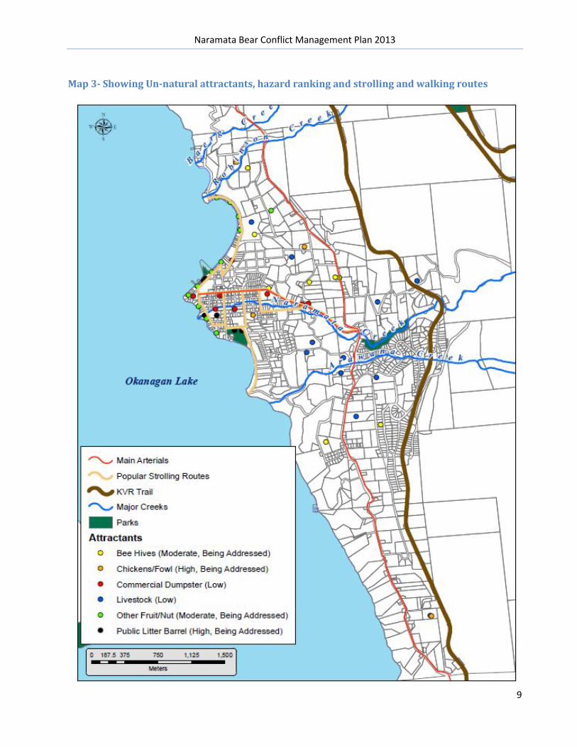
Map 3- Showing Un-natural attractants, hazard ranking and strolling and walking routes ...................... 9
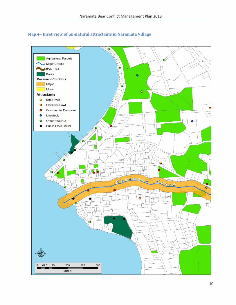
Map 4– Inset view of un-natural attractants ........................................................................................... 10
Map 5- Environmentally Sensitive Habitat – shown in orange ................................................................ 11
Recommendations: .............................................................................................................................. 13
Appendix: ............................................................................................................................................ 14
Appendix 1- RAPP Line Calls 2011 & 2012 & 2013 .................................................................................. 14
Appendix 2- Wildlife Alert Reporting Maps to illustrate call history 2012/13......................................... 15
Appendix 3- Electoral Area E Curbside Bylaw – as seen on RDOS web site ............................................. 16
Naramata Bear Conflict Management Plan 2013
2
Acknowledgements The site specific Bear Hazard Assessment and Bear Conflict Management Plan for Naramata could not be undertaken without the previous region wide BHA and BCMP produced by Alison Peatt, R.P. Bio, Joanne Siderius Ph.D., and Bryn White, SOSCP.
This area specific plan could not have been possible without the assistance from RDOS – GIS services, RDOS Solid Waste Facilities Coordinator, Don Hamilton and RDOS Solid Waste Coordinator, Cameron Baughen. In addition, the local Conservation Officer Service; Insp. Barb Leslies, Sgt. Jim Beck, Bob Hamilton, Mike Stern, and Min of Environment – WildSafeBC program (WARP mapping system)
Executive Summary Naramata: This Bear Management Plan describes the responsibilities and actions required to reduce human-bear conflict in Naramata. Several maps are duplicated throughout the Bear Hazard Assessment, Bear Conflict Management Plan and the Bear Smart Application, as they form a visual foundation to the project. . The report also includes recommendations on further conflict management planning and staged timelines for implementation. Link to both the master Bear Hazard Assessment (BHA) and Bear Conflict Management Plan: http://www.rdosmaps.bc.ca/min_bylaws/PublicWorks/WildSafeBC/Hazard_Assessment_Plan_May_24_with_maps.pdf http://www.rdosmaps.bc.ca/min_bylaws/PublicWorks/WildSafeBC/AppendixTwoConflictMgmtPlanFinal2010.pdf
The site specific to Naramata BHA and BMP have not been adopted by the RDOS as the overall region-wide plan is considered the master document. The RDOS board is aware that Electoral Area E, Naramata is applying for Bear Smart status and these reports will be made available to the board prior to submission to the Ministry of Environment. A full Board review is slated for Dec 19th 2013.
Links to the Naramata Bear Hazard Assessment and Naramata Bear Smart Application: http://www.rdosmaps.bc.ca/min_bylaws/PublicWorks/WildSafeBC/NaramataBearHazardAssessment.pdf http://www.rdosmaps.bc.ca/min_bylaws/PublicWorks/WildSafeBC/BearSmartApplicationSept2013.pdf
Naramata Bear Conflict Management Plan 2013
3
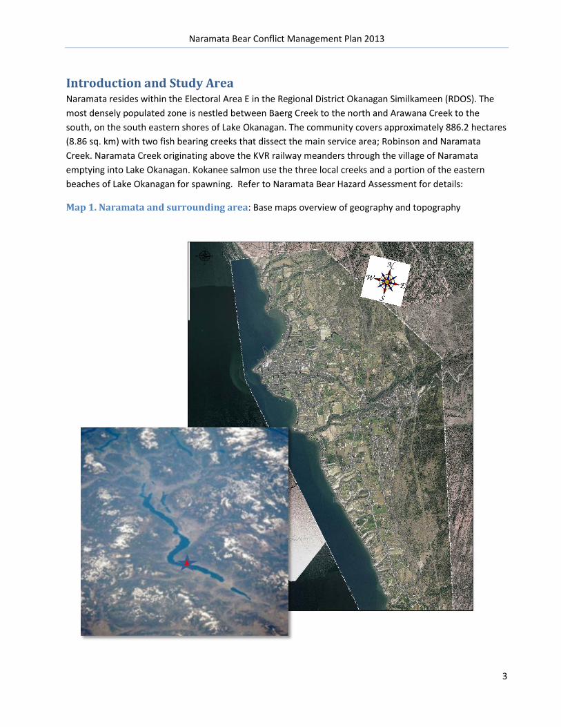
Introduction and Study Area Naramata resides within the Electoral Area E in the Regional District Okanagan Similkameen (RDOS). The most densely populated zone is nestled between Baerg Creek to the north and Arawana Creek to the south, on the south eastern shores of Lake Okanagan. The community covers approximately 886.2 hectares (8.86 sq. km) with two fish bearing creeks that dissect the main service area; Robinson and Naramata Creek. Naramata Creek originating above the KVR railway meanders through the village of Naramata emptying into Lake Okanagan. Kokanee salmon use the three local creeks and a portion of the eastern beaches of Lake Okanagan for spawning. Refer to Naramata Bear Hazard Assessment for details:
Map 1. Naramata and surrounding area: Base maps overview of geography and topography
Naramata Bear Conflict Management Plan 2013
4
Vision Statement The Naramata Bear Smart Project is a cost efficient and effective framework for addressing human-bear conflict. Successful planning and implementation of the project will result in reduced risk to people , property and wildlife, reduced number of conflicts and a reduction in the number of bears destroyed or re-located.
Mission Statement The Naramata Bear Smart Project is a partnership between an engaged community, the RDOS and Conservation Officer Service, working together to achieve mutual goals. Shared goals help initiate action, maintain engagement, document and meet milestones, implement improvements and monitor progress.
Goals and Objectives The Naramata Bear Smart Project seeks to achieve the following goals:
1. Address the root cause of human-bear conflict 2. Reduce the rate and intensity of conflicts 3. Reduce the number of bears that are destroyed or relocated 4. Increase public awareness and safety
The Naramata Bear Conflict Management Plan will address the objectives by:
• Utilizing the Master BCMP and site specific Bear Hazard Assessment to create strategies for managing and reducing local human-bear conflict
• Identifying community based opportunities to achieve goals through active engagement, waste management and human-bear conflict monitoring
• Identifying specific challenges for action and work to a timetable for completion, i.e., orphan fruit tree removal
• Continuing an already active educational campaign • Providing an ongoing ‘report card’ feedback for the community
Naramata Bear Conflict Management Plan 2013
5
Roles and Responsibilities The Naramata study area is fairly straightforward. Not only is the geography and built environment conducive to success, there have been major strides already undertaken community-wide to address conflict issues. Supporting agencies like the RDOS have established an ongoing community coordinator position through the Bear Aware program (now WildSafeBC ), implemented curbside Bylaws restricting garbage to the curb early, and are working towards a ‘behind the hedge’ Bylaw to allow for on-site inspections if conflicts and repeated sightings occur.
Responsibility for the implementation and continuance of the project lies with the Regional District and its successful WildSafeBC program. The local Conservation Officer Service fully supports the efforts of the program and its successful implementation in Naramata. Yearly statistics will be available to the community from the CO Services and WildSafeBC
The RDOS is responsible to refine and implement Bylaws for waste management, planning, re-zoning and long term land use objectives, and inserting Bear Smart ideals into the development Permit system and Official Community Plans.
The RDOS is responsible for Waste Management; related Bylaws, collection and landfill management. The Campbell Mtn. Landfill is fully fenced and electrified. It is regularly maintained and repaired as necessary. It has proven to be an excellent measure for improving worker and public safety, and reducing conflict with bears and other wildlife in and around the site. Human caused damage is the most common reason for fence repair.
The RDOS and supporting agencies are responsible for maintaining a WildSafeBC coordinator. The RDOS imbedded a line item in their operating budget to both support commitment to long term reduction of human-bear conflict and to lay the foundation for leveraging grant monies. The RDOS will explore additional grant funding opportunities as outlined in the master Bear Conflict Management Plan.
Naramata Bear Conflict Management Plan 2013
6
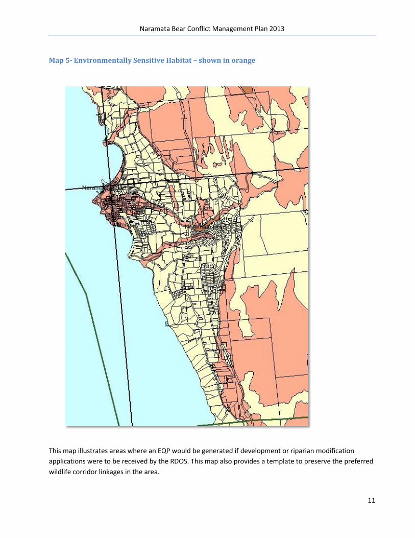
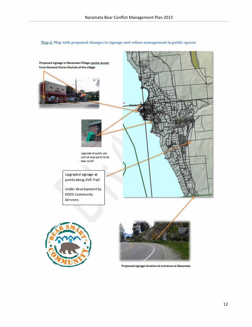
Strategies to Address Conflict Map 2 – Issue: traditional travel corridors and preferred routes for bears close to residential housing. Conflict Reduction Strategy: Residents along the edges of the ravines and gullies above the game trails have taken various strategies to mitigate bears accessing their properties. This includes removing brush for sight lines, removal of identified attractants, using bear proof carts, and some fencing. Ongoing education is being provided to support this remediation strategy Map 3 & 4 - Issue: attractants and areas of potential conflict Conflict Reduction Strategy: education and ground work is continuing to reduce human-bear conflict. The RDOS Curbside Garbage Bylaw has had significant impact of human-bear conflict. See Appendix or http://www.rdosmaps.bc.ca/min_bylaws/contract_reports/CorpBd/2012/19Oct4/Environment/3_WildlifeBylawReport.pdf Map 5 – Issue: sensitive habitat locations and where wildlife corridors and land-use planning come into conflict Conflict reduction Strategy: Planning has already taken steps to ‘exchange’ development land on a known corridor for land that is not on a wildlife corridor. In addition, any development in the orange zones trips an Environmental review known as an EQP As the community becomes more educated and aware, the landscape is changing. Orphan fruit trees are being removed voluntarily, and trees on road allowance are being brought to the attention of the WildSafeBC Coordinator. Currently, a strategy to remove roadside cultivar trees is being developed. In order of importance, implementation of High Priority items from Section 8.0: Summary of Recommendations from the overall RDOs Bear Conflict Management Plan. See pages 19-23 in the Master BHA 2009 Costs to implement recommendations are being phased in over time. A regular line item in the Solid Waste Management Plan ensures a regular budget of $7500 yr. towards bear-human conflict management.
• RDOS Parks and Recreation have allocated dollars in their 2014 budgets to begin replacement and retrofit the waste receptacles in the region’s parks See Map 6
• RDOS Community Services budgets under review for upgraded signage on both the Trans Canada Trail portion that runs through Naramata (and beyond) in partnership with the Province
• Local signage has been designated under the WildSafeBC expenses budget See Map 6 • Bylaw and OCP amendments require RDOS Board approval, but no additional budget dollar
allocation • Bylaw education materials and guidelines will be part of the regular departmental staff time and
salary requiring no formal budget allocation • While partnering with WildSafeBC, researching and applying for program funding grants is not
favoured. However, with Bear Smart Status, additional program dollars, signage and small infrastructure grants (through community organizations) is being pursued
• Removal of orphan trees and roadside attractants to be discussed with Min of Transportation and integrated into their annual roads maintenance budgets, through ARGO Road Maintenance
Naramata Bear Conflict Management Plan 2013
7
Bear Smart Committee: Naramata has been a pilot and role model for the RDOS for several human-bear conflict reduction projects. The successes of the Bear Aware (now WildSafeBC) program in Naramata have been used as an example and to expand curbside Bylaws to other electoral areas in the region. It has proven effective (to date) to work without an official Bear Smart Committee, but rather to hold meetings with stakeholders as the need arose. This may change as Naramata achieves Bear Smart Status and conditions to maintain that status needs a working group to insure action items are achieved, maintained and Bear Smart is considered for other communities within the RDOS.
Strategies undertaken and identified are documented in the Naramata Bear Smart Application page 11/12
Naramata Bear Conflict Management Plan 2013
8
Map 2- Showing bear movement corridors and agricultural operations
NOTE: Agricultural areas that are actively under cultivation shown on these maps. ALR and non-farmed properties are not shown
Naramata Bear Conflict Management Plan 2013
9
Map 3- Showing Un-natural attractants, hazard ranking and strolling and walking routes
Naramata Bear Conflict Management Plan 2013
10
Map 4– Inset view of un-natural attractants in Naramata Village
Naramata Bear Conflict Management Plan 2013
11
Map 5- Environmentally Sensitive Habitat – shown in orange
This map illustrates areas where an EQP would be generated if development or riparian modification applications were to be received by the RDOS. This map also provides a template to preserve the preferred wildlife corridor linkages in the area.
Naramata Bear Conflict Management Plan 2013
12
Naramata Bear Conflict Management Plan 2013
13
Recommendations: The following table is excerpted from the RDOS region-wide BHA page 34 -recommendations
Additional recommendations as a result of this site specific BHA:
1. Disseminate information on wildlife mitigation techniques to local agricultural producers a. Living With Wildlife in BC – agricultural focused Best Practices guides developed for both
on the land mitigation and worker safety 2. Encourage remediation to existing deer and agricultural fences to add electrification, and empower
new producers to fence correctly; for species and with wildlife movement considerations 3. Provide education to raise awareness of the need and importance of preserving wildlife corridors
where applicable as per map # 2 4. Empower the RDOS to address orphan trees identified on road allowance and residents to deal
with orphan fruit trees on private lands
Naramata Bear Conflict Management Plan 2013
14
Appendix:
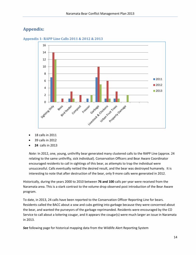
Appendix 1- RAPP Line Calls 2011 & 2012 & 2013 a
• 18 calls in 2011 • 39 calls in 2012 • 24 calls in 2013
Note: In 2012, one, young, unthrifty bear generated many clustered calls to the RAPP Line (approx. 24 relating to the same unthrifty, sick individual). Conservation Officers and Bear Aware Coordinator encouraged residents to call in sightings of this bear, as attempts to trap the individual were unsuccessful. Calls eventually netted the desired result, and the bear was destroyed humanely. It is interesting to note that after destruction of the bear, only 9 more calls were generated in 2012.
Historically, during the years 2000 to 2010 between 76 and 100 calls per year were received from the Naramata area. This is a stark contrast to the volume drop observed post introduction of the Bear Aware program.
To date, in 2013, 24 calls have been reported to the Conservation Officer Reporting Line for bears. Residents called the BACC about a sow and cubs getting into garbage because they were concerned about the bear, and wanted the purveyors of the garbage reprimanded. Residents were encouraged by the CO Service to call about a loitering cougar, and it appears the cougar(s) were much larger an issue in Naramata in 2013.
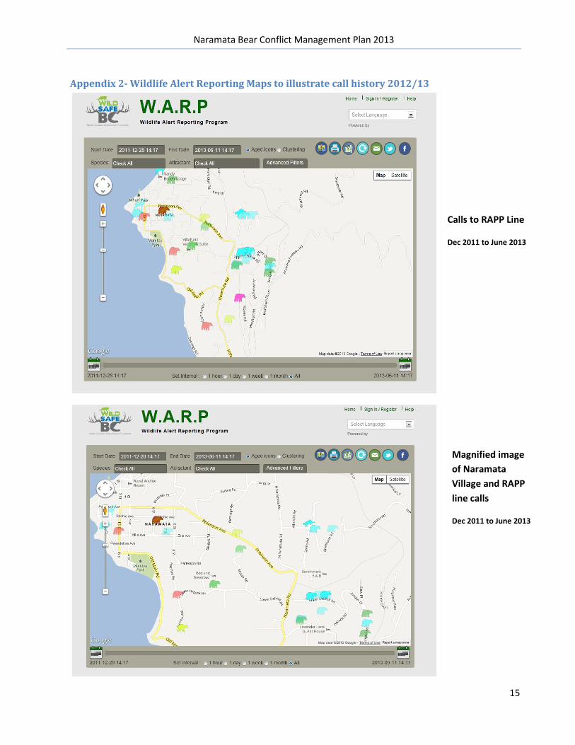
See following page for historical mapping data from the Wildlife Alert Reporting System
0
2
4
6
8
10
12
14
16
2011
2012
2013
Naramata Bear Conflict Management Plan 2013
15
Calls to RAPP Line
Dec 2011 to June 2013
Appendix 2- Wildlife Alert Reporting Maps to illustrate call history 2012/13
Magnified image of Naramata Village and RAPP line calls
Dec 2011 to June 2013
Naramata Bear Conflict Management Plan 2013
16
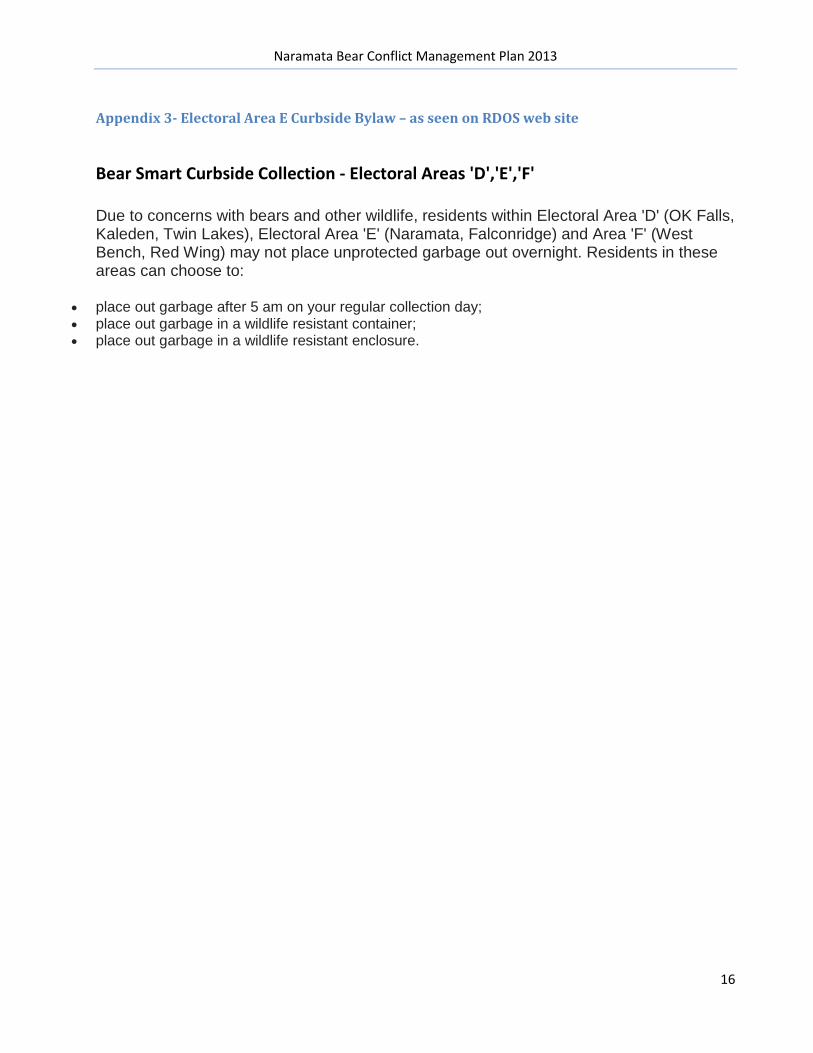
Appendix 3- Electoral Area E Curbside Bylaw – as seen on RDOS web site
Bear Smart Curbside Collection - Electoral Areas 'D','E','F'
Due to concerns with bears and other wildlife, residents within Electoral Area 'D' (OK Falls, Kaleden, Twin Lakes), Electoral Area 'E' (Naramata, Falconridge) and Area 'F' (West Bench, Red Wing) may not place unprotected garbage out overnight. Residents in these areas can choose to:
• place out garbage after 5 am on your regular collection day; • place out garbage in a wildlife resistant container; • place out garbage in a wildlife resistant enclosure.