naree budjong djara management plan
TRANSCRIPT

Naree Budjong DjaraManagement Plan
September 2020
Incorporates: Naree Budjong Djara National Park,
Naree Budjong Djara Conservation Park, Myora Conservation Park,
Main Beach Conservation Park and Minjerribah Recreation Area

This management plan has been prepared jointly by Quandamooka Yoolooburrabee Aboriginal Corporation (QYAC) and Queensland Parks and Wildlife Service and Partnerships (QPWS&P), Department of Environment and Science
© State of Queensland, 2020.
September 2020
Front cover photo: Jagun (Rainbow Serpent) Billabira (Lightning) Jalo (Fire) © Joshua Walker, Quandamooka, 2020
Aboriginal and Torres Strait Islander People should be aware that this document may contain images or names of deceased persons in photographs and printed material that some people may find distressing.
This management plan does not intend to affect, diminish or extinguish native title or associated rights.
The Queensland Government supports and encourages the dissemination and exchange of its information. The copyright in this publication is licensed under a Creative Commons Attribution 3.0 Australia (CC BY) licence.
Under this licence you are free, without having to seek our permission, to use this publication in accordance with the licence terms.
You must keep intact the copyright notice and attribute the State of Queensland as the source of the publication, and Quandamooka Yoolooburrabee Aboriginal Corporation as the copyright owner in relation to traditional cultural knowledge sections of the publication, as well as acknowledging the Quandamooka People as the source of that traditional cultural knowledge and site identification information contained in the publication.
The Quandamooka Yoolooburrabee Aboriginal Corporation jointly participated in the preparation of this document and has approved it going to public consultation.
For more information on this licence, visit http://creativecommons.org/licenses/by/3.0/au/deed.en
Disclaimer
This document has been prepared with all due diligence and care, based on the best available information at the time of publication. QYAC and the department hold no responsibility for any errors or omissions within this document. Any decisions made by other parties based on this document are solely the responsibility of those parties.
If you need to access this document in a language other than English, please call the Translating and Interpreting Service (TIS National) on 131 450 and ask them to telephone Library Services on +61 7 3170 5470.
This publication can be made available in an alternative format (e.g. large print or audiotape) on request for people with vision impairment; phone +61 7 3170 5470 or email <[email protected]>.

Yura ngiyara
“Every Tribe in Australia has a resident Rainbow Serpent in their country that is responsible for them. When laws/lores are
broken, Rainbow Serpents gather in the Sky Country and debate about the people of different tribes breaking the law/lore.
Rainbow Serpents argue and fight, whipping their tails at each other, cracking and making Lightning that strikes
the ground creating fire.
Rainbow Serpents depicted in the centre. Three concentric circles represent the three Tribes that live on Minjerribah—Ngugi,
Nunakal and Gorenpul. Footprints represent Joint Management between QYAC Indigenous Rangers and QPWS colleagues
working together, Treading Lightly on Country, looking after Country. Lightning throughout the painting is a Female Spirit of the
Sky World known as BILLABIRA, which translates as Spear from Sky. Red semi-circle design represents the sand dunes that run
south-east to north-west created by Mirragin, the South East Wind Spirit.”
Jagun (Rainbow Serpent) Billabira (Lightning) Jalo (Fire) Painting and story by Quandamooka artist Joshua Walker

Yura ngiyara
Nunagal, Goenbal, Ngugi Quandamookajen jara yari balga
Minjerribah dada dimanggalijara.
Berren nginda gagum jarala
Ngali yari nginda ngundu numbai marumba.
Greetings to you all
The Nunagal, Goenbal, Ngugi People of Quandamooka Country
say Welcome to Quandamooka Country.
Minjerribah is a strong sacred Country.
Now you are here on Country
we ask you to show only good.
Aunty Sandra Delaney
“The embedding of our Jandai language on Country is so important for us and our children’s children so it is relevant to be reminded of where it comes from time to time.
The place-names of the Quandamooka Country are invested with the breath and stories of our Ancestors, the Jandai language names are traces of their presence.
The breath of our Quandamooka Ancestors made verbal marks on Quandamooka Country that define it as a place. These place-names are a form of footprints that invest
the land with Quandamooka history and culture, creating a map that renders the path of the past visible in the present.
We are receiving an inheritance in learning the place-names of Quandamooka Country, both by activating the speech of our Ancestors and adding to their speech with our
own voice.”

Contents1. Introduction ....................................................................................................................................................................................1
1.1 Indigenous joint management arrangement ................................................................................................................................ 2
1.1.1 Indigenous Management Agreement .................................................................................................................................. 2
1.1.2 Indigenous Joint Management Areas .................................................................................................................................. 2
1.1.3 Recreation Area ................................................................................................................................................................. 2
1.2 Naree Budjong Djara .................................................................................................................................................................. 3
1.3 Management planning arrangement ........................................................................................................................................... 4
1.4 Approach to best practice management ...................................................................................................................................... 4
1.5 Management plan and thematic strategies ................................................................................................................................. 6
2. The Quandamooka People ..............................................................................................................................................................7
2.1 The Quandamooka People ......................................................................................................................................................... 8
2.2 Native title and the Quandamooka Yoolooburrabee Aboriginal Corporation .............................................................................. 10
2.2.1 Native title ....................................................................................................................................................................... 10
2.2.2 Quandamooka Yoolooburrabee Aboriginal Corporation .................................................................................................... 11
3. Wetlands of International Importance ...........................................................................................................................................13
3.1 Wetlands of International Importance (Ramsar site) .................................................................................................................. 14
4. Key values ....................................................................................................................................................................................16
4.1 Quandamookadjara values ...................................................................................................................................................... 19
a. Cultural landscape values of Quandamooka People and Country ........................................................................................... 20
b. Kaboora (Blue Lake).............................................................................................................................................................. 22
c. Burogari (Cypress) Camps cultural complex .......................................................................................................................... 25
4.2 Open heath on dunes .............................................................................................................................................................. 27
4.3 Mixed microphyll/notophyll rainforest ...................................................................................................................................... 29
4.4 Wetlands .................................................................................................................................................................................. 31
a. Estuarine clay plains and wetlands ....................................................................................................................................... 31
b. Wet heath and sedgeland coastal swamps ............................................................................................................................ 33
c. Melaleuca quinquenervia open woodlands ........................................................................................................................... 35
4.5 Quandamooka eco-cultural experience ..................................................................................................................................... 37
5. Management directions ................................................................................................................................................................39
5.1 Joint management partnership and cultural heritage management ............................................................................................ 41
5.2 Fire management ..................................................................................................................................................................... 42
5.3 Pest management ..................................................................................................................................................................... 43
5.4 Natural values management ..................................................................................................................................................... 44
5.5 Historic cultural heritage management ..................................................................................................................................... 45
5.6 Visitor management ................................................................................................................................................................. 46
5.7 Community, partnerships and other interests ........................................................................................................................... 48
5.8 Field management capability .................................................................................................................................................... 49
5.9 Operational planning and management support ....................................................................................................................... 50
6. References ....................................................................................................................................................................................51
Appendix 1. Summary of strategic management directions ...............................................................................................................52
Appendix 2. Glossary ........................................................................................................................................................................58
vNaree Budjong Djara Management Plan

Nunagal, Goenbal and Ngugi People have always protected our
Quandamookadjara (Quandamooka Country) and managed the
health of the ecosystems to allow all species to flourish. QYAC
and QPWS aim to provide best practice joint management of
Naree Budjong Djara, to ensure lands and culture stay healthy for
our children and for the benefit of all the people of Queensland.
We pay our respects to the Elders past, present and emerging for
their wisdom and knowledge of the land and sea on which
we work, live and walk.
1. Introduction
Figure 1. The intent of joint management arrangements is to meet common goals of protecting cultural and natural values through activities
undertaken together, including fire management © QYAC 2019
1

1.1 Indigenous joint management arrangementIn recognition of strong and continuing cultural connections,
the Quandamooka People and the Queensland Government
have established perpetual partnerships, ensuring that both
the natural and cultural values of protected areas are conserved
for the benefit of all. On Quandamookadjara, this includes the
joint management of designated protected areas as Indigenous
Joint Management Areas (IJMAs), managed in accordance with an
Indigenous Management Agreement (IMA) and other agreements
between the Quandamooka Yoolooburrabee Aboriginal
Corporation (QYAC) and the State of Queensland. Queensland
Parks and Wildlife Service (QPWS) is the operational stream of
the Queensland Parks and Wildlife Service and Partnerships
(QPWS&P) division within the Department of Environment
and Science (DES). QPWS will be referred to throughout this
document as the State’s representative in the joint management
arrangement, which gives effect to this management plan at an
operational level.
1.1.1 Indigenous Management AgreementThe Quandamooka People were recognised as native title
holders for the majority of the Minjerribah (North Stradbroke
Island) region on 4 July 2011. On 8 December 2011, an
Indigenous Land Use Agreement (ILUA) between the State and
the Quandamooka People was registered. The ILUA provides for
an IMA between QYAC (the Registered Native Title Body Corporate
for the determination) and the State. The IMA formalises the
joint management framework with QPWS for Naree Budjong
Djara (My Mother Earth) National Park and other IJMAs in the
determination area (see section 2 for more information about the
Quandamooka People, native title determination and QYAC).
The joint management arrangements established under the IMA
set out how QYAC, representing the Quandamooka People, and
QPWS will make joint decisions and work together to manage
and provide for appropriate use of IJMAs.
1.1.2 Indigenous Joint Management AreasAn IJMA is created when land owned and controlled by the State
is transferred to freehold Aboriginal land under the Aboriginal
Land Act 1991, and subsequently gazetted as jointly managed
national parks (or other relevant protected area classification)
under the Nature Conservation Act 1992 (NCA) for areas of high
conservation significance. In addition, existing protected area
estate is converted to IJMAs, with transfer to Aboriginal freehold
as the underlying tenure. Within the Quandamookadjara under
this plan, both new and existing NCA tenures have been created
as IJMAs.
QYAC and QPWS have jointly developed the Minjerribah
Protected Area Expansion Strategy to identify further significant
IJMA additions to the estate in the foreseeable future.
1.1.3 Recreation AreaThe Minjerribah Recreation Area is a designated Recreation Areas
Management Act 2006 (RAMA) area that overlays the IJMA’s
Main Beach Conservation Park and part of the Naree Budjong
Djara National Park. It includes the highly visited holiday parks,
camping areas and four-wheel drive beaches that are outside of
these protected areas. Minjerribah Camping Pty Ltd, a business
entity of QYAC, under service agreement with QPWS, manages
the camping, day-to-day operations and the administering of
permits within the Minjerribah Recreation Area.
2Naree Budjong Djara Management Plan

1.2 Naree Budjong Djara Naree Budjong Djara refers to the planning area in this
management plan. It is located in Moreton Bay, South East
Queensland, in the state electorate of Oodgeroo and the local
government area of Redlands City Council.
Naree Budjong Djara National Park was declared on 25 March
2011 and includes the area previously known as Blue Lake
National Park. Through a joint process of protected area
expansion, Naree Budjong Djara National Park now covers
approximately 50 per cent of Minjerribah, including some
formerly mined areas under rehabilitation. In continuing to
implement the Minjerribah Protected Area Expansion Strategy, it
is expected that the total area of Minjerribah gazetted as a
joint-managed protected area will reach approximately
80 per cent.
The Naree Budjong Djara planning area covers the terrestrial
IJMAs on Minjerribah that are jointly managed by QYAC and QPWS
within Quandamookadjara. This includes:
• Naree Budjong Djara National Park
• Naree Budjong Djara Conservation Park
• Myora Conservation Park
• Main Beach Conservation Park
as well as natural coastal areas managed under service
agreement with QPWS by Minjerribah Camping Pty Ltd within:
• Minjerribah Recreation Area.
Teerk Roo Ra (Peel Island) National Park, Teerk Roo Ra (Peel
Island) Conservation Park, Goat Island Conservation Park,
Muppanbillawah (Bird Island) Conservation Park and sea
Country within Moreton Bay Marine Park will be addressed in
a separate planning process. Future IJMA additions identified
in the Minjerribah Protected Area Expansion Strategy that are
amalgamated with existing NCA tenure will be covered by the
strategic directions set out in the management plan.
The management directions outlined in this plan do not
apply to the exercise of native title right for current or future
Quandamooka living areas agreed to in the ILUA and IMA.
Naree Budjong Djara will be managed in accordance with the
IMA, NCA, RAMA and the service agreement with Minjerribah
Camping Pty Ltd.
Map 1. Naree Budjong Djara planning area location map
3Naree Budjong Djara Management Plan

1.3 Management planning arrangementA key deliverable of the IMA is a jointly prepared management
plan under section 112 of the NCA. The NCA sets out the
‘cardinal principle’ for managing national parks: ‘A national park
is to be managed to provide, to the greatest possible extent,
for the permanent preservation of the area’s natural condition
and the protection of the area’s cultural resources and values.’
Further, if a national park is an IJMA, it is to be managed, as far
as practicable, in a way that is consistent with any Aboriginal
tradition applicable to the area, including any tradition relating
to activities in the area.
The Naree Budjong Djara Management Plan has been developed
to be consistent with the management principles for national
parks, conservation parks and recreation areas, as defined in the
NCA, RAMA and relevant state and Commonwealth legislation
and supporting regulations. It complements and is consistent
with the Quandamooka Indigenous Land Use Agreements 2011,
QYAC Indigenous Management Agreement and other joint
management arrangements between QYAC and QPWS, and aims
to strengthen the joint management partnership that supports
Quandamooka People’s aspirations and a shared vision for
looking after Country.
Joint management provides an equal role for Quandamooka
People in park operational decision-making and the management
planning process. The IMA’s joint management governance
structure includes an Operational Implementation Working
Group (OIWG) to jointly deliver operational management for
the IJMA, and a Senior Implementation Working Group (SIWG)
to jointly deliver strategic business direction for the IJMA. This
first draft of the management plan has been prepared by OIWG
and submitted to SIWG for review and recommendation to the
Minister.
1.4 Approach to best practice managementQueensland’s parks, forests and reserves are places we want to
protect for future enjoyment and wellbeing. What makes these
places special is the presence of diverse natural, cultural, social
and economic values. These areas experience natural cycles—
they live and breathe—and therefore our management needs
to be dynamic too. QPWS applies a contemporary management
process that is based on international best practice and targets
management focusing on the most important features of each
park: their key values. In acknowledging QPWS as a good partner
for the protection of their lands’ high cultural and natural values,
QYAC has agreed to adopt this joint management planning
approach as the landowners and joint managers.
The Values-Based Management Framework (VBMF) is an
adaptive management cycle that incorporates planning,
prioritising, doing, monitoring, evaluating and reporting into
all areas of our business. This enables the agency to be more
flexible and proactive and to improve management effectiveness
over time. We want to keep our parks, forests and reserves
healthy by:
• managing and protecting the things that matter most—our
key values
• strategically directing management effort towards
priorities
• delivering our custodial obligations as a land manager
• setting a level of service for all parks, forests and reserves
• building systems that support decision-making for
adaptive management
• building support for what we do through accountability
and transparency
• striving for improvement through structured learning and
doing.
QYAC and QPWS have a joint management obligation to ensure
the protected area estate is managed to provide appropriate and
safe access, protect life and property, be a good neighbour and
work cooperatively with partners across the landscape. The joint
managers address this through the setting of levels of service
for the park. Levels of service are management standards that
consider an area’s values, threatening processes, respective
management obligations, risks and overall management
complexity.
4Naree Budjong Djara Management Plan

5Naree Budjong Djara Management Plan
Figure 2. Phases of the VBMF cycle for planning and the hierarchy of planning documents

1.5 Management plan and thematic strategiesThe Naree Budjong Djara Management Plan provides the
strategic management direction for managing its key values
(section 4) and meeting our management obligations across
nine management themes (section 5). The plan is supported
by the Naree Budjong Djara Resource Information document, a
compendium of park information that tells the story of the park.
The strategic management directions set out in this management
plan link to a set of thematic strategies that detail management
objectives, providing the connection between high-level
strategies and on-ground operations. The complexity of a park’s
values and custodial obligations determines the requirements for
specific strategies.
Naree Budjong Djara has six thematic strategies:
• Quandamooka cultural heritage
• fire
• pest
• monitoring and research
• visitor
• community, partnerships and other stakeholders.
In addition to the management plan’s thematic strategies, other
documents produced through joint management, and by QPWS
and QYAC individually, have contributed to the direction of this
management plan. These documents include:
• Minjerribah Protected Area Expansion Strategy
• Gudjundabu Marumba Gubiyiyanya – Tourism For a Glad
Tomorrow
• Quandamooka Jarlo Fire Project
• QYAC Aboriginal Traditional Knowledge Project
• Quandamooka Cultural Health Indicators
• QYAC strategic plans
• Minjerribah Township Fire Management Strategy.
By assessing an area’s key values and levels of service, QYAC
and QPWS can prioritise management efforts, balancing the
importance of the values and the threats with respective
custodial obligations. Each year, we track work programs, monitor
the condition of values and evaluate our performance across all
aspects of management. The evaluation process documents how
efficiently and effectively we are working toward achieving the
objectives we set for managing the parks, and how the condition
of key values is responding to our management efforts. This
evaluation supports transparent and accountable reporting,
enabling us to continuously improve park management and
demonstrate outcomes to the community. Figure 2 illustrates
phases of the VBMF cycle for management planning. A glossary
of the key concepts (in bold) used throughout the document is
listed in Appendix 2.
6Naree Budjong Djara Management Plan

The Quandamooka People have managed and protected
Naree Budjong Djara, the surrounding lands and waters of
Minjerribah (North Stradbroke Island) and Quandamooka
(Moreton Bay) since time immemorial.
2. The Quandamooka People
Figure 3. Quandamooka Dancers at Yura Opening Ceremony of the Quandamooka Festival © QYAC 2019
7

2.1 The Quandamooka People The Quandamooka People have managed and protected Naree
Budjong Djara, the surrounding lands and waters of Minjerribah
(North Stradbroke Island) and Quandamooka (Moreton Bay) since
time immemorial. The Quandamooka People consist of three
clan groups, Nunagal, Goenbal and Ngugi, all speakers of Jandai
language dialects. A native title consent determination formally
recognised the Quandamooka People’s native title over waters of
Moreton Bay, and the islands of Minjerribah, Teerk Roo Ra (Peel
Island), Muppanbillawah (Bird Island) and Goat Island on 4 July
2011 (Map 2), and Mulgumpin (Moreton Island) by Federal Court
decision on 26 November 2019.
Quandamookadjara extends beyond the scope of the Naree
Budjong Djara Management Plan and to other areas that are
currently under claim.
The Naree Budjong Djara IJMAs were created during negotiations
with the Queensland Government to protect the native title
lands of the Quandamooka People as an agreed approach for
the future use of those areas of high conservation and cultural
significance. The Quandamooka People continue to use these
areas for cultural activities and have ongoing rights, interests,
commitments and cultural obligations to the park’s care and
management. The continued connection to Country, and ongoing
use, knowledge and protection of cultural resources, is an
exercise of their native title rights. An ILUA over Naree Budjong
Djara recognises the continuing rights and interests of the
Quandamooka People.
Naree Budjong Djara contains a wide range of Quandamooka
cultural heritage sites, the type, size and densities varying across
the area. The Quandamooka People have the oldest published
archaeological occupation site on the east coast of Australia,
substantiating their continual relationship with the environment
since the Pleistocene epoch approximately 26 000 years before
the present. The importance of cultural sites to Quandamooka
People varies, with some specific to men, women and children,
and containing valued natural and cultural resources. These may
include plants, animals, carefully managed landscapes, shell
middens, artefact scatters, occupation and camp sites, scar
trees, burial sites, fish traps, ceremonial grounds, pathways,
and important resource environments, both the physical and
living evidence of long-term and continuing occupation. The
Quandamooka People are progressively recording these sites
through the QYAC Cultural Heritage Unit.
The Quandamooka People will continue to manage and protect
Naree Budjong Djara.
Figure 4. Three concentric circles represent the three tribes that live on Minjerribah—Ngugi, Nunakal and Gorenpul © Joshua Walker 2020
8Naree Budjong Djara Management Plan

Map 2. Quandamooka People’s 2011 native title determination area
9Naree Budjong Djara Management Plan

The Quandamooka People’s native title rights over exclusive and
non-exclusive lands include:
• the right to live and be present on the area
• the right to conduct ceremonies
• the right to maintain places of importance and areas of
significance to the native title holders
• the right to teach on the area about the physical and
spiritual attributes of the area
• the right to light fires for domestic purposes such as
cooking
• the right to take, use, share and exchange traditional
natural resources and seawater for any non-commercial
purpose.
Traditional natural resources include animals and plants as
defined within the NCA; seaweed, charcoal, shells and resin, any
clay, soil, sand, ochre, gravel or rock on or below the surface of
the determination area.
As part of the Quandamooka People’s native title rights and
in retaining a connection to Country, the IMA provides for the
establishment of temporary and permanent living areas within
the existing, and any future additions to, Naree Budjong Djara.
This management plan recognises these rights and confirms their
importance as a component of a number of the Naree Budjong
Djara’s key values. Future living areas will be authorised through
an NCA authority where required, while existing living areas are
provided for in this management plan and within the IMA. Public
access into these living areas is restricted and are managed
exclusively by QYAC.
The Quandamooka People’s Country extends beyond the scope
of this management plan. A native title consent determination
for Mulgumpin (Quandamooka People #4 claim) was handed
down to the Quandamooka People on 27 November 2019. Other
claims have been lodged across Quandamookadjara.
2.2 Native title and the Quandamooka Yoolooburrabee Aboriginal Corporation2.2.1 Native titleIn January 1995, the Quandamooka People lodged a native title
claim over land and sea encompassing much of Minjerribah,
a southern portion of Mulgumpin (Moreton Island), Teerk Roo
Ra, Goat and Muppanbillawah Islands, covering State land
comprising national parks, unallocated State land, council
reserve, and lease lands—all lands not identified as freehold
tenure. This native title claim, Quandamooka People #1, was
registered in September 1995. A second claim was lodged with
the Federal Court over land parcels in the north and a large area
in the south of Minjerribah in September 1999, and registered as
Quandamooka People #2 with the National Native Title Tribunal
in June 2000.
On 4 July 2011, the Federal Court made consent determinations
for Quandamooka People #1 and #2 claims at Goompi (Dunwich),
Minjerribah, and recognised the continuing native title rights over
approximately 54 000 hectares of Quandamooka land and sea
Country. These determinations took effect upon registration of
the ILUA on 9 December 2011. His Honour Judge Dowsett noted
in handing down these determinations:
I have not come here today to give anything to the
Quandamooka People. These orders give them nothing.
Rather, I come on behalf of all Australian People to recognise
their existing rights and interests, which rights and interests
have their roots in times before 1788, only some of which have
survived European settlement. Those surviving rights and
interests I now acknowledge.
Judge Dowsett, 4 July 2011
The Quandamooka People have non-exclusive possession rights
over the majority of the determination area. They also have
areas of exclusive possession lands (approx. 2264 ha) that have
underlying Crown title (radical title) and recognise their rights to
possession, occupation, use and enjoyment to the exclusion of
all others from entering lands and controlling access.
10Naree Budjong Djara Management Plan

2.2.2 Quandamooka Yoolooburrabee Aboriginal CorporationPrior to the determination in July 2011 and subsequent ILUA,
QYAC was formed as the Registered Native Title Body Corporate
under the Corporations (Aboriginal and Torres Strait Islander) Act
2006 (Cwlth) to act as agent for the native title interests of the
Quandamooka People across recognised Quandamooka Land
and Sea Country for both the 2011 and 2019 determinations.
QYAC holds in trust the underlying Aboriginal freehold of IJMA
tenure, as well as maintaining responsibilities as the registered
cultural heritage body.
The Jandai word ‘Quandamooka’ represents Moreton Bay,
the mainland and the islands within it, with ‘Yoolooburrabee’
meaning the ‘people of the sand and the sea’. QYAC is agent
and legal entity for the native title interests of the Quandamooka
People, land rights, cultural heritage matters and agreements,
and holds joint responsibilities with QPWS for planning and works
within the IJMAs.
As outlined in the QYAC Strategic Plan:
The Quandamooka have never ceded sovereignty of their
Country and this issue remains live for the Quandamooka
Peoples. The Quandamooka Peoples continue to operate
under their own distinct system of laws and customs. The
Quandamooka Peoples are also recognised within the
Australian legal system under its Native Title Laws. The
Federal Court of Australia formalized this recognition on
4 July 2011, when Justice Dowsett made a binding order
on all governments to recognize the society known as the
Quandamooka Peoples and its enduring connection to a claim
area comprising waters, islands and land on and around
Minjerribah:
‘I find that the Quandamooka Peoples are descended from
a society of Aboriginal people who were in occupation
of the land and waters of the determination area at the
time of first assertion of British sovereignty. Those people
formed a society, united in and by their acknowledgment
and observance of traditional laws and customs. Through
the observance of these traditional laws and customs, the
Quandamooka People have maintained a connection with the
Determination Area.’
It remains key to joint management that, with their continuing
connection to Country, the Quandamooka People continue to be
empowered through the joint management process and IMA to
manage Quandamookadjara for its cultural and natural values.
Figure 5. Quandamooka ranger Claudia preparing for bushfire response © QYAC 2019
11Naree Budjong Djara Management Plan

Desired outcome and strategic management directionDesired outcome
The Quandamooka People’s governance of Country will be improved by strengthening partnerships, enhancing public communication, and
supporting the Quandamooka People’s interests and values of Naree Budjong Djara.
Threatening processes Strategic management directions Priority
Loss of Quandamooka People’s determination in management of Country
Strengthen the joint management partnership between QPWS and the Quandamooka People to ensure effective co-stewardship of natural and cultural values. 1
Support the Quandamooka People by facilitating the timely implementation of commitments within the Indigenous Management Agreement. 1
Provide sufficient space and time so that Quandamooka People always have access to enjoy Country and cultural resources, and to undertake cultural activities. 1
Promote understanding, recognition and respect for Quandamooka culture and values, and the role that language plays. 1
Encourage tourism, researchers and business operators on Quandamookadjara to practise ethical behaviour, support reconciliation, respect culture, and recognise and protect intellectual property and traditional knowledge of the Quandamooka People.
1
Promote innovative approaches to raise awareness of Quandamookadjara, Quandamooka culture and the significance of Naree Budjong Djara’s plants and animals. 1
Improve connection to Country by ensuring QYAC is involved in planning, implementing, monitoring and evaluating park management across Quandamookadjara. 1
Enhance the Quandamooka People’s connection to Country through the implementation of traditional land management practices and the use of cultural resources. 1
Increase capacity and knowledge of both QPWS and QYAC through joint participation in park management activities. 1
Increase support and provide opportunities for Quandamooka People to get back on Country at Naree Budjong Djara. 1
Maximise opportunities for Quandamooka People through employment, contracting and training opportunities. 1
Support the Quandamooka People to develop ecologically and commercially sustainable cultural enterprises, including cultural interpretation, visitor management and tourism services. 1
Improve the protection of Quandamookadjara values by securing significant cultural values where needed through regulation of access by various mechanisms. 1
Support the Quandamooka People in providing cultural awareness programs to enhance visitor appreciation of Quandamooka culture through language and other cultural information. 1
Support capabilities of QPWS staff, stakeholders and community to understand Quandamookadjara, its values and Quandamooka culture through QYAC developed and presented training programs. 1
See Appendix 2. Glossary for priority rating definitions.
12Naree Budjong Djara Management Plan

3. Wetlands of International Importance
The Moreton Bay Ramsar Area within Naree Budjong Djara
National Park provides critical ecological services and
environmental benefits.
Figure 6. Eighteen Mile Swamp extends from the southern side of Point Lookout (Mooloomba) to Swan Bay at the southern end of Minjerribah © QYAC 2019
13

3.1 Wetlands of International Importance (Ramsar site)Australia is a signatory to the Convention on Wetlands of
International Importance (Ramsar Convention), and has listed
66 wetland sites under the Convention, including five in
Queensland. The Convention seeks to stop the global loss of
wetlands and to conserve remaining wetlands through wise
use and site-appropriate management. As a signatory to the
Convention, Australia agrees to manage these wetlands to protect
their unique ecological character. The Environment Protection and
Biodiversity Conservation Act 1999 (Cwlth) (EPBC Act) provides
legislative protection for the Australian-listed Ramsar wetland
sites. The Australian Ramsar management principles are outlined
in Schedule 6 of the Environment Protection and Biodiversity
Conservation Regulations 2000 and cover the preparation of
a Ramsar site management plan and community consultation
processes (Australian Government n.d.).
Australia is also a signatory to a number of international
migratory bird agreements including the East Asian–Australasian
Flyway Partnership, Japan–Australia Migratory Bird Agreement,
China–Australia Migratory Bird Agreement, Republic of Korea–
Australia Migratory Bird Agreement and Convention on the
Conservation of Migratory Species of Wild Animals (Bonn
Convention). Migratory species identified in these agreements
are also identified in the EPBC Act and provide further support
for the protection of the critical ecosystem services and
environmental benefits of the Moreton Bay Ramsar site.
Moreton Bay was listed under the Ramsar Convention on 22
October 1993.
Naree Budjong Djara forms a part of the Moreton Bay Ramsar site
and contributes to critical ecological services and environmental
benefits for the Ramsar site including:
• a unique diversity of habitats, with many different wetland
types including window lakes, perched lakes, surface
expressions and wet heathlands
• Quandamooka cultural heritage values (including significant
places, resources, stories)
• a wildlife refuge in drought conditions for amphibians, fish,
reptiles, birds and mammals
• wetland bird and shorebird diversity, abundance and habitat
values
• habitat for threatened wetland-dependent fauna (such as
eastern curlew, Oxleyan pygmy perch, water mouse, acid
frogs)
• notable diversity of native wetland fauna of the bioregion
• rare and threatened species (such as the lesser swamp
orchid, yellow swamp orchid, swamp daisy)
• opportunities for education and research on wetlands
• clean drinking water for south-east Queensland
• cultural and ecological recreation, education and research
opportunities.
The Moreton Bay Ramsar site satisfies nine criteria for Ramsar
nomination, as outlined in the Moreton Bay Ramsar Information
Sheet (RIS, 2019). Table 1 lists the ecological values within Naree
Budjong Djara for each criteria and identifies the corresponding
key values. The management of key values, which covers and
protects Ramsar wetland features, are described in section 4.
14Naree Budjong Djara Management Plan

Wetland of International Importance criteria Key value
Contains a representative, rare, or unique examples of a natural or near-natural wetland type found within the appropriate biogeographical region.
• Lakes, window water table lakes, perched lakes, surface expressions and wet heathlands, also including wallum habitat, peat swamps and clay plains.
4.1 Quandamookadjara values
a. Cultural landscape values of Quandamooka People and Countryb. Kaboora (Blue Lake)c. Burogari (Cypress) Camps cultural complex
4.4 Wetlands
a. Estuarine clay plains and wetlandsb. Wet heath and sedgeland coastal swampc. Melaleuca quinquenervia open woodlands
Supports vulnerable, endangered, or critically endangered species or threatened ecological communities (listed nationally or under international frameworks).
4.3 Mixed microphyll/notophyll rainforest
4.4 Wetlands (a, b & c)Threatened ecological communities:
• Littoral rainforests and coastal vine thickets of eastern Australia
• Subtropical and temperate coastal saltmarsh
Threatened species:
• Swamp daisy Olearia hygrophila • Yellow swamp orchid Phaius bernaysii • Lesser swamp orchid Phaius australis • Eastern curlew Numenius
madagascariensis• Oxleyan pygmy perch Nannoperca oxleyana• Water mouse Xeromys myoides • Acid frog species:
- Cooloola sedgefrog Litoria cooloolensis - Wallum rocketfrog Litoria freycineti - Wallum sedgefrog Litoria olongburensis - Wallum froglet Crinia tinnula
Supports populations of plant and/or animal species important for maintaining the biological diversity of a particular biogeographic region.
• Biological diversity is supported by the habitat types found within the site, with notable native wetland fauna and flora species of the bioregion.
4.2 Open heath on dunes
4.3 Mixed microphyll/notophyll rainforest
4.4 Wetlands (a, b & c)
Supports plant and/or animal species at a critical stage in their life cycles or provides refuge during adverse conditions.
• Functions as wildlife refuge in drought conditions, supports migratory shorebirds and supports the entire life cycle of acid frog species, water mouse and Oxleyan pygmy perch.
4.3 Mixed microphyll/notophyll rainforest
4.4 Wetlands (a, b & c)
Regularly supports 20 000 or more waterbirds.
• Supports waterbird and shorebird species.
4.4 Wetlands (a & b)
Regularly supports one per cent of the individuals in a population of one species or subspecies of waterbird.
Contributes to supporting:
4.4 Wetlands (a, b & c)
• Bar-tailed godwit Limosa lapponica • Curlew sandpiper Calidris ferruginea • Grey-tailed tattler Heteroscelus brevipes • Red-necked stini Calidris ruficollis • Australian pied oystercatcher
Haematopus longirostris
• Whimbrel Numenius phaeopus • Sharp-tailed sandpiper Calidris acuminata • Lesser sand plover Charadrius mongolus • Double-banded plover Charadrius
bicinctus.
Significant and representative fish.
• Freshwater and wallum habitat for fish and crayfish species.
4.4 Wetlands (a, b & c)
Fish spawning grounds, etc.
• Freshwater and wallum habitat for fish and crayfish species.
4.4 Wetlands (a, b & c)
Supports 1% of the individuals in a population of one species or subspecies of wetland-dependent non-avian animal species.
• Wallum froglet, Cooloola sedgefrog, wallum sedgefrog, wallum rocketfrog, Oxleyan pygmy perch and water mouse.
4.4 Wetlands (a, b & c)
Table 1. Wetland of International Importance criteria and corresponding key values
15Naree Budjong Djara Management Plan

All parks, forests and reserves have an array of natural,
cultural, social and/or economic values that are important
and contribute to the state’s comprehensive and
representative protected area and forest estate. The VBMF
supports a process for identifying and protecting the most
important values, the key values, and this directs the
allocation of resources.
4. Key values
Figure 7. Quandamooka ranger Kathryn collecting heather Boronia falcifolia, a cultural resource, from Canalpin Swamp © QYAC 2019
16

Current condition
Confidence in condition assessment
Current trend
Confidence in trend assessment Desired condition
4.1 Quandamookadjara values
a. Cultural landscape values of Quandamooka People and Country
Limited
Limited
Short term
Long term
b. Kaboora (Blue Lake)Limited
Limited
c. Burogari (Cypress) Camps cultural complexLimited
ILimited
4.2 Open heath on dunes
Inferred
Inferred
4.3 Mixed microphyll/notophyll rainforestInferred
Inferred
4.4 Wetlands
a. Estuarine clay plains and wetlands
Inferred
Inferred
b. Wet heath and sedgeland coastal swampsInferred
Inferred
c. Melaleuca quinquenervia open woodlandsInferred
Inferred
4.5 Quandamooka eco-cultural experienceLimited
Limited
Figure 8. Key values condition, trend and confidence
Condition of key value
Good Good with some concern Significant concern Critical
The value is in good condition and
is likely to be maintained for the
foreseeable future, provided that current
measures are maintained
The value is likely to be maintained over
the long term with minor additional
conservation measures to address
existing concerns
The value is threatened by a number
of current and/or potential threats.
Significant additional conservation
measures are required to preserve the
value over the medium to long term
The value is severely threatened. Urgent
additional large-scale conservation
measures are required or the value may
be lost
Trend rating of condition
Improving
Stable
Deteriorating
No consistent trend
Confidence in assessment
Inferred
Limited
Adequate
In this section, a key value statement is provided for each key value, identifying the current condition and trend, and a desired
condition. The main threatening processes are identified and rated from high to low. A strategic management direction provides a
broad strategy to address the threatening process to achieve the desired outcome over time. Each strategic management direction is
prioritised according to the need for action to prevent further decline, stabilise current condition, or restore and enhance the value
(refer to priority rating in Appendix 2).
The condition of all key values is (or will be) assessed through regular health checks or other monitoring. The monitoring and research
strategy outlines opportunities and needs for scientific monitoring and research programs that will enhance our knowledge. Any
change to a key value’s condition will be identified through health checks and/or monitoring, enabling QYAC and QPWS to act quickly,
applying best practice adaptive management.
Summary of key valuesA summary of the key values for Naree Budjong Djara is detailed below. The location of each key value is shown in Map 3. Figure 8
provides a key to interpreting the condition and trend icons used in this section.
17Naree Budjong Djara Management Plan

Map 3. Naree Budjong Djara National Park, Naree Budjong Djara Conservation Park, Myora Conservation Park and Main Beach Conservation Park key values. Note: Microphyll/notophyll rainforest has not been mapped on Minjerribah by the Queensland Herbarium and is not shown on this map; many cultural key values cannot be mapped.
18Naree Budjong Djara Management Plan

4.1 Quandamookadjara values
Key value statementThe Quandamooka People’s ancestral heritage is tied to
Quandamookadjara. This strong connection continues today
and has since time immemorial, with evidence dating as
far back as at least 26 000 years, representing the oldest
published archaeological occupation site on Australia’s east
coast (Neal & Stock 1986).
Quandamooka People hold in their custom and lore cultural
values for the whole of Quandamookadjara, which includes
Naree Budjong Djara. These cultural values are important to
the community and are to be supported and respected by
those living, working, visiting and making decisions affecting
Quandamookadjara.
Through self-determination and the tenacity of the hard-working
community of Quandamooka People, joint management of
Naree Budjong Djara occurs with cultural values front of mind.
Quandamooka People are in positions within the protected
area’s joint management as Joint Management Coordinators,
Principal Rangers, Rangers-in-Charge and on-ground ranger
staff, ensuring the communities’ values and interests are
accounted for in day-to-day management. This extends through
to the servicing of campground facilities and the compliance
monitoring and management of the Minjerribah Recreation Area
by the Minjerribah Camping entity of QYAC.
While many cultural values exist as
physical elements or places across
Quandamookadjara, cultural principles
and ideals exist to ensure that
Quandamookadjara as a whole is regarded
as a cultural landscape. To respect the cultural landscape, and
to maintain unique cultural heritage elements, ecological values
and the links between them, overarching protocols outline
behavioural expectations of all visitors to Quandamookadjara
and, in turn, Naree Budjong Djara.
QYAC, as the cultural heritage body for the Quandamooka estate,
has identified many cultural heritage elements in the landscape.
As knowledge is always evolving, it should be expected that
not all natural and cultural heritage elements are known widely.
Many elements may not yet be known at all, and some have
details that are not to be disclosed to the wider public due to
a range of sensitivities and to protect these elements. For this
reason, many elements of Quandamooka cultural values are
demonstrated without precision and many will not be identified
at all within this management plan. With time, new knowledge
will see the adaptation of approaches and management of these
values.
Figure 9. Jagun, the Rainbow Serpent © Joshua Walker 2020
“Throughout post-colonial time, many agencies, landholders and visitors have treated Quandamooka Country with disrespect
and Quandamooka People’s cultural values with contempt. Against the pressures of forced
assimilation, removal from Country, and targeted and regressive policy, Quandamooka People have remained strong in their culture and connection to
Country.”
Jacob Martin-Doyle Quandamooka Principal Ranger
19Naree Budjong Djara Management Plan

a. Cultural landscape values of Quandamooka People and CountryKey value statement
Current condition
Current trend
Desired condition
Naree Budjong Djara lies within Quandamookadjara, a significant cultural and ecological landscape, with important ties to cultural values held by the Quandamooka People
Condition and trend
2019Short term
Long term
Assessment confidence
Limited
Limited
Joint management of Naree Budjong Djara has helped reinvigorate traditional land management practices. The over-reliance on hazard
reduction burning at the expense of jarlo fire practices has resulted in vegetation thickening and structural change, and an overall
decline of significant cultral and ecological environments. The shared vision of a Quandamooka cultural landscape is an appropriately
managed landscape using traditional practices, resulting in a fire-managed landscape of open forest that protects sensitive sites and
habitats, large old trees and cultural resources, and is free of pests and weeds, presenting overall vibrant and healthy Country with
thriving flora and fauna communities.
To respect Quandamooka People’s cultural landscape values throughout Naree Budjong Djara is to respect this place as a sanctuary to
protect cultural, ecological and biodiversity values, as well as the links that may exist between them. In doing so, threats to known and
potential values are managed through a precautionary approach. Visitors engaging in activities that are inconsistent with respecting
and protecting Quandamooka cultural landscape values and inconsistent with the provisions of the NCA present a threat to overall
cultural and natural values in the landscape.
Figure 10. View from Bippo Penbean (Mount Bippo) looking north across Minjerribah, Pulan (Amity), South Passage and Mulgumpin © QYAC 2019
20Naree Budjong Djara Management Plan

Desired outcome and strategic management directionDesired outcome
The condition of the Quandamooka cultural landscape of Naree Budjong Djara will be improved through ongoing joint
management of fire and by reducing visitor and pest impacts with respect to Quandamooka People’s values.
Threatening processes Strategic management directions Priority
Changed fire frequency or intensity
Improve Quandamooka cultural landscape values of healthy open vegetation communities through integration of jarlo (traditional fire management) practices. 1
Climate changeManage change and improve resilience of Quandamooka cultural landscape values by reducing impacts of non-climate stressors to reduce the rate of expected transition driven by climate change. 1
Barriers to access, management and connection to Country
Improve knowledge of Quandamooka cultural landscape values. 1
Improve cultural resource management through Quandamooka-led knowledge sharing. 1
Hydrological modification Improve knowledge on wetland hydrology and manage for change. 1
Inappropriate visitor behaviour
Reduce the impacts of inappropriate visitor behaviour on the Quandamooka People’s cultural landscape values within Naree Budjong Djara. 2
Improve compliance and enforcement of visitor behaviours impacting on the Quandamooka People’s cultural landscape values. 2
Minimise impacts of motorcycles on the Quandamooka People’s cultural landscape values within Naree Budjong Djara. 3
Introduced animals
Minimise impacts of unrestrained domestic dogs in Minjerribah Recreation Area on the Quandamooka People’s cultural landscape values. 2
Reduce the impacts of feral cats and foxes on the Quandamooka People’s cultural landscape values. 2
Introduced weedsReduce the impacts of weeds on the Quandamooka People’s cultural landscape values within Naree Budjong Djara. 3
See Appendix 2. Glossary for priority rating definitions.
ThreatsPrimary threat: Hot late spring to summer bushfires and lack of jarlo burning practices has led to structural change of environments, loss of large old trees, wetland peat layers, and a regrowth of thickened vegetation, perpetuating a hot fire cycle. Threat rating: Very high
Secondary threat: Climate change, as the region is predicted to experience an increase in sea level of 80 cm by 2100, increased temperature, decrease in precipitation, increased evaporation and an increase in extreme weather events (Low-Choy et al. 2013). Paired with inappropriate management of non-climate stressors, such as wildfires, hydrological modification and visitor impacts, deterioration of Quandamooka’s landscape values is possible through hot fires, burning dry wetland peat and erosion events. Threat rating: Very high
Other threat: Cats, foxes and wild dogs are a threat to the healthy balance of functioning ecosystems across Quandamookadjara. Invasive animals threaten significant species and critical-weight-range mammals such as water mouse Xeromys myoides, and nesting sea turtles and migratory shorebirds. Domestic dogs, either those that are roaming from Minjerribah’s residential areas or those left unrestrained by visitors to Minjerribah Recreation Area where they are permitted, threaten the cultural landscape through attacks on large mammals such as koalas, kangaroos and wallabies, and disturb roosting shorebirds. Threat rating: Very high
Other threat: Changes to the water table associated with altered wetland inflows, outflows, and water extraction from Minjerribah and interference with landform are accredited with groundwater-dependent ecosystems’ altered structure, composition and reliability of surface water and water-dependent resources. Threat rating: Very high
Other threat: A range of weeds exist across Naree Budjong Djara, some of them potentially ecosystem-changing, such as lantana Lantana camara, whisky grass Andropogon virginicus and umbrella tree Schefflera actinophylla. Without appropriate management, these diminish the aesthetic, functional and cultural values of the natural environment. Threat rating: Very high
Other threat: Visitors who do not respect Naree Budjong Djara as part of the Quandamooka People’s cultural landscape—a sanctuary to protect natural and cultural values—threaten the cultural and spiritual linkages and significance of Country and place by engaging in activities inconsistent with, and detrimental to, the cultural and natural values that form the cultural landscape of Naree Budjong Djara and the linkages between them. Examples of inappropriate visitor behaviour include off-road motorcycle riding, vehicle impacts on dunes, inappropriate toileting, littering and informal bushwalking. Threat rating: High
21Naree Budjong Djara Management Plan

b. Kaboora (Blue Lake)
Key value statementCurrent condition
Current trend
Desired condition
Kaboora – window lake and men’s site of significance to Quandamooka People
Condition and trend
2019
Assessment confidence
Limited
Limited
“The sacredness of Kaboora through the ancestral relationship of yuri Kabul and the Quandamooka people tells of the connection
between the carpet-snake people of Quandamooka and of certain areas of south-east Queensland, in particular Caboolture. Kaboora
was the main resting place of jahgon and even though the water continually flows out every day, the level of sacred water stays the
same. Kaboora and its jahgon were, to the Quandamooka people, a very special place of cultural significance.”
Aunty Sandra Delaney
From Quandamooka Dreaming, 2013
Many visitors go into these areas without a thought, but traditionally Kaboora was approached with a sense of reverence, caution and
respect. The following story was related by Quandamooka Elders Granny Campbell, Granny Mibu and Granny Nooninya, who were
living at Moongalba and recorded by the Superintendent of Myora Mission, Mr Benstead, in 1924.
Kaboora
“Many, many years ago some Noonuccal children were playing by the side of the beautiful lake, Kaboora. One of them found a young carpet snake, which seemed so small and harmless (as, in fact, these snakes are) that the little ones decided to make a pet and playmate of it. They delighted in carrying it about with them, lifting up its
smooth body with their hands and caressing it on all occasions.
All the young generation of Noonuccal children competed with one another, bringing it food of every kind to eat and so well cared for it that it grew very large. The years passed by and both children and the snake grew up together. The snake was known far and wide for its huge dimensions and voracious appetite and many of the
neighbouring clans came over in their bark canoes to see the snake.
The day came, however, that the snake, either through hunger or anger, swallowed up all his benefactors and disappeared in the depths of the lake. Many years later, the self-same snake was found at Gabulture. Whether it
had travelled across the blue waters of Quandamooka, no-one knew.
Even to this day there remain stories of Kaboora, which looks so lonely and mysterious, shut in as it is on nearly every side by high hills. There are those who say that no-one yet has been able to fathom the bottom, while
others assert that the sides are curved in and that beneath its waters there lives jargon yuri Kabool, which travels about at night.
This creature has, it is alleged, been actually seen and its appearance is that of an ape. On being seen sunning itself on a branch overhanging the lake as it was, it immediately disappeared beneath the waters. It is also quite
seriously asserted that a snapshot was once secured of it, but when and by whom no-one knows.”
22Naree Budjong Djara Management Plan

Figure 11. The Quandamooka cultural site of Kaboora, viewed from afar, invokes awe with its silence and reflective surface © QYAC 2019
Kaboora, meaning ‘silent pool’ or ‘dawn’ (Holmer 1983), is a culturally important site of high significance to the Quandamooka People.
The catchment of the water body features forested high dune ridges, old-growth trees, and trails that Quandamooka rangers have
constructed and actively manage (Figure 11).
Due to the water body’s significance in Quandamooka culture, visitors are requested not to swim at Kaboora. This activity is
considered culturally insensitive and may impact the site through water pollution, such as introducing sunscreen, soap, shampoo and
human waste, leaving litter such as bottles, cans and plastics, vegetation damage, bank trampling and erosion. For the Quandamooka
People and visitors, Kaboora may offer a cultural experience, an opportunity to enjoy its natural beauty and take time for quiet
reflection. Loud behaviour is considered inappropriate at this cultural site. It is asked that visitors to Kaboora respect the wishes of the
Quandamooka People and not enter the water at Kaboora.
The lack of traditional burning along much of Naree Budjong Djara’s landscapes, Kaboora and its surrounds, has led to thickening of
the scribbly gum and stringy bark woodlands that surround Kaboora, further threatening the cultural values and elements that may
exist within the cultural complex of Kaboora. Reinvigorating traditional burning and some direct management of thickened vegetation
led by the Quandamooka People helps maintain this cultural site and protects cultural values.
Kaboora is significant in its geology and hydrology. The stability and persistence of Kaboora as a ‘window lake’ over geological
timescales and through changing climates has enabled Kaboora to persist as a cultural site, landscape feature and resource site for
the Quandamooka People through history. The hydrogeological significance of Kaboora and other lakes of Naree Budjong Djara is
discussed further in key value 5.4b.
Quandamooka People leading the management of Kaboora will ensure that these aspirations are considered, and directions applied,
to improve the site’s condition.
23Naree Budjong Djara Management Plan

Desired outcome and strategic management directionDesired outcome
Kaboora’s water quality and surrounding vegetation is improved, unaffected by contaminants or lack of jarlo burning
practices, and the cultural experience on offer is one of quiet reflection.
Threatening processes Strategic management directions Priority
Inappropriate visitor behaviour
Improve visitor knowledge of cultural protocols in respecting the Quandamooka People’s cultural values
of Kaboora as a significant cultural complex.1
Reduce the impacts of inappropriate visitor behaviour on Kaboora and of the Quandamooka People’s
aspirations for Kaboora.2
Improve visitor compliance and enforcement at Kaboora. 3
Changed fire frequency or intensity
Protect cultural elements and Quandamooka cultural landscape values at Kaboora through applying jarlo fire practices to reduce the risk of wildfire and encourage healthy open forest communities. 1
Maintain healthy open forest communities and Quandamooka cultural landscape values at the Kaboora complex, including Tortoise Lagoon, through management of vegetation thickening. 1
See Appendix 2. Glossary for priority rating definitions.
ThreatsPrimary threat: Lack of respect for Kaboora as a culturally significant place and people ignoring the wishes of the Quandamooka People to not enter Kaboora’s water body. Once they enter, secondary impacts such as pollution, littering, misbehaviour, and bank and vegetation trampling can occur. Threat rating: Very high
Secondary threat: Hot late spring to summer bushfires and lack of jarlo burning practices have led to structural change of environments, loss of large old trees, and a regrowth of thickened vegetation such as she-oak, perpetuating a hot fire cycle.Threat rating: Very high
24Naree Budjong Djara Management Plan

c. Burogari (Cypress) Camps cultural complex
Key value statementCurrent condition
Current trend
Desired condition
Burogari Camps and associated significant cultural sites
Condition and trend
2019
Assessment confidence
Limited
Limited
The Burogari Camps cultural complex includes interconnected cultural elements throughout a cultural landscape that has largely
escaped disturbances from mining, bushfire and development that are seen elsewhere on Minjerribah.
The Burogari Camps are ancient occupation sites evident
from extensive middens in open, old-growth burogari forest
groves. It is understood that to facilitate their emergence,
and for the persistence of these burogari trees from
germination to present day, traditional burning in a cool
manner—when moisture levels and conditions are
right—would have been required. As an occupation site,
a desired open yet shaded environment where the use of
cooking fires was safe would have required low fuel levels
and regular burning (Figure 12).
As a fire-sensitive species, coastal cypress Callitris
collumenaris rarely survives hot fires. The suppression of
Quandamooka People’s access, active management and
ability to carry out cultural obligations has led to little fire
being applied. With a lack of fire to manage the groves of
cypress, shrubby understorey fuel such as banksia built up
throughout this landscape, threatening the persistence of
these sites if they were to experience any fire.
With sites identified in the Burogari Camps cultural
complex, these historically fire-managed landscapes were,
and continue to be, actively managed by Quandamooka
rangers, with the purpose of upholding the sites’ integrity
through cultural practice and reducing the risk from hot
fires. Heavy understorey fuel removal by Quandamooka and
joint management rangers has allowed small-scale patchy
burns to be implemented. The resulting landscape is an
open, low-fuel burogari grove with favourable grass and forb
species. Given the learnings and success of the methods applied, this has been replicated at other burogari camp sites within the
complex, and at other sites of large significant trees and cultural sites across Naree Budjong Djara (Figure 13).
Figure 12. Quandamooka ranger Jarlon Burns carrying out traditional jarlo fire management practices in the cypress camps © QYAC 2019
25Naree Budjong Djara Management Plan

Desired outcome and strategic management directionDesired outcome
The condition of the Burogari Camps cultural complex is improved and the Quandamooka People’s land management
practices restored, particularly jarlo fire practices, resulting in a complex free of disturbance by visitors and weeds.
Threatening processes Strategic management directions Priority
Changed fire frequency or intensity
Protect cultural elements and Quandamooka cultural landscape values through applying jarlo fire practices to reduce the risk of wildfire and encourage healthy open forest understorey. 1
Maintain healthy open forest communities and Quandamooka cultural landscape values at Burogari Camps cultural complex through vegetation management. 1
Inappropriate visitor behaviour
Improve visitor compliance through increased surveillance and enforcement of public access restrictions to the complex. 2
Introduced weeds Reduce extent of invasive weeds within the Burogari Camps cultural complex. 3
Barriers to access, control and connection to Country
Improve knowledge on cultural elements throughout the Burogari Camps cultural complex. 3
See Appendix 2. Glossary for priority rating definitions.
ThreatsPrimary threat: Hot late spring to summer bushfires and the lack of jarlo practices have led to structural change of environments, loss of culturally significant large old trees, deterioration of wetland peat layers, and regrowth of thickened vegetation, perpetuating a hot fire cycle. Threat rating: Very high
Secondary threat: The Burogari Camps cultural complex is a significant cultural area and is a declared restricted access area under the NCA. Any unauthorised public access is a breach of Quandamooka cultural protocols and the NCA, and can have a physical impact of this sensitive site. Threat rating: Very high
Other threat: The remoteness and loss of access to the Burogari Camps cultural complex has led to scattered occurrences of lantana Lantana camara throughout cultural sites and ecologically sensitive environments such as the Eighteen Mile Swamp edges—habitat for the lesser swamp orchid Phaius australis. Lantana has the ability to both increase fuel load when dry, threatening fire-sensitive cultural elements such as scarred trees and old burogari, and impede the ability to apply jarlo fire practices. Threat rating: Medium
Figure 13. Open and grassy understorey of Quandamooka-managed Burogari Camps following understory management and implementing traditional burning practices © QYAC 2019
Within the Burogari Camps cultural complex is a men’s ceremonial site, managed by similar vegetation intervention work to the
Burogari Camps, and implemented by Quandamooka and joint management rangers.
26Naree Budjong Djara Management Plan

4.2 Open heath on dunes
Key value statementCurrent condition
Current trend
Desired condition
Open heath on dunes
Condition and trend
2019
Assessment confidence
Inferred
Inferred
Open heath on dunes (RE 12.2.13, BVG_1M 29a) is a naturally restricted and floristically diverse community. Naree Budjong Djara
contains the largest remaining patch of this threatened community, 244 ha in total, with very few examples within the protected area
estate in Queensland. This community is habitat for the vulnerable tiny wattle Acacia baueri subsp. baueri, which has been recorded
within Naree Budjong Djara (Figure 14).
The Quandamooka People have maintained the open heath
with the surrounding landscapes through time by applying jarlo
practices. This mosaic approach to burning has resulted in an
age-class diversity supporting a range of important wildflower
species important for cultural and ceremonial purposes, such
as decoration for weddings and sorry business.
This vegetation community is often characterised by open
dune peaks and slopes, an abundance of Xanthorrhoea
johnsonii and stunted, sparsely arranged wallum banksia. This
community occurs in association with mallee woodland, mallee
needle stringybark Eucalyptus planchonia, red bloodwood
Corymbia gummifera, scribbly gum Eucalyptus racemosa subsp.
racemosa, wallum banksia Banksia aemula woodland on dunes
and sand plains (RE 12.2.10, BVG_1M 29a), as well as in occurrence with the less open but heath-like community Banksia aemula low
open woodland on dunes and sand plains (RE 12.2.9, BVG1M: 29a). A diverse range of winter- and spring-flowering wildflowers are
present in the open heath communities, including pea-flowers of Pultenaea, Gompholobium and Dillwynia species.
Throughout recent history, passive management of the open heath on dunes communities has led to the fire regime in this community
being exposed to hot, summer bushfire events every 10–15 years. While the impact of these events on this community is largely
unknown, a high level of obligate-seeder recruitment and thickening of wallum banksia canopy cover and individuals did occur
following the 2014 bushfire (NPRSR 2013). The extended time between fire events allows the fuel loads in the understorey to increase,
and scrambling species such as devil’s twine Cassytha species to smother the shrub and ground layer. This further increases the risk
of future bushfire events and lost resilience in high-intensity burning.
With a predicted drying environment due to climate change, increased temperatures, extended wildfire seasons, severe weather
events and mugara (thunderstorm) activity pose further risk of unplanned fire in this landscape (Low-Choy et al. 2016). In combination
with a lack of applying jarlo fire practices, further decline in the condition of this landscape is expected.
Figure 14. Open heath on dunes Bippo Oyerpunya (Mount Hardgrave) © QYAC 2019
27Naree Budjong Djara Management Plan

Desired outcome and strategic management directionDesired outcome
The condition of open heath on dunes will be improved to good through applying jarlo fire practices and preventing
encroachment of woodland species, pest plants and informal visitor access.
Threatening processes Strategic management directions Priority
Changed fire frequency or intensity
Restore Quandamooka cultural landscape values of healthy open heath on dune communities through applying jarlo fire practices. 2
Protect Quandamooka cultural landscape values of healthy open heath on dunes by limiting wildfire and/or planned burn encroachment when it is inconsistent with jarlo fire practices for this ecosystem. 2
Work or other activities Reduce the impacts of informal visitor access on open heath on dune communities. 3
Introduced weedsPrevent the establishment of ecosystem-changing invasive grasses within open heath on dune
communities.3
Inappropriate visitor behaviour
Minimise visitor impacts caused by unauthorised vehicle use, bush toileting and rubbish on open heath
on dune communities.2
Mining and quarrying Monitor the impacts of mining on open heath on dune communities. 2
Climate changeManage change and improve resilience of open heath on dune communities by reducing impacts of
non-climate stressors to reduce the rate of expected transition from climate change.2
See Appendix 2. Glossary for priority rating definitions.
ThreatsPrimary threat: Frequent severe wildfires causing ecosystem structural and composition changes, such as the death of large, old dakabin Xanthorrhoea johnsonii, soil changes and loss of soil nutrients. Threat rating: High
Secondary threat: Lack of jarlo fire practices resulting in woody thickening by obligate-seeding species and reduced species richness, and threatening the Quandamooka cultural landscape. Threat rating: High
Other threat: Inappropriate visitor behaviour including use of motorcycles and four-wheel drives on steep sand dunes containing open heath. Bush toileting and rubbish along roads and tracks through open heath community. Threat rating: High
Other threat: While Naree Budjong Djara is gazetted as IJMA, some areas of open heath within the protected area remain under mining lease. Threat rating: Medium
Other threat: Climate change, as the region is predicted to experience increased temperature, extended wildfire seasons, decrease in precipitation, increased evaporation, an increase in extreme weather events and mugara activity. Threat rating: Medium
Other threat: Increase of ecosystem changing weeds such as whisky grass Andropogon virginicus along ecosystem edges and along internal tracks. Threat rating: Low
Other threat: Clearing of the open heath ecosystem for tracks and other infrastructure. Threat rating: Low
On the hill peaks, visitors accessing viewpoints of the surrounding landscape has led to the creation of informal access tracks and the
deterioration of this ecosystem in places. When small unauthorised trails are made, their continued and increasing use leads to trail
widening and allows transport of pests, both plant and animal. Eventually, they may become wide enough for vehicle access and lead
to serious degradation resulting from erosion, such as the degradation evident through the open heath on Bippo Penbean, north of
Goompi (Dunwich).
28Naree Budjong Djara Management Plan
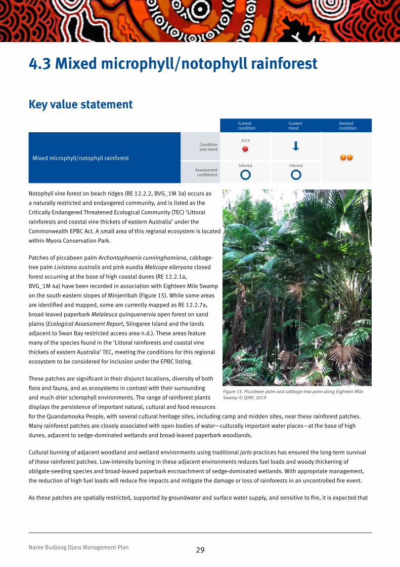
4.3 Mixed microphyll/notophyll rainforest
Key value statementCurrent condition
Current trend
Desired condition
Mixed microphyll/notophyll rainforest
Condition and trend
2019
Assessment confidence
Inferred
Inferred
Notophyll vine forest on beach ridges (RE 12.2.2, BVG_1M 3a) occurs as
a naturally restricted and endangered community, and is listed as the
Critically Endangered Threatened Ecological Community (TEC) ‘Littoral
rainforests and coastal vine thickets of eastern Australia’ under the
Commonwealth EPBC Act. A small area of this regional ecosystem is located
within Myora Conservation Park.
Patches of piccabeen palm Archontophoenix cunninghamiana, cabbage-
tree palm Livistona australis and pink euodia Melicope elleryana closed
forest occurring at the base of high coastal dunes (RE 12.2.1a,
BVG_1M 4a) have been recorded in association with Eighteen Mile Swamp
on the south-eastern slopes of Minjerribah (Figure 15). While some areas
are identified and mapped, some are currently mapped as RE 12.2.7a,
broad-leaved paperbark Melaleuca quinquenervia open forest on sand
plains (Ecological Assessment Report, Stingaree Island and the lands
adjacent to Swan Bay restricted access area n.d.). These areas feature
many of the species found in the ‘Littoral rainforests and coastal vine
thickets of eastern Australia’ TEC, meeting the conditions for this regional
ecosystem to be considered for inclusion under the EPBC listing.
These patches are significant in their disjunct locations, diversity of both
flora and fauna, and as ecosystems in contrast with their surrounding
and much drier sclerophyll environments. The range of rainforest plants
displays the persistence of important natural, cultural and food resources
for the Quandamooka People, with several cultural heritage sites, including camp and midden sites, near these rainforest patches.
Many rainforest patches are closely associated with open bodies of water—culturally important water places—at the base of high
dunes, adjacent to sedge-dominated wetlands and broad-leaved paperbark woodlands.
Cultural burning of adjacent woodland and wetland environments using traditional jarlo practices has ensured the long-term survival
of these rainforest patches. Low-intensity burning in these adjacent environments reduces fuel loads and woody thickening of
obligate-seeding species and broad-leaved paperbark encroachment of sedge-dominated wetlands. With appropriate management,
the reduction of high fuel loads will reduce fire impacts and mitigate the damage or loss of rainforests in an uncontrolled fire event.
As these patches are spatially restricted, supported by groundwater and surface water supply, and sensitive to fire, it is expected that
Figure 15. Piccabeen palm and cabbage-tree palm along Eighteen Mile Swamp © QYAC 2019
29Naree Budjong Djara Management Plan

Desired outcome and strategic management directionDesired outcome
The condition of mixed microphyll/notophyll rainforest will be improved to significant concern by reducing pest plant
impacts and applying jarlo fire practices in adjacent communities.
Threatening processes Strategic management directions Priority
Changed fire frequency or intensity
Apply jarlo fire practices to adjacent fire-adapted communities to reduce the risk of wildfire entering this community. 1
Introduced weedsContain the spread of basket asparagus fern, Easter cassia, lantana, umbrella tree, leucaena, cherry guava and corky passionfruit in mixed microphyll/notophyll rainforest. 2
Hydrological modificationMonitor the impacts of water draw down on ecosystems adjacent to mixed microphyll/notophyll rainforest through SEQwater monitoring bore data. 2
Introduced animals Reduce impacts of cats and foxes on the fauna of mixed microphyll/notophyll rainforest. 2
Climate changeManage change and improve resilience of mixed microphyll/notophyll rainforest communities by reducing impacts of non-climate stressors to reduce the rate of expected transition from climate change. 2
See Appendix 2. Glossary for priority rating definitions.
ThreatsPrimary threat: Fire encroachment into this fire-sensitive community and associated cultural sites from adjacent fire-adapted communities. Threat rating: Very high
Secondary threat: Climate change, as the region is predicted to experience increased temperature, decrease in precipitation, increased evaporation, an increase in extreme weather events and mugara activity. Threat rating: High
Other threat: Changes to the water table and surface water persistence associated with landscape modification, altered ground and surface water inflows and outflows, and water abstraction from Minjerribah (Centre for Coast Management 2002), allowing a thickening of Melaleuca quinquenervia swamp fringes. Threat rating: High
Other threat: Predation by cats and foxes of mixed microphyll/notophyll rainforest fauna. Threat rating: High
Other threat: Increase of ecosystem-changing weeds, such as Lantana camara, which can out-compete native species and modify rainforest structure. Threat rating: High
a changing climate will increase the severity of current threats. Managing the surrounding environment will be of great importance to
the long-term protection of microphyll/notophyll rainforest areas.
30Naree Budjong Djara Management Plan

4.4 Wetlandsa. Estuarine clay plains and wetlandsKey value statement
Current condition
Current trend
Desired condition
Estuarine clay plains and wetlands
Condition and trend
2019
Assessment confidence
Inferred
Inferred
Saltpan vegetation, including grasslands, herblands and sedgelands on marine clay plains (RE 12.1.2, BVG_1M 35b) and mangrove
shrublands on clay plains and estuaries (RE 12.1.3, BVG_1M 35a), extend along the western coastal edge and southern areas of Naree
Budjong Djara (Figure 16). These saline communities provide a range of important cultural resources to the Quandamooka People,
such as mudcrabs and oysters. These environments play an essential role in ensuring the sustainable use of marine resources, as they
are the breeding grounds, nurseries, shelter and feeding habitat for the wide diversity of important species in Moreton Bay and further
afield.
Mangrove shrublands provide buffering from storm surges and vessel wash, filter surface run-off prior to reaching marine
environments, and protect non-estuarine wetlands and forests adjacent to the coastline from saltwater influence. These environments
provide essential habitat for the vulnerable water mouse Xeromys myoides, evident from its mound-building habits throughout the
upper limits of the mangrove forests.
Adjacent to mangrove environments are saltpan grasslands, herblands and sedgelands dominated by species such as prickly couch
Zoysia macrantha, salt couch Sporobolus virginicus and samphire Sarcocornia quinqueflora. These areas of the upper intertidal
flats and saltmarsh may only be inundated at the highest tides, creating a hypersaline environment devoid of other larger salt-
tolerant vegetation such as mangroves. Areas of these saltmarsh are habitat for a wide range of migratory shorebirds, fish and
marine invertebrates. This regional ecosystem meets the requirements for ‘Subtropical and Temperate Coastal Saltmarsh’ listed as a
vulnerable TEC under the EPBC Act.
Figure 16. Salt couch in salt marine clay plains in southern Naree Budjong Djara © QYAC 2019
31Naree Budjong Djara Management Plan

Desired outcome and strategic management directionDesired outcome
The condition of estuarine clay plains and wetlands will be improved to good with some concern by monitoring
coastal retrograde, reducing pest plant impacts and implementing jarlo fire practices in adjacent communities.
Threatening processes Strategic management directions Priority
Climate changeManage change and improve resilience of estuarine clay plain and wetland communities by reducing impacts of non-climate stressors to reduce the rate of expected change from climate change. 2
Coastal retrograde
Monitor the impacts of erosion and/or sedimentation of estuarine clay plains and wetlands. 1
Work collaboratively with other agencies within marine parks to assess effectiveness of vessel wash reduction measures. 2
Problematic native plants Monitor the impacts of mangrove thickening on estuarine clay plains and wetlands. 2
Changed fire frequency or intensity
Protect estuarine clay plains and wetlands through application of jarlo fire practices to adjacent fire-adapted communities. 5
See Appendix 2. Glossary for priority rating definitions.
ThreatsPrimary threat: Climate change, as the region is predicted to experience an increase in sea level of 80 cm by 2100, increased temperature, decrease in precipitation, increased evaporation and an increase in extreme weather events. Threat rating: Very high
Secondary threat: Thickening of mangrove communities and encroachment by mangroves into estuarine grassland, herbland and sedgeland. Threat rating: High
Other threat: Erosion and/or sedimentation of estuarine clay plains and wetlands by increased wave action caused by vessel traffic and/or increased tidal levels. Threat rating: High
Other threat: Fire encroachment on marine grasslands from adjacent communities. Threat rating: Low
Saltmarsh environments on Naree Budjong Djara have experienced decline in extent and are projected to decrease in cover further
through mangrove expansion associated with sea level rise (IPCC 2014), increased storm surge influence and reduced groundwater
outflows (Low-Choy et al. 2013). With a reduction in extent, these saltmarsh areas require ongoing protection from damaging vessel
wash and fire encroachment.
32Naree Budjong Djara Management Plan

b. Wet heath and sedgeland coastal swamps
Key value statementCurrent condition
Current trend
Desired condition
Wet heath and sedgeland coastal swamps
Condition and trend
2019
Assessment confidence
Inferred
Inferred
Naree Budjong Djara National Park contains significant large areas of sword grass Gahnia sieberiana, spreading rope grass Empodisma
minus and coral ferns Gleichenia spp. closed sedgeland in coastal swamps. (RE 12.2.15, BVG_1M 34c) (Figure 17) and closed
heath on seasonally waterlogged sand plains (RE 12.2.12, BV_1M 29a). These swamps provide essential habitat for a vast number
of threatened species, including the endangered yellow swamp orchid Phaius bernaysii and lesser swamp orchid Phaius australis
(Figure 18), endemics Olearia hydrophile and Eleocharis difformis, and a fern Thelypteris confluens. Due to the low pH of many of
these swamps, they are habitat for unique threatened species such as Oxleyan pygmy perch Nannoperca oxleyana, Cooloola sedgefrog
Litoria cooloolensis, wallum rocketfrog Litoria freycineti, wallum sedgefrog Litoria olongburensis and wallum froglet Crinia tinnula.
Many of these coastal swamps and wetlands are associated with sensitive cultural sites, water places and story places, and are of high
cultural and spiritual importance to Quandamooka People.
Perched lakes and swamps form many of the wetland systems on Naree Budjong Djara. Decomposing leaf litter, peat and indurated
sand layers form a basin where water from groundwater expressions or rainfall is retained on the surface, forming often large bodies of
water in valley floors and landscape depressions. Kaboora’s hydrology differs from the perched lakes on Minjerribah as it is a window
lake—a depression that sinks below the surrounding landscape and into the groundwater level, presenting a ‘window’ into the aquifer.
Only a number of these lakes are present across Queensland, with Kaboora being the only window lake on Minjerribah. Kaboora is
Figure 17. Gahnia closed sedgeland in coastal swamp at Aranarawai Creek © QYAC 2019
33Naree Budjong Djara Management Plan

ThreatsPrimary threat: Changes to the water table caused by water abstraction from Minjerribah, and/or damage to perching layers, reduce moisture levels in swamps and dry out peat layers, allowing Melaleuca quinquenervia to establish in higher than usual densities. Threat rating: Very high
Secondary threat: Without implementing jarlo fire practices, these wetlands currently burn during hot unplanned fires, damaging peat layers. Threat rating: High
Other threat: Climate change, as the region is predicted to experience an increase in temperature, decrease in precipitation, increased evaporation and an increase in extreme weather events. Threat rating: Medium
Other threat: An increase in the abundance and distribution of ecosystem-changing weeds, such as groundsel Baccharis halimifolia, which can out-compete native species and modify wetland vegetation structure. Threat rating: Medium
Desired outcome and strategic management directionDesired outcome
The condition of wet heath and sedgeland coastal swamps will be improved to good in the long term by monitoring
hydrological modification, reducing pest plant impact and applying jarlo fire practices.
Threatening processes Strategic management directions Priority
Hydrological modification Monitor the impacts of hydrological modification on wet heath and sedgeland coastal swamps. 1
Changed fire frequency or intensity
Restore critical structural elements and age-class variation of Quandamooka cultural landscape values of wet heath and sedgeland coastal swamps through targeted application of jarlo fire practices. 2
Introduced weedsPrevent the establishment or incursion of ecosystem-changing weed species through adoption of appropriate biosecurity practices. 4
Climate changeManage change and improve resilience of wet heath and sedgeland coastal swamps communities by reducing impacts of non-climate stressors to reduce the rate of expected transition from climate change. 2
See Appendix 2. Glossary for priority rating definitions.
unique in its stability in both depth and chemistry over millennial timescales, presenting a resilient and persistent cultural and natural
resource through dramatic events of climatic change (DES 2019; Barr et al. 2013), and as such, a potential refuge through expected
climatic change. Other Gahnia swamp environments present a wallum or wet heath environment, large, open and slightly undulating
swamplands on thick peat layers. During late winter and through spring, these wet heaths offer a spectacular display of wildflowers,
many of which are used for cultural purposes by the Quandamooka People (Figure 7, page 16).
The diversity of sedge, reed and fern species in these wetlands provides cultural resources for Quandamooka People. Certain reeds
and grasses that grow within the wetlands are best for weaving baskets, bags and nets, with nyunggeh Baumea rubiginosa being
highly regarded for this. Their collection and use is a native title right enjoyed by Quandamooka People.
A number of swamp, wetland and lake ecosystems on Naree Budjong Djara have experienced woody thickening and encroachment of
broad-leaved paperbark, most notably throughout open areas of Eighteen Mile Swamp (Specht & Stubbs 2011) due to a combination
of extended dry periods, long fire intervals, lack of applying jarlo fire practices, and changes to groundwater hydrology through
abstraction and modification.
Climate change projections for the south-east Queensland region indicate current and future challenges for protecting the swamps
and wetlands of Naree Budjong Djara. These challenges include an increase in temperatures, decreased overall rainfall, an increase
in severity of lightning activity and heavy rainfall events, and increased evaporation, leading to a drier, more fire-prone environment
(Low-Choy et al. 2013).
34Naree Budjong Djara Management Plan

c. Melaleuca quinquenervia open woodlands
Key value statementCurrent condition
Current trend
Desired condition
Melaleuca quinquenervia open woodlands
Condition and trend
2019
Assessment confidence
Inferred
Inferred
Melaleuca quinquenervia open woodlands (RE 12.2.7, BVG_22a) occur on coastal dunes and seasonally waterlogged sandplains, and
are closely associated with Gahnia closed sedgeland in coastal swamps (RE 12.2.15, BVG_1M 34c). This also occurs as the vegetation
community Melaleuca quinquenervia low woodland with Gahnia sieberiana ground layer on Quaternary coastal sand dunes fringing
swamps (Figure 18).
These broad-leaved paperbark woodlands feature many of the natural and cultural values of open Gahnia swamps, yet the understorey
is afforded more shade and retains greater moisture due to the canopy. In turn, this provides essential habitat for the endangered
yellow swamp orchid Phaius bernaysii and lesser swamp orchid Phaius australis, and the ‘near threatened’ Durringtonia paludosa and
Olearia hydrophila.
As this ecosystem is a woodland environment, the large paperbarks and swamp mahogany Eucalyptus robusta provide key food
and shelter trees for koalas Phascolarctos cinereus. With the lack of jarlo fire practices, long fire intervals and repeated wildfires,
exacerbated by drier and hotter conditions associated with climate change and altered hydrology, the thickened whipstick paperbark
understorey forms heavy fuel loads. This, in turn, threatens the mature and emerging canopy trees essential for supporting koala
populations in Naree Budjong Djara’s wetlands.
Figure 18. Swamp orchid Phaius australis flowering in Melaleuca quinquenervia open woodland understorey © QYAC 2019
35Naree Budjong Djara Management Plan

Desired outcome and strategic management directionDesired outcome
The condition of Melaleuca quinquenervia open woodlands will be maintained as good in the long term by monitoring
hydrological modification, reducing pest plant impacts and implementing jarlo fire practices.
Threatening processes Strategic management directions Priority
Hydrological modification Monitor the impacts of hydrological modification on Melaleuca quinquenervia open woodlands. 1
Changed fire frequency or intensity
Restore critical structural elements and age-class variation of Quandamooka cultural landscape values of Melaleuca quinquenervia open woodlands through targeted application of jarlo fire practices. 2
Manage fire in Melaleuca quinquinervia open woodlands in response to hydrological modification. 1
Introduced weeds Reduce impacts of ecosystem-changing weeds on Melaleuca quinquenervia open woodlands. 4
Climate changeManage change and improve resilience of Melaleuca quinquenervia open woodlands communities by reducing impacts of non-climate stressors to reduce the rate of expected transition from climate change. 2
See Appendix 2. Glossary for priority rating definitions.
ThreatsPrimary threat: Changes to the water table caused by water abstraction from Minjerribah, and/or damage to perching layers, reduce moisture levels in swamps and dry out peat layers, allowing Melaleuca quinquenervia to establish in higher than usual densities. Threat rating: Very high
Secondary threat: The lack of implementation of jarlo fire practices, resulting in Melaleuca quinquenervia thickening. Threat rating: High
Other threat: An increase in the abundance and distribution of ecosystem-changing weeds, such as groundsel Baccharis halimifolia, which can out-compete native species and modify wetland vegetation structure. Threat rating: Medium
Other threat: Climate change, as the region is predicted to experience an increase in temperatures and decrease in overall rainfall. Threat rating: High
36Naree Budjong Djara Management Plan

4.5 Quandamooka eco-cultural experience
Key value statementCurrent condition
Current trend
Desired condition
Quandamooka eco-cultural experience
Condition and trend
2019
Assessment confidence
Limited
Limited
“Quandamooka People have always shared our sanctuary with others who respect our values. We must ensure that there is always
sufficient space and time for Quandamooka People to access and enjoy Country and resources and to undertake cultural activities.
While the Quandamooka People will continue to control how our sanctuary is shared, our sincerest wish is for visitors to feel welcome
and be enriched through engagement with Quandamooka People, Country and culture.”
Gundjundabu Murumba Gubiyiyanya – Tourism for A Glad Tomorrow (QYAC 2018)
Minjerribah is about 40 km south-east of Brisbane and is a popular tourism destination, with between 320 000 and 380 000 people
visiting in 2017 (QYAC 2018). Visitors are encouraged to enjoy learning about Quandamooka culture, landscapes, values and
knowledge while visiting, beach-camping at Flinders Beach and Main Beach, bushwalking, appreciating nature and enjoying the
four-wheel drive beach experience.
For new eco-cultural tourism opportunities, including commercial activities, the Quandamooka People must be supported to play
the lead role in managing and determining aspirational goals to ensure that the cultural, environmental and material benefits are
maximised.
Visitors are encouraged to come to Naree Budjong Djara to appreciate the unique eco-cultural landscape and be immersed in a
cultural experience. It is asked that visitors respect Naree Budjong Djara as part of the Quandamooka People’s cultural landscape—a
sanctuary that protects natural and cultural values. QYAC and QPWS jointly manage the unique eco-cultural visitor experience within
Naree Budjong Djara, with QYAC and Minjerribah Camping managing the camping and beach-touring experience within the Minjerribah
Recreation Area.
Through joint management, QYAC and QPWS wish to promote, enhance and elevate Quandamooka cultural awareness among visitors
to further enrich the eco-cultural experience on offer. Joint management seeks to encourage culturally appropriate and respectful
behaviour when visiting or conducting commercial activities on Naree Budjong Djara.
Through visitor management, education and compliance activities, QYAC, QPWS and Minjerribah Camping continue to care for Naree
Budjong Djara to ensure that eco-cultural tourism as a value does not become a threat to the cultural and ecological values that make
visiting Naree Budjong Djara a unique experience.
37Naree Budjong Djara Management Plan

ThreatsPrimary threat: Inappropriate visitor behaviour threatens the cultural significance of Country and place and impacts natural values and visitor experience. Threat rating: High
Secondary threat: Unrestrained domestic dogs are a direct threat to wildlife including koalas, kangaroos and shorebirds, and impact on visitor experience. Threat rating: High
Other threat: Current visitor facilities and infrastructure are insufficient to meet visitor demands and expectations, having an adverse impact on visitor experience within the Minjerribah Recreational Area. Threat rating: Medium
Desired outcome and strategic management directionDesired outcome
The condition of the Quandamooka eco-cultural experience of Naree Budjong Djara will be improved through ongoing
joint management by facilitating cultural and ecological appreciation and reducing visitor impacts, with respect to the
Quandamooka People’s values.
Threatening processes Strategic management directions Priority
Inappropriate visitor behaviour
Enhance educational messaging and communication with visitors and commercial operators about appropriate behaviour regarding Quandamooka People’s cultural landscape values. 1
Support the Quandamooka People in ensuring activities and operators are culturally trained and meeting and promoting cultural and ecological values. 1
Reduce impacts from inappropriate visitor behaviour through improved compliance and enforcement activities. 2
Minimise impacts on Quandamooka People’s cultural landscape values by enhancing communication about motorcycles not being permitted within Naree Budjong Djara. 3
Inappropriate facilitiesImprove visitor facilities and infrastructure to reduce impacts on the eco-cultural landscape. 2
Introduced animals Minimise impacts in Minjerribah Recreation Area on Quandamooka People’s cultural and ecological values and other visitors’ experience by unrestrained domestic dogs. 2
Improve communication to visitors on requirements for domestic dogs in the Minjerribah Recreation Area. 2
See Appendix 2. Glossary for priority rating definitions.
38Naree Budjong Djara Management Plan

Through joint management, QYAC and QPWS manage Naree
Budjong Djara to protect the cultural and natural values and
deliver legislative, cultural and management obligations as
joint land managers under the NCA and IMA.
5. Management directions
Figure 19. QYAC and QPWS rangers working together to remove lantana from the cultural landscape © QYAC 2019
39

Acceptable High Medium Very high Exceptional
Based on an assessment of values, risks and threats, community interface challenges, custodial obligations and requirement for special management intervention, best practice management
is achievable at either an ‘acceptable’ , ‘medium’, ‘high’, ‘very high’ or ‘exceptional’ LoS.
An assessment of levels of service (LoS) allows joint managers to consider the management of Naree Budjong Djara in a state-wide
context and determine desired LoS for each management theme in a consistent and equitable way. A desired LoS rating lets joint
management staff and the public know what type or level of management activity to expect. There are five LoS ratings ranging from
‘acceptable’ to ‘exceptional’: an acceptable rating is the minimum standard required to deliver good management and meet the IMA,
legislative and cultural obligations.
The key areas for management in Naree Budjong Djara are joint management and cultural heritage, fire, natural values and community,
partnerships and other interests. This section provides a management direction statement for each management theme, identifying its
current LoS, desired LoS and the strategic management direction for management.
Summary of management direction A summary of the current and desired LoS for Naree Budjong Djara is shown below; Figure 20 provides a key to the LoS icons.
Current LoS Desired LoS
1. Joint management partnership and cultural
heritage management Very high Exceptional
2. Fire management Medium Very high
3. Pest management Medium High
4. Natural values management High Very high
5. Historic cultural heritage management Acceptable Acceptable
6. Visitor management High High
7. Community, partnerships and other interest High Very high
8. Field management capability High High
9. Operational planning and management
supportHigh High
Figure 20. Key to LoS icons
40Naree Budjong Djara Management Plan

5.1 Joint management partnership and cultural heritage managementManagement direction statement
Current level of service
Joint management partnership and cultural heritage management of Naree Budjong Djara
The Quandamooka People’s rights and interests are key to the joint management arrangements under the IMA. As joint managers,
QYAC and QPWS manage Naree Budjong Djara to protect the integrity of the diverse natural and cultural values in accordance with
traditional knowledge.
QPWS and QYAC have obligations to each other in supporting the delivery of:
• IMA arrangements for joint management
• cultural heritage management
• the Quandamooka People’s native title rights and interests.
Desired level of service and strategic management direction
Desired level of service
Joint management partnership and cultural heritage management will be managed at an ‘exceptional’ LoS through
enhancing knowledge and management capacity and partnerships, to protect and enhance the Quandamooka
People’s rights, interests, cultural values and aspirations.
Strategic management directions Priority
Management obligations
Ensure the delivery of provisions under the IMA. 1
Level of service
Maintain effective joint management partnerships and governance arrangements to ensure the delivery of IMA objectives. 1
Support the Quandamooka People to play a lead role in the management and governance of joint management through QYAC. 1
Improve the capacity of QYAC to undertake and complete cultural heritage management priorities. 1
Maximise employment, procurement, capacity building and participation for Quandamooka People through joint management. 1
Improve the level of understanding, awareness and appreciation of QPWS field officers of the island’s cultural values and the Quandamooka People’s connection to Country.
1
*KEY: Priority ratings: M – maintain current priorities; Scale 1 (extremely urgent and extremely necessary) to 5 (optional and not urgent).
41Naree Budjong Djara Management Plan

5.2 Fire management
Management direction statementCurrent
level of service
Fire management for Naree Budjong Djara
Fire management is core business for QYAC and QPWS, to protect life and property, mitigate wildfires and maintain Naree Budjong
Djara’s natural diversity and cultural integrity. This is done in accordance with the NCA, Fire and Emergency Services Act 1990 (Qld)
and traditional ecological knowledge for the control and prevention of fires. QYAC and QPWS work jointly to manage fire across the
landscape and collaborate with state and local government agencies, rural fire brigades, adjoining landholders and local communities.
The strategic management direction in this management plan, combined with the Quandamooka People’s knowledge of traditional
burning practices (as defined by QYAC’s Quandamooka Jarlo Fire Management project) and the Queensland Government’s Planned
Burn Guidelines: Southeast Queensland Bioregion of Queensland, guides the formation of the Naree Budjong Djara Fire Strategy. The
strategy details QYAC and QPWS’s obligations for protecting life and property, and fire management objectives for maintaining key
cultural and natural values through using fire management zones.
The Naree Budjong Djara Fire Strategy will complement the Minjerribah Township Fire Management Strategy, with a land management
agreement between joint management partners for QYAC to manage bushfire risk surrounding townships and develop a network
of strategic fire management lines across the protected area estate and other tenure, with agreement from stakeholders. This work
supports the management of fire within Naree Budjong Djara and works to significantly reduce fire risk and allow the implementation
of traditional jarlo fire practices.
Desired level of service and strategic management direction
Desired level of service
Fire will be managed to a ‘very high’ LoS through improved knowledge, management capacity and partnerships, to
protect and reduce risk of life and property and to protect and enhance Quandamooka cultural values.
Strategic management directions Priority
Management obligations
Mitigate the potential severity and impacts of wildfire on neighbouring properties by supporting the implementation of the Minjerribah Township Fire Management Strategy.
1
Level of service
Improve the current level of fire management knowledge, understanding of jarlo fire practices, and understanding of fire requirements of the natural and cultural key values within QYAC and QPWS.
1
Improve the level of fire management skills within QYAC and QPWS. 1
Improve the capacity of QYAC and QPWS to undertake and complete priority burns in the fire management program. 1
Improve the current level of fire management consultation with neighbours and stakeholders. 2
*KEY: Priority ratings: M – maintain current priorities; Scale 1 (extremely urgent and extremely necessary) to 5 (optional and not urgent).
42Naree Budjong Djara Management Plan

5.3 Pest management
Management direction statementCurrent
level of service
Pest management for Naree Budjong Djara
Pest management is core business for QYAC and QPWS to mitigate the threats to biodiversity in accordance with the NCA and
traditional ecological knowledge. QYAC and QPWS have a responsibility under the Biosecurity Act 2014 (Qld) to take all reasonable
and practical steps to minimise the risks associated with plant and animal pests on lands under our control. Recognising that effective
management of pests across the landscape is a shared responsibility, QYAC and QPWS acknowledge the partnership with state and
local government agencies, landholders and natural resource management groups.
The strategic management direction in this management plan guides the formation of the Naree Budjong Djara Pest Strategy. The
strategy details pest management objectives for preventing and mitigating pest impacts on key values, and joint management
obligations for managing pests and priority pest species. Managing threats from pest plants, pest animals and unrestrained domestic
dogs enhances both the cultural and natural values within Naree Budjong Djara and further improves the eco-cultural experience for
visitors.
Desired level of service and strategic management direction
Desired level of service
Pests will be managed to a ‘high’ LoS through improved knowledge and a more strategic approach to management and
protection of the cultural and natural values.
Strategic management directions Priority
Management obligations
Improve the level of engagement with stakeholders to mitigate the potential impacts of pests on neighbouring properties. 1
Level of service
Improve the level of pest plant and animal knowledge and understanding of their impacts on cultural and natural key values. 2
Improve pest plant management effectiveness by increasing focus on ecosystem-changing pest plants. 2
Improve the level of pest management skills within QYAC and QPWS. 2
Improve the capacity of QYAC and QPWS to undertake and complete priority pest animal and plant projects in the pest management program.
2
*KEY: Priority ratings: M – maintain current priorities; Scale 1 (extremely urgent and extremely necessary) to 5 (optional and not urgent).
43Naree Budjong Djara Management Plan

5.4 Natural values management
Management direction statementCurrent
level of service
Natural values management for Naree Budjong Djara
QYAC and QPWS manage natural values in accordance with the NCA, EPBC, Environmental Protection Act 1994 (Qld) and relevant
international agreement guidelines, and by incorporating traditional ecological knowledge.
Naree Budjong Djara has significant natural values, including endangered regional ecosystems, and Quandamooka cultural heritage
elements. The condition of natural values will be monitored through the implementation of the Naree Budjong Djara Monitoring and
Research Strategy.
Threatening processes will be managed through the implementation of Naree Budjong Djara’s fire, pest and visitor strategies.
Naree Budjong Djara’s natural values are closely associated with, or inseparable from, Quandamooka People’s cultural value of
healthy Country and landscapes. To manage and improve natural values is to improve the condition of cultural landscape values.
Desired level of service and strategic management direction
Desired level of service
Natural values will be managed to a ‘very high’ LoS through improved knowledge and a more strategic approach to
management and protection of the natural key values.
Strategic management directions Priority
Level of service
Improve the current level of knowledge of Naree Budjong Djara’s natural key values. 2
Improve the level of natural resource management skills within QYAC and QPWS as required to protect and maintain the natural key values.
2
Health check monitoring
Monitor the condition of natural key values through health check monitoring. 1
*KEY: Priority ratings: M – maintain current priorities; Scale 1 (extremely urgent and extremely necessary) to 5 (optional and not urgent).
44Naree Budjong Djara Management Plan

5.5 Historic cultural heritage management
Management direction statementCurrent
level of service
Historic cultural heritage management for Naree Budjong Djara
QPWS and QYAC manage historical sites in accordance with the NCA and Queensland Heritage Act 1992 (Qld).
There are no identified heritage sites of significance within Naree Budjong Djara and none listed on the Queensland Heritage Register
or Australian National Heritage List. Accordingly, the ‘acceptable’ LoS has been applied.
Sites identified or contained in future planning areas will be managed in accordance with contemporary heritage management
provisions.
Desired level of service and strategic management direction
Desired level of service
Historic cultural heritage values will be managed to an ‘acceptable’ LoS.
Strategic management directions Priority
Level of service
Maintain the current approach to historic cultural heritage management. M
*KEY: Priority ratings: M – maintain current priorities; Scale 1 (extremely urgent and extremely necessary) to 5 (optional and not urgent).
45Naree Budjong Djara Management Plan

5.6 Visitor management
Management direction statementCurrent
level of service
Visitor management for Naree Budjong Djara
Queensland’s parks, forests and reserves provide local communities and visitors from around the world with opportunities to
experience our rich natural and cultural heritage, as well as diverse recreational and ecotourism opportunities. For Naree Budjong
Djara, QYAC and QPWS seek a responsible balance between visitor needs and sensitive park resources in accordance with the IMA,
NCA, RAMA, policies and procedures.
A key focus for the Quandamooka People and the Queensland Government is the transition of Minjerribah to an economy based on
tourism and promotion of its natural assets. Naree Budjong Djara and the Minjerribah Recreation Area are recognised as playing a
strategically important role in this transition. Gudjundabu Marumba Gubiyiyanya — Tourism for a Glad Tomorrow (QYAC 2018) is a
five-year strategy developed by QYAC and the Queensland Government that places ecological and cultural sustainability as the primary
requirement for tourism on Quandamookadjara. Permitted commercial tour activities, agreements and events are administered in
accordance with the NCA, RAMA and other relevant legislation, and in keeping with the objectives of this strategy.
The Minjerribah Recreation Area is a designated RAMA area that overlays the Main Beach Conservation Park and part of the Naree
Budjong Djara National Park. It includes the highly visited holiday parks, camping areas and four-wheel drive beaches that are outside
of these protected areas. QYAC, through Minjerribah Camping Pty Ltd, manages the camping and day use areas and the administering
of permits within the Minjerribah Recreation Area.
Visitor vehicle access within Naree Budjong Djara must be in a fully road registered vehicle in areas defined within the Naree Budjong
Djara Visitor Strategy. Visitor access by motorbike, quad bike and side-by-side vehicle is not permitted unless indicated otherwise for
specific areas in the Naree Budjong Djara Visitor Strategy.
The strategic management direction in this management plan guides the formation of the Naree Budjong Djara Visitor Strategy.
The strategy is operationally focused and will complement the objectives of the Tourism for a Glad Tomorrow strategy. It outlines
management objectives for key values and the desired management outcomes for visitor sites through zoning based on the physical,
social and managerial impacts of the visitor experiences and sustainability of the sites. The strategy also explores visitor opportunities
that complement other experiences in the landscape and region.
The condition of, and visitor satisfaction with, visitor experiences will be monitored through the implementation of the Naree Budjong
Djara Monitoring and Research Strategy.
46Naree Budjong Djara Management Plan

Desired level of service and strategic management direction
Desired level of service
Visitor values will be managed to a ‘high’ LoS through improved knowledge and a more strategic approach to
management and protection of the visitor values.
Strategic management directions Priority
Level of service
Facilitate the transition of the Minjerribah economy through the delivery of relevant actions within the Tourism for a Glad Tomorrow strategy.
1
Improve the visitor and commercial operator data-sharing and storage models between QYAC, QPWS and Minjerribah Camping Pty Ltd to better understand visitor use and demands and to support joint management.
2
Support the development of eco-cultural tourism opportunities to realise QYAC’s tourism aspirations and community benefits. 2
Improve visitor infrastructure, experiences and behaviour (including improvements to beach access and use) to mitigate landscape impacts.
1
Participate in tourism partnerships and program reviews to improve knowledge and to ensure complementary and non-conflicting outcomes for Naree Budjong Djara.
2
Incorporate cultural messaging into all park visitor education material, including online, on-site signs and brochures. 1
*KEY: Priority ratings: M – maintain current priorities; Scale 1 (extremely urgent and extremely necessary) to 5 (optional and not urgent).
47Naree Budjong Djara Management Plan

5.7 Community, partnerships and other interests
Management direction statementCurrent
level of service
Community, partnerships and other interests associated with Naree Budjong Djara
Naree Budjong Djara provides sustainable environmental, economic and social benefits. QYAC and QPWS are committed to working
with the community and other partners to ensure activities and infrastructure are ecologically sustainable and continue to benefit
the Quandamooka People, the wider community, and Queensland’s economic and social wellbeing as outlined in QPWS’s Master
Plan (QPWS 2014). Permitted activities are administered in accordance with the requirements of the NCA, RAMA and other relevant
legislation.
Throughout Naree Budjong Djara are bores monitored by SEQwater. QYAC and QPWS authorise the continued use of bores to monitor
the level and quality of groundwater across Naree Budjong Djara in perpetuity.
Desired level of service and strategic management direction
Desired level of service
Community, partnerships and other interests will be managed to a ‘very high’ LoS through improved engagement.
Strategic management directions Priority
Management obligations
Maintain agreement with SEQwater for the continued use of bores to monitor the level and quality of groundwater across Naree Budjong Djara.
1
Level of service
Improve the level of engagement with community and other stakeholders. 3
*KEY: Priority ratings: M – maintain current priorities; Scale 1 (extremely urgent and extremely necessary) to 5 (optional and not urgent).
48Naree Budjong Djara Management Plan

5.8 Field management capability
Management direction statementCurrent
level of service
Field management capability for Naree Budjong Djara
Managing natural and cultural areas has varying degrees of complexity. Field management capability is a measure of this complexity
and considers the significance of the planning area’s values, potential threats, intensity of visitor use and community expectations. It
considers the required proximity, frequency and intensity of on-ground management that are needed to manage key values and meet
legislative obligations. The rating provides QYAC and QPWS with a means for gauging resource requirements and staff training needs.
Desired level of service and strategic management direction
Desired level of service
Field management capacity will be managed to a ‘high’ LoS through additional support to manage, protect and
enhance Naree Budjong Djara key values.
Strategic management directions Priority
Level of service
Establish a fit-for-purpose joint operations ranger base. 1
Improve the level of protected area management skills within QYAC and QPWS. M
Improve the capacity of QYAC and QPWS to deliver priority on-ground park management actions. M
*KEY: Priority ratings: M – maintain current priorities; Scale 1 (extremely urgent and extremely necessary) to 5 (optional and not urgent).
49Naree Budjong Djara Management Plan

5.9 Operational planning and management supportManagement direction statement
Current level of service
Operational planning and management support for Naree Budjong Djara
Operational planning and management support covers all aspects of management direction including information, assessments,
systems, tools and monitoring. As with field management capability, Naree Budjong Djara’s values, potential threats, intensity of
visitor use and community expectations are considered when determining the appropriate levels of service.
Desired level of service and strategic management direction
Desired level of service
Operational planning and management capacity will be managed to a ‘high’ LoS through ongoing support to manage,
protect and enhance Naree Budjong Djara key values.
Strategic management directions Priority
Level of service
Maintain support from QPWS to deal with key management challenges, issues and planning. M
Maintain strong governance arrangements between QYAC and QPWS to ensure joint decision-making and planning. M
*KEY: Priority ratings: M – maintain current priorities; Scale 1 (extremely urgent and extremely necessary) to 5 (optional and not urgent).
50Naree Budjong Djara Management Plan

6. References
Australian Government Department of the Environment and Energy, n.d., Wetlands, accessed 15 January 2020 at www.environment.
gov.au/wetlands.
Barr C, Tibby J, Marshall J, McGregor G, Moss P, Halverson G and Fluin J, 2013, Combining monitoring, models and palaeolimnology to
assess ecosystem response to environmental change at monthly to millennial timescales: the stability of Blue Lake, North Stradbroke
Island, Australia, Freshwater Biology, vol. 58, iss. 8, pp. 1614–1630.
Centre for Coastal Management, 2002, Biological monitoring of Eighteen Mile Swamp – North Stradbroke Island 2002, prepared for
Redland Shire Council, Southern Cross University.
Delaney S, 2013, Quandamooka Dreaming, Boolarong Press, Brisbane.
Department of Agriculture, Water and the Environment, 2019, Information Sheet on Ramsar Wetlands, Moreton Bay–Australia,
Australian Government, Canberra.
Department of Environment and Science, 2019, Coastal and subcoastal non-floodplain sand lakes – Window, viewed 15 January 2020
at http://wetlandinfo.des.qld.gov.au/wetlands/ecology/aquatic-ecosystems-natural/lacustrine/non-floodplain-sand-lake.
Department of National Parks, Recreation, Sport and Racing, 2013, Planned Burn Guidelines – Southeast Queensland Bioregion of
Queensland, Queensland Government, Brisbane.
Holmer NM, 1983, Linguistic survey of south-eastern Queensland, Department of Linguistics, Research School of Pacific Studies,
Australian National University, Canberra.
Intergovernmental Panel on Climate Change (IPCC), 2014, Climate Change 2014: Synthesis Report. Contribution of Working Groups I, II
and III to the Fifth Assessment Report of the Intergovernmental Panel on Climate Change [Core Writing Team, RK Pachauri and LA Meyer
(eds.)], IPCC, Geneva, Switzerland.
Low-Choy D, Clarke P, Jones D, Serrao-Neumann S, Hales R and Koschade O, 2013, Aboriginal reconnections: Understanding coastal
urban and peri-urban Indigenous people’s vulnerability and adaptive capacity to climate change, National Climate Change Adaptation
Research Facility, Gold Coast.
Low-Choy D, Clarke P, Serrao-Neuman S, Hales R, Koschade O and Jones D, 2016, Coastal urban and peri-urban Indigenous people’s
adaptive capacity to climate change, Balanced Urban Development: Options and Strategies for Liveable Cities, pp. 441–461.
Neal R and Stock E, 1986, Pleistocene occupation in the south-east Queensland coastal region, Nature, vol. 323, pp. 618–621.
Quandamooka Yoolooburrabee Aboriginal Corporation, 2018, Gundjundabu Murumba Gubiyiyanya – Tourism for A Glad Tomorrow – A
five-year strategy for sustainable tourism on Quandamooka Country, Quandamooka Yoolooburrabee Aboriginal Corporation.
Queensland Parks and Wildlife Service, 2014, A master plan for Queensland’s parks and forests to 2025, Department of National
Parks, Sports and Racing, Brisbane.
Specht A and Stubbs BJ, 2011, Long-term monitoring of a coastal sandy freshwater wetland: Eighteen Mile Swamp, North Stradbroke
Island, Queensland, Proceedings of the Royal Society of Queensland, vol. 117, pp. 201–223.
51Naree Budjong Djara Management Plan

Table 2. Summary of strategic management direction for Quandamooka People
Appendix 1. Summary of strategic management directionsA summary of strategic management directions for Quandamooka People (Table 2), key values (Table 3) and management direction (Table 4).
Threatening processes Strategic management directions Priority
Loss of Quandamooka People’s determination in management of Country
Strengthen the joint management partnership between QPWS and the Quandamooka People to ensure effective co-stewardship of natural and cultural values. 1
Support the Quandamooka People by facilitating the timely implementation of commitments within the Indigenous Management Agreement. 1
Provide sufficient space and time so that Quandamooka People always have access to enjoy Country and cultural resources, and to undertake cultural activities. 1
Promote understanding, recognition and respect for Quandamooka culture and values, and the role that language plays. 1
Encourage tourism, researchers and business operators on Quandamookadjara to practise ethical behaviour, support reconciliation, respect culture, and recognise and protect intellectual property and traditional knowledge of the Quandamooka People.
1
Promote innovative approaches to raise awareness of Quandamookadjara, Quandamooka culture and the significance of Naree Budjong Djara’s plants and animals. 1
Improve connection to Country by ensuring QYAC is involved in planning, implementing, monitoring and evaluating park management across Quandamookadjara. 1
Enhance the Quandamooka People’s connection to Country through the implementation of traditional land management practices and the use of cultural resources. 1
Increase capacity and knowledge of both QPWS and QYAC through joint participation in park management activities. 1
Increase support and provide opportunities for Quandamooka People to get back on Country at Naree Budjong Djara. 1
Maximise opportunities for Quandamooka People through employment, contracting and training opportunities. 1
Support the Quandamooka People to develop ecologically and commercially sustainable cultural enterprises, including cultural interpretation, visitor management and tourism services. 1
Improve the protection of Quandamookadjara values by securing significant cultural values where needed through regulation of access by various mechanisms. 1
Support the Quandamooka People in providing cultural awareness programs to enhance visitor appreciation of Quandamooka culture through language and other cultural information. 1
Support capabilities of QPWS staff, stakeholders and community to understand Quandamookadjara, its values and Quandamooka culture through QYAC developed and presented training programs. 1
See Appendix 2. Glossary for priority rating definitions.
52Naree Budjong Djara Management Plan

Table 3. Summary of strategic management direction for key values
Threatening processes Strategic management directions Priority
4.1 Quandamookadjara values
a. Cultural landscape values of Quandamooka People and Country Current Desired
Changed fire frequency or intensity Improve Quandamooka cultural landscape values of healthy open vegetation communities through integration of jarlo (traditional fire management) practices. 1
Climate change Manage change and improve resilience of Quandamooka cultural landscape values by reducing impacts of non-climate stressors to reduce the rate of expected transition driven by climate change.
1
Barriers to access, management, and connection to Country
Improve knowledge of Quandamooka cultural landscape values. 1
Improve cultural resource management through Quandamooka-led knowledge sharing. 1
Hydrological modification Improve knowledge on wetland hydrology and manage for change. 1
Inappropriate visitor behaviour Reduce the impacts of inappropriate visitor behaviour on the Quandamooka People’s cultural landscape values within Naree Budjong Djara. 2
Improve compliance and enforcement of visitor behaviours impacting on the Quandamooka People’s cultural landscape values. 2
Minimise impacts of motorcycles on the Quandamooka People’s cultural landscape values within Naree Budjong Djara. 3
Introduced animals Minimise impacts of unrestrained domestic dogs in Minjerribah Recreation Area on the Quandamooka People’s cultural landscape values. 2
Introduced weeds Reduce impacts of weeds on the Quandamooka People’s cultural landscape values within Naree Budjong Djara. 3
4.1 Quandamookadjara values
b. Kaboora (Blue Lake) Current Desired
Inappropriate visitor behaviour Improve visitor knowledge of cultural protocols in respecting the Quandamooka People’s cultural values of Kaboora as a significant cultural complex. 1
Reduce the impacts of inappropriate visitor behaviour on Kaboora (Blue Lake) and the Quandamooka People’s aspirations for Kaboora. 1
Improve visitor compliance and enforcement at Kaboora (Blue Lake). 3
Changed fire frequency or intensity Protect cultural elements and Quandamooka cultural landscape values at Kaboora through applying jarlo fire practices to reduce the risk of wildfire and encourage healthy open forest communities.
1
Maintain healthy open forest communities and Quandamooka cultural landscape values at the Kaboora complex, including Tortoise Lagoon, through management of vegetation thickening. 1
4.1 Quandamookadjara values
c. Burogari (Cypress) Camps cultural complex Current Desired
Changed fire frequency or intensity Protect cultural elements and Quandamooka cultural landscape values through applying jarlo fire practices to reduce the risk of wildfire and encourage healthy open forest understorey. 1
Maintain healthy open forest communities and Quandamooka cultural landscape values at Burogari Camps cultural complex through vegetation management. 1
Inappropriate visitor behaviour Improve visitor compliance through increased surveillance and enforcement of public access restrictions to the complex. 2
Introduced weeds Reduce extent of invasive weeds within the Burogari Camps cultural complex. 3
Barriers to access, control and connection to Country
Improve knowledge on cultural elements throughout the Burogari Camps cultural complex. 3
53Naree Budjong Djara Management Plan

Threatening processes Strategic management directions Priority
4.2 Open heath on dunes Current Desired
Changed fire frequency or intensity Restore Quandamooka cultural landscape values of healthy open heath on dune communities through applying jarlo fire practices. 2
Protect Quandamooka cultural landscape values of healthy open heath on dunes by limiting wildfire and/or planned burn encroachment when it is inconsistent with jarlo fire practices for this ecosystem.
2
Work or other activities Reduce the impacts of informal visitor access on open heath on dune communities. 3
Introduced weeds Prevent the establishment of ecosystem-changing invasive grasses within open heath on dune communities. 3
Inappropriate visitor behaviour Minimise visitor impacts caused by unauthorised vehicle use, bush toileting and rubbish on open heath on dune communities. 2
Mining and quarrying Monitor the impacts of mining on open heath on dune communities. 2
Climate change Manage change and improve resilience of open heath on dune communities by reducing impacts of non-climate stressors to reduce the rate of expected transition from climate change. 2
4.3 Mixed microphyll/notophyll rainforest Current Desired
Changed fire frequency or intensityApply jarlo fire practices to adjacent fire-adapted communities to reduce the risk of wildfire entering this community. 1
Introduced weedsContain the spread of basket asparagus fern, Easter cassia, lantana, umbrella tree, leucaena, cherry guava and corky passionfruit in mixed microphyll/notophyll rainforest. 2
Hydrological modificationMonitor the impacts of water draw down on ecosystems adjacent to mixed microphyll/notophyll rainforest through SEQwater monitoring bore data. 2
Introduced animals Reduce impacts of cats and foxes on the fauna of mixed microphyll/notophyll rainforest. 2
Climate changeManage change and improve resilience of mixed microphyll/notophyll rainforest communities by reducing impacts of non-climate stressors to reduce the rate of expected transition from climate change.
2
4.4 Wetlands
a. Estuarine clay plains and wetlands Current Desired
Climate change Manage change and improve resilience of estuarine clay plain and wetland communities by reducing impacts of non-climate stressors to reduce the rate of expected change from climate change.
2
Coastal retrograde Monitor the impacts of erosion and/or sedimentation of estuarine clay plains and wetlands. 1
Work collaboratively with other agencies within marine parks to assess effectiveness of vessel wash reduction measures. 2
Problematic native plants Monitor the impacts of mangrove thickening on estuarine clay plains and wetlands. 2
Changed fire frequency or intensity Protect estuarine clay plains and wetlands through application of jarlo fire practices to adjacent fire-adapted communities. 5
4.4 Wetlands
b. Wet heath and sedgeland coastal swamps Current Desired Hydrological modification Monitor the impacts of hydrological modification on wet heath and sedgeland coastal swamps. 1
Changed fire frequency or intensityRestore critical structural elements and age-class variation of Quandamooka cultural landscape values of wet heath and sedgeland coastal swamps through targeted application of jarlo fire practices.
2
Introduced weedsPrevent the establishment or incursion of ecosystem-changing weed species through adoption of appropriate biosecurity practices. 4
Climate changeManage change and improve resilience of wet heath and sedgeland coastal swamps communities by reducing impacts of non-climate stressors to reduce the rate of expected transition from climate change.
2
Table 3. Summary of strategic management direction for key values continued
54Naree Budjong Djara Management Plan

Threatening processes Strategic management directions Priority
4.4 Wetlands
c. Melaleuca quinquenervia open woodlands Current Desired Hydrological modification Monitor the impacts of hydrological modification on Melaleuca quinquenervia open woodlands. 1
Changed fire frequency or intensity Restore critical structural elements and age-class variation of Quandamooka cultural landscape
values of Melaleuca quinquenervia open woodlands through targeted application of jarlo fire
practices.
2
Manage fire in Melaleuca quinquinervia open woodlands in response to hydrological
modification.1
Introduced weeds Reduce impacts of ecosystem-changing weeds on Melaleuca quinquenervia open woodlands. 4
Climate change Manage change and improve resilience of Melaleuca quinquenervia open woodlands
communities by reducing impacts of non-climate stressors to reduce the rate of expected
transition from climate change.
2
4.5 Quandamooka eco-cultural experience Current Desired Inappropriate visitor behaviour Enhance educational messaging and communication with visitors and commercial operators
about appropriate behaviour regarding Quandamooka People’s cultural landscape values.1
Support the Quandamooka People in ensuring activities and operators are culturally trained
and meeting and promoting cultural and ecological values.1
Reduce impacts from inappropriate visitor behaviour through improved compliance and
enforcement activities.2
Minimise impacts on the Quandamooka People’s cultural landscape values by enhancing
communication about motorcycles not being permitted within Naree Budjong Djara.3
Inappropriate facilities Improve visitor facilities and infrastructure to reduce impacts and improve cultural and natural
experiences.2
Introduced animals Minimise impacts in Minjerribah Recreation Area on Quandamooka People’s cultural and
ecological values and other visitors’ experience by unrestrained domestic dogs.2
Improve communication to visitors on requirements for domestic dogs in the Minjerribah
Recreation Area.2
See Appendix 2. Glossary for priority rating definitions.
Table 3. Summary of strategic management direction for key values continued
55Naree Budjong Djara Management Plan

Table 4. Summary of strategic management direction for management directions
Strategic management directions Priority
5.1 Joint management partnership and cultural heritage management Current VERY HIGH Desired EXCEPTIONAL
Ensure the delivery of provisions under the IMA. 1
Maintain effective joint management partnerships and governance arrangements to ensure the delivery of IMA objectives. 1
Support the Quandamooka People to play a lead role in the management and governance of joint management through QYAC. 1
Improve the capacity of QYAC to undertake and complete cultural heritage management priorities. 1
Maximise employment, procurement, capacity building and participation for Quandamooka People through joint management. 1
Improve the level of understanding, awareness and appreciation of QPWS field officers of the island’s cultural values and the Quandamooka People’s connection to Country. 1
5.2 Fire management Current MEDIUM Desired VERY HIGH
Mitigate the potential severity and impacts of wildfire on neighbouring properties by supporting the implementation of the Minjerribah Township Fire Management Strategy. 1
Improve the current level of fire management knowledge, understanding of jarlo fire practices, and understanding of fire requirements of the natural and cultural key values within QYAC and QPWS. 1
Improve the level of fire management skills within QYAC and QPWS. 1
Improve the capacity of QYAC and QPWS to undertake and complete priority burns in the fire management program. 1
Improve the current level of fire management consultation with neighbours and stakeholders. 2
5.3 Pest management Current MEDIUM Desired HIGH
Improve the level of engagement with stakeholders to mitigate the potential impacts of pests on neighbouring properties. 1
Improve the level of pest plant and animal knowledge and understanding of their impacts on cultural and natural key values. 2
Improve pest plant management effectiveness by increasing focus on ecosystem-changing pest plants. 2
Improve the level of pest management skills within QYAC and QPWS. 2
Improve the capacity of QYAC and QPWS to undertake and complete priority pest animal and plant projects in the pest management program. 2
5.4 Natural values management Current HIGH Desired VERY HIGH
Improve the current level of knowledge of Naree Budjong Djara’s natural key values. 2
Improve the level of natural resource management skills within QYAC and QPWS as required to protect and maintain the natural key values. 2
Monitor the condition of natural key values through health check monitoring. 1
5.5 Historic cultural heritage management Current ACCEPTABLE Desired ACCEPTABLE
Maintain the current approach to historic cultural heritage management. M
56Naree Budjong Djara Management Plan

Strategic management directions Priority
5.6 Visitor management Current HIGH Desired HIGH
Facilitate the transition of the Minjerribah economy through the delivery of relevant actions within the Tourism for a Glad Tomorrow
strategy. 1
Improve the visitor and commercial operator data-sharing and storage models between QYAC, QPWS and Minjerribah Camping Pty Ltd to
better understand visitor use and demands and to support joint management.2
Support the development of eco-cultural tourism opportunities to realise QYAC’s tourism aspirations and community benefits. 2
Improve visitor infrastructure, experiences and behaviour (including improvements to beach access and use) to mitigate landscape
impacts. 1
Participate in tourism partnerships and program reviews to improve knowledge and to ensure complementary and non-conflicting
outcomes for Naree Budjong Djara.2
Incorporate cultural messaging into all park visitor education material, including online, on-site signs and brochures. 1
5.7 Community, partnerships and other interests Current HIGH Desired VERY HIGH
Maintain agreement with SEQwater for the continued use of bores to monitor the level and quality of groundwater across Naree Budjong
Djara.1
Improve the level of engagement with community and other stakeholders. 3
5.8 Field management capability Current HIGH Desired HIGH
Establish a fit-for-purpose joint operations ranger base. 1
Improve the level of protected area management skills within QYAC and QPWS. M
Improve the capacity of QYAC and QPWS to deliver priority on-ground park management actions. M
5.9 Operational planning and management support Current HIGH Desired HIGH
Maintain support from QPWS to deal with key management challenges, issues and planning. M
Maintain strong governance arrangements between QYAC and QPWS to ensure joint decision-making and planning. M
*KEY: Priority ratings: M – maintain current priorities; Scale 1 (extremely urgent and extremely necessary) to 5 (optional and not urgent).
Table 4. Summary of strategic management direction for management directions continued
57Naree Budjong Djara Management Plan

Adaptive management The process of adjusting and improving how we manage parks, forests and reserves after assessing the outcomes of previous strategies and on-ground actions.
Condition and trend The condition of a key value is assessed as either good, good with some concern, significant concern or critical. Trend describes what is happening to the condition: is it improving, stable or deteriorating? A key value’s current condition is determined during the planning process. A desired condition is a realistic goal for the future condition of the key value. The ongoing condition of key values is assessed with regular health checks, monitoring and scientific assessment.
Custodial obligations The requirements in legislation and government policies are that we, as the land management agency, have to ensure QPWS&P’s parks, forests and reserves are lawfully managed and good neighbours. Management provides for the protection of life and property, biosecurity and positive relationships with adjacent communities and landholders, as well as enhancing and protecting our values.
Desired outcome A statement in the key value and management direction statements about moving from the current status (condition or LoS) to a desired status—the goal for management.
Health check Basic form of monitoring that uses indicators and visual assessments to regularly evaluate the condition of key values. Regular health checks ensure QPWS&P can respond quickly to adverse change and redirect management priorities.
Key value A natural, cultural and/or social value that is of most significance to that area. It is what makes the area special and if lost, would diminish what makes the area distinct from others.
Key value statement A statement in the management plan/statement that is developed for each key value. It describes the key value, current condition, desired condition, current threats and threat ratings, strategic management direction and priorities for further thematic strategy planning and on-ground management action.
Level of service (LoS) A planning tool used to identify the acceptable management standard, or level of resourcing that is required to maintain an area based on its values, threats and the complexity of management. There are five LoS ratings ranging from ‘acceptable’ to ‘exceptional’, noting that an acceptable rating is the minimum standard required to deliver good management and meet our custodial obligations under law as a land manager. A ‘current’ LoS rating is the level at the time of planning, the ‘desired’ LoS is where we want to be.
Management direction How we manage each management theme to protect and enhance our key values and meet our custodial management obligations.
Management direction statement A statement in the management plan/statement, developed for each management theme, that describes the current LoS, desired LoS, custodial obligations, strategic management direction and priorities for further thematic strategy planning and on-ground management action.
Management instrument A management plan or management statement.
Management theme QPWS&P has identified a number of management themes that are common to most of the parks, forests and reserves in our estate: fire management; pest management; natural values management; historic cultural heritage management; visitor management; community, partnerships and other interests; field management capability; operational planning and management support.
Priority rating (key value) A rating given to a strategic management direction according to the need for action to prevent further decline, stabilise current condition, or restore and enhance values, with consideration given to legislative obligations, cost and social, economic and political factors.
Critical (1) – Loss or very significant decline in the condition of key value/s is highly likely if action is not taken OR significant improvement in the condition of key value/s is highly likely if action is taken.
Very high (2) – Significant decline in the condition of key value/s is likely if action is not taken OR significant improvement in the condition of key value/s is likely if action is taken.
High (3) – Decline in the condition of key value/s is likely if action is not taken OR improvement in the condition of key value/s is likely if action is taken.
Moderate (4) – Some decline in the condition of key value/s is possible if action is not taken OR some improvement in the condition of key value/s is possible if action is taken.
Desirable (5) – While decline in the condition of key value/s is not likely in the short term, the action, if taken, would help build long-term resilience of key value/s.
Priority rating (LoS) A rating given to an LoS or custodial obligation strategic management direction. A scale from 1 (extremely urgent) – 5 (not urgent or optional) is assigned, with consideration given to legislative obligations, cost and social, economic and political factors.
Strategic management direction A broad strategy aimed at mitigating or removing a threat to a key value and maintaining or improving the condition of a park’s value; or addressing the gap between the current LoS and desired LoS for a management theme.
Threat or threatening process and threat rating
Based on International Union for Conservation of Nature’s classifications, QPWS&P has identified threatening processes that have the potential to affect Queensland’s values (e.g. natural systems modifications, invasive species). Current threats to key values are identified and given a threat rating based on a combination of the extent of the impact, the severity of the impact and the urgency of action.
Appendix 2. GlossaryInterpreting key values-based management framework concepts
58Naree Budjong Djara Management Plan

www.des.qld.gov.au