nasa activities and plans in water cycle...
TRANSCRIPT

Matt RodellNASA GSFC
NASA Activities and Plans in Water Cycle Research
Matt Rodell
Chief, Hydrological Sciences LaboratoryNASA Goddard Space Flight Center

Matt RodellNASA GSFC
NASA Earth Science MissionsCurrent & Planned
Highly relevant to hydrology

Matt RodellNASA GSFC
Global Precipitation Measurement (GPM)
• Global (50S-50N) precipitation measurement
– 10 85 GHz radiometers – 13.6 GHz precipitation radar– Nov 1997 to Apr 2015
• Launched Feb 28, 2014• Uses inputs from an international
constellation of satellites to increase space and time coverage
• Improvements:- Longer record length- High latitude precipitation
- including snowfall- Better accuracy and coverage
Precipitation
Tropical Rainfall Measurement Mission(TRMM)
TRMM 14-year mean rainfall
The GPM Core Observatory will provide improved measurements of precipitation from the tropics to higher latitudes

Matt RodellNASA GSFC
SMAP Facts• Resolution: 10 km (radar); 25 km (radiometer)• Instruments: L-band Radiometer and (for a couple of months) Radar• Launch: January 31, 2015• Mission Duration: 3 years
Soil Moisture Active Passive (SMAP)
SMAP radar image acquired from data from March 31 to April 3, 2015. Weaker radar signals (blues) reflect low soil moisture or lack of vegetation, such as in deserts. Strong radar signals (reds) are seen in forests.

Matt RodellNASA GSFC
6 Jan 2013
MODIS cloud gap filled (CGF) fractional snow cover map
Standard MODIS Snow-Cover Map Products
Hall & Riggs, 2007; Hall et al., 2010

Matt RodellNASA GSFC
Soil MoistureSnow, Ice, Rainfall Snow
VegetationRadiation
Gravity Recovery and Climate Experiment (GRACE)
Aqua: MODIS, AMSR-E, etc.
GRACE
GRACE is unique in its ability to monitor water at all levels, down to the deepest aquifer
Conventional radiation-based remote sensing technologies cannot sense water below the first few centimeters of the snow-canopy-soil column

Matt RodellNASA GSFC
Routine Lake Level Monitoring (Jason2 & SARAL)
Contacts: Charon Birkett/U. Maryland, Curt Reynolds/USDA/FAS
http://www.pecad.fas.usda.gov/cropexplorer/global_reservoir

Matt RodellNASA GSFC
Surface Water Mission Concept (SWOT)Stream Discharge and Surface Water Height
Interferometer Concept (JPL)
Laser Altimetry Concepte.g. ICESat (GSFC)
Targeted pathCoincident w/
river reach
Radar Altimetry Concepte.g. Topex/Poseidon over Amazon R.
Motivation:• critical water cycle component• essential for water resource planning• stream discharge and water height data are difficult to obtain outside US• find the missing continental discharge component
Mission Concepts:
Source: M. Jasinski/614.3

Matt RodellNASA GSFC
The 2017 Decadal Survey in Earth Science will likely dictate NASA’s water cycle mission launches for the next ten years
Community input now being requested water cycle mission priorities should be discussed at this conference
Planned missions: GRACE Follow On (2017); SWOT (2020) Gaps: Evapotranspiration? Snow depth/water equivalent? Another attempt at a soil moisture radar? Precipitation and other continuity missions? New measurement techniques with high risk & high reward? Perhaps a more holistic approach: a series of simultaneous or
consecutive water budget measurements, akin to the A-train? Mission proposals that include shared international investment
(launch vehicle; instruments; sister satellites/constellations) are more likely to be selected
Future NASA Water Cycle Missions

Matt RodellNASA GSFC
Data Integration Is Critical for Maximizing the Value of Water Cycle Data: LDAS Example
INTERCOMPARISON and OPTIMAL MERGING of
global data fields
Satellite derived meteorological data used as land surface model FORCING
ASSIMILATION of satellite based land surface state fields (snow, soil moisture,
surface temp, etc.)
Ground-based observations used to VALIDATE model output
SW RADIATION
MODIS SNOW COVER
PRECIPITATION
SNOW WATER EQUIVALENTMatt RodellNASA GSFC
Images from NASA’s GLDAShttp://ldas.gsfc.nasa.gov/
Matt RodellNASA GSFC
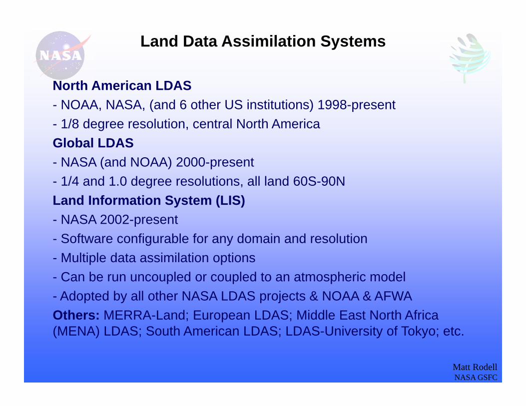
Land Data Assimilation Systems
North American LDAS- NOAA, NASA, (and 6 other US institutions) 1998-present- 1/8 degree resolution, central North AmericaGlobal LDAS- NASA (and NOAA) 2000-present- 1/4 and 1.0 degree resolutions, all land 60S-90NLand Information System (LIS)- NASA 2002-present- Software configurable for any domain and resolution- Multiple data assimilation options- Can be run uncoupled or coupled to an atmospheric model- Adopted by all other NASA LDAS projects & NOAA & AFWAOthers: MERRA-Land; European LDAS; Middle East North Africa (MENA) LDAS; South American LDAS; LDAS-University of Tokyo; etc.

Matt RodellNASA GSFCMatt RodellNASA GSFC
NEWS Grand Challenge: To document and enable improved, observationally-based, predictions of energy and water cycle consequences of Earth system variability and change.
Approach: Unlike most research funding programs, NEWS fosters large team collaborations to solve energy and water cycle challenges that would be difficult or impossible for individual investigations to address on their own.
NASA Energy and Water Cycle Study (NEWS)

Matt RodellNASA GSFCMatt RodellNASA GSFC
Premise: In order to evaluate water and energy cycle consequences of climate change, we must establish the current "state of the global water/energy cycle".
Methods: Use modern, observation-integrating products and associated error-analyses to develop a monthly climatology of W&E cycle components for each continental/oceanic to global scale region. The water and energy cycles are closed through simultaneous application of multiple conservation equation constraints, using concepts from the variational data assimilation and optimal estimation retrieval communities.
Outcomes: (1) A benchmark for W&E cycle / climate change studies and model assessments; (2) Constrained energy flux estimates for quantifying the annual cycle of top of the atmosphere, surface, and atmospheric energy balances; (3) Quantitative graphical depictions of the water and energy cycles; (4) Better understanding of where the greatest uncertainties lie and what observations should be targeted for improvement.
NEWS Water and Energy Cycle Climatology

Matt RodellNASA GSFCMatt RodellNASA GSFC
Water Cycle: Primary Data Sources
Variable Dataset Name Contributing RS Instruments
Precipitation GPCP v. 2.2MERRACMAP
SSMI, SSMIS, GOES-IR, TOVS, AIRS, TRMM
Evapotranspiration PrincetonMERRAGLDAS
AIRS, CERES, MODIS, AVHRR, MSU, HIRS, SSU, AMSU, SSMI, SSMIS, ERS1/2, QuikSCAT, GOES-IR, TOVS, TRMM
Runoff U. WashingtonDai and TrenberthMERRAGLDAS
TRMM, GOES-IR, TOVS, SSM/I, ERS, ATOVS
Terrestrial and Oceanic Water Storage Change
GRACE CSR RL05 (Chambers)
GRACE
Atmospheric Convergence QSCATMERRAPWMC
QuikSCAT, TRMM, GRACE, MSU, HIRS, SSU, AMSU, AIRS, SSMI, ERS1/2, MODIS, GOES-IR
Atmospheric Water Storage Change (Fetzer) AIRS, AMSR-E
Ocean Evaporation SeaFlux v. 1.0PrincetonMERRA
SSMI, AVHRR, AMSR-E, TMI, WindSat

Matt RodellNASA GSFCMatt RodellNASA GSFC
115.7 ±6.3
385.3 ±38.9
409.5 ±35.7
49.5 ±6.8
71.2 ±7.1
42.9 ±8.2
46.7 ±19.1 116.5 ±5.1
403.5 ±22.2
449.5 ±22.2
45.9 ±4.4
70.6 ±5.0
45.8 ±4.4
45.8 ±2.1
Global, Mean Annual Water Cycle
When water balance is enforced, uncertainty decreases
Global mean water fluxes (1,000 km3/yr) at the start of the 21st century Best guess estimates from observations and data integrating models
40
40
386
426
11474
40
Trenberth et al. (2011) for comparison
65.5
391
436.5
45.545.5
111
45.5
Oki and Kanae (2006) for comparison

Matt RodellNASA GSFCMatt RodellNASA GSFC
Continental Mean Annual Water Fluxes
Water budget constrained/optimized results: Precipitation (blue), evapotranspiration (red), runoff (green), and annual amplitude of terrestrial water storage (yellow) in 1,000 km3/yr. Background shows GRACE-based amplitude of the annual cycle of terrestrial water storage (cm).

Matt RodellNASA GSFCMatt RodellNASA GSFC
Wat
er F
lux,
mm
/day
‐1
0
1
2
3Global Land
‐1
0
1
2
3
4 Global Ocean
‐2
‐1
0
1
2
3North America
‐2‐101234567 South America
‐1
0
1
2
3
4Eurasia
‐1
0
1
2
3Africa
‐1
0
1
2
3
4Mainland Australia
‐10123456789
10 Australasian and Indonesian Islands
‐1
0
1Antarctica
Optimized Mean Monthly Water Cycle
Mean monthly precipitation (blue), evapotranspiration (red), runoff (green), atmospheric convergence (orange), and month-to-month change in terrestrial water storage (yellow), in mm/day). Shading indicates uncertainty range.

Matt RodellNASA GSFCMatt RodellNASA GSFC
0
1
2
3
4
5
6Precipitation
0
1
2
3
4
5
6Evaporation
‐3
‐2
‐1
0
1
2
3Atmospheric Convergence
Arctic North PacificSouth Pacific North AtlanticSouth Atlantic Indian
Wat
er F
lux,
mm
/day
Optimized Mean Monthly Water Cycle
Mean monthly precipitation, evaporation, and atmospheric convergence over the major ocean basins: Arctic (blue), North Pacific (red), South Pacific (green), North Atlantic (yellow), South Atlantic (orange), and Indian (pink). Shading indicates uncertainty range.

Matt RodellNASA GSFCMatt RodellNASA GSFC
Expected Closure Error
Best Guess Residual
North America 8.6% 11.0%South America 8.0% 5.0%Eurasia 12.5% 5.1%Africa 8.1% 2.1%Australia Mainland 15.0% 7.6%Australasian and Indonesian Islands
19.5% 12.5%
Antarctica 32.4% 0.0%World Land 10.1% 4.3%World Ocean 13.8% 6.6%
How Well Can We Close the Annual Surface Water Budget?
Expected Error after Optimization6.4%5.7%8.7%5.7%9.4%9.9%
17.2%7.2%7.8%
Note the residual after optimization is ~0% in all cases.

Matt RodellNASA GSFCMatt RodellNASA GSFC
• The NEWS W&E Cycle Climatology Team used observation-integrating products and associated error-analyses to develop a monthly climatology of W&E cycle components for each continental/oceanic to global scale region.
• In most cases the original observation-based water budget residual was within the uncertainty range expected based on individual error estimates.
• An optimization process was applied to force closure of the terrestrial, atmospheric, and oceanic water budgets, and the energy budget simultaneously, at mean annual and monthly, global and continental/basin scales. Adjustments were generally smaller than the expected errors.
• The largest adjustments were in the ocean evaporation estimates (~+10%), attributed mainly to energy cycle closure. Adjustments to ocean precipitation (~+5%) were consistent with GPCP error estimates and recent studies (Behrangi et al., 2012; 2014).
• Despite having denser observing networks, residuals tended to be larger over North America and Eurasia than over Africa and South America. This may reflect continuing difficulty observing and modeling cold land processes.Rodell, M., H.K. Beaudoing, T. L’Ecuyer, W. Olson, J.S. Famiglietti, P.R. Houser, R. Adler, M. Bosilovich, C.A. Clayson, D. Chambers, E. Clark, E. Fetzer, X. Gao, G. Gu, K. Hilburn, G. Huffman, D.P. Lettenmaier, W.T. Liu, F.R. Robertson, C.A. Schlosser, J. Sheffield, and E.F. Wood, 2015: The observed state of the water cycle in the early 21st century, J. Climate, in press, doi:10.1175/JCLI-D-14-00555.1.
The State of the Global Water and Energy Cycles

Matt RodellNASA GSFC
• NASA collects and archives a huge quantity of satellite observational datasets relevant to the water cycle:
Precipitation (TRMM, GPM) Soil moisture (SMAP) Terrestrial water storage changes (GRACE, GRACE-FO) Snow cover (MODIS, VIIRS) River stage (SWOT in 2020) etc.
• NASA also supports data integration research: NLDAS, GLDAS, FEWS-LDAS, etc.MERRA NEWS
• The 2017 Decadal Survey in Earth Science will likely prioritize NASA’s water cycle mission launches for the next ten years
An important area of discussion for this conference
Discussion