nasa-tm-80101 19790020623 a regression ... so (>.. ) upwelled radiance slightly above water...
TRANSCRIPT

1111111111111111111111111111111111111111111111111111111111111111 3 1176 00154 5467
, ,
• '"
NASA Technical Memorandum 80101
NASA-TM-80101 19790020623
A REGRESSION TECHNIQUE FOR EVALUATION AND
QUANTIFICATION FOR WATER QUALITY PARAMETERS
FROM REMOTE SENSING DATA
Charles H. Whitlock and Chin Y. Kuo
May 1979
NI\S/\ National Aeronautics and Space Administration
Langley Research Center Hampton, VIrginia 23665
liBRARY CDPY
111111111111111111111111111111111111111111111 NF00659
https://ntrs.nasa.gov/search.jsp?R=19790020623 2018-06-14T15:10:26+00:00Z

,----------------.,..----- - --~-- - - --- --- -- -- - ~ I 2 T ----- - --- --------
I 1 Rec,p I'nt'. r..atalog ~o --------
1 Report No
NASA TM-80lOl Governrnent Accesslvn No
4 Title and Subtitle 5 Report Date
A Regression Technique for Evaluation and Quantification May 1979 for Water Qual1ty Parameters from Remote Sensing Data ~-6--Pe-rl~0-rm--In-g-O-r-~-n-,z-a-tl-o-n-CO-d-e------~
7 Author(s)
Charles H. Whitlock and *Chin Y. Kuo
g Performing Organization Name and Address
NASA Langley Research Center Hampton, Virginia 23665
12 Sponsoring Agency Name and Address
8 Performing Or~nlzatlon Report No
10 Work Unit No
11 Contract or Grant No
13 Type of Report and Period Covered
Technical Memorandum
National Aeronautics and Space Administration Washington, DC 20546
14 Army Project No
15 Supplementary Notes *Chin Y. Kuo is affiliated with the Department of Civil Engineering, Old Dominion University, Norfolk, Virginia. This paper was presented at the Thirteenth International Symposium on Remote Sensing of the Environment, April 23-27, 1979, Ann Arbor, Michigan.
16 Abstract
Inconsistent results have been obtained from previous experiments whlch have applied linear mUltiple regression techniques to remote-sensing data for quantification of water quality parameters. The objective of this paper is to define optical physics and/or environmental conditions under which the linear multiple regression should be applicable. To achieve this objective, an investigation of the signal-response equations was conducted and the concept was tested by application to actual remotesensing data from a laboratory experiment performed under controlled conditions.
From investigation of field multispectral scanner data from past experiments, it is concluded that instrument noise, ground-truth placement, and time lapse between remote-sensor overpass and water-sample operations are serious barriers to successful use of the technique. Recommendations are made which should aid in obtaining consistent results from future remote-sensing experiments.
17 Key Words (Suggested by Author(s))
Remote Sensing Water Quality Measurement Data Analysis
18 Distribution Statement
Unclassified-Unlimited Subject Category 45
19 Security Classlf (of thiS report) 20 Security Classlf (of thiS page) 21 No of Pages 22 Price"
Unclassified Unclass1fied 15 $4.00
• For sale by the National Technical I nformatlon Service, Springfield, Virginia 22161

A REGRESSION TECHNIQUE FOR EVALUATION AND QUANTIFICATION
FOR WATER QUALITY PARAMETERS FROM REMOTE SENSING DATA
by
Dr. Charles H. Whitlock Marine Environments Branch
NASA Langley Research Center Hampton, Virginia 23665
and
Dr. Chln Y. Kuo Department of Civil Engineering
Old Domlnion University .Norfolk, Vlrginia 23508
ABSTRACT
Inconsistent results have been obtained from previous experlments which have applled linear multipleregression techniques to remote sensipg data for quantification of water quality parameters. The objective of this paper is to define optical physics and/or environmental conditions under which the linear multiple-regression should be applicable. To achieve this objective, an investigation of the signal-response equations 1S conducted and the concept is tested by appllcation to actual remote sensing data from a laboratory experiment performed under controlled conditions.
Investigation of the signal-response equations shows that the exact solution for a number of optical physics conditions is of the same form as a linearized multiple-regression equation, even if nonlinear contributions from surface reflections, atmospheric constituents, or other water pollutants are included. Limitations on achieving this type of solution are defined. Since the exact solution is in the form of a linear multiple-regression equation, applicability of multiple-regression techniques to remote senslng and ground-truth data is viewed as a calibration of the exact solution to account for daily variations in background constituents.
Application to laboratory data is used to demonstrate that the technique is applicable for water mixtures which contain constituents with both linear and nonlinear radiance gradients.
From investigation of field multispectral scanner data from past experiments, it is concluded that instrument noise, ground-truth placement, and time lapse between remote sensor overpass and water sample operations are serious barriers to successful use of the technique. Recommendatfons are made which should aid in obtaining consistent results from future remote sersing experiments.
1

1. INTRODUCTION
Large amounts of sediments and other pollutants ~re carried annually in the rivers, lakes, estuaries, and coastal waters of the United States. These sediments and pollutants are major determinates of water quality. Many agencies are investigating the potential of using remote sensing techniques to monitor various water quality parameters because of the ability of remote sensing to provide synoptic views over large areas.
Specific data needs usually vary among different user organizations (ref. 1). Generally, the desired use of remote sensing data is elther Identlfication or quantification of surface sediments and pollutants. This study is concerned with data analysis procedures for quantification of water quality parameters that have already been identified and are known to exist within the water body. Stecifically, the study deals with the linear multiple-regression technique as a orocedure for defining and calibrating data analysis algorithms for such instruments as spectrometers and multispectral scanners. The technlque has been '1 sed by a number of authors (refs. 2-8) with apparent success. Unfortunately, results have not been completely satisfactory In that (1) analyses of subsets o~ data from the same experiment sometime glve different correlatlons and algorithms (compare refs. 2, 3, and 4); (2) repeat experiments over the same water body do not always allow quantification of the same water quality parameters (compare refs. 7 and 8); (3) optimum results are not always obtained by a multiple-regres$ion equation with radiance as the independent variable (refs. 8 and 9); and (4) final mapped results do not always acree with results of other types of analysis (compare refs. 4 and 10). Prom these facts, it Is clear that a more complete understanding of the limitations, reqUirements, and precision of the linear multiple-regression technique is requlred before it can be applied by user agencies in an operational manner.
In an effort to provide improved scientific underltandins. an analytical and laboratory analysis of the linear multiple-regrellion technique has been conducted (ref. 11). That analysis demonstrated that the technique is funda~entally sound, and, in principle, should apply to many environmental situations in which both the water and atmosphere conta1n linear and nonlinear optical effects. A number of limitations (optical, mathematical, and operational) were defined, however. One problem with the reference 11 analysis 1~ that field results were not considered 1n that study. This investIgation pxtends the reference 11 results to include actual field data. An analytical .' Jestlgation of the Signal response equations is conducted, and results from "~lixed-brew" laboratory experiments are presented. A study of measurement ,,'!'!'o!'s and ground-truth operations from several past field experiments is pl'e::.ented, and recommendations are made concerning future investigations from both aircraft and satellite instruments.
2. SIGNAL-RESPONSE EQUATIONS
From reference 12, reflectance at sea level and upwelled radIance at altitude are related as follows:
where:
L (A) • apparent upwelled radiance at altitude z at wavelensth A. z atmospheriC transmission at wavelength A •
• inherent upwelled reflectance slightly above water surface at wavelength A.
(1)
2

L (>.. ) so upwelled radiance slightly above water surface from 100 percent diffuse reflector at wavelength X.
upwelled radiance from specular reflection of diffuse skylight at wavelength A.
L (>..) a
upwelled radiance from specular reflection of sunlight (sunglitter) at wavelength X.
= upwelled radiance from light scattered by the atmosphere (path radiance) at wavelength X.
For a remote sensing scene with a specific solar elevation angle, the lnherent component of Lz(X) being contributed by the water column is Ta(A)[Lu(X)] as follows:
(2 )
I'lhere'
L (X) = inherent upwelled radiance slightly above water surface at u wavelength A.
A signal response model of the water may be assumed in which the remote sensing signal is expressed as the signal from the background water plus the signal change caused by some pollutant. The change caused by the pollutant may be expressed as a gradient constant times the pollutant concentration. The lnherent slgnal component for a simplified three-constituent water mixture may be assumed as follows:
(4 )
where:
A inherent upwelled radiance component from background water including loss due to atmospheric transmission.
BPA inherent upwelled radiance componen~ caused by pollutant A.
EP B inherent upwelled radiance component caused by pollutant B.
SP c inherent upwelled radiance component caused by pollutant C (assumed vary nonlinearly as power Q).
B,E,S = gradient constants including losses due to atmospheric transmission.
PA,PB,pc=concentrations of pollutants A, B, and C, respectively.
Upwelled radiance components from surface reflection and atmospheric path radiance effects can be expressed as a value for the baseline atmosphere of
to
a particular day plus a change caused by a variatioQ in atmospheric pollutants over the scene as follows:
(5)
where:
3

I surf~ce reflection and path radiance components for the baseline atmosphere over the scene.
LX~ change in surface reflection and path radiance components caused by atmospheric pollution (assumed to vary nonlinearly as power N).
L gradient constant.
XA concentration of atmospheric pollutant XA.
In most remote sensing experiments, upwelled radiance is not measured at a specific wavelength, but instead an integrated average of radiance is measured over a range of wavelengths. To differentiate between wavelength specific and integrated-average values, the term Rad will be used to denote integratedaverage values for apparent upwelled radiance at altitude Z over a range or band of wavelengths. Equation (1) may be rewritten as'
Rad = A + BPA + EPB + SP~ + I + LX~ (6 )
Eq~ation (6) is identical to equation (4-18) in reference 11. If measurements are made with a remote sensing instrument with bands W,X,Y, and Z, then the equatlons for the measured values are:
RadX AX + BxPA + EXPB Q
+ SXPC + Ix + N LXXA
Rad y Ay + ByPA + EyPB + Q SyPC + Iy N
+ LyXA
Rad Z AZ + BZPA + EZPB + Q SZPC + I Z + N
LZXA
where subscripts ranges as bands
W,X,y and Z W,X,y, and Z.
denote values over the same wavelength
(7)
:->;uation (7) is a series of four simultaneous equations which are linear in four Jf.knowns (PA,PB'P~, and X~). If the mathematical operations described in Appendix C of reference 11 are followed, equation (7) can be solved to produce the following solutions for the values of concentration for pollutants A and B.
(8)
The J, J' constants are a function of the A, B, E, S, I, and L constants of the various bands, and the K, K' constants are a fUnction of the B, E, S, and L constants. A key element in arriving at the above solution is that the degree of nonlinearity in the Pc and XA contributions must be essentially
constant over the wavelength range of bands W, X, y, and Z or the changes must be small so that linear approximations are appropriate.
Equations (8) and (9) represent an exact solution for two constituents which have linear radiance gradien~s in a remote sensing scene which
4

(1) contalns a water mlxture wlth three constituents (one of which has a ~onlinear radiance gradlent), and (2) has nonlinear variations in surface reflection and path radiance contrlbutions due to variation in some atmospheric constituent over the scene. While this model is somewhat simple, additional complications can be selectively added. Additional water pollutants (beyond pollutant C) and surface-atmospheric contribution terms can be added to equatlon (6) to compllcate the model. As long as the degree of nonlinearity lS constant over the wavelength range of interest, a series of linear algebraic equations will result and the exact solution for PA and P
E will be of the
same form as equations (8) and (9) except that additional bands of radiance values will be required. A key element of equations (8) and (9) lS that values of PA and PB can be calculated without knowledge of each other or the
values of Pc cr XA. Knowledge of the A, B, E, S, I, and L constants of
equation (7) is requlred, however, to compute values for the J, J', K, and K' constants before Rad values can be used to compute PA and PB.
In actual field experlments, values for the constants A, B, E, S, I, and L are seldom knowr.. In fact, the number of water and atmospherlc parameters WhlCh have a slgniflcant lnfluence on the total upwelled radlance signal lS usually unknown. As a result of thlS situation, empirical methods must be used to determine values for the J, J', K, and K' constants in equations (8) and (9). Fortunately, eq~ations (8) and (9) are of the same form as the statistician's traditional multlple-regresslon equation:
where.
P dependent variable.
independent variable.
P p - I
J + ~ Ki Rad i + £
i = 1
coefficients obtained by least squares fitting techniques.
~ £ = error.
p total number of J, K coefficients.
(10)
In order to evaluate J, K coefficients by empirical methods, certain environmental restrictions must apply. All data used in the fitting process must be from a situation with identical J, K coefficients. This means that values for the A, B, E, S, I, and L constants must be equal for each data pOlnt. This condition is often satisfied if one has a single remote sensing scene with multiple ground-truth points, and atmospheric transmission values do not vary by a large amount over the scene. (Surface reflections and path radiance are allowed to vary.) Values for the J, K coefficients generally will not be equal for each data point if one has the situation of multiple remote-8ensing scenes with a data point in each. In that case, each scene has a different solar elevation angle and atmospheric condition which causes different values for T (A), L (A), L deAl, L (A), and L (A) in equation (1). a so r rs a This means that the A, E, E, S, I, and L constants in equations (6) and (7) will be different for each data point. Since A, E, E, S, I, and L determine values for the J, K coefficients, the J, K coefficients will be different for each data point. In such a case, it is impdssible to obtain an accurate estimate of the J, K coefficients if radiance and ground-truth concentration values used in the least-squares m~ltiple-regression process are from different
5

~e~ote sensing scenes. This partly explains why linearized multiple regression with radiance as the independent variable failed to give a good data-reduction ~lgorithm in reference 9. In that experiment, the operatlonal technique was ~ultiple overpasses with a single ground-truth point in each scene.
3. LEAST-SQUARES AND STATISTICAL METHODS
Estimation of J, K Coefficients
The regression task is to estimate the J, K coefficients in which Rad is assumed as the independent variable. In many observations, the independe~t variables are correlated with each other as well as with the dependent variable wnich makes results difficult to interpret (ref. 13, p. 398). For the remote sc-nsing situation, high correlations between the independent variables (Rad i ) ~r0uld be expected if the pollutant of interest has a broad spectral signal over t~e wavelength range.
As noted previously, least-squares procedures are used to estimate the J, K coefficients using a number of ground-truth pOints where radiance-constituent concentration data pairs are available. Details of the least-squares procedure a~e summarized in reference 11. In performing the process on remote sensing a~ta, three major assumptions are involved (ref. 14). They are:
1. The correct form of the equation has been chosen (Radi is linear with concentration for all bands involved).
2. The data are representative of the whole range of environmental combinations in the remote sensing scene.
3. The observations of the dependent variables (ground-truth concentration values) are uncorrelated and statistically independent.
Three minor assumptions are
1. All observations of the dependent variable (concentration) have the same (but unknown) variance, 0 2 .
2 The distribution of uncontrolled error is normal.
3. All independent variables (Rad i values) are known without error.
)ne problem is that measurements of the independent variable (Rad i ) do contain prrors. Reference 14 indicates that errors in the independent variable cause estimates of the J, K coefficients to be biased. As a rule-of-thumb, it is recommended that remote sensing experiments be designed such that the variance of radiance about mean values for the ground truth locations (o~ d ) be at least
2 a i 10 times the variance of data noise (ON). This rule-of-thumb may be referred
to as Daniel's Criteria (see ref. 11). iIn terms of standard deviation values:
or
> 3.16 oN i •
(11)
(12)
Equation (12) states that ground-truth locations should be selected within the remote sensing scene in such a manner that the standard deviation of the change
6

in upwelled radiance for the ground-truth pOints should be at least 3.16 times the standard deviation of data noise for the particular remote sensing instrument being used if least-squares procedures are to be used in the analysis of data.
Measures of Precision
Before an experiment, it is not known how many bands (or in what combination) wlll be required to separate the desired water-quality parameter from the total mix of factors which contribute to apparent upwelled radiance. The usual process is one of first calculating a regression equation for the best single band of radiance data and then successively defining multiple-regression equatlons for the best two bands, three bands, etc. As additional bands are utllized, a number of statlstlcal parameters may be used as indicators of the precision of each new multlple-regression equation. A number of factors must be considered when vlewing these parameters to select an optimum multipleregression equation
One popular statistical parameter used as a measure of precision is the correlation coefflclent, r. The proportion of total varlation that lS not explained by the regression equatlon is 1 - r2. (An r value equal 0.9 means that 19 percent of the slgnal variation is not explained by the multipleregress~on equation.) Reference 15 states that r 1s not a good measure of precision as the number of estimated coefficients approach the number of experimental observations. This implies that either the number of ground-truth observations should exceed the number of instrument bands by a wide margin or the number of bands included in the multiple-regression equation should be llmited.
The standard deviation, 0, lS a second measure of precision of the leastsquares process for estimating J, K coefficients. The standard deviation is assumed to represent a value within which 68 percent of all errors are expected to fall if (1) there lS an inflnite number of observations, and (2) there is mlnimal error in the independent variables (Rad i ). Unfortunately, most remote sensing experiments have only a limited number of ground-truth observations and Rad i measurements do contain errors.
The F-test is a thlrd method of evaluating the adequacy of the leastsquares process. The calculated value of F (see eq. (5-14) in ref. 11) must be greater than a critical value (Fer) taken from F-distribution tables in order to be Judged signiflcant. If the multiple-regression equation is to be used for predictlve purposes, calculated F should be at least 4 times the tabular critical F value (ref. 15). One problem with this parameter is that a level of confidence must be arbitrarlly selected before FIFcr can be calculated.
Reference 14 recommends the statistic, Cp ' as a measure of the sum of the squared biases plus the sum of the squared random errors (see eq. (5-17) in ref. 11). Given a multiple-regression equation with p estimated J, K coefficients, a low value of C in combination with a C Ip ratio < 1.0 is considered to indicate a good f~t with negligible bias. T~e regression equation should then be useful for predictive purposes. The Cp/p ratio is the only one of the above parameters which is indicative of bias in the fitted equation (ref. 14)
For future remote sensing experiments, it is recommended that multipleregression equations be computed for all combinations of bands for which upwelled radiance values are available. Values for r, 0, FIFcr ' Cp ' and Cp/p
should be computed for each equation. The prime basis for selecting an "optimum" regression equation should be Cp/p < 1.0 for minimum bias and FIFcr > 4.0 for predictive utilization., Values for r should approach 1 and 0
7

srould approach zero. Danlel's Criteria (eq. 12)) should also be satisfied for all bands in the regression equatlon. When all five condltions are met, the multiple regression equation wlth the minimum number of bands should be selected for calculation of pollutant concentration.
4. LABORATORY VALIDATION EXPERIMENTS
It is desirable to validate data analysis techniques with actual remote sensing data under controlled conditions. To achieve thlS result, tests were conducted with filtered-deionized tapwater in the Marine Upwelled Spectral Signature Laboratory at the NASA Langley Research Center. A sketch of the laboratory setup is shown in flgure 1. (More complete descriptions of the system and test procedures can be found ln references 11 and 16.) Only partial results from one series of tests will be presented in this paper for reasons of brevlty Additlonal laboratory test cases are presented in reference 11.
It was desirable to test the multiple-regression technique with data from water mixtures which contalned constltuents with both Ilnear and nonllnear radiance gradients. Single-constituent tests were conducted on a number of ~aterials. From these data, It was concluded that both Ball Clay and Feldspar s~lls have near linear radlance gradients for concentrations between 4 and 173 Dp~. Rhodamine WT dye has a nonlinear gradient for concentrations between 17 ayd 1052 ppb. With this knowledge, a series of three-constituent tests were co~ducted with 25 different water mixtures. Table I shows the concentrations of Ball Clay, Feldspar, and Rhodamine WT that were present ln the filtereddeio~ized tapwater for each test. ~lso shown are radiance values for the following 5 wavelength bands:
Band Number
1
2
3 4
5
Wavelength Range (nm)
340-500 460-620
540-700
620-780
700-860
Center Wavelength (nm)
420
540
620
700
780
The radiance values shown are in terms of relative units obtained by dividing ruwdr/bandwidth measurements over the water by gray-card diffuse reflectance reasurements of the input light source.
A multiple-regression analysis was performed for Ball Clay using 12 of the ~~ tests ln table I to simulate "ground-truth" values. The 12 "ground-truth" values were tests 1, 3, 5, 6, 8, 10, 13, 15, 18, 20, 21, and 23. The standard jc-vlation of the change in upwelled radiance was next calculated for each band !or this "ground-truth" data set. Values are compared with data noise from the laboratory measurements as follows:
Band Number
1
2
3 4
5
ORad
0.1372
0.1125
0.1414
0.1431
0.0992
oN (Ref. 11)
oRad/ON
0.0343 4.00
0.0343 3.23
0.0343 4.12
0.0343 4.17
0.0343 2.89
These figures indicate that Daniel's Criteria (~q. (12)) is satisfied for all bands except number 5. Since the signal-to-noise standard deviation ratio
8
for band 5 is only slightly below the value of 3.16, it was decided not to exclude that band from the regression analysis in this particular case. Regression equations for all combinations of bands we~e next calculated for Ball Clay concentration. Estimated values of the J, K coefficients and various statistical measures of precision are shown in table II. Review of table II lndicates that the lowest value of total squared error (Co) is obtained for band combinations 2, 3, and 4. The regression equation for th~s combination is:
(13)
Statistical estimates of precision for this equation are:
r = 0.99
a = 6.8 ~pm
(F/Fcr ).95 = 105.7
C 3.0 p
Cp/p 0.8 .
Since values for r, 0, F/Fcr ' and Cp/p are acceptable, it is assumed that
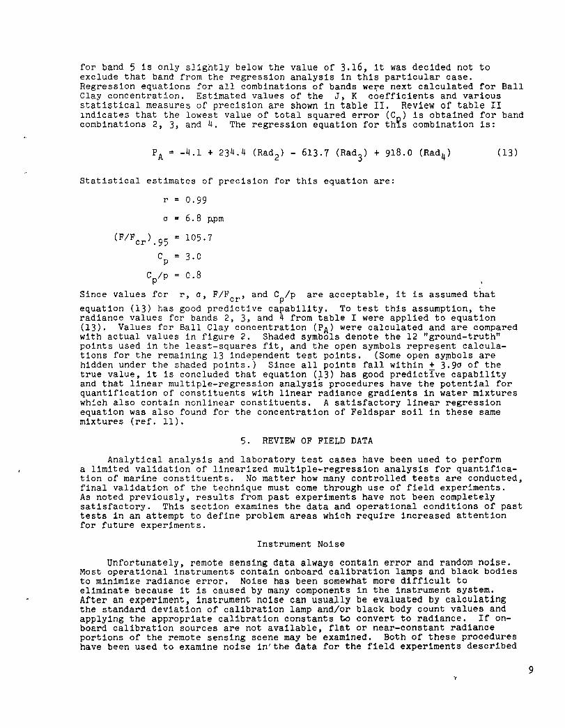
equation (13) has good predictive capability. To test this assumption, the radiance values for bands 2, 3, and 4 from table I were applied to equation (13). Values for Ball Clay concentration (PA) were calculated and are compared with actual values in figure 2. Shaded symbols denote the 12 "ground-truth" points used in the least-squares fit, and the open symbols represent calculations for the remaining 13 independent test points. (Some open sy~bols are hidden under the shaded points.) Since all points fall within + 3.90 of the true value, it is concluded that equation (13) has good predictIve capability and that linear multiple-regression analysis procedures have the potential for quantification of constituents with linear radiance gradients in water mixtures which also contain nonlinear constituents. A satisfactory linear regression equation was also found for the concentration of Feldspar soil in these same mixtures (ref. 11).
5. REVIEW OF FIELD DATA
Analytical analysis and laboratory test cases have been used to perform a limited validation of linearized multiple-regression analysis for quantification of marine constituents. No matter how many controlled tests are conducted, final validation of the technique must come through use of field experiments. As noted previously, results from past experiments have not been completely satisfactory. This section examines the data and operational conditions of past tests in an attempt to define problem areas which require increased attention for future experiments.
Instrument Noise
Unfortunately, remote sensing data always contain error and random noise. Most operational instruments contain onboard calibrat~on lamps and black bodies to minimize radiance error. Noise has been somewhat more difficult to eliminate because it is caused by many components in the instrument system. After an experiment, instrument noise can usually be evaluated by calculating the standard deviation of calibration lamp and/or black body count values and applying the appropriate calibration constants to convert to radiance. If onboard calibration sources are not available, flat or near-constant radiance portions of the remote sensing scene may be examined. Both of these procedures have been used to examine noise in'the data for the field experiments described
9

In references 4, 5, 6, and 9. F1gure 3 presents estimates of noise standard dev1atlon values for each band for which data were obtained. These data 1nctlcate that a wide range of noise values have been observed in previous exper1ments.
The problem of data noise has been widely recognized, and pixel averaging is often employed as a method of reducing the error. To illustrate the effects of thlS process, cal1brat1on lamp values from the reference 4 data were ~veraged 1n a manner to simulate p1xel averaging. New values for noise standard dev1ation were calculated and are compared with slngle-pixel values in fi~ure 4. Large reductions in instrument noise may be achieved by averaging even small size (4 by 4 or less) pixel arrays. Use of array sizes larger than 7 oy 7 prodllced only small reductions in n01se for the reference 4 data set.
P:xel a'leraging effectively 1ncreases the size of the ground resolution eLe~e~t that JJ observed by the remote sens1ng 1nstrument. If the array Slze oeco~es too large, average radiance values of the enlarged p1xels may not be representative of ground-truth values because of spacial variability in pollutant ccnce~trat1on. As p1xels are averaged, noise error will be reduced but new error is :ntroduced because of scene dynam1cs or hydraul1c changes. Carr1ed to ey~reme, ~ljdraulic features that depict smaller-scale pollutant transport may be erased by the averag1ng process. If averaging is necessary, then the followl~~ crlter:a 0houJd be used to establ1sh cred1bility of the enlarged pixel rddldnce valJes.
where
When
S2ene nojse
(14) nxn
= nxn
standard deviation of enlarged pixel about average radiance value (calculated from individual pixel radiances within n by n array surrounding each ground truth point).
[ORad tJ nxn is much larger than [ON Jnxn' dynamlbs have introduced large errors into the reduction benefits gained by pixel averaging.
Ground Truth Placement
one has an indication that
process that offset the
Previous discussion has indicated that ground-truth points should be located within the remote sensing bcene in such a manner that Daniel's Criteria Ceq. 12) are satisfied for all bands in the regression equation. To review this aspect of previous exper1ments, values of oRad have been calculated using r~diance values over each set of ground-truth points for the field experiments of references 4, 5, 6, and 9. Pixel averaging had been employed to eliminate signal changes caused by the ground-truth boat, time differences and location uncertainty as well as to reduce noise in each data set. New estimates of ON have been made from calibration lamp or background water data to simUlate the pixel averaging process for each experiment. Values of ORad/ON have been co~puted and are compared with Daniel's Criteria in figure 5. It appears that ground-truth placement was adequate such that Daniel's Criteria were satisfied after pixel averaging for most experiments. ApprOXimate calculations indicate that not a single one of these experiments would satisfy Daniel's Criteria on a 1 by 1 pixel array basis, however. Ground-truth locations for future remote sensing experiments should be selected in such a manner that ORad has the largest possible value to minimize the requirem~nt for pixel averaging. Use of past remote sensing images of the area to estimate relative radiance differences between proposed locations is pro9ably the best method of selectiDg a distribution with maX1mum standard deviation.
10

Physical Consistency
An unwritten assumption in the multiple-regression process is that all data used in the correlation are "good" without physical deficiencies. When remotely mon1toring water-quality parameters, this generally means that a number of cr1-ter1a should be sat1sfied concern1ng both environmental conditions and physical operations of the experiment. Only limited d1Scussion justifying physical conslstency of the data 15 available in references 4 through 9. For that reason, the re~ainder of this review w1ll discuss best engineering practice with the exper1ence from past exper1ments described for only those items d1scussed in the llterature.
Relative to environmental criteria, two desirable conditions are:
1. Water depth greater than the Secchi depth.
2. Constant vertical concentration gradient within the remote sensing penetration depth (the depth above which 90 percent of the upwelled radiance orig1nates, ref. 17).
It is somet1mes assumed .that the maximum remote sensing penetration depth is the same as the Secch1 depth. Calculations in reference 18 as well as unpublished data from the James R1ver 1n Virg1nia indicate that maximum remote sensing penetrat10n depth may be on the order of 20 to 50 percent of Secchi depth, , dependlng on absorption and scattering characteristics of the mixture. Knowledge of the maximum remote sensing penetration depth is required so that water samples are not obtained be~ow the zone that is causing the remotely-sensed slgnal. One method to estimate the maximum remote sensing penetration depth is that of lowering a flat black plate with less than 1 percent diffuse reflectance 1nto the water and not1ng 1tS depth of disappearance (see figs. 6 and 7 in ref. 18).
In terms of operational criteria, a major problem is the time lapse between overpass of the remote sensor and collection of individual water samples. Tlme lapse can cause the ground-truth data to be hydraulically inappropriate if there are significant wind or t1dal influences on the water body being observed. It may be possible to correct ground-truth data to account for small time lapses (ref. 19), but such procedures have not yet been widely demonstrated 1n field experiments. In pr1ncipal, all data should be synchronous with the remote sensor overpass, but that has not been achieved in past experiments, as shown below
Reference
4
5
6 7 8
9
Geographical Area
James R1ver in Virginia
New Jersey Coast
New York Bight
Saginaw Bay in Michigan
Saginaw Bay in M1chigan Delaware Shelf
Number of Ground Maximum Time Lapse Truth Points in Between Water Regression Analysis Sampling and Remote
Sensor Overpass
21 2.0 hrs
22 3.0 hrs
10 0.3 hr
27 8.0 hrs
16 8.0 hrs
7 0.5 hr
Some experiments have a small time lapse, but in other cases it has been assumed that constituents in a water pixel remain constant for 2 to 8 hours. Consider1ng that algae tend to migrate depthwise with changing light intensity (solar elevation angle), large time lapses should be justified with quantitative water sample data even when wind and tidal effects are such that flow conditions are stable.
11

In the operational area, another major problem is often encountered. Large-scale experlments wlth multlple vessels often require elther some water sample analysis cnboard ship or laboratory analysis of the same parameter by different organizations. Conslstency of laboratory results between dlfferent laboratories lS a longstanding problem, and varlations for certain parameters may be larger than that of the remote sensing scene. It is recommended that future experiments maintain consistent handling and laboratory analysis procedures.
6. SUMMARY OF RECOMMENDED CONDITIONS FOR TECHNIQUE APPLICATION
An investigation of the linear multiple-regression technique with remotely sensed radiance as the independent variable has been conducted. Signal response equations have been analyzed, and results from "mixed brew" laboratory tests are presented. Results from these studles indicate that the technique is fundamentally sound and should apply in many environmental situations In WhlCh both the water and atmosphere conta1n llnear and nonlinear optical effects. Conditions WhlCh limlt applicat10n of the technique have also been dlscussed. A review of prevlous field experiments has served to emphasize addltional llmitations which must be considered 1n future experiments. A summary of recommended cond1tions for use of the technique 1S given in figure 6. From thlS llsting, it is clear that the linearlzed multlple-regression analysis should never be applied blindly to a set of data wlthout background knowledge concernlng the constltuent of interest, hydraulics of the water body, typlcal Secchl and maXlmum remote senslng penetration depth values, and measurement uncertainties from various sources. The technique has strong theoretical foundatlon and careful appllcation should yield useful results. It is particularly appropriate for use in small regions to validate elther mathematical or hydraulic models of pollutant transport and diffusion fresent economics for obtaining multiple ground-truth pOlnts wlthin a single remote senslng scene llmit its usefulness for many routlne monitoring mlssions, however.
7. CONCLUDING REMARKS
The study described hereln is part of a continuing effort to define datareduction technlques and thelr appropriate application so that increased benefits can be derived from both aircraft and satellite remote sensing data. The goal of the present study was a more complete understanding of limltations, requirements, and precision of the linear multlple-regression technique with rad1ance as the independent variable. Environmental and optical physics condltions have been deflned for which an exact solution to the slgnal response equat10ns 1S of the same mathematical form as the statistician's tradltional multiple-regress1on equation. In such a case, use of linear1zed multiple regression is merely an empirical correlation to obtain coefficients for the exact solution to the signal-response equations. Add1tlonal analytlcal invest1-gations are desirable to more completely deflne atmospheric limitations and to consider the problem of bottom reflection in optically shallow waters.
One problem with use of the regression technique is that the independent variables (upwelled radiances) conta1n errors and are often correlated with each other. This requires consideration of a number of statistical parameters when performing the regression analysis.
Review of past field experiments indicates that data noise was of such magnitude that data smoothing was required before Daniel's Criteria could be satisfied for the least-squares multiple-regression process. Improved selection of ground-truth locations to maximize varlance is recommended to minimize data smoothing requirements and the physical errors associated with that process.
Time lapse between remote sensor overpass and water sample collection appears to have been a problem in past experiments. Economic consideration will always result in only a limited number of water,samples obtained synchronously w1th the remote sensor overpass. Additional studies to develop and demonstrate techniques for correcting nonsynchronous data for remote sensing use are desirable.
12

ACKNOWLEDGMENT
The authors are indebted to Mr. Stuart R. LeCroy of the Vought Corporation for computer programmlng support and the handling of computer compatible tapes for extractlon of data nOlse statlstlcS.
REFERENCES
1. Kuo, Chin Y., and Cheng, Robert Y. K .. Laboratory Requirements for In-Situ and Remote Sensing of Suspended Material. NASA CR-145263, ]976.
2. Johnson, Robert W Quantltative Suspended Sediment Mapping Using Aircraft Remotely Sensed Multispectral Data. NASA Earth Resources Survey Symposium, vol. I-C Land Use-Marine Resources, NASA TM X-58l68, 1975, pp. 2087-2098.
3. Johnson, Robert W Appllcation of Alrcraft Multispectral Scanners to Quantltatlve Analysis and Mapping of Water Quallty Parameters in the James River, Virglnia. COSPAR Space Research, vol. XVII, M. J. Rycroft and A C. Strickland, eds., Pergamon Press, Inc., 1977, pp. 25-31.
4. Johnson, Robert W., and Bain, Gilbert S.· Quantitative Analysis of Aircraft Multispectral-Scanner Data and Mapping of Water-Quality Parameters in the James Rlver in Vlrginla. NASA TP-I021, 1977.
5. Johnson, Robert W. Mapping the Hudson River Plume and an Acid Waste Plume by Remote Sensing in ~e New York Bight Apex. Results from the National Aeronautics and Space Administration Remote Sensing Experiments in the New York Blght - April 7-17, 1975. J. B. Hall and A. O. Pearson, eds., NASA TM X-74032, 1977.
6. Johnson, R. W., Duedall, I. W., Glasgow, R. M.; Proni, J. R.; and Nelsen, T. A.. Quantitatlve Mapping of Suspended Solids in Wastewater Sludge Plumes in the New York Bight Apex. J. Water Pollut. Control Fed., vol. 49, no. 10, Oct. 1977, pp. 2063-2073.
7. Rogers, R. H., Shah, N. J., McKeon, J. B.; Wilson, C., Reed, L.; Smith, V. Elliott, and Thomas, Nelson A.: Application of Landsat to the Surveillance and Control of Eutrophication in Saginaw Bay. Proceedings of the Tenth International Symposium on Remote Sensing of Environment, vol. I, Envlron. Res. Inst. of Michigan, Oct. 1975, pp. 437-446.
8. Rogers, R. H.; Shah, N. J., McKeon, J. B.; and Smith, V. E.: Computer Mapping of Water Quallty in Saglnaw Bay with LANDSAT Digital Data. Proceedlngs of the ACSM-ASP Convention, Washington, D.C., February 1976.
9. Ohlhorst, C. W. Quantitative Mapping by Remote Sensing of an Ocean AcidWaste Dump. NASA-TP 1275, 1978.
10. Bressette, Walter E.' Aerial Photographic Water Color Variations from Pollution in the James River. Proceedings of the ACSM-ASP 1978 Fall Convention, Albuquerque, New Mexico, October 1978.
11. Whitlock, Charles H.: Fundamental Analysis of the Linear Multiple Regression Technique for Quantification of Water Quality Parameters from Remote Sensing Data. NASA TM X-74600, 1977.
12. Miller, J. R.; Jain, S. C.; O'Neill, N. T.; McNeil, W. R.; and Thomson, K.P.B.: Interpretation of Airborne Spectral Reflectance Measurements OVer Georgian Bay. Remote Sensing of Environment. vol. 6, no. 3, 1977, pp. 183-200.
13

13 Snedecor, G. W., and Cochran, W. G.: Statistical Methods. Slxth ed., The Iowa State Universlty Press, 1967
14. Daniel, C.; and Wood, F. S.· Fltting Equations to Data. Wiley-Interscience, 1971.
15. Draper, N. R., and Smlth, H. and Sons, 1966.
Applied Regression Analysis. John Wiley
16. Whitlock, Charles H., Usry, J W.; Witte, William G.; and Gurganus, E. A.: Laboratory Measurements of Upwelled Radiance and Reflectance Spectra of Calvert, Ball, Jordan, and Feldspar Soil Sediments. NASA TP-1039, 1977.
17. Gordon, HR.; and McCluney, W R .. Estimation of the Depth of Sunlight Penetration in the Sea for Remote Sensing. vol. 14, no. 2, February 1975, pp. 413-416.
18. McCluney, W. R.. Estlmatlon of Sunllght Penetration in the Sea for Remote Sensing. NASA TMX-70643, 1974.
19. Kuo, C. Y. ; and Blalr, C. H. Ratlonal Method for Correcting Sea Truth of Suspended Sediment Concentration Related to Remote Sensing. Old Dominion University Technical Report 76-C2, 1976.
Test IIIICIIr ,...., ......... ~ IMz .., .... .., - .' .' ., I • II ,. ..... ,. .. .. U" 0.1111 , • U - .. a un 'Ie ura a.azr , , JI ,. 1.1111 1.1111 .. fir 0. lilt am • 17 JI JI 1.121 .. ,Z1 ilia leIlI 0.011 , , JI lOll 0. OM 0.1111 .. ,., .. crl I.GZt
• I' JI I. I.CI!I II .. .. 1M .. ott 1011 I 17 JI III .. II. ...,. "'" .. 1111 ..00 I I' sz III .... III. ...., ..... ... ,
" 52 '15 .. lilt .... ... 11 .. 110 o.a
10 R R 515 .. m .... a.m 0.170 0.011 11 II R ItIIl ... .. illS 0. ItS 0.111 o.OM IZ R R ItIIl .. m ... " UIZ 0.151 0.011 n I1J I2t JI I.a ... 11 Ull o.lIa 0.110 II I1J I2t III 0.. UII 1.11' .. ,. 0.251
" R lit 5)1 o.m u» "D .. III o.u • I. lit I2t 515 0. lit U!] uJt 0. !It 0. ZIG II I1J I2t 515 alit 0. JIll ,. I. ... 0.251 II R lit 11112 0.1# ... " UIII .. ,. I."" It lit I2t ItIIl 0.. un a.155 a.1I) lI. zo 11J I2t IIISl U .. ..., 0.111 .... .. 251 II 17' 17) JI I.. ..... ..'" ". ... II II) I7J I. .... .. " .. . .... ... a In 17) f. 0._ am ..... .. ., ... It I2t I7J .. I.. 0.115 0. ••
~= t: If I7J 17) IIiI ... '110 ... Table 1. - Concentration and radiance data for three-constituent tests.
1IndIu.. J ., Kz ., r. Is • Mer'" e, ell I -III .rt 0. I. .. ,
.. " al UI "' .,
I -"I .. BU' a. .. .. ... It. • tI I ... ... J ~. 0. .. •• .. .. ... 177 ... " Zli • -'lI , .. .. ... .. .... IU 12.. II. 111 , -15.5 a. .. .. a. MI5 .. " LI I'::t
l Lt U -a., .nll -111.1' a. .. 0. .. " a, Ill. •• IJ ofZ.O 116.7. I. "'. .. .. I.. 17.1 ZLI ,.. III L' -)I 5 UILIII I. a. "' . .. .... ILl ... 1 It. lJ LJ -1z.J "" . a. 0. a. a,. 0." ... 101.1 l Lt I.J .,." I. .. " .... .. .. ... 11.1 I ... " 1&1 I.' -,." .. ... .. III. • a. .. " III •• II. .. , U -Ill .. -,.,. a. ,
I •• '" 1.1 n. I. I.' U -tU I. a. -III.. M" a. .... 111 ,.,. a lZ 15 -z.J , , -IM.JI a. 91115 a." 1I I .... I. La U -11.1 , a; I. 1.11 III" '" II a. I. U U, .... 111.. -10115 ilL. , .. ,. IU IU ,.. 11.1 I.l.I -nl n. 'L. , &,. 0. 0. .. u., .. , a 1.0 LU -\11 -a. II 'UI a. , m ... " u ., I La LU ..... IlL. 0. -.- ,. . .. It. 11.. •• lZ. 11 115 Lt .. II , -mu .. am. a." " al I. u LU -, -m. a. 0. .. II I ... ,,, II a • So 1.1 I.U .... 1 .. ZJI.., ..altS .... .. .. " ... .1 I. II 1.1, -I.I .. -H.. -111.11 0. tlI.I' 0." " "" I .. I 1.4., 4.1 , ... n 0. -lOt" 'Ill' a." ... ,.., , z.z' U5 -, 0. 0. -m_ •• m .• '" II ft.1 .. LI LU' 4., .,... • " .... II .... ,. It, I.l IL. I. LI Un I.. -a"
•• R __ a. 11IL" .. " I.J ... I. LI
Ll.4' 4.2 -111.11 "'IJ a. _D \ZIf.n a." 'I "I I. LI U4' lo' -l1li.77 a. -1&11 -tln uu. '" ... .. I I • lo' 1.14.' .,.1 , Itl.R .... 1IL2I a..11 '" 1,1 .. I .. L • LU4t ... ..... IlL ....... .... u. ... " 1.1 ... .. LI
Table II. - Estimates of J, K coefficients and measures of precision for Ball Clay seaiment in three-constituent mixtures. 14

lAND II\MIBEI
o 1 D 2 o ,
SCllAII SIMIlATOII '" . "'II ,
Figure 1. - Laboratory setup.
240 o INDEPENDENT POINTS /
200 • POINTS USED IN FIT ,/ ,/
,/
160
120 CALCUlATED BALL
ClAY CONCENTRATION. 80 ppm /
,/ ,/
,/
//. L
40 / e,// /
o ,/ /
,/
,/
,/
,/ ,/
,/
,/ ,/
-40 0 40 80 120 160 200 ACTUAL BALL ClAY CONCENTRATION. ppm
Figure 2. - Comparison of calculated and actual Ball Clay concentrations for three-constituent mixture tests.
.ammg INSTRUMOO o. MOOIlAI MUlTISPECTRAL SCANNEll D' OCEAN COlOR SCANNER o 6 MODUlAR MULTISPECTRAL SCANNER -A' MODUlAR MUlTlS PECTRAL SCANNER
PllCELARMY SIZE 1 x 1 1 x 1 1 x 1 1 x 1
SlI5 7X1 PIXEL AlUlA Y SIZE
Q 6 o 7 o • CI 9 o 10
Ij)c' UX11
Figure 4. - Effects of pixel a~raging for reference 4 data.
PIXEL AVERAGl AIRAYSIZE
llICll 11 xli 7x 7 ])( .
.".,.,.,..,.,.,..,~r:m$7,-m.m,",m,",., 11M 18. 'S CIIltIIA
0,1. a ,m @ rtIo i!o fl. nm
FOR LfAST-50UARlS PIOCESSING
Figure 5. - Signal to noise standard ,deviation ratio for several field experiments.
.... 1IUIH
........ ~ • C,"S LO • FIFC1'2 u • .·0 , • r-LO • .,..-u.pI ......... IIIIII[
Figure 6. - Recommended conditions for'use of linear m~ltiple-regression
Figure 3. - Estimated standar~ deviation (technique with radiance as the of data noise for several field' e~periments·lindependent varlabie.
15

End of Document