nasa’s airborne science program supporting earth observing ... · nasa’s airborne science...
TRANSCRIPT
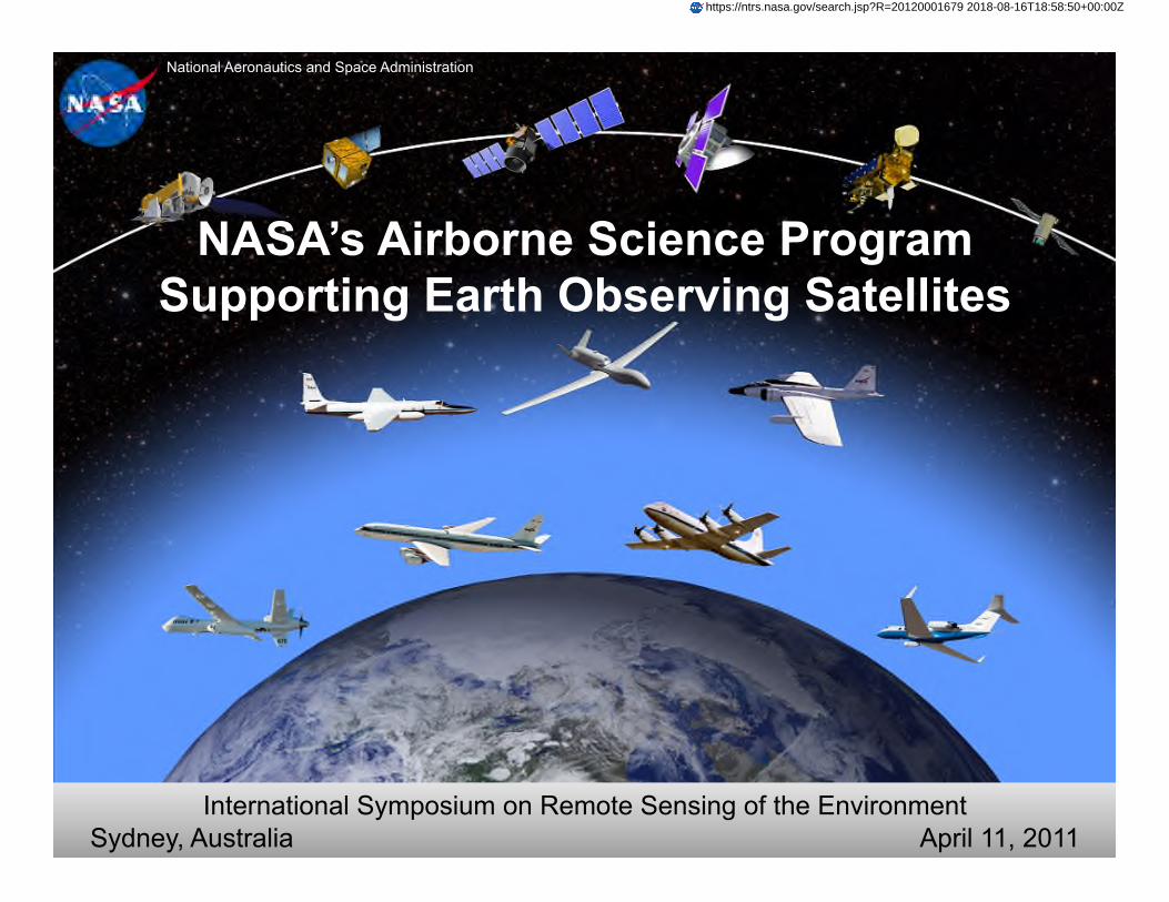
National Aeronautics and Space Administration
NASA’s Airborne Science Program Supporting Earth Observing Satellites
International Symposium on Remote Sensing of the Environment Sydney, Australia April 11, 2011
https://ntrs.nasa.gov/search.jsp?R=20120001679 2018-08-16T18:58:50+00:00Z
2011 ISRSE Outline April 11, 2011
• Presenter • Randy Albertson, Airborne Science Program Deputy Director
• Co-Authors: • Dr. Steve Volz and Bruce Tagg, NASA HQ’s • Matthew Fladeland, NASA ARC • Dr. Susan Schoenung, Longitude 122 West
• Program Objectives and Capabilities
• NASA’s Earth Observing Satellites
• How Airborne Science is Supporting NASA’s EOS
• Closing

Program Objectives Satellite Calibration and Validation Provide platforms to enable essential calibration
measurements for the Earth observing satellites, and the validation of data retrieval algorithms.
Support New Sensor Development Provide atmospheric flight opportunities to test and
refine new instrument technologies/algorithms, and reduce risk prior to committing sensors for launch into space.
Process Studies Obtain high-resolution temporal and spatial
measurements of complex local processes, which can be coupled to global satellite observations for a better understanding of the complete Earth system.
Development of Next-Generation Scientists and Engineers
Foster the development of our future workforce with the hands-on involvement of graduate students, and young scientists/engineers in all aspects of ongoing Earth science investigations.
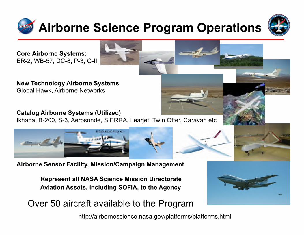
Airborne Science Program Operations
Core Airborne Systems: ER-2, WB-57, DC-8, P-3, G-III
New Technology Airborne Systems Global Hawk, Airborne Networks
Catalog Airborne Systems (Utilized) Ikhana, B-200, S-3, Aerosonde, SIERRA, Learjet, Twin Otter, Caravan etc
Airborne Sensor Facility, Mission/Campaign Management
Represent all NASA Science Mission Directorate Aviation Assets, including SOFIA, to the Agency
Over 50 aircraft available to the Program http://airbornescience.nasa.gov/platforms/platforms.html
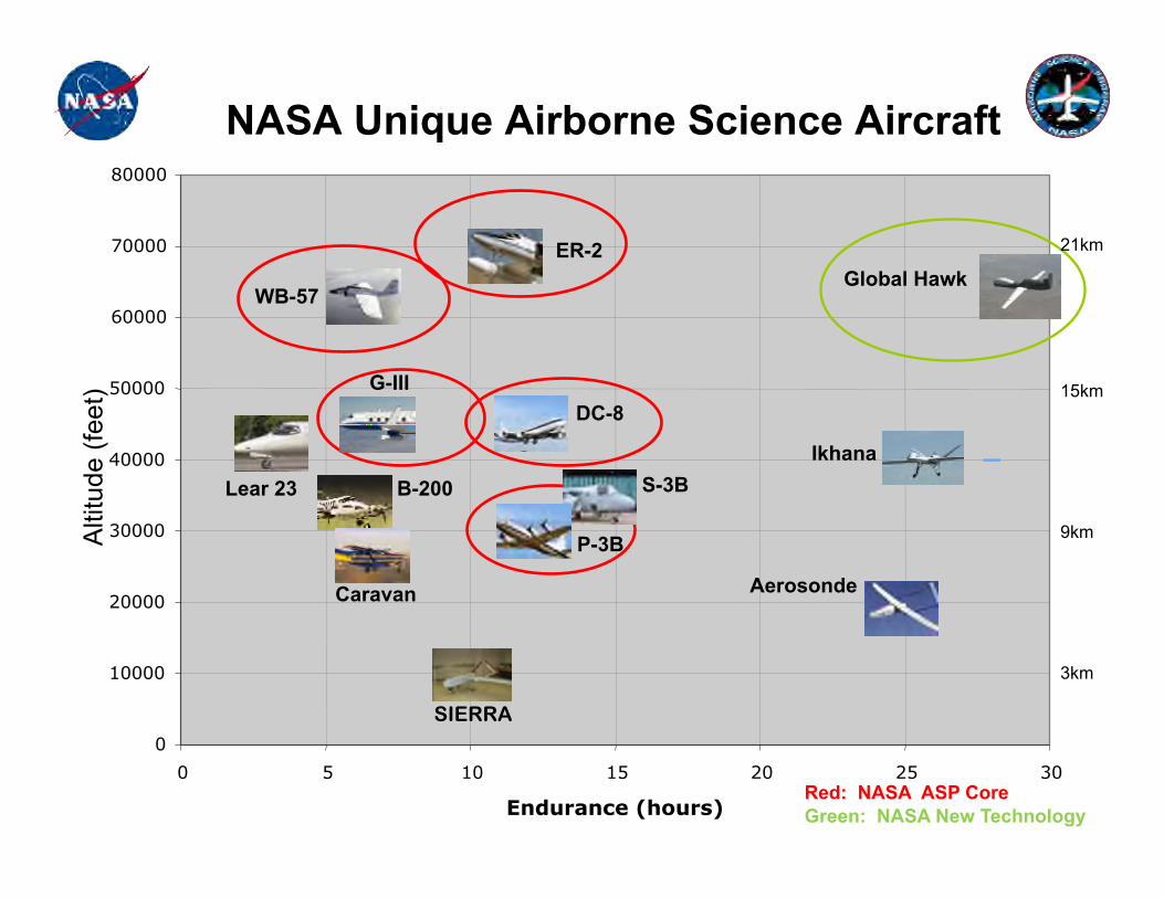
0
10000
20000
30000
40000
50000
NASA Unique Airborne Science Aircraft
SIERRA
Red: NASA ASP Core Green: NASA New Technology
Alti
tude
(fee
t)
60000
70000
80000
0 5 10 15 20 25 30 Endurance (hours)
ER-2
WB-57
S-3B B-200
DC-8
P-3B
Lear 23
Caravan
Ikhana
Global Hawk
Aerosonde
G-III
21km
15km
9km
3km
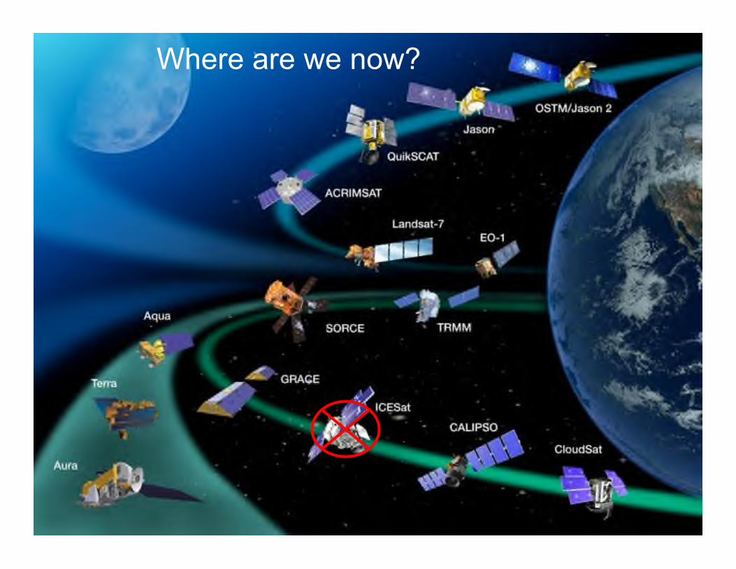
Where are we now?
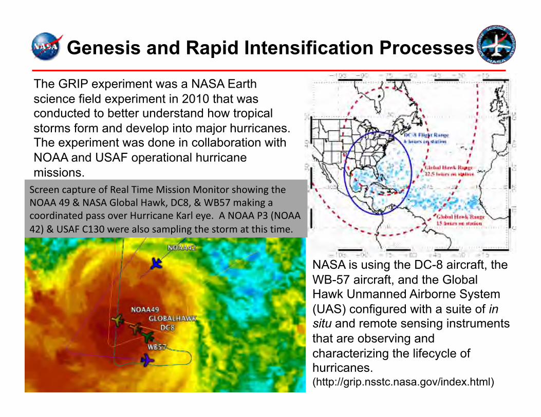
Genesis and Rapid Intensification Processes
The GRIP experiment was a NASA Earth science field experiment in 2010 that was conducted to better understand how tropical storms form and develop into major hurricanes. The experiment was done in collaboration with NOAA and USAF operational hurricane missions.
NASA is using the DC-8 aircraft, the WB-57 aircraft, and the Global Hawk Unmanned Airborne System (UAS) configured with a suite of in situ and remote sensing instruments that are observing and characterizing the lifecycle of hurricanes. (http://grip.nsstc.nasa.gov/index.html)
ScreencaptureofRealTimeMissionMonitorshowingtheNOAA49&NASAGlobalHawk,DC8,&WB57makingacoordinatedpassoverHurricaneKarleye.ANOAAP3(NOAA42)&USAFC130werealsosamplingthestormatthistime.
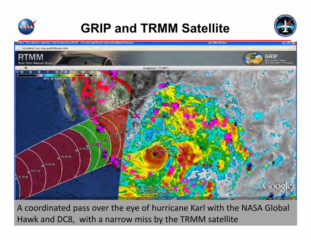
AcoordinatedpassovertheeyeofhurricaneKarlwiththeNASAGlobalHawkandDC8,withanarrowmissbytheTRMMsatellite
GRIP and TRMM Satellite
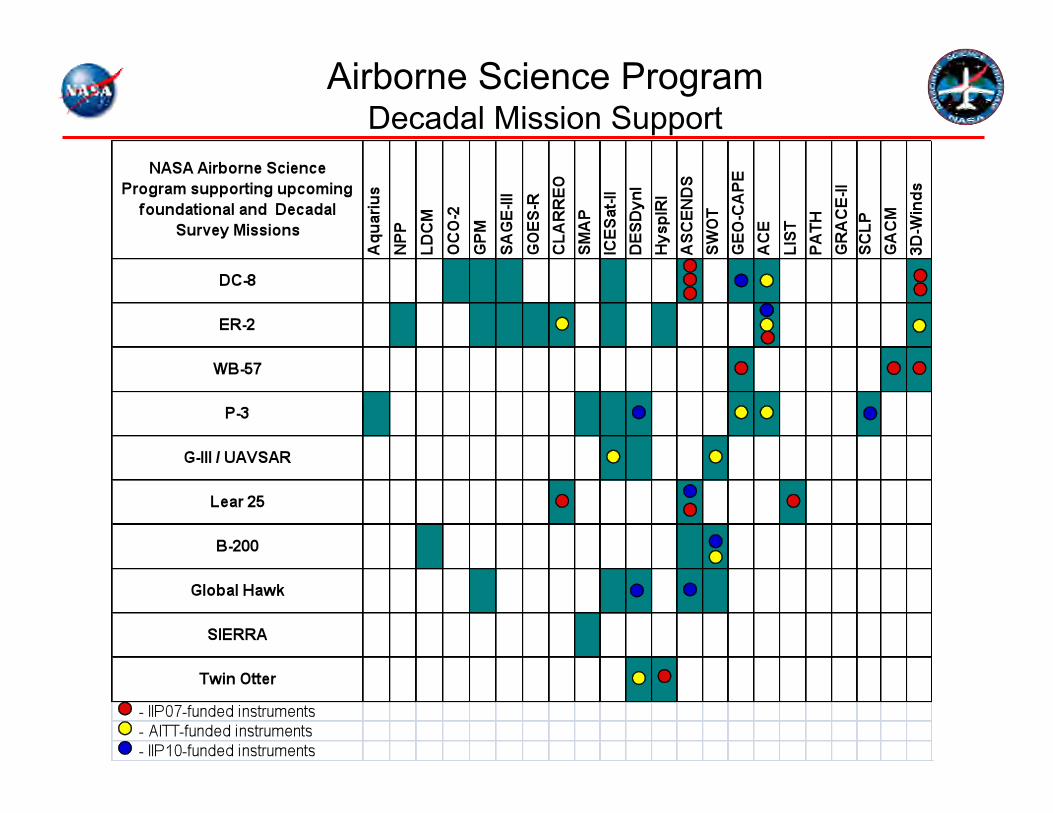
Airborne Science Program Decadal Mission Support
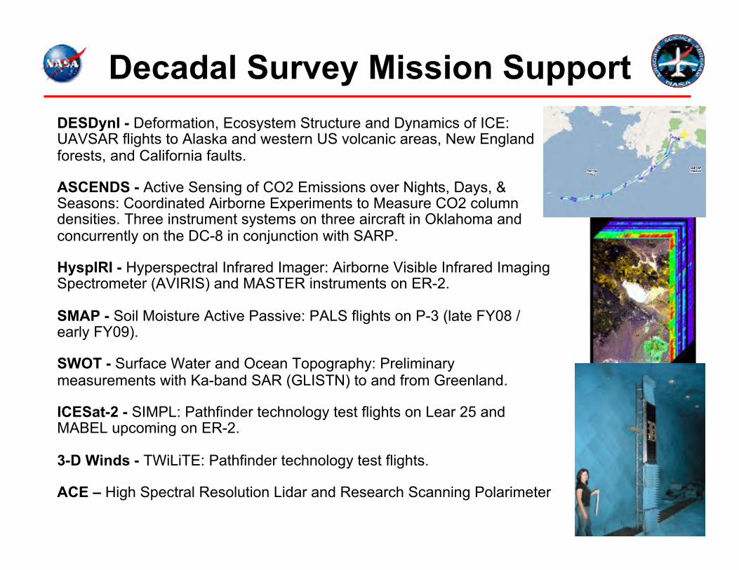
Decadal Survey Mission Support DESDynI - Deformation, Ecosystem Structure and Dynamics of ICE: UAVSAR flights to Alaska and western US volcanic areas, New England forests, and California faults.
ASCENDS - Active Sensing of CO2 Emissions over Nights, Days, & Seasons: Coordinated Airborne Experiments to Measure CO2 column densities. Three instrument systems on three aircraft in Oklahoma and concurrently on the DC-8 in conjunction with SARP.
HyspIRI - Hyperspectral Infrared Imager: Airborne Visible Infrared Imaging Spectrometer (AVIRIS) and MASTER instruments on ER-2.
SMAP - Soil Moisture Active Passive: PALS flights on P-3 (late FY08 / early FY09).
SWOT - Surface Water and Ocean Topography: Preliminary measurements with Ka-band SAR (GLISTN) to and from Greenland.
ICESat-2 - SIMPL: Pathfinder technology test flights on Lear 25 and MABEL upcoming on ER-2.
3-D Winds - TWiLiTE: Pathfinder technology test flights.
ACE – High Spectral Resolution Lidar and Research Scanning Polarimeter
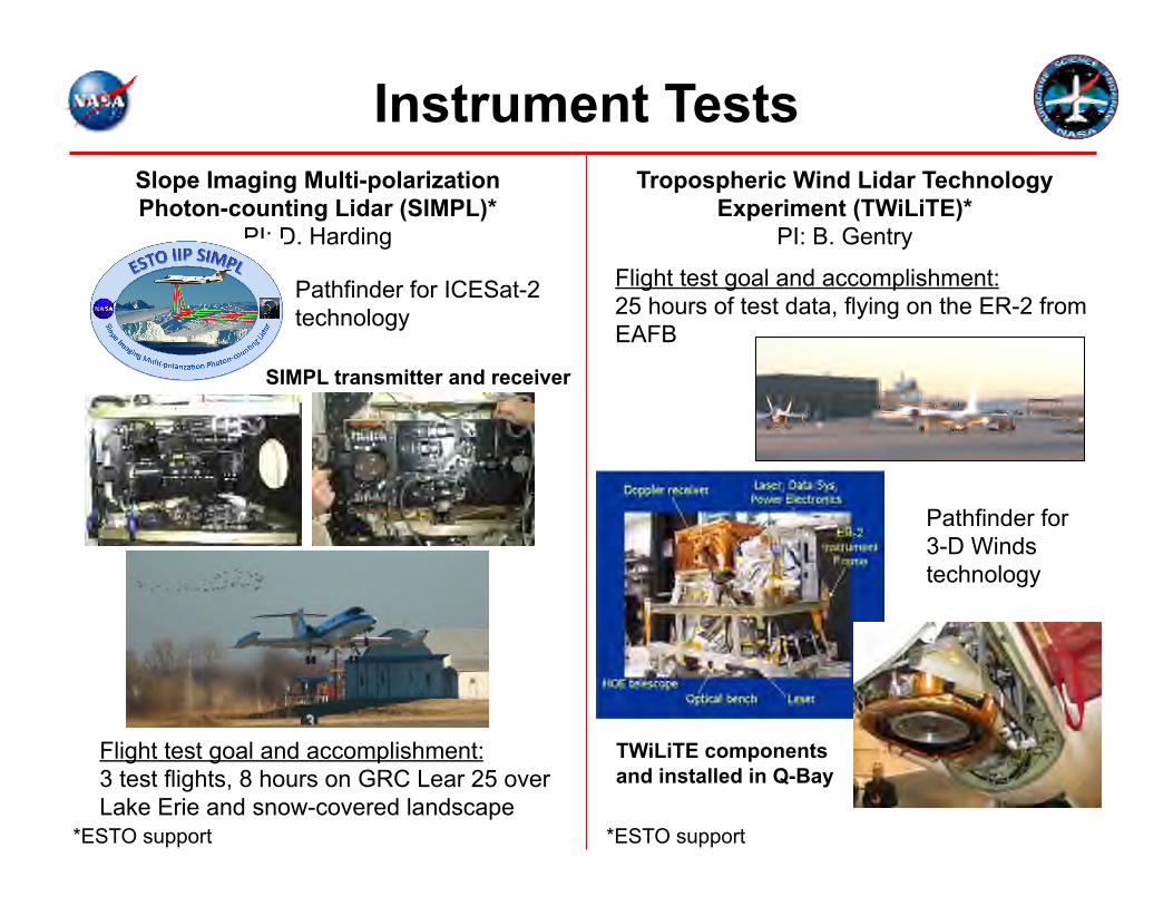
Instrument Tests Slope Imaging Multi-polarization Photon-counting Lidar (SIMPL)*
PI: D. Harding
Tropospheric Wind Lidar Technology Experiment (TWiLiTE)*
PI: B. Gentry
Flight test goal and accomplishment: 3 test flights, 8 hours on GRC Lear 25 over Lake Erie and snow-covered landscape
Flight test goal and accomplishment: 25 hours of test data, flying on the ER-2 from EAFB
SIMPL transmitter and receiver
TWiLiTE components and installed in Q-Bay
Pathfinder for ICESat-2 technology
Pathfinder for 3-D Winds technology
*ESTO support *ESTO support
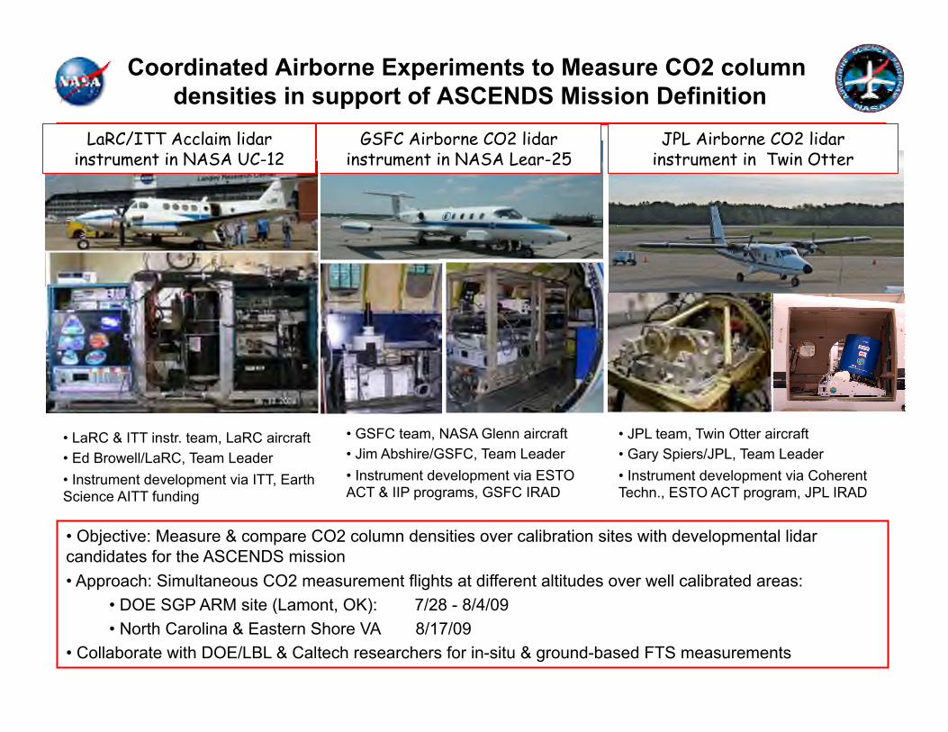
Coordinated Airborne Experiments to Measure CO2 column densities in support of ASCENDS Mission Definition
GSFC Airborne CO2 lidar instrument in NASA Lear-25
LaRC/ITT Acclaim lidar instrument in NASA UC-12
JPL Airborne CO2 lidar instrument in Twin Otter
• Objective: Measure & compare CO2 column densities over calibration sites with developmental lidar candidates for the ASCENDS mission • Approach: Simultaneous CO2 measurement flights at different altitudes over well calibrated areas:
• DOE SGP ARM site (Lamont, OK): 7/28 - 8/4/09 • North Carolina & Eastern Shore VA 8/17/09
• Collaborate with DOE/LBL & Caltech researchers for in-situ & ground-based FTS measurements
• LaRC & ITT instr. team, LaRC aircraft • Ed Browell/LaRC, Team Leader • Instrument development via ITT, Earth Science AITT funding
• GSFC team, NASA Glenn aircraft • Jim Abshire/GSFC, Team Leader • Instrument development via ESTO ACT & IIP programs, GSFC IRAD
• JPL team, Twin Otter aircraft • Gary Spiers/JPL, Team Leader • Instrument development via Coherent Techn., ESTO ACT program, JPL IRAD

For more information please visit http://www.nserc.und.edu/learning/SARP2011.html
85 Applications for admission, 30 admitted Student Profile: 14 Female/16 Male Average GPA: 3.62 Academic Disciplines: Earth & Environmental Science 30% Biology, Chemistry & Physics 44% Meteorology & Atmospheric Science 13% Engineering & Mathematics 13%
29 Universities in 21 states (in blue above) 6 week program: 6/19/2011-7/29/2011
SARP 2011 Research Topics Evapotranspiration of almond orchards and
vineyards, Central Valley Dr. Susan Ustin, UC Davis Air quality effects of commercial dairy
operations and urban air pollution, Central Valley, CA & Los Angeles
Dr. Don Blake, UC Irvine Kelp growth and biomass, Santa Barbara
Channel & Monterey Bay Dr. Raphael Kudela, UC Santa Cruz
SARP 2011 on Facebook: facebook.com/nserc.sarp2011 SARP 2011 on Twitter: twitter.com/sarp2011
The program concludes with the students presenting their research results in formal presentations
In addition, the top 3 student presentations will be given at the NASA booth during the 2011 Fall AGU meeting in San Francisco
All of the lectures and student presentations will be videotaped and available on the internet
DC-8 will be used for two 6-hour data flights Instruments to be employed are: MASTER for remote sensing of kelp and agricultural processes Whole Air Sampler (WAS) for in situ gas sampling Digital Mapping System (DMS) for multi-angle imaging
2005 TRMM Rainfall 2005 Terra/MODIS
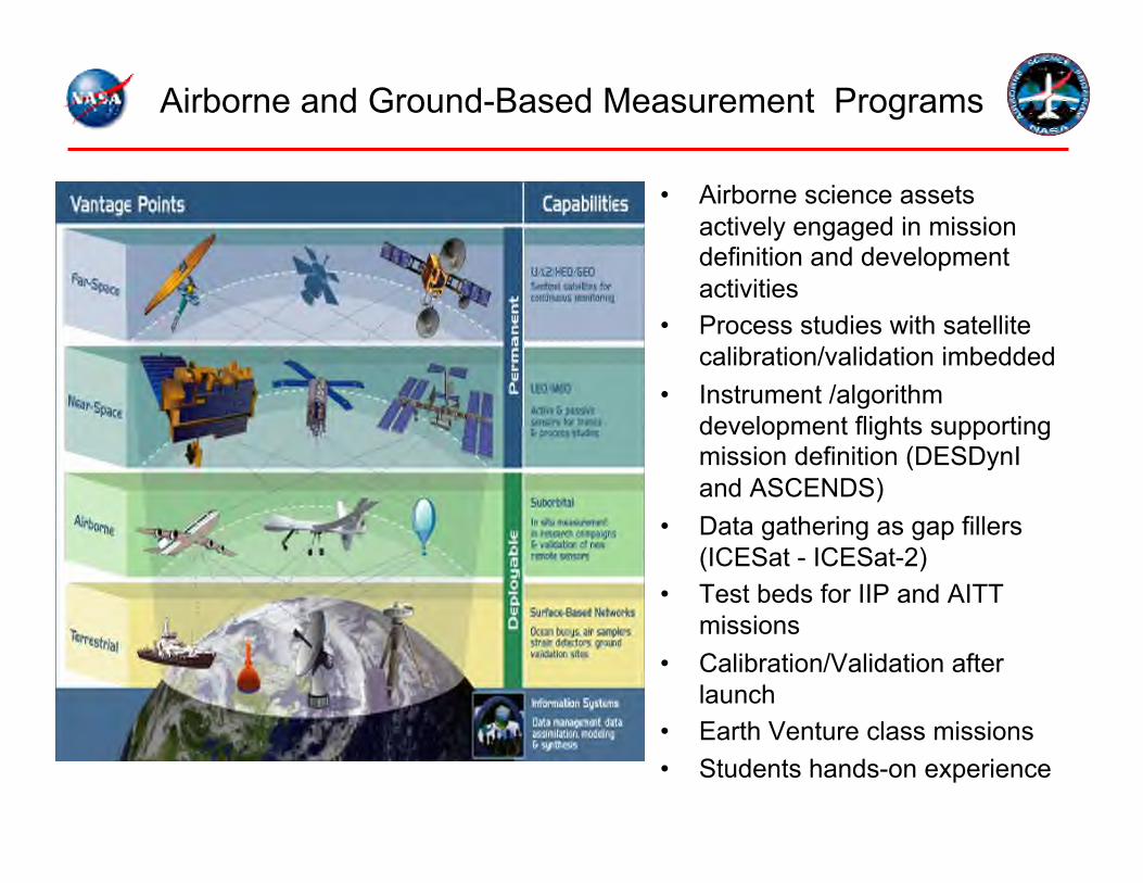
Airborne and Ground-Based Measurement Programs
• Airborne science assets actively engaged in mission definition and development activities
• Process studies with satellite calibration/validation imbedded
• Instrument /algorithm development flights supporting mission definition (DESDynI and ASCENDS)
• Data gathering as gap fillers (ICESat - ICESat-2)
• Test beds for IIP and AITT missions
• Calibration/Validation after launch
• Earth Venture class missions • Students hands-on experience
Closing
• Airborne Science Program Objectives: • Satellite Calibration and Validation • Support New Sensor Development • Process Studies • Development of Next-Generation Scientists and Engineers
• Program Capabilities • Aircraft: Core, New Technology, and Catalog • Sensors and Science Support Systems • Mission/Campaign Science Project Support
• Program Leadership • Bruce Tagg, Director, [email protected] • Randy Albertson, Deputy Director, [email protected] • Website: http://airbornescience.nasa.gov/