national character 133: blackmore vale and vale of wardour
TRANSCRIPT
1
www.naturalengland.org.uk
133: Blackmore Vale and Vale of WardourSupporting documents
National CharacterArea profile:
2
133: Blackmore Vale and Vale of WardourSupporting documents
National CharacterArea profile:
IntroductionAs part of Natural England’s responsibilities as set out in the Natural Environment White Paper1, Biodiversity 20202 and the European Landscape Convention3, we are revising profiles for England’s 159 National Character Areas (NCAs). These are areas that share similar landscape characteristics, and which follow natural lines in the landscape rather than administrative boundaries, making them a good decision-making framework for the natural environment.
NCA profiles are guidance documents which can help communities to inform their decision-making about the places that they live in and care for. The information they contain will support the planning of conservation initiatives at a landscape scale, inform the delivery of Nature Improvement Areas and encourage broader partnership working through Local Nature Partnerships. The profiles will also help to inform choices about how land is managed and can change.
Each profile includes a description of the natural and cultural features that shape our landscapes, how the landscape has changed over time, the current key drivers for ongoing change, and a broad analysis of each area’s characteristics and ecosystem services. Statements of Environmental Opportunity (SEOs) are suggested, which draw on this integrated information. The SEOs offer guidance on the critical issues, which could help to achieve sustainable growth and a more secure environmental future.
NCA profiles are working documents which draw on current evidence andknowledge. We will aim to refresh and update them periodically as newinformation becomes available to us.
We would like to hear how useful the NCA profiles are to you. You can contact theNCA team by emailing [email protected]
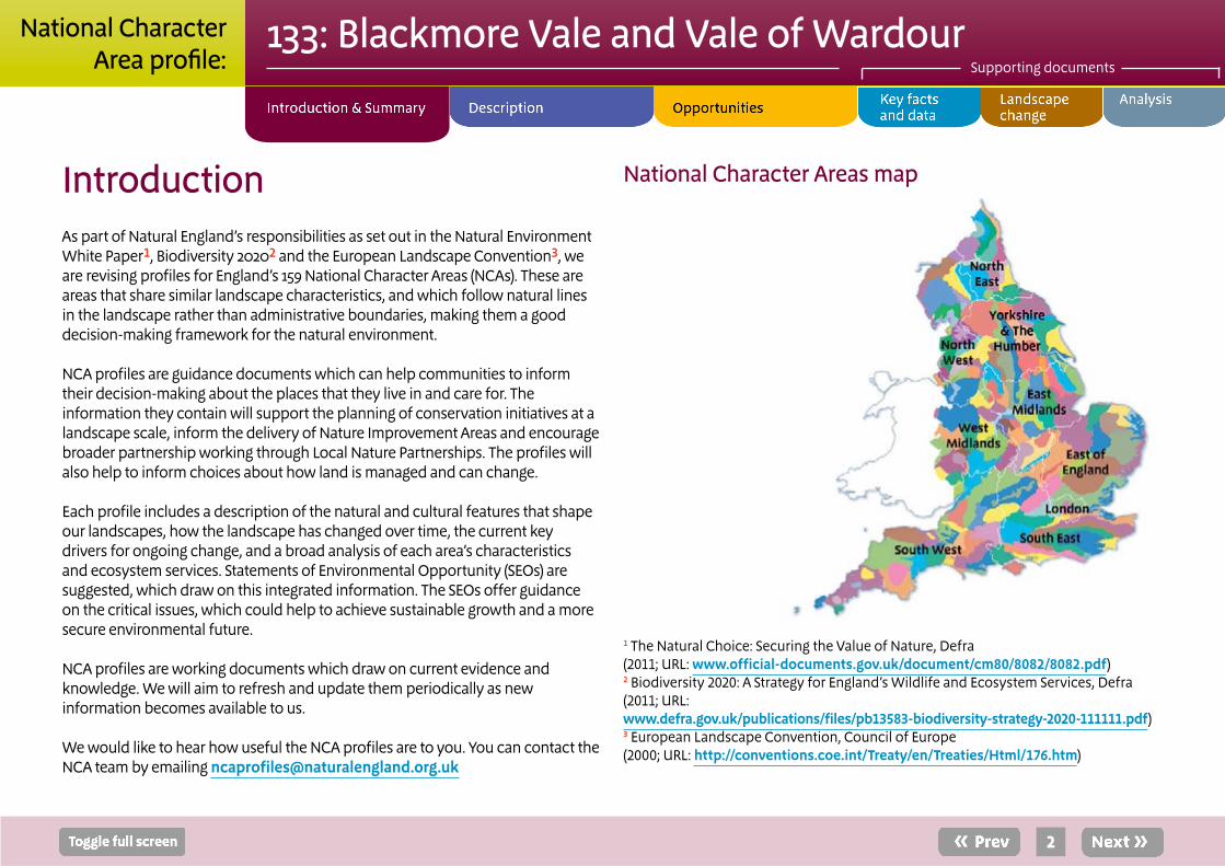
National Character Areas map
1 The Natural Choice: Securing the Value of Nature, Defra(2011; URL: www.official-documents.gov.uk/document/cm80/8082/8082.pdf)2 Biodiversity 2020: A Strategy for England’s Wildlife and Ecosystem Services, Defra(2011; URL: www.defra.gov.uk/publications/files/pb13583-biodiversity-strategy-2020-111111.pdf)3 European Landscape Convention, Council of Europe(2000; URL: http://conventions.coe.int/Treaty/en/Treaties/Html/176.htm)

The Vale of Wardour is distinct in its intense distillation of the character of the whole NCA into a very small area. Here the links between geology and landform are clear, and a suite of disused quarries offer a window into important Jurassic and Cretaceous strata.
The NCA lies partly within the Dorset and the Cranborne Chase and West Wiltshire Downs Areas of Outstanding Natural Beauty but much of it has no landscape designation.
Despite the A303 trunk road and six main roads that cross the NCA, and the two sizeable towns, a low level of urbanisation (less than 1 per cent) and the intensely rural nature of the remaining areas lead to an overall sense of remoteness, peace and tranquillity.
The Blackmore Vale and Vale of Wardour National Character Area (NCA) comprises both the large expanse of lowland clay vale and the Upper Greensand terraces and hills that mark the southern and eastern edges of the NCA, and an area extending northwards from Penselwood around the edge of the Salisbury Plain and West Wiltshire Downs NCA.
The Blackmore Vale, steeped in a long history of pastoral agriculture, is characterised by hedged fields with an abundance of hedgerow trees, many of them veteran. This is productive pastureland that is often waterlogged; it is crossed by streams and several rivers that leave the NCA at all points of the compass.
The elevated, drier and fertile Upper Greensand terraces and hills are characterised by arable agriculture and are host to an impressive series of stately homes with their associated gardens, parks, plantations and woodlands. These areas afford long, wide views over the low-lying clay vale.
Sturminster Newton and Gillingham are the main towns of the Blackmore Vale, while Tisbury serves the Vale of Wardour. Shaftesbury and Wincanton sit on the edge of the area. Rural settlement is mixed, with small villages, hamlets and isolated farmsteads set in landscapes of medieval and later enclosed fields.
The road pattern reflects the difference between areas of small, irregular fields and narrow lanes that are representative of early clearances, and the later, systematic, post-medieval enclosure. More recently the A303 and A30 roads have, in places, been duelled to meet increased traffic volumes.
3
133: Blackmore Vale and Vale of WardourSupporting documents
National CharacterArea profile:
Summary
Click map to enlarge; click again to reduce.

Statements of Environmental Opportunity
SEO 1: Protect, manage and enhance the diverse but coherent pastoral landscape character of the clay vales, limestone ridge and Greensand hills, their semi-natural grasslands and woodland and their characteristic wildlife, and manage the simple patterns of land use maintained by the long history of agriculture.
SEO 2: Work with local people to raise their understanding of the way in which the area’s strong landscape character, sense of place and distinctive wildlife are rooted in the continuity of agricultural land use, strong historic landscape character and legibility of historic features.
SEO 3: Work with the local farming and land management community to maintain the distinctive landscape and natural beauty of the area, enhancing ecosystems and ecosystem services.
SEO 4: Protect, manage and enhance the Vale of Wardour’s highly distinctive relationship between geology, landform and land use. Protect, manage and interpret the suite of national and Local Geological Sites.
4
133: Blackmore Vale and Vale of WardourSupporting documents
National CharacterArea profile:
Duncliffe Hill, an important ancient woodland site, occupies a prominent position in the Blackmore Vale. Now owned by the Woodland Trust, it offers important informal recreational space.

5
133: Blackmore Vale and Vale of WardourSupporting documents
National CharacterArea profile:
Physical and functional links to other National Character Areas
To the south and east the National Character Area (NCA) is bounded by the Dorset Downs and Cranborne Chase and the Salisbury Plain and West Wiltshire Downs NCAs. The scarps of these great Chalk masses form the backdrop to many views within the NCA, and the lowland of the Blackmore Vale affords long, wide vistas to the ridges and hills of the Yeovil Scarplands NCA and the Blackdowns NCA – and beyond.
The rivers Frome, Brue and Stour rise within a short distance of each other but drain in three directions. While the Frome and Brue head westwards and out of the NCA quickly, the River Stour and its many tributaries drain south-eastwards across the Blackmore Vale and through the Chalk of the Dorset Downs and Cranborne Chase NCA.
The Somerset Frome drains northwards through the Avon Vales NCA, while the River Brue drains westwards through the Yeovil Scarplands NCA to the Somerset Levels and Moors NCA. In the east, the River Nadder and its tributary, the Sem, flow eastwards onto the Chalk west of Teffont, then on into the Wylye as a chalk stream in the Salisbury Plain and West Wiltshire Downs NCA.
The A303 trunk road and A roads along with two railways (east towards Salisbury and south towards Dorchester) cross the NCA.
Description
The Upper Greensand area to the north is principally arable farmland with larger fields and many hedges, often gappy or replaced by post and wire fencing. Longleat Woods, in the background is mainly coniferous and they conceal and provide the setting for a large Center Parcs complex. Beyond lie the Salisbury Plain and West Wiltshire Downs and Avon Vales NCAs.
The complex geology of the Vale of Wardour reflects and complements at a smaller scale many of the geological exposures to be found on the Jurassic Coast, from Mid-Jurassic clays to the Chalk of the Cretaceous. Stone from Ham Hill, in the Yeovil Scarplands NCA, is often found in high-status buildings in the NCA.
6
133: Blackmore Vale and Vale of WardourSupporting documents
National CharacterArea profile:
Key characteristics
■ A complex mosaic of mixed farming: undulating, lush clay vales dissected by a broken limestone ridge and fringed by Upper Greensand hills and scarps.
■ Small irregular and rectilinear pasture fields with hedgerow oak trees and many scattered small broadleaved woodlands.
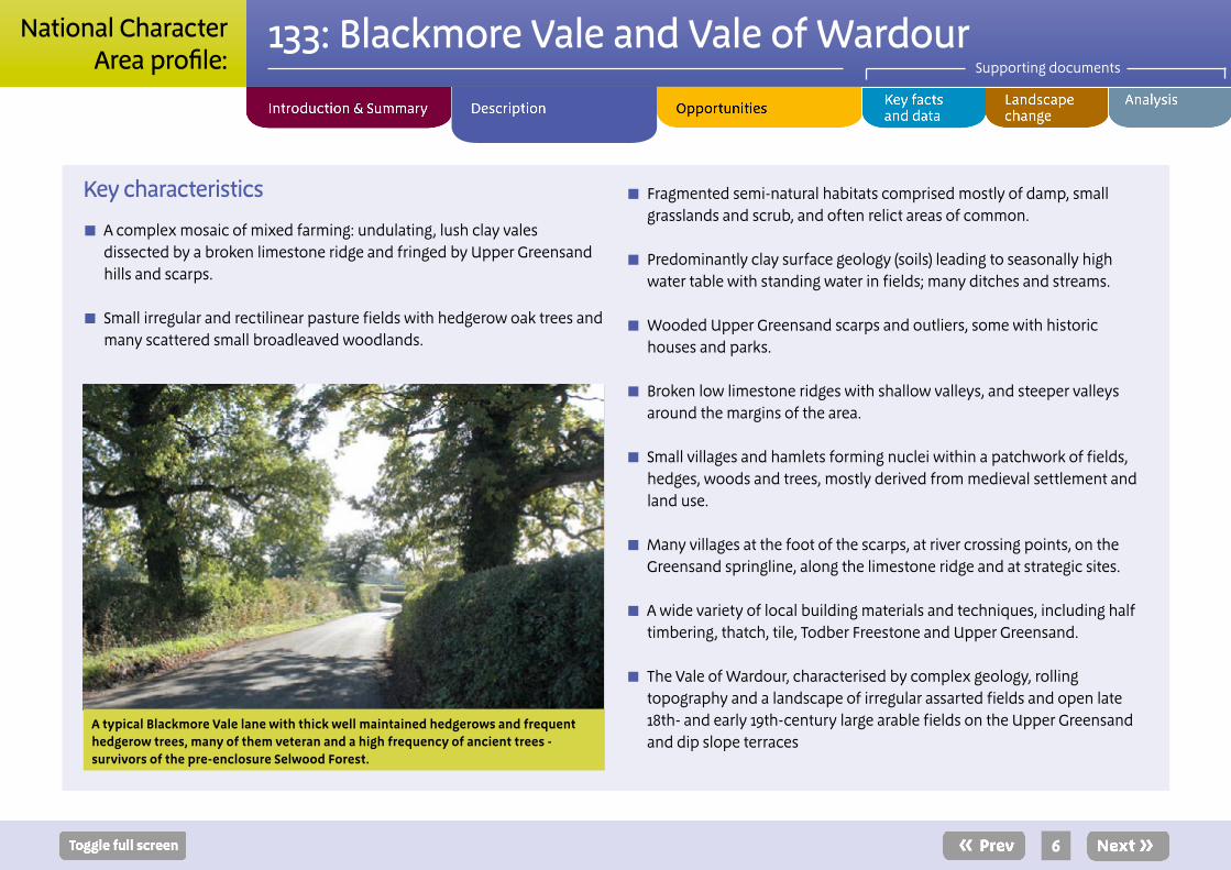
A typical Blackmore Vale lane with thick well maintained hedgerows and frequent hedgerow trees, many of them veteran and a high frequency of ancient trees - survivors of the pre-enclosure Selwood Forest.
■ Fragmented semi-natural habitats comprised mostly of damp, small grasslands and scrub, and often relict areas of common.
■ Predominantly clay surface geology (soils) leading to seasonally high water table with standing water in fields; many ditches and streams.
■ Wooded Upper Greensand scarps and outliers, some with historic houses and parks.
■ Broken low limestone ridges with shallow valleys, and steeper valleys around the margins of the area.
■ Small villages and hamlets forming nuclei within a patchwork of fields, hedges, woods and trees, mostly derived from medieval settlement and land use.
■ Many villages at the foot of the scarps, at river crossing points, on the Greensand springline, along the limestone ridge and at strategic sites.
■ A wide variety of local building materials and techniques, including half timbering, thatch, tile, Todber Freestone and Upper Greensand.
■ The Vale of Wardour, characterised by complex geology, rolling topography and a landscape of irregular assarted fields and open late 18th- and early 19th-century large arable fields on the Upper Greensand and dip slope terraces
7
133: Blackmore Vale and Vale of WardourSupporting documents
National CharacterArea profile:
Blackmore Vale and Vale of Wardour today
The gently undulating Blackmore Vale is lush, remote and intensely rural in character, with a scatter of modest settlements and few major buildings, other than imposing churches such as Witham Priory. Predominantly in pasture, the vale has a generally even pattern of regular hedged fields, scattered woodlands, dense hedgerows and frequent hedgerow trees. Willow and alder along the many streams imbue an almost wetland atmosphere, particularly in the winter, when water often stands in the poorly drained fields.
Though mostly agriculturally improved, areas such as those around Lydlinch and the Blackmore Vale Commons and Moors Site of Special Scientific Interest give a glimpse of the unimproved grassland, woodland and scrub communities that were used as common land and once covered large parts of the clay vales. Species such as marsh fritillary, nightingale and brown hairstreak still thrive here.
Rising from the clay vale is a broken ridge of low limestone hills. These divide the Blackmore Vale into east and west sections. Here the fields are typically larger than in the adjacent clay vale, and the hedgerow trees are less evenly spaced and dominant, emphasising the regular pattern on the clay all the more. Ridgetop roads with long views connect villages such as Hinton St Mary and Marnhull and scattered farmsteads.
Occasionally the flat landscape is broken by a hill, an outlier of the sandstones of the ridges. The most striking of these is the almost conical, heavily wooded Duncliffe Hill, which forms an important landmark, visually closing off the southern end of the Vale of Gillingham.
A diverse pattern of lanes and roads – narrow and twisting, sometimes straight, with wildflower-rich verges – connect settlements and amplify the historic patterns of land use that formed them.
North and east of Penselwood, the Upper Greensand hills form a distinctive transitional landscape to the Chalk of Salisbury Plain, the flatter areas of which are predominantly in arable production. The highly wooded scarp slope of the Upper Greensand provides a dramatic but embracing backdrop to the tranquil Frome Valley to the west, while the eastern dip slope provides the setting for Stourhead House and its grounds. North of Stourhead sits Longleat, another fine house and park, home of the famous safari park; over the valley is Longleat Forest, a Center Parcs holiday destination. These extensive estates with large tracts of coniferous and broadleaved woodland set the character of the surrounding landscape.
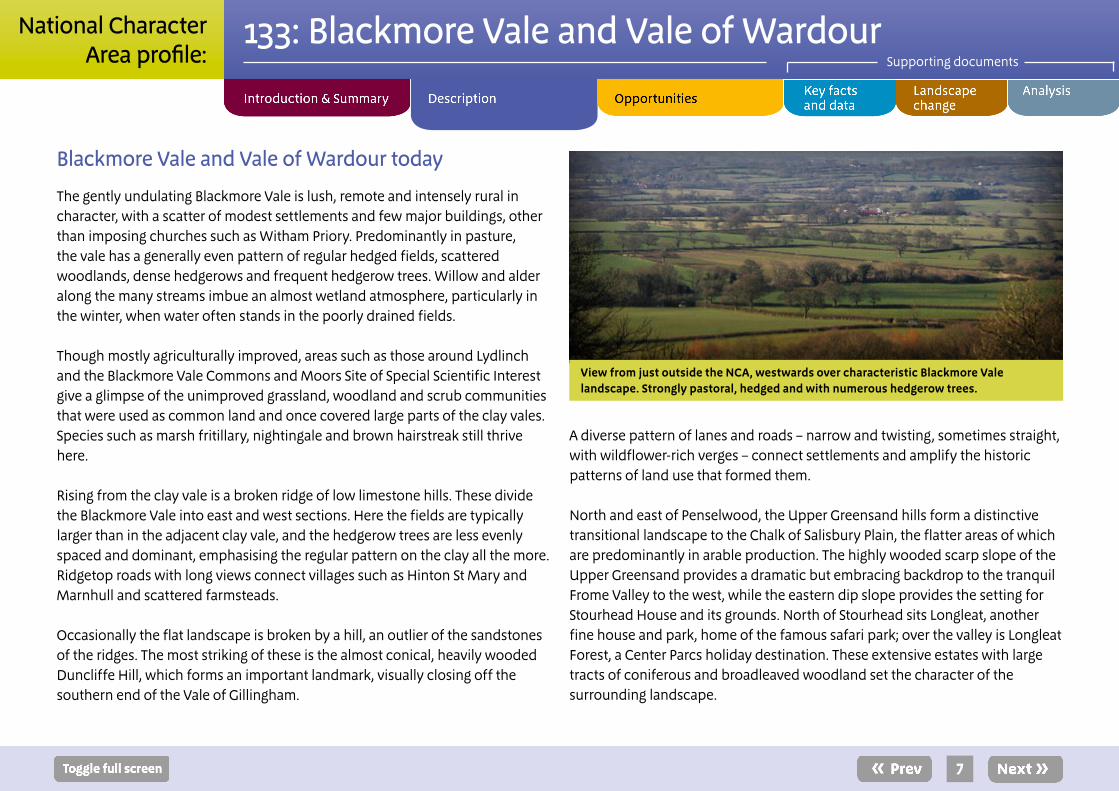
View from just outside the NCA, westwards over characteristic Blackmore Vale landscape. Strongly pastoral, hedged and with numerous hedgerow trees.
8
133: Blackmore Vale and Vale of WardourSupporting documents
National CharacterArea profile:
To the east of Duncliffe Hill lies Shaftesbury, standing on a spur of Upper Greensand at the eastern end of the Vale of Wardour. Shaftesbury is notable for its commanding expansive and impressive views over the Blackmore Vale.
East of Shaftesbury, the Vale of Wardour comprises a geologically complex area, expressed in a compact yet intricate landscape. The clay valley of the River Nadder is flanked by deep valleys and rounded hills of Purbeck, Portland, and Lower and Upper Greensand and, at the highest points, even the transition to the Chalk.
The River Nadder, with its tributary, the Sem, rises on springs at the junction of the Gault Clay and Upper Greensand. As it flows eastwards, the clay character is replaced by that of a chalk stream. This affects both the flora and fauna of the river. This interest sees it form part of the River Avon Special Area of Conservation (SAC).
Due to an underlying anticline and tilting of the strata, the Vale of Wardour is narrower at its lower, eastern end, where the Nadder cuts through sequentially younger rocks and exits the NCA. Large areas of ancient and plantation woodland on the valley sides give a strong sense of tranquillity and enclosure, especially east of Tisbury as the vale narrows.
To the south, a gently sloping Upper Greensand dip slope forms a terrace incised by steep river valleys, within which sit villages such as Fovant, Swallowcliffe and Ansty. Here, large arable fields – separated by weak, gappy hedges and punctuated in places by coverts – characterise the landscape.
The abrupt boundary against the Chalk escarpment and parklands such as those at Wardour Castle, Fonthill Abbey and Dinton add emphasis to the spurs of ridges of the valley sides and lend a particular character to the Vale of Wardour.
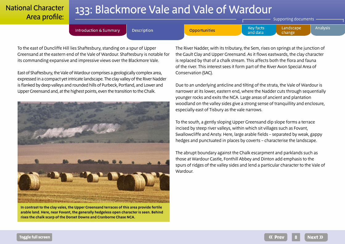
In contrast to the clay vales, the Upper Greensand terraces of this area provide fertile arable land. Here, near Fovant, the generally hedgeless open character is seen. Behind rises the chalk scarp of the Dorset Downs and Cranborne Chase NCA.
9
133: Blackmore Vale and Vale of WardourSupporting documents
National CharacterArea profile:
The landscape through time
High Jurassic sea levels some 157–152 million years ago (Ma) saw the Kimmeridge Clay laid down; falling but fluctuating sea levels then created conditions suitable for the Portland Stone to form, followed by the Purbeck Beds at the beginning of the Cretaceous. Fluctuating environments, alternating between marine and freshwater, gave rise to the different types of stone that were to become desirable as building materials.
Following uplift far to the west and north, large rivers carried sand, grit and clay into the area, creating the Wealden Beds. Slowly returning marine conditions saw the Lower Greensand deposited. This was interrupted by significant uplift and erosion across the region and then, as sea level rose and flooded this surface, the Gault Clay and Upper Greensand were deposited (around 100 Ma). Sea levels continued to rise and, as sediment supplies decreased, the pure limestones of the Chalk were deposited. Subsequent erosion has removed huge amounts of material to expose the Jurassic clays and limestones in the vale, with a fringe of younger rocks to the east and south.
Neolithic activity is only evident on the limestone hills and at prominent sites on the Chalk on the fringes of the area such as Hod Hill and Hambledon Hill. Preferential use of the high ground and lighter soils continued into later prehistory.
There is evidence of Romano-British activity on the edges of the area, but the clay vales were wooded and waterlogged, and the heavy soils difficult to cultivate. In fact, this area contained the expansion of the Saxons westwards for some time. However, by late Saxon times there was certainly occupation of the clay vales and much of the land had been divided up into estates, some of which can be traced along parish boundaries. The Saxon village of Tissebiri (Tisbury) is first mentioned in 759 ad.
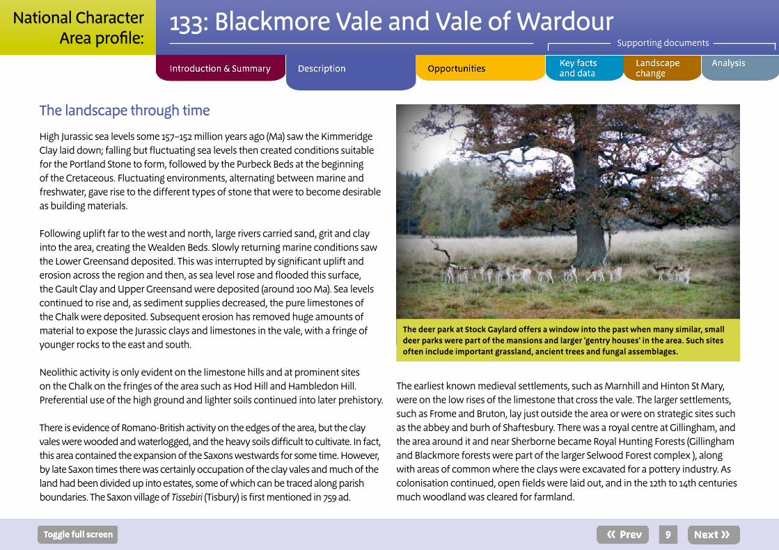
The deer park at Stock Gaylard offers a window into the past when many similar, small deer parks were part of the mansions and larger 'gentry houses' in the area. Such sites often include important grassland, ancient trees and fungal assemblages.
The earliest known medieval settlements, such as Marnhill and Hinton St Mary, were on the low rises of the limestone that cross the vale. The larger settlements, such as Frome and Bruton, lay just outside the area or were on strategic sites such as the abbey and burh of Shaftesbury. There was a royal centre at Gillingham, and the area around it and near Sherborne became Royal Hunting Forests (Gillingham and Blackmore forests were part of the larger Selwood Forest complex ), along with areas of common where the clays were excavated for a pottery industry. As colonisation continued, open fields were laid out, and in the 12th to 14th centuries much woodland was cleared for farmland.
10
133: Blackmore Vale and Vale of WardourSupporting documents
National CharacterArea profile:
The extent of this and subsequent enclosure is clearly evident from the pattern of the landscape today. Around the villages, which are usually on the slightly higher ground, lie the regular long, narrow strips of the former open fields. Beyond these are irregular clusters of fields around farms, with names such as ‘hay’ and ‘wood’ denoting medieval assarting. Surrounding these are the regular small fields of more systematic 16th- and 17th-century enclosure.
Parts of the clay vale, as well as areas such as the Greensand terraces and some of the open Upper Greensand dip slopes were not enclosed until the 18th and 19th centuries, and a larger-scale and strongly rectilinear pattern prevails. Around the edge of the area, large estates were developed in the 16th and 17th centuries and large landscaped parks were laid out, with noteworthy examples at Wardour, Longleat, Marston Bigot and Stourhead.
Elsewhere, there was only modest development of the towns and no significant expansion of the villages and towns until the 19th and 20th centuries. The most significant non-agricultural change in the 20th century has been the development of major roads through the area such as the A303.
Some of the towns in the NCA have expanded by up to 50 per cent in the last 30–40 years; housing is often accompanied by employment developments. In the north of the NCA within Longleat Forest, a Center Parcs holiday destination opened in 1994.
The Vale of Wardour contains a cluster of important exposures across the boundary of the Jurassic and Cretaceous. These rocks are richly fossiliferous, yielding diverse invertebrate and vertebrate fauna. The first book on British fossil insects, published by P.B. Brodie in 1845, was based on the Upper Jurassic fossil insects found at two quarries in the Vale of Wardour.
This area is also highly significant in the strength of the historic landscape character, the visibility of time depth in the landscape and the richness of the built heritage. These factors combine to create a strong feeling of local distinctiveness.
The Blackmore Vale was central to many of Thomas Hardy’s novels. Sturminster Newton is Stourcastle in Return of the Native, for instance; and Shaftesbury is Shaston in Jude the Obscure. The dialect poet William Barnes lived in Sturminster Newton and wrote of the locality, and East Stour was the country home of Henry Fielding. Tisbury has a strong connection with Rudyard Kipling, who wrote Kim
while staying with his parents who lived in the village. The hamlet of Hatch was where Arthur Ransome lived with his first wife and their daughter, at Manor Farm.
Stourhead, created by the Hoare family, is an internationally significant landscaped park which has strongly influenced much subsequent landscape design.
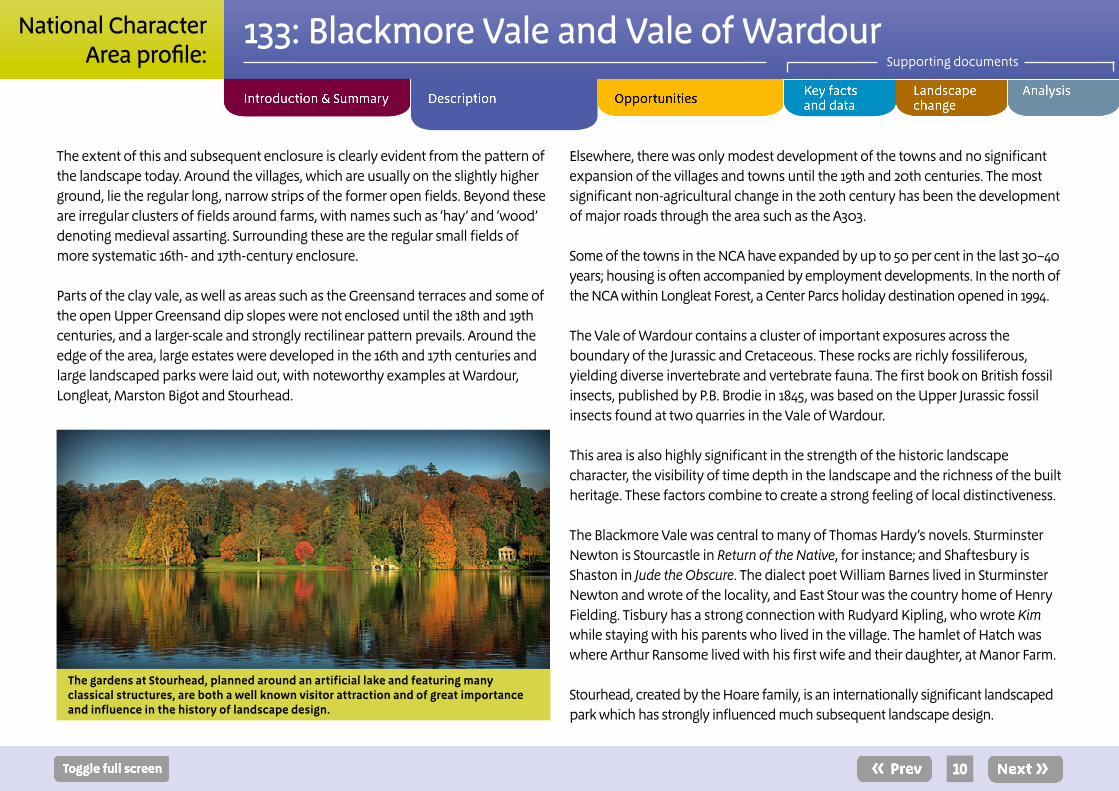
The gardens at Stourhead, planned around an artificial lake and featuring many classical structures, are both a well known visitor attraction and of great importance and influence in the history of landscape design.
11
133: Blackmore Vale and Vale of WardourSupporting documents
National CharacterArea profile:
Ecosystem services
The Blackmore Vale and Vale of Wardour NCA provides a wide range of benefits to society. Each is derived from the attributes and processes (both natural and cultural features) within the area. These benefits are known collectively as ‘ecosystem services’. The predominant services are summarised below. Further information on ecosystem services provided in the Blackmore Vale and Vale of Wardour NCA is contained in the ‘Analysis’ section of this document.
Provisioning services (food, fibre and water supply) ■ Food provision: The area is important for dairy production, and is also a producer of beef cattle and lamb. Areas of arable land in the Vale of Wardour, around Warminster and on the limestone ridges also contribute to food provision through cereal production.
■ Timber provision: The woodlands of the NCA produce high-quality timber, particularly the plantations of Douglas fir.
■ Biomass energy: Wood fuel from existing woodlands and hedgerows, and by-products of commercial timber production all have potential as biomass energy.
■ Water availability: Most of the area is classified as having additional water available for abstraction, although the NCA contains some areas that either have no water available for additional abstraction or are already over-abstracted.
Regulating services (water purification, air quality maintenance and climate regulation)
■ Regulating soil erosion: The majority of soils in this NCA are medium to heavy soils that are at only limited risk of erosion. They are most at risk on steeper slopes under cultivation and as a result of high rainfall. The upper reaches of the River Stour fall within a Department for Environment, Food and Rural Affairs (Defra) priority catchment area, due to the high rates of sedimentation. The gently sloping terrain, with its predominantly slowly permeable clay soils, has high run-off potential, with rates of surface flow leading to soil erosion and sedimentation within waterbodies. Similar issues affect the River Nadder.
■ Regulating soil quality: The slowly permeable, seasonally wet, acid, loamy and clayey soils are easily damaged when wet and are at risk of causing diffuse pollution and flooding as a result of poor water infiltration.
■ Regulating water quality: A large area of the NCA is within a Defra catchment sensitive farming priority catchment. The nature of the soils and hydrology makes this area a significant contributor to diffuse agricultural pollution in the main rivers. The River Nadder has issues with high levels of phosphate, impacting on the River Avon SAC.
■ Regulating water flow: The often waterlogged state of the clay vale makes its rivers prone to sudden high rapid flows (speight) and downstream flooding. The Stour, in particular, often has a significant flooding impact on Bournemouth.
12
133: Blackmore Vale and Vale of WardourSupporting documents
National CharacterArea profile:
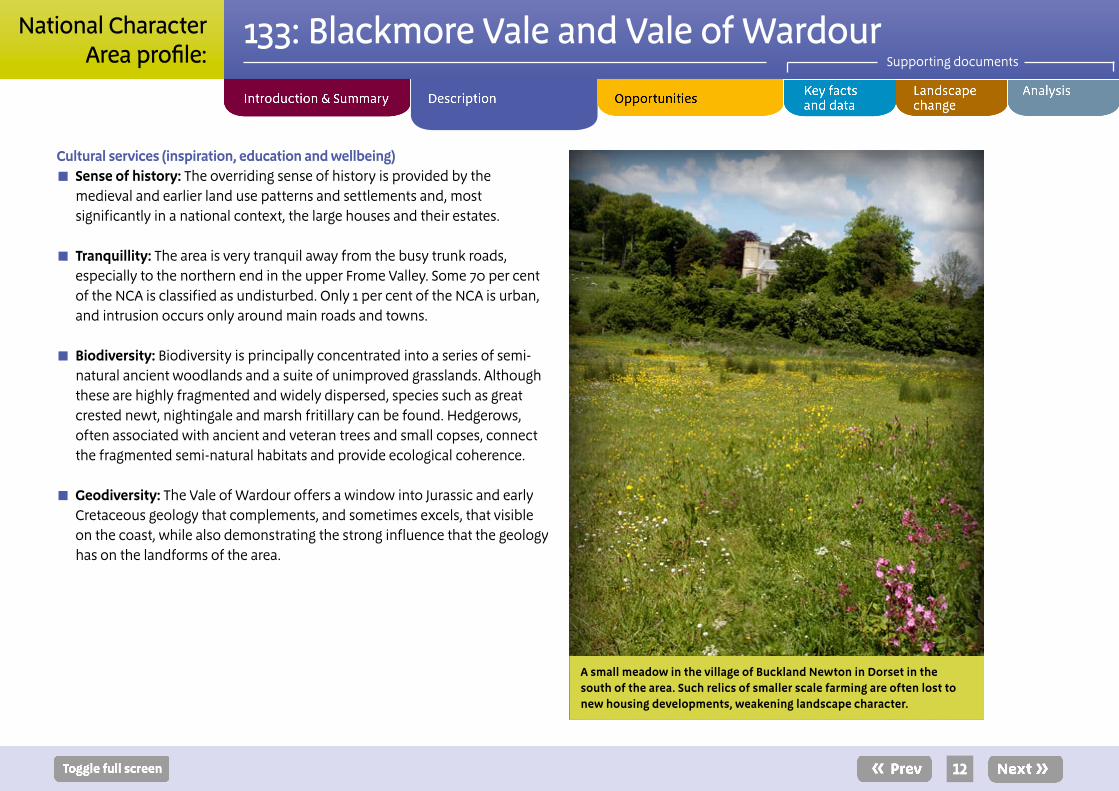
Cultural services (inspiration, education and wellbeing) ■ Sense of history: The overriding sense of history is provided by the medieval and earlier land use patterns and settlements and, most significantly in a national context, the large houses and their estates.
■ Tranquillity: The area is very tranquil away from the busy trunk roads, especially to the northern end in the upper Frome Valley. Some 70 per cent of the NCA is classified as undisturbed. Only 1 per cent of the NCA is urban, and intrusion occurs only around main roads and towns.
■ Biodiversity: Biodiversity is principally concentrated into a series of semi-natural ancient woodlands and a suite of unimproved grasslands. Although these are highly fragmented and widely dispersed, species such as great crested newt, nightingale and marsh fritillary can be found. Hedgerows, often associated with ancient and veteran trees and small copses, connect the fragmented semi-natural habitats and provide ecological coherence.
■ Geodiversity: The Vale of Wardour offers a window into Jurassic and early Cretaceous geology that complements, and sometimes excels, that visible on the coast, while also demonstrating the strong influence that the geology has on the landforms of the area.
A small meadow in the village of Buckland Newton in Dorset in the south of the area. Such relics of smaller scale farming are often lost to new housing developments, weakening landscape character.
13
133: Blackmore Vale and Vale of WardourSupporting documents
National CharacterArea profile:
SEO 1: Protect, manage and enhance the diverse but coherent pastoral landscape character of the clay vales, limestone ridge and Greensand hills, their semi-natural grasslands and their woodland and characteristic wildlife, and manage the simple patterns of land use maintained by the long history of agriculture.
For example by: ■ Explaining the links between the current distribution of semi-natural
habitats and the strong landscape character with the history of settlement and land use over the last 4,000 years.
■ Ensuring that the Special Areas of Conservation, the suite of biological Sites of Special Scientific Interest and the Sites of Nature Conservation Interest in the National Character Area (NCA) are in positive management.
■ Adapting the management of woodlands and grasslands to new markets, in ways that preserve their heritage and biodiversity.
■ Encouraging the management and restoration of parklands and gardens associated with historic estates.
■ Restoring and strengthening the matrix of connecting landscape and habitat features within a functional farmed environment, such as hedgerows, copses, thickets, streams and ditches, to increase permeability and migratory opportunities for wildlife.
■ Conserving the pattern of field boundaries with ancient and veteran trees, avoiding further loss, restoring hedgerows and establishing a new generation of hedgerow trees.
■ Continuing to restore areas of semi-natural woodland associated with the estates of stately homes and maintaining the momentum gained in removing non-native species.
■ Returning plantations on ancient woodland sites to broadleaved species. Create new woodland to buffer, extend and link ancient woodland and other semi-natural habitats. Explore and promote local wood fuel/production schemes across the woodland resource in the NCA.
■ Creating new habitats in the NCA that are tailored to a modern farmed landscape and the management techniques employed therein. These will include functional wetlands along rivers and streams, legume- and herb-rich grasslands, scrub/coppice and, in the urban environment, a system of green infrastructure and sustainable urban drainage systems. Provision of ecosystem services will be as important as biodiversity.
■ Identifying potential impacts of climate change on grassland and woodland habitats and targeting climate change adaptation actions.
■ Understanding the implications of and planning potential responses in vegetation cover to environmental changes and pathogens, with particular attention being paid to loss of ash from ash die-back and oak from ‘acute oak decline’.
■ Giving high regard to the guidelines contained in the Dorset Area of Outstanding Natural Beauty (AONB) and the Cranborne Chase AONB Landscape Character Assessments and ensuring that the relevant policies outlined in both the Dorset and the Cranborne Chase AONB Management Plans are implemented.
■ Avoiding development that detracts from the character, natural beauty and tranquillity of the NCA and, in as many cases as possible, identifying alternative approaches that enhance and reinforce them.
Statements of Environmental Opportunity
14
133: Blackmore Vale and Vale of WardourSupporting documents
National CharacterArea profile:
SEO 2: Work with local people to raise their understanding of the way in which the area’s strong landscape character, sense of place and distinctive wildlife are rooted in the continuity of agricultural land use, strong historic landscape character and legibility of historic features.
For example by: ■ Using an understanding of the area’s traditional and historic architecture, and its distinct patterns of settlement, to inform appropriate conservation and use of historic buildings, and to plan for and inspire any environmentally beneficial new development that makes a positive contribution to local character.
■ Conserving historic features in the landscape with heritage interest, including historic settlements and buildings and archaeological earthworks and sub-surface archaeology, while recognising the potential for undiscovered remains.
■ Utilising a range of media and locations to provide visitors with an integrated, high-quality interpretive experience explaining the evolution, development and conservation of the landscape of the Blackmore Vale and Vale of Wardour.
■ Using the distinctive landscape of the Blackmore Vale and Vale of Wardour as a basis for thought-provoking stories for visitors and residents alike.
■ Promoting the cultural connections associated with historic houses and parklands, literary inspiration and landscape thinking.
■ Developing new permissive access to historic sites, open access land and other areas of interest as part of a cohesive network of inspiring access provision.
■ Promoting the inspirational qualities of the NCA; exploring the cultural imprints of thousands of years of human occupation legible in the landscape; reviewing the depiction of the NCA in the arts; and understanding the changing relationship between the landscape and the people who lived – and live – in it.
■ Maintaining and, where appropriate, enhancing the Wessex Ridgeway Trail and the Stour Valley Way.
■ Maintaining and enhancing the rights of way network and open access land throughout the area.
■ Finding opportunities to increase and improve the area of accessible natural greenspace in places that are currently poorly served, notably in the NCA’s towns and the often overlooked rural areas.
■ Promoting sustainable tourism initiatives that target a broad range of visitors, allowing farm businesses to diversify, simultaneously exploiting and conserving the landscape, its wildlife and tranquillity.
■ Maintaining the high levels of tranquillity that can be experienced within the NCA. Additionally, enhance the ‘experience of tranquillity’ at certain locations through, for example, the creation of semi-natural habitats and removal of eyesores.
■ Finding opportunities to increase community participation in measures aimed at enhancing the natural environment.
15
133: Blackmore Vale and Vale of WardourSupporting documents
National CharacterArea profile:
SEO 3: Work with the local farming and land management community to maintain the distinctive landscape and natural beauty of the area, enhancing ecosystems and ecosystem services.
For example by: ■ Explaining that the currently valued wildlife and landscape are both products of a principally small-scale agricultural system that has maintained a relatively steady state for at least the last two centuries.
■ Working with farmers and other land managers to positively shape the way that land is managed into the future, innovating and diversifying to maintain the agricultural economy.
■ Investigating the need for and potential to provide ecosystem services. Take a place-based approach with local communities to identify and prioritise areas of clearly identifiable ecosystem service need.
■ Alongside established agri-environment schemes, identifying and implementing new systems of funding and investment in the countryside, such as payment for ecosystem services, allowing land managers to make business choices that are not always driven by market forces.
■ Making available sufficiently robust and accessible evidence of the ecosystem services provided by semi-natural habitats and well-managed soils and watercourses.
■ Increasing land manager understanding of the importance of the soil resource and the need for its sympathetic management, for the delivery of a range of benefits and services and to enable better control of the costs of agricultural production.
■ Working with farmers and landowners to promote best practice in nutrient and manure management, cultivation and soil management through catchment sensitive farming principles.
■ Promoting land use patterns on arable areas that maintain ground cover in the autumn and winter months, slowing and arresting water flows. Seek to minimise negative impacts of compaction and soil organic matter loss from excessive tillage. Advise land managers on how to avoid poaching and compaction on pasture sites and management of farm infrastructure to reduce run-off and siltation.
■ Working with owners and managers of both large and small estates to ensure that the significant positive influence they exert on the landscape is maintained while enabling them to continue adapting to changing economic and farming developments and societal expectations.
■ Collaborating on measures, at all types and scales of land use, to cope with the impacts of a changing or less predictable climate and weather patterns associated with it.
16
133: Blackmore Vale and Vale of WardourSupporting documents
National CharacterArea profile:
SEO 4: Protect, manage and enhance the Vale of Wardour’s highly distinctive relationship between geology, landform and land use. Protect, manage and interpret the suite of national and Local Geological Sites.
For example by: ■ Explaining the connections between the geology of this part of the NCA and its settlement and land use history.
■ Making the links between the types and patterns of agriculture that have developed in relation to the soils and hydrological conditions that the underlying geological strata and structures have created.
■ Explaining the role that the geology and geomorphology of the Vale of Wardour play in maintaining the ecosystem services we value – water, food provision, wildlife, sense of place and sense of history.
■ Ensuring that the sense of place imparted by the localised use of specific building stones is maintained and, as often as possible, reinforced by new development.
■ Protecting important features for future geological/geomorphological research and interpretation from inappropriate changes in land use, for example preventing after-use of quarries which obscures exposures and maintaining the magnificent vistas from the tops of the Upper Greensand hills.
17
133: Blackmore Vale and Vale of WardourSupporting documents
National CharacterArea profile:
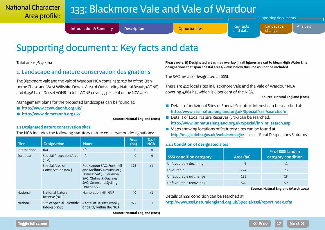
Supporting document 1: Key facts and dataTotal area: 78,414 ha
1. Landscape and nature conservation designationsThe Blackmore Vale and the Vale of Wardour NCA contains 21,710 ha of the Cran-borne Chase and West Wiltshire Downs Area of Outstanding Natural Beauty (AONB) and 6,096 ha of Dorset AONB. In total AONB cover 35 per cent of the NCA area.
Management plans for the protected landscapes can be found at: ■ http://www.ccwwdaonb.org.uk/ ■ http://www.dorsetaonb.org.uk/
Source: Natural England (2011)
1.1 Designated nature conservation sitesThe NCA includes the following statutory nature conservation de1signations:
Tier Designation NameArea (ha)
% of NCA
International n/a n/a 0 0
European Special Protection Area (SPA)
n/a 0 0
Special Area of Conservation (SAC)
Rooksmoor SAC; Fontmell and Melbury Downs SAC; Holnest SAC; River Avon SAC; Chilmark Quarries SAC; Cerne and Sydling Downs SAC
193 <1
National National Nature Reserve (NNR)
Hambledon Hill NNR 40 <1
National Site of Special Scientific Interest (SSSI)
A total of 34 sites wholly or partly within the NCA
977 1
Source: Natural England (2011)
Please note: (i) Designated areas may overlap (ii) all figures are cut to Mean High Water Line, designations that span coastal areas/views below this line will not be included.
The SAC are also designated as SSSI.
There are 410 local sites in Blackmore Vale and the Vale of Wardour NCA covering 4,885 ha, which is 6 per cent of the NCA.
Source: Natural England (2011)
■ Details of individual Sites of Special Scientific Interest can be searched at: http://www.sssi.naturalengland.org.uk/Special/sssi/search.cfm
■ Details of Local Nature Reserves (LNR) can be searched: http://www.lnr.naturalengland.org.uk/Special/lnr/lnr_search.asp
■ Maps showing locations of Statutory sites can be found at: http://magic.defra.gov.uk/website/magic/ – select ‘Rural Designations Statutory’.
1.1.1 Condition of designated sites
SSSI condition category Area (ha)% of SSSI land in
category conditionUnfavourable declining 4 <1
Favourable 224 23
Unfavourable no change 181 18
Unfavourable recovering 576 59
Source: Natural England (March 2011)
Details of SSSI condition can be searched at: http://www.sssi.naturalengland.org.uk/Special/sssi/reportIndex.cfm
18
133: Blackmore Vale and Vale of WardourSupporting documents
National CharacterArea profile:
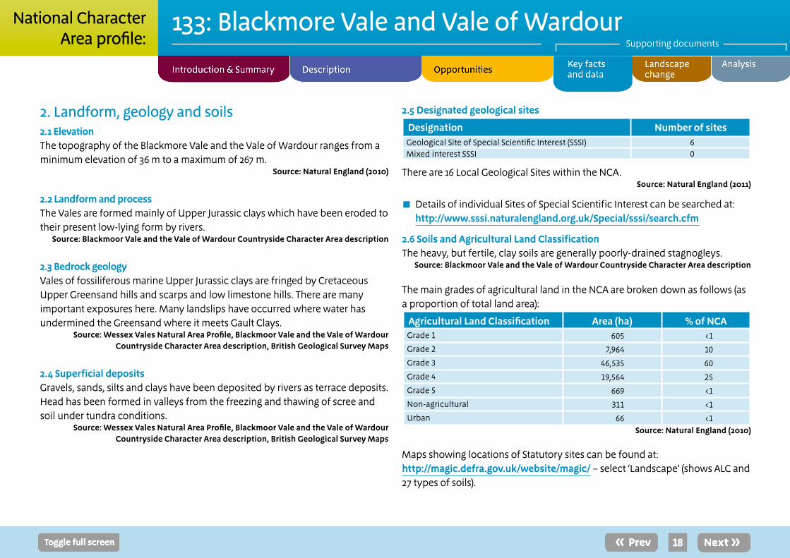
2. Landform, geology and soils2.1 ElevationThe topography of the Blackmore Vale and the Vale of Wardour ranges from a minimum elevation of 36 m to a maximum of 267 m.
Source: Natural England (2010)
2.2 Landform and processThe Vales are formed mainly of Upper Jurassic clays which have been eroded to their present low-lying form by rivers.
Source: Blackmoor Vale and the Vale of Wardour Countryside Character Area description
2.3 Bedrock geologyVales of fossiliferous marine Upper Jurassic clays are fringed by Cretaceous Upper Greensand hills and scarps and low limestone hills. There are many important exposures here. Many landslips have occurred where water has undermined the Greensand where it meets Gault Clays.
Source: Wessex Vales Natural Area Profile, Blackmoor Vale and the Vale of Wardour Countryside Character Area description, British Geological Survey Maps
2.4 Superficial depositsGravels, sands, silts and clays have been deposited by rivers as terrace deposits. Head has been formed in valleys from the freezing and thawing of scree and soil under tundra conditions.
Source: Wessex Vales Natural Area Profile, Blackmoor Vale and the Vale of Wardour Countryside Character Area description, British Geological Survey Maps
2.5 Designated geological sites
Designation Number of sitesGeological Site of Special Scientific Interest (SSSI) 6Mixed interest SSSI 0
There are 16 Local Geological Sites within the NCA.Source: Natural England (2011)
■ Details of individual Sites of Special Scientific Interest can be searched at: http://www.sssi.naturalengland.org.uk/Special/sssi/search.cfm
2.6 Soils and Agricultural Land ClassificationThe heavy, but fertile, clay soils are generally poorly-drained stagnogleys.
Source: Blackmoor Vale and the Vale of Wardour Countryside Character Area description
The main grades of agricultural land in the NCA are broken down as follows (as a proportion of total land area):
Agricultural Land Classification Area (ha) % of NCAGrade 1 605 <1
Grade 2 7,964 10
Grade 3 46,535 60
Grade 4 19,564 25
Grade 5 669 <1
Non-agricultural 311 <1
Urban 66 <1Source: Natural England (2010)
Maps showing locations of Statutory sites can be found at: http://magic.defra.gov.uk/website/magic/ – select ‘Landscape’ (shows ALC and 27 types of soils).

19
133: Blackmore Vale and Vale of WardourSupporting documents
National CharacterArea profile:
3. Key water bodies and catchments 3.1 Major rivers/canalsThe following major rivers/canals (by length) have been identified in this NCA.
Name Length (km)River Stour 43
River Nadder 21
River Cale 19
River Lydden 19
River Frome 11
River Brue 7
River Wylye 5Source: Natural England (2010)
Please note: other significant rivers (by volume) may also occur. These are not listed where the length within the NCA is short.
The great majority of the rivers within the NCA drain to the south.
3.2 Water qualityThe total area of Nitrate Vulnerable Zone is 24,621 ha, 31 per cent of the NCA.
Source: Source: Natural England (2010)
3.3 Water Framework DirectiveMaps are available from the Environment Agency showing current and projected future status of water bodies http://maps.environment-agency.gov.uk/wiyby/wiybyController?ep=maptopics&lang=_e
4. Trees and woodlands4.1 Total woodland coverThe NCA contains 8,293 ha of woodland (11 per cent of the total area), of which 3,821 ha is ancient woodland.
Source: Natural England (2010), Forestry Commission (2011)
4.2 Distribution and size of woodland and trees in the landscapeScattered woodlands, dense hedgerows and common hedgerow trees.
Source: Natural England 2010
4.3 Woodland typesA statistical breakdown of the area and type of woodland found across the NCA is detailed below.
Area and proportion of different woodland types in the NCA (over 2 ha)Woodland type Area (ha) % of NCABroadleaved 5,009 6
Coniferous 2,484 3
Mixed 435 1
Other 365 <1Source: Forestry Commission (2011)
Area and proportion of Ancient Woodland and Planted Ancient Woodland within the NCA.
Woodland type Area (ha) % of NCAAncient semi-natural woodland 1,554 1
Ancient re-planted woodland (PAWS) 2,267 1Source: Natural England (2004)
20
133: Blackmore Vale and Vale of WardourSupporting documents
National CharacterArea profile:
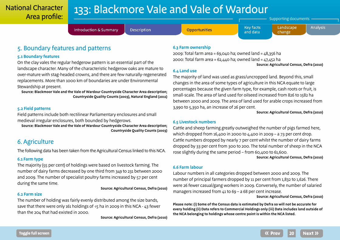
5. Boundary features and patterns5.1 Boundary featuresOn the clay vales the regular hedgerow pattern is an essential part of the landscape character. Many of the characteristic hedgerow oaks are mature to over-mature with stag-headed crowns, and there are few naturally-regenerated replacements. More than 1000 km of boundaries are under Environmental Stewardship at present.
Source: Blackmoor Vale and the Vale of Wardour Countryside Character Area description; Countryside Quality Counts (2003), Natural England (2011)
5.2 Field patternsField patterns include both rectilinear Parliamentary enclosures and small medieval irregular enclosures, both bounded by hedgerows.
Source: Blackmoor Vale and the Vale of Wardour Countryside Character Area description; Countryside Quality Counts (2003)
6. AgricultureThe following data has been taken from the Agricultural Census linked to this NCA.
6.1 Farm type The majority (55 per cent) of holdings were based on livestock farming. The number of dairy farms decreased by one third from 349 to 231 between 2000 and 2009. The number of specialist poultry farms increased by 57 per cent during the same time.
Source: Agricultural Census, Defra (2010)
6.2 Farm sizeThe number of holding was fairly evenly distributed among the size bands, save that there were only 161 holdings of <5 ha in 2009 in this NCA - 43 fewer than the 204 that had existed in 2000.
Source: Agricultural Census, Defra (2010)
6.3 Farm ownership 2009: Total farm area = 69,040 ha; owned land = 48,356 ha 2000: Total farm area = 62,440 ha; owned land = 47,452 ha
Source: Agricultural Census, Defra (2010)
6.4 Land useThe majority of land was used as grass/uncropped land. Beyond this, small changes in the area of some types of agriculture in this NCA equate to large percentages because the given farm type, for example, cash roots or fruit, is small-scale. The area of land used for oilseed increased from 826 to 1582 ha between 2000 and 2009. The area of land used for arable crops increased from 3,990 to 5,350 ha, an increase of 26 per cent.
Source: Agricultural Census, Defra (2010)
6.5 Livestock numbersCattle and sheep farming greatly outweighed the number of pigs farmed here, which dropped from 16,400 in 2000 to 4,400 in 2009 – a 73 per cent drop. Cattle numbers dropped by nearly 7 per cent whilst the number of dairy farms dropped by 33 per cent from 300 to 200. The total number of sheep in the NCA rose slightly during the same period – from 60,400 to 61,600.
Source: Agricultural Census, Defra (2010)
6.6 Farm labourLabour numbers in all categories dropped between 2000 and 2009. The number of principal farmers dropped by 11 per cent from 1,832 to 1,626. There were 26 fewer casual/gang workers in 2009. Conversely, the number of salaried managers increased from 41 to 69 – a 68 per cent increase.
Source: Agricultural Census, Defra (2010)
Please note: (i) Some of the Census data is estimated by Defra so will not be accurate for every holding (ii) Data refers to Commercial Holdings only (iii) Data includes land outside of the NCA belonging to holdings whose centre point is within the NCA listed.
21
133: Blackmore Vale and Vale of WardourSupporting documents
National CharacterArea profile:
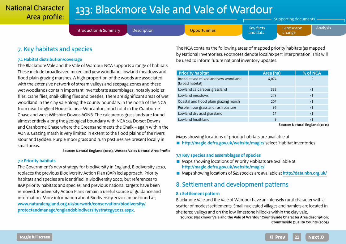
7. Key habitats and species7.1 Habitat distribution/coverage The Blackmore Vale and the Vale of Wardour NCA supports a range of habitats. These include broadleaved mixed and yew woodland, lowland meadows and flood plain grazing marshes. A high proportion of the woods are associated with the extensive network of stream valleys and seepage zones and these wet woodlands contain important invertebrate assemblages, notably soldier flies, crane flies, snail-killing flies and beetles. There are significant areas of wet woodland in the clay vale along the county boundary in the north of the NCA from near Longleat House to near Wincanton, much of it in the Cranborne Chase and west Wiltshire Downs AONB. The calcareous grasslands are found almost entirely along the geological boundary with NCA 134 Dorset Downs and Cranborne Chase where the Greensand meets the Chalk – again within the AONB. Grazing marsh is very limited in extent to the flood plains of the rivers Stour and Lydden. Purple moor grass and rush pastures are present locally in small areas.
Source: Natural England (2011), Wessex Vales Natural Area Profile
7.2 Priority habitatsThe Government’s new strategy for biodiversity in England, Biodiversity 2020, replaces the previous Biodiversity Action Plan (BAP) led approach. Priority habitats and species are identified in Biodiversity 2020, but references to BAP priority habitats and species, and previous national targets have been removed. Biodiversity Action Plans remain a useful source of guidance and information. More information about Biodiversity 2020 can be found at; www.naturalengland.org.uk/ourwork/conservation/biodiversity/protectandmanage/englandsbiodiversitystrategy2011.aspx.
The NCA contains the following areas of mapped priority habitats (as mapped by National Inventories). Footnotes denote local/expert interpretation. This will be used to inform future national inventory updates.
Priority habitat Area (ha) % of NCABroadleaved mixed and yew woodland (broad habitat)
4,074 5
Lowland calcareous grassland 338 <1
Lowland meadows 278 <1
Coastal and flood plain grazing marsh 207 <1
Purple moor grass and rush pasture 96 <1
Lowland dry acid grassland 17 <1
Lowland heathland 9 <1Source: Natural England (2011)
Maps showing locations of priority habitats are available at ■ http://magic.defra.gov.uk/website/magic/ select ‘Habitat Inventories’
7.3 Key species and assemblages of species ■ Maps showing locations of Priority Habitats are available at:
http://magic.defra.gov.uk/website/magic/ ■ Maps showing locations of S41 species are available at http://data.nbn.org.uk/
8. Settlement and development patterns 8.1 Settlement patternBlackmore Vale and the Vale of Wardour have an intensely rural character with a scatter of modest settlements. Small nucleated villages and hamlets are located in sheltered valleys and on the low limestone hillocks within the clay vale.
Source: Blackmoor Vale and the Vale of Wardour Countryside Character Area description; Countryside Quality Counts (2003)
22
133: Blackmore Vale and Vale of WardourSupporting documents
National CharacterArea profile:
8.2 Main settlementsThe main towns within the NCA include Gillingham, Shaftesbury, Wincanton, Frome and Sturminster Newton. The total estimated population for this NCA (derived from ONS 2001 census data) is 69,859.
Source: Blackmoor Vale and the Vale of Wardour Countryside Character Area description; Countryside Quality Counts (2003), Natural England (2012)
8.3 Local vernacular and building materialsA wide variety of local building materials and techniques, including half timbering. Todber Freestone (a limestone) and Upper Greensand (a Cretaceous sandstone) are widely used for building in the east.
Source: Blackmoor Vale and the Vale of Wardour Countryside Character Area description; Countryside Quality Counts (2003)
9. Key historic sites and features9.1 Origin of historic featuresNeolithic activity is evident on the limestone hills and at prominent sites on the chalk. By late Saxon times there was certainly occupation of the clay vales and much of the land was divided up into estates, some of which can be traced along parish boundaries. Around the edge of the area, large estates were developed in the 16th and 17th centuries and large landscape parks were laid out at Wardour, Longleat, Marston Bigot, Stourhead and other places in the following centuries.
Source: Draft Historic Profile, Blackmoor Vale and the Vale of Wardour Countryside Character Area description
9.2 Designated historic assets This NCA has the following historic designations:
■ 11 Registered Parks and Gardens covering 2,300 ha. ■ No Registered Battlefields. ■ 100 Scheduled Monuments. ■ 2,422 Listed Buildings.
Source: Natural England (2010)
More information is available at the following address: ■ http://www.english-heritage.org.uk/caring/heritage-at-risk/ ■ http://www.english-heritage.org.uk/professional/protection/process/national-heritage-list-for-england/
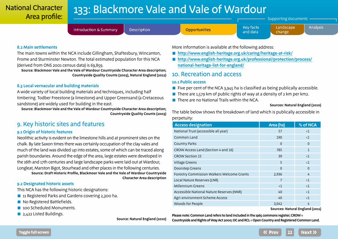
10. Recreation and access10.1 Public access
■ Five per cent of the NCA 3,945 ha is classified as being publically accessible. ■ There are 1,579 km of public rights of way at a density of 2 km per km2. ■ There are no National Trails within the NCA.
Sources: Natural England (2010)
The table below shows the breakdown of land which is publically accessible in perpetuity:
Access designation Area (ha) % of NCANational Trust (accessible all year) 57 <1
Common Land 190 <1
Country Parks 0 0
CROW Access Land (Section 4 and 16) 785 1
CROW Section 15 39 <1
Village Greens 5 <1
Doorstep Greens 0 0
Forestry Commission Walkers Welcome Grants 2,936 4
Local Nature Reserves (LNR) 7 <1
Millennium Greens <1 <1
Accessible National Nature Reserves (NNR) 40 <1
Agri-environment Scheme Access 40 <1
Woods for People 3,042 4Sources: Natural England (2011)
Please note: Common Land refers to land included in the 1965 commons register; CROW = Countryside and Rights of Way Act 2000; OC and RCL = Open Country and Registered Common Land.
23
133: Blackmore Vale and Vale of WardourSupporting documents
National CharacterArea profile:
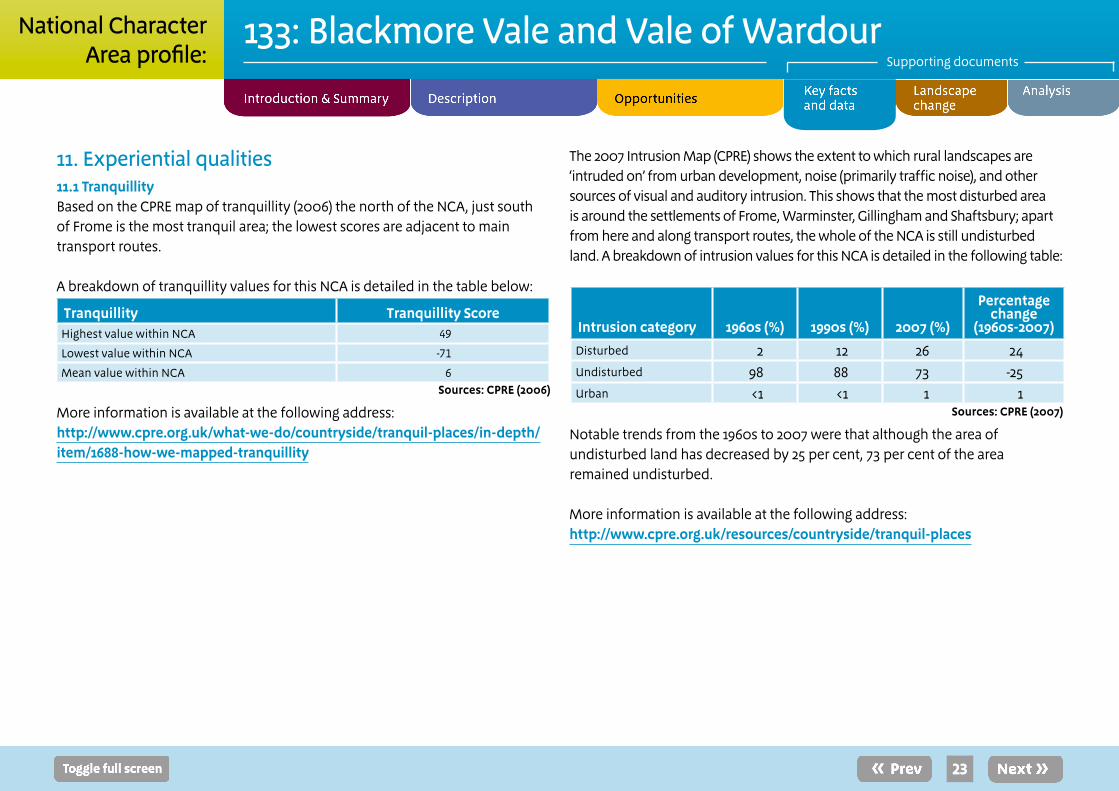
11. Experiential qualities11.1 TranquillityBased on the CPRE map of tranquillity (2006) the north of the NCA, just south of Frome is the most tranquil area; the lowest scores are adjacent to main transport routes.
A breakdown of tranquillity values for this NCA is detailed in the table below:
Tranquillity Tranquillity ScoreHighest value within NCA 49
Lowest value within NCA -71
Mean value within NCA 6Sources: CPRE (2006)
More information is available at the following address: http://www.cpre.org.uk/what-we-do/countryside/tranquil-places/in-depth/item/1688-how-we-mapped-tranquillity
The 2007 Intrusion Map (CPRE) shows the extent to which rural landscapes are ‘intruded on’ from urban development, noise (primarily traffic noise), and other sources of visual and auditory intrusion. This shows that the most disturbed area is around the settlements of Frome, Warminster, Gillingham and Shaftsbury; apart from here and along transport routes, the whole of the NCA is still undisturbed land. A breakdown of intrusion values for this NCA is detailed in the following table:
Intrusion category 1960s (%) 1990s (%) 2007 (%)
Percentage change
(1960s-2007)
Disturbed 2 12 26 24Undisturbed 98 88 73 -25Urban <1 <1 1 1
Sources: CPRE (2007)
Notable trends from the 1960s to 2007 were that although the area of undisturbed land has decreased by 25 per cent, 73 per cent of the area remained undisturbed.
More information is available at the following address:http://www.cpre.org.uk/resources/countryside/tranquil-places
24
133: Blackmore Vale and Vale of WardourSupporting documents
National CharacterArea profile:
12 Data sources ■ British Geological Survey (2006) ■ Natural Area Profiles, Natural England (published by English Nature 1993-1998 ) ■ Countryside Character Descriptions, Natural England (regional volumes published by Countryside Commission/Countryside Agency 1998/1999)
■ Joint Character Area GIS boundaries, Natural England (data created 2001) ■ National Parks and AONBs GIS boundaries, Natural England (2006) ■ Heritage Coast Boundaries, Natural England (2006) ■ Agricultural Census June Survey, Defra (2000,2009) ■ National Inventory of Woodland & Trees, Forestry Commission (2003) ■ Countryside Quality Counts Draft Historic Profiles, English Heritage (2004)* ■ Ancient Woodland Inventory, Natural England (2003) ■ Priority Habitats GIS data, Natural England (March 2011) ■ Special Areas of Conservation data, Natural England (data accessed in March 2011) ■ Special Protection Areas data, Natural England (data accessed in March 2011) ■ Ramsar sites data, Natural England (data accessed in March 2011) ■ Sites of Special Scientific Interest, Natural England (data accessed in March 2011)
■ Detailed River Network, Environment Agency (2008) ■ Source protection zones, Environment Agency (2005) ■ Registered Common Land GIS data, Natural England (2004) ■ Open Country GIS data, Natural England (2004) ■ Public Rights of Way Density, Defra (2011) ■ National Trails, Natural England (2006) ■ National Tranquillity Mapping data, CPRE (2007) ■ Intrusion map data, CPRE (2007) ■ Registered Battlefields, English Heritage (2005) ■ Record of Scheduled Monuments, English Heritage (2006) ■ Registered Parks and Gardens, English Heritage (2006) ■ World Heritage Sites, English Heritage (2006) ■ Incorporates Historic Landscape Characterisation and work for preliminary Historic Farmstead Character Statements (English Heritage/Countryside Agency 2006)Detailed River Network, Environment Agency (2008)
Please note all figures contained within the report have been rounded to the nearest unit. For this reason proportion figures will not (in all) cases add up to 100%. The convention <1 has been used to denote values less than a whole unit.
25
133: Blackmore Vale and Vale of WardourSupporting documents
National CharacterArea profile:
Recent changes and trends
Trees and woodlands ■ Latest Forestry Commission data gives a figure of 8,293 ha of woodland of all types in the NCA (around 11 per cent of the NCA). About 3,821 ha are ancient semi-natural woodland and 2,267 ha of this are plantations on ancient woodland sites (PAWS).
■ Forestry Commission policy over PAWS should see a good proportion of these sites return to native broadleaf over the coming years. It is also likely that improved open ground allocations within grant schemes will facilitate higher structural diversity.
■ The Countryside Quality Counts (CQC) data for this NCA indicates that this element of character was maintained between 1998 and 2003, particularly due to over 50 per cent of ancient woodlands being managed under the Woodland Grant Scheme. There is no sign that this trend changed between 2003 and 2013.
Boundary features ■ The CQC project estimated boundary length for the NCA at about 6,673 km (giving an average boundary length of 85 m/ha).
■ The 2003 CQC assessment noted that only 138 km or 2 per cent of the boundary length was in the Countryside Stewardship Scheme (CSS) and that the resource had ‘probably been neglected’. As of December 2013, 1,371 km
Supporting document 2: Landscape change(20 per cent of NCA boundary features) of hedgerow management options are live across the NCA. This indicates a substantial increase from the CSS figures.
■ Visually, hedgerows with standard trees are a key aspect of landscape character in the NCA. In 2003 CQC identified a shortfall of replacement hedgerow trees as a possible future issue and it would appear that no individual hedgerow trees have been planted or identified by tagging under Environmental Stewardship. Many oaks are mature to over-mature with stag-headed crowns and there are few naturally-regenerated replacements. It is likely that a ‘generation gap’ in hedgerow trees has been established and this could lead to a significant change in landscape character as established hedgerow trees senesce and die.
■ Locally, the Cranborne Chase AONB Landscape Character Assessment has identified conversion of permanent pasture to arable, with an accompanying removal of boundary features, as a particular issue on the Greensand terraces around the Vale of Wardour and near Warminster. This could also be occurring on other areas where arable conversion is practical.
Agriculture ■ The agriculture of this NCA has remained relatively stable for many years. The systems are predominantly pastoral with 73 per cent of the area comprised of grass and uncropped land. Dairy stock, though considerably declined, remains important as does grazing stock.
26
133: Blackmore Vale and Vale of WardourSupporting documents
National CharacterArea profile:
■ Arable has become more frequent over recent decades, particularly on the lighter soils of the Greensands and limestone ridges.
■ There are signs that more farms are being run by professional managers and that the larger farms are adding land from adjacent smaller farms as these come onto the market.
Settlement and development
■ The NCA is not an area under heavy pressure for development. However, the major settlements of Gillingham, Shaftesbury, Wincanton, Frome and Sturminster Newton have experienced significant growth, around 50 per cent, since 1981.
■ The NCA has seen no major development or infrastructure installed in recent years, though the volume of traffic on the trunk roads and some of the smaller rural roads is increasing (for example on B roads by between 64 and 156 per cent in last 28 years).
■ Improvements to major roads such as the A303 and A30 could have a significant effect on the landscape.
■ Some small settlements have experienced minor developments around their peripheries which while small in scale can have significant impacts upon the population and character of small settlements, though this may not always be negative.
Semi-natural habitat ■ The Blackmore Vale and Vale of Wardour has experienced a long history of
agricultural management and improvement and it is likely that much semi-natural habitat has been lost over the last 70 years. However, the supporting matrix of hedgerows, small copses, ditches and semi-natural grassland on road verges still forms links with the more varied and rich parts of the NCA.
■ The range of notified grassland and woodland sites has been maintained and condition appears to have been enhanced. The woodlands associated with large estates have ongoing management challenges with invasive non-native species such as laurel and rhododendron.
■ On the Upper Greensand there are patches of species-rich grassland that are becoming encroached with scrub.
Historic features ■ The nature of the landscape and the historic pattern of dispersed settlement mean that remains of settlements will be scattered and not evident as clusters of house platforms.
■ The post-18th-century developments that have shaped the present landscape may overlie a rich record of earlier settlement that could in the future get picked up through LIDAR survey and other new remote sensing techniques.
■ Historic parkland is a key feature of the NCA. Between 1918 and 1995 it is estimated that half of the area of historic parkland had been lost. About half of the remaining parkland is covered by a Historic Parkland Grant and 23 per cent is included in an agri-environment scheme.
■ Farm buildings are relatively stable with about 69 per cent of historic farm buildings remaining unconverted and about 89 per cent structurally intact.
4 BGS GeoIndex (URL: http://mapapps2.bgs.ac.uk/geoindex/home.html?theme=minerals) 27
133: Blackmore Vale and Vale of WardourSupporting documents
National CharacterArea profile:
Coast and rivers ■ The nature of the soils of this NCA means that flooding is likely to occur after heavy or prolonged precipitation. Recent changes such as increased planting of for example maize and winter sown crops should not have affected this area as it is principally a pastoral landscape.
■ What has changed is the attention being paid to managing water in terms of run-off, flooding, siltation and nutrient mobilisation. Catchment sensitive farming has focused on some of the NCA and will have begun to make a difference to the way land is managed. The increasing awareness of ecosystem services and the adoption of an ecosystem approach are also just beginning to influence land management practices.
Minerals ■ Mineral exploitation is limited to the southern half of the NCA with 5 quarries taking limestone from outcrops on the central ridge and in the Vale of Wardour.4
■ This represents far fewer quarries than were active in the past and may indicate a shortage in supply of characteristic building stone, essential to aspects of the area’s vernacular and character.
Drivers of change
Climate change ■ The UKCP09 climate change projections suggest that by 2050 there may be an increase of winter mean temperature and an increase in summer mean temperature. This would be accompanied by a change in the seasonal distribution of precipitation, with a decrease in summer and increase in the winter throughout south-west England.
■ While the long term climatic trend is toward hotter drier summers and warmer wetter winters, there is a more immediately experienced trend in the increased frequency of what are considered ‘freak’ or unusual patterns of weather. Intensity of rainfall events has put pressure on infrastructure, habitats, species and agriculture. Flooding can be a major issue as have lengthy periods of water logging in the Blackmore Vale that has held back growth of both crops and semi-natural habitats.
■ Wetter winters and increased summer storminess may re-activate old and accelerate existing landslip structures around the Upper Greensand – Gault Clay junction in the Vale of Wardour and around Warminster.
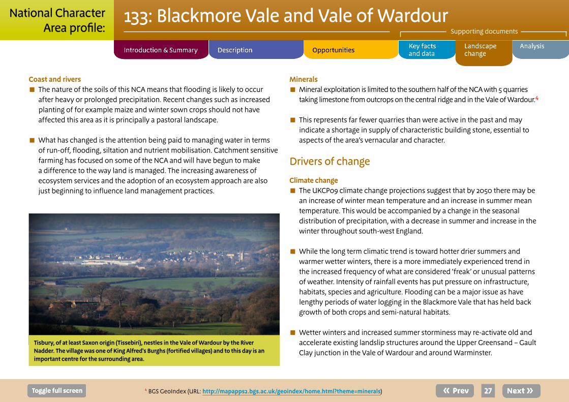
Tisbury, of at least Saxon origin (Tissebiri), nestles in the Vale of Wardour by the River Nadder. The village was one of King Alfred's Burghs (fortified villages) and to this day is an important centre for the surrounding area.
28
133: Blackmore Vale and Vale of WardourSupporting documents
National CharacterArea profile:
■ Demand for a greater proportion of energy generation from renewable sources has brought increased pressure for biomass crop production (areas are identified as being suitable). Such crops can have direct impacts where they are grown and indirect impacts through infrastructure construction, for example the upgrading of rural roads and enlargement of fields and field access for large harvesting machinery.
■ Some semi-natural habitats are well adapted to stress from drought and extremes of heat and cold. However, poor weather may prevent grazing or other, mechanised, sward management and could lead to habitat degradation, particularly on the more poorly draining clay soils of the vales.
■ In a scenario of reduced summer rainfall and increased rates of evaporation there may be a reduction in the flow and levels of the NCA’s streams and rivers as they are principally surface water fed.
Other key drivers ■ The Water Framework Directive represents a challenge for land and watercourse managers but a great opportunity for restoring the quality and biodiversity of the NCA’s watercourses and for getting more people involved in the process.
■ Housing allocations and development of employment sites could have an adverse impact on the character around the NCA’s settlements; increased infrastructure could also have deleterious impacts on character and tranquillity.
■ Continued influxes of new pests and diseases are threatening and will continue to pose a threat to agricultural and silvicultural crops, including the
area’s locally extensive conifer plantations. Native flora and fauna are also at risk from the arrival of new species and pathogens. Ash die-back and acute oak decline are two diseases that could impact significantly on the area’s landscape character and biodiversity.
■ The payment, by society, for the ecosystem services provided by the natural world and those who positively manage them opens up possibilities for new funding streams into the natural environment. Within this NCA, payment to put in place habitat to prevent flooding of towns may be an option.
■ Partnerships, working at the landscape scale, have already delivered benefits for habitats, species and people. There is, however, still considerable potential to deliver more and across larger areas to create robust ecological networks and put the NCA in the best place possible to respond to future challenges.
■ Even in the relatively small towns in this NCA, urban tree planting and the development of various green infrastructure and sustainable urban drainage systems will gain importance in the mitigation of impacts of more extreme weather events such as flash flooding. These measures can also provide other public benefits such as relaxation, informal recreation, increased local biodiversity and helping to integrate and soften new development.
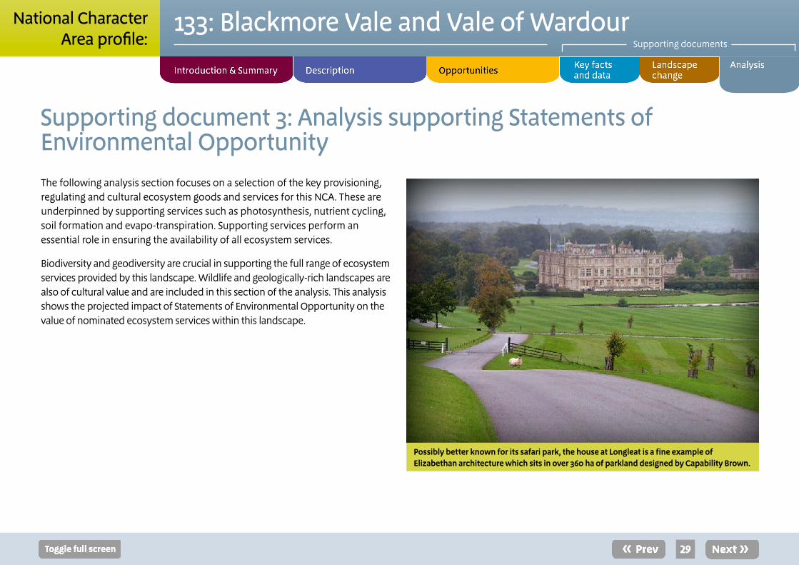
The following analysis section focuses on a selection of the key provisioning, regulating and cultural ecosystem goods and services for this NCA. These are underpinned by supporting services such as photosynthesis, nutrient cycling, soil formation and evapo-transpiration. Supporting services perform an essential role in ensuring the availability of all ecosystem services.
Biodiversity and geodiversity are crucial in supporting the full range of ecosystem services provided by this landscape. Wildlife and geologically-rich landscapes are also of cultural value and are included in this section of the analysis. This analysis shows the projected impact of Statements of Environmental Opportunity on the value of nominated ecosystem services within this landscape.
29
133: Blackmore Vale and Vale of WardourSupporting documents
National CharacterArea profile:
Supporting document 3: Analysis supporting Statements of Environmental Opportunity
Possibly better known for its safari park, the house at Longleat is a fine example of Elizabethan architecture which sits in over 360 ha of parkland designed by Capability Brown.
Statement of Environmental Opportunity
Ecosystem service
Food
pro
visi
on
Tim
ber p
rovi
sion
Wat
er a
vaila
bilit
y
Gen
etic
div
ersi
ty
Biom
ass
prov
isio
n
Clim
ate
regu
latio
n
Regu
latin
g w
ater
qu
ality
Regu
latin
g w
ater
fl
owRe
gula
ting
soil
qual
ityRe
gula
ting
soil
eros
ion
Polli
natio
n
Pest
regu
latio
n
Regu
latin
g co
asta
l er
osio
nSe
nse
of p
lace
/ In
spira
tion
Sens
e of
his
tory
Tran
quill
ity
Recr
eatio
n
Biod
iver
sity
Geo
dive
rsity
SEO 1: Protect, manage and enhance the diverse but coherent pastoral landscape character of the clay vales, limestone ridge and Greensand hills, their semi-natural grasslands and woodland and their characteristic wildlife, and manage the simple patterns of land use maintained by the long history of agriculture.
**
**
**
***
**
**
***
***
**
***
**
**
n/a
***
***
**
**
***
***
SEO 2: Work with local people to raise their understanding of the way in which the area’s strong landscape character, sense of place and distinctive wildlife are rooted in the continuity of agricultural land use, strong historic landscape character and legibility of historic features.
***
**
***
***
***
***
***
***
***
***
***
***
n/a ***
***
**
***
**
**
SEO 3: Work with the local farming and land management community to maintain the distinctive landscape and natural beauty of the area, enhancing ecosystems and ecosystem services.
**
**
***
**
**
**
***
***
***
***
***
***
n/a ***
***
***
***
***
***
SEO 4: Protect, manage and enhance the Vale of Wardour’s highly distinctive relationship between geology, landform and land use. Protect, manage and interpret the suite of national and Local Geological Sites.
***
**
***
***
**
***
***
***
***
***
***
***
n/a
***
***
***
**
**
***
30
133: Blackmore Vale and Vale of WardourSupporting documents
National CharacterArea profile:
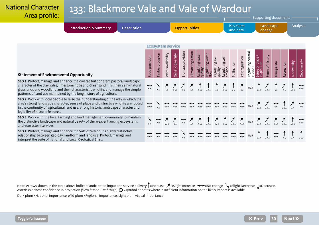
Note: Arrows shown in the table above indicate anticipated impact on service delivery =Increase ↗ =Slight Increase ↗ =No change ↗ =Slight Decrease ↗ =Decrease. Asterisks denote confidence in projection (*low **medium***high) =symbol denotes where insufficient information on the likely impact is available .
Dark plum =National Importance; Mid plum =Regional Importance; Light plum =Local Importance
31
133: Blackmore Vale and Vale of WardourSupporting documents
National CharacterArea profile:
Landscape attributes
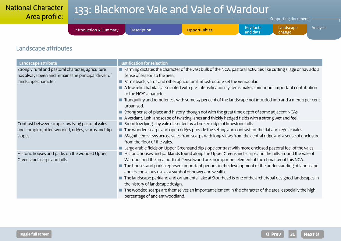
Landscape attribute Justification for selectionStrongly rural and pastoral character; agriculture has always been and remains the principal driver of landscape character.
■ Farming dictates the character of the vast bulk of the NCA, pastoral activities like cutting silage or hay add a sense of season to the area.
■ Farmsteads, yards and other agricultural infrastructure set the vernacular. ■ A few relict habitats associated with pre-intensification systems make a minor but important contribution to the NCA’s character.
■ Tranquillity and remoteness with some 75 per cent of the landscape not intruded into and a mere 1 per cent urbanised.
■ Strong sense of place and history, though not with the great time depth of some adjacent NCAs. ■ A verdant, lush landscape of twisting lanes and thickly hedged fields with a strong wetland feel.
Contrast between simple low lying pastoral vales and complex, often wooded, ridges, scarps and dip slopes.
■ Broad low lying clay vale dissected by a broken ridge of limestone hills. ■ The wooded scarps and open ridges provide the setting and contrast for the flat and regular vales. ■ Magnificent views across vales from scarps with long views from the central ridge and a sense of enclosure from the floor of the vales.
■ Large arable fields on Upper Greensand dip slope contrast with more enclosed pastoral feel of the vales.Historic houses and parks on the wooded Upper Greensand scarps and hills.
■ Historic houses and parklands found along the Upper Greensand scarps and the hills around the Vale of Wardour and the area north of Penselwood are an important element of the character of this NCA.
■ The houses and parks represent important periods in the development of the understanding of landscape and its conscious use as a symbol of power and wealth.
■ The landscape parkland and ornamental lake at Stourhead is one of the archetypal designed landscapes in the history of landscape design.
■ The wooded scarps are themselves an important element in the character of the area, especially the high percentage of ancient woodland.
32
133: Blackmore Vale and Vale of WardourSupporting documents
National CharacterArea profile:
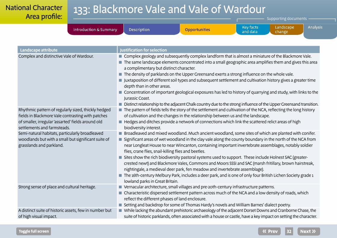
Landscape attribute Justification for selectionComplex and distinctive Vale of Wardour. ■ Complex geology and subsequently complex landform that is almost a miniature of the Blackmore Vale.
■ The same landscape elements concentrated into a small geographic area amplifies them and gives this area a complimentary but distinct character.
■ The density of parklands on the Upper Greensand exerts a strong influence on the whole vale. ■ Juxtaposition of different soil types and subsequent settlement and cultivation history gives a greater time depth than in other areas.
■ Concentration of important geological exposures has led to history of quarrying and study, with links to the Jurassic Coast.
■ Distinct relationship to the adjacent Chalk country due to the strong influence of the Upper Greensand transition.Rhythmic pattern of regularly sized, thickly hedged fields in Blackmore Vale contrasting with patches of smaller, irregular ‘assarted’ fields around old settlements and farmsteads.
■ The pattern of fields tells the story of the settlement and cultivation of the NCA, reflecting the long history of cultivation and the changes in the relationship between us and the landscape.
■ Hedges and ditches provide a network of connections which link the scattered relict areas of high biodiversity interest.
Semi-natural habitats, particularly broadleaved woodlands but with a small but significant suite of grasslands and parkland.
■ Broadleaved and mixed woodland. Much ancient woodland, some sites of which are planted with conifer. ■ Significant areas of wet woodland in the clay vale along the county boundary in the north of the NCA from near Longleat House to near Wincanton, containing important invertebrate assemblages, notably soldier flies, crane flies, snail-killing flies and beetles.
■ Sites show the rich biodiversity pastoral systems used to support. These include Holnest SAC (greater-crested newt) and Blackmore Vales, Commons and Moors SSSI and SAC (marsh fritillary, brown hairstreak, nightingale, a medieval deer park, fen meadow and invertebrate assemblage).
■ The 16th-century Melbury Park, includes a deer park, and is one of only four British Lichen Society grade 1 lowland parks in Great Britain.
Strong sense of place and cultural heritage. ■ Vernacular architecture, small villages and pre-20th-century infrastructure patterns. ■ Characteristic dispersed settlement pattern across much of the NCA and a low density of roads, which reflect the different phases of land enclosure.
■ Setting and backdrop for some of Thomas Hardy’s novels and William Barnes’ dialect poetry.A distinct suite of historic assets, few in number but of high visual impact.
■ While lacking the abundant prehistoric archaeology of the adjacent Dorset Downs and Cranborne Chase, the suite of historic parklands, often associated with a house or castle, have a key impact on setting the character.

33
133: Blackmore Vale and Vale of WardourSupporting documents
National CharacterArea profile:
Landscape opportunities
■ Protect and, where possible, enhance the wide open views across the NCA from the surrounding hills and high ground.
■ Ancient woodlands should be brought into suitable active management and planted ancient woodlands should be returned to broadleaved woodland where possible in order to enhance the contribution broadleaved woodland makes to the coherent and distinctive landscape character, climate change resilience and landscape permeability. In places new mixed and broadleaf woodland should be planted to reinforce character.
■ Protect and conserve the substantial and valuable fossil record held in the Jurassic/Cretaceous strata along the exposures in the Vale of Wardour. Maximise the conservation, scientific and educational potential of important exposures, which contribute scientific and educational value to the NCA.
■ Manage the distinctive boundary hedgerows and hedgerow trees which not only delineate patterns of occupation and land use but also provide an essential network of ecological connections across the wider countryside.
■ Secure the cultural, landscape and ecological continuity of the NCA’s suite of historic parklands through planning tree planting, grassland management and the maintenance of specific parkland features for the future.
■ Protect from damage and positively manage the archaeological heritage and heritage assets of the Blackmore Vale and Vale of Wardour NCA, ensuring its preservation while enhancing accessibility for study.
■ Manage the NCA’s settlements to ensure that sense of place is maintained through the continued use of the local vernacular and that any growth is sustainable and maintains or, preferably, enhances the character and tranquillity of this NCA.
■ Work with land managers to better understand and manage the soils of the NCA. Seek to enhance their structure and organic content where this has been damaged or degraded. Devise practical solutions to issues such as compaction, erosion and run-off.
■ Plan for changes in land use/farming types and cropping patterns in the face of climatic and economic pressures, aiming to both preserve the characteristically pastoral nature of the area and to enhance biodiversity.
■ Work with the protected landscape of the Dorset AONB and the Cranborne Chase AONB to meet the ambitions of their management plans.
■ Manage watercourses and their adjacent flood plains to enhance biodiversity, strengthen landscape character and enhance their role in buffering against downstream flooding and sediment/eutrophication issues. Ensure that the small but significant aquifers are protected from eutrophication and over-abstraction.
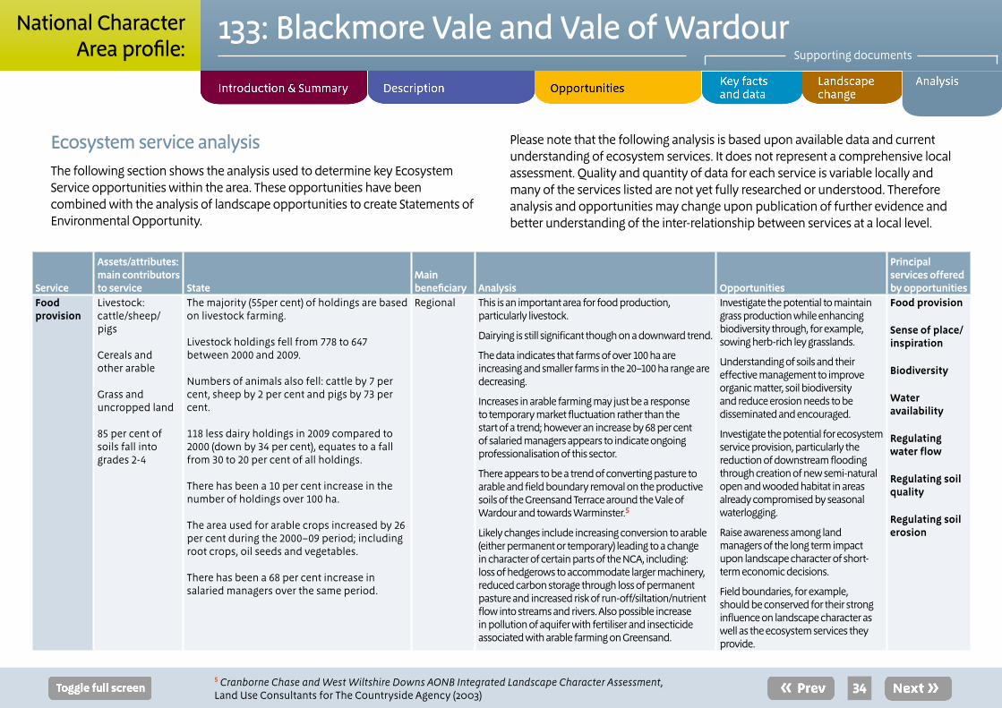
Service
Assets/attributes: main contributors to service State
Main beneficiary Analysis Opportunities
Principal services offered by opportunities
Food provision
Livestock:cattle/sheep/pigs
Cereals andother arable
Grass and uncropped land
85 per cent of soils fall into grades 2-4
The majority (55per cent) of holdings are based on livestock farming.
Livestock holdings fell from 778 to 647 between 2000 and 2009.
Numbers of animals also fell: cattle by 7 per cent, sheep by 2 per cent and pigs by 73 per cent.
118 less dairy holdings in 2009 compared to 2000 (down by 34 per cent), equates to a fall from 30 to 20 per cent of all holdings.
There has been a 10 per cent increase in the number of holdings over 100 ha.
The area used for arable crops increased by 26 per cent during the 2000–09 period; including root crops, oil seeds and vegetables.
There has been a 68 per cent increase in salaried managers over the same period.
Regional This is an important area for food production, particularly livestock.
Dairying is still significant though on a downward trend.
The data indicates that farms of over 100 ha are increasing and smaller farms in the 20–100 ha range are decreasing.
Increases in arable farming may just be a response to temporary market fluctuation rather than the start of a trend; however an increase by 68 per cent of salaried managers appears to indicate ongoing professionalisation of this sector.
There appears to be a trend of converting pasture to arable and field boundary removal on the productive soils of the Greensand Terrace around the Vale of Wardour and towards Warminster.5
Likely changes include increasing conversion to arable (either permanent or temporary) leading to a change in character of certain parts of the NCA, including: loss of hedgerows to accommodate larger machinery, reduced carbon storage through loss of permanent pasture and increased risk of run-off/siltation/nutrient flow into streams and rivers. Also possible increase in pollution of aquifer with fertiliser and insecticide associated with arable farming on Greensand.
Investigate the potential to maintain grass production while enhancing biodiversity through, for example, sowing herb-rich ley grasslands.
Understanding of soils and their effective management to improve organic matter, soil biodiversity and reduce erosion needs to be disseminated and encouraged.
Investigate the potential for ecosystem service provision, particularly the reduction of downstream flooding through creation of new semi-natural open and wooded habitat in areas already compromised by seasonal waterlogging.
Raise awareness among land managers of the long term impact upon landscape character of short-term economic decisions.
Field boundaries, for example, should be conserved for their strong influence on landscape character as well as the ecosystem services they provide.
Food provision
Sense of place/ inspiration
Biodiversity
Water availability
Regulating water flow
Regulating soil quality
Regulating soil erosion
34
133: Blackmore Vale and Vale of WardourSupporting documents
National CharacterArea profile:
Ecosystem service analysis The following section shows the analysis used to determine key Ecosystem Service opportunities within the area. These opportunities have been combined with the analysis of landscape opportunities to create Statements of Environmental Opportunity.
Please note that the following analysis is based upon available data and current understanding of ecosystem services. It does not represent a comprehensive local assessment. Quality and quantity of data for each service is variable locally and many of the services listed are not yet fully researched or understood. Therefore analysis and opportunities may change upon publication of further evidence and better understanding of the inter-relationship between services at a local level.
5 Cranborne Chase and West Wiltshire Downs AONB Integrated Landscape Character Assessment, Land Use Consultants for The Countryside Agency (2003)
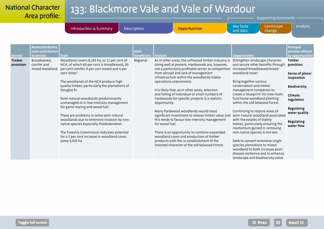
Service
Assets/attributes: main contributors to service State
Main beneficiary Analysis Opportunities
Principal services offered by opportunities
Timber provision
Broadleaved, conifer and mixed woodland
Woodland covers 8,293 ha, or 11 per cent of NCA, of which 60 per cent is broadleaved, 30 per cent conifer, 6 per cent mixed and 4 per cent ‘other’.
The woodlands of the NCA produce high quality timber, particularly the plantations of Douglas fir.
Semi-natural woodlands predominantly unmanaged or in low intensity management for game rearing and wood fuel.
There are problems in some semi-natural woodlands due to extensive invasion by non-native species especially rhododendron.
The Forestry Commission indicates potential for a 5 per cent increase in woodland cover, some 3,920 ha.
Regional As in other areas, the softwood timber industry is doing well at present. Hardwoods are, however, not a particularly profitable sector as competition from abroad and lack of management infrastructure within the woodlands makes operations uneconomic.
It is likely that, as in other areas, selection and felling of individual or small numbers of hardwoods for specific projects is a realistic opportunity.
Many hardwood woodlands would need significant investment to release timber value and this tends to favour low intensity management for wood fuel.
There is an opportunity to combine expanded woodland cover and production of timber products with the re-establishment of the forested character of the old Selwood Forest.
Strengthen landscape character and secure other benefits through increased broadleaved/mixed woodland cover.
Bring together various conservation and timber management companies to create a ‘blueprint’ for new multi-functional woodland planting within the old Selwood Forest.
Continuing to restore areas of semi-natural woodland associated with the estates of stately homes, particularly ensuring the momentum gained in removing non-native species is not lost.
Seek to convert extensive single species plantations to mixed woodland to both increase pest/disease resilience and to enhance landscape and biodiversity value.
Timber provision
Sense of place/ inspiration
Biodiversity
Climate regulation
Regulating water quality
Regulating water flow
35
133: Blackmore Vale and Vale of WardourSupporting documents
National CharacterArea profile:

Service
Assets/attributes: main contributors to service State
Main beneficiary Analysis Opportunities
Principal services offered by opportunities
Water availability
River Stour with dense network of tributaries
River Nadder
River Cale
River Lydden
Somerset Frome
River Brue
River Wylye
Local aquifers
The River Lydden drains the western side of the Blackmore Vale with underlying clay and mudstone formations. Rainfall results in rapid run-off with subsequent increases in water levels in local watercourses.
During periods of limited rainfall, river levels fall rapidly to low levels.
There is a small isolated chalk aquifer in the middle of the NCA around Mere and up to Warminster.
Most of the area is classed as having ‘no water available’ for further abstraction, and in the north-east there are areas that are classed as either ‘over-abstracted’ or ‘over-licensed’
North of Gillingham, the Stour and its tributaries and the groundwater aquifers are ‘over licensed’. All other rivers are classified as ‘no water available’ apart from the Nadder which is ‘over abstracted’.6
Local The vales are formed mainly of Upper Jurassic clays. The eastern and southern fringes of the NCA overlie the chalk aquifer of the Dorset Downs while there is also an aquifer separated from the main chalk aquifer underlying the West Wiltshire Downs by a line of distinct Greensand Hills. This isolated chalk aquifer makes a significant contribution to the flow of the upper Stour and its summer baseflow. There may be limited storage within these formations; the picture therefore is of a water environment under stress. The chalk aquifer of the Dorset Downs supplies the majority of the groundwater abstractions in this NCA.
Main abstractions from ground and surface waters are for public water supply (40 per cent of abstraction volume in the Stour catchment), aquaculture (27 per cent of abstraction volume in the Stour catchment) and hydropower (12 per cent in the Stour catchment).7
Water abstracted and used in fish farms is generally all returned to the watercourse close to the point of abstraction while other uses such as public water supply results in a total loss of water from the catchment and, potentially, the NCA. Low river flows or insufficient water may harm the wetland and river wildlife and habitats of this NCA.
Increase area of semi-natural habitats, including woodland and grassland, to reduce run-off and enhance aquifer recharge rates.
Manage soils to restore/maintain water retentiveness
Water resource planning
Promoting the catchment sensitive farming approach
Water availability
Regulating water flow
Biodiversity
Regulating soil erosion
36
133: Blackmore Vale and Vale of WardourSupporting documents
National CharacterArea profile:
6 Dorset WFD Management Area Abstraction Licensing Strategy: Dorset Stour and Frome, Piddle and West Dorset CAMS, Environment Agency (2012), Hampshire Avon WFD Management Area Abstraction Licensing Strategy, Environment Agency (2012), South and West Somerset WFD Management Area Abstraction Licensing Strategy: Parrett, Brue and West Somerset Streams CAMS, Environment Agency (2012)
7 Dorset WFD Management Area Abstraction Licensing Strategy: Dorset Stour and Frome, Piddle and West Dorset CAMS, Environment Agency (2012)
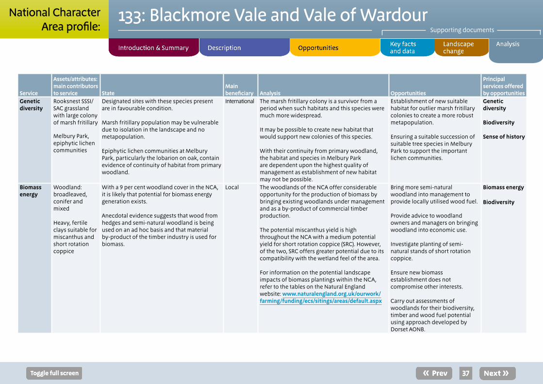
Service
Assets/attributes: main contributors to service State
Main beneficiary Analysis Opportunities
Principal services offered by opportunities
Genetic diversity
Rooksnest SSSI/SAC grassland with large colony of marsh fritillary
Melbury Park, epiphytic lichen communities
Designated sites with these species present are in favourable condition.
Marsh fritillary population may be vulnerable due to isolation in the landscape and no metapopulation.
Epiphytic lichen communities at Melbury Park, particularly the lobarion on oak, contain evidence of continuity of habitat from primary woodland.
International The marsh fritillary colony is a survivor from a period when such habitats and this species were much more widespread.
It may be possible to create new habitat that would support new colonies of this species.
With their continuity from primary woodland, the habitat and species in Melbury Park are dependent upon the highest quality of management as establishment of new habitat may not be possible.
Establishment of new suitable habitat for outlier marsh fritillary colonies to create a more robust metapopulation.
Ensuring a suitable succession of suitable tree species in Melbury Park to support the important lichen communities.
Genetic diversity
Biodiversity
Sense of history
Biomass energy
Woodland:broadleaved, conifer and mixed
Heavy, fertile clays suitable for miscanthus and short rotation coppice
With a 9 per cent woodland cover in the NCA, it is likely that potential for biomass energy generation exists.
Anecdotal evidence suggests that wood from hedges and semi-natural woodland is being used on an ad hoc basis and that material by-product of the timber industry is used for biomass.
Local The woodlands of the NCA offer considerable opportunity for the production of biomass by bringing existing woodlands under management and as a by-product of commercial timber production.
The potential miscanthus yield is high throughout the NCA with a medium potential yield for short rotation coppice (SRC). However, of the two, SRC offers greater potential due to its compatibility with the wetland feel of the area.
For information on the potential landscape impacts of biomass plantings within the NCA, refer to the tables on the Natural England website: www.naturalengland.org.uk/ourwork/farming/funding/ecs/sitings/areas/default.aspx
Bring more semi-natural woodland into management to provide locally utilised wood fuel.
Provide advice to woodland owners and managers on bringing woodland into economic use.
Investigate planting of semi-natural stands of short rotation coppice.
Ensure new biomass establishment does not compromise other interests.
Carry out assessments of woodlands for their biodiversity, timber and wood fuel potential using approach developed by Dorset AONB.
Biomass energy
Biodiversity
37
133: Blackmore Vale and Vale of WardourSupporting documents
National CharacterArea profile:
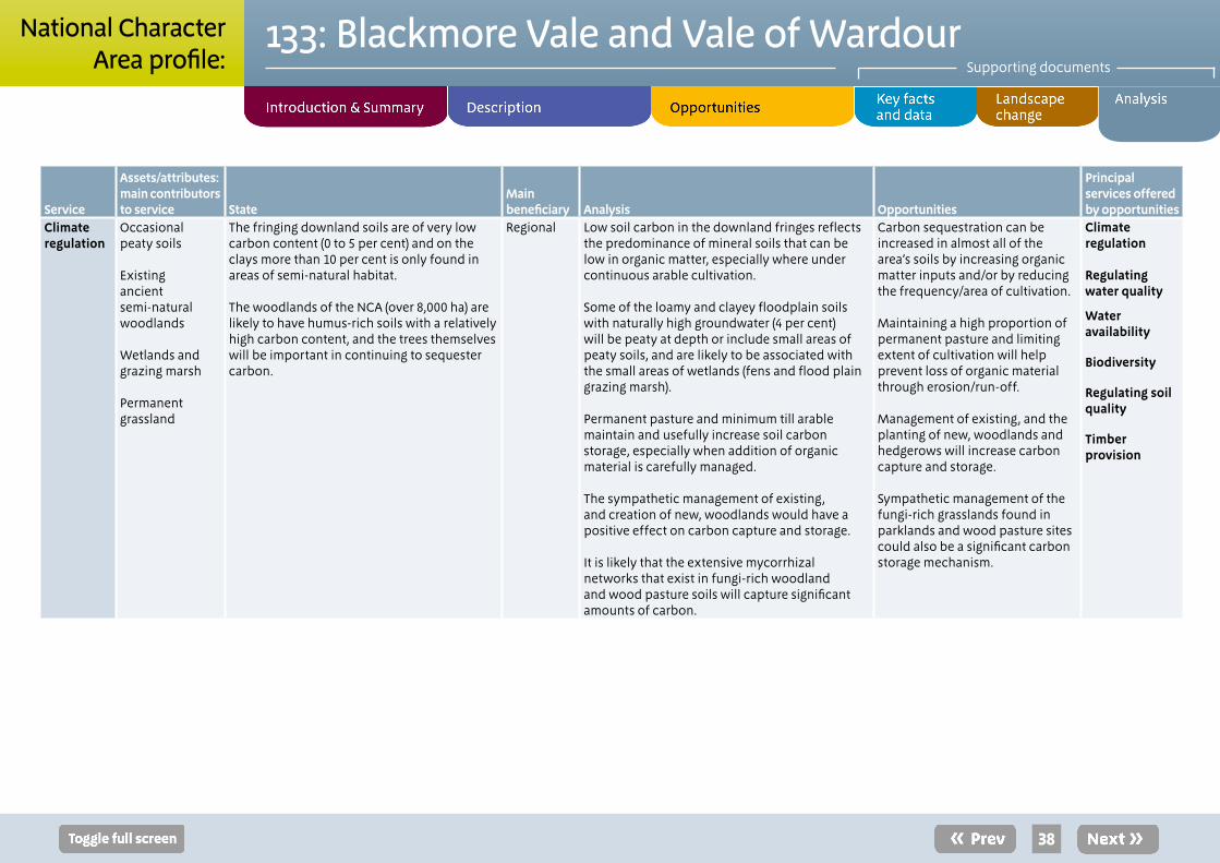
Service
Assets/attributes: main contributors to service State
Main beneficiary Analysis Opportunities
Principal services offered by opportunities
Climate regulation
Occasionalpeaty soils
Existingancientsemi-naturalwoodlands
Wetlands andgrazing marsh
Permanentgrassland
The fringing downland soils are of very low carbon content (0 to 5 per cent) and on the clays more than 10 per cent is only found in areas of semi-natural habitat.
The woodlands of the NCA (over 8,000 ha) are likely to have humus-rich soils with a relatively high carbon content, and the trees themselves will be important in continuing to sequester carbon.
Regional Low soil carbon in the downland fringes reflects the predominance of mineral soils that can be low in organic matter, especially where under continuous arable cultivation.
Some of the loamy and clayey floodplain soils with naturally high groundwater (4 per cent) will be peaty at depth or include small areas of peaty soils, and are likely to be associated with the small areas of wetlands (fens and flood plain grazing marsh).
Permanent pasture and minimum till arable maintain and usefully increase soil carbon storage, especially when addition of organic material is carefully managed.
The sympathetic management of existing, and creation of new, woodlands would have a positive effect on carbon capture and storage.
It is likely that the extensive mycorrhizal networks that exist in fungi-rich woodland and wood pasture soils will capture significant amounts of carbon.
Carbon sequestration can be increased in almost all of the area’s soils by increasing organic matter inputs and/or by reducing the frequency/area of cultivation.
Maintaining a high proportion of permanent pasture and limiting extent of cultivation will help prevent loss of organic material through erosion/run-off.
Management of existing, and the planting of new, woodlands and hedgerows will increase carbon capture and storage.
Sympathetic management of the fungi-rich grasslands found in parklands and wood pasture sites could also be a significant carbon storage mechanism.
Climate regulation
Regulating water quality
Water availability
Biodiversity
Regulating soil quality
Timber provision
38
133: Blackmore Vale and Vale of WardourSupporting documents
National CharacterArea profile:
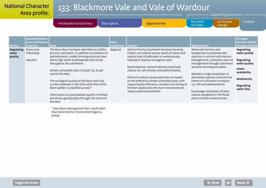
Service
Assets/attributes: main contributors to service State
Main beneficiary Analysis Opportunities
Principal services offered by opportunities
Regulating water quality
Rivers and tributaries
Aquifers
The River Stour has been identified as a Defra priority catchment. In addition to problems of sedimentation, arable farming practices have led to high levels of phosphate and nitrate throughout the catchment.
Nitrate vulnerable zone is 24,621 ha, 31 per cent of the NCA.
The ecological quality of the Stour and Cale is only moderate in this NCA while that of the River Lydden is classified as bad.8
Information on groundwater quality is limited but shows good quality through the centre of the NCA.
Regional Defra’s Priority Catchment Sensitive Farming Project can help to reduce levels of inputs and reduce level of pollutants in watercourses, helping to improve ecological value.
Restoring semi-natural habitats could help reduce run-off, erosion and sedimentation.
Efforts to reduce nitrate pollution are based on the extensive nitrate vulnerable zone, with improving the efficiency, location and timing of fertiliser application the main mechanisms to reduce potential pollution.
Work with farmers and landowners to promote best practice in nutrient and manure management, cultivation and soil management through catchment sensitive farming principles.
Maintain a high proportion of permanent pasture and limit the extent of cultivation to reduce run-off and sedimentation.
Encourage restoration of semi-natural woodland in the flood plain to buffer watercourses.
Regulating water quality
Regulating water quality
Water availability
Biodiversity
Regulating water flow
39
133: Blackmore Vale and Vale of WardourSupporting documents
National CharacterArea profile:
8 River Basin Management Plan: South West River Basin District, Environment Agency (2009)
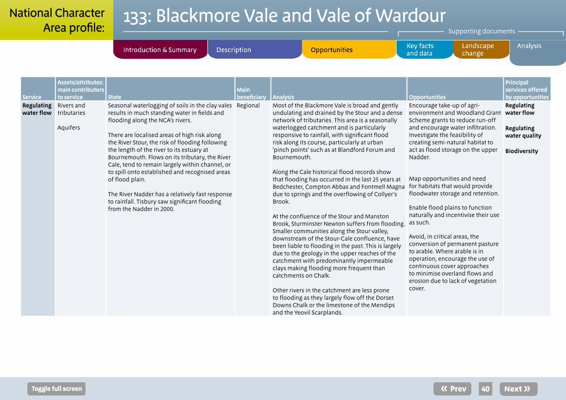
Service
Assets/attributes: main contributors to service State
Main beneficiary Analysis Opportunities
Principal services offered by opportunities
Regulating water flow
Rivers and tributaries
Aquifers
Seasonal waterlogging of soils in the clay vales results in much standing water in fields and flooding along the NCA’s rivers.
There are localised areas of high risk along the River Stour, the risk of flooding following the length of the river to its estuary at Bournemouth. Flows on its tributary, the River Cale, tend to remain largely within channel, or to spill onto established and recognised areas of flood plain.
The River Nadder has a relatively fast response to rainfall. Tisbury saw significant flooding from the Nadder in 2000.
Regional Most of the Blackmore Vale is broad and gently undulating and drained by the Stour and a dense network of tributaries. This area is a seasonally waterlogged catchment and is particularly responsive to rainfall, with significant flood risk along its course, particularly at urban ‘pinch points’ such as at Blandford Forum and Bournemouth.
Along the Cale historical flood records show that flooding has occurred in the last 25 years at Bedchester, Compton Abbas and Fontmell Magna due to springs and the overflowing of Collyer’s Brook.
At the confluence of the Stour and Manston Brook, Sturminster Newton suffers from flooding. Smaller communities along the Stour valley, downstream of the Stour-Cale confluence, have been liable to flooding in the past. This is largely due to the geology in the upper reaches of the catchment with predominantly impermeable clays making flooding more frequent than catchments on Chalk.
Other rivers in the catchment are less prone to flooding as they largely flow off the Dorset Downs Chalk or the limestone of the Mendips and the Yeovil Scarplands.
Encourage take-up of agri-environment and Woodland Grant Scheme grants to reduce run-off and encourage water infiltration. Investigate the feasibility of creating semi-natural habitat to act as flood storage on the upper Nadder.
Map opportunities and need for habitats that would provide floodwater storage and retention.
Enable flood plains to function naturally and incentivise their use as such.
Avoid, in critical areas, the conversion of permanent pasture to arable. Where arable is in operation, encourage the use of continuous cover approaches to minimise overland flows and erosion due to lack of vegetation cover.
Regulating water flow
Regulating water quality
Biodiversity
40
133: Blackmore Vale and Vale of WardourSupporting documents
National CharacterArea profile:
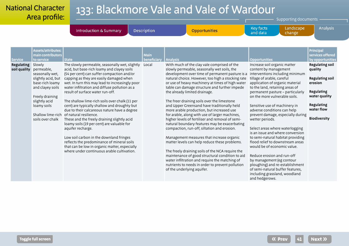
Service
Assets/attributes: main contributors to service State
Main beneficiary Analysis Opportunities
Principal services offered by opportunities
Regulating soil quality
Slowly permeable, seasonally wet, slightly acid, but base-rich loamy and clayey soils
Freely draining slightly acid loamy soils
Shallow lime-rich soils over chalk
The slowly permeable, seasonally wet, slightly acid, but base-rich loamy and clayey soils (54 per cent) can suffer compaction and/or capping as they are easily damaged when wet. In turn this may lead to increasingly poor water infiltration and diffuse pollution as a result of surface water run-off. The shallow lime-rich soils over chalk (11 per cent) are typically shallow and droughty but due to their calcareous nature have a degree of natural resilience. These and the freely draining slightly acid loamy soils (19 per cent) are valuable for aquifer recharge.
Low soil carbon in the downland fringes reflects the predominance of mineral soils that can be low in organic matter, especially where under continuous arable cultivation.
Local With much of the clay vale comprised of the slowly permeable, seasonally wet soils, the development over time of permanent pasture is a natural choice. However, too high a stocking rate or use of heavy machinery at times of high water table can damage structure and further impede the already limited drainage.
The freer draining soils over the limestone and Upper Greensand have traditionally held more arable production, but increased use for arable, along with use of larger machines, higher levels of fertiliser and removal of semi-natural boundary features may be exacerbating compaction, run-off, siltation and erosion.
Management measures that increase organic matter levels can help reduce these problems.
The freely draining soils of the NCA require the maintenance of good structural condition to aid water infiltration and require the matching of nutrients to needs in order to prevent pollution of the underlying aquifer.
Increase soil organic matter content by management interventions including minimum tillage of arable, careful application of organic material to the land, retaining areas of permanent pasture – particularly on the more vulnerable soils.
Sensitive use of machinery in adverse conditions can help prevent damage, especially during wetter periods.
Select areas where waterlogging is an issue and where conversion to semi-natural habitat providing flood relief to downstream areas would be of economic value.
Reduce erosion and run-off by management (eg contour ploughing) and re-establishment of semi-natural buffer features, including grassland, woodland and hedgerows.
Regulating soil quality
Regulating soil erosion
Regulating water quality
Regulating water flow Biodiversity
41
133: Blackmore Vale and Vale of WardourSupporting documents
National CharacterArea profile:
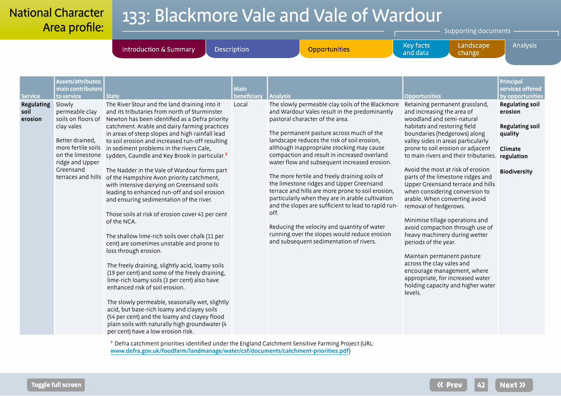
Service
Assets/attributes: main contributors to service State
Main beneficiary Analysis Opportunities
Principal services offered by opportunities
Regulating soil erosion
Slowly permeable clay soils on floors of clay vales
Better drained, more fertile soils on the limestone ridge and Upper Greensand terraces and hills
The River Stour and the land draining into it and its tributaries from north of Sturminster Newton has been identified as a Defra priority catchment. Arable and dairy farming practices in areas of steep slopes and high rainfall lead to soil erosion and increased run-off resulting in sediment problems in the rivers Cale, Lydden, Caundle and Key Brook in particular.9
The Nadder in the Vale of Wardour forms part of the Hampshire Avon priority catchment, with intensive dairying on Greensand soils leading to enhanced run-off and soil erosion and ensuring sedimentation of the river.
Those soils at risk of erosion cover 41 per cent of the NCA.
The shallow lime-rich soils over chalk (11 per cent) are sometimes unstable and prone to loss through erosion.
The freely draining, slightly acid, loamy soils (19 per cent) and some of the freely draining, lime-rich loamy soils (3 per cent) also have enhanced risk of soil erosion.
The slowly permeable, seasonally wet, slightly acid, but base-rich loamy and clayey soils (54 per cent) and the loamy and clayey flood plain soils with naturally high groundwater (4 per cent) have a low erosion risk.
Local The slowly permeable clay soils of the Blackmore and Wardour Vales result in the predominantly pastoral character of the area.
The permanent pasture across much of the landscape reduces the risk of soil erosion, although inappropriate stocking may cause compaction and result in increased overland water flow and subsequent increased erosion.
The more fertile and freely draining soils of the limestone ridges and Upper Greensand terrace and hills are more prone to soil erosion, particularly when they are in arable cultivation and the slopes are sufficient to lead to rapid run-off.
Reducing the velocity and quantity of water running over the slopes would reduce erosion and subsequent sedimentation of rivers.
Retaining permanent grassland, and increasing the area of woodland and semi-natural habitats and restoring field boundaries (hedgerows) along valley sides in areas particularly prone to soil erosion or adjacent to main rivers and their tributaries.
Avoid the most at risk of erosion parts of the limestone ridges and Upper Greensand terrace and hills when considering conversion to arable. When converting avoid removal of hedgerows.
Minimise tillage operations and avoid compaction through use of heavy machinery during wetter periods of the year.
Maintain permanent pasture across the clay vales and encourage management, where appropriate, for increased water holding capacity and higher water levels.
Regulating soil erosion
Regulating soil quality
Climate regulation
Biodiversity
42
133: Blackmore Vale and Vale of WardourSupporting documents
National CharacterArea profile:
9 Defra catchment priorities identified under the England Catchment Sensitive Farming Project (URL: www.defra.gov.uk/foodfarm/landmanage/water/csf/documents/catchment-priorities.pdf)
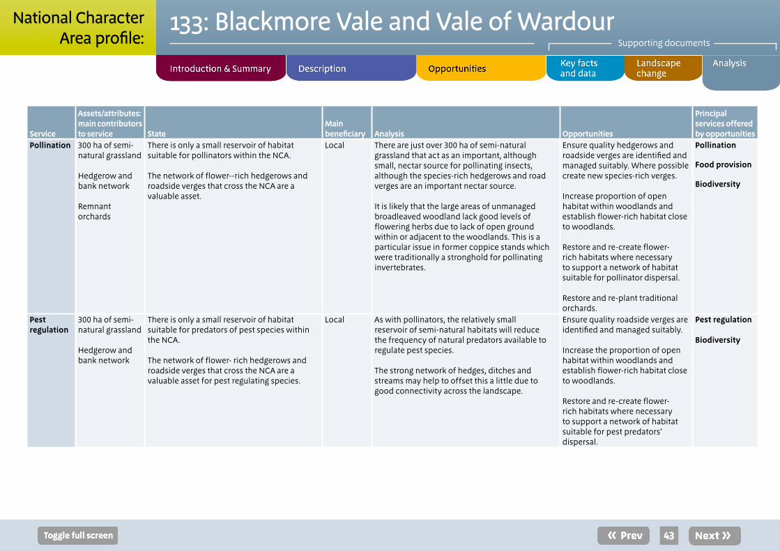
Service
Assets/attributes: main contributors to service State
Main beneficiary Analysis Opportunities
Principal services offered by opportunities
Pollination 300 ha of semi-natural grassland
Hedgerow and bank network
Remnant orchards
There is only a small reservoir of habitat suitable for pollinators within the NCA.
The network of flower--rich hedgerows and roadside verges that cross the NCA are a valuable asset.
Local There are just over 300 ha of semi-natural grassland that act as an important, although small, nectar source for pollinating insects, although the species-rich hedgerows and road verges are an important nectar source.
It is likely that the large areas of unmanaged broadleaved woodland lack good levels of flowering herbs due to lack of open ground within or adjacent to the woodlands. This is a particular issue in former coppice stands which were traditionally a stronghold for pollinating invertebrates.
Ensure quality hedgerows and roadside verges are identified and managed suitably. Where possible create new species-rich verges.
Increase proportion of open habitat within woodlands and establish flower-rich habitat close to woodlands.
Restore and re-create flower-rich habitats where necessary to support a network of habitat suitable for pollinator dispersal.
Restore and re-plant traditional orchards.
Pollination
Food provision
Biodiversity
Pest regulation
300 ha of semi-natural grassland
Hedgerow and bank network
There is only a small reservoir of habitat suitable for predators of pest species within the NCA.
The network of flower- rich hedgerows and roadside verges that cross the NCA are a valuable asset for pest regulating species.
Local As with pollinators, the relatively small reservoir of semi-natural habitats will reduce the frequency of natural predators available to regulate pest species.
The strong network of hedges, ditches and streams may help to offset this a little due to good connectivity across the landscape.
Ensure quality roadside verges are identified and managed suitably.
Increase the proportion of open habitat within woodlands and establish flower-rich habitat close to woodlands.
Restore and re-create flower-rich habitats where necessary to support a network of habitat suitable for pest predators’ dispersal.
Pest regulation Biodiversity
43
133: Blackmore Vale and Vale of WardourSupporting documents
National CharacterArea profile:
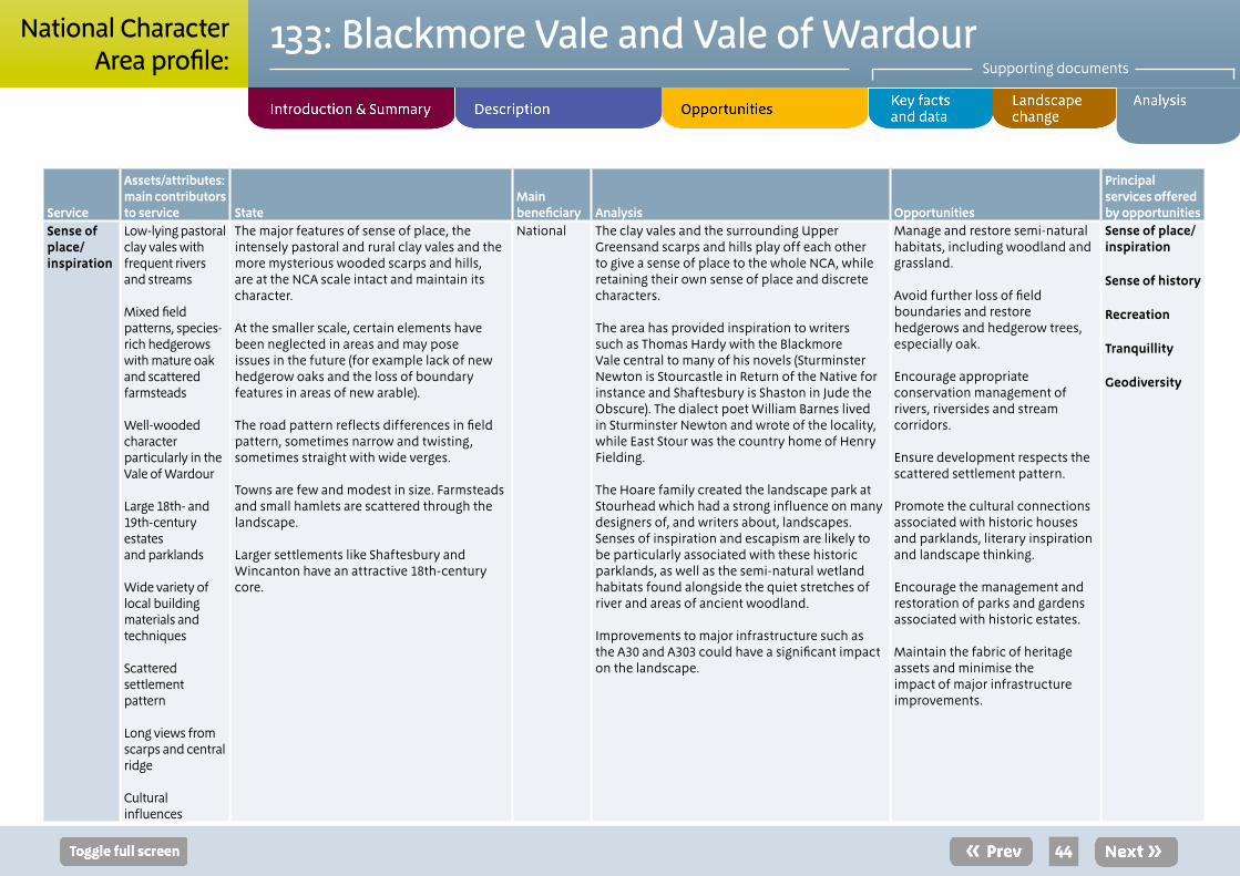
Service
Assets/attributes: main contributors to service State
Main beneficiary Analysis Opportunities
Principal services offered by opportunities
Sense of place/ inspiration
Low-lying pastoral clay vales with frequent rivers and streams
Mixed field patterns, species-rich hedgerows with mature oak and scattered farmsteads
Well-wooded character particularly in the Vale of Wardour
Large 18th- and 19th-century estates and parklands
Wide variety of local building materials and techniques
Scattered settlement pattern
Long views from scarps and central ridge
Cultural influences
The major features of sense of place, the intensely pastoral and rural clay vales and the more mysterious wooded scarps and hills, are at the NCA scale intact and maintain its character.
At the smaller scale, certain elements have been neglected in areas and may pose issues in the future (for example lack of new hedgerow oaks and the loss of boundary features in areas of new arable).
The road pattern reflects differences in field pattern, sometimes narrow and twisting, sometimes straight with wide verges.
Towns are few and modest in size. Farmsteads and small hamlets are scattered through the landscape.
Larger settlements like Shaftesbury and Wincanton have an attractive 18th-century core.
National The clay vales and the surrounding Upper Greensand scarps and hills play off each other to give a sense of place to the whole NCA, while retaining their own sense of place and discrete characters. The area has provided inspiration to writers such as Thomas Hardy with the Blackmore Vale central to many of his novels (Sturminster Newton is Stourcastle in Return of the Native for instance and Shaftesbury is Shaston in Jude the Obscure). The dialect poet William Barnes lived in Sturminster Newton and wrote of the locality, while East Stour was the country home of Henry Fielding.
The Hoare family created the landscape park at Stourhead which had a strong influence on many designers of, and writers about, landscapes. Senses of inspiration and escapism are likely to be particularly associated with these historic parklands, as well as the semi-natural wetland habitats found alongside the quiet stretches of river and areas of ancient woodland.
Improvements to major infrastructure such as the A30 and A303 could have a significant impact on the landscape.
Manage and restore semi-natural habitats, including woodland and grassland.
Avoid further loss of field boundaries and restore hedgerows and hedgerow trees, especially oak.
Encourage appropriate conservation management of rivers, riversides and stream corridors.
Ensure development respects the scattered settlement pattern.
Promote the cultural connections associated with historic houses and parklands, literary inspiration and landscape thinking.
Encourage the management and restoration of parks and gardens associated with historic estates.
Maintain the fabric of heritage assets and minimise the impact of major infrastructure improvements.
Sense of place/ inspiration
Sense of history
Recreation
Tranquillity
Geodiversity
44
133: Blackmore Vale and Vale of WardourSupporting documents
National CharacterArea profile:
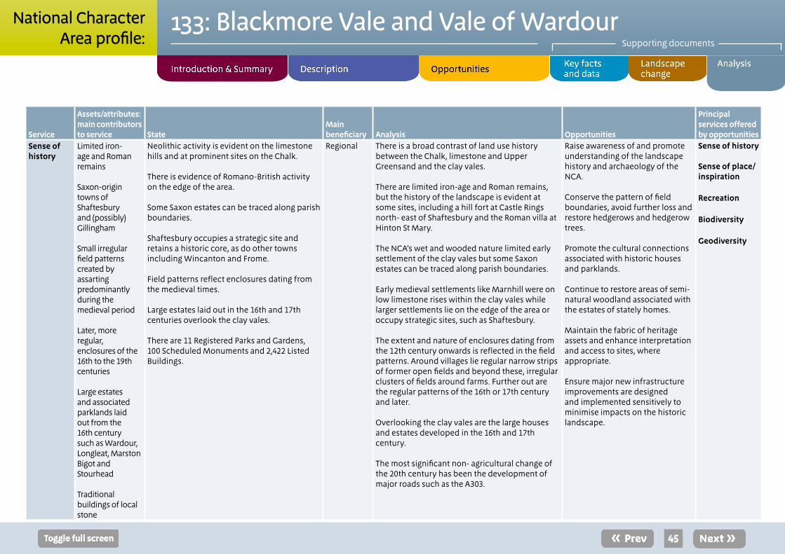
Service
Assets/attributes: main contributors to service State
Main beneficiary Analysis Opportunities
Principal services offered by opportunities
Sense of history
Limited iron- age and Roman remains
Saxon-origin towns of Shaftesbury and (possibly) Gillingham
Small irregular field patterns created by assarting predominantly during the medieval period
Later, more regular, enclosures of the 16th to the 19th centuries
Large estates and associated parklands laid out from the 16th century such as Wardour, Longleat, Marston Bigot and Stourhead
Traditional buildings of local stone
Neolithic activity is evident on the limestone hills and at prominent sites on the Chalk.
There is evidence of Romano-British activity on the edge of the area.
Some Saxon estates can be traced along parish boundaries.
Shaftesbury occupies a strategic site and retains a historic core, as do other towns including Wincanton and Frome.
Field patterns reflect enclosures dating from the medieval times.
Large estates laid out in the 16th and 17th centuries overlook the clay vales.
There are 11 Registered Parks and Gardens, 100 Scheduled Monuments and 2,422 Listed Buildings.
Regional There is a broad contrast of land use history between the Chalk, limestone and Upper Greensand and the clay vales.
There are limited iron-age and Roman remains, but the history of the landscape is evident at some sites, including a hill fort at Castle Rings north- east of Shaftesbury and the Roman villa at Hinton St Mary.
The NCA’s wet and wooded nature limited early settlement of the clay vales but some Saxon estates can be traced along parish boundaries.
Early medieval settlements like Marnhill were on low limestone rises within the clay vales while larger settlements lie on the edge of the area or occupy strategic sites, such as Shaftesbury.
The extent and nature of enclosures dating from the 12th century onwards is reflected in the field patterns. Around villages lie regular narrow strips of former open fields and beyond these, irregular clusters of fields around farms. Further out are the regular patterns of the 16th or 17th century and later.
Overlooking the clay vales are the large houses and estates developed in the 16th and 17th century.
The most significant non- agricultural change of the 20th century has been the development of major roads such as the A303.
Raise awareness of and promote understanding of the landscape history and archaeology of the NCA.
Conserve the pattern of field boundaries, avoid further loss and restore hedgerows and hedgerow trees.
Promote the cultural connections associated with historic houses and parklands.
Continue to restore areas of semi-natural woodland associated with the estates of stately homes.
Maintain the fabric of heritage assets and enhance interpretation and access to sites, where appropriate.
Ensure major new infrastructure improvements are designed and implemented sensitively to minimise impacts on the historic landscape.
Sense of history Sense of place/ inspiration
Recreation
Biodiversity
Geodiversity
45
133: Blackmore Vale and Vale of WardourSupporting documents
National CharacterArea profile:
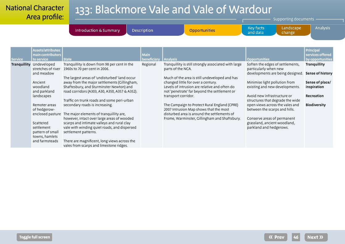
Service
Assets/attributes: main contributors to service State
Main beneficiary Analysis Opportunities
Principal services offered by opportunities
Tranquillity Undeveloped stretches of river and meadow
Ancient woodland and parkland landscapes
Remoter areas of hedgerow-enclosed pasture
Scattered settlement pattern of small towns, hamlets and farmsteads
Tranquillity is down from 98 per cent in the 1960s to 70 per cent in 2006.
The largest areas of ‘undisturbed’ land occur away from the major settlements (Gillingham, Shaftesbury, and Sturminster Newton) and road corridors (A303, A30, A350, A357 & A352).
Traffic on trunk roads and some peri-urban secondary roads is increasing.
The major elements of tranquillity are, however, intact over large areas of wooded scarps and intimate valleys and rural clay vale with winding quiet roads, and dispersed settlement patterns.
There are magnificent, long views across the vales from scarps and limestone ridges.
Regional Tranquillity is still strongly associated with large parts of the NCA.
Much of the area is still undeveloped and has changed little for over a century.Levels of intrusion are relative and often do not ‘penetrate’ far beyond the settlement or transport corridor.
The Campaign to Protect Rural England (CPRE) 2007 Intrusion Map shows that the most disturbed area is around the settlements of Frome, Warminster, Gillingham and Shaftsbury.
Soften the edges of settlements, particularly when new developments are being designed.
Minimise light pollution from existing and new developments.
Avoid new infrastructure or structures that degrade the wide open views across the vales and between the scarps and hills.
Conserve areas of permanent grassland, ancient woodland, parkland and hedgerows.
Tranquillity Sense of history Sense of place/ inspiration
Recreation
Biodiversity
46
133: Blackmore Vale and Vale of WardourSupporting documents
National CharacterArea profile:

Service
Assets/attributes: main contributors to service State
Main beneficiary Analysis Opportunities
Principal services offered by opportunities
Recreation Rights of way network and open access land
Regional routes
Parklands at Wardour, Longleat, Marston Bigot and Stourhead
Historic towns such as Shaftesbury
Visitor attractions such as Longleat Safari Park, Longleat Forest Center Parcs destination and Stourhead Gardens
Opportunities for recreation are provided by an extensive 1,600 km rights of way network (with a density of 2 km per km²).
The Wessex Ridgeway Trail and Stour Valley Way offer regional routes to follow.
There are also 785 ha of open access land (1 per cent of the NCA).
Longleat with its safari park, the Longleat Forest Center Parcs holiday destination and Stourhead are all major visitor attractions, while Shaftesbury is a popular destination.
Regional This is not an area that has been recognised fully for its informal recreational potential.
While Stourhead and Longleat are high profile destinations, other attractive destinations are much ‘lower key’, though Shaftesbury is popular.
Two regional routes and an extensive rights of way network provide an opportunity to experience the tranquillity and distinctive landscape character of the NCA through informal recreation.
Opportunities for enhancements to the public rights of way network should be realised.
Improved access opportunities should incorporate enhanced interpretation, particularly of heritage assets and features.
Extend awareness of access and recreational opportunities available across the area, possibly taking pressure away from some of the more frequented parts of Dorset, Wiltshire and Somerset.
Promote Shaftesbury and other historic town as tourist destinations and as bases from which to visit the local area.
Recreation
Sense of place/ inspiration
Sense of history
47
133: Blackmore Vale and Vale of WardourSupporting documents
National CharacterArea profile:
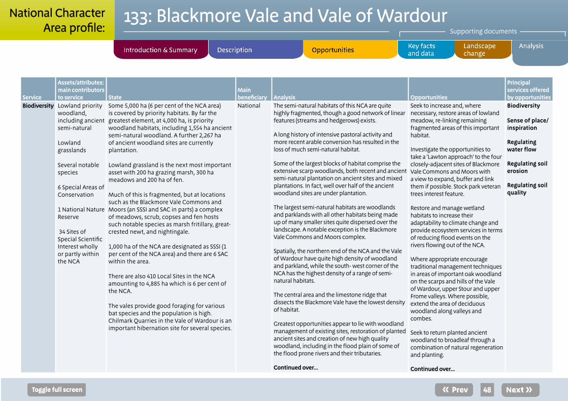
Service
Assets/attributes: main contributors to service State
Main beneficiary Analysis Opportunities
Principal services offered by opportunities
Biodiversity Lowland priority woodland, including ancient semi-natural
Lowland grasslands
Several notable species
6 Special Areas of Conservation
1 National Nature Reserve
34 Sites of Special Scientific Interest wholly or partly within the NCA
Some 5,000 ha (6 per cent of the NCA area) is covered by priority habitats. By far the greatest element, at 4,000 ha, is priority woodland habitats, including 1,554 ha ancient semi-natural woodland. A further 2,267 ha of ancient woodland sites are currently plantation.
Lowland grassland is the next most important asset with 200 ha grazing marsh, 300 ha meadows and 200 ha of fen.
Much of this is fragmented, but at locations such as the Blackmore Vale Commons and Moors (an SSSI and SAC in parts) a complex of meadows, scrub, copses and fen hosts such notable species as marsh fritillary, great-crested newt, and nightingale.
1,000 ha of the NCA are designated as SSSI (1 per cent of the NCA area) and there are 6 SAC within the area.
There are also 410 Local Sites in the NCA amounting to 4,885 ha which is 6 per cent of the NCA.
The vales provide good foraging for various bat species and the population is high. Chilmark Quarries in the Vale of Wardour is an important hibernation site for several species.
National The semi-natural habitats of this NCA are quite highly fragmented, though a good network of linear features (streams and hedgerows) exists.
A long history of intensive pastoral activity and more recent arable conversion has resulted in the loss of much semi-natural habitat.
Some of the largest blocks of habitat comprise the extensive scarp woodlands, both recent and ancient semi-natural plantation on ancient sites and mixed plantations. In fact, well over half of the ancient woodland sites are under plantation.
The largest semi-natural habitats are woodlands and parklands with all other habitats being made up of many smaller sites quite dispersed over the landscape. A notable exception is the Blackmore Vale Commons and Moors complex.
Spatially, the northern end of the NCA and the Vale of Wardour have quite high density of woodland and parkland, while the south- west corner of the NCA has the highest density of a range of semi-natural habitats.
The central area and the limestone ridge that dissects the Blackmore Vale have the lowest density of habitat.
Greatest opportunities appear to lie with woodland management of existing sites, restoration of planted ancient sites and creation of new high quality woodland, including in the flood plain of some of the flood prone rivers and their tributaries.
Continued over...
Seek to increase and, where necessary, restore areas of lowland meadow, re-linking remaining fragmented areas of this important habitat.
Investigate the opportunities to take a ‘Lawton approach’ to the four closely-adjacent sites of Blackmore Vale Commons and Moors with a view to expand, buffer and link them if possible. Stock park veteran trees interest feature.
Restore and manage wetland habitats to increase their adaptability to climate change and provide ecosystem services in terms of reducing flood events on the rivers flowing out of the NCA.
Where appropriate encourage traditional management techniques in areas of important oak woodland on the scarps and hills of the Vale of Wardour, upper Stour and upper Frome valleys. Where possible, extend the area of deciduous woodland along valleys and combes.
Seek to return planted ancient woodland to broadleaf through a combination of natural regeneration and planting.
Continued over...
Biodiversity
Sense of place/ inspiration
Regulating water flow
Regulating soil erosion
Regulating soil quality
48
133: Blackmore Vale and Vale of WardourSupporting documents
National CharacterArea profile:
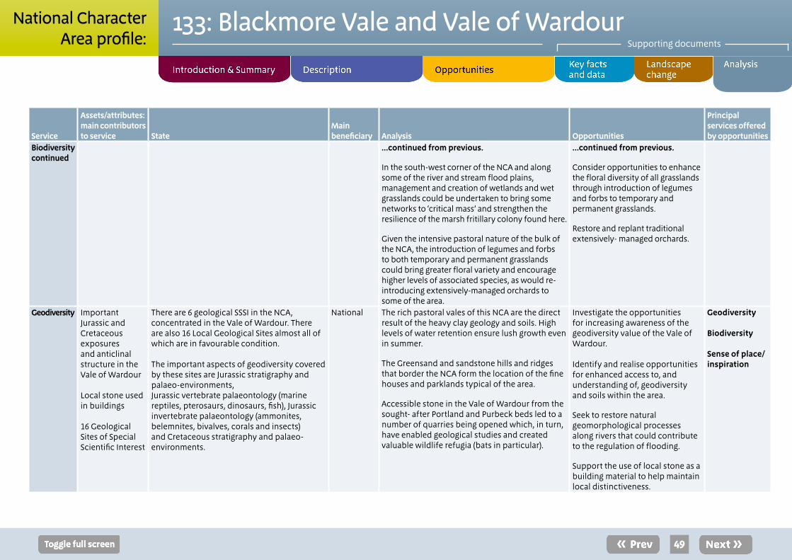
Service
Assets/attributes: main contributors to service State
Main beneficiary Analysis Opportunities
Principal services offered by opportunities
Biodiversity continued
...continued from previous.
In the south-west corner of the NCA and along some of the river and stream flood plains, management and creation of wetlands and wet grasslands could be undertaken to bring some networks to ‘critical mass’ and strengthen the resilience of the marsh fritillary colony found here.
Given the intensive pastoral nature of the bulk of the NCA, the introduction of legumes and forbs to both temporary and permanent grasslands could bring greater floral variety and encourage higher levels of associated species, as would re-introducing extensively-managed orchards to some of the area.
...continued from previous.
Consider opportunities to enhance the floral diversity of all grasslands through introduction of legumes and forbs to temporary and permanent grasslands.
Restore and replant traditional extensively- managed orchards.
Geodiversity Important Jurassic and Cretaceous exposures and anticlinal structure in the Vale of Wardour
Local stone used in buildings
16 Geological Sites of Special Scientific Interest
There are 6 geological SSSI in the NCA, concentrated in the Vale of Wardour. There are also 16 Local Geological Sites almost all of which are in favourable condition.
The important aspects of geodiversity covered by these sites are Jurassic stratigraphy and palaeo-environments,Jurassic vertebrate palaeontology (marine reptiles, pterosaurs, dinosaurs, fish), Jurassic invertebrate palaeontology (ammonites, belemnites, bivalves, corals and insects) and Cretaceous stratigraphy and palaeo-environments.
National The rich pastoral vales of this NCA are the direct result of the heavy clay geology and soils. High levels of water retention ensure lush growth even in summer.
The Greensand and sandstone hills and ridges that border the NCA form the location of the fine houses and parklands typical of the area.
Accessible stone in the Vale of Wardour from the sought- after Portland and Purbeck beds led to a number of quarries being opened which, in turn, have enabled geological studies and created valuable wildlife refugia (bats in particular).
Investigate the opportunities for increasing awareness of the geodiversity value of the Vale of Wardour.
Identify and realise opportunities for enhanced access to, and understanding of, geodiversity and soils within the area.
Seek to restore natural geomorphological processes along rivers that could contribute to the regulation of flooding.
Support the use of local stone as a building material to help maintain local distinctiveness.
Geodiversity
Biodiversity
Sense of place/ inspiration
49
133: Blackmore Vale and Vale of WardourSupporting documents
National CharacterArea profile:
* To view a copy of the licence/s, visit creativecommons.org/licenses/by-sa/2.0/ or send a letter to Creative Commons, 171 Second Street, Suite 300, San Francisco, California, 94105, USA.
50
Natural England is here to secure a healthy natural environment for people to enjoy, where wildlife is protected and England’s traditional landscapes are safeguarded for future generations.
Catalogue Code: NE539ISBN: 978-1-78367-099-4
Should an alternative format of this publication be required, please contact our enquiries line for more information: 0845 600 3078 or email [email protected]
www.naturalengland.org.uk
133: Blackmore Vale and Vale of WardourSupporting documents
National CharacterArea profile:
Photo creditsFront cover: The Vale of Wardour with its Greensand character. © David Blake, Wessex Wildlife PhotographyPage 4: © Toby/creativecommons.org/licenses/by-sa/2.0/* Page 5, 7: © David Blake, Wessex Wildlife PhotographyPage 6: © Maurice-Pullin/creativecommons.org/licenses/by-sa/2.0/*Page 8: © Natural EnglandPage 9: © Miss Steel/creativecommons.org/licenses/by-sa/2.0/* Page 10: © Mike-Searle/creativecommons.org/licenses/by-sa/2.0/*Page 12: © Mark Simmons (via Dorset AONB)Page 27: © David Blake, Wessex Wildlife PhotographyPage 29: © Ralph Rawlinson/creativecommons.org/licenses/by-sa/2.0/*
This note/report/publication is published by Natural England under the Open Government Licence - OGLv2.0 for public sector information. You are encouraged to use, and reuse, information subject to certain conditions.
For details of the licence visit www.naturalengland.org.uk/copyright
Natural England images are only available for non commercial purposes. If any other information such as maps or data cannot be used commercially this will be made clear within the note/report/publication.
© Natural England 2014