national diploma in marine meteorology and coastal ... meteriology... · the national diploma (nd)...
TRANSCRIPT

NATIONAL BOARD FOR TECHNICAL EDUCATION
NATIONAL DIPLOMAIN
MARINE METEOROLOGY AND COASTAL MANAGEMENT (MCM)
CURRICULUM AND COURSE SPECIFICATIONS
DEVELOPED IN COLLABORATION WITH
MARITIME ACADEMY OF NIGERIA, ORON
MAY, 2017
Produced by the National Board for Technical Education (NBTE)Plot B, Bida Road, P.M.B. 2239, Kaduna Nigeria.
1

FOREWORD
The National Diploma (ND) in Marine Meteorology and Coastal Management is designed to replace the various syllabuses used by traininginstitutions which produce manpower in the different sub-sectors of Maritime profession nationwide.
The acute shortage of professionally trained manpower in the Maritime industry in Nigeria as well as the need to produce Maritime Sciencespractitioners with the ethics of the profession through the acquisition of desirable knowledge and skills informed the production of thisnational curriculum.
It is my belief that this curriculum and course specifications which is the minimum requirement for producing professionals with soundknowledge and skills in Maritime Sciences, if properly implemented with the required resources (qualified teaching staff in adequate numberand mix, adequate consumables, training materials, teaching aids) and admission of qualified candidates into the programme, will lead to theproduction of the required competent and skilled manpower in the sector.
I wish to express my deep appreciation to the Maritime Academy of Nigeria, Oron for collaborating with the Board by funding the entireexercise for the development of this curriculum. I wish to also express my appreciation to our stakeholders for their invaluable contributionsto the development of this curriculum.
I hope that this curriculum would be properly implemented so as to lead to the goal of producing the required Maritime industry work forceof our dreams.
Dr. M.A. Kazaure, mniExecutive Secretary,NBTE, Kaduna.
2

GENERAL INFORMATION
1.0 GOAL AND OBJECTIVES
NATIONAL DIPLOMA (ND)
The certificate to be awarded and the programme title shall read:
NATIONAL DIPLOMAINMARINE METEOROLOGY AND COASTAL MANAGEMENT (MCM)
PROGRAMME GOAL:
The National Diploma (ND) in Marine Meteorology and Coastal Management is aimed at producing diplomates with knowledge andskills in weather, climate, and coastal management profession as related to marine operation, ocean exploration including oil and gas,fishing activities, dredging industries, port operation etc.
Programme Objectives:On the completion of this course, the ND diplomates should be able to:
Apply basic weather instrumentation to monitor marine and coastal observationsof merchant ships and related oil installations; Interpret short and medium range weather changes in respect to marine and coastal hazards; Assist in data gathering in ocean and coastal exploration of marine resources for national development; Apply basic skill with regards to coastal management and weather observation in marine technology
2.0 ENTRY REQUIREMENTS
The academic requirements for admission into the ND Marine Meteorology and Coastal Management programme are: Five (5) G.C.E. (O level), WASSCE, NECO or NABTEB subjects passed at not more than two sittings. The subjects must be passedat least at Credit level and should include English Language, Mathematics, two(2) basic sciences (Chemistry, Physics,Biology/Agricultural Science and one social science (Geography and Economics).
3

3.0 CURRICULUMThe curriculum consists of four main components. These are:i. General Studies Courses ii. Foundation Coursesiii. Professional Coursesiv. Supervised Industrial Work Experience Scheme (SIWES)
The General Studies component shall include courses in Science and Technology related programmes, English Language,Computer/Information Communication Technology, Entrepreneurship Education and Citizenship Education. The General Studiescomponent shall account for between 10-15% of total contact hours for the programme.
Foundation courses include courses in English Language, Physical Geography, Physics, Mathematics, Statistics and Basic ComputerApplications. The number of hours will account for about 10-15% of the total contact hours.
Professionalcourses are the core Marine Meteorology and Coastal Management Courses which give the students the theoretical andpractical skills needed to practise in the Marine industry. These may account for between 70-80% of the contact hours.
4.0 CURRICULUM STRUCTURE OF THE ND PROGRAMME IN MARINE METEOROLOGY AND COASTALMANAGEMENT
The structure of the ND programme consists of four semesters of classroom, laboratory and fieldwork activities in the institution.Each semester shall be of 17 weeks duration made up as follows: 15 contact weeks of teaching (lecture and practical exercises), and2 weeks for tests, quizzes, examinations, and registration.
5.0 ACCREDITATIONThe National Diploma (ND) in Marine Meteorology and Coastal Management shall be accredited by the National Board forTechnical Education (NBTE) before the diplomates can be awarded the diploma certificate.
The details of the process of accrediting a programme for the award of the ND are available from the office of the ExecutiveSecretary, National Board for Technical Education, Plot ‘B’, Bida Road, P.M.B. 2239, Kaduna, Nigeria or the Board’s website atwww.nbte.ng.org.
4

6.0 CONDITIONS FOR THE AWARD OF THE NATIONAL DIPLOMA
(A)Grading system: For test, examination, practical, and fieldwork for all courses, the grading are as follows:
Marked Range (%) Letter Grade Weighting 75-100 A 4.0070-74 AB 3.5065-69 B 3.2560-64 BC 3.0055-59 C 2.7550-54 CD 2.5045-49 D 2.2540-44 E 2.00Below 40 F 0.00
Institutions offering accredited programmes shall award the National Diploma (ND) to candidates who have successfully completedthe programme after passing the prescribed course work and examinations.
(B) Classification of National Diploma (ND)
The National Diploma shall be classified on a 4-point Cumulative Grade Point Average (CGPA) as follows:
Distinction - GPA of 3.50 and aboveUpper Credit – GPA of 3.00 – 3.49 Lower Credit – GPA of 2.50 – 2.99Pass - GPA of 2.00 – 2.49
7.0 GUIDANCE NOTES FOR TEACHERS TEACHING THE PROGRAMME
7.1 The new curriculum is drawn in course units. This is in keeping with the provisions of the National Policy on Education which stressthe introduction of the semester credit units that will enable a student who so wishes to transfer the units already completed in aninstitution to another of similar standard.
5

7.2 In designing the units, the principle of the modular system by-product has been adopted, thus making each of the professionalmodules, when completed, to provide the student with technical operative skills which can be used for job creation and employmentpurposes.
7.3 As the success of the credit unit system depends on the articulation of programmes between the institutions and industry, theCurriculum Content has been written in behavioural objectives so that the expected performance of the student who successfullycompleted the courses of the programme is clear. There is a slight departure in the presentation of the performance-based curriculumwhich requires the conditions under which the performances are expected to be carried out and the criteria for the acceptable levels ofperformance to be stated. It is a deliberate attempt to get the staff of the department teaching the programme to write their owncurriculum stating the conditions existing in their institution under which the performance can take place and to follow that with thecriteria for determining an acceptable level of performance. The Academic Board of the institution may vet departmental submissionon the final curriculum. The aim is to continue to see to it that a solid internal evaluation system exists in each institution forensuring minimum standards and quality of education in the programmes offered throughout the polytechnic and other specializedinstitution such as Maritime Academy of Nigeria, Oron.
7.4 The teaching of the theory and practical work should, as much as possible, be integrated. Practical exercises, especially those inprofessional courses and fieldwork should not be taught in isolation from the theory. For each course, there should be a balance oftheory and practice.
8.0 CAREER OPPORTUNITIES
The ND Marine Meteorology and Coastal Management course prepares students for career in areas that include:
Shipping; Meteorology application in oil and gas industries; Coastal Tourism and Recreation facilities; Oil Pollution and Control agencies; Federal Ministry of Environment National Oil Spill Detection and Regulatory Agency National Environmental Standard Regulatory and Enforcement Agency Nigerian Maritime Administration and Safety Agency Fishing industries; Port Authority; Search and Rescue Agency and Coast Guard;
6

9.0 QUALIFICATION OF THE IMPLEMENTERS OF THE CURRICULUM
Owing to the scarcity of specialists to implement the ND Marine Meteorology and Coastal Management curriculum, those in the
maritime industry with qualifications in the relevant subjects should be considered. Additional qualifications in the profession and
years of working experience in the maritime industry will be an added advantage.
7

CURRICULUM TABLE
1ST SEMESTER (ND I)
S/N Course Code Course Title L P CU CH1 MCM 101 Basic Safety at Sea 0 0 0 02 MCM 111 General Meteorology I 2 1 3 33 MCM 112 Codes and Observation 1 1 2 24 MCM 114 Coastal Marine Resources and Management 3 0 3 35 PHY 101 Mechanics and Properties of Matters 1 1 2 26 MTH 112 Algebra and Elementary Trigonometry 2 0 2 27 COM 101 Introduction to Computing 1 1 2 28 STA 111 Statistics (Descriptive Statistics I) 1 0 1 19 GNS 101 Use of English I 1 0 1 110 GNS 111 Citizenship Education I 1 0 1 111 GNS 224 Physical Geography 1 0 1 1
14 4 18 18
NB: The students must have evidence of basic safety courses especially personal survival at sea before end of first semester
2ND SEMESTER (ND I)
S/N Course Code Course Title L P CU CH1 MCM 121 General Meteorology II 2 1 3 32 MCM 122 Plotting Practices 1 2 3 33
MCM 123Introduction to Geographic Information System and Remote Sensing
1 2 3 3
4 MCM 124 Coastal Hazards and Management 2 0 2 25 MCM 125 Meteorological Instrumentation 1 2 3 36 PHY 111 Physics II (Heat and Electricity) 1 1 2 27 GNS 102 Communication in English I 1 0 1 18 GNS 121 Citizenship Education II 1 0 1 19 EED 126 Introduction to Entrepreneurship 1 1 2 1
8

11 9 20 20 3RD SEMESTER (ND II)
S/N COURSE CODE COURSE TITLE L P CU CH1 MCM 211 Synoptic Meteorology 2 2 4 42 MCM 212 Dynamic Meteorology 2 1 3 33 MCM 213 Oil Spill Management and Contingency Plan 2 3 5 54 MCM 214 Marine Meteorology I 2 1 3 35 MCM 216 Guided Field Trip 0 1 1 26 MCM 215 Integrated Coastal Management 2 0 2 27 GNS 201 Use of English II 2 0 2 28 GNS 228 Research Methods 2 0 2 29 EED 216 *Practice of Entrepreneurship 1 1 2 2
15 9 24 24
NB: Guided field trip to marine and coastal facilities
4TH SEMESTER (ND II)
S/N COURSE CODE COURSE TITLE L P CU CH1 MCM 221 Coastal Environmental Impact Assessment 2 3 5 52
MCM 222Socio-Economic Aspects in Coastal Environmental Management
2 0 2 4
3MCM 223
Geographic Information System and Remote Sensing II
1 2 3 3
4 MCM 224 Marine Meteorology II 2 1 3 35 MCM 225 Project 0 4 4 46 GNS 202 Communication in English II 2 0 2 2
9 10 19 19
9

NB: Please see NBTE curriculum for GNS and Foundation Courses
Programme: ND Course Code: Total Contact Hours: 45 Credit Unit: 3
Course Title: GENERAL METEOROLOGY I MCM 111 Theoretical: 2 hours
Semester: 1st Pre-requisite: Practical: 1 hour
Goal: The course is designed to expose the students to weather codes and decoding messages
General Objectives:On Completion of this course the students will be able to:
1] Appreciate the importance of the Science of meteorology to mankind2] Understand the atmosphere and its composition 3] Understand temperature and its variation4] Understand the pressure system of the earth’s atmosphere5] Understand clouds formation, types and classifications6] Acquire basic knowledge on issues related to atmospheric optics
10

Course Title: Course Code: Total Contact Hours: 45
GENERAL METEOROLOGY I MCM 111 Theoretical: 2 hours
Semester: 1st Practical: 1 hourTheoretical Content Practical Content
General Objective 1.0 Appreciate the importance of the Science of meteorology to mankindWeek/s
Specific Learning Outcomes Teacher’s activities
Resources Specific Learning Outcomes
Teacher’s activities
Evaluation
1 – 2 1.1 Define meteorology & Meteorological observations
1.2 Outline areas of application of meteorological sciences
1.3 State the importance of meteorology to humanity
1.4 Explain the need for an international organisation for the science of meteorology.
Explain meteorology & Meteorological Outline areas of application of meteorological sciencesState the importance of meteorology to humanityExplain the need for an international organisation for thescience of meteorology.
Video tapes, Overhead projector
Take a visit to see a meteorological station..
.
Guide and supervise students on a visit to a meteorological station..
State the importance of meteorology to humanity?
General Objective 2.0: Understand the atmosphere and its composition
3 - 4 2.1 Define the atmosphere2.2 Describe the composition of the
Explain the atmosphere and
Video tapeOverhead
Take readings of atmospheric pressure
Demonstrate how to do it through
Describe the composition of the
11

atmosphere2.3 Explain the vertical divisions of the atmosphere2.4 Explain the heat exchange processes of the atmosphere2.5 Enumerate the effect of gravity on the atmosphere and air density.
the composition ofthe atmosphere Explain the verticaldivisions of the atmosphere,the heat exchange processes of the atmosphere,Explain the effect of gravity on the atmosphere and air density.
projector using digital and analogue barograph
Depict how to measure temperatureusing thermometer and thermograph
Demonstrate how to measure relative humidity using hydrometer
practical application. atmosphere?
General Objective 3.0 Understand temperature and its variation
5 – 7 3.1 Define temperature and surface air temperature3.2 State the instrument use for measuring temperature3.3 Explain temperature scale and its conversion3.4 Explain the diurnal variation of surface air temperature3.5 Explain the physical processes use in thermometry.3.6 Describe the working principle ofthermograph3.7 Explain the horizontal and vertical variations of air temperature
Explain temperature and surface air temperature, the instrument use for measuring temperature, temperature scale and its conversionExplain the diurnal variation of surfaceair temperature, the physical processes use in thermometry, be the working principle of thermograph and the horizontal and vertical variations
Video tape, Overhead projector
Demonstrate how to measure temperatureusing different types of thermometers
Guide and supervise students
Explain temperature variation with height?
12

of air temperature.General Objective 4.0 Understand the pressure system of the earth’s atmosphere
8 - 9 4.1 Define atmospheric pressure4.2 Discuss the correction for standard condition4.3 Explain the essence of horizontal and vertical variations in pressure4.4 Discuss the ICAO standard atmosphere4.5 State the use of barometer as an altimeter4.6 Explain the significance of pressure gradient
Define atmospheric pressure Discuss the correction for standard condition Explain the essence of horizontal and vertical variations in pressureDiscuss the ICAO standard atmosphere State the use of barometer as an altimeter Explain the significance of pressure gradient
Video tapeOverhead projector
Use barometer to measure atmosphericpressure
Guide and assist students
Discuss the correction for standard condition
General Objective 5 .0: Understand clouds formation, types and classifications
10 – 125.1 Define moist air5.2 Discuss the three states of matter5.3 Explain isobaric and adiabatic processes.5.4 Define latent heat5.5 Discuss moisture indicators5.6 Discuss the elementary theory of the wet-bulb thermometer5.7 Explain the working principles of the phychrometer and the hygrometer5.8 Explain the relationship between dry-bulb, wet-bulb and dew-point
Explain moist air Discuss the three states of matter Explain isobaric and adiabatic processes. Define latent heat Discuss moisture indicators Discuss the elementary theory of the wet-bulb
Video tapes, Overhead projector
Use wet and dry bulb thermometer to compute the relative humidity
Guide and assist students
Discuss the three states of matters
13

temperatures for saturated and unsaturated air5.9 Discuss the human body as a wet-bulb thermometer 5.10 Explain the diurnal variation of relative humidity.
thermometer Explain the working principles of the phychrometer and the hygrometer Explain the relationship between dry-bulb, wet-bulb and dew-point temperatures for saturated and
General Objective 6.0 Acquire basic knowledge on issues related to atmospheric optics
13 – 146.1 Outline the general principle in clouds fog and precipitation formation 6.2 State the major classification of clouds 6.3 Explain the types of precipitation associated with clouds: Orographic, frontal, conventional, Turbulent, etc6.4 Explain visibility, factors affecting visibility, the influence of water droplets and dust (aerosols) and theeconomic importance
Explain the general principle in clouds fog and precipitation formation State the major classification of clouds Explain the types of precipitation associated with clouds: Orographic, frontal, conventional, Turbulent, etc Explain visibility, factors affecting visibility, the influence of water droplets and dust (aerosols) and the
Video tape, Overhead projector
Use visual observation todetermine type, amount and height of clouds
Guide and assiststudents
Differentiate between clouds and fog
14
economic importance
Programme: ND Course Code: Total Contact Hours: 30Credit Unit: 2
Course Title: CODES AND OBSERVATION MCM 112 Theoretical: 1 Hour
Semester: 1st Pre-requisite: Practical: 1 Hour
Goal: This course is designed to enable students appreciate coastal and marine resource management
General Objectives:
On Completion of this course the students will be able to:
1] Appreciate the background to codes and coding 2] Understand decoding METARs and METAR Reports3] Know group number4] Appreciate station plot model5] Understand weather Code and decoding message
15

Course Title: Course Code: Total Contact Hours: 30Credit Unit: 2
CODES AND OBSERVATION MCM 112 Theoretical: 1 hour
Semester: 1st Practical: 1 hourTheoretical Content Practical Content
General Objective 1: Appreciate the background to codes and coding
Week/s
Specific Learning Outcomes Teacher’s activities
Resources Specific Learning Outcomes
Teacher’s activities Evaluation
1-2 1.1 Define Codes and Coding1.2 Explain surface METAR Report and Plotting Practices1.3 Identify the primary variables in astandard METAR-format surface report1.4 Explain how to plot surface reports using the Standard Station Model
Define Codes andCoding Explain surface METAR Report and Plotting Practices Identify the primary variables in a standard METAR-format surface report
Video tape, Overheadprojector
1] Demonstrate how to present a METAR Report2] Use standard station Model to explain weather variable
Guide and assists thestudent.
What is the rationale for using codes to meteorologist?
16

Explain how to plot surface reports using the Standard Station Model
General Objective 2: Understand decoding METARs and METAR Reports
3-4 2.1 Define METAR and METAR reports2.2 Explain the International standardcode format to report surface weatherobservation2.3 Identify codes for surface winds2.4 Identify codes for visibility and cloud base height change2.5 Identify codes for occurrences of severe weather
Explain METAR and METAR reports,the International standard code format to report surface weather observation,codes for surface winds, codes for visibility and cloud base height change and codes for occurrences of severe weather
Video tapes , Overhead projector
1] Demonstrate how to measure basic weather variables using meteorologicalmeasuring instrument.2] Take the measurements of other related surface observations
Guide and assists thestudents.
Show the code for winds, visibility and severeweather
General Objective 3: Know group number
5-63.1 Describe group numbers and their meaning3.2 Describe Group 1-4 as 6hrs max/min temperature to convert to nearest degree Fahrenheit3.3 Describe Group 5 as pressure density information3.4 Describe Group 6, Precipitation
Describe group numbers and their meaning Describe Group 1-4 as 6hrs max/min temperature to convert to nearest
Video tapes , Overhead projector
1] Demonstrate how to use rain gauge to measure rainfall.2] Demonstrate how to use thermometer to measure temperature
Guide and assists thestudents
What are group numbers in coding?
17

measured in last 6 hrs. 3.5 Describe precipitation measured in24 hours
degree FahrenheitExplain Group 5 as pressure density information Describe Group 6, Precipitation measured in last 6 hrs. Describe precipitation measured in 24 hours
3] Show how to distinguish various clouds using visual observation
7-8 3.6 Explain station identifier3.7 Discuss the different meteorological variables for example wind speed and direction, visibility, weather phenomena, sky cover3.8 Describe station type3.9 Explain sea level pressure3.10 Explain precipitation recorded at different time interval.3.11Explain pressure change and so on.
Explain station identifier,the different meteorological variables for wind speed and direction, visibility, weather phenomena, sky cover.Explain station type, sea level pressure Explain precipitation recorded at different time intervaland pressure change and so on.
Video tapes , Overhead projector
Show the code for pressure, temperatureand clouds
General Objective 4: Appreciate station plot model
18

9-10 4.1 Define Station Plot Models4.2 Explain the procedure for plotting a station models4.3 Plot a station models for a station
Define Station Plot Models Explain the procedure for plotting a station models Plot a station models for a station
Video tapes , Overhead projector
Draw a station model and indicate the position of pressure, pressure tendency and clouds
General Objective 5: Understand weather Code and decoding message 11-12 5.1 Explain the ship Weather Code
5.2 Identifyq the code forms in 5.1 above and the required explanatory notes.5.3 Explain the various sections of code forms 5.4 Discuss the scope of supplementary ships 5.5 Write reports in an abbreviation form
Explain the ship Weather Code forms in 5.1 Give explanatory notes.in the various sections of code forms Explain the scope of supplementary ships Explain how to write reports in anabbreviation form
Video tapes overhead projector
Visit Nigerian Port Authority Observe and appreciate the role ofPort Meteorological Officer (PMO)
Guide and supervise the students
Administer Fieldwork
19

Programme: ND NATIONAL DIPLOMA MARINE METEOROLOGY AND COASTAL MANAGEMENT
Course Code: Total Contact Hours: 30
Credit Unit: 2Course Title: COASTAL MARINE RESOURCESAND MANAGEMENT MCM 114 Theoretical: 2 hours/week
Semester: 1st Pre-requisite: Practical: 0 hour /week
Goal: This course is designed to enable students understand the effective management of resourcesGeneral ObjectivesAt the end of this course the student should be able to:
1] Know the difference between living and non-living resources2] Appreciate resource exploration, exploitation and strategies 3] Understand marine ecology and environmental policies for effective management of coastal resources
4] Appreciate sustainable use of resources 5] Understand Coastal and Marine resource management
Course Title: Course Code: Total Contact Hours: 30Credit Unit: 2
Coastal Marine Resources and Management MCM 114Theoretical: 2 hours/week
Semester: 1st Practical: 0 hour /weekTheoretical Content Practical Content
General Objective 1: Know the ddifference between living and non-living resources
Week/s
Specific Learning Outcomes Teacher’sactivities
Resources Specific LearningOutcomes
Teacher’s activities Evaluation
1.1 List the types and functions of Explain What is the
20
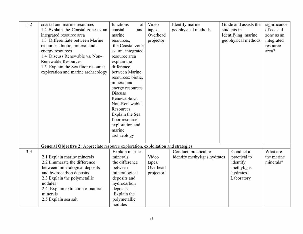
1-2 coastal and marine resources 1.2 Explain the Coastal zone as anintegrated resource area 1.3 Differentiate between Marine resources: biotic, mineral and energy resources1.4 Discuss Renewable vs. Non-Renewable Resources1.5 Explain the Sea floor resource exploration and marine archaeology
functions ofcoastal andmarineresources, the Coastal zoneas an integratedresource area explain the difference between Marine resources: biotic,mineral and energy resourcesDiscuss Renewable vs. Non-Renewable Resources Explain the Sea floor resource exploration and marine archaeology
Video tapes , Overhead projector
Identify marine geophysical methods
Guide and assists thestudents in Identifying marine geophysical methods
significanceof coastal zone as an integrated resource area?
General Objective 2: Appreciate resource exploration, exploitation and strategies3-4
2.1 Explain marine minerals2.2 Enumerate the difference between mineralogical deposits and hydrocarbon deposits2.3 Explain the polymetallic nodules2.4 Explain extraction of natural minerals2.5 Explain sea salt
Explain marine minerals,the difference between mineralogical deposits and hydrocarbon deposits Explain the polymetallic nodules
Video tapes, Overhead projector
Conduct practical to identify methyl/gas hydrates
Conduct a practical to identify methyl/gas hydratesLaboratory
What are the marine minerals?
21

Explain extraction of natural minerals2.5 Explain sea salt
General Objective 3: Describe marine ecology and environmental policies for effective management of coastal resources
5-6 3.1 Define Living Marine Resources (LMR) 3.2 Explain Ecosystem based approach 3.3 Climate effects on living marine resources3.4 Discuss biological monitoring of marine ecosystems
Define Living Marine Resources (LMR) Explain Ecosystem based approach Climate effects on living marine resources and biological monitoring of marine ecosystems
Video tapes, Overhead projector
1] Identify Marine Protected Areas (MPA) 2] Identify the Large Marine Ecosystems (LMEs)
Organise Fieldwork
Vividly discuss the process of monitoring marine ecosystem?
General Objective 4: Appreciate sustainable use of resources7-8
4.1 Describe renewable energy from the ocean4.2 Describe Ocean dumping4.3 Explain Oil spills4.4 Explain Coral reef bleaching
Describe renewable energy from the ocean Describe Ocean dumping Explain Oil spills Explain Coral
Video tapes , Overhead projector
1] Identify hydrocarbons, Gas, Wind, Wave 2] Observe and write a report on currents, seabed mining, beach sand mining, anthropogenic impacts: Overfishing
Organise Field work
How can ocean dumping be prevented?
22

reef bleachingGeneral Objective 5: Understand Coastal and Marine resource management
9-105.1 Define coastal and marine resources management 5.2 Explain legislation for coastal and marine resources management5.3 Explain conflicting interests with other coastal and marine activities 5.4 Describe ecotourism 5.5 Enumerate coastal and marine resources management tools 5.6 Explain ecosystem health and protection of biological diversity5.7 Analyse international conventions related to coastal and marine resources management (e.g. UNCLOS, CBD) 5.8 Explain future uses of the oceans.
Define coastal and marine resources management Explain legislation for coastal and marine resourcesmanagement Explain conflicting interests with other coastal andmarine activities Describe ecotourism Enumerate coastal and marine resourcesmanagement tools Explain ecosystem healthand protection ofbiological diversity,international conventions related to coastaland marine resources management (e.g. UNCLOS,
Video tapes , Overhead projector
List the ways by which coastal and marine resources can be managed
23

CBD)
Programme: ND Course Code: Total Contact Hours: 45 hoursCredit Unit: 3
Course Title: GENERAL METEOROLOGY II
MCM 121 Theoretical: 2 hours
Semester: 2nd Pre-requisite: Practical: 1 hour
Goal: This course is designed to give the students the knowledge of thermodynamics, atmosphere and the interpretation of weatherGeneral Objectives: On Completion of this course the students will be able to:
1] Understand the effect of wind in atmospheric motion2] Understand the thermodynamics of the atmosphere 3] Appreciate the importance of thermodynamic scales in meteorology 4] Understand air masses, their development and classification 5] Understand the local circulation of air6] Understand the general circulation of the atmosphere7] Deduce weather and interpret weather synoptic chart8] Know the elements of atmospheric optics and electricity
Course Title: Course Code: Total Contact Hours: 45 hoursCredit Unit: 3
GENERAL METEOROLOGY II MCM 121 Theoretical: 2 hours
Semester: 2nd Practical: 1 hourTheoretical Content Practical Content
24

General Objective 1.0 Understand the effect of wind in atmospheric motion
Week/s
Specific Learning Outcomes Teacher’s activities Resources Specific LearningOutcomes
Teacher’s activities Evaluation
1 – 21.1 Define wind1.2 Explain variation in the surfacewind1.3 Discuss wind velocity and patterns of isobar1.4 Discuss the forces controlling atmospheric motion1.5 Explain upper wind and the upper level charts1.6 Discuss vertical motion1.7 Explain wind flow over an obstacle and the effect of altitude on the wind field1.8 Explain atmospheric turbulence and identify their origins
Explain variation in the surface wind, wind velocity and patterns of isobar Discuss the forces controlling atmospheric motion,upper wind and the upper level charts, vertical motionand wind flow over an obstacle and the effect of altitude on the wind field1.8 Explain atmospheric
Video tapes, Overhead Projector
Demonstrate the effects of obstacle onwind flow using visual observation
Guide and supervise the student in the demonstration of effects of obstacle onwind flow using visual observation
What are the factors affecting atmosphericmotion?
General Objective 2.0 Understand the thermodynamics of the atmosphere
3 - 4
2.1 Define thermodynamics2.2 State the laws of thermodynamics2.3 Explain the thermodynamics of the atmosphere2.4 Discuss the application of adiabatic transformation of air saturated with water vapour2.5 Discuss vertical stability and instability of conditional equilibrium, thermal convection and conduction clouds
Explain the thermodynamics of the atmosphere and the application of adiabatic transformation of air saturated with water vapourExplain vertical stability and instability of conditional
Video tapes , Overhead projector
Discuss the thermodynamics of the atmosphere
25

2.6 Explain the psychometric formula 2.7 Identify the indicators of moisture
equilibrium, thermal convection and conduction clouds Explain the psychometric formula Identify the indicators of moisture
General Objective 3.0 Appreciate the importance of thermodynamic scales in meteorology
5 – 63.1 Explain ideas of scale in meteorology3.2 Explain Buy’s Ballot’s Law and its application in atmospheric dynamics3.3 Describe the effect of geostrophic force and gradient force and their implications on wind and pressure system3.4 Explain thermal wind: application to horizontal divergence; the existence of vertical velocities.
Explain ideas of scale in meteorology Explain Buy’s Ballot’s Law and its application in atmospheric dynamics Describe the effect of geotropic force and gradient force and their implications on windand pressure system Explain thermal wind: application to horizontal divergence; the existence of vertical velocities.
Video tapes, Overhead projector
1] Identify motions on different scales and equations of motion on the synoptic scale.2] Demonstrate the methods of detectinghorizontal convergence regions on synoptic charts.
Demonstrate the methods to the students
Explain ideas of scale in meteorology
General Objective 4.0: Understand air masses, their development and classification
7 - 8 4.1 Define air masses4.2 List the conservative properties of air masses
Explain air masses List the conservative
Video tapes, Overhead
Describe the general circulation of
26

4.3 Describe the general circulation of air masses and their development.4.5 Explain the phenomena of condensation and the influence of orography on fronts and fontal disturbances,
properties of air massesExplain the general circulation of air masses and their development. Explain the phenomena of condensation and theinfluence of orography on fronts and fontal disturbances,
projector Weather Maps
air masses
General Objective 5: Describe the local circulation of air
9 – 10 5.1 Describe the generalcirculation of the atmosphereincluding pattern at low latitudes.5.2 Distinguish between averagegeneral circulation.5.3 Explain the index of zonalcirculation5.4 Discuss jet stream and itsapplication 5.5 Differentiate between tradewinds and monsoon air masses
Explain the generalcirculation of theatmosphere.Explain thedifference betweenaverage generalcirculations. Explain the index ofzonal circulationand its application Differentiatebetween trade windsand monsoon airmasses
Video tapes, Overhead projector
What is the difference between average general circulation andinstantaneous general circulation?
General Objective 6: Understand the general circulation of the atmosphere
10 – 11 6.1Explain the elements ofExplain the elementsof atmospheric Video Discuss the
27

atmospheric Optics6.2 Discuss the application to halo,rainbow, corona and other opticalphenomena.6.3 Explain transparency ofatmosphere and visual range6.4 Explain atmospheric ions andthe conductivity of lightingdischarge and Thunderstorms
Optics, theapplication to halo,rainbow, corona andother opticalphenomena.Explain transparencyof atmosphere ,visualrange andatmospheric ions andthe conductivity oflighting discharge
ExplainThunderstorms
tapes, Overhead projector
transparency ofthe atmosphere
Programme: ND Course Code: Total Contact Hours: 45Credit Unit: 3
Course Title: PLOTTING PRACTICES MCM 122 Theoretical: 1 hour
Semester: 2nd Pre-requisite: Practical: 2 hours
Goal: This course is designed to enable students understand how to plot weather maps and interpolation in meteorology
General Objectives:On Completion of this course the students will be able to:
1] Understand the general plotting practice2] Understand how to plot weather map3] Understand the different methods of interpolation in meteorology
28

(Please add more content or merge with another related programme and change nomenclature)
Course Title: Course Code: Total Contact Hours: 45Credit Unit: 3
PLOTTING PRACTICES MCM 122 Theoretical: 1 hours
Semester: 2nd Practical: 2 hoursTheoretical Content Practical Content
General Objective 1: Understand the general plotting practiceWeek/
sSpecific Learning Outcomes Teacher’s
activitiesResources Specific Learning
OutcomesTeacher’s activities Evaluatio
n
1-31.1 Discuss the overview of plotting practices in Meteorology1.2 Explain the relationship between surface METAR Report and Plotting Practices
Discuss the overview of plotting practices in Meteorology
Explain the relationship between surface METAR Report and Plotting Practices
Video tapes , Overhead projector, weather maps and plotting models
1] Demonstrate how to identify the large surface weather variables using meteorological maps2]Show how to plot surface reports usingthe standard station model3]Use report from the meteorological weather stations for plotting on a weatherreport map
Guide and assists thestudents
What is the need for plotting in meteorology?
General Objective 2: Understand how to plot weather map
4-62.1 State the objectives of weather
List out theobjectives of
Video tapes, Overhead
1] Show how to plot a map of
Demonstrate the procedure for plotting and guide
Describe the procedures for plotting?
29

map analysis2.2 Enumerate procedures for plotting2.3 Describe other climatological information for optimum interpolation
weather mapanalysisExplain the procedures for plottingand climatological information for optimum interpolation
projector, weather maps and plotting models
meteorological dataand their number codes2] Show how to collect weather messages from various weather stations.
the students.
General Objective 3: Understand the different methods of interpolation in meteorology
7 – 123.1 Describe the optimuminterpolation method in plottingpractice3.2 Explain the use of normal chartsapplication in map interpolations3.3 Explain other methods ofobjective analysis3.4 Describe synoptic and asynopticdata3.5 Explain the concept of initialization and four-dimensional data assimilation and analysis
Explain theoptimuminterpolationmethod inplotting practice Explain the useof normal chartsapplication inmapinterpolations Explain othermethods ofobjective analysis Explain synopticand asynopticdataExplain the concept of initialization and four-dimensional data assimilation and analysis
Video tapes, Overhead projector, weather maps and plotting models
Use station weather plots and symbols to depict; ccurrent weatherconditions; cloud cover;wind speed; wind directionvisibility ttemperature dew point
Assists and guide the students
Explain the use of normalcharts in mapinterpolation?
30

Programme: NATIONAL DIPLOMA IN MARINE METEOROLOGY AND COASTAL MANAGEMENT
Course Code: Total Contact Hours: 45 hoursCredit Unit: 3
Course Title: Introduction to Geographic Information System and Remote Sensing I
MCM 123 Theoretical: 2 hours
Semester: 2nd Pre-requisite: COM 101
Practical: 1 hour
Goal: This course is designed to provide students with the knowledge of GIS systems
General Objectives:On Completion of this course the students will be able to:
1] Appreciate the Science of Geographic Information System (GIS)2] Understand vector data models in GIS 3] Understand raster data and its uses in GIS4] Understand topology in vector data 5] Appreciate remote sensing 6] Know the basic application of remote sensing
31

Course Title: Course Code: Total Contact Hours: 45 hoursCredit Unit: 3
Introduction to Geographic Information System (GIS) I MCM 123 Theoretical: 1 hour
Semester: 2nd Practical: 2 hoursTheoretical Content Practical Content
General Objective 1: Appreciate the science of Geographic Information System (GIS)
Week/s
Specific Learning Outcomes Teacher’s activities Resources Specific LearningOutcomes
Teacher’s activities Evaluation
1 – 21.1 Discuss the generaloverview of GIS1.2 Define GIS and GISSoftware and Application1.3 Explain GIS Data1.4 List examples of GIS dataas Vector and Raster data1.5 Explain the differences indata as geographical or non-geographical data
Explain the generaloverview of GISGIS Software andApplication Explain GIS Data List examples ofGIS data as Vectorand Raster dataExplain the differences in data as geographical or non-geographical data
Video tapes, Overhead projector GIS LAB
1] Demonstrate GIS application using SpatialInformation.1] Operate computer and use digital data to explain what GIS standsfor.
Guide and assists thestudents
Differentiate between vector and raster data?
General Objective 2:Understand Vector Data Models in GIS
32

3 - 4 2.1 Define Vector data2.2 Describe the attributes and features of vector data2.3 Explain Point Features in details2.4 Explain Polyline Features in details2.5 Explain Polygon Features in details2.6 Describe vector data in layers2.7 Explain editing and scale in vector data
Define Vector dataExplain the attributes and features of vector dataPoint Features in
Video tapes, Overhead projector GIS LAB
1] Apply point feature to show scale 2] Identify Polyline with its two or more vertices3] Use map scale to explain GIS vector data
Guide and assists students
Explain the attribute of vector data
5 - 62.8 Explain the General Overview of Vector Data2.9 Explain the use of symbols and colors in GIS
Explain the GeneralOverview of VectorDataand the use of symbols and colors in GIS
Video tapes , Overhead projector GIS LAB
1] Demonstrate how attributedata are associated with vector features and show how it can be use to represent data2] Apply graduated symbols as useful for clear differencesbetween features with attributes values in different value range.
Guide and assiststudents
Administer group assignment
7 - 82.10 Define Data Capture2.11 Explain the general overview of how to create and edit vector and attribute data2.12 Explain GIS data storage processes2.14 Identify planning processes before data capture and storage2.15 Describe the process of shape-files creation
Explain the generaloverview of how to create and edit vector and attribute data Explain GIS data storage processes Identify planning processes before data capture and
Video tapes, Overhead projector GIS LAB
1] Demonstrate the use of data base to store digital data.2] Use tourism map or map of pollution levels along a river to explain GIS data.3] Use digitizing table as a tool for professional GIS Users to capture map information
Administer group assignment
33

2.16 Explain addition of data to shape-files2.17 Describe the process of Heads-up digitizing using digitizing table
storage Describe the process of shape-files creation Explain addition ofdata to shape-files
Describe the process of Heads-up digitizing using digitizing table
General Objective 3:Understand raster data and its uses in GIS
9-10 3.1 Discus the general overview of Raster data as composed of rows and columns3.2 Enumerate the uses of Rasterdata .3.3 Descibe Geo-referencing3.4 List the sources of raster data3.5 Explain spatial Resolution in GIS3.6 Explain spectral Resolution3.7 Explain the Raster to Vector and 3.8 Conversion of Vector to Raster 3.9 Explain Raster Analysis
Explain the general overview of Raster data as composed of rows and columns and their usesExplain Geo-referencing List the sources of raster data Explain spatial Resolution in GIS Explain spectral Resolution Explain the Raster toVector and Conversion of Vectorto Raster Explain Raster Analysis
Video tape, Overheadprojector GIS LAB
1] Identify Raster data as grid of regular sized pixels.2] Use Raster data as tool for showing continually varying information.3] Use spatial resolution as sizes of pixels in a raster.4] Identify multi-spectral images as bands from different parts of electromagnetic spectrum.5] Depict how three of the bands of a multi-spectral image can be shown in Red, Green, and Blue.6] Identify images with a single band as grayscale images.6] Demonstrate how Raster images can consume image amount of storage space
Guide and supervise student
Explain spatial resolution in GIS
General Objective 4: UnderstandTopology in Vector Data
34

11- 124.1 Describe the General Overview of Topology4.2 Explain Topology errors, rules and tools4.3 Describe snapping distance4.4 Explain search Radius
Explain the General Overview of Topology,errors, rules and tools Describe snapping distance Explain search Radius
Video tapes, OverheadprojectorGIS LAB
1] Demonstrate how Topology can be used to express the spatial relationship between connecting or adjacent vector features in GIS2] Demonstrate how Topology in GIS can be useas a tool.3] Use topology to detect and correct digitizing errors4] Apply network analysis as essential in topological data
Guide and supervise students
Explain topology errors and tools?
General Objective 5: Appreciate remote-sensing
13 – 14
Explain the Concept of Geometrical principles of imagery (air photos, satellite image);
Explain the basic topographic features – coastline; continental shelf etc
List Remote sensing techniques applicable to Bathymetry and Coastal mapping
Explain the Concept of Geometrical principles of imagery (air photos, satellite image); Explain the basic topographic features – coastline; continental shelf etcList Remote sensing techniques applicable to Bathymetry
Video tapes , Overhead projector
illustrate the Concept of Geometrical principles of imagery (air photos, satellite image);
Depict the basic topographic features – coastline; continental shelf etcList Remote sensing techniques applicable to Bathymetry and Coastal mapping
Guide students toCarry out field work Demonstrate the Concept of Geometrical principles of imagery (air photos, satellite image);
illustrate the basic topographic features – coastline; continental shelf etcList Remote sensing techniques applicable to Bathymetry and Coastal mapping
Explain the Concept of Geometrical principles of imagery
35

and Coastal mapping
General Objective 6: Know the basic application of remote sensing
15
Describe how laser and radar altimetry are used for water surface mapping
Explain the uses of remote sensing for Oil Spill mapping
Describe how to process remotely sensed data to determine Bathymetry and Map Water surface features.
Describe how laserand radar altimetryare used for water surface mapping
Explain the uses ofremote sensing forOil Spill mapping
Describe how to process remotely sensed data to determine Bathymetry and Map Water surfacefeatures.
Video tapes , Overhead projectorGIS LAB
Demonstrate how laser and radar altimetry are used for water surface mappingDemonstrate the use of remote sensing for Oil Spill mappingDemonstrate how to process remotely sensed data to determine Bathymetry and Map Water surface features.
Guide and assists thestudents
Administer group assignment
36

Programme: ND NATIONAL DIPLOMA MARINE METEOROLOGY AND COASTAL MANAGEMENT
Course Code: Total Contact Hours: 30Credit Unit: 2
Course Title: COASTAL HAZARDS MANAGEMENT
MCM 124 Theoretical: 2 hours/week
Semester: 2nd Pre-requisite: Practical: 0 hour /week
Goal: This course is designed to enable students understand the environmental harzard management
General ObjectivesAt the end of this course the students should be able to:
1] Understand the concept of coastal hazard management 2] Understand coastal environmental hazards 3] Understand laws and policies related to coastal environmental hazard management4] Understand disaster management
37

Course Title: Course Code: Total Contact Hours: 30Credit Unit: 2
Coastal Hazards Management MCM 124 Theoretical: 2 hours/weekSemester: 2nd Practical: 0 hour /week
Theoretical Content Practical ContentGeneral Objective 1: Understand the Concept of Coastal Hazards Management
Week/s
Specific Learning Outcomes Teacher’sactivities
Resources Specific LearningOutcomes
Teacher’sactivities
Evaluation
1-21.1 Define Coastal Environmental Hazards.
1.2 Differentiate between Natural and Man-induced hazards
1.3 Describe hazards, disaster, vulnerability, and resilience 1.4 Explain coping mechanisms
Explain Coastal Environmental Hazards, difference between Natural and Man-induced hazards.Hazards, disaster that are vulnerability, and resilience Explain coping mechanisms
Video tapes, Overhead projector
Illustrate Coastal Environmental Hazards
Show the Difference between Natural and Man-induced hazards
Demonstrate hazards, disaster, vulnerability, and resilience
Show students the difference between Naturaland Man-induced hazards
.Demonstrate hazards, disaster, vulnerability, and resilience
Examine the relationship between natural and man-made hazards?
General Objective 2: Understand Coastal Environmental Hazards
38

3-4 2.1 Outline various Coastal Environmental Hazards2.2 Explain the effects of cyclones, earthquakes, tsunami, floods, storm surges, coastal erosion, Sea Level Rise on Coastal Environment2.3 Explain Technological Hazards2.4 Describe the causes, responses and mitigation strategies related to Coastal Environmental hazards2.5 Explain reduction of carbon footprints2.6 Use case studies to describe coastal hazards in Nigeria.
Outline various Coastal EnvironmentalHazardsExplain the effects of cyclones, earthquakes, tsunami, floods, storm surges, coastal erosion,Sea Level Rise on Coastal EnvironmentExplain Technological HazardsDescribe the causes, responses and mitigation strategies related to Coastal Environmental hazardsExplain reduction of carbon footprints Use case studies to describe coastal hazards in Nigeria.
Video tapes , Overhead projector
1] use flood detection device 2] Demonstrate how to use them=3] Use case studies to illustrate coastal hazards in Nigeria
Demonstrate theuse of early flood detection and warning system
What are the strategies for mitigating coastal hazards?
=Examine theneed for carbon footprints concept card concept?
General Objective 3: Understand Laws and Policies related to Coastal Environmental Hazards Management
39

5-6 3.1 Explain the rationale for disaster management law and policy3.2 Analyse paradigm of disaster management 3.3 Describe response and recovery framework 3.4 Explain the role of governmental in coastal environmental hazards management, and challengesrelated to effective implementation of laws and policies
Explain the rationale for disaster management, law and policy Explain paradigm of disaster management, response and recovery framework Explain the role of governmental in coastalenvironmental hazards management, and challenges related to effective implementation of lawsand policies
Video tapes , Overhead projector
What are the laws and policies pertinent to coastal hazards management?
General Objective 4:Understand Disaster Management
7-8 4.1 Explain disaster risk response frameworks4.2 Describe mapping and planning for disaster management 4.3 Explain the need for capacity building in coastal environmental hazards management4.4 Analyse risk transfer mechanisms 4.5 Explain community based disaster management systems 4.6 Explain indigenous knowledge for disaster
Explain disaster risk response frameworks, mapping and planning for disaster management
Explain the need for capacity building in coastal environmental hazards managementExplain risk transfer mechanisms Explain community based disaster management systems Explain indigenous
Video tapes , Overhead projector
Why is indigenous knowledge needed duringdisaster management?
40

management knowledge for disaster management
General Objective 5: Case Studies
9-12Lecture
Video tapes, Overhead projector
Programme: NDCourse Code: Total Contact Hours: 45
Course Title: Meteorological Instrumentation MCM 125 Theoretical: 1 hour/week
Semester: 2nd Pre-requisite: Practical: 2 hour /week
Goal: This course is designed to enable students understand of temperature, precipitation, salinity, and visibility measurement
General Objectives:On Completion of this course the students will be able to:
1] Understand the working principles of meteorological instrument
2] Understand sea surface temperature, precipitation, salinity, and visibility measurement
3] Know how to collect and use data from station automatic weather observing station
Course Title: Course Code: Total Contact Hours: 45
Meteorological Instrumentation MCM 125 Theoretical: 1 hour/week
Semester: 2nd Practical: 2 hours /weekTheoretical Content Practical Content
41

General Objective 1.0: Understand Meteorological Instrumentation
Week/s
Specific Learning Outcomes Teacher’sactivities
Resources Specific LearningOutcomes
Teacher’sactivities
Evaluation
1 1.1 Define Meteorological Instruments1.2 Name different types of Meteorological Instrument and their use for observation1.3 Explain the working principlesof meteorological measuringinstrument such as thermometer,analogue and digital barometerand etc1.4 Identify likely error/faultemanating from meteorologicalmeasuring instrument using fieldcalibration.
List out Meteorological Instrumentsand types of Meteorological Instrument explain their use
Explain theworking principlesof meteorologicalmeasuringinstrument such asthermometer,analogue anddigital barometerand etcExplain error/fault emanating from meteorological measuring instrument using field calibration.
White board for writing,Catalogues of MeteorologicalInstrument
Identify meteorological instrumentUse meteorological instrument to collect weather data
Illustrate error/fault emanating from meteorological measuring instrument using field calibration.
Guide and assists the students
To Use meteorological instrument to collect weather data
Illustrate error/fault emanating from meteorological measuring instrument using field calibration.
Discuss the working principle of digital barometer
Explain likelyerrors emanating from meteorological measuring instrument
2D
1.5 Describe Sensory Observations, Instrumental Observations, Result of Observation, Standard Time of Observation, 1.6 Describe Data Encoding and
Explain Sensory Observations, Instrumental Observations, Result of Observation,
White board for writing,
Catalogues of MeteorologicalInstrument
Observe safety precautions principles in a meteorological station
Carry out visit to Meteorological station to demonstrate precautions principles
Describe Sensory Observations, Instrumental Observations, Result of
42

Reporting of Meteorology Instruments
Standard Time of Observation, 1.6 Describe Data Encoding and Reporting of Meteorology Instruments
Observation, Standard Time of Observation.
General Objective 2.0 : Measure sea surface temperature
3 2.1 Describe the general principle of sea Surface Temperature 2.2 Describe the methods of observation and the basic requirements2.3 Explain the instrument, Exposure and Management2.4 Explain Remote sensing with infrared Thermometers and Applications of Remote Temperature sensors. 2.5 Define the characteristics of thermometer
Explain the general principle of sea Surface Temperature Explain the methods of observation and thebasic requirements Explain the instrument, Exposure and ManagementExplain Remote sensing with infrared Thermometers and Applications of Remote Temperature sensors. Define the characteristics of thermometer
Infrared Thermometers Remote Temperature
Demonstrate the Remote sensing withinfrared Thermometers and Applications of Remote Temperaturesensors.
Guide students to use the Remote sensing with infrared Thermometers and Applications of Remote Temperature sensors.
Describe the general principle of sea Surface Temperature
General Objective 3.0: Understand Salinity at Surface and depth
44.1 Define salinity with the use ofGala hypothesis4.2 Explain Salinity – Temperature – depth (STD) system. 4.3 Describe the working
Explain salinity with the use of Gala hypothesis Explain Salinity – Temperature – depth (STD) system.
water samples
Salinometerinstrument
Collect watersamples from thecreek, lagoon andrivers etc Carry out watersalinity test using
Guide and assistsstudents inCollection ofwater samplesfrom the creek,lagoon and rivers
Explain salinity-temperature-depth system?
43

principles of Salinometer Describe the working principles of Salinometer
Salinometer. ,
etc Carry out watersalinity test usingSalinometer
General Objective 4.0: Understand Ocean current instruments at surface at surface and depth
5 5.1 Explain the general ocean current measuring instrument.5.2 Describe the Fixed, Fathered and Shipboard Instrument and Methods5.3 Describe the methods of data recording5.4 Explain the types of current meters;Propeller Meters, Ekman Current Meter, Plessy Current Meter, Rotor Meters, etc.
Describe the general ocean current measuring instrument.Explain the Fixed, Fathered and Shipboard Instrument and MethodsExplain the methods ofdata recording Explain the types of current meters;Propeller Meters, Ekman Current Meter, Plessy Current Meter, Rotor Meters, etc.
Catalogues Projectors Practical ObservationCharts Reference textbooksRS Soft boards
Observe Ocean current using the current meter
Illustrate Ocean current using the current meter
Supervise the students in the Observations Ocean current using the current meter
Describe the working principles of current meter?
6 General Objective 5: Understand wind speed and direction
6.1 Enumerate the basic requirement and management of wind vane and cup counter anemometer 6.2 Enumerate the rationale for wind instruments
Explain the basic requirement and management of windvane and cup counter anemometer List the rationale for wind instruments
Catalogue onCIMO
Installation manuals and specificationon wind instrument
1] Use wind vane and cup counter anemometer to measure wind direction and wind speed respectively2] Use Beaufort scale to estimate wind speed
Visit meteorological station to carry out the objective 1 and 2
Examine the rationale for the use of wind vane andspeed
Explain the importance of height of windvane and anemometer
44

installation?
General Objective 6: Understand the use of atmospheric pressure measuring instrument
7 7.1 Describe the working principles of barometer (digital and analogue)and barograph7.2 Explain the general methods of Atmospheric Pressure Observations7.3 Explain the corrections of barometric readings
Explain the working principles of barometer (digital and analogue)and barograph Explain the general methods of Atmospheric Pressure Observations Explain the corrections of barometric readings
Atlas of Atmospheric Pressure
Catalogue of Pressure Equipment
Recommended Textbooks
1] Identify the basic instrument used for measuring pressure2] Use barometer (analogue and digital)and barograph to determine atmospheric pressure
Visit Meteorological station
Explain the working principle of barometer (analogue anddigital) and barograph?
8 General Objective 7: Understand the measurement of air temperature and humidity
8.1 Explain the working principleof thermometer and psychrometer8.2 Understand the working principle of minimum and maximum thermometer; dry and wet bulb thermometer
Explain the working principle ofthermometer and psychrometer Understand the working principle ofminimum and maximum thermometer; dry and wet bulb thermometer
Thermometer(wet bulb, dry bulb, minimum and maximum)
Derive the value ofhumidity using dryand wet bulbthermometer
Visit an established meteorological station
Explain the working principle of thermometer?
9 General Objective 8: Understand how to measure precipitation and estimate visibility
9.1 Explain the working principleof ordinary rain-gauge and automatic rain gauge
Explain the working principle of ordinary rain-
Rain-gauge
visibility target1] Identify the meteorological instrument to
Visit meteorological station
Describe how to use rain gauge?
45

9.2 Describe the estimation of visibility through the use of visibility targets.
gauge and automatic rain gauge Describe the estimation of visibility through the use of visibility targets.
Recommendedtexts
Maps and charts
Installation manuals
measure precipitation 2] Measure precipitation using rain gauge3] Estimate visibility through visual observation
10 General Objective 9: know how to measure sunshine hours and observe clouds
10.1 Describe the basic principlesof sunshine recorder instrument10.2 Describe the techniques of cloud cover Estimations 10.3 Explain the working principles of ceiliometer10.4 Explain the basic principles of Automatic Weather Observing System (AWOS)
Explain the basic principles of sunshine recorder instrument Describe the techniques of cloud cover Estimations Explain the working principles of ceiliometer Explain the basic principles of Automatic Weather Observing System (AWOS)
Campbell Stoke Sunshine recorder and Ceiliometer
Visual observation
1] Identify instrument used for measuring sunshine hours2] Use Campbell Stoke sun shine recorder, using the right card at the righttime to measure sun shine
Visit meteorological station (instrumental observation)
Field work carrying out visual observation
Describe the technique cloud cover estimation?
General Objective 3.0 Explain the Importance of thermodynamic scales in meteorology
46
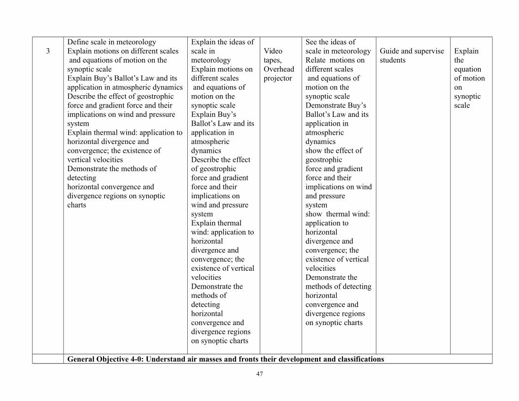
3Define scale in meteorology Explain motions on different scales and equations of motion on the synoptic scaleExplain Buy’s Ballot’s Law and its application in atmospheric dynamicsDescribe the effect of geostrophic force and gradient force and their implications on wind and pressure systemExplain thermal wind: application tohorizontal divergence and convergence; the existence of vertical velocitiesDemonstrate the methods of detectinghorizontal convergence and divergence regions on synoptic charts
Explain the ideas of scale in meteorology Explain motions on different scales and equations of motion on the synoptic scaleExplain Buy’s Ballot’s Law and its application in atmospheric dynamics Describe the effect of geostrophic force and gradient force and their implications on wind and pressure systemExplain thermal wind: application to horizontal divergence and convergence; the existence of vertical velocitiesDemonstrate the methods of detectinghorizontal convergence and divergence regions on synoptic charts
Video tapes, Overhead projector
See the ideas of scale in meteorologyRelate motions on different scales and equations of motion on the synoptic scaleDemonstrate Buy’s Ballot’s Law and its application in atmospheric dynamics show the effect of geostrophic force and gradient force and their implications on windand pressure systemshow thermal wind: application to horizontal divergence and convergence; the existence of vertical velocitiesDemonstrate the methods of detectinghorizontal convergence and divergence regions on synoptic charts
Guide and supervise students
Explain the equation of motion on synoptic scale
General Objective 4-0: Understand air masses and fronts their development and classifications
47

4Define air massesAppreciate conservative properties of air massesDescribe the general circulation of air masses, their development and classificationExplain the meaning of fronts, theirtypes, formation and developmentExplain the phenomena of condensation and the influence of orography on fronts and fontal disturbances,
Explain air massesAppreciate conservative properties of air massesDescribe the generalcirculation of air masses, their development and classificationExplain the meaningof fronts, theirtypes, formation anddevelopmentExplain the phenomena of condensation and the influence of orography on fronts and fontal disturbances,
Video tapes , Overhead projector Weather Maps
Test the general circulation of air masses, their development and classificationcondensation and theinfluence of orography on fronts and fontal disturbances,
Test the general circulation of air masses, their development and classificationcondensation and theinfluence of orography on fronts and fontal disturbances,
Describe the general circulationof air masses,their development and classification
General Objective 5-0: Understand the general circulation of the atmosphere
48

5
Describe the general circulation of the atmosphere including pattern at low latitudes Distinguish between average general circulation and instantaneous general circulationExplain the index of zonal circulationDiscuss jet stream and its applicationDifferentiate between trade windsandmonsoon air masses
Explain the general circulation of the atmosphere including pattern at low latitudes Distinguish between average general circulation and instantaneous general circulationExplain the index of zonal circulationDiscuss jet stream and its applicationDifferentiate between tradewinds andmonsoon air masses
Video tape, Overheadprojector
What is the different between average general circulationand instantaneous general circulation?
General Objectives 6.0Understand the element of atmospheric optic and electricity
7Describe the elements of atmospheric OpticsDiscuss the application to halo, rainbow, corona and other optical phenomenaExplain transparency of atmosphere andvisual rangeDescribe the atmospheric ions and the conductivity of lighting discharge and Thunderstorms
Explain the elements of atmospheric OpticsDiscuss the application to halo, rainbow, corona and other optical phenomenaExplain transparency of atmosphere and visual rangeDescribe the atmospheric ions and the conductivity of lighting discharge and Thunderstorms
Video tapes, Overhead projector
illustrate the elements of atmospheric OpticsDepicts the application to halo, rainbow, corona and other optical phenomenaDemonstrate transparency of atmosphere and visual range
Guide and supervise
Discuss the transparency of the atmosphere
49

Describe the atmospheric ions and the conductivity oflighting discharge and Thunderstorms
General Objective 5:Understand Coordinate Reference Systems
7-8
Describe the general overview of coordinate reference systems as it relates to map projectionsState the three categories of M projectionsExplain map projections with- Angular conformity- equal distance- and equal areasDescribe Cordinate Reference Systems (CRS) and GeographicCoordinate SystemsExplain projected coordinate reference systems, Universal Transverse Mercator (UTM) CRS and On-the Fly projection
Explain the general overview of coordinate reference systems as it relates to map projectionsState the three categories of M projectionsExplain map projections with
Video tapes, Overhead projector GIS LAB
Identify map projections to show the surface of the earthon a 2-dimentional, flat paper or screenDescribe map projections as never accurate but shows distortions of angular conformity distance and areaShow coordinate reference system (CRS) as relating to real locations on earth with the help of coordinatesDescribe two types of coordinate system, Geographic Coordinate Systems and Projected Coordinate SystemsDescribe on the fly projection as functionally in
Guide and supervise student
Describe coordinatereference system and the geographic reference system?
50

GIS that allows an overlay layers
General Objectives 6: Understand Map Production for Spatial Data
9Describe features of Map ProductionsExplain map productions e.g. Title, Border, Legend, North ArrowDefine Map Scale and use of Scales in Map productionAppreciate different types of map ScalesExplain Graticules, Acknowledgement, name ofMap Production
Explain features of Map ProductionsExplain map productions e.g. Title, Border, Legend, North ArrowDefine Map Scale and use of Scales in Map productionAppreciate different types of map ScalesExplain Graticules, Acknowledgement, nameof Map Production
Video tapes, Overhead projector
Use map title, map body, map border, legend, scale North arrow, and the acknowledgement to produce a mapshow scale as representing distances on the real world using ratio lines or stamen
Guide and assists the students during the field work
What are the features ofa quality map?
10 Explain the Use of Buffering in Vector Spatial AnalysisDescribe variations in bufferingExplain Multiple Buffer zonesDescribe Buffering with Intact or dissolved boundaries and outward andInward BufferingExplain spatial analysis tools
Explain the Use of Buffering in Vector Spatial AnalysisDescribe variations in bufferingExplain Multiple Buffer zonesDescribe Buffering with Intact or dissolved boundaries and outward and Inward BufferingExplain spatial analysis tools
Video tape, Overhead projector
Describe Buffer zones using Vector Polygons Compute buffer distance/ floating point value
Guide and assists the students
.Administer group assignment
General Objective 7: Understand Interpolation as Part of Spatial Analysis
11Describe the general overview of spatial analysisExplain spatial Interpolation
Explain spatial InterpolationExplain Inverse
Video tape, Overhead projector
Use vector point with knownvalue for interpolation Describe Interpolation result
Guide and assistto use vector point with known value for
51

Explain Inverse Distance Weighted (IDW)Describe the Triangulated irregular Network (TIN)Identify other Interpolation Methods
Distance Weighted (IDW)Describe the Triangulated irregular
GIS LAB as a typical raster layer.Describe its importance to find a suitable Interpolation method to optimally estimatevalues for unknown locations.Describe IDW Interpolation as giving weights to sample pointsDescribe TIN Interpolation as using sample points to create surface formed by triangles.
interpolation Interpolation result as a typical raster layer.Describe its importance to find a suitable.Describe IDW Interpolation as giving weights to sample pointsuse sample points to create surface formed by triangles.
52
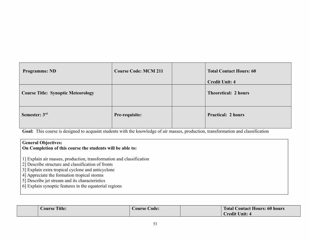
Programme: ND Course Code: MCM 211 Total Contact Hours: 60
Credit Unit: 4
Course Title: Synoptic Meteorology Theoretical: 2 hours
Semester: 3rd Pre-requisite: Practical: 2 hours
Goal: This course is designed to acquaint students with the knowledge of air masses, production, transformation and classification
General Objectives:On Completion of this course the students will be able to:
1] Explain air masses, production, transformation and classification2] Describe structure and classification of fronts3] Explain extra tropical cyclone and anticyclone 4] Appreciate the formation tropical storms 5] Describe jet stream and its characteristics 6] Explain synoptic features in the equatorial regions
Course Title: Course Code: Total Contact Hours: 60 hoursCredit Unit: 4
53

SYNOPTIC METEOROLOGY MCM 211 Theoretical: 2 hoursSemester: 3rd Practical: 2 hours
Theoretical Content Practical Content
General Objective 1: Understand air masses, production, transformation and classificationWeek
/sSpecific Learning Outcomes Teacher’s activities Resources Specific Learning
OutcomesTeacher’s activities Evaluation
11.1 Define air masses 1.2 Describe the production, transformation and classification of air masses1.3 Appreciate the conservative properties of air masses1.4 List the sources of air masses
1.1 Explain air masses 1.2 Describe the production, transformation and classification of air masses1.3 Appreciate the conservative propertiesof air masses1.4 List the sources of air masses
Video tapes , Overhead projector
Demonstrate how to analyse weather chart
Guide and assists thestudents
What are the sources of air masses?
General Objective 2: Understand structure and classification of fronts
22.1 Describe fronts 2.2 Explain the structure andclassification of fronts 2.3 Explain surface of discontinuity 2.4 Describe kinematic and dynamic boundary condition2.5 Explain frontogenesis and frontolysis, including principal front zones2.6 Explain effects of front on weather2.7 Describe occlusions and
Explain the structureand classification offronts Explain surface of discontinuity Describe kinematic and dynamic boundarycondition Explain frontogenesisand frontolysis, including principal front zones Explain effects of
Video tapes , Overhead projector
Demonstrate how to analyse weather chart
Guide and assists thestudents
Differentiate between frontogenesis and frontolysis?
54
thermal structure of cyclones front on weather2.7 Describe occlusions and thermalstructure of cyclones
General Objective 3:Understand tropical and extra tropical cyclone and anticyclone
3 3.1 Explain extra tropical cycloneand anticyclone 3.2 Describe cyclone models, and lifecycle of cyclones3.3 Explain the theory of cyclonedevelopment3.4 Describe cut off cyclone andanticyclones
Explain extra tropicalcyclone and anticyclone Describe cyclone models,and life cycle of cyclonesExplain the theory of cyclonedevelopmentDescribe cut off cyclone andanticyclones
Video tapes , Overhead projector
Demonstrate the appearanceof a cyclone using stimulation
Guide, superviseand assists the students
Explain conditions that might result to cyclone?
General Objective 4: Understand the formation tropical storms
44.1 Describe the formation of tropicalstorm4.2 Explain the theories of formation,intensification and motion of tropical storms 4.3 Explain surface and upper air structure using pressure, temperature,wind, humidity and cloud fields
Explain the formation of tropical storm Explain the theories of formation, intensification andmotion of tropical storms Explain surface and upper airstructure using pressure, temperature, wind, humidity and cloud fields
Video tapes , Overhead projector
Illustratethe appearanceof a tropical storm using stimulation
Demonstrate theappearance of a tropical storm using stimulation
What are the conditions that might result to tropical storm?
General Objective 5: Understand jet stream and its characteristics
55.1 Define jet stream5.2 Explain polar front jet stream, sub-tropical jet stream, and easterly jet stream5.3 Identify the characteristics of various jet stream
Explain polar front jet stream, sub-tropical jet stream, and easterly jet stream Identify the characteristics ofvarious jet stream
Video tapes , Overhead projector
What are the main features of jet stream?
55

5.4 Explain the theories of formation,weather development of clouds and clear air turbulence
Explain the theories of formation, weather development of clouds and clear air turbulence
General Objectives 6: Understand synoptic features in the equatorial regions
6 6.1 Infer synoptic features in the equatorial regions in different seasonsof year6.2 Describe the need for radar and satellite meteorology with reference to cyclone detection
Explain synoptic features in the equatorial regions in different seasons of year Describe the need for radar and satellite meteorology with reference to cyclone detection
Video tapes , Overhead projector
7 6.3 Explain the synoptic weather charts analysis6.4 Discuss the evolution of stream line on synoptic chart6.5 Discuss how to deduce weather associated with synoptic system
Explain the synoptic weathercharts analysis Discuss the evolution of stream line on synoptic chart Discuss how to deduce weather associated with synoptic system
Video tapes, synoptic charts
Demonstrate the use of weather map toshow different meteorologicalweather element
Guide and assists the students to Demonstrate theuse of weather map to show different meteorological weather element
Discuss the evolution of stream line on synoptic chart?
56

Programme: ND Course Code: MET
Total Contact Hours: 45Credit Unit: 3
Course Title: DYNAMIC METEOROLOGY MCM 212 Theoretical: 2 hours
Semester: 3rd Pre-requisite: Practical: 1 hour
Goal: This course is designed to provide students with the basic knowledge of meteorological equations General Objectives:On Completion of this course the students will be able to
1] Understand the basic meteorological equations2] Explain the concept of gravity3] Describe ionosphere 4] Explain balanced motion5] Explain atmospheric disturbance6] Describe the general circulation of the atmosphere7] Explain atmospheric turbulence
57
Course Title: Course Code: Total Contact Hours: 45
DYNAMIC METEOROLOGY MCM 212 Theoretical: 2 hours
Semester: 3rd Practical: 1 hourTheoretical Content Practical Content
General Objective 1: Appreciate the basic meteorological equationsWeek/s
Specific Learning Outcomes Teacher’s activities Resources Specific LearningOutcomes
Teacher’s activities Evaluation
11.1 Derive the vector form ofequations of motion fromNewton’s Laws1.2 Explain force, pressure,fields and solve problemsinvolving gravitational forceand field1.3 Discuss centripetal force, pressure gradient and coriolis force
Derive the vector formof equations of motionfrom Newton’s Laws Explain force, pressure,fields and solveproblems involvinggravitational force andfieldDiscuss centripetal force,pressure gradient and coriolis force
Video tapes , Overhead projector
Measure atmospheric pressureusing meteorologicalmeasuring instruments such barometer (digital and analogue) barometer and barograph
Guide and assists thestudents in the measurement of atmospheric pressureusing meteorologicalmeasuring instruments such barometer (digital and analogue) barometer and barograph
Discuss centripetal force
General Objective 2: Appreciate the concept of gravity
2 2.1 State equations of motion inCartesian co-ordinates and inspherical co-ordinates 2.2
State equations of motion inCartesian co-ordinates and inspherical co-ordinates Explain
Video tapes , Overhea
Explain the equation of continuity for
58

Explain hydrostaticapproximation and itsjustification2.3 Derive the equation ofquasi-hydrostatic motion usingpressure as vertical co-ordinate2.4 Derive the equation of continuity for homogeneous and incompressible fluid
hydrostatic approximation and itsjustificationDerive the equation of quasi-hydrostatic motion using pressureas vertical co-ordinateDerive the equation of continuity for homogeneous and incompressible fluid
d projector
Derive theequation of quasi-hydrostaticmotion usingpressure asvertical co-ordinateDerive the equation of continuity for homogeneous andincompressible fluid
Take studentthrough to drivethe equation ofquasi-hydrostaticmotion usingpressure asvertical co-ordinateDerive the equation of continuity for homogeneous and incompressible fluid
homogeneous and incompressible fluid?
General Objective 3: Understand the Atmosphere and Ionosphere
33.1 Explain Theoretical andempirical minor constituents ofthe Atmosphere3.2 Explain Atmosphericradiation Airglow and Aurora3.3 Explain atmospheric effects3.4 Explain ionosphericphenomena, flare effects andirregularities
Explain Theoretical and empiricalminor constituents of theAtmosphere Explain Atmospheric radiationAirglow and AuroraExplain atmospheric effects Explain ionospheric phenomena, flare effects and irregularities
Video tapes, Overhead projector
Differentiate between airglow and aurora?
General Objective 4: Appreciate balanced motion
44.1 Explain horizontal balancedmotion4.2 Discuss geostrophic motionof the wind4.3 Compare geostrophic andgradient winds with actual winds4.4 Explain the divergencevelocity of the geostrophic wind
Explain horizontal balancedmotion, Discuss geostrophicmotion of the wind
Compare geostrophic and gradientwinds with actual windsExplain the divergence velocity ofthe geostrophic wind
Video tapes , Overhead projector
Explain the essence of unstable and neutral condition inthe atmosphere?
59

4.5 Discuss geostrophic thermalwind and stationery circularvortex4.6 Explain unstable and neutral conditions in the atmosphere
Discuss geostrophic thermal windand stationery circular vortexExplain unstable and neutral conditions in the atmosphere
General Objective 5: Understand atmospheric disturbances
55.1 Describe hydrostaticequilibrium of gravity field(static stability)5.2 Explain compressibility andgravity waves in the atmosphere5.3 Discuss waves in a surface ofdiscontinuous flow anddiscontinuous specific mass
Explain hydrostatic equilibriumof gravity field (static stability)Explain compressibility andgravity waves in the atmosphereDiscuss waves in a surface of discontinuous flow and discontinuous specific mass
Video tapes , Overhead projector
Explain compressibility and gravity waves in the atmosphere?
6 5.4 Explain disturbancessuperimposed on a rectilinearflow5.6 Explain baroscopic wavesand two dimensionaldisturbances5.7 Explain Ross by long waves,baroclinic waves and baro clinic instability
Explain disturbancessuperimposed on a rectilinear flowExplain baroscopic waves and twodimensional disturbancesExplain Ross by long waves, baroclinic waves and baro clinic instability
Video tapes, Overhead projector
General Objectives 6: Describe the general circulation of the atmosphere
76.1 Explain angular momentumof the atmosphere6.2 Explain relative and absolutemomentum. Discuss meridionaltransport by atmosphericdisturbances6.3 Relate meridional transportwith zonal circulation
Explain angular momentum ofthe atmosphereExplain relative and absolutemomentum. Discuss meridionaltransport by atmosphericdisturbances Relate meridional transport withzonal circulation
Video tapes , Overhead projector
Discuss the nature of angular momentum of the atmosphere?
60

8 6.4 Explain the atmospherickinetic energy6.5 Discuss the influence of oceans, continents and orographic features on atmospheric circulation
Explain the atmospheric kineticenergy Discuss the influence of oceans, continents and orographic featureson atmospheric circulation
Video tapes , Overhead projector
9
6.6 Explain vorticity andcirculationState the Bjerknes circulation 6.7 Explain divergence of thethree dimensional and horizontalwind field
Explain vorticity and circulationState the Bjerknes circulation Explain divergence of the three dimensional and horizontal wind field
Video tapes , Overhead projector
10 6.8 State vorticity anddivergence equation in co-ordinate systems6.9 State helmet theorem6.10 Explain streamlines andtrajectories
State vorticity and divergenceequation in co-ordinate systems State helmet theorem Explain streamlines and trajectories
Video tapes , Overhead projector
General Objective 7: Appreciate atmospheric turbulence
11
7.1 Explain Eddy transport, heatand water vapour and pollutantsin planetary atmospheric layer7.2 State the Taylor-Ekmantheory of wind in boundary layer7.3 Explain heat flux equation7.4 Discuss Richardson criterion7.5 Explain forced and free convection
Explain Eddy transport, heat andwater vapour and pollutants inplanetary atmospheric layer State the Taylor-Ekman theory ofwind in boundary layer Explain heat flux equation Discuss Richardson criterionExplain forced and free convection
Video tapes , Overhead projector
Explain heat flux equation
61

Programme: ND NATIONAL DIPLOMA MARINE METEOROLOGY AND COASTAL MANAGEMENT
Course Code: Total Contact Hours: 75
Credit Unit: 5 Course Title: INTRODUCTION TO OIL SPILL CONTIGENCY PLANNING AND OPERATIONS MANAGEMENT
MCM 213 Theoretical: 2 hours/week
Semester: 3rd Pre-requisite: Practical: 3 hours /week
Goal: This course is design to provide students with knowledge of managing and controlling of oil spillGeneral ObjectivesAt the end of this course, the students should be able to:
1. Understand basic equipment used in recovering, managing and controlling oil spill via physical, chemical, biological and Geographical Information System
2. Explain the fundamentals and scope of contingency planning and operations management3. Understand personnel, skill and facilities required – logistic for mobilization and demobilization in managing oil spill
62
Course Title: Course Code: Total Contact Hours: 75
OIL SPILL CONTIGENCY PLANNING AND OPERATIONS MANAGEMENT
MCM 213Theoretical: 2 hours/week
Semester: 3rd Practical: 3 hours /weekTheoretical Content Practical Content
General Objective 1: Understand Operational Techniques in Oil Spill Management and Contingency PlanWeek
/sSpecific Learning
OutcomesTeacher’s activities Resources Specific Learning
OutcomesTeacher’s activities Evaluation
1-41.1 Discribe the physical method of managing the oil spill1.2 Discuss the chemical method of managing oil spill1.3 Explain the biological method of managing the oil spill1.4 Appreciate the use of GIS in managing oil spill
Explain the physical method of managing theoil spill Discuss the chemical method of managing oil spill Explain the biological method of managing theoil spill Appreciate the use of GIS in managing oil spill
Video tapes , Overhead projector
Demonstrate how to manage oil spill throughphysical method using boom, skimmer, in-situ burning and manual methodDemonstrate how to manage oil spill throughchemical method using dispersantDemonstrate how to manage oil spill throughbiological method usingbioremediation process Apply Geographical Information System to manage oil spill
.Guide and assists the students during the field work
Demonstrate how in-situ burning is carried out?
General Objective 2: Understand Response Techniques in Oil Spill
5-62.1 State the preferred response techniques to address floating oil and anyrestriction on their usage2.2 Determine the importance of an ability to protect sensitive resources 2.3 List the weather
Outline the preferred response techniques to address floating oil and any restriction on their usage Determine the importance of an abilityto protect sensitive
Video tapes, Overhead projector
Demonstrate how to carry out a successful clean up exercise by using the right meteorological measuring instrument to prevent the impact of wind, current and tide Demonstrate how to use
What are theappropriate clean up techniques- for shorelineoil spill?
63

parameters that can affect response techniques- wind direction, current, and tide2.4 Determine the appropriate clean up techniques- for shoreline type within area2.5 Identify response resources, leadership, command and management
resources List the weather
ballast water equipment (e.g. ballast tank) during the field workDemonstrate how to operate oil reception facilities during the field work
General Objective 3: Understand Strategic Policy and Response Strategies
7 3.1 Bring out the role of organisations that are involved in oil spill response3.2 Outline the regulatory framework and jurisdiction 3.3 Appreciate the geographical area of the plan3.4 Define the interaction with other plans- scaling of tier response
Explain the role of organisations that are involved in oil spill response Outline the regulatory framework and jurisdiction Appreciate the geographical area of the plan Define the interaction with other plans- scalingof tier response
Video tapes , Overhead projector
Outline the regulatory framework needed for OSCP?
4 General Objective 4: Understand the Operational Procedures in Oil Spill Contingency Plan
8-9 4.1 Establish notification route in oil spill response4.2 Explain the source of oilspill and establish the oil slick trajectory 4.3 Explain the role of
Describe notification route in oil spill response Explain the source of oil spill and establish theoil slick trajectory
Video tapes, Overhead projector
Discus the mobilization and demobilization procedures including
64

response team members4.4 Appreciate the logistic support needed in the operation4.5 Explain the need for mobilization and demobilization procedures
Explain the role of challenges against their full implementation?
General Objective 5: Understand the role of Government implementing Agencies in Oil Spill Management
10-125.1 Enumerate the role of government implementing agencies at all levels in managing oil spill5.2 Explain the role of Non-Government Organisation inmanaging oil spill 5.3 Describe the need for NOSDRA Act and International Convention onOil Pollution 5.4 Preparedness and Cooperation (OPRC), and MARPOL Convention5.5 Explain the role Marine Surveyor5.6 Explain challenges related to oil spill management in Nigeria
Explain the role of government implementing agencies at all levels in managingoil spill Explain the role of Non-Government Organisation in managing oil spill Describe the need for NOSDRA Act and International Convention on Oil Pollution 5.4 Preparedness and Cooperation (OPRC), and MARPOL Convention Explain the role MarineSurveyorExplain challenges related to oil spill management in Nigeria
Video tapes, Overhead projector
Explain the roles of government implementing agencies inoil spill management,including thechallenges they face ?
65

Programme: ND MARINE METEOROLOGY AND COASTAL MANAGEMENT
Course Code: Total Contact Hours: 45
Credit Unit: 3
Course Title: MARINE METEOROLOGY I MCM 214
Theoretical: 2 hours/week
Semester: 3rd Pre-requisite: Practical: 1 hour
Goal: This course is design to provide students with knowledge of measurement of wind.General Objectives: On completion of this course the students will be able to:
1] Understand Ship Borne Meteorological Instruments2] Describe the use of Wind Measuring Instruments.3] Describe the use of Temperature and Humidity instrument4] Appreciate the Functions of Port Meteorological Office (PMO)5] Use Ship Weather Code6] Describe Weather Bulletin for Merchant Shipping7] Describe Automation of Weather Observation on Board Ship.
Course Title: Course Code: Total Contact Hours: 45Credit Unit: 3
MARINE METEOROLOGY I MCM 214 Theoretical: 2 hours/weekSemester: 3rd Practical: 1 hour
Theoretical Content Practical Content
66

General Objective 1: Understand marine related Meteorological instrument
Week/s
Specific Learning Outcomes Teacher’s activities Resources Specific LearningOutcomes
Teacher’sactivities
Evaluation
1-41.1 List out marine related Meteorological Measuring Instruments 1.2 Explain the Principles of operating the instruments.1.3 Explain the procedure for maintenance of the instrument1.4 Explain corrections to the readings
Explain marine related Meteorological Measuring Instruments Explain the Principles of operating the instruments. Explain the procedure for maintenance of the instrument Explain corrections to the readings
Video tapes , Overhead projector
Identify the use meteorological measuring instrument
Guide and assists students
What are the meteorologicalmeasuring instrument?
General Objective 2: Understand the functions of Port Meteorological Officers (PMO)
5 2.1 Tell the roles of PMO and their essential services; 2.2 List the Location of PMO and functions , 2.3 Explain the relationship between PMO and Ship Meteorological Observation (SMO)2.4 Explain the role of a marine surveyor
Explain the roles of PMO and their essential services; List the Location of PMO and functions , Explain the relationship between PMO and Ship Meteorological Observation (SMO) Explain the role of a marine surveyor
Video tapes , Overhead projector
What is the relationship between PMOand SMO?
67

General Objectives 3: Understand the use Ship Weather Code and Decode Book
6-73.1 Describe weather Code Forms and explanatory notes to code:3.2 Describe ship’s code and decode book.3.3 Describe and use Beaufort letterabbreviations for present and past weather;
Discuss weather Code Forms and explanatory notes to code:Describe ship’s code and decode book. Describe and use Beaufort letter abbreviations for presentand past weather;
Video tapes, Overhead projector
Use Ship’s code and decode book to code and decode full report
.
Guide and assists the students to use Ship’s code and decode book to code and decodefull report
Describe ship code and decode book?
General Objective 4: Understand Weather Bulletin for Merchant Ship
8-9
4.1 Explain the usefulness of weather bulletin to safety of ship and cargo.4.2 List the issuing offices and area of responsibility; sea areas. 4.3 List Code names: Aurora, Baloon, Electron etc. 4.4 Explain the Content of sea area bulletins and ; coastal bulletin, 4.5 Use Gulf of Guinea and West Africa examples to explain Storm warning signals.
Explain the usefulness of weather bulletin to safety of ship and cargo. List the issuing offices and area of responsibility; sea areas. Explain the usefulness of weather bulletin to safety of ship and cargo. List the issuing offices and area of responsibility; sea areas.
Video tapes , Overhead projector
What is the need for weather bulletin?
General Objective 5: Understand Automatic Weather Observing Station10-12 5.1 Explain the general overview of
automatic weather observation system5.2 Explain the components and transmission methods 5.3 Explain the Installation procedure; recording of meteorological observations through Turbowin version
Explain the general overview of automatic weather observation system Explain the components and transmission methods Explain the Installation procedure; recording of meteorological observations through Turbowin version
Use weather simulator i.e full mission to illustrate automatic weather observing system
Guide students to use weather simulator i.e full mission to illustrate automatic weather observing system
Describe the essence of automatic weather observing station?
68

5.4 Explain the maintenance procedure of automatic weather observing station
Explain the maintenance procedure of automatic weather observing station
Programme: ND NATIONAL DIPLOMA MARINE METEOROLOGY AND COASTAL MANAGEMENT
Course Code: Total Contact Hours: 30
Credit Unit: 2Course Title: INTEGRATED COASTAL MANAGEMENT (ICM)
MCM 215Theoretical: 2 hours/week
Semester: 3rd Pre-requisite: Practical: 0 hour /week
Goal: This course is design to acquaint students with understanding of environmental functions of the components and their relationships. General ObjectivesAt the end of this course the students should be able to:
1] Explain the features and components of the natural, built and human aspects of the coastal environment, the functions of the components and relationships between them. 2] Identified coastal issues to determine appropriate approaches to manage the humans and the coastal environment
Course Title: Course Code: Total Contact Hours: 3
Credit Unit: 2Integrated Coastal Management (ICM) MCM 215 Theoretical: 2 hours/weekSemester: 3rd Practical: 0 hour /week
Theoretical Content Practical Content
69

General Objective 1: Understand the need for ICM and Fundamental Concepts
Week/s
Specific Learning Outcomes Teacher’s activities Resources Specific LearningOutcomes
Teacher’s activities Evaluation
1-21.1 Enumerate the need for ICM 1.2 Describe the interactions between Coastal and Ocean Uses and their Environments 1.3 Explain early efforts at Coastal Environmental Management 1.4 Analyse ICM goals, integration, functions and principles1.5 Identify stages in developing an ICM Program
Explain the need for ICM Describe the interactions between Coastal and Ocean Uses and their Environments Explain early efforts at Coastal Environmental Management Analyse ICM goals, integration, functions and principles Identify stages in developing an ICM Program
Video tapes, Overhead projector
.What are the stages required indeveloping an ICM program
General Objective 2: Understand the Framework and Processes in ICM
3-4 2.1 Discuss the concepts, framework and processes in ICM 2.2 Describe tools and techniques for ICM2.3 Explain ICM Processesdescribe stakeholder analysis2.4 Determine the need for conflict resolution 2.5 Describe risk evaluation 2.6 Explain Cost Benefit Analysis
Explain the concepts,framework and processes in ICM Describe tools and techniques for ICMExplain ICM Processesdescribe stakeholder analysisDetermine the need for conflict resolution Describe risk
Video tapes , Overhead projector
What are the tools and techniquesfor ICM?
70

evaluation Explain Cost Benefit Analysis
General Objective 3: Understand Coastal Environmental Laws, Policies, Institutions and Governance
5-6 3.1 Explain Law of the Sea [UNCLOS]3.2 Describe coastal regulation zones including small islands 3.3 Explain Environmental policies 3.4 Analyse spatial planning in Coastal 3.5 Environmental Management 3.6 Describe administrative and legal situations and Institutions and Governance Mechanisms
Explain the concepts, framework and processes in ICM Describe tools andtechniques for ICM Explain ICM Processesdescribe stakeholder analysis Determine the need for conflict resolution Describe risk evaluation Explain Cost Benefit Analysis
Video tapes , Overhead projector
Examine the need for spatial planning in Coastal Environmental Management?
General Objective 4: Understand the Concepts of Integrating Disciplinary Perspectives in ICM
7-8 4.1 List out social insights to ICM4.2 Describe the natural sciences insights to ICM4.3 Differentiate between horizontal and vertical integration
Describe social insights to ICM Describe the naturalsciences insights to ICM
Video tapes , Overhead projector
In what way could effective monitoring be achieved
71

4.4 Explain monitoring and evaluation in ICM
Differentiate between horizontal and vertical integration Explain monitoringand evaluation in ICM
in ICM?
General Objective 5: Understand Practice Oriented Learning in ICM
9-10 4.6 Describe learning through observation (Observing in practice, Participatory observation and Focus group discussions).
Expose the students through case studies and field work Describe learning through observation(Observing in practice, Participatory observation and Focus group discussions).
Video tapes , Overhead projector
Use case studies and fieldwork to describe learning through observation (Observing in practice, Participatory observation and Focus group discussions).
Use case studies and fieldwork to describelearning throughobservation (Observing in practice, Participatory observation and Focus group discussions).
Discuss experiencegathered during the field work?
Programme: ND NATIONAL DIPLOMAMARINE METEOROLOGY AND COASTAL
MANAGEMENT
Course Code: Total Contact Hours: 75
Credit Unit: 5Course Title: COASTAL ENVIRONMENTAL
IMPACT ASSESSMENT MCM 221 Theoretical: 2 hours/week
Semester: Four Pre-requisite: Practical: 3 hours /week
Goal: This course is design to acquaint students with understanding of socio-economic of a project of an environment.General Objectives
72
At the end of this course the students should be able to:
1] Understand the existing natural and socio-economic environments within the area of influence of a project 2] Identify project components which might have a significance impact on the existing natural and socio-economic environment and the
potential impacts of these project components on a local and regional scale 3] Analyze an Environmental Impact Statement taken into consideration mitigation and management measures
Course Title: Course Code: Total Contact Hours: 75Credit Unit: 5
COASTAL ENVIRONMENTAL IMPACT ASSESSMENT
MCM 221Theoretical: 2 hours/week
Semester: 4th Practical: 3 hours /weekTheoretical Content Practical Content
General Objective 1: Understand the Concept of Coastal Environmental Impact Assessment
Week/s
Specific Learning Outcomes Teacher’s activities Resources Specific LearningOutcomes
Teacher’s activities Evaluation
1-21.1 Define Environmental Impact Assessment (EIA)1.2 Explain the principles and requirements of EIA1.3 Explain environment relatedlegislation in Nigeria1.4 Explain Coastal regulations
Explain Environmental Impact Assessment (EIA)Explain the principlesand requirements of EIAExplain environment related legislation in NigeriaExplain Coastal regulations
Video tapes , Overhead projector
Describe coastal EIA related projects (case study)
.Lecturer should use previous approved EIA report and guidethe students
Examine the principles and regulations necessary for the conduct of EIA in Nigeria?
General Objective 2: Understand the Components and Methods of Assessing Impact
73

3-52.1 Describe ways of assessing impacts on environment and society (Air, Noise, Water, Soil, Biological and Cultural environments) 2.2 Explain the role of public participation in environmental decision making 2.3 Explain disaster management plans
Explain ways of assessing impacts on environment and society (Air, Noise, Water, Soil, Biological and Cultural environments) Explain the role of public participation inenvironmental decision making Explain disaster management plans
Video tapes, Overhead projector
Demonstrate how to use checklist and network methods to identify coastal environment related Impacts
Guide and assists the students during the field work
What are the methodsof assessingcoastal environmental related impact?
General Objective 3: Understand the Rationale for Quality Control and Institutional Arrangement
6-7 3.1 Describe the procedures to be followed in screening, scoping, mitigation, environmental management plans. environmental monitoring systems3.2 Explain the essence of capacity building, quality assurance and adequate funding in EIA3.3 Explain the role and need for institutional arrangement in EIA
Explain the procedures to be followed in screening, scoping, mitigation, environmental management plans. environmental monitoring systems Explain the essence of capacity building, quality assurance and adequate funding in EIAExplain the role and need for institutional arrangement in EIA
Video tapes, Overhead projector
What is the essence of quality control, capacity building and fundingin EIA?
74

General Objective 4: Understand the role of Government Implementing Agencies in EIA
8-94.1 Enumerate coastal environment related industries and their activities4.2 Explain impact assessment requirements for ports and harbours, shoreline change, sewage/industrial outfalls, coastal power plants, thermal impacts on marine ecosystem 4.3 Describe how managementof impacts on the coastal and marine ecosystems should be handled
Explain coastal environment related industries and their activities Explain impact assessment requirements for ports and harbours, shoreline change, sewage/industrial outfalls, coastal powerplants, thermal impacts on marine ecosystem 4.3 Describe how management of impacts on the coastal and marine ecosystems should be handled
Video tapes, Overhead projector
How shouldcoastal and marine ecosystems be handled?
General Objective 5: Understand how to Prepare Coastal related EIA Report in Nigeria
10-125.1 Differentiate between cumulative impacts assessmentand Strategic Impact Assessment5.2 Describe case studies of EIA of developmental projects and projects on coastal areas5.3 Describe the process involved in preparing an EIA in Nigeria for different sectors
Explain the difference between cumulative impacts assessment and Strategic Impact Assessment Describe case studies of EIA of developmental projects and projects on coastal areasDescribe the process involved in preparing an EIA in Nigeria for
Video tapes, Overhead projector
Describe the process involved in preparing an EIAreport in Nigeria (Maritime sector).
Guide and assists the students
Discuss how EIA report couldbe prepared?
75

different sectors
Programme: ND NATIONAL DIPLOMA MARINE METEOROLOGY AND COASTAL MANAGEMENT
Course Code: Total Contact Hours: 30
Credit Unit: 2Course Title: SOCIO-ECONOMIC ASPECTS IN COASTAL MANAGEMENT MCM 222 Theoretical: 2 hours/week
Semester: Four Pre-requisite: Practical: 0 hour /week
Goal: This course is design to acquaint students with understanding of factors in coastal environmental management.
General ObjectivesAt the end of this course, the students should be able to:
1] Understand human factors in coastal environmental management and to recognize that many coastal problems are actually man induced. 2] Develop an approach that will enable them to incorporate man in their understanding of coastal environmental management
76

Course Title: Course Code: Total Contact Hours: 30Credit Unit: 2
Socio- Economic Aspects in Coastal Environmental Management
MCM 222Theoretical: 2 hours/week
Semester: 4th Practical: 0 hour /weekTheoretical Content Practical Content
General Objective 1: Understand the Concepts of social behaviour in Coastal ManagementWeek
/sSpecific Learning Outcomes Teacher’s activities Resources Specific Learning
OutcomesTeacher’sactivities
Evaluation
1-21.1 Appreciate the background to ICM 1.2 Differentiate between sustainability and Sustainable ICM 1.3 Explain competing Claims and Visions of all stakeholders in coastal environment1.4 Explain ICM using holistic approach
Ascribe the background to ICM Differentiate between sustainability and Sustainable ICM Explain competing Claims and Visions of all stakeholders in coastal environment Explain ICM using holistic approach
Video tapes , Overhead projector
.What is the difference between sustainability and sustainable ICM?
General Objective 2: Understand the role of Inhabitants and the Society in Coastal Environmental Management
3-42.1 List out stakeholders inCoastal Management2.2 Describe processes of interaction between different stakeholders in Environmental Coastal Management2.3 Explain social change along the Nigeria Coastal Environment2.4 Describe the impacts
Explain stakeholders in Coastal ManagementDescribe processes of interaction between different stakeholders in Environmental Coastal Management Explain social change along the Nigeria Coastal EnvironmentDescribe the impacts of
Video tapes , Overhead projector
To what extent has calamities affected the coastal environment?
77
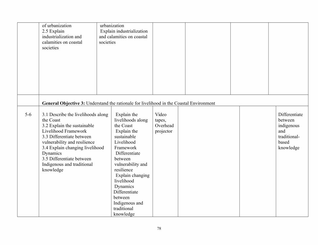
of urbanization2.5 Explain industrialization and calamities on coastal societies
urbanization Explain industrialization and calamities on coastal societies
General Objective 3: Understand the rationale for livelihood in the Coastal Environment
5-6 3.1 Describe the livelihoods alongthe Coast 3.2 Explain the sustainable Livelihood Framework 3.3 Differentiate between vulnerability and resilience 3.4 Explain changing livelihood Dynamics3.5 Differentiate between Indigenous and traditional knowledge
Explain the livelihoods along the Coast Explain the sustainable Livelihood Framework Differentiate between vulnerability and resilience Explain changinglivelihood DynamicsDifferentiate between Indigenous and traditional knowledge
Video tapes, Overhead projector
Differentiate between indigenous and traditional- based knowledge
78

General Objective 4: Understand the need for Institutions, Properties and Laws in Coastal Environmental Management
7-84.1 Explain property rights in Coastal Environmental Management4.2 Differentiate between competing property implementingagencies rights and resource claims
Explain property rights in Coastal Environmental ManagementDifferentiate between competing property implementing agencies rights and resource claims
Video tapes, Overhead projector
What are the laws related to coastal environmental management?
General Objective 5: Understand Policy and Governance of Coastal Environmental Management
9-105.1 Describe existing policies governing the Coastal Environment5.2 Identify the government implementing agencies at all levels that involves in the management of coastal environment
Describe existing policies governing the Coastal Environment Identify the government implementing agencies at all levels that involves in the management of coastal environment
Video tapes, Overhead projector
What are the existing policies governing thecoastal environment?
79

Programme: National Diploma in Marine Meteorology and Coastal ManagementModule: ND
Course Code: Total Contact Hours: 45 hours
Credit Unit: 3
Course Title: Geographic Information System (GIS) and Remote Sensing II
MCM 223 Theoretical: 1 hour
Semester: 4th Pre-requisite: MCM 123
Practical: 2 hours
Goal: This course is design to provide students with basic knowledge of principles of GIS and Remote Sensing.
General Objectives:On Completion of this course the students will be able to:
1] Explain the basic principles of GIS and Remote Sensing
2] Describe Geographic Information Concepts and Spatial Models
3] Identify practical issues associated with managing data capture project
4] Describe Data acquisition and processing
5] Appreciate Spatial Databases
6] Explain Spatial Data Infrastructures
7] Apply Remote Sensing techniques to the study of climate changes
80

Course Title: Course Code:
Total Contact Hours: 45
Geographic Information System (GIS) and Remote Sensing II
MCM 223 Theoretical: 1 hour/week
Semester: 4th Practical: 2 hoursTheoretical Content Practical Content
General Objective 1: Understand the relationship between GIS and remote sensing
Week/s
Specific Learning Outcomes Teacher’s activities Resources Specific LearningOutcomes
Teacher’s activities Evaluation
11.1 Describe the general overview of GIS and remote sensing 1.2 Explain the functionality, concepts, components, scope and application of GIS and remote sensing; 1.3 Explain the application GIS and remote sensing to other field i.e. Atmospheric sciences, meteorology and oceanography. 1.4 Identify various GIS and their components.
Explain the general overview of GIS and remote sensing Explain the functionality, concepts, components, scope and application of GIS and remote sensing; Explain the application GIS and remote sensing to other field i.e. Atmospheric sciences, meteorology and oceanography. Identify various GIS and their components.
Video tapes , Overhead projector GIS LAB
Guide and assists thestudents
What are the concepts of GIS and remote sensing
General Objective 2: UnderstandGeographical Information Concepts and Spatial Model
22.1 Delineate conceptual models of spatial information2.2 Describe alternative representation of spatial information.
Explain conceptual models of spatial information Describe
Video tapes, Overhead projector GIS LAB
Demonstrate the use of GIS software to create base maps
Guide and assists thestudents
Administer group assignment
81

alternative representation of spatial information.
General Objective 3: Understand Geographic data in the computer
3 3.1 Describe the ways in which spatial data may be efficiently coded into a computer system to support the operation of GIS.3.2 Explain the topology and its utilization; data quality and data exchange standards;
Exemplify ways in which spatial data may be efficiently coded into a computer system to support the operation of GIS. Explain the topology and its utilization; data quality and data exchange standards;
Video tapes , Overhead projectorGIS LAB
1] Perform basic data conversion functions; raster to vector and vice- versa using computer2] Use GIS software(Arc GIS software or QGIS) to explain geographical data Identify various geographic data formats: ”Open” format (XML, GML SVG) using computer
Guide and supervise the students
Explain how to use computer in explaining geographical data
General Objective 4: Understand data acquisition and processing
44.1 List the sources of Geographic data; 4.2 Explain methods of data collections and providers; data acquisition (manual, semi automatic, automatic)4.3 Explain the processes of
Describe the sources of Geographic data; Explain methods of data collections and providers; data
Video tapes , Overhead projector GIS LAB
Demonstrate how to process GIS data using computer.
Guide and assists thestudents
Explain how to process data acquired?
82

preliminary data processing, datastorage, retrieval and display; data capture, Geo- referencing, storage, update, retrieval, query and output operations on spatial data sets: 4.4 Explain Data visualization techniques; select appropriate visualization techniques for a specific problem.
acquisition (manual, semi automatic, automatic) Explain the processes of preliminary data processing, data storage, retrieval and display;
5 General Objectives 5: Understand spatial databases5.1 Describe Relational database; 5.2 List out the structural differences between spatial and non- spatial databases; conceptual, logical and physical modeling of spatial databases.5.3 Design and build a spatial database;5.4 Describe and use spatial query languages: concept and 5.5 Design principles of metadata, database structuring. 5.6 Formulate database queries using GIS.
Explain Relationaldatabase; Explain structural differences between spatial and non- spatial databases; conceptual, logicaland physical modeling of spatial databases. Design and build a spatial database; Describe and use spatial query languages: conceptand Design principles of metadata, database structuring. Formulate
Video tapes , Overhead projector GIS LAB
Demonstrate how to use spatial query languages in GIS
Guide and assists thestudents
Explain the rationale for query languages in GIS?
83

database queries using GIS.
6 General Objective 6: Understand spatial data infrastructure
6.1 Explain spatial data infrastructure;6.2 List means of facilitating and coordinating exchange and sharing spatial data.
Explain spatial data infrastructure; List means of facilitating and coordinating exchange and sharing spatial data.
Video tapes , Overhead projectorGIS LAB
Use fieldwork to show students how to collect data
Guide and assists Administer fieldwork
84

Programme: ND Course Code: Total Contact Hours: 45Credit Unit: 3
Course Title: MARINE METEOROLOGY II MCM 224 Theoretical: 2 hours
Semester: 4th Pre-requisite: MarineMeteorology I
Practical: 1 hour
Goal: This course is design to acquaint students with basic idea of water vapour in the atmosphere General Objectives:On Completion of this course the students will be able to:
1] Understand Ice and Icing at sea.2] Understand the impact of water vapour in the atmosphere3] Explain the Phenomenon of Thunderstorm4] Explain the effects of turbulence at Sea5] Understand Cyclone Detection and Tracking at sea6] Understand synoptic weather7] Understand the needs for marine meteorological services
Course Title: Course Code: Total Contact Hours: 45
Credit Unit: 3Marine Meteorology II MCM 224 Theoretical: 2 Hours
Semester: 4th Practical: 1 Hour
85

Theoretical Content Practical Content
General Objective 1: Understand Ice and Icing at sea
Wk/s Specific Learning Outcomes Teacher’s activities Resources Specific LearningOutcomes
Teacher’sactivities Evaluation
1-21.1 List the different types of seaice1.2 Differentiate between sea water and fresh water accretion;1.3 List the effects of icing on sea going ship; 1.4 Explain satellite and radar observation of ice; 1.5 Explain forecasting methods of ice at sea.1.6 State the IMO requirement under SOLAS Convention as regards Ice at sea.1.7 State basic precautions in icenavigation
Explain the different types of sea ice Differentiate between sea water and fresh water accretion;1.3 Explain the effects of icing on sea going ship; Explain satellite and radar observation of ice; Explain forecasting methods of ice at sea.1.6 State the IMO requirement under SOLAS Convention as regards Ice at sea.State basic precautions in ice navigation
Video tapes , Overhead projector
Show on video and pictures different ice types encountered at sea.Use Simulator to demonstrate ice and itseffects on ship.State WMO and IMO guidelines in ice navigation.
Guide and assists the students What are the
effects of icing on ship?
GENERAL OBJECTIVE 2: Understand the Impact of Water Vapour in the Atmosphere3-4 2.1 Explain water vapour in the
atmosphere: evaporation, condensation, precipitation, relative humidity, saturation and dew point, 2.2 Describe Foehn wind effects, formation of dew, hoar frost, glazed frost, and rime.2.3 Differentiate between drizzle, rain, shower, snow, hail.
Explain water vapour in the atmosphere: evaporation, condensation, precipitation, relative humidity, saturation and dew point, Describe Foehn wind effects, formation of dew,hoar frost, glazed frost,
Video tapes , Overhead projector
Explain the essence of water in the atmosphere
86

and rime.Explain the differencs between drizzle, rain, shower, snow, hail.
General Objective 3: Understand the Phenomenon of Thunderstorm
5-63.1 Enumerate the conditions leading to thunderstorm.3.2 Explain the life cycle of a thunderstorm cell.3.3 Describe the effects of thunderstorms on sea going ship;3.4 Explain the empirical thunderstorm forecasting techniques;3.5 Explain the use of Numerical Weather Prediction (NWP) methods in thunderstorm forecasting.
Explain the conditions leading to thunderstorm. Explain the life cycle of a thunderstorm cell.Explain the effects of thunderstorms on sea going ship;Explain the empirical
Video tapes , Overhead projector
Demonstrate how thunderstorm can affect shipboard electrical installations using stimulator
Guide and assists thestudents
Describe the effects of thunderstormon ship
General Objective 4: Understand the effects of turbulence at Sea.
7-94.1 Describe the weather associated with turbulence at sea; 4.2 Explain the types of turbulence i.e convective turbulence, mechanical turbulence, clear air turbulence. 4.3 Explain ocean wave and state wave parameters. i.e wave frequencies ,wave spectrum F(f,ø), two dimensional wave spectrum.4.4 Explain the effects of turbulence on aircraft and sea going ship.
Explain the weather associated with turbulence at sea; Explain the types of turbulence i.e convective turbulence, mechanical turbulence, clear air turbulence. Explain ocean wave and state wave parameters. i.e wave frequencies ,wave spectrum F(f,ø), two dimensional wave spectrum.Explain the effects of turbulence on aircraft and sea going ship.
Video tapes , Overhead projector
Administer fieldwork
Discuss the weather associated with turbulence atsea
87

General Objective 5: Understand Cyclone Detection and Tracking at sea
105.1 Describe the weatherconditions associated withcyclone; 5.2 Describe detections methodsi.e ship observation, swell,atmospheric pressure, wind,clouds, visibility, use of radar,weather satellites, air craftreconnaissance etc;5.3 Explain avoidance ofcyclone at sea: track, path,through line, vortex, vertex,Dangerous Quadrant, Navigablesemicircle etc5.4 Explain the reporting procedures in accordance with SOLAS requirements, contents of message, responsibility of ship masters within the vicinity of cyclone.
Explain the weather conditionsassociated with cyclone; Describe detections methods i.eship observation, swell,atmospheric pressure, wind,clouds, visibility, use of radar,weather satellites, air craftreconnaissance etc; Explain avoidance of cyclone at sea: track, path, through line, vortex, vertex
Dangerous Quadrant, Navigablesemicircle etc5.4 Explain the reporting procedures in accordance with SOLAS requirements, contents of message, responsibility of ship masters within the vicinity of cyclone.
Video tapes , Overhead projector
Demonstrate how to detect cyclone using simulator
Guide and assists the students
What are the effects of cyclone on ships?
GENERAL OBJECTIVE 6: Understand the use of Synoptic Weather Chart11 6.1 Discuss the process of
forecasting fog and low stratus; 6.2 Descibe visible and infrared dust detection techniques.6.3 State the impacts of weather on marine activities.6.4 Explain air masses, production and transformation ofair masses, conservative properties, air masses sources in winter and summer, classification of air masses.
Explain the process of forecastingfog and low stratus; Explain visible and infrared dust detection techniques. Explain impacts of weather on marine activities. Explain air masses, production andtransformation of air masses, conservative properties, air masses sources in winter and summer, classification of air masses. Explain fronts; structure of fronts,
Video tapes, Overhead Projector
Explain the impacts of weather on marine activities?
88

6.5 Describe fronts; structure of fronts, classification, kinematic and dynamic boundary conditions, frontogenesis and frontolysis, principal frontal zones.6.6 Describe jet stream, polar jet stream, subtropical jet stream, polar night jet stream, easterly jet stream,6.7 Describe characteristic of thevarious jet streams, weather associated with jet streams.
classification, kinematic and dynamic boundary conditions, frontogenesis and frontolysis, principal frontal zones and jet stream, polar jet stream, subtropical jet stream, polar night jet stream, easterly jet stream,list out the characteristic of the various jet streams, weather associated with jet streams.
GENERAL OBJECTIVE 7: Understand the need for Marine Meteorological Service12-13 List the various marine activities that
require meteorological services.Explain the sources of marine dataand the need of data for marineservices
Explain the various marineactivities that requiremeteorological services.Explain the sources of marine data and the need of data for marine services
Video tapes
Use automatedequipment andComputerbasedequipment totransmitweather report.
Guide and assists the students to use automated equipment and Computer basedequipment to transmit weatherreport
Examine the rationale for marine services to shipping industry?
MARINE METEROROLOGICAL STATION: CONVENTIONAL INSTRUMENT
S/N INSTRUMENT NUMBER REQUIRED1 THERMOGRAPH ONE2 HYGROGRAPH ONE 3 MARINE BAROGRAPH (ONE) AND IT SHOULD BE INSTALLED IN THE
LABORATORYONE
4 DIGITAL BAROMETER (ONE) AND IT SHOULD BE INSTALLED IN THE LABORATORY
ONE
89

5 AMERICAN CLASS A PAN WITH HOOK GAUGE AND STILWELL (ONE) ONE6 SOLARIMETER (CMP3) ONE7 SUNSHINE RECORDER (CAMPBELL STOKE) ONE8 CUP COUNTER ANEMOMETER ONE 9 WIND VANE ONE10 BINOCULAR ONE 11 STEVENSON SCREEN INCLUDING THE STAND TWO SETS12 ORDINARY AWOS (DAVIS AWOS) ONE13 PINCH EVAPORIMETER WITH DISC ONE 14 ORDINARY RAIN GAUGE ONE 15 SELF RECORDING RAINGAUGE ONE 16 MINIMUM MARINE THERMOMETER ONE 17 MAXIMUM MARINE THERMOMETER ONE 18 ORDINARY MARINE THERMOMETER (WET AND DRY BULB) ONE 19 REMOTE INDICATING ANEMOMETER ONE 20 CUP GENERATOR ONE 21 MEASURING CYLINDER ONE 22
232425.2627282930
MARINE INSTRUMENT:i. CANVAS BUCKET (ONE)ii. SEA SURFACE TEMPERATURE THERMOMETER (SSTT) (ONE)iii. TIDAL GAUGE (ONE)iv Automatic Weather Stations or Marine Automatic Weather Stations (ONE)
PRISMATIC COMPASSWEATHER TRACKERHAND HELD GPSCURRENT METERMULTIMEDIA PROJECTORSEA SEDIMENT GRABPH/EC WATER PROOF METERHYDROMETER BULB
ONE EACH
NOTE:Requirements and Sitting of Meteorological Station (Enclosure) are listed as below:
1] The size of the enclosure should be 20m by 20m square
2] It should be sited in plain and level ground free from obstruction.
3] It should be covered by wire mesh and have a gate facing South
90
4] The enclosure should face true North.
5] Carpet Grass should be planted inside the enclosure
6] The two Screens must face through North.
TEAM MEMBERS:
S/N
NAMES ADDRESS
1 PROFESSOR ASIWAJU BELLO FEDERAL UNIVERSITY OF TECHNOLOGY AKURE 080366727082 Dr. LAWAL AKEEM MOROUNKEJI MARITIME ACADEMY OF NIGERIA, ORON
[email protected] 080670975803 Dr. AWWAL BAMANGA NIGERIAN MARITIME ADMINSTRATION AND SAFETY AGENCY
[email protected] 09082561629
91
4 Dr. ADEYANJU JOHN ADEREMI MARITIME ACADEMY OF NIGERIA [email protected] 08037254025
5 Dr. (Mrs.) IWUEKE TARI ENUGU STATE UNIVERSITY OF SCIENCE AND TECHNOLOGY [email protected] 08062742015
6 Mr. WILLIAMS O. AWOSOLA [email protected] 08023005901
7 Mr. NATHANIEL N AISIOKUEBO [email protected] 08033437863
8 Dr. ARCHIBONG OKUKU EDIANG NIMET 08121041512
9 OGBONNA FIDELIS [email protected]
10 BILIKISU S AHMED [email protected]
11 EMMANUELLA MAJI [email protected] 08134082385
12 CHIMA A EJIOFOR [email protected] 08034524240
92