national environment commission p.o. box: 466 toll free no ... · provisional national iwrm plan...
TRANSCRIPT

National Environment Commission
Royal Government of Bhutan.
P.O. Box: 466
Th imphu - 11001, Bhutan.
Tel No: +975 2 323384 / 324323 / 326386 / 326993
Fax No: +975 2 323385
Toll Free No: 149
Website: www.nec.gov.bt
National Environment Commission
Royal Government of Bhutan
NAT IONAL INT E GRAT E D WAT E R
RE SOU RCE S MANAGE ME NT P L AN 2 0 1 6

Disclaimer
Boundaries shown on maps are not necessarily authoritative.

NATIONAL INTEGRATED WATER
RESOURCES MANAGEMENT PLAN 2016
NATIONAL ENVIRONMENT COMMISSION
March 10, 2016
Supported by:

www.nec.gov.bti
FOREWORD
For the Royal Government and the people of Bhutan, water is one of the most important natural
resource. It provides livelihood; it is vital to developing the economy; and it sustains the natural
environment. Under the wise and farsighted leadership of our Monarch, combined with our
people’s reverence and respect for nature, we have treasured water and we have been blessed with
an abundant natural supply.
At the scale of river basins and even districts, there appears to be no pressing water scarcity. But
this is an average picture, and it does not refl ect large seasonal variations and diff erences in water
availability at the local level. Even as large amounts of water are fl owing in the deep gorges, those
are generally inaccessible for many dispersed communities living on the mountain slopes. Th ey
can only access water from small springs and rivulets.
Th ere is also increasing pressure on the quantity and quality of our water resources because of
rapid socio-economic development, the eff ects of which are further exacerbated by climate change.
Th ere is now growing concern on water availability for drinking supply and for agriculture as many
spring water sources are drying up, and there is minimal fl ow in winter for hydropower generation.
Th erefore, it is important that all stakeholders understand the common issues and take a coordinated
approach to managing Bhutan’s water resources. Th e need for such approach was recognized by
the Water Act of 2011 and the Water Regulation of 2014. Th e 11th FYP mandated the NEC
Secretariat to prepare a National Integrated Water Resource Management Plan (NWIRMP).
Th e overall goal of the Plan is to establish the framework and priorities for the implementation
of integrated water resources management in Bhutan. Th e Plan presented here is based on a
comprehensive assessment of the current situation and future prospects in light of growing water
demands and the threat from climate change. Th e Plan establishes the principles and mechanisms
under which agencies involved in the water sector together with river basin stakeholders, can
coordinate their respective plans and activities, as well as collectively monitor progress toward
attainment of IWRM objectives.
Th erefore, the Plan serves as foundation for water resource stakeholders to work together to achieve
a common goal of ensuring Bhutan’s water security. Water security, as explained in the Plan, is
the capacity to provide suffi cient and sustainable quantity and quality of water for all types of
water needs and services, and to protect people from water-related disasters. Indicators of water
security have been formulated for fi ve key dimensions of water security: household water security,
urban water security, economic water security, environmental water security, and security from
adverse eff ects of climate change and natural disasters. Th ese indicators are to be used as a means
to coordinate agency plans, and to assess progress in achieving the objectives of IWRM.
We are confi dent that the management principles and mechanisms established through this Plan
will serve as rallying point, and be used as practical guide for our collective endeavor toward water

National Environment Commission
Provisional National IWRM Plan 2016 ii
security. We hope that the key result areas and performance indicators for water security that have
been formulated here will be taken on board by the Gross National Happiness Commission, and
that these become integrated into the national and local planning and budgeting processes under
the current 11th fi ve-year-plan and in the subsequent FYPs.
Yeshey Dorji
Minister
Ministry of Agriculture and Forests

www.nec.gov.btiii
ACKNOWLEGEMENT
In compliance with the Water Act and the 11th FYP, the Water Resources Coordination Division
(WRCD), National Environment Commission Secretariat is pleased to present the National
Integrated Water Resources Management Plan. It is the result of concerted eff orts by diff erent
parties. Without their contribution this document would not have materialized.
WRCD likes to thank particularly the Asian Development Bank and Japan Fund for Poverty
Reduction for the fi nancial and technical support extended to the Integrated Water Resources
Management (IWRM) program being pursued in Bhutan. Special thanks go to the National
Environment Commission for guidance and approval of the plan, and the Ministry of Finance for
facilitating the technical assistance from the Asian Development Bank.
WRCD is greatly indebted to the Technical Advisory Committee that has been established for
guiding the development of the IWRM program and elaboration of the National Integrated Water
Resources Management Plan. Th e Technical Advisory Committee consisted of representatives
from the following agencies: Map Production Division, National Land Commission; Department
of Public Health, Ministry of Health; Renewable Natural Resources Engineering Division,
Department of Agriculture, Ministry of Agriculture and Forestry; Watershed management
Division, Ministry of Agriculture and Forestry; Gross National Happiness Commission; Water
and Sanitation Division, Ministry of Works and Human Settlements; Department of Disaster
Management, Ministry of Housing and Cultural Aff airs; Department of Local Governance,
Ministry of Housing and Cultural Aff airs; Flood Engineering Management Division, Ministry
of Works and Human Settlement; Climate Change Division, National Environment Committee;
Bhutan Chamber of Commerce and Industries; Department of Hydropower and Power Systems;
Department of Hydro-Met Services; Department of Geology and Mines, Ministry of Economic
Aff airs; Tarayana Foundation; Royal Society for the Protection of Nature.
WRCD is also grateful to the Technical Assistance team of EGIS (France) in joint venture with
the Royal Society for the Protection of Nature and the Bhutan Water Partnership, who has put a
lot of eff ort into the realization of the NIWRMP.

National Environment Commission
Provisional National IWRM Plan 2016 iv

www.nec.gov.btv
ACRONYMS
ADB Asian Development Bank
AWDO Asian Water Development Outlook
BCCI Bhutan Chamber of Commerce and Industries
BhWP Bhutan Water Partnership
BNWRI Bhutan National Water Resources Inventory
BTFEC Bhutan Trust Fund for Environmental Conservation
CD Capacity Development
CDTA Capacity Development Technical Assistance
CFO Chief Forestry O ffi cer
CMIP5 Coupled Model Inter-comparison Project Phase 5
DLO Dzongkhag Livestock O ffi cer
DAO Dzongkhag Agricultural O ffi cer
DDM Department of Disaster Management
DEC Dzongkhag Environment Committee
DEO Dzongkhag Environment O ffi cer
DES Department of Engineering Services
DG Director General
DGM Department of Geology and Mines
DHPS Department of Hydropower & Power Systems
DMF Design & Monitoring Framework
DOA Department of Agriculture
DOFPS Department of Forest & Park Services
DOHS Department of Hydromet Services
DRC Department of Revenue and Customs
DWS Drinking Water Supply
ESD Environment Service Division
FAO Food & Agricultural Organization (of the United Nations)
FEMD Flood Engineering Management Division (MOWHS)
FGD Focus Group Discussion
GIS Geographical Information System
GLOF Glacier Lake Outburst Flood
GNHC Gross National Happiness Commission
GNHCS Gross National Happiness Commission Secretariat
HP Hydropower Plants
IEC Information, Education and Communication
IT Information Technology
IWRM Integrated Water Resources Management

National Environment Commission
Provisional National IWRM Plan 2016 vi
JICA Japan International Cooperation Agency
KPI Key Performance Indicator
KRA Key Result Area
MASL Meter above sea level
MOAF Ministry of Agriculture & Forestry
MOEA Ministry of Economic Aff airs
MOF Ministry of Finance
MOH Ministry of Health
MOHCA Ministry of Home & Cultural Aff airs
MOWHS Ministry of Works & Human Settlements
MPR Monthly Progress Report
NEC National Environment Commission
NECS National Environment Commission Secretariat
NIIS National Irrigation Information System
NIMP National Irrigation Master Plan
NIWRMP National Integrated Water Resources Management Plan
NLC National Land Commission
NWRB National Water Resource Board
ODE Organizational Development Exercise
PES Payment for Environmental Services
PHED Public Health Engineering Division
PlaMS Plan Monitoring System
PPT Power Point (Presentation)
RBC River Basin Committee
RBMP River Basin Management Plan
RCSC Royal Civil Service Commission
RGOB Royal Government of Bhutan
RNR Renewable Natural Resources
RSPN Royal Society for Protection of Nature (Bhutan)
TA Technical Assistance
TAC Technical Advisory Committee (advising WRCD, NECS)
TNA Training Needs Assessment
TOR Terms of Reference
UNESCO United Nations Educational, Scientifi c and Cultural Organization
WMD Watershed Management Division
WRCD Water Resources Coordination Division
WUAs Water Users Associations

www.nec.gov.btvii
GLOSSARY
Integrated Water Resources
Management
(IWRM).
IWRM is defi ned as ‘a process which promotes the coordinated
development and management of water, land and related resources in
order to maximise economic and social welfare in an equitable manner
without compromising the sustainability of vital ecosystems’.i
IWRM components Th e components of IWRM are as follows:
1. Managing water at the basin or watershed level
Th is includes integrating land and water, upstream and downstream,
groundwater, surface water, and coastal resources.
2. Optimizing supply
Th is involves conducting assessments of surface and groundwater supplies,
analysing water balances, adopting wastewater reuse, and evaluating the
environmental impacts of distribution and use options.
3. Managing demand
Th is includes adopting cost recovery policies, utilizing water-effi cient
technologies, and establishing decentralized water management
authorities.
4. Providing equitable access
Th is may include support for eff ective water users’ associations,
involvement of marginalized groups, and consideration of gender issues.
5. Establishing policy
Examples are implementation of the polluter-pays principle, water quality
norms and standards, and market-based regulatory mechanisms.
6. Inter-sectoral approach
Utilizing an inter-sectoral approach to decision-making, where authority
for managing water resources is employed responsibly and stakeholders
have a share in the process.
IWRM pillars Th e three IWRM pillars relate to: (i) enabling environment (suitable
policies, strategies, and legislation); (ii) capable institutional framework;
and (iii) management instruments.
_____________
i Global Water Partnership: http://www.gwp.org/Th e-Challenge/What-is-IWRM/

National Environment Commission
Provisional National IWRM Plan 2016 viii
IWRM spiral Th e traditional one-track approach of “predictàplanàcontrol” is no
longer appropriate. Rather, an approach that incorporates iterative
learning and fl exibility is needed to make water development plans robust
to an uncertain future faced with a variety of change drivers and challenges.
Th is can be achieved within the context of IWRM, in particular through
a process of continual evolution and improvement – which in the IWRM
literature is referred to as the “spiral” approach, see fi gure below.
From AWDO, 2013
Each spiral describes the cycle of (1) recognizing/ identifying the issues
at stake; (2) conceptualizing the mitigating strategies; (3) coordination
& planning of activities; (4) implementing, monitoring and evaluation.
Each cycle typically takes about 5 years, and thus corresponds well with
te fi ve-year planning practice of the GNHC in Bhutan. Conclusions
from the evaluation of previous round of activities will lead to renewal or
adjustment of plans in the next cycle.

www.nec.gov.btix
River basin A river basin can be defi ned as:ii
Th e geographical area determined by the watershed limits of the system
of waters, including surface and underground waters, fl owing into a
common terminus (cf. Helsinki Rules, International Law Association,
1966, article II).
Or:
A river basin is the portion of land drained by a river and its tributaries.
It encompasses the entire land surface dissected and drained by many
streams and creeks that fl ow downhill into one another, and eventually
into the river and exiting the area at one point, see fi gure below.
Schematic presentation of a river basin
NB: A (drainage) basin is basically the same as catchment area or
watershed. Th e distinction is mainly based on the scale of the area being
referred to.
Th e Dublin principles for
IWRM
IWRM strategies are based on the four principles formulated at a water
conference in Dublin in 1992 (referred to as the Dublin Principles of
IWRM) and presented to world leaders at the World Summit in Rio de
Janeiro in 1992.
Th e four principles are: (i) water is fi nite and vulnerable resource; (ii) need
for a participatory approach in water management; (iii) the role of women
is stressed; and (iv) water has social and economic value. Later, a fi fth
principle is added: (v) integration of the three E’s: economic effi ciency –
social equity – environmental sustainability.
_____________
ii https://docs.google.com/a/universitywatersectorpartnership.org
National Environment Commission
Provisional National IWRM Plan 2016 x
Water security Defi ned as “the capacity of a population to safeguard sustainable
access to adequate quantities of acceptable quality water for sustaining
livelihoods, human well-being, and socio-economic development,
for ensuring protection against water-borne pollution and water-
related disasters, and for preserving ecosystems in a climate of peace
and political stability.”iii Water security may be viewed in physical or
economic terms. Physical water security is a situation wherein water is
abundant enough to meet all demands, whereas economic water security
depends on providing adequate investments in water infrastructure and
services delivery.
Water availability Th e hydrologic capacity of a water source (surface water body, groundwater,
municipal water) to sustain additional water demands after considering
other current water uses and water conditions. (GEMI, 2012)iv
In the context of this NIWRMP the water availability in an area has
been determined as runoff generated from rainfall within the concerned
area augmented with the infl ow from upstream areas after deducting
consumption.
Hydrological water balance Any water entering a system (via precipitation), must be transferred
into either evaporation, surface runoff (eventually reaching the channel
and leaving in the form of river discharge), or stored in the ground as
groundwater and on the ground as snow or ice. Th is equation requires
the system to be closed (hydrological unit)v
Water accounting Th e systematic study of the current status and future trends in water
supply, demand, accessibility and use within a given spatial domain.VI
Wetlands “Wetland” is a generic term for all the diff erent kinds of wet habitats-
-implying that it is land that is wet for some period of time, but not
necessarily permanently wet.VII
Th ere are various defi nitions, they usually highlight three aspects: (i) the
hydrological regime (depth of fl ooding or soil saturation; (ii) the type of
plant growth (hydrophytes); and (iii) Soil development (hydric soils). Not
all defi nitions include deep permanent lakes and/or glaciers.
Wetlands are areas where water covers the soil, or is present either at
or near the surface of the soil all year or for varying periods of time
during the year, including during the growing season. Water saturation
(hydrology) largely determines how the soil develops and the types of
plant and animal communities living in and on the soil. Wetlands may
support both aquatic and terrestrial species. Th e prolonged presence
of water creates conditions that favour the growth of specially adapted
plants (hydrophytes) and promote the development of characteristic
wetland (hydric) soils. VIII
_____________iii UN-Water: http://www.unwater.org/topics/water-security/en
iv http://www.iadclexicon.org/water-availability/
v https://en.wikipedia.org/wiki/Water_balance
vi Godfrey, J. and K. Chalmers (editors). Water Accounting: International Approaches to Policy and Decision-making. Edward Elgar Publishing, 2012
vii https://water.usgs.gov/nwsum/WSP2425/defi nitions.html
VIII http://www.epa.gov/wetlands/what-wetland

www.nec.gov.btxi
Wetlands vary widely because of regional and local diff erences in soils,
topography, climate, hydrology, water chemistry, vegetation and other
factors, including human disturbance.
Inland wetlands, like in Bhutan, are non-tidal and can comprise
fl oodplains along rivers and streams; isolated depressions surrounded
by dry land along the margins of lakes and ponds, and in other low-
lying areas where the groundwater intercepts the soil surface or where
precipitation suffi ciently saturates the soil (vernal pools and bogs);
marshes and wet meadows dominated by herbaceous plants, swamps
dominated by shrubs, and wooded swamps dominated by trees.

National Environment Commission
Provisional National IWRM Plan 2016 xii

www.nec.gov.btxiii
EXECUTIVE SUMMARY
Th e National Integrated Water Resources Management Plan (NIWRMP) has been prepared on
the basis of climatic, hydrological, and social/institutional assessments as shown in the simplifi ed
diagram below.
/ Pgm a td / Ha ned . ssdssm dnt
Dyc roPoegB a P . ssdssm dnt
DgstorgB a P Aa ta M oc dPgne Buturd P rohdB tgon
P HysgB a P% gnstgtutgona P a nc soB go,dB onom gB rda Pgtgds
N 3W 7 M P 8ta idHoPc dr Y a rtgB gY a tgon
% , N , /DP8 . 7D3ADM B
Bhutan is faced with what could be dubbed as the ‘challenge at dual scale’.
• Th ere are reports about water shortage and scarcity at the local community level. However,
at the larger scale of the river basins (and districts), there are no pressing water problems
evident at the present time suggesting that the issues can be addressed with improved access.
Th e challenge is about coordination and integration of plans for management of water. Th is
is addressed in the Water Act and Regulations, along with the formation of River Basin
Committees. Th e necessity to maintain sustainability of water utilization in future has been
elaborated further in the NIWRMP - specifying priority steps to be taken. Th e NIWRMP
is not a macro-economic analysis of best development alternatives.
• However, water-related problems are felt acutely at local level by dispersed communities
living on the mountain slopes where they draw water from small (sometimes distant)
sources and rivulets. Th eir problems cannot be attended at central or even basin level, and
should be addressed at the level of villages and Gewogs. To that eff ect, the Gewogs should
start collecting information about the fragmented water sources: their location, type and
name; utilization, quantities of abstraction; but also their signifi cance for religion, culture
and ecology.

National Environment Commission
Provisional National IWRM Plan 2016 xiv
Climate change is expected to result in higher temperatures and more erratic and intensive rainfall
during the monsoon – when water is already plentiful. Extreme river discharges are expected
to occur, calling for new design criteria for water works, and ‘room for the rivers’ so as to avoid
fl ooding. Conversely, lean period fl ows are expected to be lower. So storage of monsoon water is
an appropriate measure where possible.
Water shortage as such has not been identifi ed, but rather a problem with accessibility. Given the
scattered habitation and the rugged mountain terrain, delivery of stable water supply is inherently
costly.
Water demand for expanded irrigation may negatively aff ecting the amount of water that is
available for hydropower generation. It has been estimated that achieving full cereal self-suffi ciency
could in some cases substantially reduce the discharge of the main rivers in certain months of the
year. Th e competition for water should be taken into account in the national policies towards food
self-suffi ciency and power generation, and taking ecological fl ows into account.
To support water management at smaller scale, it is essential to increase the number of weather,
river fl ow and groundwater monitoring stations, and spreading them evenly throughout the
country. Th is will enable the Department of Hydro-met Services (DHMS) to make more detailed
assessments about the climate and water availability.
Th e Water Act of Bhutan 2011 and Water Regulation of Bhutan 2014 are basically sound and in
harmony with other water-related legislations. Guidelines have been prepared to supplement the
Water Regulation particularly for the registration of Water Users Associations. Th ere is, however,
scope for fi ne-tuning the legal framework.
Bhutan has fi ve major and fi ve minor hydrological basins. It is proposed to club them into fi ve
management units: (i) Amochhu; (ii) Wangchhu; (iii) Punatsangchhu; (iv) Mangdechhu; and (v)
Drangmechhu. Th e fi ve River Basin Committees (RBCs) overseeing these management units are
designed along the ‘coordination model’, building as much as possible on existing institutions and
keeping the regulatory and implementation mandates where they are already. Th e RBCs can have
committees for minor basins or catchment areas. Th e future will tell us how workable this is for
the RBCs.
Planning, implementation and monitoring water security is built around the concept of the
Bhutan Water Security Index, which is comprised of fi ve key dimensions: (i) Rural drinking water
supply and sanitation; (ii) Economic water security; (iii) Urban drinking water supply, sanitation
and drainage; (iv) Environmental water security; and (v) Resilience to disaster and climate change.
Th e water security is expressed in an index fi gure and visualized in a spider web diagram of the
fi ve key dimensions. Th e baseline score and pentagram of the BWSI 2015 are shown below. Th e
average baseline score is 3.06.

www.nec.gov.btxv
% %
% B
, %
, B
. %
. B
/ %
/ B
A %
A B
B %3gmia B gdW
D8gHge c8
N h7P HDHnchgHe a HP
M a icdca H8a
. eM W8a 8B Bei dM B HBP eBa c N H7M %7gHBB A BHM e / M Dge8Hi ,B 3M h
Agency coordination is structured along the key water security dimensions and indicators. It is
essential that the water security concept is incorporated in the GNHC guidelines for preparing the
future Five Year Plans (FYPs), starting with the 12thFYP.
Th ere is an acute need to strengthen the capacity of the National Environment Commission
Secretariat (NECS) for implementation of the Water Act and the NIWRMP. Th ere is also an
urgent need to strengthen the Department of Agriculture (DOA) for implementation of the
National Irrigation Master Plan in the context of achieving food self-suffi ciency. Th e Department
of Hydro-met Services (DHMS) should be strengthened and reoriented to become a broad service
provider to other agencies in terms of weather forecasting and hydrological assessments. Lastly,
the Gewogs need support for registration and capacity building of water user associations (WUAs)
and for documenting local water sources and their uses. Th ere is a role for non-government
organizations (NGOs) to work with government agencies in terms of awareness raising, education,
resource mobilization and implementation support. Th e role of private sector in the construction
of water infrastructures and provision of water services needs to be enhanced especially in relation
to irrigation and water supply and sanitation.
River training works and fl ood protection measures should be expedited in order to mitigate the
expected impacts of climate change.
It is recommended to carry-out a study into the potential of groundwater utilization as
supplementary water source, particularly during the lean season.

National Environment Commission
Draft National IWRM Plan 2016 xvi
www.nec.gov.btxvii www.nec.gov.btxvii
CONTENTS
FOREWORD i
ACKNOWLEDGEMENT iii
ACRONYMS v
GLOSSARY vii
EXECUT IVE SUMMARY xiii
1. INT RODUCT ION 1
1.1 Background 1
1.2 Main issues relating to IWRM to be addressed 2
1.3 Goal and objectives of the NIWRMP 2
1.4 Methodology 3
1.5 Spiral Learning Process in Implementing IWRM 6
1.6 Structure of the NIWRMP 6
2. COUNT RY CONT EXT 9
2.1 Location 9
2.2 Geographical features 9
2.3 Society and culture 13
2.4 Economy 14
2.5 Governance system 15
2.6 Hydrological characteristics 17
3. WAT ER- RELAT ED ISSUES 25
3.1 Multisectoral coordination 25
3.2 Seasonal water availability 25
3.3 Limited managed water storage 26
3.4 Potential Water Shortage 27
3.5 Water availability versus accessibility 28
3.6 Demand management 29
3.7 Water as common pool resource 30
3.8 Vulnerability to fl oods 31
3.9 Glacial Lake Outburst Floods 32
3.10 Unreliable or insuffi cient water supply and sanitation 32

Provisional National IWRM Plan 2016 xviii
National Environment Commission
Draft National IWRM Plan 2016 xviii
3.11 Unreliable or insuffi cient irrigation water supply 33
3.12 Hydropower generation 33
3.13 Competition for water 36
3.14 Impacts of Climate Change 37
3.15 Impact of climate change 38
3.15 Water sources drying-up 40
3.16 Pollution and water quality 40
3.17 Land-use related issues aff ecting runoff 42
3.18 Limited technical and database management capacity 43
4. GOVERNANCE FRAMEWORK 45
4.1 Evolution of water management approaches 45
4.2 Overview of policies and legal framework 46
4.4. Water-related goals in the Vision, Policy and Planning 55
4.5 Institutional framework and stakeholder analysis 58
4.6 Training Needs Assessment 61
4.7 Water Users Associations 65
5. BHUTAN WAT ER SECURIT Y INDEX 71
5.1 Concept 71
5.2 Description 71
5.3 Computation of Indicator Scores 73
5.4 Visualisation of the BWSI 74
5.5 Key Result Areas, Key Performance Indicators and Strategies for
planning based on the fi ve dimensions of water security 75
5.6 Interagency Coordination Framework based on BWSI 81
6. MANAGEMENT FRAMEWORK FOR
IWRM AT BASIN LEVEL 83 6.1 Delineation of management units for IWRM 83
6.2 River basin committee and its functions 84
6.3 River basin management plans 92
7. PRIORIT IES UNDER T HE NAT IONAL
IWRM PLAN 95 7.1 Adoption of water security concept for coordination in
IWRM planning and monitoring 95
7.2 Confi rmation of agency roles in operationalizing the BWSI 95
7.3 Delineation of river basins for IWRM 96
7. 4 Formation of successive RBCs and preparation of RBMPs 96

www.nec.gov.btxix www.nec.gov.btxix
7.5 Information gathering on fragmented water sources 97
7.6 Enhance water retention capacity 97
7.7 Formalisation and strengthening of Water Users
Associations 97
7.8 Strengthening the capacity of NECS 98
7.9 Strengthening the capacity of the Department of Agriculture 99
7.10 Strengthening the weather and hydrological monitoring and
forecasting capacity 101
7.11 Support Gewog/ District administration 102
7.12 Implement training plan 102
7.13 Improvement and harmonisation of the legal
framework for IWRM 102
7.14 Study the potential for groundwater utilization 103
REFERENCES 105
APPENDICES 107
Appendix 1: Areas in basins and districts 108
Appendix 2: Description of the institutional framework 109
Appendix 3: Training plan 128
Appendix 4: IWRM planning and coordination framework based
on the BWSI, and responsible agencies 133

1
1. INTRODUCTION
1.1 Background
Th e Kingdom of Bhutan is endowed with abundant water resources. However, owing to rugged
topography and associated climatic variations, accessibility remains a major challenge with
communities facing seasonal and local scarcity of water. Historically, water resources have been
managed through community-based traditional institutions focusing primarily on provision of
water for drinking and irrigation. Th e pursuit of economic development, increasing population,
and change in lifestyle has resulted in an increasing demand for water. Th e role of government in
management of water has increased over the years, but it is still constrained by weak coordination
and regulatory mechanisms characterized by government agencies pursuing their own sectoral
objectives. Over the period of eleven fi ve year plans, water for hydropower development, though
non-consumptive, has received increasing focus with seemingly less priority given to irrigation,
industrial and environmental water demand. With increasing consumptive demand, competition
for water is emerging. Th e impact of climate change on water availability is a concern for drinking
water supply, agricultural production and also for hydropower generation.
Recognizing that increasing pressure on the quality and quantity of water resources under rapid
socio-economic development may further exacerbate with threats from changing climate, the
Water Act of Bhutan 2011 was enacted to protect the environment and human health and to
enhance the quality of lives through more secured access to adequate, safe and aff ordable water.
Th e Act identifi es integrated water resources management (IWRM) as the approach in ensuring
that the water resources are protected, conserved and/or managed in an economically effi cient,
socially equitable and environmentally sustainable manner. For this, the Act requires the National
Environment Commission Secretariat (NECS) in consultation with competent authorities
to ‘prepare and periodically update a National Integrated Water Resources Management Plan
(NIWRMP) for the conservation, development and management of water resources’. Th e Act
requires the NEC and competent authorities to take account the approved plan in all water related
decisions and that the plan be mainstreamed into national policies, plans and programs.
In taking forward the Royal Government’s drive for a more comprehensive management of the
water resources, the NECS has initiated the preparation of the NIWRMP under the ADB-funded
technical assistance ‘Adapting to climate change through Integrated Water Resources Management’
and with the guidance of a Technical Advisory Committee (TAC) comprising representatives from
the competent Authorities. Th e time horizon for this plan is 2030.
At the United Nations Sustainable Development Summit held on 25 September 2015, world
leaders adopted the 2030 Agenda for Sustainable Development. Th is 2030 agenda includes a set
of 17 Sustainable Development Goals (SDGs) to be achieved by 2030. Goal 6 addresses water

National Environment Commission
Provisional National IWRM Plan 2016 2
concerns and serves as foundation for the water security objectives that underpin the establishment
of IWRM in Bhutan. Specifi cally, the SDG water-related targets set for attainment by 2030 are:
• implement integrated water resources management
• achieve universal and equitable access to safe and aff ordable drinking water for all
• achieve access to adequate and equitable sanitation and hygiene for all
• improve water quality by reducing pollution, eliminating dumping and minimizing release
of hazardous chemicals and materials, halving the proportion of untreated wastewater and
substantially increasing recycling and safe reuse
• substantially increase water-use effi ciency across all sectors and ensure sustainable withdrawals
and supply of freshwater to address water scarcity
• protect and restore water-related ecosystems
• expand international cooperation and capacity-building support in water- and sanitation-
related activities and programs
1.2 Main issues relating to IWRM to be addressed
Th e main issues to be addressed are summarised as follows:
• agreement on common goals in water-related planning and management
• strong capacity and coordination of agencies involved in water management
• capturing the present status of water resources in terms of: water availability, demand and
quality; water-scarce and/or fl ood-prone areas; and licensing of abstractions
• assess the impact of main pressures on water management such as: climate change; change
in land use; population growth, and economic development.
1.3 Goal and objectives of the NIWRMP
Th e overall goal of this NIWRMP is to establish the framework and priorities for the implementation
of IWRM in Bhutan.
Specifi c objectives of the NIWRMP are:
• to assess the current situation and future prospects of water resources in the light of changing
climate
• to formulate the principles and framework within which players in the water sector can
plan, implement and monitor water resources management in a coordinated manner.
• to propose priority interventions and tools for integrated water resources management in
the country.

www.nec.gov.bt3
INTRODUCTION
NIWRMP is not a macro-economic analysis of best development alternatives, but rather an
elaboration of the water security development framework, assessment of driving issues, intervention
strategies, institutional roles and performance management system.
1.4 Methodology
Th e methodology followed in formulating the NIWRMP may be summarized in terms of the
following roadmap comprised of three main components as presented in Figure 1.
Situation assessment
Th is entailed assessment of national water resources through two sources of information. First,
climate and river basin modelling was performed to generate information on present and future
state of climate and hydrology. Hydrological basins were identifi ed and water availability and water
demand for each of the basins were analysed. Secondly, information on water issues was generated
through surveys and existing studies. Th is not only allowed for comprehensive understanding of
current situation with regard to water availability and accessibility, but also the prospects of water
resources in the future.
Development of framework for coordination of planning, implementation and monitoring
IWRM requires coordinated and concerted eff orts on the part of stakeholders to plan, implement
and monitor progress. For this, a comprehensive review of policies, Acts, rules and regulations as
well as existing institutional arrangements for planning and budgeting system was carried out.
In addition, institutional experts performed stakeholder analysis, identifi ed capacity gaps and
entry points for planning, implementing and monitoring IWRM and assessed the organizational
structure of Water Resources Coordination Division of NECS, Department of Agriculture, and
Department of Hydro-Meteorological Services. Th ese are the three most important institutional
players in initiating implementation of the water security agenda; and in the case of NECS, in
coordinating the roles of various other agencies. In working towards a coordination framework
and performance monitoring system, the ADB’s Asian Water Development Outlook was reviewed
and adapted to formulate the Bhutan Water Security Index.

National Environment Commission
Provisional National IWRM Plan 2016 4
Identifi cation of priority interventions and tools
Identifi cation of priority interventions and tools
Based on the outcomes of the processes outlined above, interventions were formulated on the basis
of priority issues and challenges. Th ese interventions are presented in the form of Key Result Areas
(KRAs) to concur with the process and terminology adopted by GNHCS in formulating plans.
Th e approach was taken with the expectation that the interventions will feed into the GNHC
guidelines for preparation of the next FYP.
In support of the proposed mechanisms and interventions, online Bhutan Water Security
Information system comprising of i) Bhutan Water Security Index System, ii) Interactive Web-
based GIS1, iii) Water Balance and iv) thematic maps have been developed to provide a basis upon
which the NECS can constantly refi ne and improve over time.
Figure 1: Diagram showing the roadmap for planning of the NIWRMP
1 For details on the GIS database, refer to the standalone supporting documents entitled: (i) GIS Software
Installation User Manual and (ii) Interactive Web GIS User’s Manual.

www.nec.gov.bt5
INTRODUCTION
Consultation process
Considering that the NIWRMP is a national cross cutting document, constant eff orts were made
to solicit input and guidance from stakeholder. As from an early stage in the preparation of the
NIWRMP, a Technical Advisory Committee (TAC) comprised of representatives from concerned
government and non-governmental agencies and competent authorities has been established with
the purpose of stakeholder coordination with respect to IWRM, and to guide the elaboration
of the NIWRMP2. Feedback and guidance were sought through inception workshop, interim
progress review and regular TAC meetings. Th e draft fi nal plan was presented to stakeholders in
four regional and one national consultation meetings. Th e fi nal plan incorporates the feedbacks
and comments from these consultations.
Moreover, the draft NIWRMP was posted on the NEC website for public review for one month
before fi nalisation.
Th e overall logic and linkages in the formulation of the plan may best understood in the context
of the diagram presented in fi gure 2 below.
N dmdih
. esa o P i P omenP YePiP g W a o8nemYePi PB gPica niYa nh cPP goh
DiHdW Y
M da 7P oe8 mnei8emga o 7u tde8d Yda cPsa nih a iY eo cr eW a W
B.P 3A D
Br Ygeia o P BnP h a t PnH BPn 8PPnW eiP Ya W P mmnPP 8d YP /N 3A teYd P W a Beia W nPga BPn oYP Ha dPgW a no
/a c8H BP8g a o iPe
N P Ya n P iW t P Ya nina gP Ya W ga ceogP YePi YdP Y eo r oa W YP cPsa ni
3%A D
DgP i BPn P 8dea seic Yda mnPYa 8YePiy eh mnPsa h a iY P iW or oYP eiP 7ga r oa PB Yda t P Ya n a isenPih a iY ei Yda nesa n 7P oei
, dna 7a 8P DH8hm
%nYe8r gP Ya Yda Pr Y8Ph a o P iW Pr Ymr Yo YP 7a P 8dea sa W Psa n Yda 8Pi8a nia W ma nePW
%P M .
, a o8ne7a o Yda W a cna a PB t P Ya n oa 8r neYu P 8dea sa W Pn mr nor a W ei Besa Ha u W eh a ioePio
Figure 2: Diagram showing the relation between diff erent documents
2 Th e Technical Advisory Committee consisted of representatives from the following agencies: Map Production
Division, National Land Commission; Department of Public Health, Ministry of Health; Department of Hydropower
and Power Systems; Renewable Natural Resources Engineering Division, Department of Agriculture, Ministry
of Agriculture and Forestry; Department of Hydro-Met Services; Watershed Management Division, Ministry of
Agriculture and Forestry; Gross National Happiness Commission; Water and Sanitation Division, Ministry of Works
and Human Settlements; Department of Disaster Management, Ministry of Home and Cultural Aff airs; Department
of Local Governance, Ministry of Home and Cultural Aff airs; Flood Engineering Management Division, Ministry of
Works and Human Settlement; Climate Change Division, National Environment Committee; Bhutan Chamber of
Commerce and Industries; Department of Geology and Mines, Ministry of Economic Aff airs; Tarayana Foundation;
and the Royal Society for Protection of Nature.

National Environment Commission
Provisional National IWRM Plan 2016 6
1.5 Spiral Learning Process in Implementing IWRM
IWRM is understood as an iterative learning process which is shown in Figure 3. Each spiral
describes the cycle of: (i) recognizing/identifying the issues at stake; (ii) conceptualizing the strategy;
(iii) planning and coordinating interventions by multiple players (i.e., competent authorities), and
(iv) managing performance. Lessons from evaluating the previous round of activities are used to
renew adjust plans in the next cycle.
Stakeholders are to be kept informed of the IWRM’s progress along the IWRM spiral, and of
the activities that various stakeholders are contributing to attain the IWRM objectives at each
iteration of the cycle. It is also important to keep stakeholders aware of the larger picture in which
their individual roles are set and are coordinated through the national IWRM plan and the river
basin management plans.
Figure 3: Spiral learning process for implementing IWRM
1.6 Structure of the NIWRMP
Th e NIWRMP is a framework document that establishes the foundations and framework for
coordinated planning, implementation, monitoring the status of water security in the country.
Th e structure of this plan follows the logic of fi rst setting the context, then describing the water
related issues therein that the plan intends to address followed by guiding framework and
foundations within which the players in the water sector are expected to perform. Based on the
context, issues and guiding framework and foundation, the plan outlines the priorities in the form
of Key Result Areas (KRAs) and Key Performance Indicators (KPIs) for ready integration in the

www.nec.gov.bt7
INTRODUCTION
sectoral plans and national fi ve year plans. Th e chapters are presented accordingly. Chapters 1, 2
and 3 are dedicated to introductory and context setting aspects of the plans. Chapters 4, 5 and 6
are dedicated to the guiding framework and foundations for IWRM planning, implementation
and monitoring progress towards water security. Based on the context and framework established
in earlier chapters, Chapter 7 sets out the priorities for the next three fi ve-year plans. Th e details
for specifi c chapters are described below:
Chapter 1 is an introduction to the plan. It provides background information, defi nes goal and
objectives of the plan and describes the methodology adopted in formulating the plan.
Chapter 2 describes the main characteristics of Bhutan, its location in the eastern Himalaya
mountain range; physical features; society and culture; economy; governance structure and the
hydrological context.
Chapter 3 gives an overview of water and water related issues in the country. Issues identifi ed in
this chapter relate not only to the current situation but also include future prospects especially
in terms of climate change and associated impacts on hydrology. Th e plan does not elaborate
on the commonly known issues such as drinking water supply, glacial lake outburst fl oods; and
landslides. Th e current policy and management approach to these issues is sound and should be
continued by the concerned agencies. Development of irrigated agriculture is addressed separately
in the National Irrigation Master Plan, 2016. Given its relevance for water management, the
main conclusions have been incorporated in the NIWRMP. Other issues such as institutional
coordination; water availability per district; and identifi cation of water-scarce and fl ood-prone
areas, to mention a few, have been studied in greater depth for the NIWRMP. Details are provided
in stand-alone supporting documents, while the results and main conclusions are briefl y presented
in the NIWRMP.
Chapter 4 provides an overview of the governance framework. It begins with IWRM as understood
in the global context, and a description of how water management approaches have evolved.
Th en follows an overview of IWRM pillar 1: policies and legal instruments that are binding
on government and non-governmental agencies to contribute to integrated water resources
management in the country. It elaborates the Water Policy of 2008, Water Act of 2011, Water
Regulations of 2014 and other water-related legal instruments.
Th is is followed by a review of IWRM pillar 2: the institutional framework and stakeholder
analysis; and IWRM pillar 3: tools used in IWRM. Th e chapter continues with a training need
assessment, and ends with presenting a framework for inter-agency coordination.
Chapter 5 introduces the Bhutan Water Security Index (BWSI); it is a system for planning and
monitoring the status of the water resources at basin and sub-basin/district-level scale, and their
related services towards water security. Adapted from the Asian Water Development Outlook
(ADB, 2013), the BWSI comprises of fi ve dimensions each with a set of indicators. Th e chapter
proposes the BWSI dimensions and the indicators as handy lenses through which policy makers
and leaders can visualize the status of water security at the national level. But they can also zoom

National Environment Commission
Provisional National IWRM Plan 2016 8
into each dimension and indicators to assess performance of specifi c sectors. It is also the basis for
inter-agency coordination.
Chapter 6 focuses on the management framework for implementing IWRM at the basin level. Th e
Chapter explains the delineation of basin-scale management units, the proposed role of River Basin
Committees and their composition and specifi c functions, and the arrangements for formulating
river basin management plans that incorporate stakeholder participation.
Finally, chapter 7 contains the priorities that need to be pursued within the IWRM framework set
forth in the earlier chapters.
9
2. COUNTRY CONTEXT
Th is chapter describes some main characteristics of Bhutan that are relevant to water management.
2.1 Location
Th e Kingdom of Bhutan is situated in the eastern region of the Himalayan mountain range,
between 88°E and 93°E longitudes and 26°N and 29°N latitudes. It is a landlocked country
bordered to the north by (the Tibetan Autonomous Region of) China and to the south by India
with the states of Sikkim in the west, West Bengal in the south and Arunachal Pradesh in the east,
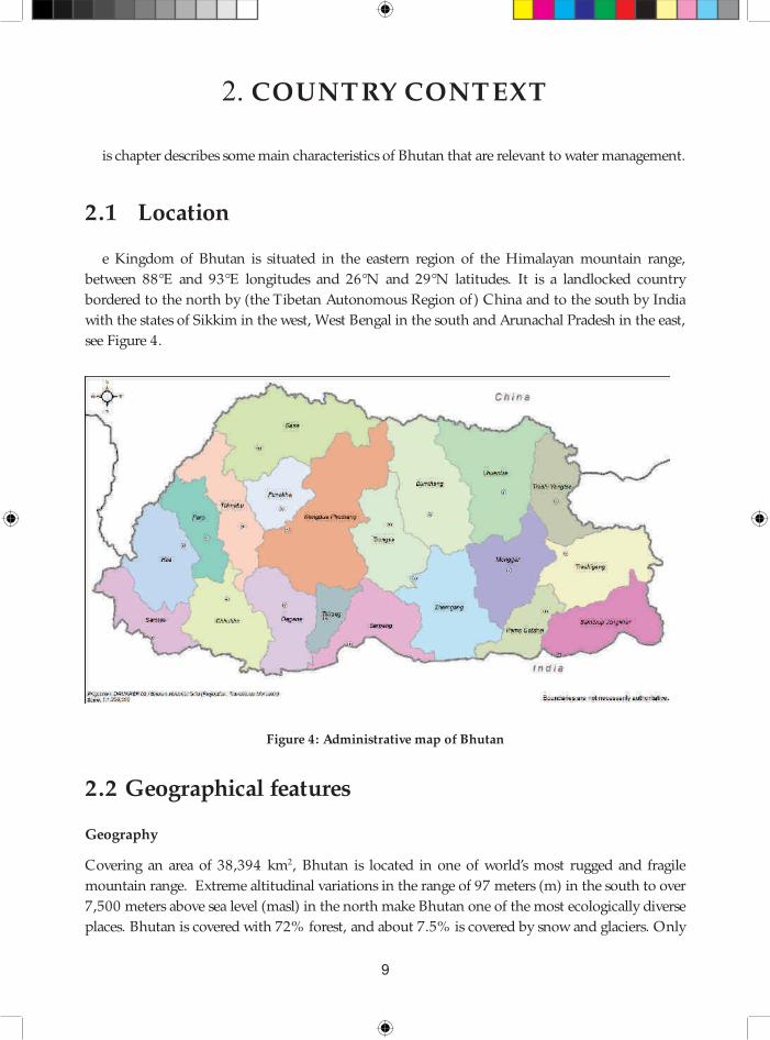
see Figure 4.
Figure 4: Administrative map of Bhutan
2.2 Geographical features
Geography
Covering an area of 38,394 km2, Bhutan is located in one of world’s most rugged and fragile
mountain range. Extreme altitudinal variations in the range of 97 meters (m) in the south to over
7,500 meters above sea level (masl) in the north make Bhutan one of the most ecologically diverse
places. Bhutan is covered with 72% forest, and about 7.5% is covered by snow and glaciers. Only

National Environment Commission
Provisional National IWRM Plan 2016 10
about 3% of the total area is arable land. Th e remaining areas are covered by water bodies, shrubs,
meadows and other land use types. Th e country is also known for its natural rich water resources
with a network of east-west fl owing tributaries and major north-south rivers fl owing through deep
gorges and narrow valleys and ultimately draining into the plains of India and discharging into the
Brahmaputra river. Over 90% of the land area has slopes exceeding 25% which promotes runoff
and erosion while making access to and management of water resources a costly aff air.
Climate
Bhutan may be broadly divided into three geographic areas and corresponding climatic zones.
Th ey are the southern foothills, inner Himalayas and higher Himalayas. Th e southern foothills,
only 20 km wide, rise from 100 to 1,500 masl. Th e climate is hot and humid in the southern
foothills, with temperatures ranging from 15 to 300C throughout the year and precipitation ranges
between 2,500 and 5,550 millimeters (mm) per year. Th e inner Himalayas, which rise to 3,000 m,
constitute, with their broad valleys, the economic and cultural heartland of the Kingdom.
Th e central inner Himalayas are characterized by a cool temperate climate with an annual average
precipitation of 1,000 mm. Th e higher Himalayas constitute the northernmost and highest
mountain ranges with elevations up to 7,550 m. Th ese northern regions, under perpetual snow,
are sparsely populated and have an alpine climate with average annual precipitation of 400 mm.
Th e temperature varies signifi cantly over the country, with some higher Himalayan regions always
below the freezing point throughout the year. Precipitation also varies signifi cantly due to high
topographic variability. Basically there are four seasons: pre-monsoon (March-May), monsoon
(June-September), post-monsoon (October-November) and cold dry winter (December-
February). July has the highest precipitation followed by August. About 80% of rainfall occurs
from June to September. Precipitation remains low during the winter season and gradually increases
from March. Th e mean monthly precipitation sum for two representative meteorological stations,
located at Druyagang and Phobjikha, for the period 1990-2009 is shown in Figure 5.
Figure 5. Mean monthly precipitation for meteorological stations Drujaygang and
Phobjikha

www.nec.gov.bt11
COUNTRY CONTEXT
Climate change projections
Climate change has been assessed during the preparation of the NIWRMP. Th e temperature is
expected to rise, and more so in the north of the country. Increased snow and glacial melt will have
an impact on river discharge. Th e temperature and its change over time are presented for RCP 4.5
in Figure 6. 3 Higher temperatures will also increase forest and crop water demand through greater
evapotranspiration, which in turn would reduce the river fl ows. 4
Figure 6: Projected changes in temperature for RCP 4.5
Source: CDTA
Th e rainfall shows an increasing trend, as displayed in Figure 7 for RCP 4.5.
,
D, ,
. %, , ,
. %D, ,
/ %, , ,
/ %D, ,
A%, , ,
A%D, ,
B%, , ,
B%D, ,
D%, , ,
. P M , . P N , . P P , / , , , / , . , / , / , / , A, / , B, / , D, / , 3, / , M , / , N , / , P , / . , ,
.WWeB7 ABPWMB77 %88,
ABPW MB77 dB3W Dc a H3B / N edBW8Hdec m 8Hh B gB r B n Wiic m 8Hh B gB r B n a PY oec mi 7PPoeHggn
Figure 7: Long-term rainfall trends for diff erent elevations in Bhutan
3 Representative Concentration Pathways (RCPs) were developed by the IPCC and are identifi ed by their
total radiative forcing, measured in watts per square meter (W/m2) in year 2100 relative to 1750. Radiative forcing is
defi ned as the diff erence of the solar energy absorbed by the Earth and the energy radiated back to space. Essentially,
these scenarios describe the degree in which greenhouse gas emissions are actively mitigated, stabilized, or increased.
RCP 4.5 is a “stabilization scenario” wherein total radiative forcing is stabilized before 2100 through a range of
technology and strategies for reducing GHG emissions.
4 Refer to supporting standalone document entitled: Hydro-meteorological projections for Bhutan based on
CMIP5 scenarios.

National Environment Commission
Provisional National IWRM Plan 2016 12
Th e spatial variation of rainfall is presented for RCP 4.5 in Figure 8.
Figure 8: Projected change in precipitation for RCP 4.5
Source: Source: ADB TA 8623
As can be seen in Figure 8, rainfall is projected to increase, particularly in the south of the country
and during the monsoon period when water is already abundant.
Agro-ecological zones
Such altitude variations lead to very diverse climatic conditions and varied vegetation ranging from
warm broad-leaf forest in the south to cool temperate coniferous forest in the inner Himalayas
and alpine shrubs and meadows in the higher Himalayas. Th e geographical and climatic diversity
is best illustrated by the six agro-ecological zones described in the Table 1 and shown in Figure 9.
Table 1: Six agro-ecological zones in Bhutan
Agro-ecological zones Altitude (m) Area (ha) Area (%)
Wet subtropical 100-600 214,918 5.6
Humid subtropical 600-1200 392,700 10.3
Dry subtropical 1200-1800 503,465 13.1
Warm temperate 1800-2600 714,554 18.6
Cool temperate 2600-3600 917,155 23.9
Alpine 3600-7500 1,096,618 28.6
Total 3,839,409 100.0
Source: Bhutan RNR statistics 2015

www.nec.gov.bt13
COUNTRY CONTEXT
Figure 9: Map of agro-ecological zones in Bhutan
2.3 Society and culture
Bhutan is a place of social and cultural diversity with local dialects, social norms, local beliefs, and
livelihood practices varying across the country. Th is may be attributed to the high mountains, deep
gorges, and fast fl owing rivers that have isolated communities. Th e limited communication and
interaction with other communities have led to evolution of livelihoods practices, dialects, religious
beliefs, traditions and culture that are unique to the ecological zones. Th e higher Himalayas are
inhabited by nomads that are dependent on livestock and dairy products. Th ose living along the
mountain slopes practice dryland agriculture depending primarily on wheat, barley, maize and
horticulture. Some communities practice terraced rain-fed as well as irrigated paddy cultivation.
Th e fertile valleys of inner Himalayas and southern foothills are inhabited by communities that
are dependent on paddy and horticultural production. Such livelihood practices are still prevalent
in the rural communities that make-up an estimated 69% of the country’s population5. Day to
day livelihood practices still revolve around subsistence farming and dependence on local natural
resources and environmental services especially water supply and forest products.
Th e majority of the population practice Buddhism followed by smaller section of Hindus and
Christians. Buddhist reverence for living beings and beliefs in local deities contribute immensely
to preservation and protection of nature and natural resources. Both urban and rural communities
pursue strong linkages with ancestral traditions, culture, and religious beliefs that promote respect
for nature. Today, Bhutan strongly pursues preservation of these cultural heritages – in which
5 According to National Statistical Bureau, Bhutan’s population was 745,153 in 2014.

National Environment Commission
Provisional National IWRM Plan 2016 14
water plays a major role.
Bhutan is a welfare state with free education, health services and agricultural subsidies. Th e
population is expected to grow from 745,000 to some 886,500 by 20306.Th ough the average
registered household size is about 4.6, most of the family members explore livelihood opportunities
in urban areas. About 30% of the population resides in urban areas and is expected to reach 50%
by 2020. Some 13% of the population lives in Th imphu alone. Given the diffi culties of farming
on the mountain slopes, more of the educated younger generation migrate to urban areas in search
of employment leaving behind the older members of the family. Migration from rural areas has
resulted in decline in agriculture work force and translated into rapid urbanization, unemployment
and associated social issues. Half of the population is under 22 years old. Th e Child (under 5yrs
old) Mortality Rate is 6.16%.
2.4 Economy
Th e GDP per capita in 2013 was Nu 142,983.67 (US$ 2,300)7. Th e average economic growth
over the last fi ve years (2009-2013) was 6.7%, but slowed down to 2.07% in the last year, mainly
due to negative growth in manufacturing, services and construction. Conversely the positive
growth in hotels & restaurants; electricity & water supply; trade; and business services accounted
for the net growth of the GDP. (In dollars the GDP declined by 2.31% to US$ 1,781.5 million, or
US$ 2,440 per capita.) Th e World Bank has classifi ed Bhutan as a lower middle-income country.
Bhutan’s economy is based primarily on agriculture and forestry, providing livelihood for about
69% of its population. Agriculture mainly consists of subsistence farming and animal husbandry.
Th e share in GDP for key sub-sectors related to water is given in Table 2.
Table 2: Share of sub-sectors in GDP
Sub-sector % share in GDP
Agriculture 9.18
Livestock 4.11
Forestry (& logging) 2.89
Water supply 0.03
Electricity 14.15
Manufacturing 8.51
Source: National Accounts Statistics
Th e country has embarked on increasing investments in hydropower development for export
6 Statistical yearbook of Bhutan, 2014
7 National Accounts Statistics of 2014

www.nec.gov.bt15
COUNTRY CONTEXT
to India. With over 2000 MW of hydropower generation capacity and another few thousand
megawatts of hydro-power under construction, the country’s economy is commonly regarded as
hydropower driven. High value low impact tourism is also a major source of foreign currency
earnings. Industries are mainly small scale cottage based, but there are breweries, mines, and a
chip board industry.
Th rough the bilateral India-Bhutan hydropower cooperation agreement, most of the hydropower
investments come from India and is made available in the mixed grant-loan mode8. Bhutan’s
foreign debt with India for hydropower has crossed the value of its GDP. Hydro-power-driven
economic development, urbanization, and lack of investment in agriculture have made Bhutan
dependent on cereal imports. Improving the food self-suffi ciency through agricultural development
and irrigation is a key water-related objective of the Royal Government of Bhutan (RGOB).
2.5 Governance system
Th e Governance system in Bhutan is a Democratic Constitutional Monarchy as enshrined under
Article 1(2) of the Constitution of the country. His Majesty the Druk Gyalpo is the Head of
the State. Th e executive power is vested in the Lhengye Zhungtshog which consists of ministers
headed by the Prime Minister. Th e legislative power is vested in the parliament which consists of
the Druk Gyalpo, the National Council (upper house) and the National Assembly (lower house).
Th e Royal Government of Bhutan has 10 ministries which work in bringing the goal of Gross
National Happiness closer to reality. Th e ten Ministries are:
• Ministry of Agriculture and Forest (MOAF)
• Ministry of Economic Aff airs (MOEA)
• Ministry of Education (MOE)
• Ministry of Finance (MOF)
• Ministry of Foreign Aff airs (MOFA)
• Ministry of Health (MOH)
• Ministry of Home and Cultural Aff airs (MOHCA)
• Ministry of Information and Communication (MOIC)
• Ministry of Labour and Human Resources (MOLHR)
• Ministry of Works and Human Settlements (MOWHS)
Under the Cabinet there is –among others- the Gross National Happiness Commission
(GNHC) for planning, and the National Environment Commission as a regulatory body. Both
8 Under the India Bhutan Hydropower cooperation arrangements, the grant loan proportion was 40% grant
and 30% loan with 10% annual interest rate. Th e grant proportion has been revised to 30% grant and 70% loan at
10% annual interest rate.

National Environment Commission
Provisional National IWRM Plan 2016 16
have their own Secretariat. Th e ministries have representation in the dzongkhags.
Bhutan is divided in 20 Dzongkhags (districts): Bumthang, Chukha, Dagana, Gasa, Ha,
Lhuentse, Monggar, Paro, Pema Gatshel, Punakha, Samdrup Jongkhar, Samtse, Sarpang,
Th imphu, Trashigang, Trashiyangtse, Trongsa, Tsirang, Wangdue Phodrang, and Zhemgang. Th e
Dzongkhags are sub-divided into Gewogs, the smallest administrative units of which there are
205 in total. A brief description of the role of functionaries of local government is given in table
3 below.
Table 3: Roles of local government functionaries
Name Description Executive Arm
Dzongkhag
Tshogdu
Th is serves as the District Assembly and
comprises the Gup and Mangmi as the two
elected representatives from each Gewog;
one elected representative to represent
the Dzongkhag Th romde, and another
elected representative to represent the
other smaller towns. Th e Chairman of
the Dzongkhag Tshogdu is elected from
among the elected Gups.
Dzongkhag Administration
Dzongkhag Administration:
Dzongkhag Administration
is headed by the Dzongdag
(district governor). Dzongkhag
Administrations are staff ed by civil
servants working under diff erent
development sectors.
Dungkhag Administration: Sub-
district administration extending
to a group of Gewogs in selected
districts with large number of far
fl ung Gewogs. Dungkhag is headed
by Dungpa and staff ed by civil
servants
Dzongkhag
Th romde
Tshogde
Dzongkhag Th romde Tshogde is
primarily a committee charged with the
responsibility of deliberating on issues
pertaining to planning and budgeting
for the district capital towns that do
not have adequate capacity to function
independently.
Municipality offi ce under District
Administration
Municipality staff are civil servants
under the district administration
Gewog Tshogde
Gewog Tshogde is Gewog Development
Committee comprised of elected Gup as
Chairman and members comprising of
Mangmi and Tshogpa (representatives)
elected by basic electoral constituencies
called Chiwogs i.e., a cluster of villages.
Gewog Administration
Gewog Administration is headed
by the elected Gup. Th e Gewog
Administration is staff ed by Gewog
Administrative O ffi cer.

www.nec.gov.bt17
COUNTRY CONTEXT
Name Description Executive Arm
Gyelyong
Th romde
Tshogdu
Gyelyong Th romde Tshogdu is the Executive
Council for larger urban area (categorized
as Class A Th romde) within a district. It
is comprised of elected members of the
constituencies and an overall elected Mayor
cum Chairman known as Th rompon.
Th romde Offi ce
Th romde Offi ce commonly termed as
‘City Corporation’ headed by the elected
Mayor and supported by an Executive
Secretary with full-fl edged independent
administrative and program operations.
Th e Th romde Administration is staff ed
by civil servants and contract employees.
2.6 Hydrological characteristics
Main and minor rivers9
Bhutan has an extensive river system that is generally distinguished by main rivers that fl ow
north to south, with tributaries fl owing in east-westerly direction. Th e main rivers are Amochhu,
Wangchhu, Punatsangchhu and Manas. Th e latter covers about half the country and is made-up
of Mangdechhu and Drangmechhu. Th ese two large rivers converge into one river just before
crossing the Indian border. For purposes of management, Mangdechhu and Drangmechhu shall
be considered as two separate basins; see Figure 10.
Figure 10: Hydrological basins in Bhutan
9 For additional information and maps on Bhutan’s hydrological characteristics, refer to the standalone
supporting document entitled: National Atlas of River Basins and Water Infrastructure in Bhutan.

National Environment Commission
Provisional National IWRM Plan 2016 18
As can be seen, Amochhu and Drangmechhu originate in China. Th ere are smaller rivers, to As
can be seen, Amochhu and Drangmechhu originate in China. Th ere are smaller rivers, to mention:
Jaldakha, Aiechhu, Nyere-Amari, Jomori/Dhansari, and Merak-Sakteng.
Th e boundaries of hydrological basins and district administrative units are shown in Figure 11. Th e
map shows that one district can be located in two hydrological basins. For example, Chukha and
Haa districts are located in Amochhu as well as Wangchhu basins. Trashigang district is located in
Drangmechhu and Nyere-Amari basins.
Most of the river discharge is fed by rainfall, supplemented by an estimated 2-12% glacial melt
and another 2% from snow melt.10 Th e combined outfl ow of the rivers is estimated at 70,576
million m3, or 2,238 m3/s. Th is corresponds to a fl ow of 109,000 m3 per capita per year, the
highest in the region. Table 4 presents an overview of the outfl ow of the main rivers.
Figure 11: Boundaries of hydrological basins and dzongkhags
10 Ministry of Water Resources, Government of India, Brahmaputra Basin, 2014. http://www.indiawris.nrsc.
gov.in/Publications/BasinReports/Brahamaputra%20Basin.pdf

www.nec.gov.bt19
COUNTRY CONTEXT
Table 4: Average net monthly outfl ow (MCM and %) per basin
Basin Aiechhu AmochhuDrangme
chhu
Mangde
chhu
Nyera
Amari
Punatsang
chhu
Wang
chhuNational
Jan 99 137 189 188 64 268 82 1,028
Feb 184 211 230 213 114 283 102 1,336
Mar 51 151 425 329 31 381 144 1,512
Apr 92 202 1,011 723 58 762 265 3,115
May 243 375 1,160 1,008 159 1,373 397 4,713
Jun 1,040 1,500 1,904 1,453 690 2,703 713 10,002
Jul 1,864 2,410 2,893 2,556 1,196 4,332 1,132 16,382
Aug 1,415 1,785 2,355 2,247 897 3,746 965 13,410
Sep 1,172 1,513 1,841 1,555 763 2,826 723 10,392
Oct 520 701 1,080 1,087 337 1,601 441 5,769
Nov 191 240 299 275 124 521 143 1,792
Dec 119 149 180 164 75 336 103 1,126
Total
MCM6,989 9,375 13,569 11,797 4,507 19,130 5,209 70,576
Total
in %9.9% 13.3% 19.2% 16.7% 6.4% 27.1% 7.4% 100.0%
Th e national water balance is composed of the water balances per basin. Water balances have been
assessed for the month of May when irrigation demand is high for paddy transplantation and the
monsoon rainfall is just starting up. 80% dependable fl ow (occurring at least in 4 out of 5 years)
and consumptive demand in the month of May have been assessed. Th e results are given in Table
5 where it can be seen the additional total water demand in 2030 takes only a few percent of the
80% dependable amount of water available, with Amochhu and Punatsangchhu the highest at 3.7
% during the month of May. Th e 80% dependable fl ow is the quantity which is available 80% of
the time, or during 4 out of every fi ve years, on average.
Table 5: 80% Dependable water balances for the month of May 2030 11
Aiechhu AmochhuDrangme
chhu
Mangde
chhu
Nyere-
Amari
Punatsang
chhu
Wang
chhuNational
Runoff (MCM) 194.1 250.0 653.0 404.8 126.9 493.1 246.0 2,367.9
Add’l Demand
(MCM)0.3 9.3 10.0 4.9 1.8 18.4 4.9 49.7
Balance
(MCM)193.8 240.7 642.0 399.9 125.1 474.7 241.1 2,318.2
Add’l Demand
ratio (%)1.3 3.7 .5 1.2 1.4 3.7 2.0 2.1
11 Relevant hydrological information has been put together in a database and GIS called Bhutan Water Security Information
System. It is accessible online through the portal of NEC, and contains the following menu options: (i) Bhutan Water Security
Index; (ii) Web-GIS; (iii) Water balances; and (iv) Th ematic maps.

National Environment Commission
Provisional National IWRM Plan 2016 20
Falkenmark water availability indicator
Th e Falkenmark Water Stress Indicator, which was developed by the Swedish water expert
Falkenmark in 1989, is one of the most commonly used indicators for renewable water resource
availability.
Water availability of 1,700m³/capita/year is defi ned as the threshold above which water shortage
occurs only irregularly or locally. Below this level, water scarcity arises in diff erent levels of severity.
Below 1,000m³/capita/year water scarcity is a limitation to economic development and human
well-being, and below 500m³/capita/year water availability becomes a major constraint.
Note, however, that only the renewable water resources within the country are considered in this
indicator, i.e., no account of water fl ows or transfers from outside the country. Moreover, the
water availability per person is calculated as an annual average and thus neglects water shortages in
dry seasons or in certain regions within a country. Nonetheless, it is a useful overall indicator for
comparing water resource endowments across countries. Th e map in Figure 12 shows a comparison
of Falkenmark indicator values for areas covering Bhutan and its neighbouring countries.12
7c sHmioH AN N A.B/ / / B/ BM .D3
%W rY PHdtHe uoeHr a B 8 B dmin c tH dhc ogH sdHoc riY P A7,
Figure 12. Falkenmark index of water availability
(renewable water resource in cubic meters per capita)
12 Abracosa, R. Regional Economics of Climate Change in South Asia Part II - Adaptation and Impact
Assessment, Sectoral Assessment Report on Water Resources. Asian Development Bank R-PATA 7423, 2012
(unpublished).

www.nec.gov.bt21
COUNTRY CONTEXT
Glaciers, snow and ice
According to Landsat satellite image analysis, Bhutan had 885 Clean Glaciers, and 50 Debris
Covered Glaciers covering an area of 642 and 16.1 km2 respectively.13 Th is is about 1.6% of Bhutan’s
total land area as shown in Figure 13. It has also been determined that the glaciers range from
4,050 to 7,230 masl with an area of 362 km2 in the Punatsangchhu (466 glaciers); 33 km2 in the
Wangchhu (58 glaciers); 180 km2 in Mangdechhu (287 glaciers); and 781 km2 in Drangmechhu
(124 glaciers). Th e largest glacier in Bhutan with an area of 36 km2 is in the Punatsangchhu basin.
Glaciers are good indicators of climate change as they react to temperature and precipitation
changes and provide direct visual evidence. Glaciers change in terms of their thickness, area and
tail end - features which are directly proportional to the change in atmosphere around them.
Melting glaciers are also important sources of freshwater.
Glacial lakes
When glaciers melt they form water bodies which later become glacial lakes. Glacial lakes can pose
a serious threat to downstream communities as they have the potential to burst and create massive
fl ooding. See Section 3.9.
Figure 13: Map showing glaciers in Bhutan
13 Bajracharya et al. 2014. Th e status and decadal change of glaciers in Bhutan from the 1980s to 2010 based on
satellite data. Samjwal Ratna Bajracharya, Sudan Bikash Maharjan, and Finu Shrestha. Annals of Glaciology 55(66)
2014 doi: 10.3189/2014AoG66A125.

National Environment Commission
Provisional National IWRM Plan 2016 22
Wetlands
Wetlands are ecologically critical water resources. Besides glaciers and glacial lakes mentioned
above, they consist of lakes, high-altitude peat lands, marshes, peat bogs, fens, mid-altitude lakes,
springs, streams and rivers. A study in 2010 prepared an inventory of wetlands as given in Table
6.14
Table 6: Inventory of wetlands
Wetland type Number Total area m2 Average area m2 Largest area m2 Smallest area m2
Supra snow lake 110 52,327 475 4,759 36
Supraglacial lake 495 28,554,801 57,686 1,517,436 134
Glacial lake 637 23,230,604 36,468 878,311 115
Lake 1722 49,973,272 29,020 868,049 35
Marsh 63 497,334 7,894 63,811 126
Source: Ugyen Wangchuk Institute for Conservation and Environment, and WWF (2010)
In the absence of a detailed wetlands inventory, information on wetlands in Bhutan is scanty and
incomplete.
Apart from being an important freshwater resource - for domestic use, agriculture and sustainable
economic development - wetlands are recognized to provide fundamental ecosystem services.
Functional wetlands support a high level of biological productivity and diversity, provide habitat
for fl ora and fauna, including rare and threatened communities and species, maintain local and
regional hydrological regimes, remove pollutants, act as storage for rain/fl ood water and support
human activities and values. Wetlands are also integral transitional ecosystems that are vital for the
sustainable functioning and maintenance of the broader ecosystem health of the entire watershed.
Bhutan’s water resources are under mounting pressure from ever-increasing demand accelerated by
growing population and economy. Striking a balance between development and conservation has
always been the cornerstone of Bhutan’s gradual and steady growth into the twenty fi rst century.
Th ough Bhutan is well recognized for its conservation policies and its strong commitment to
the promotion of Gross National Happiness, there are mounting challenges evolving with
development. In the past, strong cultural and traditional ethos among the Bhutanese and the
lack of modern development technology (such as for drainage and dredging) had inadvertently
protected the water resources.
However, in modern day Bhutan the challenges have evolved. For example, signifi cant wetlands
(large wetland areas of more than 50 ha) in and around growing towns and cities are being lost
or increasingly fragmented. Th is has led to complaints about the available quality and quantity of
drinking water.
Recognizing the importance of wetlands, Bhutan has joined the Ramsar Convention as its 161st
Contracting Party in 2012. Since then, Bhutan has designated three Ramsar sites - Bumdeling in
14 Sherub et al. (2010). Inventory of High Altitute Wetlands in Bhutan. Th imphu: Sherub., Norbu, N., Wangdi,
N. and Lhendup, P. Ugyen Wangchuk Institute for Conservation and Environment and WWF Bhutan.

www.nec.gov.bt23
COUNTRY CONTEXT
Eastern Bhutan, Khotakha and Phobji-Gangtey in central Bhutan. Th e Department of Forests
and Park Services collaborates closely with the Convention in promoting the wise use of these
wetlands.
Reservoirs
Th ere are a number of reservoirs that have been constructed on main rivers or their main
tributaries; these were built for the purpose of fl ood attenuation to prevent damage to hydropower
infrastructure. Most of the hydropower plants are run-of-the-river type. Th e live storage of these
barrage-type reservoirs is modest, mostly to buff er diurnal fl ow variation and to trap sediments.
Th ere are existing plans to build reservoir-type hydropower stations in Amochhu, Bunakha and
Sankosh. Th ese reservoirs will be large in order to equalize the seasonal variations of the river
discharge.
Groundwater
Very little is known about groundwater in Bhutan. Given the steep terrain and deeply incised
valleys, it is generally believed that there is no real groundwater aquifer to mention, although
subsurface fl ow through fl uvial deposits is believed to occur. Th e somewhat wider and fl atter
valleys of, for example, Paro, Punakha, Th imphu and particularly Samtse, Phuentsholing, Sarpang
and Samdrup Jongkhar bordering the plains in India may well have groundwater reserves that
could be exploited. Indeed, groundwater is being tapped in these areas on an individual basis
but the government is generally reluctant to develop groundwater as a resource as long as the
sustainability of its use has not been assessed.

National Environment Commission
Provisional National IWRM Plan 2016 24

25
3. WATER- RELATED ISSUES
Th is chapter gives an overview of water-related issues identifi ed through survey of water issues at
Gewog levels and technical assessment climate and water resources. Details are provided in the
stand-alone documents supporting the plan, while the results and main conclusions are briefl y
presented in the following sections.
3.1 Multisectoral coordination
Many diff erent agencies are involved in or concerned with the management of water resources. So
far, the approach to management has largely been sector-based, but eff orts for better coordination
have been made. Th e Water Policy (2003) and Water Act (2011) and Regulations (2014) pave
the way for adopting IWRM. Th e Water Act of 2011 is explicit in empowering the NEC as the
apex body for all matters related to the water resource of Bhutan. Hence, it has the responsibility
of coordinating the eff orts of competent authorities and line agencies in managing the water
resources of the country.
Th e current level of coordination is not adequate to fulfi l the requirements of the Water Act
and its regulations. Water-related agencies pursue their own agendas and priorities for use and
management of water. Defi ned mechanisms need to be put in place to coordinate and enhance
cooperation among water-related agencies/authorities and other environmental organizations.
Eff orts have been made by the government to foster coordination through establishment of a
water board comprised of director-level offi cials from various agencies. However, the board does
not meet regularly and it is not clear how it fi ts within the overall coordination role and mandated
functions of NECS.
Th e NECS is in the process of strengthening its role of coordinating water resource management
as per the provisions of the water policy, Act and regulation. Th e Water Resource Coordination
Division (WRCD) is the entity within the NECS that is responsible for implementing the
Water Act. Th e NIWRMP addresses this priority of NEC to strengthen the overall institutional
arrangement and capacity building of players in the water sector to plan, implement and monitor
water management in a coordinated matter. Chapter 7 is dedicated to this priority.
3.2 Seasonal water availability
Bhutan has high per capita availability of water when assessed at the level of basin and districts.
However, most of the abundantly available water resources vary immensely across time.
Th e climate of Bhutan is distinctly seasonal, with monsoon rains occurring between April and

National Environment Commission
Provisional National IWRM Plan 2016 26
October. Other months of the year have low or no precipitation. Given the rugged terrain, there
is a high proportion of runoff into small streams and rivulets. Th ese discharge into tributaries and
rivers that are characterised by steep gradients and narrow stream beds that have very little storage.
As a result, surface water is quickly evacuated from the river basins. Whatever water is available
during the lean winter season is the result of subsurface base fl ow – and this is marginal. On the
other hand, access to water stored in lakes up in the mountains is very diffi cult.
Hence, Bhutan’s high per capita water availability includes the aspect of much water at the wrong
time and wrong place. Th is can be stabilised by retaining water through watershed conservation
measures and maintaining forest and/or ground cover to intercept rainfall, hold the water and
promote infi ltration. Erosion gullies which make the water run faster down the slopes should be
controlled.
3.3 Limited managed water storage
Water shortage is particularly predominant in the winter season and in higher elevations. Th is
may be attributed to lack of interventions to harness the abundant water from monsoon rains.
Managing the excess water of the monsoon to provide for the lean season must be explored.
Apart from watershed conservation, water outfl ow can also be slowed-down artifi cially in the
form of storage structures. Higher on the hill slopes, many small rainwater harvesting structures
can store small amounts of water for domestic use. Lower down the hill slopes, check dams may
be somewhat larger and store water for domestic and irrigation uses, and perhaps for micro-
hydropower generation. Large reservoirs could be built in the tributaries and/or main rivers,
but in these locations water is not scarce. Such reservoirs could level-out the strongly seasonal
fl ow fl uctuations for generation of hydropower, but would have little use for domestic use and
agriculture15. Currently, there are no retention structures that can be managed to store water for
provision during times of need.
Various sites have been identifi ed for small hydropower stations in 200316. More recently, other
sites have also been identifi ed for micro-hydropower stations17. Potential sites for multi-purpose
reservoirs need to be explored to provide water for various purposes such as drinking water supply,
irrigation, fl ood mitigation and hydropower generation.
Preliminary studies done during the preparation of the NIWRMP found four locations that may
have potential for building reservoirs. Th ese are in Haa, Burichhu, Yunari, and Nikachhu as shown
in Figure 14. Details can be found in the stand-alone report on Database and GIS.18
15 Unlike Nepal, Bhutan does not have a Terai – large areas that could be irrigated with river water regulated by
reservoirs.
16 Power Systems Master Plan, MoEA, RGOB, 2003
17 Data collection survey on renewable energy in the Kingdom of Bhutan, JICA-DRE MoEA, 2013
18 ADB-CDTA Bhu-8623, 2016

www.nec.gov.bt27
WATER- RELATED ISSUES
Figure 14: Potential sites for multi-purpose reservoirs
1= Nikachhu; 2= Haachhu; 3= Burichhu; 4= Yunari. Th e shaded areas represent the respective
catchment areas.
3.4 Potential water shortage
Th ere are many reports of local water shortages, especially during the lean season. Th is has
been investigated in the context of the NIWRMP by means of hydrological modelling. Water
availability and demand have been calculated in order to establish monthly water balances at the
level of basins, sub-basins and districts.19 Th is procedure allowed for an assessment of areas that
may have (potential) water scarcity along three criteria:
• Falkenmark index: the amount of water available per capita per day (l/c/day)
• Water balance: the total net amount of water available in million m3 in a given time period
• Th e demand ratio: the percentage of water available used for future consumption
Th e results are summarised in Table 7 20.
19 For details on the hydrological modeling and water balance studies conducted in support of the NIWRMP
preparation, refer to the standalone supporting documents entitled: (i) Hydrological Modeling and Assessment for
Bhutan and (ii) Water Balance Calculator Users Manual.
20 Hydrology report, CDTA Bhu-8623, 2016

National Environment Commission
Provisional National IWRM Plan 2016 28
Table 7: Summary of districts with potential water shortage by 2030
Method Basin District JAN MAY JUN
Falkenmark Punatsangchhu Th imphu Scarcity - -
Water balance Wangchhu Haa Stress - -
Punatsangchhu Th imphuAbsolute.
scarcityScarcity Stress
Aiechhu Zhemgang Scarcity Stress -
Demand ratio Amochhu Samtse ok - -
Note: *Ok means that the score is well below the threshold for water stress. For the others,
problems related to water stress are likely to build up in these locations.
Th e following districts are ranked in decreasing order of potential water scarcity: Th imphu-Lingshi,
Zhemgang, Haa, and Samtse.
Th is assessment is based on 80% dependable water generated within the districts.21 If infl ow
from upstream areas is taken into account, all districts have ample water supply when
considering the additional water demand for domestic, irrigation and industrial use until the
year 2030.
3.5 Water availability versus accessibility
Bhutan’s water balance does not show any water scarcity at national, basin, or district level when
considering time periods of one month. But this does not exclude the possibility that within
the districts there can still be areas with temporary water shortage. Th e primarily rugged terrain
and altitudinal variations over small distances make certain places have too much water while
adjacent areas experience shortage. Most of the communities that are located along slopes depend
on smaller streams, springs and lakes for drinking and irrigation. Th e abundant water is largely
available in the form of major rivers and tributaries fl owing in the low lying river valleys and deep
gorges. For example, some housing blocks in Th imphu city located near the perennial Th imphu
river have piped water supply that is operational only for a few hours every other day. Th is shows
that the occupants of the housing block have limited access to water although the river is fl owing
past in their vicinity.
Likewise, there are many irrigated fi elds that temporarily lack water supply from the local source
on the hill slopes, even while large volumes of water run down the stream at some distance. Th is
aspect is depicted in Figure 15.
Th e examples show three aspects:
• District-level water balances have been assessed but they have little relevance at household or
21 Th is assessment is based on 80% dependable water generated within the districts. If infl ow from upstream areas is taken
into account, all districts have ample water supply when considering the additional water demand for domestic, irrigation and
industrial use until the year 2030.

www.nec.gov.bt29
WATER- RELATED ISSUES
farm level. Household or farm-level studies are possible. However, these are best undertaken
on a case-by-case basis.
• Water may be available but not accessible, without investment in equipment (storage
reservoirs, pumps) and operation (diesel or electricity cost of pumping, maintenance).
It is not a problem of water shortage, but a problem of water management. Th is aspect
is compounded by the low-density of the rural population that lives in highly dispersed
settlements on hill slopes.
• Managing water at local level cannot be done from the centre. Th is is particularly true in
Bhutan because of its large altitudinal variations and diffi cult terrain.
A problem of plenty
Figure 15: Schematic presentation of water availability
3.6 Demand management
When confronted with (potential) water scarcity, one often looks at supply-side solutions like
augmenting the water supply or accessibility in the form of putting-up retention reservoirs,
tapping new (remote) water sources, or using groundwater.
However, one may also try to contain or reduce the demand for water in order to reduce the water
stress. Examples of demand management measures can be grouped in two categories, as given
below.
Higher agricultural productivity
• Timely land preparation (power tillers) and transplantation of paddy

National Environment Commission
Provisional National IWRM Plan 2016 30
• Diff erent crops and varieties (short season, HYV, requiring less water to grow, resistant to
pest/ disease)
• System of Rice Intensifi cation
• Drainage of excess (rain) water
• Reduce pre/post-harvest losses
• Integrated Pest Management
Higher water use effi ciency
• Use of mulch or plastic sheet to reduce evaporation
• Better irrigation scheduling to prevent over-irrigation
• Better puddling of paddy fi elds to reduce seepage losses
• Piped/lined supply channels to reduce conveyance losses
• Replace surface (basin or furrow) irrigation with sprinklers or drip systems
• Trashing/mixing plant residues in soil to improve water-holding capacity
• Water pricing
3.7 Water as common pool resource
Water is used by everybody to meet personal ends, but it is also used in many ways for economic
purposes, such as irrigation, hydropower generation, commercial car wash, chip-board industry,
water bottling, and more. With everybody having access to water, this can lead to competition.
As such, water is a common pool resource. Everyone who utilizes a common pool resource is
inherently dependent on everyone else who has access to that same resource. Individuals tend to
maximize their own returns from using the common resource rather than work towards collectively
benefi cial outcomes – a situation referred to as “tragedy of the commons”.
Nevertheless, properly designed collective action systems have successfully managed common
pool resources for hundreds of years. Examples are traditional rainwater harvesting structures in
Rajasthan, as well as common grazing areas in dry parts of Africa. In Bhutan, water resources are
degrading both in quality and quantity from use and discharge of effl uents into water bodies. With
water as state property, institutional mechanisms to monitor compliance and impose sanctions
remain ineff ective. Th e capacity of NECS and line agencies need to be strengthened to establish
and update water quality standards and to regularly monitor compliance. At local level in Bhutan,
Water Users Associations can play an important role in managing water resources as a common
pool resource.
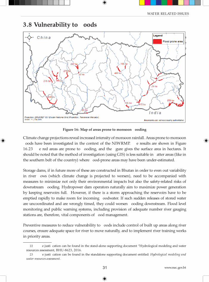
www.nec.gov.bt31
WATER- RELATED ISSUES
3.8 Vulnerability to fl oods
Areas prone to monsoon fl oods have been investigated in the context of the NIWRMP. Th e results
are shown in Figure 15.22 Th e red areas are prone to fl ooding, and the fi gure gives the surface
area in hectares. It should be noted that the method of investigation (using GIS) is less suitable
in fl atter areas (like in the southern belt of the country) where fl ood-prone areas may have been
under-estimated.
Figure 16: Map of areas prone to monsoon fl ooding
Climate change projections reveal increased intensity of monsoon rainfall. Areas prone to monsoon
fl oods have been investigated in the context of the NIWRMP. Th e results are shown in Figure
16.23 Th e red areas are prone to fl ooding, and the fi gure gives the surface area in hectares. It
should be noted that the method of investigation (using GIS) is less suitable in fl atter areas (like in
the southern belt of the country) where fl ood-prone areas may have been under-estimated.
Storage dams, if in future more of these are constructed in Bhutan in order to even out variability
in river fl ows (which climate change is projected to worsen), need to be accompanied with
measures to minimize not only their environmental impacts but also the safety-related risks of
downstream fl ooding. Hydropower dam operators naturally aim to maximize power generation
by keeping reservoirs full. However, if there is a storm approaching the reservoirs have to be
emptied rapidly to make room for incoming fl oodwater. If such sudden releases of stored water
are uncoordinated and are wrongly timed, they could worsen fl ooding downstream. Flood level
monitoring and public warning systems, including provision of adequate number river gauging
stations are, therefore, vital components of fl ood management.
Preventive measures to reduce vulnerability to fl oods include control of built up areas along river
courses, ensure adequate space for river to move naturally, and to implement river training works
in priority areas.
22 Th e justifi cation can be found in the stand-alone supporting document “Hydrological modeling and water
resources assessment, BHU-8623, 2016.
23 Th e justifi cation can be found in the standalone supporting document entitled: Hydrological modeling and
water resources assessment.
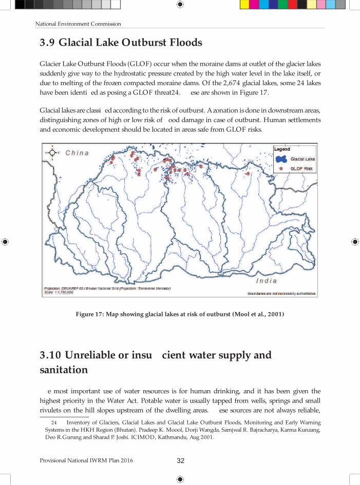
National Environment Commission
Provisional National IWRM Plan 2016 32
3.9 Glacial Lake Outburst Floods
Glacier Lake Outburst Floods (GLOF) occur when the moraine dams at outlet of the glacier lakes
suddenly give way to the hydrostatic pressure created by the high water level in the lake itself, or
due to melting of the frozen compacted moraine dams. Of the 2,674 glacial lakes, some 24 lakes
have been identifi ed as posing a GLOF threat24. Th ese are shown in Figure 17.
Glacial lakes are classifi ed according to the risk of outburst. A zonation is done in downstream areas,
distinguishing zones of high or low risk of fl ood damage in case of outburst. Human settlements
and economic development should be located in areas safe from GLOF risks.
Figure 17: Map showing glacial lakes at risk of outburst (Mool et al., 2001)
3.10 Unreliable or insuffi cient water supply and
sanitation
Th e most important use of water resources is for human drinking, and it has been given the
highest priority in the Water Act. Potable water is usually tapped from wells, springs and small
rivulets on the hill slopes upstream of the dwelling areas. Th ese sources are not always reliable,
24 Inventory of Glaciers, Glacial Lakes and Glacial Lake Outburst Floods, Monitoring and Early Warning
Systems in the HKH Region (Bhutan). Pradeep K. Moool, Dorji Wangda, Samjwal R. Bajracharya, Karma Kunzang,
Deo R.Gurung and Sharad P. Joshi. ICIMOD, Kathmandu, Aug 2001.

www.nec.gov.bt33
WATER- RELATED ISSUES
and therefore alternative sources are often being sought at relatively great expense. Drinking
water for larger cities is mainly abstracted from perennial streams where the supply is more secure
throughout the year.
Bhutan has made considerable progress in terms of coverage for both rural and urban water supply
and sanitation in the last two to three decades. Improving public health by reducing the incidence
of water-related illnesses through the provision of safe drinking water and improved sanitation
facilities is actively being pursued. According to a UN/WHO country report for 2014, the water
supply infrastructure both in rural and urban needs to be upgraded. Data from this report indicate
that more than 50% of the urban population has intermittent water supply. In rural areas only
about 69% of rural water supply schemes are reportedly functional. Delivery of water supply
services in rural areas is based on source protection specifi ed in water safety plans, but there are no
treatment systems in place.25
Rural sanitation facilities consist predominantly by pit toilets, followed by pour fl ush toilet and
others. Except in core areas of major cities, septic tanks are the most common sewage treatment
facility in urban areas. Although construction regulations require septic tanks to be equipped
with soak pits, there are many substandard systems leading to discharge of effl uent directly to the
environment.
3.11 Unreliable or insuffi cient irrigation water supply
Agriculture is the biggest consumer of water by way of irrigation. Most fi elds are fragmented
and scattered on the hill slopes, where water is tapped from springs and rivulets. Local and/or
temporary shortages of irrigation water occur frequently. Tapping alternative sources is generally
expensive because of topography. Th ere are some larger irrigation schemes in the southern
foothills. Th e National Irrigation Master Plan has been elaborated in order to increase food
production and self-suffi ciency26. Th e impact of increase irrigation water demand is addressed in
section 3.13.
3.12 Hydropower generation
Hydropower development plans
As far as hydropower is concerned, Bhutan has only so far developed some 1,500 MW out of the
economically feasible 24,000 MW of hydropower. Th e 10th and 11th FYP expressed intention of
developing over 10,000 MW hydropower potential as given in Table 8 and Figure 18.
25 UN Water and World Health Organization. Bhutan Sanitation, Drinking Water and Hygiene Status
Overview. Global Analysis and Assessment of Sanitation and Drinking Water. 2014 Update.
26 Refer to standalone supporting document entitled: National Irrigation Master Plan.

National Environment Commission
Provisional National IWRM Plan 2016 34
Table 8: Hydropower projects scheduled for construction in the 10th and 11th FYP periods
Nr. Project name Capacity (MW) Construction period
1 Punatshangchhu-I 1,200 2008-2019
2 Punatshangchhu-II 1,020 2011-2018
3 Mangdechhu 720 2011-2018
4 Kholongchhu 600 2015-2022
5 Nikachhu 118 2016-2020
6 Bunakha 180 2017-2022
7 Wangchhu 570 2017-2024
8 Chamkharchhu-I 770 2017-2025
9 Sankosh 2,560 2017-2026
10 Kuri-Gongri 2,640 2018-2027
Figure 18: Map showing location of existing and planned hydropower stations
Th e planned hydropower development is graphically presented in Figure 19.
Figure 19: Planned cumulative hydropower development until 2027
www.nec.gov.bt35
WATER- RELATED ISSUES
Currently, construction of 1,200 MW Punatsangchhu phase I, the 1,020 MW Punatsangchhu
phase II, and the 720 MW Mangdechhu Hydroelectric Projects are on-going. All three projects
are scheduled to be completed by 2018-19. Th e construction of other projects to generate
10,000 MW hydroelectricity by 2027 is planned to start during the current 11th FYP period. Th e
construction period ranges from 8-9 years. Th e pipeline projects are listed in table 9 below. In
addition, small hydro-projects shall deliver some 8,000 KW27.
Table 9: Pipeline hydropower projects in the 11th FYP
Nr. Project Capacity (MW/ GWh)
1 Sankosh 2560/ 6216
2 Kuri-Gongri 2640/ 10056
3 Chamkharchhu-1 770/ 3249
4 Bunakha 180/ 1669
5 Wangchhu 570/ 2526
6 Kolongchhu 600/ 2599
Th e EIA reports related to planned hydropower plants refer to a bilateral agreement between RGOB
and India signed in 2009, whereby India would buy 10,000 MW by the year 2020. Whereas most
of the hydropower stations in Bhutan are run-off -the-river type, some of the planned stations are
reservoir-type so as to fl atten the hydrograph and to make more effi cient use of the generators. Th e
changes in downstream water fl ows are not expected to have an impact on drinking water supply
or irrigation. But large dams and reservoirs may cause loss of agricultural land due to inundation.
Environmental Impact Assessments treat the loss of arable land as a loss of income for the farming
families, for which compensation is proposed. Such potential loss of farm land needs to be put in
the context of RGOB’s policy objective of achieving food self-suffi ciency.
Hydropower uses very large proportion of the fresh water resources of Bhutan, but it is not
consumptive use. Hence, the hydropower use of water is not included in the calculation of
water balances for the NIWRMP. Management issues relevant to hydropower development are
highlighted below.
Environmental and climate change impacts
Th e impact of hydropower on the environment is addressed in all Environmental Impact
Assessment reports that are prepared before construction of the plants. For the run-of-the-river
systems28 the impacts are local and relate mainly to land acquisition and temporary disturbance
caused by construction works. Remedial measures for negative impacts have been proposed, but
their implementation is not closely monitored. Moreover, the cumulative impacts of hydropower
plants are not being studied.
Climate change is predicted in models to cause marked changes in seasonal water availability, which
27 11th FYP, Royal Government of Bhutan
28 Run-of-the-river system is a type of hydroelectric generation plant whereby little or no water storage is
provided. Run-of-the-river power plants may have no water storage at all or only a limited amount of storage.

National Environment Commission
Provisional National IWRM Plan 2016 36
could have adverse consequences on hydropower generation. Th e Fourth Assessment Report of the
Intergovernmental Panel on Climate Change (IPCC) predicted that negative mass balance in the
Himalaya mountainous regions may eventually lead to disappearance of glaciers with subsequent
large impacts on the seasonality and volume of stream fl ow. In Bhutan, where snow and ice melt
from glaciers is often a signifi cant contributor to dry season fl ow, there are indications that climate
change might have serious eff ects on the amount of snow and ice available for glacial-fed fl ows.
Th is in turn can cause reductions in dry season runoff , which can seriously aff ect hydropower
production as plants in Bhutan are typically run-of-river type with little or no storage. Projected
increase in monsoon rainfall due to climate change would increase the sediment load and fl ooding
debris in rivers, and these can also aff ect the operation of hydropower plants.
Environmental fl ows
Th e Water Act and Regulation prescribe that environmental fl ow shall be maintained in the
river sections that are by-passed by the head and tail race tunnel of the hydropower plants. Such
mandated environmental fl ow shall be 30% of the lean period fl ow – unless otherwise proposed
and approved in the concerned Environmental Impact Assessment. Indeed, the various EIAs apply
diff erent methodologies for assessing environmental fl ows. Enforcement of environmental fl ows is
presently weak in Bhutan. A study looking at environmental fl ows has started recently.29
Competition for land
Hydropower generation is often equated with big dams, inundated areas, and resettlement of
communities. In Bhutan however, all the power plants are run-of-the-river systems (defi ned
earlier). Th ey divert water locally from the river so that no storage reservoir is involved (i.e.,
only a barrage structure) and, consequently, no land is lost to inundation. Th us, run-of-the-river
systems cause relatively less environmental damage, except for the reduced fl ows in the river stretch
between the head and tail race tunnel of the dam. Th e disadvantage is that power generation
fl uctuates with the strongly seasonal fl ow in the river.
Th ere are plans to build hydropower stations in future (such as Bunakha and Sankosh) that
incorporate storage reservoirs to avoid seasonal fl uctuation and optimize electricity production.
If land is lost to inundation due to these reservoirs, such loss would mainly be forest land, as
settlements and agricultural fi elds are located on hill slopes and not in the river gorges. Th ere might
only be a few exceptions when people are aff ected and need to be relocated and compensated.
3.13 Competition for water
Potential competition for water use between irrigation hydropower has been investigated.
Hydropower generation takes place in the main rivers or main tributaries. Water is only used to
29 Work for the Study on Minimum Environmental Flow for Hydropower Projects in Bhutan. Funding Agency:
Austrian Development Agency. Duration: November 2015-October 2017.

www.nec.gov.bt37
WATER- RELATED ISSUES
drive the turbines and then fl ows back to the river, so hydropower generation in its present form
in Bhutan does not actually consume water. By contrast, evaporation in irrigated agriculture does
consume water that is generally tapped from the higher order tributaries – hence upstream of the
hydropower plants. Th erefore, in Bhutan, irrigation water demand aff ects hydropower, but not
the other way round.
Self-suffi ciency level in paddy is presently in the order of 50%. Th e amount of water needed to
achieve full self-suffi ciency has been estimated and compared with the amounts of water available
in the basin. Th e fi gures are presented in table 10 below. Th e percentage of water used in other
months is lower.
Table 10: Percentage of available water used to increase cereal production to full self-
suffi ciency
Basin Amochhu Wangchhu Punatsangchhu Mangdechhu Drangmechhu
% water to be used for
irrigation9.4 % 3.7 % 5.5 % 1.5 % 2.8 %
Month January January May May May
Th us, the percentage of available basin water to be used to achieve self-suffi ciency in paddy
production represents a corresponding reduction of water available for hydropower generation.
One has to bear in mind the following aspects:
• Peak hydropower production is unlikely to be aff ected by increased paddy production
because rainfall in the months of July-August largely satisfi es the crop water requirements
(hence little or no irrigation water demand), and there is already more discharge in the river
than used by the hydropower stations.
• Increased rainfall resulting from climate change may (partially) compensate for the reduction
of the amount of water available for hydropower generation.
• Th e use of more-effi cient irrigation methods shall reduce the consumption of water for
irrigation and therefore leave more water for hydropower generation.
3.14 Impacts of Climate Change
Rainfall is expected to increase in the future, particularly in the south of the country, and specifi cally
during the monsoon period when water is already abundant. Th is will increase the runoff , as well
as discharge and sediment load in the rivers during summer. Th e sediments will settle along the
river when the fl ow rate reduces towards the lean season, which may increase the fl ood hazards
during the next monsoon. Greater variability and uncertainty are also expected. Th ere would
be more chance of extremely high river discharge during the wet season, calling for new design
procedures and standards for water works. Th e traditional approach for determining design fl oods

National Environment Commission
Provisional National IWRM Plan 2016 38
based on observed return-periods would grossly under-estimate the future river discharge and
levels, as shown in Figure 20.30
As can be seen, by around mid-century (2045) the fl ow for a return period of 50 years may increase
by around 26% in Wangchhu; about 7% in Punatsangchhu; and up to 38% in Mangdechhu and
Drangmechhu.
Th ere also is an expected trend towards lesser river fl ows in winter, although no change in minimum
fl ows.
However, it should be noted that the climate change assessments were constrained by data
shortage. Available data have limited spatial representation and often cover less than the minimum
requirement of thirty years of observations. Hence, the projections become less realistic when
magnifying resolution from regional into smaller areas such as districts and Gewogs.
3.15 Impact of climate change
Rainfall is expected to increase in the future, particularly in the south of the country, and specifi cally
during the monsoon period when water is already abundant. Th is will increase the runoff , as well
as discharge and sediment load in the rivers during summer. Th e sediments will settle along the
river when the fl ow rate reduces towards the lean season, which may increase the fl ood hazards
during the next monsoon. Greater variability and uncertainty are also expected. Th ere would
be more chance of extremely high river discharge during the wet season, calling for new design
procedures and standards for water works. Th e traditional approach for determining design fl oods
based on observed return-periods would grossly under-estimate the future river discharge and
levels, as shown in Figure 19.
As can be seen, by around mid-century (2045) the fl ow for a return period of 50 years may increase
by around 26% in Wangchhu; about 7% in Punatsangchhu; and up to 38% in Mangdechhu and
Drangmechhu.
Th ere also is an expected trend towards lesser river fl ows in winter, although no change in minimum
fl ows.
However, it should be noted that the climate change assessments were constrained by data
shortage. Available data have limited spatial representation and often cover less than the minimum
requirement of thirty years of observations. Hence, the projections become less realistic when
magnifying resolution from regional into smaller areas such as districts and Gewogs.
30 For detailed descriptions on the climate modeling procedure and results, refer to the standalone supporting
document entitled: Climate Modeling and Assessment for Bhutan.

www.nec.gov.bt39
WATER- RELATED ISSUES
A Ba N DP P g
, 8B h 7a DdM BeM sn iM Bd dM Hgda c M d7B 3 H788 onr s l otk
/ga BHeBa N DP P g
, 8B h 7a DdM BeM sn iM Bd dM Hgda c M d7B 3 H788 onr s l uk
. Ba N 3M DP P g
, 8B h 7a DdM BeM sn iM Bd dM Hgda c M d7B 3 H788 onr s l Y yk
%dBa N W M DP P g
, 8B h 7a DdM BeM sn iM Bd dM Hgda c M d7B 3 H788 onr s l Y yk
Figure 19: Basin outfl ows and their return periods
National Environment Commission
Provisional National IWRM Plan 2016 40
Future decades are predicted in climate models to have drier and warmer winter months, with
summer months predicted to become wetter and warmer. Under such warming climate, river fl ows
would become more erratic as rainfall is rapidly converted to runoff instead of being stored as ice.
In turn, a combination of steep topography and the projected increase in summer rainfall and
river fl ows in the coming decades pose major water-related hazards. Accelerated glacier melting is
already increasing the number and size of glacial lakes and the risk of catastrophic fl ooding if these
lakes are breached.
In South Asia, half of natural disaster events have been due to fl oods and landslides, in turn
associated with extreme weather events. Climate change is predicted to make such extreme
weather events more destructive, in particular through the intensifi ed Asian monsoon system. Th e
Himalayan region, in particular, has become even more vulnerable to natural disasters spawned by
melting glaciers, which form high-altitude lakes that can suddenly breach and cause catastrophic
fl ooding downstream.
3.15 Water sources drying-up
Th ere are frequent reports of water sources drying-up. Th is appears to be at odds with predictions
of increased rainfall caused by climate change. Investigation has shown that rainfall has in fact
declined over the last two decades in a number of stations spread over the country – without
discernible spatial trend. See Figure 21.31 Plotting rainfall fi gures over longer time periods tends,
however, to conceal this observation, and shows an increasing trend instead. Th is shows how
delicate it is with still limited data to draw conclusions in relation to climate and climate change!
3.16 Pollution and water quality
Water quality is believed to be generally very good in Bhutan, especially in upstream areas and
away from population pressure. But there is increasing concern that population growth, burial
customs, and rapid urbanisation outpace the installation of sewerage treatment and solid waste
collection, thus threatening the water quality.
Deforestation and land degradation from over-grazing by livestock contribute to soil erosion and
increase the sediment load in the rivers during high water fl ows. High sediment loads in water are
detrimental to the turbines in hydropower plants and increase demand on management. Many
small piped water systems for domestic water supply are also often blocked by sediment during
the monsoon period.
Water quality is currently being monitored, although measurements are not systematic and
regular. Water quality standards are being reviewed and additional priority parameters are being
incorporated.
31 Refer to standalone supporting document entitled: Hydrological modeling and water resources assessment

www.nec.gov.bt41
WATER- RELATED ISSUES
yiyyylyyynyyyoyyy
hppm iyyy iyym iyhy iyhm
cc
PP DH
ADad7DBB hHP dN ad %c eM W W i 3Dgad
, B ndB 8 M 8e mPW
BcHW 8i Y, B ndB 8r BcHW 8i YM 8e mPW r
y
myyy
hyyyy
hppm iyyy iyym iyhy iyhm
cc
PP DH
ADad7DBB hHP dN ad B Dd8M W W i 3Dgad
A88 , B ndB 8
38ig N B ce hB n
BcHW 8i Y, B ndB 8r
y
iyyy
lyyy
nyyy
hppm iyyy iyym iyhy iyhm
cc
PP DH
ADad7DBB hHP dN ad /idDhgDd8M W W i 3Dgad
. 8a 8H8 N Pci8Ha
/ 8P8 BcHW 8i Y. 8a 8H8r
BcHW 8i YN Pci8Ha r BcHW 8i Y/ 8P8r
ymyyyhppm iyyy iyym iyhy iyhmc
c
PP DH
ADad7DBB hHP dN ad . Dd8N P M W W i 3Dgad
%ne mB 8Ha
N igHa P8
7B W e a 8Ha
BcHW 8i Y%ne mB 8Ha r
BcHW 8i YN igHa P8r
yhyyyiyyykyyy
hppm iyyy iyym iyhy iyhm
cc
PP DH
ADad7DBB hHP dN ad , HDd8c P M W W i 3Dgad
N oP 8Ha mPW N sa 8Ha
DgHa 8i 3W e 8o/
BcHW 8i YN oP 8HamPW r BcHW 8i YN sa 8Ha r
BcHW 8i YDgHa 8ir BcHW 8i Y3W e 8o/ r
Figure 20: Recent rainfall trends in diff erent basins

National Environment Commission
Provisional National IWRM Plan 2016 42
3.17 Land-use related issues aff ecting runoff
Loss of agricultural land
Agricultural land has been under pressure with increasing population, economic development and
urbanization. Reportedly, land owners are increasingly trying to change the status of Chhuzing
into dryland to grow more lucrative cash crops instead of paddy, or in order to circumvent the ban
on building on Chhuzing land. From the Statistical Yearbooks, it was reconstructed that the area
of paddy land has decreased from 62,360 acres in 2006 to 48,361 acres in 2013 (23% reduction).
Th e area planted to maize was reduced from 75,800 acres in 2005 to 58,338 acres in 2013 (25%
reduction). Th e area under wheat reduced from 21,900 acres in 2005 to 5,560 acres in 2010,
which is a signifi cant 75 % decline.32 Such decrease in arable area reduces crop water demand, but
it puts food self-suffi ciency in jeopardy.
Landslides
Landslides are a common feature in Bhutan, especially during the rainy season. Th e frequency has
increased with the construction of (farm) roads due to steep cuts into the hill sides and the weight
of construction spoil materials deposited on the lower slopes. Th e areas that are most prone to
rainfall-induced failures are heavily fractured and weathered rocks of phyllites, slates and schists
that contain high amounts of clay minerals that occur in the southern part of Lesser Himalayas33.
Th e Department of Geology and Mines has been involved in preparing hazard maps along some of
the existing highways and important sites of new towns. Th e Department of Roads has re-aligned
some roads on the basis of these hazard maps, or applied environment-friendly road construction
methods. Th is method applies fl atter cuts into the hill sides (resulting in more-stable slopes),
provides better drainage, and removes spoil, but is very expensive.
Diff erent geological settings cause diff erent types of landslides calling for diff erent mitigating
measures, like avoidance, stabilization, prevention or no action (live with recurring maintenance
from landslide). Some of the common strategies to stabilize, control or prevent landslides include
(sub-) surface drainage, retaining walls, reinforced earth and bioengineering of the disturbed
slopes.
Over-grazing
Most of the pasture grasses are perennial, with root rhizome growth in the top 6” to 9” layer of the
soil. Th ese grasses bind the soil particles and make a good ground cover by their spreading habit
and thus reduce soil erosion from wind and water. Th ere is little registered pasture land and cattle
are allowed to graze freely in forest areas. Repeated browsing, nibbling, and uprooting of saplings
and trampling of the soil hinders natural regeneration, especially when the same areas are grazed
twice per year - by yak in winter and by cattle during the summer.
32 Refer to supporting standalone document entitled: National Irrigation Master Plan
33 Rapid classifi cation of watersheds in the Wangchhu basin, SNV-WMD, DOFPS, MOAF, 2011

www.nec.gov.bt43
WATER- RELATED ISSUES
Forest fi res
Forest fi re is one of the prominent causes of forest degradation in the country34 thus leading to
more runoff . Th e forest department in the last four years (2010-2014) recorded, an average of 45
forest fi re incidences damaging about 19,844 acres of forest annually. Helicopters can eff ectively be
used for fi re-fi ghting, if there are ponds throughout the country for refi lling their water containers.
3.18 Limited technical and database management
capacity
Climate change and hydrological assessments are essential in generating the information required
for planning water resource management. Currently, the Royal Government’s need for modeling
services is neither streamlined nor well developed. Th e NECS and DHMS have been carrying out
climate change and hydrological modelling to a limited extent and with externally funded inputs.
Th e main application in DHMS in the past was for hydropower development. In recent times,
weather forecasting has also been included. NECS is using the modelling results for a wider overview
of water resources and their spatial distribution and water availability. Th ough encouraging results
have been obtained, the modelling work is generally constrained by data availability. Th e weather
and river discharge monitoring stations are un-evenly distributed over the country, and do not
yet have a minimum required observation period of thirty years. Consequently, modelling results
become increasingly unreliable when zooming-in and downscaling to smaller areas – where most
of the water related problems occur.
Technical people require software and reliable instruments to generate the information required
to plan, implement and monitor water related programs and activities. Design and planning rural
and urban drinking water supply, urban sewer and drainage systems, irrigation, hydropower,
etc. require various types of software, equipment and instruments. Although it is effi cient and
cost eff ective to consolidate such services in the light of limited human and fi nancial resources,
diff erent sectors are pursuing development of such capacity for their own sector. As a result, data
sharing and management is also sector based, not regularly updated and often not accessible.
34 Bhutan Renewable Natural Resources Statistics, 2015

National Environment Commission
Provisional National IWRM Plan 2016 44

45
4. GOVERNANCE FRAMEWORK
Th is chapter fi rst describes how the approach to tackling water-related issues has changed over
time, and the status of the present institutional environment. It continues with a description
of the national planning process followed by a description of the institutional framework and
stakeholder analysis. Th is chapter also looks at tools available for IWRM, presents the results
of a training needs assessment carried-out during the preparation of the NIWRMP and fi nally
describes an inter-agency coordination framework based on the Bhutan Water Security Index.
4.1 Evolution of water management approaches
Approaches to water resources management and corresponding institutional setup worldwide have
evolved over many decades. Early water resource management, which continued up to the 1960s,
addressed mainly single-purpose endeavors that pursued an engineering agenda linked primarily
to dam-building and water engineering works (for fl ood control, drainage, irrigation and water
supply). Technocratic solutions dominated this era of top-down water resource management, and
water management entities were principally instruments of the national government.
Beginning in the 1970s, concern about environmental and social impacts, including worsening
water quality, paved the way for multi-purpose water resource management that also saw the
beginnings of a river basin approach (usually within an “integrated area” development context).
Multi-stakeholder participation was introduced. Watershed protection gained prominence,
and procedures for environmental impact assessment requirements expanded the scope of
water development concerns to include social and ecological aspects. Nonetheless, river basin
organizations still treated water as a separate sector and lacked multisectoral and integrated
approach in addressing water-related concerns.
In the 1990s, the shift to a sustainable development vision paved the way to adopt a comprehensive
system of water resource management, one that emphasized coordinated development and the
management of water, land and ecological resources. Th e Dublin principles of 1992 recognized
increasing water scarcity as a result of confl icting uses and overuses of water. Importance was put
on holistic approaches that sought to integrate management of water resources within a broader
socio-economic and institutional framework. During this period IWRM became the dominant
paradigm. It considerably expanded management challenges, for it often requires balancing
competing sector needs and establishing governance mechanisms for coordinating various entities
involved in water management (and who are not used to such coordination, or resist coordination).
Th e introduction of IWRM also came with sector-wide policy reforms and decentralization of
governance, and along with these the challenges of eff ective coordination. A strong focus was given
to the river basin as the logical (hydrological) unit for management, which remains to this day.
Over the past decade, the management scope for water resources has further expanded to include
concerns over the impact of climate change. Th is was to be expected since climate is the main

National Environment Commission
Provisional National IWRM Plan 2016 46
supply driver which ultimately determines how much water is available, and because managing
extreme events associated with climate change (droughts and fl oods) is fundamental to water
resource management. Apart from this development, there is increasing acknowledgment that, as
with environment, water is not a sector. Rather, that water is part of a nexus involving in particular
agriculture, ecology and energy. Drivers of change in the water sector often arise from activities in
these other sectors. Th is latest evolution of the water management paradigm has put coordination
in an even more central role.
In Bhutan, the WRM institutional framework already adopts coordination—embodied in the
mandate of the NEC--as the core management principle (in other words, Bhutan is on the “right”
track). For the institutional design of IWRM in Bhutan, corresponding emphasis is on enhancing
coordination at both the national and river basin level. Th e following defi nition of coordination
is used to guide the IWRM mission in Bhutan: Coordination is a situation in which policies and
programs of government and its agencies are characterized by minimal redundancy, incoherence and
gaps.
In addition, the coordination model of WRM in Bhutan should be framed/designed more
specifi cally to address eff ectiveness and effi ciency aims.
4.2 Overview of policies and legal framework
Th e following paragraphs summarize the steps that the government has already taken towards
adopting IWRM in the national policy documents and the national legal framework. See stand
alone report on ‘Legal aspects of IWRM in Bhutan’.
Overview of the Policies
Vision Statement 1999
In 1999 the Planning Commission issued the vision statement for 2020. Part-1 stated that the
vast hydropower potential should be developed, yet it emphasized the need for environmental
conservation, and warned that the progressive removal of vegetation cover, especially in critical
watershed areas, was beginning to aff ect the hydrological balance, leading to the localized drying
up of perennial streams and fl ash fl ooding.
It also mentioned the challenge to increase effi ciency and to widen the opportunities of the
decentralized administrative system. Hence, the people at the Gewog level should have more
infl uence in decision-making that has a direct bearing on their lives and livelihoods and the future
of their communities.
Greater priority also needed to be accorded to the development of the information systems required
for informed decision making and development planning.
Part-2, which dealt more with goals, objectives, strategies and milestones, emphasized the need

www.nec.gov.bt47
GOVERNANCE FRAMEWORK
for sustainability. It stated that sustainability had many dimensions - social, fi nancial, economic,
cultural and environmental - and they were all of critical importance in Bhutan since they all
impacted, directly and indirectly, on its sovereignty and security. It distinguished fi ve thematic
headings to steer the process of change: human development, culture and heritage, balanced and
equitable development, governance, and environmental conservation. One of the milestones
mentioned for planning (for 2007) was the preparation of watershed master plans: a prelude to
the river basin management plans that are presently foreseen under the Water Act and Regulation
Bhutan Water Policy 2003
In April 2003 the Bhutan Water Partnership prepared the Bhutan Water Policy (BWP). Th e
government approved the document in 2006. Th e BWP is a refl ection of the government’s
commitment to the conservation, development and management of the country’s water resources.
It recognized that water is a precious natural resource and a heritage important to all aspects of social,
economic and environmental wellbeing. As a result, the policy recognized that every individual
has the right to safe, aff ordable, and suffi cient quantity of water for personal consumption and
sanitation.
With regard to uses of water, the BWP stipulated three main principles:
• Water is a common good. Its uses are open to all legitimate users under the provision of the
water act.
• Th e policy sets priority for all legitimate uses of water. First priority goes to drinking
and sanitation, which are essential for human survival. Allocation of water for irrigation,
hydropower generation, industrial uses, recreation and other uses are to be guided based on
the national and local priorities.
• Th e policy also recognized the importance of water for agriculture and food production. Th e
policy thus emphasized that water allocation to the agriculture sector must be compatible
with the objective of national food security.
Th e BWP adopted the principles of IWRM. It stated that water resources in the country would be
managed based on natural river basin. Accordingly, the policy emphasized establishing institutions
based on river basins.
Overview of the legal Framework
Water Act 2011 and Water Regulation 2014
Th e Water Act of Bhutan 2011 (Water Act) is an important milestone in the development of the
legal framework regarding the water resources in Bhutan. It is the fi rst act that addresses water
resources in an integrated manner. Until then, management of water resources was fragmented,
addressed in diff erent laws, and only focused on the operational level.
Th e Water Act is also an important milestone in the implementation of the concept of IWRM in

National Environment Commission
Provisional National IWRM Plan 2016 48
national legislation. It is also in line with the national concept of Gross National Happiness. Both
concepts are expressed in the preamble of the Act and elaborated in broad terms in the various
chapters. In brief, the Act has the objective to advance a coherent, integrated and open approach to
the diff erent aspects of water resources management in a sustainable way and with the river basin
approach as leading principle. To achieve this goal, the Act provides for a number of organizational
and substantive facilities. Th e fi rst aspect concerns the formulation of the distribution of authorities
and responsibilities between the various governmental bodies involved in water management. Th e
second aspect is aimed at providing the competent authorities with strategic and operational legal
instruments to enable them to perform their tasks properly.
Some notable characteristics of the Water Act are:
• Th e Water Act is a true management law. It is not primarily about the
development of water infrastructure (including irrigation networks), but
about creating conditions for a responsible and sustainable management of
the water resources.
• Th e scope of the Water Act covers water management in all its aspects: surface
water and groundwater, both in quantitative and in qualitative terms; it
also concerns the infrastructure dimension: river basins, irrigation systems,
dams, water supply systems, etc. In other words, it provides a coherent
and integrated approach. Th e integrated approach is also manifested in the
emphasis on the importance of the basin approach. Water systems (river
basins and groundwater basins) with their functional relevant environment
are the frame of reference.
• Water management is based on a structural (long term) approach. For that
reason, a strategic plan must be drawn up for every river basin in which all
relevant aspects should be considered and weighed in relation to each other.
Th e river basin management plan is the reference for all types of operational
activities.
• Local communities and other stakeholders involved in water management
are given the opportunity to participate in all stages of the decision making
process.
• Alongside the social function of water (expressed in the Act through the
stipulation that every individual shall have access to safe, aff ordable and
suffi cient water for basic daily needs), the economic function of water is
also underlined. Water use (abstraction/discharge) and water services are
chargeable following the ‘user pays’ principle and the ‘polluter pays’ principle.
Th is expresses the fact that water is a scarce commodity, which has to be paid
for.
• Th e Water Act has a close relation with the National Environmental Protection
Act 2007 (“NEP Act”). Th is act has a broad scope: the environment in all its
dimensions, including water. Th e relation between the Water Act and the NEP
Act has an institutional and a substantive dimension. Th e former concerns the

www.nec.gov.bt49
GOVERNANCE FRAMEWORK
regulation of the tasks and powers of the NEC, while the latter is related to the
various rules about the protection of the environment.
• A fi nal characteristic of the Water Act is its framework dimension. Th e topics
covered by the Act are only provided for in broad terms. Th ey need to be
elaborated in one or more implementing government regulations. To ensure
as much integration as possible, the government of Bhutan has decided to
cover all issues in one integrated regulation, which was done through the
Water Regulation 2014 (Water Regulation).
Addressing the diff erent types of issues in the Water Act in one integrated regulation was a complex,
challenging and time-consuming operation. Th erefore, the preparation took quite some time but
the Water Regulation came into eff ect in January 2015. However, not all issues are addressed in a
suffi cient manner. Based on the experiences in the practice, the Water Regulation will need to be
updated.
Water Related Acts
As mentioned above, until the Water Act the management of water resources was fragmented,
addressed in diff erent laws, and only focused on the operational level. Th e most important acts
that contain water related provisions are acts pertaining to land, forestry and nature conservation,
mines and minerals management, electricity, waste, and environmental assessment and protection:
• Land Act 1979 and the Land Act 2007
• Forest and Nature Conservation Act 1995, and Forest and Nature Conservation
Rules 2006
• Mines and Minerals Management Act 1995
• Electricity Act 2001
• Waste Prevention and Management Act 2009
• Environmental Assessment Act 2000
• National Environmental Protection Act 2007
It is important that the Water Act and the water related acts (as well as their underlying
implementing regulations) are suffi ciently harmonized to avoid overlaps, contradictions or gaps.
Th e Water Act addresses the relation with existing acts only in broad terms. Its Article 3 stipulates
that: “Th is Act hereby repeals the provisions of any Acts/regulations and administrative instruments
which are inconsistent with this Act”. To avoid misunderstandings and confusion in practice when
inconsistencies arise, the above-mentioned existing water-related acts and regulations need to be
assessed, which has been done. Th e overall conclusion of the assessment is that the Water Act
and the existing water related acts (and regulations) are harmonized. Most issues are addressed
in the acts consistently, though in some cases there are inconsistencies that may cause confusion.

National Environment Commission
Provisional National IWRM Plan 2016 50
Observations regarding the Legal Framework
Th e Water Act is the fi rst act that addresses water resources in an integrated manner and is therefore
an important milestone in the implementation of the IWRM concept in national legislation.
All relevant issues are addressed in the Water Act and elaborated on in the Water Regulation.
Given the absence of experience with IWRM in practice, most issues are addressed conceptually
in the new legal framework and have not yet been elaborated in suffi cient detail to guide the full
implementation of the new legislation in practice. Th is section provides some examples following
a thematic approach. Th e ‘observations’ made in this section are not exhaustive. Furthermore,
some of them, such as the institutional framework, are discussed in more detail in other sections
of this NIWRMP.
Institutional Framework
A clear and transparent institutional framework, taking into account the river basin approach
and the decentralization concept, is essential. Th e task division between the various competent
authorities needs to be addressed in a clear manner to avoid misunderstandings about the question
of who is responsible for what, and which is the competent authority to take decisions (such as
issuing a license and imposing administrative sanctions). Unfortunately, this is not always done
well enough. Th is is particularly the case for the NECS, the River Basin Committee (RBC), and
the Water User Association (WUA). Furthermore, the decentralization approach needs further
attention. Th e essence of this approach is: decentralize what is possible, centralize what is necessary.
Th e ability of the NECS to hand over certain powers to the districts and the municipalities has so
far been used in a limited way.
Th e issue of the institutional setup is elaborated in more detail in Section 4.5.
Planning
A structured long-term approach through planning is a key element of IWRM. Th e two key
planning instruments in the Water Act are the National Integrated Water Resources Management
Plan (NIWRMP) and the River Basin Management Plan (RBMP). In principle, these instruments
are well covered. However, the relation between the RBMP and the Watershed Management Plan
needs further attention. A coordination mechanism to ensure that both plans are suffi ciently
harmonized is missing.
Regulatory framework
Th e Water Act and Water Regulation, together with the Environmental Assessment Act 2000 set
out a comprehensive and diff erentiated regulatory system for water abstraction and use. Some cases
require applying fi rst for an environmental clearance while others don’t require environmental
clearance and only necessitate a permit. Th e system will need to be tested in practice and if
necessary adjustments made to it to facilitate its application.

www.nec.gov.bt51
GOVERNANCE FRAMEWORK
Financing
Key points of the fi nancing arrangement in the Water Act are the establishment of fees and charges
based on the principles: user pays and polluter pays. Th eir elaboration in the Water Regulation is
incomplete. Th e focus is on fees/charges in relation to the Environmental Assessment Act 2000.
Criteria regarding the amount of a fee or charge for surface or ground water use are not clearly set
out in these Acts.
Compensation is also an important element of the fi nancing set up. In the event of governmental
decisions causing damage, those aff ected have a legal right to compensation. Th is issue is not
consistently addressed in the legislation.
Dispute resolution
An overarching feature of the dispute resolution mechanisms in the Water Act is that it is a good
example of the implementation of the decentralization approach. However, there remain issues to
be addressed. Among other things, the current operational role of the NECS in dispute resolution
needs attention. Whether this operational competence is consistent with the primary coordination
task of the NECS should be reconsidered.
Enforcement
Enforcement is an important issue with a broad scope. One of its key element is supervising
compliance with the law by monitoring and inspection, and based on that, the application of
administrative and, or, criminal sanctions where necessary. Th e administrative sanctions are set out
clearly. However, that is not the case for criminal sanctions.
4.3 Overview of the national planning process and entry
point for IWRM
National Development Planning Process
Since 1961 Bhutan’s development has been guided by a series of fi ve-year plans (FYP), the
preparation of which is directed by the Gross National Happiness Planning Commission, subject
to the National Assembly’s fi nal approval. Th e current FYP is the eleventh in the series and covers
the period 2013-2018. Th e planning/fi scal year begins in July.
Th e planning activities for the 11th FYP started in April 2012, during which central and local
government plans were prepared by local government units and central agencies. Sectoral plans were
prepared nationally by the line ministries, and harmonized with the development plans prepared
by local governments. At the local level, stakeholders fi rst identify which development activities are
best suited for implementation at the level of the Gewog, at the level of the Dzongkhag, or that of
the sector (national level).

National Environment Commission
Provisional National IWRM Plan 2016 52
Th is mode of decentralized planning, down to the level of the Gewog, was fi rst introduced during
the 9th FYP. In the 10th FYP, planning processes continued to be further decentralized, giving
greater autonomy for sectors and local governments to formulate strategies and to select priority
programs (subject to budget resources available through their respective annual grants).
Beginning with the 10th FYP, and continuing through the 11th FYP, a results-based planning
framework was adopted that identifi es clear outcomes and outputs to be achieved. Outcomes
are defi ned as Key Results Areas (KRAs) at the national, sectoral, and Dzongkhag level, which
are categorized under each of the four GNH pillars and were set after extensive stakeholder
consultations spanning 2 years. At the national level, 16 KRAs have been identifi ed. At the
sector and Dzongkhag levels, there are more than 300 KRAs aligned with the 16 national KRAs.
Th e performance of all government agencies towards the delivery of KRAs is measured through
corresponding Key Performance Indicators (KPIs) consisting of baselines and targets.
Th e result based planning is essentially meant to ensure that sector and agency plans contribute
to attainment of clearly stated results, the latter defi ned as outcomes of the specifi c development
activities (program and project levels). Th e result based planning framework was also meant to
ensure that planning and budgeting processes are able to anticipate emerging challenges in the
country’s socio-political and development context in the coming years.
Since the 10th FYP, the planning and budgeting timeframe for implementing programs and projects
has been changed to 3 years, from the original 5 years in the previous FYPs. Th e FYPs continue
to provide the medium-term outlook in identifying priorities and monitoring results, but these
plans are operationalized through multi-year rolling plans of three years (1+2) which are rolled
over from year to year based on annual work plans. Th is system allows for improved predictability
and realism in the budgeting process.
A 1+2 rolling plan refers to a plan for the coming year, plus two years in advance. Th at is, central
and local governments prepare annual plans with additional 2-year projections on program
activities and budgetary targets.
Development plans at both national and local levels are consolidated under either infrastructure
or non-infrastructure categories. Th e infrastructure items are required to be based on master plans
that serve as road maps for infrastructure development, and which are then implemented on the
basis of 3-year rolling plans.
Possible entry point for IWRM integration in development planning
Th e fi ve-year planning process provides an entry entry point for incorporating IWRM into
development planning, i.e., by preparing for the next FYP to systematically integrate IWRM
in the medium-term development planning and resource allocation via the policy and planning
guidelines that can be used as basis in the next (12th) FYP, possibly with initial focus on irrigation
infrastructure if it is prioritized by the government. See Figure 22.

www.nec.gov.bt53
GOVERNANCE FRAMEWORK
AmsYh onhmsr enY mdu 3W 8 N %Ydia sdc M dh 8dr tis . Yda r a mc M dh 7dYenYP a mB d 3mc hB a snYr
hmsn sgd dyhr shmH oia mmhmH oYnB dc tYdr tmc dY B P D/ ,
Figure 22: Diagram of the national planning process under GNHC
A way to incorporate IWRM in the the 12th FYP is to introduce KRAs for water security along
the fi ve dimensions of: rural water supply provision, urban water supply and water quality security,
economic water security for agriculture and hydropower use, sustainable environmental fl ows, and
climate change resilience.
Medium-term sector planning starts about midway through the current FYP guided by results of
the mid-term review of the current plan implementation. After extensive consultations are held
with stakeholders at local up to central levels, the identifi ed development gaps and priorities (as
“key interventions”) are sorted out according to how they should be pursued: as local activity at
the Gewog or District level, or as part of a wider sector plan.
Guidelines for FYP planning are then drawn up by the Gross National Happiness Commission
(GNHC), wherein core sector objectives, priorities and strategies are set out. Th e guidelines serve
as basis for the sector agencies to formulate their respective sector plans (and also for the local
governments). Such plans are expected to clearly articulate expected results and ways to monitor
progress of achievement (through sector KRAs and performance indicators)
Th e main sector interventions, KRAs and KPIs are compiled based on the extensive consultations
conducted with stakeholders, and which are consolidated and presented formally to the GNHC
prior to adoption and publication in the guidelines. Medium-term sectoral plans are developed
based on the key interventions, key result areas and performance indicators that are specifi ed in
the planning guidelines.

National Environment Commission
Provisional National IWRM Plan 2016 54
Although sector agencies are given fl exibility to modify the interventions in preparing their
respective sector plans based on the GNHC guidelines, changes in KRAs and KPIs have to be
cleared with the GNHC. Detailed specifi cations of each sector’s programs and projects are fi nalized
after the resource allocations for all sectors are set by the GNHC based on the fi scal projection.
Each sector plan’s specifi cations of programs and projects are accompanied by a “responsibility
framework” that identifi es the level of implementation (national or local) and the allocation of
budget resources between the central sector agency and the local governments. Th e responsibility
framework is issued by the GNHC as an attachment to the planning guidelines.
An envisioned entry point for IWRM mainstreaming in Bhutan’s development planning system
is to infl uence the GNHC planning guidelines so that these adopt the water security KRAs and
KPIs derived from the NIWRMP, which also serves to guide preparation of basin plans. And
following the “strong coordination” model described above for IWRM, water concerns—that are
spread out across various agencies—built into the national planning system will help ensure such
coordination (including synergy among interventions). Th e NEC should then resolve any gaps in
addressing various water concerns.
Following the mainstreaming approach, strategic water security interventions, KRAs and
designated competent authorities--derived from the NIWRMP--will be coordinated by the
WRCD and presented by the NECS (through the NEC) to the GNHC, after which these are
proposed to be formally adopted and published in the medium-term planning guidelines that
guide FYP preparation. Specifi c plans at the national and local levels are to be developed based
on these medium term planning guidelines. Plans formulated will be reviewed by the GNHC
Secretariat for conformity with the water security KRAs and KPIs.
Detailed specifi cations of programs and projects are fi nalized after the resource allocations for
all sectors are set by the GNHC based on the budget projection. Th e plan specifi cations are
accompanied by a “responsibility framework” that identifi es the appropriate level of projects
implementation (national or local) and the allocation of budget resources between the central
sector agency and the local governments. Th e responsibility framework is issued by the GNHC as
an attachment to the planning guidelines (and incorporated in the compact signed by the executing
agencies and the government). Th e role of the River Basin Committees (RBCs) is primarily to help
coordinate between line agencies when preparing and implementing projects and programs.
Th e RBCs would use the RBMP as a tool for coordinating between line agencies and local
governments on projects and programs that aff ect the basin. For instance, the RBC shall ensure
that district-level plans do not adversely compete for water and that they remain within the total
water available within the basin. If development plans are set to draw more water than is available,
the RBC can fl ag the issue at NEC and GNHC – which in turn could reconsider certain plans so
as to remain within the water available. Th e RBC would also highlight any proposed interventions
in the RBMP that are not being considered by the line agencies and local governments, so that
these can be attended to by the NEC and GNHC. Overall, the main aim of coordination through
the RBCs is to ensure that policies and programs in their respective basins—involving multiple

www.nec.gov.bt55
GOVERNANCE FRAMEWORK
agency players and stakeholders--are characterized by minimal redundancy, incoherence, confl ict
and gaps. Over time, and with the NEC’s mandate, the role of the RBC could be strengthened to
extend beyond advisory and coordination functions, but also to approve/disapprove any activity
that aff ects the river basin environment.
In the current 11th FYP for the renewable natural resources (RNR) sector, for instance, the
water-related KRA is stated as “enhanced sustainable forest, land, water and biodiversity resource
management” for which the identifi ed key intervention is to “conduct inventory of important
water catchment areas and eff ectively manage critical catchments.” For the next FYP, it is expected
that water security KRAs and KPIs proposed in the NIWRMP will be incorporated into the plan.
At the basin level, with the RBC providing coordination through the river basin management plan,
water-related plans will be prepared by the Dzongkhag and Gewog administration units (through
their respective development councils). Th is will be done with reference to technical guidelines
issued by competent water-related agencies/authorities, as designated by the NEC. Each local
plan will identify which strategic element under the GNHC FYP formulation guidelines are to
be implemented at the local level and, following the budget system, are to be funded through
allocations from central agencies in the form of grants earmarked for those activities.
According to the Water Regulation, every Dzongkhag Administration will prepare an Integrated
Water Use Management Plan for the Dzongkhag based on the NIWRMP for adoption by the
Dzongkhag Tshogdu. Every Th romde Administration will develop a water management/safety
plan based on demographic projections for at least the next ten years to ensure effi cient water
supply and effl uent disposal, including drainage systems, in its jurisdiction.
4.4. Water-related goals in the Vision, Policy and
Planning
Th e water-related priorities given in the Vision and Policy statements, and formulated as Key
Result Areas in the 11th FYP, are summarized in Table 11. Th ese priorities are grouped according
to the fi ve key dimensions of the water security index system (described further in Chapter 5):
1. Household water security
2. Economic water security
3. Urban water security
4. Environmental water security
5. Resilience to climate change and water-related disasters
Current policies and 11th FYP goals already incorporate water security indicators under these fi ve
dimensions, even as these indicators can further be enhanced in subsequent FYPs. Measuring the
status of water security according to these fi ve dimensions allows capturing the inherent tension

National Environment Commission
Provisional National IWRM Plan 2016 56
that emerges among water resource users as future competition for water increases. Indeed,
managing these fi ve key dimensions of water security while adressing the specifi ties and needs of
the concrend stakeholders in a context of climate change is what constitutes IWRM.
Table 11: Goals in planning
Dimension Source Domain Goal Indicator
Rural water
security
Water vision
goals
Health Reduction in water-related
diseases
Policy
statements
Drinking water
& Sanitation
Universal access & water
quality standards
Conservation of sources for
drinking water supply
11th FYP Human
settlement
Improved quality of
infrastructure facilities &
services
Millennium Goals achieved
Incidence of communicable
disease reduced
% of population
with access to
safe and reliable
drinking water &
sanitation
Improved
sanitation facilities
and hygienic use
increased from
58% to >80%
Diarrhoea
incidence per
10,000 under 5
children (2428)
Economic
water security
Water vision
goals:
Agriculture
Aquaculture
Hydropower
IndustriesRecreation
Increase food production/
irrigation
Develop fi sh farming
Tap potential
Adequate water allocation
Develop water bodies
Policy
statements
Agriculture
Industries
Irrigation water supply as
per national objectives (food
security)
Minimize pollution from
agro-chemicals
Production of ‘bottled
water’/ clean water products
promoted
All commercial abstractions
to be licensed
Sustainable development of
hot springs

www.nec.gov.bt57
GOVERNANCE FRAMEWORK
Dimension Source Domain Goal Indicator
11th FYP Energy Energy security enhanced Installed
capacity of HPP
toraise from
1,500 to 4,500
MW
Installed small
HPP capacity
12,150 KW
Urban water
security
Environmental
water security
Water vision Drinking water No explicit urban goals (other
than drinking water supply &
sewerage)
Water policy Drinking water No explicit urban plans (other
than drinking water & sewerage)
11th FYP Drinking water No explicit urban plans (other
than drinking water & sewerage)
Water vision
goals
Environment Conservation of nature
Water quality monitoring
Policy
statements
Industries
Environment
Proper waste water disposal
Preservation of river habitat
11th FYP Renewable
Natural
Resources
Enhance conservation of plant
and animal genetic source
Increase number
of protected
RAMSAR sites
from 0 to 5.
Resilience Water vision
goals
Resilience Forecast, prevent, mitigate
disasters
Policy
statements
- No policy statement formulated
11th FYP Conservation
& sustainable
utilization of
environment
Climate change induced
GLOF risk mitigated
Maps of
dangerous glacial
lakes updated

National Environment Commission
Provisional National IWRM Plan 2016 58
4.5 Institutional framework and stakeholder analysis
Th is section gives a short overview of the main stakeholders in IWRM. Appendix 2 gives a more
detailed description of the primary mandate of each of these institutions and their specifi c IWRM
roles under the Water Act with regard to: (i) policy and planning, (ii) coordination and regulatory
powers, (iii) water services delivery, and (iv) information management/reporting and capacity
building. Specifi c tasks under these four roles relevant to each organization are described in
Appendix 2.35
• Ministry of Agriculture and Forests. MoAF is responsible for irrigation development,
watershed and wetland management. Th e Engineering Division of the ministry provides
engineering services to local administrations for design and development of irrigations
systems. Th e Watershed Management Division (under the Department of Forest and Park
Services) is tasked to categorize watersheds, prepare management plans, and implement
them in collaboration with stakeholders.
• Ministry of Economic Aff airs. Th rough MoEA’s Department of Hydropower and Power
Systems, it has the responsibility of promoting sustainable hydropower development for
Bhutan. Th e Department of Renewal Energy (DRE) is responsible for identifying and
planning small hydroelectric power projects (below 25 megawatts). Th rough the Department
of Hydro-Met Services, it provides weather, water, climate, and other related environmental
services to various sectors.
• Ministry of Education. Th e MoE does not have direct water management and service delivery
mandates specifi ed in the water law and regulations. Its main role, as one of the competent
authorities mentioned in the Water Act, is to promote awareness of water-related issues
among the general public.
• Ministry of Health. MoH is responsible for the overall planning, implementation and
management of infrastructure for drinking water supply and sewage management for all
rural areas, which it undertakes in collaboration with local governments. It is also mandated
to monitor quality of drinking water.
• Ministry of Home and Cultural Aff airs. MoHCA, through its Department of Disaster
Management, is involved in the water sector in terms of disaster mitigation and relief,
especially in water-related disasters such as Glacial Lake Outburst Floods (GLOFs).
• Ministry of Works and Human Settlements. MoWHS is responsible for the overall planning,
implementation and management of infrastructure for drinking water supply and
wastewater for the urban areas in collaboration with Th romdes and local governments. Like
the Ministry of Health, it is mandated to mainstream water resources management into its
policies, plans and programs.
• National Environment Commission. Under the Water Act, NEC serves as the apex authority
for the purpose of developing policies, coordinating plans, programs and monitoring water
resource management in the country. Th e members are appointed by the Commission.
35 For details of the stakeholder analysis and the communication plan to inform them on the IWRM issues,
refer to supporting standalone documents entitled: (i) Integrated Water Resource Management in Bhutan: Stakeholder
Analysis and (ii) Communications Plan to Support Bhutan’s IWRM Process.

www.nec.gov.bt59
GOVERNANCE FRAMEWORK
• National Environment Commission Secretariat. Th e NECS carries out the day-to-day
functions of the National Environment Commission. Th e Secretariat assists the NEC in
administering the provisions of the Water Act, and a Water Resource Coordination Division
was set up in May 2010 for this purpose.
• Gross National Happiness Commission. It is the apex body for setting the development
priorities and plans for the country based in the four pillars of Gross National Happiness.
Th e Commission is comprised of government Secretaries chaired by the Prime Minister.
Water Security has been identifi ed as a priority area for development.
• Gross National Happiness Commission Secretariat. GNHCS acts as the administrative and
program machinery serving to fulfi l the functions and priorities of the GNHC. Planning
offi cers across the country support the Secretariat with planning and monitoring progress of
local and sectoral plans. As it does for other sectors, the GNHCS works closely with water
related agencies to prioritize interventions for water security.
• Civil Society Organizations. Th e relevant CSOs are the Royal Society for the Protection
of Nature (RSPN), the Bhutan Water Partnership (BhWP) hosted by RSPN and the
Tarayana Foundation. Th ese organizations work closely with government agencies and local
communities in education and awareness, advocacy, and livelihood enhancement programs.
• Dzongkhag Tshogdhu (District Development Council). For each dzongkhag, the council is
composed of elected leaders from each gewog in the district. Th romdes are subdivisions
of the dzongkhags that are more densely populated (i.e., urban municipalities) and have
their own councils with directly elected members. District and thromde councils are tasked
with balancing socio-economic development, promoting business, protecting consumers,
coordinating government agency activities, reviewing gewog regulations and ordinances,
and representing the districts in national referenda.
• Gewog Tshogde (Gewog Development Councils). Each Gewog is administered by a Gewog
Tshogde (Block Council or Block Development Committee), which is subordinate to
the Dzongkhag Tshogdu (district council). Th e Gewog council is composed of a Gup
(headman), Mangmi (deputy), and between fi ve to eight elected leaders (Tshogpas) from
among the constituent villages. Th e Gewog Tshogde is empowered to regulate resources.
Gewogs are further subdivided into Chiwogs, which are the equivalent of municipalities or
cluster of villages. Th ere are generally fi ve to six Chiwogs in each Gewog.
• Dzongkhag Water Management Committee. Under the Water Regulation, the existing
Dzongkhag Environment Committee (DEC) is mandated to function as the district water
management committee (DWMC).
• River Basin Committees. Th e Water Act mandates that such committees shall be set up for
the “purpose of proper management of water resources.” Functions described in the Water
Act pertain to community participation, preparation of the River Basin Management Plan
(RBMP), monitoring and reporting to NEC, data management, and resolution of cross-
sectoral and transboundary water management issues. Th e Water Act gives prerogative to
NEC to direct or mandate RBCs to perform additional functions, as needed.
• Water Users Associations. Except in Th romdes, water users of a common water facility are to
be established. Th e term “water user” for the purpose of forming a WUA means a household

National Environment Commission
Provisional National IWRM Plan 2016 60
using water from a registered facility or source. Any new water user duly admitted to an
existing facility will automatically be a member of the WUA.
Observations with respect to the Institutional Framework
Th e role and functions of the various institutions at central, district and local level as outlined in
the table above shows that many institutions are involved in water management. However, most
of them are only involved in some tasks or specifi c aspects of water resources management. One of
the main goals of the Water Act is to create the conditions for a shift from a fragmented approach
to an integrated approach of the management of water resources. To ensure eff ective coordination
between the involved institutions the Water Act establishes two coordinating apex bodies: the
NEC (and its Secretariat) at a national level, and the River Basin Committee (RBC) at a river
basin level. Th e NEC(S) was established in the early 1990s and legally embedded in the National
Environment Protection Act 1997. Th e RBC is a new institution required under the Water Act
and is without any prior experience. Th erefore, the RBC does require a secretariat, a role of which
can be fulfi lled by NECS as an interim measure.
Th e institutional model for the management of water resources is a complex model. It is based on
the idea that the water management tasks have to be carried out as much as possible by the existing
government agencies and that the two apex organisations, NECS and RBC, have the task to ensure
that the line agencies carry out their water-related tasks in an integrated manner. An eff ective
application of this institutional model requires that the role and functions of all institutions
concerned are clearly set out in the legislation to avoid misunderstandings, duplications, or even
contradictions. Th e following sections attempt to determine in broad terms if this is the case
for the newly established organisations: NEC(S), RBC, and WUA in relation to the existing
government institutions.
NEC Secretariat (NECS)
One of the main functions of NECS is the preparation of the NIWRMP in consultation with the
relevant stakeholders. Th e NIWRMP is a crucial coordination instrument at the national level, as is
the RBMP for the basin level. Th e approval power of the NECS is essential to ensure that a RBMP
is in line with the NIWRMP. Both coordination instruments are undisputed. Th e NECS also has
more operational tasks to perform like monitoring the state of water resources, the development
and maintenance of a National Registry on both drinking and irrigation water resources, and the
development and maintenance of inventories on river hydrology, aquatic habitat, river ecology and
morphology. It also is the competent authority for issuing clearance certifi cates and is the appeal
body in water disputes. It is questionable if all these operational tasks are typical coordination tasks
that need to be carried out by the NECS. Th e Water Act creates the possibility for the NECS to
hand-over one or more functions to other agencies. It should be considered to use this opportunity
to ensure that the NECS can focus on the essential strategic coordination tasks.
River Basin Committee (RBC)
www.nec.gov.bt61
GOVERNANCE FRAMEWORK
Th e RBC is a new institution with the purpose of ensuring proper management of water resources
within the basin. Given the choice that water tasks have to be carried out as much as possible by
existing government institutions, the RBC has mainly a coordination function. Th e most important
coordination task is the preparation of the RBMP. Other more operationally oriented tasks include
promoting community participation, monitoring and reporting to the NEC, collecting and
managing data, and helping resolve cross-sectoral and district trans-boundary issues. It is noted
that the RBC does not have regulatory functions such as the issuing of water permits, carrying out
inspections, and imposing administrative sanctions. Th ese are typical competences of the district
and local government agencies. Under the proposed coordination-model, the RBC should be
limited to coordination tasks only.
Water Users Association (WUA)
WUAs have existed since the 1980s when the irrigation systems were constructed (or rehabilitated)
by the Department of Agriculture (DoA). As part of its irrigation development policy, the DoA
required users of an irrigation system to form a water users association before the system is
turned over to them. Most WUAs that have been formed so far to manage irrigation systems
operate informally, and arrangements for cooperating on canal repairs and for contributing to
a maintenance fund are governed by customary rules, rather than codifi ed by-laws. Th at has
now been done in the Water Act. Th e Water Act stipulates that (except in urban areas) users of a
particular water source or a facility (such as for irrigation) are to be established as WUA for the
promotion of present and future water security interests. A WUA has to register with the local
administration but the Water Regulation does not set out provisions that ensure a uniform system
of registration. Such a system has been developed in the guidelines for WUAs, which will be
fi nalized and approved by NECS. 36
4.6 Training Needs Assessment
A training needs assessment (TNA) was carried-out in the context of preparing this NIWRMP.
Th e objective was to assess existing knowledge and capacity and identify role-specifi c short-term
and long-term training needs among the various IWRM stakeholders identifi ed, and to prepare a
consolidated plan for training. Th e training plan is a priority recommended for implementation
under the NIWRMP. An overview is given below. 37
Training needs were identifi ed in relation to the four categories of IWRM roles and functions
noted earlier in Section 4.5, namely: (1) policy and planning, (2) coordination and regulation, (3)
water services delivery, and (4) information sharing and capacity development, including research.
An inventory of subject matters relevant to these roles and functions was prepared. Ten subject
36 Refer for details to the standalone supporting document entitled: Guidelines for registration of Water User
Associations under Th e Water Regulations of Bhutan 2014.
37 For details, refer to the standalone supporting document entitled: Capacity Development and Training Needs
Assessment.

National Environment Commission
Provisional National IWRM Plan 2016 62
matter headings were considered, under which a total of 58 specifi c topics were identifi ed. A
survey was carried out to gather baseline information on the current knowledge of stakeholders
in relation to these IWRM-related topics, based on which the training plan was prepared. Th e
stakeholder-specifi c training needs were identifi ed based on a matching of roles and subject matter
pertinent to fulfi lling those roles properly. Th e structure of the TNA is given in Table 12.
Table 12: Structure of the training needs assessment
IWRM Role Subject Matter Specifi c Topics
Role 1
IWRM Policy
and Planning
IWRM principles and
practices
IWRM history/rationale
IWRM principles and practices
Multi-disciplinary, multi-stakeholder context of IWRM
River basin as basic unit for IWRM
Conducting water resources inventory
IWRM planning and implementation steps
Climate change and
hydrological assessments
Global climate change issues
Interpreting regional climate change projections
Managing uncertainty in climate projections
Climate change vulnerability and impact assessment
Identifying and assessing disaster risks
Hydrological analysis
Delineating watershed boundaries
Assessing water availability in ungauged basins
Statistical methods in hydrology
Watershed and river modelling
River basin planning Conducting basin situation assessment
Formulating vision and objectives
Developing basin strategies
Preparing detailed basin implementation plan
Integrating strategic components of a basin plan:• Water resource protection and conservation
• Water uses and allocations
• Water-related disaster risk management
• Climate change adaptation tools and practices
IWRM Economics and
Finance
Payment for ecosystem and water services
Economic principles in pricing of water
Trading of water rights and permits
Polluters pay principle & pollution charge system
Water development cost recovery & fi nancing schemes
Role 2
Coordination
and
Regulation
Administration and
institutional coordination
Institutional and organization management
Decentralized and results-based planning
Budgeting procedures and controls
Organizational and coordination set-up for IWRM
Stakeholder perspectives and interests

www.nec.gov.bt63
GOVERNANCE FRAMEWORK
IWRM Role Subject Matter Specifi c Topics
Regulatory Enforcement National water policy and regulatory framework
Compliance monitoring and enforcement
Environmental impact assessment and safeguards
Social impact assessment and safeguards
Setting minimum environmental fl ows
Socio-political
considerations of IWRM
Negotiation and confl ict management
Trans-boundary water issues (Bhutan-India)
Socio-politics of water in Bhutan
Role of women in IWRM
Stakeholder mapping and analysis
Monitoring and
assessment of water
security
Monitoring and evaluation (M&E) frameworks
Results-based M&E
Performance indicators and benchmarking
Geo-spatial data systems (GIS, remote sensing)
Management information system and data portals
Concept of water security and its dimensions
Measuring water security (e.g., AWDO indicators)
Media outreach and public communication
Role 3
Water
utilization
and services
delivery
Water Utilization and
Services Delivery
Assessing crop water requirements
Assessing hydropower generation potential
Assessing domestic water supply requirements
Conducting engineering surveys
Designing irrigation and drainage structures
On-farm water management
Rain water harvesting techniques
Project cycle management
Water quality analysis
Contract management and procurement
Role 4
Information
management
and Capacity
Development
Information Building and
Sharing, Reporting and
Networking
Managing IWRM as a learning process
International IWRM applications and support networks
Knowledge networks (Internet resources)
Geo-spatial data systems (GIS, remote sensing)
Management information system and data portals
Media outreach and public communication
In carrying out the TNA, roles of stakeholder groups were classifi ed under four categories above
comprising: (1) policy and planning, (2) coordination and regulation, (3) water services delivery,
and (4) information sharing and capacity development, including research. Th en an inventory
of subject matter relevant to IWRM was prepared, in which items were classifi ed under the four
IWRM role categories. Stakeholder-specifi c training needs were then identifi ed based on a
matching of roles and subject matter pertinent to fulfi lling those roles properly.
An online survey was deployed to gather baseline information on the current knowledge
of stakeholders in relation to the inventory of IWRM-related topics, and also to gauge their

National Environment Commission
Provisional National IWRM Plan 2016 64
perception of the topics’ relevance to their work and their interest in acquiring training. Survey
responses were gathered particularly among the TAC members who are based in various competent
authorities with formal IWRM roles under the water law and regulation. Respondents were asked
to indicate, on a scale of HIGH-MEDIUM-LOW, their individual rating of knowledge on each
topic, perception of relevance to their present and future work, and their interest in training.
Under the 4 subject matter headings related to IWRM policy and planning (i.e., IWRM principles
and practices, climate change and hydrologic assessments, economics and fi nance, and river basin
planning), 60 to 80% of the respondents rated their present knowledge as low. Seventeen to 37%
rated their current knowledge as medium. Only 1 to 3 % rated their current knowledge as high.
Th e need for training is strongly indicated in the relatively high ratings given by respondents on
the relevance of the topics to their present and future work, as well as their interest in receiving
training.
For the 4 subject matter headings related to coordination and regulation (grouped under subject
matter headings of water resources administration and institutions, regulatory enforcement, socio-
politics, and monitoring of water security), 37 to 72% of the respondents rated their present
knowledge as low, with the lowest rating (72%) given to monitoring of water security. Twenty-six
to 54% rated their current knowledge as medium. Th e highest percentage (54%) in this medium
rating of existing knowledge was given on regulatory enforcement; the lowest (26%) again on
water security monitoring. Ten percent of respondents rated their knowledge of regulatory
enforcement as high. But on the rest of the topics, only 1 to 3% rated their current knowledge as
high. Th e percentage of respondents who rated this group of institutions-related topics as being
highly relevant to their present work ranged from 43 to 62%; those who rated present relevance as
medium ranged from 25 to 41%. Future relevance to work was rated even higher. At least 69%
of the respondents gave high ratings on their interest in receiving training.
For the subject matter on water utilization and water services delivery (including irrigation),
79% rated their present knowledge as low. Forty-one percent rated the relevance of the topics
to their current work as high, 36% as medium and 23% low. Seventy-one percent rated future
relevance to work as high, 21% medium. Seventy percent of the respondents gave a high rating on
their interest in receiving training on the topics.
A similar pattern was found for the topics on information management. Seventy-three percent
of respondents rated their present knowledge as low. Sixty-one percent rated the relevance of
the topics to their current work as high, 16% as medium and 8% low. Seventy-six percent rated
future relevance to work as high, 16% medium. Seventy-fi ve percent of the respondents gave a
high rating on their interest in receiving training on the topics related to this subject matter.
A consolidated training plan, covering the above-mentioned grouping of training topics, has been
prepared, which also gives information on participants, timeframe, cost estimate, and logistic
requirements. Th e training items are more technically specialized or management/coordination-
oriented, and are proposed to be covered as part of the IWRM plan implementation. Refer to
Appendix 3.

www.nec.gov.bt65
GOVERNANCE FRAMEWORK
4.7 Water Users Associations
Basis for WUAs in the Water Regulation
According to Chapter III of the Water Regulation 2014, WUAs are to formulate and enforce their
own rules for managing water sources, and for protecting the sources themselves. Furthermore,
there are new expectations regarding the role of WUAs that are stated the Water Regulation
(Chapter III, Section 36). Notable are two expanded functions:
• Determine and adopt water user fees that are commensurate with the water services rendered,
i.e. the fees can be charged in proportion to the surface area (acreage, decimal or square feet)
of the irrigated land. Th e fees can also be diff erentiated between the dry land, wet land and
for other activities whether commercial or non-commercial, which require water; and
• Exercise such other powers and functions as may be delegated to it by a Competent
Authority (Dzongkhag Administration or River Basin Committee) within the jurisdiction
of the WUA.
According to the Water Regulation, WUAs are expected to become more involved in coordinating
with local administrations and river basin authorities, thereby extending their role beyond
coordination of water allocation and collection of fees. For instance:
• WUAs can request the Gewog or Dzongkhag Administrations to provide technical assistance
in determining water availability, which will be used as basis for admitting new water users
(e.g., in cases where the irrigation system is being expanded), or as basis for allowing non-
irrigation water uses (e.g., livestock water use), and as basis for water sharing when water
supply is scarce.
• WUAs can also be held accountable by the Gewog Administration in cases where “undue”
development activities are encountered that pose a threat to the water source and its
catchment (e.g., riverbank and watershed disturbances).
• From time to time, the WUAs may need to invite resource persons from the local
administrations (e.g., district forest offi cer, district rural engineer) to attend WUA meetings
in order to provide technical support or advice.
One of the coordination tasks of WUAs under the Water Regulation is that of federating with
other WUAs to improve water resource management of a common source. In particular, within
the context of integrated catchment or basin management that aims to minimize upstream and
downstream water use confl icts, federating WUAs would also be necessitated by the possible
consolidation of adjoining irrigation systems as part of the system modernization or rehabilitation.
WUAs will also increasingly be involved in resolving water disputes about water allocation. At
present, water disputes have to be brought to the attention of the Gewog chief for resolution. As
envisioned in the Water Regulation, WUAs could appoint one or more negotiation facilitators
National Environment Commission
Provisional National IWRM Plan 2016 66
to settle disputes amicably, and if necessary render a decision by casting votes among the WUA
members. 38
Other expected roles of WUA as mandated by the Water Regulation are to:
• Decide on punitive actions for members failing to comply with the standing rules of the
association;
• Hear and decide on disputes among its members relating to water and infrastructure use;
• take necessary measures to ensure effi cient use of water, and
• Employ or appoint a water guard or Chhusup.
Administrative roles of the WUAs are also being expanded, including:
• Keep records of irrigable land holdings among WUA members;
• Maintain records of minutes of meetings and decisions taken;
• Maintain books of accounts on money received (e.g., from user fees) and disbursements
made, and
• Submit reports and exchange information with the WUA federation.
• To acknowledge customary practices of water allocation, which are fair and equitable and
do not result in the denial of water to any individual or community.
Legal Framework for WUAs registration System
It has been studied whether the responsibilities of Water Users Associations (WUAs) under the
Water Act and Water Regulation is adequate in fulfi lling the aims and objectives of the NIWRMP
and over all plans and policies of the government in the management of water in the country. In
this regard, the focus has been on the conditions and procedures for the registration of WUAs
including the requirement of registration application forms and formats, which would enable the
relevant authorities to properly regulate the WUAs as per the Water Act and Water Regulation.
Th e proper registration of WUAs will also formalize the existing WUAs and will encourage the
formation of new WUAs. Th e established system will provide the legal status to the WUAs for
formation, registration and dispute settlement mechanism, which will build confi dence and
relationship amongst the people at grass root level, who are the end users and benefi ciaries of laws,
policies and systems of the government. Th e uniform systems will also bring peace and harmony
in the society, which is important in fulfi lling the principles of Gross National Happiness.
On reviewing the Water Act, it is established that the provisions are indeed provided, but only in
broad terms. Details of procedures are given in the rules and regulations. But these are found to be
too summarily and there is no proper system and procedure for regulating WUAs.
38 For additional details on resolving water allocation disputes at the community level, refer to the standalone
supporting document entitled: Social Aspects of Water Resource Management in Bhutan.

www.nec.gov.bt67
GOVERNANCE FRAMEWORK
Th erefore, guidelines have been developed, which provide detailed procedures and forms for the
registration process, and a dispute mechanism procedure that will give the aff ected parties an
opportunity to appeal if not satisfi ed with the decision of the registrar or any competent authorities.
Th e guidelines also address the requirement of a constitution or memorandum of agreement
containing full names and signatures of the founding members, which must be submitted to
the registrar for the purpose of registration. Th e constitution or memorandum of agreement will
be the governing document for WUAs. Th e said guideline will be fi nalized separately later in
consultation with NECS.
As per section 32 of Water Regulation, Gewog Administration is responsible for registering WUAs,
but there are no provisions for the appointment of the Registrar and corresponding responsibilities
and procedures for registration. Th ese provisions have also been elaborated in the guidelines, along
with procedures for issuing certifi cate of registration, change in the constitution, and name or
names of the offi ce bearers of WUAs, amongst others.
At times, the Registrar may refuse to register the WUAs on various grounds. In such a case there
has to be a procedure for the refusal and procedures for appeal against the refusal. Th ese are also
included in the guidelines.
Registration of WUAs
Th e Chairperson and Offi ce Bearers of the WUA will complete the documents and fi ll-up the
forms necessary for registration, where necessary assisted by relevant Competent Authorities from
the Gewog or the Dzongkhag Administration
Th e documents and forms will contain name and address of the WUAs, name of the Chairperson
and offi ce bearers, list of the water users, length of canal and the fl ow volume of the water, date
of construction of the water facility, name and location of irrigation or drinking water source,
whether the Association is for irrigation, drinking water or both or for any commercial purpose.
Th e Chairperson of the WUA will apply for registration with the concerned Gewog Administration.
In case the water users comprise two or more Gewogs, the Association will be registered with
the Gewog Administration that has majority water users. As per the guideline the founding
members have to frame a Constitution or Memorandum of Agreement consisting full description
of the functioning of WUA along with full names and signatures of the founding members. All
these relevant documents must be submitted to the registrar when applying for registration.
Th e constitution and other documents framed by the founding members or any subsequent
constitution and documents are the governing documents in respect of the functioning of WUA.
Th e Association will not operate in contrary to its constitution and governing documents.
Th e registrar at the Gewog Administration will register eligible WUAs in the Gewog registry and

National Environment Commission
Provisional National IWRM Plan 2016 68
maintain a register of WUAs, keep records and reports of WUAs and enquire into any matter
regarding the performance of activities and management of WUAs. He or she shall ensure that
information and other records on the operation of WUAs are made available for the government
and public reference.
After being fully satisfi ed that all necessary information and relevant documents are provided, the
registrar of the Gewog Administration will issue a certifi cate of registration under the sign and
seal of the Gup, which will contain the name and address of the Association, the area of operation
and such other terms and conditions, in respects of which the certifi cate is issued. Th e certifi cate
will be issued as per the prescribed Form of the guidelines. Th e copy of the registration certifi cates
and a list of registered WUAs maintained with the Gewog Administration will be sent annually
to the Dzongkhag Administration with a copy to the relevant Competent Authorities for updates.
Th ere shall be registration fees chargeable and payable upon any application for a certifi cation of
registration, which shall be determined by the Gewog Administration.
Th e certifi cate of registration shall be the conclusive evidence of the WUAs to operate as specifi ed
in the Constitution or Memorandum of Agreement and in the certifi cate of registration.
If the required conditions are not fulfi lled, the registrar will refuse to grant a certifi cate of registration
and the aggrieved person can appeal to Dzongkhag Water Management Committee (DWMC),
which will decide the matter according to the proposed guidelines. In such a case the registrar will
inform the applicant the reason of the decision as per the Form provided in the guidelines.
Changes and suspension of the WUA
Whenever, there are any changes in the Constitution or Memorandum of Agreement in the name
or names of the offi ce bearers of the WUAs, the respective chairpersons shall notify the registrar of
the concerned Gewog within three months of such changes in a manner prescribed in the Form of
the guideline. Th is is for the purpose of updating the records of the Association.
Th e registrar after receiving the notifi cation shall enter into the register all changes as submitted in
the notifi cation and whenever necessary issue new certifi cate of registration and remove from the
register the particulars of the Association as may be necessary. After the changes have been made in
the register in respects of the particulars of the Association, he or she shall inform the Dzongkhag
Administration and competent authorities of updates.
Th e certifi cate of registration may be suspended by the registrar, if he or she is satisfi ed that the
terms and the conditions prescribed in the certifi cate have been violated; the WUA has ceased to
exist; the WUA operates in variance to its constitution or any interested person has submitted
to the satisfaction of the registrar a recommendation for its suspension or cancellation. In such
a case, the WUA will be notifi ed in the prescribed Form of the guideline and order it to stop its

www.nec.gov.bt69
GOVERNANCE FRAMEWORK
operation or remove the name of such WUA from the register. Upon the receipt of the notice
of suspension of certifi cate of registration, the holder of certifi cate can make representation in
writing for remedying or rectifying the default and where such request is not entertained by the
registrar, he or she can appeal to the DWMC for review of the decision to suspend the certifi cate of
registration. Th ereafter, if not satisfi ed with the decision of DWMC appeal can be made to NEC.
Th e appeal before the competent court of jurisdiction is the last resort.
For the purpose of registration procedure, diff erent forms have been developed, which are provided
as annexures in the proposed guideline.

National Environment Commission
Provisional National IWRM Plan 2016 70

71
5. BHUTAN WATER SECURIT Y INDEX
Th e basis for designing a coordination mechanism among the water-related agencies is provided by
the concept of Bhutan Water Security Index (BWSI). It captures the status of water resources and
their related services in 5 key dimensions. Th e BWSI determines to what degree water resources
and their related services are developed, as measured over fi ve key dimensions:
1. Rural drinking water supply, sanitation and hygiene
2. Economic water supply for agriculture, industries and hydropower
3. Urban water supply, sanitation and drainage
4. Environmental water security
5. Disaster and climate change resilience
Th ese fi ve key dimensions comprise of 11 sub-dimensions and 57 indicators. Th ese have been
adapted from the Asian Water Development Outlook (AWDO) 2013 through a consultative
process involving the Technical Advisory Committee represented by stakeholders and competent
authorities. Th e dimensions and indicators make up the Bhutan water Security Index, which
provides the framework for planning, monitoring and interagency coordination.
Th is chapter introduces the BWSI, which is a tool that provides a benchmark of Bhutan’s water
security. It will be regularly updated and used for coordinating water resource planning and
performance monitoring across various agencies. Th e BWSI determines to what degree water
resources and their related services are developed, as measured over fi ve key dimensions.
5.1 Concept
Th e concept of water security index was introduced by ADB and their publication “Asian Water
Development Outlook” (AWDO) for the Asia-Pacifi c Water Summit in 2007 in Japan. With
the objective to provide a broader perspective on water management than (traditional) sectoral
approaches, it aimed at comparing the status of water management and its delivery services in a
number of Asian countries.
Th e concept was revised in 2013 and is being revised again to include quantitative measurements,
and to provide direction for governance, investments, capacity-building, monitoring/ reporting.39
Th e concept was accepted for elaboration in Bhutan in a meeting of the NIWRMP Technical
Advisory Committee (TAC) in December 2014. Th e indicators were adapted to Bhutan conditions
in a national IWRM workshop held in March 2015. Th e results of the workshop were endorsed
39 Asian Development Bank, 2013. Asian Water Development Outlook 2013: Measuring water security in Asia
and the Pacifi c.

National Environment Commission
Provisional National IWRM Plan 2016 72
by the TAC in May 2015. Slight modifi cations were approved by the TAC in November 2015 to
make the BWSI more practical.
5.2 Description
Societies can enjoy water security when they successfully manage their water resources and services
to:
1. Satisfy household water and sanitation needs in all communities;
2. Support productive economies in agriculture, industry, and energy;
3. Develop vibrant, liveable cities and towns;
4. Restore healthy rivers and ecosystems; and
5. Build resilient communities that can adapt to change.
UN-Water defi nes water security as “the capacity of a population to safeguard sustainable access to
adequate quantities of acceptable quality water for sustaining livelihoods, human well-being, and
socio-economic development, for ensuring protection against water-borne pollution and water-
related disasters, and for preserving ecosystems in a climate of peace and political stability.”
Five key dimensions have been designed to enable assessment of progress towards the goal of
national water security. Some key dimensions are directly calculated from a set of indicators,
while other key dimensions are composed of sub-dimensions each containing a set of indicators.
Indicators may contain more than one parameter; see Table 13.

www.nec.gov.bt73
BHUTAN WATER SECURITY INDEX
Table 13: Structure of the BWSI
Key dimensions Sub-dimensions Indicators
1. Rural - 3
2. Economic
Agric. Resilience
Agric. Water utilization
Industrial water security
Hydropower water security
12
3. Urban - 5
4. Environment
Watershed disturbance
Pollution
Water resources management
Biotic factors
12
5. Resilience
Hazards and threats
Sensitivity to exposure
Coping and adaptive capacity
25
Total 5 11 57
5.3 Computation of Indicator Scores
Th e set of indicators developed for each of the fi ve dimensions provides the measure to assess
progress in achieving water security. Th e indicators are numerically aggregated into an index score
for each dimension of water security. Water security in any given dimension is measured as an
aggregate of the indicators for the component. Th e household water security index, for example, is
an aggregation of three component indicators covering the extent of access to piped water supply,
access to improved40 sanitation, and level of hygiene.
For each water security dimension, the resulting aggregated index is scaled from 1 to 541, where
a score of 1 represents the lowest level of security, and 5 represents the highest level, as shown
in Table 14. By connecting the security index scores for each dimension, a pentagram can be
derived—the size and shape of which is a good representation of the water security of the country
or river basin. Th e results are visualized as described in the next section.42
40 Improved sanitation is defi ned as toilets with a water seal that stops fl ies entering and smell spreading
41 Th e values of the BWSI cannot be compared with those determined by AWDO because the calculation
method is very diff erent.
42 For additional details, refer to the standalone supporting documents entitled: (i) Bhutan Water Security Index
System: Software Requirements Specifi cation and (ii) Bhutan Water Security Index System: User’s Manual

National Environment Commission
Provisional National IWRM Plan 2016 74
Table 14: Water security index stage and criteria (After AWDO, 2013)
Index Stage Criteria
5 ModelSustainable fi nancing for water security, environmental protection and
management already established
4 Eff ective
Water security is given high priority in the national agenda; appropriate public
investment in water security; eff ective regulation and enforcement; public
awareness and on-going behavioural changes apparent
3 Capable
Increasing levels of investment and strength of regulation and enforcement; water
security and environment recognized as priorities in the national development
agenda; improving technical and fi nancial capabilities in addressing water-related
issues
2 Engaged
Need to invest in water security recognized, including investment in capacity-
building programs; on-going institutional development and strengthening;
improving policy environment in which water-related issues are addressed
1 HazardousInadequate levels of investment in water-related infrastructure and poor quality
regulation and enforcement result in hazardous levels of water security
5.4 Visualisation of the BWSI
Th e scores of the key dimensions of the water security index can be visualised in a spider web
diagram. Th e preliminary values43 are given in Figure 22. Th e size and shape of the diagram
provide a good representation of the water security level in the country or concerned basin, and
can be tracked over time in accordance with the evolving IWRM spiral.
43 Th e BWSI score is preliminary because some indicators have been estimated when the exact fi gures were not
yet available.

www.nec.gov.bt75
BHUTAN WATER SECURITY INDEX
Figure 23: Visualisation of the 2015 BWSI baseline scores
Th e size and shape of the diagram provide a good representation of the water security level in the
country or concerned basin, and can be tracked over time in accordance with the evolving IWRM
process, which is represented in Figure 24 as an evolving spiral.
Figure 24: Tracking of the BWSI over time
5.5 Key Result Areas, Key Performance Indicators and
Strategies for planning based on the fi ve dimensions
of water security
While the BWSI was originally designed as a monitoring tool, it can also be used for planning.
In line with the GNHC terminology in the FYPs, Key Result Areas (KRAs), Key Performance
Indicators (KPIs) and Strategies have been identifi ed along the structure of the BWSI. Some
indicators in the BWSI are not manageable, like rainfall variability. For planning purpose these
have been replaced with indicators for which management interventions and targets can actually
be set. Th e results are presented in Table 15.44
44 For details on how these KRAs and KPIs are to be incorporated into the national planning and budgeting
system, refer to the standalone supporting document entitled: Integrated Water Resource Management in Bhutan:
Possible entry points in Development Planning and Budgeting System.

National Environment Commission
Provisional National IWRM Plan 2016 76
Table 15: KRAs, KPIs and strategies against the BWSI
Key Result AreasKey Performance
IndicatorsStrategies
Rural Water Security
Improved
drinking
water supply,
sanitation and
hygiene in
rural areas
• Percentage of population
with piped potable water
supply
• Percentage of population
with improved (sealed)
sanitation
• Reduction in incidence
of diarrhea
• Improve the condition of
catchment areas and water sources
(reforestation and conservation
measures)
• Improve access to alternative
drinking water sources (water
harvesting, groundwater
development)
• Move human settlements on hill
slopes to lower elevations (for better
water supply)
• Improve management and
maintenance of rural water supply
systems (strengthen Water Users
Associations)
• Carry out health campaigns (public
awareness)
Economic Water Security
Enhanced
resilience of
agriculture
sector to
adverse eff ects
of climate
change,
notably rainfall
variability
• Percentage of cropped
areas irrigated from
water impoundments/
reservoirs
• Increase number/ volume of water
retention structures
• Groundwater exploitation
• Adopt agricultural adaptation
measures (water-effi cient crops,
increase water use effi ciencies)

www.nec.gov.bt77
BHUTAN WATER SECURITY INDEX
Increased
agricultural
water
utilization/
effi ciency and
contribution to
GDP
• Agricultural
contribution to GDP
• Percentage of arable land
that is irrigated
• Crop diversifi cation, especially
favoring high-value crops
• Increase coverage of irrigation
• Reduce water losses in agriculture/
irrigation
Increased water
utilization
effi ciency in
industry
• Revenue generated from
water-based industries
• Reduced water use
intensity of industrial
activities (i.e., volume
of water abstracted
per monetary unit of
output)
• Expand water-based clean industries
• Shift to high-value production
Enhanced
contribution
of hydropower
industry to
the national
economy
• Percentage of potential
hydropower capacity
that is installed
• Percentage of
hydropower
contribution to total
energy consumption
• Revenue derived
from hydropower (as
percentage contribution
to GDP)
• Increased hydropower
effi ciency (as weighted
average of annual plant
load factor)
• Increase hydropower development
• Conservation of catchment areas to
dampen seasonal fl ow variation and
to reduce sediment load of the water
(both expected to worsen under
climate change)
• Increase number and volume of
water retention structures/ reservoirs
to dampen seasonal fl ow variation
and to reduce sediment load of the
water
Urban Water Security
Improved/
protected
urban drinking
water supply
• Percentage of urban
population having
potable piped water
supply
• Percentage of urban
water supply loss (un-
accounted for water)
• Improve access to alternative
drinking water sources (water
harvesting, groundwater
development)
• Improve design, maintenance and
management of urban water supply
systems (strengthen responsible
agencies)

National Environment Commission
Provisional National IWRM Plan 2016 78
Improved
coverage and
eff ectiveness
of urban
sanitation and
drainage
• Percentage of urban
population with
improved sanitation
• Percentage of urban
population with (at-least
weekly) waste collection
and disposal service
• Reduction in damage
from urban fl ooding
• Improve the condition of
catchment areas and water sources
(reforestation and conservation
measures)
• Water metering and pricing
• Improve urban drainage systems
• Remove settlements from fl ood-
prone areas
• Improve solid waste collection and
disposal services
• Carry out pub
Environmental Water Security
Watersheds
protected and
conserved,
and existing
degradation
reversed
• Reduction in rate of
forest land conversion to
cropland and other land
uses including cattle
grazing
• Area of natural wetlands
placed under sustainable
management
• Area of degraded forest
lands placed under
sustainable management
• Watershed conservation programs,
particularly in areas marked as
‘critical’
• Reduce the loss of natural watershed
areas to the extent possible (under
economic development)
• Control drainage and erosion from
disturbed land surfaces
• Environment-friendly road
construction
• Control number of livestock that is
roaming free (by stable feeding)
• Protect natural wetlands
• Control forest fi res
• Control (illegal) logging
Reduced
water quality
degradation
• Reduction in total
suspended solids
in rivers tapped for
hydropower
• Reduction in organic
loading (specifi cally
biological oxygen
demand)
• Watershed conservation programs
to control run-off and erosion, and
to keep sediment loads in the water
down
• Expand and improve coverage of
sewage treatment
• Enact/enforce regulations relating to
pollution

www.nec.gov.bt79
BHUTAN WATER SECURITY INDEX
Water
resources
protected
and utilized/
managed on
a sustainable
basis
• Number of major
river basins with
updated water
resources assessments
(incorporating projected
impacts of climate
change)
• Number of rivers
in which minimum
environmental fl ows are
enforced/maintained
• Number of urban
centers with water
use effi ciency and
conservation plans
• Number of river basins
with functioning river
basin committees
• Number of functional
Water Users Associations
• Maintain ecological fl ows
• Plan water-consuming activities
(urban centres, irrigation and
industries) in those areas where
water availability is good
• Reduce water demand (increase
water-use effi ciency, water-effi cient
crops, etc.)
• Improve water balance assessments
(better quality and coverage of
climatic and stream fl ow data)
• Formulation/ updating and
implementation of (comprehensive)
river basin management plans
• Re-align district and Gewog
boundaries to match hydrological
boundaries
Biota of river
ecosystems
protected
• Number of river systems
with completed biotic
studies and conservation
plans
• • Monitoring of fi sh (aquatic)
species
Disaster and Climate Change Resilience
Reduced risk
of exposure
and sensitivity
to climate
change hazards
and threats
• Number/percentage of
glacial lakes assessed for
GLOF hazards
• Area coverage of
database on climate
change hazards,
particularly regarding
changes in rainfall
intensity and drought
frequency
• Number of additional
weather monitoring
stations established and
operational
• Strategies for adaptation to extreme
weather events
• Update inventory of GLOFs and
design/ implement mitigating
measures
• Improve weather forecasting system
(expand/ improve weather and fl ow
monitoring stations)
• Design/ implement early warning
systems for fl oods

National Environment Commission
Provisional National IWRM Plan 2016 80
• Number of fl ood
monitoring warning
systems established
• Percentage of national
area covered by hazard
zonation maps
• Number/area of
reforestation activities
to prevent fl ooding and
to increase groundwater
recharge
Increased
capacity to
cope and adapt
to impacts of
climate change
• Number of district-level
emergency response
units established/
functional
• Number of river
basin management
plans, incorporating
climate resilience
components, approved
for implementation
• Number and storage
capacity of water
retention and water
harvesting structures
constructed
• Number/length of
river training works
completed
• Length/capacity of
urban drainage systems
improved
• Drainage improvement/ river
training works
• Watershed conservation and re-
forestation
• Improve reach/ eff ectiveness of
emergency response mechanisms
• Increase number/ volume of water
retention/ infi ltration structures
• Maintain updated fl ood/ drought
hazard zonation maps
• Expand/ improve early warning
systems
• Identify/ implement fl ood
mitigation measures
• Pursue literacy and general
education
• Promote access of communities to
TV, radio and mobile phones
• Reserve emergency funds

www.nec.gov.bt81
BHUTAN WATER SECURITY INDEX
5.6 Interagency Coordination Framework based on BWSI
Some 22 diff erent agencies have been designated to submit and annually update the values of
the parameters. It follows that these agencies are ‘bound together’ in this concept, although they
remain sovereign within their own domain. NECS is custodian of the water security system,
and hence the coordinator for inputs by the respective agencies. In essence, the water security
dimensions and indicators provide the platform for assessing the contribution of the agencies
towards each of the dimensions as well as the overall national and basin-level water security. Th e
computed scores presented in the spider web diagram allow planners and decision makers to
visualize sectors contributions to the water security index thereby providing them with the basis
for prioritization in the planning.
Th e IWRM planning and coordination framework is given in full in appendix 4.

National Environment Commission
Provisional National IWRM Plan 2016 82

83
6. MANAGEMENT FRAMEWORK FOR
IWRM AT BASIN LEVEL
IWRM is applied at river basin level. It is therefore necessary to describe the management
framework for IWRM at the basin level in a separate chapter45. Th is chapter starts with the
delineation of the IWRM management basins. Th is is followed by a detailed description of the
River Basin Committees to be formed, along with their roles and responsibilities, see also Section
4.5. Th e chapter ends with a description of the River Basin Plans to be prepared.
6.1 Delineation of management units for IWRM
Th e hydrological river basins have been described in Section 2.6. From a practical administrative
viewpoint, it is not desirable to have too many basins, especially when fi ve out of the 10 basins
are relatively small. Th erefore, the hydrological basins of Bhutan have been grouped together into
fi ve management units as presented in Figure 25 and Table 17. Amochhu has been grouped with
Jaldakha; Punatsangchhu with Aiechhu, and Drangmechhu with Nyera-Amori, Jomori/Dhinsari,
and Merak Sakteng. Th is may seem at odd with the principle of IWRM, but it is important to
also take into account the practicality and cost-eff ectiveness of implementing the concept. For
instance, the delineated fi ve management units will reduce the number of new institutions (RBCs)
to be established and hence ease the coordination role of NECS.
Figure 25: Delineation of river basins for IWRM planning and management
45 Some overlap with the description of the institutional framework at national level is inevitable.

National Environment Commission
Provisional National IWRM Plan 2016 84
As shown in Figure 25, parts of some districts spread over two basins. Th e assessed areas under
each hydrological basin and annual fl ow (MCM) for the management basins are given in Table 16.
Table 16: Grouping of hydrological basins into management basins
Management basin Hydrological basinArea
(km2)
Annual fl ow
(MCM)
1 Amochhu 1 Amochhu 2310
9,375.07
2 Jaldakha 942
2 Wangchhu 3 Wangchhu 4596 5,209.06
3 Punatsangchhu 4 Punatsangchhu 9645 19,129.79
5 Aiechhu 1937 6,989.14
4 Mangdechhu 6 Mangdechhu 7380 11,797.24
5 Drangmechhu 7 Drangmechhu 8457 13,569.14
8 Nyera Amari 2348
4,506.579 Jomori/ Dhinsari 642
10 Merak-Sakteng 137
Total 38,394 70,576.01
Flow in m3/s 2238
6.2 River basin committee and its functions
Th e philosophy in designing Bhutan’s institutional set-up for IWRM at the basin level is to use
and build on the existing administrative institutions as much as possible. Th at is a key reason the
RBCs are based on the coordination model.
It is neither necessary nor politically realistic to create unitary basin organizations to replace the
role of water resource management from existing administrative institutions. Standalone basin
organizations would also be against the concept of cross-sectoral ‘integration’ and holistic views
propagated by IWRM.
Th e RBC framework and functions have been elaborated based on guidelines in the Water Act
and Water Regulation, and have been approved by NEC in their meeting held on 25 June 2015.

www.nec.gov.bt85
MANAGEMENT FRAMEWORK FOR IWRM AT BASIN LEVEL
It should be noted that an RBC, which will be formed for each of the fi ve management basins,
may have sub-committees looking after minor hydrological basins, or even at specifi c activities in
sub-basin areas.46
Th e RBC will be supported by a Secretariat. From time-to-time, the RBC may summon for
consultation a “council” consisting of invited representatives from Gewog-level administrations,
NGOs, state enterprises, and other relevant stakeholders to discuss specifi c issues or concerns.
Th e RBC for each management basin will be established offi cially by the NEC through the NECS.
Th is has already been done for the Wangchhu basin. Th e RBC will have a broad mandate to
coordinate policies and actions concerning basin plan coordination and management of water
resources, including preparation and periodic updating of the river basin management plan. From
within the basin, it will be composed of incumbent chairpersons of the district development
councils (Dzongkhag Tshogdus), district governors (Dzongdags), Mayors (Th rompons) and
district environment offi cers (DEOs) who, in accordance with the Water Act, are responsible for
water concerns.
Th e position of RBC chairperson will be rotated annually among the district governors covered
by the basin, and a staff member of the NECS-WRCD will be designated as permanent member
secretary.
According to the Water Act (Chapter 6, Section 27) , members of the River Basin Committee
(RBC) may broadly be drawn from Water User’s Associations or Federation of Water Users’
Associations, hydropower generation agencies, industries, drinking water supply and sanitation
service providers, recreation and tourism operators, registered environmental non-governmental
organizations, traditional communities with particular regard to those engaged in subsistence
farming, and the Department of Forest and Park Services. However, these stakeholders need not
all be regular members of the committee so as to avoid overcrowding the RBC membership.
Individual stakeholders shall be invited by the RBC during deliberation of matters relevant to the
stakeholders’ specifi c concerns.
A diagram showing the structure of the River Basin Committee is shown in Figure 26.
46 For additional details on the institutional set-up for forming the river basin committees, refer to the
standalone supporting document entitled: Coordination Framework and Terms of Reference for River Basin Committees.

National Environment Commission
Provisional National IWRM Plan 2016 86
Figure 26: Diagram of the River Basin Committee
Ideally, the RBC shall meet at least three times a year. Notices of meetings are to be sent out
two weeks in advance, and one week in advance if the meeting is urgent. Th e required quorum
for meetings is two-third of the RBC members. Two consecutive absences of an RBC member
shall be grounds for reporting of such absence to the NEC. Committee members may send
representatives to attend RBC meetings, but not for two consecutive meetings during the year.
Th e RBC chairperson, upon advice of the Secretariat, may invite specifi c stakeholders or resource
persons to attend meetings if their participation is relevant to the meeting agenda (but they cannot
vote). Bi-annual reports to the NEC/NECS shall be submitted by each RBC on the 30th of June
and 31st of December.
Functions of the River Basin Committee
With reference to the Water Act, the specifi c functions of the RBC are as follows:
1. To promote community participation in the protection, use, development, conservation,
management and control of water resources in its area of operation through education
and other relevant activities:
a. Formulate rules and procedures for the establishment and operation of
community-level Water Users Associations

www.nec.gov.bt87
MANAGEMENT FRAMEWORK FOR IWRM AT BASIN LEVEL
b. Promote and reward positive behavioural changes toward effi cient water use and
protection/maintenance of water sources
c. Raise community awareness on water-related issues, such as wasteful water
consumption, unhygienic sanitation, improper disposal of solid and liquid
wastes, water borne diseases, and environmental damage
d. Raise awareness on the various technical options of effi cient water distribution
and avoidance of losses
e. Encourage users to pay for water-related services within the scope of existing
regulations
f. Promote adherence to directives from the RBC in resolving water-related disputes
g. Provide regular platform to inform and hear from stakeholders on matters related
to water management in the basin
h. Develop and implement programs for local capacity-building in IWRM
2. To prepare a River Basin Management Plan together with the NECS
a. Assemble information required to prepare the basin plan
b. Consolidate water resources management plans prepared at the district level,
including those of sectoral agencies involved in water management, and ensure
that these are refl ected in the basin plan (i.e., checking that the plans do not draw
more water than is available)
c. Provide detailed specifi cations of programs and projects incorporated in the
basin plan, including a proposed “responsibility framework” that identifi es
the appropriate level of plan implementation (i.e., by national agency or local
administration)
d. Ensure that the basin plan is consistent with the principles and objectives of the
National Integrated Water Resources Management Plan (NIWRMP), and that
the water-related Key Result Areas (KRAs) and Key Performance Indicators (KPIs)
incorporated in the GNHC’s medium term planning guidelines are refl ected in
the basin plan
e. Identify potential sources of funding for the proposed basin programs, including
from international development assistance organizations, and develop proposals
accordingly
f. Mobilize and allocate funds secured that are intended for implementing IWRM
activities intended for the whole basin (i.e., programs identifi ed through the
RBC and covering multiple districts)
3. To monitor and report to the Commission on the eff ectiveness of policies and action in
achieving sustainable management of water resources in its area of operation

National Environment Commission
Provisional National IWRM Plan 2016 88
a. Review the district-level integrated water use management and safety plans
prepared by the respective Dzongkhag administrations based on the basin plan,
and monitor their implementation for reporting to the NEC
b. Review the management/safety plans prepared by Class A Th romde
Administrations in the basin to ensure effi cient urban water supply and effl uent
disposal, including urban drainage systems, and monitor their implementation
for reporting to the NEC and the Ministry of Works and Human Settlements
4. To collect, manage and share such data as are necessary to properly manage the basin in
coordination with the Commission
a. Establish baseline data on the water security indicators for the basin, following
the framework set up by the NEC and GNHC for a national water security
indicator system
b. Based on the basin plan implementation reports of the Dzongkhag and Th romde
administrations, consolidate data to periodically update the water security
indicators for the river basin, and report these to the NEC and GNHC, as well
as to the basin consultative council
c. Facilitate the exchange of data and information among agencies operating in the
river basin, and among the district and Gewog level administrations
5. To help resolve cross-sectoral and Dzongkhag trans-boundary issues relating to water
resources in the basin
a. Serve as forum through which issues/disputes related to water sharing and
distribution among districts within the basin can be discussed and resolved in an
informed and consultative manner
b. Establish procedures/rules for hearing and resolving trans-boundary water
allocation issues
c. Monitor and report to the NEC on adherence of parties to agreed trans-boundary
water resources sharing
6. To perform any such additional functions as the NEC may direct, related to water
resources management concerns in the basin.
Secretariat of the River Basin Committee
A permanent Secretariat for each RBC will be established. NECS shall facilitate the setting up
of the RBC Secretariats and serve as the interim RBC Secretariat with support from the District
Environment O ffi cers (DEOs) in each management basin. An independent Secretariat will take
over responsibility from NECS-WRCD when suitable provisions are available and with the
agreement of NECS and the particular RBC.
Th e secretariat shall prepare the meeting agenda for the basin committee, gather information

www.nec.gov.bt89
MANAGEMENT FRAMEWORK FOR IWRM AT BASIN LEVEL
needed to brief the committee on issues to be tackled, document proceedings, and consolidate the
water management plan for the basin (derived from the district and Gewog plans). As mandated
by the RBC chairperson, the secretariat may summon representatives from the sectoral competent
authorities to serve as resource persons. Th e latter shall give advice on technical matters, and
ensure coordination of the basin plan with sector-level plans and programs for water resources
development and management. Th e Secretariat will draw support from sectoral Competent
Authorities on technical matters.
Th e RBC secretariat shall also act as an administrative support unit to the RBC. It will be responsible
for following through and monitoring implementation of measures authorized or directed by the
basin committee; it will also work with the district and Gewog administrations to monitor water
use/issues in the basin, including water infrastructure activities and related programs in the basin
(in coordination with sectoral competent authorities). Th e DEOs of respective districts in the
basin will assist in carrying out Secretariat functions.
Under the supervision of the RBC, the Secretariat shall perform the following tasks:
1. Assist the Chairperson of the RBC in preparation of annotated agenda of RBC meetings;
draft minutes of the meetings and maintain records of RBC meetings.
2. Prepare and propose annual work plan and operational budget for the RBC, seek RBC
approval and submit to WRCD, NECS for timely inclusion in the annual budget
proposal.
3. Assist the RBC in applying the water security performance indicator system for the basin
4. Coordinate with the concerned district administrations and national sectoral agencies to
ensure that basin plan items are being implemented
5. Advise the RBC in evaluating impacts of development plans or actions proposed by local
administrations and national sectoral agencies operating in the basin
6. Assist the RBC in preparing water security and water-related reports to the NEC and
GNHC
7. Facilitate conveyance of advisories or directives of the RBC to the district and Gewog
administrations, as well as collate responses
8. In coordination with the NECS, maintain a water database for the basin, and coordinate
the updating of information collected by local administrations and sectoral agencies
operating in the basin
9. Establish a “knowledge hub” for matters pertaining to basin water resources management
and coordination
10. Document successful IWRM interventions in the basin for reporting to the RBC, as well
as dissemination to national policy-makers, stakeholders and the media
11. Facilitate networking and partnerships with NGOs, communities, state enterprises and

National Environment Commission
Provisional National IWRM Plan 2016 90
private organizations operating in the basin
12. Identify needs and facilitate training and capacity building (with assistance from the
NECS) among local administration staff on integrated water resources planning and
management
13. Coordinate with the district and Gewog administrations to collect, compile, check,
sort and analyse data about the status of water resources in the basin, and the on-going
implementation of basin plans
14. Prepare necessary M&E forms and formats to collect data and information on the status
of water resources and water security in the basin
15. Monitor performance of local administrations in implementing their assigned roles under
the river basin plan, and report to the RBC
A proposed staffi ng of the Secretariat, which identifi es positions and tasks, is provided in the RBC
framework.47
6.3 River basin management plans
Preparation of River Basin Management Plans
Th e Water Act requires that a River Basin Management Plan (RBMP) is prepared for each basin
and mandates the NEC, supported by the RBCs concerned, to prepare such plans.
Th e Water Act states that:
• A National Integrated Water Resources Management plan shall be formulated for
coordinated development, management, conservation and effi cient use of water resources.
• Th e NEC-Secretariat, assisted by competent authorities, shall prepare and periodically
update a River Basin Management Plans for each river basin.
• Th e NIWRMP shall provide binding guidelines for the preparation of RBMPs
Th e Water Regulation adds that NECS, with the Competent Authorities, shall ensure that the
NIWRMP is mainstreamed into national and sectoral policies, plans and programs for the effi cient,
eff ective and sustainable management of water resources, including watersheds and wetlands.
It also stipulates that NECS will designate major river basins for the purpose of preparing the
RBMP for its implementation by respective Competent Authorities. Th e NECS shall review
and adopt River Basin Management Plans and forward them to the Gross National Happiness
Commission for mainstreaming into national plans.
47 Refer to standalone supporting document entitled: Coordination Framework and Terms of Reference for River
Basin Committees.

www.nec.gov.bt91
MANAGEMENT FRAMEWORK FOR IWRM AT BASIN LEVEL
Th e Water Regulation also states that the Secretariat shall conduct an inventory of water resources;
identify and demarcate the river basins; identify water resources for drinking, irrigation, energy,
industry or other uses; and identify critical issues, gaps, and socio-economic concerns for the
protection and conservation of water resources.
Contents of the River Basin Management Plan48
Th e Water Act states that the RBMP shall contain at least the following elements:
• Details of the water management area drawn from the NIWRMP;
• Details on Flood Risk Zones and risk management plans;
• Details on designated areas for habitat conservation and species directly depending on river
water;
• A program for the monitoring of water status within the river basin area.
Th e Water Regulation adds that the RBMP shall contain the following elements:
• Details of the water management area drawn from the NIWRMP;
• Details on Flood Risk Zones and risk management plans;
• Details on designated areas for habitat conservation and species directly depending on river
water;
• A program for monitoring of water status within the river basin area.
• Maps of the location and boundaries of water bodies;
• Compilation of water related baseline data;
• Maps of watershed areas of the river;
• Maps of monitoring networks;
• Maps of human settlements;
• Maps of agricultural land use;
• Hydropower generation plans;
• Hydropower integration with respect to watershed management;
• Impacts of human activity on the quality and quantity of water resources;
• Identifi cation of both point source and non-point source pollution;
• Analysis of social and health impacts;
• An economic analysis of water, in particular, those with potential for competing use49;
48 For the plan prepared for the pilot Wangchhu river basin, refer to the standalone supporting document
entitled: Wangchhu Basin Management Plan 2016.
49 For details, refer to the standalone document entitled: Economic Analysis.

National Environment Commission
Provisional National IWRM Plan 2016 92
• Mechanisms to control water abstraction and discharges in relation to permits and
environmental clearances issued;
• A summary of the public consultation.
• Measures to prevent deterioration of water bodies, limit or control water pollutants; and
• Measures to enhance and restore polluted or depleted water bodies.

www.nec.gov.bt93
MANAGEMENT FRAMEWORK FOR IWRM AT BASIN LEVEL
7. PRIORITIES UNDER THE
NATIONAL IWRM PLAN
Th e IWRM spiral illustrates IWRM as an incremental, step-by-step iterative process, and therefore
provides a practical framework for looking ahead and planning for successive ‘turns of the spiral’
thereby gradually achieving improved status and management of the water resources. From among
all water-related activities already touched upon in the NIWRMP, the following main priorities
are recommended.
7.1 Adoption of water security concept for coordination
in IWRM planning and monitoring
It is proposed that the concept of water security is adopted as National Key Result Area in the
GNHC planning guidelines for preparation of successive Five Year Plans, starting with the 12th
FYP. Th is National Key Result Area is elaborated in the form of 5 objectives, 57 indicators and
numerous strategies for the preparation of river basin management plans as set out in Chapter 5.
Th e decision to adopt water security as KRA in the national planning process may be taken before
the end of the 11th FYP.
7.2 Confi rmation of agency roles in operationalizing the
BWSI
Th e BWSI has been developed as a tool for coordination of agencies, whereby diff erent agencies
take responsibility for planning, monitoring and reporting on specifi c BWSI dimensions and
indicators identifi ed for each agency. Th is delineation of responsibilities is given in Appendix
4, and needs to be formalized by the government when adopting the BWSI concept. To ensure
eff ective implementation of the responsibilities, it is recommended that the concerned Authority
in the government issue Executive Order requiring agencies listed in Appendix 4 to:
• appoint focal persons to take up the responsibility of coordinating collection
and input of information pertaining to the dimensions and indicators
identifi ed for the agency
• update the information on an annual basis
Th e NECS has the responsibility of ensuring proper administration and functioning of the online
Bhutan Water Security Information Management System:
• for smooth and timely data entry by designated agencies

National Environment Commission
Provisional National IWRM Plan 2016 94

95
• to collate the updated information and prepare annual report on status of
water security
• apprise the NEC, the Cabinet and the GNHC on the status of Bhutan’s water
security.
• to organize periodical platform for revision of the indicators to fi t the country’s
need over time.
7.3 Delineation of river basins for IWRM
Th e river basins are grouped into the following management units, as was shown in Figure 25
in Section 6.1 for the purpose of delineating the areas of responsibilities for each RBC and
corresponding RBMP.
i. Amochhu with Jaldakha
ii. Wangchhu
iii. Punatsangchhu with Aiechhu
iv. Mangdechhu
v. Drangmechhu with Nyera-Amari, Jomari/ Dhansari, and Merak-Sakteng
Th e decision on clustering of hydrological river basins into management units for purposes of
IWRM is expected to be taken by the NEC before the end of the 11th FYP.
7. 4 Formation of successive RBCs and preparation of
RBMPs
Th e framework and TOR for formation and operation of River Basin Committees have been
endorsed by the NEC in line with the stipulations of the Water Act. Th e formation of the RBC
for Wangchhu, as a pilot basin, has been approved, and the preparation of the RBMP for this
initial management basin is underway. Following on this initial RBC formation, it is necessary to
establish River Basin Committees and fi nalize River Basin Management Plans for the management
units of Amochu, Punatsangchhu, Mangdechhu, and Drangmechhu basins.
While it is desirable that the remaining RBMPs are prepared simultaneously, it may also be
sequenced on the basis of fund availability, urgency of water issues in the basins and other priorities
deemed appropriate by the government.

National Environment Commission
Provisional National IWRM Plan 2016 96
7.5 Information gathering on fragmented water sources
At the smaller scale where water issues are acutely being felt, and based on the stipulations of
the Water Regulation, the Gewogs shall systematically document information about the rivulets,
lakes/ ponds and wetlands in general with respect to: (i) location, type, and name of water source;
(ii) purpose of utilization and amounts of water abstracted; (iii) importance for religion, culture
and environment.
Th ere is a need for the NECS to support the Gewogs in gathering and reporting information
(discussed further in Section 7.11). It is recommended that each District Environment O ffi cer be
provided with an assistant who can facilitate support to the Gewogs.
7.6 Enhance water retention capacity
Bhutan’s physical variability and dispersed settlements render it diffi cult for large scale water
retention structure to benefi t large populations. Instead, small water impoundment systems for
harvesting rainfall, trapping water behind check dams installed in small streams, and combined
with restoration and protection of small natural lakes so that these can be used for water supply
during lean months should be given priority attention.
7.7 Formalisation and strengthening of Water Users
Associations
Th e present decentralized approach in the operations of WUAs refl ects observations that customary
water management arrangements and non-codifi ed community rules are eff ective in managing
irrigation water allocations and system maintenance, including confl ict resolution. However, such
customary practices may be eff ective as long as the water supply and irrigation systems remain
traditional. However, if external intervention is sort to expand or modernize systems as proposed
in the master plan for irrigation development50, the establishment and operation of WUAs will
need to become more formalized and codifi ed. Th is is true especially if organized water users
require fi nancial assistance, for example micro-fi nancing from the Bhutan Development Bank,
to procure farming equipment or inputs; this requires the WUA to be a legal entity. Section 4.9
described the recommended procedures for legalizing (through formal registration) the status of
WUAs.
Th e WUAs will need to acquire the capacity to cope with these new tasks. To that eff ect, it is
recommended that DOA provide training on improved irrigation practices, and that MoH provide
training on sanitation and drinking water facilities to WUAs.
50 Refer to the supporting standalone documents entitled: (i) National Irrigation Master Plan and (ii) Irrigation
Engineering Manual, 2016.

www.nec.gov.bt97
PRIORITIES UNDER THE NATIONAL IWRM PLAN
7.8 Strengthening the capacity of NECS
Given the increased work load for NECS with respect to coordinating planning and monitoring
of IWRM, it is proposed to strengthen its capacity to do so as described below.
To keep momentum in IWRM, and for its eff ective implementation, the proposed increase in
capacity of NECS may be implemented by the end of the 11th FYP.
Strengthening Coordination Mechanism
Th is will require the Water Resources Coordination Division (WRCD) in NECS to enhance
its coordination role whereby it should create platform for players to cooperate and interact
systematically plan, implement, maintain and update in-formation, and report. For this, the
WRCD shall be re-organised and strengthened into three major sections:
1. Coordination Section to:
i. Develop and apply framework for Water Security Indicator system for Bhutan.
ii. Facilitate a common platform for planning and implementation of the National
IWRM plan based on the water security framework.
2. Research and Capacity Building section to:
i. Provide research services by collecting, collating, and analysing sectorial information
and publish periodi-cal water security index (preferably at Gewog, district, and
national level).
ii. Develop and update water quality standards for diff erent sectors.
iii. Conduct orientation/training for District Environment O ffi cers and RBC Secretariats
on assessment and monitoring of water resources and water security.
3. Monitoring section to:
i. Monitor performance of government agencies with mandates under the Water
Act towards the delivery of KRAs, measured through their corresponding Key
Performance Indicators.
ii. Coordinate with the GNHC on water-related aspects for the National Monitoring
and Evaluation System (NMES), in particular on the M&E set-up and the operation
of the web-based Planning and Monitoring System (PLaMS) to incorporate key
water security indicators (adopted in the GNHC planning guidelines).
iii. Coordinate with the basin committees/secretariats to collect, compile, check, sort
and analyse qualitative and quantitative data about the status of water resources and
the on-going implementation of basin plans and district/Gewog level activities.
Th e organogram is presented in Figure 27. As can be seen a total of 10 new posts are recommended

National Environment Commission
Provisional National IWRM Plan 2016 98
to be created.
Note: Th ere are fi ve existing staff under WRCD - Chief, Deputy Chief, Environment Offi cer and two
technicians.
Figure 27: Organogram of sections proposed under the WRCD, NECS
7.9 Strengthening the capacity of the Department of
Agriculture
Water use for irrigated agriculture is an important aspect of IWRM. Th e NIWRMP therefore
incorporates the recommendations of the National Irrigation Master Plan to increase the capacity
of DOA with 20 additional staff along the lines described below. It may be realized by the end of
the 11th FYP.
Main Interventions
1. Strengthening of the existing Irrigation Management Section at the central offi ce with
establishment of three sub-units, as depicted in Figure 28. Each sub-unit will comprise of
one coordinator and two offi cers, in total adding 9 staff at the central offi ce.
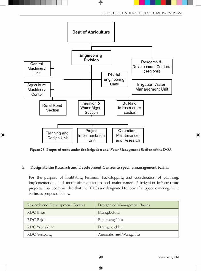
www.nec.gov.bt99
PRIORITIES UNDER THE NATIONAL IWRM PLAN
Figure 28: Proposed units under the Irrigation and Water Management Section of the DOA
2. Designate the Research and Development Centres to specifi c management basins.
For the purpose of facilitating technical backstopping and coordination of planning,
implementation, and monitoring operation and maintenance of irrigation infrastructure
projects, it is recommended that the RDCs are designated to look after specifi c management
basins as proposed below:
Research and Development Centres Designated Management Basins
RDC Bhur Mangdechhu
RDC Bajo Punatsangchhu
RDC Wengkhar Drangme chhu
RDC Yusipang Amochhu and Wangchhu

National Environment Commission
Provisional National IWRM Plan 2016 100
3. Establishment of Irrigation Water Management Units at the DoA Research & Development
Centres to facilitate research on best practices for water management in irrigation systems.
Th e 2014 Water Regulation called for setting up of irrigation water management units under
the three Research and Development Centres. Specifi cally, the regulation mandated MoAF
to “institute an irrigation water management unit under its three existing Research and
Development Centres (RDC) to facilitate and support irrigation development. Currently,
however, there is only an average of three DoA Engineering Division staff posted in each
of the three RDCs. Setting up an irrigation management unit in four RDCs, with at least 2
personnel assigned to the unit, entails adding 8 staff to the Engineering Division.
4. Moreover, it is proposed to designate the 4 Research and Development Centres to specifi c
basin management units: Th e new RDC in west Bhutan would look after Amochhu and
Wangchhu Basins; the RDC in Bhur would look after Mangdechhu basin, the RDC at Bhajo
takes care of Punatsangchhu-Aiechhu and the RDC in Wengkhar caters for Drangmechhu
and Nyera-Amari basin.
7.10 Strengthening the weather and hydrological
monitoring and forecasting capacity
It is proposed to improve the functions of the Department of Hydro and Meteorological Services
(DHMS) as outlined below during the course of the 12th FYP.51
1. Expand and improve weather and water monitoring stations
DHMS should be able generate hydro-meteorological information that is suffi ciently detailed to
represent smaller geographical units (districts and Gewogs) throughout the country. Presently,
92% of the stations cover only about half of the country’s land mass, i.e., areas below 3,000-meter
elevation. Th e higher elevations are thus signifi cantly under-represented.
Based on the guidelines of the World Meteorological Organisation regarding density of
meteorological stations, a mountainous country like Bhutan should have precipitation gauges for
every 250 square kilometres (or approximately 15 km apart, on average). Th is translates to 150
such stations to cover the country, which is roughly 60% higher than the present station density.
Expanding the meteorological network to adequately cover elevations above 3,000 meters is
important due to the projected increase in precipitation with latitude (particularly in Bhutan’s
mid-zone), and associated with the shift of the snow line northward because of global warming.
51 For details of the assessment conducted on the DHMS capacity, including recommendations for strengthening,
refer to the standalone supporting document entitled: Strengthening Bhutan’s Capacity for Future Climate Modeling: A
Proposal for Strengthening Hydromet Services.

www.nec.gov.bt101
PRIORITIES UNDER THE NATIONAL IWRM PLAN
Groundwater and ambient water quality are presently not in the domain of any agency. DHMS
would be well poised to include them in their responsibilities.
2. DHMS as broad service provider
It is proposed that DHMS will in future provide hydrological and meteorological information to
other sectors than hydropower, such as NEC (for IWRM) and Agriculture.
Th e current location of the DHMS within the MoEA has drawn concern as to whether, under
such organizational set-up, the department is in an eff ective position to fulfi l that role. Th is issue
should be further examined, preferably alongside the dialogue with sector agencies and public
stakeholders, as part of an overall institutional development and capacity strengthening.
One option is to delink the DHMS from the MoEA and establish it as a standalone service bureau,
a precedent that exists in Bhutan’s National Statistical Bureau.
7.11 Support Gewog/ District administration
Th e Gewog and District administrations need support for registration of the WUAs and for
documentation of the local water sources and their use. Th is support can be extended by the
WRCD of NECS after it has been strengthened, or by providing one assistant to the DEO in each
District. NGOs can also play a role in this context.
7.12 Implement training plan
It is proposed to implement the training plan for government staff as summarised in Appendix
3. Th is plan is based on the fi ndings of the training needs assessment described in Section 4.6 on
Institutional Strengthening.
7.13 Improvement and harmonisation of the legal
framework for IWRM
Th e Water Act is the fi rst act to address water resources in an integrated manner. Until then,
management of water resources was fragmented, addressed in diff erent laws, and only focused
on the operational level. Th e Water Act is an important milestone in the implementation of the
concept of IWRM in national legislation. It is also in line with the national concept of Gross
National Happiness. Th e issues provided for in broad terms in the Act, are elaborated in more
detail in the Water Regulation 2014. Some defi ciencies have been addressed in the Guidelines for
WUAs, which have been elaborated for this NIWRMP. Th ese Guidelines should be approved and

National Environment Commission
Provisional National IWRM Plan 2016 102
endorsed as a priority.
It is recommended to monitor the implementation of the new legal framework during the plan
period of this NIWRMP, particularly with respect to the issues identifi ed in Section 4.2. Th e NECS
should guide this monitoring process in line with its overall coordination role. Th e yearly reports
of the water-related institutions at all government levels are in important input for the collection
of information about the implementation of the Water Act and the Water Regulation. In addition,
the NECS can initiate other activities such as workshops with the relevant stakeholders with the
goal to create consensus about issues that need further improvement in the legislation. Based on
that it will become clear which issues can be suffi ciently solved through amending only the Water
Regulation, and which issues are of such an importance that they need to be solved at the level of
the Water Act itself.
Another point is concerned with the relation between the Water Act and other water related
acts. It is important that the Water Act and the water-related acts (as well as their underlying
implementing regulations) are suffi ciently harmonized to avoid overlaps, contradictions or gaps.
Th e overall conclusion of a desktop assessment carried out in 2015, is that the Water Act and the
existing water-related acts (and regulations) are in harmony. Most issues are addressed in the acts
consistently, though in some cases there are ambiguities that may cause confusion – as stated in
Section 5.2. On-going initiatives to revise the concerned water-related acts (such as the Electricity
Act) can be used to solve the ambiguities.
7.14 Study the potential for groundwater utilization
It is believed that groundwater could be a sustainable source of water that is especially useful during
the lean period. To that eff ect it is recommended that a study shall be done into the potential of
groundwater utilization, starting in the wider valleys of Punakha, Paro, Phuentsholing, Th imphu,
and in the southern belt of the country.

www.nec.gov.bt103
PRIORITIES UNDER THE NATIONAL IWRM PLAN
REFERENCES
Standalone supporting documents produced under ADB CDTA 8623-BHU
EGIS and RSPN/ BhWP, 2016. Bhutan Water Security Index System: Software
Requirements Specifi cation. A technical report prepared under ADB technical assistance
to Bhutan: Adapting to Climate Change through Integrated Water Resource Management.
Th imphu Bhutan.
EGIS and RSPN/ BhWP, 2016. Bhutan Water Security Index System: User’s Manual. A
technical report prepared under ADB technical assistance to Bhutan: Adapting to Climate
Change through Integrated Water Resource Management. Th imphu Bhutan.
EGIS and RSPN/ BhWP, 2016. Capacity Development and Training Needs Assessment. A
technical report prepared under ADB technical assistance to Bhutan: Adapting to Climate
Change through Integrated Water Resource Management. Th imphu Bhutan.
EGIS and RSPN/ BhWP, 2016. Climate Modeling and Assessment for Bhutan. A technical
report prepared under ADB technical assistance to Bhutan: Adapting to Climate Change
through Integrated Water Resource Management. Th imphu Bhutan.
EGIS and RSPN/ BhWP, 2016. Communications Plan to Support Bhutan’s IWRM
Process. A technical report prepared under ADB technical assistance to Bhutan: Adapting
to Climate Change through Integrated Water Resource Management. Th imphu Bhutan.
EGIS and RSPN/ BhWP, 2016. Coordination Framework and Terms of Reference for
River Basin Committees. A technical report prepared under ADB technical assistance to
Bhutan: Adapting to Climate Change through Integrated Water Resource Management.
Th imphu Bhutan.
EGIS and RSPN/ BhWP, 2016. Database backup and restore User’s Manual. A technical
report prepared under ADB technical assistance to Bhutan: Adapting to Climate Change
through Integrated Water Resource Management. Th imphu Bhutan.
EGIS and RSPN/ BhWP, 2016. Economic Analysis for National Irrigation Master Plan. A
technical report prepared under ADB technical assistance to Bhutan: Adapting to Climate
Change through Integrated Water Resource Management. Th imphu Bhutan.
EGIS and RSPN/ BhWP, 2016. GIS Software Installation User Manual (all in one). A
technical report prepared under ADB technical assistance to Bhutan: Adapting to Climate
Change through Integrated Water Resource Management. Th imphu Bhutan.

National Environment Commission
Provisional National IWRM Plan 2016 104
EGIS and RSPN/ BhWP, 2016. Hydrological Modeling and Assessment for Bhutan. A
technical report prepared under ADB technical assistance to Bhutan: Adapting to Climate
Change through Integrated Water Resource Management. Th imphu Bhutan.
EGIS and RSPN/ BhWP, 2016. Integrated Water Resource Management in Bhutan:
Possible entry points in Development Planning and Budgeting System. A technical report
prepared under ADB technical assistance to Bhutan: Adapting to Climate Change through
Integrated Water Resource Management. Th imphu Bhutan.
EGIS and RSPN/ BhWP, 2016. Integrated Water Resource Management in Bhutan:
Stakeholder Analysis. A technical report prepared under ADB technical assistance to
Bhutan: Adapting to Climate Change through Integrated Water Resource Management.
Th imphu Bhutan.
EGIS and RSPN/ BhWP, 2016. Irrigation Engineering Manual. A technical report
prepared under ADB technical assistance to Bhutan: Adapting to Climate Change through
Integrated Water Resource Management. Th imphu Bhutan.
EGIS and RSPN/ BhWP, 2016. Interactive Web GIS User’s Manual Legal Aspects of
Integrated Water Resource Management in Bhutan. A technical report prepared under
ADB technical assistance to Bhutan: Adapting to Climate Change through Integrated
Water Resource Management. Th imphu Bhutan.
EGIS and RSPN/ BhWP, 2016. Legal Aspects of Integrated Water Resource Management
in Bhutan. A technical report prepared under ADB technical assistance to Bhutan: Adapting
to Climate Change through Integrated Water Resource Management. Th imphu Bhutan.
EGIS and RSPN/ BhWP, 2016. National Atlas of River Basins and Water Infrastructure in
Bhutan. A technical report prepared under ADB technical assistance to Bhutan: Adapting
to Climate Change through Integrated Water Resource Management. Th imphu Bhutan.
EGIS and RSPN/ BhWP, 2016. National Irrigation Master Plan. A technical report
prepared under ADB technical assistance to Bhutan: Adapting to Climate Change through
Integrated Water Resource Management. Th imphu Bhutan.
EGIS and RSPN/ BhWP, 2016. Social Aspects of Water Resource Management in Bhutan.
A technical report prepared under ADB technical assistance to Bhutan: Adapting to Climate
Change through Integrated Water Resource Management. Th imphu Bhutan.
EGIS and RSPN/ BhWP, 2016. Strengthening Bhutan’s Capacity for Future Climate
Modeling: A Proposal for Strengthening Hydromet Services. A technical report prepared

www.nec.gov.bt105
under ADB technical assistance to Bhutan: Adapting to Climate Change through Integrated
Water Resource Management. Th imphu Bhutan.
EGIS and RSPN/ BhWP, 2016. Strengthening of the Department of Agriculture and Water
User Associations. A technical report prepared under ADB technical assistance to Bhutan:
Adapting to Climate Change through Integrated Water Resource Management. Th imphu
Bhutan.
EGIS and RSPN/ BhWP, 2016. Strengthening of the Water Resource Coordination Division
under National Environment Commission Secretariat. A technical report prepared under
ADB technical assistance to Bhutan: Adapting to Climate Change through Integrated
Water Resource Management. Th imphu Bhutan.
EGIS and RSPN/ BhWP, 2016. Water Balance Calculator Users Manual. A technical report
prepared under ADB technical assistance to Bhutan: Adapting to Climate Change through
Integrated Water Resource Management. Th imphu Bhutan.
EGIS and RSPN/ BhWP, 2016. Water: Securing Bhutan’s Future. A technical report
prepared under ADB technical assistance to Bhutan: Adapting to Climate Change through
Integrated Water Resource Management. Th imphu Bhutan.
EGIS and RSPN/ BhWP, 2016. Wangchhu Basin Management Plan. A technical report
prepared under ADB technical assistance to Bhutan: Adapting to Climate Change through
Integrated Water Resource Management. Th imphu Bhutan.
Publications and other documents
Bajrachary, S. R., S. B. Maharjan and F. Shrestha. 2014. Th e status and decadal change of
glaciers in Bhutan from the 1980s to 2010 based on satellite data. Annals of Glaciology
55(66) 2014 doi: 10.3189/2014AoG66A125.
Bhutan Renewable Natural Resources Statistics, 2015.
Data collection survey on renewable energy in the Kingdom of Bhutan, JICA-DRE, MoEA,
2013.
Eleventh Five Year Plan 2013-2018, Royal Government of Bhutan.
Global water partnership: http://www.gwp.org
Moool, P., D. Wangda, S. Bajracharya, K. Kunzang, D. Gurung and S. Joshi. Inventory of

National Environment Commission
Provisional National IWRM Plan 2016 106
Glaciers, Glacial Lakes and Glacial Lake Outburst Floods, Monitoring and Early Warning
Systems in the HKH Region (Bhutan). ICIMOD, Kathmandu, Aug 2001.
Bhutan National accounts statistics, 2014.
Rapid classifi cation of watersheds in the Wangchhu basin, SNV-WMD, DOFPS, MOAF,
2011.
Bhutan Statistical yearbook, 2014.
UN-Water: http://www.unwater.org

www.nec.gov.bt107
APPENDICES

National Environment Commission
Provisional National IWRM Plan 2016 108
Ap
pen
dix
1:
Are
as i
n b
asin
s an
d d
istr
icts
Per
cen
tag
e o
f d
istr
ict
in t
he
bas
ins,
an
d p
erce
nta
ge
of
bas
ins
in t
he
dis
tric
ts
Districts
Area
,7Y/3m.
8otaP
% oH
district
% oH
Basin
% oH
district
% oH
Basin
% oH
district
% oH
Basin
% oH
district
% oH
Basin
% oH
district
% oH
Basin
% oH
district
% oH
Basin
% oH
district
% oH
Basin
% oH
district
nhimphu
B7WD
8B.D%
3B.7%
B8.8%
3.N%
BAA%
esss
DWNB
BAA.A%
3A.7%
BAA%
Punskhs
BBBA
BAA.A%
BB.N%
BAA%
osnytuu Photrsny
3W77
7M.3%
3A.7%
DP.B%
B3.P%
BAA%
nsirsny
P38
BAA.A%
P.P%
BAA%
dsysns
B7B3
M.A%
B.N%
WN.D%
B7.A%
A.8%
A.7%
BAA%
nronyss
B8BM
BAA.A%
D3.8%
BAA%
Bumthsny
DPP7
BAA.A%
3N.A%
BAA%
rhumysny
DMBP
87.D%
D7.P%
BD.8%
3.P%
BAA%
hhuuntsu
D8NB
BAA.A%
33.M%
BAA%
ionyysr
BWMA
BAA.A%
DD.7%
BAA%
nrsshi Ysnytsu
BMM7
BAA.A%
B7.A%
BAA%
nrsshiysny
DBW8
N8.B%
BN.A%
MB.W%
3D.W%
BAA%
Pums estshul
BADD
PW.D%
8.3%
3A.8%
BN.W%
BAA%
chhukhs
B,88A
P3.3%
DN.W%
3P.7%
DB.D%
BAA%
Hss
B,WAN
3B.A%
BD.W%
PW.A%
MA.3%
BAA%
Psro
B,D87BAA.A%
D8.A%
BAA%
msmtrup gonykhsr
B,877
BAA.A%
P7%
BAA%
msmtsu
B,DNP
BAA.A%
38.N%
BAA%
msrpsny
B,PNN
BAA.A%
83.M%
BAA%
arus / %
383WNMNWD.ABAA.A%
WPB8.8BAA.A%
7PDN.BBAA.A%
8N3B.ABAA.A%
3DNW.NBAA.A%
BW83.WBAA.A%
D7W7.MBAA.A%
Basins
Wangchhu
Punatsangchhu
Mangdechhu
Drangmechhu
Amochhu
Aiechhu
Nyera Amachhu

www.nec.gov.bt109
APPENDICES
Ap
pen
dix
2:
Des
crip
tio
n o
f th
e in
stit
uti
on
al f
ram
ewo
rk
Ou
tlin
e o
f th
e In
stit
uti
on
al
Fra
mew
ork
Ther
e ar
e m
ore
th
an 1
5 k
ey i
nst
itu
tio
ns
in B
hu
tan
wh
o h
ave
a st
ake
in I
WR
M.
Thei
r re
spec
tive
ro
les
hav
e b
een
defi
ned
in
Ch
apte
r 3
of
the
Wat
er A
ct a
nd
in
Ch
apte
r 2
of
the
W
ater
Reg
ula
tio
n.
The
tab
le b
elo
w b
riefl
y d
escr
ibes
th
e p
rim
ary
man
dat
e o
f ea
ch o
f th
ese
inst
itu
tio
ns
and
thei
r sp
ecifi
c IW
RM
ro
les
wit
h r
egar
d t
o (
i) p
oli
cy a
nd
pla
nn
ing,
(ii
) co
ord
inat
ion
an
d r
egu
lato
ry p
ow
ers,
(ii
i) w
ater
ser
vice
s d
eliv
ery,
an
d (
iv)
info
rmat
ion
man
agem
ent/
rep
ort
ing
and
cap
acit
y b
uil
din
g.
Des
crip
tio
n o
f th
e in
stit
uti
on
al
fram
ew
ork
1.
Min
istr
y o
f
Agr
icu
ltu
re a
nd
Fo
rest
s (M
oA
F)
Mo
AF
is
the
Co
mp
eten
t A
uth
ori
ty o
n i
rrig
atio
n,
wat
ersh
ed a
nd
wet
lan
d m
anag
emen
t. I
t is
res
po
nsi
ble
fo
r
dev
elo
pm
ent
of
irri
gati
on
sys
tem
s an
d m
anag
emen
t o
f w
ater
shed
s th
rou
gho
ut
the
cou
ntr
y. Th
e E
ngi
nee
rin
g D
ivis
ion
of
the
min
istr
y p
rovi
des
en
gin
eeri
ng
serv
ices
to
lo
cal
adm
inis
trat
ion
s fo
r d
esig
n a
nd
dev
elo
pm
ent
of
irri
gati
on
s
syst
ems.
The
Wat
ersh
ed M
anag
emen
t D
ivis
ion
(u
nd
er t
he
Dep
artm
ent
of
Fo
rest
an
d P
ark
Ser
vice
s) i
s ta
sked
to
cate
gori
ze w
ater
shed
s, p
rep
are
man
agem
ent
pla
ns,
an
d i
mp
lem
ent
them
in
co
llab
ora
tio
n w
ith
sta
keh
old
ers.
WR
M p
oli
cy a
nd
pla
nn
ing
role
:
• F
orm
ula
te,
imp
lem
ent
and
per
iod
ical
ly r
evie
w a
co
mp
reh
ensi
ve
Nat
ion
al I
rrig
atio
n P
oli
cy
• D
evel
op
an
d i
mp
lem
ent
wat
ersh
ed
and
wet
lan
d m
anag
emen
t p
lan
s
• Id
enti
fy w
ater
shed
are
as t
hat
req
uir
e
pro
tect
ion
, co
nse
rvat
ion
an
d
man
agem
ent
for
sust
ain
able
su
pp
ly o
f
wat
er;
• C
on
du
ct f
easi
bil
ity
stu
die
s o
n n
ew
irri
gati
on
sys
tem
s
Co
ord
inat
ion
an
d R
egu
lato
ry r
ole
:
• E
nsu
re t
he
pro
tect
ion
, co
nse
rvat
ion
an
d m
anag
emen
t o
f w
ater
shed
s to
sust
ain
wat
er s
up
ply
an
d o
ther
en
viro
nm
enta
l se
rvic
es
• P
rom
ote
pay
men
t fo
r en
viro
nm
enta
l se
rvic
es m
ech
anis
m t
o s
up
po
rt
wat
ersh
ed m
anag
emen
t p
rogr
ams
• In
co
nsu
ltat
ion
wit
h N
EC
S,
dev
elo
p a
nd
iss
ue
qu
alit
y st
and
ard
s fo
r
irri
gati
on
wat
er d
isch
arge

National Environment Commission
Provisional National IWRM Plan 2016 110
Wat
er s
ervi
ce d
eliv
ery
role
::
• E
nsu
re t
hat
wat
er a
bst
ract
ion
fo
r
irri
gati
on
is
in l
ine
wit
h N
IWR
MP
• D
esig
n i
rrig
atio
n w
ater
co
nve
yan
ce
infr
astr
uct
ure
an
d i
mp
lem
ent
thes
e
op
tim
ize
wat
er u
se e
ffici
ency
• E
nsu
re r
elia
ble
an
d e
ffici
ent
wat
er s
up
ply
sys
tem
fo
r cr
op
pin
g
inte
nsi
fica
tio
n a
nd
div
ersi
fica
tio
n
• E
nsu
re t
hat
th
e co
nce
pt
of
eco
-
effici
ent
wat
er i
nfr
astr
uct
ure
is
foll
ow
ed w
hil
e d
evel
op
ing
irri
gati
on
syst
ems
• F
acil
itat
e th
e fo
rmat
ion
an
d
regi
stra
tio
n o
f an
irr
igat
ion
WU
As
and
mo
nit
or
them
Info
rmat
ion
, re
po
rtin
g, r
esea
rch
an
d c
apac
ity-
bu
ild
ing
role
:
• D
evel
op
co
mp
reh
ensi
ve i
nve
nto
ry o
n i
rrig
atio
n s
yste
ms
in t
he
cou
ntr
y
and
up
dat
e an
nu
ally
• Id
enti
fy c
ost
eff
ecti
ve i
rrig
atio
n t
ech
no
logi
es a
nd
en
cou
rage
ad
op
tio
n
• P
rom
ote
cro
pp
ing
pat
tern
s an
d l
and
use
man
agem
ent
suit
able
to
wat
er
avai
lab
ilit
y co
nd
itio
ns
• C
on
du
ct s
emin
ars
or
trai
nin
g fo
r m
emb
ers
of
the
irri
gati
on
WU
A o
n
effici
ent
wat
er m
anag
emen
t
• E
xplo
re a
lter
nat
ive
wat
er r
eso
urc
es l
ike
rain
wat
er h
arve
stin
g an
d
hyd
rop
ow
er r
eser
voir
s
• In
volv
e C
ivil
So
ciet
y O
rgan
izat
ion
s to
ed
uca
te,
info
rm a
nd
tra
in f
arm
ers
on
wat
ersh
ed m
anag
emen
t p
ract
ices
• S
et u
p a
n i
rrig
atio
n w
ater
man
agem
ent
un
it u
nd
er i
ts e
xist
ing
Res
earc
h
and
Dev
elo
pm
ent
Cen
tres
• C
on
du
ct r
esea
rch
on
bes
t p
ract
ices
in
wat
er m
anag
emen
t
• D
evel
op
an
d i
mp
lem
ent
an e
ffec
tive
M&
E a
nd
rep
ort
ing
syst
em f
or
irri
gati
on
sys
tem
s
• S
ub
mit
an
nu
al r
epo
rt t
o t
he
NE
CS
on
im
ple
men
tati
on
an
d e
nfo
rcem
ent
of
Wat
er A
ct a
nd
Reg
ula
tio
n,
incl
ud
ing
diffi
cult
ies,
iss
ues
an
d c
hal
len
ges
met

www.nec.gov.bt111
APPENDICES
2.
Min
istr
y
of
Eco
no
mic
Aff
airs
(M
oE
A)
Thro
ugh
Mo
EA
’s D
epar
tmen
t o
f H
ydro
po
wer
an
d P
ow
er S
yste
ms,
it
has
th
e re
spo
nsi
bil
ity
of
pro
mo
tin
g su
stai
nab
le
hyd
rop
ow
er d
evel
op
men
t fo
r B
hu
tan
. It
s m
issi
on
is
to g
ove
rn a
nd
fac
ilit
ate
inte
grat
ed,
regi
on
ally
bal
ance
d a
nd
op
tim
al
use
of
wat
er f
or
dev
elo
pm
ent
of
hyd
rop
ow
er w
ith
min
imu
m e
nvi
ron
men
tal
imp
acts
; en
sure
th
at h
ydro
po
wer
gen
erat
es
max
imu
m r
even
ue
to t
he
nat
ion
; en
sure
sec
ure
, re
liab
le,
and
aff
ord
able
ele
ctri
city
fo
r th
e B
hu
tan
; p
rovi
de
enab
lin
g
envi
ron
men
t fo
r p
arti
cip
atio
n o
f th
e p
ub
lic
and
pri
vate
sec
tors
in
dev
elo
pm
ent
of
hyd
rop
ow
er r
eso
urc
es;
imp
lem
ent
inst
itu
tio
nal
ref
orm
s fo
r effi
cien
t p
lan
nin
g an
d m
anag
emen
t o
f th
e se
cto
r; a
nd
dev
elo
p a
nd
en
han
ce p
rofe
ssio
nal
s fo
r
hyd
rop
ow
er d
evel
op
men
t an
d m
anag
emen
t. Th
rou
gh t
he
Dep
artm
ent
of
Hyd
ro-M
et S
ervi
ces,
it
pro
vid
es w
eath
er,
wat
er,
clim
ate,
an
d o
ther
rel
ated
en
viro
nm
enta
l se
rvic
es t
o v
ario
us
sect
ors
. It
ser
vice
s p
rovi
ded
by
the
agen
cy i
ncl
ud
e
dai
ly w
eath
er f
ore
cast
, ag
ro-m
eteo
rolo
gica
l in
form
atio
n,
war
nin
gs a
nd
ale
rts
for
extr
eme
even
ts s
uch
as
GL
OF,
an
d
hyd
ro-m
eteo
rolo
gica
l d
ata.
The
Dep
artm
ent
of
Geo
logy
an
d M
ines
, th
rou
gh i
ts G
laci
olo
gy D
ivis
ion
car
ries
ou
t
mo
nit
ori
ng
of
Gla
cier
s an
d G
laci
al L
akes
, u
pd
ate
inve
nto
ry o
f G
laci
ers
and
Gla
cial
Lak
es,
con
du
ct r
esea
rch
on
Gla
cial
Lak
es a
nd
pro
po
se r
emed
ial
mea
sure
s fo
r G
LO
F r
isk
red
uct
ion
, im
ple
men
t m
itig
atio
n m
easu
res
and
stu
dy
imp
act
of
clim
ate
chan
ge o
n G
laci
ers
and
Gla
cial
Lak
es.
WR
M p
oli
cy a
nd
pla
nn
ing
role
:
• F
or
the
NIW
RM
P, m
on
ito
r w
ater
flo
ws
and
sed
imen
ts i
n r
iver
co
urs
es
to c
on
tro
l an
d m
itig
ate
adve
rse
envi
ron
men
tal
imp
acts
fro
m t
he
dam
con
stru
ctio
ns,
riv
er d
iver
sio
ns,
min
ing
and
in
du
stri
al a
ctiv
itie
s
• A
ssis
t in
dev
elo
pin
g th
e N
IWR
MP
and
tak
e m
easu
res
to i
mp
lem
ent
it i
n
rela
tio
n t
o h
ydro
po
wer
act
ivit
ies
and
rive
r ec
olo
gy
• C
on
sid
er h
ydro
po
wer
pla
nn
ing
for
mu
ltip
le u
ses
such
as
dri
nk
ing
wat
er,
irri
gati
on
an
d r
ecre
atio
nal
pu
rpo
ses
Co
ord
inat
ion
an
d r
egu
lato
ry r
ole
:
• C
oo
rdin
ate
rive
r-re
late
d a
ctiv
itie
s in
co
llab
ora
tio
n w
ith
th
e R
BC
• E
nsu
re t
he
effec
tive
im
ple
men
tati
on
of
guid
elin
es o
n s
afet
y m
easu
res
to
be
tak
en w
hil
e p
lan
nin
g, d
esig
nin
g an
d i
mp
lem
enti
ng
hyd
rop
ow
er d
am
con
stru
ctio
n
• E
nsu
re m
inim
um
en
viro
nm
enta
l fl
ow
to
be
mai
nta
ined
in
riv
ers
wh
ile
pla
nn
ing
hyd
rop
ow
er p
roje
cts

National Environment Commission
Provisional National IWRM Plan 2016 112
Wat
er s
ervi
ce d
eliv
ery
role
:
• N
on
e
Info
rmat
ion
, re
po
rtin
g, r
esea
rch
an
d c
apac
ity-
bu
ild
ing
role
:
• M
on
ito
r w
ater
flo
ws
and
sed
imen
ts i
n r
iver
co
urs
es
• C
oll
ect,
an
alys
e an
d d
isse
min
ate
dat
a o
n w
ater
res
ou
rces
per
tain
ing
to
pla
nn
ing
and
im
ple
men
tati
on
of
hyd
rop
ow
er p
roje
cts
• C
on
du
ct s
tud
ies
on
gla
cial
dyn
amic
s fo
r G
LO
Fs
• S
ub
mit
an
nu
al r
epo
rt t
o t
he
NE
CS
on
im
ple
men
tati
on
an
d e
nfo
rcem
ent
of
Wat
er A
ct a
nd
R
egu
lati
on
, in
clu
din
g d
ifficu
ltie
s, i
ssu
es a
nd
ch
alle
nge
s
met
3.
Min
istr
y
of
Ed
uca
tio
n
(MO
E)
The
Mo
E d
oes
no
t h
ave
dir
ect
wat
er m
anag
emen
t an
d s
ervi
ce d
eliv
ery
man
dat
es s
pec
ified
in
th
e W
ater
Act
an
d t
he
Wat
er R
egu
lati
on
. It
s m
ain
ro
le,
as o
ne
of
the
com
pet
ent
auth
ori
ties
men
tio
ned
in
th
e W
ater
Act
, is
to
pro
mo
te
awar
enes
s o
f w
ater
-rel
ated
iss
ues
am
on
g th
e ge
ner
al p
ub
lic.
WR
M p
oli
cy a
nd
pla
nn
ing
role
:
No
ne
• C
oo
rdin
atio
n a
nd
reg
ula
tory
ro
le:
• C
oo
rdin
atio
n i
nfo
rmat
ion
gat
her
ing
for
edu
cati
on
al a
nd
pu
bli
c
awar
enes
s-ra
isin
g p
urp
ose
s
Wat
er s
ervi
ce d
eliv
ery
role
:
• N
on
e
• In
form
atio
n,
rep
ort
ing,
res
earc
h a
nd
cap
acit
y-b
uil
din
g ro
le:
• C
oll
ect
info
rmat
ion
on
wat
er r
eso
urc
es f
rom
oth
er C
om
pet
ent
Au
tho
riti
es a
nd
in
corp
ora
te t
hes
e i
nto
its
ed
uca
tio
n p
rogr
ams
and
curr
icu
lum
• C
on
du
ct e
du
cati
on
al a
ctiv
itie
s to
sen
siti
ze a
nd
cre
ate
awar
enes
s am
on
g
the
gen
eral
pu
bli
c o
n t
he
imp
ort
ance
of
wat
er r
eso
urc
es m
anag
emen
t
• S
ub
mit
an
nu
al r
epo
rt t
o t
he
NE
CS
on
im
ple
men
tati
on
an
d e
nfo
rcem
ent
of
Wat
er A
ct/W
ater
R
egu
lati
on
, in
clu
din
g d
ifficu
ltie
s, i
ssu
es a
nd
chal
len
ges
met

www.nec.gov.bt113
APPENDICES
4.
Min
istr
y o
f
Hea
lth
(M
oH
)
Min
istr
y o
f H
ealt
h i
s re
spo
nsi
ble
fo
r th
e o
vera
ll p
lan
nin
g, i
mp
lem
enta
tio
n a
nd
man
agem
ent
of
infr
astr
uct
ure
fo
r
dri
nk
ing
wat
er s
up
ply
an
d s
ewag
e m
anag
emen
t fo
r al
l ru
ral
area
s, w
hic
h i
t u
nd
erta
kes
in
co
llab
ora
tio
n w
ith
lo
cal
gove
rnm
ents
. It
is
also
man
dat
ed t
o m
on
ito
r q
ual
ity
of
dri
nk
ing
wat
er.
Mo
H i
s m
and
ated
un
der
th
e W
ater
Act
an
d
the
Wat
er R
egu
lati
on
to
mai
nst
ream
wat
er r
eso
urc
es m
anag
emen
t in
its
po
lici
es,
pla
ns
and
pro
gram
s. A
lth
ou
gh s
pri
ng
sou
rces
are
to
be
give
n p
refe
ren
ce a
s a
dri
nk
ing
wat
er s
ou
rce,
th
e m
inis
try
is m
and
ated
to
exp
lore
alt
ern
ativ
e d
rin
kin
g
wat
er r
eso
urc
es l
ike
rain
wat
er h
arve
stin
g an
d t
app
ing
of
hyd
rop
ow
er r
eser
voir
s.
WR
M p
oli
cy a
nd
pla
nn
ing
role
:
• R
evie
w e
xist
ing
stat
us
of
dri
nk
ing
wat
er s
up
ply
sys
tem
s in
ru
ral
area
s
• D
evel
op
nat
ion
al m
aste
r p
lan
fo
r
rura
l d
rin
kin
g w
ater
an
d w
aste
wat
er
man
agem
ent
(wit
h e
mp
has
is o
n
spri
ng
sou
rces
)
• D
evel
op
, is
sue
and
rev
ise
guid
elin
es
on
wat
er s
afet
y p
lan
s an
d “
eco
-
effici
ent”
wat
er i
nfr
astr
uct
ure
s
Co
ord
inat
ion
an
d r
egu
lato
ry r
ole
:
• A
ssis
t N
EC
S i
n d
evel
op
ing
and
rev
isin
g d
rin
kin
g w
ater
qu
alit
y st
and
ard
s
• D
esig
nat
e fo
cal
per
son
s to
mo
nit
or
wat
er q
ual
ity
stan
dar
ds
in Th
rom
de
and
ru
ral
area
s.
Wat
er s
ervi
ce d
eliv
ery
role
:
• Im
ple
men
t m
easu
res
to e
nsu
re r
elia
ble
and
effi
cien
t d
rin
kin
g w
ater
su
pp
ly
syst
ems
in r
ura
l ar
eas
• Id
enti
fy a
nd
pro
vid
e in
cen
tive
s o
r
sub
sid
ies
for
wat
er s
avin
g sc
hem
es o
r
bet
ter
was
tew
ater
man
agem
ent
for
rura
l ar
eas
Info
rmat
ion
, re
po
rtin
g, r
esea
rch
an
d c
apac
ity-
bu
ild
ing
role
:
• E
xplo
re a
lter
nat
ive
dri
nk
ing
wat
er r
eso
urc
es l
ike
rain
wat
er h
arve
stin
g
and
po
ssib
le l
ink
age
to h
ydro
po
wer
res
ervo
irs
• M
ain
tain
an
d p
erio
dic
ally
up
dat
e re
cord
s o
f p
hys
ical
, ch
emic
al a
nd
bio
logi
cal
fin
din
gs w
ith
res
pec
t to
dri
nk
ing
wat
er a
t th
e co
nsu
mer
lev
el
• R
aise
aw
aren
ess
of
dis
infe
ctan
t m
ech
anis
ms
and
on
wat
er b
orn
e d
isea
ses
amo
ng
wat
er u
sers
• D
evel
op
tra
inin
g m
ater
ials
on
wat
er s
afet
y
• S
ub
mit
an
nu
al r
epo
rt t
o t
he
NE
CS
on
im
ple
men
tati
on
an
d e
nfo
rcem
ent
of
Wat
er A
ct a
nd
R
egu
lati
on
, in
clu
din
g d
ifficu
ltie
s, i
ssu
es a
nd
ch
alle
nge
s
met

National Environment Commission
Provisional National IWRM Plan 2016 114
5.
Min
istr
y
of
Ho
me
and
Cu
ltu
ral
Aff
airs
(MO
HC
A)
The
Min
istr
y o
f H
om
e an
d C
ult
ura
l A
ffai
rs,
thro
ugh
its
Dep
artm
ent
of
Dis
aste
r M
anag
emen
t, i
s in
volv
ed i
n t
he
wat
er s
ecto
r in
ter
ms
of
dis
aste
r m
itig
atio
n a
nd
rel
ief,
esp
ecia
lly
in w
ater
-rel
ated
dis
aste
r su
ch a
s G
laci
al L
ake
Ou
tbu
rst
Flo
od
s (G
LO
Fs)
.
WR
M p
oli
cy a
nd
pla
nn
ing
role
:
• D
evel
op
sys
tem
to
in
form
th
e p
ub
lic
in t
imes
of
wat
er r
elat
ed n
atu
ral
dis
aste
rs
Co
ord
inat
ion
an
d r
egu
lato
ry r
ole
:
• C
oo
rdin
ate
on
dis
aste
r p
rep
ared
nes
s an
d m
itig
atio
n m
easu
res
to b
e ta
ken
• M
ake
loca
l go
vern
men
ts a
cco
un
tab
le f
or
the
pro
tect
ion
an
d p
rom
oti
on
of
loca
l cu
ltu
ral
pra
ctic
es t
hat
are
en
viro
nm
ent
frie
nd
ly a
nd
th
at p
rote
ct
wat
er b
od
ies
reco
gniz
ed a
s ab
od
es o
f d
eiti
es
Ser
vice
del
iver
y ro
le:
• In
form
th
e p
ub
lic
in t
imes
of
wat
er-
rela
ted
nat
ura
l d
isas
ters
Info
rmat
ion
, re
po
rtin
g, r
esea
rch
an
d c
apac
ity-
bu
ild
ing
role
:
• M
ain
tain
reg
istr
ies
on
wel
l-k
no
wn
th
erap
euti
call
y va
lued
wat
er b
od
ies,
and
en
sure
th
eir
sust
ain
able
use
• D
isco
ura
ge p
oll
uti
on
of
wat
er b
od
ies
cau
sed
by
dis
po
sin
g re
ligi
ou
s
effigi
es,
ritu
al c
akes
, cr
emat
ion
rem
nan
ts,
etc.
• S
ub
mit
an
nu
al r
epo
rt t
o t
he
NE
CS
on
im
ple
men
tati
on
an
d e
nfo
rcem
ent
of
Wat
er A
ct a
nd
Reg
ula
tio
n,
incl
ud
ing
diffi
cult
ies,
iss
ues
an
d c
hal
len
ges
met
6.
Min
istr
y
of
Wo
rks
and
Hu
man
Set
tlem
ents
(Mo
WH
S)
Mo
WH
S i
s re
spo
nsi
ble
fo
r th
e o
vera
ll p
lan
nin
g, i
mp
lem
enta
tio
n a
nd
man
agem
ent
of
infr
astr
uct
ure
fo
r d
rin
kin
g w
ater
sup
ply
an
d w
aste
wat
er f
or
the
Thro
md
e in
co
llab
ora
tio
n w
ith
lo
cal
gove
rnm
ents
. It
ass
esse
s st
ren
gth
s an
d s
ho
rtfa
lls
for
wat
er s
up
ply
mai
nte
nan
ce,
and
id
enti
fies
rem
edia
l m
easu
res.
It
is m
and
ated
to
pre
par
e it
s d
evel
op
men
t p
lan
s
in c
on
sult
atio
n w
ith
lo
cal
gove
rnm
ents
. L
ike
the
Min
istr
y o
f H
ealt
h,
it i
s m
and
ated
to
mai
nst
ream
wat
er r
eso
urc
es
man
agem
ent
into
its
po
lici
es,
pla
ns
and
pro
gram
s.
WR
M p
oli
cy a
nd
pla
nn
ing
role
:
• R
evie
w e
xist
ing
stat
us
of
dri
nk
ing
wat
er s
up
ply
sys
tem
s in
Thro
md
es
Co
ord
inat
ion
an
d r
egu
lato
ry r
ole
:
• E
nsu
re p
rop
er i
mp
lem
enta
tio
n o
f W
ater
Saf
ety
Pla
ns
thro
ugh
reg
ula
r
mo
nit
ori
ng
and
eva
luat
ion

www.nec.gov.bt115
APPENDICES
• D
evel
op
a n
atio
nal
mas
ter
pla
n f
or
the
dri
nk
ing
wat
er a
nd
was
te w
ater
man
agem
ent
syst
em f
or
Thro
md
es
• D
evel
op
, is
sue
and
rev
ise
guid
elin
es
on
wat
er s
afet
y p
lan
s an
d e
co-e
ffici
ent
wat
er i
nfr
astr
uct
ure
s
Wat
er s
ervi
ce d
eliv
ery
role
:
• Im
ple
men
t m
easu
res
to e
nsu
re r
elia
ble
and
effi
cien
t d
rin
kin
g w
ater
su
pp
ly
syst
ems
in u
rban
mu
nic
ipal
itie
s
• Id
enti
fy a
nd
pro
vid
e in
cen
tive
s o
r
sub
sid
ies
for
wat
er s
avin
g sc
hem
es o
r
bet
ter
was
tew
ater
man
agem
ent
Info
rmat
ion
, re
po
rtin
g, r
esea
rch
an
d c
apac
ity-
bu
ild
ing
role
:
• E
xplo
re a
lter
nat
ive
dri
nk
ing
wat
er r
eso
urc
es l
ike
rain
wat
er h
arve
stin
g
and
hyd
rop
ow
er r
eser
voir
s
• C
on
du
ct s
tud
ies
on
, an
d e
nco
ura
ge u
se o
f, e
nvi
ron
men
t fr
ien
dly
, co
st
effec
tive
an
d w
ater
effi
cien
t te
chn
olo
gies
• P
rovi
de
trai
nin
g o
n w
ater
saf
ety
pla
ns
and
eco
-effi
cien
t w
ater
infr
astr
uct
ure
s
• S
ub
mit
an
nu
al r
epo
rt t
o t
he
NE
CS
on
im
ple
men
tati
on
an
d e
nfo
rcem
ent
of
Wat
er A
ct a
nd
Reg
ula
tio
n,
incl
ud
ing
diffi
cult
ies,
iss
ues
an
d c
hal
len
ges
met
7.
Nat
ion
al
En
viro
nm
ent
Co
mm
issi
on
(NE
C)
NE
C w
as e
stab
lish
ed i
n t
he
earl
y 1
99
0s
and
act
s as
th
e h
igh
est
auth
ori
ty a
nd
dec
isio
n-m
akin
g b
od
y o
n a
ll m
atte
rs
rela
tin
g to
po
lici
es,
pla
ns
and
gu
idel
ines
fo
r m
anag
ing
envi
ron
men
t an
d w
ater
res
ou
rces
. Th
e co
mm
issi
on
der
ives
its
po
wer
s an
d f
un
ctio
ns
fro
m t
he
ove
rarc
hin
g N
atio
nal
En
viro
nm
ent
Pro
tect
ion
Act
20
07
, th
e E
nvi
ron
men
tal
Ass
essm
ent
Act
20
00
, W
aste
Pre
ven
tio
n a
nd
Man
agem
ent
Act
20
09
, th
e (l
ates
t) W
ater
Act
of
20
11
. U
nd
er t
he
Wat
er
Act
, N
EC
ser
ves
as t
he
apex
au
tho
rity
fo
r th
e p
urp
ose
of
dev
elo
pin
g p
oli
cies
, p
lan
s, p
rogr
ams
and
mo
nit
ori
ng
wat
er
reso
urc
e m
anag
emen
t in
th
e co
un
try.
The
NE
C m
emb
ers
are
app
oin
ted
by
the
Cab
inet
an
d c
om
pri
sed
pri
mar
ily
of
hig
h-l
evel
min
iste
rial
mem
ber
s re
pre
sen
tin
g th
e re
leva
nt
gove
rnm
ent
Min
istr
ies,
rep
rese
nta
tive
s o
f th
e p
riva
te s
ecto
r,
Civ
il S
oci
ety
Org
aniz
atio
ns
(CS
Os)
an
d a
n a
dvi
sor
to t
he
Co
mm
issi
on
. Th
e P
rim
e M
inis
ter
serv
es a
s th
e C
hai
rper
son
,
and
th
e S
ecre
tary
of
NE
CS
ser
ves
as t
he
Sec
reta
ry.
The
Mo
AF
Min
iste
r h
as b
een
des
ign
ated
as
the
Min
iste
r in
-ch
arge
for
NE
CS
an
d s
erve
s as
th
e vi
ce-c
hai
rper
son
of
the
Co
mm
issi
on
.

National Environment Commission
Provisional National IWRM Plan 2016 116
• W
RM
po
licy
an
d p
lan
nin
g ro
le:
• Im
ple
men
t th
e IW
RM
pri
nci
ple
s
ensh
rin
ed i
n t
he
Wat
er A
ct
• R
evie
w a
nd
ad
op
t th
e N
atio
nal
Inte
grat
ed W
ater
Res
ou
rce
Man
agem
ent
Pla
n (
NIW
RM
P)
for
its
inco
rpo
rati
on
in
to n
atio
nal
po
lici
es,
pla
ns
and
pro
gram
s
• R
evie
w a
nd
ad
op
t gu
idel
ines
fo
r w
ater
reso
urc
e m
anag
emen
t p
lan
s in
clu
din
g
Riv
er B
asin
Man
agem
ent
Pla
ns
(RB
MP
s)
• F
orm
Riv
er B
asin
Co
mm
itte
es
for
pre
par
atio
n o
f th
e R
iver
Bas
in
Man
agem
ent
Pla
ns
• R
evie
w a
nd
ad
op
t th
e W
ater
Reg
ula
tio
n
• P
rote
ct a
nd
pro
mo
te a
saf
e an
d
hea
lth
y en
viro
nm
ent
• P
reve
nt,
co
ntr
ol
and
ab
ate
envi
ron
men
tal
har
m,
incl
ud
ing
po
llu
tio
n
• E
nsu
re c
on
serv
atio
n a
nd
su
stai
nab
le
use
of
nat
ura
l re
sou
rces
Co
ord
inat
ion
an
d r
egu
lato
ry r
ole
:
• E
nsu
re e
ffec
tive
en
forc
emen
t o
f th
e W
ater
Reg
ula
tio
n b
y C
om
pet
ent
Au
tho
riti
es r
epre
sen
ted
in
th
e N
EC
• In
stit
uti
on
aliz
e th
e en
viro
nm
enta
l as
sess
men
t p
roce
ss a
nd
en
viro
nm
enta
l
clea
ran
ce s
yste
m a
s an
in
tegr
al p
art
of
the
wat
er r
eso
urc
e d
evel
op
men
t
pla
nn
ing
pro
cess
• C
oo
rdin
ate
the
acti
viti
es o
f th
e va
rio
us
CA
s th
rou
gh t
he
NE
C S
ecre
tari
at

www.nec.gov.bt117
APPENDICES
• N
ego
tiat
e an
d e
nfo
rce
bil
ater
al a
nd
mu
ltil
ater
al a
gree
men
ts r
elat
ed t
o
wat
er r
eso
urc
es
• U
pd
ate
wat
er l
aw a
nd
reg
ula
tio
n
Wat
er s
ervi
ce d
eliv
ery
role
:
• N
on
e
Info
rmat
ion
, re
sear
ch a
nd
cap
acit
y-b
uil
din
g ro
le:
Car
ried
ou
t th
rou
gh t
he
NE
C S
ecre
tari
at
8.
Nat
ion
al
En
viro
nm
ent
Co
mm
issi
on
Sec
reta
riat
(NE
CS
)
The
NE
CS
car
ries
ou
t th
e d
ay-t
o-d
ay f
un
ctio
ns
of
the
Nat
ion
al E
nvi
ron
men
t C
om
mis
sio
n.
It a
ssis
ts t
he
NE
C i
n
adm
inis
teri
ng
the
pro
visi
on
s in
th
e W
ater
Act
. H
ead
ed b
y a
Sec
reta
ry (
wh
o i
s al
so a
mem
ber
of
the
NE
C),
th
e N
EC
S
is c
om
pri
sed
of
five
div
isio
ns:
(i)
Ser
vice
s d
ivis
ion
pro
vid
ing
adm
inis
trat
ive
and
pro
gram
ser
vice
s, (
ii)
En
viro
nm
enta
l
Ser
vice
s D
ivis
ion
pri
mar
ily
dea
lin
g w
ith
En
viro
nm
enta
l C
lear
ance
s, (
iii)
Co
mp
lian
ce M
on
ito
rin
g D
ivis
ion
, (i
v) W
ater
Res
ou
rces
Co
ord
inat
ion
Div
isio
n a
nd
(v)
Cli
mat
e C
han
ge D
ivis
ion
. E
ach
Div
isio
n i
s h
ead
ed b
y a
Ch
ief.
Dis
tric
t
En
viro
nm
enta
l O
ffice
rs (
DE
Os)
wh
o a
re a
dm
inis
trat
ivel
y u
nd
er t
he
Dzo
ngk
hag
ad
min
istr
atio
n u
nit
s ca
rry
ou
t th
e
fun
ctio
ns
of
NE
CS
at
the
dis
tric
t le
vel.
They
rep
ort
dir
ectl
y to
th
e d
istr
ict
gove
rno
r, a
lth
ou
gh t
hey
are
als
o a
nsw
erab
le
to t
he
NE
CS
. A
Wat
er R
eso
urc
e C
oo
rdin
atio
n D
ivis
ion
(W
RC
D)
was
set
up
in
May
20
10
in
acc
ord
ance
wit
h a
Cab
inet
Dir
ecti
ve u
po
n r
eco
mm
end
atio
n o
f th
e N
EC
.
WR
M p
oli
cy a
nd
pla
nn
ing
role
:
• P
rep
are
Nat
ion
al I
nte
grat
ed W
ater
Res
ou
rce
Man
agem
ent
Pla
n
• R
evie
w a
nd
ad
op
t R
iver
Bas
in
Man
agem
ent
Pla
ns
and
fo
rwar
d t
hem
to t
he
Gro
ss N
atio
nal
Hap
pin
ess
Co
mm
issi
on
fo
r m
ain
stre
amin
g in
to
nat
ion
al p
lan
s
Co
ord
inat
ion
an
d r
egu
lato
ry r
ole
:
• D
evel
op
ap
pro
pri
ate
stan
dar
ds
for
wat
er r
egu
lati
on
• In
co
ord
inat
ion
wit
h C
om
pet
ent
Au
tho
riti
es,
revi
ew a
nd
rev
ise
the
Wat
er
Reg
ula
tio
n
• W
ith
co
mp
eten
t A
uth
ori
ties
, en
forc
e w
ater
qu
alit
y st
and
ard
s
• C
oo
rdin
ate
amo
ng
Co
mp
eten
t A
uth
ori
ties
to
dev
elo
p i
nve
nto
ries
on
wat
er r
eso
urc
es,
bo
th o
n q
ual
ity
and
qu
anti
ty b
asel
ine
dat
a
• A
sses
s an
d i
ssu
e en
viro
nm
enta
l cl
eara
nce
s fo
r p
roje
cts
incl
ud
ing
wat
er
rela
ted
pro
ject
s an
d p
rogr
ams
• Is
sue
dir
ecti
ves
that
are
bin
din
g o
n a
ll p
erso
ns
and
co
mp
eten
t au
tho
riti
es
for
pu
rpo
ses
spec
ified
in
th
e W
ater
Act

National Environment Commission
Provisional National IWRM Plan 2016 118
Wat
er s
ervi
ce d
eliv
ery
role
:
• N
on
e
Info
rmat
ion
, re
sear
ch a
nd
cap
acit
y-b
uil
din
g ro
le:
• M
on
ito
r th
e st
ate
of
wat
er r
eso
urc
es a
nd
co
mp
ile,
an
alys
e an
d
dis
sem
inat
e in
form
atio
n
• ir
riga
tio
n w
ater
res
ou
rces
an
d r
iver
bas
in m
anag
emen
t
• C
oll
abo
rate
wit
h t
he
Mo
AF,
Mo
EA
, an
d t
he
Riv
er B
asin
Co
mm
itte
es
to d
evel
op
an
d m
ain
tain
in
ven
tori
es o
n r
iver
hyd
rolo
gy,
aqu
atic
hab
itat
,
rive
r ec
olo
gy a
nd
mo
rph
olo
gy t
o e
nab
le s
cien
tifi
c d
eter
min
atio
n o
f
min
imu
m e
nvi
ron
men
tal
flo
w t
o b
e m
ain
tain
ed b
y h
ydro
po
wer
pro
ject
s
• In
itia
te a
nd
su
pp
ort
res
earc
h w
ork
s o
n w
ater
rel
ated
are
as
• D
evel
op
a r
epo
rtin
g fo
rmat
to
be
use
d b
y C
om
pet
ent
Au
tho
riti
es a
s
gen
eral
gu
idel
ines
fo
r re
po
rtin
g u
nd
er t
his
Reg
ula
tio
n
• D
evel
op
an
d m
ain
tain
a N
atio
nal
Reg
istr
y o
n b
oth
dri
nk
ing
and
9.
Gro
ss
Nat
ion
al
Hap
pin
ess
Co
mm
issi
on
(GN
HC
)
The
erst
wh
ile
Pla
nn
ing
Co
mm
issi
on
was
ren
amed
Gro
ss N
atio
nal
Hap
pin
ess
Co
mm
issi
on
(G
NH
C)
by
the
firs
t
dem
ocr
atic
ally
ele
cted
go
vern
men
t in
20
08
. G
NH
C i
s th
e ap
ex b
od
y fo
r se
ttin
g th
e d
evel
op
men
t p
rio
riti
es a
nd
pla
ns
for
the
cou
ntr
y b
ased
in
th
e fo
ur
pil
lars
of
GN
H.
The
Co
mm
issi
on
is
com
pri
sed
of
hig
h l
evel
min
iste
rial
mem
ber
s
app
oin
ted
by
the
Cab
inet
. Th
e S
ecre
tary
of
the
com
mis
sio
n’s
Sec
reta
riat
ser
ves
as t
he
mem
ber
Sec
reta
ry.
WR
M p
oli
cy a
nd
pla
nn
ing
role
:
• R
evie
w a
nd
en
do
rse
po
lici
es a
nd
guid
elin
es f
or
nat
ion
al p
lan
nin
g
that
in
corp
ora
te a
ll s
ecto
r co
nce
rns
incl
ud
ing
wat
er
• R
evie
w a
nd
en
do
rse
nat
ion
al v
isio
n
do
cum
ents
(ex
amp
le V
isio
n 2
02
0)
and
Fiv
e Y
ear
Pla
ns
that
co
nta
in w
ater
rela
ted
tar
gets
.
Co
ord
inat
ion
ro
le:
• D
elib
erat
e in
ter-
min
iste
rial
co
ord
inat
ion
iss
ues
du
rin
g co
mm
issi
on
mee
tin
gs
• R
evie
w p
rogr
ess
rep
ort
s co
nso
lid
ated
an
d s
ub
mit
ted
by
GH
NC
Sec
reta
riat
.
• D
eleg
ate
day
to
day
co
ord
inat
ion
fu
nct
ion
s to
th
e S
ecre
tari
at

www.nec.gov.bt119
APPENDICES
Wat
er s
ervi
ce d
eliv
ery
role
:
No
ne
Info
rmat
ion
, re
sear
ch a
nd
cap
acit
y-b
uil
din
g ro
le:
Car
ried
ou
t th
rou
gh t
he
GN
HC
Sec
reta
riat
10
. G
ross
Nat
ion
al
Hap
pin
ess
Co
mm
issi
on
Sec
reta
riat
(GN
HC
S)
The
GN
HC
Sec
reta
riat
is
the
adm
inis
trat
ive
and
pro
gram
s m
ach
iner
y se
rvin
g to
fu
lfil
the
fun
ctio
ns
and
pri
ori
ties
of
the
GN
HC
. P
lan
nin
g o
ffice
rs a
cro
ss t
he
cou
ntr
y su
pp
ort
th
e S
ecre
tari
at w
ith
lo
cal
and
sec
tora
l p
lan
s.
WR
M p
oli
cy a
nd
pla
nn
ing
role
:
• sc
reen
po
lici
es p
rop
ose
d b
y li
ne
agen
cies
in
th
e go
vern
men
t
• d
evel
op
gu
idel
ines
fo
r n
atio
nal
pla
nn
ing
• se
t se
cto
r K
RA
s an
d K
PIs
• R
evie
w a
nd
en
do
rse
nat
ion
al v
isio
n
do
cum
ents
(ex
amp
le V
isio
n 2
02
0)
and
Fiv
e Y
ear
Pla
ns
that
co
nta
in w
ater
rela
ted
tar
gets
.
Co
ord
inat
ion
ro
le:
• C
on
soli
dat
e p
lan
s an
d p
rio
riti
es w
ith
cle
arly
defi
ned
KR
As
and
KP
Is a
t
nat
ion
al,
dis
tric
t an
d G
ewo
g le
vels
.
• S
cree
n a
nd
ap
pro
ve p
roje
ct p
rop
osa
ls f
rom
sec
tora
l ag
enci
es.
• M
on
ito
r p
rogr
ess
agai
nst
pla
ns
thro
ugh
on
lin
e P
lan
nin
g an
d
Mo
nit
ori
ng
Sys
tem
(P
LaM
S).
9
• L
iais
e w
ith
Pri
me
Min
iste
r’s
Offi
ce i
n d
efin
ing
targ
ets
for
ann
ual
com
pac
ts w
ith
sec
tors
.
• M
ob
iliz
e re
sou
rce
in c
oll
abo
rati
on
wit
h M
inis
try
of
Fin
ance
an
d
faci
lita
te f
un
d fl
ow
.
Wat
er s
ervi
ce d
eliv
ery
role
:
• N
on
e
Info
rmat
ion
, re
sear
ch a
nd
cap
acit
y-b
uil
din
g ro
le:
• R
epo
sito
ry o
f in
form
atio
n o
n o
n-g
oin
g an
d p
ast
pla
ns
of
Gew
og,
Dzo
ngk
hag
, M
inis
trie
s an
d o
ther
go
vern
men
tal
agen
cies
.
• C
on
du
ct r
esea
rch
to
fac
ilit
ate
dev
elo
pm
ent
pla
nn
ing
• D
evel
op
mo
nit
ori
ng
and
rep
ort
ing
too
ls
• B
uil
d c
apac
ity
of
pla
nn
ing
offi
cers
11
. C
ivil
So
ciet
y
Org
aniz
atio
ns
(CS
Os)
The
rele
van
t C
SO
s ar
e th
e R
oya
l S
oci
ety
for
the
Pro
tect
ion
of
Nat
ure
(R
SP
N)
wh
ich
is
ho
stin
g th
e B
hu
tan
Wat
er
Par
tner
ship
(B
hW
P),
th
e W
orl
d W
ild
life
Fo
un
dat
ion
(W
WF
), a
nd
th
e T
aray
ana
Fo
un
dat
ion
. Th
e R
SP
N a
nd
Bh
WP
hav
e b
een
en
gage
d i
n w
ater
fo
r su
stai
nab
le l
ivel
iho
od
s p
rogr
am w
her
eby
they
wo
rk w
ith
co
nce
rned
age
nci
es i
n t
he
gove
rnm
ent
to s
up
po
rt s
mal
l-sc
ale
rura
l w
ater
su
pp
ly,
san
itat
ion
, an
d i
rrig
atio
n d
evel
op
men
t in
itia
tive
s. T
aray
ana
Fo
un
dat
ion
en
gage
s at
th
e gr
assr
oo
ts l
evel
in
ru
ral
live
lih
oo
ds
enh
ance
men
t p
rogr
am e
spec
iall
y in
far
-flu
ng
area
s.
WW
F B
hu
tan
Pro
gram
pro
vid
es fi
nan
cial
an
d t
ech
nic
al s
up
po
rt t
o t
he
gove
rnm
ent
and
NG
Os
in e
cosy
stem
ser
vice
s
asse
ssm
ent,
wat
ersh
ed m
anag
emen
t, a
nd
riv
er b
asin
pla
nn
ing.

National Environment Commission
Provisional National IWRM Plan 2016 120
WR
M p
oli
cy a
nd
pla
nn
ing
role
:
• P
rovi
de
reso
urc
es a
nd
in
pu
ts t
o t
he
pre
par
atio
n o
f IW
RM
an
d R
BM
pla
ns
Co
ord
inat
ion
ro
le:
• P
rom
ote
pu
bli
c-p
riva
te p
artn
ersh
ip a
ctiv
itie
s to
co
ntr
ol
wat
er p
oll
uti
on
and
co
nse
rve
wat
er r
eso
urc
es
Wat
er s
ervi
ce d
eliv
ery
role
:
• N
on
e
Info
rmat
ion
, re
sear
ch a
nd
cap
acit
y-b
uil
din
g ro
le:
• R
aise
pu
bli
c aw
aren
ess
on
th
e im
po
rtan
ce o
f p
reve
nti
ng
wat
er p
oll
uti
on
and
su
stai
nab
le u
se o
f w
ater
res
ou
rces
;
• E
du
cate
an
d r
aise
pu
bli
c aw
aren
ess
on
th
e u
se o
f al
tern
ativ
e te
chn
olo
gies
for
effici
ent
wat
er r
eso
urc
e m
anag
emen
t; a
nd
• In
form
th
e p
ub
lic
on
mis
use
or
abu
se o
f w
ater
res
ou
rces
by
com
mer
cial
enti
ties
• C
on
du
ct r
esea
rch
an
d p
rod
uce
po
licy
pap
ers
12
. D
zon
gkh
ag
Tsh
ogd
u (
dis
tric
t
dev
elo
pm
ent
cou
nci
l)
Lo
cal
adm
inis
trat
ion
s ar
e im
po
rtan
t p
laye
rs i
n p
lan
nin
g, i
mp
lem
enti
ng
and
op
erat
ing
wat
er p
roje
cts.
B
hu
tan’
s 2
0
adm
inis
trat
ive
dis
tric
ts a
re h
ead
ed b
y ap
po
inte
d g
ove
rno
rs a
nd
are
fu
rth
er d
ivid
ed i
nto
20
5 G
ewo
gs.
Un
der
th
e L
oca
l
Go
vern
men
t A
ct
20
09
, th
e D
zon
gkh
ag T
sho
gdu
(d
istr
ict
dev
elo
pm
ent
cou
nci
l) a
cts
as t
he
exec
uti
ve b
od
y o
f th
e
dis
tric
t, a
lth
ou
gh t
hey
are
no
t em
po
wer
ed t
o p
ass
law
s. Th
e d
istr
ict
cou
nci
ls a
re c
om
po
sed
of
elec
ted
lea
der
s fr
om
eac
h
Gew
og.
Thro
md
es (
urb
an c
entr
es)
are
sub
div
isio
ns
of
the
Dzo
ngk
hag
s th
at a
re m
ore
den
sely
po
pu
late
d (
i.e.
, u
rban
mu
nic
ipal
itie
s) a
nd
hav
e th
eir
ow
n c
ou
nci
ls w
ith
dir
ectl
y el
ecte
d m
emb
ers.
Dis
tric
t an
d Th
rom
de
cou
nci
ls a
re t
ask
ed
wit
h b
alan
cin
g so
cio
-eco
no
mic
dev
elo
pm
ent,
pro
mo
tin
g b
usi
nes
s, p
rote
ctin
g co
nsu
mer
s, c
oo
rdin
atin
g go
vern
men
t
agen
cy a
ctiv
itie
s, r
evie
win
g G
ewo
g re
gula
tio
ns
and
ord
inan
ces,
an
d r
epre
sen
tin
g th
e d
istr
icts
in
nat
ion
al r
efer
end
a.
They
en
forc
e ru
les
on
hea
lth
an
d p
ub
lic
safe
ty,
and
reg
ula
te e
nvi
ron
men
tal
po
llu
tio
n.
Dis
tric
t co
un
cils
bea
r th
e
resp
on
sib
ilit
y fo
r th
eir
ow
n fi
nan
ces.
WR
M p
oli
cy a
nd
pla
nn
ing
role
:
• Id
enti
fy e
lem
ents
un
der
th
e n
atio
nal
wat
er s
ecto
r p
lan
th
at a
re t
o b
e
imp
lem
ente
d a
t th
e lo
cal
leve
l
Co
ord
inat
ion
an
d r
egu
lato
ry r
ole
:
• C
oo
rdin
ate/
coll
abo
rate
wit
h t
he
Dzo
ngk
hag
Wat
er M
anag
emen
t
Co
mm
itte
e in
pla
nn
ing
wat
er p
roje
cts
• F
acil
itat
e o
uts
ou
rcin
g o
f d
rin
kin
g w
ater
an
d i
rrig
atio
n e
ngi
nee
rin
g
serv
ices
to
pri
vate
sec
tor
in t
he
Dzo
ngk
hag

www.nec.gov.bt121
APPENDICES
• S
pec
ify
KR
As
to b
e ad
dre
ssed
in
th
e
area
dev
elo
pm
ent
pri
ori
ties
(fr
om
th
e
stak
eho
lder
co
nsu
ltat
ion
s).
• P
lan
wat
er f
acil
itie
s fo
r d
rin
kin
g w
ater
sup
ply
an
d i
rrig
atio
n
• In
corp
ora
te t
he
Nat
ion
al I
rrig
atio
n
Pla
n (
NIP
) in
to i
ts l
oca
l w
ater
reso
urc
es m
anag
emen
t p
lan
• P
rovi
de
tech
nic
al i
np
uts
du
rin
g
pre
lim
inar
y in
vest
igat
ion
s an
d
mu
lti-
dis
cip
lin
ary
feas
ibil
ity
stu
die
s
on
dri
nk
ing
and
irr
igat
ion
wat
er
abst
ract
ion
pro
po
sals
• C
arry
ou
t d
etai
led
su
rvey
s, d
esig
ns,
dra
win
gs,
esti
mat
es a
nd
bil
l o
f
qu
anti
ties
of
feas
ible
irr
igat
ion
an
d
dri
nk
ing
wat
er s
yste
ms
• E
nsu
re t
hat
Wat
er S
afet
y P
lan
s ar
e
dev
elo
ped
an
d i
mp
lem
ente
d
Wat
er s
ervi
ce d
eliv
ery
role
:
• M
ob
iliz
e fu
nd
s an
d i
mp
lem
ent
dri
nk
ing
wat
er a
nd
irr
igat
ion
pro
ject
s
in a
cco
rdan
ce w
ith
th
e N
IP (
and
NIP
op
erat
ion
an
d m
ain
ten
ance
man
ual
)
• ju
risd
icti
on
Info
rmat
ion
, re
po
rtin
g, r
esea
rch
an
d c
apac
ity-
bu
ild
ing
role
:
• E
stab
lish
an
eff
ecti
ve m
on
ito
rin
g an
d e
valu
atio
n s
yste
m f
or
irri
gati
on
and
dri
nk
ing
wat
er s
up
ply
sys
tem
• S
ub
mit
rep
ort
s o
n t
he
pro
gres
s st
atu
s o
f w
ater
su
pp
ly s
yste
ms
to
con
cern
ed C
om
pet
ent
Au
tho
riti
es
• S
ub
mit
an
nu
al r
epo
rt t
o t
he
NE
CS
on
im
ple
men
tati
on
an
d e
nfo
rcem
ent
of
Wat
er A
ct a
nd
Reg
ula
tio
n,
incl
ud
ing
diffi
cult
ies,
iss
ues
an
d c
hal
len
ges
met

National Environment Commission
Provisional National IWRM Plan 2016 122
• C
on
du
ct t
end
er a
nd
exe
cute
co
ntr
acts
for
the
con
stru
ctio
n o
f d
rin
kin
g w
ater
and
irr
igat
ion
fac
ilit
ies
• S
up
ervi
se c
on
stru
ctio
n w
ork
s o
n
dri
nk
ing
and
irr
igat
ion
wat
er f
acil
itie
s
• E
nsu
re t
hat
th
e w
ater
su
pp
ly s
yste
ms
are
mai
nta
ined
reg
ula
rly
wit
hin
its
13
. G
ewo
g
Tsh
ogd
e (G
ewo
g
dev
elo
pm
ent
cou
nci
l)
Eac
h G
ewo
g is
ad
min
iste
red
by
a G
ewo
g T
sho
gde
(Blo
ck C
ou
nci
l o
r B
lock
Dev
elo
pm
ent
Co
mm
itte
e),
wh
ich
is
sub
ord
inat
e to
th
e D
zon
gkh
ag T
sho
gdu
(d
istr
ict
cou
nci
l).
The
Gew
og
cou
nci
l is
co
mp
ose
d o
f a
Gu
p (
hea
dm
an),
Man
gmi
(dep
uty
), a
nd
bet
wee
n fi
ve t
o e
igh
t el
ecte
d l
ead
ers
(Tsh
ogp
as)
fro
m a
mo
ng
the
con
stit
uen
t vi
llag
es.
Blo
ck
cou
nci
l re
pre
sen
tati
ves
serv
e fi
ve-y
ear
term
s. Th
e G
ewo
g T
sho
gde
is e
mp
ow
ered
to
reg
ula
te r
eso
urc
es,
man
age
pu
bli
c
hea
lth
an
d s
afet
y, a
nd
lev
y ta
xes
on
lan
d,
graz
ing,
cat
tle,
en
tert
ain
men
t, a
nd
uti
liti
es.
The
Gew
og
adm
inis
trat
ion
adm
inis
ters
its
ow
n b
ud
get
un
der
th
e su
per
visi
on
of
the
Min
istr
y o
f F
inan
ce.
It a
lso
has
ju
risd
icti
on
ove
r ro
ads,
bu
ild
ings
(in
clu
din
g ar
chit
ectu
re),
rec
reat
ion
al a
reas
, u
tili
ties
, ag
ricu
ltu
re,
and
th
e fo
rmu
lati
on
of
loca
l fi
ve-y
ear
dev
elo
pm
ent
pla
ns.
Ho
wev
er,
the
Gew
og
adm
inis
trat
ion
is
no
t em
po
wer
ed t
o p
ass
law
s.
Gew
ogs
are
fu
rth
er
sub
div
ided
in
to C
hiw
ogs
, w
hic
h a
re t
he
equ
ival
ent
of
mu
nic
ipal
itie
s o
r cl
ust
er o
f vi
llag
es.
Ther
e ar
e ge
ner
ally
5-6
Ch
iwo
gs i
n e
ach
Gew
og.
Th
e G
up
an
d T
sho
gpas
pre
par
e p
rop
osa
ls f
or
rura
l in
fras
tru
ctu
re i
n t
he
five
-yea
r
dev
elo
pm
ent
pla
ns
and
th
ey o
rgan
ize
loca
l p
roje
cts.
They
als
o s
ettl
e co
mm
un
ity
dis
pu
tes
(in
clu
din
g w
ater
-rel
ated
dis
pu
tes)
, an
d d
ecid
e th
e u
se o
f co
mm
un
ity
reso
urc
es i
ncl
ud
ing
lan
d a
nd
wat
er.
A G
ewo
g A
dm
inis
trat
ive
Offi
cer
(GA
O)
pla
ys a
key
ro
le i
n i
nit
iati
ng
and
fac
ilit
atin
g th
e an
nu
al G
ewo
g-le
vel
pla
nn
ing
pro
cess
.
WR
M p
oli
cy a
nd
pla
nn
ing
role
:
• E
nco
ura
ge t
he
ado
pti
on
of
app
rop
riat
e
dri
nk
ing
and
irr
igat
ion
tec
hn
olo
gies
and
go
od
wat
er m
anag
emen
t p
ract
ices
Co
ord
inat
ion
an
d r
egu
lato
ry r
ole
:
• F
acil
itat
e fo
rmat
ion
of
WU
As
and
ass
ist
in t
hei
r re
gist
rati
on
wit
h t
he
Gew
og
adm
inis
trat
ion

www.nec.gov.bt123
APPENDICES
• A
ssis
t co
mm
un
itie
s in
id
enti
fyin
g
and
co
nd
uct
ing
feas
ibil
ity
stu
die
s
on
new
dri
nk
ing
or
irri
gati
on
wat
er
syst
em o
r m
ain
ten
ance
of
the
exis
tin
g
infr
astr
uct
ure
• W
ork
wit
h c
om
pet
ent
auth
ori
ties
in
pla
nn
ing
dri
nk
ing
and
irr
igat
ion
wat
er
pro
ject
s
• E
nsu
re a
ll w
ater
so
urc
es f
or
dri
nk
ing
and
irr
igat
ion
are
reg
iste
red
wit
h
the
Gew
og
adm
inis
trat
ion
• P
rovi
de
liai
sin
g se
rvic
es b
etw
een
co
mm
un
ity
and
Dzo
ngk
hag
Ad
min
istr
atio
n o
r C
om
pet
ent
Au
tho
riti
es o
n p
lan
nin
g, e
xecu
tio
n a
nd
mo
nit
ori
ng
of
dri
nk
ing
and
irr
igat
ion
wat
er s
yste
ms
• C
oo
rdin
ate
skil
l d
evel
op
men
t ac
tivi
ties
fo
r th
e m
emb
ers
of
regi
ster
ed
WU
As
• Is
sue
per
mit
fo
r w
ater
ab
stra
ctio
ns
and
use
of
sou
rce
wit
hin
th
eir
juri
sdic
tio
n n
ot
req
uir
ing
an E
nvi
ron
men
tal
Cle
aran
ce
Wat
er s
ervi
ce d
eliv
ery
role
:
• Im
ple
men
t an
d m
on
ito
r n
atio
nal
dri
nk
ing
wat
er a
nd
irr
igat
ion
po
lici
es,
foll
ow
ing
pro
ced
ura
l m
anu
als
issu
ed
by
Co
mp
eten
t A
uth
ori
ties
• E
nsu
re r
egu
lar
mai
nte
nan
ce o
f w
ater
sup
ply
sys
tem
s
• E
nsu
re e
ffec
tive
im
ple
men
tati
on
of
the
Wat
er S
afet
y P
lan
• A
ssis
t C
om
pet
ent
Au
tho
riti
es i
n
the
day
-to
-day
su
per
visi
on
of
wat
er
infr
astr
uct
ure
co
nst
ruct
ion
an
d
mai
nte
nan
ce w
ork
s
Info
rmat
ion
, re
po
rtin
g re
sear
ch a
nd
cap
acit
y-b
uil
din
g ro
le:
• M
on
ito
r an
d e
valu
ate
dri
nk
ing
and
irr
igat
ion
wat
er p
rogr
ams;
• D
evel
op
an
d m
ain
tain
sep
arat
e in
ven
tori
es o
n i
rrig
atio
n a
nd
dri
nk
ing
wat
er s
yste
ms
• C
om
pil
e an
d s
ub
mit
per
iod
ic p
rogr
ess
rep
ort
s to
th
e D
zon
gkh
ag
Ad
min
istr
atio
n o
n d
rin
kin
g w
ater
an
d i
rrig
atio
n f
acil
itie
s
• M
ain
tain
rec
ord
s o
f W
UA
s an
d m
ake
thes
e re
cord
s av
aila
ble
to
rel
evan
t
Co
mp
eten
t A
uth
ori
ties
fo
r te
chn
ical
or
fin
anci
al a
ssis
tan
ce
• C
oo
per
ate
and
ass
ist
oth
er C
om
pet
ent
Au
tho
riti
es i
n r
esea
rch
act
ivit
ies
on
dri
nk
ing
or
irri
gati
on
wat
er m
anag
emen
t sy
stem
s in
th
e G
ewo
g
• S
ub
mit
an
nu
al r
epo
rt t
o t
he
NE
CS
on
im
ple
men
tati
on
an
d e
nfo
rcem
ent
of
Wat
er A
ct a
nd
Reg
ula
tio
n,
incl
ud
ing
diffi
cult
ies,
iss
ues
an
d c
hal
len
ges
met

National Environment Commission
Provisional National IWRM Plan 2016 124
14
. D
zon
gkh
ag
Wat
er
Man
agem
ent
Co
mm
itte
e
Un
der
th
e W
ater
Reg
ula
tio
n,
for
the
pu
rpo
se o
f p
rop
er a
nd
eff
ecti
ve p
rote
ctio
n a
nd
man
agem
ent
of
wat
er r
eso
urc
es a
t
Dzo
ngk
hag
lev
el,
the
exis
tin
g D
zon
gkh
ag E
nvi
ron
men
t C
om
mit
tee
(DE
C)
shal
l, w
ith
ad
dit
ion
al m
emb
ers
as m
ay b
e
nec
essa
ry,
fun
ctio
n a
s th
e d
istr
ict
wat
er m
anag
emen
t co
mm
itte
e (D
WM
C).
WR
M p
oli
cy a
nd
pla
nn
ing
role
:
• P
rovi
de
tech
nic
al d
eter
min
atio
n o
n
the
issu
es o
f w
ater
vo
lum
e, w
ater
suffi
cien
cy a
t so
urc
e an
d t
he
carr
yin
g
cap
acit
y o
f in
fras
tru
ctu
re f
or
pro
po
sed
add
itio
nal
wat
er u
sers
• D
eter
min
e w
het
her
an
exi
stin
g w
ater
sup
ply
sys
tem
is
suffi
cien
t at
so
urc
e fo
r
the
pla
nn
ing
of
new
or
exp
and
ed w
ater
use
s/u
sers
• P
rovi
de
tech
nic
al a
dvi
ce t
o t
he
Dzo
ngk
hag
Ad
min
istr
atio
n f
or
pla
nn
ing
of
dri
nk
ing
and
irr
igat
ion
wat
er
Co
ord
inat
ion
an
d r
egu
lato
ry r
ole
:
• C
oo
rdin
ate
wit
h o
ther
co
mp
eten
t au
tho
riti
es i
n a
ssis
tin
g W
UA
s to
det
erm
ine
wh
eth
er a
n e
xist
ing
wat
er s
up
ply
so
urc
e/sy
stem
is
suffi
cien
t
for
pro
po
sed
new
or
exp
and
ed w
ater
use
s/u
sers
• C
oll
abo
rate
wit
h o
ther
DW
MC
s in
th
e b
asin
, an
d i
ssu
e
reco
mm
end
atio
ns
to c
on
cern
ed C
om
pet
ent
Au
tho
riti
es p
erta
inin
g to
inte
r-D
zon
gkh
ag p
lan
s an
d p
rogr
ams
• Is
sue
per
mit
fo
r su
rfac
e w
ater
ab
stra
ctio
n a
nd
use
of
a so
urc
e w
ith
in
thei
r ju
risd
icti
on
no
t re
qu
irin
g an
En
viro
nm
enta
l C
lear
ance
• Is
sue
per
mit
fo
r gr
ou
nd
wat
er a
bst
ract
ion
s (i
f n
eces
sary
wit
h t
ech
nic
al
assi
stan
ce o
f N
EC
S)
Wat
er s
ervi
ce d
eliv
ery
role
:
• N
on
e
Info
rmat
ion
, re
po
rtin
g, r
esea
rch
an
d c
apac
ity-
bu
ild
ing
role
:
• D
eter
min
e an
d i
ssu
e te
chn
ical
op
inio
n f
or
loca
l au
tho
riti
es a
nd
con
cern
ed p
arti
es o
n w
ater
-rel
ated
iss
ues
• S
ub
mit
an
nu
al r
epo
rt t
o t
he
NE
CS
on
im
ple
men
tati
on
an
d e
nfo
rcem
ent
of
Wat
er A
ct a
nd
Reg
ula
tio
n,
incl
ud
ing
diffi
cult
ies,
iss
ues
an
d c
hal
len
ges
met
15
. R
iver
Bas
in
Co
mm
itte
es
(RB
Cs)
The
Wat
er A
ct m
and
ates
th
at s
uch
co
mm
itte
es s
hal
l b
e se
t u
p f
or
the
“pu
rpo
se o
f p
rop
er m
anag
emen
t o
f w
ater
reso
urc
es.”
Fu
nct
ion
s d
escr
ibed
in
th
e A
ct p
erta
in t
o c
om
mu
nit
y p
arti
cip
atio
n,
pre
par
atio
n o
f th
e R
BM
pla
n,
mo
nit
ori
ng
and
rep
ort
ing
to N
EC
, d
ata
man
agem
ent,
an
d r
eso
luti
on
of
cro
ss-s
ecto
ral
and
tra
ns-
bo
un
dar
y w
ater
man
agem
ent
issu
es.
Ho
wev
er,
the
Act
giv
es p
rero
gati
ve t
o N
EC
to
dir
ect
RB
Cs
to p
erfo
rm a
dd
itio
nal
fu
nct
ion
s.

www.nec.gov.bt125
APPENDICES
WR
M p
oli
cy a
nd
pla
nn
ing
role
:
• p
rep
are
Riv
er B
asin
Man
agem
ent
Pla
ns
toge
ther
wit
h t
he
NE
CS
:
• C
on
soli
dat
e w
ater
res
ou
rces
m
anag
emen
t p
lan
s p
rep
ared
at
the
dis
tric
t le
vel,
in
clu
din
g th
ose
of
sect
ora
l ag
enci
es i
nvo
lved
in
wat
er m
anag
emen
t,
and
en
sure
th
at t
hes
e ar
e re
flec
ted
in
th
e b
asin
pla
n (
i.e.
, ch
eck
ing
that
th
e p
lan
s d
o n
ot
dra
w m
ore
wat
er t
han
is
avai
lab
le
• E
nsu
re t
hat
th
e b
asin
pla
n i
s co
nsi
sten
t w
ith
th
e p
rin
cip
les
and
ob
ject
ives
of
the
NIW
RM
P.
• w
ater
-rel
ated
Key
Res
ult
Are
as (
KR
As)
an
d K
ey P
erfo
rman
ce I
nd
icat
ors
(K
PIs
) in
corp
ora
ted
in
th
e G
NH
C’s
med
ium
te
rm p
lan
nin
g gu
idel
ines
are
refl
ecte
d i
n
the
bas
in p
lan
• M
ob
iliz
e an
d a
llo
cate
res
ou
rces
fo
r b
asin
wid
e p
rogr
am
• E
stab
lish
pro
ced
ure
s/ru
les
for
hea
rin
g
and
res
olv
ing
tran
s-b
ou
nd
ary
wat
er
allo
cati
on
iss
ues
Co
ord
inat
ion
an
d r
egu
lato
ry r
ole
:
• S
erve
as
foru
m t
hro
ugh
wh
ich
iss
ues
/dis
pu
tes
rela
ted
to
wat
er s
har
ing
and
dis
trib
uti
on
am
on
g d
istr
icts
wit
hin
th
e b
asin
can
be
dis
cuss
ed a
nd
reso
lved
in
an
in
form
ed a
nd
co
nsu
ltat
ive
man
ner
• m
on
ito
r an
d r
epo
rt t
o t
he
Co
mm
issi
on
on
th
e eff
ecti
ven
ess
of
po
lici
es
and
act
ion
in
ach
ievi
ng
sust
ain
able
man
agem
ent
of
wat
er r
eso
urc
es i
n
its
area
of
op
erat
ion
• W
ith
NE
CS
, d
evel
op
gu
idel
ines
fo
r co
ord
inat
e b
asin
lev
el r
egis
try
of
wat
er u
ser
asso
ciat
ion
s (W
UA
s)
Wat
er s
ervi
ce d
eliv
ery
role
:
• P
rio
riti
ze a
nd
all
oca
te w
ater
res
ou
rces
for
vari
ou
s p
urp
ose
s
Info
rmat
ion
, re
po
rtin
g, r
esea
rch
an
d c
apac
ity-
bu
ild
ing
role
:
• C
oll
ect,
man
age
and
sh
are
such
dat
a as
are
nec
essa
ry t
o p
rop
erly
man
age
the
bas
in i
n c
oo
rdin
atio
n w
ith
th
e C
om
mis
sio
n
• E
stab
lish
bas
elin
e d
ata
on
th
e w
ater
sec
uri
ty i
nd
icat
ors
fo
r th
e b
asin
, fo
llo
win
g th
e fr
amew
ork
set
up
by
the
NE
C a
nd
GN
HC
fo
r a
nat
ion
al
wat
er s
ecu
rity
in
dic
ato
r sy
stem
• B
ased
on
th
e b
asin
pla
n i
mp
lem
enta
tio
n r
epo
rts
of
the
Dzo
ngk
hag
an
d
Thro
md
e ad
min
istr
atio
ns,
co
nso
lid
ate
dat
a to
per
iod
ical
ly u
pd
ate
the
wat
er s
ecu
rity
in
dic
ato
rs f
or
the
rive
r b
asin
, an
d r
epo
rt t
hes
e to
th
e N
EC
and
GN
HC
, as
wel
l as
to
th
e b
asin
co
nsu
ltat
ive
cou
nci
l.

National Environment Commission
Provisional National IWRM Plan 2016 126
• F
acil
itat
e th
e ex
chan
ge o
f d
ata
and
in
form
atio
n a
mo
ng
agen
cies
op
erat
ing
in t
he
rive
r b
asin
, an
d a
mo
ng
the
dis
tric
t an
d G
ewo
g le
vel
adm
inis
trat
ion
s
• S
ub
mit
an
nu
al r
epo
rt t
o t
he
NE
CS
on
im
ple
men
tati
on
an
d
enfo
rcem
ent
of
Wat
er A
ct a
nd
Reg
ula
tio
n,
incl
ud
ing
diffi
cult
ies,
iss
ues
and
ch
alle
nge
s m
et
16
. W
ater
Use
rs
Ass
oci
atio
ns
(WU
As)
Exc
ept
in Th
rom
des
, w
ater
use
rs o
f a
wat
er f
acil
ity
are
to b
e es
tab
lish
ed.
The
term
“w
ater
use
r” f
or
the
pu
rpo
se o
f
form
ing
a W
UA
mea
ns
a h
ou
seh
old
usi
ng
wat
er f
rom
a r
egis
tere
d f
acil
ity
or
sou
rce.
An
y n
ew w
ater
use
r d
uly
ad
mit
ted
to a
n e
xist
ing
faci
lity
wil
l au
tom
atic
ally
be
a m
emb
er o
f th
e W
UA
.
WR
M p
oli
cy a
nd
pla
nn
ing
role
:
• F
orm
ula
te,
ado
pt
and
en
forc
e ru
les
for
the
use
an
d m
anag
emen
t o
f d
rin
kin
g
and
/or
irri
gati
on
wat
er w
ith
in t
he
WU
A
• P
rote
ct a
nd
co
nse
rve
the
WU
A w
ater
sou
rce
Co
ord
inat
ion
an
d r
egu
lato
ry r
ole
:
• ad
min
iste
r/co
ord
inat
e ad
mis
sio
n a
nd
par
tici
pat
ion
of
wat
er u
sers
in
th
e
WU
As
• A
ckn
ow
led
ge c
ust
om
ary
pra
ctic
es
• W
hen
nec
essa
ry,
req
ues
t G
ewo
g A
dm
inis
trat
ion
fo
r th
e d
eter
min
atio
n
of
wat
er a
vail
abil
ity
to a
dm
it n
ew w
ater
use
rs t
o i
ts A
sso
ciat
ion
, an
d i
f
ther
e is
no
su
ch e
xper
tise
at
the
Gew
og
leve
l, i
t w
ill
req
ues
t D
zon
gkh
ag
Ad
min
istr
atio
n f
or
tech
nic
al a
ssis
tan
ce
• E
nsu
re (
enfo
rce
nat
ion
al p
oli
cy)
that
ever
y h
ou
seh
old
bel
on
gin
g to
th
e
WU
A h
as e
qu
itab
le a
nd
fai
r ac
cess
to
dri
nk
ing
and
/or
irri
gati
on
wat
er s
up
ply
and
th
at n
o p
erso
n i
s ar
bit
rari
ly d
enie
d
bas
ic d
aily
wat
er n
eed
s
• D
eter
min
e an
d a
do
pt
wat
er u
ser
fees
that
co
mm
ensu
rate
wit
h t
he
serv
ices
ren
der
ed b
y it
s m
emb
ers
• E
xerc
ise
oth
er p
ow
ers
and
fu
nct
ion
s
as m
ay b
e d
eleg
ated
by
a C
om
pet
ent
Au
tho
rity
to
th
e W
UA
• A
dm
it o
r d
ecli
ne
the
adm
issi
on
of
new
use
rs t
o t
he
WU
A,
dep
end
ing
on
wat
er a
vail
abil
ity
at s
ou
rce
and
car
ryin
g ca
pac
ity
of
the
wat
er s
ervi
ces
infr
astr
uct
ure
• Is
sue
lett
er o
f co
nse
nt
to t
emp
ora
ry w
ater
use
rs f
rom
th
e W
UA
’s w
ater
faci
lity
• R
equ
est
inte
rven
tio
n o
f G
ewo
g A
dm
inis
trat
ion
wh
en t
her
e ar
e u
nd
ue
dev
elo
pm
enta
l ac
tivi
ties
bei
ng
sigh
ted
in
an
d a
rou
nd
its
wat
er s
ou
rce
• F
eder
ate
wit
h o
ther
WU
As
to i
mp
rove
wat
er r
eso
urc
e m
anag
emen
t
• W
hen
nec
essa
ry,
invi
te d
istr
ict
fore
st o
ffice
r, h
ealt
h w
ork
er o
r en
gin
eers
to a
tten
d W
UA
mee
tin
gs f
or
tech
nic
al a
nd
oth
er s
up
po
rt
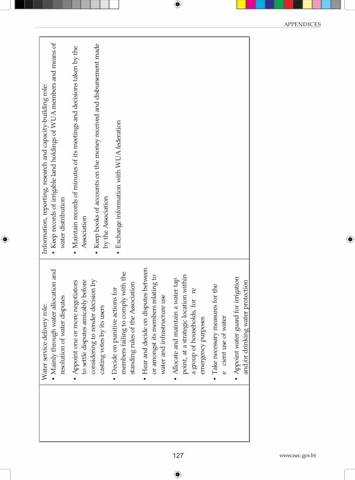
www.nec.gov.bt127
APPENDICES
Wat
er s
ervi
ce d
eliv
ery
role
:
• M
ain
ly t
hro
ugh
wat
er a
llo
cati
on
an
d
reso
luti
on
of
wat
er d
isp
ute
s
• A
pp
oin
t o
ne
or
mo
re n
ego
tiat
ors
to s
ettl
e d
isp
ute
s am
icab
ly b
efo
re
con
sid
erin
g to
ren
der
dec
isio
n b
y
cast
ing
vote
s b
y it
s u
sers
• D
ecid
e o
n p
un
itiv
e ac
tio
ns
for
mem
ber
s fa
ilin
g to
co
mp
ly w
ith
th
e
stan
din
g ru
les
of
the
Ass
oci
atio
n
• H
ear
and
dec
ide
on
dis
pu
tes
bet
wee
n
or
amo
ngs
t it
s m
emb
ers
rela
tin
g to
wat
er a
nd
in
fras
tru
ctu
re u
se
• A
llo
cate
an
d m
ain
tain
a w
ater
tap
po
int,
at
a st
rate
gic
loca
tio
n w
ith
in
a gr
ou
p o
f h
ou
seh
old
s, f
or
fire
emer
gen
cy p
urp
ose
s
• T
ake
nec
essa
ry m
easu
res
for
the
effici
ent
use
of
wat
er
• A
pp
oin
t w
ater
gu
ard
fo
r ir
riga
tio
n
and
/or
dri
nk
ing
wat
er p
rote
ctio
n
Info
rmat
ion
, re
po
rtin
g, r
esea
rch
an
d c
apac
ity-
bu
ild
ing
role
:
• K
eep
rec
ord
s o
f ir
riga
ble
lan
d h
old
ings
of
WU
A m
emb
ers
and
mea
ns
of
wat
er d
istr
ibu
tio
n
• M
ain
tain
rec
ord
s o
f m
inu
tes
of
its
mee
tin
gs a
nd
dec
isio
ns
tak
en b
y th
e
Ass
oci
atio
n
• K
eep
bo
ok
s o
f ac
cou
nts
on
th
e m
on
ey r
ecei
ved
an
d d
isb
urs
emen
t m
ade
by
the
Ass
oci
atio
n
• E
xch
ange
in
form
atio
n w
ith
WU
A f
eder
atio
n

National Environment Commission
Provisional National IWRM Plan 2016 128
Ap
pen
dix
3:
Tra
inin
g p
lan
Sh
ort
ter
m i
n-c
ou
ntr
y gr
ou
p t
rain
ing
wo
rksh
op
s an
d r
efre
sher
co
urs
es
Typ
e o
f
Tra
inin
gT
op
ics
Par
tici
pan
ts/
Rel
evan
t ag
enci
esS
ched
ule
Est
. B
ud
get
(US
$)
Lo
gist
ic R
equ
irem
ents
IWR
M
pri
nci
ple
s
and
pra
ctic
es
• IW
RM
his
tory
/rat
ion
ale;
• IW
RM
pri
nci
ple
s an
d p
ract
ices
;
• M
ult
i-d
isci
pli
nar
y/st
akeh
old
er
con
text
of
IWR
M;
• R
iver
bas
in a
s b
asic
un
it f
or
IWR
M;
• C
on
du
ctin
g w
ater
res
ou
rces
inve
nto
ry;
• IW
RM
pla
nn
ing
and
imp
lem
enta
tio
n s
tep
s.
NE
CS
, G
NH
CS
, M
oA
F,
Mo
EA
, M
oE
, M
oH
, M
oH
CA
,
Mo
WH
S,
CS
Os,
Dzo
ngk
hag
Tsh
ogd
u,
Gew
og
Tsh
ogd
e,
Dis
tric
t W
ater
man
agem
ent
Co
mm
itte
es,
RB
Cs,
WU
As.
Tar
get:
30
On
ce
ever
y F
ive
Yea
r P
lan
per
iod
fo
r
each
riv
er
bas
in
25
00
0
WR
CD
, N
EC
S t
o
pre
par
e tr
ain
ing
pla
n
in c
on
sult
atio
n w
ith
GN
HC
S,
iden
tify
ven
ue
and
rel
evan
t
in-c
ou
ntr
y re
sou
rce
per
son
s.
IWR
M
Pla
nn
ing
and
Co
ord
inat
ion
in B
hu
tan
• B
hu
tan
Wat
er A
ct a
nd
Reg
ula
tio
ns;
• B
hu
tan’
s IW
RM
Co
ord
inat
ion
set-
up
;
• P
lan
nin
g: W
ater
Sec
uri
ty
per
form
ance
ben
chm
ark
ing
and
ind
icat
ors
(K
RA
s an
d K
PIs
);
• R
esu
lts-
bas
ed m
on
ito
rin
g an
d
eval
uat
ion
(M
&E
) fr
amew
ork
s.
NE
CS
, G
NH
CS
, M
oA
F,
Mo
EA
, M
oE
, M
oH
, M
oH
CA
,
Mo
WH
S,
CS
Os,
Dzo
ngk
hag
Tsh
ogd
u,
Gew
og
Tsh
ogd
e,
Dis
tric
t W
ater
man
agem
ent
Co
mm
itte
es,
RB
Cs,
WU
As.
Tar
get:
30
On
ce
ever
y F
ive
Yea
r P
lan
per
iod
fo
r
each
riv
er
bas
in
25
00
0
WR
CD
, N
EC
S t
o
pre
par
e tr
ain
ing
pla
n
in c
on
sult
atio
n w
ith
GN
HC
S,
iden
tify
ven
ue
and
rel
evan
t
in-c
ou
ntr
y re
sou
rce
per
son
s.
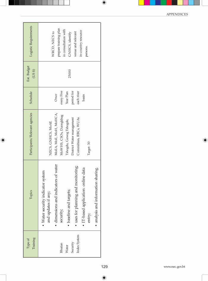
www.nec.gov.bt129
APPENDICES
Typ
e o
f
Tra
inin
gT
op
ics
Par
tici
pan
ts/
Rel
evan
t ag
enci
esS
ched
ule
Est
. B
ud
get
(US
$)
Lo
gist
ic R
equ
irem
ents
Bh
uta
n
Wat
er
Sec
uri
ty
Ind
ex S
yste
m
• W
ater
sec
uri
ty i
nd
icat
or
syst
em
and
up
dat
es i
f an
y;
• d
imen
sio
ns
and
in
dic
ato
rs o
f w
ater
secu
rity
;
• b
asel
ine
and
tar
gets
;
• u
ses
for
pla
nn
ing
and
mo
nit
ori
ng;
• IT
-bas
ed a
pp
lica
tio
n:
on
lin
e d
ata
entr
y;
• an
alys
is a
nd
in
form
atio
n s
har
ing.
NE
CS
, G
NH
CS
, M
oA
F,
Mo
EA
, M
oE
, M
oH
, M
oH
CA
,
Mo
WH
S,
CS
Os,
Dzo
ngk
hag
Tsh
ogd
u,
Gew
og
Tsh
ogd
e,
Dis
tric
t W
ater
man
agem
ent
Co
mm
itte
es,
RB
Cs,
WU
As.
Tar
get:
30
On
ce
ever
y F
ive
Yea
r P
lan
per
iod
fo
r
each
riv
er
bas
in
25
00
0
WR
CD
, N
EC
S t
o
pre
par
e tr
ain
ing
pla
n
in c
on
sult
atio
n w
ith
GN
HC
S,
iden
tify
ven
ue
and
rel
evan
t
in-c
ou
ntr
y re
sou
rce
per
son
s.

National Environment Commission
Provisional National IWRM Plan 2016 130
Reg
ula
r st
ud
y t
ou
r an
d p
arti
cip
atio
n i
n w
ater
eve
nts
an
d f
oru
ms
Typ
e o
f T
rain
ing
To
pic
sP
arti
cip
ants
/ R
elev
ant
agen
cies
Sch
edu
le
Est
.
Bu
dge
t
(US
$)
Lo
gist
ic
Req
uir
emen
ts
Par
tici
pat
ion
in g
lob
al a
nd
regi
on
al W
ater
foru
ms
and
con
fere
nce
s
Glo
bal
Wat
er F
oru
ms
• -
Wo
rld
Wat
er F
oru
ms
• -
Sto
ckh
olm
Wat
er W
eek
• -
Net
her
lan
ds
Wat
er L
earn
ing
Wee
k
WR
CD
, N
EC
S s
taff
(2
) an
d s
elec
ted
fo
cal
per
son
s o
f co
mp
eten
t A
uth
ori
ties
(3
)A
nn
ual
ly1
5,0
00
-
WR
CD
, N
EC
S
to p
lan
, fo
rm a
nd
lead
del
egat
ion
;
- in
clu
sio
n o
f
stak
eho
lder
in
del
egat
ion
;
- id
enti
fy
fun
din
g.
Reg
ion
al W
ater
Fo
rum
s
• -
Ind
ia W
ater
Wee
k
• -
Sin
gap
ore
Wat
er W
eek
• -
AD
B W
ater
Wee
k
WR
CD
, N
EC
S s
taff
(2
) an
d s
elec
ted
fo
cal
per
son
s o
f co
mp
eten
t A
uth
ori
ties
(3
)A
nn
ual
ly1
5,0
00
Stu
dy
tou
rS
tud
y to
ur
for
sele
cted
mem
ber
s o
f th
e
Wan
gch
hu
Bas
in C
om
mit
tee
Sel
ecte
d m
emb
ers
of
Wan
gch
hu
RB
C
(To
tal
14
)20
16
20
16
32
00
0

www.nec.gov.bt131
APPENDICES
Lo
ng
ter
m d
egre
es
Ty
pe
of
Tra
inin
gT
op
ics
Rel
evan
t ag
enci
esP
rop
ose
d
slo
ts
Est
.Bu
dg
et
(US
$)
Do
cto
ral
Deg
ree
Cli
mat
e an
d h
ydro
logi
cal
mo
del
lin
gC
oll
ege
of
Sci
ence
an
d
Tec
hn
olo
gy1
13
0,0
00
Cli
mat
e an
d h
ydro
logi
cal
mo
del
lin
gS
her
ub
tse
Co
lleg
e1
13
0,0
00
Agr
icu
ltu
re a
nd
Irr
igat
ion
sys
tem
s in
mo
un
tain
are
asC
oll
ege
of
Nat
ura
l R
eso
urc
es1
13
0,0
00
Mas
ter
Deg
ree
Mo
del
lin
g an
d I
nfo
rmat
ion
Sys
tem
s fo
r W
ater
Man
agem
ent.
Pro
po
sed
to
pic
s ar
e:
• M
anag
ing
un
cert
ain
ty i
n c
lim
ate
pro
ject
ion
s;
• G
lob
al &
reg
ion
al c
lim
ate
chan
ge (
CC
) is
sues
;
• In
terp
reti
ng
clim
ate
chan
ge p
roje
ctio
ns;
• C
C v
uln
erab
ilit
y &
im
pac
t as
sess
men
t;
• H
ydro
logi
cal
imp
act
anal
ysis
;
• D
elin
eati
ng
wat
ersh
ed b
ou
nd
arie
s;
• A
sses
sin
g w
ater
ava
ilab
ilit
y in
un
gau
ged
bas
ins
WR
CD
, N
EC
S;
DH
MS
,
MO
EA
21
40
,00
0
Lan
d a
nd
Wat
er D
evel
op
men
t fo
r F
oo
d S
ecu
rity
.
Pro
po
sed
to
pic
s in
clu
de:
•
Ass
essi
ng
cro
p w
ater
req
uir
emen
ts;
• O
n-f
arm
wat
er m
anag
emen
t
DO
A,
MO
AF
17
0,0
00

National Environment Commission
Provisional National IWRM Plan 2016 132
Ty
pe
of
Tra
inin
gT
op
ics
Rel
evan
t ag
enci
esP
rop
ose
d
slo
ts
Est
.Bu
dg
et
(US
$)
Hyd
rau
lic
En
gin
eeri
ng
and
Riv
er B
asin
Dev
elo
pm
ent.
Pro
po
sed
to
pic
s in
clu
de:
•
Co
nd
uct
ing
irri
gati
on
en
gin
eeri
ng
surv
eys;
• D
esig
nin
g ir
riga
tio
n a
nd
dra
inag
e st
ruct
ure
s
En
gin
eeri
ng
Div
isio
n,
DO
A,
MO
AF
;
DE
S,
MO
WH
S;
NE
CS
21
40
,00
0
Flo
od
Ris
k M
anag
emen
t
Pro
po
sed
to
pic
s in
clu
de:
•
Flo
od
ris
k a
sses
smen
t an
d f
ore
cast
ing;
• F
loo
d z
on
atio
n m
app
ing;
• F
loo
d p
reve
nti
on
an
d m
anag
emen
t m
easu
res
FE
MD
, D
ES
, M
OW
HS
;
DD
M,
MO
HC
A2
14
0,0
00
Gro
un
d w
ater
hyd
rolo
gy
Pro
po
sed
to
pic
s in
clu
de:
•
gro
un
d w
ater
ass
essm
ent
• te
chn
olo
gies
in
gro
un
d w
ater
ab
stra
ctio
n
DH
MS
, M
OE
A;
DG
M,
MO
EA
21
40
,00
0
Wat
er,
San
itat
ion
an
d H
ealt
h e
ngi
nee
rin
g
Pro
po
sed
to
pic
s in
clu
de:
Ass
essi
ng
do
mes
tic
wat
er r
equ
irem
ents
Wat
er q
ual
ity
mo
nit
ori
ng
PH
ED
, M
OH
; W
SD
, D
ES
,
MO
WH
S2
14
0,0
00
So
il,
wat
er a
nd
En
viro
nm
ent
man
agem
ent
Pro
po
sed
to
pic
s in
clu
de:
•
Ass
essm
ent
of
eco
syst
em s
ervi
ces
• W
ater
shed
del
inea
tio
n a
nd
cla
ssifi
cati
on
• W
ater
shed
man
agem
ent
• S
oil
an
d w
ater
co
nse
rvat
ion
WM
D,
DO
FP
S1
14
0,0
00

www.nec.gov.bt133
APPENDICES
Appendix 4: IWRM planning and coordination
framework based on the BWSI, and responsible agencies
Introduction
Th e NIWRMP should be seen as a framework with tools for the purpose of water-related planning
and coordination. More concrete planning shall be done through the river basin management
plans for which the NIWRMP aims to provide guidelines.
Goal, objectives and strategies
Goal of the National IWRM plan is to achieve water security for Bhutan. Th is is to be accomplished
by better coordination between the water users and key agencies that are managing the water
resources. Th e Bhutan Water Security Index is the mechanism proposed to be used for the
envisaged coordination in planning and management. In other words, it is proposed that the
BWSI will be adopted as National Key Result Area in addition to the 16 KRAs that have already
been defi ned under the planning mechanism established under the Gross National Happiness
Commission. Th e BWSI has 5 Key Dimensions, which would translate into 5 Sectoral Key Result
Areas that would be added to the 300 Sectoral Key Result Areas that are already in use in the FYPs.
Hence, the objectives of the NIWRMP are based on the key dimensions of the BWSI. Th ey
correlate with the Sectoral Key Result Areas in the FYPs and their compliance is measured by
indicators. Th e KRAs and indicators are mostly self-explanatory but will be briefl y explained below.
Th e strategies explain how the objectives of the key dimensions would be realized. A number of
strategies will be mentioned for each Key Dimension, but the list is not meant to be exhaustive.
Some duplication is unavoidable.
Key Dimension 1 (Objective/ KRA)
Improve and protect the drinking water supply, sanitation and hygiene in rural areas
KD1 assesses the extent to which rural household water and sanitation needs are met, and
improved hygiene for public health is provided in all communities. It is a composite of three main
sub-indices (i) access to piped water supply (%), (ii) access to improved sanitation (%), and (iii)
hygiene (incidence of diarrhoea per 10,000 people).

National Environment Commission
Provisional National IWRM Plan 2016 134
Indicators
1. Percentage of population with piped potable water supply
Th is indicator is self-explanatory
2. Percentage of population with improved (sealed) sanitation
As above, this indicator is self-explanatory
3. Incidence of diarrhoea
Diarrhoea is an infectious disease that is related to hygiene and thus related to proper sanitation.
It is expected that the incidences of diarrhoea will reduce when a larger part of the population is
using proper (sealed) sanitation.
Strategies
• Improve the condition of catchment areas and water sources (reforestation and conservation
measures)
• Improve access to alternative drinking water sources (water harvesting, groundwater
development)
• Move human settlements on hill slopes to lower elevations (for better water supply)
• Improve management and maintenance of rural water supply systems (strengthen Water
Users Associations)
• Carry out health campaigns (public awareness)
Key Dimension 2 (Objective/ KRA)
Maximize the economic benefi t of water resources in a sustainable way
Water is an essential input to grow food and fi bre, for many industrial processes, and to generate
the energy required by society. Th e use of water in these sectors is increasingly recognized as
closely related and can no longer be addressed in isolation from each other. Debate about the
water-food-energy nexus has begun to raise general awareness about the critical interaction among
water uses to support economic activities.
Economic water security measures the productive use of water to sustain economic growth in the
food production, industry, and energy sectors of the economy. Th e indicators are aggregates of
multiple sub-indicators, defi ned to highlight key aspects of water security in a particular sector as
described in the following sections. Th ere is debate (also in AWDO) to what extent the indicators
are applicable at basin level – beside national level.
www.nec.gov.bt135
APPENDICES
Sub-dimension 2A1 – Agriculture resilience
Resilience refers to the ability to cope with the adverse eff ects of rainfall variability. Recognizing
that agricultural water use is vulnerable to rainfall variability52 and that water storage constitutes a
viable method to mitigate the eff ects of that variability, a fi rst indicator focuses on these two key
issues.
Indicators
1. Percentage of cropped areas irrigated from reservoirs
Rain-fed agricultural production is susceptible to the weather conditions. Th e larger percentage
of cropped areas can be irrigated from reservoirs, the less vulnerable the agricultural production is
supposed to be.
2. Variability of inter-annual rainfall
Agricultural production depends on rainfall and/ or irrigation. Th e larger the variation of rainfall
over the years, the more vulnerable it is. Rainfall cannot be planned as such, but adaptive measures
for highly vulnerable areas can be planned for. Th at is why this indicator has been adopted.
3. Variability of intra-annual rainfall
As mentioned above, agricultural production depends on rainfall and/ or irrigation. Th e larger the
variation of rainfall within a year, the more vulnerable it is. Rainfall cannot be planned as such,
but adaptive measures for highly vulnerable areas can be planned for. Th at is why this indicator
has been adopted.
Strategies
• Increase number/ volume of water retention structures
• Groundwater exploitation
• Adopt agricultural adaptation measures (water-effi cient crops, increase water use effi ciencies)
Sub-dimension 2A2: Agriculture water utilization effi ciency
Th e water utilization effi ciency is defi ned as a function of agricultural water productivity, and
proportion of arable land irrigated. To characterize the productivity of water use in irrigated
agriculture, we considered the monetary value per unit of water in agriculture, and the percentage
of arable land that is irrigated.
52 Other water uses are vulnerable to rainfall variability as well. Given the greater role of water in agriculture and that
agriculture, after the environment, is usually the residual water user, agriculture can be considered particularly vulnerable.

National Environment Commission
Provisional National IWRM Plan 2016 136
Indicators
1. Agricultural contribution to GDP
Obviously a higher contribution of (irrigated) agricultural production to GDP is desirable.
2. Percentage of arable land irrigated
A higher percentage of cultivable land being irrigated will contribute to higher overall agricultural
production as well as reduction of poverty
3. Percentage of cereal consumption that is imported out of the total cereal consumption
Th is indicator has an inverse appraisal: lower volumes of cereal imports mean higher self-suffi ciency
is achieved in line with the national policies.
Strategies
• Crop diversifi cation/ high-value crops
• Increase irrigated areas
• Increase agricultural water-use effi ciencies
Sub-dimension 2B – Industrial water security
Similar measures as above were applied to industrial water use. However, the number of indicators
used for industry is smaller than for agriculture. Th e reduced number of indicators refl ects both
the reduced proportion of water claimed by industrial uses as well as the relative dearth of data
related to water and industry. Our water-industry indicator has only one indicator and focuses on
water productivity in industry.
Indicator
1. Revenue generated from water-based industries in million Nu/ MCM (productivity)
Like for agriculture, a higher contribution of (water-based) industries to GDP is desirable.
Strategies
• Expand water-based clean industries
• Shift to high-value production

www.nec.gov.bt137
APPENDICES
Sub-dimension 2C - Hydropower water security
Given the direct linkages between water, hydropower, and energy supply in a country, this sub-
dimension directly focuses on hydropower. Th e indicators focus on the dependence of hydropower
on trans-boundary infl ow into Bhutan, the proportion of a country’s technically exploitable
hydropower capability that has been tapped, and the relative contribution of hydropower to a
country’s energy supply, and the plant load factor that indicates how effi ciently the turbines are
used.
Indicators
1. Percentage of volume of trans-boundary infl ow compared with total annual fl ow (internal
renewable water resources + incoming water)
Hydropower generation is to some degree dependent on infl ow from China in Amochhu and
Drangmechhu basins, leaving Bhutan vulnerable. Th is aspect is monitored in this indicator. It has
an inverse appraisal: the lower the value, the more secure is hydropower generation.
2. Percentage of potential hydropower installed
Th e RGOB aims at high development of hydropower, which is monitored by this indicator.
3. Percentage of hydropower contribution to total energy consumption
A high percentage of hydropower in total power consumption indicates less use of fuel wood or
fossil fuel, and is in line with RGOB policy.
4. Hydropower revenue (in million Nu per amount of water used in MCM (productivity)
Like for agriculture and industries, the contribution of hydropower to GDP is monitored.
5. Hydropower effi ciency as weighted average annual plant load factor
Th e plant load factor indicates how effi ciently the generators are being used, or how eff ectively the
river fl ows are used for hydropower generation. Th is is monitored by this indicator.
Strategies
• Increase hydropower development
• Conservation of catchment areas to dampen seasonal fl ow variation and to reduce sediment
load of the water (both expected to worsen under climate change)
• Increase number and volume of water retention structures/ reservoirs to dampen seasonal
fl ow variation and to reduce sediment load of the water

National Environment Commission
Provisional National IWRM Plan 2016 138
Key Dimension 3 (Objective/ KRA)
Improve and protect urban drinking water supply, and improve eff ectiveness of urban
sanitation and drainage
Th e urban water security indicators measure the creation of better water management and services
to support vibrant and liveable water-sensitive cities. A water-sensitive city is defi ned as a city that
integrates water supply, sewage, storm-water, and the built environment; a city that respects the
value of urban waterways; and a city where citizens value water and the role it plays in sustaining
the economy, environment, and society (Brown, Keath, and Wong 2009).
Th e urban water security index is a composite of four sub-indices relating to water supply coverage,
wastewater treatment, garbage collection (to keep water ways clean) and urban fl ooding.
Indicators
1. Percentage of urban population having potable piped water supply
Th is indicator is similar to the one applied for rural drinking water supply and is self-explanatory.
2. Percentage of urban water loss (un-accounted for)
Th is indicator monitors the diff erence between the amounts of water delivered to the households
and paid for, as compared to the amounts pumped into the system. Obviously, the diff erence
should be minimized.
3. Percentage of urban population with improved sanitation
Th is indicator is similar to the one applied for rural areas and speaks for itself.
4. Percentage of urban population with (at-least weekly) waste collection and disposal service
When solid waste is not properly collected and disposed of, it will often end-up in the open water
ways and spoil the quality of the water. Th is aspect is more pronounced in urban areas, where
solid waste collection and disposal can be more effi ciently organized than in thinly populated rural
areas.
5. Damage from urban fl ooding
Monsoon fl oods can damage economic assets and property, particularly when drainage is
inadequate and/or when the water ways or drains are eroding their banks. Th e fl ood dame is
monitored by this indicator.

www.nec.gov.bt139
APPENDICES
Strategies
• Improve the condition of catchment areas and water sources (reforestation and conservation
measures)
• Improve access to alternative drinking water sources (water harvesting, groundwater
development)
• Improve design, maintenance and management of urban water supply systems (strengthen
responsible agencies)
• Water metering and pricing
• Improve urban drainage systems
• Remove settlements from fl ood-prone areas
• Improve solid waste collection and disposal services
• Carry out public awareness campaigns (for health, hygiene, and O&M of water supply &
sanitation systems)
Key Dimension 4 (Objective/ KRA) – Environmental water security
Conserve watersheds and reverse degradation that has already occurred
Rivers have become vulnerable to pressures from pollution, diminished fl ows, watershed
deterioration, and increasing populations and industrial activities. Th e environmental water
security indicator assesses the health of rivers and measures progress on restoring rivers and
ecosystems to health on a national and regional scale. Th e environmental water security index is
composed of four themes – watershed disturbance; pollution; water resource management; and
biotic factors.
Sub-dimension 1 – Watershed disturbance
Th e watershed disturbance theme captures the local-scale impact of land-use change and poor
stewardship within catchments. Drivers include (i) conversion from natural land cover to
cropland; (ii) construction of impervious surfaces; (iii) degradation of uplands and riparian zones
by livestock; and (iv) disconnection of fl oodplains from rivers.
Indicators
1. Fraction of cropland relative to total area
Conversion of natural land cover to cropland often increases the rainfall runoff and erosion,
particularly in steep sloping areas like mostly occur in Bhutan. Th us, this aspect has a negative

National Environment Commission
Provisional National IWRM Plan 2016 140
appraisal from environmental point of view.
2. Fraction of impervious layer relative to total area
Similar to above, built area like houses, roads, parking places tend to increase the rainfall runoff
and have disturbing impact on the watershed.
3. Livestock density
Free roaming cattle have a disturbing impact on the watershed by trampling and compacting the
soil, browsing the vegetation and thus increasing rainfall runoff and erosion. Th e cattle population
density is a measure to monitor this eff ect.
4. Fraction of natural wetland relative to total area
Natural wetlands have an important function in the watersheds in terms of their buff ering eff ect
on water fl ow, and natural cleaning eff ect of water quality, and providing habitat for a range of
organisms and species. Economic development often goes at the expense of natural wetlands by
draining them (and convert them into built or agricultural areas) or by cutting them off from the
rivers. Th is type of watershed disturbance is monitored by this indicator.
Strategies
• Watershed conservation programs, particularly in areas marked as ‘critical’
• Reduce the loss of natural watershed areas to the extent possible (under economic
development)
• Control drainage and erosion from disturbed land surfaces
• Environment-friendly road construction
• Control number of livestock that is roaming free (by stable feeding)
• Protect natural wetlands
• Control forest fi res
• Control (illegal) logging
Sub-dimension 2 – Pollution
Th is sub-dimension encompasses a number of pollutants that have well known direct or indirect
eff ect on water resources and/ or bio-diversity. Indicators include (i) soil salinization; (ii), nitrogen;
(iii) phosphorus; (iv) mercury deposition; (v) pesticide loading; (vi) sediment loading; (vii)
organic loading (as Biological Oxygen Demand, BOD; (viii) potential acidifi cation; (ix) thermal
alteration. As can be seen below, not all these drivers have been adopted in the BWSI.

www.nec.gov.bt141
APPENDICES
Indicators
1. Total suspended solids in ppm
Th e sediment load in the rivers is a factor to be considered in hydropower generation. Sediments
are detrimental to the turbines and should settle in stilling basins that are included in the design
of the hydropower plant.
2. Organic loading/ BOD5
Biochemical oxygen demand is a measure of pollution in terms of the amount of dissolved
oxygen utilized by microorganisms during the oxidation of organic components in the water.
After incubation, the amount of dissolved oxygen consumed is obtained by titration and the
results expressed as parts per million of BOD. Complete biological oxidation generally requires
about 20 days at 68°F. However, the test has been standardized to be completed in 5 days, hence
the term BOD5. BOD can be used as a gauge of the eff ectiveness of wastewater treatment
plants.
Strategies
• Watershed conservation programs to control run-off and erosion, and to keep sediment
loads in the water down
• Expand and improve coverage of sewage treatment
• Draft/ enforce regulations relating to pollution
Sub-dimension 3 – Water resource management
Th e Water Resource Development sub-dimension includes a variety of ways in which people have
altered the quantity of water available to human populations and providing essential ecosystem
services. Indicators include (i) the density of dams within catchments; (ii) the fragmentation of
river networks by dams; (iii) consumptive water loss; (iv) human water stress; (v) agricultural
water stress; (vi); and (vii) fl ow disruption.
Indicators
1. Dam density
Dams in rivers disrupt the free movement of migrating fi sh species. Th e reservoirs change the
temperature of the water as well as the sediments load. Th ese factors have an impact on the
environment. Th erefore the density of dams in the river system is an indicator for water resources
management. A high value has a low appreciation.

National Environment Commission
Provisional National IWRM Plan 2016 142
2. River length de-watered
Th is aspect relates to run-off -the river hydropower plants, whereby the river fl ow is diverted
through the so-called head race tunnel to the generators of the power plant. Th is practice leaves
the river bed with a fraction of the original water fl ow, particularly when environmental fl ow
requirements are not met.
3. Dependable Water availability per capita during lean season (January)
Th e amount of water available per capita is a measure of water resource management. In Bhutan,
this fi gure is only meaningful during the height of the lean season, which is January.
4. Relative total water consumption during lean season (January)
Th e percentage of available water used for consumption is an indicator for water stress. Th e
irrigation demand is low in January. A high percentage has a low appreciation.
5. Relative total water consumption during peak irrigation demand (May)
Th e domestic and industrial consumptive water use is believed to be fairly constant over the year.
But irrigation water demand varies strongly over the months within a year. Peak irrigation demand
occurs in May, when land is prepared for transplanting paddy and the monsoon rains are only just
starting. Like for total (drinking) water consumption in January, total (irrigation) water demand
as percentage of available water is an indicator for water stress in May.
Strategies
• Maintain ecological fl ows
• Plan water-consuming activities (urban centres, irrigation and industries) in those areas
where water availability is good
• Reduce water demand (increase water-use effi ciency, water-effi cient crops, etc.)
• Improve water balance assessments (better quality and coverage of climatic and stream fl ow
data)
Sub-dimension 4 – Biotic factors
Th is theme aims to capture the local and spatially-distributed impacts of changing the biota of
river ecosystems. Humans have altered riverine faunas in many ways. Specifi c drivers include (i)
the percentage of non-native fi sh species; (ii), number of non-native fi sh species; (iii), fi shing
pressure; (iv) and aquaculture pressure. Each of these drivers has a variety of detrimental eff ects
on fresh waters, ranging from changes in the loading and cycling of nutrients to destabilizing food
webs to altering species interactions. Since fi shing and aquaculture play a minor role in Bhutan,
these factors are not included in the BWSI.

www.nec.gov.bt143
APPENDICES
Indicators
1. Number of non-native fi sh species
Th e number of foreign fi sh species is monitored.
2. Percentage of non-native fi sh species
Th e percentage of foreign fi sh species is also considered since it puts the number of foreign fi sh
species in a context.
Strategies
• Monitoring of fi sh (aquatic) species
1.1 Key Dimension (Objective/ KRA) 5 – Disaster and climate change resilience
Reduce socio-economic loss resulting from (climate change induced) water-related disasters,
particularly GLOFs, landslides, and monsoon fl oods/ droughts.
Th ere is an increasing global consensus on the importance of water-related risk management. Risk
management requires quantifi cation of water-related disaster losses at a fi ner temporal and spatial
resolution than currently available for the analysis of trends. Such analysis will provide estimates
of vulnerability and resilience and allow assessment of the eff ectiveness of mitigation policies and
investments. Th e BWSI focuses on: i) Hazards and threats; ii) Sensitivity to exposure; and iii)
Coping and adaptive capacity.
Th e complexity of assessment of water-related disasters is such that the computations of the
resilience indicators are the most complex in the AWDO water security index. In fact, these could
not be replicated and therefore the BWSI uses a simple linear scoring.
NB: Many of the phenomena captured in the indicators below cannot be planned as such, but
their implications can be planned for. Th at is why the following indicators have been adopted in
the BWSI.
Sub-dimension 5A – Hazards and threats
Disaster risk (R) is defi ned as an indicator of expected disaster damage per capita, taking into
account the likelihood of occurrence and likely severity. Likelihood of occurrence is not measured
by a strict joint probability of hazard occurrence and vulnerability but by a statistical average of
hazardous phenomena, such as an area’s average daily maximum precipitation. Hence, a hazard is
a potentially damaging physical event, phenomenon, or human activity that may cause the loss of
National Environment Commission
Provisional National IWRM Plan 2016 144
life, injury, property damage, social or economic disruption, or environmental degradation.
Indicators
1. Maximum total one-week precipitation during the year
Extreme high rainfall is an obvious threat and potential cause of disaster; hence it is used as an
indicator.
2. Inventory of hazardous GLOF lakes
Glacial Lakes at risk of having an outburst fl ood are also a threat. An inventory of such lakes is
used as an indicator for assessing resilience.
3. Frequency of rainfall > 100 mm/day
A high frequency of high rainfall events is indicative for risk of fl ooding.
4. Maximum number of consecutive dry days (< 1 mm/day)
Prolonged periods of drought form the opposite risk of fl ooding, but put a high demand on
management of the water resources. Hence, drought periods are an indicator in the BWSI.
Strategies
• Strategies for adaptation to extreme weather events
• Update inventory of GLOFs and design/ implement mitigating measures
• Improve weather forecasting system (expand/ improve weather and fl ow monitoring
stations)
• Design/ implement early warning systems for fl oods
• Water retention/ infi ltration structures
• Drainage improvement/ river training works
Sub-dimension 5B – Sensitivity to exposure
Exposure relates to the people, property, systems, or other elements present in the area that may
be aff ected by a hazard or threat.
www.nec.gov.bt145
APPENDICES
Indicators
1. Dry-land (Kamzhing) as percentage of total area
A high percentage of dry-land of total area means that much of the agricultural land is dependent
on rainfall, which amounts to a sensitivity.
2. Percentage (annual) change in forest cover over the last 5 years
Th is indicator measures the rate of de-forestation and the related increase in runoff and erosion.
3. Deviation from constitutionally mandated forest cover (60%) at national and basin level
Th is indicator monitors the deviation from the mandated forest cover as a measure of sensitivity
to extreme weather events.
4. Population density
Obviously, a high population density is more sensitive to exposure to extreme weather events than
a low population density.
5. Urban population density
Same as above
6. Urban population growth rate (Th romdes)
Same as above
7. Total population growth rate
A fast growing population is more sensitive to exposure to extreme weather conditions than a
stable population.
Strategies
• Watershed conservation and re-forestation (including Payment for Environmental Services)
• Water retention/ infi ltration structures
• Move human settlements away from fl ood/ drought-prone areas
Sub-dimension 5C – Coping and adaptive capacity
Coping relates to the ability of dealing with disaster in terms of preparedness and/or mitigating
measures. Adaptive capacity is the ability to adjust to a changing environment. Th e indicators are

National Environment Commission
Provisional National IWRM Plan 2016 146
mentioned below.
Indicators
1. Governance
Number of basins with functional RBCs with:
• Secretariat formed
• RBMP prepared or under implementation
• At least one RBC meeting held /year
2. Poverty rate
Poor communities are less capable of coping with disasters and adverse conditions. Hence poverty
rate is adopted as an indicator in the BWSI.
3. Child mortality rate (0-5).
Th e child mortality rate is a considered as an (inverse) proxy for the vitality of the population.
With higher child mortality, the population is weaker and thus less adaptive to adverse conditions.
4. Net offi cial development assistance as percent of gross national income
With high development assistance, the community is expected to cope better with disaster.
5. Establishment of (eff ective) Emergency Response Mechanisms
RGOB policy aims at establishing emergency response units in each district. Th is indicator
monitors the progress.
6. Reservoir capacity
Reservoirs will dampen runoff waves in the rivers, hence a high reservoir capacity is a good way to
buff er the peak fl ows.
7. Flood/ drought hazard zonation maps produced and updated
Maintaining updated maps of fl ood hazard zones is a good way of coping with fl ood risk.
8. Number of (identifi ed) fl ood protection measures pending for implementation
Th is indicator assumes that the area is relatively safe from fl ooding if the identifi ed fl ood protection
www.nec.gov.bt147
APPENDICES
measures have largely been implemented, so there are few remaining to be done. (NB: Th e number
of fl ood protection measures implemented does not always mean that the area is safe!)
9. Number of fl ood/GLOF Early Warning Systems pending for implementation
Similar to above
10. Literacy ratio
Literate communities will be better able to cope adverse conditions because their higher level of
understanding, but also because they can be informed more easily (by radio, TV, mobile phone)
on what to do or not to do.
11. Education level of women for enhanced coping capacity (with CC impacts)
Similar to above. Women can direct households/ children in case of adverse conditions. A better
education will enable to better cope with this task.
12. Access to information – TV, radios
TV and radio are important means to inform communities about what actions to take.
13. Access to Information – mobile phones
Similar to above.
14. Gross domestic savings relative to GDP
A larger amount of savings will enable communities to cope better with adverse conditions by
investing in the necessary mitigating/ adaptation measures.
Strategies
• Formation and strengthening of River Basin Committees
• Formulation/ updating/ implementation of (comprehensive) river basin management plans
• Re-align district and Gewog boundaries to match hydrological boundaries
• Pursue economic development (in sustainable way)
• Improve reach/ eff ectiveness of emergency response mechanisms
• Increase number/ volume of water retention/ infi ltration structures
• Maintain updated fl ood/ drought hazard zonation maps
• Expand/ improve early warning systems
• Identify/ implement fl ood mitigation measures

National Environment Commission
Provisional National IWRM Plan 2016 148
• Pursue literacy and general education
• Promote access of communities to TV, radio, and mobile phones
• Reserve emergency funds

www.nec.gov.bt149
APPENDICES
Parameters of the BWSI and agencies responsible
Key
DimensionParameter Agency responsible for data
KD-1RURAL DRINKING WATER SUPPLY &
SANITATION
1% of population linked to piped water
supply
Department of Public Health,
MOH
2% of population with access to improved
(water sealed toilets)
Department of Public Health,
MOH
3hygiene by incidence of diarrhea/ 10,000
inhabitants per year
Department of Public Health,
MOH
KD-2 ECONOMIC WATER SECURITY
KD-2A1 Agriculture resilience
1 % of cropped area irrigated from reservoirMoAF/DoA/Dzongkhag
(DAO)/
2 variability of inter-annual annual rainfall DHMS, MoEA
3 variability of intra-annual rainfall DHMS, MoEA
KD-2A2 Agricultural water utilization
1Agricultural productivity - contribution to
GDP in Nu/ MCMDOA, MoAF
2 % Arable land irrigated DOA, MoAF
3Amount of cereals imported out of cereals
consumed (MT )NSB/ DRC
KD-2B Industrial water security
1Revenue generated from water based
industriesDept. of Industry, MOEA
KD-2C Hydropower water security
1Percentage annual national trans-boundary
infl owDHMS
2 % of potential hydropower capacity installedDHPS, MOEA (> 25 MW)/
DRE (< 25 MW)
3% hydropower contribution to total energy
consumptionDHPS, MOEA

National Environment Commission
Provisional National IWRM Plan 2016 150
4Hydropower contribution to GDP in
million Nu/ MCMNSB
5Hydropower Effi ciency (weighted average
annual plant load factor)DHPS, MOEA
KD-3 URBAN WATER SECURITY
1% of urban population having potable water
supply- Urban
Water and Sanitation
Division, DES, MoWHS
2 urban water lossesWater and Sanitation
Division, DES, MoWHS
3% of population without improved
sanitation
Water and Sanitation
Division, DES, MoWHS
4% of urban population with at least weekly
solid waste collection and disposal service
Water and Sanitation
Division, DES, MoWHS
5Damage from urban fl ooding/ capita / GDP
per capita
Flood Engg Mgmt Div., DES
MoWHS
KD4 ENVIRONMENTAL WATER SECURITY
KD-4A Environment - Watershed disturbance
1 Fraction of land cultivated DoA, MoAF
2 Fraction of impervious surface area. DoA, MoAF
3 Livestock density. DoL, MoAF
4 Natural Wetland status. WMD, DOFPS
KD-4B Environment - pollution
1 Total suspended solids. DHMS
2 Organic loading/ BOD NOP, DOA, MoAF
KD-4CEnvironment - Water resources
management
1 Dam densityDHPS, MoEA and DRE,
MOEA
2Percentage of the length of main and
primary river(s) dewatered (for Hydropower)DHPS, MoEA
3Relative total water consumption in the lean
period - JanuaryWSD, DES
4Relative total water consumption in the lean
period - MayWSD, DES

www.nec.gov.bt151
APPENDICES
KD-4D Environment - Biotic factors
1 Number of non-native fi sh species. National Fishery Centre,
MoAF
2 % non-native fi sh species
KD-5DISASTER & CLIMATE CHANGE
RESILIENCE
KD5A Hazards and Th reats
1Maximum total one week precipitation
(millimetre) DHMS
2Inventory of Potential hazardous lakes for
GLOF Risk DGM, MOEA
3Frequency (>100 millimetre/day rainfall) per
year DHMS
4Number of consecutive dry days (< 1
millimetre rainfall) DHMS
KD5B Sensitivity to exposure
1Dry-land (Kamzhing) area as percentage of
total area DoA, MoAF
2Percentage change in forest cover over the
last fi ve years DOFPS, MOAF
3Deviation from constitutionally mandated
forest cover (60%) at national and basin level DOFPS, MOAF
4 Population density (numbers per Km2) NSB
5 Urban Population density NSB
6Urban population growth rate (Projected
based on 2005 baseline data)MOWHS/ NSB
7 Total population growth rate (projected) NSB
KD5C Coping and Adaptive capacity
1 Governance NEC
2 Poverty Rate NSB
3 Child mortality rate (0-6). Bhutan Health Mgmt Inf.
System, PPD, MoH
4Net offi cial development assistance as
percent of gross national income DPA, MOF

National Environment Commission
Provisional National IWRM Plan 2016 152
5Establishment of Emergency Response
Mechanisms (EOCs/EC..)DDM/districts/MOHCA
6 Total reservoir capacity per Districts DoHPS/DOA
7Flood Hazard zonation maps produced and
updatedFEMD, DES
8Flood protection measures pending for
implementationFEMD, DES
9 Flood/GLOF Early Warning Systems DHMS, MOEA
10 Literacy ratio PPD, MoE
11 Education (enrolment ratio) PPD, MoE
12Information (television/Radio receivers per
1,000 inhabitants) PPD, MOIC
13 Information (mobile phone subscription) PPD, MoIC
14 gross domestic saving NAPD, NSB
Grand Total= 57
(Footnotes)
1 Global Water Partnership: http://www.gwp.org/Th e-Challenge/What-is-IWRM/
2 https://docs.google.com/a/universitywatersectorpartnership.org
3 UN-Water: http://www.unwater.org/topics/water-security/en
4 http://www.iadclexicon.org/water-availability/
5 https://en.wikipedia.org/wiki/Water_balance
6 Godfrey, J. and K. Chalmers (editors). Water Accounting: International Approaches to Policy and Decision-
making. Edward Elgar Publishing, 2012
7 https://water.usgs.gov/nwsum/WSP2425/defi nitions.html
8 http://www.epa.gov/wetlands/what-wetland
9 Th e Government Performance Monitoring System has come into practice, but PLAMS has not been abandoned.

www.nec.gov.bt153
APPENDICES

National Environment Commission
Provisional National IWRM Plan 2016 154

www.nec.gov.bt155
APPENDICES

National Environment Commission
Provisional National IWRM Plan 2016 156