national environmental satellite, data, and information ... 101 jan 2015.pdf · • migratory...
TRANSCRIPT

National Environmental Satellite,
Data, and Information Service
(NESDIS)
The Nation’s Operational Environmental Satellite Agency

National Environmental Satellite, Data, and Information Service (NESDIS)
2
NESDIS Organizational Chart

MISSION
Our mission is to deliver accurate, timely, and reliable satellite
observations and integrated products and to provide long-term
stewardship for global environmental data in support of the NOAA
mission.
NESDIS Mission
NOAA National Environmental Satellite, Data, and Information Service (NESDIS) 3

4
NOAA/NESDIS data products and services underpin and support NOAA’s mission of
Science, Service and Stewardship
Weather Ready Nation •Continuous surveillance for severe
weather
•Primary input for numerical prediction models
•Real-time images/products
Resilient Coastal Communities and Economies
• Oil spill monitoring and analysis
• Hydrologic monitoring
• Arctic sea ice analysis
• Coral reef bleaching alerts
• Harmful algal bloom detection
• Migratory tracking
Healthy Oceans
Climate Adaptation and Mitigation • Long-term climate record
• Sea-level rise
• Sea surface temperature
NOAA National Environmental Satellite, Data, and Information Service (NESDIS)
NESDIS Mission Supports NOAA’s Mission and Goals

5
Deepwater Horizon
Montage of 2010 Hurricane
Season Satellite-tagged Dolphin
DART Tsunami Buoy Coral Reef Watch
El Nino signature
Search & Rescue
Harmful Algal Bloom Ozone Hole
Supporting NOAA’s Mission
Snow & Ice Chart
AVHRR Composite
Stream gage
GOES SXI image
National Environmental Satellite, Data, and Information Service (NESDIS)

Department of Commerce’s Primary
Mission Essential Functions
Collect and provide the Nation with intelligence data, imagery, and other essential information for predictive environmental and atmospheric modeling systems and space-based distress alert systems by operating NOAA-controlled satellites, communications equipment, and associated systems
Provide the Nation with environmental forecasts, warnings, data, and expertise critical to public safety, disaster preparedness, all-hazards response and recovery, the national transportation system, safe navigation, and the protection of the Nation’s critical infrastructure and natural resources
6

Supporting the Nation’s Priorities
7
Hazards, Severe
Weather, Watches,
Warnings
Climate
Agriculture Environmental
Monitoring Commerce
Defense
Transportation
Industry
Oceans and
Coasts
National Environmental Satellite, Data, and Information Service (NESDIS)

National Environmental Satellite, Data, and Information Service (NESDIS) 8
Environmental Intelligence: NOAA Products and Services Support To the
Public’s Decision-making
Environmental decisions can impact lives, property and segments of the economy for years.
Environmental intelligence includes weather warnings or forecasts, tsunami and flood alerts, space weather, fire and drought reports and predictions, ice monitoring or harmful algal bloom assessments.
Critical information is tied to observations, modeling and computer resources.
Decision support tools are essential to effectively convey information.

NOAA National Environmental Satellite, Data, and Information Service (NESDIS) 9
An End-to-End Responsibility
Requirements & Planning
System Acquisition Launch
Command & Control
Real-Time Product Development
& Distribution
Data Archive & Access
Products & Services

Providing On-Orbit Satellite Operations
Geostationary satellites (GOES)
Polar-orbiting satellites (POES; Suomi NPP)
Defense Meteorological Satellite Program (DMSP) DMSP is operated by NOAA for the U.S. Air Force
Jason-2 altimetry satellite
Acquiring Next Generation Satellites
GOES–R Satellite Series
Joint Polar Satellite System (JPSS)
DSCOVR (Solar Wind Continuity)
Jason-3 Altimetry Satellite
COSMIC-2 Radio Occultation
Providing Long Term Data Stewardship
National Environmental Information Office
National Climatic Data Center
National Oceanographic Data Center
National Geophysical Data Center
10
GOES
POES
Jason-2
NOAA National Environmental Satellite, Data, and Information Service (NESDIS)
JPSS
NESDIS Principal Activities
Suomi NPP
GOES-R

Satellite Information Flow
National Environmental Satellite, Data, and Information Service (NESDIS) 11
Fairbanks, AK Ground Station
Wallops, VA Ground Station
NOAA Satellite Operations Facility Suitland, MD
Svalbard, Norway Ground Station
Environmental Satellite
Processing Center
Satellite Applications
Data & Products
Archive
Direct Services
McMurdo, Antarctica Ground Station
Government
Military
Universities
Private Industry
Public
GOES
POES
Suomi-
NPP
Jason-2
DMSP
COSMIC
Metop
Meteosat
MTSAT
NASA EOS
Government
Military
Universities
Private
Industry
Public

Functions include: Orbit Determination
Spacecraft Navigation
Data Acquisition
Product Development and Distribution
NOAA supports over 17 satellites daily
Satellite-assisted Search and Rescue
National Ice Center
Product Processing and Distribution
12
Photo Courtesy of: Michael A. Stewart
24 hours a day, 7 days a week,
365 days a year
NOAA National Environmental Satellite, Data, and Information Service (NESDIS)
NOAA Satellite Operations

Three Observation Points
NOAA National Environmental Satellite, Data, and Information Service (NESDIS) 13
N
S
Polar-orbiting Operational
Environmental Satellites
Geostationary Operational
Environmental Satellites
N
S
Each satellite covers the Earth twice per day
Pole-to-pole orbit is 102 minutes and views
each location at the same time of day
Global coverage every 12 hours with one
satellite
EUMETSAT in the mid-morning orbit; NOAA in
the early afternoon orbit
Continuous monitoring of the Americas
Same geographic image over time
Full image every 30 minutes and
Northern Hemisphere images every 15
minutes
Usable images between 60oN and 60oS
Deep Space at Lagrange 1
Point
Continuous monitors the surface of the
Sun
Uninterrupted view of the sun
Located ~1 million miles from Earth,
at the Lagrange Point 1 position of
the Sun-Earth system
~1 million Miles

Benefits
Ensures continuity of global weather observations and critical
environmental data around the world
Delivers real-time data to the National Weather Service,
improving the quality of forecasts and enabling improved
consistency in public warnings 3 to 7 days in advance of a
severe weather event
Provides critical monitoring for hurricanes, droughts, floods,
snowstorms and other severe weather events, allowing for the
time to protect lives and property through evacuations and
other preparations
Advances weather, climate, environmental and oceanographic
science through technological improvements in satellite
instruments and capabilities over legacy NOAA satellites
Launch Commitment Dates No later than 2Q FY 2017 (JPSS-1)*; 1Q FY 2022 (JPSS-2)
Program Architecture
3 Satellites (Suomi NPP, JPSS-1, JPSS-2)
Suomi NPP – 5 year operational design life;
JPSS-1 – 7 year operational design life
Program Operational Life FY 2012 - FY 2025
Program Life-cycle (FY 2015 President’s Budget) $11.323 billion
JPSS Overview
14 NOAA National Environmental Satellite, Data, and Information Service (NESDIS)
*Launch Date based on FY 2015 President’s Budget Request

JPSS-1 Instruments Measurements
ATMS - Advanced Technology
Microwave Sounder
ATMS and CrIS together provide high vertical
resolution temperature and water vapor
information needed to maintain and improve
forecast skill out to 7 days in advance for
extreme weather events, including hurricanes
and severe weather outbreaks CrIS - Cross-track Infrared Sounder
VIIRS – Visible Infrared Imaging
Radiometer Suite
VIIRS provides many critical imagery products
including snow/ice cover, clouds, fog, aerosols,
fire, smoke plumes, vegetation health,
phytoplankton abundance/chlorophyll
OMPS - Ozone Mapping and Profiler
Suite Nadir
Ozone spectrometers for monitoring ozone hole
and recovery of stratospheric ozone and for UV
index forecasts
CERES - Clouds and the Earth’s
Radiant Energy System
Scanning radiometer which supports studies of
Earth Radiation Budget (ERB)
NOAA National Environmental Satellite, Data, and Information Service (NESDIS) 15
JPSS-1 Instruments
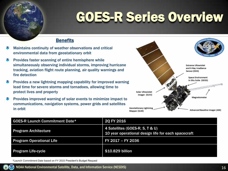
GOES-R Launch Commitment Date* 2Q FY 2016
Program Architecture 4 Satellites (GOES-R, S, T & U)
10 year operational design life for each spacecraft
Program Operational Life FY 2017 – FY 2036
Program Life-cycle $10.829 billion
GOES-R Series Overview
16 NOAA National Environmental Satellite, Data, and Information Service (NESDIS)
*Launch Commitment Date based on FY 2015 President’s Budget Request *
Benefits
Maintains continuity of weather observations and critical
environmental data from geostationary orbit
Provides faster scanning of entire hemisphere while
simultaneously observing individual storms, improving hurricane
tracking, aviation flight route planning, air quality warnings and
fire detection
Provides a new lightning mapping capability for improved warning
lead time for severe storms and tornadoes, allowing time to
protect lives and property
Provides improved warning of solar events to minimize impact to
communications, navigation systems, power grids and satellites
in orbit

Visual & IR Imagery Lightning Mapping Space Weather Monitoring Solar Imaging
Advanced Baseline
Imager (ABI)
Geostationary Lightning
Mapper (GLM)
Magnetometer
Extreme UV/X-Ray
Irradiance Sensors (EXIS)
Terrestrial Weather Solar Weather
Space Environment In-Situ
Suite (SEISS)
Solar Ultra-Violet Imager
(SUVI)
17
Key for “nowcasting” out to 3 days
Improves hurricane track & intensity
forecasts
Increases thunderstorm & tornado
warning lead time
Improves aviation flight route planning
Data for long-term climate variability
studies
Improves solar flare warnings for
communications and navigation
disruptions
More accurate monitoring of
energetic particles responsible for
radiation hazards to humans and
spacecraft
Better monitoring of Coronal
Mass Ejections to improve
geomagnetic storm forecasting
GOES-R Instruments
NOAA National Environmental Satellite, Data, and Information Service (NESDIS)

Partnered Missions
National Environmental Satellite, Data, and Information Service (NESDIS) 18
Future Missions Legacy System
2Q FY 2015
• Deep Space Climate Observatory (DSCOVR), a joint NOAA, NASA, US Air Force
mission
NASA Advanced Composition Explorer
(ACE), launched in 1997
2Q FY 2015
• Jason-3, a joint US (NOAA and NASA) and European (EUMETSAT and CNES)
mission
Jason-2, launched in 2008
FY 2016
• First, 6 COSMIC-2 satellites, a joint US (NOAA, NASA, US Air Force) and Taiwan
mission
COSMIC-1, launched in 2006
2Q FY 2016
• GOES-R, NOAA with NASA as the acquisition agent
GOES-P, launched in 2010
2Q FY 2017
• JPSS-1, NOAA with NASA as the acquisition agent
Suomi NPP, launched in 2011; NOAA-19,
launched in 2009
1Q FY 2019
• Metop-C, a joint NOAA and EUMETSAT mission, with NASA acquisition support
Metop-B, launched in 2012
TBD
• SIDAR , a joint NOAA, NASA, EUMETSAT, French Space Agency, Canadian
Department of Defence mission
• TSIS-1
• ARGOS-DCS, SARSAT
SORCE, launched in 2003; TCTE,
launched in 2013
NOAA-19, launched in 2009

NGDC
Boulder, CO
NCDC
Asheville, NC
NODC
Silver Spring, MD
NODC/NCDDC
Bay St. Louis, MS
Data Centers & Information Services:
Archive, Access and Assessment
NOAA National Environmental Satellite, Data, and Information Service (NESDIS)
NOAA’s National Environmental Information Office provide long-term preservation, management, data
stewardship and ready accessibility to the world’s largest source of oceanographic, geophysical, solar-terrestrial
and climatic data
NESDIS operates NOAA’s Central and Regional library system to support NOAA’s scientific/technical personnel.
More than weather, NESDIS is the loci for integration of data from various sources to address complex
environmental challenges, e.g., Gulf of Mexico “dead zone,” long-term polar ice trends, drought monitoring.
Over 10 Petabytes of
data in NOAA’s
National Data Centers
Over 4.1 PBs of data
served in FY 2012,
over 50 % annual
growth rate
19

Current Challenges
NOAA National Environmental Satellite, Data, and Information Service (NESDIS) 20
Continuity of critical observations for current weather forecasting
needs until future systems come on-line
Maintaining brisk pace as we develop the next generation systems
Being responsive to stakeholder pressure to make our systems and
processes more cost-effective
Maintaining an adequate cybersecurity posture without impeding full
and open access our data and information services.

NOAA National Environmental Satellite, Data, and Information Service (NESDIS) 21
Summary
NESDIS’ mission is to deliver accurate, timely, and reliable satellite
observations and integrated products and to provide long-term stewardship for
global environmental data in support of the NOAA mission
Next generation systems offer significant advantages over the legacy on-orbit
systems, and they remain on schedule and within budget as they progress
towards launch
The NESDIS satellite enterprise benefits from strong partnerships, both
domestically and internationally
The President’s FY 2015 Budget request preserves NESDIS’ core functions,
focuses on key mission areas, and provides strategic investments for new
activities

Back Up Slides
NOAA National Environmental Satellite, Data, and Information Service (NESDIS) 22

Weather-Ready Nation
23 NOAA National Environmental Satellite, Data, and Information Service (NESDIS)
Hurricane Sandy
October 2012 Snowmageddon 2011
2008
Flooding of
Cedar
Rapids,
Iowa

24 NOAA National Environmental Satellite, Data, and Information Service (NESDIS)
Resilient Coastal Communities and Economies
Ecosystems Data
Management
Ocean Altimetry
Sea surface temperature

NOAA National Environmental Satellite, Data, and Information Service (NESDIS) 25
Healthy Oceans
NOAA National Data Buoy Center March 11, 2011 – Tsunami Wave Height Model
Harmful Algal Blooms

JPSS Program Locations
NOAA National Environmental Satellite, Data, and Information Service (NESDIS) 26
Advanced Technology
Microwave Sounder (ATMS)
Northrop Grumman
Electronic Systems
Azusa, CA & Linthicum, MD
JPSS-1 spacecraft
contractor
Ball Aerospace
Boulder, CO
Visible Infrared Imager
Radiometer Suite (VIIRS)
Raytheon
El Segundo, CA
JPSS Command and
Control @ NSOF
NOAA
Suitland, MD
JPSS Program
Management
NOAA with NASA support
Greenbelt, MD
Ozone Mapping and
Profiler Suite (OMPS)
Ball Aerospace
Boulder, CO & Azusa,
CA
Ground System
Raytheon
Aurora, CO
The Cloud and Earth Radiant
Energy System (CERES)
Northrop Grumman
Aerospace Corp.
Azusa, CA
Cross-track Infrared
Sounder (CrIS)
Exelis
Fort Wayne, IN
Government presence
Contractors
JPSS Remote Back up
NOAA
Fairmont, WV
Launch Site
Vandenberg Air Force
Base, Lompoc, CA
JPSS-1 Launch Vehicle
contractor
United Launch Services
Englewood, CO
Longterm Archive and Access
NOAA, National Climatic Data
Center
Asheville, NC
Backup Command and Data
Acquisition Station
NOAA Fairbanks Satellite
Operations Facility
Fairbanks, AK

GOES-R Series Program Locations
NOAA National Environmental Satellite, Data, and Information Service (NESDIS) 27
Geostationary
Lightning Mapper
(GLM) contractor
Lockheed Martin
Advanced Tech Corp.
Palo Alto, CA
Advanced Baseline Imager (ABI)
contractor
Exelis
Ft. Wayne, IN & Rochester, NY
Spacecraft bus &
Magnetometer contractor
Lockheed Martin Space Systems
Newtown, PA
Denver, CO
Greenbelt, MD
Stennis Space Center, MS
Space Environmental In-
Situ Suite (SEISS)
contractor
Assurance Technology
Corp.
Carlisle, MA Extreme Ultra Violet / X Ray
Irradiance Sensor (EXIS)
Laboratory for Atmospheric
and Space Physics
Boulder, CO
Solar Ultra Violet
Imager (SUVI)
contractor
Lockheed Martin
Advanced Tech Corp.
Palo Alto, CA
Core Ground segment
Harris Corp.
Melbourne, FL
Greenbelt, MD
Omaha, NE
Lexington, MA
Springfield, VA
Denver, CO
Antenna contractor
Harris Corp.
Melbourne, FL
Richardson, TX
Omaha, NE
GOES-R Command and
Control @ NSOF
NOAA
Suitland, MD
Command and Data
Acquisition Station
NOAA
Wallops, VA
GOES-R Program
Management
NOAA with NASA support
Greenbelt, MD
Contractors
Government presence
Launch Site
Cape Canaveral Air Force Station
Cape Canaveral, FL
GOES-R & -S Launch
Vehicle contractor
United Launch Services
Englewood, CO