national geodetic survey stakeholder engagement update ... · national geodetic survey stakeholder...
TRANSCRIPT
National Geodetic Survey
Stakeholder Engagement Update
HSRP
October 2014
geodesy.noaa.gov

Overview of Discussion Topics
• ForeSee Results – Recent feedback • NGS Stakeholder Engagement Activities:
– Transition to a Regional Geodetic Advisor Program – NGS “One Voice” – NGS Constituent Resources Committee – 2015 Geospatial Summit
ForeSee Results
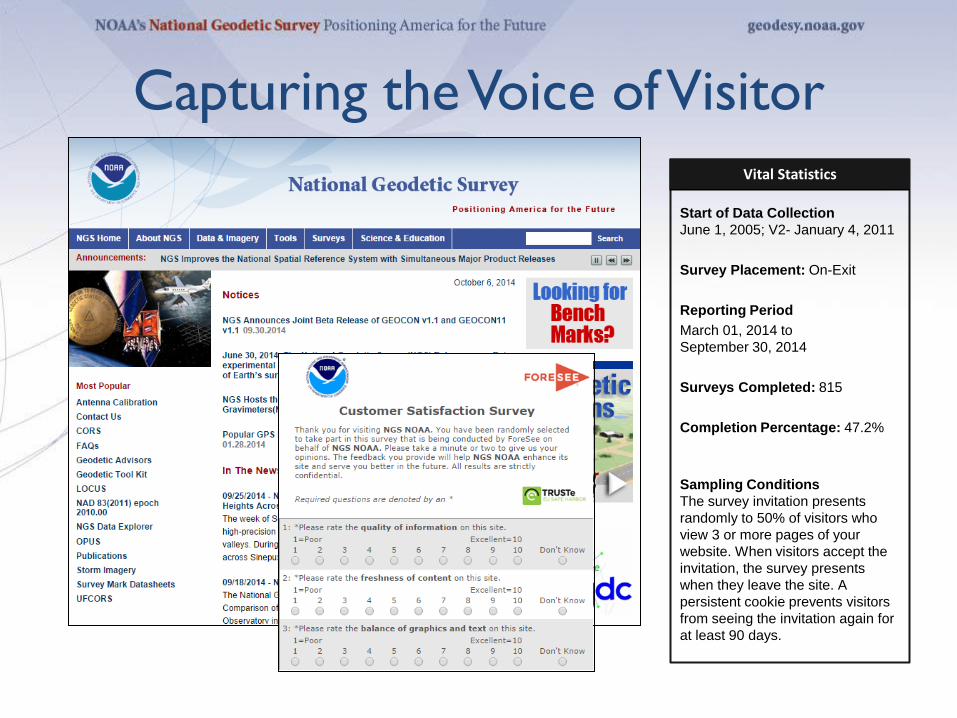
Vital Statistics
Start of Data Collection June 1, 2005; V2- January 4, 2011
Survey Placement: On-Exit Reporting Period March 01, 2014 to September 30, 2014 Surveys Completed: 815 Completion Percentage: 47.2% Sampling Conditions The survey invitation presents randomly to 50% of visitors who view 3 or more pages of your website. When visitors accept the invitation, the survey presents when they leave the site. A persistent cookie prevents visitors from seeing the invitation again for at least 90 days.
Capturing the Voice of Visitor

5 NOAA NGS > Satisfaction Insight Review
Aggregate Results Satisfaction Summary
How is your site doing? How does your site’s score compare with others?*
Where should you focus your efforts? Why does improving satisfaction matter?
Maximum
Average
Minimum
The NOAA NGS site reached a new peak for overall satisfaction during the month of September. Visitors to the site are very likely to both recommend the site and return to it in the future.
* September 2014 scores only
6 NOAA NGS > Satisfaction Insight Review
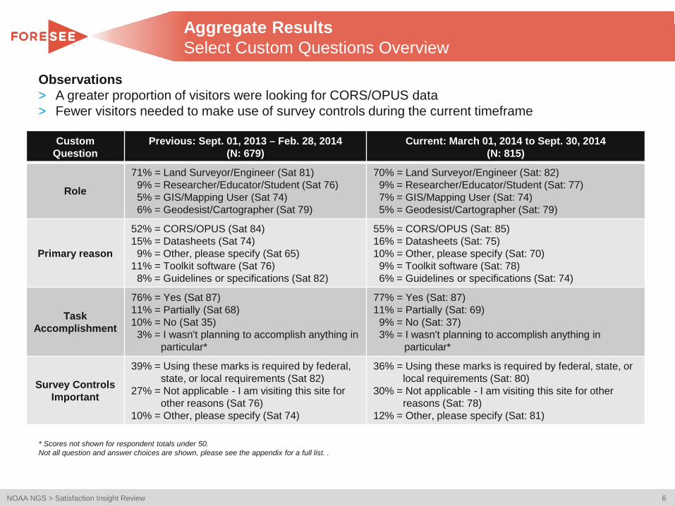
Custom Question
Previous: Sept. 01, 2013 – Feb. 28, 2014 (N: 679)
Current: March 01, 2014 to Sept. 30, 2014 (N: 815)
Role
71% = Land Surveyor/Engineer (Sat 81) 9% = Researcher/Educator/Student (Sat 76) 5% = GIS/Mapping User (Sat 74) 6% = Geodesist/Cartographer (Sat 79)
70% = Land Surveyor/Engineer (Sat: 82) 9% = Researcher/Educator/Student (Sat: 77) 7% = GIS/Mapping User (Sat: 74) 5% = Geodesist/Cartographer (Sat: 79)
Primary reason
52% = CORS/OPUS (Sat 84) 15% = Datasheets (Sat 74) 9% = Other, please specify (Sat 65) 11% = Toolkit software (Sat 76) 8% = Guidelines or specifications (Sat 82)
55% = CORS/OPUS (Sat: 85) 16% = Datasheets (Sat: 75) 10% = Other, please specify (Sat: 70) 9% = Toolkit software (Sat: 78) 6% = Guidelines or specifications (Sat: 74)
Task Accomplishment
76% = Yes (Sat 87) 11% = Partially (Sat 68) 10% = No (Sat 35) 3% = I wasn't planning to accomplish anything in
particular*
77% = Yes (Sat: 87) 11% = Partially (Sat: 69) 9% = No (Sat: 37) 3% = I wasn't planning to accomplish anything in particular*
Survey Controls Important
39% = Using these marks is required by federal, state, or local requirements (Sat 82)
27% = Not applicable - I am visiting this site for other reasons (Sat 76)
10% = Other, please specify (Sat 74)
36% = Using these marks is required by federal, state, or local requirements (Sat: 80)
30% = Not applicable - I am visiting this site for other reasons (Sat: 78)
12% = Other, please specify (Sat: 81)
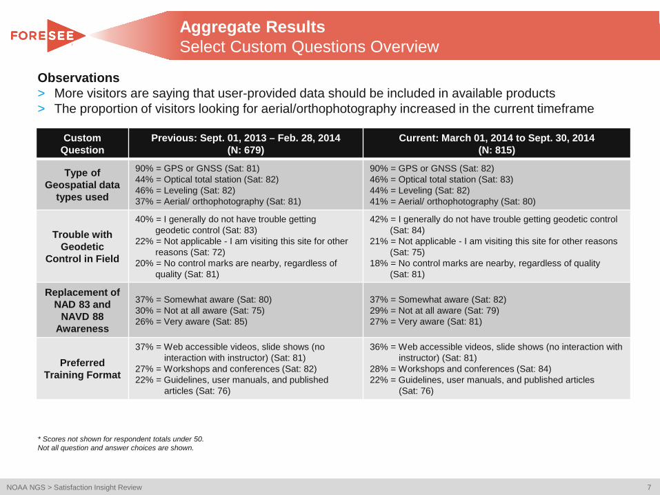
Aggregate Results Select Custom Questions Overview
* Scores not shown for respondent totals under 50. Not all question and answer choices are shown, please see the appendix for a full list. .
Observations > A greater proportion of visitors were looking for CORS/OPUS data > Fewer visitors needed to make use of survey controls during the current timeframe
7 NOAA NGS > Satisfaction Insight Review
Observations > More visitors are saying that user-provided data should be included in available products > The proportion of visitors looking for aerial/orthophotography increased in the current timeframe
Custom Question
Previous: Sept. 01, 2013 – Feb. 28, 2014 (N: 679)
Current: March 01, 2014 to Sept. 30, 2014 (N: 815)
Type of Geospatial data
types used
90% = GPS or GNSS (Sat: 81) 44% = Optical total station (Sat: 82) 46% = Leveling (Sat: 82) 37% = Aerial/ orthophotography (Sat: 81)
90% = GPS or GNSS (Sat: 82) 46% = Optical total station (Sat: 83) 44% = Leveling (Sat: 82) 41% = Aerial/ orthophotography (Sat: 80)
Trouble with Geodetic
Control in Field
40% = I generally do not have trouble getting geodetic control (Sat: 83) 22% = Not applicable - I am visiting this site for other reasons (Sat: 72) 20% = No control marks are nearby, regardless of quality (Sat: 81)
42% = I generally do not have trouble getting geodetic control (Sat: 84) 21% = Not applicable - I am visiting this site for other reasons (Sat: 75) 18% = No control marks are nearby, regardless of quality (Sat: 81)
Replacement of NAD 83 and
NAVD 88 Awareness
37% = Somewhat aware (Sat: 80) 30% = Not at all aware (Sat: 75) 26% = Very aware (Sat: 85)
37% = Somewhat aware (Sat: 82) 29% = Not at all aware (Sat: 79) 27% = Very aware (Sat: 81)
Preferred Training Format
37% = Web accessible videos, slide shows (no interaction with instructor) (Sat: 81)
27% = Workshops and conferences (Sat: 82) 22% = Guidelines, user manuals, and published
articles (Sat: 76)
36% = Web accessible videos, slide shows (no interaction with instructor) (Sat: 81)
28% = Workshops and conferences (Sat: 84) 22% = Guidelines, user manuals, and published articles
(Sat: 76)
Aggregate Results Select Custom Questions Overview
* Scores not shown for respondent totals under 50. Not all question and answer choices are shown.

NGS Stakeholder Engagement Activities
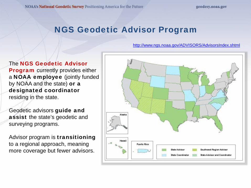
NGS Geodetic Advisor Program http://www.ngs.noaa.gov/ADVISORS/AdvisorsIndex.shtml
The NGS Geodetic Advisor Program currently provides either a NOAA employee (jointly funded by NOAA and the state) or a designated coordinator residing in the state. Geodetic advisors guide and assist the state’s geodetic and surveying programs. Advisor program is transitioning to a regional approach, meaning more coverage but fewer advisors.

Project objectives • Design a unified, accurate, and
effective stakeholder response system
• Provide mechanism to collect, track, and catalog inquiries and responses
• Develop and maintain comprehensive resources for customer response
Focus Areas • Process
• Tools
• Resources
NGS “One Voice” Project
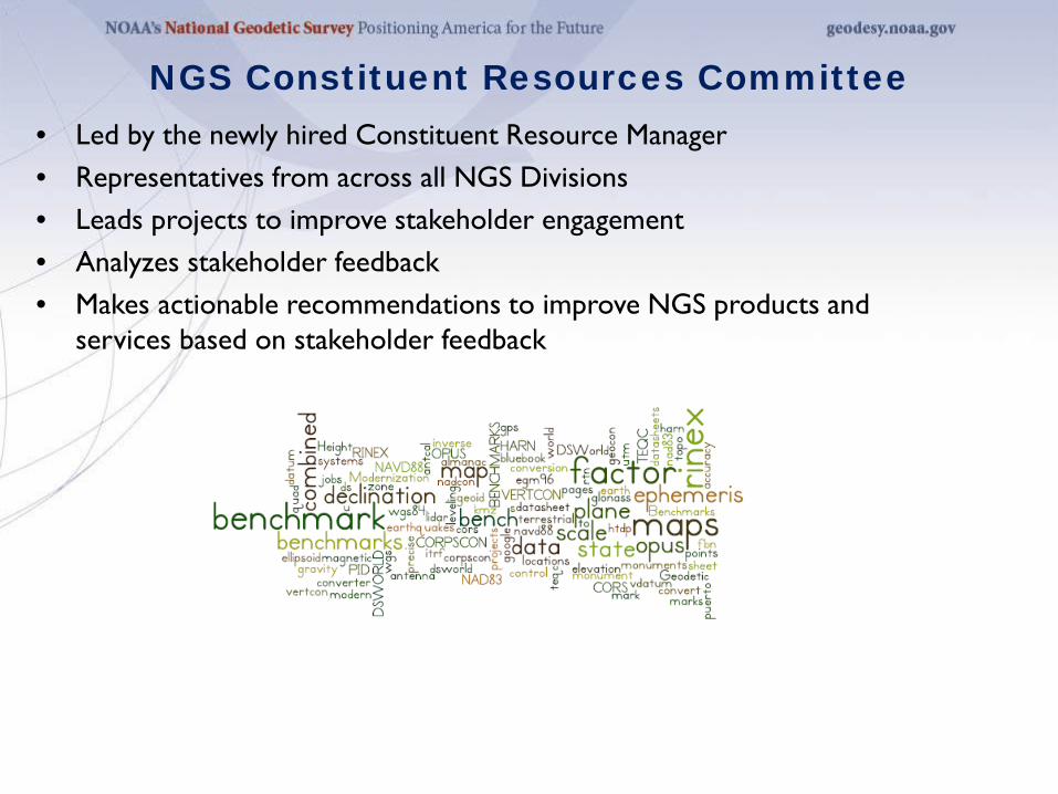
• Led by the newly hired Constituent Resource Manager • Representatives from across all NGS Divisions • Leads projects to improve stakeholder engagement • Analyzes stakeholder feedback • Makes actionable recommendations to improve NGS products and
services based on stakeholder feedback
NGS Constituent Resources Committee

• Planning to host in mid-April in the
Washington DC Area • To be held as part of a broader
“conference of conferences” with National Society of Professional Surveyors and Management Association for Private Photogrammetric Surveyors (MAPPS)
• Follows the successful 2010 Geospatial Summit: Proceedings are available here: http://www.ngs.noaa.gov/2010Summit/
2015 Geospatial Summit