national landscape character nlca28 epynt plateau and valleys · nlca28 epynt plateau and valleys...
TRANSCRIPT
National Landscape Character 31/03/2014
NLCA28
EPYNT PLATEAU AND VALLEYS
NLCA28 Epynt Plateau and Valleys - Page 1 of 9 www.naturalresources.wales
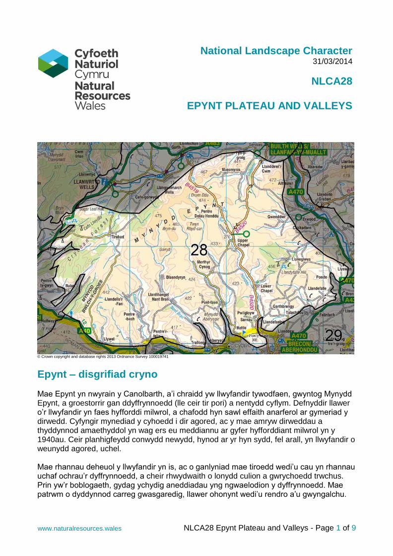
© Crown copyright and database rights 2013 Ordnance Survey 100019741
Epynt – disgrifiad cryno Mae Epynt yn nwyrain y Canolbarth, a’i chraidd yw llwyfandir tywodfaen, gwyntog Mynydd Epynt, a groestorrir gan ddyffrynnoedd (lle ceir tir pori) a nentydd cyflym. Defnyddir llawer o’r llwyfandir yn faes hyfforddi milwrol, a chafodd hyn sawl effaith anarferol ar gymeriad y dirwedd. Cyfyngir mynediad y cyhoedd i dir agored, ac y mae amryw dirweddau a thyddynnod amaethyddol yn wag ers eu meddiannu ar gyfer hyfforddiant milwrol yn y 1940au. Ceir planhigfeydd conwydd newydd, hynod ar yr hyn sydd, fel arall, yn llwyfandir o weunydd agored, uchel. Mae rhannau deheuol y llwyfandir yn is, ac o ganlyniad mae tiroedd wedi’u cau yn rhannau uchaf ochrau’r dyffrynnoedd, a cheir rhwydwaith o lonydd culion a gwrychoedd trwchus. Prin yw’r boblogaeth, gydag ychydig aneddiadau yng ngwaelodion y dyffrynnoedd. Mae patrwm o dyddynnod carreg gwasgaredig, llawer ohonynt wedi’u rendro a’u gwyngalchu.
NLCA28 Epynt Plateau and Valleys - Page 2 of 9 www.naturalresources.wales
Mae llawer o ddefaid yn y bryniau, a llawer o enghreifftiau o wahanu pendant rhwng tir agored y fyddin, nad yw wedi’i wella ac, yn is i lawr, porfeydd amgaeedig, wedi’u gwella, lle mae amaethu’n parhau heddiw. Yn hanesyddol, cysylltwyd y fro â cheffylau, ac y mae’r enw “Epynt” yn tarddu o ddau air Brythonaidd sy’n golygu “llwybrau’r ceffylau”.
Summary description Epynt lies in central eastern Wales and is defined by the windswept, sandstone plateau of Mynydd Epynt, which is intersected by pastoral valleys and fast flowing streams. Much of the plateau is used as a military training range and this has had a number of unusual effects on landscape character. Public access is limited on the unenclosed land whilst some former agricultural landscapes and farmsteads have been abandoned since their compulsory acquisition for military training in the 1940s. Curious new coniferous plantations appear on the otherwise open high moorland plateau. The southern parts of the plateau are lower in altitude and in consequence have field enclosures running higher up valley sides, and a network of narrow lanes and thick hedgerows. The area is sparsely populated, with the few hamlets located in the lower valleys. There is a pattern of scattered stone farmsteads, rendered and whitewashed in many cases. There are many sheep in the upland area and many instances of a clear division between the unimproved, open military range, including abandoned fields, and the improved, enclosed field pastures of lower levels that continue to be farmed today. The area has historically been associated with horses and the name ‘Epynt’ is derived from Brythonic words ‘ep’ + ‘hynt’, meaning "horse paths".
Key Characteristics
Upland plateau - formed from Devonian Old Red Sandstone, fringed by an outcrop of earlier, Silurian shales of the Ludlow Series. Higher to the north.
Radiating small valleys and fast flowing streams - feeding the adjacent Usk, Wye and Tywi rivers.
Rough sheep grazing on higher ground
Pasture and hedgerows in geometric pattern in lower valleys
Large and small conifer blocks - are a feature of the plateau.
Military training activities and impacts – on much of the plateau, with live firing and low flying military aircraft.
Upland and wet habitats - with Mynydd Epynt the home of slender green feather-moss – a feature of upland flushes.
Archaeology - Prehistoric ritual, religious and defensive features, including Bronze Age round barrows and Iron Age hillforts. Deserted medieval settlements are also in evidence.
Settlement is sparse - concentrated in the valleys and at stream crossing points.
Sense of tranquillity - wildness and remoteness on the tops, with views over sheltered valleys, with their mosaic of pasture fields, woodlands and quiet hamlets.
Visual and Sensory profile The Mynydd Epynt plateau is an untamed and remote, windswept landscape, with occasional geometric conifer blocks standing out on the skyline in contrast to the curved
NLCA28 Epynt Plateau and Valleys - Page 3 of 9 www.naturalresources.wales
form of the topography. Settlement is sparse, with high levels of exposure instilling a sense of wildness, particularly in adverse weather conditions. Bridleways run for miles across the open moorland that forms gentle ridges between valleys. Military infrastructure stands out from the remote character of the plateau in places, while the flying of red flags and sight of the occasional military vehicle are vivid indicators of the primary contemporary use of this landscape. In contrast, the radiating valleys contain a rich mosaic of pasture fields, woodlands and fast-flowing streams. They have a softer, more sheltered, agricultural character, with narrow lanes and thick hedgerows. The valleys are peaceful and their hamlets are compact. Individual farmsteads are linked by a network of rural lanes. In this otherwise unified visual character, modern farm buildings occasionally draw the eye. The effect of military operations resulted in some ‘abandoned’ former agricultural areas, complete with associated farmsteads. Effectively they are preserved in time and in some places the boundary between the unimproved range and the remaining farmed areas is marked by the extent of improved pasture. The area as a whole largely retains a strong sense of tranquillity and remoteness with its low population density and lack of artificial lighting retaining dark night skies throughout. The high summits afford extensive views across the area and beyond, and notably north from the highest land, across the adjacent lowland Heart of Wales landscape.
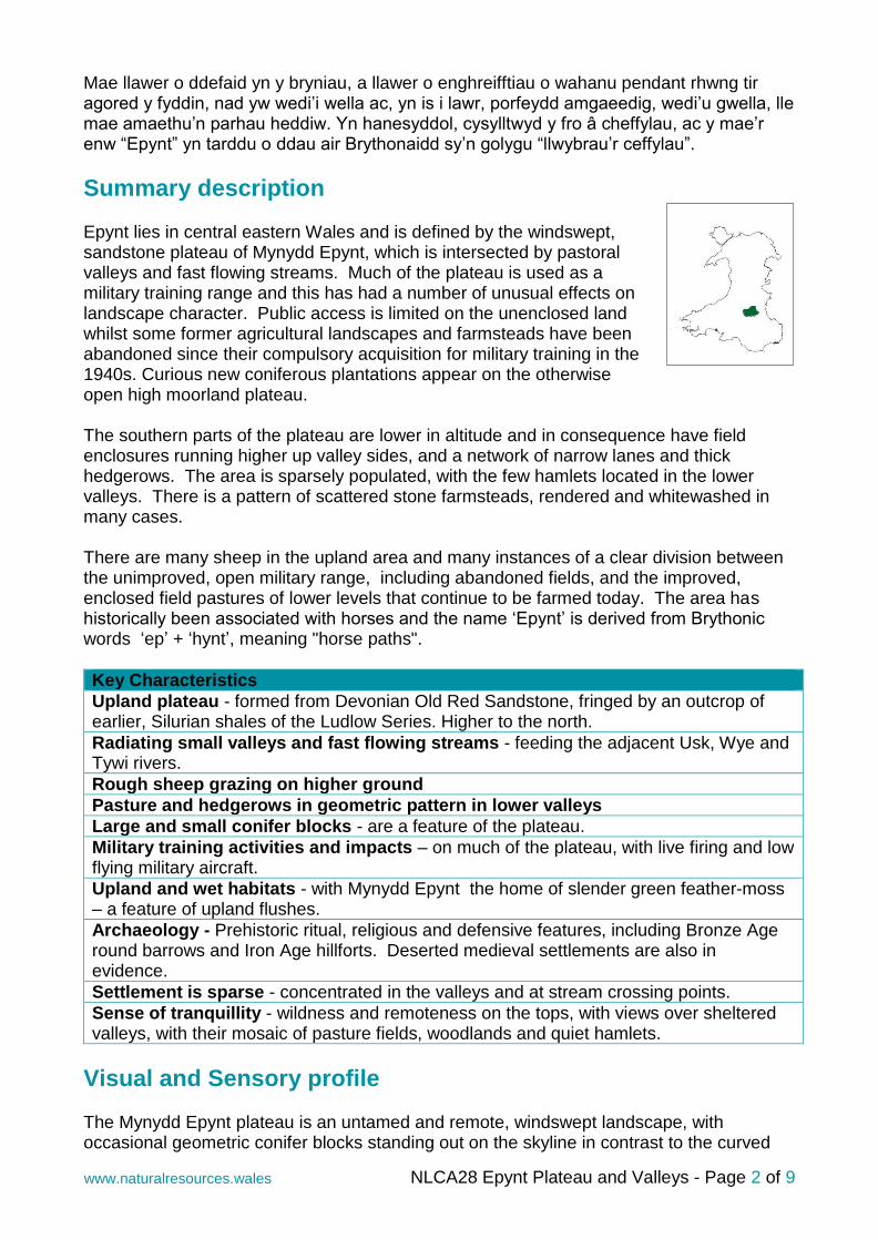
The southern-most extent of the area is enclosed and a network of narrow lanes and thick hedgerows enclose and shelter the pastoral landscape. This lane is near Upper Chapel. ©
John Briggs
NLCA28 Epynt Plateau and Valleys - Page 4 of 9 www.naturalresources.wales
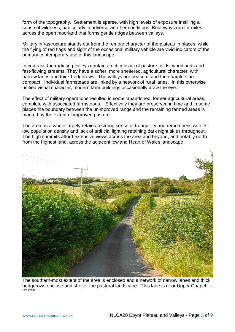
The southern-most parts of Epynt form a gentle, enclosed, rural, agricultural landscape. Field enclosures extend up most if not all of the valley sides in these areas and the wilder, open areas on their tops or to the north are hard to appreciate from valley bottoms. This view is north of the small village of Upper Chapel © John Briggs
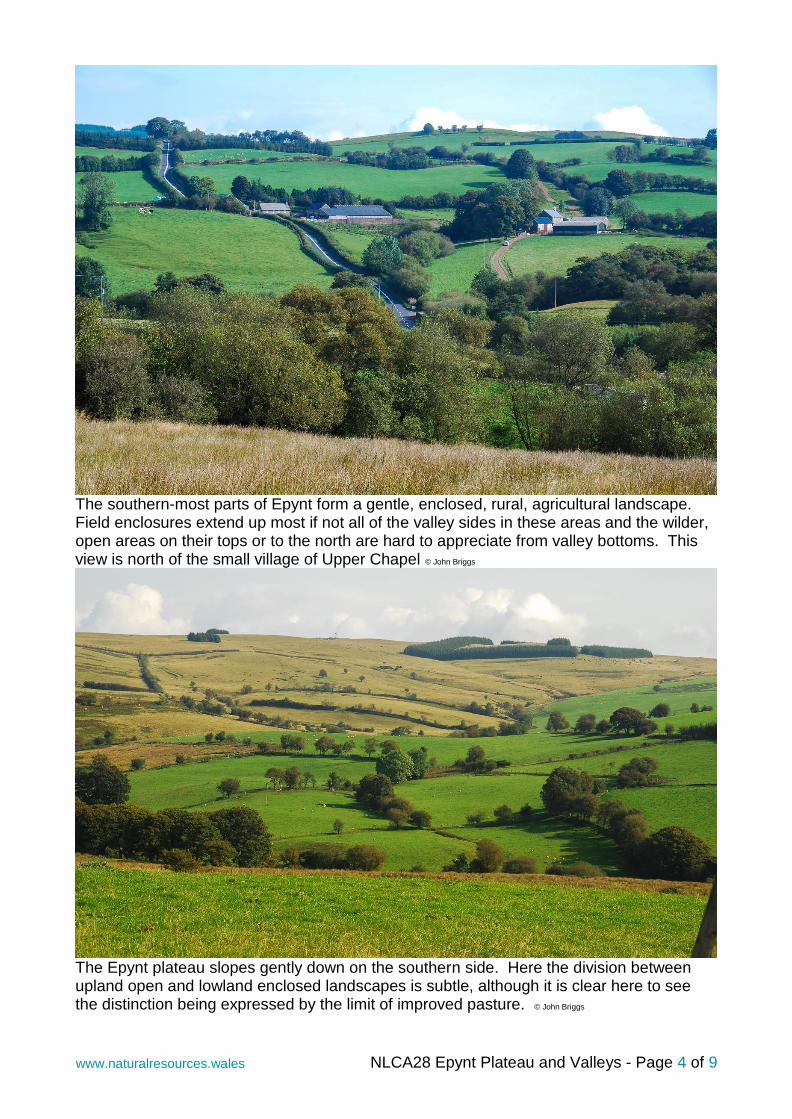
The Epynt plateau slopes gently down on the southern side. Here the division between upland open and lowland enclosed landscapes is subtle, although it is clear here to see the distinction being expressed by the limit of improved pasture. © John Briggs
NLCA28 Epynt Plateau and Valleys - Page 5 of 9 www.naturalresources.wales
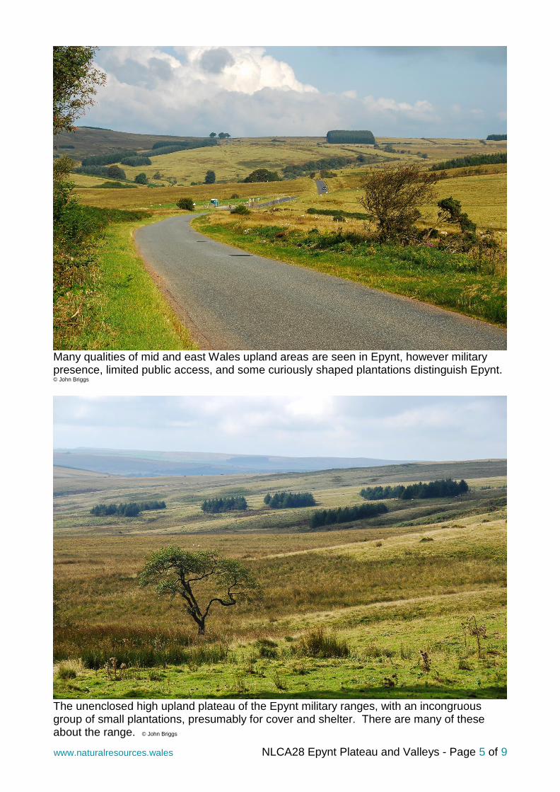
Many qualities of mid and east Wales upland areas are seen in Epynt, however military presence, limited public access, and some curiously shaped plantations distinguish Epynt. © John Briggs
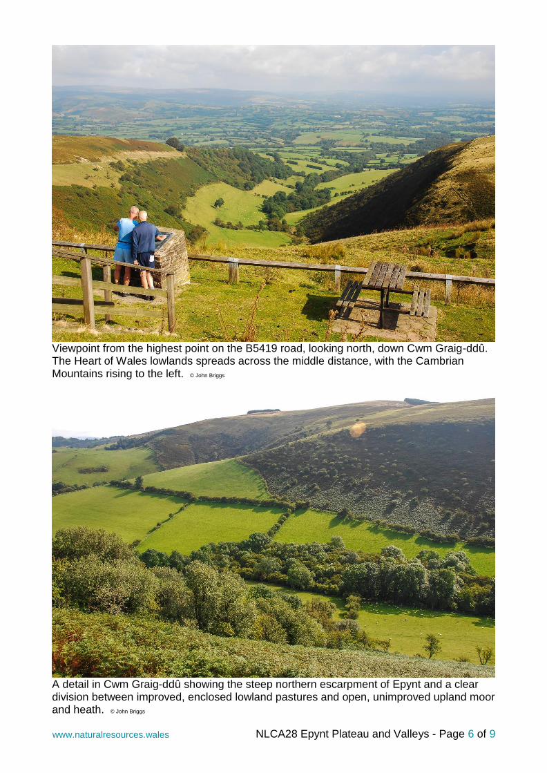
The unenclosed high upland plateau of the Epynt military ranges, with an incongruous group of small plantations, presumably for cover and shelter. There are many of these about the range. © John Briggs
NLCA28 Epynt Plateau and Valleys - Page 6 of 9 www.naturalresources.wales
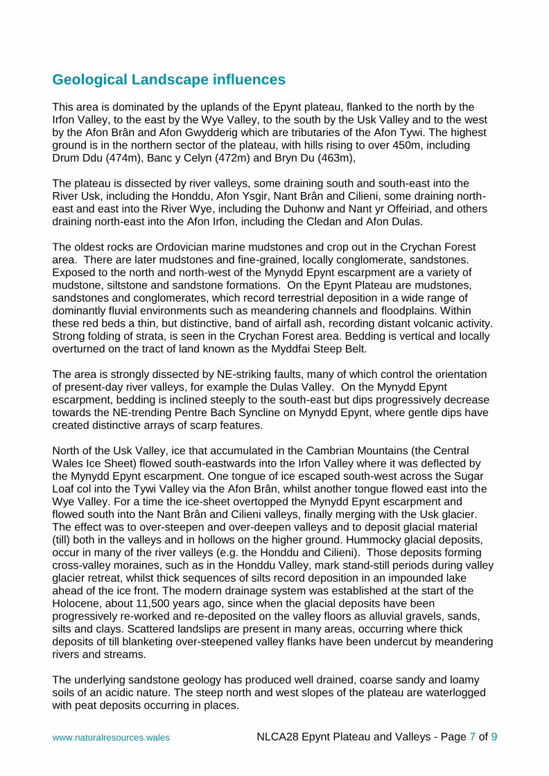
Viewpoint from the highest point on the B5419 road, looking north, down Cwm Graig-ddû. The Heart of Wales lowlands spreads across the middle distance, with the Cambrian Mountains rising to the left. © John Briggs
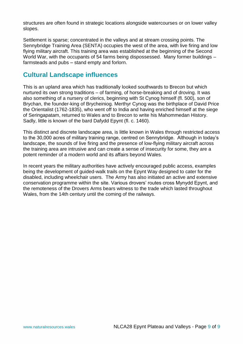
A detail in Cwm Graig-ddû showing the steep northern escarpment of Epynt and a clear division between improved, enclosed lowland pastures and open, unimproved upland moor and heath. © John Briggs
NLCA28 Epynt Plateau and Valleys - Page 7 of 9 www.naturalresources.wales
Geological Landscape influences This area is dominated by the uplands of the Epynt plateau, flanked to the north by the Irfon Valley, to the east by the Wye Valley, to the south by the Usk Valley and to the west by the Afon Brân and Afon Gwydderig which are tributaries of the Afon Tywi. The highest ground is in the northern sector of the plateau, with hills rising to over 450m, including Drum Ddu (474m), Banc y Celyn (472m) and Bryn Du (463m), The plateau is dissected by river valleys, some draining south and south-east into the River Usk, including the Honddu, Afon Ysgir, Nant Brân and Cilieni, some draining north-east and east into the River Wye, including the Duhonw and Nant yr Offeiriad, and others draining north-east into the Afon Irfon, including the Cledan and Afon Dulas. The oldest rocks are Ordovician marine mudstones and crop out in the Crychan Forest area. There are later mudstones and fine-grained, locally conglomerate, sandstones. Exposed to the north and north-west of the Mynydd Epynt escarpment are a variety of mudstone, siltstone and sandstone formations. On the Epynt Plateau are mudstones, sandstones and conglomerates, which record terrestrial deposition in a wide range of dominantly fluvial environments such as meandering channels and floodplains. Within these red beds a thin, but distinctive, band of airfall ash, recording distant volcanic activity. Strong folding of strata, is seen in the Crychan Forest area. Bedding is vertical and locally overturned on the tract of land known as the Myddfai Steep Belt. The area is strongly dissected by NE-striking faults, many of which control the orientation of present-day river valleys, for example the Dulas Valley. On the Mynydd Epynt escarpment, bedding is inclined steeply to the south-east but dips progressively decrease towards the NE-trending Pentre Bach Syncline on Mynydd Epynt, where gentle dips have created distinctive arrays of scarp features. North of the Usk Valley, ice that accumulated in the Cambrian Mountains (the Central Wales Ice Sheet) flowed south-eastwards into the Irfon Valley where it was deflected by the Mynydd Epynt escarpment. One tongue of ice escaped south-west across the Sugar Loaf col into the Tywi Valley via the Afon Brân, whilst another tongue flowed east into the Wye Valley. For a time the ice-sheet overtopped the Mynydd Epynt escarpment and flowed south into the Nant Brân and Cilieni valleys, finally merging with the Usk glacier. The effect was to over-steepen and over-deepen valleys and to deposit glacial material (till) both in the valleys and in hollows on the higher ground. Hummocky glacial deposits, occur in many of the river valleys (e.g. the Honddu and Cilieni). Those deposits forming cross-valley moraines, such as in the Honddu Valley, mark stand-still periods during valley glacier retreat, whilst thick sequences of silts record deposition in an impounded lake ahead of the ice front. The modern drainage system was established at the start of the Holocene, about 11,500 years ago, since when the glacial deposits have been progressively re-worked and re-deposited on the valley floors as alluvial gravels, sands, silts and clays. Scattered landslips are present in many areas, occurring where thick deposits of till blanketing over-steepened valley flanks have been undercut by meandering rivers and streams. The underlying sandstone geology has produced well drained, coarse sandy and loamy soils of an acidic nature. The steep north and west slopes of the plateau are waterlogged with peat deposits occurring in places.

NLCA28 Epynt Plateau and Valleys - Page 8 of 9 www.naturalresources.wales
Landscape Habitats influences The military range includes both previously improved agricultural land as well as semi-natural rough grazing on the plateau top. During military use, grazing has continued, essentially as ranching, throughout the semi-natural and agriculturally improved areas. Habitats on the range have been degraded as a result of many years of artillery bombardment and infantry use, however, small areas of moorland have been protected as SSSI. There is little heather on the Epynt plateau, but a range of semi-natural habitats occur, including large areas of semi-natural acid grassland and wet purple-moor grass dominated by degraded blanket bog, with wet flushes, bracken and scrub communities. The wetter areas are home to an interesting variety of amphibians, including frogs, toads, lizards and newts. Mynydd Epynt SAC and SSSI comprises small areas of important habitat, where waterlogged soils have produced upland flushes supporting many interesting bryophytes such as slender green feather-moss, and grassland fungi, including 20 species of waxcap. The unusual management combination of military use and extensive sheep grazing, coupled with the very wet climate, helps maintain conditions ideal for mosses and fungi. Other notable habitats include fen-meadows such as Blaen Cilieni, one of the largest such sites in Brecknock, where marsh fern thrives in its only location in Powys. Around the edge of the moorland, the former enclosed land has been used as part of the training area, with previously improved grassland now slowly reverting to rough grassland, often heavily grazed, with again a variety of interesting mosses and bryophytes that are dependent on the high rainfall of the area. More recently, a programme of hedge restoration and replanting has been undertaken in these areas, creating both military training obstacles and new habitats. Along with the 45 km of restored hedges, small areas of natural woodland have also been enclosed, and protected from grazing, leading to recolonisation by wood warbler and spotted flycatcher. Bordering the range, and partly extending into it from the west there the large coniferous plantations of the Crychan Forest are a favoured haunt for red squirrel. To the east, additional large areas of conifer plantations occur around Llaneglwys. There is little broadleaved woodland in the area, other than some small blocks along valley sides and dingles, where undisturbed by military use.
Historic Landscape influences Remains of settlement and human interaction with the Epynt area are evident in the landscape dating back thousands of years. On the higher ground of the plateau are a series of prehistoric ritual and funerary monuments, including Bronze Age round barrows and cairns. Areas overlooking the numerous valleys that cut through the plateau are the location of Iron Age hill forts and defensive enclosures. Evidence for later, Medieval settlement and agriculture is present in the remains of deserted hut settlements, farmsteads and platform houses. The Norman period saw the construction of a series of defensive castles and enclosures, with the motte of Castell Madoc overlooking the Honddu stream being a particular example. These defensive
NLCA28 Epynt Plateau and Valleys - Page 9 of 9 www.naturalresources.wales
structures are often found in strategic locations alongside watercourses or on lower valley slopes. Settlement is sparse; concentrated in the valleys and at stream crossing points. The Sennybridge Training Area (SENTA) occupies the west of the area, with live firing and low flying military aircraft. This training area was established at the beginning of the Second World War, with the occupants of 54 farms being dispossessed. Many former buildings – farmsteads and pubs – stand empty and forlorn.
Cultural Landscape influences This is an upland area which has traditionally looked southwards to Brecon but which nurtured its own strong traditions – of farming, of horse-breaking and of droving. It was also something of a nursery of clerics, beginning with St Cynog himself (fl. 500), son of Brychan, the founder-king of Brycheiniog. Merthyr Cynog was the birthplace of David Price the Orientalist (1762-1835), who went off to India and having enriched himself at the siege of Seringapatam, returned to Wales and to Brecon to write his Mahommedan History. Sadly, little is known of the bard Dafydd Epynt (fl. c. 1460). This distinct and discrete landscape area, is little known in Wales through restricted access to the 30,000 acres of military training range, centred on Sennybridge. Although in today’s landscape, the sounds of live firing and the presence of low-flying military aircraft across the training area are intrusive and can create a sense of insecurity for some, they are a potent reminder of a modern world and its affairs beyond Wales. In recent years the military authorities have actively encouraged public access, examples being the development of guided-walk trails on the Epynt Way designed to cater for the disabled, including wheelchair users. The Army has also initiated an active and extensive conservation programme within the site. Various drovers’ routes cross Mynydd Epynt, and the remoteness of the Drovers Arms bears witness to the trade which lasted throughout Wales, from the 14th century until the coming of the railways.