national park authority board meeting · national park authority board meeting ... bridge and car...
TRANSCRIPT

National Park Authority Board Meeting
Special Board Meeting - Cononish Goldmine
National Park Authority Board Meeting Tuesday 27
th February 2018 1
SUBMITTED BY:
Director of Rural Development and Planning
APPLICATION NUMBER:
2017/0254/MIN
APPLICANT:
SGZ Cononish Ltd
LOCATION:
Cononish Glen, near Tyndrum
PROPOSAL: Development of an underground mine to extract gold and silver with associated service and production building, plant, storage areas, Tailings Storage Facility (TSF), settlement pond and gauging station, bridge and car parking (Further revision of 2014/0285/DET)
NATIONAL PARK WARD: Ward 2 (northern (central) area)
COMMUNITY COUNCIL AREA: Strathfillan Community Council
CASE OFFICER: Name: Catherine Stewart Tel: 01389 727731 E-mail: [email protected]
Paper for decision 1. Introduction
1.1 A planning application for Cononish Gold Mine and associated infrastructure was
initially approved by the National Park Authority (NPA) in February 2012. In 2014 the
application was subsequently subject of a ‘section 42 application’ to vary a condition
of that permission to allow extended hours for construction, decommissioning &
restoration and for processing plant operation. Following a special board meeting in
January 2015, and subsequent amendment of the associated planning obligation
(section 75 legal agreement), this section 42 application was approved in February
2015. The Planning Permission provided by the above mentioned applications
expired on 6 February 2018. However prior to this, in August 2017, a revised
proposal was submitted with an alternative proposal for storage of the ‘tailings’ (waste
left over from processing the mined ore) within stacks and a phased approach to
production, potentially over a 17 year period. This is the application now presented
for determination by the National Park Board meeting. This is a significant
development in terms of its type, scale and location. It was agreed by the Board at its
meeting on 11 December 2017 that this application should be determined at a Special
Board Meeting.

National Park Authority Board Meeting Tuesday 27
th February 2018 2
2. Recommendation
That Members:
2.1 APPROVE application ref. 2017/0254/MIN subject to the conditions contained in
Appendix 1 of this report and the conclusion of a section 75 agreement/planning
obligation incorporating the Heads of Terms summarised in Appendix 2 and
acknowledgement of registration of the section 75 agreement in the Land
Register/Register of Sasines.
2.2 AGREE to authorise the Director of Rural Development and Planning to continue
negotiations to secure the items listed in paragraph 9.42 of this report and that the
Director of Rural Development and Planning will consult with the Convenor of the
National Park Board and revert back to the Board, if in any doubt over the
acceptability of terms, prior to the issue of the decision notice.
Contents Section: page no. 1. Introduction ............................................................................................................................ 1
2. Recommendation ................................................................................................................... 2
3. Background ............................................................................................................................ 3
Site Description: ....................................................................................................................... 3
Description of Proposal: ........................................................................................................... 4
Construction / Site Establishment Phase ................................................................................. 8
Operational Phase ................................................................................................................. 11
Site decommissioning and restoration phase ......................................................................... 13
Aftercare phase ..................................................................................................................... 13
Proposed Greater Cononish Glen Management Plan (GCGMP) ............................................ 13
Proposed Financial Guarantee and Developer Contributions ................................................. 14
Environmental Impact Assessment (EIA): .............................................................................. 16
Habitats Regulations Appraisal .............................................................................................. 17
Planning History: .................................................................................................................... 19
4. Consultations and Representations ................................................................................... 22
Responses to Consultations: ..................................................................................................... 22
Representations Received:........................................................................................................ 27
5. Policy Context ...................................................................................................................... 30
National Park Aims: ................................................................................................................... 30
Development Plan: .................................................................................................................... 30
Material Considerations: ............................................................................................................ 31
National Park Authority Board Meeting Tuesday 27
th February 2018 3
6. Summary of Supporting Information .................................................................................. 31
7. Minerals Extractive Waste (MEW) Regulations .................................................................. 32
8. Planning Assessment .......................................................................................................... 32
Principle of Development ....................................................................................................... 32
Landscape and Visual Impacts .............................................................................................. 34
Ecology and Habitat Restoration, including Peat Management .............................................. 42
Recreation and Access .......................................................................................................... 47
Hydrology (including Acid Rock Drainage) ............................................................................. 50
Socio-economic impacts ........................................................................................................ 53
Traffic and Road Safety ......................................................................................................... 55
Emissions and Blasting (Noise, Dust, Air Quality and Vibration impacts) ............................... 57
Extractive Waste .................................................................................................................... 58
Planning Obligations (Section 75) including the Greater Cononish Glen Management Plan, Developer Contributions, Planning Monitoring and Financial Guarantees .............................. 60
9. Conclusions ......................................................................................................................... 62
Assessment against Local Development Plan and Material Considerations ........................... 63
Assessment against Park Aims .............................................................................................. 68
Outstanding matters and negotiations .................................................................................... 71
10. Appendices ....................................................................................................................... 72
11. Background information .................................................................................................. 72
3. Background
Site Description:
3.1 The site is located within Cononish Glen approximately 3km south west of Tyndrum
(see Appendix 3 Site Location Plan). From the south, entry to the site is achieved
from the A85 at Dalrigh by a 5.6km metalled access track that roughly follows the
north bank of the Cononish River to the mine. There is also a northern track which
meets the southern access approximately 2km east of Cononish Farm providing
access from Tyndrum. The site consists of an area both over and underground. The
extent of the surface operations application site (excluding the access track, proposed
new bridge area and gauging station) is approximately 33 hectares. The site lies on
the south eastern face of Beinn Chuirn. The surrounding landscape is open upland
with rough grazing. To the east is an area of forestry plantation. The Allt Eas Anie
watercourse runs through the application site to converge with the Cononish Burn
which is designated as part of the River Tay Special Area of Conservation (SAC).
3.2 The nearest residential properties are located at Cononish Farm which includes the
farmhouse approximately 100 metres from the site boundary and the old Tackman’s
House and byre (‘B’ Listed Building) approximately 250 metres from the site. There
are three dwellings located near the access track at Dalrigh.
3.3 The main recreation activities in the area are walking and climbing with several routes
used on the approach to Ben Lui. In suitable conditions during winter weather the
nearby waterfall on Allt Eas Anie is used for ice climbing.

National Park Authority Board Meeting Tuesday 27
th February 2018 4
3.4 Ben Lui National Nature Reserve (NNR), Site of Special Scientific Interest (SSSI) and
Special Area of Conservation (SAC) lies to the south of the mine site on the opposite
side of the River Cononish. Additionally Coille Coire Chuilc SSSI, a native pine
forest, lies on the southern bank of the River Cononish, some 2km east of the mine
site (see Appendix 3 Site Location Plan).
3.5 The existing site has been the subject of past mining exploration works and most
recently a temporary Bulk Processing Trial (see Planning History, section 3.49 and
Appendix 4 Mine Site Layout). There has been no mining under the current consent.
The existing site elements comprise:
gated access track from Cononish Farm;
a mine portal/adit (tunnel) entrance;
the mine fill plateau (deposited material from exploratory adit) utilised as a parking
area;
46 ‘sedi-bags’ with de-watered ‘tailings’ from the Bulk Processing Trial, covered
with geojute;
two Nissen huts, most recently used to house plant, storage and office space for
the Bulk Processing Trial;
a generator;
storage containers for fuel, water etc.;
surface water cut-off ditches;
sumps and silt traps;
three settlement lagoons; and
water monitoring facilities.
Description of Proposal:
3.6 The proposed development would comprise a construction phase followed by an
operational phase when mineral is extracted from the mine, processed in a
processing building and tailings stacks created with the waste material. Restoration
of the stacks would be progressive as each stack is completed in turn during the
operational phase. Site decommissioning and restoration works are proposed to be
completed in the final year of the project, for around 6 months following cessation of
mining operations, followed by an aftercare period of 5 years.
3.7 The main changes to the proposal, compared with the consented scheme, concern
the treatment and storage of the ‘tailings’ waste from the extraction process and
the potential overall length of time for operations (seventeen years (proposed)
compared with ten years (consented)) depending on the rate of production.
3.8 Under the consented scheme tailings were to be pumped in a slurry form from the
processing building and stored in a large Tailings Management Facility (TMF) –
effectively a large dam/reservoir across the site. In order to construct the TMF the Allt
Eas Anie burn which runs through the mine site would have required to be diverted.
The capacity of the TMF would have been 400,000 tonnes of tailings. The proposal
now involves the creation of a Tailings Storage Facility (TSF) consisting of ten
individual stacks of dried tailings. This does not require the burn to be diverted.
Figure 1a and 1b below show the TMF and TSF proposals at the mine site.

National Park Authority Board Meeting Tuesday 27
th February 2018 5
Figure 1a – Mine site with completed TMF (source: 2011/0166/MIN & 2014/0285/DET)
Figure 1b – Mine site showing complete stack footprints (source: 2017/0254/MIN)

National Park Authority Board Meeting Tuesday 27
th February 2018 6
3.9 The table below summarises some of the differences between these two approaches:
Table 1 – Comparison between Tailings Management Facility (TMF) and Tailings
Storage Facility (TSF)
Tailings Management Facility (TMF) 2011/0166/MIN & 2014/0285/DET
Tailings Storage Facility (TSF) 2017/0254/MIN
Reservoir/dam 10 individual stacks
Diversion of Allt Eas Anie burn No burn diversion required
Tailings transported from processing building in a slurry form in a pipe
Tailings dewatered in processing building and dry tailings (16% water content) will be loaded from the tailings stockpile and hauled using 25 tonne All-terrain Dump Trucks
Rock blasted from diversion of the Allt Eas Anie burn would be used in the formation of the base layer for the TMF
Materials won from underground blasting would be used to create the base of the stacks (172,000 tonnes of mine rock)
Storage of 400,000 tonnes of tailings Storage of 530,000 tonnes of tailings
“Category A Waste facility” under Management of Extractive Waste (Scotland) Regulations 2010
“Waste facility (inert)” under Management of Extractive Waste (Scotland) Regulations 2010
20 year aftercare period 5 year aftercare period proposed by applicant
Maximum height: 20 metres Maximum height: 10 metres
Length of TMF: 215 metres Maximum length of stacks: 342 metres (stack 7)
Width of TMF: 275 metres Maximum width of stacks: 88 metres
Total area of TMF and Recirculation Pond: 5.82 hectares
Total area of TSF (10 stacks) and Settlement Pond: 9.7 hectares
3.10 The figures below show a comparison cross-section profile of the proposed TMF and
a stack at completion:
Figure 2a – Cross section of completed TMF (source: 2011/0166/MIN Environmental Statement, Dalgleish Associates)

National Park Authority Board Meeting Tuesday 27
th February 2018 7
Figure 2b – Cross section of completed stack (source: 2017/0254/MIN Environmental
Statement, Dalgleish Associates)
3.11 Another key change to the proposals is the phasing of the operations. The applicant
has proposed commencement of production at a rate of 36,000 tonnes per annum
(3000 tonnes per month (tpm)) which may subsequently be expanded to ‘full
production’ rate of 72,000 tonnes per annum (6000 tpm) after two years. Expansion
to full production would be subject to further investment which would involve
upgrading the plant machinery used within the proposed processing building. The
application is therefore for a 17 year temporary permission allowing for the
continuation of the initial lower production rate, in the event that funding is not
forthcoming. If the finance was available the operational phase would be reduced to
10 years. This is explained further in table 2 below. Table 3 sets out the expected
rates for recovery of gold and silver in both production scenarios, compared with the
consented scheme.
Table 2 – Timing of development phases (two scenarios)
Timing1
3000 tpm 6000 tpm
Construction (Site Establishment) 6 months 6 months, plus additional
plant brought in over 2-3
months at the end of year
3
Operational (Extraction and
Processing, deposition of ‘tailings’ in
stacks)
16 years 6 months 10 years 1 month
Restoration of stacks On-going during operational phase
Site decommissioning and restoration 6 months from cessation of mining
Aftercare proposed by applicant 5 years from cessation of mining
1 ES Addendum Appendix 2 Restoration Schedules

National Park Authority Board Meeting Tuesday 27
th February 2018 8
Table 3 – Average amounts of gold and silver processed per annum
Consented application (2011/0166/MIN & 2014/0285/DET)
Gold/year Silver/year
21,000oz 83,000oz
Total gold Total silver
8 years of production = 168,000oz 664,000oz
Current application (2014/0254/MIN)
3000 tpm Gold/year Silver/year
12,581oz 53,932oz
6000 tpm Gold/year Silver/year
21,808oz 93,482oz
Total gold Total silver
Total production (either
scenario) =
196,272oz 841,345oz
Construction / Site Establishment Phase
3.12 Below is a table showing the key site construction elements of the scheme, and how
they differ from the consented scheme:
Table 4 – Construction elements – comparison with consented scheme
Site access at Dalrigh No change
As part of the initial enabling works the
junction with the A82(T) is to be improved.
Off-site car parking at Dalrigh No change
A car park (measuring 20 metres by 20
metres) is to be provided for employee
vehicles to the south of the existing car park
at Dalrigh. A site minibus is to transport
employees to the mine site.
Bridge over the Crom Allt at Dalrigh
Previously the existing 2 tonne weight
restriction bridge was to be upgraded (with a
temporary crossing during construction),
however now it is proposed to install a new
and permanent ‘bailey’ type bridge at the
location of a ford (see Appendix 13). This will
separate mine vehicles from the existing
bridge which is on the West Highland Way.
Construction Traffic Access No change in access/routing.
Large items of plant requiring to be delivered
by low loader, will be routed to the site via the
forestry track from Tyndrum over the railway
crossing at Tyndrum Lower Station (the
northern access route).
Mine access track (existing) Access to the site shall be taken from the
A82 (T) at Dalrigh, the existing estate access

National Park Authority Board Meeting Tuesday 27
th February 2018 9
to Cononish Farm. The only changes are
that there will be slight alteration to the route
to go over the new proposed bridge and that
realignment of the access track within the
mine site is no longer required.
Mine portal/adit No change.
The mine portal is to be slightly enlarged and
all finishes will be in, or surfaced with, natural
rock.
Mine platform and workshop/core store There is an existing mine platform created
through historical exploratory mine works.
This has been altered recently through the
Bulk Processing Trial permitted under
planning applications (ref: 2016/0064/DET
and 2016/0366/DET). As part of the
groundworks for the plant building
landscaping of the hillside area is to take
place.
Underground mine No change.
The extent of the area remains the same,
although there is now more certainty on the
precise area to be mined.
Process plant building compound
Figure 3 Cross-section of Process
Building Platform
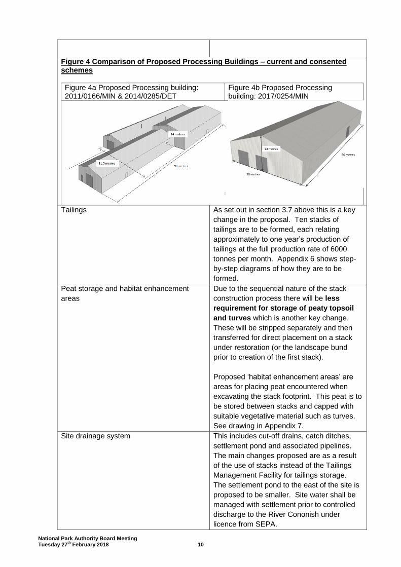
The area required for the processing plant building and compound will be excavated into the hill slope and a landscaped screening bund will be created in order to reduce the visible profile of the building (see Figure 3). This bund will be constructed of materials excavated from the footprint of the process plant compound and the first stack area. A ‘feed’ stockpile of approximately 250 tonnes of ore (1 days production at full rate) is proposed to the southern end of the building together with a small parking area for 4 vehicles. A ‘tailings’ stockpile is proposed to the northern end of the building together with a small security booth. See Appendix 5 “Process Plant Building Compound”. The process plant building has been revised in terms of design and is now proposed to be a simplified dual pitch structure, 30 metres wide by 80 metres long (2400 square metres) – see Figure 4b below. It is to be 13 metres to ridge height, 8 metres to the eaves. Previously the building had a number of different elements with varying roof heights (see Figure 4a), however the overall area was proposed to be 2300 square metres with a maximum height of 14 metres to the ridgeline. Therefore the new building has a slightly larger footprint and lower ridge height.
National Park Authority Board Meeting Tuesday 27
th February 2018 10
Figure 4 Comparison of Proposed Processing Buildings – current and consented schemes
Figure 4a Proposed Processing building: 2011/0166/MIN & 2014/0285/DET
Figure 4b Proposed Processing building: 2017/0254/MIN
Tailings As set out in section 3.7 above this is a key
change in the proposal. Ten stacks of
tailings are to be formed, each relating
approximately to one year’s production of
tailings at the full production rate of 6000
tonnes per month. Appendix 6 shows step-
by-step diagrams of how they are to be
formed.
Peat storage and habitat enhancement
areas
Due to the sequential nature of the stack
construction process there will be less
requirement for storage of peaty topsoil
and turves which is another key change.
These will be stripped separately and then
transferred for direct placement on a stack
under restoration (or the landscape bund
prior to creation of the first stack).
Proposed ‘habitat enhancement areas’ are
areas for placing peat encountered when
excavating the stack footprint. This peat is to
be stored between stacks and capped with
suitable vegetative material such as turves.
See drawing in Appendix 7.
Site drainage system This includes cut-off drains, catch ditches,
settlement pond and associated pipelines.
The main changes proposed are as a result
of the use of stacks instead of the Tailings
Management Facility for tailings storage.
The settlement pond to the east of the site is
proposed to be smaller. Site water shall be
managed with settlement prior to controlled
discharge to the River Cononish under
licence from SEPA.

National Park Authority Board Meeting Tuesday 27
th February 2018 11
Gauging point at River Cononish footbridge No change.
This would require the erection of a
stageboard mounted on the abutment of the
footbridge and of the installation of an
electronic flow measuring device.
Discharge line Slight change, as alignment, length and
dimensions have changed from that
previously consented. The discharge line is
proposed to comprise a 710mm diameter
HDPE pipe discharging directly to the River
Cononish below the confluence with the Allt
Eas Anie burn in accordance with the existing
Controlled Activities Regulations (CAR)
licence for discharge to which no change is
proposed.
Fencing and security booth This includes security fencing, fencing for
health and safety requirements, stock fencing
and deer fencing. Minor changes in
alignment have been proposed. A 2 metre
high security fence is to be erected around
the plant building compound, contained
within the landscaped mound and at the base
of the hill slope to the rear of the building.
The security booth is to be located within this
fenced off area.
Lighting Changes to the lighting have again been as a
consequential result of the proposed change
from a TMF to the TSF stack areas. There
will be additional vehicle lights within the site
from tailings delivery movements and
compaction of the stack footprints.
Signage No change. Signage in accordance with
HSE requirements will be located at the mine
access track gate. Other information
signage, e.g. information for walkers and
climbers in relation to mine activities, or
educational information about the mine will
also be provided at the same location, to
minimise visual intrusion.
Operational Phase
Extraction
3.13 In tandem with the construction / site establishment phase described above there will
be pre-production works taking place underground. This will involve the removal of
some mine rock to form the basal (bottom layer) drainage layer for each stack in turn.
The gold bearing ore will be extracted using standard underground drill and blast
methods. The ore will be transported by low profile truck from the mine portal via the
access track to form an ore stockpile outside the processing building.

National Park Authority Board Meeting Tuesday 27
th February 2018 12
Processing
3.14 The processing of the ore is to be unchanged from the consented planning
permission, but with additional plant for de-watering the tailings.
3.15 When the ore enters the building it would be passed through two stages of
mechanical crushing. It would then enter a ball mill to reduce the size of the material
to around 125 microns, the size of fine sand. This material would go through a gravity
separation process and froth flotation to produce a gold bearing sulphide concentrate.
The only chemicals used are a frothing agent, methyl isobutyl carbinol (MIBC) and
collecting agent Potassium Amyl Xanthate (PAX) to be used in the flotation process.
Both substances are degradable. Additionally there will be a filter-press (dewatering
plant) to dewater the residue from this process, known as ‘tailings’. A stockpile of
tailings would be formed outside the processing building within the compound area.
3.16 Gold extracted by gravity separation will be further processed in the small on-site
furnace, as took place in the Bulk Processing Trial. Gold and silver concentrate, once
pressed, dried and bagged will require further off-site processing outwith Scotland. It
is estimated that 5% of the material mined will be recovered to this ‘flotation
concentrate’ which will be bagged for transport off-site for further treatment. The
balance of materials (95%) is then in the form of inert ‘tailings’.
3.17 Some of the tailings currently stored at the site within ‘sedi-bags’ from the Bulk
Processing Trial may be used to test the new plant equipment. The remaining will be
left in-situ and be covered with landscaping material.
Restoration of the stacks
3.18 It is proposed that the stack footprints will be incrementally prepared for deposition of
the tailings (see Appendix 6) and once the tailings are deposited and compacted
sufficiently then soils will be added, followed by turves, mulch and divots taken from
the footprint of the next stack in the sequence (with the exception of the final stack
which will be covered with some material from the landscaped bund at
decommissioning stage). In terms of target vegetation types for each stack, these are
set out within the Environmental Statement (ES) and will depend upon what materials
are ‘harvested’ from the next stack footprint area as well as the hydrological
characteristics of the constructed stack. Each stack will take approximately one year
to construct, or longer, depending on the production scenario (3000 tpm or 6000 tpm)
and the size of the stack.
3.19 The proposed restoration of the stacks is to create a habitat mosaic including wet and
dry heath, acid grassland, flush and blanket mire/bog, although it is recognised in the
ES that the current balance of habitats will not be replicated completely at restoration
and the stack areas may support increased grassland on the potentially drier slopes.
Mitigation measures proposed include monitoring the restoring vegetation and taking
steps such as weeding, and adding additional material (such as brash or plug plants),
where necessary, to achieve the targeted habitat type. Also additional tree planting is
proposed as a compensatory measure as the replacement habitats may be of lesser
ecological value than those currently on site and native tree species would enhance
the biodiversity value.

National Park Authority Board Meeting Tuesday 27
th February 2018 13
3.20 The stack restoration phase will continue on a phased basis throughout the life of the
mine in tandem with mine operation.
Site decommissioning and restoration phase
3.21 The decommissioning phase which would commence either at year 10 or 16
(depending on the rate of production), is estimated to take six months, and would
involve the securing of the mine portal, the removal of the plant and processing
building and ancillary structures such as the security cabin, regrading and
landscaping of the plant building area and mine plateau using materials from the
landscaping bund. Any available vegetated surfaces and soil will be stripped and
temporarily stored for replacement over the regraded slopes. ES Appendix 7
contains the proposed ‘Decommissioning and Restoration Plan’. Appendix 12 of this
report shows the ‘Indicative Restoration Plan’.
3.22 Once the site has been restored, features left on site include the tailings stacks upon
which vegetation will continue to mature, and may need to be managed (e.g.
weeding, adding further plug plants etc.) and the mine access track is proposed to be
retained for estate use.
Aftercare phase
3.23 Unlike the previous application where a 20 year aftercare phase was proposed, the
current proposal, as submitted by the applicant, includes a 5 year aftercare period,
upon mine closure. This phase would include monitoring the requirement to maintain
the site drainage system and settlement pond, maintenance and replacement (e.g. of
failed trees).
3.24 Once the last tailings stacks have been constructed and disturbed areas on site are
adequately stabilised and vegetated, the proposed settlement pond would no longer
be required. The pond outflow shall be decommissioned and the pond shall be left to
naturalise.
Proposed Greater Cononish Glen Management Plan (GCGMP)
3.25 The Greater Cononish Glen Management Plan (GCGMP) is a Landscape and Habitat
Management Plan offered by the developer, for the greater Cononish Glen area.
Although the measures proposed relate to an area outwith the planning application
site boundary, they relate to the development as the plan provides for a range of
offsite mitigation in the wider Glen, to reduce the visual impacts of the development
and provide other positive landscape and biodiversity improvements over the long
term to compensate for negative impacts created on site. .
3.26 The ES confirms that the applicant is committed to providing funding to implement a
Management Plan for the Greater Cononish Glen in conjunction with the landowner,
SNH and the Park Authority over a thirty year period. A draft plan was included within
the section 75 agreement for the consented application. This plan has been updated
to reflect the new scheme in terms of the development description and planning
application boundary, but contains the same key elements.
3.27 Three main themes have been identified:

National Park Authority Board Meeting Tuesday 27
th February 2018 14
1. the maintenance of the upland heathland within the Ben Lui SAC, which is
sensitive to grazing but nonetheless requires managed grazing to maintain the
habitats for which it is designated.
2. the planting of native woodland within the lower glen as habitat enhancement
(extension of the Coille Coire Chuilc SSSI), as landscaping to tie in with
elements of planting to be established at the mine site, small scale planting to
improve the landscape experience from the Glen track and with existing
planting at Cononish, and as part of the restructuring of the edges of the
Forestry Commission plantation.
3. Ensuring continuing recreational access within and through the glen and
exploring opportunities for increasing awareness of the natural heritage
interests in the glen.
3.28 Other works to be undertaken in Year 1 as part of the GCGMP include:
Painting of the Cononish Farm buildings and roof to minimise their visual
impact;
Remedial works to Cononish Glen Track including reprofiling/ vegetating bare
batters & improving culverts; and
Planting of native woodland species around the additional parking area to be
created at Dalrigh.
3.29 During processing of the current application, the following additional works were
identified for inclusion within a revised GCGMP should Members be minded to
approve this application:
Peatland Restoration
Upgrading/improving drainage of ‘Oak Path’ core path near Dalrigh
Proposed Financial Guarantee and Developer Contributions
3.30 As part of this application the developer is proposing a financial guarantee (or bond)
to be put in place both for the Greater Cononish Glen Management Plan outlined
above and also for the Decommissioning and Restoration Scheme (a restoration
bond). In addition some developer contributions are proposed. These are
summarised below, noting any differences with the consented scheme:
Financial Guarantee
3.31 It is normal practice for applications relating to the extraction of minerals that a
financial guarantee be provided. A financial guarantee provides assurances relating
to the full restoration and aftercare of the site should the mineral operator fail to carry
out their obligations i.e. as a result of a breach of planning control or in the event of
them going into liquidation. The applicant proposes to provide the bond through a
Cash Collateral Account. This essentially means that the bond amount would be
credited to an account that shall be held by a bank to the order of the NPA. The Park
Authority has been advised by our legal advisors that, in principle, this is an
acceptable mechanism for the provision of the financial guarantee.
3.32 The consented scheme had three financial guarantees or ‘bonds’ set out in the
planning obligation/section 75 legal agreement. These bonds were as follows:
Restoration bond £950,000
GCGMP bond £222,000

National Park Authority Board Meeting Tuesday 27
th February 2018 15
Minerals Waste regulations bond £160,000
The bonds required to be in place prior to the commencement of development on site.
They were not put in place and no development commenced.
3.33 For this application there is no requirement for a Minerals Waste bond under the
regulations, as the type of waste facility has changed and is no longer a ‘Category A’
waste facility.
3.34 The Restoration Bond is to provide assurance relating to the full restoration and
aftercare of the site should the mineral operator fail to carry out their obligations, for
example as a result of the company going into liquidation. At the time of preparation
of this report the amount proposed by the developer is £503,521.
3.35 The GCGMP Bond is likewise to provide assurance that the works proposed within
the plan can be completed should the mineral operator fail to carry out their
obligations. At the time of preparation of this report the amount proposed by the
developer is £282,000.
Developer Contributions
3.36 The applicant has committed to providing a financial contribution towards enhancing
Conservation and the Visitor experience in Loch Lomond and The Trossachs National
Park.
For the consented application this was to be as follows: £25K paid in the first
year of the development and £50K pa for the following 6 years that the mine is
operated (total £325K). If the mine were to cease operations the minimum
payment would be £200K. 30% of the funding was to be spent within
Strathfillan Community Council area and 70% for the wider National Park.
For the current application the applicant has put forward the following, at the
time of preparation of this report: £25K to be paid within the earlier of: the first
year from the commencement of production operations, and the date two years
after the date of commencement; and annually thereafter pay £25Kp.a. if
operating at 3000 tpm (maximum total £425K) or up to £50Kp.a. if operating at
6000 tpm (maximum total £425K). Payments would be made to Loch Lomond
and the Trossachs Countryside Trust, again 30% of the funding would be spent
within Strathfillan Community Council area and 70% for the wider National Park.
If the mine were to cease operations the minimum payment would be increased
to £250K.
This is presented as compensation for the adverse impacts on conservation interests
and the visitor and recreation experience that will occur while the mine is operating.
The purpose of the financial contribution is to provide funding of interpretive support
within the National Park and include, for example, training and funding of additional
Park Rangers for the area. This would enable an enhanced visitor experience in
other areas of the National Park, to compensate for the adverse impacts on visitor
experience within Cononish Glen caused by the operational mine.
3.37 For the previous application the applicant agreed to meet the costs incurred by the
NPA in relation to the appointment of a Planning Monitoring Officer for monitoring
compliance of conditions during operations. This was estimated to total £117K. For
the proposed application the applicant has again agreed to meet the costs in relation
National Park Authority Board Meeting Tuesday 27
th February 2018 16
to the Planning Monitoring Officer role, however a figure has not been proposed at
the time of writing this report.
3.38 In addition, previously the applicant agreed to make a contribution to Strathfillan
Development Trust of £30Kp.a. for at least 5 years and an additional amount of
£200K to contribute to the development of a mining heritage visitor facility, making a
total provision of £350K. The applicant is now proposing to apportion payments
based on production - £15Kp.a. over a 16 year period of production, with an
increased lump sum of £250K, totalling £490K; or if there is an increase in the rate of
production they propose £15Kp.a. whilst at 3,000 tpm, increasing to £30Kp.a. at
6,000 tpm and a lump sum of £250K, totalling £490K. It should be noted that these
voluntary proposed contributions are not a material consideration in the
determination of this application.
Environmental Impact Assessment (EIA):
3.39 For the purposes of the Environmental Impact Assessment (Scotland) Regulations,
the National Park is identified as a ‘Sensitive Area’. Underground mining falls within
Schedule 2 of the Town and Country Planning (Environmental Impact Assessment)
(Scotland) Regulations 2011 (section 2 ‘Extractive industry (b) Underground mining).
No formal screening opinion was requested by the applicant or carried out, however a
scoping opinion was requested and subsequently provided by the NPA in May 2017.
The applicant submitted an Environmental Statement (ES) voluntarily in view of the
fact that the site is located within a ‘sensitive area’ and it is the view of the Applicant
that an EIA is required.
3.40 As the scoping opinion was requested prior to 16th May 2017 it is the 2011 EIA
regulations that apply to this application, rather than the 2017 regulations which came
into force on that date.
3.41 The EIA includes the following sections:
Section 1 introduces the EIA process, the legislative context, objectives, approach to
the study and structure of the ES.
Section 2 sets the background to the project, describes the area of the proposals with
regards to site history, site location, topography, land use and geology, and outlines
the mine reserve, summarises alternative options and outlines the potential benefits
arising from the proposal.
Section 3 describes the proposed development, construction works and operation, as
well as restoration.
Section 4 considers the national and local planning and development framework
relevant to the application.
Section 5 describes how the scoping process identified key impacts for assessment.
Sections 6 to 12 deal with the key impacts point by point, informed by the specialist
reports contained in ES Appendices:

National Park Authority Board Meeting Tuesday 27
th February 2018 17
Section 6 Landscape and Visual Impact Assessment
Section 7 Surface and Groundwater
Section 8 Ecology and Nature Conservation
Section 9 Emissions & Blasting
Section 10 Traffic
Section 11 Socio-economic Assessment
Section 12 Recreational Access
Section 13 details the management of waste from extractive industries as required by
The Management of Extractive Waste (Scotland) Regulations 2010 and includes the
Waste Management Plan
Section 14 concludes the ES by summarising the main findings from each of the
topics examined and compares the different positive and negative impacts of the
proposal. A summary of mitigation measures is also included.
3.42 Additional information complied in an EIA addendum was submitted on 7th December
2017 in response to further information requests from the planning case officer.
These cover the following topic areas:
Description of the development, considered against the consented scheme
identifying key changes;
Progressive Restoration schedules for the two production scenarios;
Toolkit of restoration methods;
Description of construction activities and impacts;
Description of operation activities;
Comprehensive schedule of mitigation;
Landscape – including additional photomontages;
Ecology – clarification on bats, peregrine, herpetiles and fish;
Peat Management
Habitats Regulations Appraisal
3.43 Under the Habitats Regulations an appraisal (HRA) is required of the impact of the
development on the River Tay SAC. Also an HRA is separately required to ensure no
adverse effect from the GCGMP on the Ben Lui SAC. These have been carried out
for the current proposal and can be found in the file on the online public access portal
(see link at section 11.1). The findings are summarised as follows:
River Tay SAC HRA 3.44 The ES states that all construction works would be undertaken outwith the SAC,
direct access only being the placement of the gauging point. It is recognised that
there is potential for surface run-off entering the site watercourses which drain to the
River Cononish and hence to the Tay SAC. The sources of potential impact on the
SAC are identified as:
Tailings
Release of dust from tailings during transport or deposition of stacks
Collapse or slumping of tailings stacks after deposition
Seismic event

National Park Authority Board Meeting Tuesday 27
th February 2018 18
Emissions of acidic water, heavy metals or ore extraction chemicals from the tailings Other potential impacts on the SAC
Silt emissions and dust from construction works
Pollution of groundwater
Spillages of concrete, construction or operating plant fuel or other pollutants
Discharges of waste water from the site welfare facilities (e.g. staff toilets)
Construction of new bridge over the Crom Allt
The ES sets out proposed mitigation measures including adherence to the design and
relevant Construction Method Statements and additional site supervision undertaken
by the Ecological Clerk of Works. The HRA concludes that the project design and
mitigation measures set out, including control via planning conditions and CAR
licence(s), would ensure the protection of the SAC and consequently the integrity of
the River Tay SAC would not be affected.
Ben Lui SAC HRA
3.45 None of the construction works or operations of the working mine will take place
within the Ben Lui SAC. However sources of potential impact on the SAC are
identified as:
a) compensatory tree planting and its associated deer fencing will be undertaken inside the SAC;
b) erection of a new stock fence separating Ben Lui SSSI/SAC from the ground to the north;
c) possibility of dust and pollution emanating from the development site which could be transported by wind and deposited on the SAC.
3.46 a) It has been agreed with SNH that there is scope to create pockets of new
woodland and scattered trees that avoid any losses of wet heath. The current draft
GCGMP will need further development to produce a final version that will fully
address these issues in relation to the Ben Lui SAC, by explicitly incorporating the
agreed principles that:
1) there will be no planting of trees on the wet heath SAC qualifying habitat;
2) there will be no natural regeneration onto the wet heath SAC qualifying habitat
within the deer fenced area; and
3) no areas of wet heath SAC qualifying habitat will be fenced off in a way that
excludes all grazing or other management and results in a loss of condition.
With this in place, it can be concluded that there will be no adverse effect on the
integrity of the SAC in relation to its conservation objectives arising from the
woodland establishment in the SAC.
3.47 b) The 18 hectare woodland enclosure, deer fencing around the development site and
any fences to protect young trees elsewhere under the GCGMP are judged to be too
small in total area to make any material difference to grazing pressure over the SAC
or the glen as a whole.
3.48 c) The ES sets out proposed mitigation measures including adherence to the design
and Construction Method Statements and additional site supervision undertaken by
the Ecological Clerk of Works.

National Park Authority Board Meeting Tuesday 27
th February 2018 19
The HRA concludes that the mitigation measures set out would ensure the protection of the SAC and consequently the integrity of the Ben Lui SAC would not be affected. This will be ensured via ongoing work by the GCGMP Advisory group and monitoring aftercare.
Planning History:
3.49 The site has been the subject of a number of planning applications which specifically
relate to the proposed gold mining operations. The planning history prior to 2011 can
be found in Appendix 8. The history from 2011 onwards is summarised below:
Table 5 Planning History Cononish Gold Mine
Reference Description Outcome
2011/0166/MIN Development of an underground mine to extract gold and silver with associated service and production building, plant, storage area, Tailings Management Facility (TMF), recirculation pond and gauging station, diversion of burn, access roads, bridge and car parking being further revision of proposals Ref. 90/01102/DET/S and Ref. 2010/0017/MIN.
Following a site visit and hearing the
application was minded to be approved at a
special meeting of the National Park Board
on 25th October 2011, subject to conditions
and to the completion of a section 75
planning agreement. The legal agreement
was signed and registered in February 2012
and the decision notice approving the
application was issued on 13th February
2012.
2012/0171/DET
Discharge of legal
agreement relating to
planning application
90/01102/DET/S dated
27th Feb 1996.
The applicant requested a full discharge of all planning obligations under the section 50 agreement for application 90/01102/DET (alt ref: 90/01371/DET). These obligations included requirements to restore and rehabilitate the site, mitigation measures, appointment of an Environmental Adviser, provision of an interpretative facility, contributions for new housing development, and provision of a bond or financial guarantee of £585K. These were superceded by planning obligations set out in the section 75 legal agreement associated with the new planning application (2011/0166/MIN) and this application for discharge was approved on 1st August 2012.
2014/0285/DET Variation of Condition No. 13 attached to planning permission 2011/0166/MIN to allow extended hours for construction, decommissioning & restoration and for
An application was submitted under "Section 42" of the Town and Country Planning Act. This type of application is for a new planning permission for an existing approved development (the gold mine) but with different conditions from those attached to a previous permission for that development. The alteration to condition 13

National Park Authority Board Meeting Tuesday 27
th February 2018 20
processing plant operation
was to allow extended hours for construction, decommissioning & restoration and for processing plant operation. Once the modification of the planning obligation (2014/0317/DET) was registered with the land registry the application was approved on 6th February 2015 and expired on 6th February 2018.
2014/0317/DET Modification of Planning Obligation
As a consequence of the planning application described above (2014/0285/DET) an application was submitted for the modification of the section 75 legal agreement associated with application 2011/0166/MIN, to also refer to the application 2014/0285/DET, in order to ensure that the planning obligations apply to the subsequent consent. This was approved on 28th January 2015.
3.50 More recently the site has been subject to proposals for processing of waste material
on the site, left over from exploratory investigations (which was part of the mine
platform). The history is summarised below:
Table 6 Planning History Bulk Processing Trial
Reference Description Outcome
2016/0064/DET Change of use of
existing shed to
processing plant, siting
of container and ancillary
equipment, storage of
residual material.
(temporary permission)
The proposal is for a ‘Bulk Processing Trial’, processing a portion (around 2,400 tonnes/ 1,200m3) of the existing stockpile of ore at the mine platform area over a nine month period allowing time for the establishment and commissioning of the processing plant, and for around six months of production. Planning permission was approved on 28th April 2016.
2016/0366/DET Amendment to condition
1 of planning permission
ref: 2016/0064/DET to
extend time period of
processing.
An application was submitted under
"Section 42" of the Town and Country
Planning Act for an amendment to a
condition to allow for a further 12 month
period of processing. This involved
processing the remaining ore at the surface
of the mine platform (4,800 tonnes). This
was approved on 7th February 2017.
The temporary planning permission expires
on 31st March 2018 and processing plant
and equipment is to be removed from site
by 30th June 2018. Should no works
commence on a mine at the site within five
years (i.e. by 4th May 2021) (and if there is
no extant planning permission in place)
then the site should be restored,
incorporating the geotextile bags containing
tailings within a re-profiled mine platform

National Park Authority Board Meeting Tuesday 27
th February 2018 21
area.

National Park Authority Board Meeting Tuesday 27
th February 2018 22
4. Consultations and Representations
Responses to Consultations:
Stirling Council Roads
4.1 No objections subject to conditions. As per the approved application three
proposed conditions would require the applicant to undertake road condition surveys
(on Cononish Road and Station Road Lower) prior to any construction traffic use, in
order to highlight the extent of any damage caused by construction traffic and so that
any repairs can be financed by the applicant.
4.2 A further condition is proposed to require the applicant to apply for a Road Opening
Permit for the junction improvements at Cononish Road.
Case officer’s comment – the requirement to apply for a Road Opening Permit
should be an informative, rather than condition, advising the application of the
separate consenting requirement.
West of Scotland Archaeology Service (WOSAS)
4.3 No objections subject to a condition for a Written Scheme of Investigation to be fully
implemented.
4.4 An archaeological assessment was carried out in relation to application
2011/0166/MIN, and as the alterations to the production schedule and tailings
management methods proposed under the current application would affect the same
area of ground, they would not appear likely to significantly alter the conclusions of
this assessment. It would be necessary for the applicant to undertake a programme
of archaeological mitigation fieldwork in advance of and during construction of the
mine infrastructure. This remains to be completed, although a Written Scheme of
Investigation outlining the scope of this work, prepared on behalf of the developer by
Rathmell Archaeology Ltd, was agreed previously. In order to secure the completion
of the programme of work outlined in this document, WOSAS advise that the same
condition should be attached to any consent issued in relation to the current
application as was attached to consent 2011/0166/MIN (and 2014/0285/DET).
Scottish Environmental Protection Agency (SEPA)
4.5 No objections subject to imposition of conditions. SEPA initially objected to the
proposal on the grounds of lack of information on ecological aspects of the site works
and also on flood risk issues. Further information was submitted and SEPA have now
removed their objections. In their third and final consultation response they note a
number of additional matters in the ES Addendum requiring clarification, and advise
that the appropriate mechanism for the provision of the clarification required in
respect of these matters is within the ‘stack specific’ restoration plans that are to be
prepared for the site (see 4.6 (1) below).
4.6 SEPA ask that planning conditions be attached to the consent requiring:
(1) the submission of stack-specific detailed restoration plans (see 4.11);
(2) that peat is not a component of the screening bund (see 4.15); and
(3) the preparation of a groundwater and surface water monitoring plan (see
8.106).

National Park Authority Board Meeting Tuesday 27
th February 2018 23
If these three conditions are not added to the consent then the consultation response
from SEPA should be considered as an objection.
4.7 The following advice is offered in relation to ecological matters:
Groundwater Dependent Terrestrial Ecosystems (GWDTE)
4.8 The Environmental Statement identified ground water dependant terrestrial
ecosystems (GWDTE) within the footprint of the proposed tailings stacks. SEPA
welcome the proposals for the construction of the tailing stacks and subsequent
habitat restoration. They recognise that restoring the hydrology of these areas has
been considered, although it is SEPA’s view that it is highly unlikely that a truly
GWDTE would be able to be recreated on the tailings stacks.
4.9 The protection of GWDTE that are to be retained (M6 flush habitats) must be referred
to (e.g. as part of the Construction Environmental Management Plan (CEMP)). This
should include the provision of exclusion zones set up and monitored by the
Ecological Clerk of Works (ECoW), in order to minimise disturbance to these habitats.
To minimise compaction and disturbance to the habitats on site, SEPA advise that
site traffic is restricted to marked routes.
Sequential restoration of tailings stacks
4.10 SEPA welcome the proposal to sequentially restore tailings stacks. Considering the
challenges inherent in the proposal, SEPA advise that the applicant make links to the
Peatland ACTION project (administered by Scottish Natural Heritage) to seek advice
on the best current available techniques for habitat restoration. These techniques
include the effective use of Sphagnum propagules via mechanical methods to aid in
the development of target vegetation communities.
4.11 SEPA request that a stack-specific detailed Restoration Plan is submitted for each
individual tailing stack prior to work beginning on each stack to be agreed by SEPA.
The detailed plan should include the details of the target habitat for each restoration
area and should focus on the protection and restoration of GWDTE. By submitting the
plan immediately prior to work on each stack, throughout the extraction period, this
will allow for the current best practice to be maintained and provide a clear audit of
lessons learnt through experiences on site, in order to make improvements to
restoration techniques where necessary.
4.12 Monitoring should continue until 5 years after the conclusion of the restoration of each
stack or area of the site, or until 75% of the area has achieved the target habitat.
SEPA advise that the monitoring of target vegetation includes an assessment of
species composition. In regards to wet heath, indicators of successful restoration
should include a percentage of species such as Sphagnum.
4.13 SEPA welcome the proposal to potentially restore areas of degraded bog, including
re-profiling of peat haggs. SEPA advise that links should be made to Peatland
ACTION for advice on the best current available techniques.
Peat 4.14 The Peat Management Plan refers to blending saturated peat with consolidated peat
or granular material. SEPA advise against blending acrotelmic peat; it is a resource that could be used in peatland restoration. The applicant should be aware that such

National Park Authority Board Meeting Tuesday 27
th February 2018 24
practice should only be considered in exceptional circumstances and must be pre-agreed by the NPA.
4.15 The Development Cross Sections include a screening bund. The ES states that the
bund was part of the design principles from 2011 and its purpose is for screening for visual and noise effects. It also states that “the mound will be constructed of materials excavated from the footprint of the process plant compound and the first stack area”. SEPA also request that peat should not be a component of the bund and ask that this is secured by condition.
Transport Scotland
4.16 No objections – No conditions are required as the Traffic Management Plan
submitted with the 2017 application effectively covers the concerns (and suggested
conditions) of the 2011 application.
Scottish Natural Heritage (SNH)
4.17 No objections - There are natural heritage interests of international importance on
the site, but in SNH’s view, these will not be adversely affected by the proposal. They
comment further under the following headings:
Appraisal of the impact on the River Tay Special Area of Conservation (SAC)
4.18 SNH advised the planning authority to carry out an appropriate assessment in view of
the site’s conservation objectives for its qualifying interests.
Protected Species including European Protected Species (EPS)
4.19 Provided the development is carried out strictly in accordance with the species
protection plan (ES Appendix 6 CEMP) the proposal is unlikely to require a species
licence under protected species legislation.
Otter – impacts of the proposal on otter are to be considered in the appropriate
assessment.
Bats – there is a hibernaculum (place where bats hibernate for the winter) in the mine
adit/portal. SNH support the mitigation outlined in the protection plan and note that a
licence to disturb bats has been granted and that an extension will be sought.
Peregrine falcon – SNH note comments in the species protection plan (ES Appendix
6 CEMP) about habituation of nesting peregrine to disturbance from noise and the
timing of the commencement of activity on site. SNH note the commitment to
undertake surveys and cease work if disturbance is suspected.
Decommissioning and Restoration
4.20 SNH welcome the new approach to managing the tailings by creating ten separate
tailings stacks rather than the original single large Tailings Management Facility
(TMF). Detailed advice on peat management, seeding mix, turf management and
targets, aftercare and monitoring were provided.
Greater Cononish Glen Management Plan (GCGMP)
4.21 SNH support the commitment to revisit the Greater Cononish Glen Management Plan
through a section 75 agreement and would be pleased to be part of the detailed
discussions to ensure the plan meets SNH wider objectives for the Ben Lui SAC.
Stirling Council Environmental Health
4.22 No objections subject to conditions regarding noise, noise monitoring, dust
mitigation, blasting, lighting and the protection of Private Water Supplies.

National Park Authority Board Meeting Tuesday 27
th February 2018 25
Historic Environment Scotland
4.23 No comments.
Tay District Salmon Fisheries Board (Perth) 4.24 No response received.
Stirling Council Flood Prevention 4.25 No response received.
Argyll and Bute Council Forward Planning 4.26 No response received.
Network Rail (Glasgow) 4.27 No objections. Proposed access to the application site is over Tyndrum Lower
Station Level Crossing and through an underbridge which are owned and maintained
by Network Rail. To ensure the safety of the railway and the users of the level
crossing and underbridge, they request a condition or informative stating that the use
of these for operational traffic must be agreed with Network Rail prior to works
commencing on site.
Forestry Commission (Trossachs And Cowal) 4.28 No response received.
British Geological Survey 4.29 No response received.
RSPB (Glasgow) 4.30 No objections. RSPB are content that the species mitigation plan adequately
mitigates potential impacts on the breeding peregrines within the glen. They welcome
inclusion of the Greater Cononish Glen Management Plan (GCGMP) and a
Restoration Plan within the application. RSPB believe the restoration plan could be
further improved by bringing together all the elements that are currently scattered in
different parts of the ES into an overarching Restoration Plan. They are supportive of
the objective of restoring a mosaic of habitats however restoration plans should follow
best practice as agreed by the planning authority and SNH.
4.31 Black Grouse should be referred to in the GCGMP and new and existing deer fences
should be marked to reduce the risk of bird strike.
4.32 Given the recent problems with financing restoration and aftercare of opencast
developments in Scotland, RSPB have concerns with the use of bonds or bank
guarantees by developers and advise the use of alternative financial guarantees to
minimise risk of negative impacts on communities and the environment.
Case officer’s response: It is recognised that there are concerns regarding bonds given
the recent problems with financing restoration and aftercare of opencast
developments, however the proposed bond (Cash Collateral Account) has been
agreed as an acceptable mechanism by our legal advisors (see section 3.31). The
financial guarantee proposed by the applicant would be checked by the NPA using
Minerals experts. The bond amount would be suitably quantified and periodically
reviewed to ensure the maximum sum required to decommission and restore the site
in line with the restoration plan is available.
National Park Authority Board Meeting Tuesday 27
th February 2018 26
Health and Safety Executive 4.33 No objections.
Scottish Water 4.34 No objections.
4.35 Water Quality – The EIA does not mention the River Cononish Drinking Water
Protected Area (DWPA) downstream. The applicant is required to advise on any
potential impact on the DWPA in terms of the use of reagents and flotation frother
usage. The concentration of xanthate should be monitored. Scottish Water (SW)
should be consulted on the groundwater and surface water monitoring plan and
request additional parameters for monitoring surface water. The response appends a
list of precautions to protect drinking water catchments.
4.36 Assets – there is no mention of Scottish Water assets within the ES section on
Utilities, yet there is Scottish Water apparatus within the development site including a
raw water main which the access road would cross. Works should not take place on
site without prior written acceptance by Scottish Water. The response appends a list
of precautions to be taken when working in the vicinity of SW assets.
Strathfillan Community Council 4.37 Support for the application, and a request that the WHW be re-routed as part of the
proposal:
4.38 Strathfillan Community Council (SCC) support the new planning application for the
Cononish Goldmine, look forward to further jobs being created when full production
starts and believe that the proposed Tailings storage and associated landscaping will
be less visually intrusive than those agreed by the previous planning application.
4.39 However the issue of pedestrian interface needs to be addressed, with regard to the
section of Cononish drive which would be shared between West Highland Way
pedestrians and Goldmine traffic. The planning application includes construction of a
bridge over Cononish Ford, and SCC request that the WHW be re-routed over this
bridge and then round the riverside ‘Oak leaf’ path. This route would significantly
reduce the amount of time pedestrians are sharing the path with vehicles. There
would be some small sections of upgrading which Scotgold would need to carry out
on this path. Re-routing the WHW has an impact on maps and guide books etc., but
believe that it would be possible to address this via local signage, until the relevant
publications are re-issued. SCC understand that a review of the Loch Lomond & The
Trossachs Core Paths network is being carried out soon, and would suggest this as
the logical time for a permanent re-routing of the WHW to be implemented.
Case officer’s response: The proposed construction of a new bridge crossing over
the Crom Allt will reduce potential conflict between vehicles and WHW walkers as the
previous proposal involved both going over the existing bridge, whereas now walkers
would have a choice of routes. In relation to the re-routing of the WHW the NPA
access officer considered this was unnecessary for the following reasons:
1. The number and frequency of mine vehicles using the Cononish track is
relatively low (approximately 5-7 vehicles / day). This compares favourably with

National Park Authority Board Meeting Tuesday 27
th February 2018 27
other sections of the WHW in the Park where the route is either near to, or
crosses, busy main roads.
2. The developer is committed to providing new infrastructure to mitigate against
safety concerns and facilitate the safe passage of recreationists on the section
of track with coincidental mine traffic. Including constructing two new lateral
hard-standings at strategic locations on the Cononish track. The new stand-offs
will provide good visibility splays and allow recreational visitors to stand off the
track if mine vehicles are present.
Representations Received:
4.40 At the date of the preparation of this report 10 representations had been received of
which 5 are in support including Strathfillan Community Development Trust, 4 are in
objection including Mountaineering Scotland and 1 is neither supporting nor
objecting to the proposal, from John Muir Trust. These have been summarised and
responded to (where necessary) below. The full representations can be viewed on
the online public access portal (see link in section 11.1).
4.41 Of those who wrote in support of the application the following points were made:
a) Jobs will be created.
b) The tailings storage would be less visually intrusive than the previous approval.
c) It would be a boost to the local tourism industry and the mine would add to the
area.
d) There is nothing adverse relating to the project.
e) Request for the West Highland Way (WHW) to be re-routed over the new bridge
and then round the riverside ‘oak leaf’ path. This route would reduce the amount
of time pedestrians are sharing the path with vehicles.
Case officer’s response on ‘e) Request for the WHW to be re-routed’ – see section
4.39 above.
4.42 The following points were made in objection to the application:
(1) Landscape and visual impact,
(2) Sandford Principle – Ben Lui Wild Land and Special Qualities,
(3) Access Management Plan and
(4) Duration.
Each will be summarised and addressed in turn below:
(1) Landscape and visual impact –
a) Increase in material - The amount of waste material to be stored will
increase (an increase from 400,000 tonnes to 530,000 tonnes of tailings
and 170,000 tonnes of crushed rock – totalling 700,000 tonnes). This
increase will have serious landscape and visual consequences resulting in
adverse impacts to this important glen. The footprint of the stacks in total
will cover twice the size of the approved tailings management facility. The
amount of waste should be limited similar to the previous application
(400,000 tonnes).
b) Unnatural landform of the Tailings Storage Facility - There are no similar
natural moraine-type features (larger drumlin features) in this location and
such features would appear unnatural and artificial in this landscape.

National Park Authority Board Meeting Tuesday 27
th February 2018 28
c) Restoration Failure of the Tailings Storage Facility - The photomontages
are not realistic and show the tailings heaps in the same colour as the
surrounding landscape. The vegetation will be different on the heaps and
there is no guarantee that any vegetation would grow successfully and be
compatible with the surroundings. The suitability of the material as a
growing medium has not been assessed. The gold is being mined from a
vein which had several lead mines in the past. In these other mines there
were difficulties with establishing vegetation on the spoil heaps. There is
a risk of 10 individual storage mounds easily eroding once the geotextile
breaks down from rain or grazing animals. In summary, it is not
considered that the restoration will be possible given engineering
properties, the altitude and exposed location. There is no proper
consideration of risks. The guarantees are inadequate for the remediation.
The Park needs to seek expert advice.
d) Processing Building – The building is 6% larger footprint than approved in
2015 and is the ‘size of a suburban superstore’. The design is more
monolithic in appearance with reduced screen bunding and will be more
prominent feature in the landscape. The bund to surround the buildings
would be a new feature and look unnatural.
e) Drainage - The new scheme proposes 2km of open drains which will be
man-made in appearance and add difficulties to achieving restoration.
Applicant’s response received 13th December 2017:
Even though the tonnage has increased the total volume of material
remains as previous (approximately 430,000m3 above existing ground
level).
The compacted tailings will be a suitable growing medium. The tailings
waste is sandy silt and the compaction, shear strength and permeability of
the tailings has been properly assessed in order to demonstrate the
stability of the stack design. The compacted tailings have very low
permeability, similar to the existing till.
The old lead tailings are not comparable. They were probably hand
cobbed during operations from 1740 to 1920 using some form of gravity
separation technique which means that the lead tailings contain far
greater residual lead. And no attempt was made to cover the old lead
tailings or re-establish vegetation. There is no reason that vegetation
would not re-establish on the tailings stacks. The current process uses
much finer grind size and uses flotation to release the mineral particles.
The laboratory tests confirmed that the lead levels are similar to that of the
natural soils in the area.
Case officer’s response: The landscape and visual assessment and
assessment of the restoration proposals can be found in section 8.6 to 8.51.
(2) ‘Sandford Principle’ - Ben Lui Wild Land Area and Special Qualities – The
previous scheme was given approval, on the basis that the restoration
proposals would contribute to the first aim, it was considered there was no need
to invoke the Sandford Principle. The convenor stated “the glen will regain its
quiet, remote character following closure of the mine and the landscape will be

National Park Authority Board Meeting Tuesday 27
th February 2018 29
improved from its current state.” It is also noted that the Special Qualities report2
did not mention the mining operation at Cononish, and it is thought this was
because it was a small-scale operation. The area was designated as a Wild
Land Area in 2014. The visibility of the mining site from surrounding hills and
the effect on the setting of the waterfall are not considered in the ES. The
assessment downplays the impact on the special qualities and Wild Land Area.
The impacts are too great a price to pay for the anticipated economic benefits
and mitigation measures offered. One objector states that the “Uncertainties
about restoring the land, could leave a huge permanent scar on what is one of
Scotland’s most valued landscapes. Consequently, the precautionary principle
should apply” and planning permission should be refused.
Case officer’s response – see Assessment against Park Aims, section 9.29 to
9.39.
(3) Access Management Plan – One representative welcomes the access
management plan in relation to Eas Anie waterfall ice climb. Comments are
made in relation to the indicators alerting the mine of climbers. In addition a
visible warning is requested and notification on the web to avoid wasted
journeys when blasting is in progress.
Case officer’s response – see section 8.95.
(4) Duration – The approved scheme was for 10 years and now it is 17 years.
Going further into the Cononish Vein and extracting more ore has previously
been identified as a possibility and Scotgold have also highlighted six other
priority targets within a 2.5 km radius of the Cononish Mine. These have the
potential to extend the life of the operation well beyond the 17 years that
planning permission is being sought for. The waste from the processing trial
can remain until May 2021 when the site “shall be restored unless there is an
extant planning permission for the development of a mine at the site”. How has
this been allowed to continue in what is a protected landscape for some 30
years with the prospect of another 20 years, if the current scheme is approved?
Case officer’s response – The proposal to be assessed is for a 17 year
temporary permission. Any extension to this would require a further planning
application. Waste in ‘sedi-bags’ from the processing trial is to be covered with
soil and landscaped - see section 3.17.
4.43 The representation neither supporting nor objecting to the proposal made the
following comments:
1. The current proposal has improved on the original with regard to the tailings.
2. Although this is a new development within the National Park, which would
warrant an objection, the historical tradition of mining in the area and utilisation
of an existing development is recognised.
3. Lack of detail about the number of jobs to be created.
4. Support revisiting the Greater Cononish Glen Management plan and seek to
contribute to that discussion.
Case officer’s response – In relation to point (3) details on the number of jobs to be
created can be found within the ES, section 11 ‘2017 BFS Update’. These are the full
time jobs to be created at the mine – see also Table 7 in section 8.115 of this report.
2 See section 5.6

National Park Authority Board Meeting Tuesday 27
th February 2018 30
4.44 Also the representation neither supporting nor objecting to the proposal raised
the following concerns:
1. The current proposal will produce additional volumes of waste materials
compared with the previous application.
2. The bund proposed will be an obvious and discordant feature.
3. Impact on the Wild Land Area 6 Ben Lui affecting the sense of remoteness and
sanctuary of the eastern part of the WLA should be mitigated against.
4. Decommissioning and Restoration bonds or other financial arrangements
should be both adequate and fully secured.
Case officer’s response – In relation to point (1) see applicant’s response on
question of volume in section 4.42 above; (2) see Landscape Assessment in section
8.6 to 8.51; (3) section 8.26 to 8.30 regarding wild land and (4) see Case Officer’s
response on bonds in section 4.32 above.
5. Policy Context
National Park Aims:
5.1 The four statutory aims of the National Park are a material planning consideration.
These are set out in Section 1 of the National Parks (Scotland) Act 2000 and are:
(a) to conserve and enhance the natural and cultural heritage of the area; (b) to promote sustainable use of the natural resources of the area; (c) to promote understanding and enjoyment (including enjoyment in the form of
recreation) of the special qualities of the area by the public; and (d) to promote sustainable economic and social development of the area's
communities. 5.2 Section 9 of the Act then states that these aims should be achieved collectively.
However, if in relation to any matter it appears to the National Park Authority that
there is a conflict between the first aim, and the other National Park aims, greater
weight must be given to the conservation and enhancement of the natural and cultural
heritage of the area.
Development Plan:
5.3 The Local Development Plan 2017-2021 (Adopted Dec 2016) has the following
relevant policies:
Overarching Policy 1 – Strategic Principles
Overarching Policy 2 – Developer Requirements
Overarching Policy 3 – Developer Contributions
Economic Development Policy 2 – Economic Development in the Countryside and Small Rural Communities
Transport Policy 3 – Impact Assessment and Design Standards for New Development
Natural Environment Policy 1 – National Park Landscapes, Seascapes and Visual Impact
Natural Environment Policy 2 – European Sites – Special Areas of Conservation (SAC) and Special Protection Areas (SPAs)
Natural Environment Policy 3 – SSSI, NNR and Ramsar sites
Natural Environment Policy 5 – Species and Habitats
Natural Environment Policy 6 – Enhancing Biodiversity
Natural Environment Policy 8 – Development Impacts on Trees and Woodlands
Natural Environment Policy 10 – Protecting Peatlands
Natural Environment Policy 11 – Protecting the Water Environment
Natural Environment Policy 12 – Surface Water and Waste Water Management
National Park Authority Board Meeting Tuesday 27
th February 2018 31
Natural Environment Policy 13 – Flood Risk
Historic Environment Policy 1 – Listed Buildings
Historic Environment Policy 8 – Sites with unknown archaeological potential
Mineral Extraction Policy 1
Waste Management Policy 1 – Waste Management Requirements
Material Considerations:
5.4 National Park Partnership Plan (2012-2017): All planning decisions within the
National Park require to be guided by the policies of the Partnership Plan, where they
are considered to be material. In this respect the following policies are relevant:
Con Policy 1: Conservation (Sandford) Principle
Con Policy 2: Natural Heritage
Con Policy 3: Landscapes
Con Policy 5: Carbon Storage
VE Policy 3: Recreation and Access
RD Policy 3: Rural Economy
5.5 Final Draft National Park Partnership Plan (2018-2023): The final draft of the new
National Park Partnership Plan has been approved by the NPA Board and been
submitted for Ministerial approval. The plan no longer has policies as this has been
replaced with a series of outcomes and priorities. These are a material consideration
and the following outcomes are relevant:
Conservation Outcome 1 – Park’s natural resources are enhanced for future
generations: important habitats are protected, restored and better connected on
a landscape scale.
Conservation Outcome 2 – The Park’s special landscape qualities and sense of
place are conserved and enhanced with more opportunities to enjoy and
experience them.
Rural Development Outcome 2 – The rural economy has been strengthened
through sustainable business growth and diversification.
5.6 The Special Landscape Qualities of the Loch Lomond and The Trossachs National
Park (2010) (SNH & the NPA)
5.7 Wildness Study in the Loch Lomond & The Trossachs National Park (2011)
5.8 Scottish Planning Policy (SPP) 2014
5.9 Scottish Planning Advice Notes
Planning Advice Note PAN 51 (Revised 2006): Planning, Environmental
Protection and Regulation
Planning Advice Note PAN 50 Controlling the Environmental Effects of Surface
Mineral Workings - Annex A: The Control of Noise at Surface Mineral Workings
Planning Advice Note 1/2011: Planning and Noise
Planning Advice Note 1/2013: Environmental Impact Assessment
6. Summary of Supporting Information
6.1 The applicant submitted an Environmental Impact Assessment with the application,
as stated in section 3.39 of this report. Subsequently the applicant responded to

National Park Authority Board Meeting Tuesday 27
th February 2018 32
requests for further information/clarification from the planning case officer on a
number of matters, including SEPA’s initial consultation response which was an
objection pending submission of further information. The applicant also submitted a
response to some of the letters of representation received objecting to the proposal.
6.2 The applicant also responded to a further information request which resulted in
submission of an addendum to the EIA (see section 3.42 above).
6.3 The applicant has also submitted information on bond quantum calculations and a
draft section 75 agreement, which is an amendment to the planning obligations
agreed under the previous planning permission (ref. 2014/0317/DET).
7. Minerals Extractive Waste (MEW) Regulations
7.1 Regulation 10 of the Management of Extractive Waste (Scotland) Regulations 2010
requires that applications for planning permission for developments comprising
extractive waste, such as the tailings at the mine, are to be accompanied by a Waste
Management Plan (WMP). The Regulations transpose the EC Mining Waste
Directive into Scottish law and make planning authorities determining mineral
planning applications the ‘Competent Authority’ for issuing permits. In effect a
mineral planning permission will serve as a permit under the Mining Waste Directive.
7.2 The applicant submitted a Waste Management Plan as part of the application and this
was amended following advice sought by the NPA from a Minerals/mine waste
expert. The revised Waste Management Plan (v.1) is now in a form which can be
approved by the NPA should the planning application be granted.
7.3 There are two waste facilities described within the WMP – one to contain inert mine
‘tailings’ (the Tailings Storage Facility or TSF) and one to contain mine rock which
may be stored underground before being utilised in the construction of the stacks as
a drainage layer (the Underground Waste Facility or UWF). Both of these waste
facilities are to be categorised as ‘waste facility inert’ under the regulations. This
differs from the consented application where the tailings within the Tailings
Management Facility were to be categorised as a ‘Category A Waste Facility’ and
there was also an underground storage facility for tailings, categorised as ‘waste
facility inert’. The change to no longer having a ‘Category A’ facility is significant in
that the environmental and structural risk associated with the TSF is lower than for
that of the TMF. Also no Minerals Waste Bond is required under the regulations and
the conditions to be imposed no longer require an emergency plan. Further
information can be found in the ‘Extractive Waste’ section 8.134 to 8.141 in the
planning assessment below.
8. Planning Assessment
Principle of Development
8.1 The principle of mining at Cononish Glen has been established through the planning
history at the site. At the time of submission of this application there was an extant
permission in place which had not yet been implemented. This had been in place

National Park Authority Board Meeting Tuesday 27
th February 2018 33
continuously for the last six years (ref: 2011/0166/MIN & 2014/0285/DET). Whilst this
has now expired it is still given significant weight in assessment of the revised
proposal. There have been no significant relevant changes in planning policy either
nationally or locally. Although there is a new Local Development Plan the policies
against which the proposal would be considered are not significantly different to those
in the National Park Local Plan under which the 2011 application was assessed. The
key points in this assessment are therefore concerning what has changed with the
new proposal. However this does not restrict the NPA from considering all aspects in
determining this application afresh.
8.2 For the consented proposal the assessment was weighted between the adverse
impacts within the glen over a ten year period, the positive economic benefits with the
creation of jobs associated with the mine and the long term gains for the glen set out
in the Greater Cononish Glen Management Plan (GCGMP). Overall it was concluded
that the temporary adverse impacts and loss of special qualities were outweighed by
the anticipated outcome of a higher quality landscape and recreational experience
being delivered in the long term.
8.3 The assessment of the current proposal will therefore focus on how the longer
impacts on the glen (over 17 years compared with a 10 year period) will be mitigated
against or compensated for through the revised scheme with the creation of stacks
(TSF) instead of a tailings dam (TMF) and additional proposals in the Greater
Cononish Glen Management Plan. The assessment will cover:
Landscape and Visual Impacts
Ecology and Habitat Restoration, including Peat Management
Recreation and Access
Hydrology (including Acid Rock Drainage)
Socio-economic impacts
Traffic and Road Safety
Emissions and Blasting (Noise, Dust, Air Quality and Vibration impacts)
Extractive Waste
Planning Obligations (Section 75) including the Restoration Plan, Review of
Financial Bonds and the Greater Cononish Glen Management Plan
8.4 Impacts on Archaeology and Cultural Heritage were assessed through the previous
proposal and it was concluded that there were no major issues. As no changes are
proposed other than that to the footprint area that will be disturbed at the mine site,
the previous assessment still applies. Provided that a condition proposed by West of
Scotland Archaeology Service is retained regarding the implementation of a
programme of archaeological works in accordance with a written scheme of
investigation is imposed then any archaeological resources found will be recorded.
8.5 For the topic areas below the assessment will consider relevant local plan policies,
summarise the applicant’s findings in the Environmental Statement (ES), provide the
NPA’s assessment of the ES, consider the mitigation measures put forward by the
applicant and state any additional mitigation measures required, followed by a short
summary. Conclusions can be found in section 9 of this report.

National Park Authority Board Meeting Tuesday 27
th February 2018 34
Landscape and Visual Impacts
Introduction
8.6 The impact of the proposed development on the landscape is one of the key planning
considerations for this application. The Environmental Statement (ES) submitted by
the applicant includes a Landscape and Visual Impact Assessment (LVIA). This
considers potential effects of the proposal on:
The landscape, as a resource in its own right – this involves (1) an assessment
of the impact on Landscape Character, also considering impacts on (2) the
National Park Special Qualities and (3) wild land; and
Views and visual amenity as experienced by people – this considers (4) the
impact on Visual Amenity, as well as (5) sequential effects;
The LVIA focuses on the key changes between the consented permission and the
amended proposal (this application). Therefore impacts are considered both to the
physical baseline (prevailing conditions on site) and the planning baseline (what the
impacts would have been had the consented permission been implemented). For the
purposes of this section “short term” effects are considered over a 0 to 2 year period;
“medium term” over 3 to 16 years and “long term” is more than 16 years. The same
periods of time were used in the assessment of the consented development.
8.7 The LVIA was assessed and found to comply with the requirements of the EIA
Scoping opinion and the methodology has been undertaken in accordance with good
practice.
8.8 From a landscape and visual perspective, the main concern about the proposed
development relates to the new landforms created by the introduction of the tailing
stacks and the restoration of vegetation cover at the mine site. The primary objective
of the tailing stacks is to create a naturalistic landform characteristic of ‘moraines’
similar to hummocky features naturally occurring elsewhere in the glen. In creating
these, it is essential that they do not appear as man-made engineered earthworks
and are integrated into the existing topography. The satisfactory restoration of the
tailing stacks also relies significantly on the majority of vegetation being successfully
transferred from one area and established in another, maintaining a mosaic of
habitats.
8.9 Additionally, as the tailing stacks are designed to shed water, it is unlikely that the
restored vegetation will retain wet heath properties found in the current habitat, but
will be drier. The progressive revegetation of the tailing stacks depends on a range of
external factors which should include the implementation of best practice measures
including alternative restoration methods should one method fail. Between tailing
stacks, it is agreed that areas would be suitable for the reuse of excavated peat,
provided this is capped appropriately with topsoil/turves and could help to create a
mosaic of boggy habitat.
Policy background 8.10 Local Development Plan
Relevant Local Development Plan (LDP) policies include:
Natural Environment Policy 1 – ‘National Park Landscapes, Seascapes and
Visual Impact’, which states that Development will protect the special landscape
qualities of the National Park in accordance with ‘The Special Landscape
National Park Authority Board Meeting Tuesday 27
th February 2018 35
Qualities of Loch Lomond & The Trossachs National Park’ (SNH 2010).
Development proposals will be required to be sympathetic to their setting and
minimise visual impact, including areas of wild land character and wild land
areas;
LDP Overarching Policy 2 – ‘Developer Requirements’ states that development
proposals should safeguard visual amenity and important views, protect and/or
enhance rich landscape character, and features and areas specifically
designated for their landscape values at any level;
LDP Mineral Extraction Policy 1 states that support will be given to proposals
provided that: (a) There will be no adverse effect on the National Park's special
qualities ... and (b) The site will be subsequently restored and enhanced to
provide benefits for the local community, biodiversity and the landscape.
8.11 National Park Partnership Plan
Conservation Policy 3: ‘Landscapes’ states that “The outstanding landscapes and
special qualities of the Park should be protected and where possible enhanced.”
Similarly the Final Draft National Park Partnership Plan seeks an outcome where:
“The Park’s special landscape qualities and sense of place are conserved and
enhanced with more opportunities to enjoy and experience them.”
(1) Impacts on Landscape Character 8.12 The Landscape Character Area (LCA) designation provides high level background
information about the landscape character of an area, much of which is generic rather
than geographically specific. As part of the 2011 LVIA, a more detailed assessment of
landscape character was undertaken at a local level, leading to the definition of five
Local Landscape Character Areas (LLCAs), these are:
Strath Fillan and Dalrigh
River Cononish and Coille Coire Chuilc
Cononish Farm Upland Glen
Existing Exploratory Mine
Cononish and Strath Fillan Hills
Summary of Applicant’s Assessment of Impact on Landscape Character 8.13 The LVIA considered the impacts of the development on the two areas of landscape
(LLCAs) which are directly impacted by the development – the Strath Fillan and
Dalrigh Local Landscape Character Area and also the Existing Exploratory Mine
Local Landscape Character Area.
8.14 Impacts on the Strath Fillan and Dalrigh areas occur in the form of an enlarged car
park and bridge over the Crom Allt. The LVIA states that the potential effects will be
localised, short term and partially reversible during the site establishment phase, as
that is when the car park is being extended and the bridge installed, and effects will
start to reduce as new trees establish from the operational period onwards.
8.15 At the Exploratory Mine landscape area there will be a localised large scale change
as a result of the erection of the large industrial-scale processing building, associated
screening bund and phased creation of tailing stacks. During site establishment,
operation and decommissioning phases this will be a major and significant effect.
However with ongoing progressive restoration, effects would reduce on account of the
permanent features being integrated into the landscape through the successful
establishment of vegetation on the tailing stacks and native woodland planting, as
National Park Authority Board Meeting Tuesday 27
th February 2018 36
well as removal of the processing building and re-landscaping of the screening bund.
This would result in a minor and not significant effect in the long term.
8.16 Overall looking at other landscape character areas in the vicinity of the mine (River
Cononish and Coille Coire Chuilc; Cononish Farm Upland Glen; and Cononish and
Strath Fillan Hills) the LVIA found that during site establishment, potential effects are
predicted to be major and significant within 1km of the mine platform. During the
decommissioning and restoration phase, there would be an increase in activity as the
majority of mine components were removed from site. It is expected that the final
stacks to be restored would still be a noticeable feature within the landscape as
vegetation would not have fully established. Post restoration, it is predicted that the
permanent effects would be limited to the presence of the restored tailing stacks and
access track which would be small in extent and localised resulting in a minor and not
significant effect provided there is successful restoration.
NPA Assessment of Impact on Landscape Character
8.17 The impacts of the development on the Strath Fillan and Dalrigh Local Landscape
Character Area will be dependent on the successful implementation of landscaping
around the car park and its aftercare. The level of effect within other local landscape
character areas in the vicinity of the mine would depend upon the successful
establishment of vegetation on the tailing stacks.
8.18 During operation of the mine, the phased creation of tailing stacks would reduce the
potential of views of bare ground and material that could contrast with the surrounding
vegetation. The areas involved at any one time would be significantly less than that
of the larger TMF structure which was proposed.
8.19 It is agreed that during the decommissioning and restoration phase, a moderate and
significant effect would be experienced which would be medium in scale and short
term. In the long term is acknowledged that the effect would be positive on account of
vegetation having become established including native woodland establishment
adjacent to the River Cononish and Coille Coire Chuilc and around the stacks. By this
stage, ongoing management detailed in the GCGMP would be well established and
would contribute to the landscape enhancement of Glen Cononish and aid the
integration of the remaining elements of the proposed development.
(2) Impact on Special Qualities
8.20 The Special Qualities of the Loch Lomond & The Trossachs National Park are those
natural and cultural heritage qualities and features that not only make the area of
outstanding national importance, but combine to give the area the distinctive
character and coherent identity that is required in the conditions for designating a
National Park.
8.21 There are Special Qualities associated with 4 distinct areas to consider in relation to
this proposal, Glen Cononish itself and the long walk in, the Landmark Mountain
Summits, the Open Upland Hills and the Caledonian Pinewood. The majority of the
area is considered to be an open upland glen with fast flowing burns but the Special
Qualities of the ancient Caledonian pinewood are a highly visible attractive landscape
feature when entering the glen. The open upland hills include the Eas Anie waterfall,
a feature on the side of Beinn Chuirn where the mine is situated. The Landmark

National Park Authority Board Meeting Tuesday 27
th February 2018 37
Mountains include Ben Lui, Ben Oss and Ben Dubhchraig. The sense of place is
remote and undeveloped with the higher upland glen providing the open vistas and
varied views as a result of their elevation and openness. The old sheilings in the glen
and the former tackman’s house (Cononish House, B Listed Building) also add to the
special qualities. The biodiversity found in the Glen is unique given the Ben Lui
SSSI/SAC/NNR, Coille Coire Chuilc SSSI and the River Tay SAC and notable upland
plant and bird communities.
Summary of Applicant’s Assessment of Impact on Special Qualities
8.22 The impact of the development on the Special Qualities of the National Park has been
considered. The LVIA notes the 2010 Special Landscape Qualities Report refers to
Glen Cononish as follows:
‘Glimpses are also obtained of Ben Lui at the head of Glen Cononish, with its
spectacular eastern cliffs retaining their snows until well into summer. The flat-
bottomed Glen Cononish leads into the heart of high mountains and at its eastern end
is found the ancient Caledonian Pinewood of Coille Coire Chuilc, a dark canopy of
rounded crowns and orange bark’
8.23 Whilst no effects on the Special Landscape Qualities of the National Park area are
predicted to arise according to the LVIA, it acknowledges that the proposed
development will affect the experience of the upland glen landscape for people
accessing the hills.
8.24 The LVIA also notes that the proposed development may locally affect some of the
more general special qualities of Breadalbane and the wider National Park, such as
‘tranquillity’ and the ‘landscape of distinctive glens and straths’. Any such effects will
be localised to the Glen and will be medium term over the life of the mine. The LVIA
concludes that none of the identified special qualities of the National Park will be
compromised or undermined by the proposed development. Indeed elsewhere in the
ES it states that compared to the consented operations, the proposals will impact
positively on the special qualities of the Glen, noting that for most visitors any
detraction is likely to be short-term and transient as they pass along recognised
routes. Whilst there is an initial loss of the quality of outdoor recreation experience
this would not be permanent and in the longer term planting proposals would deliver a
net improvement to the experience of the Glen.
NPA Assessment of Impact on Special Qualities
8.25 During site establishment and operation, it is anticipated that there would be a
significant effect to the amenity of the footpath into the glen and the experience of
Ben Lui from some areas within Glen Cononish, both from the landscape impact of
the creation of the stacks and from the establishment of the processing building and
bund. However, this would be localised, and short to medium term in relation to each
individual stack. During decommissioning, effects would remain significant but
reduce to moderate as vegetation establishes. Post restoration, effects are
considered to be minor as a result of the revegetation of the permanent components
of the mine and the ongoing management of the glen through the GCGMP. The
achievement of this is therefore dependent on successful restoration of the site.
(3) Wild Land

National Park Authority Board Meeting Tuesday 27
th February 2018 38
8.26 The Loch Lomond and the Trossachs National Park Wildness Study (2011) mapped
those areas considered to be most relatively wild and then identified three broad
categories ‘core’, ‘buffer’ and ‘periphery’. The development lies within a transitional
area on the edge of core but impacted upon by the existing mine building and track
reducing the majority of the mine site itself to ‘buffer’. The surrounding upland areas
are considered to be some of the most wild areas in the entire National Park.
8.27 In 2014 SNH produced a map of wild land areas. The boundary of SNH Wild Land
Area (WLA) 6 - Ben Lui crosses the mine site, including the existing mine entrance
but excluding Cononish Farm. Whilst this is not a statutory designation it is given
protection within the SPP.
8.28 Scottish Planning Policy (2014) states: “wild land character is displayed in some of
Scotland’s remoter upland, mountain and coastal areas, which are very sensitive to
any form of intrusive human activity and have little or no capacity to accept new
development.” However, it also states: “In areas of wild land, development may be
appropriate in some circumstances. Further consideration will be required to
demonstrate that any significant effects on the qualities of these areas can be
substantially overcome by siting, design or other mitigation.”
Summary of Applicant’s Assessment of Impact on Wild Land
8.29 The applicant undertook a wild land assessment in accordance with SNH
Consultation Draft Guidance on assessing the impact of development on wild land
(2017). The assessment presents an assessment of effects against each of the four
key qualities of the WLA and concludes that a moderate and significant effect would
be experienced by receptors in upper Glen Cononish when approaching the north
eastern hills of Ben Lui and Ben Oss from Cononish Farm. The LVIA recognises that
the progressive restoration would be a positive mitigating effect in relation to wild land
qualities as vegetation establishes reducing effects to a ‘not significant’ level.
NPA Assessment of Impact on Wild Land
8.30 It is agreed that the effects noted in the LVIA reflect the likely effects to be
experienced from the WLA which is already influenced by the existing mine site and
conspicuous agricultural sheds at Cononish Farm. Again the reduction to ‘not
significant’ level of effects depends on the successful restoration.
(4) Visual Amenity
8.31 The visual impact study relates to the changes made in the composition of particular
views of the landscape, to people’s responses to the changes, and to the overall
effects with respect to visual amenity.
Summary of Applicant’s Assessment of Impact on Visual Amenity 8.32 The LVIA includes an assessment of visual amenity primarily based on a viewpoint
assessment using photomontages of the site at different stages in the development
process. Eight viewpoints from the previous assessment undertaken in 2011 were
selected and an additional viewpoint was requested showing the bridge crossing at
Crom Allt. Appendix 9 gives an example of this, showing visualisations of the site
from viewpoint 4 above the mine platform, comparing the proposed scheme and the
consented scheme. On request, the applicant provided additional photomontages
from viewpoints 5, 6 and 7 showing 15 years post restoration. Additionally, the
National Park Authority Board Meeting Tuesday 27
th February 2018 39
applicant provided copies of the photomontages with the red line superimposed
around each tailing stack. The LVIA includes a table describing each of the selected
viewpoints and provides a detailed summary of the visual baseline, value,
susceptibility and sensitivity of view, as well as the magnitude of change and overall
significance of effect.
8.33 The site is relatively well contained within Glen Cononish and is overlooked by a
number of summits and hill slopes. During the four phases (site establishment;
operation; decommissioning and restoration; and post restoration), activity around the
mine platform will form a notable feature in views from these locations. In particular,
from the nearby waterfall at Ben Chuirn as well as routes to the north and south.
During site establishment and operation, significant effects are predicted from nearby
viewpoints as a result of the disruption from creating the mine platform, processing
building and tailing stacks. Views from beyond 1.5km are likely to be less significant
on account of the panoramic views experienced and distance. Effects on views are
likely to reduce as progressive restoration takes place reducing to moderate and
minor levels depending on distance from the mine platform site.
NPA Assessment of Impact on Visual Amenity 8.34 In the LVIA visualisations were produced using Digital Terrain Model (DTM) data to
create a 3D model of the proposed development. Photomontages are used as a tool
for visual assessment and should always be treated with caution. A visualisation
methodology was missing from the submission but has now been provided by the
applicant. The photomontages submitted provide a computer generated visual
impression of the proposed development showing progressive restoration.
Vegetation has been matched to the surrounding vegetation for illustrative purposes
only. The vegetation shown is based on the restoration being successfully established
and does not take into account the effect of elevation and weather conditions on
growth rates. Experience from hydro schemes at similar altitudes has shown that
whilst it can take several growing seasons for vegetation to become fully established,
that provided a suitable growing medium is provided re-vegetation will be successful.
8.35 The impacts on Visual Amenity assessed in the LVIA are similar to those predicted
with the consented proposal, however the nature of the sequential stack construction
will ensure that a smaller area of tailings deposition is taking place at any one time,
compared with the larger TMF structure. Impacts are likely to be less from greater
distances, although these were not specified in the previous LVIA.
(5) Sequential Effects
Summary of Applicant’s Assessment of Impact on Sequential Effects 8.36 As well as the visual effects, the LVIA has considered the potential for sequential
effects on receptors moving through the landscape and includes walkers heading into
the glen from the car park at Dalrigh towards Ben Lui, Beinn Chuirn, Meall Odhar and
Ben Oss.
8.37 For routes close to the proposed development such as Beinn Chuirn and Meall
Odhar, significant effects are predicted for sections of the track during the site
establishment and operational phases. Thereafter the effects will reduce as
vegetation establishes on the tailing stacks and progressive restoration takes place.
Routes further away such as sections within Glen Cononish or towards Ben Oss are

National Park Authority Board Meeting Tuesday 27
th February 2018 40
predicted to receive visibility from short sections at distance and the effect is
considered to be lower and not significant.
NPA Assessment of Impact on Sequential Effects 8.38 The effects stated in the visual assessment are similar to those stated for the
consented proposal. Reduction of effects when mining ceases will be dependent on
the successful restoration of the Proposed Development.
Mitigation Measures Proposed by the Applicant
8.39 Mitigation to reduce potential adverse effects during each of the four phases of the
proposed development (site establishment; operation; decommissioning and
restoration; and post restoration) as well as mitigation by design are outlined in the
LVIA. This focusses on short to medium term objectives associated with the site
establishment and operation of the mine, to longer term objectives set out in the
Great Cononish Glen Management Plan (GCGMP).
8.40 Examples include:
a Landscape Restoration Plan and Construction Method Statements,
successful implementation of these will require appointment of an Ecological
Clerk of Works;
mitigation by design – the iterative design process has been developed with the
final appearance of the landscape in mind. This was developed to create 10
dry-stack areas with a naturalistic and sympathetically designed ‘moraine’
landscape profile instead of the Tailings Management Facility (TMF);
progressive restoration methodology for the stacks which will keep bare un-
vegetated areas to a minimum and ensure that topsoil and peat turves can be
replaced on restoring stacks and the screening bund minimising storage
requirements;
location, layout and detailed design of the processing building and associated
compound area with recessive colours and a screening bund;
painting agricultural sheds at Cononish Farm a darker recessive colour; and
native tree planting to successfully integrate with the wider glen and create a
naturalist terrain.
Compensatory Measures - Greater Cononish Glen Management Plan (GCGMP)
8.41 The landscape restoration scheme detailed on Figure 6.iv Landscape Masterplan
indicates that new woodland establishment in the form of Scots pine woodland (i.e.
aspen, birch, rowan etc.) would be created, as per the consented scheme. This
would be outwith the development site, to the south of the access track, to extend the
existing native pinewoods of Coille Coire Chuilc. It is agreed that further planting will
provide some landscape enhancement and help to soften the existing geometric
pattern of the adjacent commercial forestry plantations. New woodland establishment
under the GCGMP will be designed to integrate with woodland establishment in the
Tailings Storage Facility (TSF) stacks area. Additional proposals associated with this
application can be found in sections 3.25 to 3.29 and further assessment of the
GCGMP can be found in sections 8.150 to 8.152.
Additional Mitigation Measures identified by the NPA

National Park Authority Board Meeting Tuesday 27
th February 2018 41
8.42 It is clear that mitigation can lessen the impacts of this development. While the
applicant’s proposals have been outlined, there are further measures and
requirements which could be added should the Board be minded to approve the
application. It is recommended that a condition and/or planning obligation is imposed
requiring a more detailed GCGMP to be produced prior to the commencement of
construction. The revised GCGMP will require a programme setting out the timing of
landscape enhancement during the project life cycle in order to ensure that planting
takes place as early as possible in the timeline of the development.
8.43 It is recommended that a condition is imposed requiring approval for the detailing the
method of turf management to be used in the restoration of the tailing stacks. This
should include a detailed method statement and details of the temporary storage of
turves for approval.
8.44 The design of the bridge proposed over the Crom Allt is to be of a simple profile with
timber, concrete and steel construction. A condition should be required for the
submission of the detailed design of this for approval. Its design should take into
consideration the rural setting and sensitive landscape.
8.45 It is also recommended that a condition is imposed requiring the involvement of a
suitably qualified Landscape Clerk of Works (LCoW) to advise on the shape and form
of the tailings stacks and their integration into the existing landscape. The LCoW
should also advise on the methods of vegetation restoration on the tailing stacks and
will monitor establishment of turves and establishment of the pine woodland. It is
recommended that a condition is imposed requiring the installation of a deer fence
around the proposed woodland to be maintained from site establishment through to
post restoration in order to encourage natural regeneration. Further, it is
recommended that further native woodland planting could be required, in addition to
what is being proposed by the applicant, in order to compensate for the loss of high
value habitat (wet heath) by replacement with a different habitat (native woodland)
that will be ecologically diverse.
8.46 The need to produce a detailed Decommissioning and Restoration Plan which will
include a strategy for restoration including progressive restoration, monitoring,
materials balance, decommissioning and aftercare management details is clear and is
also recommended. The aftercare period could be extended from five years
proposed by the applicant, to twenty years as per the consented scheme, in order to
ensure there is adequate monitoring of restoration of vegetation including
establishment of trees.
8.47 It is recommended that a condition is imposed to monitor potential landscape and
visual effects during site establishment through to the post restoration period. This
will help to inform ongoing monitoring to ensure the integration of the Proposed
Development into the wider landscape.
Summary of Landscape and Visual Impacts
8.48 The amended proposal involves the creation of dry stacks of tailings designed to be
hummocky ‘moranic’ type features within the landscape, sympathetic to their setting
and minimising visual impact, particularly when compared against the planning
baseline of the consented permission, namely the Tailings Management Facility

National Park Authority Board Meeting Tuesday 27
th February 2018 42
(TMF). These are significantly different structures. This approach complies with LDP
NEP1.
8.49 The wider glen improvements proposed via the GCGMP still seek to protect and
enhance landscape character areas, for example by addition of tree planting at Coille
Coire Chuilc in accordance with LPD OP2. This is also reflected in LDP MEP1.
8.50 The findings of the LVIA conclude that there will be no permanent adverse effect on
the National Park’s Special Qualities in accordance with LDP MEP1.
8.51 However many of the conclusions made about the landscape impacts depend on the
successful formation of the stack features and the establishment of a mosaic of
habitats upon them, closely reflecting that in the existing landscape. Much of this will
depend on successful implementation of the mitigation measures proposed,
particularly the appointment of a Landscape Clerk of Works (LCoW) to advise on the
shape and form of the tailings. This could be done via imposition of a condition on any
consent.
Ecology and Habitat Restoration, including Peat Management
Introduction
8.52 Impacts on the existing habitat and ecology within the development site have been
assessed through the Environmental Statement (ES) submitted by the applicant. In
this section these impacts will be considered against both the physical baseline
(prevailing conditions on site) and the planning baseline (what the impacts would
have been had the consented permission been implemented).
8.53 In terms of impacts on ecology the key changes compared with the consented
scheme are that the Allt Eas Anie burn no longer requires to be diverted and there will
be no TMF, hence no risk of catastrophic collapse, however there would be a greater
area of the site utilised for storage of tailings. The stacks and settlement pond will
cover 9.7 hectares whereas the TMF and recirculation pond were proposed to cover
5.82 hectares. The restoration phase is to be more incremental as the stacks are
revegetated on a rolling basis with the next stack in sequence stripped of vegetation
and donor turves, divots and mulch placed directly onto the stack under restoration.
Policy background 8.54 Local Development Plan
Relevant Local Development Plan (LDP) policies include:
Overarching Policy 1 – ‘Strategic Principles’ which requires development to minimise
adverse impacts on water, air and soil quality;
Overarching Policy 2 – ‘Developer Requirements’ which requires developments to
“protect and/or enhance the biodiversity, geodiversity, water environment, sites and
species designated at any level (international, national or local) including ancient and
semi-natural woodland, green infrastructure and habitat networks;”;
Natural Environment Policy 2 – ‘European Sites – Special Areas of Conservation
(SAC) and Special Protection Areas (SPAs) European sites’ which states that
development that is likely to have a significant effect on a European Site, which is not
directly connected with or necessary to their conservation management, will be
subject to an assessment (known as an Appropriate Assessment) of the implications

National Park Authority Board Meeting Tuesday 27
th February 2018 43
for the site’s conservation objectives. This has been carried out (see sections 3.43 to
3.48);
Natural Environment Policy 3 – ‘SSSI, NNR and Ramsar sites’ sets out criteria that
must be met for any development which affects a Site of Special Scientific Interest,
National Nature Reserve or RAMSAR site.
Natural Environment Policy 5 – ‘Species and Habitats’ sets out criteria for assessing
development that would have an adverse on habitats or species identified in the
National Park Biodiversity Action Plan which occur in the National Park.
Natural Environment Policy 6 – ‘Enhancing Biodiversity’. This policy requires
development to enhance biodiversity by securing the protection, management and
enhancement of natural landscape, wildlife and wildlife and aiming to have native
species planted and preventing the planting or spread of invasive non-native species;
Natural Environment Policy 10 – ‘Protecting Peatlands’ which requires development
to avoid the unnecessary disturbance of peat and carbon-rich soils.
8.55 National Park Partnership Plan
Conservation Policy 2: Natural Heritage states that “Native species, habitats and
geodiversity features within the National Park should be protected and enhanced
through management and development that is in keeping with the Park’s protected
status”. Similarly, the Final Draft National Park Partnership Plan seeks an outcome
where: “Park’s natural resources are enhanced for future generations: important
habitats are protected, restored and better connected on a landscape scale.”
NPA Assessment of Ecological Impacts
Survey data
8.56 The site was subject to a range of ecological surveys for the previous application that
received planning consent in 2012. Much of this older survey data has been relied
upon to inform the EIA for the current planning application. Though there have been
some updates to certain surveys these have been restricted to otters and detailed
vegetation surveys (NVC) of the tailing stacks area only. Further clarification has
been requested and received for a number of ecology matters to add to and clarify
the submitted baseline data.
Designated sites
8.57 Aside from the Allt Eas Anie burn which feeds into the River Tay SAC the application
site does not fall within any designated sites and there have been no changes since
submission of the consented application. The Ben Lui NNR/SSSI/SAC and the River
Tay SAC are located to the south east of the main mine and tailings site. These
designated sites are approximately 450m from the development but the access track
(an existing feature) does run closer than this in places. After consideration of the
scheme design and mitigation proposed it is concluded that there is no risk of adverse
effects to these designated features. See the Habitats Regulations Appraisal in
sections 3.43 to 3.48.
Protected species
8.58 The most notable protected species on the site are bats and peregrine falcon.
Bats
8.59 Bats roost in the mine shaft and SNH have already agreed and licenced a strategy to
ensure the development of the mine can proceed in a lawful manner. Further

National Park Authority Board Meeting Tuesday 27
th February 2018 44
information submitted by the applicant confirmed that they are satisfied that no other
potential roost features will be adversely impacted upon by the proposed scheme.
This is accepted by the NPA.
Peregrine falcon
8.60 Peregrine falcons have nested on rock faces close to the mine site. The applicant has
provided a species protection plan and additional supporting information following
requests about how potential impacts upon this species will be managed to ensure
works proceed in a lawful way. These measures are considered to be adequate.
Fish
8.61 Atlantic Salmon is present in the River Tay which is downstream of the site. The
applicant has confirmed and provided evidence to show that there are significant
natural barriers to fish migration into the site itself therefore this species will not be
directly impacted upon and this is accepted by the NPA. Measures are proposed to
ensure that the water quality of the River Tay would not be adversely impacted upon
by the proposed development.
8.62 Consideration has also been given to a range of other protected species that are
either known to be present in the locality or could be present and it is considered that
potential impacts have been reduced through mitigation to acceptable levels.
Habitats
8.63 The scheme will result in the loss of a range of habitats typical of such marginal
upland areas. These include acid grassland, wet and dry heath, blanket mire, rush
dominant mires, rush pasture and tall herb communities. There are also man-made
lagoon ponds. Due to the levels of grazing at the site and past disturbance these
habitats tend to be in a degraded and sub-optimal form. With the exception of the
ponds, which are a result of the former mining activities, the habitats present are
common and widespread locally.
8.64 There will be losses to all those habitats listed above. The Turf Management Plan and
site restoration scheme focus on creating a mix of habitats that are typical of the area.
However ‘like for like’ replacements will not be achieved and a change in the
composition of the habitat assemblage is anticipated. A flexible scheme of
restoration and monitoring is proposed by the applicant, and SEPA have proposed an
additional condition (see section 8.71 below) which allows for changes to restoration
priorities to be made that are focussed on achieving the best practicable outcome for
biodiversity.
Ground Water Dependent Terrestrial Ecosystems (GWDTEs)
8.65 The site area (mainly within the footprint of the tailings stacks) contains a number of
habitats listed as Ground Water Dependent Terrestrial Ecosystems. The greatest
impacts upon GWDTEs will be through the development of the tailings stacks. To
mitigate for the loss of such habitats it is proposed that turf/divots/mulch and topsoil
be stripped and then used for restoration elsewhere or stored for later use as a
restoration medium. The Turf Management Plan sets out a strategy for restoring
habitats that have been lost. However realistically it is unlikely that habitats of a
similar quality and function will be created in equal measure through this
process. Although habitats of appropriate structure and composition for the locality

National Park Authority Board Meeting Tuesday 27
th February 2018 45
will be created it is likely that there will be a reduction in GWDTEs as a result of the
scheme.
Bryophytes
8.66 No specific surveys have been undertaken by the applicant for bryophytes. They
have however been recorded during National Vegetation Classification Surveys when
vegetation was sampled to describe the plant communities present. The turf
management plan and restoration scheme proposes some wetland and peat based
habitats that would potentially provide the conditions for the re-establishment of
bryophytes such as Sphagnum moss and this is supported by the NPA.
Mitigation measures proposed by the applicant
8.67 Mitigation measures to reduce potential adverse effects are included within the
Environmental Statement. These include progressive working across the site,
establishing and restoring stacks and thereby minimising simultaneous disturbance;
direct translocation of turf/habitat wherever possible, pre‐clearance checks to be
undertaken prior to disturbance in any area, and supervision by an Ecological Clerk of
Works. These are considered to be valid requirements which will protect and
enhance the biodiversity of the area.
Additional Mitigation Measures identified by the NPA
8.68 Having considered the mitigation proposed by the applicant, consultation responses
have outlined further potential safeguards. SEPA have advised that the areas of
GWDTEs that are to be retained (M6 flush habitats) outwith stack footprints should be
referred to within the Construction Environmental Management Plan (CEMP) and that
this should include the provision of exclusion zones set up and monitored by the
Ecological Clerk of Works (ECoW), in order to minimise disturbance to these habitats.
To minimise compaction and disturbance to the habitats on site, SEPA also advise
that site traffic is restricted to marked routes.
8.69 As noted in the landscape assessment above additional tree planting is proposed
as a compensatory measure as the replacement habitats on the stacks may be of
lesser ecological value than those currently on the site and expansion of the native
woodland cover and scattered trees on site would enhance the biodiversity value of
the area. Whilst the applicant has proposed some tree planting on the stacks, further
planting would compensate for the loss of the existing habitats and enhance the
restoration outcome.
8.70 Again as noted in the landscape section above the aftercare period should be
increased from five years proposed by the application to a twenty year period as
proposed in the consented application, in order to ensure adequate monitoring and
restoring vegetation in the long term, particularly the establishment of trees.
8.71 SEPA have also recommended that a stack-specific detailed Restoration Plan is
submitted for each individual tailing stack prior to work commencing on that stack
area for approval – should the application be granted. The detailed plan should
include the details of the target habitat for each restoration area and should focus on
the protection and restoration of GWDTE. By submitting the plan immediately prior to
work on each stack, throughout the extraction period, this will allow for the current
best practice to be maintained and provide a clear audit of lessons learnt through

National Park Authority Board Meeting Tuesday 27
th February 2018 46
experiences on site, in order to make improvements to restoration techniques where
necessary.
8.72 In addition to the ‘stack-specific’ restoration plan a further check on restoration
progress could be required – to verify that the first stack has been constructed
correctly and ensure lessons are appropriately recorded and best practice techniques
applied to the next group of stacks in sequence. Another point to review progress
would be once the second group of stacks are almost complete, before works move
on to the third stack area (prior to the construction of stack 7). These requirements
would be on account of the uniqueness of the waste management solution in this
particular environment, and to ensure that the highest quality restoration techniques
are being implemented on site.
8.73 In their consultation response SNH have provided detailed advice on peat
management, seeding mix, turf management and targets, aftercare and monitoring.
The developer could refer to these comments in preparing the Construction Method
Statements which will form the Construction Environmental Management Plan
(CEMP).
8.74 In order to ensure that vegetation restoration materials are both appropriate for the
site and to ensure no adverse impact will occur it is recommended that a vegetation
survey using the NVC methodology shall be undertaken along with an appraisal of
potential impacts upon protected species and other sensitive ecological receptors
prior to collection of brash or other vegetation propagules (e.g. seeds and spores) for
habitat creation purposes from areas outside the application area.
8.75 It has been recognised by the NPA that the lagoons created as part of the former
mineral working at the site may have established a valued amphibian and
invertebrate fauna. The phasing of any removal should cross over with the creation
and establishment of alternative features and these should be designed to have
biodiversity benefits beyond the operational phase of the scheme.
Peat Management 8.76 As part of the formation of the stacks (see Appendix 6) vegetation and soils are to be
stripped from the footprint and transferred to the stack currently under restoration (or
the bund in the case of the first stack). A Peat Management Plan was requested by
SEPA in their first consultation response, to ensure that peat within, and peat
removed from, the stack footprints, is properly dealt with. This document was
submitted by the applicant and it addresses the management and handling of
excavated peat as well as the re-use of peat on site for ‘habitat enhancement and
restoration’. It refers to the peat depth plan and gives recommendations for
minimising peat excavation, plus methods for peat handling, storage and re-use in
order to promote successful restoration and where possible enhancement of habitat.
Areas for placement of excess peat between stacks has been submitted on a plan.
8.77 The Peat Management Plan has been reviewed by SEPA and they note it refers to
blending saturated peat with consolidated peat or granular material. SEPA advise
against blending acrotelmic peat and state that such practice should only be
considered in exceptional circumstances and must be pre-agreed by the NPA.

National Park Authority Board Meeting Tuesday 27
th February 2018 47
Summary of Ecology and Habitat Restoration, including Peat Management 8.78 A number of points were clarified with the applicant and it can now be concluded that
although there will be a loss of some habitat types, there will also be gains,
particularly new woodland and with appropriate planning controls in place the
development can proceed without significant adverse ecological impacts, in
accordance with LDP OP1, OP2, NEP3, NEP5 and NEP6. The Habitats Regulations
Appraisal in section 3.44 confirms that the development will not have a significant
impact on the River Tay SAC in accordance with NEP2.
8.79 The Peat Management Plan sets out a peat depth map and shows how the footprints
of the stacks were identified in order to minimise peat loss. This complies with the
approach set out in NEP 10 which requires development to avoid the unnecessary
disturbance of peat and carbon-rich soils.
8.80 The changes in the proposed development, such as not requiring the burn diversion
and implementing a more progressive restoration method will also result in a reduced
level of impact to that in the consented scheme. The risks associated with the
scheme are much lower than for that with the TMF. The GCGMP and additional tree
planting associated with the restoration of stacks would lead to the creation of high
quality habitats which would compensate for the direct loss of habitat within the stack
footprints.
Recreation and Access
Introduction
8.81 Impacts on the Recreation and Access have been assessed through the
Environmental Statement (ES) submitted by the applicant. The main differences in
terms of impacts on recreation and access in the current application, compared with
the consented application are as follows:
Longer length of time of impacts from the operational mine (17 years compared with
10 years)
No surface blasting proposed (previously required for blasting the Allt Eas Anie burn
diversion channel)
Proposed increase in traffic associated movements associated with the creation of
the stacks
New Bridge over the Crom Allt burn (previously there was a bridge upgrade which
involved a temporary diversion of the West Highland Way)
Earlier tree planting within the mine site
Policy background 8.82 Local Development Plan
Relevant Local Development Plan (LDP) policies include:
Overarching Policy 2 – ‘Developer Requirements’, requires new development to
promote understanding and enjoyment (including recreation) of the special
qualities of the area by the public including safeguarding access rights;
Mineral Extraction Policy 1, support will be given to proposals provided that: …
“The site will be subsequently restored and enhanced to provide benefits for the
local community, biodiversity and the landscape”
8.83 National Park Partnership Plan

National Park Authority Board Meeting Tuesday 27
th February 2018 48
National Park Partnership Plan (2012-2017), VE Policy 3: “Recreation and Access”
states that the National Park should provide high quality recreation and access
opportunities that offer something for everyone. Similarly the Final Draft National
Park Partnership Plan seeks an outcome where: “The Park’s special landscape
qualities and sense of place are conserved and enhanced with more opportunities to
enjoy and experience them.”
NPA Assessment of Impact on Access and Recreation
8.84 Impacts on recreational users are either direct or indirect. Direct impacts concern the
restriction of access over an area whereas indirect impacts result from the
consequences of the development including the effects on visual amenity and noise
from blasting. Direct and indirect impacts on recreational and access in Cononish
Glen, resulting from the proposed development will be assessed in turn below:
Direct impacts
8.85 The key direct impact from this development is exclusion from the area of the mine
site, for health and safety reasons, and in the context of the wider glen area this
impact is assessed in the ES as negligible due to the small size of the size in the
scale of the glen. There is no difference from the consented application as the mine
site would also have been fenced off. There shall be no restrictions on the usage of
existing informal footpaths or identified core paths. The consented proposal involved
upgrading the existing bridge over the Crom Allt with associated temporary diversion
of the West Highland Way. The current proposal for a new bridge over the Crom Allt
will not require any temporary diversion and will result in the retention of a bridge after
mining is completed. In addition to the movement of mine vehicles, the new bridge
would also support a core path and low-key recreational use.
Indirect impacts
Traffic
8.86 Indirect impacts include traffic impacts – greatest during site establishment and end of
mine decommissioning, but also to an extent during the operational phase also. The
site establishment/decommissioning impacts will be slightly less than for the
consented permission as less plant requires to be brought to and removed from the
site. During the operational phase there are likely to be around 8 return vehicle
movements per day, and this is considered to be a slight-moderate impact in the ES,
which is accepted by the NPA.
Visual amenity
8.87 Effects on visual amenity have already been discussed in the Landscape and Visual
impact assessment above and have been assessed in the ES as significant during
site establishment and operation reducing to moderate-minor as progressive
restoration takes place, depending on the distance to the site.
Noise Impact
8.88 Effects on noise will be discussed further in section 8.130. The difference with the
consented permission is that there will be increased vehicle movements on site due
to the construction of the stacks using a dump truck, rather that slurry transferred via
pipe to the TMF previously proposed. Although the noise emissions will not exceed
normally accepted construction noise criteria the NPA considers proposals will have
an adverse impact on recreational users as it will increase noise levels over a longer
National Park Authority Board Meeting Tuesday 27
th February 2018 49
period in a normally quiet area. There have however been recent vehicular
movements and noise at the site as part of the Bulk Processing Trial.
Blasting Impact
8.89 The new proposal will not involve any surface blasting as the proposals do not involve
the diversion of the Allt Eas Anie burn. No changes are proposed to below ground
blasting.
8.90 There are also no changes to the approach for dealing with ice climbers wishing to
climb the Eas Anie waterfall. A condition was attached to the consented scheme
limiting blasting when the waterfall is in condition (frozen) thereby providing
opportunities for ice climbing if judged to be safe by ice climbers, this is explained
further in 8.93 and 8.95 below.
Mitigation Measures Proposed by the Applicant
8.91 Mitigation proposed include the Traffic Management Plan, submitted as part of the
ES, including a commitment from the developer to implement a driver’s code of
practice. Also a comprehensive Access Management Plan was submitted which sets
out the developer’s approach towards upholding and supporting recreation and
access rights wherever possible and this has been welcomed by the NPA Access
team. The developers commitment to clear signage and new infrastructure to support
public access on the formalised access routes (WHW and three Rights of Way) is
also supported, as is the approach towards facilitating access on informal routes, for
example the path to Eas Anie waterfall.
8.92 The developer has stated they are committed to providing new infrastructure to
mitigate against any safety concerns and facilitate the safe passage of recreational
users on the section of track with coincidental mine traffic. This includes constructing
two new lateral, hard-standings at key locations on the Cononish track. The proposed
new stand-offs will provide good visibility splays on the Cononish track, and allow
recreational visitors to stand away from the Cononish track if they encounter mine
vehicles.
8.93 Potential impacts on climbers will be mitigated by avoiding blasting within 300 metres
of the waterfall when the ice climb is in condition. In addition, at these times, no
blasting will take place in the east section of the mine (within 300 metres of the
waterfall) after 1900hrs on a Friday, until Monday evening (when there are no
climbers on the waterfall). Consequently the ice will be subject overnight to prevailing
climatic conditions.
Additional Mitigation Measures identified by the NPA
8.94 Upgrading of the ‘Oak Path’ – path and infrastructure upgrades. As part of the
planning consultation process, Strathfillan Community Development Trust (SCDT)
have expressed a desire to upgrade the path surface and aging wooden access
infrastructure on this short but picturesque and popular core path. This is supported
by the NPA. The developer is requested to implement drainage improvements to the
path.
8.95 Ice climb. Also as part of the planning consultation Mountaineering Scotland
submitted a representation asking for further clarification on the mechanism for
National Park Authority Board Meeting Tuesday 27
th February 2018 50
notifying ice climbers about blasting, suggesting further visible warnings and
information on a website. This is agreed and further details on the blast warning
system should be required by condition, if planning permission is granted.
Summary and conclusion on impacts on recreation and access
8.96 The proposed changes from the consented scheme will increase some impacts on
recreation and access, and decrease others. Overall the increase in the timeframe
for disturbance is set to potentially increase from 10 years to 17 years, which would
extend the predicted adverse impacts on recreation and access over a longer period.
Likewise increased traffic movements on site associated with the creation of stacks
would lead to more disturbance, albeit very low level, especially at greater distances
to the mine. However some aspects will have less impact or not change – there will
be no need to have a temporary diversion for works on the Crom Allt bridge as a new
one is proposed; no surface blasting and associated noise and disturbance and there
will be a similar volume of construction traffic.
8.97 The ES concludes that in the longer term the overall improved landscape fit of the
proposals will be beneficial as the stacks will blend in more than the engineered
design of the proposed Tailings Management Facility (TMF) under the consented
scheme, provided there is successful restoration. However the NPA notes adverse
impacts on recreational users will be present within the glen potentially for seven
more years than permitted under the consented scheme, although this will be partially
compensated for due to tree planting which will have begun to have some positive
effects on the landscape as the trees grow over time.
8.98 The proposed development will be contrary to LDP OP2 as the access rights to the
mine site itself will be restricted. In the long term (15-20 years) the proposals will
comply with LDP MEP1 as the site will be restored and enhanced via the Greater
Cononish Glen Management Plan and retention of the new bridge over the Crom Allt
which can be utilised by recreational users.
Hydrology (including Acid Rock Drainage)
8.99 Chapter 7 of the ES assesses the impact of the proposed development on surface
water and groundwater. The change from a Tailings Management Facility (TMF) fed
by a pipe of tailings in slurry form, to the de-watering of the tailings ‘sludge’ and
creation of dry stacks of tailings is a key change when considering the impact on the
hydrology of the site. Existing lagoons on site are to be drained and removed and a
new settlement pond created (smaller than the previously proposed recirculation pond
at the base of the TMF), as well as the formation of temporary drainage ditches
around each stack. There is to be no change to the processing method for the
extraction of gold and silver.
8.100 A number of concerns were raised by SEPA in the initial review of the hydrology
section of the ES, noting that for the assessment of effects on the environment there
was a heavy reliance on cross-referencing the Tailings Management Feasibility Study
(ES Appendix 3). Further detailed correspondence has taken place between the
applicant, the NPA and SEPA to clarify and amplify some of the assessments
contained in the ES chapter, and it is now considered that all requisite technical
information has been provided for assessment purposes.

National Park Authority Board Meeting Tuesday 27
th February 2018 51
Policy background
Local Development Plan
8.101 Relevant Local Development Plan (LDP) policies include:
Overarching Policy 1 – ‘Strategic Principles’ which states that all development should
contribute to the National Park being a natural, resilient place by minimising adverse
impacts on water, air and soil quality, avoiding significant flood risk;
Overarching Policy 2 – ‘Developer Requirements’ which requires development
proposals to protect the water environment;
Natural Environment Policy 11 – ‘Protecting the Water Environment’ which states
that development will be required to ensure no significant adverse impact on the
water environment ;
Natural Environment Policy 12 – ‘Surface Water and Waste Water Management’
which states that developers should consider the impact of managing additional
surface water arising from developments, including during the site preparation
construction phase;
Natural Environment Policy 13 – ‘Flood Risk Development’ states that development
will not be supported, unless it is demonstrated that the proposed development
complies with the Flood Risk Framework as defined in Scottish Planning Policy.
NPA Assessment of Impacts on Hydrology
Water Management System
8.102 An overview of the site’s water management system is provided in the ES Chapter 3
and further details are set out in ES Appendix 3: Tailings Management Feasibility
Study. The process plant has a water requirement of approx. 200m3/day that will be
supplied by mine water (dewatering) and recirculation from settlement pond. Process
water will be re-circulated within the system minimising the requirement for mine
water. All tailing stacks storage areas are to be drained by ditches leading to the
settlement pond area and in principle SEPA are satisfied with this approach as these
will be subject to the findings of the site monitoring plan and the CAR licensing
regime.
Use of Reagents and Discharge Assessment
8.103 Contaminants of concern to be used in the flotation process include potassium-amyl-
xanthate (PAX) and methyl-isobutyl-carbinol (MIC). The usage of PAX has not
changed from previous granted applications. SEPA have provided a list of trigger
levels for the water environment and Scottish Water have added to these in their most
recent consultation response. The discharge to the River Cononish will be subject to
a detailed assessment at the time of discharge licencing by SEPA.
8.104 According to the ES no Acid Rock Drainage(ARD) has been detected from water
analysis spanning from 1990 to present, therefore it is stated there will be no impact
on water environment from acid generated from ore process water or tailings. The
conclusion that future waste rock and tailing are predicted to behave like inert
material is considered plausible by SEPA however they recommend that a water
monitoring plan should be submitted if planning permission is granted and works
commence on site, to validate this assumption.

National Park Authority Board Meeting Tuesday 27
th February 2018 52
8.105 Part of the extraction waste will be deposited in the mine void as a temporary
arrangement and then will be used to form the base of the tailing stacks, which differs
from the consented scheme which was proposed to utilise material from the burn
diversion to create the base of the TMF. The short temporary storage of extractive
waste within the mine void is considered by SEPA to result in a negligible risk to the
groundwater environment. However if during the mine activity this preliminary
arrangement is changed and the extractive waste is to be left permanently within the
mine void SEPA will require a risk assessment of groundwater within the bedrock
aquifer and a monitoring plan to demonstrate compliance.
8.106 There is little or no recent monitoring data both for groundwater chemistry and
surface water flow. The proposal for a groundwater and surface water monitoring plan
would need to be agreed by the NPA in consultation with SEPA. The monitoring plan
should include the post abandonment phase at the site to ensure that any impacts are
identified and appropriate mitigation provided.
8.107 Three Private Water Supplies (PWS) are present within or near the footprint of the proposed development. SEPA note that the PWS at Cononish Farm could be possibly impacted by the discharge from the tailings and should be included in any proposed water monitoring plan.
8.108 Flow monitoring on the River Cononish and the Allt Eas Anie are proposed in the ES
however SEPA have asked that the overall proposal, final location of the gauging,
gauging methodology etc. should be refined and agreed by the NPA in consultation
with SEPA.
8.109 Mine abandonment, subsequent flooding of the mine complex and discharge of mine
waters poses a potential risk to the water environment. The monitoring plan prepared
by the applicant should include the post abandonment phase at the site so that any
impacts are identified and appropriate mitigation provided. Standard post
abandonment monitoring lasts between 5 and 10 years, however due to the
hydrogeology at the site and surrounding rocks, flooding of the mine complex may
take considerable time. This should be recognised in the abandonment plan and
monitoring period, and actions taken to ensure impacts, should they are occur, are
managed appropriately.
Mine Water Abstraction
8.110 The applicant has confirmed that there is not expected to be any requirement for mine
dewatering. SEPA recommend that a condition is imposed requiring the submission
of a detailed water abstraction management scheme for the approval of the NPA prior
to any dewatering taking place.
Flood Risk
8.111 SEPA removed their initial objection regarding floodrisk as it was confirmed that there
is no watercourse to the south of the site. Previous recommendations to the applicant
regarding culverts and bridges have been taken into account by the applicant in
additional information submitted and a single span bridge is now proposed over the
Allt Eas Anie to transport tailings from the processing building to the stacks on the
south side of the burn. Likewise the Crom Allt bridge design is yet to be finalised but
the applicant confirmed that a single span bridge, with no significant embankments,

National Park Authority Board Meeting Tuesday 27
th February 2018 53
will be specified. SEPA recommend that the bridge is designed to convey the 1:200
year peak flow to reduce the likelihood of blockage.
Additional Mitigation Measures identified by the NPA
8.112 In their consultation response, SEPA have requested a condition for the submission
of a groundwater and surface water monitoring plan, including the post abandonment
phase. This should include a list of mitigation measures and actions to ensure that
any impacts, should they occur, are managed appropriately.
Summary and conclusion on impacts on hydrology
8.113 Impacts on groundwater will be minimised as the process water will be supplied with
mine water and re-circulated water and SEPA are satisfied with this approach. All
tailings stack storage areas are to be drained by ditches leading to the settlement
pond and in principle SEPA are satisfied with this approach as these will be subject to
the findings of the site monitoring plan as well as the CAR licencing regime.
Modelling contained in the ES indicates PNEC (Predicted No Effect Concentrations)
of Xanthate chemicals if the CAR licence conditions with regard to minimum flow in
the River Cononish are adhered to.
8.114 The proposals are considered to comply with LDP OP1 and NEP 13 as adverse
impacts on the water quality are to be avoided, flood risk is not a concern and the risk
of the stacks compared with the TMF is significantly lower. Provided the development
is carried out in the manner described in the ES, and mitigation measures are
implemented the water environment will be protected in accordance with LDP OP2,
NEP11 and NEP12.
Socio-economic impacts
8.115 Chapter 11 of the ES provides a socio-economic assessment of the proposed
development, largely based on ES Appendix 10 which is a socio-economic report
prepared in 2011. The key changes from the consented proposal in terms of
projected employment are summarised in the table below:
Table 7 Data on projected employees and average salary
2011/0166/MIN &
2014/0285/DET
2017/0254/MIN
3000 tpm (half
production) /
17 years
6000 tpm (full
production) /
10 years
Pre-production employees
(6 month site establishment
period)
10 22 22
Full-time employees during
production (including 7-8
apprenticeship places)
52 37 62
Average salary of
employees
£25,600 £32,500
National Park Authority Board Meeting Tuesday 27
th February 2018 54
8.116 Other key changes to the application include the proposed working method
underground whereby higher yielding ore will be accessed earlier in the mining
process, thereby increasing the amount of gold produced at an earlier phase. This
measure, together with the revised working method above ground – creating the base
of one individual stack in preparation for receipt of dry tailings within a six month
construction period rather than the large engineered Tailings Management Facility
(TMF) with a higher up-front cost, and projected construction period of a year, will
ensure lower initial costs for the development and a higher return over a shorter
period of time increasing the viability of the scheme.
8.117 Another update since the planning permissions were granted in 2012 and 2015 is that
the applicant has stated that the production of Scottish Gold from the Bulk Processing
Trial has attracted considerable interest with a significant premium being generated
from the sale of the first commercially produced Scottish gold. The ES also notes
there has been interest in the gold from Scottish Jewellers.
Policy background
Local Development Plan
8.118 Relevant Local Development Plan (LDP) policies include:
Overarching Policy 2 – ‘Developer Requirements’ states that development should
support new businesses and provide training/jobs for local people.
NPA Assessment of Socio-economic Impacts
8.119 The information provided in ES chapter 11 regarding economic and employment
benefits should be considered as a qualitative rather than quantitative assessment as
some of the data is out of date. The applicant’s agent agreed in further information
submitted that, whilst all parties agree that the economic effects are likely to be
positive, in the absence of defined terminology it should be accepted that the report
refers to subjective terms.
Summary of socio-economic impacts
8.120 The creation of jobs is a key material consideration of the application. It is still the
intention of the applicant to search for employees intensively within the local labour
market and it is anticipated by them that the majority of workers will be sourced from
the local area, with the exception of around 14 specialist positions. Whilst it cannot
be guaranteed how many of the jobs will be taken up by existing National Park
residents the proposal can be considered to comply with LDP OP2 in as far as the
development will provide training/jobs opportunities for local people, including the
creation of apprenticeship places.
8.121 Clearly there will also be the creation of jobs in-directly as a result of the
development, however this is very difficult to quantify and as stated above the ES
chapter is based on information submitted with the 2011 application and therefore has
shortcomings. The figure of £80million over 10 years has not been updated since the
2011 application. As noted in the assessment of the 2011 application some of the
processing of gold will take place overseas and associated multipliers will take place
elsewhere. However it is accepted by the NPA that overall the development will have
a significant economic benefit within a rural context. It is also accepted that this

National Park Authority Board Meeting Tuesday 27
th February 2018 55
will significantly outweigh any economic loss resulting from visitors at risk of no longer
using Cononish Glen for outdoor recreation.
8.122 Since the mine proposal was first consented in 2011 a series of design based
workshops were held across the NPA area including in Tyndrum. This community and
stakeholder engagement shaped the current Local Development Plan. The report of
these events were published in May 2013.The design proposals for Tyndrum in
response to feedback from the local community involved an improved village centre
including a Gold Mine related visitor facility. The report recognised that the mine is a
significant opportunity for the village to become unique visitor destination. Although
the developer has proposed to give some money to the local community to develop
such a facility this is not a material consideration in the determination of the
application. Nonetheless it is noted that the potential for developing the tourism/
visitor aspect of the mine could have a socio-economic benefit for Tyndrum.
Traffic and Road Safety
Introduction
8.123 The changes between the consented scheme and the proposed scheme in terms of
traffic generation are not significant. The main differences concern more vehicle
movements within the site itself during the operational phase, travelling back and forth
between the processing building compound area collecting the dry tailings stockpiled
there and transferring these to whichever stack is currently under construction.
Previously the tailings were to be transferred to the TMF in a slurry form by pipe.
Another difference is that there would be a shorter construction phase (6 months
compared with a year), however if the rate of production was to increase from 3000
tpm to 6000 tpm at the end of year 3 then further plant would require to be delivered
to the site with around 50 HGVs (100 return movements) visiting the site over a two to
three month period. The key differences during the operational phase are
summarised in the following table:
Table 8 Data on projected traffic movements during operational phase
2011/0116/MIN &
2014/0285/DET
2017/0254/MIN
Vehicle movements within the glen
Operational phase 3000 tpm (half
production)
6000 tpm (full
production)
Shift vehicles Shuttle bus – 8 per
day (16 return
movements)
No change
Despatch of
concentrate for
processing
1 x 5-10 tonne
commercial vehicle
9 per week
1 x 15 tonne
commercial vehicle
10 per month
1 x 15 tonne
commercial vehicle
20 per month
Consumables
deliveries e.g.
Import of supplies 26
HGV/week –
Import of supplies 18 HGV/week –
averaging 3 per day

National Park Authority Board Meeting Tuesday 27
th February 2018 56
diesel,
explosives, etc.
averaging 4 per day
Vehicle movements within the mine site
Ore from mine
to stockpile
10-15 minutes per
hour
15 movements per
day
30 movements per
day
Mine Rock
waste from
mine to stack
footprints
n/a Varies according to mine schedule
[maximum 23 loads a day with a small
truck, 13 with a 20 tonne truck]
Mine vehicles No data 10 per day
Loading plant No data 4 movements per
hour (doors open
approx. 10 mins)
8 movements per
hour (doors open
approx. 20 mins)
Tailings
disposal
n/a as tailings were
piped in sludge form
1 movement per 3
hours
1 movement per 1.5
hours
5-10 minutes of compaction per day
Stack
preparation and
restoration
n/a Varies according to mine schedule
TMF lifts 3 weeks per year n/a
Policy background
Local Development Plan
8.124 Relevant Local Development Plan (LDP) policies include:
Overarching Policy 2 ‘Development Requirements’ which states that
development proposals should support public transport use over car use; and
provide safe road access and appropriate parking provision;
Transport Policy 2 'Promoting sustainable Travel and Improved active Travel
options' requires all development proposals to make a positive contribution
towards encouraging safe, sustainable travel and improving active travel
options throughout the Park by enabling opportunities for: (a) Sustainable
transport modes, based on a hierarchy of walking, cycling, public transport and
motorised transport; for freight, a shift from road to rail and water-based
transport where possible,
Transport Policy 3 'Impact assessment and Design standards of new
Development' requires larger-scale developments to include (b) a full transport
assessment to assess the implications of development (including cumulative
impact with other development proposals) and a travel plan indicating measures
to reduce the impact of travel; and (c) Developers will be required to implement
any measures identified in, or arising from, a transport statement or assessment
that the NPA, in consultation with the Roads Authority and/or Transport
Scotland have determined as appropriate.
NPA Assessment of Impact on traffic and road safety
8.125 Overall there is no significant change in terms of traffic generation between the
consented scheme and the proposed development although there will be some
additional movement of vehicles on site to do with the construction of the stacks and
deposition of tailings. Both the local roads authority and trunk roads authority have

National Park Authority Board Meeting Tuesday 27
th February 2018 57
been consulted on the proposals and they have the same requirements as for the
consented scheme.
Summary of traffic and road safety impacts
8.126 The proposals comply with LDP OP2, TP2 and TP3 as employees are to access the
site via a shuttle bus from the car park at Dalrigh – promoting a sustainable means of
transport all year round for this remote location.
Emissions and Blasting (Noise, Dust, Air Quality and Vibration impacts)
Introduction
8.127 Key changes between the consented and proposed schemes in terms of emissions
and blasting include the fact that there will be no surface blasting, as the Allt Eas Anie
burn no longer requires to be diverted. This was to be a 784 metres long diversion
channel which would have taken ten weeks to create and would have created the
greatest noise levels in the development. As this is not required there will be reduced
impacts in terms of noise and vibration during the construction phase. Another
change is that dry tailings will be used to create stacks rather than the tailings slurry
which was proposed to be piped into the TMF. The potential for dust generation in
relation to these stacks is considered below. A final change is the noise from the
plant vehicle (all terrain dump truck) moving tailings from the stockpile outside the
processing building to the stacks, and compaction of the tailings on the stack.
Policy background
Local Development Plan
8.128 Relevant Local Development Plan (LDP) policies include:
Overarching Policy 1 – ‘Strategic Principles’ which requires development to minimise adverse impacts on water, air and soil quality;
Overarching Policy 2 – ‘Developer Requirements’ states that development
proposals should “avoid any significant adverse impacts of: …, noise/vibration,
air emissions/ odour/fumes/dust, light pollution, …;”
NPA Assessment of Emissions and Blasting
8.129 Chapter 9 of the ES assesses the impact of the development in terms of noise
emissions and blasting. Tailings shall be hauled from the stockpile at the north of the
plant building to tailings stacks, generally one return vehicle movement per hour
during daytime hours. The tailings would then be placed and compacted in 300mm
layers, generally 5-10 minutes of compaction per day, during daylight hours.
Noise
8.130 The consultation response from Environmental Health requires maximum noise levels
during the construction and operation of the mine to be controlled via planning
condition were consent to be granted. This is to be a maximum of 55dB at any time
at Cononish Farm and the footpath to Ben Lui. Also, internally at Cononish Farm a
maximum of 40dB during the day and 30dB at night limitations are proposed.
Environmental Health note that the 55dB level has been reduced from the level set in
2014 as it offers greater protection to the residents of Cononish Farm, is in
accordance with recognised standards and is achievable on the basis of noise
predictions supplied by the applicant. It is notable that there will be less noise from
this proposal due to no surface blasting.

National Park Authority Board Meeting Tuesday 27
th February 2018 58
Dust
8.131 The consultation response from SEPA notes that the tailings stacks will be formed by
fine quartz particles of size between coarse silt to fine sand dried to less than 20%
water content. The small size and light weight make these particles easily mobilised
by wind especially at the surface of the stacks in dry conditions and as such this
should be risk assessed and mitigating measures put in place to avoid or limit the air
transport of tailing particles. The ES also notes that progressive restoration of tailings
stacks shall mitigate the potential for dust generation in the longer term as vegetation
shall be established on the stacks, and this is acknowledged by the NPA.
Blasting
8.132 Drilling and blasting will be required underground at the mine to develop roadways
and to fragment the mineral vein before it is hauled to the surface for further
processing. Most of the material to be won, over 90%, will be at a depth in excess of
50 metres below ground level. As per the consented scheme a blast monitoring
programme shall be implemented with monitoring being undertaken at Cononish
Farmhouse to demonstrate compliance with the proposed criteria.
Summary on emissions and blasting
8.133 Impacts from noise and blasting are expected to be slightly less for this proposal as
the noise limitation is slightly lower and no surface blasting is required. Concerns
about dust emanating from the dry stacks can be mitigated against through measures
such as dampening being included in the Construction Method Statements. The
proposals are considered to comply with LDP OP1 and OP2 2 as significant adverse
impacts on noise/vibration, air emissions/odour/fumes/dust will be avoided.
Extractive Waste
8.134 The Waste Management Plan (WMP) required under the Management of Extractive
Waste (Scotland) Regulations 2010 was submitted as chapter 13 of the ES. As
stated in section 7 above this was revised and is now in a form that can be approved.
Below is an assessment of the handling of extractive waste in relation to local plan
policies and the findings of the ES, together with additional conditions required, if the
application was to be granted.
Policy background
Local Development Plan
8.135 Relevant Local Development Plan (LDP) policies include:
Mineral Extraction Policy 1 which states that support will be given to proposals
where there is provision to facilitate the recycling and re-use of waste resulting from
mineral extraction and processing.
NPA Assessment of Extractive Waste
Storage volume of tailings
8.136 The calculation of the size of the tailings in the ES has been done on the basis of
optimum moisture content. The applicant’s explanation, that any minor potential
variations in tailings volumes are best addressed during the operational phase of the
mine once experience of tailings dewatering and placement has been gained, is
accepted by the NPA as a reasonable approach. This will require the monitoring of

National Park Authority Board Meeting Tuesday 27
th February 2018 59
‘as-placed’ dry densities for the tailings from the start of operations so that any
required refinements to the storage scheme can be adequately defined.
Tailings stack stability analysis
8.137 Analysis of a typical stack profile was carried out by the developer as part of the
Tailings Management Feasibility Study (ES Appendix 3). This is considered
adequate for the purposes of the ES and planning application process, however
before commencement of development of the stacks, at the detailed design stage,
further analysis will be required on a number of specific cross-sections. For example
analysis will be required where peat deposits are to be left in situ in order to identify to
what extent weak soils/peat might need to be removed from the footprint, or which
parts of the footprint, in order to achieve the required stability. Copies of the detailed
design report, the Construction Quality Assurance (CQA) plan and the Operational
Manual for the TSF should be required to be submitted for the approval of the NPA
prior to commencement of works on the stacks, in the event that consent is granted.
8.138 The NPA consider the level of risk associated with the TSF proposal is significantly
lower than that associated with the consented scheme. Key reasons for this include:
Less water: whilst the TMF had a pond area where the tailings in slurry form
slowly dried out, the tailings are now proposed to be dewatered before transport
via dump truck to the dry stacks in the TSF.
Lower height: the ‘typical’ stack design used for modelling is 7 metres in height
(maximum 10 metres). The maximum height of the TMF was around 28
metres.
Compaction: the tailings are to be compacted as the stacks are created. The
consented TMF was proposed to have non-compacted loose and saturated
tailings stored behind the outer dam shell wall. Compacted tailings within the
stacks are much ‘stronger’ than loose tailings and less prone to flow slide
behaviour in the event of a failure, and will not be subject to liquefaction during
seismic events. The tailings stacks are to be located at least 30 metres away
from any watercourse. If there was any ‘slumping’ this has been estimated by
modelling to travel only 23 metres and would therefore not enter any
watercourse on the site.
8.139 Provided that unsuitable/weak soils in the key foundation areas are removed, and that
any remaining soils will have similar strength properties to those of the underlying
glacial till the NPA considers that the possibility of stack failure would be negligible.
Re-use of waste
8.140 The second consultation response from SEPA asks the applicant to consider if the
by-product of the extraction process (i.e. tailings) can be re-sold as a product, as an
alternative to tailing stack construction landscaping. Also LDP MEP1 seeks provision
for recycling and re-using waste resulting from mineral extraction and processing.
Many construction and restoration aspects of the proposals involve the re-use of
materials won from the site – for example the drainage layers of the stacks will be
created using mine rock waste; the re-vegetation and restoration proposals involve
the use of recovered turves and soils from one stack footprint area, to the newly
formed slopes of another stack; and the processing building bund will be formed from

National Park Authority Board Meeting Tuesday 27
th February 2018 60
existing material which will be re-profiled once the building is removed. However the
re-use of tailings is not something that the NPA has sought to encourage as this
would involve transportation by lorry along the Cononish Glen track from the mine to
Dalrigh and associated potentially significant adverse impacts from traffic on the track
and on the trunk road resulting in increased carbon emissions.
Summary on Extractive Waste 8.141 The revised Waste Management Plan has been assessed and is recommended to be
approved. In addition to conditions required under the Management of Extractive
Waste (Scotland) Regulations, further conditions are recommended if planning
permission is granted, requiring monitoring of the volume and density of tailings and
further analysis of stack stability and submission of detailed design report,
Construction Quality Assurance (CQA) plan and Operations Manual. The NPA
consider the level of risk associated with the TSF is significantly lower than for the
TMF in the consented scheme and the possibility of a stack failure is considered to be
negligible. The proposal does not fully comply with LDP MEP1 (c) as not all of the
extractive waste from the mine will be recycled or reused. However given the remote
location of the mine the transportation of tailings is not something the NPA would wish
to encourage due to the negative impacts of significant increase in volume of traffic
within the glen, on the trunk road and associated carbon emissions.
Planning Obligations (Section 75) including the Greater Cononish Glen
Management Plan, Developer Contributions, Planning Monitoring and Financial
Guarantees
8.142 Planning Circular 3/2012: Planning Obligations and Good Neighbour Agreements
sets out the current Scottish Government Policy on the use of agreements made
under Section 75 of the Town and Country Planning (Scotland) Act 1997. This states
that planning obligations can be used to overcome obstacles to the grant of planning
permission: “In this way development can be permitted or enhanced and potentially
negative impacts on land use, the environment and infrastructure can be reduced,
eliminated or compensated for”.
8.143 The consented application was subject to a section 75 legal agreement, which
covered a number of matters including the provision of financial guarantees, how the
Greater Cononish Glen Management Plan was to be developed and implemented,
the payment of developer contributions and funding for a Planning Monitoring Officer
if planning permission is granted. The legal agreement requires to be amended to
reflect the revised application and any proposed changes must be assessed.
Policy background
Local Development Plan
8.144 Relevant Local Development Plan (LDP) policies include:
Overarching Policy 3 – Developer contributions may be required for public
infrastructure, public services or to address adverse environmental impacts.
Mineral Extraction Policy 1 – A bond will be required in most instances for restoration,
enhancement and aftercare of ground conditions.
Section 75/Planning Obligation

National Park Authority Board Meeting Tuesday 27
th February 2018 61
8.145 The two key elements of the section 75 planning obligation which have a critical
bearing on the acceptability of the proposed development are (a) the provision of
adequate financial guarantees and (b) the improvements to the wider glen proposed
through the Greater Cononish Glen Management Plan. Additionally (c) developer
contributions are proposed and (d) the applicant has also indicated that they will
contribute towards a Planning Monitoring role. Each of these will be considered in
turn:
(a) Provision of Financial Guarantee (bonds) 8.146 LDP MEP1 states that “a bond will be required in most instances for the restoration,
enhancement and aftercare of ground conditions”. The purpose of a bond is to
provide availability of adequate finance which can be called upon in the event of a
future default by the applicant in relation to the restoration of the site and aftercare
costs. As set out in section 3.32 three bonds were proposed for the consented
scheme. Two bonds are now proposed as the Minerals Waste bond is no longer a
requirement under the Management of Extractive Waste (Scotland) Regulations
2010. These two bonds are for (i) failure of the applicant in relation to
Decommissioning and Restoration Scheme and (ii) failure of the applicant to fully
implement the GCGMP.
(i) Decommissioning and Restoration Bond
8.147 ES Appendix 7 sets out the proposed Decommissioning and Restoration Scheme,
together with drawing Figure 3.8 ‘Indicative Restoration’ (see Appendix 12). The
bond quantum (calculation of the bond amount) looks at different scenarios where the
applicant were to default in order to calculate the worst case scenario from a financial
point of view. Negotiations on this are ongoing, however at the time of the
preparation of this report the figure of £503,521had been calculated (see section
3.34).
(ii) Greater Cononish Glen Management Plan Bond
8.148 Similarly ES Appendix 11 sets out the details of the proposed Greater Cononish Glen
Management Plan (see Appendix 10). The bond quantum for this relates to the cost
of implementing the project. The amount proposed for this is also being reviewed to
ensure it adequately covers any increased costs, and the figure of £282,000 has been
calculated (see section 3.35).
8.149 If Members are minded to approve this application then officers require
authority to continue negotiations on both of these bonds to secure a
satisfactory financial guarantee.
(b) Greater Cononish Glen Management Plan (GCGMP)
8.150 Section 3.25 to 3.29 of this report summarise the GCGMP proposals for the wider
glen. The preparation and implementation of the proposed GCGMP cannot be
regulated by planning conditions because it relates to land outside the application site
boundary and is not under control of the applicant. Also the proposed length of the
plan (30 years) is longer than the maximum length of the life of the mine (17 years).
The proposals, which have been reviewed with a proposed additional provision for
peatland restoration, are considered to be important improvements to the Special
Qualities of the Glen which will either mitigate, or compensate, for the impacts of the
development in the medium to long term.

National Park Authority Board Meeting Tuesday 27
th February 2018 62
8.151 As with the consented application, the terms of the draft planning obligation would
require submission of a finalised GCGMP within three months of the date of
commencement, and its approval within six months. A Glen Advisory Group, with
representatives from the NPA, applicant, SNH and the landowners is also to be set up
within three months of the date of commencement. A report is to be prepared in
advance of any meeting of the Glen Advisory Group setting out what has been
achieved and what works are proposed for the next twelve months.
8.152 The implementation of the GCGMP is a key material planning consideration
critical to the potential acceptability of this development.
(c) Developer Contributions
8.153 Section 3.36 sets out proposals in relation to developer contributions. The purpose of
these is to mitigate any adverse environmental impacts and to ensure the wider social
and economic impacts of the development are met. The main update with these
payments are that they would be at a lower annual rate, if the production rate is lower
(3000 tpm compared with 6000 tpm) and increase incrementally if the production rate
increases at the end of year 3. Overall the payments would be over a longer time
period and would amount to a greater total (£425K compared with £325 for the
consented application).
8.154 LDP OP3 states that developer contributions may be required to address adverse
environmental impacts. Weight can therefore be given to the developer contributions
to the Loch Lomond and The Trossachs Countryside Trust as these are related in
scale and type to the development proposed.
8.155 However no weight should be given to the proposed payments from the developer to
Strathfillan Development Trust and these are not included as planning obligations.
(d) Planning Monitoring
8.156 Monitoring of the development to ensure compliance is of key importance in this
scheme in order that best practice measures are implemented in the restoration of the
stacks as the scheme progresses. For the consented application the appointment of
a Planning Monitoring Officer (PMO) was envisaged, who would visit the site regularly
over the ten year life of the mine. For this application the mechanism for monitoring
of the mine has yet to be agreed, however a ‘PMO’ role is now more commonplace
within the planning system in Scotland and is a specialist role which can be carried
out by multidisciplinary consultancies.
8.157 If Members are minded to approve this application then officers require
authority to continue negotiations to secure adequate financial contribution
toward the funding of this monitoring role.
9. Conclusions
9.1 In drawing together the various strands of the assessment above, this section will
firstly provide an overview review and then summarise the assessment of the current
proposal against key LDP policies, material considerations followed by an
assessment against the National Parks statutory Aims.

National Park Authority Board Meeting Tuesday 27
th February 2018 63
Assessment against Local Development Plan and Material Considerations
Overview
9.2 This application presents a revised proposal from the 2011 consented scheme that
again raises complex issues within a sensitive part of the National Park. It must be
considered on its own merits against the relevant policies and material considerations
at this time along with an assessment against the National Parks aims.
9.3 The different planning 'baseline' at the time of the approved application must also be
recognised. Specifically, that the NPA approved a previous scheme at the same site
and has therefore considered many of the same issues that this proposed
development raises. The principle and acceptability of a mine at this location and
of this scale has been established.
9.4 The focus of the assessment therefore must be on any changes in prevailing planning
policies as well the changes proposed from the consented scheme along with any
new issues that this revised scheme raises. In assessing the application it must be
remembered that planning policies are generally prepared to assess the impacts of
completed permanent developments. However, this assessment must carefully
consider the impacts of the different phases of the development – from site
establishment/construction, operation, decommissioning and restoration, and post-
restoration/aftercare - and the different questions this has raised against the relevant
policies.
9.5 It is also relevant to highlight a further new aspect of this proposal; the applicant is
seeking approval to cover two operational scenarios in terms of different levels of
production from the mine and as a consequence the different associated operational
timelines. While both should be considered, the focus of the assessment must
be on the reduced annual production that would result in a 17 year site
operation and therefore lengthening the impacts.
9.6 While it is clear that the drive for the changes to the consented scheme have come
from a project finance and viability perspective; namely reducing the upfront
development costs in establishing the Tailings Management Facility, it has also
resulted in the applicant re-designing the approach to tailings management within the
context of the site constraints previously identified. It is notable that the proposal does
not now include the creation of a slurry tailings dam and the effects of associated
conservation impacts will be less acute. The result is a very different approach to
the management of the tailings, which presents significant lower risk of failure
and overall is concluded to be a positive change. It does, however, lengthen the
period of the mine and associated activity.
9.7 The implementation of a successful restoration of the site remains critical to achieving
the applicants proposed mitigation. The management of turf is again key along
with a bespoke approach to stack creation and restoration. Since the approval of
the consented scheme the NPA has gained the experience of monitoring a significant
number of small hydro schemes which have required applying similar turf restoration
techniques to areas of disturbed ground around intakes and access/maintenance
tracks. This experience is relevant and has confirmed through the existing

National Park Authority Board Meeting Tuesday 27
th February 2018 64
development that with the application of good practice turf restoration can be
achieved if undertaken correctly. Key to successful restoration has included
progressive turf placement along with correct handling of peat, soil and turves while
construction works continues on site. The proposed scheme would facilitate this given
the sequence of stack creation and the longer site operational presence.
9.8 Key to the acceptability of the 2011 consented scheme was the mitigation and
restoration proposed on the site and particularly also in the wider Cononish Glen that
would, if delivered successfully, ensure that over the longer term the impacts were
mitigated and the Glen returned to an improved condition. The same package of
measures is proposed, with an update to the inclusion of peatland restoration
as an additional compensation for habitat loss at the mine site. This is a
significant material consideration.
9.9 The socio-economic benefits of this development must also be recognised, where it is
concluded that this development would be significant for this area of the National Park
and more widely, with the benefit of broadening current economic development and
encouraging other economic activity.
9.10 Drawing this together, the main question concerns the acceptability of the longer
period of this proposed mine development at this location, considered against a
reduced impact overall during the four different phases of development: site
establishment/construction, operation, decommissioning and restoration, and post-
restoration/aftercare. Provided the restoration of the site is successful, and the
wider Glen enhancements required by the GCGMP are implemented, then there
will be an overall improvement from the previously consented scheme. This is
due to some reduction in impacts during the mine’s operation and after the conclusion
of restoration, particularly in respect of an improved ‘landscape fit’ of the restored
tailing stacks.
9.11 In concluding this assessment, the application must be justified against the Local
Development Plan Policies. During the construction, operational and
decommissioning phases of the mine, years 1-17, this development will be
contrary to the Local Development Plan as it will not safeguard, protect or
enhance the Landscape, Visual Amenity, Wild Land, Special Qualities,
Recreation and Access. However, the impacts have been reduced for most issues
and the significant impacts will be temporary, transitional and less acute than the
previously consented proposal.
9.12 Mitigation has been proposed by the applicant, and with additional requirements
identified by the NPA and consultees to be secured by conditions, a rigorous
monitoring regime to ensure adherence to these requirements the impacts can be
further reduced and managed. The assessment of the application has confirmed that
the temporary nature of the development activity must be given particular
consideration in terms of compliance with the LDP policies. It is clear that significant
impacts identified are temporary and with successful restoration on site and in the
wider Glen, then these will be a positive impact in the longer term. As a result, over
the longer term (beyond the mine’s 17 year activity) it is considered that this
development will comply with the Local Development Plan.

National Park Authority Board Meeting Tuesday 27
th February 2018 65
9.13 Considering both the short and long term impacts, balanced with the economic
benefits in terms of investment in the National Park, the job creation and the
improvement to the Cononish Glen, and taking a broad view of the context of the
decision making and the planning baseline it is considered that the development does
not represent a major departure from the Local Development Plan. Critical to this has
been the revised and lower impact approach to the management of tailings; without
this it may have been more difficult to justify a longer mine operation.
Local Development Plan Policies
9.14 Local Development Plan (LDP) Economic Development Policy 2 (EDP2) – “Economic
Development in the Countryside and Small Rural Communities” states: that
development proposals in the countryside for new or expanded businesses uses
which support economic activity shall be supported, provided proposals can
demonstrate that there is reasonable justification why they cannot be located within
Economic Development Sites as shown within town and village maps; and subject to
a number of criteria, of which the most relevant is: (e) ‘redevelops land which has
been identified as vacant or derelict within the associated land audit’. The mine
cannot be re-located to an Economic Development Site within a town or village as the
resource can only be extracted where it occurs. Although the land hasn’t been
identified as a derelict site and is not identified within the vacant and derelict land
audit, the existing mine platform has been left in situ through exploratory mining and
is a scar on the landscape. The proposal therefore can be said to comply with EDP2
as the justification about location is reasonable and the site is considered derelict due
to previous activity at the site having ceased (both exploratory mining and the Bulk
Processing Trial).
9.15 Landscape and Visual Impacts predicted to result from the proposed development will
be less when considered against the planning baseline of the consented permission,
namely the Tailings Management Facility (TMF), in compliance with LDP NEP1.
These impacts will be for a longer period although will be temporary and the nature of
these will be different due to the sequential approach to stack creation. Similarly, the
impact on Wild Land and Special Qualities will increase during the operation of the
mine but will reduce in the long term. Therefore the proposal on balance will comply
with LDP NEP1. Many of the assumptions made about the impacts depend on the
successful formation of the stack features and the establishment of a mosaic of
habitats upon them, closely reflecting that in the existing wider landscape. The
appointment of a Landscape Clerk of Works (LCoW), which if Members are minded to
approve the application would be required by condition, as it will be important in
securing the development has the best landscape integration. Ensuring the
successful restoration through a monitoring regime during site restoration works will
also be key. It is considered that the proposed aftercare period of 5 years – after the
conclusion of restoration activity - should again be 20 years. This would also be
required by condition.
9.16 Ecologically changes in the proposed development, such as not requiring the burn
diversion and implementing a more progressive restoration method including
increased tree planting on site, will result in a reduced level of impact to that in the
consented scheme. It has been concluded that with appropriate planning controls in
National Park Authority Board Meeting Tuesday 27
th February 2018 66
place there will not be significant adverse ecological impacts, in accordance with LDP
OP1, OP2, NEP2, NEP3, NEP5, NEP6 and NEP10.
9.17 The proposed changes to the proposal will increase some impacts on recreation and
access, and decrease others. The potential increase in timeframe (from 10 to 17
years) will increase the period of disturbance in the glen and have an adverse impact.
Some aspects will have less impact – there will be no need to have a temporary
diversion for works on the Crom Allt bridge as a new one is proposed; no surface
blasting to divert the Allt Eas Anie for creation of a TMF and the construction period
will be shorter (six months). The proposed development will be contrary to LDP OP2
as the access rights to the mine site itself will be restricted. In the longer term (17
years onwards) the proposals will comply with LDP MEP1 as the site will be restored
and enhanced via the Greater Cononish Glen Management Plan and the new bridge
over the Crom Allt will be retained which can be utilised by recreational users.
9.18 Impacts on hydrology are not predicted to be significantly different from the consented
development, although the benefit of not diverting the Alt Eas Anie is notable.
Impacts on groundwater will be minimised as the process water will be supplied with
mine water and re-circulated water and impacts on surface water will be controlled
through the use of drainage ditches and the settlement pond. Conditions are required
for the submission of a groundwater and surface water monitoring plan, including the
post abandonment phase. The proposals are considered to comply with LDP OP1
and NEP13 as adverse impacts on the water quality are to be avoided, and flood risk
is not a concern. Provided the development is carried out in the manner described in
the ES, and mitigation measures are implemented the water environment will be
protected in accordance with LDP OP2, NEP11 and NEP12.
9.19 If the proposed development is implemented, it will result in new job creation and
have a significant positive economic impact, in accordance with LDP OP2. This does
not differ significantly from that proposed for the consented application, although the
jobs would be over a longer period of time of the mine is operated at half production
rate (3000tpm).
9.20 There is no significant change in terms of traffic generation between the consented
scheme and the proposed development. The proposals comply with LDP OP2, TP2
and TP3 as employees are to access the site via a shuttle bus from the car park at
Dalrigh – promoting a sustainable means of transport all year round for this remote
location.
9.21 Impacts from noise and blasting are expected to be slightly less for this proposal as
the noise limitation is slightly lower and no surface blasting is required in relation to
the burn diversion. The proposals are considered to comply with LDP OP1 and OP2
2 as significant adverse impacts on noise/vibration, air emissions/odour/fumes/dust
will be avoided.
Assessment against Mineral Extraction Policy 1 (MEP1)
9.22 LDP MEP1 (a) states that that support will be given to proposals, provided that there
will be no adverse effect on the National Park’s special qualities, communities, traffic
generation or flooding. Each of these potential impacts have been assessed in this

National Park Authority Board Meeting Tuesday 27
th February 2018 67
report. Section 8.23 notes that the LVIA states that there will be no adverse effects
on Special Landscape Qualities, however it also acknowledges that experience of the
landscape within the glen will be affected during the operation of the mine. The
impact on communities has been considered under section 8.120 Socio-economic
impacts. The proposal is generally supported by the local community due to the job
creation opportunities and resulting indirect economic benefits. Traffic generation has
been considered under section 8.125 and the proposal will not generate significant
volumes of traffic. Flooding has been considered by SEPA and this is assessed
under section 8.111 not to be of concern. The proposal therefore complies with
MEP1 (a) aside from potential adverse impacts on Special Landscape Qualities over
the short to medium term during the construction, operational and decommissioning
phases.
9.23 MEP1 (b) states that proposals will be supported provided that the site will be
subsequently restored and enhanced to provide benefits for the local community,
biodiversity and the landscape. The proposed development provides for ongoing
restoration of the stacks through the operational phase, and monitoring with further
management if required for the aftercare period. The applicants’ Decommissioning
and Restoration Plan sets out how the site will be restored once mining is complete –
with the removal of the processing building, break-up of the concrete hardstanding,
re-landscaping of the bund over this area, and re-vegetation of the mine platform and
laydown areas. The site will therefore be restored and enhanced from its current
state of an exposed mine platform. Benefits for the local community would involve
retaining the extended car park area at Dalrigh for public use and retaining the new
bridge over the Crom Allt, which could be used for walkers/other recreational users
within the glen. Enhancements are proposed through the Greater Cononish Glen
Management Plan, to be achieved through a planning obligation/section 75. This is to
provide enhanced biodiversity through the planting of trees and peatland restoration.
The GCGMP is also to provide landscape improvements through planting of native
woodland as well as measures such as restructuring the edges of the Forestry
Commission Plantation and painting the farm buildings recessive colours. The
proposal therefore can be considered to comply with MEP1 (b).
9.24 LDP MEP1 (c) requires provision to facilitate the recycling and re-use of waste. This
has already been assessed in sections 8.140 and 8.141 above, and the proposal
does not fully comply with LDP MEP1 (c) as the extractive waste (tailings) from the
mine will not be recycled or reused. However given the remote location of the mine
this is not something the NPA would wish to encourage due to the negative impacts
of significant increase in volume of traffic within the glen, on the trunk road and
associated carbon emissions.
9.25 LDP MEP1 allows for flexibility in the case of a proposed extension to existing
facilities. The mine at Cononish has never been utilised as a commercial mine and
therefore the proposal cannot be considered as a proposed extension.
9.26 The policy goes on to state:
‘New mineral extraction sites shall only be supported where the material to be
extracted is required to facilitate the enhancement and maintenance of the National Park’s built environment or, where it can be demonstrated that there is an overriding national interest and there is no reasonable alternative source outwith the National Park.’
National Park Authority Board Meeting Tuesday 27
th February 2018 68
The main thrust of this is to allow mineral extraction where this would provide sources of traditional building materials to improve the built environment or other ‘exceptions’.
9.27 This requirement was assessed under similar text set out in National Park Local Plan
(2011) policy MIN1 for the previous application (ref: 2011/0166/MIN). Clearly gold and
silver are not required as building materials to enhance and maintain the built
environment. The Board report concluded that the proposal would represent a
departure from Policy MIN1 as gold has not been identified as a nationally important
strategic mineral resource and therefore there was no overriding national interest.
This position has not changed in the intervening time period. Likewise, although
there are no current commercial goldmines on mainland UK there are alternative
sources outwith the National Park which could be explored.
9.28 Overall a departure from LDP policy MEP1 can be justified on the basis that during
production there will be benefits for the local community in terms of job creation and
resulting positive economic impacts; that the site will be subsequently restored and
enhanced to provide benefits for the local community, biodiversity and the landscape;
and any adverse impacts will be minor and temporary – over the life of the mine itself
(1 to 17 years).
Assessment against National Park Partnership Plan
9.29 Policies within the National Park Partnership Plan and outcomes in the Final Draft
National Park Partnership Plan reflect the intent of policies within the Local
Development Plan, which, as a statutory plan, has primacy. The proposed
development complies with Con Policy 1 as there will be an overall enhancement of
the glen in the long term (see section 9.10). The proposal complies with Con Policy 2
as the development proposal will not have adverse impacts on important habitats and
species provided that the mitigation measures put forward by the applicant, and
required through planning condition, are implemented (see 8.78). Conservation
Outcome 1 would therefore be met by the proposed development. The proposal will
not comply with Con Policy 3 during development, but will post restoration as the
restored TSF will have an improved landscape fit in the long term and the GCGMP
proposes enhancements to the wider glen. Conservation Outcome 2 will also
therefore be met in the longer term. Peat restoration works proposed in the GCGMP
accord with Con Policy 5. Recreation and Access impacts have been considered in
section 9.17 and in the longer term will comply with VE Policy3. The proposal will
result in new job creation and have a positive economic impact in accordance with
RD Policy 3 and Rural Development Outcome RD2. All other material considerations,
including responses from contributors, have been considered and none lead to a
change from the conclusions above.
Assessment against Park Aims
9.30 The proposal must be assessed as to whether it contributes to the National Park
aims, as required by Local Development Plan Overarching Policy 1 ‘Strategic
Principles’ which states that all development should contribute to the National Park
being a successful, sustainable place by contributing to the collective achievement of
the 4 aims of the National Parks (Scotland) Act, and giving greater weight to the first
aim of the National Park if it appears to be in conflict with other National Park aims.

National Park Authority Board Meeting Tuesday 27
th February 2018 69
1. To conserve and enhance the natural and cultural heritage of the area
Natural Heritage
9.31 The development proposal will not have adverse impacts on important habitats and
species provided that the mitigation measures put forward by the applicant, and
required through planning condition, are implemented. Changes from the consented
scheme include removal of the Allt Eas Anie burn diversion and implementing a more
progressive restoration method on the incrementally developed, individually smaller,
inert tailings stacks. This will result in a reduced level of temporary significant impacts
– particularly in relation to landscape and Special Qualities – compared to that of the
TMF in the consented scheme despite the longer development. In addition, further
planting of native trees within the site, and enhancements proposed in the wider glen
through the GCGMP including the addition of peatland restoration, will conserve and
enhance the natural heritage of the area over the longer term and contribute to
conservation objectives in the National Park Partnership Plan and Wild Park 2020.
Taken together, with the mitigation and compensatory measures over the long term,
this will result in an overall benefit and leads to a conclusion that the development will
support the Park’s first aim.
Cultural Heritage
9.32 The development is not considered to have any adverse impacts on the cultural
heritage of the area, being located a sufficient distance away from the nearest
recognised, formal cultural heritage interests (such as a listed building or similar
designation). The wider area does have a cultural heritage associated with mining,
including the former lead mines and mining cottages in Tyndrum. It is clear there is
interest from the community to promote the historic mining heritage along with the
recent activity at the mine site. An operational mine could therefore present further
opportunities to promote this heritage. It is recognised that the cultural heritage of the
landscapes of the National Park are recognised more broadly to be of interest, from
gaelic places names to historical events. Greater weight must therefore be placed on
the broader value of the landscape along with the outdoor recreational qualities that
this adds to the experience of the area.
2. To promote the sustainable use of natural resources of the area
9.33 The proposed development would involve the exploitation of the natural resources of
gold and silver. Many construction and restoration aspects of the proposal involve the
re-use of materials won from the site such as the use of mine waste rock in the
creation of the base drainage layer for the stacks. Key is that the development will
result in an overall improvement to the Cononish Glen, so while natural resources will
be removed, the nature of the significant impacts will be temporary. Therefore while
the impacts on the natural heritage are recognised, this development continues to
endeavour to support this aim.
3. To promote the understanding and enjoyment (including enjoyment in the form of
recreation) of the special qualities of the area by the public
9.34 It is difficult to anticipate what the impact of an operational mine will have on visits to
the area by members of the public. Whilst the mine can be expected to deter some
walkers who might otherwise seek to visit this part of the National Park to enjoy its

National Park Authority Board Meeting Tuesday 27
th February 2018 70
remote and semi wild qualities, an indirect benefit from the development would be to
give greater prominence to the mining heritage and geological interests in the area
(the applicant has agreed to contribute towards development of a mining heritage
visitor facility, although this is given no weight in the determination of this application.)
There may be education opportunities associated with the mine (e.g. geology
studies).
9.35 These losses of the current quality of outdoor recreation experience would not be
permanent, but would be extended from the consented scheme – from a 10 year
impact up to 17 years – that would last for the life of the mine although the impacts
would be reduced compared with the consented scheme. Proposed enhancements
within the GCGMP such as extending the Coille Coire Chuilc Caledonian pine wood
and other planting proposals would deliver a net improvement to the experience of
the Glen, but this would not come into effect until medium to longer term as trees
establish. The restoration and mitigation activity will commence in tandem with the
mines operation which will help reduce the previous greater scale of initial activity
(which included surface blasting of the Alt Eas Anie burn diversion, TMF groundworks
and establishment). Given that the development will ultimately increase the wild
character of the Glen through the removal of existing and new mine infrastructure
along with mitigating and compensatory improvements, it is concluded that
development will support the Park’s third aim over the long term.
4. To promote the sustainable economic and social development of the area’s
communities
9.36 The contributions that the development, considering all its components over its
lifetime and the legacy of improvements to the area, are not challenged. The case
and justification considered previously by the Board remains. Clearly this application
reflects a further iteration of proposed mining activity and prevailing market conditions
may be claimed to have improved through now complete Bulk Trial Processing
project . This is set against a backdrop of the consented scheme not being
implemented due to the challenging finance climate for an operation of this scale and
location, with the intention that this revised scheme will increase viability. Again, this
is not challenged, although the impact of wider market conditions will remain as this
site has experienced since exploratory activity first took place. The proposal is
considered to support the fourth National Park aim due to the economic contribution
the proposal could make to the area.
Overall Assessment against Park Aims
9.37 As has been concluded from the assessment above there is no conflict in the longer
term – beyond the mines’ 17 years operation - in this case between the first and the
other aims. It is considered that looking at the development during its temporary
lifetime in isolation, it will result in significant impacts which would bring the aims into
conflict, however this must be considered overall considering the temporary nature
and the permanent positive legacy. Therefore, there is no requirement to invoke the
‘Sandford Principle’ (Section 9 (6) of the National Parks (Scotland) Act 2000) giving
greater weight to the first National Park aim as there will be an overall enhancement
in the long term.

National Park Authority Board Meeting Tuesday 27
th February 2018 71
9.38 The assessment of the proposal against the National Park aims is similar to that for
the assessment against Local Development Plan policies - any adverse impacts are
predicted to be temporary – over the life of the mine itself (10 to 17 years). However
during construction and production there will be benefits for the local community in
terms of job creation and resulting positive economic impacts. The site will be
subsequently restored and enhanced to provide longer term benefits for the local
community, biodiversity and the landscape.
9.39 While the impacts will be over a longer period, these will be less acute than from the
consented scheme, meaning that the overall impacts will be less and at the same
time the established programme of improvement and restoration will ensure that on
an ongoing basis and post closure of the site that the landscape, Special Qualities
and associated recreational experience will be enhanced.
9.40 Accordingly and taking all of these matters into consideration, it is recommend that
the proposal be approved subject to the conditions contained in Appendix 1 of this
report and the conclusion of a section 75 agreement/planning obligation incorporating
the Heads of Terms summarised in Appendix 2 which shall require the
implementation of the Greater Cononish Glen Management Plan.
Outstanding matters and negotiations
9.41 If members are minded to support approval of this planning application, then there
remains a range of detailed issues requiring resolution before a decision notice could
be released.
Section 75/planning obligation
9.42 Negotiations have been undertaken prior to a planning decision on the terms of a
potential Section 75 Planning Agreement. These have been undertaken at the
applicant’s cost at risk and is normal practice in handling detailed applications of this
type. It in no way prejudices the Authority’s formal consideration of this application
and ensures that there be confidence that the proposed development can be
delivered. Section 75 Agreements are normally used to cover the details of money
related payments or to secure planning outcomes where use of conditions would be
difficult and a voluntary legal obligation is more effective. A key part of the planning
consideration is the GCGMP which will be implemented on land outwith the
application site and the applicant’s control.
To date, negotiations have reached provisional outline agreement on the following
matters:
a) Sufficient financial security for the restoration and aftercare of the application
site – this has been proposed at £503,521;
b) Financial security for the GCGMP being implemented; the approach and
updates have been proposed at £282,000. This allows for an inflationary
increase and the inclusion of peatland restoration. The request by the
community for the inclusion of a path upgrade locally has not been concluded,
although this may be able to be addressed separately between the community
and the applicant.
National Park Authority Board Meeting Tuesday 27
th February 2018 72
To date, negotiations have not reached provisional agreement on the following
matters:
a) Confirmation of the type of bond arrangement;.
b) The proposed funding for a planning compliance officer to monitor the
development. Previously an amount was agreed to be funded by the applicant,
this is again proposed – as is appropriate, but hasn’t been concluded; and
c) Finalising the terms of the applicant’s financial contribution to Visitor Experience
and Conservation projects in the National Park.
9.43 If minded to approve this application, Members are asked to authorise delegation to
the Director of Rural Development and Planning authority to continue negotiations to
secure arrangements which will support the satisfactory planning outcomes discussed
in this report. A planning decision notice would not be issued until the Section
75/planning obligation is concluded and has legal force by being registered at the
Land Registry/Register of Sasines. The revised Waste Management Plan (v.1) would
also be approved alongside the planning application in accordance with the
Management of Extractive Waste (Scotland) Regulations 2010.
10. Appendices
1. Conditions, list of plans and informatives for application 2017/0254/MIN
2. Proposed Heads of Terms for Planning Obligation/Section 75 legal agreement
3. Site Location Plan
4. Existing Mine Layout
5. Process Plant Building Compound
6. Tailings Stack Construction Methodology
7. Habitat Enhancement Areas
8. Planning History prior to 2011
9. Viewpoint 4 visualisations
10. GCGMP drawings
11. Stacks 1-10
12. Indicative Restoration Plan
13. Crom Allt Bridge Plans
11. Background information
11.1 Application file 2017/0254/MIN (website link)
11.2 Application file 2011/0166/MIN (website link)
11.3 Application file 2014/0285/DET (website link)
11.4 Application file Cononish Bulk Processing Trial 2016/0064/DET (website link)
11.5 Application file Cononish Bulk Processing Trial extension 2016/0366/DET (website
link)
11.6 Introductory paper requesting Special Board Meeting 11/12/2017 (website link)
Author: Catherine Stewart, Development Management Planner
Executive Sponsor: Stuart Mearns, Director of Rural Development and Planning