national project proposal to the adaptation fund …
TRANSCRIPT

Page 1 of 200
PART I: PROJECT/PROGRAMME INFORMATION
PART 1: PROJECT/PROGRAMME INFORMATION Project/Programme Categories: Food Security and Water Management Country: Zimbabwe Title of Project/Programme: Strengthening local communities’ adaptive
capacity and resilience to climate change through sustainable groundwater utilisation in Zimbabwe
Type of Implementing Entity: Multilateral Implementing Entity (MIE) Implementing Entity: United Nations Education, Scientific and Cultural
Organisation (UNESCO) Executing Entity: Ministry of Lands, Agriculture, Water and Rural
Resettlement Amount of Financing Requested: USD 5,000,000
NATIONAL PROJECT PROPOSAL TO THE ADAPTATION FUND

Page 2 of 200
Executive Summary Erratic rainfall and poor water management practices have a direct negative impact on the water availability in the rural communities of Binga and Buhera districts, located in the Lower Gwayi and Upper Save catchments of Zimbabwe. As a result, water sources often dry up during the September to November dry season, causing the failure of crops and animal productive systems during this period. The largest burden of this water insecurity is put on women and particularly girls, as they are forced to miss out on other crucial opportunities, such as education, when having to walk for more than 10km to fetch water. Even during the rainfall season, the precipitation that is received is very limited (<400 mm) and unreliable, and therefore strategies are required to improve and protect livelihoods in periods with little or no rainfall. Due to limited adaptation options, an increase in unsustainable activities along key value chains is observed, leading to land degradation and deterioration of key water sources. Poor land husbandry practices have degraded crucial water resources systems such as wetlands and natural sand dams, which are incrementally reducing their ability to provide ecosystem services. The other challenge, as in most poor areas in Zimbabwe, is related to poor value chains. Some business ventures such as beekeeping and goat rearing have not been successful because of the limited scale of the projects and disorganized markets. These challenges are happening in a space where there is a weak institutional framework for farmers to participate viably in priority value chains, with weak adaptive capacities among the smallholder communities and low application of climate smart technologies. To address several of these challenges, this Project aims to increase local communities’ adaptive capacity and resilience to climate change through sustainable groundwater utilisation for food security and other productive uses in rural areas of Zimbabwe. To achieve this, an array of actions is required starting at national to local levels and involving institutional reforms and modelling, characterisation and quantification of the groundwater resources, knowledge generation and capacity development, and awareness raising through piloting and demonstration. The specific project objectives linked to the above are as follows:
1. To strengthen technical, institutional and human capacity at national and local levels for improved and sustainable utilization of groundwater.
2. To conduct comprehensive assessments of groundwater resources in two poverty-stricken and highly vulnerable sub-catchments of Lower Gwayi and Upper Save and develop sample plans for improving climate resilience through sustainable groundwater utilization;
3. To strengthen the capacity of water and land management institutions in Lower Gwayi and Upper Save sub-catchments in developing integrated catchment management plans that promote groundwater use and protection of groundwater sources;
4. To pilot and demonstrate concrete climate change adaptation measures based on sustainable groundwater utilisation by diversifying and strengthening the livelihoods of the most vulnerable population in four wards of Binga and Buhera;
5. To compile and disseminate lessons learnt from the project in order to facilitate future upscaling and replication of good practices in groundwater extraction and management.
These objectives are in line with those set by the Adaptation Fund aiming to "reduce the vulnerability and increase adaptive capacity to respond to climate change impacts, including variability at local and national level".

Page 3 of 200
TABLE OF CONTENTS
PROJECT BACKGROUND AND CONTEXT ............................................................................. 4 Introduction ................................................................................................................................ 4 The Project ................................................................................................................................ 8 Detailed Description of the Project Areas ..................................................................................10 Project / Programme Objectives ................................................................................................18 Project / Programme Components and Financing .....................................................................18 Projected Calendar ...................................................................................................................20 PART II: PROJECT / PROGRAMME JUSTIFICATION ............................................................21 A. Description of Project Components .......................................................................................21 B. Project Economic, Social and Environmental Benefits ..........................................................44 C. Analysis of Project Cost-Effectiveness ..................................................................................47 D. Project Consistency with National or Sub-National Sustainable Development Strategies .....48 E. Project Compliance with Relevant Zimbabwean Technical Standards and the Environmental and Social Policy of the Adaptation Fund ..................................................................................51 F. Duplication of Project with Other Funding Sources ...............................................................51 G. Description of Knowledge Management Component to Capture and Disseminate Lessons Learned.....................................................................................................................................53 H. Consultative Process, Including the List of Stakeholders Consulted .....................................54 I. Justification for Funding Requested .......................................................................................57 J. Inclusion of Sustainability of Project Outcome in Designing the Project .................................57 K. Overview of Relevant Environmental and Social Impacts and Risks Identified ......................58 PART III : IMPLEMENTATION ARRANGEMENTS ..................................................................65 A. Description of Project Implementation Arrangement .............................................................65
Grievance Handling ...............................................................................................................67 B. Description of Measures for Financial and Project Risk Management ...................................67 C. Measures for Environmental and Social Risk Management ..................................................69 D. Description of Monitoring and Evaluation Arrangements and Budgeted M&E Plan ...............77 E. Results Framework for the Project Proposal .........................................................................80 Project Milestone Time Framework ...........................................................................................86 F. Project alignment with the Results Framework of the Adaptation Fund .................................88 G. Detailed Budgets and Budget Justification ...........................................................................91 H. Include a Disbursement Schedule with Time-Bound Milestones ...........................................99 PART IV: ENDORSEMENT BY GOVERNMENT AND CERTIFICATION BY THE IMPLEMENTING ENTITY ....................................................................................................... 100 ANNEXES ............................................................................................................................... 101 Annex 1: Endorsement Letter from National Designated Authority .......................................... 101 Annex 2: Support Letter from University of Zimbabwe ............................................................. 102 Annex 3: Cofinancing Letter (to support DPhil and MPhil studies) from the Government of Zimbabwe ............................................................................................................................... 103 Annex 4: A needs assessment /consultative report of Binga [Ward 19 and 25] and Buhera [Ward 20 and 23] ............................................................................................................................... 103 Annex 5: Gender Assessment ................................................................................................. 157 Annex 6: Initial Environmental and Social Impact Assessment Report and Environmental and Social Management Plan ........................................................................................................ 169 Annex 7: List of stakeholders consulted and attendance registers form .................................. 196 References ............................................................................................................................. 199

Page 4 of 200
PROJECT BACKGROUND AND CONTEXT
Introduction Population and Rainfall distribution Zimbabwe is a landlocked country located in Southern Africa with a total land area of 390,757km2. Situated between the Zambezi and the Limpopo Rivers, Zimbabwe shares borders with Zambia (797 km) in the north and northwest, South Africa (225 km) in the south, Mozambique (1,231 km) in the east and north-east, and Botswana (813 km) in the west and south-west (Figure 1a). About 80% of the country is situated more than 600 m above mean sea level (ZIMSTAT, 2012). The agricultural area is estimated at 16.2 million ha, of which 4.1 million ha is cultivated and 12.1 million ha are permanent pastures. The country’s forested area declined from over 22 million ha in 1990 to around 15 million in 2012 (FAOSTAT, 2015). In addition, savanna woodland interspersed with open grasslands covers much of the country and the dambo (seasonally waterlogged low-lying areas) of the central watershed area (MENR, 2010). As a result, Zimbabwe provides habitats for abundant and diverse flora and fauna. When calculated with the 2019 projected population of 14.65 million people, the population density of Zimbabwe is 37.5 people per square kilometre. From the 2012 census, the population was relatively young, with 41% of the population being below 15 years and about 4% aged 65 years and above. The sex ratio in the country was nearly 0.93. About 67% of the population was rural and 65% of households were headed by males whilst the literacy rate was 96%. Zimbabwe is generally a water-scarce country with an average annual rainfall of 657 mm, ranging from over 1,000 mm in the Eastern Highlands to around 300-450 mm in the lowveld to the south (Figure 1b). Only 37% of the country receives rainfall considered adequate for crop production. Around 80% of the population is concentrated in areas where rainfall is unreliable. Previous studies and surveys have shown that those with limited access to water for productive use are extremely vulnerable to climate change impacts. The country has experienced recurrent devastating droughts (1982/83, 1991/92, 2001/02, 2002/03, 2004/05, 2006/07, 2011/12 and 2015/16 farming seasons) directly impacting agriculture, food and water security. Zimbabwe is divided into five agro-ecological regions which have provided the basis for land use planning and analyses (Figure 1c). The zoning has been modelled along rainfall and weather patterns. The regions are classified from the highest rainfall areas region I and IIA (>750 mm annual rainfall), medium rainfall areas, region IIB and III (650 – 750 mm), and the lowest rainfall areas, region IV (450 – 650 mm) and V (<450 mm). Zimbabwe’s border to the north with Zambia lies along the Zambezi River and to the south with South Africa along the Limpopo River, both of which flow into Mozambique. All the river systems in Zimbabwe originate from the Central Watershed and drain towards international watercourses. As part of the water reforms, Zimbabwe was divided into seven catchment areas (Table 1) defined by the major river systems, i.e., the Gwayi, Sanyati, Manyame, Mazowe, Save, Runde and Mzingwane Catchments. The catchments were further divided into 47 Sub-catchments, largely organized along tributaries of the major river systems. Except for the Save and Runde, which join at the border with Mozambique and then flow as one river to the Indian Ocean, all other main rivers drain into either the Zambezi or Limpopo. There is also the Pungwe and Buzi with flow into Mozambique. However, while the Gwayi River drains into the Zambezi, the Nata (or Amanzamnyama) River, which is jointly administered with the Gwayi catchment, drains into the

Page 5 of 200
Makgadikgadi Pans in Botswana. The Zambezi is particularly important to the country as it produces most of its electricity.
Figure 1 (a) Location Map of Zimbabwe, Source: OCHA; (b) Mean annual rainfall distribution of Zimbabwe, Source: Zimbabwe Meteorological Services Department; (c) Agro-ecological regions of Zimbabwe, Source: http://www.fao.org/docrep/012/ak352e/ak352e00.htm
Table 1 Characteristics of Zimbabwean catchment areas. Source: Various sources.
Catchment Catchment area (km2)
Sub-catchments Transboundary basin
Gwayi 87,960 Nata, Upper Gwayi, Mbembesi, Shangani, Lower Gwayi Zambezi, Nata Mazowe 34,944 Kairezi, Middle Mazowe, Lower Mazowe, Nyadiri,
Nyagui, Rwenya North, Rwenya South, Upper Mazowe, Zambezi
Manyame 40,497 Angwa-Rukomechi, Lower Manyame, Middle Manyame, Zambezi Mzingwane 62,451 Shashe, Mwenezi, Upper Mzingwane, Lower Limpopo Runde 41,056 Upper Runde, Chiredzi, Tokwe, Mutirikwi, Lower Runde Save Sanyati 74,534 Sengwa, Zivagwe, Upper Munyati, Muzvezve, Lower
Munyati, Upper Mupfure, Lower Middle Mupfure, Lower Mupfure, Lower Sanyati
Zambezi
Save 48, 448 Macheke, Pungwe, Odzi, Upper Save, Devure, Budzi, Lower Save
Save, Buzi, Pungwe
Differentiated Impacts of Climate Change on Women and Men About two-thirds of the population of Zimbabwe is below the age of 25, and the majority are women (52%), (Zimbabwe Country Analysis Report, 2014). Gender inequality is evident in all spheres of life and it is supported and sustained by cultural and religious practices, patriarchal attitudes, power imbalances and lack of knowledge and skills on gender mainstreaming. Gender equality and women’s empowerment are important to achieve socio-economic transformation of women, however over the past years climate change has been reversing progress in achieving gender equality. The division of labour between men and women follows tradition and cultural gender responsibilities. About 85% of women in Zimbabwe depend on agricultural activities for their livelihoods and rural women make up the majority of smallholder farmers who are also dependent on rain-fed agriculture and on climate sensitive economic activities like farming and rearing livestock. Additionally, water is not readily available to women in rural areas. One impact of climate change is falling rainfall and the drying up of water sources. As women and children are mostly responsible for fetching water in most rural communities, the distances that women walk in search of water will increase. Taking note of the fact that rural women already have the responsibility of looking after children, the elderly and the sick, an additional impact of climate change is an increase in the workloads. Women, especially rural women, are responsible for ensuring food security for the entire household. Female and child headed rural households are the most vulnerable to climate change since they have the least access to climate-proof productive resources. Traditionally, men are responsible for food production, rearing cattle and financing the homestead. The livelihoods of men are also climate sensitive, however, men have better access to productive
a) b) c)

Page 6 of 200
resources like land, finances, and jobs. Men and boys whose main source of livelihood is rearing cattle will find themselves having to walk long distances in search of pastures and water for their livestock. Additionally, climate change is having negative impacts on the environment. Poor rainfall has resulted in depletion of pastures and water sources. The remaining natural resources are hardly enough to support livestock and people, and hence they are overstretched. This has resulted in land degradation from grazing activities and drying of wetlands from farming activities. This is further increasing the vulnerability of both men and women to poverty, and further loss of livelihoods. Boys are at risk of dropping out of school in search of pastures and water for cattle. This is particularly a problem for boys coming from child-headed households, and poor families who herd livestock for a living.
Figure 2 (a) Women are the worst affected by climate change impacts – Photo shows women after Cyclone Idai disaster in Mozambique and Zimbabwe. (b) Zimbabwe Bush Pump Source: Ezra Millstein/Mercy Corps
The Strategic Importance of Groundwater Resources in Climate Adaptation in Zimbabwe Groundwater is the main drinking water source in rural parts of Zimbabwe. According to the 2012 census, about 38% of a total of 3 million Zimbabwean households fetched their water from boreholes and protected wells (Zimbabwe National Statistics Agency, 2012). The total annual abstraction of groundwater in the rural areas, from an estimated 40,000 boreholes, is estimated at 35 x 106 m³. In addition to domestic use in rural and urban areas, groundwater supplies agriculture and industry in Zimbabwe. The total groundwater abstraction for the agricultural sector is estimated at 350 x 106 m³ (~12% of the total agricultural water demand1). Groundwater is also abstracted for emerging towns known as Growth Points (e.g. Gokwe), urban centres (e.g. Bulawayo) and rural institutions (e.g. schools, health and business centres). Demand for groundwater is also increasing in urban areas because the public water supply network systems have become unreliable. There is a clear link between wealth and the use of water, with implications for livelihoods. More wealthy groups use more water, for all purposes, across all livelihood zones. Differences are especially pronounced in the dry season. There is evidence that for some income generating activities, poorer households suffer disproportionately when water is scarce (Open Report OR/11/031, BGS). In the agro-pastoral zones, poor households are less likely to be able to meet minimum water needs for their livestock, particularly in the dry season thereby affecting livestock productivity. In rural areas, water is mainly abstracted through boreholes fitted with a hand pump, due to limited electrification. The standard hand pump in Zimbabwe has traditionally been the unique ‘Zimbabwe
1 Based on a total of an estimated 2 930 x 106 m3/year water used for agriculture according to study done by FAO in 2007

Page 7 of 200
bush pump’ (Figure 2b), which is relatively robust. However, lack of maintenance and support of all water supply infrastructure has led to increasing levels of failure. Electric borehole pumps are more common in urban areas, where there has been an increase in the number of private urban boreholes due to inadequate municipal water supply infrastructure. Sustainable groundwater utilisation could play a major role in achieving the following Sustainable Development Goals (SDGs) in Zimbabwe: 1) end poverty, 2) end hunger and promote sustainable agriculture, 6) sustainable water and sanitation, 8) inclusive sustainable economic growth, and 13) combating the impacts of climate change. As water supply coverage improves, new sources will be required in difficult-to-reach locations and tough hydrogeological conditions where the risk of drilling low-yielding boreholes is high. Projected Climate Change Impacts on Zimbabwe Climate change is projected to affect the total annual rainfall patterns as well as its distribution within years throughout the world (IPCC, 2007). Zimbabwe’s long-term rainfall shows a negative trend which has become more pronounced over the past thirty years. Figure 3 shows the departure from the average mean rainfall between the years 1901 and 2006/7.
Besides the normal cyclic patterns that have been witnessed over the years, the number of years with below average rainfall has been increasing. In addition, the amplitudes of the deviations below the mean are increasing which suggests an increase in more severe dry years (Figure 3). Climate change projections for Zimbabwe indicate a significant negative trend in precipitation, both under the low (RCP2 2.6), medium (RCP 4.5) and high (RCP 8.5) IPCC emission scenarios (Rainsphere, 2018). This
will put additional pressure on available water resources. Climate change will impact on different sectors in different ways. While there is still debate on issues around climate change at global and national scales it is, however, generally agreed that a “do nothing” approach will become costly to governments. At local level, there is need for communities to engage in adaptation and mitigation strategies to minimize the impacts of climate change. The challenge for developing countries is data scarcity as there is no sound historical data to analyze at finer scales and then use models to project and have a clearer picture of how the future will unfold. Zimbabwe has recently been through a severe multi-year drought, that extend until the 2020 rainfall season. In that season, the Kariba Dam reached its lowest water level since 1996, raising further risks to the hydropower plants that Zimbabwe and Zambia depend on for nearly half of their power supplies. The water levels fell to 10% of usable storage, according to data posted on the Zambezi River Authority’s website (www.zambezira.org). This resulted in the reduction of power generation from Kariba by Zambia and Zimbabwe. The Victoria Falls,
2 A Representative Concentration Pathway (RCP) is a greenhouse gas concentration (not emissions) trajectory adopted by the IPCC. Four pathways were used for climate modeling and research for the IPCC fifth Assessment Report (AR5) in 2014.
Figure 3 Zimbabwe Average Rainfall (mm) 1901-2006. Source: MSD, Zimbabwe
300400500600700800900
100011001200
19
01
/02
19
08
/09
19
15
/16
19
22
/23
19
29
/30
19
36
/37
19
43
/44
19
50
/51
19
57
/58
19
64
/65
19
71
/72
19
78
/79
19
85
/86
19
92
/93
19
99
/00
20
06
/07

Page 8 of 200
which is one of the main tourist attractions for Zambia and Zimbabwe, was also drastically affected (Figure 4). Consequently, the economy growth of the two nations slowed down according to the International Monetary Fund.
Figure 4 Victoria Falls, one of the “7 Natural Wonders of the World”, under normal (a) and 2019 drought conditions (b). The graph (c) shows the trend in water flows at the Victoria Falls Big Tree station; Source: https://www.theguardian.com/world/2019/dec/07/victoria-falls-dries-to-a-trickle-after-worst-drought-in-a-century, and http://www.zambezira.org/hydrology/river-flows
The Government of Zimbabwe, through its various agencies has taken several steps to respond to climate change. These include the development of the National Environmental Policy and Strategies in 2009 (Government of Zimbabwe, 2009); the development of Zimbabwe’s National Climate Change Response Strategy (Government of Zimbabwe, 2015); the commissioning of a World Bank Study on Climate Change and Water Resources Planning, Development and Management in Zimbabwe (Davies and Hirji, 2014); the formulation of National Water Policy (Government of Zimbabwe, 2013), and the National Water Resources Masterplan (Government of Zimbabwe, 2019).
The Project Summary of Problem to be addressed through the Project The least productive agro-ecological regions in Zimbabwe are in Regions IV and V, arid areas with rainfall less than 400 mm/annum. These areas are very hot (temperature ranges 25 – 35oC). Surface water plays a minor role in these parts of Zimbabwe because of the generally flat terrain, high evaporation rates and seasonal rivers. These areas have shallow and deep aquifers with varying yields. It is not surprising that these areas are home to the poorest and most vulnerable communities who only use water for primary purposes such as household use and livestock watering. Climate change in Zimbabwe will result in more drought years and increasing flooding incidences, placing the lives of people in these regions at greater risk, the majority of whom are women and girls. The Government of Zimbabwe therefore believes that if these communities are trained to use groundwater in a sustainable way – without causing groundwater mining and catchment degradation – they could diversify and improve their livelihoods in the face of the changing climate. The choice of groundwater for mitigating climate change is also informed by the current Government thrust highlighted in the Climate Change Response Strategy, Climate Policy, Water Policy and the Draft National Water Resources Masterplan. The Government is also running an ambitious programme to drill at least five boreholes in each of the 210 parliamentary constituencies, with funding secured from the Chinese government. This will build synergies with the proposed Project.

Page 9 of 200
Project Philosophy This Project seeks to develop human, technical and institutional capacity through a framework for sustainably utilising groundwater for productive use in selected vulnerable rural communities. The Project philosophy is based on enhancing ecosystem resilience and reversing environmental degradation; improving food security through better water stewardship, water harvesting and climate-smart agriculture; enhancing income security through livelihood diversification to improve coping mechanisms in times of extreme climatic events; and freeing up time and space of women and children for productive uses. To achieve this, the Project will develop key capacities at national, district and sub-catchment levels and mainstream groundwater, climate change and gender in sustainable sub-catchment planning and carry out pilot and demonstrations at local levels. The Project will complement current government efforts to develop a national water masterplan and regional groundwater initiatives through the SADC Groundwater Management Institute (SADC-GMI) based at University of the Free State in Bloemfontein, in South Africa. The Project’s national component will assess the groundwater resources in selected two sub-catchments and develop/tackle the critical shortage of skilled groundwater technicians, scientists and managers. The Project will establish a National Groundwater Training and Research Centre at the University of Zimbabwe with the primary function of training technicians, undergraduate, postgraduate and postdoctoral scientists in advanced hydrogeological sciences and related technologies, as well as improving knowledge of groundwater connectivity and policy, and management issues confronting water managers. At district and sub-catchment level, the Project will train extension workers, NGO and community leaders on adaptive groundwater management, in-ground water harvesting, climate resilient and gendered catchment planning and management. At local level, the Project will pilot and demonstrate differentiated solutions and best practices in climate-smart development using groundwater. Selection of Project Areas A systematic selection system was used for the project action areas. This resulted in the selection of Binga and Buhera districts. The statistics to justify the choice of these districts and awards are given in Table 2. The population densities are 10.43/km2 for Binga, and 45.90/km2 for Buhera. The percentages of female populations are 54.2% in Binga and 53.6% for Buhera. According to the Zimbabwe Poverty Atlas of 2015 and the Zimbabwe 2015/16 food security and vulnerability situation - Food & Livelihoods Insecurity (ZimVAC 2015 Results) - these districts have the worst poverty prevalence and food insecurity and are situated in the least productive agro-ecological regions of the country which receive less than 400 mm/year rainfall. Because these areas are arid or semi-arid, surface water storage is hampered by terrain, high temperatures in the dry season and high evaporation rates of >1,600 mm/year. A simultaneous assessment of district borehole density, poverty, food insecurity and agro-ecological regions shows that boreholes are having little impact in reducing vulnerability in low rainfall areas (Regions IV and V). Table 2 Statistical data for the selected wards
District and Ward
Households Population Poverty Prevalence, %
Poverty Severity, %
GINI Index Agro-ecological Region
Sub-catchment Council
Binga Ward 19 1,088 5,183 91.3 29.8 31.4 IV Lower Gwayi
Binga Ward 25 879 3,963 90.4 28.5 31.1 IV Lower Gwayi
Buhera Ward 20
1,607 7,194 81.4 20.3 32.6 IV Upper Save
Buhera Ward 23
2,632 11,855 83.2 21.3 32.3 V Upper Save
Total 6,206 28,195
The Project preparation team further visited the selected areas for ground-truthing and to conduct household surveys and stakeholder consultations. The team also confirmed other humanitarian

Page 10 of 200
and development projects on the ground to avoid duplication of efforts and ensure complementarity. Boreholes in some parts of Binga have saline water that has little use in productive purposes such as crop farming. In such areas most interventions will be centred on community and household utilisation of shallow aquifers, alluvial aquifers, in-ground and surface water harvesting, deep/shallow wells, springs, sand dams, etc. Rainwater harvesting will mainly focus on rooftop harvesting and ground storage techniques.
Detailed Description of the Project Areas Preliminary Work on Groundwater Mapping in the Targeted Wards in Binga and Buhera Results from preliminary geological mapping of the underground rock formations for the targeted wards tailor-made for water exploration is shown in (Figure 5). The geological maps were useful in guiding the project preparation team to sites that potentially contain aquifers or large underground water deposits for possible productive utilisation. The maps feature detailed underground rock formations in the areas targeted by the Project. Access to Water in Binga and Buhera Districts Main Sources of Drinking Water Table 3 and Table 4 show that boreholes and wells are the main sources of water for Binga and Buhera. Wells and boreholes combined cater for the water needs of 94.5% of Buhera villagers interviewed during the field visits. Boreholes and wells in Binga on the other hand cater for the water needs of 59.4% of the villagers consulted during the research. Less than 5% of villagers in Buhera rely on rivers, springs and dams for water for domestic consumption.
Figure 5 Topographic (a) and Aeromagnetic (b) Map of Binga Ward 19 and 25 Topographic (c) and Aeromagnetic (d) Map of Buhera Ward 20 and 23
The main water source for Buhera Ward 20 and 23 are wells followed by boreholes. Villagers in these two wards also use water from rivers, springs and dams albeit to a lesser extent. The main sources of water for villagers in Ward 19 of Binga are boreholes, followed by dams and then wells.

Page 11 of 200
All these water sources are owned communally. The main water sources for villagers in Ward 25 are rivers, followed by springs, dams, wells and then boreholes. Again, all the water sources in Ward 25 are communally owned. It is also interesting to note that Ward 25 has more wells than Ward 19. However, these wells dry up during the year. Table 3 Main sources of water for Buhera and Binga districts
District
Rank Buhera Binga
1 Wells (72.9%) Borehole (50.8%)
2 Borehole (21.6%) Rivers (18.3%)
3 Rivers (4.3%) Springs (11.7%)
4 Springs (1.2%) Dams (10.7%)
5 Dam (0%) Wells (8.6%)
Table 4 Sources of drinking water by Ward in Buhera and Binga Districts
Buhera Binga
Rank Ward 20 Ward 23 Ward 19 Ward 25
1 Well Well Borehole River
2 Borehole Borehole Dam Spring
3 River River Well Dam
4 Spring Spring River Well
5 Dam Dam Spring Borehole
Time Spent Looking for Water Villagers in Binga spend the highest amount of time looking for water compared to their colleagues in Buhera. The percentage of villagers in Buhera Ward 20 and 23 who spend less than an hour going to the water source is 90% and 85% respectively. Comparing this to the 78% and 50% of villagers in Binga Ward 19 and 25 who have access to a water source that is less than one hour’s walk from their homesteads. Villagers in Binga Ward 25 have the least access to water sources that are closer to their homesteads. 37% of villagers from this ward spend between one (1) and two (2) hours looking for water, 10% spend between two (2) to four (4) hours searching for water, and 3% of the villagers spend more than four (4) hours searching for water. Villagers from this ward revealed that they walk as far as 10 km in search of water during the dry seasons of the year. The responsibility to fetch water in both Binga and Buhera districts either falls on the mother or is shared between the mother and girl children (See Annex 4). The implication is that in wards where villagers spend long hours fetching water, there will be days when girls miss school going to fetch water. Vulnerability of Villagers to Drying up of Water Sources in Binga and Buhera The main sources of water for villagers in Binga and Buhera districts are at risk of drying up during the year because of climate change (See Annex 4). This leaves the villagers vulnerable to lack of access to water in the dry parts the year. Water sources in Binga Ward 19 and 25 start drying during the period April to June whilst those in Buhera start drying up during the months July to September. This results in villagers walking long distances in search of water.The most vulnerable ward in terms of water security is Binga Ward 25. About 74% of the homesteads from Binga Ward 25 use a water source that dries during the year. In Buhera, 64% and 65% of villagers from Ward 20 and 23 respectively have their water source dry up during the year. Additionally, due to the methods of well digging employed, wells found in Buhera are not deep enough to ensure water security for the villagers. Villagers in Binga Ward 19 have the most secure sources of water amongst the four wards visited. The main source of water for villagers in Binga Ward 19, are boreholes. About 74% of villagers from Binga Ward 19 access water from the same source

Page 12 of 200
throughout the year. The impacts climate change is having on men and women in Binga and Buhera is summarised in Table 5. Table 5 Impacts climate change is having on men and women in Binga and Buhera
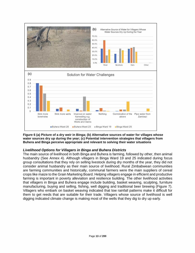
Figure 6(a) shows a dry weir close to Ward 19 in Binga. This weir dries up during the months of July to September. Before it dries up, it provides drinking water to at least 2,000 cattle daily. The main alternative source of water for villagers from Binga Ward 25 is rivers followed by dams (Figure 6(b)). It is important to note that Ward 25 villagers do not have access to boreholes as an alternative water source whenever their sources of water run dry. Villagers from Binga Ward 19 and the two wards in Buhera access water from rivers, boreholes, and dams whenever their water sources run dry during the year. Figure 6(c) shows the potential intervention strategies that villagers from Buhera Ward 20 and 23, and Binga Ward 19 and 25 thinks are appropriate and relevant to solving their water situations. About 81% and 74% of villagers in Buhera Ward 20 and 23 respectively, believe that drilling boreholes is the solution to water challenges within their wards. The remainder of villagers in Buhera Ward 20 and 23 believe that sinking more wells (7% for Ward 20 and 11% for Ward 23), improving on water harvesting (7% for Ward 20 and 2% for Ward 23) or combining groundwater use and water harvesting (1% for Ward 20 and 5% for Ward 23) as the solutions to their water problems. The statistics gathered from Binga on the potential way forward in terms of solving the water problems within their areas slightly differ from the solutions proposed in Buhera. More villagers in Binga compared to Buhera believed in water harvesting as key in solving water problems within their wards – probably due to high groundwater salinity in the area. The statistics of villagers proposing water harvesting in Binga were 42% for Ward 19 and 30% for Ward 25, compared to only 7% for Ward 20 and 2% for Ward 23 in Buhera. Apart from water harvesting, villagers in Binga proposed drilling of more boreholes (51% for Ward 19 and 30% for Ward 25); sinking more wells (0% for Ward 19 and 5% for Ward 25); combining water harvesting and borehole drilling (5% for Ward 19 and 28% for Ward 25); and piping water from the Zambezi River (0% for Ward 19 and 8% for Ward 25) as solutions to the water problems within their wards.
Impact Binga Buhera
Ward 19 Ward
25 Ward
20 Ward 23
Loss of livestock × × × ×
Loss of livelihoods × × × ×
Drying of water sources × × × ×
Water conflicts × × × ×
Women forced to walk long distances in search of water
× ×
Girls missing school looking for water × ×
Food insecurity × × × ×
Men forced to migrate in search of employment × × × ×
Men forced to travel long distances in search of pastures and water for livestock
× × × ×
Increasing levels of poverty × × ×
Forced migration × × ×
Vulnerability to hygiene related diseases × × ×
Schools teachers migrating from the area due to water shortages
× ×
Page 13 of 200
Figure 6 (a) Picture of a dry weir in Binga; (b) Alternative sources of water for villages whose water sources dry up during the year; (c) Potential intervention strategies that villagers from Buhera and Binga perceive appropriate and relevant to solving their water situations
Livelihood Options for Villagers in Binga and Buhera Districts The main source of livelihood in both Binga and Buhera is farming, followed by other, then animal husbandry (See Annex 4). Although villagers in Binga Ward 19 and 25 indicated during focus group consultations that they rely on selling livestock during dry months of the year, they did not consider animal husbandry as their main source of livelihood. Rural Zimbabwean communities are farming communities and historically, communal farmers were the main suppliers of cereal crops like maize to the Grain Marketing Board. Helping villagers engage in efficient and productive farming is important in poverty alleviation and resilience building. The other livelihood activities that villagers in Binga and Buhera engage include building, basket weaving, sculpting, furniture manufacturing, buying and selling, fishing, well digging and traditional beer brewing (Figure 7). Villagers who embark on basket weaving indicated that low rainfall patterns make it difficult for them to get reeds that are suitable for their trade. Villagers whose source of livelihood is well digging indicated climate change is making most of the wells that they dig to dry up early.

Page 14 of 200
Crop Farming in Binga and Buhera Districts Some parts of Ward 19 and 25 in Binga have soils suitable for farming. However, these fertile pieces of land lack access to water and are therefore not available for productive/farming purposes. Additionally, the boreholes and wells found in Binga use manual hand pumps and are not suitable for large gardening projects. Villagers concentrate on doing small gardens next to perennial boreholes in Ward 19. Apart from gardening close to boreholes, rivers, and springs, villagers in Binga also engage in rainfed cotton farming, with free inputs from the Government. Cotton is mainly sold to the Cotton
Company of Zimbabwe (COTTCO). However, climate change, mostly characterised by poor rainfall, significantly affects the cotton yields of the villagers. Villagers in Buhera Ward 20 and 23 engage in growing roundnuts and groundnuts during the rainy season. These two crops require sandy soils and do very well with little moisture. The Grain Marketing Board provides the main market for roundnuts and groundnuts grown in Buhera. However, villagers indicated that the prices paid by GMB are low. Apart from GMB, some villagers also take their produce to Mbare Musika in Harare. Agricultural Technical and Extension Services (AGRITEX) Officers in Buhera revealed that Buhera has good soils suitable for growing small grains. Villagers are, however, reluctant to grow small grains because they are labour-intensive. Additionally, apart from small grains, AGRITEX Officers in Buhera also believe that soils in Buhera can support various agricultural activities if irrigation water is available. Access to water affects ownership of gardens in Buhera. Gardens are found in homesteads that own wells or close to boreholes. Some villagers do gardening close to rivers and springs. During the year 2004, the Red Cross established community gardens in Ward 23 Buhera which are no longer functional, as the rivers that used to water the gardens have dried up. Villagers believed drilling deep boreholes can help bring sustainability to the irrigation schemes. Villagers who embark on gardening, irrigation farming and orchards requested for projects that provide them with access to markets for their crops. Most vegetable gardens in Binga are found next to boreholes (Figure 8). A few gardens are located close to rivers and springs. The type of gardens found in Binga are community-owned where two or three villagers combine efforts and establish a vegetable garden next to a common borehole. Due to water challenges, several households in Binga do not have vegetable gardens. Animal Husbandry in Binga and Buhera Districts Cattle is a source of wealth for the traditional Zimbabwean rural household and given the option, villagers from Binga and Buhera would stock as many cattle as possible. Men in Binga own more cattle than their male counterparts in Buhera. About 88% of men in Binga Ward 19 and 86% of men in Binga Ward 25 own at least three and above cattle. This is compared to 70% of men in Buhera Ward 20 and 80% of men in Buhera Ward 23 who own at least three cattle and above. The highest percentage of men owning more than eight (8) cattle
Figure 7 A picture of villagers in Buhera
engaging in brick moulding
Figure 8 A picture of a community garden located
next to a borehole in Manyanda Village Binga. This garden serves three sub-
villages within Manyanda

Page 15 of 200
comes from Binga Ward 19 and the highest percentage of men who do not own any cattle is in Buhera Ward 20. The statistics of cattle ownership of women also follow the same trends as that of men. People in Binga Ward 25 survive on selling cattle and other livestock during periods of drought. Rivers followed by wells are the main sources of drinking water for livestock in Buhera Ward 20 and 23. The main source of water for livestock in Binga Ward 19 is boreholes followed by dams. Villagers from Binga Ward 25 get water for their livestock from rivers, followed by dams and springs. Focus group meetings with villagers, and interviews held with various stakeholders from Buhera Ward 20 and 23 revealed some factors affecting livestock ownership and wellbeing. Villagers lose many livestock due to lack of access to drinking water. Cattle owners from Ward 20 go for as long as three (3) months without dipping their animals because there is no water, potentially losing cattle to tick borne diseases. Poor animal husbandry practices in Buhera contribute to land degradation and siltation of both natural and man-made dams. Baravara dam in Ward 20 silted because of farming activities and cattle trampling. There are some NGOs in Buhera assisting villagers to restock livestock. Villagers revealed that NGOs such as Red Cross, GOAL and World Vision have been actively involved in various livestock projects. The main source of capital, emergency income and livelihood for villagers (especially villagers in Binga Ward 25) is trading livestock. One of the distinguishing features of Ward 25 is the substantial number of free-range pigs and chickens. Focus group meetings and interviews with the chiefs in Binga revealed that villagers are losing cattle due to lack of access to drinking water. Additionally, livestock in Binga are susceptible to disease outbreaks. In Ward 19 there were no village chickens, the villagers revealed that the last outbreak of Newcastle disease wiped out the entire population of chickens in the village. Binga is also a red zone district for tsetse fly. This means that cattle from Binga do not fetch high prices if sold in markets outside of Binga. Access to Productive Resources for Villagers in Binga and Buhera Districts In Binga and Buhera villagers access land for resettling free of charge. The chief is responsible for distributing land to the villagers. The Rural District Council sells business stands to villagers interested in setting up shops or other businesses at the designated business sites. Villagers provide for their own labour for the preparation of land or any other activities that need labour. Women provide labour for most activities, including building huts. The majority of men do not stay in Binga due to lack of employment opportunities and other livelihood options. The main source of capital for setting up businesses comes from selling cattle and other personal savings. Overview of Activities of District Development Fund, Rural District Councils, and Sub-
Catchment Councils in Binga and Buhera Districts Wards 19 and 25 of Binga are in the Lower Gwayi Sub-Catchment Council (SCC), which issues permits for borehole drilling, but not for digging wells. There are 31 commercial boreholes in Binga, but no breakdown records per ward. The SCC is supposed to monitor the usage of boreholes on a quarterly basis. Currently the SCC does not have water quality records of boreholes. Boreholes in Binga dry up mainly due to drought, and destruction of wetlands. A case in point are wetlands in Ward 25 that dried up due to farming and grazing activities of the villagers. The council now has a program in place to encourage villagers to conserve wetlands through embracing indigenous knowledge systems on protection of wetlands. Water drawn from boreholes is for domestic consumption. However, some boreholes support gardening projects. Coal or peat adversely affects the quality of groundwater in Binga. Boreholes

Page 16 of 200
in Ward 23 produce salty water and the council closed some boreholes due to the high levels of water contamination. The District Development Fund drilled most of the boreholes in Binga. The funding for borehole drilling comes mostly from NGOs. Save the Children has been operational in Binga for more than 37 years and provided the funding to drill a considerable number of boreholes in Ward 19. Once a borehole is drilled, a borehole minder (usually one of the villagers staying close to the borehole) is appointed and tasked with the maintenance and repairing of the borehole. The Rural District Council provides the materials needed to repair broken down boreholes. Summary of Problems to be addressed by the Project and Pathway to Impact Given the analyses done in the preceding section, it is clear that water scarcity in Binga and Buhera is a present and continuing concern. Rainfall is seasonal and water sources dry up around September to early November. These problems are being exacerbated by climate change, with a decrease in overall rainfall, further shortening of the rainfall season, and more severe droughts. The failure of crops and animals during this period is key to the diversification of livelihoods as options for survival are limited. The burden on women and the girl child is enormous as they are forced to miss other crucial tasks and walking distances of sometimes more than 10 km in some cases to fetch water. Even during the rainfall period, the precipitation that is received is very small (>400 mm), meaning that strategies are required to improve and protect livelihoods in periods with and without rainfall. There is also increased unsustainable activities along key value chains leading to land degradation and deterioration of key water sources. Poor land husbandry practices have degraded crucial water resources systems such as wetlands and sand dams. There is therefore increased pressure on the natural ecosystems, which is incrementally reducing their ability to provide ecosystem services. These baseline challenges will be exacerbated by climate change, with traditional coping strategies no longer sufficing. The other challenge, as in most poor areas in Zimbabwe, is related to poor value chains. Some business ventures such as beekeeping and goat rearing have not been successful because of the scale of the project and disorganized markets. These challenges are happening in a space where there is a weak institutional framework for farmers to participate viably in priority value chains, with weak adaptive capacities among the smallholder communities and low application of climate smart technologies Figure 9.
Page 17 of 200
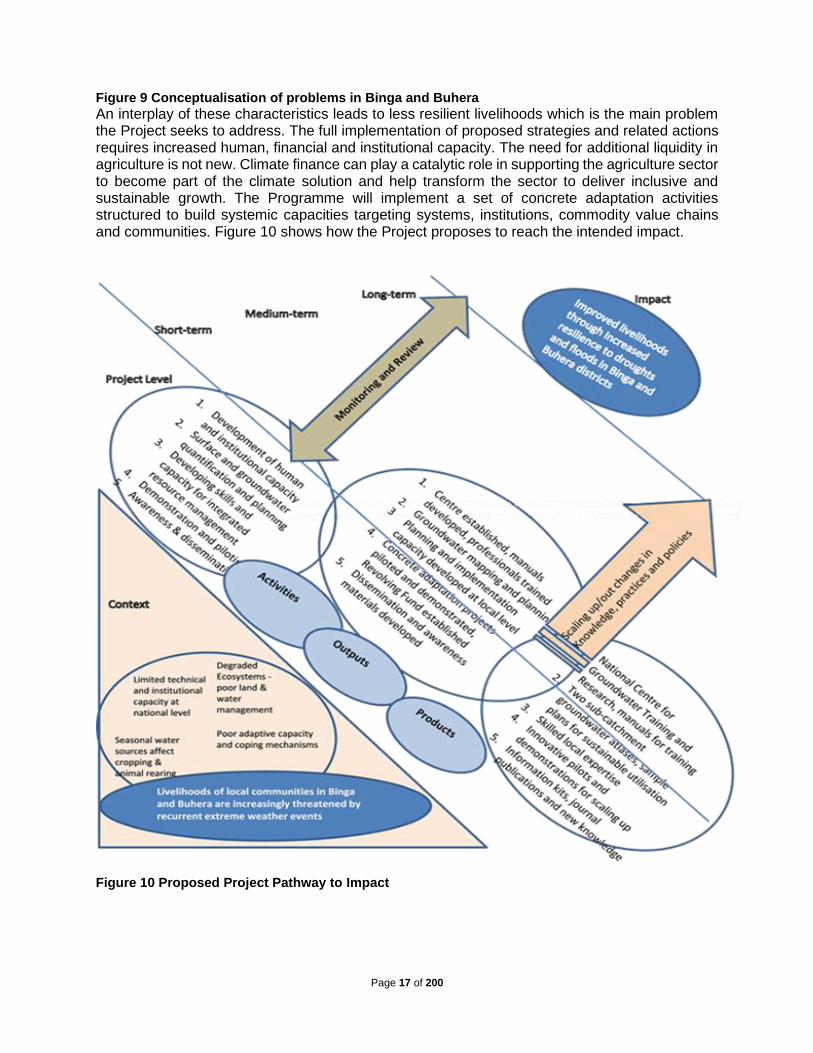
Figure 9 Conceptualisation of problems in Binga and Buhera
An interplay of these characteristics leads to less resilient livelihoods which is the main problem the Project seeks to address. The full implementation of proposed strategies and related actions requires increased human, financial and institutional capacity. The need for additional liquidity in agriculture is not new. Climate finance can play a catalytic role in supporting the agriculture sector to become part of the climate solution and help transform the sector to deliver inclusive and sustainable growth. The Programme will implement a set of concrete adaptation activities structured to build systemic capacities targeting systems, institutions, commodity value chains and communities. Figure 10 shows how the Project proposes to reach the intended impact.
Figure 10 Proposed Project Pathway to Impact

Page 18 of 200
D. Project / Programme Objectives The ultimate goal of this Project is to increase local communities’ adaptive capacity and resilience to climate change through sustainable groundwater utilisation for food security and other productive uses in rural areas of Zimbabwe. To achieve this, an array of actions are required starting at national to local levels and involving institutional reforms and modelling, characterisation and quantification of the groundwater resources, knowledge generation and capacity development, and awareness raising through piloting and demonstration. The specific project objectives linked to the above are as follows : 1. To strengthen technical, institutional and human capacity at national and local levels for
improved and sustainable utilization of groundwater ; 2. To conduct comprehensive assessments of groundwater resources in two poverty-stricken
and highly vulnerable sub-catchments of Lower Gwayi and Upper Save and develop sample plans for improving climate resilience through sustainable groundwater utilization;
3. To strengthen the capacity of water and land management institutions in Lower Gwayi and Upper Save sub-catchments in developing integrated catchment management plans that promote groundwater use and protection of groundwater sources;
4. To pilot and demonstrate concrete climate change adaptation measures based on sustainable groundwater utilisation by diversifying and strengthening the livelihoods of the most vulnerable population in Lower Gwayi and Upper Save sub-catchments;
5. To compile and disseminate lessons learnt from the project to facilitate future upscaling and replication of good practices in groundwater extraction and management.
These objectives are in line with those set by the Adaptation Fund aiming to reduce the vulnerability and increase adaptive capacity to respond to climate change impacts, including variability at local and national level.
Project / Programme Components and Financing Table 6 Relationships among project components, activities, expected concrete outputs, and the corresponding budgets
Project/Programme Components
Activities
Expected Concrete Outputs Expected Outcomes
Amount
(US$)
1. To strengthen technical, institutional and human capacity for improved and sustainable utilization of groundwater at national and local levels
1.1 Establish a National Centre for Groundwater Research and Training at the University of Zimbabwe
Output 1.1 National Centre for Groundwater Research and Training established at the University of Zimbabwe
Improved knowledge and capacity in groundwater science, policy and participatory management at national and local levels
419,689
1.2 Assess the capacity of local and national institutions and identify training needs for managing groundwater in particular, and water resources in general
Output 1.2 Capacity needs of local and national institutions to manage groundwater and water resources in general assessed and training needs identified
1.3 Develop practical guidelines and manuals for groundwater planning, development and management
Output 1.3 Practical guidelines and manuals for groundwater resources planning, development and management developed

Page 19 of 200
1.4 Train groundwater technicians, scientists and managers at national and local levels in improved and sustainable utilization of groundwater
Output 1.4 At least 100 groundwater technicians, scientists and managers trained each year on improved and sustainable utilization of groundwater, via tailor-made or regular short courses, certificates, diplomas, undergraduate and postgraduate courses.
2. To conduct comprehensive assessments of groundwater resources in two poverty-stricken and highly vulnerable sub-catchments of Lower Gwayi and Upper Save and develop sample plans for improving climate resilience through sustainable groundwater utilization
2.1 Develop two groundwater atlases for Lower Gwayi and Upper Save Sub-Catchments
Output 2.1: Groundwater atlases for Lower Gwayi and Upper Save Sub-Catchments developed
Sustainable utilisation of groundwater based on sound scientific inventory of the resource; science-based formulation of groundwater management policy to improve management of the resource and further develop new groundwater-based resilience strategies and practical interventions.
300,000
2.2 Develop two Groundwater Development Action Plans for Lower Gwayi and Upper Save Sub-Catchments
Output 2.2: Groundwater Development Action Plans for Lower Gwayi and Upper Save Sub-Catchment Councils developed.
3. To strengthen the capacity of water and land management institutions in Lower Gwayi and Upper Save sub-catchments by developing integrated catchment management plans that promote groundwater use whilst protecting groundwater resources
3.1 Update catchment management plans (River Systems Outline Plans) and structures by mainstreaming gender, climate change and sustainable groundwater management
Output 3.1 Existing catchment management planning guidelines and structures updated to clearly mainstream gender, climate change and sustainable groundwater management
Increased participation by the wider stakeholder community, who are aware of water resource management issues and have access to tailored information and guidelines that support better catchment planning and sustainable use of groundwater.
145,750
3.2 Revise Sub-Catchment Management Plans of Lower Gwayi and Upper Save Sub-Catchments through stakeholder participation to address climate change and groundwater management issues
Output 3.2 The Sub-Catchment Management Plans of Lower Gwayi and Upper Save Sub-catchments revised through stakeholder participation to address climate change and groundwater management issues
3.3 Strengthen the capacity of extension services and institutions to support communities in Lower Gwayi and Upper Save Sub-Catchments to undertake climate change adaptation activities
Output 3.3 Capacity of extension services and institutions strengthened to support communities in Lower Gwayi and Upper Save Sub-catchments to undertake climate change adaptation activities
3.4 Strengthen technical capacity of the two sub-catchment councils and Binga and Buhera Rural District Councils to manage and protect groundwater resources
Output 3.4 Technical capacity of the two sub-catchment councils and Rural District Councils strengthened to manage and protect groundwater resources

Page 20 of 200
Projected Calendar Table 7 Proposed dates of the milestones for the proposed Project
Output 3.5 Skills training for community members on sustainable technologies and smart agricultural techniques
Output 3.5 About 2,000 farmers in target areas trained on skills for sustainable technologies and smart agricultural techniques
4. To pilot and demonstrate concrete climate change adaptation measures based on sustainable groundwater utilisation by diversifying and strengthening the livelihoods of the most vulnerable population in Lower Gwayi and Upper Save sub-catchments
4.1 Look and learn visits to best practice projects in Zimbabwe or regionally
Output 4.1 Look and learn visits to best practice projects in Zimbabwe or regionally
Livelihoods of communities in demonstration wards improved and diversified, reducing vulnerability to the impacts of climate change
3,226,402
4.2 Pilot and demonstrate community-based ecosystem resilience and mitigation projects in selected four Wards in Binga and Buhera districts
Output 4.2 Four pilot climate-smart ecosystem mitigation and resilience projects implemented in four wards in Binga and Buhera districts
4.3 Pilot and demonstrate community-based climate resiliency and livelihood enhancement projects in selected four Wards in Binga and Buhera districts
Output 4.3 Four climate-smart water and food security pilot projects using groundwater and rainwater harvesting at community level implemented in four wards
4.4 Pilot and demonstrate household climate resiliency, livelihood enhancement and diversification projects in the four wards in Binga and Buhera districts
Output 4.4 Climate-smart livelihood enhancement and diversification pilot projects using groundwater, rainwater harvesting and renewable energy for 2,000 households implemented
4.5 Establish a food security and livelihood enhancement revolving fund
Output 4.5 About 2,000 households in the four Project wards apply and access funding from the food security and livelihood enhancement revolving fund
5. To compile and disseminate lessons learnt from the project to facilitate future upscaling and replication of good practices in groundwater extraction and management.
5.1 Establish a web-based information sharing and exchange platform for project participants
Output 5.1 Web-based information sharing and exchange platform for Project participants established
A framework for improved groundwater utilisation to reduce vulnerability to climate change developed and adopted
100,000
5.2 Document and adopt good practices by key stakeholders
Output 5.2 Good practices documented and adopted by key stakeholders
6. Project/Programme Execution cost 437,789
7. Total Project/Programme Cost 4,629,630
8. Project/Programme Cycle Management Fee charged by the Implementing Entity 8.5% - This total includes the costs over the four years of the Project Coordinating Units plus the M&E costs)
370,370
Amount of Financing Requested 5,000,000
Milestones Expected Dates
Start of Project/Programme Implementation September 2021
Mid-term Review February 2023
Project/Programme Closing August 2025
Terminal Evaluation June 2025

Page 21 of 200
PART II: PROJECT / PROGRAMME JUSTIFICATION
A. Description of Project Components The project consists of five complementary components focused on strengthening the resilience of local communities in Zimbabwe to climate change impacts — particularly droughts and flash floods — by increasing water supply in Lower Gwayi and the Upper Save sub-catchments to enhance food and livelihood security in the region. Specifically, this will involve: i) improving knowledge and capacity in groundwater science, policy and participatory management at national and local levels; ii) promoting the sustainable utilisation of groundwater; iii) increasing participation of relevant stakeholders at the national and local levels who are aware of water resource management challenges and have access to tailored information and guidelines to support improved catchment management; iv) enhancing livelihood and food security of vulnerable communities in Zimbabwe under future climate change conditions; and v) developing and implementing a framework for improved groundwater utilisation within the most vulnerable communities in Lower Gwayi and the Upper Save sub-catchments. Communities in these areas will be targeted under the project because they have some of the highest food insecurity and poverty levels in the country and are located in the least productive agro-ecological regions IV and V. All interventions to be implemented in these areas have been designed to be readily upscaled to other wards, sub-catchments and catchments. Component 1. To strengthen technical, institutional and human capacity for improved and sustainable utilization of groundwater at national and local levels Output 1.1 National Centre for Groundwater Research and Training established at the University of Zimbabwe: This proposed Centre will build capacity in groundwater knowledge and tackle the shortage of skilled groundwater technicians, scientists and managers in Zimbabwe. The Centre will be established in collaboration with the University of Zimbabwe and will be fully resourced by the Project. Other Universities teaching groundwater-related courses will be included in the governing structure of the Centre so as to allow for the sharing of equipment and knowledge and effective dissemination of groundwater technology. These universities are Chinhoyi University of Technology, Lupane State University, Midlands State University, National University of Science and Technology, and Zimbabwe Open University. This is also in line with the current thrust of the Government of Zimbabwe to increase sharing of resources and cooperation among universities and a new model of funding research in universities. The Centre will be linked to the Southern Africa Development Community Groundwater Management Institute (SADC-GMI), a regional centre of excellence on groundwater management hosted by the University of the Free State in Bloemfontein, South Africa, for synergies and sustainability. The SADC-GMI has just completed a capacity needs assessment, which has highlighted the lack of capacity in SADC Member State institutions tasked with groundwater management, as a major hindrance in achieving sustainable groundwater management in the region (SADC-GMI, 2017). It is noted here that SADC-GMI was involved in meetings to discuss the establishment of the Centre. This gives us scope that the Centre will be more than a national centre, with high possibilities of training people from the SADC region and to get regional facilitators/trainers where required. The link to SADC-GMI will be formalised through a memorandum of understanding at the beginning of the Project.

Page 22 of 200
The Centre will train postgraduate and postdoctoral scientists in advanced hydrogeological and related technologies, as well as improving knowledge on groundwater science, policy and management issues confronting water managers. The Centre will also train district groundwater technicians, who will in turn train their district personnel up to the lowest level. National manuals and guidelines for groundwater development and implementation will be developed. The Centre will act as an entry for groundwater technologies in the country and it will advise the government on groundwater development issues. Tailor-made short courses for communities with groundwater-related issues will be offered at the Centre as well as in the communities themselves. Output 1.2 Capacity needs of local and national institutions to manage groundwater and water resources in general assessed and training needs identified: The National Water Policy of 2013, the Water Act (Chapter 20:24), and the new National Water Resources Masterplan currently being finalised, cover issues of groundwater management. However, relevant institutions need to be revitalized in light of the current deficiencies in regulating and monitoring groundwater abstractions in view of climate change realities in the country. Although the Zimbabwe National Water Authority has a groundwater section and statutory instruments to guide groundwater development and utilisation are in place, it is evident from lack of up-to-date statistics that the monitoring of groundwater is inadequate in many sub-catchment councils. Groundwater regulation should go beyond boreholes and cover springs and wells as these are the predominant facilities in use in Zimbabwe. The aim will be to promote groundwater use not only for primary use, but mainly for secondary uses. Water ownership in Zimbabwe is not tied to land tenure as all water is vested in the President of the country who has the power to commandeer its use, especially in times of emergencies. The Project will look into impediments to water governance, especially for communally-owned facilities such as boreholes, springs and sand dams and how these will be monitored to ensure economic and environmental sustainability. The Project will also tap into the ongoing SADC-GMI initiative on, “Policy, Legal and Institutional Development for Groundwater Management in the SADC Member States (GMI-PLI)”, which seeks to respond to gaps in the existing policy, legal and institutional frameworks for groundwater management in the region, and enhancing institutional capacity of governments in SADC Member States. Output 1.3 Practical guidelines and manuals for groundwater resources planning, development and management developed: During the course of the implementation of the Project, at least five manuals and guidelines will be developed by the Centre in conjunction with the District Development Fund, the Zimbabwe National Water Authority, Ministry of Lands, Agriculture, Water and Rural Resettlement (MLAWRR). These will guide practitioners on groundwater planning and development, and the mainstreaming of gender and groundwater in climate resilient catchment development. The Project will also benefit from the guidelines and manuals being developed by the SADC-GMI, to avoid duplication of efforts and ensure standardisation of practices across the region. The manuals will be prepared by participating universities in the Centre and the Centre staff providing facilitation and quality control. Output 1.4 At least 100 groundwater technicians, scientists and managers trained each year on improved and sustainable utilization of groundwater, via tailor-made or regular short courses, certificates, diplomas, undergraduate and postgraduate courses: The Project will provide seed funding for purchasing state-of-the-art groundwater equipment for the training of groundwater technicians, scientists and managers, and for use by the Centre in outreach activities. Technicians will be trained in modern methods of well and borehole siting, drilling and protection, and groundwater monitoring. Of particular importance will be the training on borehole maintenance. Scientists and managers will also be trained on the holistic systems approach for groundwater

Page 23 of 200
management. The holistic systems approach is a sustainable organised model which promotes coordinated development and management of water, land, and related resources, in order to not only maximize economic and social welfare, but also ensure equity and sustainability (Mayhew, 2009). The approach which monitors groundwater level and water quality is aimed at reversing resource degradation and stabilizing water harvesting and groundwater recharge systems through implementing actions such as artificial recharge, rainwater harvesting, water use efficiency, catchment and wetland protection, spring capture construction, sand dam construction and various techniques of surface and underground water harvesting, catchment protection, etc. Although the whole country will benefit from this in the medium to long-term, Project efforts will specifically emphasize on the target catchments (Gwayi and Save) and districts (Binga and Buhera) under the Project first. This is part of the transformative agenda of the Project to ensure that a critical mass is built around the Project area, with easy upscaling to other sub-catchments and wards. Table 8 Indicative work programme for Component 1
Output 1.1 National Centre for Groundwater Research and Training established
1.1.1 Develop a concept note, convene and conduct a four-day workshop at the University of Zimbabwe for local universities and SADC-GMI to set up a Centre for Groundwater Training and Research to develop its structures and TORs
1.1.2 Advertise, shortlist, interview and appoint staff for the Centre (Director, 3 Specialists, Programmes Officer, Receptionist)
1.1.3 Resource and capacitate the Centre through state-of-the-art groundwater development and monitoring equipment
1.1.4 Plan and convene a four-day workshop to develop a four-year strategic plan and budget for the Centre
Output 1.2 Capacity needs of local and national institutions to manage groundwater and water resources in general assessed and training needs identified
1.2.1 Prepare TORs, advertise, select and appoint an institutional reform specialist
1.2.2 Conduct an institutional gap analysis with a specific focus on groundwater, climate change and gender mainstreaming
1.2.3 Organise and conduct a one-day national workshop to review institutional gaps identified in Sub-component 1.2.2 and develop a training needs strategy
1.2.4 Present summary recommendations to government ministries for action
Output 1.3 Practical guidelines and manuals for groundwater resources planning, development and management developed
1.3.1 Identify and contract teams to prepare the guidelines and manuals
1.3.2 Convene and conduct a five-day workshop of universities, practitioners and SADC-GMI to formulate a training curriculum, at least five practical guidelines and manuals for groundwater planning, development and management
1.3.3 Prepare, review, edit and publish the 5 manuals
Output 1.4 At least 25 groundwater technicians, scientists and managers trained each year on improved and sustainable utilization of groundwater, via tailor-made or regular short courses, certificates, diplomas, undergraduate and postgraduate courses
1.4.1 Recruit and fully fund 2 PhD and 3 MPhil students to conduct research on sustainable ground water utilisation
1.4.2 Accredit regular course with the Zimbabwe Council for Higher Education and the short courses with the Zimbabwe Institution of Engineers for Continuous Professional Development (CPD) points
1.4.3 Conduct training of approved courses
Component 2. To conduct comprehensive assessments of groundwater resources in two poverty-stricken and highly vulnerable sub-catchments of Lower Gwayi and Upper Save and develop sample plans for improving climate resilience through sustainable groundwater utilization

Page 24 of 200
The use of groundwater for productive purposes is limited although it is believed that some areas in Zimbabwe have high yielding boreholes (>20 m3/hr). Recent challenges caused by recurrent droughts have shown that groundwater could be a viable alternative water supply in agriculture. However, the adoption of groundwater as a sustainable adaptive strategy for agriculture in Zimbabwe is highly dependent on a comprehensive understanding of available groundwater reserves and their safe yield potential. The maps that have been used for identifying groundwater potential areas in Zimbabwe are outdated and not robust enough to represent a comprehensive current picture of the situation on the ground. Outdated data on groundwater availability is particularly troubling given the observed and projected impacts of climate change on water availability. Misinformation on the safe yields of aquifers targeted for extraction may lead to over-exploitation of resources, creating long0term negative impacts. It is therefore essential that detailed and up to date data are maintained to ensure that groundwater extraction is sustainable. This is a core objective of the Project, with activities under Component 2 contributing directly to establishing plans sustainable extraction of ground water resources. Using modern technologies such as aeromagnetic surveys for identifying and quantifying groundwater for different areas is the first step in promoting increased utilisation of groundwater. Sustainable utilisation requires monitoring resource usage and impact, together with appropriate corrective actions. Also required is the mapping and monitoring of groundwater quality. The study area of Binga, with its unique geology and salinity challenges, will offer an interesting case study on groundwater quality. Key to achieving the objectives of the Project is to fully map out and understand the link and potential of groundwater both qualitatively and quantitatively through understanding the four wards’ hydro geological properties. The aim is to fully understand the geology of the host aquifers in all regions where groundwater will be extracted to support livelihood projects. The water depending on realised quantities could be used to upscale the water-dependent interventions outlined in Component 4 from ward level to district level. Outputs of this Component will also directly contribute to ensuring that interventions under Component 4 are sustainable and do not lead to over-exploitation of groundwater for short-term gain at the expense of long-term sustainability. The results of the assessments will contribute to meeting the management strategies outlined in the Environmental Social Management Plan. Output 2.1 Groundwater atlases for Lower Gwayi and Upper Save Sub-Catchments developed: In line with the current Water Resources Masterplan for Zimbabwe and the National Water Policy of 2013, the Project proposes to use modern technologies/techniques to carry out an extensive pilot study and mapping of groundwater potential, risks and vulnerabilities in the two proposed sub-catchments of Lower Gwayi and Upper Save. Considering the huge costs for a national campaign, starting small will give an insight into the complexity of the task before scaling up the exercise in future. This part will be carried out by local experts and will be supervised by the Ministry of Lands, Agriculture, Water and Rural Resettlement and ZINWA and respective Sub-catchment councils. The Centre established in Component 1 will also be heavily involved in order to gather knowledge, document lessons learnt and build capacity for upscaling the task to other catchment areas. Backstopping will be provided by the SADC Groundwater Management Institute, the UNESCO Groundwater Management Unit at the Headquarters and the International Groundwater Resources Assessment Centre (IGRAC), a UNESCO Category 2 Centre. This will ensure quality control and sustainable skills transfers to the locals. The results will enable catchment authorities to properly plan, regulate and monitor the use of groundwater as an adaptation measure against climate change whilst also learning from effective case studies how to avoid over-exploitation of the resource, as well as any potential environmental impacts (e.g. water quality degradation and land subsidence).

Page 25 of 200
On the mitigation side, this component will look at various catchment management strategies for recharging shallow and deeper aquifers and develop guidelines for sustainable utilization. An important inclusion in this component is the establishment of groundwater monitoring sites in the target wards, for monitoring both water quantity and quality. The measurement of quantity will take place seasonally, while that of quality will be twice a year, in summer and winter. The Zimbabwe Government is already in the process of encouraging the use of irrigation through the Command Agriculture programme and this Project will also help to extend and promote the sustainable use of groundwater for productive purposes by poor peasant farmers in arid and semi-arid areas in an environmentally sustainable manner. The atlases will inform the catchment managers of the available groundwater resources in the respective catchments, hence provide a basis for inclusion of groundwater in the overall water resources planning. Output 2.2 Groundwater Development Action Plans for Lower Gwayi and Upper Save Sub-Catchment Councils developed: This is essentially an integrated land and water resources management plan aimed at enhancing ecosystem resilience, ensuring environmental sustainability and enhancing better water stewardship. Knowing the quantity and quality of groundwater is not enough if there is no action plan and rules on how it will be sustainably utilized. To support the National Water Masterplan, a Groundwater Development Action Plan for the sustainable development of groundwater which mainstreams gender, youth empowerment and expected climate change impacts will be developed for each sub-catchment through comprehensive stakeholder consultations. This plan will provide for the technical and financial resourcing of the programme and provide solutions and models for use in different villages. The Action Plan which will be formulated following a distinct procedure as laid out in Agenda 21 on conservation and management of resources for development. The Action Plan will address governance issues for groundwater use, the measurement of use and replenishment of groundwater, including water quality monitoring, as well as the impact on potential changes in river baseflow. Local community leadership: including councillors, chiefs, headmen, headmasters, etc, will be trained in practical skills for developing groundwater management plans and building climate resilience. Emphasis will also be on the targeted inclusion of women and youth leaders as these are more vulnerable to climate change and water scarcity, and are the drivers of change. Model groundwater management and utilisation plans, developed through local stakeholder dialogue and focusing on women and youth empowerment, will be developed for each sub-catchment and this will be used to design specific ward pilot schemes. These will address specific ward groundwater issues, exposure risks and food security, and should show innovation in approaches and technologies and show direct links to community livelihood enhancement and improved food security. The UNESCO-supported ‘Climate Risk Informed Decision Analysis: Collaborative Water Resources Planning for an Uncertain Future’ (CRIDA)3 will be used, and presents an innovative, bottom-up approach to identify vulnerability of the current and future water security at the local level, but also provides a pathway for the identification of robust adaptation strategies considering climate change uncertainties. As CRIDA is a participatory approach, it allows for active engagement with Local and Indigenous Knowledge Systems (LINKS), one of UNESCO’s priority areas4, as well as to ensure gender mainstreaming and equality, which is a UNESCO priority5 to strengthen social inclusion in the decision-making process. Table 9 Indicative work programme for Component 2
3 http://unesdoc.unesco.org/images/0026/002658/265895e.pdf 4 https://en.unesco.org/links 5 https://en.unesco.org/genderequality

Page 26 of 200
Output 2.1: Groundwater atlases for Lower Gwayi and Upper Save Sub-Catchments developed
2.1.1 Develop TORs, advertise, select and recruit a local company to carry out extensive pilot study and mapping of groundwater potential, risks and vulnerabilities in the two proposed sub-catchments of Lower Gwayi and Upper Save
2.1.2 Conduct pilot groundwater mapping in Lower Gwayi and Upper Save sub-Catchment
2.1.3 Identify and establish groundwater monitoring sites in Binga Wards 19 and 25 and Buhera Wards 20 and 23
2.1.4 Develop potential, risks and vulnerability maps
Output 2.2: Groundwater Development Action Plans for Lower Gwayi and Upper Save Sub-Catchment Councils developed
2.2.1 Develop TORs, advertise, select and recruit a facilitator for the development of sub-catchment action plans which mainstreams gender, youth empowerment and expected climate change impacts
2.2.2 Facilitator develops training materials for approval
2.2.3 Conduct two-day training courses in each sub-catchment for local community leadership: including councillors, chiefs, headmen, headmasters, etc, on practical skills for developing groundwater management plans and building climate resilience
2.2.4 Facilitate the development of Action Plans for each sub-catchment through two-day workshops through local stakeholder dialogue and focusing on women and youth empowerment, and this will be used to design specific ward pilot schemes (see Components 4.2 – 4,4)
Component 3. To strengthen the capacity of water and land management institutions in Lower Gwayi and Upper Save sub-catchments in developing integrated catchment management plans that promote and protect groundwater use whilst protecting groundwater resources This component will focus on capacity building actions at district and sub-catchment levels,
focusing on capacity of the two sub-catchments so that they can upscale activities to other sub-
catchments that will not be covered under this Project. The overlap between districts at
administrative level and catchments and sub-catchments at hydrological levels in Zimbabwe is
noted in the development of specific action plans. However, this will also be an advantage in
terms of the wider reach of Project actions and future upscaling of the Project. The main purpose
of this component is to build critical mass and capacity in carrying out various adaptation and
resilience building measures beyond the life of this Project. The actions will be centred on four
pilot projects (Component 4) in selected wards, under the two sub-catchments, that will be led by
the MLAWRR through ZINWA and Agritex, with support from the National Centre for Groundwater
Research and Training, SADC Groundwater Management Institute, the Groundwater
Management Unit at UNESCO Headquarters and the International Groundwater Resources
Assessment Centre (IGRAC), a UNESCO Category 2 Centre. The continued and strategic
involvement of the National Centre for Groundwater Research and Training will be ensured at all
levels as a knowledge management imperative.
Output 3.1 Existing catchment management planning guidelines and structures updated to clearly
mainstream gender, climate change and sustainable groundwater management: River System
Outline Plans (RSOP) are part of the water sector reforms introduced in 1998 and are reviewed
every ten years. The plans for Lower Gwayi and Upper Save Sub-Catchments will be updated in
line with the Project’s thrust on climate change, groundwater and gender. Water resources
specialists, climate change experts, social scientists and gender experts will be engaged to
facilitate the revision of the catchment planning guidelines by incorporating aspects of gender and
climate change, as part of the Climate Risk Informed Decision Analysis (CRIDA) approach.
Stakeholder consultative workshops will be conducted during revision of guidelines, which will
then be printed and disseminated to the different stakeholders through training workshops;
Page 27 of 200
focusing on climate change mitigation and adaptation, resilience building, climate change
leadership, climate smart agriculture solutions, framework and needs assessment of groundwater
management at the local level, aquifer systems characterisation for groundwater management,
groundwater monitoring and information management, groundwater regulation, allocation,
licencing and institutions, the role of stakeholder participation and communication in groundwater
management, groundwater and food security, groundwater hazards, groundwater and the
environment, and groundwater and climate change. The workshops will reflect gender profiles of
the targeted communities.
Output 3.2 The Sub-Catchment Management Plans of Lower Gwayi and Upper Save Sub-catchments revised through stakeholder participation to address climate change and groundwater management issues: In this Project, experts hired in sub-component 3.1 will facilitate the process of integrating climate change aspects and giving prominence to the role of groundwater in catchment outline plans. Stakeholder consultation workshops will be organised during the revision of the catchment outline plans, which will be printed and shared with all stakeholders. The plans will cover innovative systems and technologies related to: community-based mitigation and adaptation to climate change, resilience building, water chain approaches, water use efficiency, groundwater treatment, groundwater recharge, catchment protection, soil conservation, reduction of land degradation through supporting terraces, afforestation, climate smart agriculture, etc. As part of the CRIDA process, adaptation pathways will be developed, that consider climate change uncertainty, as well as any other drivers of change relevant for the local pilot case studies (e.g. population growth). Output 3.3 Capacity of extension services and institutions strengthened to support communities in Lower Gwayi and Upper Save Sub-catchments to undertake climate change adaptation activities: Capacity needs assessments will be conducted for key stakeholders (regional and local government staff, extension workers, catchment management councils, ward water committees). A consultant will be hired to determine the capacity gaps among the different stakeholders to inform their training. A detailed training plan will be developed to guide the capacity building program for the Project. The consultant will also develop a detailed training plan highlighting the specific content with relevant examples to the prevailing conditions in each of the four wards. Training modules for the training-of-trainers (TOT) and field level trainings to build capacity of stakeholders on a continuous basis will be conducted. TOT trainings will be undertaken to create a critical mass of trainers in prioritized adaptation and mitigation actions at community level. The following are some of the areas that the trainings will focus on: community-based climate change mitigation and adaptation strategies, community resilience building, communality-based climate change leadership, climate smart agriculture solutions, local level framework and needs assessment of groundwater management, community-based aquifer systems characterisation for groundwater management, community-based groundwater monitoring and information management, community-based groundwater regulation, allocation, licencing and institutions, the role of stakeholder participation and communication in groundwater management, community-based groundwater and food security, managing groundwater hazards at the local level, and groundwater and the environment. Information, Education and Communication (IEC) materials for awareness raising will be developed and disseminated. Output 3.4 Technical capacity of the two sub-catchment councils and Rural District Councils strengthened to manage and protect groundwater resources: The Lower Gwayi and Upper Save sub-catchment councils have limited capacity to communicate and monitor the status of groundwater resources within their areas of operations. The best they can do is measuring consumption (i.e. how much water villagers extract from the boreholes). These councils need to

Page 28 of 200
be capacitated with requisite communication skills, equipment and skills to measure borehole water quality, capacity tests, and sustainable yields to avoid groundwater mining. Key people will also be provided with technical support to create and update the database of all the boreholes, wells, wetlands, springs, and any other water sources related to groundwater within their areas of operations. Through the project, the sub-catchment councils will be furnished with tools and equipment that will enable them to carry out robust groundwater monitoring and to prevent underground water resources from reaching critical levels. Output 3.5 About 2,000 farmers in target areas trained on skills for sustainable technologies and smart agricultural techniques: In each of the selected 4 project wards, gendered groups will be trained on groundwater technologies such as groundwater exploration (boreholes and wells), well protection, borehole maintenance, deep well digging, technologies for water abstraction, spring capture, rainwater harvesting, drip irrigation systems, solar pump installations, windmill pumps, etc. This training will include specific focus on principles of sustainable extraction, including how to follow groundwater extraction guidelines and plans developed for their specific area. Training will also cover practical aspects of ecosystem protection such as gully protection and reclamation, veld firefighting and protection, land use planning, etc. Community members will be trained on various fire suppression projects such as hay baling, thatch grass combing, small animals rearing, apiculture and fire guard construction. The project will also train at least 2,000 farmers/households on climate smart agriculture techniques such as intercropping with legumes, mulching, crop rotation, greater crop diversity and improving storage and processing, and improved feeding strategies, rotational grazing, grassland restoration, integrated crop and livestock, and manure management to improve agriculture productivity. In addition, in order to take advantage of improved water access, households will also receive training on other livelihood activities such as poultry, piggery, fishery, orchards and horticulture. The emphasis will be on women and youth trainees so as to empower vulnerable groups in society and thus increase their resilience. For easier upscaling and sustainability, the training will also be extended to other non-participating wards.
Table 10 Indicative work programme for Component 3
Output 3.1 Existing catchment management planning guidelines and structures updated to clearly mainstream gender, climate change and sustainable groundwater management
3.1.1 Develop TORs, advertise, select and appoint a team of water resources specialists, climate change experts, social scientists and gender experts
3.1.2 Consult key stakeholders and facilitate the revision of the catchment planning guidelines by mainstreaming groundwater, gender and climate change, as part of the CRIDA approach.
3.1.3 Validate, print and disseminate revised guidelines to the different stakeholders
3.1.4 Conduct one-day training workshops on revised catchment planning guidelines at national and catchment levels
Output 3.2 The Sub-Catchment Management Plans of Lower Gwayi and Upper Save Sub-catchments revised through stakeholder participation to address climate change and groundwater management issues
3.2.1 Preparations for training workshop concept note by experts hired in sub-component 3.1.1.
3.2.2 Conduct one-day consultative workshops in Gwayi and Save catchments to revise catchment outlines as per sub-component 3.1.3 guidelines
3.2.3 Print and disseminate revised catchment outline plans
Output 3.3 Capacity of extension services and institutions strengthened to support communities in Lower Gwayi and Upper Save Sub-catchments to undertake climate change adaptation activities
3.3.1 Develop TORs, advertise, select and appoint an Human Resources expert to carry out a detailed skills inventory and needs assessment of extension services in the Binga and Buhera districts and Lower Gwayi and Upper Save sub-catchments, based on the Project objectives and thrust
3.3.2 Develop TORs, advertise, select and appoint a team of trainers based on the identified skilled gaps

Page 29 of 200
3.3.3 In collaboration with the Centre for Groundwater Training and Research in sub-component 1.1, conduct three-day Training of Trainers skills training workshops of maximum five days in each of the Project districts
3.3.4 Develop and disseminate Information, Education and Communication (IEC) materials for awareness raising
Output 3.4 Technical capacity of the two sub-catchment councils and Rural District Councils strengthened to manage and protect groundwater resources
3.4.1 Led by the Centre for Groundwater Training and Research, assess the Lower Gwayi and Upper Save and the Binga and Buhera districts personnel in terms of the requisite communication skills, equipment and technical skills to measure borehole water quality, capacity tests, and sustainable yields to avoid groundwater depletion
3.4.2 Develop training materials for 2 two-day short training courses and accredit courses with the Zimbabwe Institution of Engineers and other relevant bodies
3.4.3 Conduct 1 two-day training courses per district/sub-catchment and evaluate
3.4.4 Procure and install tools and equipment that will enable Sub-catchment and district councils to carry out robust groundwater monitoring
Output 3.5 About 2,000 farmers in target areas trained on skills for sustainable technologies and smart agricultural techniques
3.5.1 Using ToTs trained in sub-component 3.3.3 and backup from the Centre for Groundwater Training and Research, conduct at least ten 1-2 days training courses in each district of Binga and Buhera focusing on participants from the specific Project wards
3.5.2 Develop and disseminate Information, Education and Communication materials for awareness raising
Component 4. To pilot and demonstrate concrete climate change adaptation measures based on sustainable groundwater utilisation for diversifying and strengthening livelihoods of the most vulnerable population in Lower Gwayi and Upper Save sub-catchments This project component aims to tap into Ecosystem Stewardship Principles (Chapin III et al., 2009)) whose broad objectives are to integrate three broadly overlapping sustainability approaches; (i) reducing vulnerability to expected changes; (ii) fostering resilience to sustain desirable conditions in the face of climate uncertainty; (iii) forward planning to manage uncertainties and turning them into opportunities through ideation and strategy. This, in part, will be achieved through a mix of indigenous knowledge systems and new technologies/techniques such as climate smart agriculture. Stewardship inevitably entails trade-offs, particularly between efficiency and flexibility and between immediate and long-term benefits (Kareiva et al. 2007; Chapin et al. 2009). To work within the available budget and to maintain desired adaptation impact, this component is strategically structured as follows (see also Figure 11):
a) Community-based ecosystem resilience projects in Binga Ward 19 and Buhera Ward 20 b) Community-based livelihood enhancement and diversification projects in Binga Ward 25
and Buhera Ward 23 c) Household livelihood enhancement and diversification in all the 4 Project wards.
The interventions under Component 4 will increase the climate resilience of vulnerable communities living in the target project wards. This will be achieved by: increasing access to groundwater resources to support agricultural production and improve the sustainable management of these resources; implementing rainwater harvesting solutions; protecting catchments and wetlands; promoting conservation livestock farming; improving water use efficiency through installation of water-saving irrigation techniques and cultivating a wide range of drought-resistant crops for income diversification. Together, these interventions will reduce the impacts of periodic water shortages as a result of climate change on the livelihoods of vulnerable

Page 30 of 200
communities, while simultaneously contributing to environmental sustainability in the Lower Gwayi and Upper Save sub-catchments. This project recognizes that the sustainability of community-owned boreholes is threatened by a number of factors such as poor financial mechanisms for effective borehole maintenance and lack of users’ sense of ownership of the projects. In order to ensure financial, institutional and technical sustainability, the project will adopt a Community Based Management (CBM) model where the community, through Water Point Committees (WPC), will manage the operation and maintenance of the boreholes and related infrastructure. WPCs which are the highest water management institutions found at community level will be established with support from the Rural District Council (RDC). The responsibilities of the WPCs which will be guided by set by-laws will include, setting up an O&M fund, collecting O&M funds from water users, organizing meetings, carrying out preventive maintenance, and attending to minor repairs. The WPCs have proven to generate benefits such as constant technical, managerial and institutional support especially in cases where support from mandated local institutions will be lacking. The CBM model will be implemented based on the CBM implementation guide developed by the Zimbabwe National Action Committee. The CBM guide gives direction to stakeholders to empower communities to manage, make decisions and provide necessary resources needed to develop, operate and maintain water infrastructure. In terms of financial sustainability of borehole installations, the WPC will create a fund, community user finance, which will cover costs of O&M of boreholes. The project recognizes that some users may fail to possess sufficient capital to contribute effectively especially during the first year of the project. In such cases, a context-specific finance scheme such as in-kind contribution will be considered. The project will also depend on funding support from RDCs which are mandated to direct part of the collected land taxes towards development and management of boreholes. As for technical sustainability of the borehole installations, post-construction technical support will be provided by District Development Fund during the early phases of operation of the boreholes. The support will be withdrawn gradually to ensure that the community is capable of managing their own water infrastructure. However, technical support from DDF will be sought whenever required. The project will train borehole technicians and pump minders from the targeted community and equip them with necessary technical skills for operating and maintaining the boreholes. At the district level, performance monitoring of the boreholes will be done by the District Water and Sanitation Sub-Committees (DWSSCs).

Page 31 of 200
Figure 11 Conceptual framing of the Project from community to household level
Output 4.1 Look and learn visits to best practice projects in Zimbabwe or regionally: Farmers understand better by practical demonstration. A gender-balanced group of four members from each proposed ward demonstration project will be sponsored to visit best practice and pilot projects locally or regionally. The actual areas to visit will be determined at the Inception stage with input from other NGOs and Government participants who have experience in implementing projects in other areas. The projects to be visited may also be from other countries, in which case the number of delegates will be reduced in line with the budget. Delegate selection will depend on the nature of projects to be visited but will also look at potential change agents within communities. Output 4.2 Pilot and demonstrate community-based ecosystem resilience and mitigation projects in selected four Wards in Binga and Buhera districts: Like the rest of rural Zimbabwean, the Binga and Buhera districts have suffered serious land degradation and environmental destruction due to many reasons (Figure 12) among them livestock overstocking, poor land husbandry practices, gully erosion worsened by cyclones, perennial veldfires, cutting down of trees for firewood, poor cultivation practices, etc. The net effect of this will be to reduce land productivity, affect local climates, diminish natural capital, reduce the provision of ecosystem goods and services (including water provisioning services) and generally reduce resiliency of vulnerable communities to climate change. Although this Proposal is mainly concerned with groundwater utilisation, it cannot ignore land degradation on the supply side of groundwater, which is set to worsen with climate change. In Binga and Buhera, one of the major effects evident on the ground is the drying up of almost all water sources in the dry season. The implication of this is that both crop and livestock farming are severely constrained. This is crucial and cannot be ignored in this Project as it renders all other interventions futile. This output is thereby included to tackle this and ensure ecosystem resilience.

Page 32 of 200
Figure 12 Evidence of land degradation in Binga and Buhera districts
The link between veldfires, land degradation and local climate is often elusive and is shown here in Figure 12. High levels of bare soils and erosion are evident. An analysis of the rate of landuse changes in Binga and Buhera reveals a high rate and extent of depletion of forestry resources. Figure 13 shows raging bushfire/veldfire. Bushfire/veldfires destroy and disrupt the natural ecosystem services that are vital in building community resilience and adaptive capacity to climate change (Folke et al., 2003; Nyamadzawo et al., 2013). They can burn deeper into the soil; affecting seed viability, microorganisms, organic content, water holding capacity, nutrients, and destroy old seed-bearing trees. It is therefore proposed to reduce veldfires by training villagers in manual firefighting, controlled burning, and erection of fireguards. Documentary films will also be used to sensitize communities on the effects of veldfires. Deforestation will also be addressed through better landuse planning (sub-Components 2.2, 3.1 and 3.2) with a proposal for each family setting aside about 0.1 hectares of its land for tree planting. Under Output 4.2, the Project will directly support families to interpret the landuse planning tools and will provide seedlings for reforestation initiatives on the demarcated land.This will lessen the pressure on natural forests caused by family timber and firewood requirements. Tree species to be planted will be chosen from those already adapted to the target areas, have a higher growth rate and have no known side-effects on the ecology of the area.

Page 33 of 200
Figure 13 (a) A conceptualisation of how veldfires affect catchment and hydrological processes, including groundwater recharge. Source: Nyamadzawo et al. (2013); (b) and (c) Raging bushfire and veldfire are detrimental to flora and fauna, increasing climate change vulnerability
Under Output 4.2, organised landuse planning and zoning will be implemented at communal level. Land-use categories will be demarcated by fencing, with land reserved for heritage sites, wetlands, grazing, cropping, forestry, communal game ranching, etc, appropriately demarcated. Fencing and access control will be employed to demarcate land-uses, allowing for specific interventions to be carried out in each zoned area. Following the development of Groundwater Development Plans (Output 2.2), Catchment Planning Guidelines (Output 3.1) and Sub-catchment Management Plans (Output 3.2), a professional consulting firm will be contracted for land-use demarcation and protection. The guidelines for streambank cultivation will be enforced by village heads and will inform Project interventions. Tree nurseries will be set up in each ward to provide seedlings for orchards and reforestation. The Project will provide extension services through Agritex and the Forestry Commission. Land degradation will also be addressed through gully protection and reclamation using methods such as sissal planting, contour planting, gabions, etc. Figure 15 shows some of the gully protection measures in use in Zimbabwe. The choice of gully control and reclamation methods will depend on the available construction materials and scope of works to be carried out. If it is a small gully, vegetation can be planted in strips across the gully to reduce the velocity of water, trap silt, and prevent further erosion. Small dams can also be constructed using loose boulders, simultaneously contributing to rainwater harvesting.

Page 34 of 200
Figure 14 An integrated farming model and a wood-efficient and smokeless stove which can be used as an alternative source of power for cooking which reduce dependence on forestry resources.=-Source: http://www.who.int/medical_devices
Figure 15 Gullies in Binga and Buhera and some gully protection measures in use in Zimbabwe using sissal
Output 4.3 Climate-smart water and food security pilot projects using groundwater and rainwater harvesting at community level implemented in four wards: Under Output 4.3, four pilot projects will be implemented in Wards 20 and 23 in the Buhera district and Wards 19 and 25 in the Binga districts. These projects will be primarily focused on improving water supply to vulnerable communities during intense droughts as a result of climate change by: i) drilling boreholes at strategic locations for improved access to groundwater resources; ii) establishing sand dams to abstract sand from these resources; iii) installing rainwater harvesting schemes e.g weir dams; and iv) protecting freshwater resources to reduce pollution of these resources and ensure sustainable groundwater use by communities. A sand dam is a reinforced concrete wall built across a seasonal river to hold underground water in sand (see schematic diagram below).
Figure 16 Schematic diagram of a sand dam ( Source: Borst et al., 2006)

Page 35 of 200
The sand dam is initially built one meter high. During the heavy and erratic seasonal rains, the water and silt flow over the dam while the heavier sand settles to the bottom. Approximately only 1-3% of the water flowing downstream is retained behind the wall. Over one to three seasons of rain, the dam fills up with sand which acts as a storage tank for water. In good quality sand, the sand dam volume is approximately 35% water (Beimers et al., 2001). Most of this water does not evaporate as it is protected by the sand. Evaporation decreases by 90% at 60 cm below the surface (Borst et al., 2006). The sand dam is always built on bed rock. A natural aquifer is formed under the sand as water accumulates. Often there is already an aquifer present and the sand dam simply increases the water in it. Over time, the aquifer increases in size and the water table of the surrounding area rises. A weir is a small barrier built across a stream or river to raise the water. Weirs allow water to flow steadily over top of the weir. In this project, the design for the weir will be informed by the need to enhance the environmental improvement/sustainability. Sustainability issues to be considered include making provision for fish and other wildlife, avoiding structuresstructures with high maintenance requirements, avoiding cutting down trees and removal of other valuable features and ensuring that structure does not pose a safety risk to the river users and its environment. Thus a low weir with a modest drop will be used so as not to obstruct fish movement and protective rock on the banks downstream to resist erosion will be constructed. The weir will have a positive effect on the environment in that it will permit recharge of riparian lands and thus revegetation. The weirs and the sand dam improve groundwater recharge and the overall hydrology of the watersheds hence will have a major impact on the intended catchment restoration. The strategic site selection process for all four pilot projects was informed by the preliminary (ground) water assessments which was done in the respective wards. This information was also complemented by the results from the community participatory needs assessment (Annex 6) which was done in the four wards in order to get an understanding of the types of intervention preferred by communities as well as the exact location where they would want the interventions to be implemented (Annex 4). The proposed activities and locations (including exact coordinates) are shown in Table 11, Figures 17-21 and Annex 6. Identification of project activities and project locations was necessitated by the need to ensure Unidentified Sub-projects (USPs) are kept to a minimum as much as possible in compliance with Adaptation Fund’s ESP. The identified project activities are small-scale and managed at community level and they have no or minimal negative impacts which can be mitigated. The scale of the sand dams and weirs is also small and subject to Environmental Management Agency exemption and will not require a full EIA, but an ESMP for purposes of managing the few negative impacts as well as boosting the obvious positive impacts. This project output will also focus on borehole drilling and maintenance, spring protection, fencing to control animal encroachment, construction of separate livestock drinking troughs, and protection of groundwater recovery/recharge areas, and sustainability of maintenance and repair functions. The Project will provide for the regular borehole monitoring (state, quantity and quality of water) by sub-catchment councils to prevent groundwater depletion (see sub-Component 2.2). For water quanitity, the water level and water withdrawal will be measured by water level gauge and flowmeter, respectively. For water quality, physical parameters (temperature, turbidity and conductivity) and chemical parameters (pH, sulphate, total dissolved solids, ammonia, nitrate, nitrite, total hardness, dissolved oxygen, total nitrogen and phosphate) will be monitored in the four proposed sites in Binga and Buhera. Another two parameters, sodium and chlorine, will be checked in Binga because of the salinity in the groundwater. Five parameters - temperature, pH, dissolved oxygen, turbidity and conductivity will be measured on site; while water samples will be collected and sent to analysis centre for analysing the other parameters.

Page 36 of 200
These actions will ensure environmental sustainability by preventing and minimizing the non-desirable impacts of unsustainable usage of groundwater such as lowering ground water levels, water quality degradation, reduction in groundwater storage, land subsidence and depletions of surface water. The selected interventions are based on the needs of an integrated farming approach (IFA) as shown in Figure 17. The development of the IFA involves selecting a combination of crops and livestock that can be managed profitably by the communal and smallholder farmers. Crops are selected on the basics of three criteria, with due consideration of potential environmental impacts. These criteria are: (i) Importance - by growing the crop combination the farmers should contribute to their own food security, with excess for sale or processing to enhance income generation and therefore achieve sustainable livelihoods, (ii) Compatibility - any by-products from the selected crops or animals will constitute inputs for one or more activities, (iii) Attractiveness - local and or international financial investors are willing to inject finances into the growing of such crops by the communal and smallholder farmers.
Details of the four proposed pilot projects to be implemented under Output 4.3 of this Project are summarised in Table 11. Further detail on the general considerations for each ward are described in the paragraphs that follow.
Figure 17 Project construction design components for all Wards

Page 37 of 200
Table 11. Four pilot projects proposed for implementation in the Buhera and Binga districts. District Ward Number of
project(s) Project components
Key project activities Key project infrastructure Size and description of the project
Buhera 20 One integrated farming model project located within the ward.
• Borehole drilling
• Sand abstraction through sand dams
• Rainwater harvesting
• Drip irrigation scheme for small-scale community-based horticultural activities
• Infrastructure for small-scale community-based animal husbandry activities
• Irrigation schemes powered by both solar and gravity
• Water-harvesting infrastructure embedded within the irrigation scheme
• Drinking troughs to support animal husbandry project
• Sand dams to support sand abstraction during dry periods, as well as increase recharge rate of groundwater
• Biogas digestors for clean energy
• Fishponds
The project will be located close to the Save water basin and cover 3 hectares. To support horticulture and intensive animal husbandry within the ward, a number of water sources will be used, including: i) borehole water; ii) sand abstraction from sand dams within the Save water basin; and iii) water harvested during rainy season
23 One integrated farming model project centrally located within the ward
• Borehole and deep-well drilling
• Rainwater harvesting
• Sand abstraction through sand dams
• Drip rrigation scheme for small-scale community-based horticultural activities
• Infrastructure for small-scale community-based animal husbandry activities
• Irrigation schemes powered by both solar and gravity
• Water-harvesting infrastructure embedded within the irrigation scheme
• Drinking troughs to support animal husbandry project
• Sand dams to support sand abstraction during dry periods, as well as increase recharge rate of groundwater
• Biogas digestors for clean energy
• Fishponds
The project will cover an area of 3 hectares within the ward and make use of different water sources to support horticultural schemes and animal husbandry, including: i) borehole water; ii) deep wells; and iii) rainwater harvesting.
Binga 19 One integrated farming model project centrally located within the ward
• Borehole drilling
• Weir dam
• Rainwater harvesting
• Drip irrigation scheme for small-scale community-based horticultural activities
• Infrastructure for small-scale community-based animal husbandry activities
• Irrigation schemes powered by both solar and gravity
• Water-harvesting infrastructure embedded within the irrigation scheme
• Drinking troughs to support animal husbandry project
• Sand dams to support sand abstraction during dry periods, as well as increase recharge rate of groundwater
• Biogas digestors for clean energy
• Fishponds
The project, which will cover an area of 9 hectares, will rehabilitate and drill boreholes to cater for communal irrigation schemes, animal drinking and dipping, as well as other agricultural activities.
25 One integrated farming model project centrally located within the ward
• Borehole drilling
• Sand abstraction through sand dams
• Spring water protection
• Rainwater harvesting
• Drip irrigation scheme for small-scale community-based horticultural activities
• Infrastructure for small-scale community-based animal husbandry activities
• Irrigation schemes powered by both solar and gravity
• Spring water protection and harvesting to support animal husbandry and irrigation scheme
• Water-harvesting infrastructure embedded within the irrigation scheme
• Drinking troughs to support animal husbandry project
• Sand dams to support sand abstraction during dry periods, as well as increase recharge rate of ground water
• Biogas digestors
• Fishponds
The project, which will cover an area of 6 hectares, will include: i) drilling of solar boreholes; and ii) protecting and harnessing spring water sources. Rainwater harvesting and sand dams will also be used as provision for domestic drinking water, communal irrigation schemes, and animal husbandry.
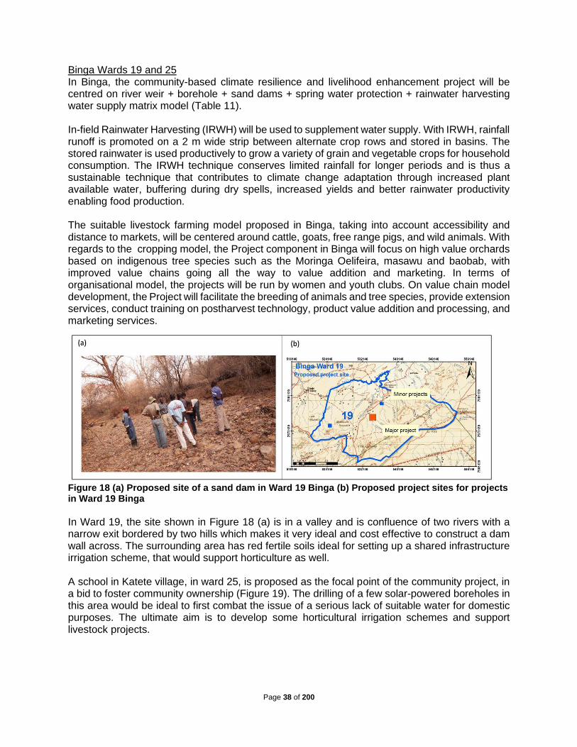
Page 38 of 200
Binga Wards 19 and 25 In Binga, the community-based climate resilience and livelihood enhancement project will be centred on river weir + borehole + sand dams + spring water protection + rainwater harvesting water supply matrix model (Table 11). In-field Rainwater Harvesting (IRWH) will be used to supplement water supply. With IRWH, rainfall runoff is promoted on a 2 m wide strip between alternate crop rows and stored in basins. The stored rainwater is used productively to grow a variety of grain and vegetable crops for household consumption. The IRWH technique conserves limited rainfall for longer periods and is thus a sustainable technique that contributes to climate change adaptation through increased plant available water, buffering during dry spells, increased yields and better rainwater productivity enabling food production. The suitable livestock farming model proposed in Binga, taking into account accessibility and distance to markets, will be centered around cattle, goats, free range pigs, and wild animals. With regards to the cropping model, the Project component in Binga will focus on high value orchards based on indigenous tree species such as the Moringa Oelifeira, masawu and baobab, with improved value chains going all the way to value addition and marketing. In terms of organisational model, the projects will be run by women and youth clubs. On value chain model development, the Project will facilitate the breeding of animals and tree species, provide extension services, conduct training on postharvest technology, product value addition and processing, and marketing services.
Figure 18 (a) Proposed site of a sand dam in Ward 19 Binga (b) Proposed project sites for projects in Ward 19 Binga
In Ward 19, the site shown in Figure 18 (a) is in a valley and is confluence of two rivers with a narrow exit bordered by two hills which makes it very ideal and cost effective to construct a dam wall across. The surrounding area has red fertile soils ideal for setting up a shared infrastructure irrigation scheme, that would support horticulture as well. A school in Katete village, in ward 25, is proposed as the focal point of the community project, in a bid to foster community ownership (Figure 19). The drilling of a few solar-powered boreholes in this area would be ideal to first combat the issue of a serious lack of suitable water for domestic purposes. The ultimate aim is to develop some horticultural irrigation schemes and support livestock projects.

Page 39 of 200
Figure 19 Photo and map (red square) on proposed site for the community resilience project in Binga Ward 25
Buhera Wards 20 and 23 The design of the project in Buhera Wards 20 and 23 under this Component is very similar to the one in Binga. In Buhera Ward 23, the community-based livelihood project will be centred on the borehole + riverbank abstraction + deep wells + IRWH + rainwater harvesting water supply matrix model. The suitable livestock farming model, taking into account better accessibility and less distance to markets, will be cattle, goats, free range pigs, and wild animals. The suitable livestock farming model, taking into account accessibility and distance to markets, will be cattle breeding and pen fattening, piggery and poultry. Because of climatic conditions and human population densities, free range types will not be feasible. On cropping model, the Project component in Buhera will focus on high value orchards and irrigated horticulture with improved value chains going all the way to value addition and marketing. The proximity to the Save River offers great opportunities provided solar power is harnessed to pump the water from the river or riverbank abstractions. In terms of organisational model, the projects will also be run by women and youth clubs. On value chain model development, the Project will facilitate the breeding of animals and tree species, provide extension services, training on postharvest technology, product value addition and processing, and marketing services. The photo in Figure 20 shows the proposed project site in Buhera Ward 20. The site is close to Save River, where there is good farming land suitable for high value horticultural production. Irrigation schemes set up here will also be beneficial to the community as it enables them to farm various cash crops.
Figure 20 Photo on proposed site and map (red square) for the community resilience project in Buhera Ward 20
The photo in Fig 21 was taken from the proposed site for the community project in Buhera Ward 23. This prolific borehole in Ward 23, and the potential for high water yielding boreholes is high because of the contact zone there, the boundary that separates one rocky body from another.

Page 40 of 200
Proposed projects in this area include irrigation schemes for maize, small grains and horticultural gardening. Adding another borehole would complement the good farming land in this ward and would boost the practice of horticulture and livestock projects.
Figure 21 Photo on proposed site and map (red square) for community resilience project in Buhera Ward 23
Output 4.4 Climate-smart livelihood enhancement and diversification pilot projects using groundwater, rainwater harvesting and renewable energy for 2,000 households implemented: At household level, water security, food security and income security are all important and interdependent. If water supply fails, food security will be affected and households will then require income security to cope with impacts of climate extremes. In times of failure, income security needs to come from elsewhere if the household does not have enough crop and livestock asset bases. For poor communities, the primary target for income security could be the ecosystem services and goods around them. These could include forestry products, wetland vegetation, wildlife services, etc. In this Output it is assumed that positively improving or expanding the asset base of a household will enhance adaptive capacity, and increase the ability of the household to positively respond to climate change impacts, thus reducing overall vulnerability. ‘Asset base’ refers to the financial, physical, natural, social, political and human capitals necessary to prepare a system to best respond to a changing climate. This category incorporates the importance of different kinds of capital, often informal, non-monetary or reliant on social networks. Household access to water is crucial as even the long distances of 0.6 – 15 km travelled by women and children to fetch water in both Binga and Buhera cuts into the time that could be used by household members for income generation. The livelihood activities in the target areas of Binga and Buhera are limited to cattle farming and rain-fed cereal production, because of the erratic nature of rainfall and frequent droughts experienced in the areas. The introduction of protected deep wells with large storage volumes, sand dams, water harvesting technologies and water saving technologies such as drip irrigation by the Project will ensure improved water access and water efficiency. As a result of improved water supply, the communities will be able to diversify livelihoods options from cattle and cereal production to poultry, piggery, fishery, orchards and horticulture. To ensure sustainable use of groundwater, a number of activities will be carried out (Figure 22). The yield of wells will be improved by groundwater recharge. The available household rainwater harvesting techniques to be used to augment groundwater include: roof top rainwater, IRWH, runoff harvesting through recharge pits, recharge trenches, tubewells, and recharge wells. In-ground rainwater harvesting will also be used directly for crop cultivation. The in-field rainwater harvesting (IRWH) technique conserves limited rainfall for longer periods and is thus a sustainable technique that contributes to climate change adaptation through increased plant available water, buffering during dry spells, increased yields and better rainwater productivity, enabling food production. Drip irrigation will be used wherever possible in conjunction with high value crops,

Page 41 of 200
orchards or horticulture, whilst short-season crop varieties and small grains (sorghum, rapoko, millet) will be encouraged in view of the prevailing rainfall patterns in Binga and Buhera. The use of water saving technologies such as drip irrigation will greatly improve the irrigation water use inefficiencies, which currently range between 40 and 60%. Climate-smart agricultural techniques such as intercropping with legumes, mulching, crop rotation, greater crop diversity and improving storage and processing, and improved feeding strategies, rotational grazing, grassland restoration, integrated crop and livestock, and manure management will be piloted and demonstrated. Communities will also receive training in the different climate-smart agricultural techniques and different livelihood activities such as poultry, piggery, fishery, orchards and horticulture under Component 3.
Figure 22 Strategic activities to improve climate resilience through water, food, energy and income security at household level
The Project seeks to focus household time on productive activities, hence food and income security. Against this, household energy needs consume considerable time for women and children in fetching firewood and destroys forests and the environment, thereby increasing community vulnerability. Women spend up to eight hours a day in household chores whilst the young children stay with them. Inefficient use of biomass in the traditional firewood stoves coupled with insufficient ventilation causes severe health hazards, and most of it affects women and girl children, as rural men traditionally do not spend much time in kitchens, except in the winter season. More than 90% of households in Binga and Buhera use firewood as a source of fuel for cooking and heating. Women often spend as long as two hours per day on average collecting fuelwood and leaf fodder, which leaves them with no time to do some meaningful income generating activities. Children are significantly involved in collecting firewood. This in turn also induces lower levels of schooling and child health. The Project will support energy security through a variety of interventions such as smokeless energy efficient stoves to reduce firewood demand and solar lighting. Examples include beehive briquettes which are mainly charcoal briquettes made from char and clay mud mixed in certain proportion. Emission of harmful gases from burning briquette is very low as compared to wood and woody biomass which are commonly used by rural

Page 42 of 200
households. Agricultural residues are produced in abundance after harvesting and biomass charcoal briquetting techniques will be used for generating an alternative fuel that is cost effective and environmentally friendly and can also add income to the family. Bio-digesters, discussed in Component 4.3 above, are also a viable option at household level. Gender friendly technologies like biogas, improved cooking stoves, solar lanterns can empower rural women in many ways and contribute to climate resilience. Output 4.5 About 2,000 households in the four Project wards apply and access funding from the food security and livelihood enhancement revolving fund: The population in the four Project wards is 28,000, consisting of more than 6,000 households. A revolving fund of USD 425,280 will be established for about 2,000 households using rainwater harvesting and sustainable groundwater management techniques for productive purposes and financial experts will guide on the amount per family, repayment period, and grant/loan apportionment. Fieldwork research has already shown that some NGOs have already collaborated with banks/micro-finance institutions in running revolving funds. In this Project, the Government established Women’s Bank and Empower Bank are very attractive options. Agronomists and extension workers will guide the farmers on good practice farming so that they will be able to pay back the loan – a measure of venture sustainability. The project activities to be funded by the revolving fund will be inline with the climate-smart livelihood enhancement interventions proposed by the communities during the participatory consultations and which were found to have no or minimal negative impacts during the risk screening progess. Thus each application for sub-project submitted for funding through the revolving fund will be evaluated against these options (Table 12). The revolving fund will ensure sustainability of project actions beyond the Project lifetime. Table 12 Proposed Eligible Activities
Eligible Activities Excluded Activities Climate Smart Agriculture
• Conservation farming- crop rotation, intercropping with legumes, mulching
• Rotational grazing
• Integrated crop and livestock farming
• Introduction of agroforestry Natural solutions for fertilization and pest control Crop calendars
• Resistant crop varieties Reforestation
Introduction of agrochemicals Introduction of GMOs Introduction of alien crop species
Water management
• Household rainwater harvesting Impoundments such as pools
Livelihood diversification
• Piggery
• Bee keeping
• Poultry
• Pen fattening
• Orchard
• Horticulture
Introduction of alien bees Introduction of alien crop species Introduction of alien livestock species
• Renewable energy initiatives, (biogas, solar products, tsotso stoves)
Initiatives that involves the utilisation of fossil fuels.
Table 13 Indicative work programme for Component 4
Output 4.1 Look and learn visits to best practice projects in Zimbabwe or regionally
4.1.1 Government, UNESCO and Project partners meet to finalise look and learn visits, identify participants and book appointments
4.1.2 Identified team member conduct look and learn visits to projects locally and internationally and produce mission reports

Page 43 of 200
Output 4.2 Four pilot climate-smart ecosystem mitigation and resilience projects implemented in four Project wards
4.2.1 Prepare TORs, advertise, select and appoint a consultant firm with specialisation on landuse, forestry, ecosystem and environmental planning to design and ecosystem protection plans for the 4 Project Wards based on sub-Components 2.2, 3.1 and 3.2
4.2.2 Consultant firm presents Inception Report, conducts fieldwork, presents draft report, makes corrections and present Final Report with detailed drawings and Social and Environmental Management Plan
4.2.3 Materials procurement and installation with supervision from Agritex, Forestry Commission, and EMA.
Output 4.3 Four climate-smart water and food security pilot projects using groundwater and rainwater harvesting at community level implemented
4.3.1 Planning meetings in Harare and in the Project wards to confirm the design the of the community resilience projects with Agritex, ZINWA, Forestry Commission, EMA, NGOs working in the area, and universities, based on plans developed in sub-Components 2.2, and 3.2
4.3.2 Goods and services procurement and installation with supervision from Agritex,Forestry Commission, and EMA.
Output 4.4 Climate-smart livelihood enhancement and diversification pilot projects using groundwater, rainwater harvesting and renewable energy for 2,000 households implemented
4.4.1 Develop a detailed data collection tool to profile all families in the four Project wards and collect the data using local Government extension workers and village heads
4.4.2 Using the demographic data collected in Output 4.4.1, develop and validate an intervention matrix or model to identify suitable interventions at individual level based on food, water, energy and income security
4.4.3 Procure goods and services and install interventions
Output 4.5 About 2,000 households in the four Project wards apply and access funding from the food security and livelihood enhancement revolving fund
4.5.1 Identify, negotiate and agree a collaborative arrangement and terms with a bank or micro-finance institution working in the Project districts
4.5.2 Appoint a financial advisor to work with selected bank to develop terms and guidelines for appraisal of business plans by beneficiaries accessing revolving funds
4.5.3 Prepare fund brochures and advertise for loan applicants using channels easily and fairly accessible to all potential beneficiaries in the four Project wards
4.5.4 Process applications,disburse funds and collect loan repayments
4.5.5 Provide field extension and advisory services to beneficiaries
4.5.6 ESMP implementation and monitoring and stakeholder consultations
Component 5. To compile and disseminate lessons learnt to facilitate future upscaling and replication of good practices in groundwater extraction and management Lessons learnt and good practices will be continuously documented and field shows conducted to share experiences among the demonstration projects. Multimedia and written documents/manuals will be prepared, validated and disseminated to key stakeholders. Professional multimedia personnel and authors will be hired to do this. Output 5.1 Web-based information sharing and exchange platform for Project participants established: Social media such as Facebook, Whatsapp or Twitter, linked to an internet-based platform for Project participants to upload information for sharing, will augment information sharing and dissemination. Staff in the project management team will be trained on how to operate and update the website. Output 5.2 Good practices documented and adopted by key stakeholders: Good practices and key lessons from project interventions will be identified, documented (case studies, bulletins, drama, poems, videos, etc) and disseminated. Field shows amongst the participating wards will also help intra-project dissemination whilst short films, radio and TV shows will help disseminate

Page 44 of 200
to the wider audience at national/international levels. The knowledge and information will also be shared through the use of existing and popular platforms e.g. social media, SMS platforms and other forms that are easily accessible by the stakeholders. Table 14 Indicative work programme for Component 5
Output 5.1 Web-based information sharing and exchange platform for Project participants established
5.1.1 Advertise, select and recruit a specialist website design specialist
5.1.2 Develop a website for the project with link to social media
5.1.3 Select and train Project staff on how to use and maintain website
Output 5.2 Good practices documented and adopted by key stakeholders
5.2.1 Identify and train Project staff on documenting good practices and project interventions
5.2.2 Conduct dissemination activities such as short films, radio and TV shows
B. Project Economic, Social and Environmental Benefits Economic Benefits The increased water availability will be used for productive purposes thereby enabling the vulnerable communities, particularly rural women who are the majority and most affected by climate-related shortages of water, to diversify their income, thus building more resilience to climate effects. The anticipated productive uses of water include cultivation of high value crops, fruit trees, animal husbandry, poultry farming, market gardening, etc. Communities in the project districts are expected to benefit from the pilot integrated farming project set to be established through the project. Normal potato production is 24-30 t/ha but with the integrated farming farmers will be expected to yield between 30-40 t/ha. Moreover, all the inputs used are environmentally friendly and produced within the system further reducing on the cost of inputs and increasing profit for the farmers. A revolving fund will be set up to kick-start these activities, with the Project catering for offsite investments such as drilling boreholes, drip irrigation kits, etc. Based on experiences elsewhere, this should improve income levels and reduce poverty levels. Thus, the project will mitigate the negative socio-economic impacts of drought such as water shortages, food shortages, absenteeism from school and loss of income by ensuring sustainable access to reliable domestic water supply as well as access to water for productive uses. In addition, the Project seeks to diversify livelihoods beyond the use of groundwater so that households have asset bases to support them in times of food shortages due to extreme climatic events. Improved incomes from irrigation will also be used to finance household water supply and sanitation. Irrigation projects at schools will be used to finance sanitation and hygiene improvements in schools. The losses suffered by farmers due to exposures to droughts will be greatly reduced by irrigation using groundwater and rainwater harvesting. The use of drought-tolerant varieties will also improve harvests. These varieties should be broadly tolerant to diseases but the need for additional pests and weeds control will be catered for by proceeds from irrigation and improved productivity in other project action areas. Awareness raising campaigns will be used to reduce veld fires and land degradation. Social Benefits This Project will train community members on climate change impacts and the whole array of actions they can take at personal and community levels to reduce their vulnerability. The target demographic for the community trainings, will ensure at least 60 percent women are provided with practical knowledge to adapt and mitigate the climate change impacts. It will use role playing, scenario developments and group discussions to explain and demonstrate the phenomenon of
Page 45 of 200
climate change and thus encourage communities to take appropriate action. Well-trained social scientists and gender experts will be used for the training. The Project will provide additional water supply to the targeted communities and thus reduce the time spend by women and children fetching water. This time could be used for productive purposes such as working in fields and attending school. The activities proposed in this Project for enhancing groundwater recharge and in-ground rainwater harvesting will help to make water available even in times of droughts thereby mitigating the environmental impacts of drought on agricultural productivity, domestic water supply and groundwater dependent ecosystems. The availability of food will thus be improved by increased availability of water for irrigation systems and this will also enable crop cultivation throughout the year. The irrigation systems will also aim at cost-effectiveness and productivity enhancement by providing low-cost but efficient technologies to beneficiary families. The selection of beneficiaries will also ensure the poorest and most vulnerable in society are properly selected and targeted. The project will improve access to food by focusing on enhanced productivity and promotion of climate-friendly crops for different regions. Farmers will also be trained on post-harvest loss management in order to maximise their profits. This intervention seeks to promote climate-proof agricultural activities for the community members, through the provision of sustainable water resources. This will directly impact, an initial target of 2000 households and at least 4000 women, with the aim improving the horticulture industry to attract more lucrative markets and provide a greater economic turn-over for the respective households. Other highly productive economic activities such as cattle ranging, rearing free range pigs and goats, etc, will be rolled out to 2500 women, and 2000 households, with care taken on developing downstream markets for the products, ensuring economic viability and sustainability. Environmental Benefits Zimbabwe’s environmental situation in rural areas has continued to deteriorate over the past two decades due to poor land husbandry practices. Challenges relate to lack of proper soil and water management especially in newly resettled areas. Poor soil management techniques also result in loss of fertile top soils, further impacting on agricultural productivity. In some cases, over-grazing is prevalent. Wetlands have been invaded for crop cultivation, affecting water flow and water quality. Veld fires are quite common and illegal mining rampant. A lot of mines have also closed without following appropriate mine closure procedures. The Project areas are faced with rampant ecosystem and environmental degradation, soil loss, and reduction in biodiversity, which contribute to low resilience to climate change with high risk of floods. The Project, will foster good land husbandry and water stewardship through improved land-use planning, separation of wildlife and grazing areas, protection of wetlands and heritage sites, recycling of agricultural residue as fertiliser after bio-digestion, gully protection and restoration, etc. Current borehole density in the three districts is less than 0.06/km2. To avoid groundwater mining, the Project will avoid intensive drilling of boreholes and will mostly depend on deep wells which will be sparsely populated (>10/km2) to have a significant impact on groundwater quantity. The land area that can be irrigated from a deep well rarely exceeds 1,000 m2. Using drip irrigation, this area can be safely irrigated by wells with yields of more than 2 m3/day, with allowance for other household water uses. Rural household wells are rarely less than 100 m apart. In addition, the available groundwater resource in each of the sub-catchment and main aquifers will be established in the research component of the project. This will culminate in a water balance of the main aquifers in the sub-catchment to establish the available resource, the current water uses and establish how much can be allocated to new abstractions. The Project will result in the realization of further environmental benefits such as ecosystem protection and restoration through the implementation of the ‘whole systems approach’ which

Page 46 of 200
include activities such as catchment management (agroforestry, afforestation, groundwater recharge, gully control and restoration, contour ridges, terracing, etc), improved water availability through promotion of water saving irrigation technologies (drip irrigation), groundwater recharge and in-ground rainwater harvesting. In addition, the project will result in improved biodiversity and protection of wetlands through protection of water sources. Through these activities, the project will mitigate the potential negative environmental impacts of groundwater use such as over-extraction of the water resource, land degradation (due to livestock traffic to water sources), loss of biodiversity and destruction of wetlands. The whole systems approach to groundwater management to be implemented in this Project is shown in Figure 23 (a). This is compared to the current traditional approach to groundwater utilization in Figure 23 (b). Figure 23(b) shows that unsustainable utilization of groundwater will result in over-extraction of the water resource as evidence by low ground water table and dry wells. In addition, land subsidence, land degradation (due to livestock traffic to water sources), loss of biodiversity and destruction of wetlands are the other effects of unsustainable utilization of groundwater. In contrast, through adoption of a whole systems approach, there will be increased groundwater recharge, increased groundwater storage, water quality improvement and improvement of surface water. The project will thus stimulate the sustainable use of natural resources and improve the natural-resource base of the communities, which are still the main assets for income generation for vulnerable communities. The establishment of household tree plantations will help mitigate greenhouse gas emissions.
Figure 23 (a) Sustainable Innovation Framework for Groundwater Utilization; (b) Traditional Groundwater Utilization

Page 47 of 200
Avoiding or mitigating negative impacts The project will implement a number of measures to ensure that all envisaged negative social or environmental impacts related to the project interventions are avoided or mitigated. The measures are described in more detail in Annex 6. The project acknowledges the differentiated impacts of climate change on women and men, as a result, a number of measures will be put in place to avoid and/or mitigate any negative gender-related impacts. The project will collect sex-disaggregated data and formulate gender-sensitive indicators for results frameworks. Mechanisms for selection of beneficiaries will be gender-sensitive in order to ensure that participation of men and women takes into consideration the differentiated impacts of climate change on men and women as well as other vulnerable groups, youth, child-headed households and people living with disabilities. The project staff will include gender experts to ensure that consultations are responsive to various gender needs and roles such that project activities effectively respond to the unique needs of women and girls, men and boys, and promote equal opportunities to participate, and receive comparable social and economic benefits. The gender experts will also monitor and evaluate compliance of project activities with the Gender Policy of the Adaptation Fund. Project activities have been designed to be gender sensitive and to empower women. All project staff will be trained on gender-sensitive approaches. The project implementation will include partners such as Ministry of Women Affairs, Community, Small and Medium Enterprises, Ministry of Youth, Sport, Arts and Recreation, Ministry of Public Service, Labour and Social Welfare and, Zimbabwe Gender Commission and Zimbabwe Human Rights Commission to ensure that gender considerations are mainstreamed in project activities.
C. Analysis of Project Cost-Effectiveness The general problem in Zimbabwe on groundwater utilisation is lack of technical and institutional capacity. As a result, knowledge on groundwater as a resource is poor, despite the fact that rural communities and farmers rely on it a lot. The project will therefore use a portion of Project funds to address this under Components 1 and 2, which together are allocated about US$0.7 million. This will build critical mass at national level that will be able to take the Project forward beyond the requested funding period. The envisaged National Centre for Groundwater Research and Training to be established at the University of Zimbabwe, will build the necessary critical mass and momentum, by leveraging funds beyond this Project. Using the Project funding and government allocations, 2PhDs and 3 MPhils will be trained, and these would form the nucleus to train more people in future. The project will provide tuition fees and stipend to the students for the whole duration of their studies (48 months for PhD and 24 months for MPhil students). Government funding will support research work of the students (See Annex 3). Project Component 3 will build capacity at local level and will train about 200 people, who will in turn train at least 2,000 people in the next ten years based on demand and government funding. US$145,750 will be allocated to Component 3 which will also establish robust frameworks for climate resilient catchment management and build capacities of institutions and communities and for knowledge management. The Project will allocate about US$3.2 million to Component 4 for implementing concrete adaptation actions for resilient and sustainable ecosystems, groundwater development, improving agricultural productivity and hedging it against climate change and other livelihood systems. Component 4 is the most critical as it will ensure that concrete investments in climate change adaptation and mitigation are implemented in the two sub-catchments. The component will start by strengthening the broader ecosystem within which current business as usual approaches have resulted in catchment degradation, deterioration of wetlands, lowering of groundwater tables, rampant cutting down of trees, etc. The benefits, and improvement in goods and services will be felt by the wider community and the planting of trees will mitigate the effects of climate change

Page 48 of 200
and possibly raise/attract further funding. A sub-component will facilitate livelihoods enhancement and diversification interventions at community level, taking into account that there are many shared resources in communal areas such as dip tanks, dams, boreholes, schools, etc. The benefits of these investments would include improved economic productivity and better livelihoods as a result of sustainable groundwater development, reduced catchment degradation, good agricultural practices, improved water infiltration and water harvesting. The number of households in the four Project wards are estimated at 8,000. The Project will set up a revolving fund of US$425,280 that is estimated to support an additional 2,000 beneficiaries to implement small climate resilience projects based on full cost recovery. This could extend the project benefits to other households that will not have been covered directly by the Project in other intervening areas. It is important to note that there are other possible interventions which could have been implemented to help adapt and build resilience to overcome the identified climate-related challenges but could not the included in the project design because of a number of factors. Table shows a comparison of the proposed project activities with other possible interventions.
D. Project Consistency with National or Sub-National Sustainable Development
Strategies The original project concept note was based on the then running Government five-year economic plan (2013 - 2018) called the “Zimbabwe Agenda for Sustainable Socio-Economic Transformation (ZimAsset)”. The plan’s vision was to move towards an integrated, holistic approach to raising productivity, increasing food security and diversifying income in recognition of the complexity of rural development. The ZimAsset identified agriculture as a key sector for economic growth and employment creation. Value addition activities were to be implemented to revitalize the agricultural sector and grow the economy rapidly; as such, agriculture was tasked with a 12.5% growth target for 2018. It is now important to note that the ZimAsset development targets were met to varying degrees, especially in agriculture where the Government introduced Command Agriculture and Presidential Input Scheme for commercial and subsistence agriculture, respectively. The rainfall season 2017/18 was a particularly successful one as maize production more than doubled. In October 2018, the Government came up with a new economic blueprint – the Transitional Stabilisation Programme (TSP) October 2018 – December 2020, “Towards a Prosperous & Empowered Upper Middle-Income Society by 2030”. The realisation of Vision 2030 will be through the implementation of Strategic Programmes, supported by appropriate National Budgets. These are:
• A two and a quarter year “Transitional Stabilisation Programme” which ran from October 2018 to December 2020.
• Two Five-Year Development Strategies, with the first one running from 2021-2025, and the second covering 2026-2030.

Page 49 of 200
Table 15 A comparison of proposed project activities and alternative interventions
Project Activities Alternatives Remarks Cost Implications
Establish a National Centre for Groundwater Research and Training at the University of Zimbabwe
A scholarship programme outside the country to build technical and human capacity for improved and sustainable utilization of groundwater
This alternative could be more expensive and not sustainable in the long-term The local problems may not be fully addressed. There is also limited ownership of the data products produced from the trainings
It is a more expensive alternative, with an average cost of USD 15,000-20,000 per student, per year, i.e. at most 80,000 per student over the training period. This is against USD57,600,000 required to train 2 PhD students and USD43,200 needed to train 3 MPhil students for a duration of four and two years respectively in Zimbabwe.
Skills training for community members on smart agriculture technologies and borehole maintenance
Outsourcing services It is better to have local people trained because that will give them a sense of project ownership which is critical for long-term sustainability of project interventions. The trained community members will also pass on the knowledge gained to other members unlike the case where external service providers are brought in.
It cheaper to train locals than bring in consultants or other service providers
Borehole drilling Dam construction
Dam construction is expensive as compared borehole drilling. The flat topography of the target areas also limits potential for surface dam construction.
An estimated cost of 500,000 – 1 000,000 would be required for construction of a small dam against an average of US$10,000.00 of drilling a borehole
Irrigation Schemes using drip irrigation technologies
Flood irrigation and center pivots
The alternative methods are not water efficient hence will not be suitable for the climate conditions in the two drought prone districts. In addition, drip irrigation is best suited for the small plots where the alternatives are best for larger fields. Targeted communities preferred drip irrigation systems to centre pivots because of the high temperatures in the areas which reduces crop water productivity
The capital costs for drip irrigation systems per hectare are about 20% higher than for centre pivots and flood irrigation.
Integrated farming Traditional farming Integrated farming system is a closed loop system where nutrients generated are used for crop production. There is minimal nutrient and energy losses. The system also generates biogas energy which could be used for farming operations. More crops grown and higher yields can be obtained compared to traditional farming system
There is minimal input requirement (i.e fertilizers and pesticides and herbicides) in Integrated farming thus cost of production is lower compared to traditional farming system

Page 50 of 200
The National Development Strategy (NDS) 1 (2021-2025) which replaces the TSP has several priorities identified thorough extensive stakeholder consultations. These include: economic growth and stability; food security and nutrition; governance; moving the economy up the value chain and structural transformation; human capital development; environmental protection; climate resilience and natural resource management; health and well-being and devolution. The thrust of environmental protection, climate resilience and natural resource management under the NDS1 will be on sustainable management of wetlands, rehabilitation of mined areas, climate change mitigation and sustainable natural resources management. Further, Government will integrate the necessary climate change mitigation measures into national policies, strategies and planning, to strengthen resilience and adaptive capacity to climate-related hazards and natural disasters. This includes promoting climate resilient water management systems, focusing on both crop and livestock production. This informed the development of intervention measures proposed in this Project. To respond to and manage growing climate risks and hazards, the Government of Zimbabwe has formulated several key policies and plans, as well as strengthened the corresponding institutional frameworks. The GoZ has submitted an Intended Nationally Determined Contribution (INDC) to the UNFCCC that summarizes climate vulnerabilities and identifies long-term and near-term adaptation visions, goals and targets. In its INDC, Zimbabwe commits to promoting adapted crop and livestock development and climate-smart agricultural practices; strengthening management of water resources and irrigation in the face of climate change; and promoting practices that reduce risks of losses in crops, livestock and agricultural incomes, among other priorities. All these are addressed in this Project. In addition, Zimbabwe submitted three national Communications to the UNFCC in 1998, 2013 and 2017. The third communication presents up to date information on climate change issues in Zimbabwe focusing on climate change impacts, mitigation, vulnerability and adaptation, research and technology transfer and climate change education, training and awareness. The GoZ has developed a National Climate Policy (2016) and a costed National Climate Change Response Strategy (2015) and has established a Climate Change Management Department (recently transferred from MLAWRR to the Ministry of Environment, Climate and Tourism) to coordinate and guide the national response to climate change. In light of the climate change impact on water resources, Zimbabwe has also received support from the World Bank to develop a National Water Master Plan. Zimbabwe is currently developing a National Adaptation Plan (NAP) with readiness funding from the Green Climate Fund. The GoZ has initiated a stocktaking exercise supported by UNDP for the National Adaptation Plan which it expects to finalise in 2018 and this involved consultations on gender for climate change adaptation which were used to inform the development of this Project. The stocktaking exercise will inform the development of the NAP. Zimbabwe is also planning the formulation of a Low Emission Development Strategy for 2019, supported by the UNDP-Russia Trust Fund for Development. The proposed Project has a very high level of support from the Zimbabwean government, as the proposed interventions are an integral part of GoZ priorities as outlined above. The development of this proposal was at the request of the former Minister in charge of environment, water and climate. Zimbabwe identified water resources management and climate change adaptation as key priority areas in its national policies or program documents. The Government is prioritising groundwater utilisation in arid and semi-arid areas and is aiming to drill at least four boreholes in each of the 210 parliamentary constituencies. To address the various water resources related challenges, Zimbabwe also launched a National Command Water Harvesting Programme in 2017 meant to enhance rainwater harvesting and help communities adapt and mitigate against the adverse impacts of climate change. It has declared the 1st of December of each year as the

Page 51 of 200
National Tree Planting day and set a target of planting 40 million tree by 2020. Zimbabwe adopted the principle of Integrated Water Resources Management (IWRM) in the Water Act of 1998 and this will be the basis for interventions underpinning this Project. The GoZ has also developed several guiding policies that are aimed at mitigating the adverse impacts of climate change and variability and to achieve reduction in poverty through environmentally sustainable development. This project will thus complement government efforts of providing sustainable access to water by vulnerable communities in water scarce areas by implementing a whole system’s approach to groundwater management which ensures environmental sustainability of groundwater extraction. The Water Policy of 2013 also supports the sustainable utilisation of groundwater, with emphasis on guarding against resource over-exploitation and deterioration.
E. Project Compliance with Relevant Zimbabwean Technical Standards and the
Environmental and Social Policy of the Adaptation Fund The Project will be implemented following the national standards of Zimbabwe related to environmental, water (surface and groundwater), wetlands and ecosystems management. Some project resources will be used to meet relevant standards for the management of critical natural resources taking into account the threats to critical ecosystems, water quality and quantity and also land degradation. The standards applicable to the Project include Environmental Impact Assessment (EIA) and Ecosystem Protection Regulations (2007), Catchment and Sub-catchment statutory requirements, Standards for drilling boreholes (SAZ ZWS6182013), Standard Association of Zimbabwe specifications (SAZ S560:1997), Water Quality regulations (SI6 of 2007), Wetland management guidelines and River Systems Outline Plans. Some of the guidelines include the location of toilets versus boreholes and wells (>30 m), streambank cultivation (>30 m), and maximum walking distances to water sources (<500 m). Since the project is mainly aiming at improving the state of the environment of the Gwayi and Save catchments, it is not expected to have any negative environmental impacts. The Water Act of 1998 and the Zimbabwe National Water Policy of 2013 has entrenched integrated water resources management as the principal management philosophy for water resources. Water is managed through seven catchment councils and below them are 57 sub-catchment councils. The drilling of boreholes is controlled by sub-catchment councils and an annual monitoring fee is charged. Drillers should be registered. There are no regulations specifically dealing with where boreholes are drilled but the quality of the water should meet national standards. Motorised boreholes are considered as non-primary use of water which should be charged at prescribed commercial rates. Communal boreholes are managed by local Water Point Committees which are responsible for their repairs and maintenance through user contributions. The proposed interventions will also have environmental public disclosure requirements as determined by both local legislation and that of the funder. These projects will therefore comply with all the relevant national standards, the Environmental and Social Policy principles of the Adaptation Fund as well as adopt best practice international guidelines, for reducing vulnerability and promoting sustainable development while addressing climate change impacts. In addition, the implementation of the projects in accordance with various environmental and social compliance requirements will require regular monitoring, evaluation and reporting, as described further in Annex 6.
F. Duplication of Project with Other Funding Sources The Project design and consultative processes have ensured that the project is not duplicating current efforts in Zimbabwe. Instead, the Project seeks to complement other projects, including

Page 52 of 200
those by GoZ, UNDP, UNICEF, FAO, SADC-GMI, Plan International, etc. A list of projects currently under way or those already done in the targeted districts are presented in Table , based on the fieldwork and consultations conducted August – October 2019. Table 16 List of ongoing and past project implemented by NGOs and other Institutions in Binga and Buhera districts
Project Type Implementing Organisation/NGO Dates
Borehole Drilling and Rehabilitation Save The Children [1983 – present]
Solar Powered Borehole Drilling Resilience Building Fund (ZRBF) [2017 – present]
Borehole Drilling Action Aid
Borehole Drilling World Vision [Dates not specified]
Sand Abstraction Save The Children [1983 – present]
Water Harvesting World Vision[Dates not specified]
Gardening Save The Children [1983 – present
Conservation Agriculture GOAL [dates not specified]
Livestock Farming and Access to Livestock Markets/Value Chains
Save The Children
[1983 – present]
The activities of various NGOs in Buhera and Binga are the best proxies for reviewing both ongoing and past projects within the targeted wards. Save the Children and Zimbabwe Resilience Building Fund (ZRBF) have drilled boreholes and rehabilitated some boreholes in Binga District. Save the Children also initiated the harnessing of spring water for irrigation. Apart from borehole drilling and spring water harnessing, the NGO has also tried sand abstraction for livestock water in Ward 19 (Chinengo and Tinde villages). The project failed because the water extracted from the sands in these villages was very little and the sands would completely dry up during the months October to November each year. The proposed Project will complement these activities by ensuring that the utilisation of groundwater in the target areas of Binga and Buhera is sustainable through implementing actions which will preserve natural recharge and discharge areas against climatic and socio-economic pressures as well as enhance water services and security through rainwater harvesting, catchment and wetland protection, improving water use efficiency through installation of water-saving irrigation techniques and cultivation of a wide range of crops for income diversification. This project will also install solar on the boreholes in order to lessen the burden of pumping water associated with the traditional bush pump especially on women as well as increase crop productivity.
Figure 24 Pictures of solar powered borehole drilled by ZRBF in Binga Ward 25
GOAL, a Non-Governmental Organisation, Agricultural Trust and River of Life Church are promoting conservation agriculture in Binga. Conservation farming is ideal for places like Binga since it uses methods that allow villagers to trap water in basins where it stays for long periods of time; land preparation techniques under conservation farming significantly improve the yields of

Page 53 of 200
farmers. The Tonga people who live in Zambia close to the Zimbabwean border are also using conservation farming to grow maize. The villagers yield an average of 5 tonnes of maize per hectare. Action Aid (AA) and World Vision have projects focussed on value chain of goats, pigs and cattle. The thrust is to build resilience amongst the villagers by strengthening the value chains of goats and pigs reared in rural areas. One of the approaches recommended by Action Aid is grouping small-scale farmers and linking them with established big farmers who will buy products from the groupings of small-scale farmers and offer advice on breeding, feed and disease management. This Project will set-up a revolving fund of USD US$425,280 which will benefit about 2,000 households using rainwater harvesting and sustainable groundwater management techniques for productive purposes such as the goats and piggery project implemented by Action Aid. Agronomists and extension workers will guide the farmers on good practice farming so that they will be able to pay back the loan – a measure of venture sustainability. The Project also recognises that the ZINWA Act provides for the preparation of River System Outline Plans by each catchment and that these were prepared nearly a decade ago. It therefore supports the revision of these at sub-catchment level in two main catchments with targeted inclusion of gender, groundwater and climate change resilience, under sub-Component 2.2. The departure point in this Project is the need to start from the national level and incrementally fixing the enabling environment and capacity needs right to the village level. In this Project, the broader ecosystem is also fixed before community and individual projects can come in, to ensure sustainability at both levels. Attention is therefore given to the reason why water sources dry up and hinder crop farming and animal husbandry to be sustained throughout the year and why wetlands, rivers and boreholes dry up around September to October period.
G. Description of Knowledge Management Component to Capture and Disseminate
Lessons Learned At the outset of the project, a Knowledge Management Strategy (KMS) will be developed. This strategy will detail processes for generating, capturing, sharing and disseminating learnings. The KMS will also set out how lessons from the project will be integrated with existing knowledge and how this will inform adaptive management of the project itself. The project will adopt a KMS developed by International Fund for Agricultural Development (IFAD), comprised of three main aspects namely knowledge generation, knowledge use and enabling environment. The project interventions will generate several knowledge products such as training manuals, training reports, practical guidelines and manuals on groundwater planning, development management, groundwater atlases, groundwater development management planning guidelines, catchment management plans and videos and photos from pilot/demonstration projects. Good practices and key lessons from project interventions will be identified, documented as case studies, bulletins, drama, poems, and videos. In addition, the project will also produce learning documents, evaluation reports and policy briefs. Knowledge generation will be the responsibility of the project management team. The project management team will receive training on knowledge management which will enhance capacity for collection, analysis and dissemination of evidence, good practice and lessons. Different methods will be used to collect evidence and lessons which include key-informant interviews, surveys, and focus group discussions. Collection of evidence and lessons learnt will be included as regular part of M&E thus will be done during annual reviews, mid-term and end of term project evaluation. The lessons learnt will assist in replication and scaling up of activities to other districts. The project takes cognisance of the need to exchange knowledge and disseminate knowledge products to a wider audience by including a standalone Component 5. A Web-based and social media information sharing and exchange platform will be
Page 54 of 200
established for Project participants and beneficiaries. Social media such as Facebook, Whatsapp or Twitter, linked to an internet-based platform for Project participants and to upload information for sharing, will augment information sharing and dissemination. The platform will enable various stakeholders to provide real-time assessments of the project initiatives. Staff in the project management team will be trained on how to operate and update the website. Professional multimedia personnel and authors will be hired to prepare and validate multimedia and other documents. Field shows amongst the participating wards will also help intra-project dissemination whilst short films, radio and TV shows will help disseminate to the wider audience at national/international levels. For effective and efficient knowledge management it is important to have an enabling environment. Thus, it is important to recognize the capabilities and capacities of the knowledge management staff and where possible provide necessary training to encourage knowledge generation, sharing and use. In this regard, the project will provide training to the project management team to develop knowledge management expertise and knowledge management tools will be provided to develop KM expertise and KM tools. Awareness raising sessions will be held for interested stakeholders on the importance of knowledge management and how the stakeholders can contribute towards effective knowledge management.
H. Consultative Process, Including the List of Stakeholders Consulted The consultation had two main activities namely national level process comprising of national consultative workshops and community/project site level meetings in targeted districts of Binga and Buhera. The stakeholders were consulted in a gender responsive and gender equal way in order to ensure equal representation of women and men in consultation throughout all stages of the project/program cycle. Adequate representation of stakeholder groups in the consultation process was prioritised keeping in mind the multi-stakeholder dimension of the project interventions impact, and that the stakeholder groups differ among issues and topics. Consultations were designed to focus on the parties directly affected by, or with an interest in, the proposed engagement. Stakeholder organizations such as the Ministry, district officials, government departments, civil society organizations, traditional leaders assisted in identifying target groups. The consultations also considered youth to ensure the inclusion of their often-overlooked needs and concerns and abilities in project planning, implementation, monitoring and evaluation. Responding to impacts of climate change requires a multi-disciplinary, multi-sectoral and multi-institutional approach because climate change is cross-cutting, affecting various sectors and groups of societies. The adopted project design facilitates multi-stakeholder participation and collaboration starting right from its development up to its implementation. It promotes consultations, participatory processes and dialogues among the various stakeholders of central government, NGOs, CBO, private sector, development partners, research/academics, catchment and sub-catchment councils, and local communities at ward and village levels. To this end, UNESCO together with the MLAWRR and the Department of Climate Change, which is the National Designated Authority for the Adaptation Fund in Zimbabwe, have worked in close coordination during the formulation of this project concept. National Consultations After the endorsement of the project proposal a meeting was held with the Government of Zimbabwe represented by the Ministry of Lands, Agriculture, Water and Rural Resettlement and the UNESCO National Commission to inform them of the endorsement and plan the way forward to develop the full proposal. In the meeting a schedule of consultations was agreed upon beginning with the inception meeting. An Inception Meeting which was attended by Zimbabwe National Water Authority, academic institutions, Catchment councils from the two districts and the consultant firm NIOM was held on 10 July 2019. The purpose of the meetings was to discuss the

Page 55 of 200
path to be taken in fully carrying out required assessment and consultations. A national consultative meeting was then held on 23 October 2019. The meeting was attended by 43 participants including the government representative, the Executing Entity (EE), Implementing Entity (IE), representatives, environmental agencies, UN agencies, NGOs, district administrators, catchment councils and academia. The objectives of the national consultative meeting were; to present the findings of the consultations and baseline studies in the selected project areas of Binga and Buhera; to obtain the inputs, views and contributions of national level stakeholders in terms of overall design and relevance of interventions; and to ensure and facilitate alignment, alliance and compliance with national and local policies, rules, regulations as well as ongoing programmes and projects. Consultations at community level- A consultant firm NIOM organized community and individuals’ consultations in the two districts of Buhera and Binga. The consultative meetings with a cross section of community representatives including women and youths were arranged with assistance from Traditional Chiefs and district officers. Communities were interviewed using structured questionnaires (attached in Annex 4: Appendix 2 of the need assessment report). During the consultation process, communities were asked of their socio and economic challenges due to effects of climate change. Non-governmental organisations working or with previous experience in the districts were also interviewed to avoid duplication of efforts and learn from their experience in the region. Key stakeholders were also interviewed after the field trips to further clarify on the issues raised during consultations at community level. In Buhera consultations were held from 10 – 11 September 2019 and from 23-25 December 2020, with different stakeholders including Chiefs, village heads, political leaders and district officers. The techniques used included community hall meeting styles with local administrators, chiefs and community members, focus group discussions (women, men and youth separate groups), mixed groups and individual structured interviews. The process began by an assessment study including assessment of groundwater resources, assessing capacities of catchment and sub-catchment councils and observations across areas worst hit by the water crisis due to the impact of climate change. The assessment proved beyond no doubt that the area is hard hit by water scarcity which has left most community members food insecure with need of interventions. The community leaders as well as catchment councils and political leaders were in support of the proposed project intervention and indicated that this will go a long way in addressing their plight. In Binga consultative meetings were held from 25 – 27 September 2019 and from 2-5 January 2020 with various community representatives. All the communal constituencies of Binga were consulted for a sample of 100%. The same techniques used for Buhera were followed for Binga. Water scarcity was mentioned as the major challenge affecting schools and in some cases salinity of the underground water. From the discussions, it was noted that although communities were practising many adaptation interventions, gaps and needs were identified such as the need for education and awareness, capacity building (strengthening local institutions, training of farmers and technical support) and research to improve adaptation options as well as research publications to communicate climate change impacts in the context of Zimbabwe. Prioritization of adaptation options was given to rainwater harvesting, sustainable groundwater utilisation, capacity building, rehabilitation of irrigation schemes and the use of water-efficient irrigation methods. . The importance of making sure climate change interventions go hand in hand with good management practices was also highlighted. A summary of the outcome of the consultation is given in Table 17. For a comprehensive report on the issues raised see Annex 6. Table 17 Summary of the consultation outcomes

Page 56 of 200
Interview group Issues raised/findings
National Consultations ZINWA EMA AGRITEX MLAWR UNDP FAO OXFAM SIDA Met Dept Climate Change Dept Academics(UZand Chinhoyi) SADC-GMI Catchment Councils RDCs DDF
• Zimbabwe does not have a national centre for ground water to enhance research.
• Need to work together with all stakeholders including the District Development Fund, catchment councils and NGOs to avoid duplication.
• Lack of technical capacities and resources at district and catchment level
• Capacitation of local communities on managing community groundwater infrastructure identified as a way to ensure sustainability
• Need to create and train water point committees to ensure community ownership of the projects
• Limited integration of climate information into national programmes and policies, due to limited capacity and resources
• Need for primary data in terms of ground water quality and quantity.
• Capacitation in terms of training people technically for boreholes.
• The boreholes must have certain standards which are agreed upon (SI).
• Introduction of the tilapia fish project in Buhera and Binga.
• Apiculture could be introduced because there is a honey processing plant Southern Alliance for Indigenous Resources (SAFIRE)
• There was a concern on what is done with the data after years of piloting that is how to share and disseminate the data.
Focus Groups Binga and Buhera
• There is water scarcity resulting in loss of crops and cattle
• There is fertile land but lack irrigation schemes to farm
• Women and children walk long distances in search for water
• There are no boreholes in a lot of areas including schools
• In some area water is saline
• Lack of knowledge on financial management
• High level of unemployment among youth.
• Variable rainfalls
• In some areas people use river water for drinking and cooking
• Villagers are losing livestock
• Youth unemployment resulting in rural urban migration
• Lack of knowledge on climate smart agriculture
• Where there were wells and boreholes they dry up before the rain season
Key informants Binga and Buhera Catchment councils Sub-catchment councils AGRITEX Chiefs, head men District Administrators NGO ZRBF DDF EMA
• The catchment councils are under capacitated
• Need to have technical people trained including pump minders
• There is not enough ground water monitoring being done resulting in over abstraction
• Most of the existing boreholes need rehabilitation.
• Poverty level has increased due to impacts of climate change.
• The catchment councils are under capacitated
• Boreholes in Buhera dry before rain season
• Need to have a small grain farming project to improve food security.
• Lack of awareness and knowledge of climate change and its impact on livelihoods
The main proposal design and development committee was composed of experts from UNESCO, Chinhoyi University of Technology, University of Zimbabwe, MLAWRR, Department of Climate Change, Zimbabwe National Water Authority, Environmental Management Agency and the Upper Manyame Sub-catchment Council (Table 18). Table 18 Proposal design team members
Name Gender Institution Represented
Innocent Nhapi Male Chinhoyi University of Technology
Maideyi Meck-Mabvira Female University of Zimbabwe
Webster Gumindoga Male University of Zimbabwe
Muchaneta Munamati Female UNESCO
Kuzivakwashe Nyarugwe Male Upper Manyame Sub-Catchment Council
Happymore Mbiza Male Vermex Products
Gilbert Matara Male NIOM Consultancy
Brighton Munyai Male SADC-GMI
Krasposy Kujinga Male WaterNet
Gerald Mundondwa Male Ministry of Lands, Agriculture, Water and Rural Resettlement

Page 57 of 200
I. Justification for Funding Requested The Climate Change Response Strategy of Zimbabwe makes an initial attempt to estimate the cost of national adaptation strategies to climate change, which is estimated at US$10 billion. However, there generally is limited detailed data for Zimbabwe on the projected economic costs of climate change and the additional costs and benefits of adaptation. Assessments undertaken so far in Africa indicate high benefits incurred by adaptation compared to costs. For example, appropriate adaptation measures could reduce the economic costs of climate change in Africa from ~2 to 1% of GDP by 2040 and from 10 to 7% of GDP in Zimbabwe by 2100 (GoZ, 2015). Adaptation measures need to be carefully planned for and managed to reduce the negative effects of climate change on socio-economic returns in Zimbabwe. It is estimated that in Zimbabwe, climate change, water-related disasters, such as floods, droughts, landslides, windstorms and hailstorms, contribute well over 80% of the natural disasters and destroys many hectares of crops annually, resulting in huge economic losses. The Project targets building adaptive capacity and enhancing climate resilience of local communities through implementing concrete adaptation and mitigation actions. Unlike the usually sectoral-oriented projects, the proposed Project is designed to employ a more integrated and holistic approach of supporting communities in Binga and Buhera districts in their efforts to increase their resilience to droughts and improve their adaptation capacity to those risks while at the same time improving their livelihoods strategies and enhancing food security. The project starts by improving the enabling environment through strengthening of policies, institutions and human capacity. It then develops mitigation and adaptation measures at ecosystem level, before dealing with community and household livelihood enhancement, diversification and resilience projects. Community-based climate adaptive actions on the ground will improve sustainable natural resources management and enhance agricultural productivity by these communities. Climate-responsive agronomic practices such as climate smart agriculture, water harvesting schemes and sustainable groundwater utilisation will not only improve agricultural productivity, but also make production more reliable, contributing to household food security. The adaptation activities of Component 4 therefore do not only increase the resilience of ecosystems and agricultural production systems to the risk of droughts, but also enhance the food security of the livelihoods in the catchments. The inclusion of sustainable energy will help to reduce wanton cutting down of trees and will reduce the time spent by women and children in fetching firewood at the expense of other productive uses of time.
J. Inclusion of Sustainability of Project Outcome in Designing the Project A project risk assessment exercise was carried out and covered also the environmental impact assessment of proposed project activities in line with environmental regulations of Zimbabwe. Some of the anticipated risks include environmental, economic, political and social risks. Environmental sustainability of the groundwater utilization will be through implementing activities that increase groundwater recharge and decrease discharge. Such activities include catchment management activities (agroforestry, afforestation, groundwater recharge, gully control and restoration, contour ridges, terracing, etc), improved water availability through promotion of water-saving irrigation technologies (drip irrigation), groundwater recharge and in-ground rainwater harvesting. These interventions will continue to provide benefits to communities beyond the Project lifespan so as to meet their current and future demands. The Project will consider monitoring and evaluation of environmental changes as part of the regular project M&E system. The economic sustainability of the Project will be hinged on the participatory and consultative process to build ownership of the Project by communities, local authorities and other key stakeholders. This process is expected to mobilize some resources for the implementation of the Project (including in-kind) and the continuity of the activities after the end of the Project. Technical, logistical, material and political support is expected from the different stakeholders and will be

Page 58 of 200
ensured through the various stakeholder coordination and collaboration structures that will be created by the Project Specifically, in the event of change in government or responsible minister, the new government or minister will be engaged so that they understand the need to carry out the project and its associated benefits. Project interventions such as irrigation schemes, water harvesting structures and technologies to reduce firewood usage (land degradation) will continue to provide benefits to communities beyond the Project lifespan. Investment plans and budgets developed will ensure future investments are implemented with ease based on available financial information and costing of investments. The creation of stakeholder coordination and collaboration structures will ensure that technical expertise and experiences are continuously shared and utilized during implementation of activities in the sub-catchments, hence contributing to technical and technological sustainability. The introduction of some technologies will be undertaken through a credit arrangement (revolving fund) linked to catchment management that contributes to better technology adoption by communities while ensuring environmental protection. Communities will also be engaged in the local production of introduced technologies for easy dissemination. Issues of social, cultural and other social values of local communities will be considered in proposing interventions. Recognition of the role of women and youth in the implementation of the project by all stakeholders is also expected to contribute to sustainability. The Project appreciates the differences in livelihoods, social systems and identified interventions in response to those differences. The project activities will be further refined by communities through consultation and participatory processes before full scale implementation is undertaken. This will create ownership by communities to project interventions and to their sustainability. Institutional sustainability will be achieved through the management structure included in the project design. The project will be executed through already existing government structures at national, catchment, and local levels. The structures and personnel will ensure sustainability of the project results beyond project lifecycle because institutions are permanent and will continue to execute their mandates after the Project and their capacities would have been built by the Project. Lastly, the Project Monitoring and Evaluation system, including mid-term review and phasing out strategy, will also contribute to sustainability of Project interventions. All relevant national social and environmental standards of Zimbabwe, such as borehole drilling standards, river protection, irrigation policy, water policy, and climate change policy and water quality regulations will be respected while implementing the Project. The monitoring system of the project will therefore include monitoring environmental performance of the project through conducting environmental audits and reviewing project reports. It is also envisaged that for some specific interventions of the Project at the initial phase of the Project, some Project resources will be used to undertake environmental and social impact assessments for selected project activities, based on the guidance obtained from the Environment Management Agency (EMA) of Zimbabwe.
K. Overview of Relevant Environmental and Social Impacts and Risks Identified The project interventions were designed in consultation with national stakeholders and targeted communities in such a way that they would generate positive environmental and social impacts. The proposed concrete climate change adaptation measures based on sustainable groundwater utilisation for diversifying and strengthening livelihoods of the most vulnerable population in target districts include rainwater harvesting, catchment and wetland protection, livestock farming, improving water use efficiency through installation of water-saving irrigation techniques and cultivation of a wide range of crops for income diversification. As such, they will deliver positive

Page 59 of 200
environmental and social outcomes and benefits in certain areas (e.g. water efficiency, ecosystem protection, generation of climate change resilient livelihood opportunities etc.) In developing and implementing the interventions it is also important to ensure that potential negative environmental and social impacts are identified and managed, in order to uphold the safeguards required under both the Adaptation Fund’s Environmental and Social Policy (ESP) and national requirements, notably those specified through the Environment Management Act and implemented through its associated EIA Regulations. As part of the development of this proposal, a consultancy firm was therefore commissioned to carry out both a preliminary ground (water) resource assessment in order to identify the specific locations of the different groundwater interventions and a needs assessment (to enable the interventions to maximise the socio-economic benefits delivered) and to initiate an environmental and social impact assessment process (to identify and manage environmental and social risks) for Component 4 of the Project. While in general these studies showed that the project interventions under this component are likely to comply with the 15 principles of the ESP, they identified that a key element of environmental risks will be linked to potential over-exploitation of groundwater resources, and the possibility for associated long-term impacts thereof. However, these risks are considered to be manageable. . It is important to note that a full assessment of the potential impact of the revolving fund could not be possible at the time of project submission because the project will need to identify and profile the beneficiaries as well as the actual project interventions they will implement. The project identified a list of eligible project interventions which were screened and shown to have no or minimal negative impacts. To address the uncertainty and provide an indication of the likely environmental and social impacts that might arise as a result of the revolving fund and their required management measures at proposal stage; the actual beneficiaries, exact locations and specific nature of the interventions funded by the revolving fund (Output 4.5) (i.e. referred to as unidentified sub projects (USPs), is dependent on future profiling of beneficiaries and approval of the interventions and therefore cannot as yet be defined to a level that allows application of a full Environmental and Social Impact Assessment process. It should be noted that the overall budget for these USPs is very limited (<8.5%) with respect to the overall project budget. A robust mechanism that will be applied for their future preselection, screening, assessment management and monitoring has therefore been developed to ensure that they will fully comply with both the AF’s ESP and national requirements relating to EIA. This involves, amongst others: application of eligibility criteria and the screening checklist in Table 18 below which is followed, if required, by an EIA (including consultation and grievance management), development of an ESMP and monitoring proposals. It also makes provision for the required reviews and approvals from the AF Board, and if necessary national authorities, at key stages in the USP formulation. Application of this process will thus ensure that all E&S requirements of both the AF and national legislation are efficiently met, before any on-the-ground activities are implemented. Further details of the specific elements of this process and how they will be applied, are outlined in Part III.C. Identified Projects (four pilot sub-projects) The sub projects developed under Outputs 4.2, 4.3 and 4.4 in Buhera and Binga districts (See Table 12 in Part II: A) were combined for the purpose of screening. As specified in the AF’s

Page 60 of 200
Instruction for preparing the Funding Application (AF, 2017)6 and as required by the Section 28 of ESP7 and Section 4 of the E&S Guidelines (AF, 2016) 8 the results of that screening are summarized in Table 19 below using the checklist template provided. The screening resulted in the classification of these combined sub-projects as Category B activities i.e. comprising activities that may result in a few small scale, limited extent impacts which are reversible or easily mitigated. Under AF’s ESP (paragraph 30), an ESMP elaborating how environmental and social risks will be adequately and timely addressed is required. The approach adopted to address this requirement is described in Part III:C of the document. Table 19 Summary of Screening for the defined sub projects in Components 4.2, 4.3 and 4.5
Checklist of principles and criteria
Further assessment
required
Potential impact and risks - further assessment and management required for compliance
Y N
1. Compliance with the Law
Will the activities conflict with any national laws or policies?
X
During the National Stakeholder consultations and meetings, it was established that the proposed project interventions can readily be planned designed and implemented to comply with relevant national policies laws/regulations guidelines and regulations and permit conditions including those specified in the Environmental Management Act9 National Water Policy 2012, Water Act 1998, Zimbabwe National Water Authority Act 1998,, National Gender Policy (2013 – 2017), Indigenous and Economic Empowerment Act, Comprehensive Agricultural Policy Framework (2012 – 2032) etc.
Is there a requirement for an EIA process under national legislation as determined through application national screening requirements
X
Several of the activities (e.g. groundwater abstraction, irrigation etc., proposed as part of the identified subprojects, are included in Schedule 1 (under items 1,2 and 12) of the Zimbabwe Environmental Management Act, which lists activities for which the EIA process is required. However, discussions with Environmental Management Agency indicated that these activities could be excempted from full EIA process because of their scope, they are sufficiently low scale projects to trigger the requirement . Screening of the projects showed that most ofthe activities are likely to have minimal or no negative impacts
2. Access and Equity
Is there potential for unequal access to project benefits?
X
During the consultative meetings, women and child headed families indicated that they are currently disadvantaged by traditional practices in how they access land and productive resources. This is particularly relevant as such households are often those that are most vulnerable to climate changes and therefore are important target beneficiaries for the sub projects. There may also be potential for abstraction from groundwater reserves to adversely affect neighbouring non target beneficiary communities that are dependent on the same aquifer. It is therefore important that the potential for such impacts to occur is assessed and, management measures identified to prevent this occurring. As part of project preparation water resources assessments were undertaken (under Component 2) for the four proposed pilot sub projects, to ensure that selected borehole sites and proposed abstraction rates would not affect such water resources, the ecosystems or local
`6 Adaptation Fund,2017 Annex 5 to OPG: Instructions for preparing a request for project or programme funding from the Adaptation
Fund 7 Adaptation Fund Board, 2016 Annex 3 to the OPG: Environmental and Social Policy (approved November 2013, revised March 20916 8 Adaptation Fund, undated a Guidance Document for implementing Entities on compliance with the Adaptation Fund Environmental and Social policy 9 Government of the Republic of Zimbabwe. 2002. Environmental Management Act (Chapter 20:27).Amended by Act 5/2004

Page 61 of 200
Checklist of principles and criteria
Further assessment
required
Potential impact and risks - further assessment and management required for compliance
Y N
communities (including non-target beneficiaries) would not be significantly impacted. Ongoing monitoring of such water resources is also proposed (Output 3.4) as part of the sub projects design to enable adaptive management should any adverse impacts be detected.
3. Marginalized and Vulnerable Groups
Are there any marginalised or vulnerable groups living in the area (children elderly IPs tribal displaced people refugees disabled those living with AIDs etc.? Is there potential for benefits not to reach these groups?
X
The project is designed to decrease the vulnerability, and increase resilience, of targeted communities, in particular the most vulnerable and marginalised groups such as women, the disabled, elderly, and youth. There are some potential risks to achieving this outcome due to local political economy dynamics e.g. community leaders and people with higher social standing gaining preferential access to the benefits at the expense of marginalized and vulnerable groups. While a revolving fund (Output 4.5) and livelihood diversification sub projects will be targeted at vulnerable groups, some further assessments are required to determine who these groups are and their characteristics, to ensure that these complementary activities are appropriately designed to mitigate potential impacts of the sub projects delivered under Output 4.2, 4.3 and 4.4.
4. Human Rights
Do any of the activities have potential to conflict with national and international Human Rights Laws and Conventions notably the UDHR
X
Although Zimbabwe is not member of the Human Rights Council, no activities are proposed that could present a risk of non-compliance with either national requirements relating to Human Rights or with International Human Rights Laws and Conventions.
5. Gender Equality and Women’s Empowerment
Do the activities exclude any gender group, not maintain or exacerbate gender inequality?
X
The national consultative process indicated that current traditional and cultural practices in the sub projects’ areas normally exclude women from participating in decision-making structures. This may therefore apply to their influence on the subprojects’ development process and hence limit their ability to derive benefits from them, addressed at their specific needs. National consultative meetings and field visits also revealed that women have limited access compared to men to natural resources (land, water etc.). Additionally, big livestock (cattle) and major livelihood projects are viewed as the right of men rather than women. Stakeholders recommended that the design of the sub project must avoid the pitfall of delivering project benefits or implementing livelihood activities that disadvantage women based on the traditional roles and responsibilities of women. The sub-project therefore need to involve women’s groups, gender rights advocacy groups and women in their design and implementation processes to ensure they are not limited from accessing or benefiting from the proposed measures.
6. Core Labour Rights
Will the proposed activities expected to have impacts on the working conditions, particularly the terms of employment, worker’s organization, non-discrimination, equal opportunity, child labour, and forced labour of direct, contracted and third-party workers? s
X
The sub projects respect the Zimbabwe Labour Relations Act and international labour standards as identified by ILO. The project activities do not involve aspects where forced labour and/or child labour will be used

Page 62 of 200
Checklist of principles and criteria
Further assessment
required
Potential impact and risks - further assessment and management required for compliance
Y N
Will the proposed activities pose occupational health and safety risks to workers including supply chain workers?
X
Has Zimbabwe ratified the ILO?
X
7. Indigenous Peoples
Will the activities affect indigenous peoples that would require further due diligence, free, prior and informed consent (FPIC) and development of inclusion and development plans?
X
While unlikely be affected by the sub projects, owing to the presence of the Tonga and Shangani indigenous people in the districts where the sub project activities are located further consideration of this aspect is required. This requires, amongst others, determination of their qualification as indigenous peoples and of their potential to be impacted by the specific sub project activities, or have an interest in, or influence on them. Based on the results of such a study specific actions may be required to ensure their due participation in the EIA process including through “Free Prior and Informed Consent” Application of this process, if such a need is triggered, should to take account of relevant international standards and guidance notably that provided under IFC Performance Standard 7 (IFC, 2012) and its associated guidance10
8. Involuntary Resettlement
Will the proposed activities potentially involve involuntary resettlement and dispossession, land acquisition, and/or economic displacement of persons and communities?
X
The sub projects’ components do not involve activities potentially leading to involuntary, physical or economic resettlement of any people settled in or using the area of influence of the sub projects
9. Protection of Natural Habitats
Will the activities be located in or close to protected areas and areas of ecological Significance, including critical habitats, key biodiversity areas, and internationally recognized conservation sites?
X
The sub projects are not located within, or in the vicinity of, areas protected or designated for their biological conservation values or with the potential to qualify as critical habitat (as defined under IFC PS6 (IFC, 2012)
10. Conservation of Biological Diversity
Do the activities have potential for introduction of Invasive species or pathogens?
X
Should new varieties be of seed plant or animal stock be introduced as part of the sub projects they could result in the introduction of invasive species or alien varieties which could potentially eradicate, change or significantly reduce local naturally occurring varieties. The project will prohibit the use of invasive species or alien varietiest
Do the activities involve import of living modified organisms?
X
11. Climate Change
Will the activities result in any significant or unjustified increase in greenhouse gas emissions or other drivers of climate change?
X While likely to be small scale, increased use of fertiliser and livestock activity (particularly cattle) resulting from improved water availability may result in increases in greenhouse gas emission
12. Pollution Prevention and Resource Efficiency
10 IFC, 2012 IFC Performance Standards on Environmental and Social Sustainability

Page 63 of 200
Checklist of principles and criteria
Further assessment
required
Potential impact and risks - further assessment and management required for compliance
Y N
Will the activities result in significant generation of (1) emissions to air including of greenhouse gases and ozone (2) discharges to water; (3) release to land (4) waste
X
The sub projects may involve transportation, storage, handling, release (Including through application of agricultural inputs and generation of and agricultural runoff) or disposal of hazardous materials (particularly herbicide and pesticides). Although limited in scale further consideration and assessment is required of these potential sources of pollution and appropriate measures identified to manage them. It is understood that minimal use of pesticides is required/expected and the sub projects will specifically promote natural pest control mechanisms such as crop rotation, proper termination and disposal of crop residue after harvest. The limited use of pesticides in certain circumstances cannot however be ruled out. In order to, where possible comply with international good practice and in the context of the increasing controls on pesticide use (e.g. by WHO) should its use, even limited quantities, be anticipated, conditions should be set out in a pesticide management plan which should cover amongst others: alternative approaches (e.g. organic approaches); approved substances; protection of ecosystems, permitting and other requirements of national authorities. If any spraying is proposed it should also address operating procedures and health and safety requirements. .
Will the activities expected to utilize natural resources notably water and energy?
X
The interventions have potential to result in increased rates and volumes of water extraction due to provision of new boreholes and their use for amongst others irrigation which is water intensive. As part of sub project preparation water resources assessments were undertaken (under Component 2) for the four proposed pilot sub projects, to ensure that selected borehole sites and proposed abstraction rates would not affect such water resources, the ecosystems or local communities (including non-target beneficiaries) would not be significantly impacted. Ongoing monitoring of such water resources is also proposed (Output 3.4) as part of the sub projects design will enable adaptive management should any adverse impacts be detected
13. Public Health
Will the activities potentially generate risks and impacts to the health and safety of nearby communities?
X
Water harvesting and irrigation activities can potentially increase the risk of water borne (e.g. typhoid) and vector-borne (e.g. malaria) diseases if not properly managed. In addition (as outlined in item 12 above) application of chemicals can present health risks. The presence of a workforce during construction may present a risk of transmission of STDs. No construction, maintenance or rehabilitation of critical infrastructure (like dams, water impoundments, coastal and river bank infrastructure) of a scale and nature that have the potential to pose hazards to the environment and the communities residing in the activity area and would require further technical assessment and safety studies is proposed.
14. Cultural Heritage
Will the activities be located in areas that are considered to have archaeological (prehistoric), paleontological, historical, cultural, artistic, and religious values or contains features considered as critical cultural heritage?
X
Evidence gathered during the national consultative meetings, field visits and local stakeholder engagement indicated that other than burial sites, there are no (designated or non-designated) physical cultural heritage sites in the four sub project areas of influence, or elements of intangible cultural heritage (e.g. cultural practices, traditions or values) that could be affected by them. Community members and traditional leadership within targeted areas will be engaged to ensure that the project implementation does not affect cultural resources like burial sites.
15. Lands and Soil Conservation

Page 64 of 200
Checklist of principles and criteria
Further assessment
required
Potential impact and risks - further assessment and management required for compliance
Y N
Do the activist have potential to results in erosion or reduction in soil productivity e.g. through their siting on steep slopes or fragile soils?
X
Stakeholder have identified that the sub project areas are subject to significant soil erosions, siltation and gullying, which they attribute to poor farming practices. There is thus a risk that this could be locally exacerbated through an increase in activity, particularly through vegetation clearance for the concrete measures (fishponds, small dams, boreholes etc.) and potentially an increase in livestock rearing, if this is promoted through the sub projects. While this would be at a small scale it could locally affect water courses, or flooding due to intense run off. Measures to prevent further degradation of the environment such as soil erosion and gulley formation will be implemented. These measures include sissal planting, contour planting, agroforestry, rotational grazing and conservation farming.
Do the activities have potential to result in land degradations and /or soils based ecosystem service impacts
X
Owing to the small scale nature of the sub projects, and their promotion of conservation agriculture, the potential for soil degradation and consequent impacts on ecosystem services is likely to be limited.
Currently unidentified sub projects (USPs) The ESP makes no provision for considering USPs at the time of the Funding Application. The AF, however, recognize the need to do so in its document11 that guides IEs in the process of ensuring ESP compliance in the development and implementation of projects/programmes that include USPs to ensure that the same levels of E&S risk identification and subsequent compliance, are comprehensively addressed to the same standards as if they had been identified at the time of submission. Similar considerations apply to Gender Policy compliance for USPs. UNESCOs proposed approach to achieving such compliance, through future rigorous application of the E&S risk identification and management process of the ESP and Gender Policy, to all USPs, is therefore outlined in Part III:C.
11 AF, no date b. Projects/Programmes with Unidentified Sub-projects (USPs): Compliance with the ESP and GP

Page 65 of 200
PART III : IMPLEMENTATION ARRANGEMENTS
A. Description of Project Implementation Arrangement Implementing Structure
The arrangements for Project implementation are shown in Figure 25. At the national level, the project will be implemented by UNESCO as the Multilateral Implementing Entity, executed by the Ministry of Lands, Agriculture, Water and Rural Resettlement (MLAWRR) as the National Execution Entity (NEE) and supported by the Department of Climate Change under the Ministry of Environment, Climate, Tourism and Hospitality (MECTH) as the Designated Agent (DA). These three will have an overall oversight of the Project as represented in the Project Steering Committee (PSC) at the execution level. The PSC will have other members from ministries with interest in the Project such as the Ministry of Energy and Power Development, Ministry of Gender, Community and Small Enterprise Development, Ministry of Finance and Economic Development, and Ministry of Local Government and Public Construction. The PSC will meet twice a year to assess Project performance and advise on policy issues. It will work in close collaboration with key stakeholders such as the National Committee of the International Hydrological Programme and, SADC Groundwater Management Institute. The project management team will work closely with various women’s groups and NGOs such as Zimbabwe Women Lawyers Association, which promotes women empowerment and is sensitive to the needs of children; Women and Land Rights in Zimbabwe, an organisation which promotes eradication of poverty and gender discrimination.
Figure 25 Proposed Project implementing structures at various levels
At the ward level, project implementation will be facilitated through the Ward Water Supply and Sanitation Committee (WWSSC). Key member in this are the Sub-catchment councillors, ward councillor and traditional chiefs. In addition, there will also be AGRITEX officers, Environmental Health Technician, and Youth and Gender officers. The role at this level is to facilitate project implementation and mobilise community support. At the community level, implementation processes will be managed through village coordinating structures that include all village authorities (community councils, which are local government structures, as well as traditional authorities), extension staff, NGOs, and the socio- economic groups established during community based participatory planning. The socio-economic groups will include those consulted during design, which included women, men, youth, the elderly, farmers, child-headed households, people living with disabilities, traditional leaders and support groups for people living with HIV/AIDS. The gender representation of 70% female and 30% male observed during consultations will be maintained in the community project

Page 66 of 200
implementing and coordinating structures. The low proportion of male relative to females was attributed to high migration rates among men in search of employment.
Regular feedback and communication on progress with Project implementation will be maintained through the PSC, Project Management Unit (PMU) reporting structures, and through the task teams that are established at district and ward levels. The Project Management Unit will report to the Director of Water Development in MLAWRR (who is a member of the steering committee. Role of UNESCO The role of UNESCO as the Multilateral Implementing Entity of the project is to bear full responsibility for the overall management of the project, including the financial, monitoring, and reporting responsibility. UNESCO will receive the funds from Adaptation Fund for project implementation. Some specific roles and responsibilities of UNESCO include, inter alia:
• Advise and oversee project implementation
• Liaise with and report to Adaptation Fund
• Establish protocols for mid-term, annual progress and terminal reporting. The reports will include the status of implementation of the environmental and social management plan, including those measures required to avoid, minimize, or mitigate environmental and social risks. The reports shall also include, if necessary, a description of any corrective actions that are deemed necessary. The mid-term and terminal evaluation reports shall also include an evaluation of the project/programme performance with respect to environmental and social risks
• Facilitate formal scheduled project evaluations
• Ensure compliance with the Environmental and Social Policy of the Adaptation Fund, and other essential operational frameworks. In ensuring project compliance with the ESP and GP, UNESCO as the implementing entity will address all environmental and social risks identified at the project design and implementation during monitoring and evaluation of the project
• Disburse funds to the EE and monitor expenditure Role of Project Steering Committee The Steering Committee has the following functions:
• Supporting MLAWRR to ensure overall compliance with the spirit, policies and procedures of the AF. Supporting the NIE to build a coordinated adaptation response that delivers tangible outcomes. Guiding the development of and endorse the NIE investment strategy, ensuring optimal linkages with the policy environment and that projects are driven by country needs
• Setting up and oversee the project review process, including guiding the development of terms of reference for reviewers, setting up the review panel, and considering the recommendations of reviewers.
• Endorsing projects for submission to the AF, ensuring appropriate linkages with AF criteria and facilitating appropriate consultation with and, where necessary, endorsement from relevant spheres of government. From time to time this may involve promoting agreement on the roles of relevant institutions in implementing AF projects and facilitate the resolution of disputes among project partners.
• Promoting cooperation between relevant Zimbabwe Institutions and funding agencies to enhance synergy and avoid duplication between adaptation efforts, to leverage additional resources where appropriate, and to support information management and flows between and feedback between the NIE and the NCCC and IGCCC and contribute towards climate finance and climate change adaptation policy development.
Role of MLAWRR

Page 67 of 200
The MLAWRR is the National Execution Entity for the Project, with overall responsibility for project implementation over the five-year period and will thus stand accountable for both project and financial management. The MLAWRR through its Directorate of Water Resources Planning and Development and ZINWA will take the lead in executing the project. ZINWA will coordinate local activities through the catchment and sub-catchment councils selected for this Project. ZINWA, through the various catchment councils, has already established governance structures in the two sub-catchments and these will be strengthened and used for the coordination of project implementation. At the local level, two project execution offices will be based at Lower Gwayi and Save sub-catchment council offices. The project execution offices will closely collaborate with local district structures in the execution of the project in line with the catchment planning guidelines. These structures include the District Coordinator’s office, District Development Fund, and the Binga and Buhera Rural District Offices. Incidentally, these are the key organisations in the District Water Supply and Sanitation Committees (DWSSC).
Role of Project Management Unit The Project will be administered by a PMU that is housed within the MLWARR and that reports to the Director of Water Resources Development and Management. The PMU will be responsible for providing technical leadership to the Project, managing and coordinating Project activities, providing oversight on the day-to-day operations of the Project including procurement, financial management and reporting, communications, monitoring and evaluation of project performance, reporting and serving as secretariat for the PSC. Grievance Handling During Project inception workshops and component launch workshops, stakeholders will be advised that any concerns relating to the design or management of the Project, including social and environmental risks, should be raised with MLAWRR through the PMU. Where these are not adequately addressed, these may be escalated to the project PSC and, where necessary, UNESCO (See Section C and Annex 6 for the Grievance Mechanism). Project accounting and procurement processes As the Executing Entity, the MLAWRR will be responsible for undertaking the fiduciary responsibilities of the Project. Some of the partners may operate different accounting systems, but they shall maintain sound financial records in accordance with applied accounting standards acceptable to the Government of Zimbabwe as defined by the Ministry of Finance and Economic Development. The Project will have separate accounts in USD and Zimbabwean Dollar. The following will be elaborated between UNESCO and MLAWRR at Project inception phase:
• financial management systems and financial flows
• Adaptation Fund reporting requirements
• audits and revenue management
• Standard Chart of Accounts and Adaptation Fund account categories
• sub-executing entity agreements; and
• capacity requirements (financial, processing and procurement capabilities).
B. Description of Measures for Financial and Project Risk Management A number of financial and project risks are anticipated in this Project and measures will be taken to manage the identified risks. A summary of these risks and mitigation measures are described in the table below. Table 20 Identified Project risks, their levels and proposed risk management measures
Identified Risks Risk Level
Risk Management Measures
Change in government or responsible Minister may
Medium The project team will engage the new government or Minister so that they understand the need to carry out the project and its associated benefits.

Page 68 of 200
result in delay in implementation of project
Communities fail to support project activities and they are not informed
Medium The project will carry out awareness campaigns and hold stakeholder meetings to explain the project to the communities. Local leadership will be involved in these meetings.
Inadequate funding to complete the project (e.g. due to costs increases)
Low The project will explore various channels to secure resources, consider alternative implementation approaches or restructure the project in consultation with the Adaptation Fund.
Changes in the political environment
Medium The project might defer project activities until conditions are suitable or restructure project and choose areas which are least affected priority areas.
Human capacity Medium The project will make use of expertise from UNESCO’s Centres of Excellence in cases where available human capacity is not sufficient.
Climate change High Effects of climate change such as flooding may make some areas inaccessible. The project is designed in such a way that activities in flood-prone areas will be carried out before or after the rainy season.
Competing interests between different stakeholders regarding accessing and use of water and other natural resources
Low Establish multi-stakeholders’ dialogue forum.
High expectations by communities and local government for quick investments on the ground
High More awareness raising programs for understanding the policy-practice linkage helps.
Mismatch between the catchment and administrative boundaries
Low Promote catchment-based management and development.
Inadequate baseline data/resource potential
Medium The baseline situation was studied in detailed but there might be some exceptions. Establish baseline situation during implementation.
Low technology adoption rate by communities
Low Promotion and demonstration of new technologies and practices.
Local communities with limited participation and willingness to promote project initiatives
Low Increase sensitization at local community level, working with available local structures, active involvement of community organizations in project implementation.
Failure to involve adequate representation of vulnerable communities, particularly women, and therefore failure to create ownership of the project at the community level at project sites.
Low
The project will avoid a top down approach and create community ownership of the project interventions by building the capacity of community members at an early stage in the project. Engagement and capacity building will adopt a gender-sensitive approach, as guided by the Gender and Social Expert on the PMU. The development of detailed implementation plans will be undertaken in a participatory manner, encouraging input from all community members, especially women. This will also assist with the inclusion of traditional knowledge. This participatory approach was adopted during the design phase, when traditional authorities were consulted.
Poor collaboration amongst the relevant technical institutions
Medium The relevant institutions should be involved right from the project inception and continuously be involved in planning, implementation, Project review, and reporting.
Project resource capture Low
Follow transparent and participatory process (using catchment management structures) in selecting beneficiaries of the project using some agreed criteria. E.g., defining criteria and process to select community members that are eligible to access the revolving fund.
Ineffective management of project funds affects project implementation.
Low
The project will have clear separation of roles and strengthen accountability and auditing. A Financial and Procurement Manager will be recruited to strengthen the PMU and ensure appropriate management of project funds. In addition, UNESCO oversight and account audits will ensure that there is no ineffective use of project funds.

Page 69 of 200
Fluctuations in exchange rate (USD: ZWL) which could affect the funding available for implementation and lead to budgetary constraints.
High
The Financial and Procurement Manager will closely monitor the USD: ZAR exchange rate and communicate any implications to the Project Manager so that project management can be adaptive. The PMU and MLAWRR officials will collaborate closely with UNESCO should exchange rates fluctuate to the extent that budget reallocations are required. In this event, budget reallocations shall be made in such a way that the achievements of project outcomes are compromised as little as possible.
Delay in project implementation due to government bureaucracy, long and inefficient procurement processes.
Low Do proper planning (including developing a procurement plan). Negotiate with Government to get a special support or treatment that can facilitate implementation.
C. Measures for Environmental and Social Risk Management UNESCO recognizes that its responsibilities for managing the risks of its proposed programme and projects funded by the AF extend to those associated with their Environmental and Social (E&S) performance (AF, 2016a). Its approach to E&S risk management has therefore been developed to comply with the AF’s E&S and gender requirements, as specified in it E&S Policy (AF, 2016a)12 and Gender Policy and Action Plan (GP) (AF2016b13), taking account of the associated Practical Guidance for Implementing Entities (IE), covering these two areas (AF, undated a14-, AF, 201715). As the project includes several as yet undefined sub projects (USP) reference has also been made to AFs specific guidance to ensure such sub projects comply with its ESP and GP (AF, undated b)16. Key elements of these policies and guidelines require: 1. that all activities supported by the Fund are designed to meet the AFs 15 E&S Principles.
and in doing so also apply both AFs gender specific approaches and national (in this case Zimbabwe) requirements relating to E&S safeguards, and the environmental and social assessment (ESIA) process.
2. development and application of an ESMS and delivery process that for each proposed activity includes:
• screening;
• assessment;
• development of management measures and their documentation in an Environmental and Social Management Plan (ESMP);
• development and implementation of activity monitoring, reporting and evaluation;
• disclosure and consultation mechanisms; and
• grievance procedures. 3. recognition that the programmes and projects covered under a funding proposal may
comprise both:
• subprojects (SPs) that are defined at the proposal stage and can therefore be subject to the above ESMS prior to submission of the proposals; and
• those that are unidentified subproject (USP) at the proposal stage, i.e. projects that are not yet defined but are nonetheless subject to full compliance with the ESP and GP.
The project identifies the revolving fund (Output 4.5) as a potential USP. Although it represents a minor part of the overall project (<8.5% of project budget) it is important that, as well as
12 Adaptation Fund Board, 2016 Annex 3 to the OPG Environmental and Social Policy (approved November 2013, revised March
20916 13 Adaptation Fund Board, Annex 4 to OPG: Gender Policy and Action Plan o the Adaptation Fund (approved in March 20916) 14 Adaptation Fund, undated a Guidance Document for implementing Entities on compliance with the Adaptation Fund Environmental and Social policy 15 Adaptation Fund, 2017 Guidance Document for implementing Entities on compliance with the Adaptation Fund Gender Policy 16 AF, undated b. Projects/Programmes with Unidentified Sub-projects (USPs): Compliance with the ESP and GP

Page 70 of 200
demonstrating the effective management of E&S risks associated with sub projects that have already been defined at the proposal stage, the ESMS also provides a robust framework for the future identification and management of USPs. The above considerations have therefore informed the E&S risk management approach that has/will be applied. As specified in the AF’s guide on ESP compliance for Projects/Programmes with USPs, this approach has two main elements as follows:
• for the already fully formulated activities, it describes how the potential for environmental and social impacts have been identified and assessed during project/programme formulation and how results of that assessment including the associated management measures have been documented; and.
• for USPs, it outlines the review process that will be applied to ensure that, for each USP, E&S risks are identified, and subsequent assessment and management measure will be taken commensurate to the identified risks.
These two elements are described in turn below. Currently identified projects The sub projects developed under Output 4.2, 4.3 and 4.4 in Buhera and Binga districts (See Table 12 in Part II: A) were combined for the purpose of screening. As specified in the AF’s Instruction for preparing the Funding Application (AF, 2017)17 and as required by the Section 28 of ESP18 and Section 4 of the E&S Guidelines (AF, 2016) 19 the results of that screening are summarized in Table 19 in Part II.K of this proposal, and formed the basis for their classification as Category B activities i.e. those that have some potential to result in adverse impacts that are few in number, small in scale, limited in extent and reversible or easily mitigated. They are therefore subject to production of an ESMP, as described in the ESP Guidelines. Desk studies, a field visit, and national district and village level consultations undertaken in 2018, 2019 and 2020 informed the production of and initial ESIA Report, Management Plan and monitoring proposals for the identified sub projects (NOIM, 2020)20 included in Annex 6 of this proposal. While these address key elements of E&S performance they were based on limited baseline and project information and while this was sufficient for the ESP screening process (documented in Part II.K) they have not as yet been screened for, or subject to, the national EIA process (should this be triggered through that screening) as specified in the AF ESP guidance (AF, undated a Section 2). Until these processes can be followed the ESIA report contained in Annex 6 must therefore be considered as preliminary. As the sub projects addressed by that initial ESIA and ESMP comprise a “minor part of the project” and since their “assessment and management plans cannot be completed” prior to submission of this application, it is proposed, as allowed for under certain circumstances in the ESP (paras 9 and 30), to seek AF Board approval of the overall project, subject to the condition that the outstanding elements of ESP process (primarily relating to national compliance) for these subprojects will be adequately and timely addressed and tracked. Such a process will incorporate any national EIA requirements (including review period, consultation requirements and receipt of relevant permits) and the related documentation will be submitted to the AF for review and approval before construction can begin.
`17 Adaptation Fund,2017 Annex 5 to OPG: Instructions for preparing a request for project or programme funding from the
Adaptation Fund 18 Adaptation Fund Board, 2016 Annex 3 to the OPG: Environmental and Social Policy (approved November 2013, revised March 20916 19 Adaptation Fund, undated a Guidance Document for implementing Entities on compliance with the Adaptation Fund Environmental and Social policy 20 NOIM Consultancy, ESIA and ESMP for Adaptation Fund Project Proposal on Sustainable Groundwater Management in pilot areas in Zimbabwe

Page 71 of 200
Currently unidentified sub projects Step 1: Eligibility restriction To simplify the E&S assessment process for USPs, certain eligibility criteria will be applied as outlined below. The following projects will be ineligible for funding under the programme:
• those located inside areas protected for biodiversity or within or close to critical habitats:
• those that could result in physical or economic resettlement;
• those in areas where there is uncertainty or dispute over land tenure or land rights or other conflict;
• those that could adversely affect indigenous people;
• those that could results in transboundary impacts;
• those that involve wide scale spraying of pesticides;
• those that involve vegetation clearance close to watercourse or within floodplains;
• those that involve critical infrastructure such as dams water impoundments that would requires specific technical assessments and safety studies;
• those that could impact cultural heritage; and
• those that could result in significant in migration and/or induced development.
Priority will be given to projects that:
• do not require the full EIA process under the Zimbabwean Environmental Management Act; and
• are not subject to substantial controls or demanding permit conditions to achieved national E&S compliance.
Application of these eligibility criteria during USP formulation will be informed by a set of resources prepared by the IE including:
• mapping of protected areas and potential areas of critical habitats in the two subproject districts where all sub projects will be located;
• mapping of known historic and cultural heritage feature within these districts;
• soils mapping within these districts;
• baseline study of IP in these districts;
• a list of proposed intervention types proposed under the programme. For those included in Schedule 1 of the Zimbabwe Environment Management Act i.e. that could be subject to the statutory EIA process, the criteria/thresholds (e.g. location, size, nature abstraction volumes) that could trigger such a requirement;
• a list of project parameters and thresholds that would influence the classification of interventions as “critical infrastructure” requiring specialist technical assessments; and
• a schedule of applicable environmental and social standards and permit requirements (e.g. for water abstraction) as specified in national legislation and relevant international standards and good practice (e.g. that of the IFC). This will both inform the detailed planning and implementation of the interventions to ensure that they are compliant with all relevant laws and ensure that those that are selected for consideration are not overly onerous in this respect
Step 2 Screening At concept stage all future as yet unidentified sub-projects, which meet the eligibility criteria, will be screened to determine their potential to give rise to environmental or social risks. This will be undertaken through application of the checklist developed for screening of subprojects that have already been formulated (Table 20 in Part II.C) also to the screening of candidate USPs. The outcome of the screening will be the allocation of an E&S category (A, B or C) as per the AF risk categorization where:

Page 72 of 200
Category A sub-projects are likely to have significant adverse environmental or social impacts that are for example diverse, widespread, and irreversible. Category B sub-projects have some potential adverse impacts but these are less adverse than those of Category because for example they are fewer in number, smaller in scale, less widespread, reversible and can be easily mitigated. Category C Those projects/programmes with no adverse environmental or social impacts or where such impacts can be readily addressed through well-established good practice e.g. standard measures for handling small amounts of hazardous materials. This categorization will inform the level and focus of subsequent assessment and management measures, thus ensuring they are commensurate with the scope and severity of potential risks and will be compliant with both the AF ESP and national E&S EIA requirements whichever are the more stringent. The results of the screening will be submitted to the AF Board Secretariat for review and approval prior to proceeding to the next stage. Step 3: Environmental Assessment The IE will subject all subprojects screened as Category A or B that are taken forward for development to an Environmental and Social Assessment, the scope and depth of which will be commensurate to the level of identified risks and impacts, as determined in the screening and any similar requirement of the Zimbabwean EIA process as outlined in relevant legislation and guidance (GoZ, 2002 and GoZ, 2007) 21. This will ensure that the projects will comply with both the AFs ESP and national environmental and social requirements. For Category A activities, a full and comprehensive ESIA report and ESMP will be produced. For Category B, a fit-for-purpose ESIA and ESMP, with a more limited focus as may be appropriate, will be prepared. As Category C activities should have no expected significant environmental and social impacts they are unlikely to require assessments. At this stage it is anticipated that the majority of the USPs will be Category C. In preparing these documents the IE will provide oversight and checks so that they meet both the requirements of the ESP and those of the relevant Zimbabwean EIA regulations (2007) including those for disclosure, consultation and statutory requirements for reviews/approvals. They will, to the extent possible, be carried out to international standards (e.g. IFC PS or similar). As such they will include scoping, baseline studies, assessment, development of mitigation and management measures and monitoring, to provide a robust and transparent audit trail to support decisions making and project implementation. It is recognised that any EIA submitted to the Zimbabwean authorities as part of the statutory
process must be prepared by a consultant registered to do so by the Zimbabwe Environmental
Management Agency (EMA). The process also needs to incorporate specific requirements
beyond those specified in the AF ESP e.g. preparation of a prospectus, allowance for statutory
review at various stages in the process, and payments for the reviews. As part of their
oversight, the IE will ensure all such requirements are identified and met.
Step 4: Environmental and Social Management Plan (ESMP) The ESMP is central to the EIA process in that it provides in one place the management measures for all programme/project design and on-site requirements. It is also a key mechanism for communicating, in a structured and comprehensive manner, the commitments
21 Government of the Republic of Zimbabwe. 2002. Environmental Management Act (Chapter 20:27).Amended by Act 5/2004 and Government of the Republic of Zimbabwe 2007 EIA and Ecosystem Protection Regulations

Page 73 of 200
on the IE that will become a condition of programme/project, and subsequent USP, approval and reflected in its monitoring and reporting plans. As specified in AF’s guide on ESP compliance for Projects/Programmes with USPs, the management measures for the USPs should, as they are determined, be incorporated in the project/programme wide ESMP. It is therefore recommended that an initial project/programme wide ESMP is written at the Funding proposal stage. Therefore, an initial project wide ESMP was developed . This will be updated and submitted for approval to the AF Board following screening and the EIA processes for subsequent USPs, to incorporate any additional management measured that may be identified. Step 5 Monitoring, reporting and evaluation An ESP monitoring programme will be developed at project inception and is likely to cover
five key areas:
1. Generation E&S information required to feed into the project quarterly and annual
monitoring programme as set out in Part II.D.
2. Internal reporting between the site and PMU, and the PMU and UNESCO. The
frequency and templates will be developed at project inception, but it is anticipated that:
• the site to PMU report may be up to weekly during project EIAs and construction and monthly during operation, and may include details of site activities, observations relating to ESMP compliance, incidents, emergence of unanticipated risks, grievances received etc; and
• the PMU to UNESCO report is likely to be monthly and may contain a synthesis of the above, a summary of progress on ongoing screening and EIA studies, updates to E&S risk registers etc .
3. As required for projects/programme with USPs, additional regular reporting will be
undertaken to update AF on the IE’s progress in applying the sequential requirements of
the ESP process and to enable approvals. This will include:
• once developed, descriptions of each of the fully formulated USPs, including their environmental and social setting;
• provision of completed screening checklists and EIAs commensurate with the identified E&S risks for each USP as they become available;
• updated versions of the overall project ESMPs that incorporates any USP specific measures that may be required;
• any modification proposed on the roles and responsibilities of those responsible for ESP compliance, needed to address such changes in the ESMP;
• information in consultation and feedback relating to each USP;
• details of how the information used in the E&S risk identification subsequent and development of management measure for each USP took account of gender issues; and
• how the grievance mechanism was applied to each USP, a summary of grievances received and their status – open/addressed.
4. Audits by UNESCO.
5. ESP compliance elements of independent mid- term and terminal evaluations and
reports as set out in Part II.D.
Disclosure and consultation
Page 74 of 200
The approach adopted for disclosure and consultation at national and district level for overall
project /programme activities and for the already identified sub projects is addressed in Part
II.H. Should the planned update to the initial EIA for the four pilot projects to address national
requirements identify that the proposed activities trigger the national EIA process, and should
the consultation to date not meet the requirements of that process, then the necessary further
engagement measures will be implemented.
A similar approach will be adopted for USPs, although any requirement for consultation under
the Zimbabwean EIA process, will be fulfilled through a combined exercise with that required
by for ESP compliance. The proposed approach to grievance management is addressed in
Annex 6 Section 3 and will apply equally to both currently developed sub-projects and USPs.
Grievance Management
During the project inception workshops and component launch workshops, stakeholders including project staff, project beneficiaries in the community, EE service providers and implementing partners will be advised of the grievance mechanism which they can use in the event that they have concerns relating to the design or management of the Project, including social and environmental risks. The principles of Grievance Mechanism include:
• involvement of the beneficiaries in the design of the mechanism;
• ensure that people understand and agree to how the complaint and/or feedback will be processed.
• ensure that the mechanism is accessible;
• ensure confidentiality and professionalism;
• ensure a referral system for protection-related complaints;
• design procedures for high priority cases (fraud, corruption, sexual exploitation and abuse).
The stakeholders in the project, including the representatives of the l targeted communities, agreed on the following additional principles for the grievance mechanisms:
• it should allow for anonymous complaints;
• it should be accessible by illiterate beneficiaries;
• it should be accessible by beneficiaries who have no access to telephone;
• it should include different, parallel channels, to allow for complaints about different aspects of or actors involved in the project (e.g. complaints about mistargeting, negative impacts, underperformance of certain actors, fraud, etc.);
• civil society organizations should be involved in the management of complaints. This grievance mechanism will be applied to all project target areas. The mechanism considers the particular needs of different groups in the target communities. As part of the grievance redressal mechanism, the contact details of the project partners and Project Manager would be made available to stakeholders including project beneficiaries and the community, contact numbers will also be displayed on all project documents and at strategic places such as district and provincial offices of the different departments in the MLAWRR as well as community centers in the project target areas. The aggrieved persons can lodge their complaints in their local languages. Stakeholders can raise their complaints at any project organized event in public or in private. A Complaints Management Committee will be set up in PMU. It will include representatives of different stakeholders: implementing partners, government representatives, and representatives of the target communities. This committee will review all complaints and feedback and will forward them as follows:
• complaints and feedback about the project setup, beneficiary selection, targeting, and implementation are forwarded to the PMU;

Page 75 of 200
• complaints about fraud or sexual abuse or exploitation are directly forwarded to the UNESCO; if they involve UNESCO staff, the UNESCO forwards them to the AF Office of Inspections and Investigations.
• protection concerns (clinical, legal, psychosocial, security) are referred to external protection- mandated partners.
All grievances will be treated with equal and urgent importance, regardless of who raised them, or the mode used. Stakeholders will be reminded of the grievance mechanism periodically throughout the project. The contact details of the AF will also be made public for anyone wishing to raise concerns regarding the project:
Adaptation Fund Board secretariat 1818 H Street NW Washington DC
Roles and responsibilities for implementation of the ESMP
In order to achieve effective implementation of the required ESP processes and delivery of
performance in this area, specific roles and responsibilities have been defined, consistent with
the overall Project Implementation structure set out in Part III: A and D. Key roles and
responsibilities are outlined below.
UNESCO E&S Manager – As the IE, UNESCO has ultimate responsibility for management of
E&S risk of the project/programme. A named individual will be identified within that
organization with such accountability. This may be the UNESCO Lead or another member of
the UNESCO team, in which case they will report directly to the Lead, and through them to
the AF regarding ESP and Gender issues. They will also lead on audits and evaluations in
relation to ESP compliance.
E&S coordinator - A named technically qualified individual within the PMU will have
responsibility for day-to-day oversight of the E&S management processes (including USP,
screening, delivery of EIAs, consultation, implementation of the grievance process, internal
audit and evaluations etc.), implementation of the ESMPs and monitoring. They will therefore
interface with both the intervention design teams and the Site E&S Officer to ensure the
management measures contained in the ESMPs are understood and applied by both.
In delivering the above they will work closely with, and provide technical oversight to, the Site
E&S Officer as well as technical support specialists and external consultants (see below) and
provide the key interface with any and regulatory agencies regarding E&S matters They will
approve key decisions regarding E&S performance and activities and escalate issues that
require further attention.
He/she will report to the UNESCO E&S manager (including through preparation of quarterly
and annual reports). They will also be accountable to the Steering committee for E&S matters.

Page 76 of 200
Site E&S Officer - This officer will provide the interface for E&S performance between on-site
activities (including those of district and ward tasks teams) and the PMU. They will be
responsible for routine observations of on-the-ground activities and will work with members of
the technical support team to generate information for the quarterly and annual reports.
They will also be responsible for routine interactions with local communities and authorities
regarding E&S issues. Since all sub-projects will be located in two districts it is anticipated that
this role will be fulfilled by a single individual located in the project area. They will provide
regular reports to the E&S Coordinator including early warning of any non-conformances or
incidents.
Technical support - While the majority of the technical inputs will be provided by the E&S
Coordinator, supported by the Site E&S Officer, a roster of specialists will be identified who
can be called upon for specific short input to provide targeted support and advice e.g. in
relation to gender issues, for annual monitoring etc. Where feasible these will be drawn from
the PMU (e.g., the Agricultural Technical and Extension Services (AGRITEX) of the
MLAWRR) but in some instances there may a requirement for external consultants to ensure
a specific technical issue is adequately addressed.
External Consultants - In addition to the possible requirement for consultants to provide
technical support, any EIA required under the Zimbabwean EIA Regulations must be carried
out by a practitioner registered to do so by the Environment Management Agency. Unless this
individual can be provided through the PMU, the services of a suitably qualified consultant
would be required in the event that the national EIA process was triggered. External
consultants may also be called upon by UNESCO for the independent audits and evaluation
of E&S.
Public communication and consultation mechanism/plan throughout the project
lifecycle
The national consultations identified preliminary stakeholders who will assist in identifying
more stakeholder groups during implementation. During project implementation, stakeholder
engagement will be maintained in all phases of the project life cycle. The Stakeholder
engagement process will seek to achieve the following: Establish a systematic approach to
stakeholder engagement that helps UNESCO and its project partners to identify stakeholders
and maintain a constructive relationship with them; Assess stakeholder interest and support
for the project and enable stakeholders’ views to be taken into account in project design;
Promote and provide means for effective and inclusive engagement with project-affected
parties throughout the project life-cycle; Ensure that appropriate project information is
disclosed to stakeholders in a timely, understandable, accessible and appropriate manner. As
part of the stakeholder engagement, UNESCO and project partners will ensure that
stakeholder consultation continues on an ongoing basis, as risks and impacts arise; is
culturally appropriate, accessible and understandable to stakeholders; supports active and
inclusive engagement with project-affected parties; allows stakeholders to express their views
on projects risks and impacts and mitigation measures; is free of external manipulation,
interference, coercion, discrimination, and intimidation; allows UNESCO to consider and
respond to stakeholder input; is documented and reports are disclosed by the UNESCO;
information disclosure; disclose project information to inform consultations; disclose
information in an accessible and culturally appropriate manner. The following channels will be

Page 77 of 200
used to reach out to stakeholders: stakeholder meetings; training sessions and UNESCO
website. The proposed strategy to incorporate the view of vulnerable groups includes
UNESCO and project partners to ensure that women and vulnerable groups are participating
in consultative processes and that their voices are not ignored; specific meetings are held with
vulnerable groups in addition to general community consultations; separate meetings are held
with young people or with minority groups; reliance on other consultation methods not
requiring physical participation in meetings, such as social media, SMS, or radio broadcasting.
The budget makes provisions for covering the costs of the consultations in Output 4.5.6.
Available capacity and proposal for strengthening
On appointment UNESCO will develop ToRs or each key member of the ESP team, building
on the roles and responsibilities identified above. Appointment of staff from within the PMU
will be subject to UNESCO approval. UNESCO will undertake capacity assessment of the
key appointment from PMU staff, formulate proposals for addressing any identified gaps,
and track their implementation and effectiveness to ensure relevant capacity is developed.
D. Description of Monitoring and Evaluation Arrangements and Budgeted M&E
Plan Introduction The project will be monitored through the Monitoring and Evaluation (M&E) activities described below. The M&E budget is provided in Table 21 M&E activities, responsibilities, budget and time frame.The M&E system for the Project will be developed and used to closely monitor and evaluate the Project. Monitoring and evaluation will be done through production of annual reports, quarterly implementation reviews, technical reports and regular supervision missions to enhance success. A more detailed baseline survey will be carried out at the beginning of the project to prepare a detailed M&E plan that will streamline project objectives, indicators and methodologies of data collection. A joint review mission to the project sites are also planned to be conducted twice in a year. UNESCO as implementing entity supervises the M&E activities of the project, ensuring that the MLAWRR and its agencies undertake the evaluation and prepare the yearly reports. The MLAWRR will set up Project structures headed by a Project Manager. Quarterly Progress Reports will be prepared by the Project Management Unit and verified by UNESCO. Annual Project Reports will be prepared to monitor progress covering:
• Progress made towards project objectives and project outcomes - each with indicators, baseline data and end-of-project targets (cumulative);
• Project outputs delivered per project outcome (annual);
• Lessons learned/good practices;
• Annual expenditure reports;
• Reporting on project risk management
In terms of financial monitoring, the Project Team will provide UNESCO with certified periodic financial statements. Audits on the project will follow UNESCO financial regulations and rules as well as applicable audit policies. Annual Work Plans and Quarterly Work Plans will be used to refine project delivery targets and re-align project work in close consultation and endorsement by UNESCO. An independent Mid-Term Review is planned for June 2022, midway through project implementation, to determine progress made in achieving outcomes and identify any adjustments required. An independent terminal evaluation will also be conducted. Reporting, Monitoring and Evaluation Activities during the Inception Phase A Project Inception Workshop will be held within the first 3 months of the project start with those stakeholders with assigned roles in the project organisation structure, as well as other stakeholders. The Inception Workshop is crucial to build ownership for the project

Page 78 of 200
results and to plan the first-year annual work plan. The workshop will address a number of key issues, such as:
• Ensure all partners fully understand and take ownership of the project.
• Detail the roles, support services and complementary responsibilities of UNESCO staff Vis à Vis the project team. Discuss the roles, functions, and responsibilities within the project's decision-making structures, including reporting and communication lines, and conflict resolution mechanisms.
• Based on the project results framework, finalise the first annual work plan. Review and agree on the indicators, targets and their means of verification, and recheck assumptions and risks.
• Provide a detailed overview of reporting and M&E requirements. The M&E work plan and budget will be agreed and scheduled.
• Discuss financial reporting procedures and obligations, and arrangements for annual audit.
• Agree on the Terms of Reference for the PSC and plan and schedule the PSC meetings. Roles and responsibilities of all project organisation structures will be clarified, and meetings planned. The first PSC meeting should be held within the first 6 months following the Inception Workshop.
An Inception Workshop report will be prepared and shared with participants to formalise various agreements and plans decided during the meeting. In the Inception phase, UNESCO will engage directly with the MLAWRR and other project partners on the operating procedures that will apply to the management of the project, and that will be necessary to ensure compliance with UNESCO and Adaptation Fund policies and procedures. An Operating Procedures Manual will be developed to support this process. In relation to the Environmental and Social Policy of the Adaptation Fund, attention will be given to ensuring that activities do not impact adversely on any priority biodiversity areas or ecosystem support areas, and that there are no negative impacts on local communities, including vulnerable groups and indigenous people. No such adverse impacts are anticipated. Reporting Frequency and Risk Management
Progress will be monitored quarterly via quarterly reports that are submitted to and collated by the PMU and submitted to UNESCO. These will align with the agreed annual project work plan and will include qualitative, quantitative and financial information using a quarterly reporting template that will be used internally and by all sub- executing entities. Before funds to be disbursed, the MLAWRR will need to submit detailed quarterly forecasts to UNESCO that are built up from anticipated project activities.
To strengthen risk screening and ensure that no unintended negative impacts are caused or not mitigated, the MLAWRR will be required to submit a basic environmental and social risk table with their forecasts. These tables are to be submitted to the UNESCO for verification prior to forecast approval. Project activities that pose social or environmental risks will not be approved during the detailed quarterly forecasting process. Selected interventions will not be approved if they pose risks or entail environmental assessments, other than those that are granted exemption, as per local regulations. Special attention will be given to the monitoring of unanticipated environmental and social risks in the quarterly reporting process. UNESCO will work closely with MLAWRR to ensure that PMU staff have the capacity to undertake the required screening, and to provide the necessary scrutiny.
Annual Reporting Annual Project Implementation Reports will be prepared by the PMU and submitted to UNESCO in order to monitor progress made since project start and in particular for the previous reporting period. These annual reports will include:
• progress made toward project objective and project outcomes – each with indicators, baseline data and end-of-project targets (cumulative);

Page 79 of 200
• project outputs delivered per project outcome (annual);
• lessons learned/good practice;
• expenditure reports; and
• risks and adaptive management, with a particular focus on environmental and social risks as identified in the AF ESP.
A reporting template for the Annual Project Implementation Report shall be prepared by UNESCO in consultation with the Adaptation Fund Secretariat. Periodic Monitoring through site visits UNESCO will conduct visits to project sites based on the agreed schedule in the project's Inception Report or Annual Work Plans to assess first-hand project progress.
Independent Project Mid-Term Evaluation The project will undergo an independent Mid-Term Evaluation at the mid-point of project implementation. This Evaluation will determine progress being made toward the achievement of outcomes and will identify course correction if needed. It will focus on the effectiveness, efficiency and timeliness of project implementation; will highlight issues requiring decisions and actions; and will present initial lessons learned about project design, implementation and management. The mid-term evaluation will include a focus on environmental and social risks, and ensure compliance with the AF ESP.
Findings of this review will be incorporated as recommendations for enhanced implementation during the final half of the Project’s term. The organization, Terms of Reference and timing of the Mid-Term Evaluation will be decided after consultation between the parties to the project document. The Terms of Reference for this Mid-Term Evaluation will be prepared by UNESCO based on guidance from the Adaptation Fund.
Project Terminal Evaluation and Reporting An independent Terminal Evaluation will take place three months prior to project closure and will be undertaken in accordance with UNESCO guidance. The Terminal Evaluation will focus on the delivery of the project’s results as initially planned (and as corrected after the mid-term evaluation, if any such correction took place). The final evaluation will look at impact and sustainability of results, including the contribution to capacity development and the achievement of global environmental benefits/goals. The terminal evaluation will include a focus on environmental and social risks, and ensure compliance with the AF ESP. It will provide recommendations for follow-up activities and will require a management response from the MLAWRR. The Terminal Evaluation should also provide recommendations for follow-up activities and requires a management response. During the last three months, the project team will prepare the Project Terminal Report. This comprehensive report will summarise the results achieved (objectives, outcomes, outputs), risk management, lessons learned, problems met and areas where results may not have been achieved. It will also lay out recommendations for any further steps that may need to be taken to ensure sustainability and replicability of the project’s results. Monitoring and Evaluation Work Plan and Budget Table 21 M&E activities, responsibilities, budget and time frame Note: Costs included in this table are part and parcel of the Total Budget and Workplan, and not additional to it.
Type of M&E activity Responsible Parties
Budget USD Budget Source Time frame
Excluding project team staff time
Inception Workshop and Report, Component Launch Workshops
Project Leader 30,000
Executing costs Within first three months of project start up
UNESCO, MLAWRR
Verification of baselines Project Leader Project staff time Executing costs In first year

Page 80 of 200
UNESCO
Annual project implementation report
Project Leader and team
Project staff time and financial department staff time
Executing and implementation costs
Annually
UNESCO
Periodic status/ progress reports
Project Leader and team
Project staff time and financial department staff time
Executing and implementation costs
Quarterly
UNESCO, MLAWRR
Mid-Term Evaluation Project Leader and team
15,000
At the mid-point of project implementation. UNESCO
External Consultants (i.e. evaluation team)
Terminal Evaluation Project manager and team, UNESCO
16,569
At least three months before the end of project implementation External
Consultants
Project Terminal Report Project manager and team
Project staff time and financial department staff time
Executing and implementation costs
At most three months after the end of the project UNESCO,
MLAWRR
Local consultant
Audit Project manager and team
Financial department staff time
Implementing Entity Fee
Yearly
UNESCO
M&E Workshops and project staff transport
UNESCO 40,000
Executing costs Yearly (5000/year) Government
representatives
Knowledge management Project manager and team. All sub project executants Government representatives
30,000
Output 5.2 budget
Throughout the project and at mid-point, at project termination
Project monitoring Project manager and team. All sub project executants Government representatives
Project staff time Executing and implementation costs
TOTAL M&E COST (excluding staff time) 131,569
E. Results Framework for the Project Proposal Project Results Framework The Results Framework of the project is shown in Table 12 and defines success indicators for project implementation and the respective means of verification. An M&E system for the project will be established, based on the indicators and means of verification. This Results Framework, including its indicators, targets and means of verification, will be reconfirmed during the Inception Phase of the Project. Any changes to the Results Framework require approval by the Project Steering Committee.

Page 81 of 200
Table 12 Project Results Framework Project Strategy Indicator Baseline Target Source of
Verification Risk and Assumptions
The ultimate goal of this Project is to increase local communities’ adaptive capacity and resilience to climate change through increased groundwater utilisation for food security and other productive uses in rural areas of Zimbabwe
% of households exploiting groundwater for food security and other productive uses (all female-headed households to be targeted) Number of people benefitting directly and indirectly from the project
The communities currently lack access to groundwater for food security and other productive uses and their capacity to adapt to impacts of climate change is weak
By the end of the project cycle, 2,000 out of the 8,000 households in the project areas will have access to and use groundwater for food security and increased their adaptive capacity and resilience to climate change By the end of the project, 12,000 people from the four wards would have directly benefitted from the project while 36,000 people would benefit indirectly
Baseline survey report Annual report End of project reports
Gender sensitive and Climate-smart interventions introduced by the project will result in greater difference compared to conventional practices Groundwater will be available closer to beneficiaries in adequate amounts
Outcome 1: Improved knowledge and capacity in groundwater science, policy and participatory management at national and local levels
Number of technical, institutional and human capacities strengthened for improved and sustainable utilization of groundwater at national and local levels, with an emphasis on gender parity, across the target indicators
The current knowledge and capacity on groundwater science, policy and participatory management issues is weak and inadequate at both national and local levels
By the end of the project at least 100 people will be trained on groundwater science, policy and participatory management issues at national and local levels, targeting at least 52 women (in line with gender composition of the rural areas)
Annual and end of project reports Technical reports Implementation reviews
Beneficiaries interested in training and willing and capable to absorb and apply training and capacity strengthening Beneficiaries to be involved in downstream capacity building
Output 1.1 National Centre for Groundwater Research and Training established at the University of Zimbabwe
A National Centre for Groundwater Research and Training established
There is currently no centre dedicated for groundwater research and training in Zimbabwe
By the end of the project cycle, a fully functional National Centre for Groundwater Research and Training will be established
Annual and end of project reports Technical reports Implementation reviews
All the required technical expertise and financial resources are available
Output 1.2 Capacity needs of local and national institutions to manage groundwater and water resources in general assessed and training needs identified.
Number of revamped local and national institutions for managing groundwater in particular, and water resources in general
The current local and national institutions for managing groundwater are weak and inefficient
By the end of the project cycle, all the local and national institutions for managing groundwater will be revamped
Annual and end of project reports Technical reports Implementation reviews
There is cooperation from the responsible authorities to implement identified changes

Page 82 of 200
Output 1.3 Practical guidelines and manuals for groundwater resources planning, development and management developed
Number of practical guidelines and manuals for groundwater planning, development and management developed The guidelines to identify, and propose actionable measures to address the gender inequality in the sector
There is no comprehensive guidelines and manuals on groundwater planning, development and management
A set of practical guidelines and manuals will be developed and distributed to all relevant institutions
Annual and end of project reports Technical reports Implementation reviews Practical guidelines and manuals
Experts are identified to develop the manuals and guidelines Experts to be consulted include gender and disability experts
Output 1.4 At least 100 groundwater technicians, scientists and managers trained each year on improved and sustainable utilization of groundwater, via tailor-made or regular short courses, certificates, diplomas, undergraduate and postgraduate courses.
Number of skilled groundwater technicians, scientists and managers trained There is need to enforce a 50% gender parity rule to ensure women’s involvement in the capacity building
There is lack of human capacity in groundwater management There is low participation of women in groundwater participation
By the end of the project cycle at least 100 groundwater technicians, scientists and managers will be trained, with at least 50 of them being women
Implementation reviews End of year reports Training manuals Training reports
Beneficiaries interested in training and willing and capable to absorb and apply training and capacity strengthening Beneficiaries will be able to assist in capacity building of their peers
Outcome 2: Sustainable utilisation of groundwater based on sound scientific inventory of the resource; science-based formulation of groundwater management policy to improve management of the resource and further develop new groundwater-based resilience strategies and practical interventions.
Number of sub-catchments where comprehensive assessments of groundwater resources are carried out
The assessments of groundwater resources are outdated and incomplete in the project target areas
Four comprehensive assessment reports on groundwater resources will be produced in the two target sub-catchments
Annual and end of project reports Technical reports Implementation reviews Assessment reports
Human capacity and expertise is available to carry out the groundwater assessments
Number of sample plans for sustainable groundwater utilization in improving climate resilience developed
Currently, there are no plans for sustainable groundwater utilization in the project target areas
Two sample plans for sustainable groundwater utilization will be developed in the project target areas
Annual and end of project reports Technical reports Implementation reviews Sample plans
Human capacity and expertise is available to carry out the groundwater assessments
Output 2.1: Groundwater atlases for Lower Gwayi and Upper Save Sub-Catchments developed
Number of groundwater atlases for each of the two sub-catchments developed
There are no groundwater atlases available for the two sub-catchments
Two groundwater atlases will have been developed for the two sub-catchments
Annual and end of project reports Technical reports Implementation reviews Groundwater atlases
Local human capacity and expertise is available to develop the groundwater atlases
Output 2.2: Groundwater Development Action Plans for Lower Gwayi and Upper Save Sub-Catchment Councils developed.
Number of Groundwater Development Action Plans developed
There is currently no comprehensive Groundwater
Two Groundwater Development Action Plans will be developed for Lower Gwayi and Upper Save sub-catchments
Annual and end of project reports Technical reports
Human capacity and expertise are available to develop the Groundwater Development Action Plans

Page 83 of 200
Development Action Plans
Implementation reviews Groundwater Development Action Plans
Outcome 3: Increased participation by the wider stakeholder community, who are aware of water resource management issues and have access to tailored information and guidelines that support better catchment planning and sustainable use of groundwater.
% of beneficiaries who participate in water resource management issues % of beneficiaries who have access to information and guidelines that support better catchment planning and sustainable use of groundwater Gender parity of the participants. (Target is 50%, at least) % of beneficiaries involved in the activities, who represent the marginalised community members
The current level of participation by stakeholders in water resource management issues in target areas is low, and its even lower for women (esp in the rural areas) % of target beneficiaries particularly women, in project target areas who have access to information and guidelines that support better catchment planning and sustainable use of groundwater is very low
Level of participation by stakeholders in water resource management issues in target areas will improve by 80% All the beneficiaries will have access to information and guidelines that support better catchment planning and sustainable use of groundwater To improve women’s participation, in water resources management, targeting full participation of at least one woman per target household
Annual and end of project reports Technical reports Implementation reviews Training reports Annual and end of project reports Technical reports Implementation reviews Assessment reports
Beneficiaries are willing to participate in water resource management issues Beneficiaries are interested in accessing the information and guidelines that support better catchment planning and sustainable use of groundwater
Output 3.1 Existing catchment management planning guidelines and structures updated to clearly mainstream gender, climate change and sustainable groundwater management.
Number of catchment management planning guidelines revised
The current catchment management planning guidelines are outdated and do not reflect the emerging issues of climate change, gender and groundwater
Two catchment management planning guidelines will be revised for Lower Gwayi and Upper Save sub-catchments
Annual and end of project reports Technical reports Implementation reviews Catchment management planning guidelines
Human capacity and expertise are available to revise the catchment management planning guidelines
Output 3.2 The Sub-Catchment Management Plans of Lower Gwayi and Upper Save Sub-catchments revised through stakeholder participation to address climate change and groundwater management issues.
Number of Sub-Catchment Management Plans revised
The sub-catchment management plans are outdated and do not reflect the emerging issues of climate change, gender and groundwater
Two sub-catchment management plans will be revised for Lower Gwayi and Upper Save sub-catchments
Annual and end of project reports Technical reports Implementation reviews Sub-catchment management plans
Human capacity and expertise is available to revise the catchment management planning guidelines
Output 3.3 Capacity of extension services and institutions
Number of extension services and institutions
Capacities of extension services and
Capacities of extension services and institutions at catchment level
Annual and end of project reports
Human capacity and expertise is available to
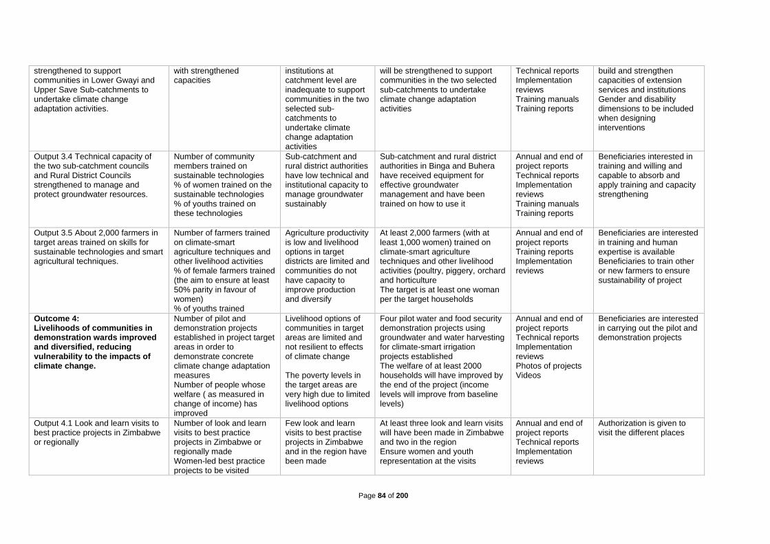
Page 84 of 200
strengthened to support communities in Lower Gwayi and Upper Save Sub-catchments to undertake climate change adaptation activities.
with strengthened capacities
institutions at catchment level are inadequate to support communities in the two selected sub-catchments to undertake climate change adaptation activities
will be strengthened to support communities in the two selected sub-catchments to undertake climate change adaptation activities
Technical reports Implementation reviews Training manuals Training reports
build and strengthen capacities of extension services and institutions Gender and disability dimensions to be included when designing interventions
Output 3.4 Technical capacity of the two sub-catchment councils and Rural District Councils strengthened to manage and protect groundwater resources.
Number of community members trained on sustainable technologies % of women trained on the sustainable technologies % of youths trained on these technologies
Sub-catchment and rural district authorities have low technical and institutional capacity to manage groundwater sustainably
Sub-catchment and rural district authorities in Binga and Buhera have received equipment for effective groundwater management and have been trained on how to use it
Annual and end of project reports Technical reports Implementation reviews Training manuals Training reports
Beneficiaries interested in training and willing and capable to absorb and apply training and capacity strengthening
Output 3.5 About 2,000 farmers in target areas trained on skills for sustainable technologies and smart agricultural techniques.
Number of farmers trained on climate-smart agriculture techniques and other livelihood activities % of female farmers trained (the aim to ensure at least 50% parity in favour of women) % of youths trained
Agriculture productivity is low and livelihood options in target districts are limited and communities do not have capacity to improve production and diversify
At least 2,000 farmers (with at least 1,000 women) trained on climate-smart agriculture techniques and other livelihood activities (poultry, piggery, orchard and horticulture The target is at least one woman per the target households
Annual and end of project reports Training reports Implementation reviews
Beneficiaries are interested in training and human expertise is available Beneficiaries to train other or new farmers to ensure sustainability of project
Outcome 4: Livelihoods of communities in demonstration wards improved and diversified, reducing vulnerability to the impacts of climate change.
Number of pilot and demonstration projects established in project target areas in order to demonstrate concrete climate change adaptation measures Number of people whose welfare ( as measured in change of income) has improved
Livelihood options of communities in target areas are limited and not resilient to effects of climate change The poverty levels in the target areas are very high due to limited livelihood options
Four pilot water and food security demonstration projects using groundwater and water harvesting for climate-smart irrigation projects established The welfare of at least 2000 households will have improved by the end of the project (income levels will improve from baseline levels)
Annual and end of project reports Technical reports Implementation reviews Photos of projects Videos
Beneficiaries are interested in carrying out the pilot and demonstration projects
Output 4.1 Look and learn visits to best practice projects in Zimbabwe or regionally
Number of look and learn visits to best practice projects in Zimbabwe or regionally made Women-led best practice projects to be visited
Few look and learn visits to best practise projects in Zimbabwe and in the region have been made
At least three look and learn visits will have been made in Zimbabwe and two in the region Ensure women and youth representation at the visits
Annual and end of project reports Technical reports Implementation reviews
Authorization is given to visit the different places

Page 85 of 200
Few prominent women-led big projects
Output 4.2 Four pilot climate-smart ecosystem mitigation and resilience projects implemented in four Project wards
Number of pilot and demonstrate community-based ecosystem resilience and mitigation projects Gender sensitivity of proposed pilots % of natural capital/assets recovered or rehabilitated
Massive land degradation resulting in loss of natural capital (forestry resources, wetlands, groundwater) for climate resilience and mitigation
At least one ecosystem protection project in each Project ward At least 25% of the degraded area will be rehabilitated by the end of the project
Annual and end of project reports Technical reports Implementation reviews Photos and video clips
Beneficiaries appreciate benefits and are interested in carrying out ecosystem protection projects
Output 4.3 Four climate-smart water and food security pilot projects using groundwater and rainwater harvesting at community level implemented
Number of pilot climate-smart water and food security projects using groundwater and rainwater harvesting at community level
Food security in target wards is hampered by insufficient water and inappropriate farming methods which do not take into account climate change
At least four pilot climate-smart water and food security projects using groundwater and rainwater harvesting at community level
Annual and end of project reports Technical reports Implementation reviews Photos and video clips
Beneficiaries appreciate benefits and are interested in carrying out ecosystem protection projects
Output 4.4 Climate-smart livelihood enhancement and diversification pilot projects using groundwater, rainwater harvesting and renewable energy for 2,000 households implemented
Number of households participating in livelihood enhancement and diversification projects using groundwater and rainwater harvesting Number of female-headed households involved in the projects
Food security in target wards is hampered by insufficient water and inappropriate farming methods which do not take into account climate change
Pilot climate-smart livelihood enhancement and diversification projects using groundwater and rainwater harvesting for 2,000 households (all female-headed households to be included)
Annual and end of project reports Technical reports Implementation reviews Photos and video clips
Beneficiaries appreciate benefits and are interested in carrying out ecosystem protection projects
Output 4.5 About 2,000 households in the four Project wards apply and access funding from the food security and livelihood enhancement revolving fund
Amount of money set aside for the food security and livelihood enhancement revolving fund established, with at least 50% gender parity with regards to access to the fund
There is currently no revolving fund targeted for food security and livelihood enhancement programmes
A revolving fund will be established Women and youths to be prioritised by the fund
Annual and end of project reports Technical reports Implementation reviews Bank account
Beneficiaries identify viable projects and there is buy-in from financial service providers Beneficiaries should aim for independence from fund after initial round
Outcome 5: A framework for improved groundwater utilisation to reduce vulnerability to climate change developed and adopted.
A sustainable framework for improved groundwater utilisation to reduce vulnerability to climate change developed and adopted
Currently there is no framework for improved groundwater utilisation to reduce vulnerability to climate change
A framework for improved groundwater utilisation to reduce vulnerability to climate change will be developed
Annual and end of project reports Technical reports Implementation reviews Framework
Human capacity and expertise is available to develop the framework
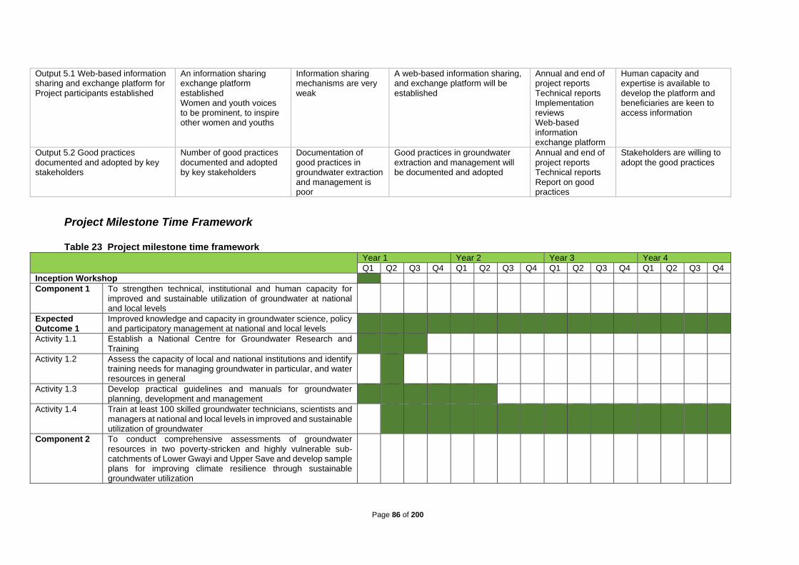
Page 86 of 200
Output 5.1 Web-based information sharing and exchange platform for Project participants established
An information sharing exchange platform established Women and youth voices to be prominent, to inspire other women and youths
Information sharing mechanisms are very weak
A web-based information sharing, and exchange platform will be established
Annual and end of project reports Technical reports Implementation reviews Web-based information exchange platform
Human capacity and expertise is available to develop the platform and beneficiaries are keen to access information
Output 5.2 Good practices documented and adopted by key stakeholders
Number of good practices documented and adopted by key stakeholders
Documentation of good practices in groundwater extraction and management is poor
Good practices in groundwater extraction and management will be documented and adopted
Annual and end of project reports Technical reports Report on good practices
Stakeholders are willing to adopt the good practices
Project Milestone Time Framework Table 23 Project milestone time framework
Year 1 Year 2 Year 3 Year 4
Q1 Q2 Q3 Q4 Q1 Q2 Q3 Q4 Q1 Q2 Q3 Q4 Q1 Q2 Q3 Q4
Inception Workshop
Component 1 To strengthen technical, institutional and human capacity for improved and sustainable utilization of groundwater at national and local levels
Expected Outcome 1
Improved knowledge and capacity in groundwater science, policy and participatory management at national and local levels
Activity 1.1 Establish a National Centre for Groundwater Research and Training
Activity 1.2 Assess the capacity of local and national institutions and identify training needs for managing groundwater in particular, and water resources in general
Activity 1.3 Develop practical guidelines and manuals for groundwater planning, development and management
Activity 1.4 Train at least 100 skilled groundwater technicians, scientists and managers at national and local levels in improved and sustainable utilization of groundwater
Component 2 To conduct comprehensive assessments of groundwater resources in two poverty-stricken and highly vulnerable sub-catchments of Lower Gwayi and Upper Save and develop sample plans for improving climate resilience through sustainable groundwater utilization
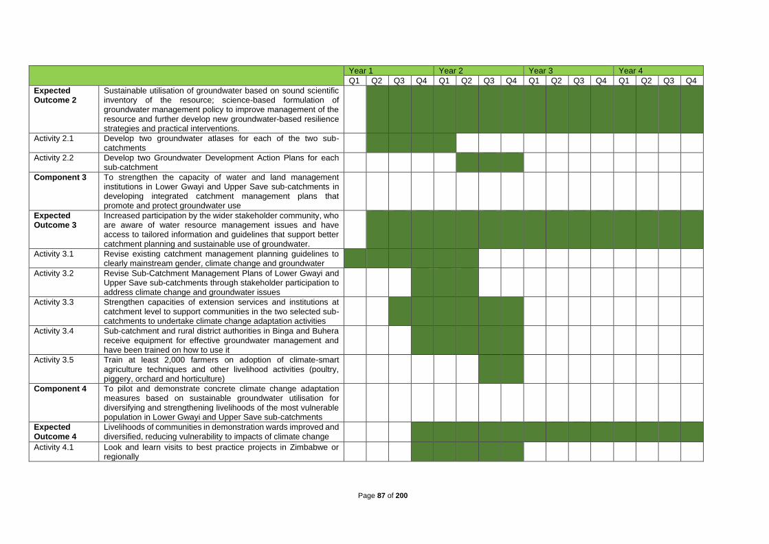
Page 87 of 200
Year 1 Year 2 Year 3 Year 4
Q1 Q2 Q3 Q4 Q1 Q2 Q3 Q4 Q1 Q2 Q3 Q4 Q1 Q2 Q3 Q4
Expected Outcome 2
Sustainable utilisation of groundwater based on sound scientific inventory of the resource; science-based formulation of groundwater management policy to improve management of the resource and further develop new groundwater-based resilience strategies and practical interventions.
Activity 2.1 Develop two groundwater atlases for each of the two sub-catchments
Activity 2.2 Develop two Groundwater Development Action Plans for each sub-catchment
Component 3 To strengthen the capacity of water and land management institutions in Lower Gwayi and Upper Save sub-catchments in developing integrated catchment management plans that promote and protect groundwater use
Expected Outcome 3
Increased participation by the wider stakeholder community, who are aware of water resource management issues and have access to tailored information and guidelines that support better catchment planning and sustainable use of groundwater.
Activity 3.1 Revise existing catchment management planning guidelines to clearly mainstream gender, climate change and groundwater
Activity 3.2 Revise Sub-Catchment Management Plans of Lower Gwayi and Upper Save sub-catchments through stakeholder participation to address climate change and groundwater issues
Activity 3.3 Strengthen capacities of extension services and institutions at catchment level to support communities in the two selected sub-catchments to undertake climate change adaptation activities
Activity 3.4 Sub-catchment and rural district authorities in Binga and Buhera receive equipment for effective groundwater management and have been trained on how to use it
Activity 3.5 Train at least 2,000 farmers on adoption of climate-smart agriculture techniques and other livelihood activities (poultry, piggery, orchard and horticulture)
Component 4 To pilot and demonstrate concrete climate change adaptation measures based on sustainable groundwater utilisation for diversifying and strengthening livelihoods of the most vulnerable population in Lower Gwayi and Upper Save sub-catchments
Expected Outcome 4
Livelihoods of communities in demonstration wards improved and diversified, reducing vulnerability to impacts of climate change
Activity 4.1 Look and learn visits to best practice projects in Zimbabwe or regionally

Page 88 of 200
Year 1 Year 2 Year 3 Year 4
Q1 Q2 Q3 Q4 Q1 Q2 Q3 Q4 Q1 Q2 Q3 Q4 Q1 Q2 Q3 Q4
Activity 4.2 Pilot and demonstrate community-based ecosystem resilience and mitigation projects in four Project wards
Activity 4.3 Four climate-smart water and food security pilot projects using groundwater and rainwater harvesting at community level implemented.
Activity 4.4 Pilot and demonstrate household livelihood enhancement, diversification and climate resiliency projects in four Project wards
Activity 4.5 Establish a food security and livelihood enhancement revolving fund
Component 5 To compile and disseminate lessons learnt to facilitate future upscaling and replication of good practices in groundwater extraction and management
Expected Outcome 5
A framework for improved groundwater utilisation to reduce vulnerability to climate change developed and adopted
Activity 5.1 Establish web-based information sharing and exchange platform for project participants
Activity 5.2 Document and adopt good practices by key stakeholders
End of year project evaluation
Mid-term project evaluation
End of project evaluation
F. Project alignment with the Results Framework of the Adaptation Fund Table 24 Project Alignment with the Results Framework of the Adaptation Fund
Project Objective(s)22 Project Objective Indicator(s) Fund Outcome Fund Outcome Indicator Grant Amount (USD)
1. To strengthen technical, institutional and human capacity for improved and sustainable utilization of groundwater at national and local levels
1.1. Fully functional National Centre for Groundwater Research and Training will be established
1.2. All local and national institutions for managing groundwater revamped
1.3. A set of practical guidelines and manuals on groundwater use developed and distributed to all relevant institutions
Outcome 2: Strengthened institutional capacity to reduce risks associated with climate-induced socioeconomic and environmental losses
2.4. No. and type of targeted institutions with increased capacity to minimize exposure to climate variability risks
419,689
22 The AF utilized OECD/DAC terminology for its results framework. Project proponents may use different terminology but the overall principle should still apply

Page 89 of 200
1.4. At least 25 groundwater technicians, scientists and managers trained each year
Outcome 7: Improved policies and regulations that promote and enforce resilience measures
7. Climate change priorities are integrated into national development strategy
2. To conduct comprehensive assessments of groundwater resources in two poverty-stricken and highly vulnerable sub-catchments of Lower Gwayi and Upper Save and develop sample plans for improving climate resilience through sustainable groundwater utilization
2.1. Two groundwater atlases developed for the two sub-catchments
2.2. Two Groundwater Development Action Plans developed for Lower Gwayi and Upper Save, sub-catchments
Outcome 5: Increased ecosystem resilience in response to climate variability and change induced stress
5. Ecosystem services and natural assets maintained or improved under climate variability and change induced stress
300,000
3. To strengthen the capacity of water and land management institutions in Lower Gwayi and Upper Save sub-catchments in developing integrated catchment management plans that promote and protect groundwater use
3.1. Two catchment management planning guidelines and structures revised for Lower Gwayi and Upper Save sub-catchments
3.2. Two sub-catchment management plans revised for Lower Gwayi and Upper Save sub-catchments
3.3. Capacities of extension services and institutions at catchment level strengthened to support communities in the two selected sub-catchments to undertake climate change adaptation activities
3.4. Sub-catchment and rural district authorities in Binga and Buhera have received equipment for effective groundwater management and have been trained on how to use it
3.5. At least 2,000 community members receive training on climate-smart agriculture techniques and sustainable technologies
Outcome 3: Strengthened awareness and ownership of adaptation and climate risk reduction processes at local level
3.4. Percentage of targeted population aware of predicted adverse impacts of climate change, and of appropriate responses 3.2. Modification in behavior of targeted population
145,750
4. To pilot and demonstrate concrete climate change adaptation measures based on sustainable groundwater utilisation for diversifying and strengthening livelihoods of the most vulnerable population in Lower Gwayi and Upper Save sub-catchments
4.1. At least three look and learn visits made in Zimbabwe and two in the region
4.2. Four pilot climate-smart ecosystem mitigation and resilience projects
4.3. Four pilot climate-smart water and food security projects using groundwater and rainwater harvesting at community level
4.4. Pilot climate-smart livelihood enhancement and diversification projects (piggery, poultry, fishery, orchards, horticulture) using
Outcome 4: Increased adaptive capacity within relevant development and natural resource sectors Outcome 6: Diversified and strengthened livelihoods and sources of income for vulnerable people in targeted areas
4.2. Physical infrastructure improved to withstand climate change and variability-induced stress 6.1 Percentage of households and communities having more secure (increased) access to livelihood assets
3,226,402

Page 90 of 200
groundwater and rainwater harvesting for about 2,000 households.
4.5. Revolving fund established and functional for about 2,000 households
6.2. Percentage of targeted population with sustained climate-resilient livelihoods
5. To compile and disseminate lessons learnt to facilitate future upscaling and replication of good practices in groundwater extraction and management
5.1. Web-based information sharing, and exchange platform established
5.2. Good practices documented and adopted by stakeholders
Outcome 3: Strengthened awareness and ownership of adaptation and climate risk reduction processes at local level
3.4. Percentage of targeted population aware of predicted adverse impacts of climate change, and of appropriate responses 3.2. Modification in behaviour of targeted population
100,000
Project Outcome(s) Project Outcome Indicator(s) Fund Output Fund Output Indicator Grant Amount
(USD)
1. Improved knowledge and capacity in groundwater science, policy and participatory management at national and local levels
1.1 The knowledge and capacity on groundwater science, policy and participatory management issues at national and local levels improved
Output 2.1: Strengthened capacity of national and regional centres and networks to respond rapidly to extreme weather events Output 7: Improved integration of climate-resilience strategies into country development plans
2.4.4. No. of staff trained to respond to, and mitigate impacts of, climate-related events 7.4. No., type, and sector of policies introduced or adjusted to address climate change risks
419,689
2. Sustainable utilisation of groundwater based on sound scientific inventory of the resource; science-based formulation of groundwater management policy to improve management of the resource and further develop new groundwater-based resilience strategies and practical interventions.
2.1 Four comprehensive assessment reports on groundwater resources produced in the four target sub-catchments 2.2 Four sample plans for sustainable groundwater utilization developed in the project target areas
Output 5: Vulnerable physical, natural, and social assets strengthened in response to climate change impacts, including variability
5.4. No. and type of natural resource assets created, maintained or improved to withstand conditions resulting from climate variability and change (by type of assets)
300,000
3. Increased participation by the wider stakeholder community, who are aware of water resource management issues and have access to tailored information and guidelines that support better catchment planning and sustainable use of groundwater.
3.1 Level of participation by stakeholders in water resource management issues in target areas improve by 80% 3.2 All the beneficiaries have access to information and guidelines that support better catchment planning and sustainable use of groundwater
Output 3: Targeted population groups participating in adaptation and risk reduction awareness activities
3.4.1 No. and type of risk reduction actions or strategies introduced at local level
145,750

Page 91 of 200
4. Livelihoods of communities in demonstration wards improved and diversified, reducing vulnerability to impacts of climate change
4. Four pilot water and food security demonstration projects using groundwater and rainwater harvesting for climate-smart irrigation projects established
Output 4: Vulnerable physical, natural, and social assets strengthened in response to climate change impacts, including variability Output 6: Targeted individual and community livelihood strategies strengthened in relation to climate change impacts, including variability
4.4.2. No. of physical assets strengthened or constructed to withstand conditions resulting from climate variability and change (by asset types) 6.4.4.No. and type of adaptation assets created in support of individual-or community-livelihood strategies 6.4.2. Type of income sources for households generated under climate change scenario
3,226,402
5. A framework for improved groundwater utilisation to reduce vulnerability to climate change developed and adopted
5. A framework for improved groundwater utilisation to reduce vulnerability to climate change developed
Output 3: Targeted population groups participating in adaptation and risk reduction awareness activities
3.4.1 No. and type of risk reduction actions or strategies introduced at local level 3.4.2 No. of news outlets in the local press and media that have covered the topic
100,000
G. Detailed Budgets and Budget Justification Table 25 Detailed budget with budget notes
Components Outputs
Amount Year 1 USD
Amount Year 2 USD
Amount Year 3 USD
Amount Year 4 USD
Total (USD) Budget Notes
Outcome 1 Improved knowledge and capacity in groundwater science, policy and participatory management at national and local levels
Output 1.1 National Centre for Groundwater Research and Training established.
50,400 71,697 71,697 0.00 193,794 1
Output 1.2 Capacity needs of local and national institutions to manage groundwater and water resources in general assessed and training needs identified.
24,400 0.00 0.00 0.00 24,400 2
Output 1.3 Practical guidelines and manuals for groundwater resources planning, development and management developed 500 58,195 0.00 0.00 58,695 3
Output 1.4 At least 25 groundwater technicians, scientists and managers trained each year on improved and sustainable utilization of groundwater, via tailor-made or regular short courses, certificates, diplomas, undergraduate and postgraduate courses.
36,000 78,000 14,400 14,400 142,800 4
Sub-Total Outcome 1 111,300 207,892 86,097 14,400 419,689
Outcome 2
Sustainable utilisation of groundwater based on sound scientific inventory of the resource; science-based formulation of groundwater management policy to improve management of the resource and further develop new groundwater-based resilience strategies and practical interventions.
Output 2.1: Groundwater atlases for Lower Gwayi and Upper Save Sub-Catchments developed.
20,000 231,600 0.00 0.00 251,600 5
Output 2.2: Groundwater Development Action Plans for Lower Gwayi and Upper Save Sub-Catchment Councils developed.
0,00 48,400 0.00 0.00 48,400 6
Sub-Total Outcome 2 20,000 280,000 0.00 0.00 300,000
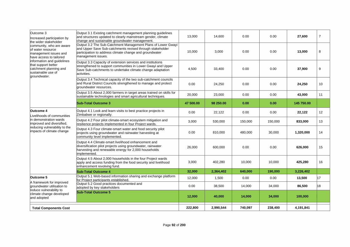
Page 92 of 200
Outcome 3
Increased participation by the wider stakeholder community, who are aware of water resource management issues and have access to tailored information and guidelines that support better catchment planning and sustainable use of groundwater.
Output 3.1 Existing catchment management planning guidelines and structures updated to clearly mainstream gender, climate change and sustainable groundwater management.
13,000 14,600 0.00 0.00 27,600 7
Output 3.2 The Sub-Catchment Management Plans of Lower Gwayi and Upper Save Sub-catchments revised through stakeholder participation to address climate change and groundwater management issues.
10,000 3,000 0.00 0.00 13,000 8
Output 3.3 Capacity of extension services and institutions strengthened to support communities in Lower Gwayi and Upper Save Sub-catchments to undertake climate change adaptation activities.
4,500 33,400 0.00 0.00 37,900 9
Output 3.4 Technical capacity of the two sub-catchment councils and Rural District Councils strengthened to manage and protect groundwater resources.
0.00 24,250 0.00 0.00 24,250 10
Output 3.5 About 2,000 farmers in target areas trained on skills for sustainable technologies and smart agricultural techniques.
20,000 23,000 0.00 0.00 43,000 11
Sub-Total Outcome 3 47 500.00 98 250.00 0.00 0.00 145 750.00
Outcome 4
Livelihoods of communities in demonstration wards improved and diversified, reducing vulnerability to the impacts of climate change
Output 4.1 Look and learn visits to best practice projects in Zimbabwe or regionally.
0.00 22,122 0.00 0.00 22,122 12
Output 4.2 Four pilot climate-smart ecosystem mitigation and resilience projects implemented in four Project wards.
3,000 530,000 150,000 150,000 833,000 13
Output 4.3 Four climate-smart water and food security pilot projects using groundwater and rainwater harvesting at community level implemented.
0.00 810,000 480,000 30,000 1,320,000 14
Output 4.4 Climate-smart livelihood enhancement and diversification pilot projects using groundwater, rainwater harvesting and renewable energy for 2,000 households implemented.
26,000 600,000 0.00 0.00 626,000 15
Output 4.5 About 2,000 households in the four Project wards apply and access funding from the food security and livelihood enhancement revolving fund.
3,000 402,280 10,000 10,000 425,280 16
Sub-Total Outcome 4 32,000 2,364,402 640,000 190,000 3,226,402
Outcome 5
A framework for improved groundwater utilisation to reduce vulnerability to climate change developed and adopted
Output 5.1 Web-based information sharing and exchange platform for Project participants established.
12,000 1,500 0.00 0.00 13,500 17
Output 5.2 Good practices documented and adopted by key stakeholders 0.00 38,500 14,000 34,000 86,500 18
Sub-Total Outcome 5
12,000 40,000 14,000 34,000 100,000
Total Components Cost 222,800 2,990,544 740,097 238,400 4,191,841

Page 93 of 200
Project Execution cost (9.5% of project cost) 134,055 109,055 84,055 111,624 437,789
Total Project Cost 356,855 3,099,599 824,152 349,024 4,629,630
Project Management Fee charged by the Implementing Entity (8%) 28,548 247,968 65,932 27,922 370,370
Amount of Financing Requested 385,403 3,347,567 890,084 376,946 5,000,000
Budget Notes Project Components/Outputs
Notes Budget Activities Total (USD) Budget Expenditure Notes (USD)
Outcome 1 Improved knowledge and capacity in groundwater science, policy and participatory management at national and local levels Total: 419,689
Output 1.1 National Centre for Groundwater Research and Training established
1
1.1.1. Develop a concept note, convene and conduct a four-day workshop at the University of Zimbabwe for local universities and SADC-GMI to set up a Centre for Groundwater Training and Research to develop its structures and TORs
24,200
Facilitation and Administration costs: $4,700. Traveling and Accommodation costs: $19,500
1.1.2. Advertise, shortlist, interview and appoint staff for the Centre (Director, 3 Specialists, Programmes Officer, and Receptionist)
2,000
Advertisement costs. Interview panel to include any other two deans from other universities who will be available.
1.1.3. Resource and capacitate the Centre through state-of-art groundwater development equipment
143,394
Office, laboratory, and field equipment costs.
1.1.4. Plan and convene a four-day workshop to develop a four year-strategic plan and budget for the Centre
24,200
Facilitation and Administration costs: $4,700 Traveling and Accommodation costs: $19,500
Sub-Total 193,794
Output 1.2 Capacity needs of local and national institutions to manage groundwater and water resources in general assessed and training needs identified
2
1.2.1 Prepare TORs, advertise, select and appoint an institutional reform specialist.
1,000 Advertisement costs.
1.2.2 Conduct an institutional gap analysis with a specific focus on groundwater, climate change and gender mainstreaming. 10,000
Done by the institutional expert covering training institutions and organisations involved in groundwater at national and local levels.
1.2.3 Organise and conduct a one-day national workshop to review institutional gaps identified in Sub-component 1.2.2 and develop a training needs strategy
11,400
Costs includes facilitation, venue hire, lunch and cordials, travelling and subsistence, accommodation.
1.2.4 Present summary recommendations to government ministries for action. 2,000
Report production and mini workshop with senior Government officers and Centre personnel.
Sub-Total 24,400
Output 1.3 Practical guidelines and manuals for groundwater resources planning, development and
3
1.3.1 Identify and contract teams to prepare the guidelines and manuals.
500
Advertisement and courier services costs.
1.3.2 Convene and conduct a five-day workshop of universities, practitioners and SADC-GMI to formulate a training curriculum, at least five practical guidelines and manuals for groundwater planning, development and management.
42,195
Facilitation and Administration costs: $6,400. Traveling and Accommodation costs: $35,795.

Page 94 of 200
management developed
1.3.3 Prepare, review, edit and publish the 5 manuals.
16,000
Selected authors develop training materials, present them for review before finalisation. 2 Reviewers for the materials costs included.
Sub-Total 58,695
Output 1.4 At least 25 groundwater technicians, scientists and managers trained each year on improved and sustainable utilization of groundwater, via tailor-made or regular short courses, certificates, diplomas, undergraduate and postgraduate courses.
4
1.4.1 Recruit and fully fund 2 PhD and 3 MPhil students.
100,800
Project will cover tuition and living stipends for 2 PhD for 48months and 3 MPhil for 24months while the government will provide in-kind and technical support for their trainings (support letter attached)
1.4.2 Accredit regular course with the Zimbabwe Council for Higher Education and the short courses with the Zimbabwe Institution of Engineers for Continuous Professional Development (CPD) points
2,000
Costs include meeting to review documents before submission and upon receiving feedback from ZimCHE and Zimbabwe Institution of Engineers.
1.4.3 Conduct training of approved courses 40,000
Budget to cover running costs related to conducting the training costs and some guest lecturers from non-UZ lecturers.
Sub-Total 142,800
Outcome 2
Sustainable utilisation of groundwater based on sound scientific inventory of the resource; science-based formulation of groundwater management policy to improve management of the resource and further develop new groundwater-based resilience strategies and practical interventions. Total: 300,000
Output 2.1: Groundwater atlases for Lower Gwayi and Upper Save Sub-Catchments developed.
5
2.1.1 Develop TORs, advertise, select and recruit a local company to carry out extensive pilot study and mapping of groundwater potential, risks and vulnerabilities in the two proposed sub-catchments of Lower Gwayi and Upper Save.
4,000
National advertisement and procurement costs.
2.1.2 Conduct pilot groundwater mapping in Lower Gwayi and Upper Manyame sub-Catchment.
207,600
Hired consultant costs to conduct extensive geophysical investigations and produce ground water maps for the two sub-catchments.
2.1.3 Identify and establish groundwater monitoring sites in Binga Wards 19 and 25 and Buhera Wards 20 and 23
40,000
Two borehole monitoring sites in each ward at $5,000 each. Drilling by ZINWA.
2.1.4 Develop potential, risks and vulnerability maps 0 Costs included 2.1.2.
Sub-Total 251,600
Output 2.2: Groundwater Development Action Plans for Lower Gwayi
6
2.2.1 Develop TORs, advertise, select and recruit a facilitator for the development of sub-catchment action plans which mainstreams gender, youth empowerment and expected climate change impacts.
2,000
National advertisement and selection costs for an individual to facilitate the development of action plans

Page 95 of 200
and Upper Save Sub-Catchment Councils developed.
2.2.2 Facilitator develops training materials for approval.
8,000
Development of training materials present them for review before finalisation. Reviewers for the materials costs included.
2.2.3 Conduct two-day training courses in each sub-catchment for local community leadership: including councillors, chiefs, headmen, headmasters, etc, on practical skills for developing groundwater management plans and building climate resilience.
17,400
Facilitation and Administration costs: $4,600. Traveling and Accommodation costs: $12,800. 2.2.4 Facilitate the development of Action Plans for each sub-catchment
through two-day workshops through local stakeholder dialogue and focusing on women and youth empowerment, and this will be used to design specific ward pilot schemes (see Components 4.2 – 4,4)
21,000
Facilitation and Administration costs: $8,200. Traveling and Accommodation costs: $12,800.
Sub-Total
48,400
Outcome 3
Increased participation by the wider stakeholder community, who are aware of water resource management issues and have access to tailored information and guidelines that support better catchment planning and sustainable use of groundwater. Total: 145,750
Output 3.1 Existing catchment management planning guidelines and structures updated to clearly mainstream gender, climate change and sustainable groundwater management.
7
3.1.1 Develop TORs, advertise, select and appoint a team of water resources specialists, climate change experts, social scientists and gender experts.
2,000
Advertisement and selection costs for a team of experts to review catchment planning guidelines.
3.1.2 Consult key stakeholders and facilitate the revision of the catchment planning guidelines by mainstreaming groundwater, gender and climate change, as part of the CRIDA approach.
8,000
Key informant interviews and document reviews Costs include expert’s time.
3.1.3 Validate, print and disseminate revised guidelines to the different stakeholders.
3,000
Documents reviewed by three experts Final document packaged for online and hardcopy distribution.
3.1.4 Conduct one-day training workshops on revised catchment planning guidelines at national, catchment levels. 14,600
Three workshops envisaged. Workshops target 20-30 participants, (ensuring 50% gender parity) from Government, ZINWA, NGOs, councillors
Sub-Total 27,600
Output 3.2 The Sub-Catchment Management Plans of Lower Gwayi and Upper Save Sub-catchments revised through stakeholder participation to address climate change and groundwater management issues.
8
3.2.1 Preparations for training workshop concept note by experts hired in sub-component 3.1.1.
2,000
Preparatory meeting at national and sub—catchment level in conjunction with the facilitators.
3.2.2 Conduct one-day consultative workshops in Gwayi and Save catchments to revise catchment outlines as per sub-component 3.1.3 guidelines.
8,000
Two workshops envisaged. Workshops target 20-30 participants, (ensuring 50% gender parity) from Government, ZINWA, NGOs, and councillors.
3.2.3 Print and disseminate revised catchment outline plans. 3,000
Review by two experts. Final document packaged for online and hardcopy distribution.
Sub-Total 13,000

Page 96 of 200
Output 3.3 Capacity of extension services and institutions strengthened to support communities in Lower Gwayi and Upper Save Sub-catchments to undertake climate change adaptation activities.
9
3.3.1 Develop TORs, advertise, select and appoint an Human Resources expert to carry out a detailed skills inventory and needs assessment of extension services in the Binga and Buhera districts and Lower Gwayi and Upper Save sub-catchments, based on the Project objectives and thrust.
2,000
National advertisement and selection costs for an individual to carry out skills inventory and needs assessment. 3.3.2 Develop TORs, advertise, select and appoint a team of trainers
based on the identified skilled gaps.
2,500
Advertisement and recruitment costs.
3.3.3 In collaboration with the Centre for Groundwater Training and Research in sub-component 1.1, conduct three-day Training of Trainers skills training workshops of maximum five days in each of the Project districts.
29,900
Facilitation and Administration costs: $4,600. Traveling and Accommodation costs: $25,300.
3.3.4 Develop and disseminate Information, Education and Communication (IEC) materials for awareness raising. 3,500
Review by two experts Final document packaged for online and hardcopy distribution costs.
Sub-Total 37,900
Output 3.4 Technical capacity of the two sub-catchment councils and Rural District Councils strengthened to manage and protect groundwater resources.
10
3.4.1 Led by the Centre for Groundwater Training and Research, assess the Lower Gwayi and Upper Save and the Binga and Buhera districts personnel in terms of the requisite communication skills, equipment and technical skills to measure borehole water quality, capacity tests, and sustainable yields to avoid groundwater depletion.
2,500
Travel to the two project districts.
3.4.2 Develop training materials for 2 two-day short training courses and accredit courses with the Zimbabwe Institution of Engineers and other relevant bodies.
1,000
Materials developed in-house by the Centre.
3.4.3 Conduct 1 two-day training courses per district/sub-catchment and evaluate.
8,000 Costs are related to travelling and conducting the courses in Binga and Buhera.
3.4.4 Procure and install tools and equipment that will enable Subcatchment and district councils to carry out robust groundwater monitoring.
12,750
Office equipment, motorcycles for field visits, groundwater quality and quantity monitoring equipment.
Sub-Total 24,250
Output 3.5 About 2,000 farmers in target areas trained on skills for sustainable technologies and smart agricultural techniques.
11
3.5.1 Using ToTs trained in sub-component 3.3.3 and backup from the Centre for Groundwater Training and Research, conduct at least ten 1-2 days training courses in each district of Binga and Buhera. focusing on participants from the specific project wards.
40,000
Trainings conducted in the field with less costs for venue, food and travelling Each training session to have 20-30 participants. 3.5.2 Develop and disseminate Information, Education and
Communication materials for awareness raising. 3,000
Review by one expert cost. Trainings costs Final document packaged for online and hardcopy distribution costs.
Sub-Total 43,000
Outcome 4
Livelihoods of communities in demonstration wards improved and diversified, reducing vulnerability to the impacts of climate change Total: 3,226,402.00

Page 97 of 200
Output 4.1 Look and learn visits to best practice projects in Zimbabwe or regionally.
12
4.1.1 Government, UNESCO and Project partners meet to finalise look and learn visits, identify participants and book appointments.
3,122
Travelling and meeting cost Administration costs.
4.1.2 Identified team members conduct look and learn visits to projects locally and internationally and produce mission reports.
19,000 Travelling, accommodation, subsistence and development costs.
Sub-Total 22,122
Output 4.2 Four pilot climate-smart ecosystem mitigation and resilience projects implemented in four Project wards.
13
4.2.1 Prepare TORs, advertise, select and appoint a consultant firm with specialisation on land use, forestry, ecosystem and environmental planning to design and ecosystem protection plans for the 4 Project Wards based on sub-Components 2.2, 3.1 and 3.2.
3,000
Advertisement and selection costs for a consultant firm. Contract signing.
4.2.2 Consultant firm presents Inception Report, conducts fieldwork, presents draft report, makes corrections and present Final Report with detailed drawings.
80,000
Lump sum contract + supervision costs.
4.2.3 Materials procurement and installation with supervision from Agritex, Forestry Commission, and EMA.
750,000
Procurement of fence, poles, tree seedlings and awareness campaign materials in the 4 wards: $450,000. Fire protection activities, land use demarcation, fencing, tree planting, awareness campaigns, wetland protection, and gully protection in the 4 wards: $300,000.
Sub-Total 833,000
Output 4.3 Four climate-smart water and food security pilot projects using groundwater and rainwater harvesting at community level implemented.
14
4.3.1 Planning meetings in Harare and in the Project wards to confirm the design the of the community resilience projects with Agritex, ZINWA, Forestry Commission, EMA, NGOs working in the area, and universities, based on plans developed in sub-Components 2.2, and 3.2.
30,000
Costs include meetings, travelling to project sites, accommodation, subsistence, fieldwork surveys, mapping, sample collection and analysis for water and soils, condition analysis, value chain analysis
4.3.2 Goods and services procurement and installation with supervision from Agritex, Forestry Commission, and EMA.
1,290,000
Weir construction, sand dam construction, drip irrigation kits, repair of existing infrastructure, , drilling of boreholes, provision of water supply systems, labour hire, provision of orchard trees, supply of farming inputs and field travelling. Cost breakdown per ward: Binga Ward 19: $470,000, Binga Ward 25: $300,000, Buhera Ward 20: $260,000, Buhera Ward 23: $260,000
Sub-Total 1,320,000
Output 4.4 Climate-smart livelihood enhancement and diversification pilot projects using groundwater, rainwater harvesting and
14
4.4.1 Develop a detailed data collection tool to profile all families in the four Project wards and collect the data using local Government extension workers and village heads.
20,000
Transport and fieldwork costs. Printing and stationery costs
4.4.2 Using the demographic data collected in Output 4.4.1, develop and validate an intervention matrix or model to identify suitable interventions at individual level based on food, water, energy and income security.
6,000
Procurement of data analysis software, Hiring of a data analysis expert.

Page 98 of 200
renewable energy for 2,000 households implemented.
4.4.3 Procure goods and services and install interventions.
600,000
Procurement of fencing, irrigation equipment, and farming inputs at household level in the 4 wards. Fieldwork costs. Hiring of experts for installation.
Sub-Total 626,000
Output 4.5 About 2,000 households in the four Project wards apply and access funding from the food security and livelihood enhancement revolving fund.
16
4.5.1 Identify, negotiate and agree a collaborative arrangement and terms with a bank or micro-finance institution working in the Project districts.
20,000
Costs includes meetings with bank officials in Harare and travel to Binga and Buhera for due diligence checks with bank local branches.
4.5.2 Appoint a financial advisor to work with selected bank to develop terms and guidelines for appraisal of business plans by beneficiaries accessing revolving funds.
15,000
Consultancy costs, travels and consultations with leadership in beneficiary areas. Training of community leaders so that they understand the facility better.
4.5.3 Prepare fund brochures and advertise for loan applicants using channels easily and fairly accessible to all potential beneficiaries in the four Project wards.
3,000
Design of brochures, printing and dissemination costs.
4.5.4 Process applications,disburse funds and collect loan repayments
295,180
Revolving loan disbursement and loan repayments 4.5.5 Provide field extension and advisory services to beneficiaries.
20,000
Hired bank and extension workers. 4.5.6 Implementation and monitoring of the ESMP and stakeholder
consultations
72,100 Hired consultant and project staff
Sub-Total 425,280
Outcome 5
A framework for improved groundwater utilisation to reduce vulnerability to climate change developed and adopted Total: 100,000
Output 5.1 Web-based information sharing and exchange platform for Project participants established.
17
5.1.1 Advertise, select and recruit a website design specialist.
2,000
Advertisement and selection costs.
5.1.2 Develop a website for the project with link to social media.
10,000
Consultant costs. 5.1.3 Select and train Project staff on how to use and maintain website.
1,500 Consultant costs
Sub-Total 13,500
Output 5.2 Good practices documented and adopted by key stakeholders
18
5.2.1 Identify and train Project staff on documenting good practices and project interventions.
12,000
Coaching of project staff. Professional editing and publication costs. 5.2.2 Conduct dissemination activities such as short films, radio and TV
shows 74,500
Specialist activities and equipment hire. Cost of airtime on radio and TV.
Sub-Total 86,500
Total Components Cost 4,191,841
Total Project Cost 4,629,630
Project Management Fee charged by the Implementing Entity (8%) 370,370
Amount of Financing Requested
5,000,000

Page 99 of 200
Table 26 Budget on the Implementing Entity management fee use
Description Percentage, % Total (USD)
Direction 29 107,407
Strategic planning 14 51,852
Human resources management 23 85,185
Financial management 23 85,185
ICT infrastructure and operation 10 37,037
Administration & Management 1 3,704
TOTAL 370,370 Note: Programme support costs (PSC), or Implementing Entity Fee, also called administrative overhead costs: indirect variable costs which are incurred by UNESCO in its support to extrabudgetary projects, but which cannot easily be traced unequivocally to the project. These costs are therefore estimated as a percentage of direct project costs. For UNESCO, these costs generally include the support and administration of Programme-related and Corporate Services (e.g. BSP, BFM, LA etc), and of the administrative units of Field Offices.
Table 13 Explanation and a breakdown of the execution costs
Item Year 1 (USD) Year 2 (USD) Year 3 (USD) Year 4 (USD) Total (USD)
Project manager (National Officer)
45,155 45,155 45,155 45,155 180,620
Administrative assistant 13,200 13,200 13,200 13,200 52,800
Finance assistant 13,200 13,200 13,200 13,200 52,800
Social and Gender Expert, part time
7,500 7,500 7,500 7,500 30,000
Inception and kick-off meetings 30,000 0.00 0.00 0.00 30,000
M&E Workshops 10,000 0.00 10,000 20,000
Office Equipment 20,000 0.00 0.00 0.00 20,000
Transport for Project Staff 5,000 5,000 5,000 5,000 20,000
Mid and end term evaluation 0.00 15,000 0.00 16,569 31,569
Total Executing costs (9.5%) 134,055 109,055 84,055 110,624 437,789
H. Include a Disbursement Schedule with Time-Bound Milestones
Upon Agreement
Signature Year 2 Year 3 Year 4 Total (USD)
Schedule Date (Tentative)
Sep-21 Sep-22 Sep-23 Sep-24
Project Funds 222,800 2,990,544 740,097 238,400 4,191,841
EE Fee 134,055 109,055 84,055 110,624 437,789
MIE Fee 28,548 247,968 65,932 27,922 370,370
Total (USD) 385,403 3,347,567 890,084 376,946 5,000,000

Page 100 of 200
PART IV: ENDORSEMENT BY GOVERNMENT AND CERTIFICATION BY THE IMPLEMENTING ENTITY

Page 101 of 200
ANNEXES Annex 1: Endorsement Letter from National Designated Authority

Page 102 of 200
Annex 2: Support Letter from University of Zimbabwe

Page 103 of 200
Annex 3: Cofinancing Letter (to support DPhil and MPhil studies) from the
Government of Zimbabwe
Annex 4: A needs assessment /consultative report of Binga [Ward 19 and 25]
and Buhera [Ward 20 and 23] Introduction A needs assessment study was conducted in Binga (Ward 19 and 25) and Buhera (Ward 20 and 23). The purpose of the study was to gather data to be used in informing project interventions and implementation strategies for the project: Strengthening local communities’ adaptive capacity and resilience to climate change through sustainable groundwater utilisation in Zimbabwe. The specific objective of the need assessment study was to gather data that can be used to answer the following objectives:

Page 104 of 200
• Carry out a preliminary assessment of groundwater resources in the target areas including potential, challenges and opportunities for sustainable utilization of the resource
• Assess capacities of catchment and sub-catchment councils in managing water resources
• Assess the differentiated climate change impacts on men and women and differentiated capabilities
• Assess access to productive resources such as water, land, labour and capital
• Review of past and ongoing similar projects in the target areas to identify synergies
• Identify and describe various livelihood options and activities and the respective value chains.
• Develop concrete pilot actions that can be developed in each of the targeted areas, and proposal of four wards for project implementation.
Presentation of Data - Maps of Villages Visited and Demographic Information of
Villagers Participating in the Research This section of the report presents the maps of the villages visited and discusses the demographic profile of the villagers that participated in the research in detail. Six hundred and thirteen (613) homesteads participated in the stakeholder consultations done in Binga and Buhera combined. 68% of the homestead participating in the research came from Buhera and 32% of the homesteads participating in the research came from Binga.
Figure 26 Total Household Visited
Breakdown of homesteads visited based on villages – Binga Ward 19 and 25 Homesteads from five villages in Binga Ward 19 participated in the research. The highest number of participants came from Manyanda village; the lowest number of participants came from Bungu village. Manyanda village was the most accessible, had more boreholes and was better populated than the other four villages. Six (6) villages from Ward 25 participated in the research. The highest number of participants came from Mankunku village and the lowest number of participants come from Sichimwali village. Sichimwali village is the least accessible and is located close to Kavira forest.
416
197
Which district are you from?
Binga Buhera

Page 105 of 200
Figure 27 Breakdown of Homesteads visited based on villages – Binga Ward 19 and 25
Maps of visited homesteads in Binga The maps below show the distribution of visited homesteads and reveal the settlement patterns of vilages in Binga Ward 19 and 25. Villages in both Ward 19 and 25 are spread either along major roads or along rivers. Ward 25 is sparsely populated and the distances between villages are long. Half of Ward 25 is Kavira Forest Land. The forest is a game reserve and has landmines. Some villages like Katete falling under Ward 25, appears outside the map of Ward 25. This is indicative of ward boundaries that have expanded over the years.
Figure 28 Maps showing visited homesteads in Binga – Source Primary data
Settlements in Ward 19 follow similar patterns as those in Ward 25. Villages tend to be located close to roads. Incidentally, boreholes in Ward 19 are located close to major roads. Some points of homesteads visited, lie outside Ward 19 boundaries. This again is indicative of ward boundaries having expanded over the years. The map of Ward 19 shows villages occupying a little over half the ward. Boreholes are the main source of water for villagers in Ward 19 and these boreholes tend to follow the same distribution as that shown by the location of villagers. Settlements tend to grow close to water sources. However, despite boreholes following the same settlement patterns as villages, a significant number of villagers within Ward 19 walk long distances in search of water. Breakdown of villages visited in Buhera Ward 20 and 23 Ten (10) and twelve(12) villages were interviewed in Buhera Ward 20 and 23, respectively.

Page 106 of 200
Which village do you come from in Buhera Ward 20 and 23? Figure 29 Breakdown of villages visited in Buhera Ward 20 and 23
Maps of villages visited in Buhera
Figure 30 Maps of homesteads/villages visited in Buhera
Figure 30 above shows maps of homesteads visited in Buhera. The spread of villages is evenly distributed, and covers most parts of the ward. Additionally, villages in Buhera are densely populated. Again, points on the map show that ward boundaries for Ward 20 and 23 expanded over the years. Gender composition and age distribution of the research participants
Figure 31 (a) Gender Composition of the research participants; (b) Age distribution of the research
The majority of the participants were women in the age group from 36 to 60 years. 70.3% of the research participants were women. Generally, men do not to stay in rural areas due to

Page 107 of 200
lack of employment and other livelihood enhancing opportunities. It is important to highlight that lack of employment and other livelihood opportunities in rural areas affect men and women alike. However, culturally, it is the duty of women to stay at home, raise children, and look after the homestead. This cultural bias in the sharing of responsibilities makes women more vulnerable than men to the effects of climate change. Women cannot make the decision to migrate on their own. Age distribution by location The diagram aside shows the age distribution by location. There are no material differences amongst the wards and districts on age distribution. The majority of the participants during the research for all the wards fall into the 36 – 60 years age category, and the 6 – 25 years age group had the least number of participants in all the four wards. Family sizes of homesteads visited The diagram (Figure 32 (b)) shows the combined statistics of family sizes of homesteads interviewed during the needs assessment. 48.3% of visited homesteads had between four to six family members. 33.4% had more than 6 family members. Traditionally, the average number of children per family is ten or more. Statistics collected indicate family with an average size of five (5) members, which approximately translates to an average of three (3) children per family. Compared with the traditional norms, birth rates in rural areas are falling.
Figure 32 (a)Age Distribution by location; (b) Family Sizes of Homesteads Visited People living with disabilities Figure 33(a) shows the percentage of households visited that has family members living with one form of disability or another. 19.09% of the households participating in the research had family members living with some form of disability. The common forms of disability encountered range from mental impairment due to natural causes, dementia, crippled legs, blindness and deafness. Researchers, however, noted that households were uncomfortable when discussing the disabilities affecting their family members. Segregating disabilities by location The Wards with the highest number of households looking after people with disabilities were Buhera Ward 20 (26%) and Buhera Ward 23 (18%).

Page 108 of 200
Figure 33 (a) People Living with Disabilities; (b) Segregating Disabilities by Location
Marital status and windowed participants based on village visited The majority of the participants during the stakeholder consultations were married. 71.39% of participants in Buhera were married compared to 80.2% of participants from Binga. Richer information is obtained if the statistic on marriage is further segregated based on age and location. The purpose of further segregation of data by age is to gain an understanding of the level of vulnerability of rural women. Women who are married at an early stage are the most vulnerable to the effects of climate change, since they generally lack opportunity for self-development.
Figure 34 (a) Marital status; (b) Widowed participants based on villages visited
Analysis of Data Collected from the Field Assessment of water resources in Binga and Buhera This section of the report presents an analysis of data collected during the assessment of groundwater resources in Binga and Buhera. The variables were an analysis of geological maps showing the distribution of boreholes and wells in Binga and Buhera; main sources of

Page 109 of 200
water; quality of water from these sources; and the potential for groundwater extraction in both districts.
Main Sources of Water
a. Breakdown of the main sources of water by Ward
Figure 35 Breakdown of the Main Sources of Water by Ward
b. Overall Rankings of Main Sources of Water by District The rankings of the main sources of water for Binga and Buhera are as follows: Table 14 Ranking sources of water for Binga and Buhera
District
Rank Buhera Binga
1 Wells (72.84%) Borehole (50.76%)
2 Borehole (21.63%) Rivers (18.27%)
3 Rivers (4.33%) Springs (11.68%)
4 Springs (1.20%) Dams (10.66%)
5 Dam (0%) Wells (8.63%)
The main source of water for villagers in Buhera is wells whilst the main source of water for villagers in Binga is boreholes. Wells and boreholes combined cater for the water needs of 94.47% of Buhera villagers interviewed during the field visits. Boreholes and wells in Binga on the other hand cater for the water needs of 59.39% of the villagers consulted during the research. Less than 5% of villagers in Buhera rely on rivers, springs and dams for water for domestic consumption.
c. Rankings of main sources of water by ward Table 15 Rankings of Main sources of Water by Ward
Buhera Binga
Which ward do you reside in? Which ward do you reside in?
Ward 20 Ward 23 Ward 19 Ward 25
Rank 1 Well Well Borehole River
2 Borehole Borehole Dam Spring
3 River River Well Dam
4 Spring Spring River Well
5 Dam Dam Spring Borehole
Maps and history of boreholes and wells visited in Binga and Buhera
a. Maps of boreholes visited in Buhera - Ward 20 and 23 Figure 36(a) below is a map showing the distribution of boreholes and wells visited in Buhera. The aeromagnetic map shows north south low magnetic features that are generally the host of underground water. Most boreholes lie within structures and low magnetic horizons.
23% 21%
91%
3%
72% 74%
3%
16%
5% 4%0%
40%
1% 1% 0%
26%
0% 0%
7%
16%
Binga Ward 19 Binga Ward 25 Buhera Ward 20 Buhera Ward 23
What is your main source of water for domestic consumption?
Borehole Well River Spring Dam
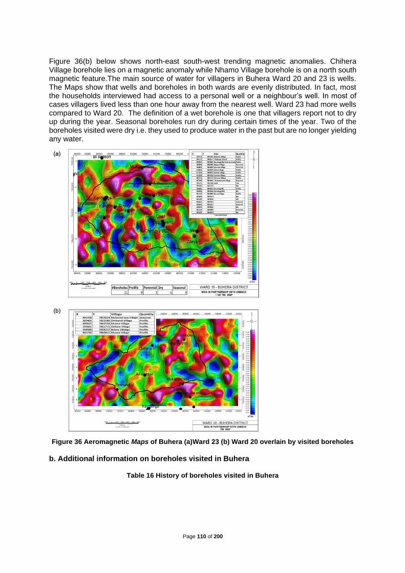
Page 110 of 200
Figure 36(b) below shows north-east south-west trending magnetic anomalies. Chihera Village borehole lies on a magnetic anomaly while Nhamo Village borehole is on a north south magnetic feature.The main source of water for villagers in Buhera Ward 20 and 23 is wells. The Maps show that wells and boreholes in both wards are evenly distributed. In fact, most the households interviewed had access to a personal well or a neighbour’s well. In most of cases villagers lived less than one hour away from the nearest well. Ward 23 had more wells compared to Ward 20. The definition of a wet borehole is one that villagers report not to dry up during the year. Seasonal boreholes run dry during certain times of the year. Two of the boreholes visited were dry i.e. they used to produce water in the past but are no longer yielding any water.
Figure 36 Aeromagnetic Maps of Buhera (a)Ward 23 (b) Ward 20 overlain by visited boreholes
b. Additional information on boreholes visited in Buhera
Table 16 History of boreholes visited in Buhera

Page 111 of 200
c. Maps of Boreholes visited in Binga – Ward 19 and 25 The map below (Figure 37) shows the distribution of boreholes and wells in Binga Ward 19. The boreholes are hosted within the sandstones and quartz schists. The granites are poor aquifers and host few boreholes that dry up during the winter season. An interesting feature of boreholes assessed during assements.
Location Type Elevation above sea level Details and history
Kandenha Primary
SchoolWell 832.73m above sea level Well produces water
Muonde Village -
ZibuteBorehole 848 meters above sea level Borehole supplies more than 80 families with water
Kandenga Secondary
SchoolBorehole 833.25 meters above sea level
The borehole is prolific, and the engine works well.
However, the water tank is dead and the school does
not have water.
Kandenga VillageDip borehole
Kandenga856.71meters above sea level
Dip borehole. Villagers did not have the history of the
borehole
Muuya Village Borehole 755.39 meters above sea level The borehole is perennial
Charuka Village Borehole 750.91 meters above sea level The borehole is perennial
Ziteya Village Borehole 716.14 meters above sea level
Wet and prolific borehole. During drought periods, or
times of the year when wells in the area run dry, the
boreholes serves a radius of fourteen (14) km. The
borehole is currently broken down and awaits repairs
Neunze Village Borehole 699.76 meters above sea level
Wet and prolific borehole. However, there is no arable
land close to the borehole. It is the only borehole in the
village and it is located right at the edge of the village.
Therefore, most villagers in Neunze village do not have
access to this borehole and rely on wells and Save river
for water.
Tarwirei Village Borehole. 719.34 meters above sea levelWet and prolific borehole. It is the only borehole in the
village and it is 48 meters deep
Chirozva Borehole Borehole 776.14 meters above sea level Wet borehole that supplies Chirozva clinic and dip tank.
Mukananána village Borehole 728.22 meters above sea levelWet borehole, but is non-functional. The hand pump of
the borehole died one (1) year ago
Zimbandi Village Well 755.33 meters above sea levelWell is 15 meters deep and yields a maximum of 400
litres/ 2 drums of water per day
Zimbandi Village Well 763.23 above sea level Prolific well. Well is 13 meters deep
Zimbandi Village Borehole 881.62 meters above sea level Prolific borehole
Nhamo village Borehole 793.59 meters above sea level No information was obtained for this borehole
Chihera Village Borehole 803.41 meters above sea levelBorehole is 102 meters deep. No additional
information was obtained for this borehole

Page 112 of 200
Figure 37 (a) Geology Map of Binga Ward 19 overlain by visited boreholes; (b) Aeromagnetic Map of Binga Ward 25 overlain by visited boreholes and homesteads
Binga ward 25 has not been mapped under the Zimbabwe Geological Survey Bulletin series. The area is generally overlain by Aeolian Sands within a basin. Regional aeromagnetic maps, Figure 37(b) shows a layered sequence of siltstones, sandstones, mudstones and brits. The underground water is hosted within the sandstones as evidenced in Ward 19. d. Additional information on the boreholes assessed in Binga
Table 17 History of wet boreholes in Binga

Page 113 of 200
Table 18 History of dry borehole in Binga
Table 19 History of seasonal boreholes
Figure 38 A picture of villagers fetching water at a borehole in ward 19 Binga
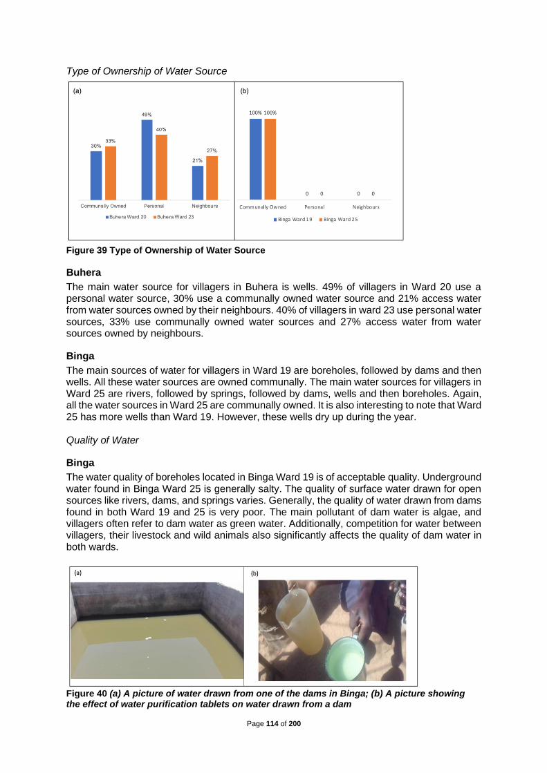
Page 114 of 200
Type of Ownership of Water Source
Figure 39 Type of Ownership of Water Source
Buhera
The main water source for villagers in Buhera is wells. 49% of villagers in Ward 20 use a personal water source, 30% use a communally owned water source and 21% access water from water sources owned by their neighbours. 40% of villagers in ward 23 use personal water sources, 33% use communally owned water sources and 27% access water from water sources owned by neighbours.
Binga
The main sources of water for villagers in Ward 19 are boreholes, followed by dams and then wells. All these water sources are owned communally. The main water sources for villagers in Ward 25 are rivers, followed by springs, followed by dams, wells and then boreholes. Again, all the water sources in Ward 25 are communally owned. It is also interesting to note that Ward 25 has more wells than Ward 19. However, these wells dry up during the year. Quality of Water
Binga
The water quality of boreholes located in Binga Ward 19 is of acceptable quality. Underground water found in Binga Ward 25 is generally salty. The quality of surface water drawn for open sources like rivers, dams, and springs varies. Generally, the quality of water drawn from dams found in both Ward 19 and 25 is very poor. The main pollutant of dam water is algae, and villagers often refer to dam water as green water. Additionally, competition for water between villagers, their livestock and wild animals also significantly affects the quality of dam water in both wards.
Figure 40 (a) A picture of water drawn from one of the dams in Binga; (b) A picture showing the effect of water purification tablets on water drawn from a dam
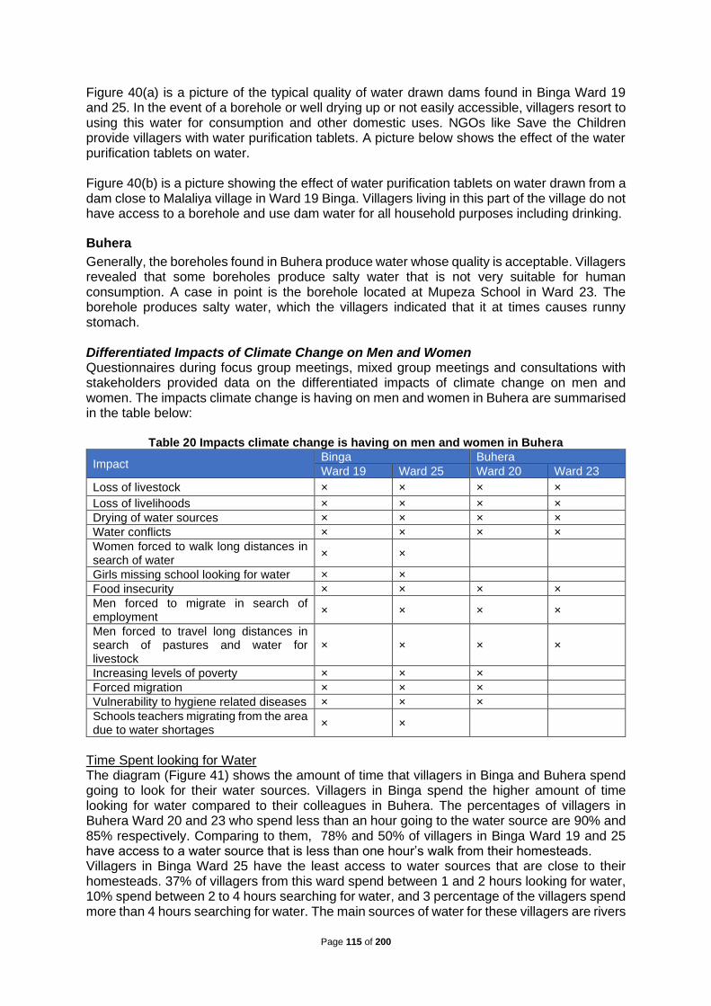
Page 115 of 200
Figure 40(a) is a picture of the typical quality of water drawn dams found in Binga Ward 19 and 25. In the event of a borehole or well drying up or not easily accessible, villagers resort to using this water for consumption and other domestic uses. NGOs like Save the Children provide villagers with water purification tablets. A picture below shows the effect of the water purification tablets on water. Figure 40(b) is a picture showing the effect of water purification tablets on water drawn from a dam close to Malaliya village in Ward 19 Binga. Villagers living in this part of the village do not have access to a borehole and use dam water for all household purposes including drinking.
Buhera
Generally, the boreholes found in Buhera produce water whose quality is acceptable. Villagers revealed that some boreholes produce salty water that is not very suitable for human consumption. A case in point is the borehole located at Mupeza School in Ward 23. The borehole produces salty water, which the villagers indicated that it at times causes runny stomach. Differentiated Impacts of Climate Change on Men and Women Questionnaires during focus group meetings, mixed group meetings and consultations with stakeholders provided data on the differentiated impacts of climate change on men and women. The impacts climate change is having on men and women in Buhera are summarised in the table below:
Table 20 Impacts climate change is having on men and women in Buhera
Impact Binga Buhera
Ward 19 Ward 25 Ward 20 Ward 23
Loss of livestock × × × ×
Loss of livelihoods × × × ×
Drying of water sources × × × ×
Water conflicts × × × ×
Women forced to walk long distances in search of water
× ×
Girls missing school looking for water × ×
Food insecurity × × × ×
Men forced to migrate in search of employment
× × × ×
Men forced to travel long distances in search of pastures and water for livestock
× × × ×
Increasing levels of poverty × × ×
Forced migration × × ×
Vulnerability to hygiene related diseases × × ×
Schools teachers migrating from the area due to water shortages
× ×
Time Spent looking for Water The diagram (Figure 41) shows the amount of time that villagers in Binga and Buhera spend going to look for their water sources. Villagers in Binga spend the higher amount of time looking for water compared to their colleagues in Buhera. The percentages of villagers in Buhera Ward 20 and 23 who spend less than an hour going to the water source are 90% and 85% respectively. Comparing to them, 78% and 50% of villagers in Binga Ward 19 and 25 have access to a water source that is less than one hour’s walk from their homesteads. Villagers in Binga Ward 25 have the least access to water sources that are close to their homesteads. 37% of villagers from this ward spend between 1 and 2 hours looking for water, 10% spend between 2 to 4 hours searching for water, and 3 percentage of the villagers spend more than 4 hours searching for water. The main sources of water for these villagers are rivers

Page 116 of 200
and springs. Villagers from this ward revealed that they walk as far as ten (10km) kilometres in search of water during the dry seasons of the year. Responsibility of looking for water The responsibility to fetch water in both Binga and Buhera districts either falls on the mother or is shared between the mother and girl children. The implication is that in wards where villagers spend long hours fetching water, there will be days when girls miss school going to fetch water.
Figure 41 (a) Time spent for looking for water; (b) Responsibility for looking for water
Impacts of lack of access to water on education In Binga Ward 25, schools have a shortage of teachers because of water challenges. Teachers prefer leaving the ward in search of teaching places in wards or districts with better access to water. This affects the girl children mostly, since girls attend school fewer days in a year than boys do. Additionally, schools within the ward are underdeveloped because of lack of access to water.
Figure 42 (a) Katete Primary and Secondary School in Ward 25 Binga. The school relies on 15 000 litres of water a year for drinking(b) The school in Lubanda Village does not have a borehole or well within its premises and relies on a community well to provide drinking water for its student
Figure 42(a) is a picture of Katete Primary School in Binga Ward 25. The school relies on fifteen thousand (15 000) litres of water per annum of drinking for its teachers and pupils. The source of drinking water is rainwater harvested during the rainy season. There were times in the past years that the school closed after it had run out of drinking water. The other alternative nearest source of drinking water for the school is a borehole located 10km away from the school and outside Ward 25.

Page 117 of 200
Katete Secondary School is currently under construction, however, construction work slowed because of lack of access to water. The school has 6 teachers teaching primary school and only one teacher for the newly established secondary school. The secondary school teacher teaches all subjects in all the forms (form 1 to form 4). The Roman Catholic Church is constructing the school. Figure 42(b) is a picture of a primary school located in Lubanda Village in Binga Ward 25. The school does not have any watering source within its premises for either drinking or general purpose. The only source of water for the school is a community well that dries during the year. The school uses mud huts (round buildings appearing in the picture) for both classroom for its students and accommodation for the teachers. Only 2 teachers were present at the school when we visited the field during the stakeholder consultations. Lack of access to water makes construction of modern day classrooms difficult at the school. There is only one block at the school made of brick and cement. Vulnerability of villagers to drying up of their water sources The main sources of water for villagers in all the two districts (Binga and Buhera) visited are at risk of drying up during the year due to the effects of climate change. This leaves the villagers vulnerable to access to water during the year. In Binga Ward 25, the main sources of water for the villagers start drying up in April. Villagers will walk long distances in search of water outside the ward.
Figure 43 (a) Time when water sources dry up (b) Water sources drying up during the year
The most vulnerable ward in terms of water security is Binga Ward 25. 74% of the homesteads from Binga Ward 25 use a water source that dries during the year. In Buhera, 64% and 65% of villagers from Ward 20 and 23 respectively have their water source dry up during the year. The main source of water for villagers in Buhera is wells, which account for 72% of the water needs of the households interviewed. The wells found in Buhera are hand dug, meaning that rudimentary methods of water divination would have been employed during water surveying. Additionally, due to the methods of well digging employed, wells found in Buhera are not deep enough to ensure water security for the villagers. Villagers in Binga Ward 19 have the most secure sources of water amongst the four wards visited. The main source of water for villagers in Binga Ward 19 is boreholes. 74% of villagers

Page 118 of 200
from Binga Ward 19 access water from the same source throughout the year. Water sources in Binga Ward 19 and 25 start drying during the period April to June. Water sources in Buhera start drying up during the months July to September, the majority of the water sources in Buhera dry up during the months October to November. At least fifty percent (50%) of the homesteads in Binga Ward 19 and 25 who indicated that their water source dry up, have their water sources drying up during the month July to September. The majority of the water sources in Buhera dry up during the period October to November. Figure 44 is a picture of a dry weir close to Ward 19 in Binga. This weir dries up during the months from July to September. Before it dries up, it provides drinking water to at least 2000 cattle on a daily basis.
Figure 44 (a) Picture of a dry weir in Binga; (b) Alternative sources of water for villages whose
water sources dry up during the year
The main alternative sources of water for villagers from Binga Ward 25 are rivers followed by dams. It is important to note that for these villagers residing in Ward 25 they do not have access to boreholes as an alternative water source whenever their sources of water run dry. Villagers from Binga Ward 19 and all the two wards assessed in Buhera access water from rivers, boreholes, and dams whenever their water sources run dry during the year. Livelihood Options for Villagers in Binga and Buhera
Sources of livelihood in Binga and Buhera
Figure 45 (a) Main sources of livelihoods; (b) A picture of villagers in Buhera engaging in brick moulding
The main sources of livelihood in both Binga and Buhera are farming, followed by other, then animal husbandry. Although villagers in Binga Ward 19 and 25 indicated during focus group consultations that they rely on selling livestock during dry months of the year, they did not consider animal husbandry as their source of livelihood. Rural Zimbabwean communities are farming communities and historically, communal farmers were the main suppliers of cereal

Page 119 of 200
crops like maize to the Grain Marketing Board. Helping villagers engage in efficient and productive farming is important in poverty alleviation and resilience building. The other livelihood activities that villagers in Binga and Buhera engage in are building, basket weaving, sculpting, furniture manufacturing, buying and selling, fishing, well digging, traditional beer brewing, piece jobs and shoe repair services. Villagers who embark on basket weaving indicated that low rainfall patterns make it difficult for them to get reeds that are suitable for their trade. Villagers whose source of livelihood is well digging indicated climate change is making most of the wells that they dig to dry up early. Figure 45(b) shows some of the bricks moulded by villagers in Buhera. Villagers in Binga also engage in brick moulding, however, lack of access to water limits their operations.
Farming activities in Binga and Buhera
Field Cropping in Binga and Buhera
a. Binga: Some parts of Ward 19 and 25 in Binga have soils suitable for farming. However, these fertile pieces of land lack access to water and are therefore not available for productive/farming purposes. Additionally, the boreholes and wells found in Binga use manual hand pumps, and are not suitable for big gardening projects. Villagers concentrate on doing small gardens next to perennial boreholes in Ward 19. Apart from gardening close to boreholes, rivers, and springs, villagers in Binga also engage in cotton farming. The Presidential inputs scheme is the main source of inputs for the cotton grown in Binga. The Cotton Company of Zimbabwe (COTTCO) provides the main market for the cotton grown in Binga. Villagers rely on natural rains to water their cotton, however, changes in climatic conditions mostly characterised by poor rainfall, are significantly affecting the cotton yields of the villagers. b. Buhera: Villagers in Buhera Ward 20 and 23 engage in growing roundnuts and groundnuts during the rainy season. These two crops require sandy soils and do very well with little moisture. The Grain Marketing Board (GMB) provides the main market for roundnuts and groundnuts grown in Buhera. However, villagers indicated that the prices paid by GMB are low. Apart from GMB, some villagers also take their produce to Mbare Musika in Harare. Agricultural Technical and Extension Services (AGRITEX) Officers in Buhera revealed that Buhera has good soils suitable for growing small grains. Villagers are however reluctant to grow small grains because they are labour intensive. Additionally, apart from small grains, AGRITEX Officers in Buhera also believe that soils in Buhera can support various agricultural activities if irrigation water is available.
Gardening in Binga and Buhera
a. Buhera Access to water affects ownership of gardens in Buhera. Gardens are found in homesteads that own wells or close to boreholes. Some villagers do gardening close to rivers and springs. During the year 2004, the Red Cross established community gardens in Ward 23 Buhera. Red Cross and GOAL once carried out gardening projects in Buhera. However, the gardens are no longer functional, as the rivers that used to water the gardens have dried up. Additionally, the fence that used to secure the garden established by Red Cross was vandalised. Villagers are of the opinion that drilling deep boreholes can help bring longevity to the irrigation schemes. Villagers who embark on gardening, irrigation farming and orchards requested for projects that provide them with access to markets for their crops.

Page 120 of 200
Figure 46 Water source of gardening in Buhera and Binga
b. Binga The majority of vegetable gardens in Binga are found next to boreholes. A few gardens are located close to rivers and springs. The type of gardens found in Binga are community owned where two or three villagers combine efforts and establish a vegetable garden next to a common borehole. Due to water challenges, a number of households in Binga do not have vegetable gardens.Figure 8 shows one of the community vegetable gardens located next to a borehole in Manyanda Village Ward 19. This garden serves three sub-villages within Manyanda. Animal husbandry in Binga and Buhera Cattle is a source of wealth for the traditional Zimbabwean rural household and given the option, villagers from Binga and Buhera would stock as many cattle as possible. Men in Binga own more cattle than their female counterparts in Buhera. Compared to 88% of men in Binga Ward 19 and 86% of men in Binga Ward 25, 70% of men in Buhera Ward 20 and 80% of men in Buhera Ward 23 own cattle. The highest percentage of men owning more than eight (8) cattle comes from Binga Ward 19 and the highest percentage of men who do not own any cattle is in Buhera Ward 20. The statistics of cattle ownership of women also follow the same trends as that of men. The highest percentage of women owning more than eight cattle comes from Binga Ward 19. However, the highest percentage of women who do not own any cattle also come from Binga Ward 25. It is important to note that although Binga produces that highest proportion of women without any cattle, of those women in Binga who own more cattle, they own more cattle than their counterparts in Buhera. Women and men in Binga Ward 25 survive on selling cattle and other livestock during periods of drought.
0%
10%
20%
30%
40%
50%
60%
70%
80%
90%
100%
BuheraWard
20
BuheraWard
23
BingaWard
19
BingaWard
25
BuheraWard
20
BuheraWard
23
BingaWard
19
BingaWard
25
BuheraWard
20
BuheraWard
23
BingaWard
19
BingaWard
25
BuheraWard
20
BuheraWard
23
BingaWard
19
BingaWard
25
Not Application Vegetable Garden Orchards Vegetable Garden andOrchards
Borehole Well River Spring Dam

Page 121 of 200
Figure 47 Livestock ownership in Binga and Buhera
Sources of Drinking Water for Livestock
Rivers followed by wells are the main sources of drinking water for livestock in Buhera Ward 20 and 23. The main sources of water for livestock in Binga Ward 19 are boreholes followed by dams. Villagers from Binga Ward 25 mainly get water for their livestock from rivers, followed by dams and springs.
Figure 48 Source of Drinking Water for Livestock
Factors affecting livestock production in Binga and Buhera
a. Buhera
0%
10%
20%
30%
40%
50%
60%
70%
80%
90%
100%
Ward 20 Ward 23 Ward 19 Ward 25 Ward 20 Ward 23 Ward 19 Ward 25
Buhera Binga Buhera Binga
Male Female
Less than 3 between 3-8 more than 8 none
0%
10%
20%
30%
40%
50%
60%
70%
80%
90%
100%
Buhera Ward 20 Buhera Ward 23 Binga Ward 19 Binga Ward 25
River Well Borehole Spring Dam

Page 122 of 200
Focus group meetings with villagers, and interviews held with various stakeholders from Buhera Ward 20 and 23 revealed the following factors affecting livestock ownership and wellbeing in Buhera:
• Villagers are losing many animals due to lack of access to drinking water for livestock.
• Villagers from Ward 20 revealed that lack of access to water is forcing cattle owners to go for as long as three (3) months without dipping their animals. This has resulted in some villagers losing cattle to tick-borne diseases
• It is also noted that the animal husbandry practices in Buhera contribute to land degradation and siltation of both natural and man-made dams. Baravara dam in Ward 20 silted because of farming activities and cattle trampling on the dam.
• Inconsistent, infrequent and inconsistent dipping of cattle in Ward 20 and 23 puts livestock at risk of tick-borne diseases. Some villagers in Ward 23 revealed that they can go for the period between dipping that stretches up to five or six months without dipping their cattle.
• There are some Non-Governmental Organisations (NGOs) in Buhera assisting villagers to restock livestock. Villagers revealed that Red Cross has been involved in Buhera since 2004 and some of the livelihoods projects implemented include goat rearing and beekeeping. An NGO called GOAL also had a cattle and goat project in Buhera. World Vision is implementing a feeding lots project in Buhera.
b. Binga Villagers in Binga Ward 19 and 25 own many cattle. A typical borehole in Ward 19 serves at least 500 cattle and estimates are that Ward 19 alone is home to at least 5000 cattle. This translates to an average of 10 cattle per household. However, the ownership of cattle is not evenly distributed amongst the households in Binga. Despite the large number of cattle in Binga, some households do not own cattle or and any other livestock. The main source of capital, emergency income and livelihood for villagers (especially villagers in Ward 25) is trading livestock. One of the distinguishing features of Ward 25 is the large number of free-range pigs and chickens. Focus group meetings and interviews with the chiefs in Binga revealed that villagers are losing cattle due to lack of access to drinking water. Additionally, livestock in Binga are susceptible to disease outbreaks. In Ward 19 there were no village chickens, the villagers revealed that the last outbreak of Newcastle disease wiped out the entire population of chickens in the village. Binga is also a red zone district for tsetse fly. This means that cattle from Binga do not fetch high prices if sold in markets outside of Binga. Despite the large number of cattle, residents in Wards 19 and 25, researchers did not stumble upon any dip tanks for cattle in both wards. Villagers in Binga revealed that they spray their cattle as opposed to dipping them. Access to Productive Resources for Villagers in Binga and Buhera Access to Land, Labour and Capital a. Binga Villagers access land for resettling free of charge. The chief is responsible for distributing land to the villagers. Land for setting up shops and other businesses comes at a cost. The Rural District Council sells business stands to villagers interested in setting up shops or other businesses at the designated business sites in Ward 19 and 25. Villagers in Ward 19 and 25 provide their own labour for preparation of land or any other activities that need labour. Women provide labour for most activities, including building huts. The majority of men do not stay in Binga due to lack of employment opportunities and other livelihood options. The businesses operating in Ward 19 and 25 indicated that the main source of capital for setting up their business came from selling cattle and other personal savings. Access to water and transport affects the location of businesses in Ward 19 and 25. Businesses are located close to major roads and water sources. This forces villagers to travel very long distances to the nearest shops. Additionally, business that are located further inside the wards have challenges of restocking certain commodities. For instance, shops that sell bread to villagers

Page 123 of 200
in Ward 19 are located at Tinde Business Centre. This means that villagers from Ward 19 travel as far as 30km in search of certain commodities. Business owners provide labour to operate the shops and the businesses located at business centres in Ward 19 and 25. Shop owners of the visited shops stay behind their shops or very close to the business/shopping centre. Access to additional capital for business expansion is a challenge for businesses located in Binga.
b. Buhera Villagers in Buhera access land for resettling free of charge. Chiefs are the custodians of land and are responsible for distributing land to the villagers as and when the need arises. The Rural District Council sell business stands at designated areas to villagers interested in setting up business ventures in Buhera. Villagers provide their own labour for preparation of land or any other activities that need labour. Women provide most of the labour needed to prepare the land and are mostly responsible for looking for water. The businesses operating in Ward 20 and 23 raised start-up capital from various sources. Some of the sources of capital include selling cattle, money from pension lump sum, selling of farm product, vending, brewing traditional beer and crowd funding. Business owners work in their own businesses. Access to additional capital is a challenge to businesses operating in Buhera. Business owners indicated the high interest rates and amounts offered by microfinance institutions are not big enough to fund meaningful business expansion. Access to water also limits the number of lines of business done at the business centres. Most business indicated that if access to water improves, they will either open canteens or butcheries. Activities of District Development Fund, Rural District Councils, Catchment and Sub-
Catchment Councils in Binga and Buhera The catchment council in Binga has policies for groundwater extraction. A permit is required before one drills a borehole or digs a well. Villagers do not seek permits before digging wells. The catchment council revealed that there are 31 commercial boreholes in the area of Binga. However, the specific number of boreholes per ward were not confirmed. Wards do not provide the council with statistics on the number of boreholes within their wards. The catchment council in Binga monitors the usage of boreholes on a quarterly basis. The council assesses boreholes based on the quantity of water yielded by the boreholes. Currently the council does not have a means to measure the quality of water produced by the boreholes. Boreholes in Binga dry up mainly due to drought, and destruction of wetlands by the villagers. A case in point is wetlands in Ward 25 that dried up due to farming and grazing activities of the villagers. The council now has a program in place to encourage villagers to conserve wetlands through embracing indigenous knowledge systems on protection of wetlands. The depth of boreholes in Binga ranges from 40 metres to 100 metres. Water drawn from boreholes is for domestic consumption. However, some boreholes support gardening projects. Coal negatively affects the quality of underground water in Binga. Boreholes in Ward 7 and 23 produce salty water and the council closed some boreholes within those wards due to the high levels of water contamination. The council also supplies residents of Binga with water. The District Development Fund drilled most of the boreholes in Binga. The funding for borehole drilling comes mostly from NGOs. Save the Children has been operational in Binga for more than 37 years and provided the funding to drill a considerable number of boreholes in Ward 19. Once a borehole is drilled, a borehole minder (usually one of the villagers staying close to the borehole) is appointed and tasked with the maintenance and repairing of the borehole. The Rural District Council provides the materials needed to repair broken down boreholes.

Page 124 of 200
Review of ongoing and past projects in Binga and Buhera Districts The activities of various Non-Governmental Organisations in Buhera and Binga are the best proxies for reviewing both on going and past projects within the targeted wards. Additionally, initiatives taken by community members to improve their livelihoods are considered. In fact, the past and current initiatives from community members form a good basis for recommending potential projects within the four wards targeted by the research. The common theme coming out of the four wards during the needs assessment visits is that villagers do not prefer prescribed projects. This can also explain the failure of donor funded projects once the source of funding stops. Summarized list of ongoing and past project implemented by NGOs and other institutions
Table 21 Summarised List of Ongoing and Past Project implemented by NGOs and other Institutions
Details of past and ongoing projects in Binga and Buhera a. Binga projects Various Non-Governmental Organisations (NGOs) have been active in Binga Ward 19 and 25 for a considerable number of years. Villagers from Ward 19 and 25 pointed out a number of different initiatives taken by the NGOs in order to help alleviate poverty within the Binga community. The researchers concentrated more on project initiative targeted at alleviating water stress and projects built around water. Save the Children: Save the children has been active in Binga since 1983 and implemented food security projects through gardening initiatives. Additionally, the NGO supported agriculture by providing inputs and training to villagers. Besides empowering villagers through gardening initiatives and agricultural activities, the NGO has also assisted villagers with aid in
Location Implementing Organisation/NGO
Binga Ward 19 and 25Save The Children [1983 – present]
Zimbabwe
Binga Ward 25Resilience Building Fund (ZRBF) [2017 –
present]
Binga Ward 18 Action Aid [Dates not specified]
Buhera Ward 20 and 23 World Vision [Dates not specified]
Binga Ward 19 Save The Children [1983 – present]
Buhera World Vision [Dates not specified]
Binga Ward 19 and 25 Save the Children [1983 – present]
Binga Action Aid [Dates not specified]
Binga Ward 19 Save The Children [1983 – present]
Buhera Ward 20 and 23 World Vision [Dates not specified]
Buhera Ward 20 and 23 Red Cross [2004 – date not specified]
Binga Ward 25Zimbabwe Resilience Building Fund (ZRBF)
[2017 – present]
Binga GOAL [dates not specified]
Binga Ward 19 and 25 Save The Children [1983 – present]
Buhera Ward 20 and 23 World Vision [Dates not specified]
Binga and Buhera GOAL [Dates not specified]
Buhera Ward 20 and 23 Red Cross [dates not specified]
Borehole Drilling and Borehole Rehabilitation
Solar Powered Drilling
Water Harvesting
Gardening
Conservation Agriculture
Livestock Farming and Access to Livestock
Markets/Value Chains
Borehole Drilling
Sand Abstraction
Borehole Drilling
Project Type

Page 125 of 200
terms of foodstuffs and cash transfers. In the past, the NGO collaborated with Agribank to give loans to villagers with the intention of capacitating villagers to be self-sustaining. Two villagers who benefited from this collaboration initiative between the NGO and Agribank successfully ventured into the kapenta business. Regrettably, these two reside in the District but not the Wards under focus. Additionally, the NGO has provided start-up training kits to villagers across the District including the Wards under focus but most have not fared well because of water scarcity. The NGO has drilled boreholes in Ward 19 and 25 and has done rehabilitation to some of the boreholes. Additionally, the NGO initiated the harnessing spring water for irrigation. The NGO revealed that part of the reason behind the few boreholes in Ward 25 is attributed to the constant resettling patterns of villagers in the Ward. Villagers relocate whenever the father of the homestead dies. Binga Rural District Council in the past condemned water development projects in areas of Ward 25 close to Kavira Forest due to the presence of landmines in the area. Apart from borehole drilling and spring water harnessing, the NGO has also tried sand abstraction for livestock water in Ward 19 (Chinengo village and Tinde village). The project failed because the water extracted from the sands in these villages was very little and the sands would completely dry up during the months from October to November each year. The NGO recommended adoption of water harvesting techniques since Binga at times during the rainy season can receive as much as 67 millimeters in 24 hours, but all that water if not harvested will be lost within just a few days. An NGO named GOAL is active in teaching villagers conservation agriculture in Binga. Conservation farming is ideal for places like Binga since it uses methods that allow villagers to trap water in basins where it stays for long period; land preparation techniques under conservation farming significantly improve the yields of farmers. The villagers yield an average of 5 tonnes of maize per hectare. The other organisations promoting conservation farming in Binga are the Agricultural Trust and River of Life Church. Apart from providing education of conservation farming, the NGO has also implemented animal husbandry projects in Binga and linked villagers with meat markets. MC Meats collaborated with Save the Children in providing a market for meat for villagers in Binga. The animal husbandry projects implemented by Save the Children included a goat husbandry project that linked villagers with abattoirs in Hwange and Bulawayo. The project is no longer operational. The reasons cited as leading to the failure of the project include the low prices offered for goats that led villagers to pull out of the arrangement. Additionally, the number of goats that villagers were sending to the abattoirs were too few to sustain abattoirs operations. Save the Children recommended that if the goat project is to be implemented, the minimum number of goats per household should be between 30 and 50 animals. Any number below that will not have a meaningful impact on the livelihood of the villagers. Besides goats, the NGO has also done cattle projects in Binga. The project focused on crossbreeding and introduction of new breed tolerant to diseases and drought. Artificial insemination with the intention of improving the genes was also tried in the past. Action Aid: Action Aid (AA) is another NGO active in Binga and Buhera. Although the NGO is not active in Binga Ward 19 and 25, it has operations in Binga Ward 18. The NGO focuses on value chain of goats and pigs. The thrust of the NGO is to build resilience amongst the villagers by strengthening the value chains of goats and pigs reared in rural areas. One of the approaches that the NGO recommends is grouping small-scale farmers and linking them with established big farmers who will buy products from the groupings of small-scale farmers and offer advice on breeding, feed and disease management. Action Aid is currently working on establishing Goat Improvement Centres (GICs). GICs will be responsible for buying goats from farmers and will provide farmers with information on how to improve on goat husbandry practices.

Page 126 of 200
The activities of Action Aid are not only limited to animal husbandry. Water harvesting through the construction of weir dams, and harnessing and piping spring water for irrigation purposes are some of the initiatives of Action Aid in both Binga and Buhera. The NGO has also drilled boreholes in Binga and is considering investing in solar powered boreholes in Binga. The NGO seeks to empower youth and women through provision of vocational training skills as well as engaging youths in agricultural projects. The interesting feature of Action Aid is how the NGO is embracing technology in aiding its resilience building initiatives. The NGO has a pilot 2-way application called Agropal that links small-scale farmers, AGRITEX officers, markets, and large-scale farmers. Zimbabwe Resilience Building Fund (ZRBF): ZRBF has been active in Binga since 2017 and is involved in gardening and innovative centres. The NGO drilled a solar powered borehole in Binga Ward 25. According to ZRBF, the greatest risk to projects is vandalism of infrastructure. Figure 49 is a solar powered borehole drilled by ZRBF in Binga Ward 25. Water drawn from the borehole will be used to irrigate gardening projects in villages close to the borehole. Additionally, the borehole will provide piped water for villagers that are reasonably close to it.
Figure 49 Pictures of solar powered borehole drilled by ZRBF in Binga Ward 25
b. Buhera projects Various NGOs are active in Buhera. The notable NGOs operating in Buhera are World Vision, and Red Cross. World Vision: The focus of the NGO is livestock production and their emphasis is on cattle and goats. The organisation targets small scale farmers. According to officials from World Vision, farmers in Ward 23 are good at taking up projects and are cooperative during project consultations. The livestock projects currently implemented by World Vision are aimed at improving the breed of cattle in Buhera, commercialisation of cattle production and production of fodder in drought prone areas. The medium to long-term plan of the organisation is to establish the establishment of cattle business centres managed by private players like KOALA. The intention of involving private players is to facilitate cattle production through knowledge impartation. The Water Sanitation and Hygiene, arm of World Vision, drilled boreholes in Ward 23. Additionally, World Vision intends to construct weir dams, and install solar boreholes in Ward 23. Water from these projects will irrigate pastures in the various feeding lots that the NGO will set up in the ward. The other NGOs active in Buhera include Action Aid that is implementing a dairy project. Red Cross has implemented gardening projects in Ward 20 and 23.

Page 127 of 200
NIOM gathered from the various interviews held with NGOs operating in Buhera that Buhera is highly politicised, therefore there is need for consultations with all the relevant stakeholders in order to make the project successful. Additionally, it is important to profile the ages of beneficiaries of donor funds. Experience has shown that the older the person gets without having done anything meaningful with their lives at an early age, the higher the chances that donor funds will not change the person. Traditionally, men own cattle and women are involved in small livestock. Thus, for livestock projects to succeed, they should be modelled along the traditional livestock ownership trends. Way Forward – Resilience Building and Adaption Strategy Proposals Results of the baseline studies in this section are applied to inform the potential courses of action that the project can adopt. The proposed resilience building and adoption strategy proposals presented in this section are centred on the development and utilisation of groundwater. The understanding behind the proposed adoption strategies is the need to increase access to groundwater for domestic and productive use, to improve food security amongst the vulnerable communities, and poverty reduction through resilience building. Proposed interventions for the 5 project components Component 1 – To strengthen technical, institutional and human capacity for improved and sustainable utilization of groundwater at national and local levels. The proposed interventions for component 1 based on the stakeholder consultations done in Binga and Buhera are as follows:

Page 128 of 200
Component 2 - To conduct comprehensive assessments of groundwater resources in two poverty stricken and most vulnerable sub-catchment councils of Lower Gwayi and Upper Save, and thus develop sample paths for sustainable groundwater utilisation in improving climate resilience The proposed interventions are based on the results of the stakeholder consultations done in Binga Ward 19 and 25, and Buhera Ward 20 and 23.
Component 3 - To strengthen capacity of water and land management institutions in Lower Gwayi and Upper Save sub-catchments in developing integrated catchment management plans that promote and protect groundwater use A. Providing capacity and training sub-catchment councils to monitor groundwater
resources within Binga and Buhera. The Lower Gwayi and Upper Save sub-catchment councils do not have the capacity to monitor groundwater resources within their areas of operations. The best they can go is measuring consumption (i.e. how much water villagers extract from the boreholes). These councils need to be capacitated with equipment and training that enables them to perform the following activities when monitoring groundwater:
Ward 20 Ward 23 Ward 19 Ward 25
1. Rehabilitating and adopting
existing boreholes for commercial
water exploitation
Boreholes are the main source of
water for villagers within this ward.
The majority of boreholes assessed
within this ward do not dry up
during the year.
However, the boreholes found in this
ward use hand pumps and are
therefore not suitable to support
commercial exploitation of water.
Proposed Interventions
Buhera Binga
1. Surveying for sites where commercial boreholes can be drilled
Wells are the main source of water for villagers in this ward. However,
these wells dry up during the year. There is need to do comprehensive
assessments of groundwater resources within this ward to locate sites
where commercial boreholes can be drilled.
2. Rehabilitation and adopting existing boreholes for commercial
exploitation.
The boreholes currently found in Ward 20 are suitably designed for
commercial exploitation. There is need to install either solar pumps or
wind powered pumps at the existing boreholes so that they can draw
water in a manner that supports sizeable farming activities.
3. Assessment of size and potential yields of the groundwater resources
on the existing boreholes within the ward.
The villagers interviewed during the stakeholder consultations did not
have any information on the size of groundwater resources of the
boreholes operational within the ward. There is therefore need to do
comprehensive assessment and mapping of the size, yield, water quality,
and suitability of groundwater resources of the current operational
boreholes for commercial exploitation
2. Assessment of size and potential
yields of the groundwater resources
on the existing boreholes within the
ward.
The villagers, and pump minders
interviewed during the stakeholder
consultations did not have any
information on the size of
groundwater resources of the
boreholes operational within the
ward. There is therefore need to do
comprehensive assessment and
mapping of the size, yield, water
quality, and suitability of
groundwater resources of the
current operational boreholes for
commercial
exploitation
1. Surveying for sites where
commercial boreholes can
be drilled
Rivers, springs and dams are the
main sources of water for villagers
in this ward. There is need to do
comprehensive assessments of
groundwater resources within this
ward to locate sites where
commercial boreholes can be
drilled. There is only one borehole
within this Ward, and this borehole
is powered by solar.

Page 129 of 200
a. Measuring water quality produced by boreholes b. Measuring the quantity water under ground and juxtapose it with the demand for waterfor each borehole.
This ideally should be done throughout the year, in order to avoid over-extraction and the eventual drying up of groundwater resources within their catchment. B. Providing equipment and technical support to sub-catchment councils that enables
them to create and update the database of all the boreholes, wells, wetlands, springs, and any other water sources related to groundwater within their areas of operations.
The Lower Gwayi and Upper Save sub-catchment councils do not have the capacity to create database that maps and keeps track of the health of all the boreholes, wells, wetlands, and water sources related to groundwater within their areas of operations. The sub-catchment councils should be equipped with the necessary computers and devices that enable creation, and remote monitoring of groundwater resources within their areas of operation. This will enable timely interventions to be taken to prevent underground water resources from reaching critical levels. C. Providing capacity and technical training to sub-catchment councils to restore and
protect wetlands within their areas of operation. Wetlands are responsible for recharging underground water bodies. Wetlands in Binga and Buhera have dried or are at serious risk of drying due to the activities of villagers within those areas. Sub-catchment councils should be given the capacity to protect existing wetlands, and where possible restore former wetlands within Binga and Buhera. Protection of wetlands includes giving the councils capacity to go and teach villagers on the importance of wetlands, and train them methods of ensuring the protection of wetlands. Solutions to current water challenges villagers are facing
Figure 50 Solutions to current Water Challenges Villagers are facing
The graph above shows the potential intervention strategies that villagers from Buhera Ward 20 and 23, and Binga Ward 19 and 25 think as appropriate and relevant to solving their water situations. 81% and 74% of villagers in Buhera Ward 20 and 23 respectively, believe that drilling boreholes is the solution to water challenges within their wards. The remainder of villagers in Buhera Ward 20 and 23 believe that sinking more wells (7% for Ward 20 and 11% for Ward 23), improving on water harvesting (7% for Ward 20 and 2% for Ward 23) or
0
0.1
0.2
0.3
0.4
0.5
0.6
0.7
0.8
0.9
Sink moreboreholes
Sink more wells Improve on waterharvesting e.g.construction ofWeirs and Dams
Nothing Combination ofthe above
Pipe water fromZambezi
Solution for Water Challenges
Buhera Ward 20 Buhera Ward 23 Binga Ward 19 Binga Ward 25

Page 130 of 200
combining groundwater exploitation and water harvesting [1% for Ward 20 and 5% for Ward 23] as the solutions to their water problems. The statistics gathered from Binga on the potential way forward in terms of solving the water problems within their areas slightly differ from the solutions proposed in Buhera. More villagers in Binga compared to Buhera believed in improvement on water harvesting as key in solving water problems within their wards. The statistics of villagers proposing to improve water harvesting in Binga were 42% for Ward 19 and 30% for Ward 25, compared to only 7% for Ward 20 and 2% for Ward 23 in Buhera. Apart from improving water harvesting, villagers in Binga proposed drilling of more boreholes (51% for Ward 19 and 30% for Ward 25); sinking more wells (0% for Ward 19 and 5% for Ward 25); combining water harvesting and borehole drilling (5% for Ward 19 and 28% for Ward 25); and piping water from the Zambezi River (0% for Ward 19 and 8% for Ward 25] as solutions to the water problems within their wards. Situational analysis of the wards combined Before developing and implementing potential proposals, it was important to conduct a situation analysis to determine the potential and challenges. This analysis serves as a useful tool for determining the wards’ strengths and weaknesses, and any opportunities and threats (SWOT). A situational analysis in the four wards and possible action plans is listed as below: Strength 1: Visible local leadership structures in place in all wards. Action: Leverage on these local leadership structures to implement livelihood projects within the community. Weaknesses: Poor soils in majority of areas of the wards. Action Plan on Weaknesses and Threats:
• Rearing small livestock.
• Carry out livelihood projects which do not require intensive use of soil e.g. Beekeeping.
• Use of holistic management approach to increase soil cover.
• Training of local leadership, NGOs, national and local government institutions on technical skills on how to train communities to do sustainable livelihood practices.
• Building of weirs upstream of Lubanda River which act as silt traps. Strength 2: Good soils in some areas suitable for farming activities. Action: Irrigation farming activities can be carried out if water is made available at the right quantities. Weaknesses:People have a donor syndrome attitude. This creates lack of ownership on projects implemented, causing projects to fail soon after the donor disengages from the project. Action Plan on Weaknesses and Threats:
• Drilling of high yielding boreholes on aquifers identified if any in the wards.
• Implement livelihood projects which require less water. E.g. Beekeeping
• Construction of weirs or dams as a way holding water and as a recharge system.
• Use of holistic management approach at ward level to increase soil cover by vegetation to increase groundwater recharge
Strength 3: Wards in Buhera are located along Save River. Action: Geological assessments to estimate the quantities of underground water trapped under the sandy soils which characterize the river base.
• The flood plains have good soils and can be used for irrigation farming if substantial amounts of water are obtained.
• Aquaculture farming in the river.

Page 131 of 200
Weaknesses: People have a donor syndrome attitude. This creates lack of ownership on projects implemented, causing projects to fail soon after the donor disengages from the project. Action Plan on Weaknesses and Threats:
• Consider diversity and not only focus on farming as a source of livelihood e.g. cultural tourism in Binga.
• The selection of potential projects for each ward should consider inputs from villagers to foster ownership to ensure continuity of projects.
• Set up value chains by leveraging on each ward’s strengths and opportunities to attract people who come originally from the villages but currently staying in urban areas.
• This may lead to increased production since people with capital will be attracted to back to the villages
• Enourage government and NGOs not to offer free food handouts, unless there is a natural disaster.
• Set production targets for communities involved in various livelihood projects so that they can access valuable markets
Strength 4: Communities have a large number of economically active individuals, especially women. Action: Leverage on this strength by capacitating individuals on how to efficiently and effectively produce products. Working hard but also smart. Weaknesses: Low groundwater tables in wards, hence most boreholes and wells run dry during the year. This hinders productivity to occur throughout the year. Action Plan on Weaknesses and Threats:
• Drill deeper boreholes to obtain larger quantities of water
• Consider facilitating implementation of projects which require less utilization of water resources.
Strength 5: Boreholes located in key settlement areas which are schools and shopping centers. Action: Review of the groundwater quantity and ascertain whether commercially viable livelihood projects can be implemented. Monitor groundwater utilization. Weaknesses: Lack of participation by women, girls and boys to community meetings Action Plan on Weaknesses and Threats:
• Engage local women leadership at churches and other platforms to encourage women to participate in livelihood initiatives.
• Engage teachers, parents and community leaders to encourage boys and girls to participate in livelihood initiatives.
The List of Suggested Projects Target Area Table 22 Suggested projects in Buhera and Binga
Suggested Project
District
Buhera Binga
Ward 20 Ward 23 Ward 19 Ward 25
Irrigation schemes for horticultural farming
× ×
Growing drought resistant crops × × × ×
Cattle ranging × ×
Free range pigs ×
Goats × ×
Free range chickens × × × ×

Page 132 of 200
Recommended project per ward by location and expected Impacts using IFA Project Model The proposed interventions for Binga and Buhera are discussed in this section of the report. For each Ward, three areas were identified where the projects would be undertaken. These have been marked as indicated on the maps below where the major project for each ward is marked in red and the complimentary minor projects marked in blue. The site shown in Figure 18 (a) is in a valley and is confluence of two rivers with a narrow exit bordered by two hills which makes it very ideal and cost effective to construct a dam wall across. The surrounding area has red fertile soils ideal for setting up a shared infrastructure irrigation scheme, that would support horticulture as well.
Figure 19(a) is a school in Katete village, in ward 25. the drilling of a few solar-powered boreholes in this area would be ideal to first combat the issue of a serious lack of suitable water for domestic purposes, then thereafter look to develop some irrigation schemes to support horticulture projects. Figure 20 proposes project area for Ward 20 Buhera (Save River in background), close to Save River, where there is good farming land in this area horticulture will be an effective intervention and project
sites for Ward 20 Buhera. Irrigation schemes set up here will also be beneficial to the community as it enables them to farm various cash crops. Figure 21 shows a prolific borehole in ward 23, and the potential for high water yielding boreholes is high because of the contact zone there, the boundary which separates one rocky body from another. Proposed projects in this area include irrigation schemes for maize, small grains and gardening. Adding another borehole would complement the good farming land in this ward and would boost the practice of horticulture and livestock projects.
Proposed interventions
The overall objective would be to promote inclusive and sustainable development of the selected agro and food sector value chains, in line with the priorities and techno-economic viability to drive enhanced sustainable economic transformation, food security and resilient livelihoods. The global project will thus:
• Support institutional capacity building water management and harvesting techniques and for value chain development for agricultural development.
• Provide technical advice and direct investment support to promote the establishment or upgrading of value chains.
• Introduce good practices in water management pilot development of irrigation schemes along selected agro value chains.
• Promote the uptake of scaling up strategies.
• Disseminate the investment promotion and scaling up strategy to leverage appropriate financing and investment support for small and medium scale and linked agro enterprises.
The proposed interventions are as follows: • Groundwater exploration, extraction and Irrigation Development • Small Scale/Communal Farming Modelling based on the potential of discovered
groundwater resources A. Groundwater exploration, extraction and Irrigation Development Key Focus: Greater understanding of groundwater capabilities and potential capacities for use in potential for irrigation development, horticulture and animal husbandry promotion.

Page 133 of 200
The overall objective is to promote inclusive and sustainable development of selected agro and food sector value chains, in line with the priorities and technology driven ground water mapping and harvesting. Key to achieving the objectives of the project is to fully map out and understand the link and potential of groundwater both qualitatively and quantitatively through understanding the 4 wards hydro geological properties. This will effectively address the both grown, climate change adaptation and attractiveness to curb rural population migration to the already crowded urban centers. The other overriding benefit is the achievement of being a driver of inclusive rural economic growth and sustained food security outcomes. The approach for exploring for ground water for commercial is multi-pronged. The aim is to fully understand the geology, which hosts aquifers in all regions where boreholes will be drilled. This entails mapping broad structures that would otherwise host water e.g. shear zones, fractures, and depth of weathering. This will enable identification of water sources that have large recharge systems and are high yielding. This is achieved through the combined use of magnetics, VLF (very low frequency) electromagnetics and follow-up resistivity on the mapped shears/fractures. In cases where fractures systems are mapped, it is essential to identify dip and dip direction to enable drilling and intersecting the fracture zone at the appropriate depth. There exists a potential to explore for water near major rivers such as Save in Buhera and Lubanda in Binga which have potential for trapped water due to very heavy siltation. The water depending on realised quantities could be used for development of small-scale high value crop cultivation. B. Small scale/communal farming modelling based on the potential of discovered groundwater resources Key Focus: Technical assistance under specific value chain support projects through managed water resources is expected to contribute to increased and strengthened producer and trade linkages to these selected areas, which is in line with the projects strategic goal of mobilizing a significant scale of harnessing water potential in agro-food production. An integrated model of productive use of water and land structured resources is proposed as a potential catalyst to facilitation of poverty reduction and resilience building for villagers/communal farmers. The model seeks to promote the development of value addition initiatives of farm output within the project’s targeted areas as a method of increasing project positive impact by creating upstream and downstream employment within the area. This integrated approach is achieved through creating and capacitating strong market bases of raw materials, labour force and economic activities in the communal areas and building of processing plants nearer the farms. Facilities will be structured to add value to the farm output thereby reducing post-harvest losses significantly and increasing income potential and focused growth for each area of intervention. Minor processing will include simple activities like packaging farm output, slaughtering, cutting and freezing livestock or the establishment of a central point of harvest delivery and marketing (e.g. an auction floor for livestock). The farming model also employs the use of simple technologies such as bio-digesters to promote recycling and treatment of waste products. This reduces or eliminates negative environmental impacts of farm waste products. Additionally, effluent from bio digesters is a good substitute for fertilizers. This implies that the thrust of the model is organic farming, which has improved nutritional benefits on both the farmer, and the final market consuming the farm produce. Additionally, fertilizers increase the acidity of the soil overtime. The bio-digesters can be located either at the homestead of the farmer or at community level. There already exists a reasonable technical resource base to build on the required systems with co-financing

Page 134 of 200
potential possibilities with organizations such as Action Aid, World Vision, Save the Children, Zimbabwe Resilience Building Fund and ZERA (Zimbabwe Electricity Regulatory Authority), which have bio digester construction and other projects ongoing. Wastes from processing facilities such as abattoirs can be effectively utilized as additional feedstock to bio digesters. The resurgence of organizations such as the Rabbit Breeders Association, The Road Runners Association (free-range chicken), Goat Breeders Association, Mushroom Growers Association and many more which from a Private Sector perspective will benefit the rural farmers given strong linkages and strategic direction in both technical assistance and breed input source and market. Farming of some of the products represented will be beneficial in terms of the space requirements and as grazing comes under threat from reduced rainfall. Moreover, it different and high meat yielding species especially for goat meat processing, free range chickens and free-range pigs can be strengthened. More adaptive foraging species of plants suited to harsh conditions such as moringa can be adopted. Plants such as Neem can again be adopted, as they have high potential for substitution in treating animals for different conditions such as tick and insect control over and above the normal traditional dipping. Maximizing value addition at each stage of the production allows communities to obtain maximum returns from their produce, thereby improving livelihoods. Also, through value addition excessive use of groundwater will be reduced as the number of livelihood projects relying on it as a key input.
The Farming Model Implementation Process Mapping
A. Identification of the right mix of crops for the farmers The first stage of the model is to do a selection of the right mix of crops that can be grown profitably by the smallholder farmers. Such crops will be aimed at assisting the smallholder farmer to utilise his land in the most productive way. Crops that will be targeted are those that offer the best prospects for growth and local community development (UNIDO and FAO, 2009). This prioritisation process will emphasise the potential for agriculture commercialisation and agro-industrial development at the local growth points. The following criteria will be used for selecting crops to be grown by the smallholder farmers: a. Crops importance to the economy on the basic of (UNIDO, 2009):
(1) Population involved in the production, marketing, processing and related services from income generation and employment perspectives (2) Relevance in terms of food security (3) Potential for regional exportation.
b. Availability of inputs needed for farming the selected crops. The inputs needed by the crops will include seed, fertilisers and chemicals. The project will also be looking at the capacity levels needed for profitable production of the crop.
(1) How many hectares of land must be committed to the production of the crop? (2) Is the crop attractive to the local industry and financial investors? (3) Level of impact that the crop has on the local value chain.
All the crops that can be potentially grown in a given area shall then be listed and tested using the above criterion. The crops that would have scored high on the above test shall then be considered for farming by the smallholder farmers. B. Organising farmers and helping them come up with business models The second stage of the model is the organisation of farmers and the construction of business models for each farming group based on the identified crop mix. If the identified crops fall in one farming season then a calculation on how much of the land of the smallholder farmer that

Page 135 of 200
needs to be apportioned for the farming of the crop will be done. A business model will then be constructed that will clearly show the following: a. Land size of each farmer or community b. The crop/product mix of that is intended for farming and how much of the land of the
smallholder farmer or community will be committed for the farming of each crop c. The cycle in which the crops will be grown (that is if the crops fall into different farming
seasons) d. Available markets and market alternatives for the smallholder farmers i.e. is it going to be
sold directs to the final market or indirectly to agro-processors e. Funding requirements by each farmer or community f. Projects of the costs and profits expected from each farming venture This stage will then lead to the next stage of the model. C. Organising markets for the farm produce This stage of the model will involve the identification of well-paying markets for the crops that will be produced on the farms. Such market might include agro-processors or selling directly to organised markets e.g. auction floors for tobacco. If the crops have to go through agro-processors then this step will form the first step of mapping the value chain of a product. An estimation of the size of the market shall also be made and the logistical constraints encountered when trying to supply that market.
Integrated Farming Approach methodology (IFA)
A. The IFA Model objectives An Agro-Business model that seeks to achieve the following objectives:
• To contribute towards food security and sustainable livelihoods development for resource constrained smallholder farmers by facilitating a more advanced and focused model of productive use of land
• Develop appropriate climate compatible energy solutions for the farming community by building capacity of local communities to access and use renewable energy sources for livelihood diversification and improvement. (innovation platform)
• Decentralization of industry and industrial activities to selected locations in the rural areas in the medium to long term
• Generate and disseminate policy lessons to improve rural food and energy security under a changing climate.
B. Structure and stages of the model The strength of the IFA model is the achievement of the above-mentioned objectives through organised mentorship farming. This model seeks to address the shortcomings of the current practices of contract farming which do not transfer skills and economic value to the communal and smallholder farmers. The following are the stages in the model development: a. Selection of a combination of crops and livestock that can be managed profitably by the communal and smallholder farmers. The crops shall be selected on the basics of importance, compatibility and attractiveness:
- Importance: By growing the crop combination the farmers should contribute their own food security with food security with excess for sale or processing to enhance income generation and therefore achieve sustainable livelihoods - Compatibility: Any by-products from the selected crops or animals will constitute inputs for one or more activities - Attractive: Local and or International financial investors should be willing to inject finances into the growing of such crops by the communal and smallholder farmers.

Page 136 of 200
b. Mapping the value chain of the selected crops. At this stage we will be determining the markets and market sizes for the selected crops, the processing that needs to be done to the crop before it reaches the market and the current processors of the crop (including their capacities), identification of the potential areas where the selected crops can be grown and the inputs and infrastructure requires for the effective farming of the selected crops, the current suppliers of the inputs (including their current capacities).
Suggest models
NOTES: The Models below attempt to match the varieties and quantities and size of infrastructure which could be selected based on a matrix of factors. The most important factors which will guide the decision-making process will thus be:
1.The available size of land for the farmer or community 2.The availability of a perennial supply of water 3.The availability and proximity of services in the immediate area

Page 137 of 200
Project’s possible implementing and monitoring mechanisms Component 1: Modelling Integrated value chain development (IFA model) with a strategic ground water development, empowerment of Youth and Women in rural and new resettlement of communities. Outcome 1: Development strategies and policies relevant to each sectoral value chain from conception with concrete guidelines and measurable in quality standards and repeatability of result Outputs: 1.1: Relevant policies and strategies for small holder based value chains reviewed, and CCA mainstreaming measures targeting selected and piloted 1.2: Youth and gender equality policies strengthened through active participation and consultations with rural communities clarity of purpose 1.3: Pilot model on value addition and beneficiation with active waste management and recycling developed for private/ public up take 1.4: Stakeholders, MoA/MID/Agritex are trained on support initiatives and measures to enable them to provide support and field extension services to industry, rural community projects 1.5: Value chain development for selected climate resilient pilot product is mapped and guidelines adopted for evaluation of environmental impacts and benefits Component 2: Pilot demonstrations on resilience for value addition models for rural community’s development focusing on water efficient farming technologies, primary value addition and recycling and treatment of waste products for secondary value addition
WATER SOURCE CROP ANIMAL PRODUCTION BIODIGESTER MANAGED WATER BODY
Groundwater
extraction
Rehabilitating and
adopting existing
boreholes for
commercial water
exploitation
Cattle
Goats
Free range Pigs
Free range
Chickens
Fish
Fuel
Fertigation Processed
manure
Fish Farming
Harvested Off
Season Storage
Animal water
Duck pools
Dams and Weirs
Harvested during
rainy season and
from wetlands
discharge
Ducks
Cattle
Goats
Fish
Fuel
Fertigation Processed
manure
Fish Farming
Harvested Off
Season Storage
Animal water
Duck pools
Rain
Developing value chains for drought resistant
crops, and implementation of conservation
agriculture/climate smart agriculture
Promotion of growing of free
range drought resistant
livestock
Developing markets for free
range livestock
Dam and Weir recharge
Groundwater
extraction
Rehabilitating and
adopting existing
boreholes and wells
for commercial
water exploitation
Gardens
0.5 – 1Ha
3 Crops per year using combination of rain weir
and ground water where all systems are
available
50 Goats
50 Free range
Pigs
1000 Free range
Chickens
Fish
2-5 m3
Solar Pump installation
Fish Pond
Animal fencing
Animal pens
Chicken sheds
Dams and Weirs
Harvested during
rainy season and
from wetlands
discharge
Vegetable gardens
Main Targets:
Potato
Sweet Potato Onion
Others...
3 Crops per year using combination of rain weir
and ground water where all systems
are available
Ducks
Cattle
Goats
Fish
5 – 10m3 Might requires
seasonal support from
ground water source
Solar Pump installation
Dam
Weir
Animal fencing
Animal pens
Chicken pens
Rain
Developing value chains for drought resistant
crops, and implementation of conservation
agriculture/climat e smart agriculture
Promotion of growing of free
range drought resistant
livestock
Developing markets for free
range livestock
5 – 10m3
Requires support from
ground water source
Solar Pump installation
Dam
Weirs
Ground Water Recharge
System
development
Vegetable gardens
Main Targets:
Potato
Sweet Potato Onion
Others...
3 Crops per year using combination of rain weir
and ground water where all systems
are available

Page 138 of 200
Outcome 2.1: Increased resilience, adaptive capacities and independence of community projects on external inputs for projects sustenance Outcome 2.2: Improved sustainability of ground and harvested water resources in targeted areas Outputs: 2.1: Pilot water, land and forestry efficient farming technologies that ease pressure on surface and ground water resources, minimize land degradation and deforestation 2.2: Train the Trainer principle is adopted with each trainer ideally selected from Agriculture training institutions and additional skills imparted at the demonstration site before being released to the community to provide localized technical guidance and assistance Component 3: Localizing the understanding of ground water as a basis to build, sustain and empower with emphasis on women and youths as key custodian partners Outcome 3: Build and strengthen owner driven localized community development enhancement project initiatives supported by management built in reporting and management information systems Outputs: 3.1: Trained trainers capacity enhanced through scheduled development, trend and knowledge sharing briefs held at least twice a year and bringing together Trainers from all areas and sites under schemes across the country 3.2: Graphic training materials produced on effects and solutions related to efficient ground water usage 3.3: Gender balance ratios achieved through selection/recruitment of enhanced Train the Trainer program on equal representation basis Component 4: Project monitoring and evaluation Outcome 4: Establishment of Hub and Spoke interactive information monitoring and delivery electronic platform with specific pre-set data collection templates Outputs: 4.1: Information disseminated to Trainers through established electronic platforms and in turn shared with local communities through established platforms and briefs at regular pre-set times 4.2: Information gathered from communities centralized and documented Cost estimation for the proposed project interventions
Index 1 - Stakeholder Consultations A. Binga 1. Binga Chief Pashu Interview
Ward 19 Ward 25 Ward 20 Ward 23
Groundwater Extraction 40%
allocation
Water Exploration Drilling and
equiping new boreholes Drilling
and equiping new boreholes
Rehabilitating and equiping
existing boreholes
Siting and Construction of
dams/weirs
Rehabilitation existing
dams/weirs
329,000.00 329,001.00 329,002.00 329,003.00 1,316,000
Implementation of IFA
model 60% allocation
Crop and vegetable production,
Animal Husbandry,
Biodegesters, Local value
addition, Fisheries,
493,500.00 493,500.00 493,500.00 493,500.00 1,974,000
Particular
Allocation
Total Binga Buhera

Page 139 of 200
Date of meeting: September 25 & 27, 2019
Location: Pashu, Binga
Engagement: Strengthening local communities’ adaptive capacity and resilience to climate change through sustainable groundwater utilisation in Zimbabwe.
Purpose: Chief Pashu Interview
Chief Pashu Official Chief Pashu
NIOM Officials Mr. Matara; Mr. Gumede; Mr. Gara; Mr. Murwira; Mr. Nyabunze; Mrs Ncube; Ms Ndebele
Key Points from Chief Pashu (Ward 19)
• Water is a priority despite our proximity to the Lake Kariba.
• Historically we were promised to have tap water in our homes after being removed from the Zambezi.
• In Binga we have big rivers which pass through the district but dams were built upstream and therefore they do serve us.
• People in Tonga are highly politicized therefore you may face resistance from them if they think the project is political.
• We have pieces of land which are fertile and have not been used as a result of lack of access to water for productive purposes.
• We have a lot of boreholes which were drilled in Ward 19 by Save the Children, but however some of our trusted boreholes are now running dry. Save the Children has been operating in the district for the past 37 years. The boreholes drilled are not mechanized and we need them to be mechanized. People now want dams to capture rain water for productive purposes.
• The boreholes which have been drilled have not changed our lifestyles because we cannot use the water for bigger projects.
• A lot of our area has coal and the water needs to be treated before it is consumed. The water also is salty in some areas.
• Cattle are dying in their hundreds because of lack of water.
• We have one dam which was pegged recently and it is now at the designing stage. We have 2 other sites which are not yet pegged. Tinde, Manyanda, Mulindi and Nakapande rivers are sites were dams could be built.
• Siltation is problematic especially along Tinde River. A dam along the river silted at Chinego area. The major causes of siltation are the sandy soils which are prevalent in Binga, overstocking livestock and streambank cultivation.
• Specific mechanized boreholes are needed at Tinde area so that large irrigation farming is carried out.
• Lusulu is the bread basket for Binga. There are no rivers but there is fertile land. Coal was discovered in the area and therefore can be a challenge when it comes to use of borehole water. Lusulu produces food for 6 districts in which include Gokwe, Binga, Tsholotsho, Nkayi, Bubi and Lupane.
• In Binga there is only one irrigation scheme which is Kariangwe Scheme.
• Villagers are now getting into cooperatives for building weirs so as to capture rain water and utilize it for productive use. Most weirs run dry 3 months after the end of the rainy season thus are not able to sustain the intentions of villagers which is of getting bigger producing all year round.
• The weirs are the low hanging fruits.
• We do not like NGOs they come here with already concluded projects which they implement without consulting us. ADRA is coming to feed children and old people, but we do not need these food packages we want viable projects which can allow people earn money for themselves. We would prefer seed than food.

Page 140 of 200
• Under Pashu ward we have 6 villages, 60 000 people, 38 schools (secondary and primary) and 9 clinics, only 5 of which are functioning. As the Chief, Chief Pashu has three wards under him which are; Pashu, Tinde and Dobola wards.
• Some schools have no boreholes and these include; Siyadindi, Simaliza and Katete.
Inspections in Areas under Chief Pashu
• It was revealed that 3000 cattle depend on the Sayili weir but it had dried up in August. It was also revealed that at the site of the weir there used to be a natural pool historically and that is the reason why the site was chosen for the weir.
• There are 128 stock cards with an average of 20 cattle per card.
• Windmills are ideal in the areas under Chief Pashu because the area is flat and there is a lot of wind.
• Zunde Ramambo has about 100 hectares of fertile land and we plan to produce maize, sorghum and citrus fruits.
• We noted that Pashu Secondary and Primary schools’ had a windmill which was not working and needed repair.
• It was revealed that 520 cattle drink water at Kambana 2 borehole · It was revealed that there are 8 weirs in Ward 19.
• It was noted that there was a heritage site in Ward 19 in Lobengula village. The site is called The Lobengula cave.
2. Binga Chief Saba Interview
Date of meeting: September 27, 2019
Location: Chief Saba, Binga
Engagement: Strengthening local communities’ adaptive capacity and resilience to climate change through sustainable groundwater utilisation in Zimbabwe.
Purpose: Interviews with Chief Saba
Chief Saba Official Chief Saba
NIOM Officials Mr. Matara; Mr. Gumede; Mr. Gara; Mr. Murwira; Mr. Nyabunze; Mrs Ncube; Ms Ndebele
Key Points from Chief Saba (Ward 25)
• We have hot springs in the ward.
• There are no boreholes in a lot of areas, wells are there but most of them are dry.
• Land for farming is very good but there is no water to utilize it.
• Boreholes which are in the area, some of them are broken and need repair. The water from some of the boreholes is salty and not drinkable.
• There are a few people near the Forestry area.
• The Ward is generally very sparsely populated because of water scacity
• The forestry area covers almost half the ward 3. Binga Ward 19 - Focus Group Minutes Manyanda Village
Date of meeting: September 26/09/ 2019
Location: Manyanda Village
Engagement: Strengthening local communities’ adaptive capacity and resilience to climate change through sustainable groundwater utilisation in Zimbabwe.
Purpose: Focus Group Meeting
Ward 19 Binga Official Chief Pashu
NIOM Officials Mr. Matara; Mr. Gara; Mr. Murwira
Key Points
• 4 youths were represented and they were all males · 5 villages were represented.

Page 141 of 200
• 16 men responded to the focus group meeting as compared to 30 women who responded.
• Key Points from the Men group.
• Activities done as a source of livelihood; cotton farming, gardening, livestock rearing, blacksmiths and sculpting.
• Climate change has affected their planning system especially for cotton farming. Fertilizes provided as inputs at times burn crops when it fails to rain. Climate change is reducing their crop yield and resulting in death of our livestock.
• It was revealed that none of the participants present had ever considered migrating or had migrated from Binga before.
• It was revealed that the people had access to land but did not have access to water.
• Water was owned by the community, whilst land is family owned.
• It was revealed at times boreholes breakdown and take time to repair. They need mechanical equipment so that they can properly construct small dams.
• They plant vegetables normally in the dry season. They also do piece jobs (provide part time labor) for survival.
• Some boreholes are locked during the night and are unlocked in the morning so that water is shared equally among community members.
• Villagers have designed a duty roster, which is used to manually pump water from the borehole for livestock to drink during the dry season.
• It was suggested that there was need for construction of more dams and boreholes should be left for domestic consumption only. Dams will be used for livestock drinking and other productive uses. It was suggested that more boreholes be drilled.
• Due to people queuing for water at boreholes naturally conflicts arise for one reason or another. It was revealed that some people are very harsh to livestock when they want to drink water.
• It was revealed that the RDC gives villagers free pipes for repairing boreholes, however they are not given transport to bring the pipes were they are needed. Some of the boreholes were drilled by the RDC.
• The councilor is the middleman between the RDC and the villagers and the chiefs are for local decision making and land demarcation.
• The community maintains the boreholes by themselves with the assistance of pump minders.
• It was revealed that water from boreholes was of acceptable quality.
• Save the Children and DDF drilled boreholes and all had been successful.
• It was revealed that potential NGOs should consider consulting with the community before they implement their projects. It was suggested that they also consider population growth in their plans
• It was highlighted that if water was made available the villagers would do large-scale irrigation and everyone will have a job to do. Livestock will also live well.
• Villagers indicated some of the projects they would prefer if access to water was strengthened.
Table 23 Number of villagers per project and their input proposals
Project No. Key Stakeholder Inputs
Cattle 10 We need a market for selling our livestock.
Gardening 12 We need suitable transport amd market for perishables.
Irrigation farming 6 We need contract farming
Chickens 4 We need markets and good prices.
Goats 5 We need reliable transport so that we can take them to bigger cities, which have a larger market.
Consolidated Farming (Livestock and irrigation farming)
8 We need contract farming
Page 142 of 200
Buying and Selling 2 We need access to capital at affordable interest rates so that we can stock.
4. Binga Ward 25 Interview with the Councilor Date of meeting: September 26/09/ 2019
Location: Ward 25
Engagement: Strengthening local communities’ adaptive capacity and resilience to climate change through sustainable groundwater utilisation in Zimbabwe.
Purpose: Local Councilor Interview
Ward 25 Binga Official Councilor
NIOM Officials Mr. Gara; Mr. Murwira
Ward 25 Key Points
• It was revealed from interviews with the councillor that the deepest borehole drilled was 70-90 meters deep.
• From general observations ward 25 looked less developed compared to ward 19 and our assumption is that it is because of lack of access to water.
• We noted that villagers in some instances walk almost 7km to fetch water from Lubanda River.
• People do not find time to do other productive initiatives as they would be busy fetching water for the better part of the day.
• We observed that people in ward 25 had access to Radio Zimbabwe signal as a result of their proximity to Kamativi Base station.
• We observed that in most parts of Lubanda village is rocky with no good arable soils.
• It was revealed that people survive from selling their livestock.
• We noted that some groups of people in the ward survive on weaving and selling baskets.
• We observed that people want dams but feel that they will dry up before the new rainy season starts therefore it is not a lasting solution. Siltation is also a concern considering the soils in area and the vegetation cover.
• There are 10 small dams in ward constructed by DDF and only 4 currently still have water.
• People is Lubanda keep a fair size number of free range pigs
• People in the village Lubanda participate in food for work for them to obtain food to feed for themselves.
5. Binga Ward 19 Group Date of meeting: September 26/09/ 2019
Location: Ward 19
Engagement: Strengthening local communities’ adaptive capacity and resilience to climate change through sustainable groundwater utilisation in Zimbabwe.
Purpose: Transient Walks - General Observations
Ward 19 Binga Official Chief Pashu
NIOM Officials Mr. Matara; Mr. Gara; Mr. Murwira
Binga Ward 19 – Transient Walks - General Observations
• Noted that mostly women were the ones fetching water at the boreholes using 20 litre buckets.
• We observed children of school going age which were fetching water for domestic use during school time.
• We observed that for every borehole which had water there was a community garden located nearby.
• Most cattle in the Ward looked healthy and there were also plenty of goats in the areas possibly out numbering the cattle in the ward.
• We also observed that women were the ones doing the irrigation of gardens with water from boreholes. It was revealed that most able-bodied men did not stay and work in Binga.

Page 143 of 200
• We observed that men in the ward liked to play football judging by the number of soccer fields which were dotted across the ward.
• We observed that most households did not have chickens and it was revealed that chickens were killed by the Newcastle outbreak.
6. Binga Contacts List Contact person Agency Phone number
T Rosen ZInwa Sub catchment manager 0712 239 873
S Mwinde Lower gwayi subcatchment area 0772 550 523 [email protected]
Ndlovu AGRITEX Supervisor 0712 327 401
Pashu CHIEF ward 19 0713 887 138
Saba Chief ward 25 0778 385 036 / 0739 823 984
Banda DA 0773 496 425 [email protected]
Binga Rural District 0772 933 081 [email protected]
NYANYIWA DDF 0713 613 825 [email protected]
MOREBLESSING NGO Zimbabwe Resilient Building Fund (ZRBF)
0772 802 914 [email protected]
Nyaradzo Ncube Agritex Tinde Centre 0782 360 739
Mudimbwa EMA 0773 507 343
B. Buhera 1. Buhera Chief Nyashanu Interview Date of meeting: September 11, 2019
Location: Kandenga Village, Buhera
Engagement: Strengthening local communities’ adaptive capacity and resilience to climate change through sustainable groundwater utilisation in Zimbabwe.
Purpose: Interviews with Chief Nyashanu
Chief Nyashanu Official Chief Nyashanu
NIOM Officials Mr. Matara; Mr. Gumede; Mr. Gara; Mr. Murwira; Ms. Nyambo; Mr. Nyabunze
Key Points
• Buhera is generally a dry area
• You should get information you want from the people directly; I will organize that you will meet the people.
• There is a borehole drilled at the Chief’s homestead but currently no water is being drawn out.
• Government officials operating in the district do not come from Buhera hence some of them do not want to develop the area.
• Government did not respond to our plea when we wanted to reconstruct a bridge which had collapsed some years ago.
• There are a lot of areas with no boreholes and people are surviving on river water which is polluted.
• Areas which need immediate attention with regards to access to clean water are those near Save River.
• It was suggested that there was need for construction of more dams and boreholes should be left for domestic consumption only. Dams will be used for livestock drinking and other productive uses. It was suggested that more boreholes be drilled.
• Often people que for water especially during dry season and at times some minor conflicts arise. In some circumstances they are taken to the local headman for resolution. These normally occur especially between people with and without large herds of livestock.
• RDC gives villagers free pipes for repairing boreholes, however they are not given transport to bring the pipes where they are needed. Some of the boreholes were drilled

Page 144 of 200
by the RDC and others by various NGOs but there is no clear maintenance apart from local ill-equipped pump minders.
• The councilor is the middleman between the RDC and the villagers and the chiefs are for local decision making and land demarcation.
2. Buhera District Administrator Interview Date of meeting: September 10, 2019
Location: Buhera Centre, Buhera
Engagement: Strengthening local communities’ adaptive capacity and resilience to climate change through sustainable groundwater utilisation in Zimbabwe.
Purpose: Interviews with District Administrator
District Administrator
District Administrator
Mr Mavhisa
NIOM Officials Mr. Matara; Mr. Gumede; Mr. Gara, Ms. Nyambo
Key Points
• Irrigation schemes will be ideal in this district.
• Some people in the district have developed donor syndrome and do not want to work.
• Livestock (cattle) has been affected by January disease.
• Small grains do well in the district.
• People are not interested in commercial farming of small grains because they are labour intensive.
• People in the district have embraced World Vision’s Feedlot concept.
• The uptake of projects from people is very poor, there is need for a shift in approach whereby engagement is done and not prescribing projects to people.
• Overall if engagement is remodeled and water sources strengthened there will be far greater results.
• Dams should be considered as most rain water is not harvested in the district
• There is a need to strengthen education on land degradation and methods to minimize. 3. Buhera Centre Agritex Interview Date of meeting: September 10, 2019
Location: Buhera Centre
Engagement: Strengthening local communities’ adaptive capacity and resilience to climate change through sustainable groundwater utilisation in Zimbabwe.
Purpose: Interviews with the Agritex Buhera Centre
Agritex Buhera Centre Offices Officials Mr. Mafukidze; Mr. Mwandifura; Mr. Pfekenye; Ms. Chierengo
NIOM Officials Mr. Gumede; Mr. Gara; Mr. Nyabunze
Key Points from Agritex Officials
• In ward 20 and 23 there are good soils which are suitable for various agricultural activities.
• Aquaculture is also another viable livelihood option which can be carried out in the wards.
• Water points for livestock should be considered in the project.
• The mode of extraction of water from the ground should be considered.
• Livestock (cattle) has been affected by January disease.
• Dams and weirs to harvest rainwater should be constructed
• Soil erosion and river siltation has become a major challenge
• There is a need to strengthen education on land degredation and methods to minimise.
• The Agritex officers do not have sufficient tools and transportation to effectively monitor and train villagers
• It was revealed that all villagers at the meeting had lost their livestock due to poor rainfall as a result of climate change. I

Page 145 of 200
• It was also established that cattle were now dipping after 5 months leading to them being susceptible to tick diseases.
• It was revealed that 2019 had been plagued by an outbreak of January desease resulting in deaths of many cattle. Actual numbers could not be established as Villagers tended to underdeclare as they quickly sold any animals that showed signs and symptoms to illegal meat dealers.
4. Buhera Agritex Officers and Headman Interview Date of meeting: September 11, 2019
Location: Mudawose Clinic,Ward 23, Chirozva Village Buhera
Engagement: Strengthening local communities’ adaptive capacity and resilience to climate change through sustainable groundwater utilisation in Zimbabwe.
Purpose: Interviews with the Agritex Field Officers and Headman
Mudawose Clinic Agritex Officials Headman
Mr. Chidhakwa; Mr. Murinda; Mr. Mbozhera Mr. Chirozva
NIOM Officials Mr. Matara; Mr. Gara; Ms Nyambo
Key Points
• Nzungu and nyimo are key crops in Buhera. Prices from GMB are very low, thus people get better prices from private players.
• Southern Part of Buhera is a prime area for cattle, but it is prone to diseases.
• Poor dipping services provision from government is causing diseases like January diseases. This has led to the cost of livestock farming.
• There used to be a market centre for cattle. This removed the middleman so that farmers got value for their cattle and crops. Farmers need market linkages and training of our farmers.
• Nzungu and nyimo require sandy loom soils and require less moisture.
• Roadrunners and goats are a good form of livestock which can be reared in the area.
• Consideration of cattle fattening to complement World Vision project.
• Form groups of child headed families and empower them.
• Ward 20 & 23 there are places which are sacred. Some of them include Mupeza Mountain and Madziva eshumba.
• EMA is protecting the area around Nyazvidzi River. 5. Buhera Focus Group Meetings Chirozva Date of meeting: September 12, 2019
Location: Chirozva
Engagement: Strengthening local communities’ adaptive capacity and resilience to climate change through sustainable groundwater utilisation in Zimbabwe.
Purpose: Focus Group Meeting
Ward Focus Group Official Chiefs Headman.
NIOM Officials Mr. Matara Mr Gumede
Focus Group Meetings A Focus group meeting where carried out at Chirozva Village in ward 23 on September 13, 2019. In ward 23 it was noted there were 27 villages. Participants were split into two broad categories, which are men and women. It was noted that men turned out in large numbers as compared to women. Findings for Focus Group Meeting in Chirozva Village a. Men Group
• 40 men attended the focus group meeting. Elderly men constituted over 60%nearly all those who attended the meeting.
• Farming activities were identified as the main sources of livelihood in the ward. Other livelihood alternatives which were identified are livestock rearing, gardening, sculpting,

Page 146 of 200
furniture manufacturing, well digging, making ice-lolly, traditional beer brewing, piece jobs and shoe repair services.
• Concerns were raised on the recent weather patterns which seem to have adversely affected both agriculture yield and livestock. The Table 24 shows some of the effects which were highlighted by the villagers:
Table 24 Effects of water shortages on livelihoods
Items Effect
Boreholes Drying up early before the new rainy season
Wells Drying up early before the new rain season begins. This also is affecting people who making a living from digging wells.
Crops Drying up as result of lack of moisture
Livestock Cattle and goats dying as a result of lack moisture.
Wild Fruits Wild fruits no longer bearing fruit due to drought.
• It was revealed that all villagers at the meeting had lost their livestock due to climate change. It was also established that cattle were now dipping after 5 months leading to them being susceptible to tick diseases.
• Schools, dip tanks and business centers are places where you find most of the boreholes located. Therefore, the way they are set up makes people staying far from the centers travel long distances in search for clean drinking water.
• It was also revealed that some villages had no boreholes at all and they had to go to another village.
• Villagers revealed that most of the boreholes were sunk by NGOs, whilst the DDF does the repair of boreholes.
• Villagers noted that the RDC role was to provide services to them, but said they have never heard of the sub-catchment councils.
• It was established that Red Cross and Goal had carried out projects in gardening for the community. However, it was noted that they were no longer functioning because the rivers had dried up in which water was being drawn. Villagers said NGOs should consider carrying out surveys of groundwater and drill boreholes so that there is permanent water supply.
• It was highlighted that weir dams should be constructed so as to capture rainfall.
• Villagers also revealed that not all of them wanted to be prescribed on which projects to do but would prefer to have access to water permanently so that they can various projects they wish to do. Table 25 shows number of villagers per project of their choice.
Table 25 Number of villagers per project and marketing proposals
Project No. Key Points to marketing
Cattle 12 We need a national market for selling our livestock.
Gardening 14 We need contract farming and suitable transport for perishables.
Brick molding 2 We need to be provided with space at shopping complexes so that we can sell our products. We need boreholes in our villages to be located in places we can easily access them.
Irrigation farming 8 We need contract farming
Chickens 3 We need contract farming, big companies like Irvines should bulk buy from us.
Free range chickens 1 We need contract farming.
Goats 4 We need reliable transport so that we can take them to bigger cities, which have a larger market.
Orchards 4 We need contract farming, big companies like Matanuska should bulk buy from us
Consolidated Farming (Livestock and farming irrigation)
3 We need contract farming
Buying and Selling 1 We need access to capital at affordable interest rates so that we can stock.

Page 147 of 200
b. Women Group
• Only 9 women attended the scheduled meeting.
• They are carrying out cooperative gardens to get food but the boreholes are not yielding enough water anymore.
• Climate change is causing frequent occurrences’ of drought. Plants and animals are dying as a result of these droughts.
• There are also outbreaks of diseases that are killing livestock.
• Most women rent land on which they farm.
• At times verbal fights are happening between members of the public due to water shortages.
• Projects that have been carried out by other organizations were on cooperative gardens and livestock production.
• Some of the projects struggled as a result of conflicts between leadership and some due to failed management by those in charge.
6. Buhera Focus Group Meetings Kadenga Date of meeting: September 12, 2019
Location: Kadenga
Engagement: Strengthening local communities’ adaptive capacity and resilience to climate change through sustainable groundwater utilisation in Zimbabwe.
Purpose: Focus Group Meetings
Ward Focus Group Official Chiefs Headman.
NIOM Officials Mr. Gara; Ms. Nyambo; Ms. Chierengo; Mr. Nyabunze
Focus group meetings where carried out at Kandenga Village in ward 23 on September 13, 2019. In ward 23 it was noted there were 27 villages. Participants were split into two broad categories, which are men and women. It was noted that men turned out in large numbers as compared to women. Findings for Focus Group Meeting in Chirozva Village a. Men Group
• 44 men attended the focus group meeting. Elderly men constituted nearly all those who attended the meeting.
• Farming activities were identified as the main sources of livelihood in the ward. Other livelihood alternatives which were identified are livestock rearing, building, gardening, basket weaving, sculpting, furniture manufacturing, buying and selling, fishing, well digging, making ice-lolly, traditional beer brewing, piece jobs and shoe repair services.
• It was revealed that extreme weather patterns were affecting the livelihoods of villagers. The Table 26 shows some of the effects which were highlighted by the villagers:
Table 26 Effects of water shortages on livelihoods
Items Effect
Boreholes Drying up early before the new rainy season
Wells Drying up early before the new rain season begins. This also is affecting people who making a living from digging wells.
Crops Drying up as result of lack of moisture
Livestock Cattle and goats dying as a result of lack moisture.
Fishing Fishing areas are drying up before the new rain season.
Wild Fruits Wild fruits no longer bearing fruit due to drought.
Reeds Due to dryness reeds, which are used in the weaving of baskets, are now in short supply.

Page 148 of 200
• It was revealed that all villagers at the meeting had lost their livestock due to climate change. It was also established that cattle were now dipping after 5 months leading to them being susceptible to tick diseases.
• 10 villagers have considered leaving Buhera because of shortages of water. They said they preferred areas, which were up north or east of Buhera.
• Schools, dip tanks and business centers are places where you find most of the boreholes located. Therefore the way they are set up makes people staying far from the centers travel long distances in search for clean drinking water.
• It was also revealed that some villages had no boreholes at all and they had to go to another village. It was also noted that most of the boreholes in the village had broken down and some had salty water, which was not suitable for human consumption. At Mupeza school water from the borehole is salty which at times cause running stomach.
• Villagers revealed that most of the boreholes were sunk by NGOs, whilst the DDF does the repair of boreholes.
• Villagers noted that the RDC role was to provide services to them, but said they have never heard of the sub-catchment councils.
• It was established that Red Cross and Goal had carried out projects in gardening for the community. However, it was noted that they were no longer functioning because the rivers had dried up in which water was being drawn. Villagers said NGOs should consider carrying out surveys of groundwater and drill boreholes so that there is permanent water supply.
• It was highlighted that weir dams should be constructed so as to capture rainfall and stop it from flowing into Save River which eventually gets to Indian Ocean.
• Villagers also revealed that not all of them wanted to be prescribed on which projects to do but would prefer to have access to water permanently so that they can various projects they wish to do. Table 27 shows number of villagers per project of their choice;
Table 27 Number of villagers per project and marketing proposals
Project No. Key Points to marketing
Cattle 6 We need a national market for selling our livestock.
Gardening 14 We need contract farming and suitable transport for perishables.
Brick molding 2 We need to be provided with space at shopping complexes so that we can sell our products. We need boreholes in our villages to be located in places we can easily access them.
Building 2 Cement prices are affecting our trade.
Irrigation farming 2 We need contract farming
Chickens 3 We need contract farming, big companies like Irvine should bulk buy from us.
Beekeeping 1 We need to be provided with chemicals and be able to sale our produce at a central place.
Weaving 1 We need local art centers where we can sale our products.
Turkeys 1 We need contract farming.
Goats 2 We need reliable transport so that we can take them to bigger cities, which have a larger market.
Orchards 4 We need contract farming, big companies like Matanuska should bulk buy from us
Fishing 1 We need access to fishing permits. We need access to bigger markets so that we can sell in bulk.
Consolidated Farming (Livestock and farming irrigation)
1 We need contract farming
Buying and Selling
1 We need access to capital at affordable interest rates so that we can stock.

Page 149 of 200
b. Women Group
• Only 7 women attended the scheduled meeting.
• People struggle a lot to get food. They are carrying out cooperative gardens to get food. · Climate change is causing frequent occurrences’ of drought. Plants and animals are dying as a result of these droughts.
• There are also outbreaks of diseases that are killing livestock.
• Most women rent land on which they farm.
• There are conflicts between leaderships. People at times accuse each other of witchcraft because of hate and jealousy.
• Fights are happening between members of the public due to water shortages.
• Projects that have been carried out by other organizations were on cooperative gardens and livestock production.
• The projects failed as a result of conflicts between leadership and some due to failed management by those in charge.
7. Buhera Focused Group Meeting Baravara Date of meeting: September 13, 2019
Location: Baravara
Engagement: Strengthening local communities’ adaptive capacity and resilience to climate change through sustainable groundwater utilisation in Zimbabwe.
Purpose: Focus Group Meetings
Ward Focus Group Official Chiefs Headman.
NIOM Officials Mr. Gara; Mrs Chidkakwa
Findings for Focus Group at Baravara Shopping Center Ward 20. In ward 20 a focus group meeting was carried out Baravara Shopping Centre on September 14, 2019. Participants were split into two broad categories, which are men and women. It was noted that men turned out in large numbers as compared to women. a. Men Group
• It was noted that there are 18 villages in ward 20. Of the 18 only 9 villages were represented.
• 18 men came for the focus group meeting. Two youths were identified with the group.
• It was noted that almost all forms livelihood were the same between wards. However, wielding was identified as one of the alternative sources of livelihood.
• It was established in this ward that cattle were taking up to 3 months without dipping. From the people present it was noted that 14 of them had lost their livestock as a result of water shortages and tick borne diseases.
• It was noted that Baravara dam was affected by siltation caused by upstream farming activities and cattle trembling. It was also revealed that the fence which used protect the dam was stolen.
• It was noted that youth had considered moving out of Buhera due to water shortages affecting their sources of livelihoods. An elderly said he once he migrated from Buhera to Chivhu only to return after some time.
• It was established that boreholes in the ward should be drilled more than 75 meters.
• It was also revealed that most of the villages had no boreholes meant for them except for those at shopping centers and schools. It was revealed that Vengesa village has 185 households, which use a single a borehole. Makanyisa village has 108 households that use one borehole.
• It was establish that for the ward the water table is too deep making it impossible to dig wells manually.
• It was revealed that people were farming in river banks which was causing rivers to quickly to dry up

Page 150 of 200
• It was noted that the council was not visible and the people were not aware of the subcatchment council.
• It was established had been involved in the ward since 2004 doing livelihood projects which include cooperative gardens, providing 20 drip kits, provision of 20 treadle pumps, women goats and guinea fowl project, beekeeping project.
• It was revealed that treadle pumps were given to older people who could not use them, hence the project did not bear fruit. For the goats project it was revealed that only 2 male goats are left and they cannot be able to breed with the many female goats in the ward.
• It was also establish that for one of the Red Cross project on a cooperative garden the fence was stolen hence the project is no longer viable. However, the other was still functioning.
• It was also established that Goal had a project on cattle in the ward.
• It was noted that roads needed to be repaired so that they can be able to transport their produce efficiently.
• It was also noted that the ward needed to have a similar market day as the one, which is done in ward 23 so that they will not need to travel long distances to sale their produce on the market day.
b. Women Group
• Farming is our main source of livelihood.
• Climate change causing drought, destruction of buildings.
• Goal established bull and goat projects in the ward.
• Red Cross established a gardening project in the ward.
8. Buhera SME Questionnaire responses Chirozva Bus Centre Date of meeting: September 13, 2019
Location: Chirozva Business Centre
Engagement: Strengthening local communities’ adaptive capacity and resilience to climate change through sustainable groundwater utilisation in Zimbabwe.
Purpose: Interviews with SMEs
Agritex Officials Headman
Mr. Chidhakwa Mr. Chirozva
NIOM Officials Mr. Matara; Mr. Gara; Mr Nyabunze
9. Buhera Contact List Organisation contact Contact details.
Buhera Catchment manager Mr Muyambo 0772515246
Councillor ward 20 Mr Nangatidza 0714 260116
RDC buhera (civil technician) Supremo Nyakurimwa 0773697972
Sub-catchment officer Mr Chiwamba 0773 557 315
DDF Mandikate 0773623679
DDF Nherera 0777673604
Agritex head Mbonani 0773504098
Agritex (Ward20) Mavhiya 0771264340
Agritex (Ward20) Mufadzanyasha 0714009158
Agritex (Ward 23) Chidhakwa 0774305749
Agritex (Ward23) Murinda 0774590718
DA Mavhisa 0773021689
Ward 23 councillor 07713355285
Headman ward23 Chirozva 0779027081
BR District councillor +26325206287
RDC Head Chibvongodze 0772546389
Chief Nyashanu 0712 503846
Headman ward 20 Betera 0771390740
EMA Mhandu 0773285798/0718161068

Page 151 of 200
World vision Choga 0773092836/0713355285
Index 2 A. NON-GOVERNMENTAL ORGANISATIONS (NGO) INTERVIEWS 1. Binga Acton Aid Date of meeting: October 11, 2019
Location: Milton Park, Harare
Engagement: Strengthening local communities’ adaptive capacity and resilience to climate change through sustainable groundwater utilisation in Zimbabwe.
Purpose: Interview with Action Aid
Official Contact Details
Mr Eben Tombo +263 772164448/9 or [email protected]/Zimbabwe
NIOM Officials Mr. Matara; Mr. Murwira
Key Points.
• Leading the Resilience Building Fund under the UNDP and Min of Agriculture, Swedish **
• Focusing on Value Chains (mainly Pork and Goat) Goat predominantly in Buhera.
• RBF active in 18 wards in Binga.
• Value Chains strengthening project in partnership with (EC; Agriculture programme) and have put an integration (Zvikomborero farm) in Goat value chains
• To increase the value chain there is need to link small farmers to commercial ones as well as putting small farmers into groups to promote team work. The bigger farmers can now buy from small farmers, can offer tips and help, with breeding, feed, disease etc.
• Are pushing forward the start of Goat Improvement Centres (GIC) where farmers can sell their goats, get information they need, learn innovative ways to practice goat husbandry, share information and practices together.
• Developing of resilience plans at ward level and district level, and strengthening resilience structures in place already moving them away from reactionary stance to a preparatory one when combating human-wildlife conflict in Binga (elephants, crocodiles)
• Are into water harvesting (weir dams), as well as harvesting water from spring and moving it in pipes for use irrigation use.
• Working with Youth to empower them, teaching vocational skills (carpentry) to improve livelihoods, as well as agriculture projects (goat husbandry)
• Involving youth in ICT as well, using bulk sms; Frequency monitoring systems to advise and communicate with farmers to help them prepare (commodities, disasters etc)
• Have a pilot 2-way application Agropal linking small scale farmers, agritex, large scale farmers, markets.
• Working with Ocfin, Greetrade, ISFP, in agriculture prijcts
• Focusing on Youth and Women empowerment
• Binga is a fishing area, so working with Sub-aqua team to provide training and kit to have readily available team in cases of water related accidents (drowning and croc attacks)
• AA has drilled many boreholes in binga and done the rehabilitation, but struggle with lacking information pertinent to drilling sustainable boreholes and could use help from NIOM when planning on drilling otjer boreholes.
• Are planning on investing solar powered boreholes in binga. 2. Binga Save The Children Interview Date of meeting: October 10, 2019
Location: Fife Avenue, Harare
Engagement: Strengthening local communities’ adaptive capacity and resilience to climate change through sustainable groundwater utilisation in Zimbabwe.

Page 152 of 200
Purpose: Interview with Save the children
Official Contact Details
Mr Kanengoni +263 772 535111 or +263 772336458 [email protected]
NIOM Officials Mr. Matara; Mr. Murwira
Key points
• Has been in Binga since 1983
• Has been involved in Food security programmes through gardening, has supported agriculture by providing inputs & training.
• Providing aid in terms of food stuffs and cash transfers.
• Drilled boreholes and has done rehabilitation on them.
• Harnessed springs for irrigation
• Have taught household economics, linking households to services and markets
• Partnered with Agribank to give loans to farmers, to give the capacity to sustain themselves, and to curb donor syndrome (has been successful 2 guys have started a kapenta business and have manage sustain it.
• Have provided start-up kits and training as well working with Silveira house
• GOL (NGO) worked on teaching Conservation agriculture. As well as improving livestock projects by teaching value chains and linking farmers to markets. In partnership with MC Meats.
• Water development needs to be the priority in Binga because of the serious lack of.
• Water harvesting needs to be done, because Binga can receive about 67mls of rain in 24 hours, but after a few days all that water is gone.
• Part of the reason there few boreholes in ward 25 Binga is mostly because of villagers resettling regularly (traditional reason in the case where the father of the household dies the entire family usually moves on). As well as the fact that the RDC has condemned water development in the area close to the game reserve because of landmine there.
• Conservation agriculture is a good project to introduce in Binga district as it focuses on trapping the little available water in basins where it last longer. the use the Shaka hoe, and cattle drone ripper, (Conservation Agri used in matepatepa used for wheat production and yielded 10tonnes per hectare it involved planting in the rip line)
• Across the border in Zambia with other Tonga people conservation farming works and yields 5tonnes per hectare in maize.
• Agriculture trust as well as River of life Church have been promoting conversation agriculture)
• Goat husbandry projects started in Binga even had abattoirs from Hwange and Bulawayo involved, but failed to impact because the value chain system was flawed.
• Goats had little impact because of low pricing, so abattoirs pulled out, because of small volumes being moved as well
• To do goat husbandry sustainably a good value chain system must be set up, farmers need to have at least 30 -50 goats to make sizable impact on livelihoods.
• Sand abstraction was tried in Chinegu and Tinde for livestock water but because of very little water in the sand it wasn’t very useful (October to November completely dry). the yield of water is higher in April.
• Used a joma pump for the process. people weren’t interested in pumping the water especially when their pools of water around for the livestock.
• Boreholes drilled in the areas of involvement by STC were from 55 to 70 m.
• STC good at mobilizing and linking people to markets, resources etc.
• Have done cattle projects and focused on crossbreeding and introducing new breeds to combat issues of disease and draught resistance, also into artificial insemination to improve genes.

Page 153 of 200
3. Buhera MERCI CORPS1 – Questionnaire Interview Date of meeting: September 10, 2019
Location: Murambinda Centre
Engagement: Strengthening local communities’ adaptive capacity and resilience to climate change through sustainable groundwater utilisation in Zimbabwe.
Purpose: NGO Inteview
MERCI CORPS Wash Officer Mr. Dangiso Ncube
NIOM Officials Ms Nyambo; Mr. Gara
1. What are the core activities of your NGO in the community?
➢ Answer: Water access, sanitation, hygiene, ten latrines in ward 5
➢ Cyclone response 10 wards of Buhera
➢ ISUVALA promote market for small livestock 2. What type of challenges do you face in working with members of the communities?
➢ ANSWER: they have faced resistance with the Apostolic sect(managed the resistance by leaving the water guard with the headman)
3. What activities or project initiatives have you implemented to increase the community’s access to water for the community?
➢ ANSWER: we are targeting borehole drilling of 10 boreholes (still in process) 4. How long ago were the initiatives implemented?
➢ Answer: April ending September 5. What is the biggest risk to continuity of the water initiative?
➢ Answer: failure to rehabilitate boreholes 6. What activities or projects have you implemented to improve the livelihoods of community
members through underground water abstraction?
➢ Answer: reduction of diseases through WASH programs Ø Water provision through borehole drilling.
7. What is your advice on proposed project?
➢ Answer: Borehole rehabilitation and drilling 8. How can it help build synergies on what you are doing?
➢ Answer: Borehole drilling facet water access for hygiene Ø Water quality 9. What are you doing to ensure gender sensitivity and stakeholder participation in your project?
➢ By including more women in water point committees (making the chairperson for the committee a woman)
➢ Community health clubs 4. Buhera World Vision Murambinda Interview Date of meeting: September 11, 2019
Location: Murambinda, Buhera
Engagement: Strengthening local communities’ adaptive capacity and resilience to climate change through sustainable groundwater utilisation in Zimbabwe.
Purpose: Interviews with the World Vision Official
World Vision Murambinda
Official Contact Details
Mr. Choga Email address: [email protected] Mobile: 0773 092 836/0713 355 285
NIOM Officials Mr. Matara; Mr. Gara; Mr. Murwira
Key Points
• Focus mainly on Livestock and we are targeting an average of 10 wards with the highest number of cattle. We are targeting small holder farmers for cattle and goats.
• Farmers in ward 23 are good at project up taking and they participate during consultations. This in contrast with those from ward 20.

Page 154 of 200
• WASH carried out projects in ward 23 of drilling boreholes for drinking water. Contact Bothwell Mhashu from WASH for more information on the project (0772 633 578/ 0713 964 228).
• With the livestock project they intend to do breed improvement, commercialization of cattle farming, fodder production in drought prone areas, construction of weir dams, solar boreholes for irrigation of pastures and water for livestock.
• They intend to construct cattle business centres which are going to be managed by private players like Koala. The private players will also train farmers on livestock farming.
• Other NGOs carrying out projects in the District include Action Aid which is doing a dairy project.
• Have been carrying out projects in Buhera for the past 15 years and new programmes are done incrementally.
• Buhera is very much political and has a high donor syndrome perception. Therefore stakeholder engagement is key.
• Men are involved in heavy livestock (cattle) and women are involved in small livestock.
• When dealing with youths consider age, the older they are and have not been doing anything for themselves chances are they will not produce positive results if they get donor support.
5. World Vision HQ Interview Date of meeting: October 4, 2019
Location: Mt Pleasant, Harare
Engagement: Strengthening local communities’ adaptive capacity and resilience to climate change through sustainable groundwater utilisation in Zimbabwe.
Purpose: Interviews with the World Vision Operations manager.
World Vision Offices Harare
Official Contact Details
Mr. Email address: [email protected] Mobile: +263 773 235 089
NIOM Officials Mr. Matara; Mr. Murwira
Key points
• World Vision have specific projects targeting: Education, WASH and Livelihoods
• Enhancing irrigation projects in Chakohwa and in Chimanimani covering from 1-40 hectares, being drawn from electric powered boreholes.
• Close to Nyanyadzi they have raised water to surface to supply piped water to the community and the borehole supplies water for an 8km radius.
• They have a WASH Project in Mukumbura where they have an irrigation system currently covering a space of 1-2 hectares and are hoping to grow it to be able to cover a larger space of 10 – 15 hectares.
• They also have a beef enterprise project in Mukumbura where there looking to grow the number of cattle in that area over 4 years.
• The beef projects are looking at linking livestock owners to markets, breed improvement. 6. Zimbabwe Resilience Building Fund (ZRBF) Interview Interview Questions -NGOs, CBOs a. What are the core activities of your NGO in the community? Resilience Building through supporting the adaptive, absorptive and transformative capacities of the communities b. What type of challenges do you face in working with members of the communities? The main challenge is around the drought situation which has constrained the communities` absorptive capacities. This has negatively affected participation c. What activities or project initiatives have you implemented to increase the community’s access to water for the community?

Page 155 of 200
Supported the construction of weir dam, two piped water schemes, installed pressure pumps on 8 boreholes, constructed 40 cattle water troughs, installed 3 solar powered pumps on garden and CLICs d. How long ago were the initiatives implemented? From 2017 and ongoing e. What is the biggest risk to continuity of the water initiative? Vandalism of infrastructure f. What activities or projects have you implemented to improve the livelihoods of community members through underground water abstraction? Community gardens and innovation centers g. What is your advice on proposed project? Not sure about the project h. How can it help build synergies on what you are doing? No idea i. What are you doing to ensure gender sensitivity and stakeholder participation in your project? Deliberately ensure women are in leadership positions

Page 156 of 200
B. Questionnaire

Page 157 of 200
C. Borehole Checklist
Annex 5: Gender Assessment Introduction The gender assessment is a tool that identifies the differences in gender roles, livelihood activities, needs, opportunities and risks for men and women targeted by the groundwater project. Conducting gender assessments ensures the integration of gender-responsive project implementation and monitoring arrangements, and creation of gender responsive indicators. Information gathered during the gender assessment provides the basis for subsequent gender mainstreaming actions during project implementation. Additionally, the gender assessment informs the planning and overall project design; and identifies the gender-responsive activities needed during project implementation, monitoring and evaluation. Gender Assessment Methodology The methodology for the gender assessment for the Adaptation Fund Project Proposal on Sustainable Groundwater Management in Pilot areas of Zimbabwe used a combination of desktop research and community consultations. The following documents were used during the desktop research:
• National Gender Assessment Report (FAO)
• National Gender Policy (2013)
• National Climate Change Response Strategy (2013 – 2017)
• The National Constitution of Zimbabwe

Page 158 of 200
• Gender, Women’s Economic Empowerment and Financial Inclusion in Zimbabwe Report.
Primary data for the gender assessment was collected to fill in the gaps identified during literature review (desktop research). The key stakeholders interviewed during the gender assessment were Ministry of Women Affairs, Gender and Community Development, various Non-Governmental Organisations, villagers in Binga and Buhera, leadership structures within the targeted wards in Binga and Buhera. Gender Specific Legal and Cultural Context This section describes the legal and cultural context within which the Adaption Fund project “Strengthening local communities’ adaptive capacity and resilience to climate change through sustainable groundwater utilisation” will operate. The laws and policies, which have a bearing on the project, are analysed, and the cultural concepts regarding the rights, responsibilities, and relationships between members of the different genders are analysed. Importantly, the targeted districts belong to different cultures, the Shona (Buhera) and the Tonga (Binga), thus gender mainstreaming for the project also needs to take note of the key differences between these cultures, if they exist. Legal and Policy Environment of Zimbabwe The legal and policy environment in Zimbabwe is progressive in terms of promoting gender equality. The country is signatories to a number of international protocols, treaties, conventions, and other instruments that seek to promote gender equality. Additionally, Zimbabwe created an enabling environment for mainstreaming gender into the development of the country. The relevant policy instruments signed and ratified by Zimbabwe include:
• Convention on the Elimination of all Forms of Discrimination against Women (CEDAW);
• Beijing Platform for Action;
• Protocol to the African Charter on Human and People’s Rights on the Rights of Women;
• Universal Declaration of Human Rights;
• International Convention on Economic, Social and Cultural Rights;
• Convention on Civil and Political Rights (CCPR);
• Equal Remuneration Convention (ERC); · Protocol to the African Charter on Human and People’s Rights on the Rights of Women 2005 (The Maputo Protocol);
• Millennium Declaration of 2000;
• United Nations Sustainable Development Goals (SDGs);
• Convention on Prohibition of Discrimination in Occupations;
• Convention on the Elimination of the Worst Forms of Child Labour;
• Convention on Economic, and Social and Cultural Rights (ECOSOC);
• The 2004 Solemn Declaration on Gender and Equality in Africa;
• SADC’s Gender and Development Protocol which was adopted in 2008. The protocol advocates for gender parity in all sectors and sets out 28 substantive targets for achieving gender equality by 2015;
Zimbabwe also subscribes to the COMESA Gender Policy which fosters gender equality and equity at all levels of regional integration and cooperation; and Declaration of the AU Summit on: 2015 Year of Women’s Empowerment and Development towards Africa’s Agenda 2063. The Declaration encourages AU member States to increase mechanization, technological innovation, education and skills development for women, intensify the financial inclusion of women in agribusiness and empower women with knowledge and skills to use modern technologies in agribusiness and agricultural value chains. Another key dimension is to
Page 159 of 200
enforce women’s rights to productive assets including land and their access to public procurement processes in agribusiness. The government of Zimbabwe enacted various legislation driven by the above-mentioned instruments. According to FAO (2017), Zimbabwe signed 17 pieces of legislations that are driven by the various international and regional instruments and policies . The notable of these legislations include: Matrimonial Causes Act (1987), Maintanance Act (1999), Administration of Estate Act (1997), Sexual Offenses Act (2001), Education Act (2004), Labour Act (2005), and Domestic Violence Act. In 2013, Zimbabwe reached two key milestones in promoting gender equality. The country adopted the new National Constitution, and drafted the Zimbabwe Agenda for Sustainable Socio-Economic Transformation (popularly known as ZimAsset). The National Constitution is very progressive in ensuring that gender equality prevails in Zimbabwe. It accords women the rights to custodianship and guardianship, and makes void all customs, laws, cultural practices and traditions that violate women’s rights. ZimAsset on the other hand promoted gender mainstreaming in all the productive sectors of the economy. A key result area of the policy was gender equality and equity. The concept of gender equality and equity aligns very well with one of the fifteen Environmental and Social Assessment Principles of the Adaption Fund. Zimbabwe is still making more progress in ensuring gender equality and equity. The Agricultural Development Framework (2013 – 2032) incorporates gender mainstreaming agricultural development in the country. Post 2013, Zimbabwe created the National Gender Policy (2013 – 2017). Again, the policy emphasises gender equality and equity in all spheres of national development. In fact, the policy recommends a list of strategies for each economic sector in Zimbabwe that ensures gender equality and equity. The National Climate Change Response Strategy (2013), which the national policy on dealing with climate change and how to help communities within Zimbabwe adapt and build resilience to climate change, is gender responsive. According to the policy, unequal access to productive resources between men and women negatively affects women’s migratory and adaptive capacity to climate change. Institutional Arrangements to Support Gender Equality and Equity
a. Ministry of Women Affairs, Gender and Community Development The Ministry of Women Affairs, Gender and Community Development (MWAGCD) drives the government of Zimbabwe gender equality and equity agenda. The ministry is represented almost everywhere in Zimbabwe and has representatives going down to village level. The Ministry’s mandate is to ensure that:
• Women become key participants in the economy through meaningful involvement in all key sectors of the economy.
• Economic opportunities for women, namely the quantity and quality of women’s economic involvement in leadership and ownership of the means of production, beyond their mere presence as workers.
• Educational empowerment of women, which is the most fundamental prerequisite for empowering women in all spheres of life.
• Political empowerment, particularly with reference to equal representation and meaningful involvement of women in decision-making at all levels in the public and private sectors including in local government; access to and control of land and other resources, as well as preserving the environment.
• The health and well-being of women through access to sufficient nutrition, healthcare and reproductive health facilities, and to issues of fundamental safety and integrity of persons.
• Community development with regard to taking charge of and controlling the basic means of securing water, providing food, fuel and overseeing family health and diet.

Page 160 of 200
The MWAGCD strategy is to use women’s economic empowerment as a tool for achieving long-term national economic growth and poverty reduction. Women’s empowerment and gender equality is a key priority of the Zimbabwean government in its bid to attain sustainable economic growth and meet the Millennium Development Goal 3. MWAGCD primarily falls under the Social Security and Poverty Reduction cluster of ministries, however, due to the cross-cutting nature of gender, the ministry participates in almost all the other clusters of ministries. MWAGCD, has a number of initiatives aimed at empowering women that include community gardens established at ward level. The project targets at least 50 women at ward level with access to water and gardens, with the overall objective of eliminating food shortages that villagers normally experience during the months December to January of each year. The following are some of the key achievement of the MWAGCD with regards to gender equality and equity:
• The National Gender Policy 2013–2017 is in place and has also put in place gender focal points in all government ministries and parastatals.
• Development of general guidelines on gender mainstreaming - a tool for all gender focal persons and government officials.
• Initiation of dialogue to set up a Gender Commission in 2012. The Gender Commission was approved in September 2015
Additionally, MWGCD implemented the following:
• BBWEEF 2012;
• National Plan of Action for Women, Girls, Gender and HIV and AIDS (2007–2010);
• Accelerated Country Action on Women, Girls, Gender and HIV and AIDS (2010– 2015); and,
• Agricultural Sector Gender Mainstreaming Strategy Falling within the MWGCD’s mandate is the compilation of the country’s CEDAW report for periodic review. The Ministry calls for contributions from different government departments, reflecting progress made on gender issues and women’s empowerment. The issues of concern regarding rural women include:
• The burden of rural women’s multiple roles;
• The challenges faced by rural women in accessing health facilities; and
• The challenges faced by rural women in accessing safe water and energy.
The MWGCD collaborates with various stakeholders: government ministries, CSOs in the several implementation platforms, and initiatives such as the Beijing Platform of Action and CEDAW recommendations. A theme group, the National Gender Forum (coordinated by UN WOMEN) was established to provide a platform for regular dialogues between the government and the civil society. The National Gender Forum is made up of women NGOs, academics, representatives from the private sector with an interest in gender equality, representatives of girl child organizations and faith-based organizations. The group meets quarterly to share progress made in implementing gender equality. b. Department of Agricultural Technical and Extension Services (AGRITEX) The department of AGRITEX falls under the MAMID. It has highly decentralized structures extending to the ward and village levels. Through its specialist branches (Agronomy, Land Use, Agribusiness and Farm Management, and Training) at provincial and district offices, it

Page 161 of 200
provides technical and advisory services, regulatory services, farmer training, food production technology (including post-harvesting processing and product development), dissemination of technologies and market-oriented extension for sustainable farming. One of its sections, the Training Branch, is responsible for developing an in-service training curriculum for AGRITEX personnel and farmer group leadership. The curriculum includes gender mainstreaming. About 50 percent of the field extension staff in AGRITEX is female. Although this is at a lower level in the AGRITEX Organogram, this field is where AGRITEX makes the greatest impact. The Training Branch services are also on radio and national television. Cultural Context Zimbabwe is a patriarchy society. The customary laws and traditional practices positions women as minors and view them as inferior to men. This is especially true in the Shona, Ndebele and other ethnic groups native to Zimbabwe. The cultural position of women is an impediment to the advancement and economic empowerment of girls and women. Where resources are limited, resources are diverted to the advancement of boys’ education, healthcare at the expense of girls. Boys and men are regarded as permanent members of the family and hence receive priority when it comes to receiving inheritance. The cultural norms and practices relegate women to performing and remaining in unpaid domestic labour, subsistence agriculture and low-paid wage work. Men do not necessarily live permanently with their families, a situation that often leads to the splitting of the family unit. This results in households headed by men who either work away from home or have a polygamous family that is dispersed. Occasionally, the assumed male head supports the family inadequately. He simply makes the major decisions and owns whatever property has been in the family that is managed by his wife or wives. The women, with help from their children, develop and maintain property that is officially in their husbands' names. The men cut costs by making the women work supposedly in the interest of the family. The cultural position of women also affects how women access land, and their ability to retain ownership of land and property, including property they had before marriage. Women cannot directly access to land or make a claim to it except through their male relatives or husbands. Additionally, customary law allows the husband, by virtue of matrimonial power, to dispose of land, and any other family assets on behalf of the family. This includes property acquired during marriage or before the marriage. Customarily, widows cannot inherit the husband’s estate because a man’s claim to the family inheritance takes precedence over a woman’s, regardless of the woman’s age or seniority in the family. Therefore, eviction of widows and orphans from the land by their in-laws upon the death of their husbands/fathers is a widespread practice in the country. Furthermore, rural women farm for a living on land in communal areas run by traditional chiefs. According to custom, chiefs allocate land to male heads of households, but a woman does not automatically inherit this land upon her husband’s death. Consequently, women may be evicted from the land when widowed. Those who remain on the land do so at the pleasure of their in-laws or traditional leaders. Childless widows are often evicted, as are young widows who refuse to be physically “inherited” by a male relative of their late husband, often a brother. Zimbabwe recognises three type of marriage: registered customary marriages, unregistered customary marriages, and civil marriage. It is not yet compulsory for marriages to be registered, and hence rural women who have the least access to the judicial system are married under unregistered customary marriages. This accounts for almost 80% of married women living in the rural areas. The worrying phenomenon in rural areas is the large number of early marriages affecting almost entirely young girls. The Constitution of Zimbabwe outlaws

Page 162 of 200
child marriages, and there is now need for all the laws of the country to be aligned and institutions to be capacitated to ensure enforcement of the law especially in remote parts of the country. Demographics and Gender Disparities – An Overview of Zimbabwe A summary of Zimbabwe’s demographics and gender disparities with respect to access to resources for women living in rural areas is discussed in this section of the report. a. Demographics and Poverty Zimbabwe has a total population above thirteen million, 52% of the population is female, and 48% is male. The majority of the population lives in rural areas. The percentage of the population living in urban areas is only 33%. The country has a youthful population with the age group 15-34 years comprising 36 percent. Zimbabwe has a population density of 33 persons per square km and the average size of household is 4.2 persons. About 65 percent of households in Zimbabwe are headed by males and 35 percent by females. Child-headed households are relatively high with 0.8 percent of all households being headed by children under the age of 18 years (35 percent female-headed and 61 percent male-headed households) (FAO, 2017). b. Access to Land and Resources According to the National Gender Policy (2012), the 1998 Human Development report on Zimbabwe described the country as a society that is highly unequal in terms of access, control and ownership of resources. The 1995 Poverty Assessment Study Survey report indicates that 61 percent of Zimbabwean households is poor and 31 percent of the households headed by females have a greater incidence of poverty than those headed by males. Zimbabwe ranks only 109 in the global gender related development index. This is a reflection of the general low status of women with respect to access, control and ownership of economic resources and positions in decision-making processes. The land reform implemented at the start of the current new millennium sought to address the cultural and traditional barriers that women face when accessing land by introducing quotas on the distribution of land between men and women. The policy of the Zimbabwean government is that women are entitled to 20% of A2 (large-scale farming land). Additionally, women are entitled to apply for resettling village land in their own right. Traditionally, women access land through their husbands, fathers or male relatives. Despite this departure of policy from traditional and cultural norms, women accessed less than 10% of agricultural land under the land reform exercise. Factors cited as causes to these disparities between policy position and actual land ownership include non implementation of the policy; poor representation of women in the land allocation committee, traditional patriarchal practices that limit or prevent married women from owning land in their own right. Traditionally, men own resources including land in a marriage setup. Additionally, rural women still lack access to productive land due to the chief’s limited understanding of government policy on land allocation and the rights of women under the new policy. The efforts of the government in ensuring that women are financially included are quite visible, notable and very commendable. Due to various government initiatives, women’s access to bank credit improved and in December 2017 the total direct loans to women was $432. 36 million. This was a 39% increment from the total loans accessed by women the previous year. Additionally, the Reserve Bank of Zimbabwe established empowerment facilities with banks aimed at lending to target groups like youths, Medium and Small-Scale Enterprises, small-scale farmers, and women. The bank licensed the Women’s Bank, focused at serving the needs of women. However, the access of rural women to these facilities is still very limited. The majority of women in Zimbabwe live in rural areas and lack access to financial services, and hence still remain financially excluded.

Page 163 of 200
c. Health, Nutrition, and Food Security The Zimbabwean National Constitution guarantees the right to health care, food, water and shelter for all. Zimbabwe is facing economic challenges that making access to health, nutrition and general food security at risk. The effects are particularly adverse on rural women. Rural women travel long distances to health care centres, lack access to drugs and have limited personnel care. Additionally, women in rural areas are responsible for giving home based to care to sick family members, and look after the elderly. This leaves rural women with limited time to engage in productive activities to uplift their livelihoods. Zimbabwe has the following policies aimed at promoting the health of its citizens: National Health Strategy, Reproductive Health Policy, and National HIV and AIDS policy. These policies emphasise on the importance of equality in access to health care, with particular focus on women. The national policy makers realised the importance of designing HIV and AIDS service delivery mechanisms that do not negatively affect women. Flaws in the HIV and AIDS delivery system are more adverse on women compared to men. The efforts that Zimbabwe has made to address the issues related to gender in the health sector aim at reducing the maternal mortality ratio by less than 75%; ensuring that hygiene, sanitation and nutritional needs are met for all; universal access to HIV and AIDS treatment; and recognition and supporting care givers. The government of Zimbabwe is committed towards the Campaign on Accelerated Reduction of Maternal Mortality in Africa (CARMMA), and in improving access to maternal health in the country. The positive outcomes from the various government initiatives adopted by the government of Zimbabwe include improvement in the prevalence of HIV from 33% in 1990 to a little over 15% in 2007; free maternal care for women in rural areas, and increased access to treatment. These successes are just a starting point, there still exist large disparities in access to health care between the different genders exist. A study done by the Zimbabwe Demographic Health Survey revealed that an alarming 374 women die each month due to pregnancy complications. Additionally, the number of births attended by a skilled health worker is also declining. The prevalence of HIV is still high amongst young women in the age group 15 years to 24 years compared to young men in same age category. d. Inadequate Access to Services Women of all ages tend to stay in rural areas while men migrate to urban areas in search of employment and other livelihood enhancing opportunities. Women staying in rural areas spend most of their time engaged in activities where they are not remunerated. This walking long distances looking for water, looking after the elderly, and the sick. Additionally, women are historically disadvantaged in terms of education, access to economic resources, discriminated against, and social exclusion. These disadvantages emanate from ethnic cultures and the structuring of local societies. Zimbabwe has in turn adopted gender mainstreaming to ensure the empowerment of women and increase the participation of women in the mainstream economy, and sub-economies. There are a number of polices in place to empower women and increase their access to productive resources. However, there exist gaps in these policies resulting in the continued exclusion of women from the economy. The National Gender Policy does not specifically target rural women; however, it tackles gender issues that affect rural women. A case in point was the adoption of the Campaign on Accelerated Reduction of Maternal Mortality in Africa (CARMMA), which provided free maternal care for rural women. Women were entitled to receive 20% of the total land redistributed during the land reform. However, they only accessed 15% of the land distributed. Reasons to under-allocation of land to women include poor representation of women in the land allocation committee, and ignorance of traditional

Page 164 of 200
leaders responsible for reallocating resettling land on the government’s policy on the women’s quota on land during the land reform. Gender Division of Labour and Gender-based Power Structure a. Gendered Division of Labour Zimbabwe faces economic challenges leading to high levels of unemployment, low savings and investment, increasing poverty levels and economic inequalities in the ownership of resources. Zimstats (2014) published that women labourers in the formal agricultural sector out number males employed in the same sector. Additionally, rural women constitute the majority of subsistence communal farmers in Zimbabwe and contribute at least 70% of household and family labour in rural communities. Apart from agriculture, women in formal employment is only 37% of the women population in the nation compared to 62% of formally employed men. On average, the real income of women is at least three times less than that of males. Women are at risk of structural unemployment at a rate of 70% compared to 56% for men. This means that the majority of women are inadequately skilled. b. Gender-based Power Structures There exists a conflict between traditional practices and the national legislative framework. The traditional and cultural practices of ethnic groups found in Zimbabwe prevents women from owning productive resources such as land in their own right. Women have access to land through either their husbands, fathers or other close male relatives. Additionally, ownership of high value livestock is skewed towards men, with women owning small livestock such as chickens, goats and sheep. Customary inheritance laws more often than not dispossess women, since the laws give first priority to males. Women in a patriarchy family set ups found in Zimbabwe still exercise power within the family set up, however, this power is exercised over junior female members within the family. Zimbabwe has enacted laws since independence in 1980 that seek to redress the traditional and cultural disadvantages of women. Thus, there is a gradual shift from the traditional gender-based power structures with women exercising more control over productive resources, occupying decision-making positions, and gaining employment. Factors contributing to this shift in power structure include a favourable policy and regulatory environment, an increasing number of women gaining education, and an increasing number of men migrating into urban areas and outside the country leaving women in-charge of the household in rural areas. Differentiated Impacts of Climate Change on and Capabilities of Men and Women The effects of climate change on Zimbabwe are evidenced by an increase in surface temperatures, shorter winters, increased drought frequencies, and reduced rainfall during none drought years. Such a scenario has impacts on Zimbabwe’s economy which is primarily agro-based with over 70 percent of the population living in rural areas and dependent on climate sensitive livelihoods such as arable farming and livestock rearing among others. The Government of Zimbabwe regards climate change as one of the threats to the country and its people and is also of the view that climate change has the potential to undermine many of the positive developments made in meeting the country’s development goals. Both climate change and policies to minimize its effects have enormous socioeconomic and environmental implications. The challenge for the country is how to develop adaptation and mitigation strategies that can reduce the diverse and complex impacts of climate change. To this effect, the government has developed a National Climate Change Response Strategy, which details the broad strategies to be followed by each sector of the economy. However, the strategy document is not gender mainstreamed, although women (especially rural women) are the most vulnerable to the impacts of climate change. There are still not enough in-depth studies on the impacts of climate change on men and women in Zimbabwe. The majority of women in Zimbabwe stay in rural areas and have the

Page 165 of 200
responsibility of looking after the homestead and raising children whilst men go to urban areas in search of employment. The livelihood of rural women depends on climate sensitive activities like farming and rearing livestock. Additionally, water is not readily available to women in rural areas. One of the impacts of climate change is falling rainfall and the drying up of water sources. Thus, women in rural areas will lose their means of livelihoods as crops and livestock fail due to droughts. The distances that rural women walk in search of water will also increase, as the water sources in rural areas dry up due to increasing ground temperatures and falling rainfall. Taking note of the fact that rural women already have the responsibility of looking after children, the elderly and the sick, an additional impact of climate change is an increase in the workloads of rural women. The division of labour between men and women follows tradition and cultural gender responsibilities. Women, especially rural women, are responsible for ensuring food security for the entire household. Food security encompasses production, distribution and utilisation of food. Additionally, women are responsible for household duties, which include food preparation, fetching water for the household, caring for the sick and elderly, child rearing, and domestic management. Female and child headed rural households are most vulnerable to climate change since they have the least access to productive resources. The impacts of climate are also far-reaching. Industries whose value chains are climate sensitive are likely to go into decline if they fail to cope with climate change. This is likely going to result in increased unemployment amongst men since men account for the majority of the workforce. The difference in the impacts that climate change is having on men and women, means that the climate change response-strategies and policies that the country should enact must be gender sensitive. Traditionally, men are responsible for food production, rearing cattle and financing the homestead. The livelihoods of men are also climate sensitive. However, men have better access to productive resources like land, finances, and jobs. Men and boys whose main source of livelihood is rearing cattle will find themselves having to walk long distances in search of pastures and water for their livestock. Additionally, climate change is having negative impacts on the environment. Poor rainfalls has resulted in depletion of pastures and water sources. The remaining natural resources are hardly enough to support livestock and people, and hence they are overstretched. This has resulted in land degradation from grazing activities and drying of wetlands from farming activities. This is further increasing the vulnerability of both men and women to poverty, and further loss of livelihoods. Boys are at risk of dropping out of school in search of pastures and water for cattle. This is particularly a problem for boys coming from child-headed households, and poor families who herd livestock for a living. Depletion of natural resources due to climate change is reducing the access to resources like clean water, proper sanitation, and good nutrition from a balanced diet. Climate change is also making men and women in rural areas and urban areas alike susceptible to diseases related to lack of clean water and sanitation and malnutrition. Again, women child-headed households are the most vulnerable since they have the least access to the scarce natural resources. Multi-dimensional Vulnerability Exacerbated by Climate Change The following factors exacerbate the impacts of climate change amongst rural women and men in Zimbabwe: resettlement in arid areas that have poor rains and soils (sandy and less fertile soils), high levels of poverty incidences, and high levels of unemployment. Additionally, productivity in the economy, including agriculture, which is the main source of livelihood for rural population in Zimbabwe, is declining. The causes for declining productivity in communal farming include back-to-back years of drought, loss of soil due to land degradation, and increasing cost of agricultural inputs beyond the reach of the rural population.

Page 166 of 200
Project Target Areas (Binga Ward 19 and 25, and Buhera Ward 20 and 23) and gender
related issues arising from community consultations The targeted areas of Binga and Buhera lie in natural region IV that receive low rainfall. The population residing in the areas are identified as chronically vulnerable and at most risk to the negative impacts of climate change. The poverty prevalence in Binga Ward 19 and 25 is at least 90% and poverty severity averages 28%. The statistics for Buhera Ward 20 and 23 stands at 81% poverty prevalence and 20% poverty severity. A gendered approach was adopted for community consultations during the needs assessment study whose results feed into this gender assessment report. Community consultations were done in Binga Ward 19 and 25, and Buhera Ward 20 and 23. To ensure a comprehensive and inclusive coverage of the targeted population, community members were engaged through household interviews, focus group meetings, and consultations of the traditional leadership in Binga Ward 19 and 25 as well as Buhera Ward 20 and 23. Further consultations were done through interviews with key institutions such as the officials from the Ministry of Women Affairs, Gender and Community Development who have the nation’s mandate to ensuring gender equality and women’s empowerment. Inclusion of all sectors of the society, particularly the most vulnerable members of the community was ensured through engagement of representatives of all socio-economic groups in respective communities; elderly, women and child headed families, people living with disabilities, youths, traditional (chiefs and headmen) and political leadership (councillors). All engagements with community members were done using the local languages. Men and women were consulted collectively as well as individually to fully capture their respective needs and priorities on the negative impacts of climate change, livelihoods options and climate change adaptation methods. Gender specialists were engaged during the needs assessment study. The table below highlights the impacts that climate change is having on women and men in Binga Ward 19 and 25, and Buhera Ward 20 and 23.
Impact Gender Group affected
Binga Buhera
Ward 19 Ward 25 Ward 20 Ward 23
Loss of livestock Men and Women × × × ×
Loss of livelihoods Men and Women × × × ×
Drying of water sources Men and Women × × × ×
Water conflicts Men and Women × × × ×
Women forced to walk long distances in search of water Women and girls × ×
Girls missing school looking for water girls × ×
Food insecurity Women × × × ×
Men forced to migrate in search of employment Men × × × ×
Men forced to travel long distances in search of pastures and water for livestock
Men and boys × × × ×
Increasing levels of poverty Men and Women × × ×
Forced migration Men and Women × × ×
Vulnerability to hygiene related diseases Men and Women × × ×
Schools teachers migrating from the area due to water shortages
Girls and Boys × ×

Page 167 of 200
Envisaged Project Responses to the Climate Change-related Gender Disparities The livelihoods of men and women residing in Binga and Buhera are climate sensitive and negatively impacted by loss of wetlands, water sources, and land degradation. There is a need for the project to implement strategies that protect lands, wetlands, and water sources used by villagers. Exploitation of groundwater resources will build the villagers resilience to climate change by giving them access to water sources that is more reliable and available throughout the year. This is particularly beneficial to women and girls who walk very long distances in search of water for domestic consumptions. Increasing access to productive resources like land and capital is improved if there is going to be a deliberate effort by policy makers to have awareness campaigns targeting women and people who are in leadership structures in the rural areas on the rights and entitlements of women provided for by national laws, strategies and policies. There is also a need for the implementers of the project to have an equitable representation of women in decision-making structures of the project to ensure that women are not disadvantaged in how they access benefits of the project. Women constitute a higher proportion of the population in rural areas, but lack access to land and productive resources. Women and child headed families are most vulnerable and tend to be amongst the poorest homesteads in rural areas. The interventions of this project must target more women, and the proposed split between women and men be at least 52% women and 48% men. This is representative of the population made up of rural communities. The project can adopt the water management method currently used in Binga. A water committee manages boreholes in Binga Ward 19. The majority of members of the water committee are women. Women are engaged in communal farming and small livestock (chickens, goats, and pigs) rearing. These are not only sensitive to changes in climate, but they are also at risk of failing due to land degradation, and loss of pastures due to overgrazing. Conservation farming should be a part of the project interventions in the targeted areas. Additionally, training villagers on the importance of wetlands, and the benefits of not overstocking livestock is key in ensuring success and sustainability of the project. Some gender specific interventions per project component are presented below: Component 1 – there is a need to include more women and provide more training to water management committees in the project’s targeted areas. In Binga water management committees whose majority of members are, women are responsible for managing boreholes. These need further capacity building and training, especially on how to mobilise finances for borehole repairs which is one of the main challenges leading to non-repairs of broken-down boreholes. Component 3 – Consultations on the development of the management planning guidelines for sub-catchment councils should be gender mainstreamed. Community members especially women must be consulted and the negative impacts that climate change is having on how they access water captured. Training rural women conservation farming and water harvesting to improve yields on their subsistence farming activities. Component 4 – Designing project interventions in a way that does not exclude women and vulnerable groups within the project-targeted communities. For example, livestock intervention project must emphasis on covering the types of livestock that are traditionally owned by women. Designing gardening projects must not be in a way that puts women at a disadvantage in terms of how they access land and water needed to embark on the gardening projects. Value addition activities must be such that a significant component of the value addition activities naturally inclined towards traditional activities that women do. For example, groundnuts farming intervention can come with peanut butter making project, where women form cooperatives and are provided the capacity to start processing and packaging peanut

Page 168 of 200
butter. Growing of vegetables can come with an additional component of drying and packaging vegetables for resale in urban centres. Designing the project interventions in this way ensures that women are included in most of the value chain activities. Irrigation development must be done on community level and the committees responsible for managing the irrigation infrastructures must be gender mainstreamed.

Page 169 of 200
Annex 6: Initial Environmental and Social Impact Assessment Report and
Environmental and Social Management Plan Introduction
UNESCO Regional Office for Southern Africa in collaboration with the Government of Zimbabwe is in the process of developing a proposal entitled ‘Strengthening local communities’ adaptive capacity and resilience to climate change through sustainable groundwater exploitation in Zimbabwe.’ The objective of this Project is to increase local communities’ adaptive capacity and resilience to climate change through increased groundwater exploitation for food security and other productive uses in rural areas of Zimbabwe. An important step before the implementation of the proposed project is the consideration of the Environmental and Social Impacts associated with the project. A study of the Environmental and Social Impacts of the proposed project was conducted. The objectives of the Environmental and Social Impact assessment study were:
1. Identification and analysis of the environmental and social impact risks
associated with the implementation of the groundwater project
2. Determining the potential impact of the identified risk i.e. determining whether
a risk is low, moderate or high impact
3. Recommendation of potential risk management strategies for the identified
risks

Page 170 of 200
Table 28: Project descriptions District Ward Number of Project(s) Project
Components Key Project Activities Key Project Infrastructure Size and Description of the
project Families targeted to benefit
Buhera 20 One Integrated Farming Model project located within the Ward.
Borehole drilling Sand Abstraction – through sand dams Rain Water Harvesting
Irrigation Scheme for small scale community based horticultural activities; Infrastructure for small scale community-based animal husbandry activities
Irrigation Schemes powered by both solar and gravity; Water harvesting infrastructure embedded within the irrigation scheme Drinking Troughs to support animal husbandry project; Fish ponds Sand dams to support sand abstraction during dry periods and also increase recharge of underground water Biogas digestors for clean energy; Fish ponds
3 hectares Project will be located close to the Save water basin and will make use of the following water sources to support horticulture and intensive animal husbandry:
- borehole water - sand abstraction from
sand dams within the Save water basin;
- Water harvested during rainy season
23 One Integrated Farming Model project located at a central location within the ward
Borehole and Deep well drilling Water Harvesting Sand Abstraction through sand dams
Irrigation Scheme for small scale community based horticultural activities; Infrastructure for small scale community-based animal husbandry activities
Irrigation Schemes powered by both solar and gravity; Water harvesting infrastructure embedded within the irrigation scheme Drinking Troughs to support animal husbandry project; Fish ponds Sand dams to support sand abstraction during dry periods and also increase recharge of underground water Biogas digestors; Fish ponds
3 hectares Borehole drilling, deep wells, and rainwater harvesting to support horticultural scheme and animal husbandry
Binga 19 One Integrated Farming Model project
Borehole drilling; Weir Dam;
Irrigation Scheme for small scale community based horticultural activities;
Irrigation Schemes powered by both solar and gravity;
9 hectares

Page 171 of 200
located at a central location within the ward
Rain Water Harvesting
Infrastructure for small scale community-based animal husbandry activities
Water harvesting infrastructure embedded within the irrigation scheme Drinking Troughs to support animal husbandry project; Fish ponds Sand dams to support sand abstraction during dry periods and also increase recharge of underground water Biogas digestors; Fish ponds;
Rehabilitation/Drilling of a borehole to cater for communal irrigation schemes, animal drinking and dipping and other agricultural activities
25 One Integrated Farming Model project located at a central location within the ward
Borehole drilling Sand Abstraction – through sand dams; Spring water protection; Rain Water Harvesting
Irrigation Scheme for small scale community based horticultural activities; Infrastructure for small scale community-based animal husbandry activities
Irrigation Schemes powered by both solar and gravity; Spring water protection and harvesting to support animal husbandry and irrigation scheme Water harvesting infrastructure embedded within the irrigation scheme Drinking Troughs to support animal husbandry project; Fish ponds Sand dams to support sand abstraction during dry periods and also increase recharge of underground water; Biogas digestors; Fish ponds;
6 hectares Drilling of solar boreholes, protection and harnessing of spring water, rain water harvesting, and sand dams to cater for domestic drinking water, communal irrigation schemes, and animal husbandry

Page 172 of 200
Project Location and Area Description of the Project Area and Location-Buhera The projects are located in Wards 20 and 23 in Buhera district of Manicaland Province in Zimbabwe. The projects are also located in the Upper Save Catchment area which is an agro-ecological region IV (Ward 20) and V (Ward 23). Ecological regions IV and V in Zimbabwe are the lowest rainfall receiving regions in the country. Below is the detailed project location description in the 2 wards: Nhamo Project Location (Ward 20) The location of the Project is shown on Figure 1. The GPS coordinates are UTM WGS84 403601/7862744. The site is close to Save River, where there is good farming land suitable for high value horticultural production. The project is also highly accessible with a well maintained gravel road which passes through Nhamo Primary School and Nhamo Shopping Center. Irrigation schemes set up here will also be beneficial to the community as it enables them to farm various cash crops. Neighbouring land uses include subsistence crop farming and livestock rearing.
Figure 51: Nhamo project location - Ward 20 Buhera, closest boundary is 100m from edge of Save River Nyashanu Project Location The location of the Project is shown on Figure 2. The GPS coordinates are UTM WGS84 403320/7862760. The site is close to Chief Nyashanu’s homestead. The project is also highly accessible with a well maintained gravel road. At the site there is a prolific borehole located at a contact zone which is the boundary that separates one rocky body from another. Irrigation schemes set up here will be beneficial to the community as it enables them to farm various cash crops. Neighbouring land uses include subsistence crop farming and livestock rearing.

Page 173 of 200
Figure 52: Nyashanu project location - Ward 23 Buhera Description of the Project Area and Location-Binga The projects are located in Wards 19 and 25 in Binga district of Matabeleland North Province in Zimbabwe. The projects are also located in an agro-ecological region V which receives the lowest rainfall in the country. Below is the detailed project location description in the 2 wards: Ward 19 Project Location Main Location The proposed location for the project in Ward 19 is close to a confluence of two seasonal dry rivers in Manyanda where there is potential to construct a dam and weirs, and also drill boreholes. Access to the water here would cater for some irrigation schemes, which would support horticulture, aquaculture, and animal husbandry. The site for a weir dam is in a valley and is confluence of two rivers with a narrow exit bordered by two hills which makes it very ideal and cost effective to construct a weir dam wall across. The surrounding area has red fertile soils ideal for siting up a shared infrastructure irrigation scheme as per the requirements of the of the adaptation fund.
Figure 53: Ward 19 project locations - Binga

Page 174 of 200
Alternative Project location areas Two (2) alternative project location areas in Ward 19 were identified: Zunde Ramambo and Tinde. Zunde Ramambo location is approximately 30 hectares on open space that has a mixture of sands, red soils and black solids and the Tinde site is located on approximately 80 hectares along Tinde river which is ideal for constructing sand dams. Ward 25 Project Location Main Location The proposed location for the project in Ward 25 is located in Katete village. Drilling of a few solar-powered boreholes in this area would be ideal to 1st combat the issue of a serious lack of suitable water for domestic purposes and then set up irrigation schemes to support horticultural project. Additionally, the site has hot springs that need to be protected and its water harnessed for productive agricultural use.
Figure 54: Ward 25 project location – Binga Project Impact Areas The projects impacts are only limited to the location of the selected project sites. Project Components This section presents that main project components and sub-components. Additionally, any temporary components that need to be put in-place to support any part/phase of the project design, construction or implementation are also presented in this section of the report. Main Project Components including sub-components The main project components and sub-components for the four wards targeted by the project are tabulated below: Table 29: Main project components and sub-components
Project Component Estimated Investment Cost (United States Dollars)
Binga Buhera
Ward 19 Ward 25 Ward 20 Ward 23
Weir Dam 30,000
Spring Protection 15,000
Drip rrigation Scheme 120,000 95,000 60,000 60,000

Page 175 of 200
Project Component Estimated Investment Cost (United States Dollars)
Binga Buhera
Ward 19 Ward 25 Ward 20 Ward 23
Borehole Siting and Drilling 8,000 8,000 8,000 8,000
Rain Water Harvesting System 16,500 16,500 16,500 16,500
Sand Dams 65,000 30.000 20,000 20,000
Biogas-Digestors 27,000 27,000 27,000 27,000
Repair of existing infrastructure 10,000 10,000
10,000
10,000
Supply of farming inputs 8,000 8,000 8,000 8,000 Training and Workshops 15,000 15,000 15,000 15,000
Infrastructure for Animal Husbandry
118,500 93,500 53,500 53,500
Key Shows where it applies Project Size Tabulated below is total area to be occupied by the project in each of the four wards, including the size of the alternative sites: Table 30: Project size
District Ward Main Site Alternative site 1 Alternative Site 2
Binga 19 9 hectares 10 hectares 10 hectares
25 6 hectares 3 hectares 3 hectares
Buhera 20 3 hectares N/A N/A
23 3 hectares N/A N/A
Development Plan and Description of Project Phases
This section describes the various activities to be undertaken during the project life cycle i.e. pre-construction phase, construction phase, and operation/implementation phase of the project. These phases of the project life cycle are collectively known as the development plan of the project. Pre-Construction Phase Tabulated below are the pre-construction activities per each ward targeted by the project Table 31: Pre-construction activities per each ward targeted by the project
Activity Area
Binga Buhera
Ward 19 Ward 25 Ward 20 Ward 23
Surveying Siting for boreholes, weir dam and irrigation systems
Siting for boreholes and irrigation system including protection of hot springs
Siting for boreholes and irrigation systems
Siting for boreholes and irrigation systems
Preparation of relevant plans and programs23
Acquisition of relevant permits
23Construction Plan; Irrigation Plan (pump stations, canals, pipelines, flood control systems, water harvesting and storage systems etc.)

Page 176 of 200
Activity Area
Binga Buhera
Ward 19 Ward 25 Ward 20 Ward 23
Procurement of construction materials
Implementation of environmental mitigation measures of per-construction activities
2.1.1 Construction Phase
• Preparation of construction site which includes clearing land for the establishment of farming lots, borehole sites, and irrigation systems e.g. canals or trenches.
• Transportation of construction materials – fencing for the farming lots; pipes and other irrigation components; sand, cement, quarry stones and other material needed for the weir dams etc.
• Construction of temporary structures to house security personal guarding the construction site and other construction workers that need to be resident on the site
• Construction of flood control and mitigation system for the weir dam in ward 19 Binga
• Implementation of environment mitigation measures and monitoring of construction activities
Post Construction Phase Demolition of temporary structures erected to support construction activities Removal of construction materials from the site Operation/Implementation Phase Farming activities at the farming lots at the selected project site Maintenance activities of the project infrastructure Disposal of agricultural waste e.g. animal waste, chemicals containers for pesticides for plants and other chemicals used to vaccinate animals Implementation of Environmental Management Plan Estimated Project Investment Cost Tabulated below are the proposed project investment costs: Table 32: Estimated project investment cost
Project Component Estimated Investment Cost (United States Dollars)
Binga Buhera
Ward 19 Ward 25 Ward 20 Ward 23
Weir Dam $30,000
Spring Protection $15,000
Irrigation Scheme $120,000 $95,000 $60,000 $60,000
Borehole Siting and Drilling $8,000 $8,000 $8,000 $8,000
Rain Water Harvesting System $20,000 $20,000 $20,000 $20,000
Sand Dams $65,000 $30,000 $20,000 $20,000
Biogas-Digestors $27,000 $27,000 $27,000 $27,000
Repair of existing infrastructure $20,000 $10,000 $10,000 $10,000
Supply of farming inputs $13,000 $9,000 $9,000 $9,000 Training and Workshops $15,000 $15,000 $15,000 $15,000
Where it applies

Page 177 of 200
Project Component Estimated Investment Cost (United States Dollars)
Binga Buhera
Ward 19 Ward 25 Ward 20 Ward 23
Infrastructure for Animal Husbandry
$115,000 $90,000 $50,000 $50,000
Estimated Total Cost $433,000 $319,000 $219,000 $219,000

Page 178 of 200
Environmental and Social Impact Assessment (ESIA) ESIA Execution and Methodology
The objectives fulfilled by the EIA assessment are listed below:
i. Conduct an assessment of the potential impacts (positive and negative) of the
proposed project on the environments based on the ESIA 15 principles of the
Adaption Fund
ii. Develop an Environmental and Social Management Plan (ESMP) for the project
based on the 15 EIA principles of the Adaption Fund. Additionally, our EIA report
will also include a detailed Gender Assessment.
The EIA assessment addressed the following:
a. Make clear distinctions between positive and negative environmental impacts of the
project;
b. Identify the direct, indirect, immediate and long-term impacts of the project on the
environment.
Compliance with the Law - Legal and Institutional Framework on the Environmental and
Impact Assessment The proposed project interventions are supposed to be done within the governing legal framework of Zimbabwe and also follow international best practices, including fulfilling the requirements of the Adaptation Fund. National Laws, Policies and Strategies Zimbabwe has a number of laws, regulations, policies and strategies governing the different components of the proposed project. The proposed project is already complying with the laws governing its current activities. Environmental Management Act [Chapter 20:27] The Environmental Management Act [Chapter 20:26] is the key legislation guiding environmental management and implementation of development projects in Zimbabwe. The First Schedule of the Act has a list of projects for which EIA studies are required before implementation (Prescribed Activities). Other relevant legislation and principles The other relevant legislation to be adhered to during the various phases of the project is tabulated below:
Table 33: List of legislation and principles governing the EIA
Law/Policy/Strategy Stipulation
National Water Policy Maps out the road map for sustainable utilisation of water resources in Zimbabwe. Policy was crafted August 2012
Water Act [Chapter 20:24] Provides for development and utilisation of water in Zimbabwe. Law was enacted in 1998 and came into force in January 2000
Zimbabwe’s National Climate Change Response Strategy
Document gives the road map for mainstreaming the integration of climate change issues into national development planning processes at national, provincial, district and local levels and ensures coordinated activities
Zimbabwe Climate Policy 2016

Page 179 of 200
Law/Policy/Strategy Stipulation
Manpower Development and Training Act of 1995
Sets out the legal requirements for setting training institutions, and human capital development amongst many others
Indigenisation and Economic Empowerment Act
Provides for support measures for the economic empowerment of indigenous Zimbabweans
The National Gender Policy [2013 – 2017]
Provides the roadmap for eliminating gender discrimination and inequalities in all spheres of life and development
Comprehensive Agricultural Policy Framework (2012 – 2032)
Gives the strategic roadmap for agricultural development in Zimbabwe
Access to Information and Protection of Privacy Act [Chapter 10:27]
Environmental Management Act [Chapter 20:27]
The First Schedule prescribes all activities which require an Environmental Impact Assessment before they are implemented
Environment Management Act (Environmental Impact Assessment & Ecosystems Protection) Regulations, 2007
Implements the requirements of the Act with respect to EIA
Traditional Leaders Act [Chapter 29:17]
Sets out the roles and responsibility of traditional leaders in Zimbabwe
Environmental and Social Impact Assessment Framework of the Adaption Fund
Sets out the fifteen (15) principles that are supposed to be adhered to by projects funded by the Adaption Fund
Institutional Framework The following institutions are important in the implementation of the project and were part of the consultative framework from the inception of the project:
o Rural District Councils – Custodians of Rural Lands in Zimbabwe
o Traditional Leaders – Custodians of Communal Land in Zimbabwe
o Zimbabwe National Water Authority –
o Environmental Management Agency – have oversight on the protection of the
environment and issue out all relevant permits for projects that may have an impact on
the environment
o SADC Groundwater Management Institute
Compliance with Statutory requirements for social impact assessments in Zimbabwe Stakeholders during the National Consultative meetings indicated that all the relevant clearance for each stage of project should be obtained from the relevant authorities before implementation, and information disclosed according to the Access to Information and Protection of Privacy Act [Chapter 10:27] Alignment of the project with existing legal social frameworks including traditional frameworks
and norms Traditional leaders were consulted during environmental and social impact assessments stakeholder consultations. Additionally, the project implementers should continue consulting traditional and local leadership during project implementation stage. The following traditional leaders were consulted during the assessments: Table 34: List of Chiefs consulted during the EIA process
District Ward Traditional Leader
Buhera 20 Chief Nyashanu
23 Chief Nyashanu
Binga 19 Chief Pashu
25 Chief Saba

Page 180 of 200
Environmental Aspects and Impacts to be Managed The implementation of the proposed projects activities in the targeted four wards targeted is expected to generate both positive and negative environment and social impacts. Tabulated below are the envisaged project activities and their associated impacts: Table 35: List of environmental aspects and impacts that need to be managed
Project Activity/Component
Area(s) Envisaged Potential Impact on the Environment
Aspect of the environment to be affected
Spatial Extent of Impact
Drilling of Boreholes All four wards
Water security for the surrounding community
Human Environment
On-Site
Transportation of Construction material to project site(s)
All four wards
Potential Accident Human Environment
On/Off-Site
Construction of Weir Dam Filling of weir dam with water
Binga Ward 19
Possibility of water borne diseases due to stagnation of water; Flood prevention; improved water table at the site of the weir dam; water security for surrounding community
Surface water, groundwater, Soil/land; vegetation; Human Environment
On-Site and Of-Site
Construction of Sand Dams May negatively impact macroinvertebrates; Improved vegetation close to the sand dam; Improved soil water infiltration Improved soil and water conservation Improved underground water table; Water security
Surface water, underground water, vegetation
On-Site
Spring Protection Binga Ward 25
Water security for the surrounding community
Human Environment
On-/Off-Site
Construction and operation of Rain Water Harvesting Systems
Water borne diseases (from stagnant water) Human Environment
On-/Off-Site
Construction of Biogas digestors and animal husbandry infrastructure
All four wards
Environmentally friendly renewable fuel for the community leading to reduction in deforestation; Readily usable Organic Fertilizer from waste produced by bio-gas digestor; Recycling of farm waste since all animal waste is feed into bio-gas digestor for use as fuel
Vegetation On-/Off-Site
Clearing and securing of land to establish farm lots
All four wards
Loosening of soil and subsequent potential erosion which could lead to siltation of water bodies; Loss of vegetation and habitat;
Soil; Vegetation; Surface Water
On-/Off-Site
Storage of agricultural chemicals and fertilizers24
All four wards
Pollution Human Environment
On-Site
Disposal of agricultural waste and used chemical containers
All four wards
Pollution Soil; Surface Water; Human Environment
On-/Off-Site
Labour for the project All four wards
Potential increase in STIs, HIV/AIDS; Employment Creation; Improved Living Standards
Human Environment
On-/Off-Site
24 Use of agricultural chemicals will be kept at the absolute minimum. However, use of some chemical is unavoidable e.g. vaccinations for animals, pesticides to control outbreak of pests or diseases e.g. fall armyworm or tsetse fly. The thrust of the project is to, to extent possible, solely use organic farming methods

Page 181 of 200

Page 182 of 200
Environmental and Social Risk Matrix Table 36: Environmental and social risk matrix
2 Access and Equity
2.1 Will the project provide fair and equitable access to benefits in a manner that is inclusive and does not impede access to basic health services, clean water and sanitation, energy, education, housing, safe and decent working conditions, and land rights?
Low Risk Yes During the national consultative meetings, women and child headed families indicated that they are currently disadvantaged by traditional practices in how they access land and productive resources. Stakeholders recommended that the implementers of the project must ensure equitable distribution of project benefits to marginalized groups The potential for abstraction to adversely affect neighbouring non target beneficiary communities dependent on the same aquifer has been addressed through a water resources assessment. If not monitored the project activities could present a residual risk to these communities, in the event that unanticipated pressures and trends on the aquifer result in changes in water availability and hence equitable access to it by different communities
2.2 Is there a risk that the project creates or aggravates inequalities between women and men or adversely impacts the situation or livelihood conditions of women or girls?
Low Risk No During the field visits women [accounting for 70.3% of households visited], and other marginalised groups were consulted. The environmental and social impacts assessment study captured the differentiated effects of climate change on women, and other marginalised groups.
2.3 Explain whether the project use opportunities to secure and, when appropriate, enhance the economic, social and environmental benefits to women?
Low Risk Yes Project to implement empowerment activities (gardening, livestock rearing, and value addition) targeted at women.
2.4 Explain whether the project provide, when appropriate and consistent with national policy, for measures that strengthen women’s rights and access to land and resources?
Low Risk Yes Stakeholders made the following recommendations during consultative meetings:
a. empowering women, and the vulnerable groups to make decisions on which adaptation strategies to adopt.

Page 183 of 200
b. Including women in the decision-making structures of the project both at village level up to national level.
c. Educating village heads and chiefs who are responsible for allocation of communal land on the national policies that address the issue of women’s rights and access to land and economic resources.
d. setting up a grievance committee that deals with issues of access to resources provided for under the project. The membership of the grievance committee must have proportionate representation of women and vulnerable groups
3 Marginalised and Vulnerable Group
3.1 Will the project be imposing any disproportionate adverse impacts on marginalized and vulnerable groups including children, women and girls, the elderly, indigenous people, tribal groups, displaced people, refugees, people living with disabilities, and people living with HIV/AIDS? In screening any proposed project/programme, the implementing entities shall assess and consider particular impacts on marginalized and vulnerable groups
Low Risk No The disabled, elderly, youths, and community leaders were consulted during the field visits. The proportions of each of the interest groups above are as follows: 19.09% disabled, 37.4% youths (below 36 years of age), and 20.1% elderly (above 60 years of age). Additionally, the traditional leaders, village heads, and other leadership structures within the wards visited were consulted and their inputs on the project captured. The input of chiefs, as both the custodians of land, and culture is important in ensuring that the beliefs and rights of the vulnerable members of society
3.2 Is there a risk that the project might negatively affect vulnerable groups in terms of material or non-material livelihood conditions or contribute to their discrimination or marginalisation (only issues not captured in any of the sections above)?
No Risk No See Access and Equity
4 Human Rights
4.1 Would the proposed Project potentially affect the human rights, lands, natural resources, territories, and traditional livelihoods of indigenous peoples (regardless of whether indigenous peoples possess the legal titles to such areas, whether the Project is located within or outside of the lands and territories inhabited by the affected peoples, or whether the indigenous peoples are recognized as indigenous peoples by the country in question)?
No Risk No National Stakeholder consultations and literature review revealed that there are no elements within all the components of the project that negatively affect human rights.

Page 184 of 200
If the answer to the screening question 15.1 is “yes” the potential risk impacts are considered potentially severe and/or critical and the Project would be categorized as either Moderate or High Risk.
4.2 Is there a risk that the project negatively affects human rights (e.g., right to self-determination, to education, to health, or cultural rights) – other than issues related to indigenous peoples which are dealt with in the respective standard? Differentiate between women and men, where applicable.
No Risk No National Stakeholder consultations and literature review revealed that there are no elements within all the components of the project that negatively affect human rights.
4.3 Will the project influence land tenure arrangements or community-based property rights to land or resources and is there a risk that this might adversely affect peoples’ rights and livelihoods? Consider in particular impacts on transhumant pastoralist, vulnerable groups, different gender etc.?
No Risk No National Stakeholder consultations and literature review revealed that there are no elements within all the components of the project that negatively affect human rights.
5 Gender Equity and Women’s Empowerment
5.1 Is there a likelihood that the proposed Project would have adverse impacts on gender equality and/or the situation of women and girls?
Low Risk No During the National Stakeholders consultations it was recommended that project interventions be designed such that there be no adverse impacts on women and girls.
5.2 Would the Project potentially reproduce discriminations against women based on gender, especially regarding participation in design and implementation or access to opportunities and benefits?
Low Risk No The national consultative process indicated that current traditional and cultural practices in the project targeted areas normally exclude women from participating in decision-making structures. It was recommended that women be involved during the design and implementation of the project.
5.3 Have women’s groups/leaders raised gender equality concerns regarding the Project during the stakeholder engagement process and has this been included in the overall Project proposal and in the risk assessment?
No Risk No Women groups/leaders (both at local and national level) did not indicate any particular concerns during the stakeholder consultations that might lead to gender equality concerns.
5.4 Would the Project potentially limit women’s ability to use, develop and protect natural resources, taking into account different roles and positions of women and men in accessing environmental goods and services?
Low Risk No National consultative meetings and field visits revealed that culturally, women have limited access compared to men on access to natural resources (land, and water). Additionally, big livestock (cattle) and major livelihood projects are viewed as the right of men as opposed to women. Stakeholders recommended that the design of the project must avoid the pitfall of distributing project benefits or implementing livelihood activities that disadvantage women based on the traditional roles and responsibilities of women.

Page 185 of 200
5.5 Would the Project potentially affect the Cultural Heritage of indigenous peoples, including through the commercialization or use of their traditional knowledge and practices?
No Risk No The was no evidence from the national consultative meetings and field assessments that components of the project will commercialize or use the traditional knowledge and practices of the local people
6 Core Labour Rights
6.1 Will the proposed Project meet the core labour standards as identified by the International Labor Organization
No Risk Yes The project meets all the core labour standards identified by the International Labour Organisation.
6.2 Does the Project involve support for employment or livelihoods that may fail to comply with national and international labour standards (i.e. principles and standards of ILO fundamental conventions)?
No Risk No The project does involve any components that fail to comply with national or international labour practices
6.3 Might the project be directly or indirectly involved in forced labour and/or child labour?
No Risk No The project activities do not involve aspects where forced labour and/or child labour will be used
6.4 Does the Project pose potential risks and vulnerabilities related to occupational health and safety due to physical, chemical, biological, and radiological hazards during Project construction, operation, or decommissioning?
No Risk No Not applicable to the project
7 Indigenous Peoples
7.1 Are indigenous peoples present in the Project area (including Project area of influence)?
No Risk No While indigenous people are known to be present in the wider district there are none that could be affected by the four sub projects that are the subject of this assessment
7.2 Is it likely that the Project or portions of the Project will be located on lands and territories claimed by indigenous peoples?
No Risk No
7.3 Has there been an absence of culturally appropriate consultations carried out with the objective of achieving FPIC on matters that may affect the rights and interests, lands, resources, territories and traditional livelihoods of the indigenous peoples concerned?
No Risk No
7.4 Does the proposed Project involve the utilization and/or commercial development of natural resources on lands and territories claimed by indigenous peoples?
No Risk No

Page 186 of 200
7.5 Would the Project adversely affect the development priorities of indigenous peoples as defined by them?
No Risk No
7.6 Would the Project potentially affect the physical and cultural survival of indigenous peoples?
No Risk No
8 Involuntary Resettlement
8.1 Is there a potential for forced eviction or the whole or partial physical or economic displacement of indigenous peoples, including through access restrictions to lands, territories, and resources?
No Risk No The project components do not involve activities potentially leading to involuntary resettlement of any people settled in the areas targeted by the project 8.2 When limited involuntary resettlement is unavoidable, will due be observed so that
displaced persons shall be informed of their rights, consulted on their options, and offered technically, economically, and socially feasible resettlement alternatives or fair and adequate compensation.
No Risk No
9 Protection of Natural Habitat
9.1 Could the Project potentially cause adverse impacts to habitats, endangered species and local ecosystems services
Low Risk Yes There are no endangered species in the areas targeted by the project. However, there was evidence of deforestation as villagers from activities related to villagers opening and establishing new fields for cultivation which might also occur from the projects and could potentially have implications on ecosystems and the services they provide e.g. forest produce
9.2 Are any Project activities proposed within or adjacent to critical habitats and/or environmentally sensitive areas, including legally protected areas (e.g. nature reserve, national park), areas proposed for protection including reserves according to UNESCO Natural World Heritage Sites, UNESCO Biosphere Reserves, Ramsar Convention on Wetlands, or recognized as such by authoritative sources and/or indigenous peoples or local communities?
No Risk No There are no such sites in the areas targeted by the project.
9.3 Could the Project lead to loss (eradication or removal from local area) of one or more animal, insect, or plant species?
No risk Yes Although more areas may be opened up for cultivation resulting in some loss of habitat the scale nature and location of such activities is insufficient to affect species population or viability at local or wider levels
10 Conservation of Biological Diversity

Page 187 of 200
10.1 Could the activity lead to introduction of invasive alien varieties or species which potentially could eradicate, change, or significantly reduce local naturally occurring varieties or species?
Mod Yes Should new varieties be of seed plant or animal stock be introduced as part of the sub projects they could result in the introduction of invasive species or alien varieties which could potentially eradicate, change or significantly reduce local naturally occurring varieties” Although the likelihood of this occurrence is low the consequence may be significant. Hence with9out mitigation it ranked as a moderate risk
10.2 Could the activity introduce genetically altered organisms and/or involve the transfer, handling or use of genetically modified organisms/living modified organisms that result from modern biotechnology and that may have an adverse effect on biodiversity?
Mod YEs
11 Climate Change Mitigation and Adaptation
11.1 Will the proposed Project result in s greenhouse gas emissions or Low Yes While likely to be small scale, increased use of fertiliser and livestock activity (particularly cattle) resulting from improved water availability may result in increases in greenhouse gas emission
12 Pollution Prevention and Resource Efficiency
12.1 Would the Project potentially result in the release of pollutants to the environment due to routine or non-routine circumstances with the potential for adverse local impacts?
No Risk No No project components lead to pollution of the environment
12.2 Would the proposed Project potentially result in the generation of waste (both hazardous and non-hazardous)?
Low Risk Yes Farming and livestock production will result in the production of farm and animal waste.
12.3 Will the proposed Project potentially involve the manufacture, trade, release, and/or use of hazardous chemicals and/or materials? Does the Project propose use of chemicals or materials subject to international bans or phase-outs? For example, DDT, PCBs and other chemicals listed in international conventions such as the Stockholm Conventions on Persistent Organic Pollutants or the Montreal Protocol
No Risk No There are no components of the project involving manufacturing of any form release
12.4 Does the project intend to use pesticides, fungicides or herbicides (biocides)? If yes, provide details and answer questions a-b
Low Risk Yes Although discouraged Crop Activities and Rearing of Livestock may involve limited se of pesticides, and fungicides to control pests and diseases.
a Have alternatives to the use of biocides been rigorously considered or tested? Yes The primary method of controlling pests and diseases is through organic means. For instance planting of certain herbs close to fowl runs for chickens and letting the birds eat those herbs helps to control diseases. Intercropping and crop rotation is also

Page 188 of 200
important in controlling pests and diseases in gardening activities
b Has a pest management plan been established? Yes Adequate bio security measures should be enacted around places where livestock are kept Crop rotation must be practices in order to control plant pests and diseases Proper disposal of plant residues after harvest, must be practices in order to kill soil pests
12.5 Does the Project include activities that require significant consumption of raw materials, energy, and/or water?
Low Risk Yes Irrigation activities can possibly result in increased consumption/usage of water The potential for depletion of water resources has been addressed through a water resources assessment. If not monitored however the water resources could become depleted, in the event that unanticipated pressures and trends on the aquifer.
1 2.6
Could the Project lead to significant increase in consumption of locally sourced fuel-wood?
No Risk No The activities do not result in consumption of local wood
13 Public Health
13.1 Would elements of Project construction, operation, or decommissioning pose potential safety risks to local communities?
No Risk No No components of the project pose safety risks to the local communities
13.2 Would the Project pose potential risks to community health and safety due to the transport, storage, and use and/or disposal of hazardous or dangerous materials (e.g. explosives, fuel and other chemicals during construction and operation)?
No Risk No The project does not use any hazardous materials
13.3 Does the Project involve large-scale infrastructure development (e.g. dams, roads, buildings)?
No Risk No No components of the project involve large scale infrastructure construction
13.4 Would failure of structural elements of the Project pose risks to communities? (e.g. collapse of buildings or infrastructure)
No Risk No
13.5 Would the proposed Project be susceptible to or lead to increased vulnerability to earthquakes, subsidence, landslides, erosion, flooding or extreme climatic conditions?
No Risk No

Page 189 of 200
13.6 Would the Project result in potential increased health risks (e.g. from water-borne or other vector-borne diseases or communicable infections such as HIV/AIDS)?
Low Risk Yes Water harvesting activities can potentially increase the risk of water borne (like typhoid) and vector-borne diseases (like malaria) if not properly managed.
13.7 Does the Project engage security personnel that may pose a potential risk to health and safety of communities and/or individuals (e.g. due to a lack of adequate training or accountability)?
No Risk No Not applicable to the project
14 Physical and Cultural Heritage
14.1 Will the proposed Project result in interventions that would potentially adversely impact sites, structures, or objects with historical, cultural, artistic, traditional or religious values or intangible forms of culture (e.g. knowledge, innovations, practices)? (Note: Projects intended to protect and conserve Cultural Heritage may also have inadvertent adverse impacts)
No Risk No Evidence gathered during the national consultative meetings and field visit assessments shows that there are no physical or cultural heritage sites in the pilot areas targeted by the project.
14.2 Does the Project propose utilizing tangible and/or intangible forms of cultural heritage?
No Risk No The project interventions proposed do not utilize tangible or intangible forms of cultural heritage.
14.3 Is the project located in or near a site officially designated or proposed as a cultural heritage site (e.g., UNESCO World Cultural or Mixed Heritage Sites, or Cultural Landscapes) or a nationally designated site for cultural heritage protection?
No Risk No
Stakeholder indicated that the pilot areas of the project interventions are not located in or near sites officially designated or proposed as cultural heritage sites.
14.4 Does the project site include important cultural resources such as burial sites, buildings or monuments of archaeological, historical, artistic, religious, spiritual or symbolic value?
No Risk No Project activities will not impact any cultural resources. Community members and traditional leadership within targeted areas must be engaged to ensure that the project implementation does not affect cultural resources like burial sites
15 Lands and Soil Conservation
15.1 Does the Project involve significant extraction, diversion or containment of surface or ground water?
Medium Risk
Yes Stakeholders indicated that Farming activities, (irrigation of gardens), can lead to over-extraction of surface or groundwater if proper water management policies and strategies are not implemented. It was recommended that sustainable groundwater strategies be implemented throughout the project life cycle.
15.2 Could there be significant impacts on quality or quantity of surface- or ground-water? Medium Risk
Yes Stakeholders indicated that livestock production and gardening activities could lead to reduction in surface water quality through the use of inorganic fertilizers. It was recommended that organic farming methods be implemented.

Page 190 of 200
15.3 Could the activity lead to increased soil erosion, run-off, or significant changes to soil characteristics and/or lead to major detriments to soil quality over a large or locally important area?
Medium Risk
Yes Stakeholders indicated that there are challenges of severe soil erosion, siltation, and gullying as a result of the current poor farming activities of villagers in the targeted. Farming activities and livestock rearing during project implementation can lead to continued soil erosion, siltation and gullying. The stakeholders indicated that farmers/villagers be trained in conservation farming, and also be encouraged to stock livestock in a sustainable manner
15.4 Could the Project lead to degradation or fragmentation of local forest areas, wetlands, farming or grazing land, or other landscape elements of ecological or economic importance
Medium Risk
Yes There was evidence of deforestation, land degradation, destruction of wetlands, depletion of farming and grazing land due to activities of the villagers. Villagers do not follow good land husbandry practices when doing communal farming and livestock rearing. The project activities involve farming and livestock rearing, and hence implementers of the project must train villagers good land husbandry practices.
15.5 Could the activity lead to major changes in flow regimes of local waterways, conditions of water bodies?
No Risk No There was no evidence from the stakeholder consultations and field assessments that proposed project activities might possibly affect the flow regimes of local waterways, and conditions of water bodies.
15.6 Would the Project generate potential adverse regional sustainability concerns? No Risk No There were no indications from national stakeholder consultations that the project could generate adverse regional sustainability concerns.

The Environmental and Social Management Plan (ESMP)
The ESMP outlines the mitigation and enhancement measures required to prevent, minimize, mitigate or compensate for adverse environmental and social impacts, or to enhance the project beneficial impacts. The monitoring of the implementation of the plan will be undertaken through the project wide measures outlined in Part III.C of the Funding Proposal Mitigation Measures
Tabulated below are the mitigation measures for the identified environmental and social impacts. Table 37: Mitigation measures for identified impacts on the environment
Project Activity/Component Area(s) Envisaged Impact on the Environment
Mitigation Measure(s)
Drilling of Boreholes All four wards
Water security for the surrounding community
No Risk to the Environment
Transportation of Construction material to project site(s)
All four wards
Potential Accident Low Risk. All safety measures should be observed during transportation of equipment
Construction of Weir Dam Filling of weir dam with water
Binga Ward 19
Possibility of vector borne diseases due to stagnation of water; Flood prevention; improved water table at the site of the weir dam; water security for surrounding community
Stocking weir with fish reduces the risk of vector borne
diseases. Use of biopesticides and biocontrol agents to control mosquitoes
Construction of Sand Dams May negatively impact macroinvertebrates; Improved vegetation close to the sand dam; Improved underground water table; Water security
No risk to the environment
Spring Protection Binga Ward 25
Water security for the surrounding community
No risk to the environment
Construction and operation of Rain Water Harvesting Systems
Vector borne diseases (from stagnant water)
Use of biopesticides and biocontrol agents to control mosquitoes
Construction of Biogas digestors and animal husbandry infrastructure
All four wards
Environmentally friendly renewable fuel for the community leading to reduction in deforestation; Readily usable Organic Fertilizer from waste produced by bio-gas digestor; Recycling of farm waste since all animal waste is feed into bio-gas digestor for use as fuel
No Risk
Clearing and securing of land to establish farm lots
All four wards
Loosening of soil and subsequent potential erosion which could lead to siltation of water bodies; Loss of vegetation and habitat;
Conservation cropping
practices that maintain cover on
soils. Practising contour
farming and strip cropping.
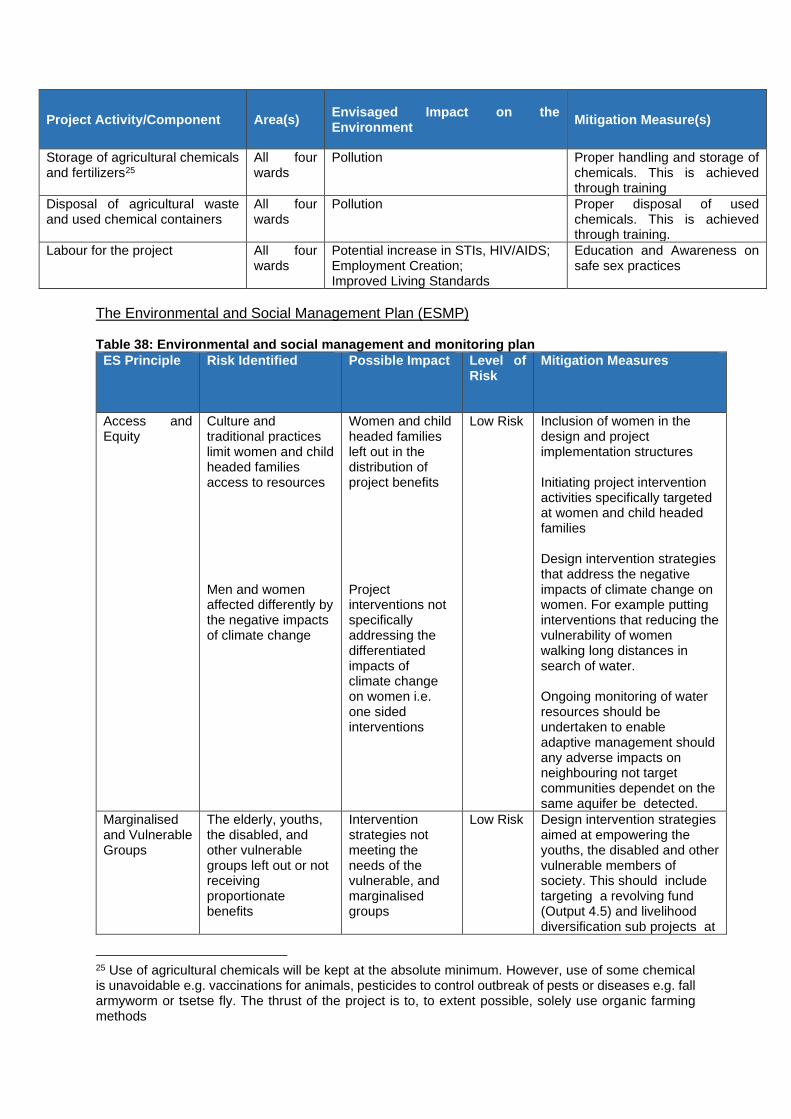
Project Activity/Component Area(s) Envisaged Impact on the Environment
Mitigation Measure(s)
Storage of agricultural chemicals and fertilizers25
All four wards
Pollution Proper handling and storage of chemicals. This is achieved through training
Disposal of agricultural waste and used chemical containers
All four wards
Pollution Proper disposal of used chemicals. This is achieved through training.
Labour for the project All four wards
Potential increase in STIs, HIV/AIDS; Employment Creation; Improved Living Standards
Education and Awareness on safe sex practices
The Environmental and Social Management Plan (ESMP) Table 38: Environmental and social management and monitoring plan
ES Principle Risk Identified Possible Impact Level of Risk
Mitigation Measures
Access and Equity
Culture and traditional practices limit women and child headed families access to resources Men and women affected differently by the negative impacts of climate change
Women and child headed families left out in the distribution of project benefits Project interventions not specifically addressing the differentiated impacts of climate change on women i.e. one sided interventions
Low Risk Inclusion of women in the design and project implementation structures Initiating project intervention activities specifically targeted at women and child headed families Design intervention strategies that address the negative impacts of climate change on women. For example putting interventions that reducing the vulnerability of women walking long distances in search of water. Ongoing monitoring of water resources should be undertaken to enable adaptive management should any adverse impacts on neighbouring not target communities dependet on the same aquifer be detected.
Marginalised and Vulnerable Groups
The elderly, youths, the disabled, and other vulnerable groups left out or not receiving proportionate benefits
Intervention strategies not meeting the needs of the vulnerable, and marginalised groups
Low Risk Design intervention strategies aimed at empowering the youths, the disabled and other vulnerable members of society. This should include targeting a revolving fund (Output 4.5) and livelihood diversification sub projects at
25 Use of agricultural chemicals will be kept at the absolute minimum. However, use of some chemical is unavoidable e.g. vaccinations for animals, pesticides to control outbreak of pests or diseases e.g. fall armyworm or tsetse fly. The thrust of the project is to, to extent possible, solely use organic farming methods

ES Principle Risk Identified Possible Impact Level of Risk
Mitigation Measures
marginalised and vulnerable groups Engage chiefs, and local leadership to help in ensuring that the project benefits reaches out to the vulnerable members of society
Gender Equity and Women’s empowerment
Disparities on livestock ownership. Traditionally men own cattle and larges fields, whilst women owned small livestock like chickens and goats and small vegetable gardens Women not adequately represented in community decision making structures
Women disadvantaged if interventions involve cattle ranging or require access to large tracks of land Project interventions not specifically suitable to adequately address the negative impacts of climate change on women
Low Risk Employment of gender experts to ensure that consultations were responsive to various gender needs and roles such that project activities effectively respond to the unique needs of women and girls, men and boys, and promote equal opportunities to participate, and receive comparable social and economic benefits. Project activities have been designed to be gender sensitive and to empower women. Training all project staff on gender-sensitive approaches. Mechanisms for selection of beneficiaries will be gender-sensitive in order to ensure equal participation of men and women taking into consideration different needs
Conservation of Biological Diversity
Iintroduction of Invasive species or pathogens through seed plant or animal stock?
Eradicate, change or significantly reduce local naturally occurring varieties
Moderate Risk
Tree species to be planted should be chosen from those already adapted to the target areas, have a higher growth rate and have no known side-effects on the ecology of the area." Prohibition on promotion of invasive species or alien varieties "
Climate Change,
Application of fertilisers and animal husbandry particularly livestock releases GHGs
Contribution to GHGs
Low Risk Minimise use of fertiliser through adoption of conservation farming techniques Promotion of non-ruminant animal husbandry

ES Principle Risk Identified Possible Impact Level of Risk
Mitigation Measures
Pollution Prevention and Resource Efficiency
Farming activities and gardening projects will require chemicals (pesticides, and fungicides) to control pests Intensive Farming activities, (irrigation of gardens), can lead to over-extraction of surface or groundwater if proper water management policies and strategies are not implemented
Pesticides and fungicides pollute the environment Depletion of water resources leading to depletion of ecosystems dependent upon them including those that support the sub project activities
Low Risk Putting up bio – security measures around livestock projects to reduce the incidence and spread of diseases Use of natural pest and disease control mechanisms for crops e.g. crop rotation, proper termination and disposal of crop residue after harvest Growing indigenous crops that are tolerant to diseases and local pests to minimise pesticide used Adoption of conservation farming e.g.
- Using climate smart agriculture
- Proper management of water resources
- Use of drip irrigation - Using prolific
boreholes that produce commercial water to irrigate vegetable gardens
- Reducing the sizes of gardens
- Growing indigenous vegetables and drought tolerant but high value vegetables like onions
Ongoing monitoring of water resources should be undertaken to enable adaptive management should any adverse impacts on water resources or ecosystem services dependent upon them be detected.
Public Health Contamination of water harvested to support project activities
Potential increase in water borne diseases, and vector borne diseases like malaria
Low Risk Training project staff on how to manage harvested water sources to reduce the chances of contamination of water sources Engage in biosecurity to protect water sources, and engage in treatment and maintenance of water storage vessels such as wells. Regular testing of water for
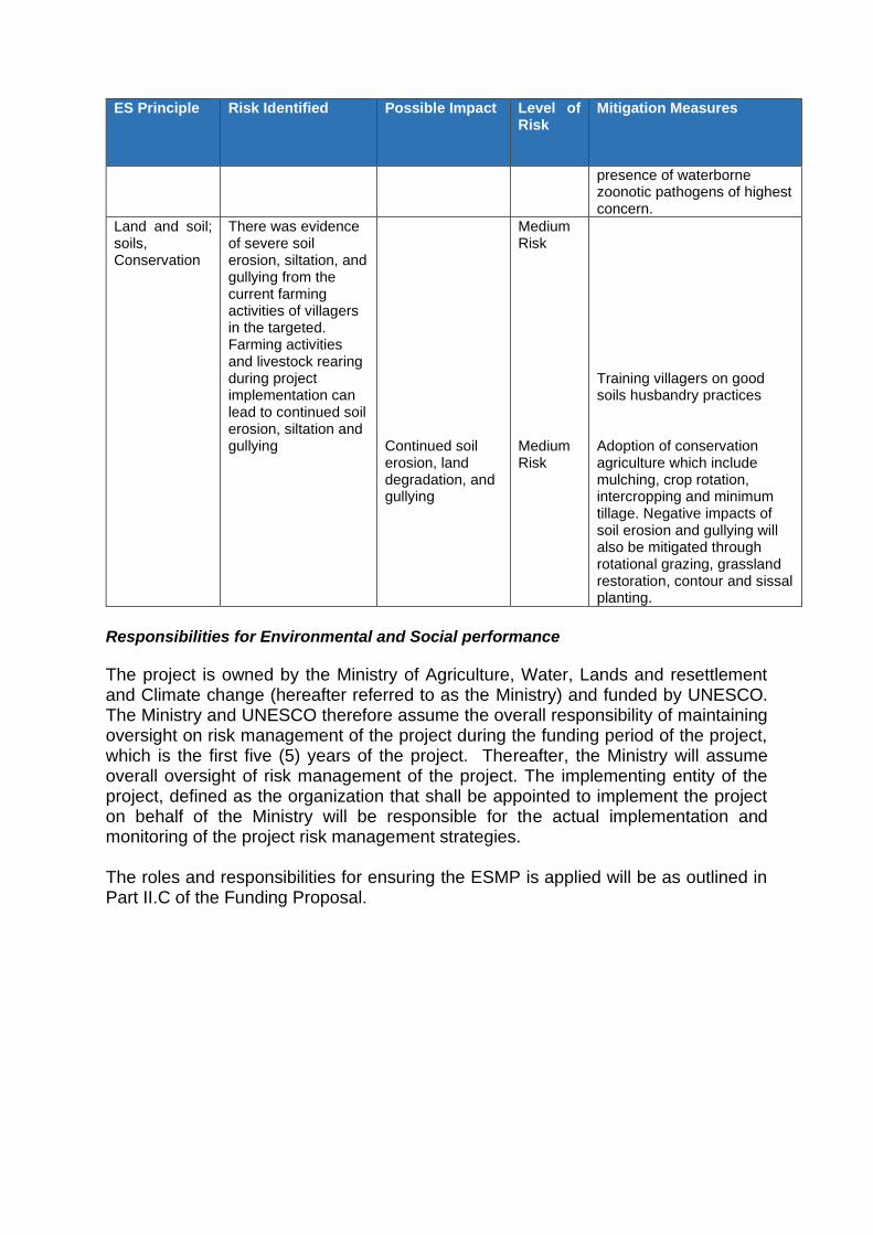
ES Principle Risk Identified Possible Impact Level of Risk
Mitigation Measures
presence of waterborne zoonotic pathogens of highest concern.
Land and soil; soils, Conservation
There was evidence of severe soil erosion, siltation, and gullying from the current farming activities of villagers in the targeted. Farming activities and livestock rearing during project implementation can lead to continued soil erosion, siltation and gullying
Continued soil erosion, land degradation, and gullying
Medium Risk Medium Risk
Training villagers on good soils husbandry practices Adoption of conservation agriculture which include mulching, crop rotation, intercropping and minimum tillage. Negative impacts of soil erosion and gullying will also be mitigated through rotational grazing, grassland restoration, contour and sissal planting.
Responsibilities for Environmental and Social performance
The project is owned by the Ministry of Agriculture, Water, Lands and resettlement and Climate change (hereafter referred to as the Ministry) and funded by UNESCO. The Ministry and UNESCO therefore assume the overall responsibility of maintaining oversight on risk management of the project during the funding period of the project, which is the first five (5) years of the project. Thereafter, the Ministry will assume overall oversight of risk management of the project. The implementing entity of the project, defined as the organization that shall be appointed to implement the project on behalf of the Ministry will be responsible for the actual implementation and monitoring of the project risk management strategies. The roles and responsibilities for ensuring the ESMP is applied will be as outlined in Part II.C of the Funding Proposal.

Annex 7: List of stakeholders consulted and attendance registers form


References AFD. 2012. Zimbabwe’s agricultural reconstruction: Present state, ongoing projects and
prospects for reinvestment. Agence Française de Développement, Paris. AfDB. 2014. Infrastructure and growth in Zimbabwe. An action plan for sustained strong
economic growth. African Development Bank, Tunis. African Crop Science Journal 20: 361 - 369 Chapin III, F. S., Kofinas, G. P., & Folke, C. (Eds.). (2009). Principles of ecosystem
stewardship: resilience-based natural resource management in a changing world. Springer Science & Business Media.
Chenje, M., Sola, L. & Paleczny, D., eds. (1998) The state of Zimbabwe's environment 1998. Zimbabwe, Ministry of Mines, Environment and Tourism.
Development (2013a) Agricultural Sector Gender Assessment Report, Harare EMA. 2014a. What is land degradation? Environmental Management Agency, Harare. EMA. 2014b. Dead rivers, myth or reality? Environmental Management Agency, Harare. FAO, NEPAD, GoZ. 2004. Support to NEPAD-CAADP implementation. Rehabilitation of
smallholder irrigation schemes. Volume I of VII. Food and Agriculture Organization of the United Nations, New Partnership forvAfrica’s Development, Government of Zimbabwe.
FAOSTAT. 2015. FAOSTAT database. Food and Agriculture Organization of the United Nations. Rome.
FNC. 2012. Zimbabwe Vulnerability Assessment Committee (ZIMVAC) 2012. Food and Nutrition Council, Harare.
FNC. 2013. Zimbabwe Vulnerability Assessment Committee (ZIMVAC) 2013. Food and Nutrition Council, Harare.
Folke, C., Colding, J., & Berkes, F. (2003). Synthesis: building resilience and adaptive capacity in social-ecological systems. Navigating social-ecological systems: Building resilience for complexity and change, 9(1), 352-387.
Government of Zimbabwe (GoZ) Ministry of Agriculture, Mechanisation and Irrigation Government of Zimbabwe (GoZ) Ministry of Environment and Natural Resources
Management Government of Zimbabwe. 1998. Zimbabwe National Water Authority Act. Chapter 20: 24. Government of Zimbabwe. 1998. Zimbabwe National Water Authority Act. Chapter 20: 25. GoZ. 2012. The Future we want. Report to the United Nations Conference on Sustainable
Development 2012 Rio +20. Government of Zimbabwe. GoZ. 2013. Zimbabwe Agricultural Investment Plan (ZAIP 2013-2017). A comprehensive
framework for the development of Zimbabwe’s agriculture sector. Government of Zimbabwe. Harare, Government Printers.
IPCC (Intergovernmental Panel on Climate Change). (2007) Climate change 2007: The physical
IPCC (Intergovernmental Panel on Climate Change). (2012) Managing the risks of extreme IUCN. 1994. Wetlands ecology and priorities for conservation in Zimbabwe. Proceedings of a
seminar on wetland ecology and priorities for conservation in Zimbabwe, Harare, 13-15 January 1992. International Union for Conservation of Nature.
JMP. 2015. Progress on drinking water and sanitation – 2014 update. WHO/UNICEF Joint Monitoring Programme for Water Supply and Sanitation.
Junior, L. M. C., da Costa Martins, K. D. L., & Carvalho, M. (2019). Carbon footprint associated with firewood consumption in northeast Brazil: An analysis by the IPCC 2013 GWP 100y Criterion. Waste and Biomass Valorization, 10(10), 2985-2993.
Kashangura, C. (2014) Policy Issues For Possible Temporal And Spatial Rainfall Distribution Changes Due To Climate Change, Conference: Water Forum on Water Security and Water-related Disaster Challenges: Policy Issues for Discussion At: Harare, Zimbabwe DOI: 10.13140/2.1.2701.4724
Mabeza,C.M., Mawere, M. 2012. Dambo cultivation in Zimbabwe: Challenges faced by small-scale dambo farming communitie sin Seke-Chitungwiza Communal Area. Journal of Sustainable Development in Africa 14 (5): 39-53.

MENR. 2010. Zimbabwe’s Fourth National Report To the Convention on Biological Diversity. Ministry of Environment & Natural Resources Management, Harare.
MEPIP. 2014. Zimbabwe Medium Term Plan 2011-2015. Ministry of Economic Planning and Investment Promotion, Harare.
Mtisi, S., (2008) Zimbabwe’s Water Reform and Effects on Local Level Water Management Mugandani, R., Wuta. M., Makarau, A. and Chipindu, B. (2013) Re-classification of
agroecological Mutambara, S., Mutambara, J. and Kwesi Darkoh, M.B. 2014. Towards sustainable
stakeholder engagement in smallholder irrigation schemes in Zimbabwe. African Journal of Agricultural Research 9 (50): 3587-3599.
Nyamadzawo, G., Gwenzi, W., Kanda, A., Kundhlande, A., & Masona, C. (2013). Understanding the causes, socio-economic and environmental impacts, and management of veld fires in tropical Zimbabwe. Fire science reviews, 2(1), 2.
Processes and Rural Livelihoods: Evidence from Lower Save East Sub-Catchment. PhD Ramsar. 2013. The List of Wetlands of International Importance. regions of Zimbabwe in conformity with climate change and variability. Robinson, D. L. (2011). Australian wood heaters currently increase global warming and health
costs. Atmospheric Pollution Research, 2(3), 267-274. Rukuni, M. 1988. The evolution of smallholder irrigation policy in Zimbabwe: 1928-1986.
Irrigation and Drainage 2: 199-210. SADC. 2012. Regional Infrastructure Development Master Plan. Water Sector Plan. Southern
African Development Community. science basis. Fourth Assessment Report, IPCC. Tempelhoff, J.W.N. 2009. Ancient Southern African irrigation technology unearthed. Water
wheel Sept/Oct 2009: 28-30. Thesis, University of Manchester. UNDP. 2015. Human Development Reports: Data. United Nations Development Programme.
New York. UNESCO. 2008. Participation and Institutional Reform in the Water Sector in Zimbabwe: Case
of smallholder formal and informal irrigation in the Mzingwane Catchment. Svubure, O. JJ/WBGSP Scaling-Up Program Regional Conference, 07/05/08, Cameroon.
UNWAIS. 2012. Wastewater production, treatment, and use in Zimbabwe. Thebe, T.A. and Mangore, E.N.
USAID. 2012. Zimbabwe Biodiversity and Tropical Forest Assessment. United States Agency International Development.
WaterNet. 2005. An overview of the Mzingwane Catchment, Zimbabwe. WaterNet Working Paper 4. CGIAR Challenge Program on Water and Food.
WB. 2014. Climate change and Water Resources Planning, Development and Management in Zimbabwe. An Issue Paper. World Bank. Washington.
WB. 2015. World Development Indicators. World DataBank. World Bank. Washington.