national register of historic places … · national register of historic places ... as well as the...
TRANSCRIPT
MHT D-6
Form 10-300 UNITED STATES DEPARTMENT OF THE INTERIOR (July 1969) NATIONAL PARK SERVICE
NATIONAL REGISTER OF HISTORIC PLACES INVENTORY - NOMINATION FORM
(Type all entries — complete applicable sections)
S T « T E :
Maryland C O U N T Y :
D o r c h e s t e r FOR NPS USE ONLY
E N T R Y N U M B E R D A T E
1. NAME < I . , : _ _ _ _ _ _ „ 1 . _
C OMMON:
Rehoboth AND OR H I S T O R I C :
T u r p i n P l a c e , Lee Mansion 2. L O C A T I O N
S T R E E T A N C N U M B E R :
West s i d e of Punkum Road CITY OR TOWN:
El Dorado S T A T E CODE C O U N T Y - | C O D F
Mary l a n d |24 [ D o r c h e s t e r 1 019 [ I T C L A S S I F I C A T I O N C
CATEGORY"""" OWNERSHIP STATUS I ACCESSIBLE (Check 0„C) TO THE PUBLIC
• Distr ict g j | Building Q Public Public Acquisi t ion: , _ Occupied Y e , :
13 Si t . f ] Structure k l M»«»« I 1 I " Process __ Unoccupied D R e , , r i c , e d
CI Object D Both I ] Being Considered _-, p r e s e r v o t i o n work • Unrestricted
in progress IX No
P R E S E N T USE (Check One or More as Appropriate)
_ Agricultural [_] Government [_] Pork f_] Transportation [_1 Comments
[~*1 Commerc ia l [71 Industrial Jjj) Private Residence [~| Other (Specify)
i | l:ducationol I I Military | | Roligious [ .
i 1 Entertainment [Zl Museum [") Scientific
U . OWNER OF P R O P E R T Y ' I OWNER'S N AME:
Mr. and Mrs . John B r e u i l ".^^ ~t
S T R E E T AND N U M B E R :
Rehoboth CI TY OR TOWN: S T A T E : CODE
E l D o r a d o J Maryland | 24 [5 . L O C A T I O N OF L E G A L D E S C R I P T I O N
C O U R T H O U S E . REGISTRY O F D E E D S . E T C :
H a l l of Records STREET AND NUMBER:
S t . J o h n ' s C o l l e g e Campus , C o l l e g e Avenue ___^ C I T Y OR TOWN: S T A T E CODE
A n n a p o l i s Maryland 24
_ REPRESENTATION IN EXISTING SURVEYS~ r l T L E Of S U R V E Y :
Maryland R e g i s t e r of h i s t o r i c s i t e s and landmark.'; D«TE OF SURVEY: 1 9 7 0 [_D Federal j j £ State ) | County | | Local D E P O S I T O R Y FOR S U R V E Y R E C O R D S :
Maryland H i s t o r i c a l T r u s t « S T R E E T AND N U M B E R :
94 C o l l e g e Avenue , C I T Y O R T O W N : S T A T E : CODE.
A n n a p o l i s ^ [ Maryland I 24
| S T A T E:
" E
I '. T
•
Maryland
Dorchester
SE
E
IN
ST
RU
CT
IO
NS
MHT D-6
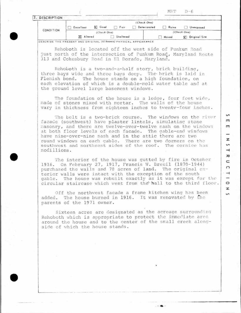
17. DESCRIPTION
• Excellent 52 Good Q Fair • Deteriorated • Ruins • Unexposed CONDITION 1 , „ , . , „ ,
(Check One) (Check One) B Altered • Unaltered Q Moved g ] Original Site
D E S C R I B E T H E P R E S E N T AND O R I G I N A L (II known) P H Y S I C A L A P P E A R A N C E
Rehoboth is located off the west side of Punkurn Road just north of the intersection of Punkum Road, Maryland Route 313 and Cokesbury Road in El Dorado, Maryland.
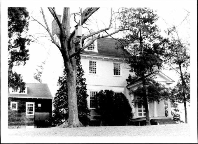
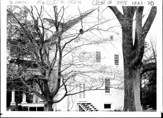
Rehoboth is a two-and-a-half story, brick building, three bays wide and three bays deep. The- brick is laid in Flemish bond. The house stands on a high foundation, on each elevation of which is a double-mold water table and at the ground level large basement windows.
The foundation of the house is a ledge, four feet wide, made of stones mixed with mortar. The walls of the house vary in thickness from eighteen inches to twentv-four inches.
The belt is a two-brick course. The windows on the river facade (southwest) have plaster lintels, simulating stone masonry, and there are twelve-over-twelve sash on the windows at both floor levels of each facade. The gable-end windows have nine-over-nine sash and in the attic there are two round windows on each gable. There are two dormers on the southwest and northeast sides of the roof. The cornice has mocillions.
The interior of the house was gutted by fire in October 1916. On February 27, 1917, Francis W. Breuil (1870-1944) purchased the walls and 70 acres of land. The original exterior walls were intact with the exception of the south gable. The house was rebuilt exactly as it was except for the circular staircase which went from the'-hall to the third floor.
Off the northwest facade a frame kitchen wing has been added. The house burned in 1916. It was renovated by £ho parents of the 1971 owner.
Sixteen acres are designated as the acreage surrounding Rehoboth which is appropriate to protect the immediate area around the house and to the center of the small creek alongside of which the house stands.
SE
E
IN
ST
RU
CT
IO
NS
MHT D-6
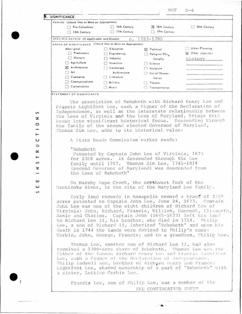
9. SIGNIFICANCE P E R I O D (Check One or More as Appropriate)
• Pre-Columbian I D 16th Century _ 18th Century D 20th Century
n 15th Century Q 17th Century _ " t h Century
S P E C I F I C D A T E I S I (It Applicable and Known) Qm 1 7 8 3 - 1 7 9 0
AREAS O F S I G N I F I C A N C E (Check One or More as Appropriate)
Abor ig ina l • Education gg Po l i t i ca l C71 Urban Planning
• Prehistoric Q Engineering Q R e l i g i o n / P h i . Bd 0 , h e r tSptxIly)
• Histor ic Q Induitry losophy H i R h f i r y
• Agriculture [ J Invention [""] Science
CS Architecture [ ] Londscope (- ] Sculpture
D A " Architecture [~] Socia l /Human-
• Commerce [7] Li terature itorion
• Communications r-j M i | i t a r v r-j Theater
• Conservat ion rj M u s i c Q Transportation
S T A T E M E N T O F S I G N I F I C A N C E
The association of Rehoboth with Richard Henry Lee and Francis Lightfoot Lee, each a Signer of the Declaration of Independence, as well as the interstate relationship between the Lees of Virginia and the Lees of Maryland, brings thin house into significant historical focus. Descending through the family of the second elected Governor of Maryland, Thomas Sim Lee, adds to its historical value:
A State Roads Commission marker reads:
"Rehoboth Patented by Captain John Lee of Virginia, 16 73 for 2 36 0 acres. It descended through the Lee family until 1787. Thomas Sim Lee, 1745-1819 (second Governor of Maryland) was descended from the Lees of Rehoboth"
On Marshy Hope Creek, the northwest fork of the Nanticoke River, is the site of the Maryland Lee family.
Early land records in Annapolis record a tract* of 2350 acres patented to Captain John Lee, June 24, 16 73. Captain John Lee was one of the eight children of Richard Lee of Virginia: John, Richard, Francis, VJilJ.iam, Hancock, Elizabeth, Annie and Charles. Captain John (1645-1673) left his land to Richard Lee II, his brother, who died in 1714. Philip Lee, a son of Richard II, inherited "Rehoboth" and upon his death in 1744 the lands were devised to Philip's sons: Corbin, John, George, Francis; and to a grandson, Philip Lee.
Thomas Lee, another son of Richard Lee II, had also received a 1300-acre share of Rehoboth. Thomas Lee was the father of the famous Richard Uonry Leo and Franoir-; Ligli t- foot. Lee, each a Signer of. Lhe Declaration of [ndoperidonco. Philip Ludwell Lee, brother of Richard Uonry and Francis Lightfoot Lee, shared ownership of a part of "Rehoboth" with a sister, Lettice Corbin Lee.
Francis Lee, son of Philip Lee, was a member of the
SEE CONTINUATION SHEET
SE
E
IN
ST
RU
CT
IO
NS
MHT D-6
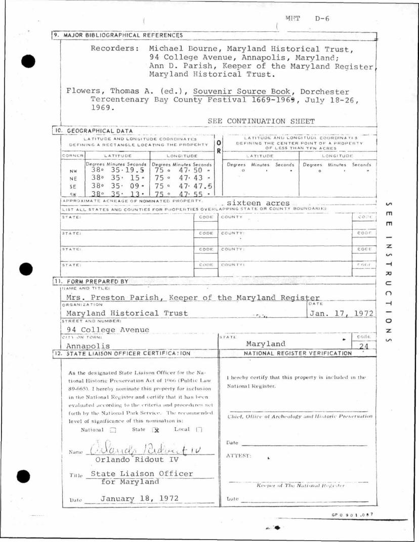
9. MAJOR BIBLIOGRAPHICAL REFERENCES
Recorders: Michael Bourne, Maryland Historical Trust, 9 4 College Avenue, Annapolis, Maryland; Ann D. Parish, Keeper of the Maryland Register, Maryland Historical Trust.
Flowers, Thomas A. (ed.), Souvenir Source Book, Dorchester Tercentenary Bay County Festival 1669-1969, July 18-26, 1969.
SEE CONTINUATION SHEET 10. GEOGRAPHICAL DATA
L A T I T U D E AND L O N G I T U D E COOH Dl M A T IIS D E F I N I N G A R E C T A N G L E L O C A T I N G T H E P R O P E H T Y
C O H N t R L A T I T U D E L O N G I T U D E
Degrees M inu tes Seconds Degrees M inu tes Seconds
NW 38° 35- 1 9 . 5 75 ° 47- 50 •• NE 38° 3 5 ' 1 5 - 75 • 47- 43 •• SE 38° 35- 09 - 7 5 ° 47- 4 7 . 5 sw 1 38° 35- 13 75 ° 47- 55 •
L A T I T U D E AND L O N G I 1 U U I C O O R D I N A T E S D E F I N I N G T H E C E N T E R P O I N T OF A P R O P E R T Y
OF LESS T H A N T F N ACRES
L A T I T U D E L O N G I T U D E
Degrees M inu tes Seconds Degrees M inu tes Seconds o • • o > »•
A P P R O X I M A T E A C R E A G E O F N O M I N A T E D P R O P E R T Y . Q 1 V f p P r l ^ r , T " < ^ Q
LIST A L L S T A T E S AND C O U N T I E S FOR P R O P E R T I E S O V E R L A P P I N G S T A T E OR C O U N T Y B O U N D A R I E S
S T A T E : CODE C O U N T Y CO:?t
STATE: CODE COUNTY: COOT
STATE: CODE COUNTY: COCf
STATE: CODE COUNTY: r'M.I
I K FORM PREPARED BY ; NAME AND Tl T L E :
Mrs. Preston Parish, Keeper of the Maryland Register O R G A N I Z A T I O N D A T E
Mary land Historical _T r usjt _ .......rt |Jan. 17, 1972 S T R E E T AND N U M B E R :
94 Col lege Avenue . CITN OH TOWN: STATfe' C O D l .
Annapol is_ , Maryland 24 1 2 . STATE LIAISON OFFICER C E R T I F Y C A : ION [ NATIONAL REGISTER VERIFICATION
As the designated State Liaison Officer for the Na
tional Historic Preservat ion Act of l*VOG (Public Law
89-665V I hereby nominate th is property for inclusion
in the National Register and certify that it has been
evaluated according to the criteria and procedures set
forth by the National Park Service. The recommended
level of significance of this nomination is:
National • State [ £ Local [~]
Orlando Ridout IV
Tuie State Liaison Officer for Maryland
Date January 18 , _ 19 72_
1 hereby certify that this property is included in the
National Register .
Chief, Oflia- oi Archtolofiy anil Historic Profcerwifion
Date
ATTEST: k
Keeper oi Tin: Nulimuil lifftititrr
Dale
SE
E
IN
ST
RU
CT
IO
NS
MKT D-6 Form 10-300o UNIT^ ATESDEPARTMENT OF THE INTERIOR (July 1969) NATIONAL PARK SERVICE
NATIONAL REGISTER OF HISTORIC PLACES
INVENTORY - NOMINATION FORM
(Continuation Sheet)
Maryland C O U N T Y
Dorchester FOR NPS USE ONLY
E N T R Y N U M B E R D A T E
(Number all entries)
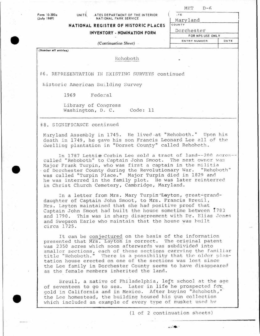
Rehoboth
#6. REPRESENTATION IN EXISTING SURVEYS continued
historic American Building Survey
1969 Federal
Library of Congress Washington, D. C. Code: 11
#8. SIGNIFICANCE continued
Maryland Assembly in 1745. He lived-at "Rehoboth." Upon his death in 1749, he gave his son Francis Leonard Lee all of the dwelling plantation in "Dorset County" called Rehoboth.
In 1787 LettioB Corbin Lee sold a tract of land— 200 acres-called "Rehoboth" to Captain John Smoot. The next owner was Major Frank Turpin, who was first a captain in the militia of Dorchester County during the Revolutionary War. "Rehoboth" was called "Turpin Place." Major Turpin died in 1829 and he was interred in the family plot. He was later reinterred in Christ Church Cemetery, Cambridge, Maryland.
In a letter from Mrs. Mary Turpin "Layton, great-granddaughter of Captain John Smoot, to Mrs. Francis Breuil, Mrs. Layton maintained that she had positive proof that Captain John Smoot had built the house sometime between 1783 and 1790. This was in sharp disagreement with Dr. Elias Jones and Swepson Earle who maintain that the house was built circa 1725.
It can be conjectured on the basis of the information presented that Mrs. Layton is correct. The original patent was 2350 acres which soon afterwards was subdivided into smaller sections, each of these sections carrying the familiar title "Rehoboth." There is a possibility that the older plantation house erected on one of the sections was lost since the Lee family in Dorchester County seems to have disappeared as the female members inherited the land.
Breuil, a native of Philadelphia, left schoo] at the age of seventeen to go to sea. Later in life he prospected foX gold in California and in Mexico. After buying "Rehoboth," the Lee homestead, the building housed his gun collection which included an example of every type of musket used bv
(1 of 2 continuation sheets)
MHT D-6
Form 10-300o UNITED. STATE DEPARTMENT OF THE INTERIOR (July 1969) NATIONAL PARK SERVICE
NATIONAL REGISTER OF HISTORIC PLACES
INVENTORY - NOMINATION FORM
(Continuation Sheet)
Maryland C O U N T Y
Dorchester FOR NPS USE ONLY
E N T R Y N U M B E R D A T E
(Number mil entries)
Rehoboth
#8. SIGNIFICANCE continued
the United States Army from the American Revolution to the Civil War.
After his death in 1944 the house and grounds went to Breuil's son John Breuil, the 1971 owner.
#9. REFERENCES continued
Clark, Charles B., The Eastern Shore of Maryland and Virginia, 3 vols., New York: Lewis Historical Publishing Company, 1950.
Wilstach, Paul, Tidewater Maryland, Blue Ribbon Books, Inc., New York, 1931, p. 165.
(2 of 2 continuation sheets)
MH
T D
-6
UNITED STATES DEPARTMENT OF THE INTERIOR NATIONAL PARK SERVICE
NATIONAL REGISTER OF HISTORIC PLACES
PROPERTY PHOTOGRAPH FORM (Type all entries - attach to or enclose with photograph)
S T A T E
Maryland C O U N T Y
Dorchester FOR NPS USE ONLY
E N T R Y N U M B E R D A T E
[ . . N A M E
COMMON: Rehoboth
AND OR HISTORIC: Turpin P l a c e , Lee Mansion _ 2. LOCATION
S T R E E T A N D N U M B E R :
West side of Punkum Road C I T Y O R T O W N :
El Dorado STATE: CODE COUNTY: CODE
Maryland 24 Dorches ter 019 3. PHOTO REFERENCE
Michael Bourne for the Maryland Historical Trust J u l y __1968 __.__ . - ,
NEGATIVE FILED AT: Maryland H i s t o r i c a l T rus t __ 94 College Avenue, Annapol is , Maryland 21401
4. IDENTIFICATION D E S C R I B E V I E W , D I R E C T I O N , E T C .
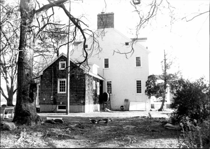
Southwest elevation
SE
E
IN
ST
RU
CT
IO
NS
MIHT D-6
Form 10-301 UNITED STATES DEPARTMENT OF THE INTERIOR (Dec. 1968) NATIONAL PARK SERVICE
NATIONAL REGISTER OF HISTORIC PLACES
PROPERTY MAP FORM
(Type all entries - attach to or enclose with map)
S T A T E
Maryland COUN TY
Dorchester
FOR NPS USE ONLY
E N T R Y N U M B E R D A T E
| 1 . NAME
COMMON: Rehoboth |AND-OB HISTORIC; T u r p i n P l a c e , L e e M a n s i o n
2 . L O C A T I O N S T R E E T A N D N U M B E R :
West side of Punkum Road C I T Y O R T O W N :
El Dorado
STATE: CODE COUNTY: COCE
Maryland 24 Dorchester 019
3. MAP REFERENCE S O U R C E :
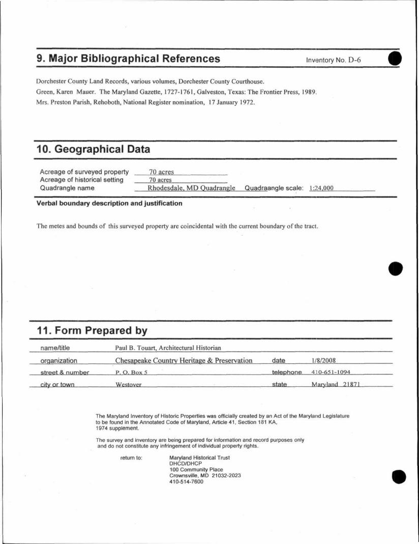
U.S.G.S. 7.5 minute map; Rhodesdale Quadrangle, Maryland
SCALE: ~1;24,0~00
DATE: 1 9 4 4
4. REQUIREMENTS
TO BE I N C L U D E D ON A L L MAPS
1. Property broundaries where requi red.
2. North arrow.
3. Latitude and longitude reference.
SE
E
IN
ST
RU
CT
IO
NS
D-6 Rehoboth (NR) Eldorado vicinity c. 1785-90 Private
The property known since the seventeenth century as Rehoboth figures prominently in
the history of northeastern Dorchester County as the long-time plantation of Captain
John Lee and his descendants, who held title to various sections of this large tract for one
hundred years. Captain Lee patented over two thousand acres along the Northwest Fork
of the Nanticoke River, now called Marshyhope Creek, in 1673. Family ownership of
various sections lasted until the 1770s. The two-story, Flemish and English bond brick
house, however, dates to the decade following Lee ownership after merchant and planter
Captain John Smoot and his father, Edward Smoot, acquired 1300 acres of the Rehoboth
tract from Dr. Philip Ludwell Lee of Westmoreland County, Virginia. The two-story
Flemish bond brick side hall/double-pile plan dwelling was erected around 1785-90 with
the characteristic blend of late Georgian and Federal architectural finishes. The
foundation of the house is defined by a molded watertable and a beltcourse stretches
across the front and rear walls. Rusticated wood jack arches spanned the original
window and door openings, however a fire in the fall of 1916 completely gutted the
structure and all its exterior and interior finishes aside from the walls themselves. The
tall, narrow proportions of the gable end chimney stack and the round gable end
windows are very similar to the same features at Friendship Hall. (See D-2)
Between the 1673 patent date of the Rehoboth tract, which encompassed 2350
acres, and the Revolutionary War, the large plantation bordering the Northwest Fork of
the Nanticoke River was held by Captain John Lee and his heirs. Early Lee family plats

D-6
of the plantation, recorded in 1713,and again in 1759, clearly indicate that the large
acreage had been improved with various structures and the property was surrounded by
the plantations and fields of other inhabitants of the Hundred of the North-west Fork,
which was laid out in 1682 after the county's founding around 1669. Philip Lee (d.
1744), whose principal residence was in Prince George's County, Maryland, inherited
1300 acres of the Rehoboth tract from his father, Richard Lee, in 1714. To another son,
Thomas, Richard Lee left the balance of the family lands on the Northwest Fork.
During the next generation of Lee family ownership, the Rehoboth tract was
subdivided between various family members, although the largest portion encompassing
1300 acres bordering Bachelor's Creek and the Northwest Fork, was held by Dr. Philip
Ludwell Lee (1727-1775), who inherited Stratford Hall in Westmoreland County,
Virginia, as well as other lands in Virginia and Maryland from his father, Thomas Lee (d.
1750). By the second quarter of the eighteenth century, various Lee family holdings of
the Rehoboth tract were advertised for sale or lease in the Maryland Gazette. In February
1747, Francis Lee, son of Philip Lee who died in 1744, advertised for lease, "his late
Mansion House on the North-West Fork of the Nanticoke River." He also put forth a
mutual interest of his and Captain Walter Montgomery to have a ship built at "Lee's
Landing on the Nanticoke." Philip Ludwell Lee placed an advertisement for his holdings
in September 1754, and during the following summer, the plantation lands held by Philip
Lee, deceased, were also available and any interest should be directed to Daniel Sulivane
in Dorchester County, Corbin Lee in Baltimore County, George Lee in Prince George's
County, or John Lee, Jr. of Essex County, Virginia.
2
D-6
It was not until April 1770, however, that Philip Ludwell Lee found an interested
buyer. Edward Smoot (1724-1795) and his son John Smoot, then residents of Charles
County, Maryland, entered into an agreement to purchase two portions of the Rehoboth
tract for LI009.10. It appears that John Smoot (c. 1748-1793) relocated soon to
Dorchester County, while his father Edward remained in Charles County. One of the
first official actions of the Smoots was to determine the actual boundary of the land they
had purchased since, according to them, the "bounds thereof is gone to decay." A
commission was set up with Daniel Sulivane, Anderton Brown, George Kirkman and
Matthew Smith, Jr. who were to serve in the capacity of commissioners to hear
depositions from local residents as to their personal knowledge of the location of the old
boundary markers. Evidently, within the year John Smoot was residing in Dorchester
County. A confirmatory deed for the 1770 transfer, conveyed in September 1772 for one
additional pound, relinquished full title of the Lee plantation to Edward and John Smoot.
Identified in the land records as a merchant, John Smoot purchased an assortment of
household items, farm implements and farm animals from John Lyon in October 1773.
John Smoot also surfaces in the county and provincial records as a captain during the
Revolutionary War in command of calvary, and by 1780 in charge of 54 privates.
Following Captain John Smoot's service during the Revolutionary War, he
engaged in the merchant-planter activities well known for the eighteenth and early
nineteenth centuries. A bill of sale executed in 1786 between Thomas Shiles of Vienna,
a mariner or ship captain, and John Smoot indicates that Smoot partnered in the
mercantile trade with Alexander Douglas. From the architectural character of the
3
D-6
exterior brickwork, it is clear that John Smoot financed construction of the large brick
mansion between the end of the Revolution and his death in 1793.
At the time of John Smoot's death in 1793, the Dorchester County court ordered
an assessment and division of his real estate between his many heirs. The large
plantation was subdivided into several sections; Captain Henry Smoot transferred 395 Vi
acres along the North West Fork, including the brick house, to Francis B. C. Turpin in
November 1815. Smoot family ownership of other Rehoboth parcels continued through
the early to mid nineteenth century as were associated with the slow development of
Crotcher's Ferry as a commercial center in the Fork election district. A landing on the
North West Fork at Crotcher's Ferry was known as "Smoot's Wharf and Thomas Smoot
operated a store in the village during the second quarter of the nineteenth century, one of
which had been begun by Captain John Smoot. John Smoot also had stores at
Federalsburg and Vienna. Captain Smoot also took advantage of the sizable timber
stands in the region, and he established a saw mill on his land during his occupancy.
Captain John Smoot's son, John, later sold a 2-acre part of Rehoboth next to the saw mill
operated by William Drura.
Francis B. C. Turpin and his wife Mary Adeline occupied the old Smoot mansion,
known as Liberty Hall, during the early to mid nineteenth century. In 1870 the Rehoboth
tract with the Liberty Hall house was acquired by William H. Brinsfield, who is
designated at this location on the Fork election district map printed in the Lake, Griffing,
and Stevenson atlas of Talbot and Dorchester Counties, issued in 1877. He is also
included in the atlas patron list as a farmer with 371 acres. In April 1892, the heirs of
William H. Brinsfield sold the old Rehoboth mansion with 130 acres to John H. Renner
4
D-6
in a straw deed; on the same day Renner transferred the same property to Philadelphians
Rosanna Blumenstock, Emma Blumenstock, and Laura Blumenstock. During the early
twentieth century the property, with a reduced 70 acres, was sold several times until
James H. Saunders acquired the farm in 1912. Tragically, in the fall of 1916, under
Saunders ownership, the old brick house was gutted by fire; it was sold as a gutted house
several months later to another native Philadelphian, Francis W. Breuil and his wife Sara
A. Breuil. Instead of leveling the site of the burned out shell, the Breuils entered into a
rebuilding of the house with Colonial Revival detailing. Breuil family ownership of the
property lasted until 2003.
5
Maryland Historical Trust Inventory No. D-6
Maryland Inventory of Historic Properties Form
1. Name of Property (indicate preferred name)
historic Rehoboth, Liberty Hall
other Turpin Place
2. Location street and number 5850 Puckum Road not for publication
city, town Eldorado x vicinity
county Dorchester
3. Owner of Property (give names and mailing addresses of all owners)
name O. James Lighthizer and James P. Lighthizer
street and number 1547 Eton Way telephone
city, town Cro f ton state M P zip code 21 I 14-0730
4. Location of Legal Description courthouse, registry of deeds, etc. Dorchester County Clerk of Court liber MLB 844 folio 403
city, town Cambr idge tax map 24 tax parcel 33 tax ID number 01-000977
5. Primary Location of Additional Data Contributing Resource in National Register District Contributing Resource in Local Historic District Determined Eligible for the National Register/Maryland Register Determined Ineligible for the National Register/Maryland Register Recorded by HABS/HAER Historic Structure Report or Research Report at MHT Other:
6. Classification
Category Ownership Current Function Resource Count district public agriculture landscape Contributing Noncontributing
x buildinq(s) x private commerce/trade recreation/culture 3 buildings structure both defense religion sites site x domestic social structures object education transportation objects
funerary work in progress 3 Total government unknown healthcare vacant/not in use Number of Contributing Resources industry other: previously listed in the Inventory
7. Description Inventory No. D-6
Condition
x excellent deteriorated good ruins fair altered
Prepare both a one paragraph summary and a comprehensive description of the resource and its various elements as it exists today.
DESCRIPTION SUMMARY
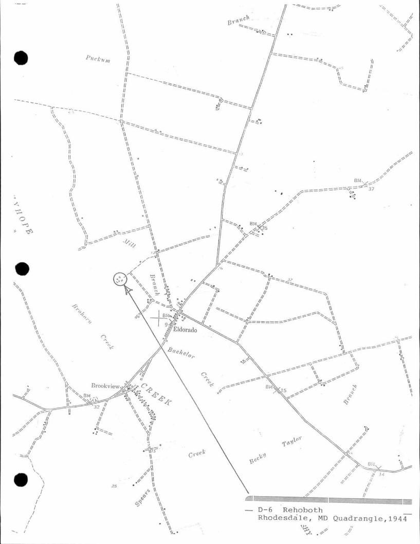
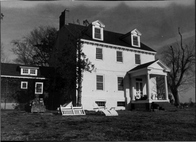
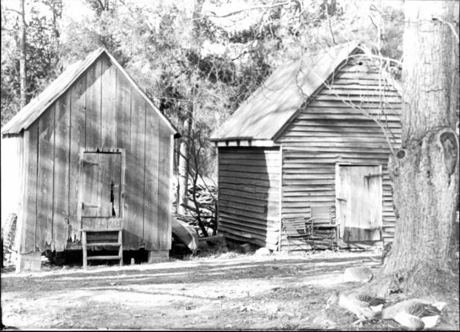
The plantation house known as Rehobeth or "Liberty Hall"1 is situated at the end of a long farm lane with the address of 5850 Puckum Road, north of the village of Eldorado in Dorchester County, Maryland. The two-and-a-half story Flemish bond brick house, built atop a raised brick foundation, faces the Marshy Hope Creek with a southwestern principal exposure. The gable roof is oriented on a northwest/southeast axis. Dating around 1785-90, the side hall/double pile plan brick dwelling burned in the fall of 1916 and was completely gutted of its original interior finishes. The house was restored to a habitable dwelling after a new owner acquired the property in March 1917. A story-and-half frame kitchen wing extending the house to the northwest was added during the restoration of the house. Accompanying the house on the property are two nineteenth century frame outbuildings; a second quarter of the nineteenth century smokehouse and a late nineteenth century storage building.
GENERAL DESCRIPTION
The historic farm property known as Rehoboth is located on the north side of the small village of Eldorado at 5850 Puckum Road, Dorchester County, Maryland. The two-and-half story Flemish bond brick house stands at the end of lane and is situated on a high bank overlooking Marshy Hope Creek. Dating around 1790, the side hall/double-pile plan brick house is supported on a raised brick foundation of English bond. The house is painted a cream color. While the exterior brickwork remains largely intact, the windows, roof, and interior woodwork were destroyed in a October 1916 fire. The southwest (main) elevation is laid in Flemish bond atop a molded brick watertable, whereas the other three walls are laid in English bond. The steeply pitched gable roof is defined by early twentieth century gable roofed dormers. Attached to the northwest gable end is an early twentieth century frame service wing. Accompanying the house on the property are two frame outbuildings; a second quarter of the nineteenth century smokehouse and a late nineteenth century storage building.
The southwest (main) elevation is a three-bay facade with a double-door entrance filling the southernmost bay, which is enhanced by an early twentieth century neoclassical entrance portico. The foundation of the house is defined by a high English bond wall capped by a molded watertable and pierced by wide cellar openings spanned by segmental rowlock arches. The openings are fitted with horizontal ten-pane windows. Flemish bond rises from the molded watertable, and twelve-over-twelve restoration sash light the first and second stories. Between the two stories is a two-brick beltcourse. The first floor windows are topped by scored wooden jack arches dating from the early twentieth century. The entrance bay is fitted with double leaf doors and it is topped by a decorative transom window dating from the early twentieth century restoration/renovation. A photograph of the house dating before the fire indicates the entrance
1 Harry Wright Newman, The Smoots of Maryland and Virginia, p. 17.
Maryland Historical Trust Maryland Inventory of Inventory No. D-6
Historic Properties Form
Name Rehoboth Continuation Sheet
Number 7 Page 1
featured a more typical five-light transom. Greek Doric columns support the gable front portico finished with extended eaves and cornice returns. The second story is lighted by smaller sized twelve-over-twelve sash windows, and an early twentieth century modillion block cornice finishes the base of the roof. Centered on the medium pitched gable roof is a pair of early twentieth century dormers featuring fluted pilasters flanking twelve-over-over sash windows.
The southeast gable end of English bond is defined by an asymmetrical fenestration of twelve-over-twelve sash windows topped by segmental arches of rowlocks. Fixed on the southwest corner is a double-door entrance spanned by a segmental arch as well . Two twelve-over-twelve sash windows light the second story, and a pair of round windows pierce the upper gable. These round windows are similar to those employed at Friendship Hall (D-2) in East New Market, which dates to the last decade of the eighteenth century. The gable end is finished flush with a molded bargeboard.
The northwest gable end, laid in English bond, is defined by an asymmetrical fenestration of nine-over-nine sash windows topped by segmental rowlock arches. Piercing the foundation wall is a bulkhead entrance to the cellar. Piercing the upper gable is a pair of small round windows that flank a wide interior end brick chimney stack. Extending northward from the gable end is a single-story frame kitchen wing dating from the early twentieth century. Supported on a parged brick foundation, the exterior is clad in wood shingles. The northeast elevation of the kitchen wing has a Tuscan columned porch.
The northeast (rear) elevation of the main block is laid in English bond as well above the English bond molded watertable. A two-course beltcourse divides the wall surface between floors, and twelve-over-twelve sash windows light the first and second stories. There is a rear entrance in the easternmost bay that is spanned by a segmental rowlock arch. The base of the roof is defined by a modillion block cornice, and two gable roofed dormers light the attic.
Standing northwest of the house are two frame outbuildings; a second quarter of the nineteenth-century smokehouse and a smaller frame building current used for storage. The smokehouse is a timber frame structure sheathed with weatherboard siding fastened with cut nails. While converted to a storage building as well, some of the interior framing elements have a furred surface common to smokehouses.
8. Significance Inventory No. D--6
Period Areas of Significance Check and justify below
_ 1600-1699 agriculture economics health/medicine performing arts x_ 1700-1799 archeology _ education industry philosophy
. 1800-1899 x architecture _ engineering invention politics/government 1900-1999 art entertainment/ landscape architecture religion 2000- commerce recreation _ law science
communications ethnic heritage literature social history __ community planning exploration/ maritime history transportation
conservation settlement military other:
Specific dates Architect/Builder
Construction dates
Evaluation for:
National Register Maryland Register x not evaluated
Prepare a one-paragraph summary statement of significance addressing applicable criteria, followed by a narrative discussion of the history of the resource and its context. (For compliance projects, complete evaluation on a DOE Form - see manual.)
SUMMARY SIGNIFICANCE
The property known since the seventeenth century as Rehoboth figures prominently in the history of northeastern Dorchester County as the long-time plantation land of Captain John Lee of Virginia and his descendants, who held title to various sections of this large tract for one hundred years. Captain Lee patented over two thousand acres along the Northwest Fork of the Nantiocke River, now called Marshyhope Creek, in 1673, and family ownership of sections lasted until the early 1770s. The two-story Flemish and English bond brick house, however, dates to the decade following the Lee ownership after merchant and planter Captain John Smoot and his father Edward Smoot acquired 1300 acres of the Rehoboth tract from Dr. Philip Ludwell Lee of Westmoreland County, Virginia.2 The two-and-a-half Flemish bond brick dwelling was erected around 1785-90 with the characteristic blend of late Georgian and Federal architectural finishes.3 The foundation of the house is defined by a molded brick watertable and a beltcourse stretches across the front and rear walls. Rusticated wood jack arches spanned the first floor window and door openings. The base of the roof was finished with a modillion block cornice typical of the late eighteenth century. In addition the tall, narrow proportions of the chimney stack and the round gable end attic windows are very similar to the same features at Friendship Hall. Tragically, the house experienced a catastrophic fire in the fall of 1916 that gutted the entire structure leaving only the walls remaining.
2 Dorchester County Land Record, Old 24/34, 6 April 1770, Dorchester County Courthouse. 3 The Georgian character of the brickwork at Rehoboth led many to believe this structure was erected during the ownership of the Lee family during the early to mid-eighteenth century. The two-story side hall/double-pile plan and brickwork design similarities to other houses of the same period confirm the estimated date of construction. (See D-2, Friendship Hall, and D-l, House of the Hinges) The absence of any mention of a brick structure on the 1783 tax lists for various "Rehoboth" parcels confirms as well its estimated date of construction.
Maryland Historical Trust Maryland Inventory of Inventory No. D-6
Historic Properties Form
Name Rehoboth Cont inuat ion Sheet
Number 8 Page 1
HISTORY AND SUPPORT
Between the 1673 patent date of the Rehoboth tract, which encompassed 2350 acres, and the Revolutionary War, the large plantation bordering the Northwest Fork of the Nanticoke River was held by Captain John Lee of Virginia and his descendants. Early Lee family plats of the plantation recorded in 1713 and again in 1759 clearly indicate that the large acreage had been improved with various structures and that the property was surrounded by the plantations and fields of other inhabitants of the Hundred of the North-west Fork, which was created in 1682 after the county's founding around 1669. Philip Lee (d. 1744), whose principal residence was in Prince George's County, Maryland, inherited 1300 acres of the Rehoboth tract from his father, Richard Lee in 1714. To another son, Thomas, Richard Lee, left the balance of the family lands on the North West Fork.4
During the next generation of Lee family ownership the Rehoboth tract was subdivided between various family members, although the largest portion encompassing 1300 hundred acres along the North West Fork with Bachelor's Creek as the southwest boundary was held by "Dr. Philip Ludwell Lee" (1727-1775), who inherited Stratford Hall in Westmoreland County, Virginia and other lands in Virginia and Maryland from his father, Thomas Lee (d. 1750), as the eldest son. By the second quarter of the eighteenth century, various Lee family holdings of the North West Fork plantations were advertised for sale or lease in the Maryland Gazette. In February 1747, Francis Lee, son of Philip Lee who died in 1744, advertised for lease "his late Mansion House on the North-West Fork of the Nanticoke River. He also put forth a mutual of his and Captain Walter Montgomery to have a ship built at "Lee's Landing on the Nanticoke." Philip Ludwell Lee placed an advertisement for his holdings in September 1754, 6 and during the following summer, plantation lands held by Philip Lee, deceased, were also available and any interest should be directed to Daniel Sullivane in Dorchester County, Corbin Lee in Baltimore County, Geroge Lee in Prince George's County, or John Lee, Jr. of Essex County, Virginia.7
It was not until April 1770, however, that Philip Ludwell Lee found an interested buyer. Edward Smoot (1724-1795) and his son John Smoot, then residents of Charles County, Maryland entered into an agreement to purchase two portions of the Rehoboth tract for L1009.10.8 It appears that John Smoot ( c. 1748-1793) relocated soon to Dorchester County,
4 Jones, p. 103. 5 Karen Mauer Green, The Maryland Gazette, 1727-1761, Galveston, The Frontier Press, 1989, p. 31. 6 Ibid, p. 149. 1 Ibid., p. 161. 8 Dorchester County Land Record, Old 24/34, 6 April 1770, Dorchester County Courthouse.
Maryland Historical Trust Maryland Inventory of Inventory No. D-6
Historic Properties Form
Name Rehoboth Continuation Sheet
Number 8 Page 2
while his father Edward remained in Charles County. One of the first official actions of the Smoots was to determine the actual boundary of the land they had purchased since, according to them the "bounds thereof is gone to decay." A commission was set up with Daniel Sullivane, Anderton Brown, George Kirkman and Matthew Smith, Jr. serving in the capacity to hear depositions from local residents as to their knowledge of the location of the old boundary markers that defined the Rehoboth tract. Evidently, within the year John Smoot was residing in Dorchester County, whereas his brother Edward remained in Charles County. A confirmatory deed for the 1770 transfer, conveyed in September 1772 for one additional pound, relinquished full title of the Lee plantation to the Smoot brothers.10 Identified in the land records as a merchant, John Smoot purchased an assortment of household items, farm implements and farm animals from John Lyon in October 1773." John Smoot also surfaces in the county and provincial records as a captain during the Revolutionary War in command of cavalry and in 1780 in charge of 54 privates.13
Following Captain John Smoot's service during the Revolutionary War, he engaged in the merchant-planter activities well known for the eighteenth and early nineteenth centuries when wealthy gentry served as brokers of local manufactures and produce in exchange for imported and selling finished goods from Europe and the West Indies. A bill of sale executed in 1786 between Thomas Shiles of Vienna, a mariner or ship captain and merchant John Smoot indicates the Smoot had partnered in the mercantile trade with Alexander Douglas. From the architectural character of the extant brick walls, it is evident that John Smoot financed construction of the two-story side hall/double-pile brick dwelling between 1785 and 1790 and prior to his death in 1793.
Merchant John Smoot died in 1793, and the court ordered an assessment and division of his real estate between his many heirs.15 The large plantation was subdivided into several sections; Captain Henry Smoot transferred 395 54 acres along the North West Fork including the two-story brick house to Francis B. C. Turpin in November 1815.16 Smoot family ownership of other Rehoboth parcels continued through the early to mid nineteenth century and were associated with the slow development of Crotcher's Ferry as a commercial center in the Fork election
9 Dorchester County Land Record, Old 25/238-262, 13 November 1771, Dorchester County Courthouse. 10 Dorchester County Land Record, Old 26/205, 18 September 1772, Dorchester County Courthouse. 11 Dorchester County Land Record, Old 26/450, 7 October 1773, Dorchester County Courthouse. 12 Jones, p. 230. 13 Jones, p. 235. 14 Dorchester County Land Record, Bill of Sale, NH 9/148, 4 September 1786, Dorchester County Courthouse. 15 Dorchester County Land Record, ER 3/568, 27 October 1814, Dorchester County Courthouse. 16 Dorchester County Land Record, ER 4/24, 10 November 1815, Dorchester County Courthouse.
Maryland Historical Trust Maryland Inventory of Inventory No. D-6
Historic Properties Form
Name Rehoboth Continuation Sheet
Number 8 Page 3
district. A landing on the North West Fork at Crotcher's Ferry was known as "Smoot's Wharf and Thomas Smoot operated a store in the village during the second quarter of the nineteenth century, one which had been begun by Captain John Smoot. Captain Smoot also took advantage of the sizable timber stands in region and established a saw mill on his land during his occupancy. Captain John Smoot's son, John, later sold a 2-acre part of Rehoboth next to the saw mill operated by William Drura.17
Francis B. C. Turpin and his wife Mary Adeline occupied the old Smoot mansion during the early to mid-nineteenth century. In 1870 the Rehoboth tract with the house was acquired by William H. Brinsfield, who is designated at this location on Fork election district map printed in the Lake, Griffing and Stevenson atlas of 1877.18 He is also listed in the atlas patron list as a farmer with 371 acres.1 In April 1892, the heirs of William H. Brinsfield sold the old Rehoboth mansion with 130 acres to John H. Renner in a straw deed; on the same day Renner transferred the same property to Philadelphians Rosanna Blumenstock, Emma Blumenstock and Laura Blumenstock. During the early twentieth century the property, with a reduced 70 acres, was sold several times until Joseph H. Saunders acquired the farm in January 1912.21 Tragically, in the fall of 1916 under the Saunders ownership, the old brick house was gutted by fire; it was sold as a gutted housel several months later to another native Philadelphian, Francis W. Breuil22
and his wife Sara A. Breuil. Instead of leveling the site of the burned out shell, the Breuils entered into a rebuilding of the house with Colonial Revival detailing. Breuil family ownership of the property lasted until 2003.23
17 Dorchester County Land Record, HD 21/424, 8 November 1804, Dorchester County Courthouse. 18 John L Graham, The 1877 Atlases and Other Early Maps of the Eastern Shore of Maryland, Salisbury: Wicomico Bicentennial Committee, p. 66. 19 Ibid., p. 84. 20 Dorchester County Land Record, CL 26/13, 3 October 1901. 21 Dorchester County Land Record, WLR 4/196, 4 January 1912. 22 Dorchester County Land Record, WHM 3/. 164, 17 March 1917. 23 Dorchester County Land Record, 537/448, 12 August 2003.
Maryland Historical Trust Maryland Inventory of Inventory No. D-6
Historic Properties Form
Name Rehoboth Continuation Sheet
Number _8_ Page 4
Rehoboth 5850 Puckum Road Eldorado vicinity, Dorchester County, Maryland Map 24, Parcel 33
CHAIN-OF-TITLE
MLB 844/403 Chesapeake Land Preservation, LLC
to
12.20.2007 O. James Lighthizer and James P. Lighthizer
807/129 Gregory W. Jones and Barbara L. Jones
to
5.7.2007 Chesapeake Land Preservation, LLC
$1,150,000.00
537/448 Ruth Woolen Breuil
to
8.12.2003 Gregory W. Jones and Barbara L. Jones

Maryland Historical Trust Maryland Inventory of Inventory No. D-6
Historic Properties Form
Name Rehoboth Continuation Sheet
Number _8_ Page 5
135/349 Clarence H. Cochran, Jr. Trustee
to
10.10.1963 John J. Breuil and Ruth Woolen Breuil
135/346 John J. Breuil and Ruth Woolen Breuil
to
10.10.1963 Clarence H. Cochran, Jr. Trustee
Land conveyed was devised unto the said John J. Breuil and Edwin D. Breuil by last will and testament of their mother, Sara A. Breuil, APM 4/92
Whereas by deed dated 2.21.1963, PLC 134/112, Edwin D. Breuil and Edna H. Breuil conveyed to John J. Breuil all of the 'A interest of the said Edwin D. Breuil
Lot No. 1, "Rehoboth" from County Corporation of Maryland, 1.15.1935, JFD 31/675, Survey made by J. Watson Thompson, 2.18.1887, in the Subdivision of lands of William H. Brinsfield, deceased 18 acres
Lot No. 2, to Sara A. Breuil by Viola M. Brinsfield, 9.30.1935, JFD 33/31, "Cripple Land"
Lot No. 3, to Sara A. Breuil by William L. Dean and wife by deed bearing date, 2.16.1939, and recorded in JFD 38/686, Lot No. 28 on the plat of "Map of Lots of Dean & Stevens"
Lot No. 4, "Rehoboth" 70 acres....on the northeast on the northwest prong of the Nanticoke River a short distance below what is commonly called Hackett's Wharf.....to a cedar post at or near the stream of what is called "Drewry's Mill" branch...
Maryland Historical Trust Maryland Inventory of Inventory No. D-6
Historic Properties Form
Name Rehoboth Continuation Sheet
Number 8 Page 6
RSM 42/693 Sara A. Breuil and Francis W. Breuil
to
5.31.1941 Calvin L. Brinsfield, Trustee
WHM 3/164 Joseph H. Saunders and Sadie J. Saunders
to
3.17.1917 Francis W. Breuil
70 acres "Rehoboth"
WLR 4/196 Olivia C. Brinsfield and D'Arcy Brinsfield
to
1.4.1912 Joseph H. Saunders
$2,500.00 70 acres "Rehoboth"
Maryland Historical Trust Maryland Inventory of Inventory No. D-6
Historic Properties Form
Name Rehoboth Continuation Sheet
Number 8 Page 7
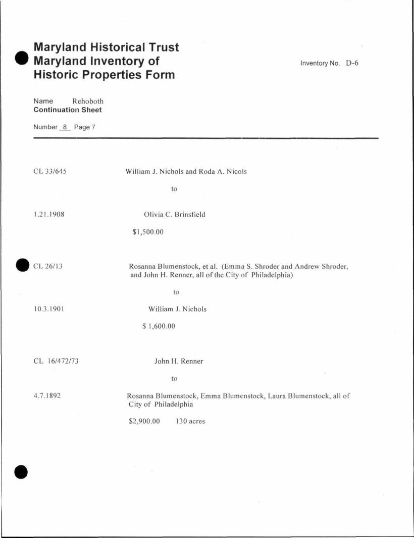
CL 33/645 William J. Nichols and Roda A. Nicols
to
1.21.1908 Olivia C. Brinsfield
$1,500.00
CL 26/13 Rosanna Blumenstock, et al. (Emma S. Shroder and Andrew Shroder, and John H. Renner, all of the City of Philadelphia)
to
10.3.1901 William J.Nichols
$ 1,600.00
CL 16/472/73 John H. Renner
to
4.7.1892 Rosanna Blumenstock, Emma Blumenstock, Laura Blumenstock, all of City of Philadelphia
$2,900.00 130 acres
Maryland Historical Trust Maryland Inventory of Inventory No. D-6
Historic Properties Form
Name Rehoboth Continuation Sheet
Number 8 Page 8
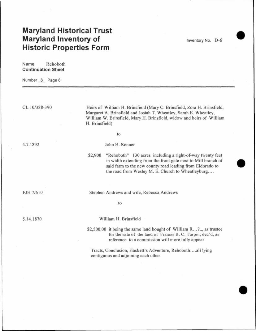
CL 10/388-390 Heirs of William H. Brinsfield (Mary C. Brinsfield, Zora H. Brinsfield, Margaret A. Brinsfield and Josiah T. Wheatley, Sarah E. Wheatley, William W. Brinsfield, Mary H. Brinsfield, widow and heirs of William H. Brinsfield)
to
4.7.1892 JohnH. Renner
$2,900 "Rehoboth" 130 acres including a right-of-way twenty feet in width extending from the front gate next to Mill branch of said farm to the new county road leading from Eldorado to the road from Wesley M. E. Church to Wheatleyburg....
FJH 7/610 Stephen Andrews and wife, Rebecca Andrews
to
5.14.1870 William H. Brinsfield
$2,500.00 it being the same land bought of William R...?.., as trustee for the sale of the land of Francis B. C. Turpin, dec'd, as reference to a commission will more fully appear
Tracts, Conclusion, Hackett's Adventure, Rehoboth....all lying contiguous and adjoining each other
Maryland Historical Trust Maryland Inventory of Inventory No. D-6
Historic Properties Form
Name Rehoboth Continuation Sheet
Number 8 Page 9
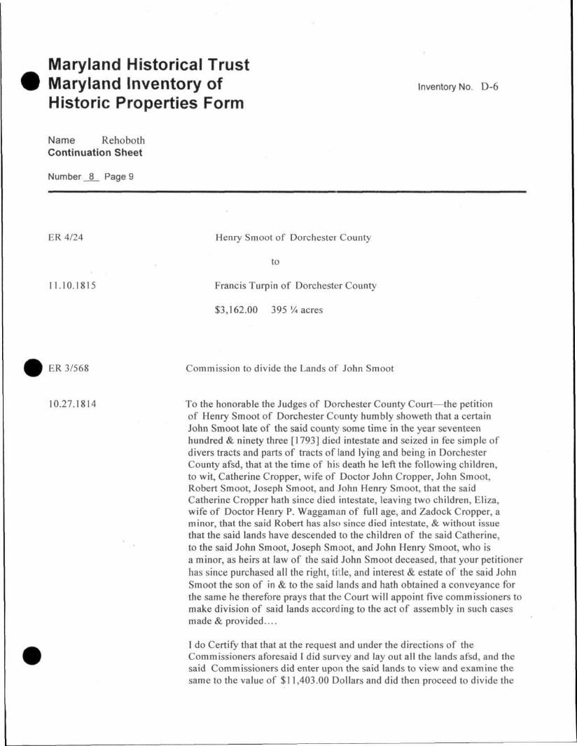
ER 4/24 Henry Smoot of Dorchester County
to
11.10.1815 Francis Turpin of Dorchester County
$3,162.00 395% acres
ER 3/568 Commission to divide the Lands of John Smoot
10.27.1814 To the honorable the Judges of Dorchester County Court—the petition of Henry Smoot of Dorchester County humbly showeth that a certain John Smoot late of the said count}' some time in the year seventeen hundred & ninety three [1793] died intestate and seized in fee simple of divers tracts and parts of tracts of land lying and being in Dorchester County afsd, that at the time of his death he left the following children, to wit, Catherine Cropper, wife of Doctor John Cropper, John Smoot, Robert Smoot, Joseph Smoot, and John Henry Smoot, that the said Catherine Cropper hath since died intestate, leaving two children, Eliza, wife of Doctor Henry P. Waggaman of full age, and Zadock Cropper, a minor, that the said Robert has also since died intestate, & without issue that the said lands have descended to the children of the said Catherine, to the said John Smoot, Joseph Smoot, and John Henry Smoot, who is a minor, as heirs at law of the said John Smoot deceased, that your petitioner has since purchased all the right, title, and interest & estate of the said John Smoot the son of in & to the said lands and hath obtained a conveyance for the same he therefore prays that the Court will appoint five commissioners to make division of said lands according to the act of assembly in such cases made & provided
I do Certify that that at the request and under the directions of the Commissioners aforesaid I did survey and lay out all the lands afsd, and the said Commissioners did enter upon the said lands to view and examine the same to the value of $11,403.00 Dollars and did then proceed to divide the

Maryland Historical Trust Maryland Inventory of Inventory No. D-6
Historic Properties Form
Name Rehoboth Continuation Sheet
Number 8 Page 10
same into four parts as follows—
Lot No. 1 assigned by the Commissioners to Captain Henry Smoot composed of a part of a tract of land called Rehoboth, part of Reids Chance and a part of Addition Reids Chance, part of Robins Ridge, and a part of Adams Dear Purchase...containing five hundred and ten acres of land more or less, the said Commissioners also assigned to the said Henry Smoot a small tract of land Called Strawberry Hill lying on the west side of the N.W. Fork river containing agreeable to Certificate thereof Eleven Acres of land more or less, and also an undivided moiety of the first part or tract of land called Discovery, adjoining to the said Strawberry Hill containing fifteen acres and one quarter acres of land, more or less, making in all the several parts five hundred and thirty seven acres of land more or less
Lot No. 2, assigned by the Commissioners to the heirs of Catherine Cropper, Eliza Waggaman, wife of Henry P. Waggaman and Zadock Cropper, composed of part of a tract of land called Rehoboth, part of Hackett's Adventure and a a part of a Tract of land called Conclusion four hundred and eighty acres and one half acres of land more or less
Lot No. 3, assigned by the Commissioners to Joseph Smoot, composed of a part of a tract of land called Robins Ridge, part of Adam's Dear Purchase, and part of Conclusion containing 408 acres...The commissioners also assign to the said Joseph Smoot all that part of a tract of Land called Discovery... containing 122 acres more or less...as also all that part of a Tract of land called Dawsons Discovery" lying near the Northwest Fork Bridge containing forty One and one half acres of Land more or less, and the Commissioners further assign to the said Joseph Smoot one house and Lot at the North West Fork bridge, the said Lot of ground being part of a Tract of land called Sandy Hill,
containing one half acre of land, more or less, containing in all the several parts and parcels of land 572 acres of land more or less...
Lot No. 4, assigned by the Commissioners to John Henry Smoot being a part of the Tract of land called Rehoboth, Containing three hundred eighty eight acres of land more or less...
Maryland Historical Trust Maryland Inventory of Inventory No. D-6
Historic Properties Form
Name Rehoboth Continuation Sheet
Number 8 Page 11
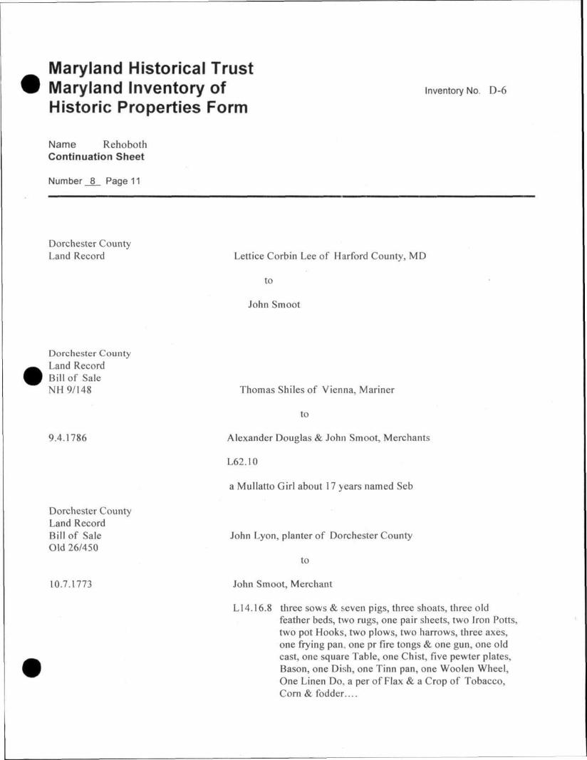
Dorchester County Land Record Lettice Corbin Lee of Harford County, MD
to
John Smoot
Dorchester County Land Record Bill of Sale NH 9/148 Thomas Shiles of Vienna, Mariner
to
9.4.1786 Alexander Douglas & John Smoot, Merchants
L62.10
a Mullatto Girl about 17 years named Seb
Dorchester County Land Record Bill of Sale John Lyon, planter of Dorchester County Old 26/450
to
10.7.1773 John Smoot, Merchant
L14.16.8 three sows & seven pigs, three shoats, three old feather beds, two rugs, one pair sheets, two Iron Potts, two pot Hooks, two plows, two harrows, three axes, one frying pan, one pr fire tongs & one gun, one old cast, one square Table, one Chist, five pewter plates, Bason, one Dish, one Tinn pan, one Woolen Wheel, One Linen Do, a per of Flax & a Crop of Tobacco, Corn & fodder....
Maryland Historical Trust Maryland Inventory of Inventory No. D-6
Historic Properties Form
Name Rehoboth Continuation Sheet
Number _8_ Page 12
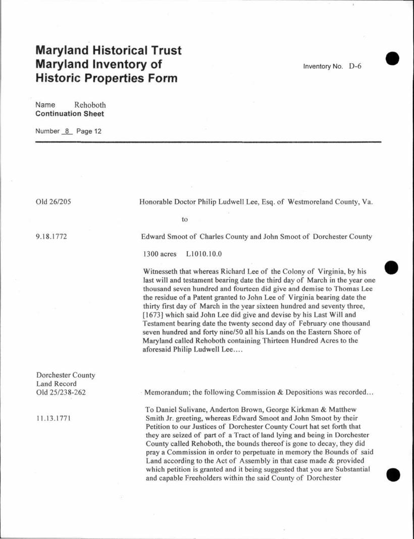
Old 26/205 Honorable Doctor Philip Ludwell Lee, Esq. of Westmoreland County, Va.
to
9.18.1772 Edward Smoot of Charles County and John Smoot of Dorchester County
1300 acres L1010.10.0
Witnesseth that whereas Richard Lee of the Colony of Virginia, by his last will and testament bearing date the third day of March in the year one thousand seven hundred and fourteen did give and demise to Thomas Lee the residue of a Patent granted to John Lee of Virginia bearing date the thirty first day of March in the year sixteen hundred and seventy three, [1673] which said John Lee did give and devise by his Last Will and Testament bearing date the twenty second day of February one thousand seven hundred and forty nine/50 all his Lands on the Eastern Shore of Maryland called Rehoboth containing Thirteen Hundred Acres to the aforesaid Philip Ludwell Lee....
Dorchester County Land Record Old 25/238-262 Memorandum; the following Commission & Depositions was recorded...
To Daniel Sulivane, Anderton Brown, George Kirkman & Matthew 11.13.1771 Smith Jr. greeting, whereas Edward Smoot and John Smoot by their
Petition to our Justices of Dorchester County Court hat set forth that they are seized of part of a Tract of land lying and being in Dorchester County called Rehoboth, the bounds thereof is gone to decay, they did pray a Commission in order to perpetuate in memory the Bounds of said Land according to the Act of Assembly in that case made & provided which petition is granted and it being suggested that you are Substantial and capable Freeholders within the said County of Dorchester
Maryland Historical Trust Maryland Inventory of Inventory No. D-6
Historic Properties Form
Name Rehoboth Continuation Sheet
Number _8_ Page 13
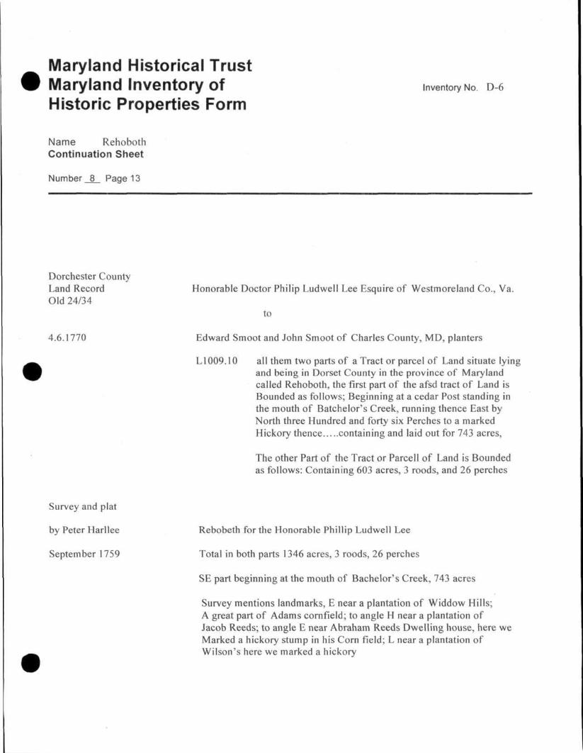
Dorchester County Land Record Honorable Doctor Philip Ludwell Lee Esquire of Westmoreland Co., Va. Old 24/34
to
4.6.1770 Edward Smoot and John Smoot of Charles County, MD, planters
LI009.10 ail them two parts of a Tract or parcel of Land situate lying and being in Dorset County in the province of Maryland called Rehoboth, the first part of the afsd tract of Land is Bounded as follows; Beginning at a cedar Post standing in the mouth of Batchelor's Creek, running thence East by North three Hundred and forty six Perches to a marked Hickory thence containing and laid out for 743 acres,
The other Part of the Tract or Parcell of Land is Bounded as follows: Containing 603 acres, 3 roods, and 26 perches
Survey and plat
by Peter Harllee Rebobeth for the Honorable Phillip Ludwell Lee
September 1759 Total in both parts 1346 acres, 3 roods, 26 perches
SE part beginning at the mouth of Bachelor's Creek, 743 acres
Survey mentions landmarks, E near a plantation of Widdow Hills; A great part of Adams cornfield; to angle H near a plantation of Jacob Reeds; to angle E near Abraham Reeds Dwelling house, here we Marked a hickory stump in his Corn field; L near a plantation of Wilson's here we marked a hickory
Maryland Historical Trust Maryland Inventory of Inventory No. D-6
Historic Properties Form
Name Rehoboth Continuation Sheet
Number 8 Page 14
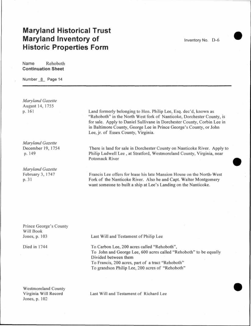
Maryland Gazette August 14, 1755 p. 161 Land formerly belonging to Hon. Philip Lee, Esq. dec'd, known as
"Rehoboth" in the North West fork of Nanticoke, Dorchester County, is for sale. Apply to Daniel Sullivane in Dorchester County, Corbin Lee in in Baltimore County, George Lee in Prince George's County, or John Lee, jr. of Essex County, Virginia.
Maryland Gazette December 19, 1754 There is land for sale in Dorchester County on Nanticoke River. Apply to p. 149 Philip Ludwell Lee , at Stratford, Westmoreland County, Virginia, near
Potomack River
Maryland Gazette February 3, 1747 Francis Lee offers for lease his late Mansion House on the North-West p. 31 Fork of the Nanticoke River. Also he and Capt. Walter Montgomery
want someone to built a ship at Lee's Landing on the Nanticoke.
Prince George's County Will Book Jones, p. 103 Last Will and Testament of Philip Lee
Died in 1744 To Carbon Lee, 200 acres called "Rehoboth", To John and George Lee, 600 acres called "Rehoboth" to be equally Divided between them To Francis, 200 acres, part of a tract "Rehoboth" To grandson Philip Lee, 200 acres of "Rehoboth"
Westmoreland County Virginia Will Record Last Will and Testament of Richard Lee Jones, p. 102
Maryland Historical Trust Maryland Inventory of Inventory No. D-6
Historic Properties Form
Name Rehoboth Continuation Sheet
Number 8 Page 15
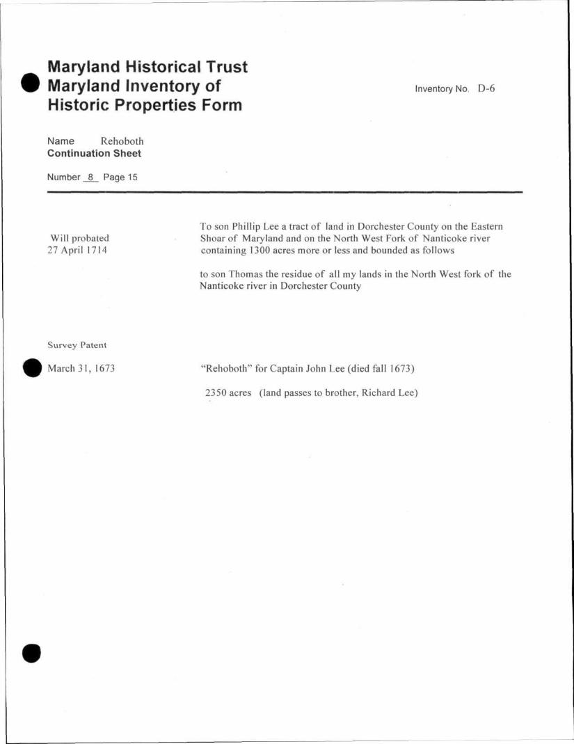
To son Phillip Lee a tract of land in Dorchester County on the Eastern Will probated Shoar of Maryland and on the North West Fork of Nanticoke river
27 April 1714 containing 1300 acres more or less and bounded as follows
to son Thomas the residue of all my lands in the North West fork of the Nanticoke river in Dorchester County
Survey Patent
March 31, 1673 "Rehoboth" for Captain John Lee (died fall 1673)
2350 acres (land passes to brother, Richard Lee)
9. Major Bibliographical References Inventory No. D-6
Dorchester County Land Records, various volumes, Dorchester County Courthouse.
Green, Karen Mauer. The Maryland Gazette, 1727-1761, Galveston, Texas: The Frontier Press, 1989.
Mrs. Preston Parish, Rehoboth, National Register nomination, 17 January 1972.
10. Geographical Data
Acreage of surveyed property 70 acres Acreage of historical setting 70 acres Quadrangle name Rhodesdale, MP Quadrangle Quadraanqle scale: 1:24,000
Verbal boundary description and justification
The metes and bounds of this surveyed property are coincidental with the current boundary of the tract.
11. Form Prepared by name/t i t le Paul B. Touart, Architectural Historian
organization Chesapeake Country Heritage & Preservation date 1/8/2008
st reet & n u m b e r P. Q. Box 5 te lephone 4JQ-6S1-1Q94
d t y or town Westover : Stale Maryland 21871
The Maryland Inventory of Historic Properties was officially created by an Act of the Maryland Legislature to be found in the Annotated Code of Maryland, Article 41, Section 181 KA, 1974 supplement.
The survey and inventory are being prepared for information and record purposes only and do not constitute any infringement of individual property rights.
return to: Maryland Historical Trust DHCD/DHCP 100 Community Place Crownsville, MD 21032-2023 410-514-7600
D-6 Rehoboth _ Rhodesdale, MD Quadrangle, 1944


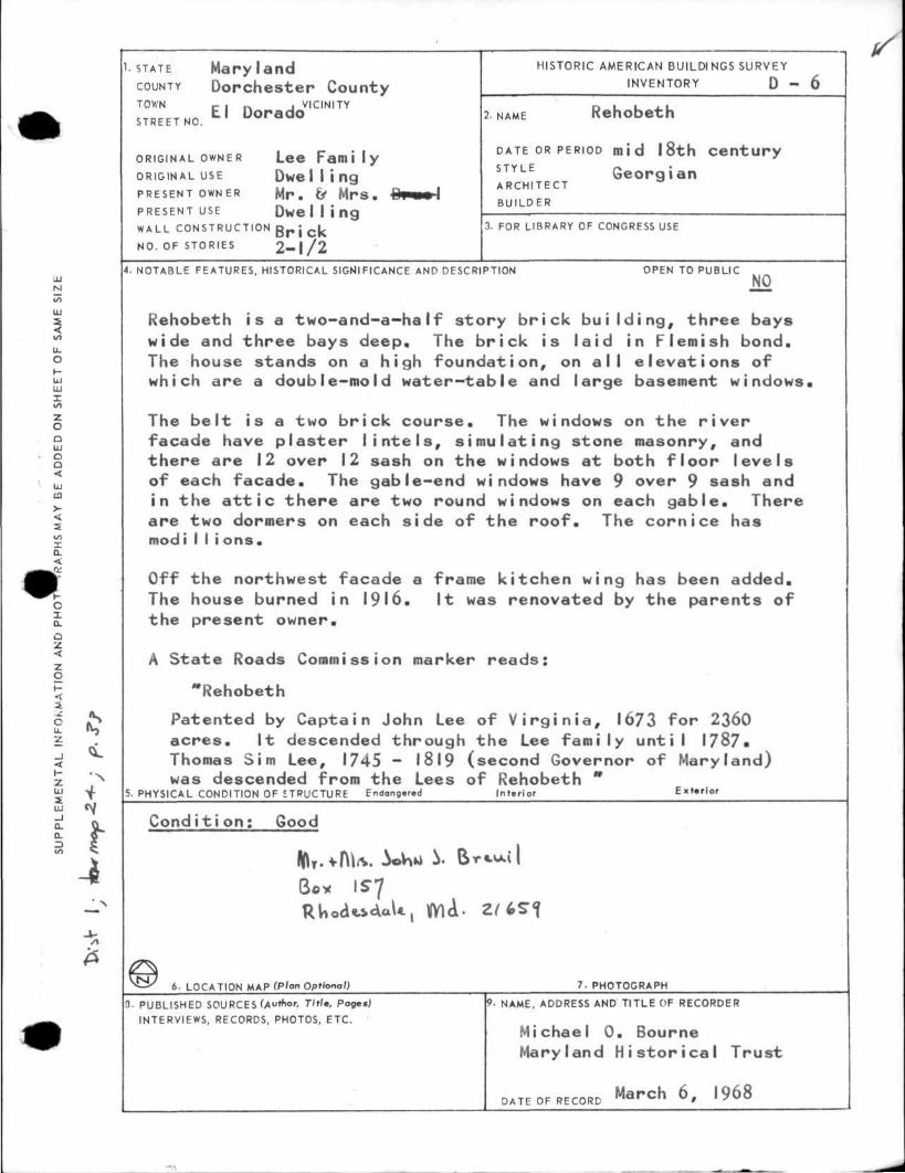
1. STATE M a r y l a n d COUNTY D o r c h e s t e r County
El Dorado VICINITY
STREET NO.
ORIGINAL OWNER Lee F a m i l y ORIGINAL USE D w e l l i n g PRESENT OWNER M r . & M r s .
PRESENT USE D w e l l i n g WALL CONSTRUCTION BRICK
NO. OF STORIES 2 - I / 2
HISTORIC AMERICAN DUILDI NGS SURVEY
INVENTORY D - 6
2. NAME Rehobeth
DATE OR PERIOD mid 18th c e n t u r y S T Y L E G e o r g i a n ARCHITECT
BUILDER
3. FOR LIBRARY OF CONGRESS USE
4. NOTABLE FEATURES, HISTORICAL SIGNIFICANCE AND DESCRIPTION OPEN TO PUBLIC
NO
Rehobeth is a two-and-a-half story brick building, three bays wide and three bays deep. The brick is laid in Flemish bond. The house stands on a high foundation, on all elevations of which are a double-mold water—table and large basement windows.
The belt is a two brick course. The windows on the river facade have plaster lintels, simulating stone masonry, and there are 12 over 12 sash on the windows at both floor levels of each facade. The gable-end windows have 9 over 9 sash and in the attic there are two round windows on each gable. There are two dormers on each side of the roof. The cornice has modi I I i ons.
Off the northwest facade a frame kitchen wing has been added. The house burned in 1916. It was renovated by the parents of the present owner.
A State Roads Commission marker reads:
"Rehobeth
Patented by Captain John Lee of Virginia, 1673 for 2360 acres. It descended through the Lee family until 1787« Thomas Sim Lee, 1745 - 1819 (second Governor of Maryland) was descended from the Lees of Rehobeth *
5. PHYSICAL CONDITION OF STRUCTURE Endonger.d Interior Ext»rlor
C o n d i t i o n : Good
6. LOCATION MAP (Plan Optional) 7. PHOTOGRAPH
3- PUBLISHED SOURCES (A"tnor, Title, Pages) 9. NAME, ADDRESS AND TITLE OF RECORDER
INTERVIEWS, RECORDS, PHOTOS, ETC.
Michael 0. Bourne Maryland Historical Trust
DATE OF RECORD March 6 1968
SU
PP
LE
ME
NT
AL
IN
FO
RM
AT
ION
A
ND
P
HO
T^tf
A.P
HS
MA
Y B
E
AD
DE
D O
N
SH
EE
T O
F
SA
ME
S
IZE
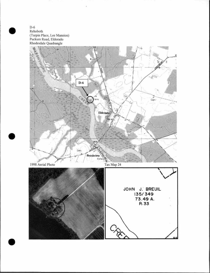
D-6 Rehoboth (Turpin Place, Lee Mansion) Puckum Road, Eldorado Rhodesdale Quadrangle
1998 Aerial Photo Tax Map 24
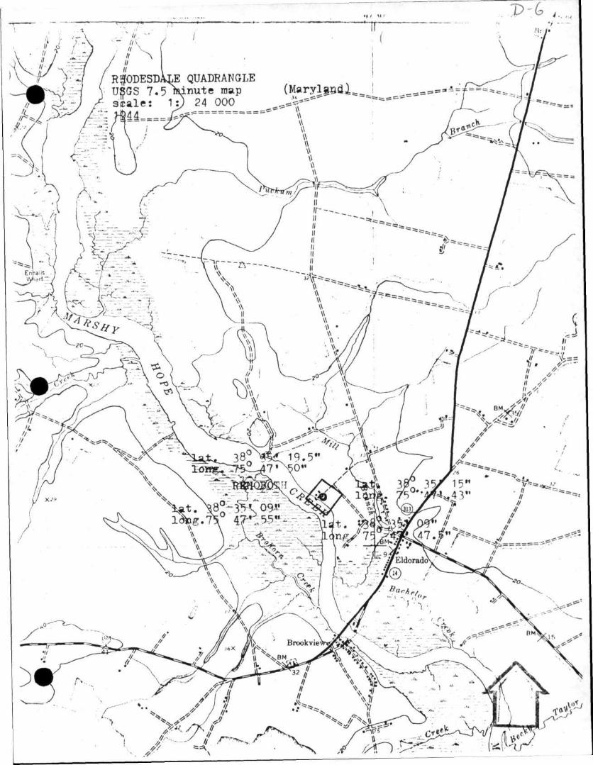
D-6
RftODESDALE QUADRANGLE USGS 7.5 minute map (Maryland) scale: 1: 24 000 1944