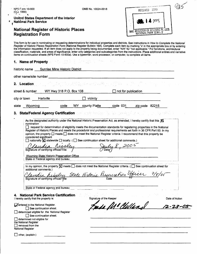
national register of historic places registration form · national register of historic places ......
TRANSCRIPT
RECEIVED 2280
Jt. | 4
NPS Fvrnn 10-900 OMB No. 10024-0018 (Opt. 1990)
United States Department of the Interior National Park Service
National Register of Historic Places Registration Form
This form is for use in nominating or requesting determinations for individual properties and districts. See instructions in How to Complete the National Register of Historic Places Registration Form (National Register Bulletin 16A). Complete each item by marking "x1 in the appropriate box or by entering the information requested. If an item does not apply to the property being documented, enter "N/A" for "not applicable." For functions, architectural classification, materials, and areas of significance, enter only categories and subcategories from the instructions. Place additional entries and narrative items on continuation sheets (NPS Form 10-900a). Use a typewriter, word processor, or computer, to complete all items.
1. Name of Property
historic name Sunrise Mine Historic District________________________________
other name/site number _____________________________________________
2. Location , ,, . :.' ; : : .- ^..S'Vvv: :-"-".'- ; v : .'.' ' "V..'.'':' ; '.''':'V- . , , : -'•''•'-''"' - --
street & number WY Hwy 318 P.O. Box 108________
city or town Hartville____________D vicinity
D not for publication
state Wyoming code WY county Platte code 031 zip code 82215
3. State/Federal Agency Certification
As the designated authority under the National Historic Preservation Act, as amended, I hereby certify that this Jglnominationn request for determination of eligibility meets the documentation standards for registering properties in the NationalRegister of Historic Places and meets the procedural and professional requirements set forth in 36 CFR Part 60. In myopinion, the property Q meets O does not meet the National Register criteria. I recommend that this property beconsidered significant[U nationally |)£] statewide D locally. ( [H See continuation sheet for additional comments.)tT'
Signature of certifying official/Title /
Wyoming State Historic Preservation OfficeState or Federal agency and bureau
In my opinion, the property K] meets d does not meet the National Register criteria. ( [U See continuation sheet for additional comments.)
Signature of certifying official/Title Date
State or Federal agency and bureau
4. National Park Service CertificationI hereby certify that the property is:
(^entered in the National Register.O See continuation sheet.
[H determined eligible for the National RegisterI | See continuation sheet.
I I determined not eligible for the National Register I I removed from the National Register
Signature of the Keeper Date of Action
I I other, (explain:)
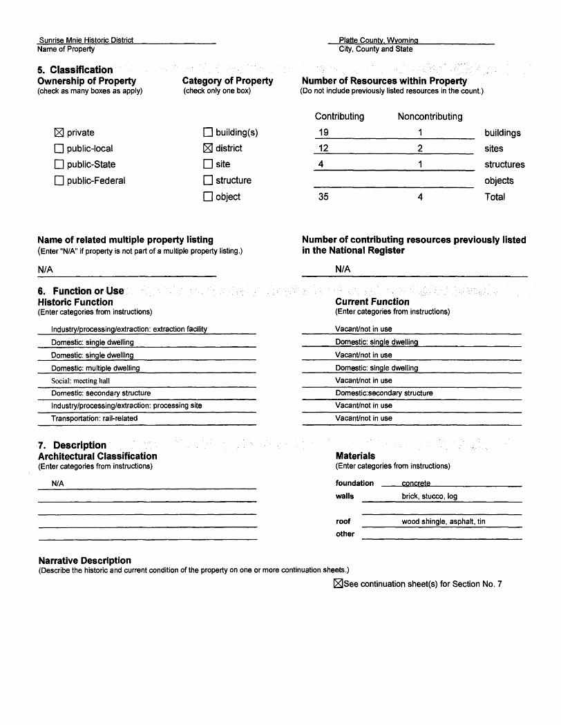
Sunrise Mnie Historic DistrictName of Property
5. Classification Ownership of Property(check as many boxes as apply)
Platte County. Wyoming
Category of Property(check only one box)
City, County and State
Number of Resources within Property(Do not include previously listed resources in the count.)
_x] private
D public-local
D public-State
D public-Federal
D building(s)
IEI district
Dsite
D structure
D object
Contributing
19
12
4
35
Noncontributing
1
2
1
4
buildings
sites
structures
objects
Total
Name of related multiple property listing(Enter "N/A" if property is not part of a multiple property listing.)
N/A_______________________
.6. Function or Use Historic Function(Enter categories from instructions)
Industry/processing/extraction: extraction facility__________
Domestic: single dwelling_________________________________
Domestic: single dwelling________________
Domestic: multiple dwelling___________________________
Social: meeting hall
Domestic: secondary structure
Industry/processing/extraction: processing site______
Transportation: rail-related
Number of contributing resources previously listed in the National Register
N/A
Current Function(Enter categories from instructions)
Vacant/not in use______________
Domestic: single dwelling_______
Vacant/not in use_______________
Domestic: single dwelling________
Vacant/not in use
Domestic:secondary structure
Vacant/not in use
Vacant/not in use
7. Description Architectural Classification(Enter categories from instructions)
N/A
Materials(Enter categories from instructions)
foundation
walls
concrete
brick, stucco, log
roof
other
wood shingle, asphalt, tin
Narrative Description(Describe the historic and current condition of the property on one or more continuation sheets.)
_x_See continuation sheet(s) for Section No. 7
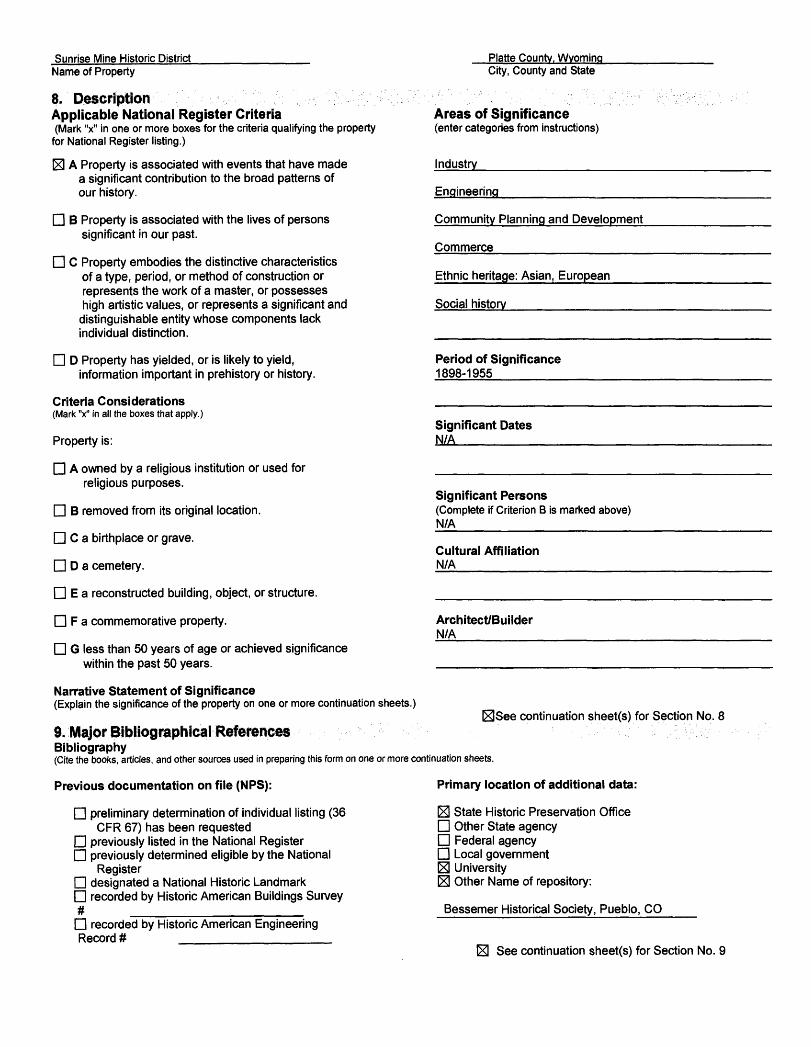
Sunrise Mine Historic DistrictName of Property
Platte County. WyomingCity, County and State
Engineering
Commerce
Social history
8.' Description ., , •• ;..^;.-\':.'•':• ;'•; '^^•'•••'•-••-f^-^^.. Applicable National Register Criteria(Mark "x" in one or more boxes for the criteria qualifying the property
for National Register listing.)
^ A Property is associated with events that have made a significant contribution to the broad patterns of our history.
D B Property is associated with the lives of persons significant in our past.
D C Property embodies the distinctive characteristics of a type, period, or method of construction or represents the work of a master, or possesses high artistic values, or represents a significant and
distinguishable entity whose components lackindividual distinction.
D D Property has yielded, or is likely to yield, information important in prehistory or history.
Criteria Considerations(Mark "x" in all the boxes that apply.)
Property is:
D A owned by a religious institution or used for religious purposes.
D B removed from its original location.
D C a birthplace or grave.
D D a cemetery.
D E a reconstructed building, object, or structure.
D F a commemorative property.
D G less than 50 years of age or achieved significance within the past 50 years.
Narrative Statement of Significance(Explain the significance of the property on one or more continuation sheets.)
9. Major Bibliographical ReferencesBibliography(Cite the books, articles, and other sources used in preparing this form on one or more continuation sheets.
Areas of Significance(enter categories from instructions)
Industry____________
Community Planning and Development
Ethnic heritage: Asian, European
Period of Significance1898-1955
Significant DatesN/A________
Significant Persons(Complete if Criterion B is marked above) N/A
Cultural AffiliationN/A
Architect/BuilderN/A
continuation sheet(s) for Section No. 8
Previous documentation on file (NPS):
D preliminary determination of individual listing (36CFR 67) has been requested
D previously listed in the National Register D previously determined eligible by the National
RegisterD designated a National Historic Landmark D recorded by Historic American Buildings Survey # ________________ D recorded by Historic American Engineering Record # ______________
Primary location of additional data:
E3 State Historic Preservation OfficeD Other State agencyD Federal agencyD Local government03 UniversityE] Other Name of repository:
Bessemer Historical Society, Pueblo, CO_____
I3 See continuation sheet(s) for Section No. 9
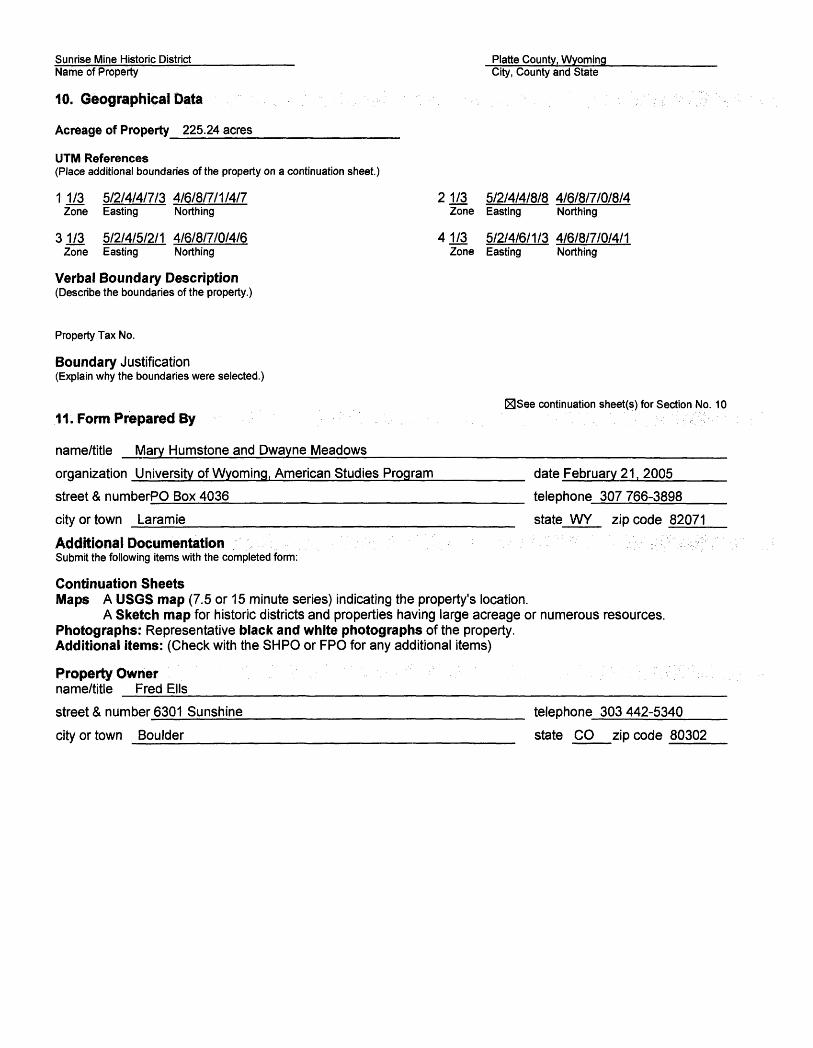
Sunrise Mine Historic District___________ Platte County, Wyoming Name of Property City, County and State
10, Geographical Data
Acreage of Property 225.24 acres_____________
UTM References(Place additional boundaries of the property on a continuation sheet.)
11/3 5/2/4/4/7/3 4/6/8/7/1/4/7 21/3 5/2/4/4/8/8 4/6/8/7/0/8/4 Zone Easting Northing Zone Easting Northing
31/3 5/2/4/5/2/1 4/6/8/7/0/4/6 41/3 5/2/4/6/1/3 4/6/8/7/0/4/1 Zone Easting Northing Zone Easting Northing
Verbal Boundary Description(Describe the boundaries of the property.)
Property Tax No.
Boundary Justification(Explain why the boundaries were selected.)
_3See continuation sheet(s) for Section No. 10.11; Form Prepared By
name/title Mary Humstone and Dwayne Meadows_________________________________________
organization University of Wyoming, American Studies Program________ date February 21. 2005_________
street & numberPO Box 4036__________________________ telephone 307766-3898________
city or town Laramie____________________________ state WY zip code 82071
Additional DocumentationSubmit the following items with the completed form:
Continuation SheetsMaps A USGS map (7.5 or 15 minute series) indicating the property's location.
A Sketch map for historic districts and properties having large acreage or numerous resources. Photographs: Representative black and white photographs of the property. Additional items: (Check with the SHPO or FPO for any additional items)
Property Ownername/title Fred Ells______________________________________________
street & number 6301 Sunshine________________________ telephone 303442-5340________
city or town Boulder____________________________ state CO zip code 80302
0MB No. 1024-0018, NFS Form
United States Department of the Interior National Park Service
National Register of Historic Places Continuation SheetSection No. 7 Page 1 Sunrise Mine Historic District, Hartville, Platte County, WY
Narrative Description
The Sunrise Mine Historic District encompasses 225.24 acres in the rural, high desert foothills of eastern Wyoming, where the Sunrise Iron Ore Mine and company town operated from 1898 to 1980. The now abandoned town of Sunrise, Wyoming, where the mining operations and company town were located, lies on the floor of Eureka Canyon, surrounded by canyon walls on the north, south, and east. The soil in the district is red, due to the large amount of red ochre that accompanies the iron and copper deposits scattered throughout the area. Red dust colors everything in the site, including the trees and buildings. The property is overgrown with native shrubs and grasses in addition to a few coniferous and deciduous trees, and the remains of domestic plantings such as fruit trees, roses, lilacs and perennial flowers.
The district is roughly divided into three sections, each of which is readily distinguishable by the remaining buildings and features: the company town, the railroad and maintenance yard, and the mining area. The company town site is located on the southern side of the canyon, south of Wyoming Highway 318, which leads to the site from Hartville. The town site ends at the end of this highway, which is marked by the remains of an old fence that separated the community from the mine. Across Hwy. 318 to the north are the remains of the rail and maintenance yard, and to the east lies the industrial mining site.
Several archeological sites exist within and just outside the boundaries of the District. The Powars II site, discovered in the late 1930s, is an extensive red ochre mining site dating to the Paleoindian Period between 12,000 B.P. and 8,000 B.P. The site is located within the rail yard east of the Paint House. This site is outside the purview of this nomination, but may be individually eligible for the National Register of Historic Places under Criterion D.
The contributing structures and sites found within the Sunrise Mine Historic District are associated with the Extraction Property Type, and specifically, Mine Development and Exploitation. These property types represent a physical progression in the evolution of mining at a particular site. As stated in the National Register Bulletin Guidelines for Identifying, Evaluating and Registering Historic Mining Properties, examples of Mine Development and Exploitation Property Types include "physical remains of hoisting works such as headframes and hoist engines; excavations such as open pits or shafts or adits; ventilation systems such as air shafts or blowers; power systems such as steam boilers or electric generator houses; drainage systems such as Cornish pumps; water delivery systems; ore bins or tipples; transportation systems such as short-line railroads or ore cart runways; and maintenance and administrative facilities such as blacksmith shops, assay laboratories, offices and workers' housing." Sunrise retains physical remains of all of these property types.
The Sunrise Mine underwent many changes from its founding in 1898 until mining operations stopped in 1980. Mine buildings were updated, new shafts were sunk, and electrical power replaced steam power. The company continued to improve the town site, which at first consisted of just a general store and some frame houses. At one time there were 50 houses, six duplexes, a hotel, a store, two schools, a train depot, a gas station and a
0MB No. 1024-0018, NPS Form
United States Department of the Interior National Park Service
National Register of Historic Places Continuation SheetSection No. 7 Page 2 Sunrise Mine Historic District, Hartville, Platte County, WY
church. Most of these buildings and many of the mining, railroad and maintenance structures were removed or destroyed when the mine closed in 1980; however, enough remains to reconstruct the history of the site, and to give the feeling and association of a mining town. The historic buildings that remain on the site, most of which are constructed of red brick, have not been altered since the period of significance. In spite of some salvage and reclamation work, the layout of the site exists almost as it was when mining operations ended. Existing buildings, structures, foundations and landscape features represent extraction and ore processing and shipping functions from the early 20th century until 1980, as well as residential and community uses.
The Sunrise Mine was primarily used to obtain iron ore, although copper was located there as well. Several mining methods were used at Sunrise, from simply stripping blasted waste material from ore with a rail mounted steam shovel, to the glory-hole method and later block-caving method. Both surface and underground mining continued until 1941, when surface mining was discontinued and all ore was excavated by underground block-caving methods only. Features representing the second two methods still exist at Sunrise.
The industrial area occupies the eastern section of the property, and includes as its main feature the 44-acre, 650-foot-deep mining pit known as the Glory Hole, where thousands of tons of ore were extracted through the glory hole and block-caving methods of mining. A temporary berm constructed of mine tailings has recently been constructed around the pit, as part of a reclamation project. This berm covers the location of the original shaft (Shaft #1 - Site No. 30). The industrial area includes two large, brick, mining-related buildings. The Boiler House (Building No. 29) represents the early stages of mining, when power was generated through steam from a boiler. The Hoist House (Building No. 35) represents the World War II era when increased production at the mine necessitated the sinking of the 700-foot Wright Shaft #3 (Site No. 34).
The mining area also retains two smaller, but very significant, brick buildings, the Laboratory (Building No. 28) and the "Dry" (or shower house) (Building No. 27). The remains of the coal bin, a later boiler house and the railroad trestle used for dumping carloads of coal, and the foundations of a beneficiation plant added in 1964, also exist in this area. Other features of the industrial landscape include the widening of the narrow southeast branch of the canyon by 50 feet to accommodate three train tracks, and terraces constructed of stacked rock which divide the area into several levels and provide roads to service the mine. There are also several storage areas for explosives which were cut back into the hillsides and are now closed by iron-bar doors. Three to four million yards of tailings are stacked up at the northeast edge of the industrial area, forming an industrial backdrop just beyond the eastern boundary of the district, denoted by an abandoned county road bed.
In the railroad and maintenance yard, dry stream beds have been lined with rock walls to manage water. These walls extend to the town of Hartville. Original railroad grades and a few railroad ties mark the location of tracks leading from Hartville into the town site and on to the mining site. This area includes the Engine House, where trains could be serviced before continuing up the grade past the open pit, as well as the Paint House (Building No. 5), the Log Bam (Building No. 1) and foundations of the former blacksmith and machine shops (Site no. 7) and oil storage depot (Site No. 8).
OMB No. 1024-0018, NFS Form
United States Department of the Interior National Park Service
National Register of Historic Places Continuation SheetSection No. 7 Page 3 Sunrise Mine Historic District, Hartville, Platte County, WY
The development of Sunrise as a company town began with the construction of a general store in 1899. Soon after, C.F. & I carpenters built a two-story depot that housed offices for the mine's first superintendent and engineers, and began building the square, four-room, frame houses that were the first residences in Sunrise. By 1902 there were 38 four-room homes, a boarding house with a "seating capacity of 90," a school house, and a "sociological" building with a hall and reading room. None of the above-mentioned buildings exist today, although the steps that led to the store and the hotel, the foundation of the depot and the foundations of many homes can still be seen.
Sunrise continued to expand during the first quarter of the 20th century, with additional houses, schools, a church and by the 1920s, automobile garages and a gas station. The newest remaining building in the town site is the Duplex (Building No. 9), built in 1928. By the 1950s, as commuting became the norm, the population of Sunrise gradually declined. As people moved out, the company destroyed the houses. When CF&I vacated the property in the 1980s, all that remained of the town site were the 20 buildings, 14 sites and 5 structures and other features described below.
The Sunrise town site, consisting of residences and commercial and community buildings, begins at the entrance to the district and extends east along Highway 318. Originally buildings lined both sides of the street. On the south side of the highway are the ruins of the Infirmary (Building No. 3), Duplex 9 and 10 (Building No. 9), and the centerpiece of the town, the large, 2-story, red-brick YMCA (Building No. 12). The Y replaced the old Sociological Hall as the community recreation and meeting center. In the 1960s, the Y was converted to offices for C.F. & I.
Along the north edge of Hwy 318 are the Sunrise Boiler House (Building No. 10), which provided steam heat for the commercial buildings, foundations of the train depot, filling station and oil pit and fire house, and a 13- bay garage (Building No. 15). The oldest buildings remaining in the residential district, the two Bachelors' Quarters built in 1910 (Buildings 25 and 26), are located on a slope to the northeast.
At the eastern edge of the town site, canyon walls were terraced to accommodate a compact residential area, laid out in a grid pattern, with streets running east-west and north-south, alleys, sidewalks and concrete gutters. Terraces are built of stacked rock, and individual yards are marked by a border of concrete into which iron poles were inserted, and fences strung between the poles. Five brick houses (Buildings 19-23) are the sole remaining buildings representing several blocks of single-family housing. The concrete foundations of a 65- stall garage extend 650 feet along the eastern edge of the town site.
In addition to the 39 combined sites, structures, and buildings that remain, many terraced walls, roads, foundations, stairs, clothesline poles, iron fence poles, and remnants of individual yards and gardens help to interpret the town site.
IntegrityThe Sunrise Mine Historic District retains integrity in all areas required for listing on the National Register. Its
OMB No. 1024-0018, NPS Form
United States Department of the Interior National Park Service
National Register of Historic Places Continuation SheetSection No. 7 Page 4 Sunrise Mine Historic District, Hartville, Platte County, WY
location and setting are intact, with no modern intrusions. Design, materials and workmanship are all evident in the buildings and other features that define the site. The site retains sufficient evidence to understand and interpret the history of the mine and company town, including examples of almost every property sub-type of the Mine Development or Exploitation Property Type. Most of these consist of intact buildings representing the important stages in the history of the mine and community. Because of its layout and the physical remains, the site strongly conveys the feeling and association of a historic industrial site.
Some deterioration to buildings has occurred due lack of maintenance and weather, and several buildings are in need of new roofing and window glass. Reclamation work in the industrial area has changed the look of this landscape since 1955, but the area still reads like an industrial landscape.
MethodologyInitially, each structure in the district was surveyed by University of Wyoming American Studies students under the direction of Mary Humstone, using WYSHPO architectural survey forms, and following the guidelines outlined in the National Register Bulletins Guidelines for Identifying, Evaluating and Registering Historic Mining Properties and Guidelines for Evaluating and Documenting Rural Historic Landscapes. In addition, digital photographs were taken of the site as a whole, as well as each structure and significant feature, to document overall design and significant elements. Using the WYSHPO survey forms, photographs and on-site inspection, narrative descriptions of the site and each individual structure and feature were composed. Dates and other historical information were determined from research conducted at the University of Wyoming's American Heritage Center and Coe library, Goshen County Library, the Wyoming State Archives, and the Colorado Fuel and Iron Company Archives at the Bessemer Historical Society in Pueblo, Colorado, as well as through oral interviews conducted on site at Sunrise and in Hartville, Wyoming. In most cases, building construction dates were documented by the company. In other cases, approximate dates were ascertained by historic photographs and maps.
Identification and evaluation of property types followed the "Multiple Property Documentation Form for Copper and Iron Mining in the Hartville Uplift, Goshen, Platte and Niobrara Counties, Wyoming, 1879-1980" (Rosenberg, 1995).
Ratings criteriaBuildings, structures and sites were evaluated as contributing or noncontributing based primarily on their contribution to the understanding of how the mine and community functioned during the period of significance. Not only buildings and structures but also landscape features and foundations were found to be contribute to the sense of time and place at the Sunrise Mine Historic District. These features also provide on-site verification of the historical record, and are important clues to interpreting life and work at Sunrise. Therefore, all identifiable foundations dating from the period of significance have been described below, and are considered contributing elements to the district.

0MB NO. 1024-0018, NFS Form
United States Department of the Interior National Park Service
National Register of Historic Places Continuation SheetSection No. 7 Page 5 Sunrise Mine Historic District, Hartville, Platte County, WY
A rating of 3 was assigned to buildings, structures and sites that retain a high degree of integrity, and a rating of 2 was assigned to buildings, structures and sites that are deteriorated but still contribute to the overall historic character of the district. Most foundations fall into this category. Buildings, structures and sites rated 1 are determined noncontributing/non-intrusive, either due to extensive alterations or deterioration, or due to age (less than 50 years old). Landscape features were not individually rated as contributing/noncontributing, but are noted and described in this section.
Of the 39 numbered resources in the district, 20 are buildings, 14 are sites or foundations, and five are structures. Of these, 35 are considered contributing (rating 2 or 3) and 4 are non-contributing (rating 1). (See table at end of section.)
The buildings, structures and sites described below are numbered in the order in which they are found on the site, starting at the entrance to the property on the west end, and progressing along Highway 318, through the town site and rail yard, then on to the industrial site, and ending at the northeast end of the district.
1. Log barn (c. 1900): Located at the northwest end of the original rail yard, the bam is possibly the oldest structure at Sunrise and is the only log structure on the site. The barn is also the only building in the industrial section of the site that is still being used for its original purpose, livestock shelter and feeding. The barn probably dates from the first construction activity at Sunrise, when horses were used to haul wagons. However, this has not been documented. The one-and-a-half-story barn is constructed of hewn logs fit into corner posts and chinked with mortar and strips of wood, with gables sheathed in corrugated metal. It has a poured concrete floor.
The barn faces south, with large wooden double doors occupying the west half. A small square hole covered with rusted steel mesh is in the east half. The gable end has a wooden door accessing the hay mow. The east, west, and north elevations have no windows. The roof is medium pitched gable with corrugated steel covering. A corral constructed of posts and boards made from railroad ties extends to the west of the facade. The barn is in fair condition. Rating: Contributing 3.
2. Doctor's House Foundation (1916): This 40-foot by 25-foot foundation is located to the west of the Infirmary. Much of the foundation is intact. Rating: contributing 2.
3. Infirmary (1916): The Infirmary, which opened in October, 1916, is in a ruined condition, with only the foundation and portions of three walls remaining. The structure is located west of the duplex on a rise above the main road, and is accessed on the east end by a driveway. A six-foot, stacked-rock wall serves as a retaining wall along the sidewalk and street in front of the structure. This wall begins at the driveway and rises following the street westward to the edge of the district. According to historic photographs, the original structure was built in the Spanish Colonial-Revival style popular in Colorado during the early 20th century, and was constructed of brick with a tile roof. The fa9ade faced east.
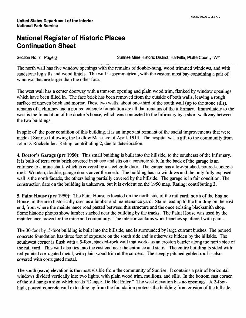
OMB No. 1024-0018, NFS Form
United States Department of the Interior National Park Service
National Register of Historic Places Continuation SheetSection No. 7 Page 6 Sunrise Mine Historic District, Hartville, Platte County, WY
The north wall has five window openings with the remains of double-hung, wood trimmed windows, and with sandstone lug sills and wood lintels. The wall is asymmetrical, with the eastern most bay containing a pair of windows that are larger than the other four.
The west wall has a center doorway with a transom opening and plain wood trim, flanked by window openings which have been filled in. The face brick has been removed from the outside of both walls, leaving a rough surface of uneven brick and mortar. These two walls, about one-third of the south wall (up to the stone sills), remains of a chimney and a poured concrete foundation are all that remains of the infirmary. Immediately to the west is the foundation of the doctor's house, which was connected to the Infirmary by a short walkway between the two buildings.
In spite of the poor condition of this building, it is an important remnant of the social improvements that were made at Sunrise following the Ludlow Massacre of April, 1914. The hospital was a gift to the community from John D. Rockefeller. Rating: contributing 2, due to deterioration.
4. Doctor's Garage (pre 1950): This small building is built into the hillside, to the southeast of the Infirmary. It is built of terra cotta brick covered in stucco and sits on a concrete slab. In the back of the garage is an entrance to a mine shaft, which is covered by a steel grate door. The garage has a low-pitched, poured-concrete roof. Wooden, double, garage doors cover the north. The building has no windows and the only fully exposed wall is the north facade, the others being partially covered by the hillside. The garage is in fair condition. The construction date on the building is unknown, but it is evident on the 1950 map. Rating: contributing 3.
5. Paint House (pre 1950): The Paint House is located on the north side of the rail yard, north of the Engine House, in the area historically used as a lumber and maintenance yard. Stairs lead up to the building on the east end, from where the maintenance road passed between this structure and the once existing blacksmith shop. Some historic photos show lumber stacked near the building by the tracks. The Paint House was used by the maintenance crews for the mine and community. The interior contains work benches splattered with paint.
The 30-foot by 15-foot building is built into the hillside, and is surrounded by large currant bushes. The poured concrete foundation has three feet of exposure on the south side and is otherwise hidden by the hillside. The southwest corner is flush with a 5-foot, stacked-rock wall that works as an erosion barrier along the north side of the rail yard. This wall also ties into the east end near the entrance and stairs. The entire building is sided with red-painted corrugated metal, with plain wood trim at the corners. The steeply pitched gabled roof is also covered with corrugated metal.
The south (eave) elevation is the most visible from the community of Sunrise. It contains a pair of horizontal windows divided vertically into two lights, with plain wood trim, mullions, and sills. In the bottom east corner of the sill hangs a sign which reads "Danger, Do Not Enter." The west elevation has no openings. A 2-foot- high, poured-concrete wall extending up from the foundation protects the building from erosion of the hillside.
0MB No. 1024-0018, NPS Form
United States Department of the Interior National Park Service
National Register of Historic Places Continuation SheetSection No. 7 Page 7 Sunrise Mine Historic District, Hartville, Platte County, WY
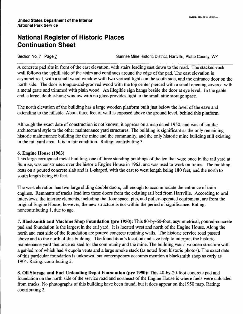
A concrete pad sits in front of the east elevation, with stairs leading east down to the road. The stacked-rock wall follows the uphill side of the stairs and continues around the edge of the pad. The east elevation is asymmetrical, with a small wood window with two vertical lights on the south side, and the entrance door on the north side. The door is tongue-and-grooved wood with the top center pierced with a small opening covered with a metal grate and trimmed with plain wood. An illegible sign hangs beside the door at eye level. In the gable end, a large, double-hung window with no glass provides light to the small attic storage space.
The north elevation of the building has a large wooden platform built just below the level of the eave and extending to the hillside. About three feet of wall is exposed above the ground level, behind this platform.
Although the exact date of construction is not known, it appears on a map dated 1950, and was of similar architectural style to the other maintenance yard structures. The building is significant as the only remaining historic maintenance building for the mine and the community, and the only historic mine building still existing in the rail yard area. It is in fair condition. Rating: contributing 3.
6. Engine House (1963)This large corrugated metal building, one of three standing buildings of the ten that were once in the rail yard at Sunrise, was constructed over the historic Engine House in 1963, and was used to work on trains. The building rests on a poured concrete slab and is L-shaped, with the east to west length being 180 feet, and the north to south length being 60 feet.
The west elevation has two large sliding double doors, tall enough to accommodate the entrance of train engines. Remnants of tracks lead into these doors from the existing rail bed from Hartville. According to oral interviews, the interior elements, including the floor space, pits, and pulley-operated equipment, are from the original Engine House; however, the new structure is not within the period of significance. Rating: noncontributing 1, due to age.
7. Blacksmith and Machine Shop Foundation (pre 1950): This 80-by-60-foot, asymmetrical, poured-concrete pad and foundation is the largest in the rail yard. It is located west and north of the Engine House. Along the north and east side of the foundation are poured concrete retaining walls. The historic service road passed above and to the north of this building. The foundation's location and size help to interpret the historic maintenance yard that once existed for the community and the mine. The building was a wooden structure with a gabled roof which had 4 cupola vents and a large smoke stack (as noted from historic photos). The exact date of this particular foundation is unknown, but contemporary accounts mention a blacksmith shop as early as 1904. Rating: contributing 2.
8. Oil Storage and Fuel Unloading Depot Foundation (pre 1950): This 40-by-20-foot concrete pad and foundation on the north side of the service road and northeast of the Engine House is where fuels were unloaded from trucks. No photographs of this building have been found, but it does appear on the 1950 map. Rating: contributing 2.
OMB No. 1024-0018, NFS FormUnited States Department of the Interior National Park Service
National Register of Historic Places Continuation SheetSection No. 7 Page 8 Sunrise Mine Historic District, Hartville, Platte County, WY
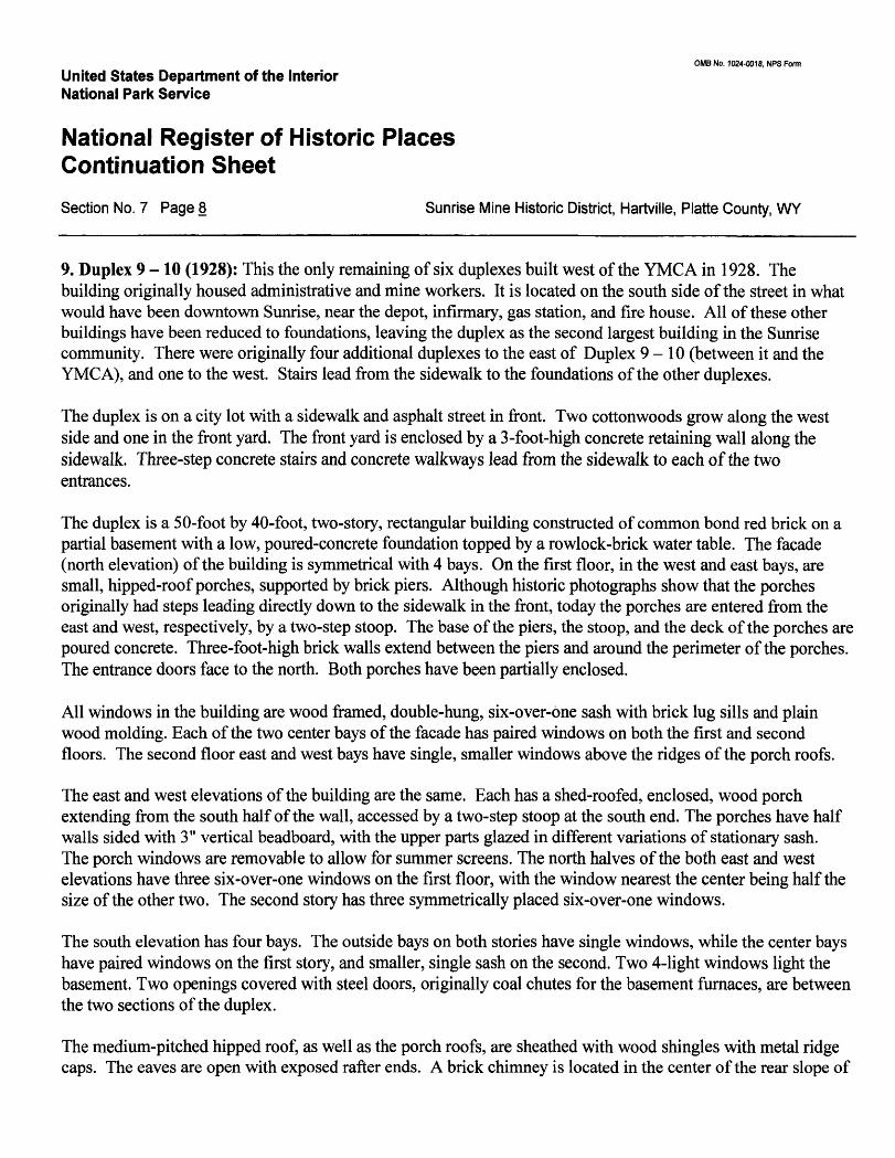
9. Duplex 9-10 (1928): This the only remaining of six duplexes built west of the YMCA in 1928. The building originally housed administrative and mine workers. It is located on the south side of the street in what would have been downtown Sunrise, near the depot, infirmary, gas station, and fire house. All of these other buildings have been reduced to foundations, leaving the duplex as the second largest building in the Sunrise community. There were originally four additional duplexes to the east of Duplex 9-10 (between it and the YMCA), and one to the west. Stairs lead from the sidewalk to the foundations of the other duplexes.
The duplex is on a city lot with a sidewalk and asphalt street in front. Two cottonwoods grow along the west side and one in the front yard. The front yard is enclosed by a 3-foot-high concrete retaining wall along the sidewalk. Three-step concrete stairs and concrete walkways lead from the sidewalk to each of the two entrances.
The duplex is a 50-foot by 40-foot, two-story, rectangular building constructed of common bond red brick on a partial basement with a low, poured-concrete foundation topped by a rowlock-brick water table. The facade (north elevation) of the building is symmetrical with 4 bays. On the first floor, in the west and east bays, are small, hipped-roof porches, supported by brick piers. Although historic photographs show that the porches originally had steps leading directly down to the sidewalk in the front, today the porches are entered from the east and west, respectively, by a two-step stoop. The base of the piers, the stoop, and the deck of the porches are poured concrete. Three-foot-high brick walls extend between the piers and around the perimeter of the porches. The entrance doors face to the north. Both porches have been partially enclosed.
All windows in the building are wood framed, double-hung, six-over-one sash with brick lug sills and plain wood molding. Each of the two center bays of the facade has paired windows on both the first and second floors. The second floor east and west bays have single, smaller windows above the ridges of the porch roofs.
The east and west elevations of the building are the same. Each has a shed-roofed, enclosed, wood porch extending from the south half of the wall, accessed by a two-step stoop at the south end. The porches have half walls sided with 3" vertical beadboard, with the upper parts glazed in different variations of stationary sash. The porch windows are removable to allow for summer screens. The north halves of the both east and west elevations have three six-over-one windows on the first floor, with the window nearest the center being half the size of the other two. The second story has three symmetrically placed six-over-one windows.
The south elevation has four bays. The outside bays on both stories have single windows, while the center bays have paired windows on the first story, and smaller, single sash on the second. Two 4-light windows light the basement. Two openings covered with steel doors, originally coal chutes for the basement furnaces, are between the two sections of the duplex.
The medium-pitched hipped roof, as well as the porch roofs, are sheathed with wood shingles with metal ridge caps. The eaves are open with exposed rafter ends. A brick chimney is located in the center of the rear slope of
OMB No. 1024-0018, NFS Form
United States Department of the Interior National Park Service
National Register of Historic Places Continuation SheetSection No. 7 Page 9 Sunrise Mine Historic District, Hartville, Platte County, WY
the roof.
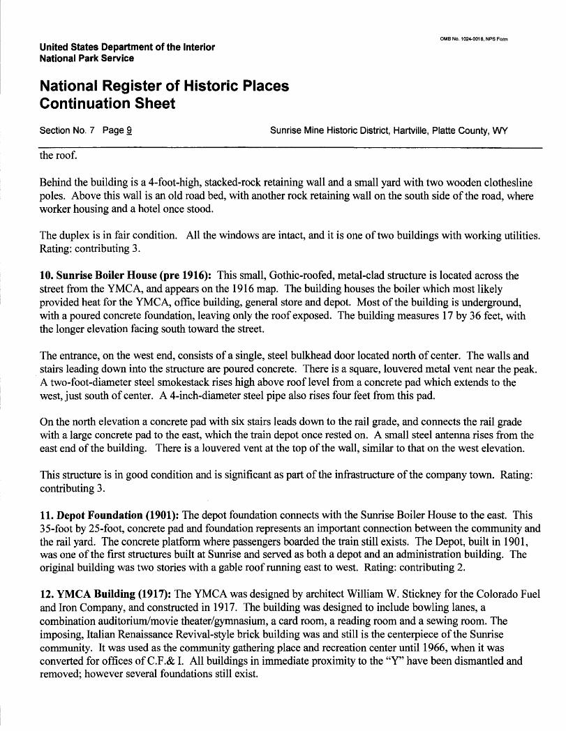
Behind the building is a 4-foot-high, stacked-rock retaining wall and a small yard with two wooden clothesline poles. Above this wall is an old road bed, with another rock retaining wall on the south side of the road, where worker housing and a hotel once stood.
The duplex is in fair condition. All the windows are intact, and it is one of two buildings with working utilities. Rating: contributing 3.
10. Sunrise Boiler House (pre 1916): This small, Gothic-roofed, metal-clad structure is located across the street from the YMCA, and appears on the 1916 map. The building houses the boiler which most likely provided heat for the YMCA, office building, general store and depot. Most of the building is underground, with a poured concrete foundation, leaving only the roof exposed. The building measures 17 by 36 feet, with the longer elevation facing south toward the street.
The entrance, on the west end, consists of a single, steel bulkhead door located north of center. The walls and stairs leading down into the structure are poured concrete. There is a square, louvered metal vent near the peak. A two-foot-diameter steel smokestack rises high above roof level from a concrete pad which extends to the west, just south of center. A 4-inch-diameter steel pipe also rises four feet from this pad.
On the north elevation a concrete pad with six stairs leads down to the rail grade, and connects the rail grade with a large concrete pad to the east, which the train depot once rested on. A small steel antenna rises from the east end of the building. There is a louvered vent at the top of the wall, similar to that on the west elevation.
This structure is in good condition and is significant as part of the infrastructure of the company town. Rating: contributing 3.
11. Depot Foundation (1901): The depot foundation connects with the Sunrise Boiler House to the east. This 35-foot by 25-foot, concrete pad and foundation represents an important connection between the community and the rail yard. The concrete platform where passengers boarded the train still exists. The Depot, built in 1901, was one of the first structures built at Sunrise and served as both a depot and an administration building. The original building was two stories with a gable roof running east to west. Rating: contributing 2.
12. YMCA Building (1917): The YMCA was designed by architect William W. Stickney for the Colorado Fuel and Iron Company, and constructed in 1917. The building was designed to include bowling lanes, a combination auditorium/movie theater/gymnasium, a card room, a reading room and a sewing room. The imposing, Italian Renaissance Revival-style brick building was and still is the centerpiece of the Sunrise community. It was used as the community gathering place and recreation center until 1966, when it was converted for offices of C.F.& I. All buildings in immediate proximity to the "Y" have been dismantled and removed; however several foundations still exist.
0MB No. 1024-0018, NFS Form
United States Department of the Interior National Park Service
National Register of Historic Places Continuation SheetSection No. 7 Page 10 Sunrise Mine Historic District, Hartville, Platte County, WY
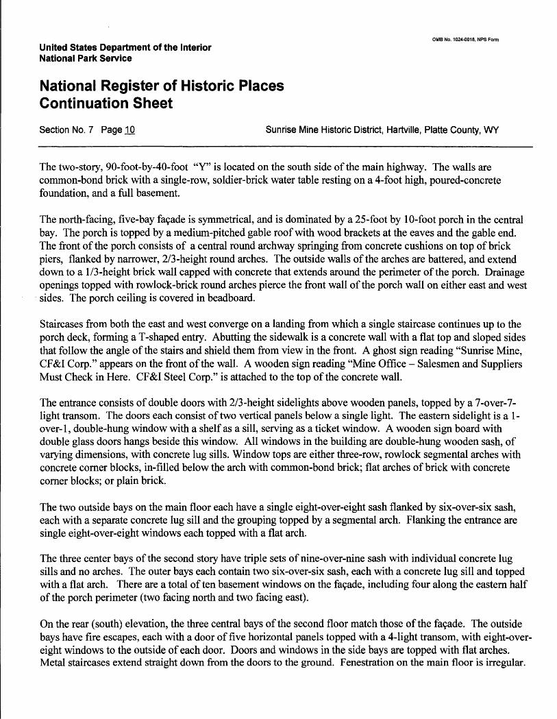
The two-story, 90-foot-by-40-foot "Y" is located on the south side of the main highway. The walls are common-bond brick with a single-row, soldier-brick water table resting on a 4-foot high, poured-concrete foundation, and a full basement.
The north-facing, five-bay fa9ade is symmetrical, and is dominated by a 25-foot by 10-foot porch in the central bay. The porch is topped by a medium-pitched gable roof with wood brackets at the eaves and the gable end. The front of the porch consists of a central round archway springing from concrete cushions on top of brick piers, flanked by narrower, 2/3-height round arches. The outside walls of the arches are battered, and extend down to a 1/3-height brick wall capped with concrete that extends around the perimeter of the porch. Drainage openings topped with rowlock-brick round arches pierce the front wall of the porch wall on either east and west sides. The porch ceiling is covered in beadboard.
Staircases from both the east and west converge on a landing from which a single staircase continues up to the porch deck, forming a T-shaped entry. Abutting the sidewalk is a concrete wall with a flat top and sloped sides that follow the angle of the stairs and shield them from view in the front. A ghost sign reading "Sunrise Mine, CF&I Corp." appears on the front of the wall. A wooden sign reading "Mine Office - Salesmen and Suppliers Must Check in Here. CF&I Steel Corp." is attached to the top of the concrete wall.
The entrance consists of double doors with 2/3-height sidelights above wooden panels, topped by a 7-over-7- light transom. The doors each consist of two vertical panels below a single light. The eastern sidelight is a 1- over-1, double-hung window with a shelf as a sill, serving as a ticket window. A wooden sign board with double glass doors hangs beside this window. All windows in the building are double-hung wooden sash, of varying dimensions, with concrete lug sills. Window tops are either three-row, rowlock segmental arches with concrete corner blocks, in-filled below the arch with common-bond brick; flat arches of brick with concrete corner blocks; or plain brick.
The two outside bays on the main floor each have a single eight-over-eight sash flanked by six-over-six sash, each with a separate concrete lug sill and the grouping topped by a segmental arch. Flanking the entrance are single eight-over-eight windows each topped with a flat arch.
The three center bays of the second story have triple sets of nine-over-nine sash with individual concrete lug sills and no arches. The outer bays each contain two six-over-six sash, each with a concrete lug sill and topped with a flat arch. There are a total often basement windows on the fa9ade, including four along the eastern half of the porch perimeter (two facing north and two facing east).
On the rear (south) elevation, the three central bays of the second floor match those of the fa9ade. The outside bays have fire escapes, each with a door of five horizontal panels topped with a 4-light transom, with eight-over- eight windows to the outside of each door. Doors and windows in the side bays are topped with flat arches. Metal staircases extend straight down from the doors to the ground. Fenestration on the main floor is irregular.
OMB No. 1024-0018, NFS Form
United States Department of the Interior National Park Service
National Register of Historic Places Continuation SheetSection No. 7 Page H Sunrise Mine Historic District, Hartville, Platte County, WY
At the center is a composite window consisting of a center six-over-six sash flanked by very narrow, vertical two-over-two lights. The window is topped by a segmental arch like those on the facade. A similar composite window, lacking the arch, lies to the west. A total of three small, four-over-four sash are on either side and between the two composite windows. The westernmost bay contains two eight-over-eight sash, and the easternmost bay has a rear entrance door with a four-light transom, topped by a gabled hood supported by wood brackets, and to the east, four six-over-six sash. All first floor windows have concrete lug sills, and all but the central window have plain brick surrounds. There are eight basement windows on the south elevation.
An exterior brick chimney with concrete base, shoulders and cap rises at the center of the east elevation The chimney is flanked by paired six-over-six windows with individual concrete lug sills and a single segmental arch over each on the first floor, and single six-over-six windows with flat arches on the second story. It is also flanked by a pair of boarded-up windows trimmed in plain wood on the basement level.
The central bay of the west elevation is offset one-half story, and has one eight-over-eight sash next to an entrance door on the lower story, two tall, nine-over-nine sash between the first and second stories, and two small, six-pane sash at the eave. The eight-light-over-wood-panel-door is accessed by a 4-step concrete stoop and leads to stairs on the inside that go up to the first floor, or down to the basement. The top windows light the projection room. The outside bays match those of the east elevation. Basement windows match those of the east elevation, flanking the stoop.
The building is topped with a medium-pitched, hipped roof with wood shingles and two louvered eye-brow dormers accenting both the front and rear slopes. The eaves are bracketed.
Main interior points of interest include the second story combination auditorium/movie theater/gymnasium with a stage, wooden movie screen and projection room. On the main floor, the meeting room at the east end of the building has a prominent brick fireplace. In the basement, one of the three original bowling lanes remains intact, with its manual pin setter. The building is structurally sound with no apparent signs of damage to the roof, foundation, porch or chimney. Several windows are missing. Rating: contributing 3.
13. Filling Station and Oil Change Pit Foundation (1926): This 15-by-20-foot concrete pad is across the street and east of the YMCA. Once a garage and filling station for the community, it represents an important part of community life, and the beginning of the automobile era at Sunrise. The station is on the 1950 map. Rating: contributing 2.
14. Fire House Foundation (pre 1950): East of the filling station is a 30-by-20-foot foundation for a garage that housed the fire trucks. The concrete pad still has a yellow parking line painted on it. Rating: contributing 2.
15. Sunrise Garage (1917): This garage, located east of and across the road from the YMCA, was originally rented out to residents of Sunrise as they began to acquire automobiles. The south-facing facade borders the street and is a very substantial contributor to the Sunrise streetscape.
OMB No. 1024-0018, NFS Form
United States Department of the Interior National Park Service
National Register of Historic Places Continuation SheetSection No. 7 Page 12 Sunrise Mine Historic District, Hartville, Platte County, WY
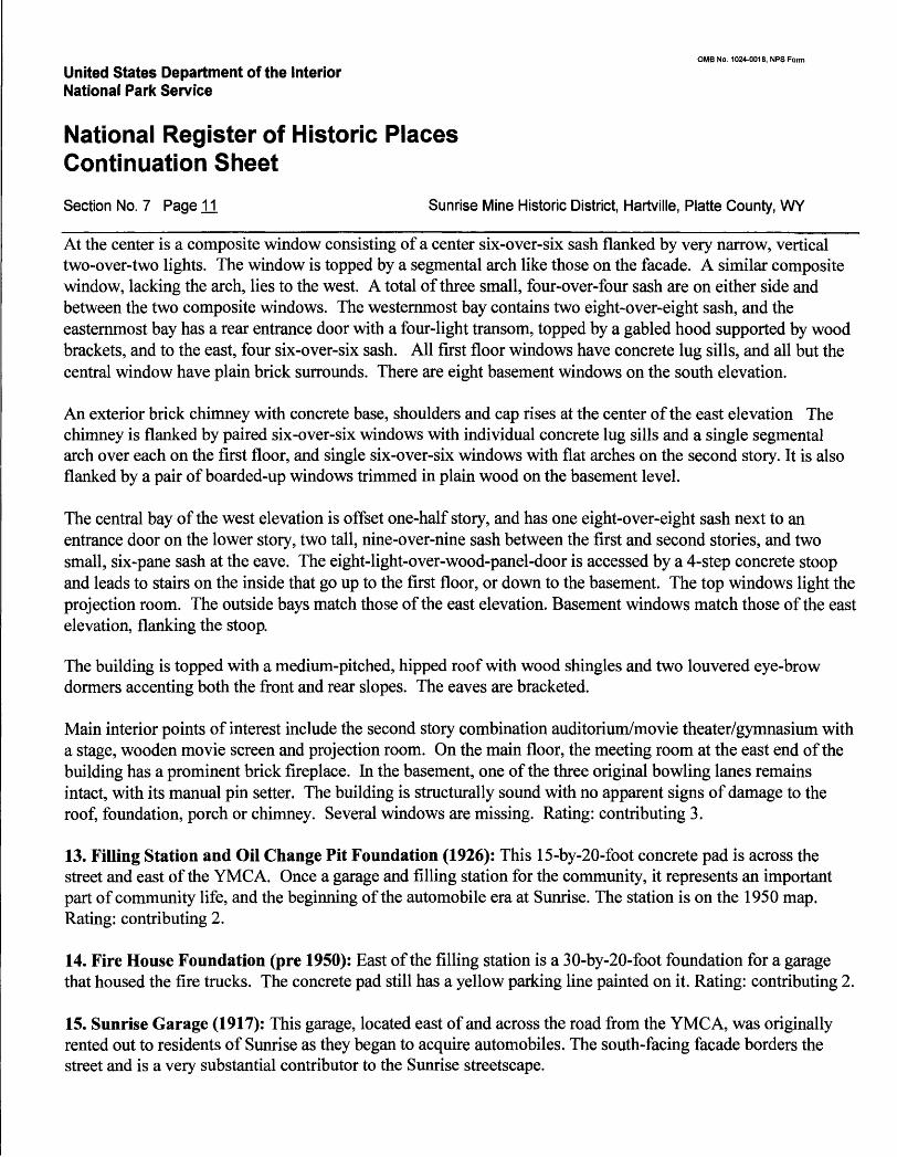
The garage is built of the same red brick found in most of the buildings at Sunrise. The foundation is very low, and sloped to allow cars to enter the 13 garage bays. The facade is symmetrical with five bays on either side of a center bay. Two bays were added to the west end before 1950 (noted on a 1950 map). Three-foot-high steel posts set three feet from the walls separate each drive, guiding the cars into the bays. All of the bays have double wooden doors, painted red and numbered. Historically all of the original 22 doors had 8-light windows above a slanted, tongue-and-groove panel with a 2" x 6" diagonal cross. Today some of the original muntins exist, but all windows are covered.
Starting at the west end, bays 3, 12 and 13 are missing doors. Bays 4 and 5 have wooden replacement doors. Bay 8 (the original center bay before two bays were added to the west end) has an ornate, Tudor-styled stepped parapet which extends over and above a small, intersecting gable.
The eave-front, medium-pitched, gabled roof is covered in corrugated metal and is in poor condition. Three brick stepped parapets capped with concrete, one at each end and the third marking the original west end of the garage, extend above the roof.
The west and east elevations both have bricked-in windows with segmental brick arches. The foundation on the west end is ten feet high. The north elevation has two vertical tongue-and-groove, overhead garage doors in the west addition. The westerly most door has a sign reading "Ambulance." All windows on this elevation have brick segmental arches, and have been in-filled with brick. The building is in good condition. Rating: contributing 3.
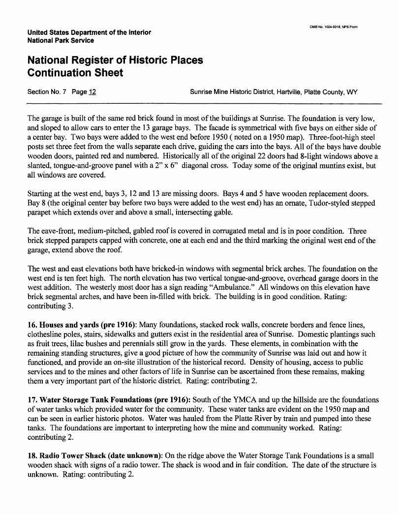
16. Houses and yards (pre 1916): Many foundations, stacked rock walls, concrete borders and fence lines, clothesline poles, stairs, sidewalks and gutters exist in the residential area of Sunrise. Domestic plantings such as fruit trees, lilac bushes and perennials still grow in the yards. These elements, in combination with the remaining standing structures, give a good picture of how the community of Sunrise was laid out and how it functioned, and provide an on-site illustration of the historical record. Density of housing, access to public services and to the mines and other factors of life in Sunrise can be ascertained from these remains, making them a very important part of the historic district. Rating: contributing 2.
17. Water Storage Tank Foundations (pre 1916): South of the YMCA and up the hillside are the foundations of water tanks which provided water for the community. These water tanks are evident on the 1950 map and can be seen in earlier historic photos. Water was hauled from the Platte River by train and pumped into these tanks. The foundations are important to interpreting how the mine and community worked. Rating: contributing 2.
18. Radio Tower Shack (date unknown): On the ridge above the Water Storage Tank Foundations is a small wooden shack with signs of a radio tower. The shack is wood and in fair condition. The date of the structure is unknown. Rating: contributing 2.
OMB No. 1024-0018, NFS Form
United States Department of the Interior National Park Service
National Register of Historic Places Continuation SheetSection No. 7 Page 13 Sunrise Mine Historic District, Hartville, Platte County, WY
Houses #1-5 (1918)
The community of Sunrise once had a population of over 500 people. The majority of the homes, which were constructed of wood, have been removed or destroyed. The only remaining single-family residences are five brick houses, one of which is occupied by the owner of Sunrise. The construction and style of these homes are the same; their condition ranges from good to poor. Three of the homes sit together at the south end of the easternmost street, on the west side of the street (facing east). The other two homes are located near the entrance to the mining area, and face south. The two sets of houses are separated by the remains of the Residential Garage. The brick houses were built in 1918, during the period when C. F. & I. made a concerted effort to improve housing conditions in their mining camps.
House #1 (Building No. 23) is described in detail below. For the other four houses, only differences from House # 1 are described.
19. House #5: The northern house of the west-facing pair is identical to House #1, except its chimney is intact. This home is in good condition and is being used as a residence by the owner. Rating: contributing 3.
20. House #4: The southern house of the west-facing pair is identical to House #1, with an intact chimney and an uncovered bulkhead cellar door. This home is in fair condition. Rating: contributing 3.
21. House #3: The northernmost east-facing home is identical to House #1 except that the chimney is not damaged. The home is in fair condition. Rating: contributing 3.
22. House #2: Identical to House #1. Rating: contributing 3.
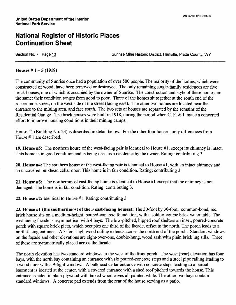
23. House #1 (the southernmost of the 3 east-facing houses): The 30-foot by 30-foot, common-bond, red brick house sits on a medium-height, poured-concrete foundation, with a soldier-course brick water table. The east-facing facade is asymmetrical with 4 bays. The low-pitched, hipped roof shelters an inset, poured-concrete porch with square brick piers, which occupies one third of the facade, offset to the north. The porch leads to a north-facing entrance. A 3-foot-high wood railing extends across the north end of the porch. Standard windows on the fa9ade and other elevations are eight-over-one, double-hung, wood sash with plain brick lug sills. Three of these are symmetrically placed across the fa9ade.
The north elevation has two standard windows to the west of the front porch. The west (rear) elevation has four bays, with the north bay containing an entrance with six poured-concrete steps and a steel pipe railing leading to a wood door with a 9-light window. A bulkhead cellar entrance with concrete steps leading to a partial basement is located at the center, with a covered entrance with a shed roof pitched towards the house. This entrance is sided in plain plywood with boxed wood eaves all painted white. The other two bays contain standard windows. A concrete pad extends from the rear of the house serving as a patio.
OMB No. 1024-0018, NPS Form
United States Department of the Interior National Park Service
National Register of Historic Places Continuation SheetSection No. 7 Page .14 Sunrise Mine Historic District, Hartville, Platte County, WY
The south elevation is separated into two sections by a large brick chimney projecting one brick length from the wall and extending through the eave past the peak of the roof. This chimney is damaged and has fallen to the level of the roof. In the west section are two sets of six-over-one paired windows with a plain brick sill extending the length of each pair. The east half contains a standard window.
The low-hipped roof is covered in wood shingles. A small, gabled dormer with a wooden louvered opening extends from the center of the pitch on the front and rear elevations. The rafter tails are exposed, with a fascia board covering the rafter ends. The house is in poor condition. Rating: contributing 3.
24. Residential Garage Foundation (1918,1924,1926): This 65-bay garage ran along the east side of the town site, from House #4 south to House #1. It was built in three stages, starting in 1918 when the brick houses were built, with additional bays added in 1924 and 1926. The 650-foot, poured-concrete east wall of the garage serves as a retaining wall and is still standing. The 20-foot-wide end walls and foundations of the walls separating the stalls still exist, but the roof and the entire west wall (where the doors were) has been removed. This garage is another example of the improvements made to living conditions at the C. F. & I. company towns in the 1910s and 20s. It also reflects a change in the Sunrise community, when residents began to own cars. Eventually, they used their new mobility to move out of the company town and commute to work, spelling the end of Sunrise as a community. Rating: contributing 2.
East and West Bachelor Quarters (1910): The two Bachelor Quarters are on the south slope of the canyon above the road leading from the community to the mine. These are the last residential buildings before the mine entrance. The buildings were originally quarters for single working men, and in later years were used to store core samples. Currently both buildings are filled with shelves full of core samples. The structures sit higher in elevation than all buildings but the Hoist House. From the front porches, the bachelors could have watched most of the workings of the mine and community.
These originally identical 60-foot by 24-foot buildings are constructed of poured concrete, and sit on poured- concrete foundations. To the north, just below and parallel to the buildings, runs a three-foot-high, stacked-rock wall which extends beyond the buildings to the east and west. The roofs are medium-pitched, hipped, covered with wooden shingles and have boxed eaves. Windows are 4-over-4-light, double-hung wood sash, with plain wood trim. Window and door openings are topped with segmental arches.
Originally these buildings were separated into four apartments. Despite the floor to ceiling drawers of core samples, and the fact that entrances and windows have been covered on several exterior walls, the old quarters can still be made out.
25. West Bachelor Quarters: The east and west elevations are the same, with two symmetrically placed windows. The south elevation has four asymmetrical bays, with two windows and two entrances, one of which is double-sized, and neither of which have doors.
OMB No. 1024-0018, NFS Form
United States Department of the Interior National Park Service
National Register of Historic Places Continuation SheetSection No. 7 Page 15 Sunrise Mine Historic District, Hartville, Platte County, WY
The north elevation is symmetrical with 8 bays. Starting from the east, bays 1, 3, 6, and 8 are doorway entrances, with no doors in bays 1 and 8. The opening in bay 3 is covered with horizontal boards, and the opening in bay 6 has boards on the bottom and a window in the top. Bays 2 and 4 contain boarded-up windows, and bays 5 and 7 have standard windows. Concrete steps and stoop lead up to the entrance in bay 8. A 5-foot wide wooden deck with no railing extends the length of the north elevation.
There are three symmetrically placed brick chimneys, one at the center of the building, and one at each end of the ridge. The building is in poor condition. Rating: contributing 3.
26. East Bachelor Quarters: This structure sits slightly higher in elevation. The west elevation has two symmetrically placed windows. The east elevation has two symmetrically placed windows which have been in filled. The south elevation has four asymmetrical bays, with two windows (in-filled) and two doorways. The entrance near the southwest corner has a five-panel wooden door with plain wood trim, and the entrance east of center has no door.
At the northeast corner of the north elevation, four stairs lead up to a concrete stoop with a metal pipe railing, which leads to an entrance similar to those on the south side. A single straddle-ridge brick chimney rises from the west end of the roof. The structure is in poor condition. Rating: contributing 3.
27. The "Dry" Shower House (1906): Located near the entrance to the underground mine, this is one of the first buildings seen when entering the mining area from the Sunrise community. This building was used by the workers each day to change from their red-stained work clothes to clean clothes. It had two entrances, one for a dirty worker to disrobe and shower, and one for a clean worker to get dressed and leave for home. A small office was used for time clocks and administrative work.
The Dry is a 100-foot by 30-foot, red-brick building similar in style to the Boiler House. It stands on a low, poured-concrete foundation. The main fa9ade, which faces west, has a 10-foot by 15-foot, concrete-block addition extending from just north of center to the southwest corner of the building. Lettering reading "Sunrise Mine CF&I Steel Corp." is painted on the west wall of the addition. The gable end of the addition is stucco trimmed in plain wood, with a small, rectangular, louvered vent near the peak. The eaves are boxed, with plain trim.
Two bays of the original building are exposed on the north half of the fa9ade. Each bay has a wooden, double- hung, 4-over-4 window topped with a two-row, rowlock-brick segmental arch. The bays are separated by raised-brick pilasters connected at the top by corbelling which steps up along the eaves. A wooden, louvered vent has been installed just north of the center pilaster. The corbelling continues on the south half of the fa9ade, but most of it is covered by the addition. A circle of rowlock brick decorates the gable end.
OMB No. 1024-0018, NPS Form
United States Department of the Interior National Park Service
National Register of Historic Places Continuation SheetSection No. 7 Page 16 Sunrise Mine Historic District, Hartville, Platte County, WY
The north elevation faces the mine and is where miners would enter after a day or night in the mine. This 100- foot-long side of the building is broken up into 14 bays by brick pilasters. The elevation is asymmetrical with openings in every other bay. Starting at the east end, Bay 1 has a wooden, vertical-board door with plain trim, topped by a two-row brick segmental arch. Bays 3, 5, 7, 9, and 11 have window openings with segmental arches and brick lug sills, with frames and glass missing. Bay 6 contains the main entrance, with an enclosed porch topped by a gable roof. The door is missing. Bay 14 contains an entrance with the same details as bay 1, but without the door. To the west of this entrance is a small, double-hung, wooden window missing the glass and muntins.
The east elevation is similar to the facade in number of bays, pilasters and corbelling, but there is no decorative brick circle in the gable end, and all of the window frames are missing. A small, shed-roofed, stuccoed entrance addition extends at the southeast corner. A single-light, plain trimmed, wood door faces north as an entrance into the east end of the building.
The south elevation sits about 5 feet away from a 9-foot-high, stacked-rock retaining wall. The wall supports a rail bed that passes on the south side, uphill from the Dry. Like the north elevation, the south is accented by 15 raised brick pilasters, but each of the 14 bays contains a 4-over-4, double-hung window, with the same segmental arches and brick lug sills, except the 5th bay from the west, which has a 6-over-6 window. Most of these are missing glass and have broken muntins.
The long, medium-pitched, gable roof is in poor shape. The roof is partially covered with tongue and groove board, with no roofing material on it. East of center, evenly spaced along the peak, are three cylindrical vents with conical tops.
The interior of the Dry still contains some of the original piping and showers. This is an unusual and important building, in that it demonstrates a little recognized but important part of the mining process - getting clean ~ thus contributing significantly to telling the story of mining life at Sunrise. The structure is in fair condition. Rating: contributing 3.
28. Laboratory (1917): The laboratory was used for testing ore samples at the mine, and is located just east of the Dry and to the south of the Boiler House and Coal Storage. The building has a four-to-five-foot, stacked- rock retaining wall along the south and east sides. This one-story, 50-foot by 20-foot, common-bond, red-brick structure rests on a concrete basement.
The Lab is entered from the south, although this elevation faces away from the other buildings, towards a stone wall. The south elevation has 5 bays. The western three bays each contain a standard 4-over-4-light, double- hung window. To the east is a one-light-over two-panel wood door with plain trim, and at the east end is a pair of standard windows with brick lug sills, separated by a brick mullion. The basement has one awning window.
OMB No. 1024-0018, NPS Form
United States Department of the Interior National Park Service
National Register of Historic Places Continuation SheetSection No. 7 Page T7 Sunrise Mine Historic District, Hartville, Platte County, WY
The west elevation has 3 bays, each containing a standard window. The north elevation has 5 asymmetrically placed standard windows. The east elevation has three bays, with standard windows in the outside bays, a door in the center, and a bulkhead entrance to the basement beneath the south window.
The medium-pitched, hipped roof has wooden shingles with exposed rafter tails. Three wood-shingle-clad structures protrude from the ridge. A flue which was originally about 10-feet high, but has broken off, extends from a hood above the lab area inside the building. To the west of the flue is a rectangular chimney, and to the east is a smaller, square chimney. In center of the main room of the Lab is a large wooden work area, topped by a hood that drew the chemicals out of the building. Work benches also line the perimeter of the room.
The Laboratory is significant in telling the story of how ore was tested and evaluated. The building appears to be in fair structural condition, although all the windows are broken. Rating: contributing 3.
29. Boiler House (1904): The Boiler House is a one-story, front-gabled red brick industrial structure with the main fa9ade facing west. The building historically housed a boiler for creating electricity for the mine. Historic photographs show a large smoke stack rising above the north side. In 1906, the Boiler House suffered an explosion, which blew a hole in one of the walls. In 1926, electricity was brought in from the Guernsey Dam on the North Platte River, eliminating the need for the boilers. This building was later used as a warehouse.
The Boiler House can be seen from many parts of the canyon. It stands at the base of a slope that creates the east-to-west Eureka Canyon, and at the southeast edge of the Glory Hole, dwarfed by the massive open pit mine it once supplied power for. Cottonwood trees stand along the southwest side. An old road bed passes along the south side and the road connecting Sunrise to the Chicago Mine Site rises up the slope on the southwest side. The concrete foundation and slab of the #1 Shaft engine house and lamp house still exist underneath a recently built reclamation berm. The Lab, Dry, and Coal Storage structures are to the south.
The building sits on a concrete slab and is constructed of brick in a combination of common bond and stretcher bond. The facade consists of three bays, each defined by a raised brick pilaster connected by 3-brick corbelling which rises along the eaves in four steps. In the north bay, a 4-step stoop leads to a man-door entrance with a plain wood frame and trim, no door, and a three-row, rowlock-brick, segmental-arched top. The middle bay has a large, double-hung window which reaches half-way up the wall, with a three-row, rowlock-brick, segmental arch and a sandstone lug sill. Most muntins are broken out of the plain wood window frame. In the bottom corner of the south bay, near the edge of the pilaster and two feet from the ground, is a 2-foot-square opening covered with plywood.
The south elevation of the building has six bays defined by raised brick pilasters. Starting from the east, bays 1, 3, 4 and 6 have large windows which were originally (based on historic photographs) 25-over-25 light, but are now 25-over-l. The windows have sandstone sills and rowlock-brick, segmental arched tops. The window in bay 6 has been made into a door. The second bay has a man door topped with a segmental arch. A metal, crane- neck yard light extends from the center pilaster.
OMB No. 1024-0018, NFS Form
United States Department of the Interior National Park Service
National Register of Historic Places Continuation SheetSection No. 7 Page 18 Sunrise Mine Historic District, Hartville, Platte County, WY
The east elevation matches the fa9ade, with the exception of a large garage-door entrance in the center bay, with the remains of a sliding door track, but no door. Judging from historic photographs, this door opening is not original.
On the north elevation at the west end is a car-sized garage-door opening with a concrete stoop and double, vertical-wood doors, sheltered by a small gabled roof with exposed brackets, covered with corrugated metal. Beginning six feet to the east of this opening is a second opening, twice as large as the opening to the west, with a concrete stoop and the same style roof, and with a metal sliding door track but no door. Five large, multi- paned windows with brick lug sills and no glass extend across the wall just below the eave, from the east end to just west of the large opening. Segmental arches over brick infill along the lower portion of the east half of the wall and just above the smaller opening indicate that there were once additional windows on this elevation. The medium-pitched gable roof is covered in galvanized metal. The eaves and gable ends have exposed rafter tails and plain wood fascia boards.
Although the building is standing square and seems to be structurally sound, it is in poor condition. All of the windows are broken, and most doors have been removed. The brick work is in need of repointing, and some of the metal sheathing is coming off the roof. The Boiler House is the closest structure to the Glory Hole, and the land above the building is unstable. Because of this, it is the most threatened building at the site. Rating: contributing 3.
30. #1 Shaft Engine House & Lamp House Foundation (1902): This poured concrete foundation is located to the west of the Boiler House. The foundation has an intact half basement. This foundation depicts where the original 200-foot shaft was dug in 1902 to facilitate the glory hole method of mining. It was later used for block-cave mining as well. A 90-foot-tall head frame originally extended above the shaft. This structure was also where miners picked up their lights before going into the mine. Currently this entire foundation is underneath a temporary reclamation berm built in 2004, precluding an accurate measurement of the foundation. Rating 1: non-contributing due to the fact that it is currently not visible.
31. Water Storage Tank Foundations (1904,1920): North of the Boiler House and up the hillside are the foundations of the tanks which provided water for the Boiler House. Rating: contributing 2.
32. Coal Bin and attached structures (1904 and later additions): When coal was brought to the mine to power the boiler in the old Boiler House, it was brought to this building. At one time a short train trestle existed where coal cars could be unloaded into the bins below. Today the large concrete bins, two attached buildings, two concrete piers, and a raised rail bed still exist to interpret the site. This structure is in the heart of the industrial area, located on the south side of the road from the Boiler House. It was once part of a complex of three buildings, one of which housed the coal-burning boiler that produced steam for the Boiler House to generate electricity for the mine. The boiler building is now gone with only the gable end left. Attached to the west end of the coal bin is a small cinder-block warehouse. The date of construction is unknown, but historic
OMB No. 1024-0018, NFS Form
United States Department of the Interior National Park Service
National Register of Historic Places Continuation SheetSection No. 7 Page 19 Sunrise Mine Historic District, Hartville, Platte County, WY
photos and documents about use of the structures indicate that they are well within the period of significance. The Coal Bin and related structures all appear on the 1950 map.
The entire three-part structure sits on a diagonal from the rest of the mine buildings. The coal bin and its attached buildings are a large rectangle running from southeast to northwest, with the coal bin on the southeast end. This will be referred to as the east end. Leading up to the east end are the raised rail bed and the concrete piers of the trestle which once allowed trains to back over the coal bin and unload coal. This end of the structure is a ten-foot-high, poured-concrete wall with no openings. Remains of foundations and walls extend in a rectangle off the north half about 3-5-feet high. At the top of the south half of this wall is where the rail cars once backed over the structure to unload. Large grooves are cut into the top of the wall where ties once existed to hold the rails that extended from the trestle. Below this half of the building is the coal bin. On either side of the bin are six-foot-high, poured-concrete walls with sloping concrete buttresses supporting the walls on the interior above the coal bin.
The south elevation of the coal bin consists of a rock wall topped by a six-foot-high, poured-concrete wall which runs the length of this side, serving as a catch and block for coal being unloaded on the other side of the wall. Six large, concrete brackets extend from the upper half of the rock wall to support the upper concrete wall. Extending thirty feet from the coal bin to the west is a 15-foot high, flat-roofed, poured-concrete structure, with a small window opening in the center of the wall at the eave.
Attached to this building is a one-story, cinderblock structure with a gabled roof covered in corrugated metal. The south and north elevations of this addition each has a 4-over-4, double-hung wood window set horizontal and trimmed in plain wood. The eaves are boxed in plain trim.
The west elevation is the gable end of the cinderblock warehouse addition. The north half of the elevation has a poured concrete pad leading up to a garage entrance with double, wooden, hinged doors made of three-inch vertical wood slats and trimmed in plain wood. Near the south corner is a solid wood man-door with plain trim. The gabled end is covered in corrugated metal with a 2-foot-square opening near the peak trimmed in plain wood.
On the north elevation, the poured concrete addition (central section of the three-section structure) has a single, two-panel, wood door trimmed in plain wood in the center, topped by a poured-concrete lintel. Close to the east edge, where this addition is attached to the coal bin, is a metal ladder with 12 rungs, leading to the roof. This was most likely access for workers who unloaded the coal cars.
The north elevation of the coal bin structure consists of a poured concrete wall terminating in a gable. This gable end was once the south end of the boiler building, which extended to the north towards the brick Boiler House. Only this wall and the poured concrete pad remain. The wall has an opening in the center near ground level, where the coal overflowed into the boiler building, and a smaller opening at ground level covered with a steel plate.
OMB No. 1024-0018, NFS Form
United States Department of the Interior National Park Service
National Register of Historic Places Continuation SheetSection No. 7 Page 20 Sunrise Mine Historic District, Hartville, Platte County, WY
Although at first glance this structure is difficult to decipher, enough remains to interpret the coal-burning phase of power generation at the mine. Rating: contributing 2.
33. Wash Plant and Settling Basin (1964): Located across from the Coal Bin to the northeast, these walls created a place where the ore was sorted before shipment. This was associated with the Beneficiation Plant, which is not within the period of significance. Rating: noncontributing 1, due to age.
34. #3 Shaft (1943): A 70-foot by 35-foot concrete pad or lid covers the 700-foot-deep #3 Shaft, which was connected with the Wright Tipple, completed in 1945. This foundation is associated with the Hoist House. Rating: contributing 2.
35. Hoist House (1944): Along with the Wright Shaft and Tipple, the Hoist House was constructed during WWII when the mine was at peak production. The building housed the massive motors and pulleys which ran the cable to the top of the 199-foot-high tipple and lowered and raised ore, men, and supplies up and down the 700-foot-deep Wright Shaft. The Hoist House served the mine for almost 40 years and is the largest structure left standing on the site.
The 65-by-200-foot building is constructed of red brick, and built into a hillside above and southeast of the Lab and the Dry. A gravel road passes along the south side and a parking area is on the east end. The foundation is poured concrete with a varying height. A partial basement on the north end provided space for maintenance on the equipment..
The north facade is where the cables historically left the Hoist House. The facade is separated into 11 bays by raised-brick pilasters which extend up from the six-foot-high foundation, changing from concrete to brick at the water table. Each bay terminates in 3-brick corbelling rising to a plain brick entablature. In the top half of each bay are square panels of raised brick.
The bays will be described from east to west as bays 1-11. In the basement level, bays 1, 2, and 11 have two symmetrical openings covered by wooden louvers. Bay 6 has this same feature but only one opening. Bay 9 has two 3-over-3-light, casement windows with metal muntins and plain wood trim.
On the main floor, bays 1-4 and 9-11 are identical, each having a pair of large, 20-light windows separated by a plain brick mullion, with brick sills and lintels. The windows have metal muntins and plain wood trim, and the middle section opens as an awning window. Bays 5, 6, 7 and 8 have irregularly spaced rectangular openings designed to allow cables to pass. The two center bays (6 and 7) are about 2/3 the size of the other bays.
The south elevation is identical to the north in number of bays and brick treatment, except that the bases of the pilasters have 4-step corbelling a foot above where they change from concrete to brick. The water table on this side is very low because it is on the uphill side and along the road. All bays but one have the same paired, 20-
0MB No. 1024-0018, NPS Form
United States Department of the Interior National Park Service
National Register of Historic Places Continuation SheetSection No. 7 Page 21. Sunrise Mine Historic District, Hartville, Platte County, WY
light windows. The fourth bay from the west end has a large wooden garage door, which slides upward into the interior of the building. Forty feet from the east end is a 2-foot diameter steel pipe which rises almost to the level of the top of the windows. A square steel box rests on top on this pipe.
The east elevation has four symmetrical bays. The south bay has a large wooden garage door that slides upward into the interior of the building. The other bays match those of the south elevation. The wall extends above the roof line forming a two-step parapet, which is capped in concrete.
The west elevation matches the east above the water table. Below, the foundation is exposed at the north end, and a 44-step concrete staircase with a steel pipe railing and 4 landings runs along the foundation. A plain, two- panel wood door opens into the partial basement near the northwest corner. Above the door, "AD WOOD CONST CO 1943" is stamped in the concrete.
The Hoist House represents a new era of industrial mining at Sunrise, spurred by the nation's demand for iron during the war years. The building is in good structural condition. Rating: contributing 3
36. Blasting Cap Magazine (date unknown): This small shed-like structure is built into the hillside southwest of the Hoist House. The low, shed-roofed, poured-concrete building has a garage door entrance with double wooden doors. Rating: contributing 3.
37. Transformer Pad (1944): This 50-by-20-foot concrete pad extends off the east end of the Hoist House and was where the transformers for electricity for the mine were located after 1944. Rating: contributing 2.
38. Beneficiation Plant Foundation (1964): Located to the east of the Wash Plant and Settling Basin, this massive structure was removed when the mine shut down in the early 1980s, leaving only a concrete wall and foundation pads. Rating: noncontributing 1, due to age.
39. Powder Magazine (pre 1950): This concrete-lined shaft, which is on the south side of the upper end of the rail bed, southeast and downhill from the Hoist House, has large steel double doors covering the entrance. The shaft and doors are intact and in good condition. The shaft is evident on the 1950 map. Rating: contributing 3.
Additional Features of the Sunrise Landscape
In addition to the buildings, sites and structures described individually above, there are numerous features of the landscape that contribute to the feeling and association of the historic site, and help to interpret its history. These features include rock walls and ditches, roads, bridges, sidewalks and gutters, and the remains of the railroad right-of-way.
0MB No. 1024-0018, NPS Form
United States Department of the Interior National Park Service
National Register of Historic Places Continuation SheetSection No. 7 Page 22 Sunrise Mine Historic District, Hartville, Platte County, WY
Stacked Rock Walls and ditchesOne of the most significant features of the Sunrise landscape is the stacked rock walls, which retain the many terraces built on the steep slopes of Eureka Canyon. These rock walls, most likely built from mining debris, are all hand stacked of the same type and size of red and tan rock that makes up much of the slopes and outcrops in the canyon. It is this terracing that transformed Eureka Canyon into a functioning community. The terraced walls are a testament to just how extensive development at Sunrise was during its peak years.
These walls are found lining the roadside as it climbs up the canyon from Hartville into Sunrise. At the entrance to the Sunrise site, a rock retaining wall runs along the south side of the highway. Between the wall and the street is a sidewalk, curb and gutter. There are additional walls further up the hillside on the south, where higher road cuts exist.
Another wall is built to retain the slope of the highway on the downhill side, separating it from the rail yard. A wall on the north side of the rail yard, as described in the Paint House description, keeps the hillside from sloughing down. A drainage ditch lined with rock walls extends from the mine through the rail yard.
In the residential area of the town site, rock walls extend along the alleys and sidewalks, marking the tiers of terraces on which the houses and yards were built. Directly behind the old hotel site, the YMCA, and the Duplex, these walls are as high as the first-story window levels.
A large drainage ditch lined with rock runs from the residential area into the main ditch from the mine. A rock retaining wall is also found in front of the Bachelors' Quarters. In several other locations throughout the site are remnants of walls which indicate human development and use of the land.
Roads, Bridges, Sidewalks, GuttersCirculation patterns throughout the Sunrise town site and industrial area are still evident. In addition to the main highway (318) that runs through the town site, there are numerous side roads that follow the terraces, and originally led to houses built on the hillsides. At the east end of the town site is a residential area laid out in a grid, with streets, alleys and remains of some sidewalks and gutters. Sections of sidewalk also lead from the town site to the mining area, across a small bridge. Another small bridge crosses the residential drainage ditch south of Houses #4 and #5. A wooden bridge exists on the road up to the Bachelors' Quarters. A former county road runs along the perimeter of the industrial area, forming part of the boundary of the historic district.
Railroad right-of-way and tiesThe railroad line came in from Hartville from the west, ran through the rail yard between the roundhouse and the paint house, and continued into the mining area, where it ran between the Boiler House and the Coal Bin. The line terminated at the southeast branch of the canyon, where the canyon walls were scooped out to create a level area for three tracks. This right-of-way, marked in some places by railroad ties, can still be traced today.
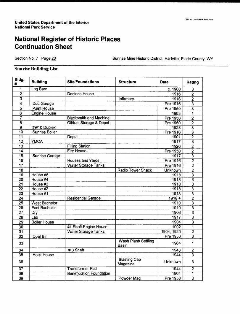
United States Department of the Interior National Park Service
OMB No. 1024-0018, NFS Form
National Register of Historic Places Continuation SheetSection No. 7 Page 23 Sunrise Mine Historic District, Hartvilie, Platte County, WY
Sunrise Building List
Bldg.#
1234567891011121314151617181920212223242526272829303132
33
3435
36
373839
Building
Log Barn
Doc GaragePaint House
Engine House
#9/10 DuplexSunrise Boiler
YMCA
Sunrise Garage
House #5House #4House #3House #2House #1
West BachelorEast BachelorDryLabBoiler House
Coal Bin
Hoist House
Site/Foundations
Doctor's House
Blacksmith and MachineOil/fuel Storage & Depot
Depot
Filling StationFire House
Houses and YardsWater Storage Tanks
Residential Garage
#1 Shaft Engine HouseWater Storage Tanks
# 3 Shaft
Transformer PadBeneficiation Foundation
Structure
Infirmary
Radio Tower Shack
Wash Plant/ Settling Basin
Blasting Cap Magazine
Powder Mag
Date
c. 190019161916
Pre1916Pre1950
1963Pre1950Pre1950
1928Pre 1916
190119171926
Pre 19501917
Pre 1916Pre 1916Unknown
19181918191819181918
1918 +191019101906191719041902
1904, 1920Pre 1950
1964
19431944
Unknown
19441964
Pre 1950
Rating
32233122332322322233333233333123
1
23
3
213
OMB No. 1024-0018, NPS Form
United States Department of the Interior National Park Service
National Register of Historic Places Continuation SheetSection No. 8 Page 24 Sunrise Mine Historic District, Hartville, Platte County, WY
Narrative Statement of Significance
The Sunrise Mine Historic District is a 225-acre property containing buildings, foundations and landscape features representing 80 years of iron-ore mining, with an associated company town. The district is a part of the Hartville Uplift, an area in southeastern Wyoming that connects the southern Black Hills with the Laramie Range. From Rawhide Buttes and Guernsey to its northeastern point at Lusk, the Hartville Uplift covers parts of Goshen, Platte, and Niobrara counties. The district is eligible for the National Register of Historic Places under Criterion A for its contributions to the historical understanding of mining in Wyoming and the region. The district is also significant in the areas of community planning and development, ethnic heritage, social history and commerce. The period of significance is 1898 - 1955.
Sunrise Mine was the principal source of iron used at the Colorado Fuel and Iron plant in Pueblo, Colorado, from 1899 and until its close in 1980, making it an important contributor to the economy of Colorado as well as Wyoming. During this 80-year period, several new engineering techniques were pioneered at Sunrise, including a steel headframe built in 1903, glory-hole and block-cave methods of mining, and a 199-foot-tall headframe built in 1945 that was the highest steel headframe in the United States at that time. Sunrise is also significant for the community planning and development that occurred under the direction of the Colorado Fuel and Iron Company, especially the improvements that were constructed as a direct response to the Ludlow Massacre of 1914. Workers' housing, a hospital, water and sewage systems, a school, a YMCA and other facilities were constructed to maintain a steady source of local labor, foster a sense of community and ensure labor relations did not deteriorate. Many considered Sunrise a model company town, and the YMCA and its amenities were unprecedented in the state.
The Sunrise Mine was important in the social and ethnic history of the region. The unskilled workers at Sunrise included Italians, Greeks, Syrio-Lebanese, Japanese, Scandinavians, and English. The ethnic diversity not only affected Sunrise and Hartville, but nearby Guernsey as well. The heritage of the European workers is reflected in the ethnic diversity in the region today. Sunrise was equally important for its contributions to the commerce and business of the local and regional economy. The copper boom begun at Sunrise in the 1880s created the town of Hartville, and spurred increased exploration and subsequently exploitation that led eventually to commercial iron ore extraction, as well as a rail connection to the rest of Wyoming and beyond. Beginning with the copper boom of the 1880s, the Sunrise Mine sustained nearby communities and economies, until well after its period of significance.
The historic context for Sunrise Mine is based in part on Robert Rosenberg's National Register Multiple Property Nomination for "Copper and Iron Mining in the Hartville Uplift, Goshen, Platte, and Niobrara Counties, Wyoming, 1879-1980," prepared as part of a cultural resource inventory for the Wyoming Department of Environmental Quality/Abandoned Mine Lands Program in 1995 (Carender et al), but never formally submitted to the State Historic Preservation Office or the National Park Service. These documents and others reveal the district's importance in the five major areas of significance defined above.
0MB No. 1024-0018, NFS Form
United States Department of the Interior National Park Service
National Register of Historic Places Continuation SheetSection No. 8 Page 25 Sunrise Mine Historic District, Hartville, Platte County, WY
The historic context encompasses three main mining processes and their associated property types: extraction (the removal of the ore from the ground), beneficiation (the upgrading of the ore by removing impurities), and refining (further enhancement of the ore resulting in a pure or almost pure state). Only the first two processes are represented at Sunrise Mine. Refinement occurred in Pueblo, Colorado and not on the Sunrise site.
There are four major periods of mining in the Sunrise district: the prehistoric period when the land provided stones for tools and red hematite for paints; the copper era from 1880-1887 during which small deposits of copper led to increased interest in the area; the iron discovery or prospecting period immediately following the copper era and lasting until 1897; and the commercialization period of iron extraction from 1898-1980. The prehistoric period is beyond the scope of this nomination, and should be addressed in a separate nomination. Because there is very little evidence remaining from the pre-commercialization period, the period of significance for this nomination begins with commercial iron-ore mining era in 1898 and extends to 1955, ending at the latest date permissible under National Register criteria.
The Sunrise Mine retains a high degree of integrity, especially for a historic mining site. Extant buildings and foundations represent the important stages in the history of the mine and community. Because of its layout and the physical remains, the site strongly conveys the feeling and association of a historic industrial site.
Historical overview
The history of human occupation in the Sunrise area dates to at least 12,000 years ago. Indigenous peoples extracted red hematite for corporal painting, as well as stones for the production of tools. The site seems to have served this purpose at least until the Late Prehistoric Period. The prehistoric tools found at the Powars II site (within the district boundaries) and the many tipi rings located north of the district may render another portion of the area eligible under Criteria D.
The Euro-American exploitation of the area followed the apex of the gold rush in the Black Hills during the middle to late 1870s, which brought new miners into the sparsely inhabited area. Concomitantly, soldiers from Fort Laramie were also seeking precious metals and the number of claimed mines increased steadily.
From approximately 1880 to 1887, the chief mineral sought at Sunrise was copper. As a part of this copper boom in the Hartville Uplift, Henry T. Miller staked his first claim to the copper in 1881, at what later became the Sunrise Iron-ore Mine. The copper was hauled with mules and wagons to a smelter near Guernsey. From 1881 until 1887, 250 tons of copper were produced. However, the copper boom proved ephemeral and effectively ended by 1887, due to the cost of transporting the ore to the smelter and the need to haul coke from other locations (mainly by rail, then by wagon from Cheyenne) to fire the furnaces. The price of copper dropped as well, from $370 a ton in 1882 to $220 a ton in 1886.
0MB No. 1024-0018, NPS Form
United States Department of the Interior National Park Service
National Register of Historic Places Continuation SheetSection No. 8 Page 26 Sunrise Mine Historic District, Hartville, Platte County, WY
The most important copper mining town in this period was Hartville, which is located one mile south of Sunrise. Managed by a group of saloon owners until its incorporation in 1901, Hartville's fortunes paralleled those of the nearby mines. The town increased in size after the Colorado Fuel and Iron Company began to develop Sunrise Mine at the turn of the century.
The most significant mining activity at Sunrise was the iron-ore mining from 1898 to 1980. The initial discovery period lasted roughly from 1888 to 1897, and served to orient miners to iron ore instead of copper. Icabod Bartlett, who was one of the organizers of the Wyoming Copper Company in 1881, was one of the first to try mining iron ore after the copper fizzled out. Although 10,000 tons a year were mined, because of the fifteen miles that the ore had to be hauled by freight teams to reach the existing rail line, the process was inefficient. Local rancher (and later Wyoming Senator) Charles A. Guernsey also recognized the potential of the iron ore after visiting mining operations in Minnesota. He returned to Wyoming and bought all of the mining claims that he could. In 1890, Guernsey formed the Wyoming Railway and Iron Company (W.R.& I.) with Ichabod Bartlett and a group of Chicago investors.
With a 60% iron content, the Sunrise hematite was quite pure. "The Hartville-Sunrise ores exhibited at the 1893 Columbia Exposition in Chicago were superior to all other domestic and foreign samples" (Rosenberg 6). Encouraged by the high quality of the ore, Guernsey expanded his holdings and began large-scale development and extraction in 1898. At the same time, the Pueblo-based Colorado Fuel and Iron Company was undertaking a major expansion, and seeking new sources for iron ore. A representative sent to investigate Sunrise reported that the area was rich in iron ore and would be feasible to mine. One year later, Colorado Fuel and Iron Company leased all the claims of W.R.& I. In 1904, C.F.& I. purchased Sunrise Mine for $500,000.
To improve transportation, C.F.& I. created a subsidiary, the Colorado and Wyoming Railroad, to convey the raw material from Sunrise to Guernsey. There, the company rail connected to the Cheyenne and Northern Branch of the Colorado and Southern Railroad, and the ore was sent 375 miles to the smelter in Pueblo, Colorado. The first shipment of ore by the Colorado and Wyoming Railroad from the mine occurred in 1900; in 1901, Sunrise sent an average of 21,000 tons per month to Pueblo (Casper Star-Tribune, 6/21/79:36).
Despite a few closings during the early years, the Sunrise Mine was generally successful. In 1901, Sunrise employed 175 workers. By 1905, the company procured 600,000 gross tons of iron ore, worth approximately $900,000. This success directly influenced the growth of the company town around the mine.
The Sunrise Mine did not succumb to the fate of many mining locales in the West, whose operations were short-lived. Sunrise lasted for more than 80 years, longer than any other iron-ore mine in the state, providing work for several generations in eastern Wyoming. The mine also operated longer, and produced and shipped more iron ore (a total of 40 million tons), than any other C.F.& I. mine. In 1980, C.F.& I. abruptly ended operations at Sunrise, ending an important era in the mining history of Wyoming and the West.
OMB No. 1024-0018, NPS Form
United States Department of the Interior National Park Service
National Register of Historic Places Continuation SheetSection No. 8 Page 27 Sunrise Mine Historic District, Hartville, Platte County, WY
Mining and Engineering
The Sunrise iron-ore mine utilized three major methods of mining: stripping (1899 - 1920), glory hole (1903 - 1941) and block caving (1930s on). All of these methods are represented in some way by the structures and features remaining on the site today.
In 1899, Colorado Fuel and Iron's T.B. Butler arrived at Sunrise, charged with the task of setting up the supporting infrastructure and getting the mine off the ground. Butler was soon followed by John D. Gilchrist, who took over on February 15, 1902. Soon after mining began, engineers discovered the ore deposits at Sunrise were concentrated in a relatively narrow area, but the ore body extended hundreds of feet below the surface, which presented a unique mining situation. The initial mining method used at Sunrise had been pioneered on the Mesabi Range in Minnesota and was brought to Wyoming by John Gilchrist. It consisted of simply using black powder and dynamite to blast the rock into more manageable pieces, and stripping blasted waste material from ore with a rail mounted steam shovel. The waste rock was loaded into small railroad cars, referred to as "dinkies," to be dumped on tailing piles, and the ore was loaded onto cars bound for Pueblo, Colorado. The entire operation was accomplished at the price of only 15 cents per ton. Construction of new furnaces at the C.F.& I. plant in Pueblo resulted in a continuous demand for ore from Sunrise. By February, 1902, Sunrise was already producing 75% of the iron ore used by C.F.& I. By 1903, nearly 500,000 tons had been blasted down on three terraces (Wyoming Industrial Journal, January, 1903:189).
The stripping method was used with relative success until the pit created by the mining began to get too deep for rail cars to come out of it and a new method was needed. In December, 1902, work was started on what was to be the first of several shafts. The #1 shaft (Site No. 30) was 6 feet by 8 feet with an original depth of 200 feet, though it was soon extended to 340 feet. In 1903, a 90-foot-tall, steel headframe was erected above the shaft's three compartments, two of which were used for skips, with the third compartment being used for a ladder and a pipe way. Three 5-ton Jeffery electric locomotives running on 24-inch tracks were used to haul ore in the shaft. The headframe incorporated a crusher through which ore passed by gravity and was automatically loaded onto railroad cars. The Wyoming Industrial Journal of May, 1903 reported that it was the only one of its kind in the west.
In 1903, the "glory-hole, open-pit" method of mining was introduced, thought to be the first operation of its kind in the western United States. The "glory-hole" method was designed to recover ore from deep pits inaccessible by railroad cars. The system uses surface mining and blasting, allowing the ore to fall down into the pit and then into mills (funnels made by raises from underground). From there the ore goes into underground mine cars and is carried to a hoisting shaft, to be recovered from the deep pit. Holes were drilled from the top of raises, loaded and shot with explosives, and the broken ore was drawn out through chutes. As a result of this new mining method, direct railroad car loading was phased out by 1920.
0MB No. 1024-0018, NPS Form
United States Department of the Interior National Park Service
National Register of Historic Places Continuation SheetSection No. 8 Page 28 Sunrise Mine Historic District, Hartville, Platte County, WY
In March, 1904, bricklayers began laying the foundation for the boiler house to provide steam power and heat for operations, and on March 27 the smoke stack was raised. The boiler house (Building No. 29) housed six 150-horsepower boilers, which allowed the mine to have reserve units in case of an accident. In January, 1906, a spark from one of the boilers landed on a car load of black powder stored in the boiler house, blowing the roof off the building, and leading to new explosive storage strategies.
To help facilitate the "glory hole" method, the 400-foot-deep #2 shaft was completed in 1906. The shaft had a 401-foot drift with 60 feet going east and 220 feet going west, to be used for car and equipment storage. The shaft was operational until water was encountered in 1916. Progress was still being made until a 1,520 gallon per minute leak and equipment failure forced abandonment.
Also completed in 1906 was a 40-by-l 15-foot, brick shower house, called "The Dry" (Building No. 27). Due to the blood-red color of the dusty soil and the dirty nature of mining itself, all the miners were required to stop at the shower house to shower and change before going home. Costing $10,442, the shower house included a 38- by-54-foot changing room with several hundred lockers. Steam racks with ventilation hoods were used to dry mining clothes. The shower room had 12 shower heads and 2 long steel troughs which were equivalent to 50 wash basins. The shower house also had a separate boss' changing room and an emergency hospital.
Until the completion of the Guernsey Dam, electric power for mining operations was produced on site by C.F. & I. In 1925, the United States government appropriated $3 million to build the earth dam at Guernsey. When it was completed two years later, Sunrise had a new source of electricity, and thus used far less coal, as it was needed only for heating and for running the steam shovel.
By the late 1920s, Sunrise Mine had become the chief source of ore for the C. F. & I. smelters in Pueblo, producing about 60% of the 7.5 million tons used by the plant from 1916 to 1926. In spite of this success, the company wanted to reduce the amount of waste rock that was shipped with the ore. In 1927 a "picking plant" was constructed to the west of the railroad shops. It consisted of a crusher and screens to separate out the fine material and leave the coarse ore, which was then hand picked to remove waste rock before loading onto the rail cars. This plant was in operation until 1945. Its exact location has not been determined.
As the "glory hole" method became increasingly less cost effective, a new system was again needed. In 1927, Charles A. Mitke, a consulting mining engineer from Phoenix, Arizona, and expert in the block-caving method of mining, was brought in to assess the situation in Sunrise. Block caving is generally considered the cheapest method of underground mining, although it requires a large upfront investment. The method is most suitable for massive veins or thick beds of homogenous ore overlaying ground that will cave readily. Block caving involves undercutting large blocks of ore, allowing them to cave and break up naturally. These blocks reportedly averaged 350 square feet (the size of a city block) and were 200 feet deep.
Based on design information provided by Mitke, the layouts and structures for the block-caving process were erected at Sunrise, and the first ore produced by this method was mined in 1930. In the 1930s, block-caving
0MB No. 1024-0018, NPS Form
United States Department of the Interior National Park Service
National Register of Historic Places Continuation SheetSection No. 8 Page 29 Sunrise Mine Historic District, Hartville, Platte County, WY
gradually began to replace the "glory hole" method, although the latter continued to be used up until 1941 when it became impractical and too dangerous to continue. By 1939 it was reported that more than 15 million long tons of ore had been mined from Sunrise, with 1,018,000 tons coming from block-caving operations. (A long ton is a British unit of measurement, equaling 2,240 pounds).
The use of the block-caving method at Sunrise, with its narrow yet deep ore vein, meant encountering and solving unusual problems. A report on the innovative solutions developed at Sunrise Mine was given in a paper entitled "Block Caving at the Sunrise Mine, Wyoming," delivered by mining engineer George Rupp at the Annual American Institute of Mining and Metallurgical Engineers Conference in New York City in 1939. This report was incorporated into a technical publication of the American Institute of Mining and Metallurgical Engineers, which is required reading for students at the Colorado School of Mines. An earlier report on Sunrise written by mining engineer Ben Vallat was published in the Proceedings of the Colorado Scientific Society in November, 1907.
An important part of the mining operation was chemical analysis of all core samples and of the ore being shipped in the railroad cars. To facilitate this, a new chemical lab (Building No. 28) was completed in February, 1917, for a cost of $2,400.
During World War 2, there was an increased demand for iron, and C.F.& I. instituted new measures to increase production. In 1941, surface mining was discontinued and all operations were conducted underground by block- caving methods. The mine was said to be one of the few active underground iron mines in the country, and the only one west of the Missouri River (Casper Star-Tribune., 7/12/1967).
To help meet the increased demand, the Wright shaft (#3 shaft) and associated structures were constructed. Planning for the $1.5 million project began in 1940, but the actual work did not begin until September, 1942. Towering 199 feet above the surrounding landscape, the Wright head frame was one of the tallest ever constructed. The 750-foot-deep Wright shaft was sunk beginning in 1943 and was dedicated to former Sunrise superintendent Harry A. Wright on July 24,1945 (Site No. 34).
To haul the ore out of the depths of the shaft, a 190-by-60-foot, fireproof, brick and steel hoist house was built (Building No. 35). The building housed an ore hoist, a man and material hoist, 3 air compressors, and 2 motor generator sets and associated accessory equipment. The 6,000- cubic-foot air compressors sent compressed air down 12-inch steel pipes to the bottom of the shaft for equipment operation. All the cables were 1 5/8 inches in diameter and over 1,300 feet of cable was wound on the drums. The latest types of hoists were employed, giving the ore skips a capacity of 8 long tons and the ability to travel at 1,000 feet per minute. The man and material skips had a 20,000 pound capacity and traveled at 800 feet per minute. The addition of the Wright shaft helped increase mine production to 43 train cars hauling 2,200 tons per day by 1945. Employment at the mine that year was one of the highest in its history, with 405 employees.
0MB No. 1024-0018, NFS Form
United States Department of the Interior National Park Service
National Register of Historic Places Continuation SheetSection No. 8 Page 30 Sunrise Mine Historic District, Hartville, Platte County, WY
In spite of a gradually weakening domestic steel market, Colorado Fuel and Iron continued to implement improvements at the mine over the next 30 years. In 1964, the company constructed a multimillion dollar beneficiation plant, to further refine the ore before shipping it to Pueblo. In 1965, a record one million tons of steel were produced at the plant in Pueblo, thanks in part to the increased efficiency and production at the Sunrise Mine. The company continued to invest in the mine, right up until it closed. When operations ceased in 1980, there were 266 men employed at the mine. Sunrise Mine officially closed on July 10,1980, and the company dismantled most of the remaining mine structures.
All of the structures mentioned above can still be viewed to this day in some form or another. The structures, foundations, enormous pit, and concrete covered shafts stand as a quiet testament to a major mining operation of the last century.
Community Planning and Ethnic and Social History
The community of Sunrise evolved with the start of construction of the Colorado and Wyoming Railroad in August, 1899. At this time, C.F.& I. brought four groups of twenty men to Eureka Canyon to begin building the rail grade from the mine site to Hartville. Three of these groups worked on the rail spur, while one began removing overburden to begin surface mining of ore. They also began digging wells and building bunkhouses. This group of 80 men was the beginning of 80 years of mining and community activity in Eureka Canyon.
At the same time, a crew of 500 contract bridge gang workers was working from the northern end of the spur. In March, 1900, C.F.&I. brought in more workers to rush the job. When the rail spur was finished on April 25,1900, more than 600 workers were in Sunrise. Only a fraction of them remained to work in the mine. When John D. Gilchrist was brought from the Iron Range mines in Minnesota to become the new mine superintendent in 1901, he imported skilled laborers from the mines of Minnesota and Michigan. By February, 1902, 205 employees of C.F. & I. were working at Sunrise Mine, 153 in the mine and 52 on the railroad. These workers represented the broad spectrum of immigrants to the United States in the early 20th century. According to the company newspaper, the Camp and Plant, there were 75 Italians, 55 Americans, 35 Greeks, 14 Irish, nine Germans, eight French, five Austrians and one Scot.
C.F.& I. was apparently anxious to avoid some of the mistakes made in its company towns in Colorado, and to make Sunrise a model company town. In June, 1900, William Porter, an engineer from the Denver office of C.F. & I., arrived in Sunrise and began laying out the location of houses and other facilities. The camp's permanent crew often carpenters was kept busy building homes for the workers (Camp and Plant}. By February, 1902 there were 38 small, square, four-room homes and a boarding house with a "seating capacity of 90." By August of the same year, 50 houses had been completed. In spite of this building boom, there was a housing shortage at Sunrise in the early 1900s, and the company gave preference to families, so many bachelors had to live in very crowded conditions, or live in nearby Hartville.
OMB No. 1024-0018, NPS Form
United States Department of the Interior National Park Service
National Register of Historic Places Continuation SheetSection No. 8 Page 31 Sunrise Mine Historic District, Hartville, Platte County, WY
The company boasted that many of the homes had plumbing, and those without had a hydrant near the front door, but early photographs indicate that there were many outhouses as well. Water was hauled to Sunrise by train for use by both the industry and the community, and stored in large storage tanks on the hill overlooking the town site (Site No. 17).
C.F. & I. carpenters also built the Colorado Supply Company Store, a two-story depot that housed offices for the mine's first superintendent and engineers,, and a warehouse, engine house and blacksmith shop. None of these early structures exist today, although foundations of the blacksmith and machine shop (Site No. 7) and the Depot (Site No. 11) remain.
The Sociological Hall, built in 1902, was planned as the recreational building for Sunrise. As described in the Camp and Plant, it was a 30-by-40-foot building with a large basement, "well lighted, heated by furnace and furnished with chairs, tables, books, magazines, newspapers and all the current periodicals" (Camp and Plant, February, 1902). This same company bulletin also states that the community had an assay office/laboratory, company office building, a bath house (Building No. 27), and a one-room school house. Future plans for a bowling alley, a larger school and tennis courts were also reported.
The town site today still shows evidence of significant community planning, in the system of streets, bridges, sidewalks, sewers and rock-walled terraces that extend up the hillside to the south of the main road.
As Sunrise changed from a mining camp to a small community, housing was one of the first social issues that the workers had to deal with. The C.F. & I. Company had a policy prohibiting owner-built homes, which was explained in a 1902 article in Camp and Plant. Photographs of a run-down, privately owned house and a well-kept company house accompanied the following text.
As the illustrations show, the home the miner is able to construct is often inferior. For this reason, the company has erected comfortable and convenient houses and rents them at a nominal price. This answers the inquiry so often made, "Why does the company expend so much money on improvements? Why not give the money to the men and let them spend it?"
It is hoped that education and an improved environment may be the means of bringing about brotherly love and the application of the Golden Rule. That the rich and the poor, the illiterate and the educated alike may be made to realize our social conditions and to unite in an effort to help one another and conscientiously to aid in teaching, and to abide by the teachings of true Christianity, the foundation of all Sociological thought and Social Betterment in the Rockies as well as elsewhere. (Camp and Plant, March 1,1902, p. 182.)
In housing as in other aspects of community life, C.F.& I. had a consistent policy that extended to its coal mining towns and steel plant in Colorado as well as to Sunrise. Each town had a Colorado Supply Company
OMB No. 1024-0018, NPS Form
United States Department of the Interior National Park Service
National Register of Historic Places Continuation SheetSection No. 8 Page 32 Sunrise Mine Historic District, Hartville, Platte County, WY
store, and almost all services were handled directly by the Company. The camps (as C.F.& I. preferred to call them) were linked by the official C.F.& I. publication, Camp and Plant, a weekly newspaper that was published in Italian, German, Spanish and English and was intended to build identification with the company among the various far-flung C.F.& I. properties.
The population of Sunrise continued to rise through the first two decades of the 20th century, surpassing Hartville and reaching 518 individuals by 1920. Between 1905 and 1910, C. F. & I. built more of the square, wooden, four-room homes. Two large boarding houses were built in 1910 to provide for the new workers. The buildings were referred to as "Greek Houses" on a company estimate sheet dated 1910, but later came to be known as the "Bachelors' Quarters" (Buildings No. 25 and 26). They are rectangular structures, 60-by-24-feet (although the drawing called for a 72 x 24 foot building), and divided into 12-by- 12-foot rooms. These quarters were adapted to a storage area for mineral core samples in later years.
In 1911 the building of a nondenominational community church was completed. The church was used for Saturday night movies and other social events as well as religious services. Many of the Greeks and Italians chose to attend church in Hartville where Catholic and Episcopal services were offered. Schooling started with a one-room school house built in 1902. By 1920, Sunrise had a junior high school and a senior high school was being planned.
The Colorado Supply Company, Sunrise's general store, was operated by a subsidiary of C.F. & I. The store not only catered to Sunrise residents, it also did "an extensive business outside the Sunrise employees," (Camp and Plant) providing goods for citizens of Hartville as well. The company employed a scrip system, under which employees could borrow against their future paychecks to buy supplies at the company store. Thanks to the company-owned Colorado and Wyoming Railroad, residents of Sunrise had daily mail and passenger train service. Almost, but not all of the business conducted at Sunrise was owned and managed by the company. Private industry existed in the form of the Sunrise Dairy and Kelly's Ice Wagon. Thus the community also helped create private industry in the region.
On the whole, Sunrise workers appear to have been quite satisfied with their working and living conditions. One complaint, however, was that workers could not own their own homes. While the company provided adequate, comfortable housing at Sunrise, and rent was reasonable, many workers and their families wanted homes of their own. There was a rivalry of sorts between Sunrise and Hartville. Most people agreed that the housing was of a better quality at Sunrise, but in Hartville a miner could own his own home. With the advent of the automobile, workers were able to satisfy this yearning by moving to nearby Hartville, and eventually as far as Guernsey and Wheatland. The automobile resulted in the eventual demise of the company town.
There were other drawbacks to living under the scrutiny of the company. For example, no saloons or bars were allowed in Sunrise. "Drinking was considered by the company to be a definite social evil." In a 1903 issue of Camp and Plant magazine, the company announced that "the question of drinking is the most serious one before the Department [Sociological]. Men who drink look upon it as their right and privilege
OMB No. 1024-0018, NPS Form
United States Department of the Interior National Park Service
National Register of Historic Places Continuation SheetSection No. 8 Page 33 Sunrise Mine Historic District, Hartville, Platte County, WY
and deny the authority of anyone to deprive them of it." The proximity of Hartville provided some relief to those wanted to get out from under the watchful eye of the company. In 1900 there were reportedly nine saloons'and two dance halls in Hartville. From the early 1900s to 1918, when it was officially declared "dry," Hartville had gambling, prostitution, and plenty of bars.
By 1901 it is estimated that there were about 100 Greeks and 100 Italians living and working in the area of Hartville and Sunrise, many of them lured away from jobs on the railroad to the better paying jobs at the mine. Evidence suggests that the Company employed a "padrone" system to conscript immigrant workers, especially Greeks, who comprised half of all the immigrants at Sunrise. The first Greek immigrants spread the word back home about the opportunities in Wyoming, and were soon joined by their friends and relatives. The early Greek miners, who were mostly bachelors, worked in all-Greek gangs, and lived in all-Greek housing. The Greek community maintained a Socrates Society "to provide benefits for the victims of sickness and death," including helping to pay wages for fellow Greeks who were too sick to work.
Several of the Greek miners eventually left the mine to establish businesses in Hartville, such as grocery stores, bakeries and coffee houses and taverns. A 1924 article in the Torrington Telegram reports that "Hartville is temporarily, perhaps permanently, deprived of her most important institutions, the Greek coffee houses." An agent of the state posing as an employee of Sunrise Mine bought alcoholic drinks at the four "coffee houses," and afterwards arrested the owners (Torrington Telegram, May 1,1924).
The Italians, many of whom had come to Wyoming from mines in Michigan and Minnesota, also lived in separate housing and formed their own social society, a local chapter of the Dante Alighieri Society. Unlike the Greeks, the Italians tended to marry and raise families in the area.
During the Balkan Wars, the community lost many of its Greek workers. A new group of English, Lebanese, Japanese, and Scandinavians came to the mine. In 1910 about 50-100 Japanese were recruited from Denver to work in the mine, but most did not remain longer than a few years. While in Sunrise they lived in what was known as the "Japanese boarding house." Some Japanese graves still exist in Hartville Cemetery. Many of the English miners came from the Iron Range in Michigan. The English immigrants mixed easily with the Americans, and did not form their own society or live in a separate enclave. About a dozen Lebanese worked at the mine for a short period, most from the Minneapolis region.
While some of the immigrants returned home after earning enough money, others stayed in the area or emigrated to other parts of Wyoming. C.F.& I. operated night schools in English, as well as Americanization classes, which helped many of the immigrants to obtain American citizenship. Although no physical evidence of ethnic diversity can be found at the Sunrise site today (in part because all physical improvements were controlled by the Company), the ethnic legacy of Sunrise Mine persists in the many families of Greek, Italian and Lebanese heritage than remain in the area today.
0MB No. 1024-0018, NPS Form
United States Department of the Interior National Park Service
National Register of Historic Places Continuation SheetSection No. 8 Page 34 Sunrise Mine Historic District, Hartville, Platte County, WY
While Sunrise was a growing community, producing more ore for C.F. & I. each year, labor troubles were brewing at company-owned camps in Colorado. Sunrise never had a labor strike in its 80-year history, but C.F. & I. workers in Colorado went on strike in 1903-04,1910,1913-14, and 1919.
Although its workers did not strike, the Sunrise community benefited from the labor unrest plaguing C.F. & I.'s other operations. In September, 1913, the United Mine Workers of America declared a strike against the coal operators in Colorado. On April 20,1914, the strike reached a climax when National Guardsmen fired on a tent camp of miners and their families. Eleven women and two children were among the dead.
As a result of this incident, John D. Rockefeller, who was a major investor in the company but had kept a low profile, became more involved in the operations of C.F. & I. To improve his image as well as to make peace with the striking miners, Rockefeller instituted the Colorado Industrial Plan, the first example of a corporation creating a system of corporate representation of the worker. The plan became a model that was adopted by other companies in the years following. In the history of labor, Sunrise and the other C.F. & I. communities became experiments in how a company could represent its workers and provide a better life for them without an "outside" union.
The Colorado Industrial Plan changed the face of all the mining camps under the ownership of C.F. & I. Through its "Industrial Constitution," it stipulated that the miners should elect representatives to discuss "matters of mutual concern" with management. Sunrise, like all of the Colorado camps, voted to accept the constitution, and thus fell under the rules of the first company-run union, with citizens overseeing and taking part in decisions about community and mine life. The plan also divided the camps into jurisdictions that were represented by elected officials. An Advisory Board on Social and Industrial Betterment was elected in each community. The board consisted of four committees: a Joint Committee on Industrial Cooperation and Conciliation, on Safety and Accidents, on Sanitation Health and Housing, and on Recreation and Education. The Plan also outlined the steps an employee could go through to settle any labor dispute.
In terms of social history and community development, all of these joint committees played an important role. Each committee consisted of elected residents who made decisions on camp life. Some were in charge of mine safety complaints, others street cleaning duties, and still others, educating "those who speak foreign languages." Part IV of the plan outlined rules for "Social and Industrial Betterment," including the exact, agreed-upon price for rent, coal, electricity, garbage removal, and bath and club houses; eight-hour work days and semimonthly pay; and a 30-day notice of pay or job change.
The new Industrial Plan also included positive steps to improve living conditions in the company towns, including improving opportunities for recreation and cultural events. In February, 1916, Irwin J. McCary, a Denver landscape architect, was commissioned to draw up a plan for Sunrise which included two parks, a ball field, a playground, treescaping along the streets, and improved water and sewer systems, as well as new dwellings and community facilities. The centerpiece of these improvements was the new YMCA building (Building No. 12). Completed in 1917, the Sunrise YMCA was the first YMCA in the state (and the only one
0MB No. 1024-0018, NFS Form
United States Department of the Interior National Park Service
National Register of Historic Places Continuation SheetSection No. 8 Page 35 Sunrise Mine Historic District, Hartville, Platte County, WY
until the 1930s), and one of fourteen built by C.F.& I. during this period. The new YMCA featured a gymnasium/theater, bowling lanes, a card room, a billiards and pool room, a barber shop, a kitchen, a ladies' lounge, a soda fountain, a sewing machine, and a reading room that contained magazines, newspapers, and books. The building became the center for cultural activities in the community with all sorts of civic organizations hosting events there. The "Y" offered classes in knitting and sewing, as well as citizenship. Motion pictures were shown, local theater performed and meetings held in the upstairs auditorium. There were also "boxing and wrestling matches, silent movies, square dancing, Christmas shows, vaudeville and Chautauqua performances, a women's club, youth groups, first aid classes, and Boy Scout activities" (Mellinger, 123). As a result of Americanization classes held at Y, many immigrant workers became citizens.
Rockefeller also donated a hospital to each of the mining camps (Building No. 3). The Sunrise infirmary was a ground-level brick building with nine rooms: a bedroom for patients, a doctor's office, a room for optical exams, a dressing room, a general examination room, a shower, kitchen, and a reception room. A doctor's house (Site No. 2) was built to the west of the hospital, connected by a short walkway. The infirmary operated until 1961, at which time miners were sent to Wheatland or Torrington for their medical needs.
Brick homes, significantly larger than the original frame homes, were built in the eastern part of town in 1918 (Buildings No. 19 - 23), and six brick duplexes were added to the west of the YMCA by 1928 (Building No. 9). Providing a personal garage for each resident also contributed to the neat and tidy town called for in the Industrial Plan, and in 1917, a brick garage (Building No. 15) was built across the street from the Colorado Supply Company store. Two additional bays were later added to this garage to accommodate the trucks of the Sunrise Volunteer Fire Department and the town ambulance. The following year, a concrete garage was constructed near the newer homes, along the eastern edge of the community. This garage was added onto in 1924 and 1926, resulting in the 650-foot long structure whose foundation is still extant (Site No. 24). Originally designed to house Model-T Fords, the stalls in this garage were later adjusted to house the larger "modern" automobiles. A gas and automobile service station was added in 1926 (Site No. 13).
The company pitched in to help the beautification process: "To encourage employees to cultivate flower and vegetable gardens, the company agrees to fence, free of charge, each house lot owned by it." The company planted trees and provided other landscaping and maintenance services, and gave awards for the most attractive gardens and yards. A 1916 Torrington Telegram article proclaimed, "A model community is being built at Sunrise, Wyoming ... improvements, which are destined to make the camp one of the finest of its kind in the country" (Miller, 4). Sunrise was called a "more modern town" in comparison to Guernsey and Hartville in a 1924 article. The effects of the landscaping provided by the Industrial Plan can be seen today in the large trees that line the main road, the fruit trees, lilacs and other ornamental plants that dot the yards of the former houses, the remains offences around each yard and even the clothesline poles.
0MB No. 1024-0018, NFS Form
United States Department of the Interior National Park Service
National Register of Historic Places Continuation SheetSection No. 8 Page 36 Sunrise Mine Historic District, Hartville, Platte County, WY
Despite the Industrial Plan's provision for a company union, ultimate community decisions were made by the mine superintendent and not the joint committee. A Dec 25,1924 article on the building of a new school in Sunrise reads:
".. .when it came time to vote a bond issue to build the high school, it was found that one man only was the property owner. That man, Thomas Tucker, mine superintendent acting for the Colorado Fuel and Iron Company, will act as the election board, and do all of the voting. He will challenge his vote, and then be the sole judge of his qualifications" (Torrington Telegram).
To help workers and citizens understand the new Industrial Plan and how it was being implemented, the constitution called for publication of a paper called the Industrial Bulletin. In the 1919 issues, articles were written about the great results that had been achieved through the plan. An April headline exclaimed, "Workmen's Homes Models of Comfort." The article compared the tent-like dwellings of the past to the modern homes that were being built in the C.F. & I. company towns. "The effect of improving housing conditions on the social, moral, and intellectual development of the mining communities scarcely can be overestimated. It is one of the most powerful factors in the Americanization of alien families and their education in American ideals and standard of living." Articles told of Americanization classes, new baseball teams, company improvements, a superintendent's positive reactions to the plan, Y.M.C.A. buildings, and reports from each camp district and its joint committee (Industrial Bulletin, 1919).
The company union lasted for 20 years, until the Wagner Act of 1935 made it illegal. In 1938 employees at Sunrise started to form an outside labor union, resulting in tension between workers who supported United Steel Workers and those who supported the Industrial Plan. In 1942 Sunrise Mine signed a contract recognizing Local 442 of the International Union of Mine, Mill, and Smelter Workers.
On Sept. 28,1945, the CF & I Blast, which superceded the Industrial Bulletin, published the "Sunrise Edition." Articles from this issue give a flavor of life in Sunrise at mid-century. On page 9, an article, "Center of Community Life" boasts about the YMCA serving the entire community as one of the most universally used and enjoyed facilities of its kind in the nation. The article reports on the Sunrise Bowling Team-engaged in a telegraphic meet with the New York Stock Exchange Team-and how the Sunrise team made a highly credible showing. Another article, entitled "Sunrise has fine schools," discusses the modern schools provided for the children of the workers at Sunrise. There were twelve teachers, including a superintendent, and about 140 students. On more than one occasion the Sunrise football team became the state champions. "Ninety from Sunrise in Armed Forces of World War II" lists the names of the 90 men involved in the war effort. "Protects Community Health" discusses the Sunrise infirmary the direction of Dr. L.L. Wood, which cared for approximately 200 patients a month, including families of the employees.
As mentioned earlier, the automobile eventually contributed to the demise of the company town. Once they were able to commute to work, miners and their families found it more appealing to own a home in Hartville, Guernsey or even Wheatland, away from the dust and noise of the mine. School consolidation resulted in the
OMB No. 1024-0018, NPS Form
United States Department of the Interior National Park Service
National Register of Historic Places Continuation SheetSection No. 8 Page 37 Sunrise Mine Historic District, Hartville, Platte County, WY
closing of the Sunrise grade school and high school in 1964, followed by the junior high school in 1968, prompting families with school-age children to move away. The infirmary closed in 1961, followed by the company store and post office in 1966. The YMCA was converted to company offices in 1967. Around this time, the company decided to discontinue renting houses in Sunrise, and began bulldozing or burning the frame houses as they were vacated.
Commerce
Sunrise Mine produced 42,457,187 tons of iron ore during its operation from 1900 until 1980, making it the largest source of iron ore for Colorado Fuel and Iron Company. It employed a large work force of professionals and skilled and unskilled laborers, whose wages supported many more dependents. The Sunrise Mine benefited not only the communities of Hartville and Sunrise, but also Guernsey, Wheatland, and the State of Wyoming, providing a solid economic base for a large number of people for 80 years.
As part of the C.F.& I. corporation, Sunrise played a role in the corporate maneuvers of the early 20th century, when John W. Gates and other speculators began buying large amounts of C.F.& I. stock in hopes of gaining control of the company to sell it to United States Steel. John Osgood, the major owner, refused to relinquish control of his company, but was forced to resign in 1903 due to over investment in construction projects. New investors were found, including John D. Rockefeller Jr. The production dropped off during the transition year of 1904, from 235,000 tons to 130,000 tons, but from that point on remained relatively stable, even through labor strikes in 1913-14 and World War I.
During the Great Depression, employment at Sunrise declined from 547 in 1928, to 361 in 1929, to 156 in 1930, to 112 in 1931, and eventually to closure and no employment in 1932. The production of rails at this time also declined sharply from 450,000 tons in 1929 to no production in 1932. In 1934, Colorado Fuel and Iron declared bankruptcy. The Colorado and Wyoming Railway also looked doomed, but due to the fact that it was independent of C.F.& I. and its only debts were with C.F.& I., they were forgiven. In order to keep the workforce during these times, C.F.& I. loaned $33,539.57 to those who needed it in Sunrise. Overall the company loaned $340,303.77 to employees who were in need.
In 1935 Sunrise was the state's only iron ore mine, and one of 133 iron ore mines in the U.S. Peak production for Sunrise was during the pre-WWII years of 1941-42, with the best production in 1941, when Sunrise produced approximately 1% of all iron ore mined in the United States. The iron was used in a variety of steel applications in WWII including structural members for ships, barbed wire, and fencing.
Sunrise continued to run smoothly and profitably until the labor strikes of 1959. As late as July 24, 1959, a headline in the Wyoming State Tribune boasted, "Sunrise Top Supplier for Steel," with an article stating "from Sunrise iron ore comes the steel by which our country has grown and preserved its integrity and heritage. And, it is through this ore that C.F.& I. continues to manufacture the low cost, high quality steel which the nation desires" (Wyoming State Tribune, July 21-24, 1959). But during that year, labor strikes dramatically reduced

0MB No. 1024-0018, NFS Form
United States Department of the Interior National Park Service
National Register of Historic Places Continuation SheetSection No. 8 Page 38 Sunrise Mine Historic District, Hartville, Platte County, WY
steel production, forcing companies that had normally used steel and other iron products produced in the U.S. to buy from international sources. At the same time, the quality of ore at Sunrise was deteriorating as the miners had to go ever deeper to reach the ore. In spite of improvements, including the new beneficiation plant built in 1964, Sunrise never fully recovered from this slump.
When C.F. I. ceased operations at Sunrise in 1980, the company salvaged most of the mining equipment, and destroyed all but five of the remaining houses. Since then mining reclamation activity has further altered the landscape, but enough remains to tell the story of the 80 years of operation of Sunrise Mine and Town Site.
OMB No. 1024-0018, NPS Form
United States Department of the interior National Park Service
National Register of Historic Places Continuation SheetSection No. 9 Page 39 Sunrise Mine Historic District, Hartville, Platte County, WY
Bibliography
Alanen, Arnold A. and Robert Z. Melnick. Preserving Cultural Landscapes in America. Baltimore: John Hopkins University Press, 2000.
Ball, Sidney H. 59th Congress 2nd Session December 3, 1906-March 4, 1907: House Documents. Vol. 59. Washington Printing Office, 1908.
Bettelheim, B. Symbolic Wounds. New York: Collier Books, 1962.
Carender, P.L., J.B. Tyler, R.G. Rosenberg. "1995 WYCRO Report #941595." On file at the Wyoming State Historic Preservation Office, Cultural Records Office. Laramie: University Of Wyoming, 1995.
C.F.& I. Steel Corporation. "Facts Concerning the Sunrise Mine." Pueblo, CO: C.F.& I. Steel Corporation, 1966.
C.F. & I. Steel Corporation. Camp and Plant, 1902 - 1904.
De Fond, George. "First Mine was 'Good Fortune'." Torrington Telegram, March 28,1974.
Ells, Fred. Personal Communications. December 9, 2003.
Prison, George C. Prehistoric Hunters of the High Plains. San Diego: Academic Press, 1991.
Prison, George C., et al. "Digging for the Color of Life: Paleoindian Red Ochre Mining at the Powars II Site, Platte County, Wyoming, U.S.A." Geoarchaeology: AnInternationalJournal,Vo\. 18, No.
Headley, Jim. "Mine Dumped on Wyoming." Wyoming Tribune Eagle, Cheyenne, WY, September 12, 1993.
Hendrickson, Gordon O. ed. Peopling the High Plains: Wyoming's European Heritage. Cheyenne: Wyoming State Archives and Historical Department, 1977.
Hunton, E. Deane. "The Geology, Deposits and Methods of Mining Iron Ore at Sunrise, Wyoming." Bachelor of Science Thesis. University of Wyoming, 1911.
Key to the City's page for Hartville. 10 December 2003. ][>ttp;//www.pejiet/~rksnow/wycountyhai'tville.litm
MacCannon, Robert W. Sunrise: A Chronology of a Wyoming Mine. Pueblo, CO: The Bessemer Historical Society, 2003.
OMB No. 1024-0018, NFS Form
United States Department of the Interior National Park Service
National Register of Historic Places Continuation SheetSection No. 9 Page 40 Sunrise Mine Historic District, Hartville, Platte County, WY McCrary, Irwin J. Town of Sunrise, Wyoming: Preliminary Plan for Improvement and Extension. February, 1916.
Mellinger, Philip J. "Early Hartville and Sunrise: A study of the frontier and immigration in Wyoming." Master of Arts Thesis. Roosevelt University, 1969.
Miller, Gaylord, "Sentimental Journey: Sunrise Newspaper History." Torrington Telegram, Torrington, WY, 1992.
Millies, Stephen. The Ludlow Massacre and the Birth of Company Unions. 10 December 2003.^^^
Miner's Bar: Oldest Bar in the State of Wyoming. 10 December 2003. http://w\vw.windom_.org/mhiers.htm
Noble, Bruce J. Jr. and Robert Spude. National Register Bulletin No. 42: Guidelines for Identifying, Evaluating, and Registering Historic Mining Properties. National Park Service, U.S. Department of the Interior. Washington, D.C.: U.S. Government Printing Office, 1992.
Rees, Jonathan. "New Resources for Labour History." The Bessemer Historical Society and the Colorado Fuel and Iron. 1 0 December 2003 . http://w^yw.hijst^
Rockefeller, John D. Jr., The Colorado Industrial Plan, 1916.
Rupp, George H. "Block Caving at the Sunrise Mine, Wyoming." American Institute of Mining and Metallurgical Engineers, Technical Publication No. 1069. New York, 1939.
Scamehorn, H. Lee. Pioneer Steelmaker in the West: The Colorado Fuel andiron Company 1 87 2- 1 903. Boulder, Colorado: Pruett Publishing Company, 1976.
Sharpe, M.E. Nonunion Employee Representation: History, Contemporary Practice, and Policy. Armonk, NY, 2000.
Stafford, M. D. "The Powars II Site: A Paleoindian Red Ochre Mine in Eastern Wyoming." Master of Arts Thesis, Department of Anthropology, University of Wyoming, Laramie.
Strack, Don. To Move a Mountain: Railroads and Mining in Utah 's Bingham Canyon. 4 December 2003.nham- 1 900- 191. 4 ,htm
Trinklein, Michael. The Oregon Trail, http ://www. i su.edu/~tri nniich/FtLarainie .htm 1.
Turner, V.W. The Ritual Process. Chicago: Aldine,1969.
OMB No. 1024-0018, NFS Form
United States Department of the Interior National Park Service
National Register of Historic Places Continuation SheetSection No. 9 Page 41. Sunrise Mine Historic District, Hartville, Platte County, WY
Wilcox, R.W. Pharmacology and Therapeutics. Philadephia: Blackiston, 1911.
Whissen, Steve. "D.E.Q. Project No. 10-15, Sunrise Mine: Site (48PL83)." Cheyenne, Wyoming, 17 October 1985.
Wideman, F.L. "Block-Caving Method at the Sunrise Mine, Platte Co., Wyo." Bureau of Mines Information Circular 7759. Bureau of Mines, U.S. Department of the Interior. Washington D.C., 1956.
1998 Western Regional Award: Sunrise Mining District Reclamation, Wyoming. 4 December 2003.littp://www.osm:t'c.gov/awardwy.htm
No Author. Casper Star Tribune, 1967, 1979
No Author. The Wyoming Industrial Journal, 1899-1911.
No Author. Wyoming State Tribune, 1959.
No Author. Industrial Bulletin. Colorado Fuel and Iron Company, Pueblo, CO. April, July, Jan, 1919.
No Author. "The Sunrise Mine Was Founded, Developed By H. T. Miller Who Also Found the First Copper Mine in the Hartville Uplift Area, Torrington, WY." Torrington Telegram, August 16, 1965.
No Author. The C.F.& I. Blast. Pueblo, Colorado, September 28,1945.
No Author. "Pioneer Personalities: Thomas Tucker." Guernsey Gazette. Guernsey, Wyoming, December 27,1962.
Photo archives. The Bessemer Historical Society, Pueblo, CO.
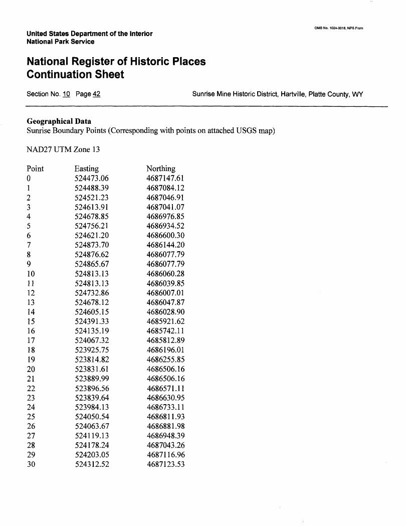
United States Department of the Interior National Park Service
National Register of Historic Places Continuation Sheet
OMB No. 1024-0018, NFS Form
Section No. 10 Page 42 Sunrise Mine Historic District, Hartville, Platte County, WY
Geographical DataSunrise Boundary Points (Corresponding with points on attached USGS map)
NAD27UTMZonel3
Point 0123456789101112131415161718192021222324252627282930
Easting524473.06524488.39524521.23524613.91524678.85524756.21524621.20524873.70524876.62524865.67524813.13524813.13524732.86524678.12524605.15524391.33524135.19524067.32523925.75523814.82523831.61523889.99523896.56523839.64523984.13524050.54524063.67524119.13524178.24524203.05524312.52
Northing4687147.614687084.124687046.914687041.074686976.854686934.524686600.304686144.204686077.794686077.794686060.284686039.854686007.014686047.874686028.904685921.624685742.114685812.894686196.014686255.854686506.164686506.164686571.114686630.954686733.114686811.934686881.984686948.394687043.264687116.964687123.53
OMB No. 1024-0018, NPS Form
United States Department of the Interior National Park Service
National Register of Historic Places Continuation SheetSection No. .10 Page 43 Sunrise Mine Historic District, Hartville, Platte County, WY
Verbal Boundary Description:
The boundary for the Sunrise Mine Historic District follows the visual horizon and natural contours as much as possible. The boundary is defined by a series of UTM points creating an irregular polygon. UTM points are numbered from 0 to 30, beginning at the northwest corner and proceeding clockwise, as specified in "How to Complete the National Register Registration Form" (page 55). For ease of understanding, this verbal boundary description begins where a visitor would enter the site, at the property line just west of the entrance gate, which is at Point 23. Only the major points of the polygon are noted in the verbal boundary description.
The boundary for the historic district begins at the intersection of the south side of the main road into the property (Wyoming Highway 318) and the western property line (Point 23). Point 23 is slightly north of the center line of the polygon formed by the boundary of the historic district.
From Point 23, the boundary follows the road southeast about 250 feet to the gate which marks the entrance to the property (Point 22). From Point 22, the boundary proceeds along an arbitrary line (the property line) up a steep slope, in a southerly direction approximately 1200 feet to Point 19, where it meets the ridgeline surrounding the historic district.
From here the boundary follows the ridgeline at the 5100-foot contour in a southeasterly direction approximately 2,200 feet to Point 16, which is the southernmost point of the historic district boundary.
The boundary continues in a northeasterly direction approximately 2,600 feet along the ridgeline, which rises to 5180 before returning to the 5100-foot contour at Point 8, the southeastern-most point of the historic district boundary. At this point a non-historic infill of mining tailings forms a boundary which cuts off the southeast end of the natural 'bowl' in which the historic district is located.
Point 8, on the 5000-foot contour, is an arbitrary point at which the infill butts up against the natural contour of the ridge. At this point the boundary meets up with an abandoned county road, which it follows along the 5000- foot contour approximately 2,000 feet in a northerly direction, skirting the tailings piles to the east which are not within the period of significance. Where the county road veers to the northeast, the boundary continues in a straight line to Point 6 at the top of the natural ridge which forms the northeastern boundary of the historic district, and runs along the eastern edge of the "Glory Hole."
The boundary follows the ridge line as it proceeds in a northerly direction and climbs to the 5200-foot contour at Point 5, the northeastern-most point of the district boundary.
From Point 5 the boundary follows the 5200-foot contour line in a westerly direction approximately 2,000 feet to Point 29.
OMB No. 1024-0018, NFS Form
United States Department of the Interior National Park Service
National Register of Historic Places Continuation SheetSection No. 10 Page 44 Sunrise Mine Historic District, Hartville, Platte County, WY
At Point 29 the boundary turns and proceeds southwest approximately 2,000 feet, following a natural draw, which meets up with Point 23, the point of beginning.
Boundary Justification:
The boundaries of the Sunrise Mine Historic District include the significant historic structures relating to the Sunrise Iron Ore Mine and the company town of Sunrise. The boundary follows the topographical horizon of Eureka Canyon on the north and south, including the impressive Glory Hole open pit and the forested slope south of the community and mine. The ridge line was chosen for a boundary because it encompasses the mine site and the community, and includes the landscape that was historically visible from the site. On the east, the boundary runs along the abandoned county road that once passed through the valley. This road separates the significant historic structures from tailing piles which are not within the period of significance. These tailing piles also have been, and will be in the future, subjected to reclamation and have lost much of their historic integrity. The western boundary is denoted both by the topographic ridge line and the western terminus of the property line.
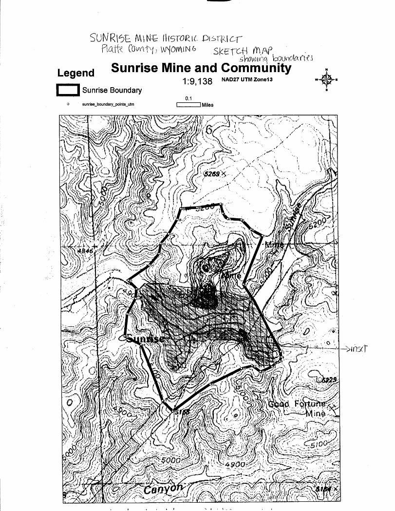
Leqend Sunrise Mine and Community1'9138 NAD27UTMZone13
Sunrise Boundary0.1
sunrise_boundary_points_utm J Miles
C((^^*^3^*^?^^>S^^^M^^^¥f^ ^m'T^^^^^i-'^^S^^m^Mm^m^
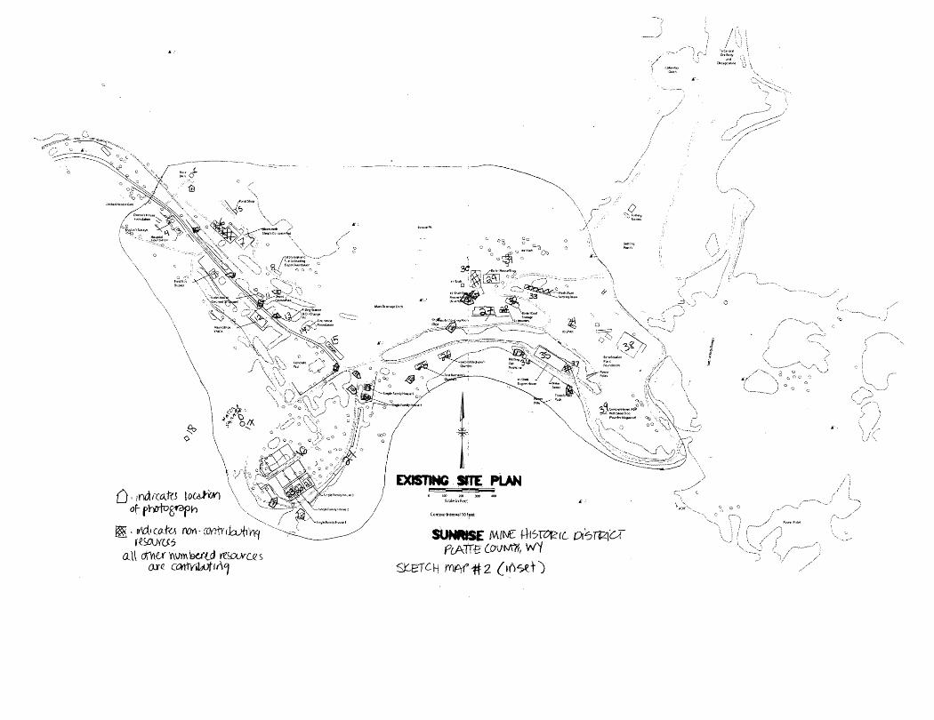
all ofha y\um'i96rtdSUHWSE
P6ATT0 twWi,
rn^r^2