national review of hurricane evacuation · national review of hurricane evacuation plans and...
TRANSCRIPT


National Review of Hurricane EvacuationPlans and Policies
LSU HURRICANE CENTER
1 Assistant Professor, LSU Hurricane Center and Department of Civil and Environmental Engineering, Louisiana State University, Baton Rouge, LA 70803; (225) 578-5247; FAX (225) 578-5263; email: [email protected] Engineer, Chiang, Patel & Yerby, Inc., 1820 Regal Row, Suite 200, Dallas, TX 75235; (214) 638-0500; FAX (214) 638-3723; email: [email protected]
3 Director, LSU Hurricane Center, and Charles P. Siess, Jr. Associate Professor of Civil and Environmental Engineering, Louisiana State University, Baton Rouge, LA 70803; (225) 578-4445; FAX (225) 578-8652; email: [email protected]
An electronic version of this report is available on the web at www.hurricane.lsu.edu. Additional copies may be obtained from LSU Hurricane Center; Suite 3513CEBA Building; Louisiana State University; Baton Rouge, LA 70803; Phone:(225) 578-4813; Fax: (225) 578-8652 email:[email protected]
Photo credits: cover image - NASA.
Brian Wolshon1
Elba Urbina2
Marc Levitan3
Copyright 2001 LSU Hurricane Center.
The mission of the LSU Hurricane Center is to advance thestate-of-knowledge of hurricanes and their impacts on the natural,built, and human environments; to stimulate interdisciplinary and
collaborative research activities; to transfer this knowledge tostudents and professionals in concerned disciplines; and to assistthe nation and the world in reducing vulnerability to these powerful
and often devastating storms.
Any opinions, findings, and conclusions or recommendations expressed in this paper are those of the authors and do not necessarily reflect the views of
Louisiana State University

The events of recent hurricane seasonshave made evacuation one of the leadingemergency management issues. HurricanesGeorges in 1998 and Floyd in 1999 precipitatedthe two largest evacuations in the history of theUnited States (US) and perhaps, its two largesttraffic jams. Opinions as to why these prob-lems occurred are numerous and varied.Some explanations that have been offeredhave included the well-publicized (some haveargued over-publicized) threat of these storms,an over-reaction for the need to evacuate,insufficient planning, and limited coordinationbetween the various agencies responsible forevacuations. Whatever the causes, it isobvious that evacuations have become a topicof significant concern in states threatened byhurricanes.
One of the ways that emergency manage-ment officials have responded to these eventshas been to increase the level of coordinationbetween and involvement of agencies that havetraditionally been only peripherally involved inevacuation. One of the most notable of thesegroups are Departments� of Transportation(DOTs). Since Hurricane Floyd, transportationagencies at the federal, state, and local levelshave begun to take a more active role in theplanning, management, and operation ofhurricane evacuations. This is somewhat of adeparture from prior practice, when these taskswere planned and directed nearly exclusivelyby emergency management officials.
Since the involvement of transportationprofessionals in evacuation has been a fairlyrecent development, it is not surprising that thelevel of understanding of evacuation issues andterminology in the transportation community is
Executive Summarysomewhat limited. It has meant that many ofthe newly developed plans and policies havenever been put into actual practice. It has alsomeant that many aspects of these plans andpolicies vary significantly from state to stateand remain largely unknown to the widerprofessional transportation community.
To determine what the latest policies andstrategies are, how they differ from one locationto another, and to increase the level of knowl-edge and awareness of these new evacuationpractices, a national review of evacuation plansand practices was recently undertaken byresearchers from Louisiana State University(LSU) in cooperation with the LSU HurricaneCenter. The study was carried out from atransportation (rather than an emergencymanagement) perspective. It included both areview of transportation literature and a surveyof DOT and emergency management officialsin coastal states threatened by hurricanes.This report summarizes the findings of thesurvey while also providing some backgroundon development evacuation practices andresearch in the US.
This report includes information on theapplication of evacuation strategies andtechnologies, such as the use of reverse flowoperations and intelligent transportationsystems (ITS). It also summarizes currentevacuation management policies, methods ofinformation exchange, and decision-makingcriteria. The intent of this report is to provide abroad perspective on the current state ofevacuation practices, while also presentingsimilarities and differences in individual statepractices. Particular attention is paid to unique,innovative, and potentially useful practices
1
NATIONAL REVIEW OF HURRICANE EVACUATION PLANS AND POLICIES

used in individual states that could be morewidely applied.
The results of the LSU survey bring tolight many of the current needs and importantissues in the field and the ways in whichemergency management and transportationagencies are working to address them. Keyissues and problems identified by the surveyinclude:
� limited involvement from and aware-ness within the professional transportationcommunity in the field of evacuation;
� limited interagency coordination forregional and cross-state evacuations;
� limited consistency between states inthe both the authority structure and planning/design processes for hurricane evacuation;
� limited planning (at the DOT level) forthe evacuation of low-mobility groups;
� less than adequate use of the availabletransportation infrastructure during evacua-tions; and
� a need to better coordinate construc-tion work zone activities on hurricane evacua-tion routes.
The survey also showed that transporta-tion agencies have recognized many of theseissues and are working to overcome them.This was demonstrated in the survey by DOTefforts to:
� increase their level of involvement inevacuation transportation issues both at thestate and regional level;
� enhance their ability to communicatevital traffic flow and route condition informationto emergency managers and the public;
� develop contraflow evacuation plans;and
� seek ways to apply intelligent transpor-tation systems to improve the safety, efficiency,and speed of evacuations. 2
LSU HURRICANE CENTER
Recent trends have increased the vulner-ability of the US to hurricanes. The combina-tion of growing population and development incoastal zones, rising ocean levels, coastalerosion, and changing climatic trends haveincreased the potential for loss of life andproperty in coastal regions of the country. Arecent example of such an event was Hurri-cane Andrew. This powerful storm struck bothFlorida and Louisiana in 1992, causing anestimated $25 billion in damage and economicloss (USGS, 1998). While more stringentbuilding codes have been enacted to reducedamage from winds and flooding, not allcoastal populations can be protected in theirhomes or shelters. To counter this threat,states in the Atlantic and Gulf coast regions ofthe US have plans to evacuate people fromvulnerable areas in advance of threateningstorms.
Historically, hurricane evacuation plan-ning in the US has been the responsibility ofemergency management and law enforcementagencies. While some state transportationagencies have contributed to the evacuationplanning and management process, theiractivities could usually be characterized asperipheral support. In the two most recentlarge-scale evacuations, Hurricanes Georgesin 1998 and Floyd in 1999, colossal traffic jamsoccurred revealing the fact that emergencyresponse agencies may not have been asprepared for such scenarios as previouslyassumed. In the aftermath of these events,emergency management and state transporta-tion officials recognized the need for an in-creased level of involvement from the profes-sional transportation community.
IntroductionThe Georges and Floyd experiences
clearly demonstrated the need for increasedevacuation route capacity; development ofsystems for better, faster, more reliable ex-change of traffic flow and traveler information;and better planning and coordination of re-gional and cross-state evacuations. To theircredit, DOTs in every state threatened byhurricanes are now actively working at varyinglevels to better manage evacuations. In recentmeetings and conferences organized forpurpose of discussing plans and practices forevacuation, however, it was apparent thatmany DOT officials were not aware of thecurrent state of practice nor the way in whichnew technologies and methods could be usedto better address evacuation-related problems.This lack of awareness was not surprisinggiven that most of them had never beeninvolved in the evacuation planning andmanagement process and there was littleinformation available to them in the transporta-tion literature.
To meet this need for more information, anational review of evacuation plans andpractices was undertaken by researchers atLSU. The study was carried out from a trans-portation perspective and included a review ofliterature from traditional transportation-oriented sources and a direct survey of DOTand emergency management officials. Theinformation presented here focuses on thesurvey portion of the study and includes ageneral discussion of current practice; the useof reverse flow operations, intelligent transpor-tation systems (ITS), and public transportationduring evacuations; methods of informationexchange; and emergency management3
NATIONAL REVIEW OF HURRICANE EVACUATION PLANS AND POLICIES

4
LSU HURRICANE CENTER
policies and decision-making criteria. Thisreport uses the survey responses to compareand contrast various state practices, withparticular attention given to unique, innovative,and potentially useful practices.

Hurricanes develop throughout thetropical ocean regions of the world, at anannual frequency of about 85 per year. Whilehurricanes cannot be controlled, our vulnerabil-ity to their effects can be reduced througheffective planning and preparedness, includingthe use of evacuation. Despite the threat thathurricanes pose to life and limb, the US isamong a small number of countries worldwidethat effectively use mass evacuation as ameans of protecting its coastal populations.Unlike many other areas, the geography of theUS mainland generally makes it possible toshelter people away from coastal hazard zonesand, perhaps more importantly, evacuees haveready access to transportation to take them tothese locations.
Background
The nature of evacuations in the US hasbeen changing. Where in prior years evacua-tions were look upon as localized events, theyhave tended to become more regional innature. One of the primary reasons for this hasbeen the explosion in population growth alongthe Atlantic and Gulf coasts over the past 40years (Culliton et al., 1990). From Maine toTexas, the population of coastal counties aloneexceeds 45 million (Jerrell et al., 1992). De-spite this growth, the number of evacuationroutes has remained relatively unchanged overthe past few decades.
The nature of hurricane preparednessand response has also been changing. Two ofthe most important needs for effective evacua-tions are advanced warning time and access totransportation. Until the middle of the 20th
Century, US coastal populations had little ofeither. In the era prior to World War II, the only
Historical Perspectiveinformation on advancing storms came fromislands and ships in the Atlantic Ocean, Gulfof Mexico, and Caribbean Sea. Similarly, thenumber of roads that were available asevacuation routes and alternative modes oftransportation were quite limited.
The event that brought national aware-ness to the danger of tropical cyclones wasthe Galveston Hurricane of 1900. Residentsof this barrier island in Southeast Texas didnot evacuate due to inadequate warning.Storm surge completely inundated the islandresulting in over 8,000 deaths. This remainsthe single largest natural disaster (in terms oflives lost) in American history. As tragic andunfortunate as this storm was, it broughtattention to the need for improved of hurri-cane warning and response systems and useof evacuations to protect the lives of people incoastal zones. Beginning in 1909, the advent
Photo Credit: FEMA
5
NATIONAL REVIEW OF HURRICANE EVACUATION PLANS AND POLICIES

this era was Hurricane Camille, one of onlytwo Category 5 hurricanes to make landfall onthe mainland US in the 20th Century. Thestorm struck along the Mississippi andLouisiana coastline causing significantdamage and loss of life. The storm surgefrom Camille sent a wall of water over 25 feethigh crashing many miles inland. Most of the256 fatalities were people who did not evacu-ate despite the warnings.
From the 1970�s through the early 90�shurricane activity was moderate compared tothe previous few decades. Probably notcoincidentally, this period also saw the mostsignificant increases in coastal population andland development. 1995 marked the begin-ning of a new cycle of significantly higherlevels of hurricane activity in the Atlanticbasin. If tropical climate patters observedover the past century hold, it is likely that thisheightened activity level will continue foranother two decades. This most recent timeperiod has also seen significant improve-ments in our ability to identify, track, andestimate the strength of hurricanes. With themore widespread use of computers it has alsobeen the period in which the greatest effort tomodel evacuations has occurred.
of maritime radios allowed the US WeatherBureau to begin receiving hurricane reportsfrom ships at sea. These sources of informa-tion were later augmented by use of weatherreconnaissance aircraft, which began in 1944.Advances in both the technology and scienceof meteorology in the period immediately afterWorld War II led to an improved ability toforecast the both storm strength and path (RPI,1997).
The post war period through the 1950�salso marked an era of increased storm activity.During this period more 60 hurricanes struckthe US mainland, with over 20 of them catego-rized as major hurricanes. In the mid-50�s,several strong hurricanes hit the Atlantic coast,precipitating a federal effort to collect informa-tion about how, why, where, and when peopleevacuated.
During the 1960�s and 70�s, an era ofsignificantly improved hurricane forecastingand evacuation preparedness was ushered inwith the development and deployment ofweather satellites and construction of theinterstate highway system. These two develop-ments more than any other, dramaticallyimproved the ability to both anticipate thearrival of storm and move people away fromthreatened areas. One of the major events of
6
LSU HURRICANE CENTER
KILLER STORMSHURRICANE YEAR CATEGORY DEATHS
TX (Galveston)FL (Lake Okeechobee)
FL (Keys)NEW ENGLAND
AUDREY (SW LAN/ N TX)LA (Grand Isle)
LA (New Orleans)TX (Galveston)
CAMILLE (MS/LA)
19001928
1969
1915
19571909
19351938
1915
44
4
44
53
45 256
8,000+1,836
275
390350
408600
275
Source: NOAA

Evacuation Modeling
Background
One of the means of planning and prepar-ing for evacuations involves the use of com-puter modeling. Since the 1970�s modelingtechniques have improved significantly, mainlyas a result of faster and less expensive com-puters and access to more and better evacua-tion behavioral data. Today, simulation pro-grams are used to model weather, flooding,traffic flow, and evacuation travel behavioramong others.
The data that feeds many of theseprograms has come from the inventory ofhurricane evacuation studies (HES). HESwere initiated in the 1980�s by the FederalEmergency Management Agency (FEMA) tointegrate key aspects of hurricane evacuationplanning and to assist in disaster prepared-ness. A HES typically consists of a stormhazard and vulnerability analysis, an evacueebehavioral analysis, a sheltering analysis, anda transportation analysis. The hazard analysisidentifies the areas that would need to beevacuated based on various storm tracks andintensities. The vulnerability analysis identifiesthe number of people and households occupy-ing the threatened area and the structures thatneed to be evacuated. The behavioral analysisis used to project how the public will respond tothe hurricane threat. The shelter analysis isused to evaluate structures for safely housingthe evacuees. The transportation analysiscomponent assesses street and road capaci-ties and identifies critical links in the evacuationnetwork.
The most widely applied flooding modelfor evacuation analysis is the Sea, Lake andOverland Surges from Hurricanes (SLOSH)
model. Developed by the National WeatherService to predict hurricane storm surge for agiven set of conditions, it is also used to planevacuation routes and locate emergencyshelters based on estimates of which geo-graphic could be flooded in certain stormscenarios.
Several models have been developed forhurricane evacuation traffic flow analysis. It isinteresting to note that many of the earlymodels were initially developed to plan forother civil defense emergencies such asnuclear missile attacks and nuclear power plantaccidents. One of these programs, MASSeVACuation (MASSVAC), is a macro-levelmodel originally developed for the purpose ofmodeling nuclear power plant evacuations.More recently it was applied to test operationalstrategies for hurricane evacuations in Virginia(Hobieka et al., 1985). Another model of thistype is the Hurricane and Evacuation(HURREVAC) program. HURREVAC usesgeographic information system (GIS) informa-tion to correlate demographic data with shelterlocations and their proximity to evacuationroutes to estimate the effect of strategic-levelevacuation decisions.
One of the most robust evacuationanalysis tools is the Oak Ridge EvacuationModeling System (OREMS). Developed by theCenter for Transportation Analysis at the OakRidge National Laboratory (ORNL) using theCORridor SIMulation (CORSIM) platform,OREMS was developed to simulate traffic flowduring various defense-oriented emergencyevacuations. The model can be used toestimate clearance times, identify operational7
NATIONAL REVIEW OF HURRICANE EVACUATION PLANS AND POLICIES

Since 1998 there have been severaldevelopments to improve evacuation traffic flowand route capacity. These changes can bedirectly attributed to the involvement of highwayand transportation agencies. The most notableof these are the use of contraflow operations toincrease the capacity of evacuation routes andthe application of intelligent transportationsystems (ITS) systems to collect and communi-cate up-to-date traffic information (PBS&J,2000c). ITS involves the use of informationtechnologies, including hardware, software,
Other Recent Developments
2000a). This system was developed in theaftermath of Hurricane Floyd, driven by theneed for a capability to forecast and anticipatelarge cross-state traffic volumes. At the heartof the model is a web-based travel demandforecast system that anticipates evacuationtraffic congestion and cross-state travel flowsfor North Carolina, South Carolina, Georgia,and Florida. The Evacuation Travel DemandForecasting System model was designed soemergency management officials can accessthe model on-line and input category of hurri-cane, expected evacuation participation rate,tourist occupancy, and destination percentagesfor effected counties. The output of the modelincludes the level of congestion on majorhighways and tables of vehicle volumesexpected to cross state lines by direction.
8
LSU HURRICANE CENTER
traffic characteristics, and other informationsuch as evacuation routes and times necessaryto develop evacuation plans. It also allowsusers to experiment with alternate routes,destinations, traffic control and managementstrategies, and evacuees response rates(ORNL, 1995).
More recently, researchers from ORNLhave identified the need for a decision toolcapable of modeling hurricane evacuationactivities in more timely and accurate ways. Aneffort is underway to develop a computer-basedincident management decision aid system(IMDAS) (Franzese and Han, 2001). Whencompleted, the system will be used to identifyareas that are at greatest risk from potentialthreats and develop alternative evacuationplans, using various operational traffic strate-gies such as the use of shoulder lanes andcontraflow operations.
Another recent macro-level evacuationmodeling and analysis system is EvacuationTravel Demand Forecasting System (PBS&J,
communications, controls, and electronics, inan integrated manner to increase the safetyand efficiency of the transportation system.The most widely planned use of ITS will be forthe acquisition and processing of traffic flowdata in real time. This information will be usedto help control and reroute traffic, decisionsupport (such as when to terminate the evacua-tion), and inform the evacuees and the mediaof current conditions. A more thorough discus-sion of the planned use of both contraflow andITS usage is included later in this report.

The most visible part of the evacuationprocess is when people take to the road to fleean approaching storm. However, this action isonly the last step in a process often beginsmore than a week before. The sequence ofactivities that leads up to an evacuation order istypically led and coordinated by state-levelemergency management officials, incorporatinga progression of weather observation, readi-ness, and response activities. The level ofurgency at which these activities are under-taken is based on the development and move-ment of the storm. Thus, while emergencymanagement agencies use established proce-dures, the sequence and timing of responseactivities can vary widely based on the charac-teristics of any particular storm.
The first phase of the evacuation processtypically starts with routine monitoring oftropical weather patterns that have the potentialto impact the coastal US. Depending on stormlocation and genesis, this routine monitoringphase may last from a few hours to more thana week. When it appears that a storm maypose a threat, initial preparatory steps aretaken to insure readiness should a call toevacuate be issued. Once it appears that astorm strike is likely, a more active phase of theprocess is initiated. This phase involvesspecific actions, again, taken at various levelsof urgency based on the storm characteristics.These actions could include the configurationof routes for evacuee movement and recom-mendations to evacuate. This chapter de-scribes procedures used by the State ofLouisiana as an example to illustrate thegeneral process of evacuation decision makingand implementation. Later sections of this
The Evacuation Processreport will present more specific informationrelated to authority structures and the proce-dural aspects of evacuation management oncean order is given.
Emergency management terminology andpreparedness activities vary significantly fromstate-to-state. However, most states generallyfollow a similar process in their response tohurricane threats. In Louisiana, the Office ofEmergency Preparedness (LOEP) is respon-sible for developing emergency procedures andcoordinating preparedness, response, andrecovery functions for hurricanes. The devel-opment of an evacuation order, while a criticalpart of the response process, is one of manytasks that need to be carried out during thisprocess. The LOEP uses a five-step �activa-tion� process that transitions their staff fromroutine operation through the various stages ofreadiness, response, and recovery after thestorm (LOEP, 1999). The LOEP activationprocess is used to highlight the key milestonesand activities of the pre-evacuation develop-ment process. While these procedures arepresented relative to the landfall time of anapproaching storm, it should be noted that inpreparing for hurricane there is no such thingas a �normal� storm. Hurricane behavior canbe notoriously unpredictable and, as such,these pre-landfall time references can varysignificantly and the activations can often jumpseveral levels at once.
9
NATIONAL REVIEW OF HURRICANE EVACUATION PLANS AND POLICIES

Under routine operation LOEP functionsat a Level V Activation status. At this level,normal staffing is maintained and no specialduties are undertaken. Anytime a tropicalsystem forms in the Gulf of Mexico or AtlanticOcean with a track that might take it into theGulf, LOEP moves to Level IV Activation.Level IV represents a very preliminary activa-tion and operations within the managementcenter are still relatively routine. At Level IVActivation a Crisis Action Team (CAT) isactivated to monitor the storm (using NationalHurricane Center forecasts) and prepare asituation report for key government officials,including the Governor and FEMA. Communi-cations with local emergency managementoffices and other involved state agencies suchas the Departments of Transportation, Environ-mental Quality, Health and Hospitals, etc., arealso initiated. Based on weather conditions,Level IV activation could take place up to aweek prior to storm landfall.
Levels V and IV Activation
Photo Credit: NOAA
10
LSU HURRICANE CENTER
Level III ActivationWhen forecasts show that a hurricane
poses a threat to coastal Louisiana, LOEPmoves to a Level III Activation. At Level IIILOEP staff move to an increased state ofreadiness. At this point a storm strike could beas close as three days away. LOEP staff beginto coordinate with the Louisiana Department ofTransportation and Development (DOTD) toclear evacuation routes of all obstructions andto collect traffic volume data on key routes onan eight-hour basis. The LOEP also requeststhe activation of National Guard liaison officers
to coordinate the needs of local emergencymanagement officials, such as the use ofmilitary vehicles for evacuation transportation.At this stage LOEP officials also begin tocoordinate their activities with bordering states(Texas, Arkansas, and Mississippi), particularlyin the area of traffic control measures asevacuees may need to move across state lines.

If a storm continues on a track thatthreatens the state, Louisiana emergencyofficials shift to a Level II activation giving themhigher state of readiness. Transition to thislevel would normally occur two to three daysprior to predicted storm landfall. In Level IIstatus, emergency management officials beginto disseminate evacuation and shelter informa-tion to the public via various media outlets.
The Evacuation Process
Level II Activation
Level I Activation
11
NATIONAL REVIEW OF HURRICANE EVACUATION PLANS AND POLICIES
The LOEP also meets with both DOTD andState Police officials to determine the status ofevacuation routes. At this time the emergencymanagement officials would seek a Declarationof Emergency from the Governor of Louisiana.This declaration gives LOEP officials theauthority over state services that would typi-cally be under the sole control of the Governor.
When a storm strike is imminent theLOEP reaches its highest state of readiness.Activities within the emergency operationscenter (EOC) shift to action-oriented tasks,including the recommendations to evacuate. InLouisiana, evacuation orders can only beissued by local authorities, such as a mayors orparish presidents (the highest county-levelofficials). Evacuations orders may also beissued at any one of three levels, �precaution-ary,� �recommended,� or �mandatory.� Adiscussion of the meaning and intent of theseevacuation types will be introduced later. Theevacuation order level is critical since it effectsseveral aspects of the evacuation, including thenumber of people who likely evacuate and theimplementation of reverse flow operations.Evacuation orders can also be politicallysensitive and controversial decisions, thus theyare used under only likely threat situations.The geographic extent and urgency level of an
evacuation order is made after the extent of thearea at risk has been defined and discussionsare held with local-level officials in the riskzones. During a Level I Activation, the LOEPmonitors the status of institutional housing andlow-mobility groups such as nursing homes,hospitals, and prisons. If problems arise,LOEP helps make arrangements to transportpeople out of these facilities.
At two hours prior to expected stormlandfall, the LOEP issues an order to close allevacuation routes and evacuates traffic en-forcement and news media personnel to lastresort refuges. During the storm LOEP re-mains at Level I Activation and develops post-storm response and recovery strategies.Activities also include assessments of casual-ties, damage to personal property and criticalinfrastructure, resource availability, and thecoordination of services for the post-stormrecovery effort.

Although there is a moderately-sized bodyof literature on evacuations in general andhurricane evacuations in specific, most of thepublished material is in the domain of the socialand behavioral sciences. The limited amountof transportation-oriented material that doesexist lies primarily in �gray� literature, consist-ing of unpublished planning studies for localcommunities; DOT reports; law enforcementand emergency management operationalmanuals; and other location-specific difficult-to-access reports and studies. Thus impedimentsto the involvement of transportation profes-sional in the evacuation planning and manage-ment process include: lack of familiarity withthe subject; limited sources of information; anddifficulty in accessing the minimal literature thatdoes exist. To address these problems andgain access to the most up-to-date sources ofinformation, researchers from LSU undertook adirect survey of DOT and emergency manage-ment agencies.
The survey was designed to gatherinformation about the general practices forevacuation in each state and to examine theuse of newer techniques such as reverse flowand ITS. Areas of emphasis included theauthority and command structure, the ad-vanced warning times required to implementevacuations, the policies that governed theenforcement and management of evacuations,and the communication strategies used for theexchange of data and information. The surveyalso posed questions that allowed the re-searchers to learn how transportation depart-ments in each state viewed and dealt withconstruction work zones on evacuation routesand moving people without access to personal
Surveytransportation. A total of 28 survey questionswere presented to each survey participant.
Surveys were sent to every at-risk coastalstate in the continental US. These are the 14states on the Atlantic coast from Maine toFlorida and the four states from Florida andTexas that border the Gulf of Mexico. A total of40 surveys were mailed, faxed, or emailed toemergency management, DOT, and lawenforcement officials in each of the 18 states.At least one response was received from everystate in the survey, for a total of 29 responses.Of these responses, 15 were from EM officials,10 were from state DOT officials, and threewere from law enforcement officials. Additionalinformation was also gathered from officials atthe Federal Highway Administration (FHWA),FEMA, private engineering firms, and research-ers. The following sections of this reporthighlight the major findings of the survey.Additional details on the survey findings areavailable in the full project report (Urbina,2001).
12
LSU HURRICANE CENTER

The federal government, through FEMA,requires all states to have a comprehensiveemergency operations plan. These plans guideemergency operations for all types of hazards,from natural to manmade and technological.While the general evacuation issues faced bycoastal states are similar, different strategiesand plans have been developed to deal withvariations in population, geography, andtransportation system characteristics. Statesalso differ in the way that they delegate author-ity, allocate people and resources, and enforceevacuations. They seek to maximize theefficiency of their emergency operation planswithin these many constraints.
Most states take a two-tiered approach toemergency planning and response. For themost part, evacuation planning, response, andrecovery activities are developed at the local(e.g. county or city) level. State-level emer-gency management agencies typically serve tocoordinate local emergency managementactivities and participation of state-level lawenforcement, transportation and other relevantagencies. An example of this approach isillustrated by practices in the State of Texaswhere possible threats differ widely in thevarious regions of the state. The Texas StateEmergency Management Plan has a generalevacuation plan, however, specific hurricaneevacuation planning is left up to local coastaljurisdictions. Inland jurisdictions in Texas areconcerned more with sheltering and mass careissues rather than the movement of evacuees.In Florida, where the entire state is vulnerableto hurricanes, the state emergency manage-ment agency takes a greater managerial role indeveloping evacuation plans.
Evacuation Plans and PoliciesState plans also differ on the level of
detail in their plans. The North CarolinaDepartment of Transportation (NCDOT) iscurrently developing an Emergency Operationsand Procedures Manual for the Division ofHighways (DOH). When finished, the plan willinclude information on various emergencyresponse and recovery issues covering detailsdown to debris removal, personnel and equip-ment needs.
13
NATIONAL REVIEW OF HURRICANE EVACUATION PLANS AND POLICIES

The emergency response commandstructure differs in every state. By law, Gover-nors in most states have the ultimate authority toorder evacuations. However, some Governorsdelegate this authority to local-level officials,such as mayors, city councils, county sheriffs,county judges, or county presidents. This isprimarily because these officials have a betterknowledge of local characteristics and are betterinformed on current local conditions. It may alsobe in part because evacuations can often beunpopular and politically sensitive issues sincethey are so costly and disruptive and (in hind-sight) the orders can turn out to be unneeded,too large, or worse, too small.
Authority and Command StructureTable 1 shows, by state, which officials
and agencies have the authority to orderhurricane evacuations. Governors maintaintheir authority in fourteen of sixteen respond-ing states. In New York and Texas, authorityhas been delegated exclusively to localauthorities. The stated reason was thatrelatively small areas of these states arevulnerable to hurricanes. In South Carolina,the opposite is true. The Governor has soleauthority to order a hurricane evacuation.
STATE
Gov
erno
r
Stat
eEm
erge
ncy
Man
agem
ent
Offi
ce
Dep
artm
ent
of P
ublic
Safe
tySt
ate
Polic
e
Loca
lEm
erge
ncy
Man
agem
ent
Offi
ce
May
or
Cou
nty
or C
ityLa
wEn
forc
emen
t
Cou
nty
Judg
e
Cou
nty
Pres
iden
t
STATE AGENCIES
Hgi
hest
Loc
alEl
ecte
d O
ffici
al
Table 1. Authority to Order Hurricane Evacuations
14
LSU HURRICANE CENTER
RHODE ISLAND X X XMASSACHUSETTS X X
CONNETICUT X XXX
NEW YORK X
NEW JERSEY X X X X X X
DELAWARE X
MARYLAND X XX
VIRGINIA X XNORTH CAROLINA X XSOUTH CAROLINA X
GEORGIA X XXFLORIDA X X
MISSISSIPPI X XXLOUISIANA X X
TEXAS XX
NEW HAMPSHIRE X
LOCAL AGENCIES

Evacuation Plans and Policies
A critical issue in hurricane evacuations istiming. The earlier the evacuation order isissued, the more time residents and tourists willhave to evacuate. Unfortunately, the earlier itis issued the greater the possibility the hurri-cane could change course before landfall,rendering the evacuation unnecessary orleading evacuees to more dangerous locations.Evacuations that turn out to be unnecessarycan also lead to a �Cry Wolf� syndrome inwhich some people are less likely to evacuateduring future threats.
The primary criteria used to make deci-sions of how soon and how large an area toevacuate are the storm forecasts issued by theNational Hurricane Center (NHC). The NHCprovides information on storm track, forwardspeed, and intensity to state and local authori-ties about every six hours. Currently, theaverage error in NHC storm track forecastsabout 100 miles for a 24 hour forecast. How-ever, most of the surveyed agencies felt thatNHC predictions were neither timely noraccurate enough since even medium-sizedcoastal cities need 12 hours to initiate andcomplete evacuations before arrival of tropicalstorm-force winds (39 miles per hour), the mostcommon evacuation termination criteria.
Time requirements for issuing evacuationorders are estimated from a combination ofclearance time and the pre-landfall hazardtime. Clearance time is the time required toconfigure all traffic control elements on theevacuation routes, initiate the evacuation, andclear the routes of vehicles once deterioratingconditions warrant its end. Pre-landfall hazardstime is the time during which hazardous
Implementation Timeconditions exist prior to actual hurricanelandfall. This occurs as outer bands of thestorm begin to impact the coast, bringingtropical storm-force winds and possible road-way inundation due to storm surge flooding.Clearance times are estimated using evacua-tion traffic models, which are dependant ondata such as the population anticipated toevacuate, the number of lanes available forevacuation and impacts from other areas thatwill affect the evacuation. Clearance time canbe significantly lengthened by en route conges-tion and the setup time required for complexcontrol features (e.g. contraflow)
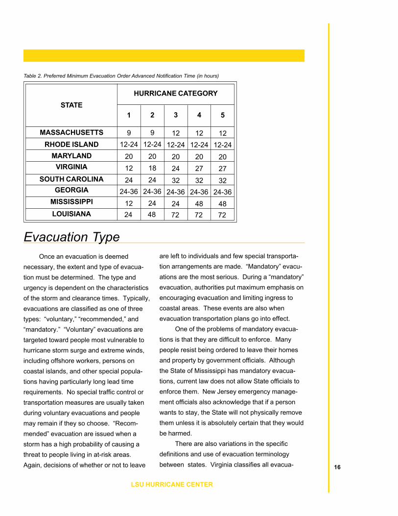
With all of the factors listed above thatneed to be considered, it is not surprising thatpre-planned evacuation times vary widely bylocation. These variables effect the preferredadvance times that states use to issue anevacuation order, as shown in Table 2. Most ofthese times were around 24 hours. However,the survey also showed that many statesrequired additional time for stronger storms.One of the stated reasons is that they assumethat more people will heed warnings to evacu-ate. While not stated directly, it was assumedthat during more powerful storms more peoplewill be at risk both along the coast and furtherinland; states will need additional time toconfigure and initiate contraflow operations.Louisiana, home to the City of New Orleans,with its 1.3 million residents and limited out-bound route capacities, prefers 72 hours ofadvanced notification time to issue an evacua-tion order for Category 5 storm. Obviously, thismuch advanced notice is difficult given thelimitations of current storm forecasting.15
NATIONAL REVIEW OF HURRICANE EVACUATION PLANS AND POLICIES
MASSACHUSETTSRHODE ISLAND
MARYLANDVIRGINIA
SOUTH CAROLINAGEORGIA
MISSISSIPPILOUISIANA
STATEHURRICANE CATEGORY
1 2 3 4 5
9 9 12 12 1212-24 12-24 12-24 12-24 12-24
20 20 20 20 2012 18 24 27 2724 24 32 32 32
24-36 24-36 24-36 24-36 24-3612 24 24 48 4824 48 72 72 72
Table 2. Preferred Minimum Evacuation Order Advanced Notification Time (in hours)
Once an evacuation is deemednecessary, the extent and type of evacua-tion must be determined. The type andurgency is dependent on the characteristicsof the storm and clearance times. Typically,evacuations are classified as one of threetypes: �voluntary,� �recommended,� and�mandatory.� �Voluntary� evacuations aretargeted toward people most vulnerable tohurricane storm surge and extreme winds,including offshore workers, persons oncoastal islands, and other special popula-tions having particularly long lead timerequirements. No special traffic control ortransportation measures are usually takenduring voluntary evacuations and peoplemay remain if they so choose. �Recom-mended� evacuation are issued when astorm has a high probability of causing athreat to people living in at-risk areas.Again, decisions of whether or not to leave
Evacuation Typeare left to individuals and few special transporta-tion arrangements are made. �Mandatory� evacu-ations are the most serious. During a �mandatory�evacuation, authorities put maximum emphasis onencouraging evacuation and limiting ingress tocoastal areas. These events are also whenevacuation transportation plans go into effect.
One of the problems of mandatory evacua-tions is that they are difficult to enforce. Manypeople resist being ordered to leave their homesand property by government officials. Althoughthe State of Mississippi has mandatory evacua-tions, current law does not allow State officials toenforce them. New Jersey emergency manage-ment officials also acknowledge that if a personwants to stay, the State will not physically removethem unless it is absolutely certain that they wouldbe harmed.
There are also variations in the specificdefinitions and use of evacuation terminologybetween states. Virginia classifies all evacua- 16
LSU HURRICANE CENTER

tions as either �voluntary� or �recommended,�none are �mandatory.� In South Carolina, allevacuations are either �voluntary� or �manda-tory.� All evacuations in Texas are regarded tobe �recommended.� In areas of Georgiasusceptible to storm surge evacuations may be�partial voluntary,� when only a portion of acounty is asked to evacuate. Georgia alsouses the terms �full voluntary,� �partial manda-tory,� and �full mandatory� evacuation. InJefferson Parish Louisiana, �voluntary� evacua-tions are referred to as �precautionary.�
Definition and terminology of evacuationdeclarations are important because they impactpeoples� decision of whether or not to leave.Prior research has shown that people who said
Evacuation Plans and Policiesthey heard mandatory evacuation orders arethe most likely to evacuate; while recom-mended evacuation orders are met with lessurgency (PBS&J, 2000b). The type of evacua-tion order and how it is communicated is alsocritical to avoid unnecessary evacuations, alsoreferred to as �shadow evacuations.� Shadowevacuations occur when people near threat-ened areas evacuate their homes even thoughthey are not necessarily in danger. Authoritiesin Florida feel that the one of the reasons forthe extreme number of evacuees duringHurricane Floyd was shadow evacuation.
17
NATIONAL REVIEW OF HURRICANE EVACUATION PLANS AND POLICIES
Transportation infrastructure in the UShas developed to serve vehicular traffic. Whilereliance on personal transportation worksreasonably well under routine conditions, it cancause significant challenges for emergencymanagement officials. The number of peoplewithout access to transportation in New Or-leans, has been estimated as high as 25 to 30percent of the population. In addition to peoplewithout vehicles, potential evacuees include theindigent, elderly, prisoners, the infirm, andtourists. Evacuation of these low mobility andspecial needs groups is an area that whileincluded in most state emergency operationplans, has been largely unaddressed by DOTs.
In practice, the responsibility for theevacuation of low mobility groups in facilitieslike prisons, hospitals, and schools is given tofacility administrators. Often, however, theseadministrators are neither familiar with nortrained in emergency management or masstransportation. Recognizing this situation,some state emergency management agencieshave attempted to make special arrangementsfor these groups.
Busing is the most common mode oftransportation for low mobility groups. Totransport people in busses, emergency man-agement agencies have in the past contractedwith local transit authorities, school districts,and tour operators, with varying levels ofsuccess. Many heavily populated cities do nothave an adequate supply of busses to move alllow-mobility evacuees. For example, about250,000 residents of New Orleans (not includ-ing tourists or �special needs� populations)
Low Mobility Groups and Use of Public Transithave no means of private transportation. Thetotal number of busses in all of New Orleanswould provide only a fraction of the capacityneeded to transport all of these people. Thus,Louisiana emergency management officialsplan to use any available alternative means oftransportation, including National Guardvehicles. They also plan to open local sheltersand �refuges of last resort� for those not able toevacuate. Emergency management officials inFlorida have also used air transport to evacu-ate critically ill people from threat areas ifnecessary. None of the survey respondentsindicated plans for the use of other forms ofpublic transportation, such as rail, for evacua-tions.
18
LSU HURRICANE CENTER

Hurricanes Georges and Floyd exposedweaknesses of evacuation planning andmanagement practices in the US. Althoughsome argue that the problems encounteredduring these two evacuations were extremeand not likely to occur on a frequent basis,others feel that evacuations of similar magni-tudes are likely to occur more frequently. Thelatter is supported by climate forecasts thatpredict an increased frequency of major tropicalstorms and long-term population trends thatforecast substantial population growth in the
New Practicescoastal regions of the southeast. As a result,the need for more effective transportationpractices and technologies in evacuation isapparent and the expertise for them will have tocome from the transportation community. Thefollowing sections describe some of the waysthat DOTs are working with emergency man-agement agencies to improve future evacua-tions through the application of contraflowoperations and ITS systems.
Photo Credit: NOAA
19
NATIONAL REVIEW OF HURRICANE EVACUATION PLANS AND POLICIES

Contraflow, or reverse laning as it is alsocommonly known, involves the reversal oftraffic flow in one or more of the inbound lanes(or shoulders) for use in the outbound directionwith the goal of increasing capacity. In 1998only the Florida and Georgia DOTs had plansin place to reverse the flow on their interstatefreeways to expedite evacuations. Today,eleven of the 18 mainland coastal statesthreatened by hurricanes plan to use some typeof contraflow evacuation strategy. Contraflowtypes and associated benefits, costs, andinherent difficulties are discussed in recentseveral reports (FEMA, 2000; PBS&J, 2000c;and Wolshon, 2001).
While contraflow is widely viewed as thebest way to increase outbound flow duringevacuations, it is not a cure all. In fact, the truecosts and benefits of contraflow in terms of itscapacity improvements, safety, and manpowerrequirements remain largely unknown.Contraflow was implemented for the first time in
ContraflowGeorgia during Hurricane Floyd in 1999 withmixed, though overall positive, results.Contraflow was also improvised in SouthCarolina during Floyd, after a strong publicoutcry came from evacuees trapped in conges-tion on I-26 from Charleston to Columbia.
Four different variants of contraflow arecurrently planned for use. They include: alllanes reversed; one lane reversed and onelane with inbound flow for emergency/servicevehicle entry only; one lane reversed and onelane with normal flow for inbound traffic entry;and one lane reversed with the use of the leftshoulder of the outbound lanes. These con-figurations are shown schematically in Figure1. The locations where they are planned foruse are shown in Table 3.
Because it offers the largest increase incapacity, the most common contraflow strategyis to reverse all inbound lanes to the outbounddirection. One study estimated that a fullreversal would provide a near 70 percent
LSU HURRICANE CENTER
FIgure 1. Freeway Contraflow Lane Use Configurations
1a. Normal Operation
1c. Normal w/Shoulder and One Contraflow Lane 1d. Normal Plus Two Contraflow Lanes
1b. Normal Plus One Contraflow Lane
SHLDR. INBOUNDLANE
INBOUNDLANE
SHLDR. MEDIAN SHLDR.OUTBOUNDLANE
SHLDR.OUTBOUNDLANE
SHLDR. INBOUNDLANE
INBOUNDLANE
SHLDR. MEDIAN SHLDR. OUTBOUNDLANE
SHLDR.OUTBOUNDLANE
SHLDR. INBOUNDLANE
INBOUNDLANE
SHLDR. MEDIAN SHLDR.OUTBOUNDLANE
SHLDR.OUTBOUNDLANE
SHLDR. INBOUNDLANE
INBOUNDLANE
SHLDR. MEDIAN SHLDR.OUTBOUNDLANE
SHLDR.OUTBOUNDLANE
20

Contraflow
21
NATIONAL REVIEW OF HURRICANE EVACUATION PLANS AND POLICIES
Table 3. Evacuation Contraflow Use Strategies
STATE
All lanes outbound
One lane reversed, one laneinbound for emergency/ service vehicle
entry only
One lane reversed, one lane inboundfor traffic entry
One lane reversed and use ofoutbound left shoulder lane
MAR
YLAN
D
NEW
JER
SEY
NO
RTH
CA
RO
LIN
A
VIR
GIN
IA
GEO
RG
IA
SOU
TH C
AR
OLI
NA
ALAB
AMA
FLO
RID
A
TEXA
S
LOU
ISIA
NA
� � � � � � � � �
�
� �
�
�
STRATEGY
Notes: EM and DOT officials inthe State of Delaware plan touse contraflow, although thespecific configuration type hasnot yet been determined.Officials from the State ofMississippi are in discussionswith their counterparts fromLouisiana to extend thenorthbound I-55 contraflow outof New Orleans into their state.
Figure 2. Interstate Freeway Shoulder Drop at Bridge
increase in capacity over conventional twooutbound lane configurations (FEMA, 2000).
Though not as widely planned, single-lanecontraflow strategies are also proposed. Singleinbound lane reversals are thought to increaseoutbound road capacity by about 30 percent.The main advantage of this strategy is its abilityto maintain a lane for inbound law enforcementpersonnel and emergency service vehicles,critical for clearing incidents. It can also permitaccess for people that want to move againstthe evacuation traffic. One of the majordrawbacks of single-lane reversals is that itraises the potential for head-on accidents.
Another strategy to improve capacity is touse the outbound left shoulder as an additionaloutbound lane. This has been estimated toincrease capacity by only about eight percent(FEMA, 2000). The capacity increase dependson the width and condition of the shoulder,since flow rates are decreased and drivers tendto reduce speeds when they are laterallyconstrained. Two additional concerns associ-
ated with the use of shoulders are pavementsuitability and bridge widths. Shoulders aretypically designed with a thinner pavementcross-section and greater cross-slope. Theymay not be able to withstand prolonged trafficloading and thus provide an inadequate ridingsurface. Cross-section width can be a problemon bridges. Many freeway bridges, particularlyolder ones, have been constructed with narrowshoulders, or as shown is Figure 2, with withoutshoulders. If shoulders were used as outboundlanes, these locations would create bottleneckscausing additional congestion as vehiclesmerge back into the through lanes.

Currently, there are no recognizedstandards or guidelines for the design, opera-tion, and location of contraflow segments.Most contraflow designs have been adaptedfrom standard design practice and past evacu-ation experiences. Results of the surveydemonstrated that while some of their geomet-ric design and traffic control elements weresimilar, there were also many obvious differ-ences.
Contraflow sections typically start with amedian cross-over or traffic control configura-tion that redirects or splits a portion of theoutbound traffic stream into the inbound lanes.These designs vary by location. However, themost common method to affect the traffic splitis through the use of a median crossover. Thespecific location of these crossover points isusually a function of roadway geometry, theapproximate beginning of congestion duringprior evacuations, and the proximity of thelocation to other evacuation routes. A typicalat-grade crossover configuration is shown inFigure 3. This particular design in KennerLouisiana, will divert traffic from the two leftlanes of westbound I-10 into the eastboundlanes as evacuees depart New Orleans toward
Contraflow Design
Figure 3. Typical At-Grade Crossover
22
LSU HURRICANE CENTER
Contraflow section termini designs alsovary by location. One of the controlling criteriafor the location of a termination point is theprevention of merging congestion. This can beaccomplished in several different ways. Themethod that is most common, particularly forshorter segments, is to permanently split thetraffic flows. In this type of design one of thestreams of traffic is diverted onto a separateroadway, while the other continues travel onthe original route. In New Orleans, vehiclestraveling in the normal outbound lanes of I-10will all be diverted northbound onto I-55 nearthe City of LaPlace (some 25 miles outside of
Baton Rouge. A water-filled segmented barrieris used to prevent vehicles from crossing themedian during normal operations.
Crossover designs at the interchange oftwo freeways can be more complex. Anexample of an is shown in Figure 4. A connect-ing roadway has been constructed between theloop ramp from I-526 to I-26 to divert traffic intothe contraflow lanes of I-26 as it departsCharleston South Carolina. An additionalconnecting road is used to divert evacuationtraffic from eastbound I-526 into the contraflowlanes of I-26 heading toward Columbia.

Contraflow
23
NATIONAL REVIEW OF HURRICANE EVACUATION PLANS AND POLICIES
the City). After the I-55 diversion, the traffic inthe contraflow lanes of I-10 will cross themedian back into the normal outbound lanes(LSP, 2000). A similar design will also be usedto terminate contraflow operations in SouthCarolina. At the end of the I-26 contraflowsection in Columbia, all evacuation traffic in thenormal outbound (westbound) lanes will bediverted on to northbound I-77, while the I-26contraflow traffic will be diverted back into thenormal westbound lanes after the I-26/I-77interchange.
The other common type of contraflowtermini design is the attrition-merge. Thesedesigns are favored in states having longcontraflow segments such as Georgia andTexas. In this design, traffic in the normal andreverse flow lanes is reduced by allowingvehicles to exit to secondary routes at pointsalong the contraflow segment. Through aprocess of exit attrition, it is assumed thattraffic would be reduced to a level at the end of
Source: South Carolina Department of Transportation
Figure 4. Interchange Crossover
the segment that would allow a merging of thetraffic streams without causing bottleneckcongestion (Ford et al., 2000).
Specific lengths of contraflow segmentsare a function of the evacuation area geogra-phy and the road infrastructure. Plannedsegments range in lengths from 3½ to 180miles. Short sections are typically used to gainmaximum capacity on routes that connect othertraffic arteries. Longer segments will be usedto evacuate coastal cities to inland cities suchas those from Corpus Christi to San Antonio,Charleston to Columbia, and Mobile to Mont-gomery, or for connecting to distant majorevacuation highways.
Table 4 summarizes the planned routesand lengths for evacuation contraflow routes.Florida and New Jersey plan the most exten-sive use of contraflow operations, with sevenand five segments, respectively (it should benoted the New Jersey segments are shorterthose in Florida). Both states are also analyz-

Table 4. Planned Contraflow Evacuation Routes
State Route(s)Approx.Lengths(miles)
OriginLocation
TerminationLocation
New Jersey
Maryland
VirginiaNorth Carolina
South Carolina
Georgia
Florida
47/347Atlantic City Expressway
72/7035
138/I-195
I-10 Westbound1-10 Eastbound
SR 528 (Beeline)I-4 Eastbound
I-75 NorthboundFL Turnpike
I -75 (Alligator Alley)
MD-90
I-64
I-40
I-26
I-16
1944
29.53.526
11
80
90
95
120
18018020
1108575
100
Dennis TwpAtlantic City
Ship Bottom BoroMantoloking Boro
Wall Twp
Ocean City
Hampton Road Bridge
Wilmington
Charleston
Savannah
JacksonvillePensacola
SR 520Tampa
Charlotte CountyFt. Pierce
Coast
Maurice River TwpWashington TwpSouthhampton
Pt. Pleasant BeachUpper Freehold
U.S. 50
Richmond
Benson (I-95)
Columbia
Dublin
TallahasseeTallahassee
SR 417Orange County
I-275OrlandoCoast
Note: Delaware,Virginia and the New Orleans, LA to Hattiesburg, MS contraflow plans are still under development.
States also differed in the amount of detailconsidered during contraflow planning. Thesevariations appeared to be related to the agencythat prepared the plan. In Alabama and NorthCarolina, where the plans were developed bytheir DOTs, contraflow design plans included aconsiderable level of detail in the geometricdesign and traffic control aspects of the cross-over location. The North Carolina plans, for
24
LSU HURRICANE CENTER
ing the feasibility of adding more contraflowroutes, including I-75 from Wildwood to I-275 inFlorida and the Garden State Parkway, NewJersey Turnpike, I-78 and I-80 in New Jersey(Trammell, 2001 and Augustiniak, 2001).
example, emphasized the placement andlocation of traffic control devices in the vicinityof the crossover and the use of highwayadvisory radio (HAR) and dynamic messagesigns (DMS) to guide evacuees. The Louisianaplan, developed primarily by the State Police,paid considerably more attention to enforce-ment requirements in the contraflow area.These plans detailed specific numbers andlocations of police vehicles at the beginningand termination points of the segment, includ-ing the number of troopers and vehiclesneeded at each exit ramp.
Alabama
Louisiana
Texas
I-65
I-10 WestboundI-10/I-59 (east/north)
I-37
135
25115
90
Mobile
New OrleansNew Orleans
Corpus Christi
Montgomery
I-55Hattiesburg, MS
San Antonio

Contraflow
Managing Contraflow OperationsIn addition to the variation in designs,
states also have significantly differing philoso-phies on how they plan to utilize and managecontraflow operations on their highways. SouthCarolina, for example, is the only state thatplans to use contraflow for post storm re-entry.Differences were also apparent in the waystates viewed the somewhat conflicting needsof having a rapid and orderly evacuation usingcontraflow versus the need to maintain accept-able levels of safety on the road. Despite theadvantages that contraflow operations canbring to an evacuation, its disadvantages alsoneed to be considered. Highway agenciesagree that reverse flow operations will likely beinconvenient and confusing for drivers. Theyalso expect contraflow to be labor intensive toinitiate, difficult to enforce, and potentiallydangerous for drivers. Survey questions were
posed to determine managerial strategies suchas who will decide when to use contraflow;under what conditions it will be started andended; how long it will last; and how will issuesassociated with safety, accessibility, conve-nience, enforcement, and cost be addressed.
In most states the authority to start andend of contraflow operations resides with theGovernor, although that responsibility falls onenforcement and/or transportation officials in afew states. Table 5 shows the agency orofficial having the authority to initiate andterminate contraflow operations in the stateswhere they are planned. Consistent with theirphilosophy of local-level evacuation authority,Texas has given operational control to local lawenforcement officials at the beginning andending of the contraflow segment. The onlystate where DOT officials have full authority to
Table 5. Authority to Start and End Contraflow Operations
State Start EndNew Jersey
Delaware
Virginia
Maryland
South CarolinaGeorgiaFlorida
Alabama
Louisiana
North Carolina
Texas
GovernorGovernor
Governor
Local emergency management withState Police and Maryland DOT
GovernorGovernor
Governor
Alabama DOT
Governor
Governor
Highway Patrol Captainin Corpus Christi
GovernorGovernor
Governor
Local emergency management withState Police and Maryland DOT
Department of Public SafetyGeorgia DOT
Highway Patrol
Alabama DOT
Governor
Governor
Highway Patrol Captainin San Antonio25
NATIONAL REVIEW OF HURRICANE EVACUATION PLANS AND POLICIES

assigned locations. Most states anticipate thisprocess will take from four to 12 hours. Set uptime depends on the length of the segment, thenumber of interchanges involved, and thenumber ramps and merge points that mayrequire control. In a few states, the processcould take considerably longer. Authorities inFlorida estimate that 49 hours will be needed toprepare for a contraflow operation. The time isso much longer than other states becauseFlorida needs to activate National Guard forcesto set up and patrol their segments (Collins,2001).
Most states are reluctant to implementcontraflow after nightfall, because of thepreviously mentioned implementation difficul-ties. Florida officials stated that they willneither initiate nor operate any lane reversalsat night. Georgia officials will also resistbeginning contraflow operations after nightfall.However, they also recognized that somesituations may dictate the need and they wantto maintain flexibility in their response. Incontrast, New Jersey and Maryland officialsplan to implement contraflow as needed,regardless of the time of day.
26
LSU HURRICANE CENTER
Several criteria were identified as affect-ing decisions on if and when to initiatecontraflow operations, including: storm charac-teristics (size, intensity, track) and potentialrisks; traffic volume; set up time; and time ofday. In cases where the storm was not fore-cast to make imminent landfall or was ofmodest strength, most states indicated theywould resist the use of contraflow. The othercriteria controlling the implementation ofcontraflow was traffic volume.
Because of the inherent difficulties of itsuse, the majority of states felt that reverse flowlanes should not be implemented until trafficvolumes warranted their use. Officials in thesestates stated their intention to wait until vol-umes were at, or rapidly approaching, capacitylevels before using contraflow. These opinionswere not, however, shared by all states.Officials in South Carolina and Louisiana planto initiate contraflow operations as soon as thecall for an evacuation is made. It was theiropinion that attempts to initiate contraflowoperations after the normal outbound lanes arenear or at capacity will result in the loss ofvaluable evacuation time.
To initiate contraflow, traffic controldevices and barricades must be erected,inbound lanes must be cleared of vehicles overtheir length, and law enforcement and DOTfield personnel must be positioned at their
initiate and terminate contraflow operations isAlabama. It should be noted that in stateswhere the authority rests with the Governor, thedecision of when to initiate and terminatecontraflow is made in close consultation withDOT, law enforcement, and emergency man-agement officials.
Photo Credit: NOAA
Ending Contraflow
Contraflow
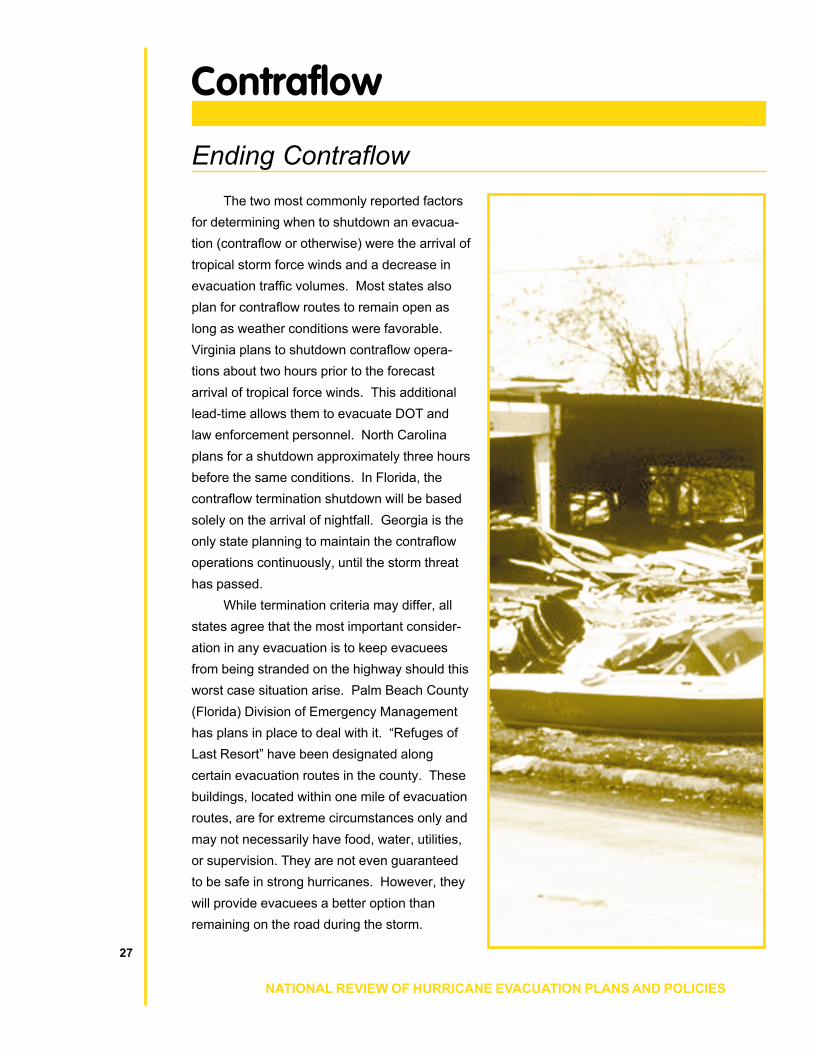
The two most commonly reported factorsfor determining when to shutdown an evacua-tion (contraflow or otherwise) were the arrival oftropical storm force winds and a decrease inevacuation traffic volumes. Most states alsoplan for contraflow routes to remain open aslong as weather conditions were favorable.Virginia plans to shutdown contraflow opera-tions about two hours prior to the forecastarrival of tropical force winds. This additionallead-time allows them to evacuate DOT andlaw enforcement personnel. North Carolinaplans for a shutdown approximately three hoursbefore the same conditions. In Florida, thecontraflow termination shutdown will be basedsolely on the arrival of nightfall. Georgia is theonly state planning to maintain the contraflowoperations continuously, until the storm threathas passed.
While termination criteria may differ, allstates agree that the most important consider-ation in any evacuation is to keep evacueesfrom being stranded on the highway should thisworst case situation arise. Palm Beach County(Florida) Division of Emergency Managementhas plans in place to deal with it. �Refuges ofLast Resort� have been designated alongcertain evacuation routes in the county. Thesebuildings, located within one mile of evacuationroutes, are for extreme circumstances only andmay not necessarily have food, water, utilities,or supervision. They are not even guaranteedto be safe in strong hurricanes. However, theywill provide evacuees a better option thanremaining on the road during the storm.
27
NATIONAL REVIEW OF HURRICANE EVACUATION PLANS AND POLICIES

Intelligent Transportation Systems
Access to timely and accurate trafficinformation during evacuations is critical to theevacuation process. Information about trafficflow rates and speeds, along with lane clo-sures, weather conditions, incidents, and theavailability of alternative routes is needed toeffectively guide evacuees. During the Georgesand Floyd evacuations, access to and ex-change of accurate and timely traffic informa-tion was often difficult. Emergency manage-ment officials were often �working blind,� withlittle quantitative knowledge of which evacua-tion routes were flowing well and which were ingridlock. As a result, they were unable toredirect traffic from routes that were overcapacity to nearby roads that were carryinglittle traffic.
One of the ways that DOT officials areresponding to the need for information isthrough the application of ITS technologies.Currently, all of the states surveyed have plansto enhance existing and develop new ITSsystems for use in hurricane evacuations. Themost common area of ITS application is forreal-time monitoring of travel conditions.Several states, including South Carolina,Florida, and Louisiana, are either using orplanning to use remote traffic detection sys-tems.
All DOTs have some type of statewidetraffic data recording system, used for planningpurposes to monitor and assess statewidetraffic volume and speed characteristics. Whilethe design of individual systems vary, theytypically use a remote sensing system (i.e.,pavement loops) and a basic traffic datarecorder. Under routine operation, most DOTsdownload data from the recorders via tele-
phone connections on a monthly basis. Re-cently, minor modifications to these samesystems have allowed South Carolina andFlorida DOT officials to retrieve this informationon hourly or 15-minute basis during evacua-tions. The modifications allow data to beassembled and displayed in tables and graphsto monitor the progression of the evacuation,track volume changes, and identify routes withexcess capacity. While these systems may notprovide true real-time data, they will give EMand DOT evacuation coordinators a muchbetter idea of up-to-date travel conditions thanthey have had in the past.
Cameras are another type of surveillancesystem capable of monitoring speed and flowsthat can be used for evacuation management.One commonly used system is closed circuittelevision (CCTV). CCTV cameras have anadvantage over loop detection in that they canprovide direct visual confirmation of traffic andweather conditions at remote locations. Theycan also be used for detecting incidents andverifying their removal. One of the limitationsof CCTV is that it typically requires direct powerand communication connections. This is oftendifficult in remote locations along evacuationroutes.
ITS systems are also planned to dissemi-nate travel information to evacuees. Two of thesystems planned for use are highway advisoryradio (HAR) and dynamic message signs(DMS). In contrast to traffic counter and CCTVsystems that bring data in, HAR and DMSsystems get information out. To make themake most effective use of these tools (HARhas a limited range of about 3 to 5 miles),states are planning to use them in advance of
28
LSU HURRICANE CENTER

Intelligent Transportation Systems
29
NATIONAL REVIEW OF HURRICANE EVACUATION PLANS AND POLICIES
exits and interchanges where services andalterative routes are available. The type ofinformation conveyed through HAR and DMSwill include shelter locations, alternativeevacuation routes, congestion and incidentinformation, and services such as gas station,rest area locations, lodging availability. As analternative to traditional HAR, the DelawareDOT is currently in the process of acquiring acommercial FM radio station for use as astatewide travel information station. Thestation will convey general travel informationduring non-evacuation periods and evacuationinformation in advance of hurricanes. Therelatively small area of Delaware makes itpossible for a single station to cover the (NHC),Virginia Department of Emergency Services,and the Red Cross. The Florida Division ofEmergency Management website provideslinks to hotels in Florida, Alabama, and Georgiathat allow evacuees to make online hotelreservations. The Florida DOT�s website toprovides access to its statewide network ofreal-time traffic volume and speed data record-ers. While all of these internet systems aretargeted for use prior to the evacuation, there islittle doubt that future wireless-Internet tech-nologies will allow them to be used en route.
There are also limitations in the applica-tion of ITS to hurricane evacuation. One of themost significant is that many ITS systems arelocated in urban areas, while the majority ofevacuation route mileage is in rural areas. Toaddress this, several states plan to use por-table systems, particularly HAR and DMS.Researchers in Louisiana are also currentlyworking on the development of a mobile trafficdata recording system. When completed,
these self-contained mobile data collectors willbe used to provide real-time traffic flow infor-mation using wireless communication technolo-gies. Another advantage to mobile systems isthat they can be deployed to any location inresponse to varying hurricane scenarios.Another limitation of ITS is its expense. Sinceevacuations are rare events that cover suchwide areas, it is difficult to justify their costunless they can incorporate multipurposefunctionality.

A historically overlooked issue in evacua-tion planning and preparedness has beenhighway work zones. In 1998, during theevacuation for Hurricane Georges, the Statesof Alabama, Mississippi, and Louisiana all hadconstruction zones on evacuation routes. InLouisiana, evacuation traffic on westbound I-10out of New Orleans was limited to a single lane.Early recognition of this problem by the DOTallowed them to request the contractor clearconstruction equipment and open both of thepartially constructed lanes to outbound traffic.Fortunately the contractor acted quickly anddelay was minimized. However, things couldhave been worse had the storm not changed toa more easterly course. A year later, similarproblems of construction on evacuation routeswere also experienced in North Carolina duringHurricane Floyd.
Since the need for maintenance andconstruction during the hurricane season isunavoidable, some DOTs have made attemptsto avoid conflicts by adding special provisionsin construction contracts to accommodateevacuation traffic through work zones. Themost common way to do this has been to addclauses that require a contractor to cease allconstruction activities once an evacuation isdeclared, clear all equipment, and open alllanes of traffic including those under construc-tion.
These types of contract provisions limitinglane closures in work zones are not thatunusual. Most states, particularly those wheretraffic congestion is routine, restrict construc-tion that reduces capacity. For example, theMaryland and New York DOTs do not allowconstruction to restrict traffic on any state
Work Zones
arterial route to less than the normal number oflanes during the peak summer travel periodfrom June to September. While these restric-tions cover most of the hurricane season theydo not apply to the less active, though stillpotentially dangerous, months of October andNovember. The Houston District of the TexasDOT uses contract language that requirescontractors to maintain the same number oflanes for evacuation as were originally avail-able. According to one official, this provision isunderstood but not necessarily written intocontracts in other Texas DOT districts.
Other options to maintain capacitythrough work zones on evacuation routes haveincluded limiting the construction season,distance, performance time, and/or phasesequencing of projects. These types of con-traction provisions can potentially increase thecost and/or duration of projects, since they mayrequire a contractor to work in shorter seg-ments or use non-standard constructionpractices.
Photo Credit: NOAA
30
LSU HURRICANE CENTER

The results of this study showed encour-aging signs for the improvement of hurricaneevacuations in the US. It was apparent thathighway and transportation professionals havebecome more involved in the development ofevacuation plans since 1998. This is a signifi-cant step and represents a needed changefrom prior practice. The involvement of trans-portation planners and engineers has alsobrought expertise and experience in dealingwith transportation-related issues, includingforecasting evacuation travel demand; evacua-tion traffic analysis and modeling; and theapplication of ITS technologies.
Although progress has been made in thepast few years, many needs still exist. One ofthe most obvious is the need for education andgreater exchange of information. The FederalHighway Administration has recognized thisneed and initiated a series of evacuation-related workshops. FHWA working with FEMA,has also established an Evacuation LiaisonTeam that will improve coordination andcommunications among states during hurricaneevents. A Transportation Research Boardsubcommittee (A3B01(4) � Subcommittee onEmergency Evacuation) has also been formedto disseminate new research findings to thepracticing community.
At a more basic level, additional researchand development of standards and bestpractices guidelines are also needed. While itis recognized that evacuation plans need toallow room for flexibility, checklists and basicguidelines could benefit state and local levelDOT and EM officials in the development ofspecific plans. They would also ensure a basiclevel of practice uniformity from location to
Conclusion
31
NATIONAL REVIEW OF HURRICANE EVACUATION PLANS AND POLICIES
location, an issue that has gained importanceas evacuations become regionalized. There isalso a need to address specific transportation-related evacuations issues, including thoseassociated with the movement of low-mobilitygroups, accommodating evacuation trafficthrough work zones, and determining the costsand benefits of contraflow operations.

Acknowledgements
The authors thank all of the surveyrespondents without whose assistance thisreport would not have been possible. Theauthors also wish to acknowledge the technicalassistance and information provided to them byDr. Chester Wilmot of the LSU Department ofCivil and Environmental Engineering and Mr.Sean Fontenot of the Louisiana Office ofEmergency Preparedness. The authors wouldalso like to thank Ms. Amber Cancienne of LSU
32
LSU HURRICANE CENTER
for the design and layout of this report and Mr.Joe Baker and Ms. Vicki Dischler of the Louisi-ana Transportation Research Center for theiradditional support in the production of thisdocument.

References
Augustiniak, M. (2001). �Reverse LanePlans for Cape May County and Other NewJersey Hot Spots.� Technical Presentation tothe 2001 National Hurricane Conference.Washington, D.C.
Collins, R. (2001). �Using ITS in HelpingFlorida Manage Evacuations.� TechnicalPresentation to the 2001 National HurricaneConference, Washington, D.C.
Culliton, T.J, M.A. Warren, D.G. Remer,C.M Blackwell, and J.J. McDonough (1990).�50 Years of Population Change along theNation�s Coasts 1960-2010.� National Oceanicand Atmospheric Administration, Washington,D.C.
FEMA (2000). �Southeast United StatesHurricane Evacuation Traffic Study � ExecutiveSummary (Draft).� Federal Emergency Man-agement Agency. Washington, D.C.
Ford, G., R. Henk, and P Barricklow(2000). �Interstate Highway 37 Reverse-FlowAnalysis � Technical Memorandum.� TexasTransportation Institute. San Antonio, Texas.
Franzese, O. and L. Han (2001). �TrafficModeling Framework for Hurricane Evacua-tion.� Technical Paper No. 01-2591. 80th
Annual Meeting of the Transportation ResearchBoard. Washington, D.C.
Hobeika, A. G., A.E. Radwan, and B.Jamei (1985). �Transportation Actions toReduce Evacuation Times Under Hurricane/Flood Conditions: A Case Study of Virginia
Beach City.� 74th Annual Meeting of the Trans-portation Research Board. Washington D.C.,January.
Jarrell, Herbert, and Mayfield (1992).�Hurricane Experience Levels of CoastalCounty Populations from Texas to Maine,�NOAA Technical Memorandum NWS HHC-46,National Oceanic and Atmospheric Administra-tion, Washington, D.C.
LSP (2000). �Troop �B� EmergencyEvacuation Plan.� Department of Public Safetyand Corrections, Louisiana State Police.Kenner, Louisiana.
LEOP (2001). �EOC Hurricane/MajorEvents Checklist.� Louisiana Office of Emer-gency Preparedness. Baton Rouge, Louisiana.
ORNL (1995). �Oak Ridge EvacuationModeling System (OREMS), User�s Guide.�Oak Ridge National Laboratory. Oak Ridge,Tennessee.
PBS&J (2000a). �Evacuation TravelDemand Forecasting System: TechnicalMemorandum 2.� Post, Buckley, Schuh &Jernigan, Inc. Tallahassee, Florida.
PBS&J (2000b). �Hurricane Floyd As-sessment - Review of Hurricane EvacuationStudies Utilization and Information Dissemina-tion.� Post, Buckley, Schuh & Jernigan, Inc.Tallahassee, Florida.
33
NATIONAL REVIEW OF HURRICANE EVACUATION PLANS AND POLICIES

34
LSU HURRICANE CENTER
PBS&J (2000c). �Reverse Lane Stan-dards and ITS Strategies Southeast UnitedStates Hurricane Study. Technical Memoran-dum 3.� Post, Buckley, Schuh & Jernigan, Inc.Tallahassee, Florida.
RPI (1997). �Tropical Cyclones andClimate Variability: A Research Agenda for theNext Century.� Bermuda Biological Station forResearch Risk Prediction Initiative. Availableat: http://www.bbsr.edu/rpi/tcdoc/tc.html,November, 1997.
Trammell, M. (2001). �Developing Evacu-ation Plans for Hurricane Operations.� Techni-cal Presentation to the 2001 National HurricaneConference, Washington, D.C.
Urbina, E. (2001). �State-of-the-PracticeReview of Hurricane Evacuation Practices.�Final Draft Master�s Thesis, Louisiana StateUniversity, Baton Rouge, Louisiana.
USGS (1998). �Natural Disasters -Forecasting Hurricane Occurrence, Economicand Life Losses.� United States GeologicalSurvey Center for Coastal Geology. Available:http://coastal.er.usgs.gov/hurricane_forecast/
Wolshon, B. (2001). ��One Way Out� �Contraflow Freeway Operation Hurricane forEvacuation.� American Society of Civil Engi-neers. Natural Hazards Review. Vol. 2, No. 2,Reston, Virginia.