nats 101 section 13: lecture 10 condensation, cloud formation, and fog
TRANSCRIPT

NATS 101 Section 13: Lecture 10
Condensation, Cloud Formation,
and Fog

Last time we focused on measures of atmospheric moisture which assumed
the atmosphere is either saturated or unsaturated.
What happens in the case where the atmosphere is supersaturated?

What is happening when liquid water condenses?
Definition of supersaturation from last time?
LIQUID WATER
If the rate of evaporation < rate of condensation, the air is said to be supersaturated with respect to water vapor.
Supersaturatione > es

In the atmosphere, this “surface” is a cloud condensation nuclei.
The key idea is that water needs some sort of surface to condense on when the air is supersaturated, like the
example of dew on grass.

Cloud condensation nuclei (CCN)
Tiny aerosol particles upon whose surfaces condensation of water vapor begins in the atmosphere, or heterogeneous nucleation.
Cloud condensation nuclei ultimately originate from the Earth’s surface, from both natural and man-made sources such as:
• Dust• Volcanoes• Smoke• Ocean spray (salt particles)• Biological processes• Industrial processes

Classification of Cloud Condensation Nuclei
(Wallace and Hobbs, 1977)
The wide range in cloud condensation nuclei concentration occurs because more aerosol pollutants occur over continents than oceans.
Continental air more CCN
Maritime air less CCN

What types of particles are good CCN?
Hygroscopic: condenses easily
• Salt• Sulfuric and nitric acid
Particles must be hydroscopic, or water seeking, so condensation will occur at or near the point where the relative humidity is 100%
Hydrophobic: resists condensation
• Oil or gasoline• Waxes
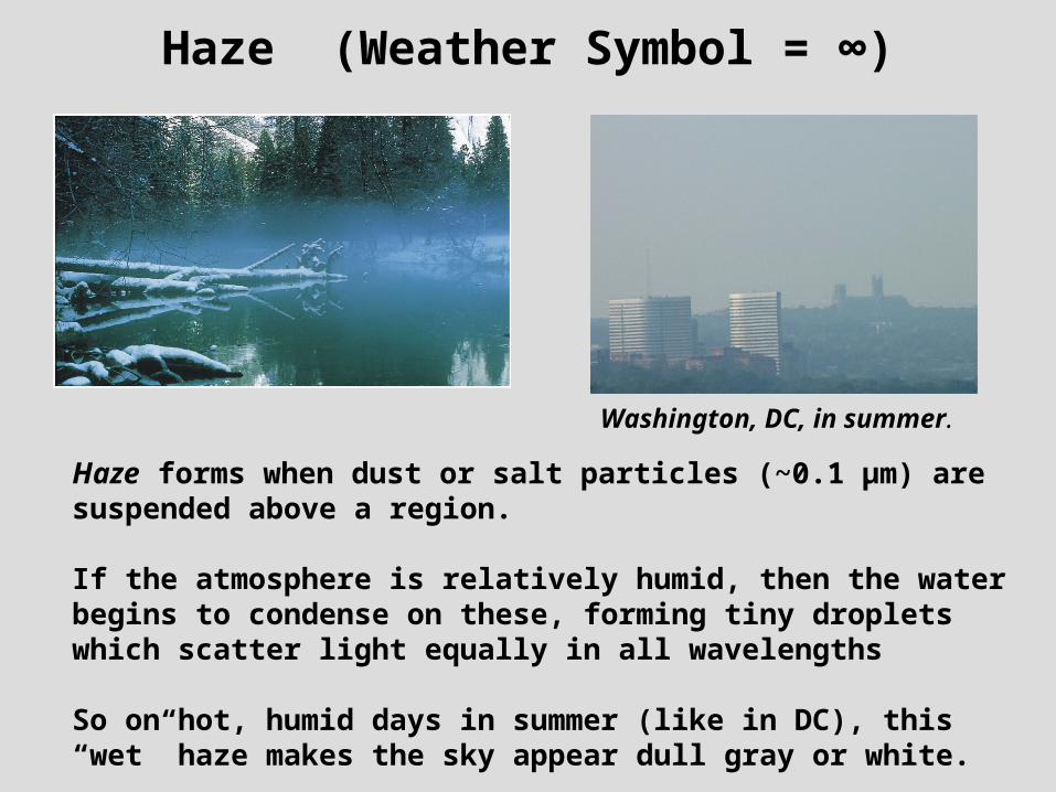
Haze (Weather Symbol = ∞)
Haze forms when dust or salt particles (~0.1 µm) are suspended above a region.
If the atmosphere is relatively humid, then the water begins to condense on these, forming tiny droplets which scatter light equally in all wavelengths
So on hot, humid days in summer (like in DC), this “wet” haze makes the sky appear dull gray or white.
Washington, DC, in summer.

Cloud droplets
Cloud droplets occur when enough water has condensed on the CCN to form a drop with a radius of about 10 µm.
How big is a typical CCN compared to a cloud drop or raindrop?
(Rogers and Yau, 1989)

Cloud drop concentration and sizeMaritime vs. Continental Environment
(Wallace and Hobbs, 1977)
Marine Environment
Less CCNLess total number of dropsLarger drops
Continental environment
More CCNMore total number of dropsSmaller drops

Rain cloud in Hawaii
The difference in the drop size distribution between marine and continental environments explains why rainfall can occur with very shallow clouds in tropical islands like Hawaii.
Though there are a relatively ________number of drops in the cloud, those drops a grow into raindrops a lot faster!

What is fog?
Fog: A cloud which forms at the ground, lowering the visibility to less than 1 km (or about two-thirds of a mile).
London, England is infamous for foggy weather. What are some reasons it is so prone to fog?
Fog Types:
Radiation Fog
Advection Fog
Upslope Fog
Steam Fog

Formation of Radiation Fog in Clear, Calm Nighttime Conditions
GROUND
Tground decreasesTair decreases and inversion forms
Solar radiation shut off
If conditions are clear and calm and the temperature cools to its dew point, water will begin to form on CCN. This is called radiation fog because it occurs as a result of radiative surface cooling.
Outgoing terrestrial radiation
Conduction(from air to ground)
Tair reaches dewpoint.
RADIATION FOGRADIATION FOG
COLDINVERSION
WARM ABOVE
Inversion height

Radiation Fog
Radiation fog commonly forms in valley bottoms. It typically dissipates, or burns off shortly after sunrise when the ground begins to warm and the inversion goes away.
However, for big valleys, like the Central Valley of California, a strong inversion and thick fog (called Tule fog in CA) may persist for days or weeks.
NASA image.
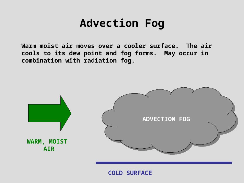
Advection Fog
Warm moist air moves over a cooler surface. The air cools to its dew point and fog forms. May occur in combination with radiation fog.
COLD SURFACE
ADVECTION FOG
WARM, MOIST AIR

Advection Fog
Pacific coast example: Why does this happen more there?

Warm air from the Gulf of Mexico travels north over the central and eastern U.S. (February 2000). Advection fog forms in the Midwest over snow cover and Texas coast.
NOAA Imagery

Upslope Fog
Moist air is forced upslope. Because the temperature decreases with elevation, the air cools to its dew point and fog forms.
MOIST AIR
UPSLOPE FOG
WARM
COLD
A good example is the Front Range of Colorado.
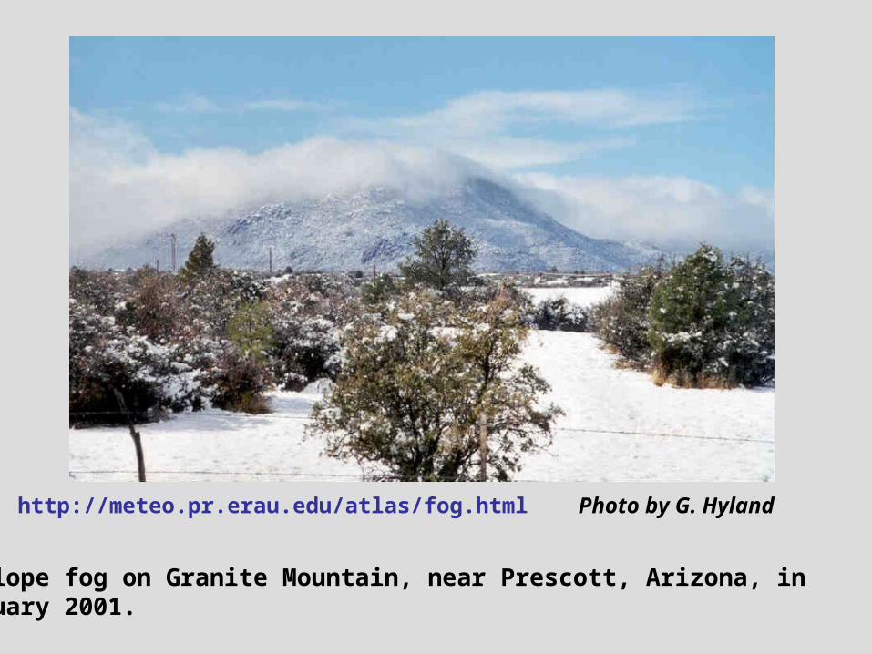
Photo by G. Hyland
Upslope fog on Granite Mountain, near Prescott, Arizona, in January 2001.
http://meteo.pr.erau.edu/atlas/fog.html

Steam or Evaporation Fog
Cold dry air travels over warm water (or a warm, moist surface). Water evaporates into the air, raising the dew point. If saturation occurs, fog forms.
Cold, dry air Evaporation
STEAM FOG
WARM WATER

www.physicalgeography.net
Steam fog typically forms over lakes in cold, winter weather. Does this process warm or cool the water? Why?
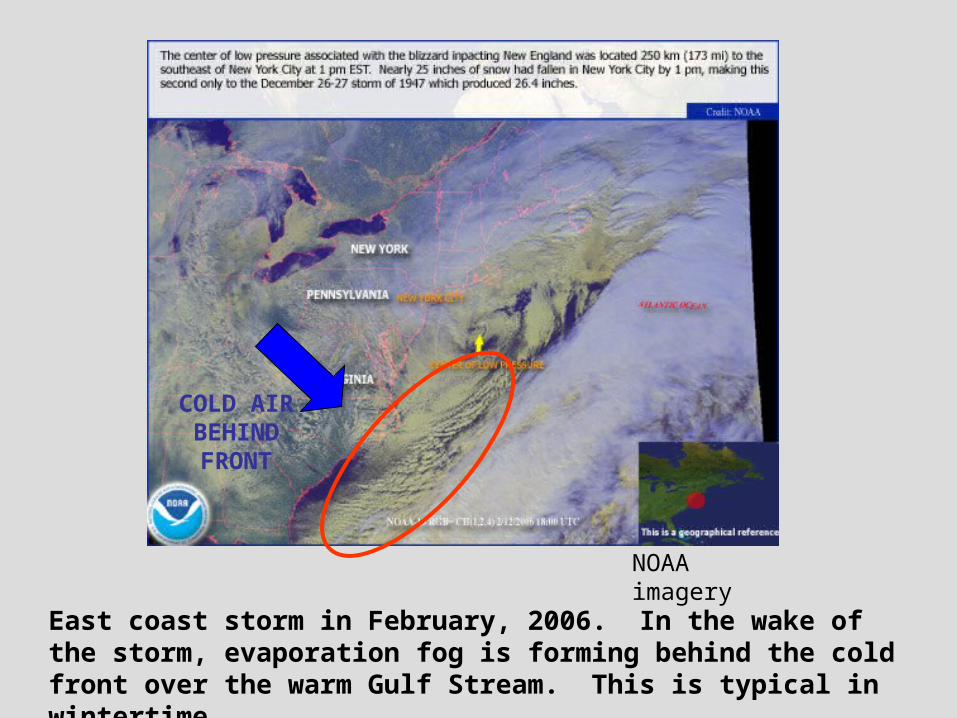
NOAA imagery
East coast storm in February, 2006. In the wake of the storm, evaporation fog is forming behind the cold front over the warm Gulf Stream. This is typical in wintertime.
COLD AIR BEHIND FRONT

Precipitation or Frontal Fog
Warm rain falls through a layer of cold, moist air. Water evaporates into the cold air, raising the dew point. If the air reaches saturation, fog may form. It is a type of steam fog.
Common situation in warm fronts (which we’ll talk about later), so it is also called frontal fog.
WARM AIR ABOVE
COLD AIR NEAR
SURFACE
PRECIPITATION FOG
Ground
WARM FRONT
RAIN EVAPORATES
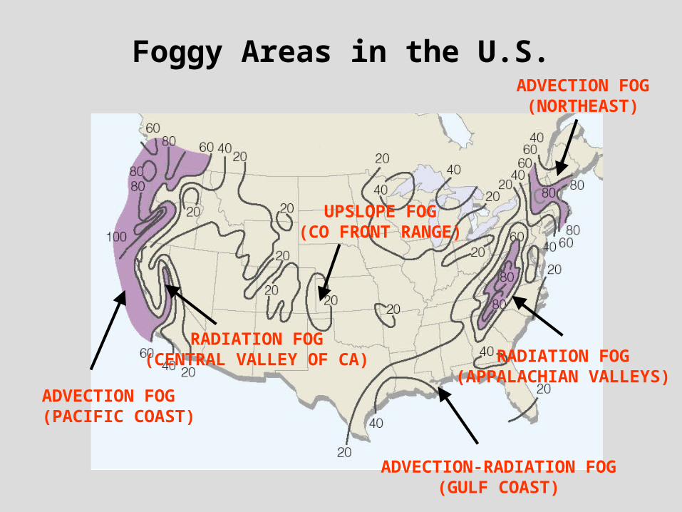
Foggy Areas in the U.S.
UPSLOPE FOG(CO FRONT RANGE)
ADVECTION FOG(PACIFIC COAST)
RADIATION FOG(CENTRAL VALLEY OF CA) RADIATION FOG
(APPALACHIAN VALLEYS)
ADVECTION-RADIATION FOG(GULF COAST)
ADVECTION FOG(NORTHEAST)

Summary of Lecture 10
Supersaturation occurs when the rate of condensation exceeds the rate of evaporation. In order for condensation to proceed a condensation surface is necessary.
The condensation surface in the atmosphere is a cloud condensation nuclei (CCN) which originate as aerosol particles from the Earth’s surface. In order to be good CCN, the aerosols must be hydroscopic.
More CCN are found over continents than oceans.
Haze forms when water condenses on dust or salt particles, and it makes the sky appear gray or white due to Mie scattering.
Cloud droplets are about 10 µm or greater.
Fog is a cloud which forms near the ground and reduces visibility. The four types of fog are radiation, advection, upslope and steam. Know the physical mechanism for each of these and where they’re most likely to occur.

Reading Assignment and Review Questions
Chapter 5: pp. 117-135 (8th ed.) pp. 122-138 (9th ed.) Cloud Chart at the back of the book.