natura 2000: introducing a discussion on identification...
TRANSCRIPT

Natura 2000:
Introducing a discussion on
identification and selection of sites
Alberto Arroyo SchnellWWF International12th October 2005 ©WWF-Canon / Krista SORMUNEN

Previous hypothesis
Bosnia Hercegovina is an EU candidate / accession country
Therefore:
• Legislation has to be transposed
• If needed, annexes of both Directives are being adapted
• National lists are under preparation
Alberto Arroyo SchnellApril 2007

Experience fromlatest enlargement processes
• No transition periods for nature legislation
• Prepare national lists to be ready by accession
• Art.6.2/3/4 applies by accession
• Adaptation of the annexes of both directives
Alberto Arroyo SchnellApril 2007

Establisment of the Natura 2000 network
Alberto Arroyo SchnellApril 2007

Legal obligationsfrom the designation
XXXXSACXXXSCI
X?X?X?cSCI?pSCI
XXXSPA6.46.36.26.1
Alberto Arroyo SchnellApril 2007
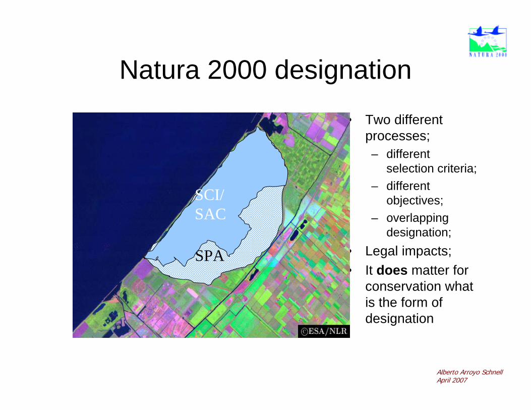
Natura 2000 designation
• Two different processes;– different
selection criteria;– different
objectives;– overlapping
designation; • Legal impacts;• It does matter for
conservation what is the form of designation
SPA
SCI/SAC
Alberto Arroyo SchnellApril 2007

SPA – A Place for Birds
©Birdlife International

Site designation: SPAs
Alberto Arroyo SchnellApril 2007

The Birds Directive and the IBA Programme
• The IBA programme has originally aimed at identifying potential SPAsin the EU;
• Today it is the global tool for priority setting for site-based bird conservation.
• The IBA inventories widely used by the CEC to challenge Member States for insufficient desig-nation of SPAs (11 of 15)

‘A’Global
‘B’Europe
‘C’European Union
Threatened spp. A1: Globallythreatened
B2: One of ‘n’ mostimportant for aSPEC1-3 sp.
C1: Globally threatened[= A1]
Restricted-range spp. A2: Endemic spp.
Assemlages ofbiome-restricted spp.
A3: Biome restrictedspp.
Congregations A4i: ≥ 1% of biogeogr.pop. of a waterbirdsp.;
A4ii: ≥ 1% of global pop.of seabird or othersp.;
A4iii: ≥ 20,000 waterbirdsor ≥ 10,000 pairs ofseabird;
A4iv: ≥ 20,000 storks,raptors or cranes
B1i: ≥ 1% of flywaypop. of a waterbirdsp.;
B1ii: ≥ 1% of a distinctpop. of seabirdsp.;
B1iii: ≥ 1% of a flyway orother distinct pop.of other congr.sp.;
B1iv: ≥ 5,000 storks or≥3,000 raptors orcranes
C2: 1% of flyway or EUpop. of an Annex Isp. [≈B1];
C3: 1% of flyway or EUpop. of a non-Annex I migratorysp. [=B1];
C4: ≥ 20,000 waterbirdsor ≥ 10,000 pairs ofseabird [=A4iii];
C5: ≥ 5,000 storks or≥3,000 raptors orcranes [=B1iv];
C6: top 5 site for anAnnex I sp. in theNUTS reg.
Others B3: One of ‘n’ mostimportant forSPEC4 sp.
C7: SPAs selected basedon other ornith.criteria [n/a]

SAC – A Place forHabitats & Species
©Alberto Arroyo
Alberto Arroyo SchnellApril 2007

Site designation: pSCIs
Alberto Arroyo SchnellApril 2007

The Biogeographical Regions
Alberto Arroyo SchnellApril 2007

SCIs designation follows
• 4 phases
– Proposal of Member states (1 list per region)
– Evaluation in biogeographic seminars (1- 3 loops)
– Improvement of National Lists
– Bilateral negotiations (member states and EC)
Alberto Arroyo SchnellApril 2007

SCIs designation basics
• Based on scientific background (annexes)
• Includes discussion with stakeholders in a transparent procedure: the Biogeographicseminars
©WWF-Canon / Edward PARKERAlberto Arroyo SchnellApril 2007
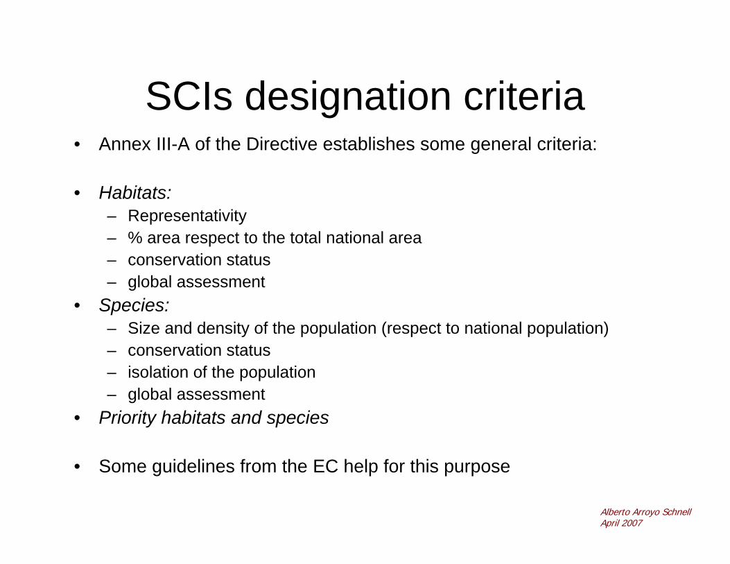
SCIs designation criteria• Annex III-A of the Directive establishes some general criteria:
• Habitats:– Representativity– % area respect to the total national area– conservation status– global assessment
• Species:– Size and density of the population (respect to national population)– conservation status– isolation of the population– global assessment
• Priority habitats and species
• Some guidelines from the EC help for this purpose
Alberto Arroyo SchnellApril 2007

What needs to be protected?National reference list:
• Which habitats and species from the Annexes of the HD are present in your country? (anything relevant at the EU level missing?)
• Is the Habitats interpretation manual adapted to your country (very technical phytosociological information)?
• The Habitats interpretation manual allows to very broad interpretation: it could be enough to ensure national subtypes are included
Alberto Arroyo SchnellApril 2007

Site designation: do we know what needs to be protected in
Bosnia Hercegovina?

Identification of sites:some ideas
Use of inventories• e.g. ES: 1:50.000 habitats inventory (based on
phitosociology)• e.g. HR: Habitat mapping on the whole territory of Croatia
(9ha units, remote sensing + field work)
Use of existing information (scientific evidence, knownlocations, expert opinions)
• e.g. all over: use of known locations (non published expert cites) for the site designation process, use of scientific articles…
Focusing on known spots• e.g. BG: inventory of known best areas (40% of their
territory)
Alberto Arroyo SchnellApril 2007

Data collectionACTIONS
- contact experts
- collectinformation
PROBLEMS AND SOLUTIONS• sometimes narrow field of expertise
=> many experts to be contacted• different regions => even more experts• specialists often not reluctant to give
their data => write motivating letterwith engagement of correct use ofdata
• differences in data quality• which parts of the total distribution
area are essential?• data not always recent (< 10 years ?)

Data collectionACTIONS
- Put togetherinformation
PROBLEMS AND SOLUTIONS• absence of estimations of total
area/habitat• lack of precision of data• difficulty to estimate the % covered by
a habitat type • interpretation of the ‘interpretation
manual’ (e.g. for degraded habitats)

Identification of sites:which information can we use in
your country (see annexes)? Which is the situation (availability,
gaps)

Selection of sites
• GIS: basic tool!
• EC requirement: minimum scale of 1:100.000
• Based on the scientific information; borders can be broader (different approaches)
• Stakeholder involvement (not always carried out, as the site designation is a scientific process)
Alberto Arroyo SchnellApril 2007

MappingACTIONS - Digitalizing
information
PROBLEMS AND SOLUTIONS• availability of precise location• different grid systems: UTM,
Lambert,…=> PC-conversion programme=> transparent grid lines on top opmap
• absence of GIS-system=> road map + transparents (samescale)
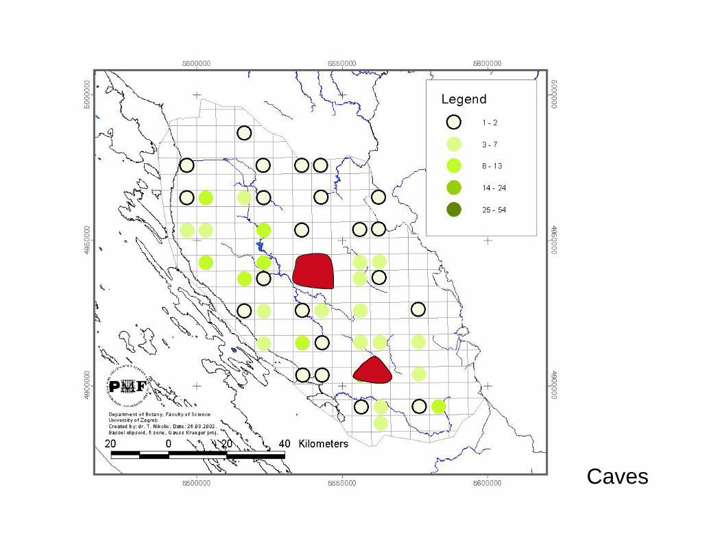
Caves

Selection of sites: how can the task be done in Bosnia
Hercegovina? (GIS)

The standard data forms• Available on Internet
• Based on the scientific information from the sites
• Digital form to be filled in, including– habitats and species present– % of habitats and species on the site, respect to national
surface of them– conservation status of the habitats and species– other information
Alberto Arroyo SchnellApril 2007

Filling in of the Standard Data Forms: how in Bosnia
Hercegovina?
Further information
• EC websitehttp://ec.europa.eu/environment/nature/home.htm
• ETC (technical Agency of the EC):http://biodiversity.eionet.europa.eu/activities/Natura_2000/documentation
Alberto Arroyo SchnellApril 2007