natura impact statement - limerick smarter travel · this document is a natura impact statement...
TRANSCRIPT

Limerick Smarter Travel Route 2: Natura Impact Statement ____January 2015
__________________________________________________________________________ www.ecofact.ie
Limerick Smarter Travel Route 2 Shared Pedestrian and Cycleway Facility
Natura Impact Statement
Version: 13th January 2015 (Final)
Tait Business Centre, Dominic Street, Limerick City, Ireland.
t. +353 61 419477, f. +353 61 414315 e. [email protected] w. www.ecofact.ie

Limerick Smarter Travel Route 2: Natura Impact Statement ___January 2015
________________________________________________________________________________www.ecofact.ie 2
SUMMARY This document is a Natura Impact Statement (NIS) and assesses the likely significant effects on the Natura 2000 network arising from the proposed Limerick Smarter Travel Route 2 Limerick Smarter Travel Route 2 Shared Pedestrian and Cycleway Facility. This document sets out to inform the appropriate assessment process under Article 6(3) and 6(4) of the Habitats Directive. The document was prepared following the guidance published by the National Parks and Wildlife Service (NPWS, 2009) ‘Appropriate Assessment of Plans and Projects in Ireland. Guidance for Planning Authorities’. The proposed overall scheme includes for the upgrading and improvement of an existing public track to include approximately 1.2km of cycleway/pathway. Natura 2000 sites within 15km of the proposed development were considered and it was concluded that only one Natura 2000 could be potentially affected; the Lower River Shannon candidate Special Area of Conservation (Site Code 2165). The site is a candidate SAC selected for lagoons and alluvial wet woodlands, both priority habitats listed on Annex I of the E.U. Habitats Directive. The site is also selected for floating river vegetation, Molinia meadows, estuaries, tidal mudflats, Atlantic salt meadows, Mediterranean salt meadows, Salicornia mudflats, sand banks, perennial vegetation of stony banks, sea cliffs, reefs and large shallow inlets and bays all habitats listed on Annex I of the E.U. Habitats Directive. The site is also selected for the following species listed on Annex II of the same Directive – Bottle-nosed Dolphin, Sea Lamprey, River Lamprey, Brook Lamprey, Freshwater Pearl Mussel, Atlantic salmon and Otter. The proposed works are located within and adjacent to the Lower River Shannon cSAC and will include works adjacent to the riparian corridor and alluvial woodland of the lower Shannon. The alluvial woodland within the study area corresponds to the priority Annex I habitat ‘Alluvial forests with Alnus glutinosa and Fraxinus excelsior (Alno-padion, Alnion incanae, Salicion albae)’. The baseline conditions of this habitat within the study area are degraded with regard to the existing walkways and public access and also taking account of the significant colonisation of the Lower Shannon river corridor with non-native invasive species. The example of alluvial woodland which occurs along the River Shannon is a very poor example of this priority habitat type, and is a secondary habitat which has developed along the river in this area as a result of the reduction of flows in the river as a consequence of the Shannon Scheme. The woodland has a large amount of non-native species present, and is already fragmented by the existing towpath which pre-dates the development of this alluvial woodland strip. The riparian woodland which broadly meets the qualifying criteria set out for Annex I priority alluvial forest habitat [91E0] only occurs on the riverside of the existing towpath and is avoided by the proposed development. The proposed cycleway/pathway has been designed to fully avoid this habitat and works will follow the route of the existing pathways and right of way tracks within this area, avoiding impacts affecting alluvial woodland. The temporary construction wayleave has also been carefully designed to avoid this habitat and generally keeps away from the cSAC. The removal of individual immature trees (which will be replaced by planting) will be required for the construction of the proposed development and access wayleave. However, no loss of priority habitat will occur. The proposed walkway/cycleway is evaluated as having an imperceptible impact where future public use of the amenity walkways will limit trampling and disturbance away from the designated cycleway/pathway. Impacts affecting otter are evaluated as being imperceptible negative in the local context during the construction phase and in line with ongoing trends with regard to the operational phase. There are no otter holts in the study area and there is existing disturbance (including dog walking) and lighting (from UL and the GAA grounds). In the current proposal lighting will be switched off from April to September each year and will be switched off at 11pm in the evening from October to March each year.
Limerick Smarter Travel Route 2: Natura Impact Statement ___January 2015
________________________________________________________________________________www.ecofact.ie 3
In the absence of works in the aquatic environment and taking account of the proposed mitigation measures for the avoidance of disturbance and protection of water quality during the construction phase of the works, there are no impacts identified which would have the potential to significantly affect the remaining Annex I habitats or Annex II species listed as qualifying interests of the cSAC No impacts affecting the aquatic habitats and species listed as qualifying interests of the cSAC are identified. Taking the above into account it is concluded that the proposed walkway/cycleway development, subject to the proposed mitigation measures, will not result in direct, indirect or cumulative impacts which would have the potential to adversely affect the conservation objectives of the Lower River Shannon cSAC in relation to the relevant Annex II species and Annex I habitats; with regard to their range, population densities or conservation status within the cSAC. It is considered that the scale of these works, in addition to the implementation of the prescribed mitigation measures, would not give rise to significant impacts affecting the integrity of the Lower River Shannon candidate Special Area of Conservation.
Limerick Smarter Travel Route 2: Natura Impact Statement ___January 2015
________________________________________________________________________________www.ecofact.ie 4
TABLE OF CONTENTS 1. INTRODUCTION ........................................................................................................................................ 6
1.1 FOREWORD ................................................................................................................................................ 6 1.2 LEGISLATIVE CONTEXT ................................................................................................................................... 7 1.3 BACKGROUND ............................................................................................................................................. 8 1.4 DESCRIPTION OF THE PROPOSED WORKS ......................................................................................................... 10
1.4.1 Outline Methodology .................................................................................................................... 10 1.5 OVERVIEW OF ISSUES .................................................................................................................................. 12
2. METHODOLOGY ..................................................................................................................................... 14
2.1 DESK STUDY AND ECOLOGICAL FIELD SURVEY ................................................................................................... 14 2.2 APPROPRIATE ASSESSMENT METHODOLOGY ................................................................................................... 15
2.2.1 Stage 1: Screening......................................................................................................................... 15 2.2.2 Stage 2: Appropriate Assessment ................................................................................................. 17
2.3 EVALUATION ............................................................................................................................................. 17
3. STAGE 1: SCREENING / TEST OF SIGNIFICANCE ....................................................................................... 19
3.1 DESCRIPTION OF THE PROPOSED DEVELOPMENT ............................................................................................... 19 3.2. IDENTIFICATION OF RELEVANT NATURA 2000 SITES .......................................................................................... 19
3.2.1 Screening of Natura 2000 Sites within 15km of the study area .................................................... 19 3.2.2 Description of Natura 2000 sites likely to be affected by the proposed project ........................... 23
3.3 SCREENING ASSESSMENT OF LIKELY EFFECTS ................................................................................................... 23 3.3.1 Assessment of likely direct impacts affecting the Natura 2000 site ............................................. 23 3.3.2 Assessment of likely indirect impacts affecting the Natura 2000 site .......................................... 24 3.3.3 Assessment of likely cumulative impacts affecting the Natura 2000 site ..................................... 25
3.4 SCREENING STATEMENT WITH CONCLUSIONS ................................................................................................... 25
4 STAGE 2: NATURA IMPACT STATEMENT ................................................................................................. 26
4.1 DESCRIPTION OF THE NATURA 2000 SITE AFFECTED ......................................................................................... 26 4.1.1 Overview of the receiving environment ........................................................................................ 26 4.1.2 Overview of the Lower River Shannon cSAC ................................................................................. 27
4.2 IMPACT PREDICTION ................................................................................................................................... 31 4.2.1 Direct impacts ............................................................................................................................... 31 4.2.2 Indirect impacts ............................................................................................................................ 32 4.2.3 Cumulative impacts ...................................................................................................................... 33
4.3 MITIGATION MEASURES .............................................................................................................................. 35 4.3.1 Construction phase mitigations .................................................................................................... 35 4.3.2 Operational phase mitigation ....................................................................................................... 36
4.4 IMPACTS AFFECTING THE CONSERVATION OBJECTIVES OF THE NATURA 2000 SITE ................................................... 37 4.5 APPROPRIATE ASSESSMENT NIS CONCLUSION STATEMENT ................................................................................. 40
REFERENCES ................................................................................................................................................... 42
PLATES ........................................................................................................................................................... 45
APPENDIX 1 DESCRIPTION OF PROPOSED SCHEME AND CONSTRUCTION METHODS ..................................... 49
CONSTRUCTION METHODOLOGY ................................................................................................................... 49
INTRODUCTION ..................................................................................................................................................... 49 SITE DESCRIPTION .................................................................................................................................................. 49 SITE ACCESS ......................................................................................................................................................... 50 SITE COMPOUND LOCATION .................................................................................................................................... 50 OUTLINE CONSTRUCTION METHODOLOGY – PROPOSED PATH ......................................................................................... 51 OUTLINE CONSTRUCTION METHODOLOGY – PROPOSED BRIDGES ..................................................................................... 51
Bridge 4 ......................................................................................................................................................... 51 Bridge 5 ......................................................................................................................................................... 52 Bridge 6 ......................................................................................................................................................... 52
Limerick Smarter Travel Route 2: Natura Impact Statement ___January 2015
________________________________________________________________________________www.ecofact.ie 5
Bridge 7 ......................................................................................................................................................... 53
APPENDIX 2 NPWS SITE SYNOPSIS ................................................................................................................. 62
APPENDIX 3 BOTANIST REPORT (JANUARY 2015) .......................................................................................... 68
APPENDIX 4 INVASIVE SPECIES IDENTIFICATION GUIDES ............................................................................... 82
A1.1 HIMALAYAN BALSAM IDENTIFICATION SHEET ...................................................................................................... 82 A1.2 GIANT HOGWEED IDENTIFICATION SHEET .......................................................................................................... 84 A1.3 JAPANESE KNOTWEED IDENTIFICATION SHEET ..................................................................................................... 86

Limerick Smarter Travel Route 2: Natura Impact Statement ___January 2015
________________________________________________________________________________www.ecofact.ie 6
1. INTRODUCTION 1.1 Foreword This document is a Natura Impact Statement (NIS) and assesses the likely significant effects on the Natura 2000 network arising from the proposed Limerick Smarter Travel Route 2 Limerick Smarter Travel Route 2 Shared Pedestrian and Cycleway Facility. This document sets out to inform the appropriate assessment process under Article 6(3) and 6(4) of the Habitats Directive. This NIS was originally prepared during March 2014, but was updated following revision of the proposal in response to a further information request (FIR) from An Bord Pleanála (Ref 30.JP0027). The FIR required the following to be to be provided:- (1) A revised proposal for the upgrade of the existing walkway and cycleway, which should be at grade insofar as possible, with the exception of the areas required to be raised to provide for the proposed bridge structures; the revised design is likely to be similar to that of Route 2 Link 1, and generally in accordance with the “Proposed Bitmac surfacing” set out in Drawing Number 131-143-250 Revision PL0 (Path Construction Details). 2. A revised Ecological Impact Statement, and Natura Impact Statement: these reports should have regard to the modified design as set out above, and should be prepared by an appropriately qualified and experienced habitats specialist, incorporating the following: (i) the proposed construction methodologies, clarifying the identified conflicts on file; (ii) provide an analysis of whether any of the alluvial forest identified, and which is to be removed, meets the qualifying criteria set out for Annex I priority alluvial forest habitat [91E0]; (iii) produce a map identifying the specific lands to be affected by construction, indicating the habitats arising, particularly where the conservation objectives of a European site might be involved, including any Annex I priority alluvial forest habitat; this is likely to require the re-survey of the subject site; however, National Parks and Wildlife Service maps of the relevant qualifying interest may also be of assistance; (iv) further details on the potential for cumulative impact with works as identifies in Section 3.3.3 of the Limerick Smarter Travel Route 2 Appropriate Assessment Natura Impact Statement; (v) the mitigation measures necessary in respect of any revised proposals should be set out in detail, and in respect of construction mitigation measures in particular, and (vi) It is noted that habitat compensation measures might not be considered appropriate in respect of any loss of Annex I habitat. The above requests have been addressed and a revised proposal has been developed and is assessed in this NIS. A description of the proposed development along with a proposed outline construction methodology is provided in Appendix 1. As identified in the previous NIS, the riparian woodland which adjoins the proposed Limerick Smarter Travel Route 2 Shared Pedestrian and Cycleway Facility does broadly correspond to the priority EU Annex I habitat ‘alluvial forest with Alnus glutinosa and Fraxinus excelsior (Alno-padnion, Alnion incanae, Salicion albae) (91E0). However, it is considered to be a secondary, poor and fragmented example of this habitat. The proposed development has been carefully designed to ensure that there
Limerick Smarter Travel Route 2: Natura Impact Statement ___January 2015
________________________________________________________________________________www.ecofact.ie 7
will be no direct impacts on any habitat which meets the qualifying criteria set out for Annex I priority alluvial forest habitat [91E0] as a result of the construction or operation of this proposed scheme. This has been confirmed by consultant botanist Dr John Conaghan of Enviroscope Environmental Consultancy who was engaged by ECOFACT to resurvey the woodland habitats in the vicinity of the proposed scheme during November 2014. The proposed scheme has been designed to follow the existing disturbed towpath along the River Shannon. At the bridge crossing sites and at some points along the route a number of individual trees (generally immature) will be removed to facilitate the development. However, this represents a loss of a few individual trees only, which will be replaced, rather than any loss of a priority habitat. There is no requirement for compensation measures in relation to the Lower Shannon cSAC. The example of alluvial woodland which occurs along the River Shannon is a very poor example of this priority habitat type, and is a secondary habitat which has developed along the river in this area as a result of the reduction of flows in the river as a consequence of the Shannon Scheme. The woodland has a large amount of non-native species present, and is already fragmented by the existing towpath which pre-dates the development of this alluvial woodland strip. The riparian woodland which broadly meets the qualifying criteria set out for Annex I priority alluvial forest habitat [91E0] only occurs on the riverside of the existing towpath and is avoided by the proposed development. The current NIS also assesses the impact of the proposed construction access way leave. This temporary access way leave will also avoid alluvial woodland habitat, and all other habitats of conservation importance. The way leave will only result in the temporary disturbance of habitats rated as being of Local Importance only. These include grassland habitats, hedgerows and tree lines, all of which will be reinstated following the construction phase. This has also been confirmed by consultant botanist Dr John Conaghan. 1.2 Legislative context The current assessment takes account of Council Directive 92/43/EEC on the conservation of natural habitats and of wild fauna and flora - ‘The Habitats Directive’ which was transposed into Irish law by the ‘European Community (Natural Habitats) Regulations 1997’ (S.I. No. 94/1997). The most recent transposition of this legislation in Ireland is the European Communities (Birds and Natural Habitats) Regulations 2011 (S.I. No. 477 of 2011). The Birds Directive (2009/147/EC) which is now included in the former Regulations seeks to protect birds of special importance by the designation of Special Protection Areas (SPAs) whereas the Habitats Directive does the same for habitats and other species groups within Special Areas of Conservation (SACs), which are designated or proposed as candidate Special Areas of Conservation (cSACs). It is the responsibility of each member state to designate SPAs and SACs, both of which will form part of Natura 2000, a network of protected areas throughout the European Community. Article 6, paragraphs 3 and 4 of the EC ‘Habitats’ Directive (1992) state that: 6(3) ‘Any plan or project not directly connected with or necessary to the management of the site but likely to have a significant effect thereon, either individually or in combination with other plans or projects, shall be subject to appropriate assessment of its implications for the site in view of the site's conservation objectives. In the light of the conclusions of the assessment of the implications for the site and subject to the provisions of paragraph 4, the competent national authorities shall agree to the plan or project only after having ascertained that it will not adversely affect the integrity of the site concerned and, if appropriate, after having obtained the opinion of the general public.’

Limerick Smarter Travel Route 2: Natura Impact Statement ___January 2015
________________________________________________________________________________www.ecofact.ie 8
6(4) ‘If, in spite of a negative assessment of the implications for the site and in the absence of alternative solutions, a plan or project must nevertheless be carried out for imperative reasons of overriding public interest, including those of a social or economic nature, the Member State shall take all compensatory measures necessary to ensure that the overall coherence of Natura 2000 is protected. It shall inform the Commission of the compensatory measures adopted. Where the site concerned hosts a priority natural habitat type and / or a priority species, the only considerations which may be raised are those relating to human health or public safety, to beneficial consequences of primary importance for the environment or, further to an opinion from the Commission, to other imperative reasons of overriding public interest.’ In addition, the European Court of Justice in Case C-127/02 (the “Waddenzee Ruling”) has made a relevant ruling in relation to Appropriate Assessment and this is reflected in the current assessment: ‘Any plan or project not directly connected with or necessary to the management of the site is to be subject to an appropriate assessment of its implications for the site in view of the site’s conservation objectives if it cannot be excluded, on the basis of objective information, that it will have a significant effect on that site, either individually or in combination with other plans or projects” and that the plan or project may only be authorised “where no reasonable scientific doubt remains as to the absence of such effects.’ 1.3 Background Limerick Smarter Travel is a joint initiative by Limerick City Council and Limerick County Council in partnership with the University of Limerick (UL). The proposed Limerick Smarter Travel Route 2 walkway/cycleway development runs from Guinness Bridge (at the confluence of the Park Canal with the River Shannon) to the existing Black Bridge in the University of Limerick campus. The proposed development comprises a walkway/cycleway that will follow existing pathway, old towpaths and riparian rights of way. The route has been in existence, and has been used extensively, for over 200 years. Most of the route subjected to improvements in the recent past. The proposed development runs from the confluence of the Park Canal along the River Shannon to the existing Black Bridge and University of Limerick Campus at Plassey. The entire route runs along the 'old' Limerick navigation scheme. The Limerick Smarter Travel Route 2 connects with other pathways and cycle ways at Guinness Bridge including a 4m wide walkway and cycleway which was recently upgraded as part of the Limerick City Park Canal Restoration Project. Ongoing improvements to this route have been taking place since the 1980s. The Limerick City Municipal boundary is located to the west of the Groody River confluence with the River Shannon. The University of Limerick have also partially improved the route within their property boundary, with the provision of a new surface and post and rail fencing. The University of Limerick have also developed a boat house and slipway along the route, with other improvements to the former towpath in this area. This towpath was formerly used by horses to tow barges and other boats along the River Shannon. In particular it was used to be used to tow barges of sand, that were dug from the River at Plassey, down to Limerick for use locally or exported for building material (Source: The Old Limerick Journal). The current route is also already part of the Lough Derg Way. This is a long distance walking trail extending from Limerick City along the canal and onwards to Killaloe by way of O’Brien’s Bridge (Limerick City Council, 2008). This is currently a busy and regularly used walking and cycling track, mainly for recreation but is already being used by some commuters. The 'old' Limerick navigation scheme formerly connected Limerick and the sea to Lough Derg via the Park Canal and also derelict Plassey–Errina Canal, prior to the construction of the Shannon

Limerick Smarter Travel Route 2: Natura Impact Statement ___January 2015
________________________________________________________________________________www.ecofact.ie 9
Hydroelectric scheme in the 1920s'. According to Prothero & Clark (1896) (and taken from the Irish Waterways History website www.IrishWaterwaysHistory.com) the Old Limerick Navigation included five sections. Starting from the upstream end, these were:
1. A canal bypassing rapids at Killaloe and some distance downstream. This canal had three locks;
2. A river navigation section, on the Shannon itself, from the lowest lock on the Killaloe canal through O’Brien's Bridge to Errina;
3. A second canal from Errina to Plassey, with six locks 4. A river navigation section from Plassey 5. A third canal leading to the canal harbour in Limerick. This canal had one lock about half way
along; a second lock allowed boats out of the harbour on to the Abbey River and thus provided access to Limerick Dock and the Shannon Estuary. This canal bypassed rapids at Corbally.
The proposed Limerick Smarter Travel Route 2 development follows Section 4 above of the 'old' Limerick Navigation scheme. The new Limerick navigation now directs boats along the Abbey River, and through the tailrace and headrace canals of Ardnacrusha hydroelectric station. The new Limerick City Navigation has only been a partial success and there are significant navigation issues when trying travel along the Abbey River. Indeed, there have always navigation problems in this area. Prior to the Shannon scheme there were problems when crossing the River Shannon from Section 4 to Section 5 of the 'old' Limerick Navigation scheme (according to the website of Irish Waterways History). This was when the Lower River Shannon was in full flow. Since the construction of the Shannon scheme in 1920's the 'old' River Shannon receives a base compensation flow of 400 cubic meters of water per second (m3 sec-1, or cumecs) with the next 400 cumecs used for hydroelectricity generation at Ardnacrusha hydroelectric power station. Water flows in excess of 410 cumecs are then 'spilled' at Parteen weir down the Old River Shannon. The usually much reduced flows on the Old River Shannon as well as the abandonment of the 'old' Limerick navigation scheme has lead to encroachment of the river beside the old tow path on the River Shannon by silt and riparian woodland. Likewise the Park canal has become derelict in navigation terms, and the restoration of this area undertaken in 2005 did not provide navigation. On the Limerick bank of the Black Bridge there was formerly a large Mill Building known as Plassey Mills, which was built in 1824. This building "was six storeys high and took advantage of the ten foot drop from the water race behind it into the Shannon making it one of the most productive mills in the area at the time" according to website of Limerick's Life (www.LimericksLife.com). In the 1840s the mill was affected by a fire but this was soon repaired but became derelict due to the reduction in water flows after the Shannon Hydroelectric Scheme. The mill stood derelict for many years until 1957 when all but the corner tower were demolished (source: Limerick Life). The corner tower is still present and is in the study area of the proposed development. The entire proposed Route follows the route of the old Shannon navigation scheme, between the Black Bridge at the University of Limerick campus and the confluence with the Park canal. As outlined above, the entire area has a long history of development, decay and redevelopment. Most of the route has been recently improved and is in current use. The entire route follows the old Limerick navigation tow path from Guinness Bridge, at the junction of the Abbey River and Park Canal, to Plassey Mills and Black Bridge and the current modern expansive development of the University of Limerick campus. The entire route is already used extensively for running, cycling, and walking (with dogs etc.) and is a long established and utilised right of way.

Limerick Smarter Travel Route 2: Natura Impact Statement ___January 2015
________________________________________________________________________________www.ecofact.ie 10
The proposed development of a 3m wide pathway has been carefully designed to 'fit on top' of the existing tow path and embankment as it runs along the River Shannon, from Guinness Bridge to Black Bridge and into the existing University of Limerick campus. The proposal also involves the construction of a number of new bridges adjacent to existing bridges, over watercourses and drainage channels which flow into the River Shannon. The most significant watercourse entering the River Shannon along this stretch is the Groody River; itself a highly modified and channelised river. While it is acknowledged that the entire proposed development either immediately adjoins or runs through parts of the Lower River Shannon candidate Special Area of Conservation (cSAC), the habitats directly affected in their own merit are largely of low ecological value. The proposed development is 'inset' into an existing route where the habitats directly affected mostly comprise artificial surfaces and bare/recolonising ground. The Pedestrian and Cycleway Facility has been carefully designed to avoid the woodland that corresponds to priority Annex I alluvial woodland. Likewise, the proposed temporary construction access way leave has been designed to avoid impacts on this habitat. Figure 1 gives the location of the proposed Limerick Smarter travel Route 2 proposed development. 1.4 Description of the proposed works The proposed route runs alongside the River Shannon for a distance of approximately 1.2km. The proposed facility will be 3m wide with a bitumous surface, lit, signposted and provided with CCTV facilities. There will be directional low pressure sodium lighting (with a curfew at 11pm). Lighting will be used between the months of October and March inclusive (i.e. no lighting between April and September inclusive). The project will be delivered via an outline construction methodology and outline construction programme, as provided in Appendix 1. These areas are described here under along with site access proposals, site compound locations and material storage areas. One site compound is proposed for this project and will be located behind the University of Limerick boat club. Due to the restricted width of the proposed route, the majority of materials will be stockpiled at the site compound location and delivered to site as required. The following is a summary of the methodology proposed; 1.4.1 Outline Methodology The revised planning drawings are provided in Appendix 1. The outline methodology proposed is as follows: • The existing pathway will be graded and levelled using a small excavator. Excess material will be
removed from the site by a dumper via the temporary roadway and access easement. • The proposed timber kerbing arrangement will be installed within the top of the existing
embankment. Pressure treated timber support posts (600mm long) will be driven into the top of the existing embankment at approx. 1.2m centres. Treated timber kerbs will then be fixed between each of the support posts.
• Subject to ground conditions, a geotextile material will be laid along the route of the proposed pathway. Imported granular material will be filled to a thickness of approx. 120mm between the timber kerbing. The proposed build up will be completed by laying a bitmac surfacing to a depth of approx. 75mm. The bituminous surface will be machine laid using equipment suitable and will access the towpath using the temporary roadway or along the top of towpath.

Limerick Smarter Travel Route 2: Natura Impact Statement ___January 2015
________________________________________________________________________________www.ecofact.ie 11
1.4.1.1 New Footbridge at Bridge 4 The planning drawings for proposed bridge 4 are also provided in Appendix 1. Outline methodology proposed:
• The existing pathway will be graded and levelled using a small excavator. Excess material will be removed from the site by a dumper via the temporary roadway and access easement.
• The existing balustrade will be removed. • The existing bridge deck will be extended in reinforced concrete with masonry facing to match
existing with structural support provided by the existing abutment walls. • The existing bridge will be repaired as it is in poor condition due to stone slippage and robbing
out. Where required, missing masonry elements will be replaced using like for like materials. • A new balustrade will be provided upon completion.
1.4.1.2 New Footbridge at Bridge 5 The planning drawings of proposed bridge 5 are also provided in Appendix 1. The outline methodology proposed is as follows:
• Excavation for the foundations of the proposed bridge will be undertaken using an excavator and material will be removed from the site using a dumper. All machinery will access the area around bridge 5 using the temporary roadway.
• Foundations will be poured using in-situ concrete. All concrete will be mixed off site, brought to bridge 5 using the temporary roadway and pumped into the excavation from the supplier’s vehicle.
• Piled foundations will be required to provide support due to poor ground conditions and will be driven into the ground at locations required.
• The support posts for the footbridge will be bolted to the foundation pads. • Where spans greater than 4m are required, a prefabricated steel frame will be provided. • Cross beams and runners will be bolted to the support structure. Decking boards and
balustrade will then be fitted. • The existing bridge will be cleaned and repaired.
1.4.1.4 New Footbridge at Bridge 6 The planning drawings of proposed bridge 6 are also provided in Appendix 1. The outline methodology proposed is as follows:
• Excavation for the foundations of the proposed bridge will be undertaken using an excavator and material will be removed from the site using a dumper. All machinery will access the area around bridge 6 using the temporary roadway.
• Foundations will be poured using in-situ concrete. All concrete will be mixed off site, brought to bridge 6 using the temporary roadway from the Boat House and pumped into the excavation from the supplier’s vehicle.
• Piled foundations will be required to provide support due to poor ground conditions and will be driven into the ground at locations required.
• The support posts for the footbridge will be bolted to the foundation pads. • Where spans greater than 4m are required, a prefabricated steel frame will be provided. • Cross beams and runners will be bolted to the support structure. Decking boards and
balustrade will then be fitted.

Limerick Smarter Travel Route 2: Natura Impact Statement ___January 2015
________________________________________________________________________________www.ecofact.ie 12
• The existing bridge will be cleaned and repaired as necessary. 1.4.1.5 Widening of Existing Bridge 7 The planning drawings of proposed bridge 6 are also provided in Appendix 1. The outline methodology proposed is as follows:
• The existing concrete and steel sections of the bridge and deck will be removed and the bridge will be widened toward the River Shannon.
• A section of the existing masonry abutment walls will be replaced with reinforced concrete (RC) abutment walls with masonry facing to match existing. The reinforced concrete retaining walls will be constructed in-situ using appropriate shuttering and formwork.
• A new pre-cast reinforced concrete deck will be installed adjacent to the existing bridge spanning between the proposed RC abutment walls. The precast reinforced concrete will be transported to the site by a supplier truck and moved into position using a crane.
• A new low plastered masonry/ cast in situ reinforced concrete upstand wall will be constructed on the river side of the widened bridge.
• The existing bridge will be cleaned and repaired as necessary. 1.4.1.6 Site Access Due to the restriction imposed by the width of the existing towpath, access from the lands adjacent to the towpath is required for health and safety reasons. A 10m (maximum) wide easement along the length of the pathway (refer to planning drawing in Appendix 1), to be agreed with respective landowners, will provide access and additional working space for construction traffic during the construction stage. It is proposed that a 3m wide temporary gravel access road be provided within this easement to allow construction traffic to access the proposed bridge along the route. The access road would be removed and the lands fully reinstate to the their original conditions on completion of the construction works. The proposed way leave will not encroach into the priority alluvial woodland habitat within the cSAC boundary. 1.4.1.7 Site Compound Locations It is proposed to locate a site compound adjacent to the University of Limerick Rowing Club Boat House. Materials will be received at this site compound initially and will then be delivered to locations along the towpath as required. 1.5 Overview of issues The proposed Limerick Smarter Travel Route 2 walkway/cycleway is located beside and, in some parts within, the Lower River Shannon candidate Special area of Conservation (cSAC). However, the route has been carefully designed to follow existing disturbed areas and/or avoid habitats for which the cSAC has been designated for. There is however the potential for direct and indirect impacts on this Natura 2000 site. Potential direct impacts would include loss of habitat and disturbance of areas with the cSAC. Indirect potential impacts would include the introduction or spread of non-native invasive species, or water quality impacts due to the location of works area adjacent to the Old River Shannon and River Groody. There is also the potential for cumulative impacts on the Lower River Shannon cSAC, with the potential for in-combination effects and cumulative impacts with, for example, other phases of the Limerick Smarter Travel project, and ongoing developments at the University of Limerick. Impacts (direct, indirect and cumulative) could occur during both the construction and operational phase of the proposed development, and have the potential to be significant.
Limerick Smarter Travel Route 2: Natura Impact Statement ___January 2015
________________________________________________________________________________www.ecofact.ie 13
A range of 'design stage' mitigation has been included in the current proposal. This has included consideration of different sizes and types of pathway and also construction methods. One of the major design stage mitigation measures used was limiting the width of the proposed route to 3m as it runs along the Old River Shannon between Guinness Bridge and the University of Limerick. Careful consideration has been given to the location and size of the proposed bridges and materials used during construction. A temporary construction access wayleave has been included in the construction phase of the proposed project. To avoid the alluvial woodland, that is associated with the river corridor side of the existing towpath, the wayleave runs along the landward side of the existing towpath. This wayleave will also not extend into any area of alluvial woodland (assessed as being priority 91E0 habitat). The size of the construction wayleave has been minimised as far as possible and the route has been designed to ensure that there is no impact on the conservation interests of the cSAC. The proposed project does have the potential to cause water quality impacts, habitat loss due to the proximity of priority 'Alluvial forests with Alnus glutinosa and Fraxinus excelsior (Alno-Padion, Alnion incanae, Salicion albae) [91E0]' habitat to the proposed development, disturbance of key conservation interests such as the Otter (Lutra lutra) [1355] which is frequent in this area, and indirect effects on water dependant conservation interests, particularly lampreys (Sea lamprey (Petromyzon marinus) [1095], Brook lamprey (Lampetra planeri) [1096], and River lamprey (Lampetra fluviatilis) [1099]) due to the proximity of the proposed development to nursery areas for these species. Other species such as Atlantic salmon (Salmo salar) [1106] also occur in the Old River Shannon adjoining the proposed development; however there are no salmon spawning or nursery areas adjoining the proposed development. Likewise, only lamprey nursery habitats are within the immediate zone of influence of the proposed development. The footprint of the proposed development does not require any land take of priority alluvial woodland habitat, and no otter dwelling (or any other terrestrial mammal) are affected. It is also noted that there is a buffer area of 5m or more between the majority of the route and the margins of the river where lamprey nursery habitats are located. On a cumulative level the proposal will contribute to the ongoing urbanisation of this part of the Lower River Shannon cSAC and this could be potentially significant for the conservation interests of the Lower River Shannon cSAC. However, by limiting the works footprint to the existing disturbed and currently used footpaths and tracks, the provision and implementation of an effective Construction Phase Environmental Management Plan (CEMP), and the provision and implementation of a Non-native Invasive Species Management Plan (NISMP) it is clear that construction phase impacts can be reduced to below significant levels. The route will inevitably result in significantly increased usage of the route by both walkers and cyclists and this is the purpose of the proposed development. There will also be lighting provided along the route; although at design stage it was decided to provide a curfew of this lighting for this route for ecological reasons. Additionally, it was decided to limit lighting to the months of October to March inclusive. As the route is already used significantly by walkers (with dogs) and cyclists it is unlikely that the impact of increased usage would result in a significant impact on the integrity of the cSAC or its conservation interests. There will be impacts, at a local level, but these are predicted to be moderate in magnitude and will not reach significant levels. If there were major breaches of the CEMP and NISMP (e.g. ‘worst-case-scenario’), there would be the potential for significant impacts. However, these would be localised, short-term and reversible with reference to the conservation interests of the cSAC.

Limerick Smarter Travel Route 2: Natura Impact Statement ___January 2015
________________________________________________________________________________www.ecofact.ie 14
2. METHODOLOGY This Natura Impact Statement was originally prepared during April 2014, and was updated following a further information request from An Bord Pleanála (Ref 30.JP0027). This Natura Impact Statement was prepared by the following ecologists:-
• Dr. William O'Connor, PhD, MSc, CBiol, CEnv, FSB, MIEEM, MIFM • Dr. John Conaghan, PhD, BSc, MIEEM • Gerard Hayes, BSc, MIEEM • Rory Dalton BSc.
Dr. William O’Connor is a senior ecologist who has over 20 year’s professional ecological assessment experience, and has extensive knowledge of the Lower River Shannon which was the subject of his PhD thesis. Dr. John Conaghan is a consultant botanist and was engaged to give an independent expert opinion in relation to the evaluation and assessment of impacts on woodland habitats in the study area. 2.1 Desk study and ecological field survey A desktop review was carried out for the study area, with respect to the Lower Shannon cSAC and the qualifying interests present within the study area. The desktop study identified the conservation interests of the designated sites with respect to the qualifying interests (species and habitats) relevant to the designated sites within the area. Information sources reviewed as part of the current assessment included the NPWS site synopsis for the Lower Shannon candidate Special Area of Conservation, as well as protected species data held on the NPWS online database. A full list of information sources consulted is provided in the references section of this report. A site walkover survey of the proposed development site and surrounding lands was undertaken during March 2014, with an additional survey of the proposed development area (including area designated for construction access) undertaken during November 2014. The assessments included a survey of habitats within the proximity of the site and the land interest associated with the proposed development. Habitats were classified according to habitat descriptions and codes published in the Heritage Council’s ‘A Guide to Habitats in Ireland’ (Fossitt, 2000). Plant species nomenclature follows Stace ‘New Flora of the British Isles’ (1997) and scientific names are given at first mention. A river corridor survey and photographic survey of the study area was undertaken following the methodology given in the Environment Agency's 'River Habitat Survey in Britain and Ireland Field Survey Guidance Manual 2003' (EA, 2003). Habitat survey follows the methodology set out in the Heritage Council publication ‘Best Practice Guidance for Habitat Surveying and Mapping’ (Smith et al., 2010). Survey methodology for protected flora and fauna follows the NRA guidance ‘Ecological Surveying Techniques for Protected Flora and Fauna during the Planning of National Road Schemes’ (NRA, 2009). A follow up survey of the woodland present to determine its composition structure and establish whether or not the habitat/vegetation conforms to the priority EU Annex I habitat ‘alluvial forest with Alnus glutinosa and Fraxinus excelsior (Alno-padnion, Alnion incanae, Salicion albae) (91E0)’ was undertaken during November 2014. Vegetation was sampled according to the Zurich-Montpellier approach (Mueller-Dombois and Ellenberg, 1974). The cover abundance of plants present within releves is estimated according to the Domin scale of cover/abundance. The report of this survey is provided in Appendix 3, with the results also summarised in this updated NIS.

Limerick Smarter Travel Route 2: Natura Impact Statement ___January 2015
________________________________________________________________________________www.ecofact.ie 15
Mammal surveys for protected species, including otter, were undertaken during March and November 2014. Mammal surveys were undertaken to assess the locations of features such as otter holts and to propose appropriate mitigation measures for the protection where necessary. Mammal surveys were undertaken during the daytime and the site was walked and evidence of mammal activity (burrows, tracks, trails, footprints, hair etc.) was searched for. The surveys followed standard methodology as outlined in 'How to find and identify mammals' by Muir et al (2013). All trees and bridges along the route were visually assessed in relation to their suitability to providing roosting opportunities for bats. A list of birds seen and heard during the walkover surveys was also recorded. The presence / absence of lampreys ammocoetes was assessed using a dip net. 2.2 Appropriate Assessment Methodology This Natura Impact Statement follows the guidance published by the National Parks and Wildlife Service (NPWS 2009) ‘Appropriate Assessment of Plans and Projects in Ireland: Guidance for Planning Authorities’. Based on these guidelines, the Appropriate Assessment process is a four-staged approach described below:
• Stage One: Screening / Test of Significance - the process which identifies the likely impacts upon a Natura 2000 site of a project or plan, either alone or in combination with other projects or plans, and considers whether these impacts are likely to be significant;
• Stage Two: Appropriate Assessment - the consideration of the impact of the project or plan on the integrity of the Natura 2000 site, either alone or in combination with other projects or plans, with respect to the site’s structure and function and its conservation objectives. Additionally, where there are adverse impacts, an assessment of the potential mitigation of those impacts;
• Stage Three: Assessment of Alternative Solutions - the process which examines alternative ways of achieving the objectives of the project or plan that avoid adverse impacts on the integrity of the Natura 2000 site; and
• Stage Four: Assessment Where Adverse Impacts Remain - an assessment of compensatory measures where, in the light of an assessment of Imperative Reasons of Overriding Public Interest (IROPI), it is deemed that the project or plan should proceed.
The safeguards set out in Article 6(3) and (4) of the Habitats Directive are triggered not by certainty but by the possibility of significant effects. Thus, in line with the precautionary principle, it is unacceptable to fail to undertake an appropriate assessment on the basis that it is not certain that there are significant effects. 2.2.1 Stage 1: Screening Following the guidelines set out by DoEHLG (2009) Appropriate Assessment Stage 1: Screening is the process that addresses and records the reasoning and conclusions in relation to the first two tests of Article 6(3); i.e. whether a plan or project can be excluded from Appropriate Assessment requirements because it is directly connected with or necessary to the management of the site; and the potential effects of a project or plan, either alone or in combination with other projects or plans, on a Natura 2000 site in view of its conservation objectives, and considering whether these effects will be significant. According to DoEHLG (2009), screening is the process that addresses and records the reasoning and conclusions in relation to the first two tests of Article 6(3) of the EU Habitats Directive:
• Whether a plan or project is directly connected to or necessary for the management of the site; and
Limerick Smarter Travel Route 2: Natura Impact Statement ___January 2015
________________________________________________________________________________www.ecofact.ie 16
• Whether a plan or project, alone or in combination with other plans and projects, is likely to have significant effects on a Natura 2000 site in view of its conservation objectives.
The proposed Limerick Smarter Travel cycleway/walkway development does not comply with the first screening test (i.e. the proposed works are not directly connected to or necessary for the management of any Natura 2000 site). The current Screening Assessment therefore sets out to determine whether the proposed project, alone or in combination with other plans and projects, is likely to have significant effects on the Natura 2000 sites within the study area. If the effects are deemed to be significant, potentially significant, or uncertain, or it the screening process becomes overly complicated, then the process must proceed to Stage 2 i.e. a Natura Impact Statement. When assessing the significance of potential effects, the DoEHLG Guidelines (2009) recommend that “a precautionary approach is fundamental and, in cases of uncertainty, it should be assumed the effects could be significant”. Screening can result in the following possible conclusions or outcomes:
• AA is not required. Screening, followed by consultation and agreement with the NPWS, establishes that the plan or project is directly connected with or necessary to the nature conservation management of the site.
• No potential for significant effects / AA is not required. Screening establishes that there is no potential for significant effects and the project or plan can proceed as proposed. However, no changes may be made after this as this will invalidate the findings of screening. Documentation of the AA screening process, including conclusions reached and how decisions were made, must be kept on file.
• Significant effects are certain, likely or uncertain. The plan or project must either proceed to Stage 2 (AA), or be rejected. Rejection of a plan or project that is too potentially damaging and/or inappropriate ends the process and negates any need to proceed to Stage 2 (AA).
The required elements of a Screening Report included in the current report are as follows:
• Description of plan or project - Identification of relevant Natura 2000 sites and compilation of information on their qualifying interests and conservation objectives. Include the potential for a plan or project, whether it is within or outside a Natura 2000 site, to have direct, indirect or cumulative effects. Desk study information for the conservation interests is available from the NPWS;
• Assessment of likely effects – direct, indirect and cumulative – undertaken on the basis of available information as a desk study or field survey or primary research as necessary. A precautionary approach is fundamental and, in cases of uncertainty, it should be assumed the effects could be significant. As a guide, any element of a plan or project that has the potential to affect the conservation objectives of a Natura 2000 site, including its structure and function, should be considered significant.
According to DoEHLG (2009), another possible option is to recommence the screening process with a modified plan or project that removes or avoids elements that posed obvious risks. For example, it could potentially arise during the screening assessment that an alternative design option that avoids the designated site, or has a less significant effect (i.e. avoids Annex 1 habitats) could become apparent. This highlights the iterative process of screening a plan or project when new alternatives that may not have any impact are being considered. However, according to the DoEHLG Guidelines (2009) repeated or complicated screening exercises are not recommended as they point to the risk of significant effects and the need for Stage 2 (AA).
Limerick Smarter Travel Route 2: Natura Impact Statement ___January 2015
________________________________________________________________________________www.ecofact.ie 17
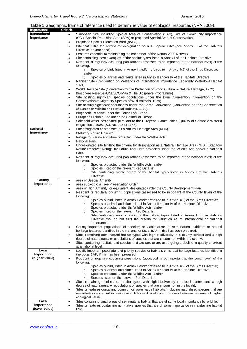
2.2.2 Stage 2: Appropriate Assessment This stage considers whether the plan or project, alone or in combination with other projects or plans, will have adverse effects on the integrity of a Natura 2000 site, and includes any mitigation measures necessary to avoid, reduce or offset negative effects. The Stage 2 Appropriate Assessment comprises a scientific examination of the plan / project and the relevant Natura 2000 sites; to identify and characterise any possible implications for the site in view of the site’s conservation objectives, structure and function, taking account of in combination effects. 2.3 Evaluation The impact significance is a combined function of the value of the affected feature (its ecological importance), the type of impact and the magnitude of the impact. It is necessary to identify the value of ecological features within the study area in order to evaluate the significance and magnitude of possible impacts (see Appendix 2). The results of the ecological survey were evaluated to determine the significance of identified features located in the study area on an importance scale ranging from international-national-county-local. The local scale is approximately equivalent to one 10km square but can be operationally defined to reflect the character of the area of interest. The criteria used are shown in Table 1.
Limerick Smarter Travel Route 2: Natura Impact Statement ___January 2015
________________________________________________________________________________www.ecofact.ie 18
Table 1 Geographic frame of reference used to determine value of ecological resources (NRA 2009). Importance Criteria International Importance
• ‘European Site’ including Special Area of Conservation (SAC), Site of Community Importance (SCI), Special Protection Area (SPA) or proposed Special Area of Conservation.
• Proposed Special Protection Area (pSPA). • Site that fulfils the criteria for designation as a ‘European Site’ (see Annex III of the Habitats
Directive, as amended). • Features essential to maintaining the coherence of the Natura 2000 Network • Site containing ‘best examples’ of the habitat types listed in Annex I of the Habitats Directive. • Resident or regularly occurring populations (assessed to be important at the national level) of the
following: o Species of bird, listed in Annex I and/or referred to in Article 4(2) of the Birds Directive; and/or o Species of animal and plants listed in Annex II and/or IV of the Habitats Directive.
• Ramsar Site (Convention on Wetlands of International Importance Especially Waterfowl Habitat 1971).
• World Heritage Site (Convention for the Protection of World Cultural & Natural Heritage, 1972). • Biosphere Reserve (UNESCO Man & The Biosphere Programme) • Site hosting significant species populations under the Bonn Convention (Convention on the
Conservation of Migratory Species of Wild Animals, 1979). • Site hosting significant populations under the Berne Convention (Convention on the Conservation
of European Wildlife and Natural Habitats, 1979). • Biogenetic Reserve under the Council of Europe. • European Diploma Site under the Council of Europe. • Salmonid water designated pursuant to the European Communities (Quality of Salmonid Waters)
Regulations, 1988, (S.I. No. 293 of 1988). National Importance
• Site designated or proposed as a Natural Heritage Area (NHA). • Statutory Nature Reserve. • Refuge for Fauna and Flora protected under the Wildlife Acts. • National Park. • Undesignated site fulfilling the criteria for designation as a Natural Heritage Area (NHA); Statutory
Nature Reserve; Refuge for Fauna and Flora protected under the Wildlife Act; and/or a National Park.
• Resident or regularly occurring populations (assessed to be important at the national level) of the following:
o Species protected under the Wildlife Acts; and/or o Species listed on the relevant Red Data list. o Site containing ‘viable areas’ of the habitat types listed in Annex I of the Habitats
Directive. County
Importance • Area of Special Amenity. • Area subject to a Tree Preservation Order. • Area of High Amenity, or equivalent, designated under the County Development Plan. • Resident or regularly occurring populations (assessed to be important at the County level) of the
following: o Species of bird, listed in Annex I and/or referred to in Article 4(2) of the Birds Directive; o Species of animal and plants listed in Annex II and/or IV of the Habitats Directive; o Species protected under the Wildlife Acts; and/or o Species listed on the relevant Red Data list. o Site containing area or areas of the habitat types listed in Annex I of the Habitats
Directive that do not fulfil the criteria for valuation as of International or National importance.
• County important populations of species; or viable areas of semi-natural habitats; or natural heritage features identified in the National or Local BAP; if this has been prepared.
• Sites containing semi-natural habitat types with high biodiversity in a county context and a high degree of naturalness, or populations of species that are uncommon within the county.
• Sites containing habitats and species that are rare or are undergoing a decline in quality or extent at a national level.
Local Importance
(higher value)
• Locally important populations of priority species or habitats or natural heritage features identified in the Local BAP, if this has been prepared;
• Resident or regularly occurring populations (assessed to be important at the Local level) of the following:
o Species of bird, listed in Annex I and/or referred to in Article 4(2) of the Birds Directive; o Species of animal and plants listed in Annex II and/or IV of the Habitats Directive; o Species protected under the Wildlife Acts; and/or o Species listed on the relevant Red Data list.
• Sites containing semi-natural habitat types with high biodiversity in a local context and a high degree of naturalness, or populations of species that are uncommon in the locality;
• Sites or features containing common or lower value habitats, including naturalised species that are nevertheless essential in maintaining links and ecological corridors between features of higher ecological value.
Local Importance
(lower value)
• Sites containing small areas of semi-natural habitat that are of some local importance for wildlife; • Sites or features containing non-native species that are of some importance in maintaining habitat
links.
Limerick Smarter Travel Route 2: Natura Impact Statement ___January 2015
________________________________________________________________________________www.ecofact.ie 19
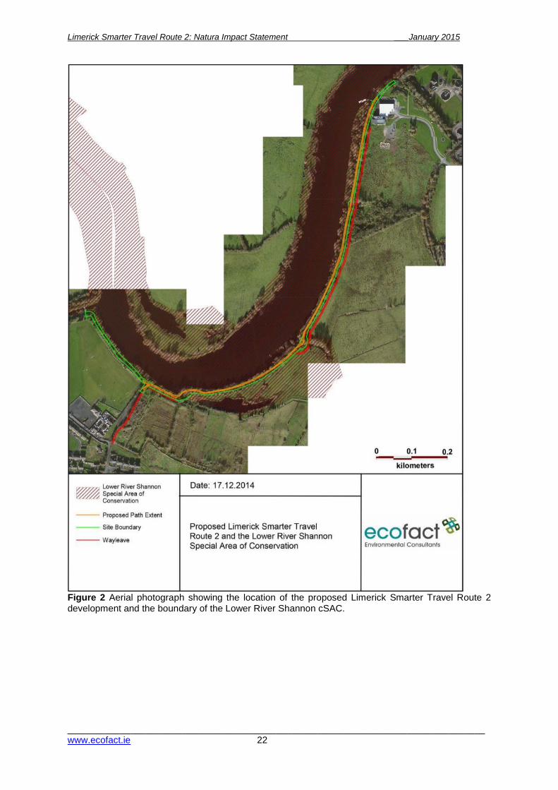
3. STAGE 1: SCREENING / TEST OF SIGNIFICANCE 3.1 Description of the proposed development The proposed overall route comprises the upgrading and improvement of existing pedestrian walkways to incorporate a combined walkway and cycleway. The route is largely on embankments adjacent to the canal and the River Shannon and has a length of approximately 1.2km. The River Shannon and Park Canal adjacent to the proposed development are designated within the Natura 2000 network (Lower River Shannon cSAC). The Special Area of Conservation (cSAC) is a statutory designation, which has a legal basis under the EU Habitats Directive (92/43/EEC), as transposed into Irish law through the European Communities (Natural Habitats) Regulations (1997) and European Communities (Birds and Natural Habitats) Regulations (2011). This project involves the following main elements:
• An upgrade of an existing gravel pathway to provide a 3m wide shared walk and cycle way with a bitmac surface along the bank of the River Shannon.
• Construction of two new footbridges to bypass existing bridges with industrial heritage value along the route.
• Widening of the two further bridges which have already been subject to structural alterations.
• Provision of public lighting and signage along the route. The proposed lighting will be directional, placed on the landward side of the path away from the riparian zone and switched off from April to September each year and will also be switched off at 11pm in the evening from October to March each year. The proposed outline construction methodology and drawings are provided in Appendix 1. 3.2. Identification of relevant Natura 2000 Sites 3.2.1 Screening of Natura 2000 Sites within 15km of the study area The current Screening Assessment has identified the designated Natura 2000 sites within a 15km radius of the proposed Limerick Smarter Travel Route 2 Shared Pedestrian and Cycleway Facility (the proposed development). These are presented in Table 2 and also shown on the map in Figure 2. Sites in close proximity to or directly/indirectly connected to the proposed project are identified for assessment in the current Screening Report. The qualifying interests of these sites are detailed below in table 2. A candidate Special Area of Conservation (cSAC) is a statutory designation, which has a legal basis under the EU Habitats Directive (92/43/EEC) as transposed into Irish law through the European Communities (Natural Habitats) Regulations, 1997. The main implication of this designation is that any project likely to have a significant adverse impact on the integrity of the cSAC may only be carried out for “imperative reasons of overriding public interest, including those of a social or economic nature”.

Limerick Smarter Travel Route 2: Natura Impact Statement ___January 2015
________________________________________________________________________________www.ecofact.ie 20
Table 2 Summary details of the designated Natura 2000 sites located within 15km of the proposed development area. Natura Site Distance
(km) Notes Included in the current
Screening Assessment
Lower River Shannon cSAC (2165)
Proposed works would be within and adjacent to this site
Annex I Habitats: Lagoons (priority); sandbanks; estuaries; mudflats and sand flats; large shallow inlets and bays; reefs; vegetation of stony banks; vegetated sea cliffs; Salicornia mudflats; Atlantic salt meadows; Mediterranean salt meadows; floating river vegetation. Annex II species: Freshwater pearl-mussel, sea lamprey, brook lamprey; river lamprey; bottlenose dolphin, otter.
Included as the proposed works would take place within and adjacent to the designated area.
River Shannon and River Fergus estuaries SPA (4077)
1.5km west, over 2km downstream
The site is the most important coastal wetland site in the country and regularly supports in excess of 50,000 wintering waterfowl. The site also has vast expanses of intertidal flats an Annex 1 habitat on the E.U Habitats Directive.
Not included due to distance between this site and the proposed works and the absence of pathways for significant impacts with regard to the conservation interests of the site.
Glenomra Wood cSAC (1013)
8km north Deciduous semi-natural woodland and is of considerable conservation significance as it is of a type listed on Annex I of the EU Habitats Directive. Three Red Data Book mammals occur in the site: Badger (Meles meles), Pine Marten (Martes martes) and Hare (Lepus timidus hibernicus).
Not included as there is no connection between this site and the proposed works
Ratty River Cave cSAC (2316)
15km northwest
Cave, a habitat listed on Annex I of the EU Habitats Directive, and also an important winter roost and a breeding site of the Lesser Horseshoe Bat (Rhinolophus hipposideros), a species listed on Annex II of the EU Habitats Directive.
Not included as there is no connection between this site and the proposed works
Danes Hole, Poulnalecka cSAC (0030)
15km northwest
Small fossil cave in the banks of the Ahaclare River, a winter hibernation site and also a mating site of the Lesser Horseshoe Bat (Rhinolophus hipposideros), a species listed on Annex II of the EU Habitats Directive.
Not included as there is no connection between this site and the proposed works
Slieve Bernagh Bog cSAC (2312)
15km north Designated for priority Annex I and Annex I listed peatland habitats.
Not included as there is no connection between this site and the proposed works
Slievefelim to Silvermines Mountains SPA (4165)
13km east SPA site designated for Hen Harrier listed on Annex I of the EU Birds Directive.
Not included as there is no connection between this site and the proposed works
Tory Hill cSAC (0439)
14km southwest
Wooded limestone hill with grasslands and scrubland facies, and fens listed on Annex I of the E.U. Habitats Directive
Not included as there is no connection between this site and the proposed works
Glenstall Wood cSAC (1432)
13km east Killarney Fern (Trichomanes speciosum), a rare species that is listed on Annex II of the EU Habitats Directive and that is also protected under the Flora (Protection) Order, 1999 occurs at the site.
Not included as there is no connection between this site and the proposed works

Limerick Smarter Travel Route 2: Natura Impact Statement ___January 2015
________________________________________________________________________________www.ecofact.ie 21
Figure 1 Natura 2000 sites within a 15km radius of the proposed Limerick Smarter Travel Route 2 development.
Limerick Smarter Travel Route 2: Natura Impact Statement ___January 2015
________________________________________________________________________________www.ecofact.ie 22
Figure 2 Aerial photograph showing the location of the proposed Limerick Smarter Travel Route 2 development and the boundary of the Lower River Shannon cSAC.
Limerick Smarter Travel Route 2: Natura Impact Statement ____December 2014
__________________________________________________________________________ www.ecofact.ie
3.2.2 Description of Natura 2000 sites likely to be affected by the proposed project The only site potentially affected by the proposed development is the Lower River Shannon cSAC (site code 002165), designated under the Habitats Directive (92/43/EEC). The site is a candidate SAC selected for lagoons and alluvial wet woodlands, both priority habitats listed on Annex I of the E.U. Habitats Directive. The site is also selected for floating river vegetation, Molinia meadows, estuaries, tidal mudflats, Atlantic salt meadows, Mediterranean salt meadows, Salicornia mudflats, sand banks, perennial vegetation of stony banks, sea cliffs, reefs and large shallow inlets and bays all habitats listed on Annex I of the E.U. Habitats Directive. The site is also selected for the following species listed on Annex II of the same Directive – Bottle-nosed Dolphin, Sea Lamprey, River Lamprey, Brook Lamprey, Freshwater Pearl Mussel, Atlantic salmon and Otter. The NPWS site synopsis for the site is presented in Appendix 2. Annex I habitats potentially occurring within the study area of the proposed development include floating river vegetation within the River Shannon channel and the priority habitat alluvial wet woodland. The footprint of the proposed development includes existing pathways and tracks utilised by pedestrians, cyclists and fishermen adjacent to the alluvial woodland habitat along the River Shannon corridor. The River Shannon within the study area supports migratory populations of Atlantic salmon, Sea Lamprey and River Lamprey; with resident populations of Otter, Brook Lamprey and White-clawed Crayfish also occurring. 3.3 Screening Assessment of Likely Effects 3.3.1 Assessment of likely direct impacts affecting the Natura 2000 site Parts of the proposed development are located within the boundary of the Lower River Shannon cSAC while other sections border and lie adjacent to this designated site. The length of the proposed cycleway/walkway is approximately 1.2km. Likely direct impacts of the project arising by virtue of the size and scale and land-take of the project have been identified as being potentially significant due to the extent and footprint of the development, and proximity to water dependent habitats associated with the River Shannon. There is also potential for impacts affecting priority Annex I woodland habitat which occurs along the River Shannon in this area. There are likely direct impacts associated with the proposed development arising from emissions in the form of silt laden runoff to surface waters within the cSAC. In relation to excavation requirements and transportation requirements, there would be direct impacts as some elements of the proposed works involving earthworks and moving of materials would be carried out within the cSAC and could be significant. Though unlikely, it is possible, under a ‘worst-case’ scenario, that this embankment or part of same could subside during the proposed works, resulting in releases of soil to the river and suspension of solids to the water column. Works are required adjacent to the aquatic environment of the River Shannon which would have the potential to directly affect the aquatic ecological interests of the cSAC. For example, the margins of the river are provide habitat for juvenile lampreys and damage or infilling (e.g. by soil spillage) could harm juvenile lampreys or their habitats. Direct impacts are identified with respect to water quality, aquatic fauna and the riparian corridor of the River Shannon, as there is potential for increased levels of suspended solids in the river arising from riparian works and the risk of fuel spillages or concrete contamination during construction. The construction phase of the development is identified as being short-term and the impacts outlined above could be significant at a local level.

Limerick Smarter Travel Route 2: Natura Impact Statement January 2015
________________________________________________________________________________www.ecofact.ie 24
The construction of the proposed walkway/cycleway could potentially give rise to significant direct impacts with regard to change of alluvial woodland and to key species. The project is unlikely to have further potential direct impacts on the cSAC as a whole with respect to interference with the key relationships defining the structure and function of the site. The construction phase of the proposed development will include the provision of a 10m (maximum) wide wayleave, which will include a 3 m wide temporary gravel road. A minor section of the wayleave is located within the Lower River Shannon cSAC. There is potential for impacts directly affecting priority Annex I woodland habitat within proposed way leave with regard to habitat loss and degradation. There is also the potential for habitat fragmentation caused by the felling of trees to facilitate the way leave. However, at design stage the route of this wayleave was altered to ensure that habitats of conservation interest within the cSAC were avoided (i.e. alluvial woodland) and the route now mainly avoids the cSAC and fully avoids areas of priority habitat. The operational phase of the development is considered to be in line with the ongoing right-of-way and pedestrian access along the route, which has been evaluated as not currently resulting in significant adverse effects on the cSAC. However, there remains the potential for direct impacts. It is considered that with upgrading of the existing track, ongoing human use of this site will be mainly confined to the amenity walkway/cycleway and will avoid increased trampling within the more sensitive habitats of the cSAC. An increase in pedestrian use is likely to have an equivalent increase in dog presence along the route. The proposed improved surface along with lighting will likely bring about an increase in usage during daylight hours and also during evening/darkness up to curfew time between the months of October and March inclusive, with extra safety along the route. The impact of the proposed development on otters during operation stage will be related to the magnitude of increase in human activity (and dog presence). The proposed route of the walkway/cycleway however gives rise to the potential for changes affecting the fragmentation of habitats or key species. The proposed development is not likely to result in direct changes to the cSAC with regard to a reduction in species density or changes in key indicators of conservation value. There are no direct impacts affecting the cSAC with regard to climate change arising from the project. The operational phase of the proposed walkway/cycleway development is not likely to result in any significant direct impacts affecting the conservation objectives or qualifying interests the Lower River Shannon cSAC and will be in line with the current amenity use of the study area. Conservation objectives of the Lower River Shannon cSAC are outlined in NPWS (2012). 3.3.2 Assessment of likely indirect impacts affecting the Natura 2000 site The proposed works extend over a length of approximately 1.2km and are confined to a relatively narrow strip of land. The construction phase of the proposed development gives rise to the potential for indirect disturbance to species listed as qualifying interests of the cSAC and also the potential for changes in key indicators of conservation value (e.g. water quality). Excavation and other works that occur outside of and adjacent to the cSAC could result in water quality impacts within the cSAC are also evaluated as potential indirect impacts. Potential indirect impacts arising from the project have been identified with regard to water quality arising from machinery on site (e.g. pollution potential or suspended solids discharges from digging of top-soil), the use of concrete within the cSAC site and within close proximity to the River Shannon. Any impacts affecting water quality are considered likely to have implications for the water-dependent Annex II species listed as qualifying interests of the cSAC with regard to the structure and function of these populations.

Limerick Smarter Travel Route 2: Natura Impact Statement January 2015
________________________________________________________________________________www.ecofact.ie 25
Potential indirect impacts arising from the project have been identified with regard to habitat loss and water quality impacts (i.e. pollution potential or suspended solids discharges from excavation of top-soil), the use of machinery and movement of gravel within the boundary or within close proximity of the cSAC. Any impacts affecting water quality are considered likely to have implications on the proximate aquatic habitat. The proposed wayleave also has the potential to result in similar indirect impacts. Indirect impacts could also arise as a result of the introduction and/or dispersion of non-native invasive species within the works area. It is noted that there is an extensive presence of Himalayan balsam Impatiens glandulifera and Giant Hogweed Heracleum mantegazzianum within the works area, and there is a large well established stand of Japanese knotweed Fallopia japonica at the Rhebogue access road. The operational phase of the proposed development is not considered likely to result in any significant indirect impacts affecting the conservation objectives or qualifying interests the Lower River Shannon cSAC, with regard to the existing pattern of usage presently and the fact that the current amenity usage of the study area is not responsible for affecting the conservation status of the qualifying interests of the site. However the potential for direct and indirect impacts will be considered further at Stage 2. 3.3.3 Assessment of likely cumulative impacts affecting the Natura 2000 site Developments of a similar nature to that proposed such as other sections of the Limerick Smarter Travel Development may result in a cumulative impact affecting the Lower River Shannon cSAC or its conservation interests in the study area. Other anthropogenic pressures that could impact on the cSAC is the ongoing expansion of the University of Limerick where buildings and infrastructure could have direct and indirect impacts on habitats and species of conservation interest in the cSAC. Further development at Plassey Technological Park and housing development in the Castletroy area would increase loading on the Castletroy waste water treatment plant and this may have negative effects on water quality in the River Shannon downstream of the discharge point. Past clearance of alluvial woodland and flood alleviation works undertaken by the OPW upstream have resulted in the loss of priority alluvial woodland within the cSAC, giving rise to the requirement for no further loss of this habitat. Further clearance of alluvial woodland would constitute a significant impact on this habitat at a local level and juvenile lampreys which occur at its margins. Other infrastructure projects such as the Limerick Northern Relief Road and developments such as GAA playing fields have potentially cumulative impacts on the cSAC. Significant colonisation by non-native invasive flora (particularly Himalayan balsam) has compromised the integrity and ecological value of the riparian woodland and its understory. The spread of this non-native species as well as other invasive plants pose a significant risk to the structure and function of the Lower River Shannon cSAC, in particular to the freshwater reaches of this designated site. 3.4 Screening statement with conclusions According to NPWS (2009), the Appropriate Assessment Screening exercise can either identify that an Appropriate Assessment is not required; or that there is no potential for significant effects (i.e. Appropriate Assessment is not required); or that significant effects are certain, likely or uncertain (i.e. the project must either proceed to Stage 2 (AA) or be rejected). From the examination of the information available it is considered that the proposed walkway/cycleway development, located within and adjacent to the Lower River Shannon cSAC site
Limerick Smarter Travel Route 2: Natura Impact Statement January 2015
________________________________________________________________________________www.ecofact.ie 26
designation has the potential to result in significant impacts to the Natura 2000 site network, specifically in relation to direct and indirect impacts affecting the conservation interests of the Lower River Shannon cSAC; where impacts on the key conservation interests of the Natura site i.e. Annex I habitats, Annex II species and key indicators of conservation value (water quality) are uncertain following the Precautionary Principle and may be significant. Based on the information provided, the current Screening Assessment has determined that the proposal must progress to Stage 2 with regard to the Lower River Shannon cSAC i.e. an Appropriate Assessment for the proposed combined walkway/cycleway development is required. This is in line with the consultation recommendations from the NPWS Development Applications Unit, which identified that a Natura Impact Statement (NIS) would be necessary for the proposal. Several Natura 2000 sites are not being discussed further as it has been demonstrated that there are no vector pathways from the works site and the following Natura 2000 Sites: Glenomra Wood, Ratty River Ratty Cave cSAC, Danes Hole Poulnalecka cSAC, Slieve Bemagh Bog cSAC, Slievefelim to Silvermines Mountains SPA, Tory Hill cSAC and Glenstall Wood cSAC. The River Shannon and River Fergus estuaries SPA are not being discussed further in the Stage Two: Appropriate Assessment as the distance between the two locations is sufficient to state that no potential impacts can occur. 4 STAGE 2: NATURA IMPACT STATEMENT An Appropriate Assessment Natura Impact Statement considers whether the plan or project, alone or in combination with other projects or plans, will have adverse effects on the integrity of a Natura 2000 site, and includes any mitigation measures necessary to avoid, reduce or offset negative effects. The proposed cycleway/walkway development between Lelia St. and University of Limerick Campus, adjacent to the River Shannon corridor has been subject to a scientific examination of the proposal and the relevant Natura 2000 sites with regard to any possible implications for the site in view of the site’s conservation objectives, structure and function, taking account of in combination effects. 4.1 Description of the Natura 2000 site affected 4.1.1 Overview of the receiving environment 4.1.1.1 Habitats within the study area The field survey of the study area identified the different habitat types according to Fossitt (2000). Habitats within the vicinity of the walkway/cycleway and the adjoining areas were surveyed as part of the current ecological assessment. Table 3 presents a summary of the habitats recorded from the study area during the site survey which are listed as conservation interests in the cSAC. The woodland next to the River Shannon occurs as a strip of 'riparian woodland (WN5)'. Tree species present within the alluvial woodland include grey willow Salix cinerea, white willow Salix alba, crack willow Salix fragilis, sycamore Acer pseudoplatanus, ash Fraxinus excelsior, alder Alnus glutinosa, hawthorn Crataegus monogyna and some beech Fagus sylvatica associated with drier ground along the line of the proposed walkway/cycleway. The non-native sycamore Acer pseudoplatanus was found to be abundant within the riparian woodland of the lower River Shannon corridor. The riparian woodland on the riverside of the existing towpath broadly corresponds to the Priority Annex I Alluvial woodland. This habitat does not occur within the footprint of the proposed development. It also does not occur on the landward side of the existing towpath (i.e. where the temporary wayleave access is located). Within the study area gallery woodland broadly corresponding to priority Annex I Alluvial woodland is limited in extent and is degraded within the understory due to a very high occurrence of non-native species such as Himalayan balsam Impatiens glandulifera. Willow woodland broadly

Limerick Smarter Travel Route 2: Natura Impact Statement January 2015
________________________________________________________________________________www.ecofact.ie 27
corresponding to Priority Annex I Alluvial woodland within the study area is evaluated as being of International conservation importance. The non-native invasive Himalayan balsam was found to be well established within the study area, along the riparian corridor of the River Shannon and also occurring within the study area, along the line of the proposed walkway/cycleway. Table 3 List of the habitat types recorded in the study area which are listed as conservation interests of the Lower River Shannon cSAC. Habitat name (according to Fossitt, 2000)
Habitat Code Location (within or adjacent to the site)
Riparian woodland WN5 Within and adjacent to the site 4.1.1.2 Fauna within the study area The alluvial woodland and riparian corridor of the River Shannon was found to have a high level of mammal activity, most notably otter. However, no active otter holts or active badger setts were present in the affected areas of woodland. These areas regularly flood and are therefore sub-optimal for mammal dwellings which are normally located on drier ground. The lower River Shannon supports a diversity of fish species including both native and non-native species. According to McCarthy (1997) a total of 23 freshwater fish species in the catchment area above Limerick and noted that the fish community includes a large proportion of introduced species. The fish community includes the anadromous sea lamprey (Peteromyzon marinus), river lamprey (Lampetra fluvialitis), Atlantic salmon (Salmo salar) and smelt (Osmerous eperlanus). Ecofact have undertaken a number of surveys of lamprey populations within the Lower River Shannon in the vicinity of the University of Limerick campus. High densities of brook / river lamprey (Lampetra spp.) juveniles have been recorded; where identification of these species at juvenile stage is limited to genus level (Lampetra sp.) in the field. Sea lamprey juveniles have also been recorded. The lower Shannon has extensive areas of suitable juvenile lamprey nursery habitat with spawning habitat located in fast flowing riffled habitat, such as is found downstream of weirs and within the lower Mulkear River and the Old Shannon at Castleconnell. The Annex II listed white-clawed crayfish has also been recorded from the south bank of the lower River Shannon directly upstream from the University of Limerick campus at Plassey. This species is listed as a qualifying interest of the Lower River Shannon cSAC and is considered to occur in low densities within the current study area. 4.1.2 Overview of the Lower River Shannon cSAC Table 4 presents the qualifying interests within the Lower Shannon cSAC, outlining habitats and species listed on Annex I and Annex II of the EU Habitats Directive that require SAC designation and which are listed as conservation interests for the Lower River Shannon cSAC within the study area. Areas of importance for habitats and flora within the Lower Shannon cSAC in the vicinity of the proposed works area are detailed below. Habitat classification is according to Fossitt (2000) with corresponding Annex I habitats identified. 4.1.2.1 Annex I habitats listed as qualifying interests of the Natura 2000 site Of the qualifying interests listed above, the only Annex I habitat occurring within the study area is alluvial woodland which occurs as along the bank of the River Shannon (on the riverside of the existing towpath) between the University of Limerick campus and Guinness Bridge. At the time of the survey, the ground flora of this riparian woodland was inundated due to high water levels (as a result

Limerick Smarter Travel Route 2: Natura Impact Statement January 2015
________________________________________________________________________________www.ecofact.ie 28
of ‘excess’ water being spilled by the ESB though Parteen Regulating Weir). It is noted however that much of this riparian woodland may not be periodically innundated, a feature of Alluvial forests with Alnus glutinosa and Fraxinus excelsior (Alno-Padion, Alnion incanae, Salicion albae) [91E0]. Alluvial wet woodland occurs within the study area largely as a linear feature along the riverside of the existing towpath but is not present within the footprint of the proposed works. Alluvial woodland habitat along the riparian corridor of the lower River Shannon is dominated by alder, ash and willow species. This habitat is currently under considerable pressure from invasive non-native flora affecting the understory of the woodland, principally but not limited to Himalayan balsam. The woodland within the study area varies in age and structure, with the upstream end of the study area being more mature, with woodland of this type along the Park canal ranging from immature to semi-mature. Sycamore encroachment within the alluvial woodland along the River Shannon is evaluated as a significant pressure on the canopy and structure. The extent of riparian woodland habitat in the study area, which comprises alluvial woodland is presented in Figure 3. It is noted that this woodland in the study area is not a prime example of this priority Annex I habitat and the relatively recently established gallery woodland along the riverside of the existing towpath only broadly meets the criteria of this habitat. Table 4 Qualifying Interests of Lower River Shannon cSAC.
Natura Code
Item Description Records from the study area
Ann
ex II
Spe
cies
1095 Sea lamprey Petromyzon marinus 1106 Atlantic salmon Salmo salar 1096 Brook lamprey Lampetra planeri 1099 River lamprey Lampetra fluvialitis 1092 White-clawed crayfish Austropotamobius pallipes 1029 Freshwater pearl mussel Margaritifera margaritifera × 1303 Lesser horseshoe bat Rhinolophus hipposideros × 1349 Bottle-nosed Dolphin Tursiops truncatus × 1355 Otter Lutra lutra
Ann
ex I
Hab
itats
3260 Water courses of plain to montane levels with the Ranunculion fluitantis and Callitricho-Batrachion vegetation
×
1150 Coastal Lagoons × 91EO Alluvial forests with Alnus glutinosa and Fraxinus excelsior
(Alno-padion, Alnion incanae, Salicion albae)
6410 Molinia meadows on calcareous, peaty or clayey-silt-laden soils (Molinion caeruleae)
×
1110 Sand banks × 1220 Perennial vegetation of stony banks × 1230 Sea cliffs × 1160 Large shallow inlets and bays × 1170 Reefs × 1130 Estuaries × 1140 Tidal mudflats × 1330 Atlantic salt meadows (Glauco-Puccinellietalia maritimae) × 1310 Salicornia and other annuals colonising mud and sand ×
4.1.2.2 Annex II species listed as qualifying interests of the Natura 2000 site Sea Lamprey, River lamprey and Atlantic salmon are anadromous migratory species which occur within the study area. Brook lamprey are a resident freshwater species. Otter and Lesser horseshoe bat are also listed as a qualifying interests of the cSAC and are mobile species. Otter uses the River Shannon within the study area, but there are no dwellings within the study area. Lesser horseshoe bat may use the riparian corridor of the River Shannon in the study area for foraging and commuting; however there are no records of this species in the study area. The faunal conservation interests recorded from the study area are all directly related to the aquatic habitats of the River Shannon.

Limerick Smarter Travel Route 2: Natura Impact Statement January 2015
________________________________________________________________________________www.ecofact.ie 29
Figure 3.1 Extent and location of riparian woodland within the study area, in relation to the proposed development. Areas of Riparian Woodland which were confirmed as Annex 1 priority alluvial forest (91EO) are indicated. The boundary of the Lower Shannon cSAC is also indicated.
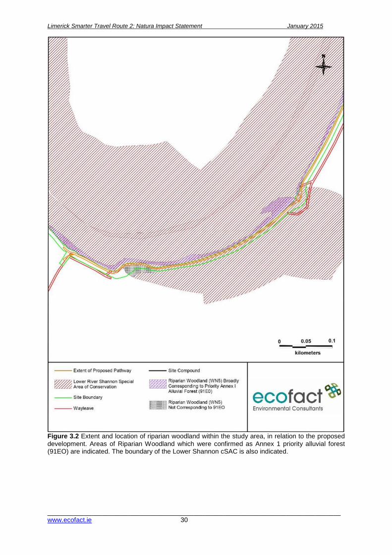
Limerick Smarter Travel Route 2: Natura Impact Statement January 2015
________________________________________________________________________________www.ecofact.ie 30
Figure 3.2 Extent and location of riparian woodland within the study area, in relation to the proposed development. Areas of Riparian Woodland which were confirmed as Annex 1 priority alluvial forest (91EO) are indicated. The boundary of the Lower Shannon cSAC is also indicated.
Limerick Smarter Travel Route 2: Natura Impact Statement January 2015
________________________________________________________________________________www.ecofact.ie 31
The migrations of salmon, sea lamprey and river lamprey include both downstream migration of juveniles (salmon smolts and lamprey microphthalmia) and upstream migrations of adult salmon, lamprey and smelt. Juvenile salmon and smolts move downstream during April/May while adult salmon run upstream from February onwards. Lamprey transformers (sea and river species) migrate downstream during the spring while adult sea and river lamprey move upstream in the spring; from March onwards. Eel species are also of conservation concern in the River Shannon catchment with silver eels migrating downstream during the autumn / winter period and juveniles (glass eels) migrating upstream from the coast during the late spring / summer months. Due to fish passage issues on the Lower River Shannon (due to the hydroelectric scheme) migratory salmon and lamprey populations are mainly confined to the river below the dams.
4.2 Impact prediction 4.2.1 Direct impacts 4.2.1.1 Direct impacts during the construction phase of the walkway-cycleway/wayleave The proposed development will require works along a linear route within and adjacent to the Lower River Shannon cSAC site designation. The route of the proposed works will follow the existing public pathway along the towpath on the southern bank of the River Shannon between the University of Limerick campus and Guinness Bridge. A temporary wayleave access will also be required. Direct impacts arising as a result of the proposed development are identified with regard to habitat loss limited to the footprint of the proposed works and disturbance impacts arising during the construction works phase potentially affecting fauna within the works site. There will be no direct habitat loss of any alluvial woodland habitat, identified as broadly corresponding to priority habitat. However, within the study area it is limited in extent and is degraded within the understory due to a very high occurrence of non-native species such as Himalayan balsam. The proposed construction wayleave will not enter into any areas identified as containing annex 1 priority habitat. The cycle / walkway has been designed to ensure that it follows the existing pathway/towpath and there will be no encroachment into the riparian woodland and no loss or impacts on the gallery woodland which broadly corresponds to priority habitat. It is noted that a number of individual trees (mainly immature) will be lost, however these are not associated with the annex 1 habitat. A method statement will prepared by the appointed contractor to demonstrate how the annex 1 woodland (and other woodland habitats) in the study area will be protected during construction works, and this will be agreed in advance with NPWS. The proposed temporary wayleave will require works along a linear route within and adjacent to the Lower River Shannon cSAC site designation. The route of the wayleave will run parallel to the existing public pathway along the riparian corridor of the southern bank of the River Shannon between the University of Limerick campus and Rhebogue access path. This proposed temporary wayleave will not enter into the gallery riparian woodland strip which broadly corresponds to Annex 1 priority habitat, and has been designed to avoid the pond and marsh/reed swamp areas which are of biodiversity value and within the cSAC (near proposed bridge 6). There are no direct impacts identified affecting the aquatic habitat of the lower River Shannon which would have the potential for loss of floating river vegetation as this habitat does not occur in the study area. The slow flowing nature of watercourses in the study area precludes the presence of floating river vegetation. This habitat occurs in the fast flowing water at Corbally falls downstream of the proposed development and within the university campus upstream of the living bridge. However,
Limerick Smarter Travel Route 2: Natura Impact Statement January 2015
________________________________________________________________________________www.ecofact.ie 32
these areas would not be affected by any component of the proposed development as they are outside the zone of influence of the proposed development. Direct impacts potentially affecting the Annex II listed qualifying interests of the Lower River Shannon cSAC are limited to construction phase disturbance impacts affecting otter which utilise the River Shannon corridor for foraging and commuting. These impacts are evaluated as being slight and not significant, where there is existing low level human activity along this stretch of the river, including dog-walking. No otter dwellings (holts) were recorded and the short term nature of the construction activity is evaluated as not being significant with regard to this species. The aquatic Annex II species listed as qualifying interests of the cSAC will not be directly affected by the proposed works, where no instream works are required during the construction of the walkway or temporary construction access wayleave. Mitigation measures are in place to reduce the scale of effects within the riparian corridor of the works site; these include stringent measures to avoid impacts to the aquatic environment. 4.2.1.2 Direct impacts during the operational phase of the cycleway/wayleave There is the potential for operational impacts directly affecting the Lower River Shannon cSAC arising through an increase in human traffic due to improved accessibility along the riparian corridor of the lower River Shannon. Increase human traffic is evaluated as not likely to give rise to direct impacts on the alluvial woodland habitat of the study area, where the walkway/cycleway will effectively limit trampling and traffic within the woodland, encouraging users to follow the established walkways. Impacts directly affecting Annex II fauna during the operational phase are also limited to human activity along the riparian corridor and within the wet woodland habitat with potential effects on otter and bat activity. However, it is clear that existing rights of way along the riparian corridor give rise to ongoing disturbance impacts on this species which would not be expected to increase with the development of a clearly defined pathways. It is evaluated that the proposed walkway development would reduce traffic outside of the new pathways thus limiting disturbance impacts on fauna within the cSAC. There will be a direct impact of lighting on the towpath, but this will be subjected to restrictions including a curfew and is not expected to affect use of the towpath by otters. 4.2.2 Indirect impacts 4.2.2.1 Indirect impacts during the construction phase of the cycleway/wayleave The construction of the proposed cycleway/pathway includes the casting of concrete foundations for the proposed lighting along the line of the development. Pouring of raw concrete, in addition to potential wash out of equipment and run-off / leachate to the cSAC are identified as having the potential moderate indirect negative effects on water quality and the aquatic conservation interests within the cSAC. Further construction phase impacts include the potential for leakage or accidental spillage of oils, lubricants, fuels or chemicals required during the construction process. Mitigation measures are proposed for the avoidance of significant (and indeed any) water quality impacts arising during the construction phase. The proposed works give rise to the potential for indirect disturbance outside of the footprint of the proposed works arising from the access wayleave and compound. The temporary nature of the works is not evaluated as giving rise to any significant impacts affecting otter which is identified as the only Annex II listed species potentially affected within the study area.

Limerick Smarter Travel Route 2: Natura Impact Statement January 2015
________________________________________________________________________________www.ecofact.ie 33
There is the potential that works could result in a collapse of the embankment leading to soil and other material entering the river. However, this is unlikely to occur with reference to the relatively low level of the embankment and mitigation measures include providing suitable geotechnical mitigation as required. The construction phase of the proposed works gives rise to the introduction and / or potential spread of non-native invasive species into the study area including both flora and fauna. Although the works area of the proposed development is currently significantly affected by Himalayan balsam there remains the potential for spread of Japanese knotweed Fallopia japonica and other non-native flora during the works. The potential for introduction or spread of non-native aquatic flora and fauna can be avoided with suitable mitigation. Construction phase impacts include the potential for leakage or accidental spillage of oils, lubricants, fuels or chemicals required during the construction process. Mitigation measures are proposed for the avoidance of water quality impacts arising during the construction phase. 4.2.2.3 Indirect impacts during the operational phase There are no indirect impacts identified during the operational phase of the proposed development which would have the potential to affect the conservation interests of the cSAC with regard to their structure or function. Ongoing usage of the walkways will give rise to indirect disturbance impacts which are evaluated as being imperceptible negative in the local context. It is expected that the provision of the new combined cycleway / walkway will encourage users to stay on the defined path and reduce excursions away from the defined route. 4.2.3 Cumulative impacts Cumulative impacts or effects are changes in the environment that result from numerous human-induced, small-scale alterations. Cumulative impacts can be thought of as occurring through two main pathways: first, through persistent additions or losses of the same materials or resource, and second, through the compounding effects as a result of the coming together of two or more effects (Bowers-Marriott, 1997). The proposed development will contribute to the increasing urbanisation of this part of the Lower River Shannon. This includes the development of the north campus and two bridges over the River Shannon at the University of Limerick, and also the development of other components of the Limerick Smarter Travel Project. Moreover, previous clearance of alluvial woodland and flood alleviation works undertaken by the OPW upstream of the current proposed development has resulted in the loss of alluvial woodland within the cSAC. However, the current proposed development does not result in any habitat loss within the cSAC and no important features of the cSAC are being disturbed. Overall, the extent of potential cumulative impacts are considered to be negated due to the relatively small footprint of the works proposed and the fact that this is an existing walkway and public right of way – which is already intensively used by cyclists and walkers. There are no significant cumulative impacts anticipated during the construction or operation stage. Further development in the study area potentially affecting the conservation interests of the Lower River Shannon cSAC could include further housing developments and increased access to the River Shannon, resulting in more human traffic and associated increased disturbance within/adjacent to the cSAC. However, the current development is considered to be neutral with respect to these pressures and it is seen that encouraging users to stay on the proposed new pathway / cycleway will assist in protecting sensitive habitats along the river. According to the Water Management Unit Action Plan for the Lower River Shannon (ShIRBD, 2010) this water body is subject to chemical and biological water quality pressures, in addition to hydro-
Limerick Smarter Travel Route 2: Natura Impact Statement January 2015
________________________________________________________________________________www.ecofact.ie 34
geomorphological pressures. However, the current proposed development is not identified as being capable to add to these pressures as there will be no emissions from same during the operational phase, and a surface water quality management plan will be implemented during the construction phase of the project ensuring that significant water quality impacts are avoided. Recent development and expansion of the UL campus has proceeded though planning and the resulting construction and operational phases which were not identified as having a significant impact on the conservation objectives or integrity of the Lower River Shannon cSAC. The proposed development is identified as giving rise to imperceptible negative impacts with regard to the conservation objectives of the Lower River Shannon cSAC. The public right of way and riparian access along the river corridor is required irrespective of any development within the study area. There are no potential significant cumulative impacts arising from the proposed walkway/cycleway, over-laying an existing regularly used path, in combination with the Limerick Northern Relief Road, where both projects are separated by distance and the current proposal will in isolation not give rise to any significant impacts on the conservation objectives of the cSAC. There are no pathways or connections for in-combination impacts that could be identified as potentially being significant or affecting the conservation objectives of the Lower River Shannon cSAC with regard to land use zonings and objectives within Limerick City. This is taking account of the imperceptible negative impact arising from the proposed development in the local context and the absence of any connectivity between this site and significant impacts arising from the Limerick City Development Plan. Policies and Objectives of the Limerick City Development Plan (2010-2016), Limerick County Development Plan (2010-2016) and Clare County Development Plan (2011-2017) are all subject to separate Strategic Environmental Assessment (SEA) and Appropriate Assessment processes undertaken by the planning section of these local authorities, where adverse effects on designated Natura 2000 sites have been deemed to be avoided. Recent flood relief and flood alleviation works undertaken by the OPW resulted in the clearance of priority Annex I alluvial woodland habitat upstream of the proposed development site. The current proposal is to ensure that there will be no impact on or loss of alluvial woodland habitat. During the construction phase the temporary wayleave will also not encroach into any sensitive habitat. There are no in-combination impacts arising from the proposed pathway/cycleway development which are identified as being potentially significant, or affecting the conservation objectives of the cSAC. There are no impacts predicted which would affect the conservation status of any of the qualifying interests of the cSAC in isolation or in combination at the proposed development site; provided the proposed mitigation measures are implemented. The current proposed development does not result in any habitat loss within the cSAC and no important features of the cSAC are being disturbed. Overall, the extent of potential cumulative impacts are considered to be negated due to the relatively small footprint of the works proposed and the fact that this is located on an existing walkway. Developments of a similar nature to that proposed such as other sections of the Limerick Smarter Travel Development may result in a cumulative impact affecting the Lower River Shannon cSAC or its conservation interests in the study area. Further development at Plassey Technological Park and urbanisation/housing development in the Castletroy area would increase loading on the Castletroy waste water treatment plant and this may have negative effects on water quality in the River Shannon downstream of the discharge point. Other projects and developments such as GAA playing fields have potentially cumulative impacts on the cSAC, via ground works impacts on water quality and reduction of buffer areas adjacent to the cSAC. The GAA playing fields also do not have a lighting curfew as proposed in the current development.

Limerick Smarter Travel Route 2: Natura Impact Statement January 2015
________________________________________________________________________________www.ecofact.ie 35
Significant colonisation by non-native invasive flora has compromised the integrity and ecological value of the alluvial woodland and its understory. The spread of this non-native species as well as other invasive plants pose a significant risk to the structure and function of the Lower River Shannon cSAC, in particular to the freshwater reaches of this designated site. A positive impact of the current proposed development will be the implementation of a non-native invasive species management programme, which is particular will eradicate Japanese Knotweed from the study area and ensure that Himalayan balsam and Giant Hogweed are not dispersed. The direct and indirect impacts arising from the proposed works have been evaluated; there are no impacts identified which would adversely affect the integrity of the Natura 2000 site that cannot be avoided with mitigation. With regard to in combination effects it is considered that the scale and footprint of the proposed works is relatively minor. Disturbance impacts arising from the proposed combined walkway/cycleway development during construction and operation are not identified as being significant, taking account of the ongoing disturbance along the existing pathways and the proposed works are evaluated as being in line with ongoing trends. There are no impacts predicted which would affect the conservation status of any of the qualifying interests of the cSAC in isolation or in combination at the proposed development site; provided the proposed mitigations are implemented. 4.3 Mitigation measures
4.3.1 Construction phase mitigations The key commitment given by the developer in relation to protecting riparian / alluvial woodland habitat is that there will be no encroachment by any construction machinery into the priority habitat areas shown in Figure 3. This includes ensuring that the temporary construction wayleave access is kept away from this area. The large stand of Japanese knotweed which occurs at the proposed Rhebogue access area will also be eradicated prior to works commencing, and a non-native invasive species management plan and surface water management plan will be implemented on the site. The non-native invasive species management will in particular address the species listed in Appendix 4, and will have regard to guidance such as ‘The management of noxious weeds and non-native invasive plant species on national roads’ by NRA (2010). The surface water management plan will have regard to guidance such as ‘Control of water pollution from linear construction projects’ by Murnane et al (2006). Taking account of the sensitive nature of the proposed development no heavy plant machinery will be used during the construction phase. A tracked mini digger will be utilised within the route of the proposed cycleway/pathway development only to core foundations and supply gravel material for the pathway as necessary. Where ground conditions are soft protection trackways will be implemented to support the mini-digger at key locations to avoid creating ruts and soil compaction. Works shall cease during periods of heavy rain to the chances of run-off from works entering the river. All fuel to be used in the course of works to be stored at least 15m from the river, with all being removed on completion of works. No servicing or refuelling of equipment machinery is to take place within 15m of the river. Storage of construction materials will be at the secure compound approximately 30 meters from river. All construction materials will be removed on completion of works. Servicing and refuelling of equipment machinery will take place in same location. No mature trees are to be felled on the proposed route or during the construction of the temporary wayleave. However, removal of young trees (i.e. with trunk diameter of less than 30cm) will occur in some areas but these are less than ten years old and lack the cracks and crevices that would afford roosting sites for bat species. A bat survey of all affected trees will be undertaken prior to removal.
Limerick Smarter Travel Route 2: Natura Impact Statement January 2015
________________________________________________________________________________www.ecofact.ie 36
There will be no disturbance of trees on the river side of the path, or within any of the areas identified as being analogous to annex 1 priority alluvial woodland habitat (see Figure 3). The minimum amount of trees and vegetation necessary to complete the works only is to be removed, and no alluvial woodland habitat will be affected. Any removal of trees or shrub species is to be carried out outside the bird nesting season i.e. during the period September to March. Where mature trees are located within close proximity to the route of the proposed cycleway/footpath and the working wayleave shall be reduced as necessary. The route will meander around existing trees in so far as possible to ensure that the minimum number of trees shall require removal. Where low branches interfere with the walkway/cycleway route, it is intended that these shall be cleanly cut back to the main stem/trunk of the tree. The removed branches shall be disposed of within the woodland adjacent to the walkway, as this is the preferable approach for enhancing biodiversity. No woody material will be removed from the site. Prior to works taking place the entire works area will be surveyed to identify the number of individual trees scheduled for removal. There will be no net loss of trees arising from the proposed development. The works have been designed to avoid mature trees and focus on the removal of immature non-native species such as sycamore. Despite this it is recommended that 1.5 times the number of trees removed are replaced with native species. Species to be planted will be limited to native stock of local provenance including alder Alnus glutinosa, ash Fraxnius excelsior and native willow species (Salix cinerea, S. fragilis). There will be no habitat loss of riparian / alluvial woodland and no compensatory measures will be required in relation to this habitat. An Invasive Species Management Plan will be necessary (ISPM). There are significant and extensive stands of the invasive Himalayan balsam along the riverbank and adjacent to the existing path. Giant Hogweed is also present, and is abundant along the route of the proposed temporary wayleave. Control measures will be implemented during the construction works to ensure that these species are not accidentally spread further along the project areas. These shall include: all machinery and equipment should be thoroughly cleaned to ensure infected soils are not spread to other areas of the site or off-site. Works will be planned to avoid double handling of materials as far as possible to reduce the risk of spread. A licensed waste carrier will transport the waste material off site. The large stand of Japanese knotweed which occurs at the proposed Rhebogue access area will be eradicated prior to works commencing. This will be set out in the ISMP. Designated storage areas for materials will be located within the university campus outside of the Special Area of Conservation and delivery of materials along the development route will follow the route itself. The proposed works methodology to be undertaken by the Contractor on site will be set out in a Construction Method Statement. This will include a Construction Environmental Management Plan (CEMP) for the works. The CEMP will contain the mitigation measures set out in the NIS and EcIA document. The exact location of storage materials, site fencing details and planting schedules will be set out in this document, and agreed with IFI and NPWS. The proposed works methodology does not require any works within the aquatic environment of the River Shannon. The current assessment is evaluated on this basis. 4.3.2 Operational phase mitigation Lighting posts will be installed on the landward side of the path away from the riparian zone and will follow Bat Conservation Ireland Guidelines. Low Pressure Sodium Lights will be used with column heights of lamp posts of 3m or 8m. Lighting will to be directional lighting thus preventing light spillage and light pollution. The horizontal plane of the luminaries will be restricted thereby directing the lighting to where required (e.g. HiLux Projectors). Light will not be directed at an angle greater than

Limerick Smarter Travel Route 2: Natura Impact Statement January 2015
________________________________________________________________________________www.ecofact.ie 37
70o from the vertical plane (i.e. Using flat glass protector). Lighting will be directional, placed on the landward side of the path away from the riparian zone and switched off from April to September each year and will also be switched off at 11pm in the evening from October to March each year. In the absence of direct or indirect impacts affecting the conservation interests of the Lower River Shannon cSAC arising from the proposed walkway development there are no further operational mitigation measures proposed. It is considered that operational impacts will deviate little from baseline conditions. 4.4 Impacts affecting the conservation objectives of the Natura 2000 site The proposed walkway/cycleway development has been identified as having the potential to give rise to impacts with respect to the qualifying interests of the Lower Shannon cSAC, additionally the wayleave access path has the potential to impact interests of the cSAC. However these impacts can be avoided or mitigated and are not at a scale that would have implications for the conservation status of these qualifying interests within the Lower River Shannon cSAC. Table 5 presents a summary of the predicted impact assessment for the conservation interests of the Lower River Shannon cSAC. Consultant botanist Dr John Conaghan has stated in his report (presented in Appendix 5) that “It is clear from the proposed path upgrade construction methodology that there will be no significant negative effect on the areas of wet woodland habitat present”. The proposed walkway/cycleway and proposed temporary construction access wayleave will not have any direct (or indirect) impact on the poor example of priority Annex I habitat ‘Alluvial forests with Alnus glutinosa and Fraxinus excelsior (Alno-padion, Alnion incanae, Salicion albae)’ which occurs in the study area. With the implementation of the proposed mitigation measures, there are no impacts identified affecting the qualifying interests of the Lower River Shannon cSAC which would have the potential to affect the conservation status of these Annex I habitats or Annex II species. There are therefore no impacts identified which would affect the conservation objectives of the designated Lower River Shannon cSAC arising from the proposed development. Table 5 presents a summary of the predicted impact assessment for the conservation interests of the Lower River Shannon cSAC.

Limerick Smarter Travel Route 2: Natura Impact Statement ____December 2014
__________________________________________________________________________ www.ecofact.ie
Table 5 Impact assessment for the conservation interests of the Lower River Shannon cSAC.
Natura Code
Item Description Construction phase Operational phase Significance affecting the integrity of the cSAC
Potential impacts Residual impacts Potential impacts
Residual impacts
Ann
ex II
Spe
cies
1095 Sea lamprey Petromyzon marinus
Moderate negative localised impact on ammocoetes via habitat loss and water pollution
Potential impacts avoided through mitigation. Imperceptible negative No impacts No impacts Not significant, not affecting the integrity of the SAC
1106 Atlantic salmon Salmo salar
Water pollution affecting juvenile salmon, a slight negative impact
Potential impacts avoided through mitigation. Imperceptible negative No impacts No impacts Not significant, not affecting the integrity of the SAC
1096 Brook lamprey Lampetra planeri
As for Sea lamprey Potential impacts avoided through mitigation. Imperceptible negative No impacts No impacts Not significant, not affecting the integrity of the SAC
1099 River lamprey Lampetra fluvialitis
As for Sea lamprey Potential impacts avoided through mitigation. Imperceptible negative No impacts No impacts Not significant, not affecting the integrity of the SAC
1092 White-clawed crayfish Austropotamobius pallipes
Habitat destruction, a Slight negative impact
Potential impacts avoided through mitigation. Imperceptible negative No impacts No impacts Not significant, not affecting the integrity of the SAC
1029 Freshwater pearl mussel Margaritifera margaritifera
No impacts No impacts No impacts No impacts Not significant, not affecting the integrity of the SAC
1303 Lesser horseshoe bat Rhinolophus hipposideros
Imperceptible negative disturbance impacts
No impacts Moderate negative impact due to lighting and habitat fragmentation
No impacts No impacts
1349 Bottle-nosed Dolphin Tursiops truncatus
No impacts No impacts No impacts No impacts
1355 Otter Lutra lutra Slight negative disturbance impacts
Potential impacts avoided through mitigation. Imperceptible negative Slight negative through increased human traffic and dogs
Imperceptible negative
Not significant, not affecting the integrity of the SAC
Ann
ex I
Hab
itats
3260 Water courses of plain to montane levels with the Ranunculion fluitantis and Callitricho-
No impacts Potential impacts avoided through mitigation. Imperceptible negative No impacts No impacts Not significant, not affecting the integrity of the SAC

Limerick Smarter Travel Route 2: Natura Impact Statement January 2015
________________________________________________________________________________www.ecofact.ie 39
Natura Code
Item Description Construction phase Operational phase Significance affecting the integrity of the cSAC
Potential impacts Residual impacts Potential impacts
Residual impacts
Batrachion vegetation 1150 Coastal Lagoons No impacts No impacts identified No impacts No impacts No impacts 91EO Alluvial forests with
Alnus glutinosa and Fraxinus excelsior (Alno-padion, Alnion incanae, Salicion albae)
Moderate negative due to loss of habitat – however scheme was redesigned to avoid all areas of habitat which approximates this habitat type.
Potential impacts avoided through avoidance mitigation. Imperceptible negative Fragmentation of habitat
No impacts Not significant, not affecting the integrity of the SAC
6410 Molinia meadows on calcareous, peaty or clavey-silt-laden soils (Molinion caeruleae)
No impacts No impacts identified No impacts No impacts No impacts
1110 Sand banks No impacts No impacts identified No impacts No impacts No impacts 1220 Perennial vegetation
of stony banks No impacts No impacts identified No impacts No impacts No impacts
1230 Sea cliffs No impacts No impacts identified No impacts No impacts No impacts 1160 Large shallow inlets
and bays No impacts No impacts identified No impacts No impacts No impacts
1170 Reefs No impacts No impacts identified No impacts No impacts No impacts 1130 Estuaries No impacts No impacts identified No impacts No impacts No impacts 1140 Tidal mudflats No impacts No impacts identified No impacts No impacts No impacts 1330 Atlantic salt meadows
(Glauco-Puccinellietalia maritimae)
No impacts No impacts identified No impacts No impacts No impacts
1310 Salicornia and other annuals colonising mud and sand
No impacts No impacts identified No impacts No impacts identified
No impacts

Limerick Smarter Travel Route 2: Natura Impact Statement ____December 2014
__________________________________________________________________________ www.ecofact.ie
4.5 Appropriate Assessment NIS conclusion statement The preparation of this Natura Impact Statement follows the guidance published by the National Parks and Wildlife Service (NPWS, 2009) ‘Appropriate Assessment of Plans and Projects in Ireland. Guidance for Planning Authorities’. The proposed overall scheme includes for the upgrading and improvement of an existing public track to include approximately 1.2km of cycleway/pathway. The proposed works are located within and adjacent to the Lower River Shannon cSAC and will include works adjacent to the riparian corridor and alluvial woodland of the lower Shannon. The alluvial woodland within the study area corresponds to the priority Annex I habitat ‘Alluvial forests with Alnus glutinosa and Fraxinus excelsior (Alno-padion, Alnion incanae, Salicion albae)’. The baseline conditions of this habitat within the proposed works area are degraded with regard to the existing walkways and public access and also taking account of the significant colonisation of the Lower Shannon river corridor with non-native invasive species. The proposed cycleway/pathway has however been designed to fully avoid this habitat and works will follow the route of the existing pathways and right of way tracks within this area, avoiding impacts affecting alluvial woodland. The temporary construction wayleave has also been carefully designed to avoid this habitat and generally keeps aaway from the cSAC. The removal of individual immature trees (which will be replaced by planting) will be required for the construction of the proposed development and access wayleave. However, no loss of priority habitat will occur. This has been confirmed by consultant botanist Dr. John Conaghan who has stated in his report that “It is clear from the proposed path upgrade construction methodology that there will be no significant negative effect on the areas of wet woodland habitat present”. The proposed walkway/cycleway is evaluated as having an imperceptible impact where future public use of the amenity walkways will limit trampling and disturbance away from the designated cycleway/pathway. In the absence of works in the aquatic environment and taking account of the proposed mitigation measures for the avoidance of disturbance and protection of water quality during the construction phase of the works, there are no impacts identified which would have the potential to significantly affect the remaining Annex I habitats or Annex II species listed as qualifying interests of the cSAC. Impacts affecting otter are evaluated as being imperceptible negative in the local context during the construction phase and in line with ongoing trends with regard to the operational phase. There are no otter holts in the study area and there is existing disturbance (including dog walking) and lighting (from UL and the GAA grounds). In the current proposal lighting will be switched off from April to September each year and will be switched off at 11pm in the evening from October to March each year. No impacts affecting the aquatic habitats and species listed as qualifying interests of the cSAC are identified. Taking the above into account it is concluded that the proposed walkway/cycleway development, subject to the proposed mitigation measures and conditions above, will not result in direct, indirect or cumulative impacts which would have the potential to adversely affect the conservation objectives of the Lower River Shannon cSAC in relation to the relevant Annex II species and Annex I habitats; with regard to their range, population densities or conservation status within the cSAC. The provisions of Article 6 of the ‘Habitats’ Directive 92/43/EC (2000) defines ‘integrity’ as the ‘coherence of the site’s ecological structure and function, across its whole area, or the habitats, complex of habitats and/or population of species for which the site is or will be classified’. It is considered that the scale of these works, in addition to the implementation of the prescribed mitigation measures, would not give rise to significant impacts affecting the integrity of the Lower River Shannon SAC, this conclusion is summarized in Table 6 below.
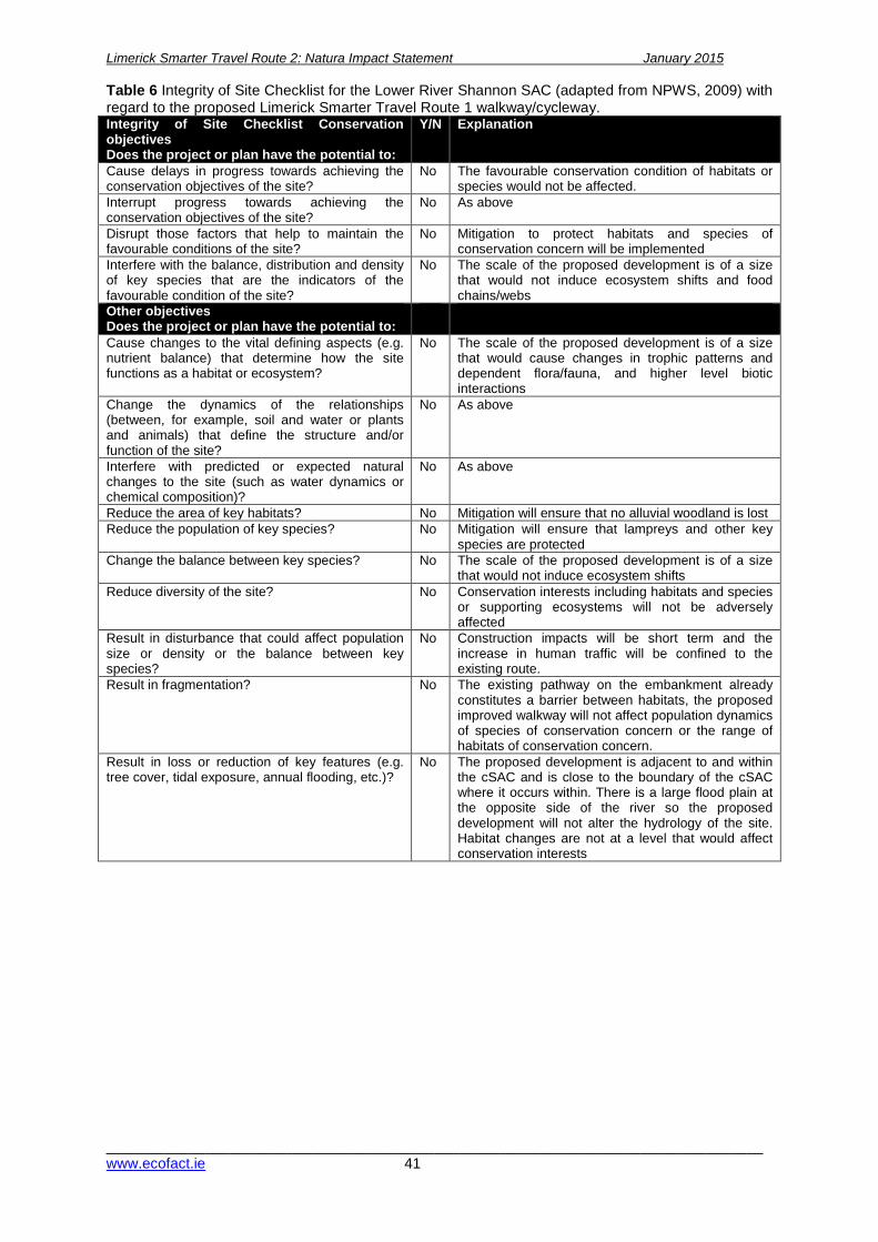
Limerick Smarter Travel Route 2: Natura Impact Statement January 2015
________________________________________________________________________________www.ecofact.ie 41
Table 6 Integrity of Site Checklist for the Lower River Shannon SAC (adapted from NPWS, 2009) with regard to the proposed Limerick Smarter Travel Route 1 walkway/cycleway. Integrity of Site Checklist Conservation objectives Does the project or plan have the potential to:
Y/N Explanation
Cause delays in progress towards achieving the conservation objectives of the site?
No The favourable conservation condition of habitats or species would not be affected.
Interrupt progress towards achieving the conservation objectives of the site?
No As above
Disrupt those factors that help to maintain the favourable conditions of the site?
No Mitigation to protect habitats and species of conservation concern will be implemented
Interfere with the balance, distribution and density of key species that are the indicators of the favourable condition of the site?
No The scale of the proposed development is of a size that would not induce ecosystem shifts and food chains/webs
Other objectives Does the project or plan have the potential to:
Cause changes to the vital defining aspects (e.g. nutrient balance) that determine how the site functions as a habitat or ecosystem?
No The scale of the proposed development is of a size that would cause changes in trophic patterns and dependent flora/fauna, and higher level biotic interactions
Change the dynamics of the relationships (between, for example, soil and water or plants and animals) that define the structure and/or function of the site?
No As above
Interfere with predicted or expected natural changes to the site (such as water dynamics or chemical composition)?
No As above
Reduce the area of key habitats? No Mitigation will ensure that no alluvial woodland is lost Reduce the population of key species? No Mitigation will ensure that lampreys and other key
species are protected Change the balance between key species? No The scale of the proposed development is of a size
that would not induce ecosystem shifts Reduce diversity of the site? No Conservation interests including habitats and species
or supporting ecosystems will not be adversely affected
Result in disturbance that could affect population size or density or the balance between key species?
No Construction impacts will be short term and the increase in human traffic will be confined to the existing route.
Result in fragmentation? No The existing pathway on the embankment already constitutes a barrier between habitats, the proposed improved walkway will not affect population dynamics of species of conservation concern or the range of habitats of conservation concern.
Result in loss or reduction of key features (e.g. tree cover, tidal exposure, annual flooding, etc.)?
No The proposed development is adjacent to and within the cSAC and is close to the boundary of the cSAC where it occurs within. There is a large flood plain at the opposite side of the river so the proposed development will not alter the hydrology of the site. Habitat changes are not at a level that would affect conservation interests

Limerick Smarter Travel Route 2: Natura Impact Statement January 2015
________________________________________________________________________________www.ecofact.ie 42
REFERENCES Bowers Marriott, B. (1997) Practical Guide to Environmental Impact Assessment: A Practical Guide. Published by McGraw-Hill Professional, 1997, 320 pp. Clabby, K.J., Bradley, C., Craig, M., Lucey, J., McGarrigle, M., O’ Boyle, S., Tierney, D. and Bowman, J. (2008) Water Quality in Ireland 2004-2006. Environmental Protection Agency, Co. Wexford, Ireland. Department of the Marine (1998) Fishery Guidelines for Local Authority works. Dept. of the Marine and Natural Resources, Leeson Lane, Dublin. DoEHLG (2009). Appropriate Assessment of Plans and Projects in Ireland - Guidance for Planning Authorities. Department of the Environment, Heritage and Local Government, Dublin. Doherty, D. and McCarthy, T.K. (2004) The Ecology and Conservation of European smelt (Osmerus eperlanus l.) from Waterford Estuary, in Southeastern Ireland. Biology and Environment: Proceedings of The Royal Irish Academy, Vol. 104b, No. 2, 125/130. EA (2003) River Habitat Survey in Britain and Ireland: Field Survey Guidance Manual. River Habitat Survey Manual: 2003 version, Environment Agency, 136 pp ECOFACT (2011) Limerick City Navigation Maintenance Works. Natura Impact Statement. A Report to waterways Ireland. European Commission (2000) Managing Natura 2000 sites: the provisions of Article 6 of the ‘Habitats’ Directive 92/43/EEC European Commission Environment DG (2002) Assessment of plans and projects significantly affecting Natura 2000 sites: Methodological guidance on the provisions of Article 6(3) and (4) of the Habitats Directive 92/43/EEC. European Commission (2007) Guidance document on Article 6(4) of the 'Habitats Directive' 92/43/EEC: Clarification of the concepts of: alternative solutions, imperative reasons of overriding public interests, compensatory measures, overall coherence and opinion of the Commission. European Commission, Brussels Fossitt, J. (2000) A guide to habitats in Ireland. The Heritage Council, Kilkenny. Gardiner, R. (2003) Identifying lamprey. A field key for sea, river and brook lamprey. Conserving Natura 2000 Rivers, Conservation techniques No. 4. Peterborough. English Nature. Geraghty, F. (1996) Studies on smelt Osmerus eperlanus (L.) and Pollan Coregonus autumnalis pollan (Pallas) from the River Shannon, with particular reference to their parasite assemblages. Unpublished BS (Hons) thesis, University College, Galway. Hardisty, M.W. and Potter, I.C. (1971) The behaviour, ecology and growth of larval lampreys. In M.W. Hardisty and I.C. Potter (eds), The Biology of Lampreys, vol. 1. London. Academic Press. Hurford,C., Schneider, M. Cowx, I. (2010) Conservation Monitoring in Freshwater Habitats: A Practical Guide and Case Studies, Springer, 415pp.

Limerick Smarter Travel Route 2: Natura Impact Statement January 2015
________________________________________________________________________________www.ecofact.ie 43
Kelly & King (2001) A review of the ecology and distribution of three lamprey species, Lampetra fluviatilis (L.), Lampetra planeri (Bloch), and Petromyzon marinus (L.): A context for conservation and biodiversity considerations in Ireland. Biology and the Environment. 101B(3):165-185. Kilfeather, P. (2007) Maintenance and protection of the inland fisheries resource during the road construction and improvement works. Requirements of the Southern Regional Fisheries Board. Southern Regional Fisheries Board. July 2007. King J.J., Hanna G. And Wightman G.D. 2008 Ecological Impact Assessment (EcIA) of The Effects of Statutory Arterial Drainage Maintenance Activities on Three Lamprey species (Lampetra planeri Bloch, Lampetra fluviatilis L., and Petromyzon marinus L.).Series of Ecological Assessments on Arterial Drainage Maintenance No 9 Environment Section, Office of Public Works, Headford, Co. Galway. Kurtz, I. and Costello, M. J. (1999). An outline of the biology, distribution and conservation of lampreys in Ireland. Irish Wildlife Manuals No. 5. Dúchas, the Heritage Service, Dublin. Laine A, Kamuls R and Hooli J (1998) Fish and lamprey passage in a combined Denil and vertical slot fishway. Fisheries Management and Ecology 5, 31-44. Lenihan’s M. (1866) History of Limerick, 1866: (in www.LimericksLife.com). Limerick City Council (2008) Park Canal Restoration Project, Limerick. Design Report, January 2005. Maitland, P.S. and Lyle, A.A. (1990) Practical conservation of British fishes: current action on six declining species. Journal of Fish Biology 37A, 255/6. Maitland P.S. and Campbell, R.N. (1992) Freshwater Fishes of the British Isles. Harper Collins UK. Mc Auley, T. C. (1996). Development of an instream velocity barrier to stop sea lamprey migrations in the Great Lakes. University of Manitoba, Winnipeg. McCleave, J.D. (1980) Swimming performance of European eel (Anguilla anguilla, L.) elver. Journal of Fish Biology, 16:445-452. Muir, G., Morris, P.A. Troughton, G., Strachan, R., Wroot, S., Beer, A.J., Savery, J. (2013) How to Find and Identify Mammals [Revised Edition). Published by the Mammal Society. 74pp. NPWS (2008). The Status of EU Protected Habitats and Species in Ireland. National Parks and Wildlife Service, Department of the Environment, Heritage and Local Government, Dublin. NPWS (2012) Conservation Objectives: Lower River Shannon SAC 002165. Version 1.0.National Parks and Wildlife Service, Department of Arts, Heritage and the Gaeltacht. NRA (2010) The Management of Noxious Weeds and Non-Native Invasive Plant Species on National Roads. National Roads Authority. NRA (2008) Guidelines for the crossing of watercourses during the construction of national road schemes. National Roads Authority. NRA (2008) Guidelines for the Treatment of Otters prior to the Construction of National Road Schemes. National Roads Authority, St. Martin’s House, Waterloo Road, Dublin 4.

Limerick Smarter Travel Route 2: Natura Impact Statement January 2015
________________________________________________________________________________www.ecofact.ie 44
NRA (2009a) Ecological Surveying Techniques for Protected Flora and Fauna during the Planning of National Road Schemes. National Roads Authority, Dublin. Murnane, E., Heap, A, & Swain, A. (2006) Control of water pollution from linear construction projects. CIRIA Technical guidance (C648). PP 234, ISBN: 978-0-86017-648-0. Mueller-Dombois, D. & Ellenberg, H. (1974). Aims and Methods in Vegetation Ecology. Wiley, New York. O'Connor, W. (1996) Lampreys in the Shannon catchment. In the Annual Report of ESB Fisheries Conservation, 2006. O’Grady, M. (2006). Channels and Challenges. The enhancement of salmonid rivers. Central Fisheries Board, Dublin. 142pp. O’Reilly, P. (2004) Rivers of Ireland – a flyfisher’s Guide. 5th Ed. Merlin Unwin Books. Potter, I.C. and Osborne, T.S. (1975) The systematics of British larval lampreys. Journal of Zoology , London 176, 311/29. Prothero,. F.E.,and Clark, W.A. (1896) A New Oarsman’s Guide to the Rivers and Canals of Great Britain and Ireland. George Philip & Son, London (in http://irishwaterwayshistory.com/abandoned-or-little-used-irish-waterways/the-lower-shannon/the-limerick-navigation/). Quigley, D., Igoe, F., & O’Connor, W. (2004) The European Smelt Osmerous eperlanus (L.) in Ireland. Biology, Ecology, Distribution and Status with Conservation Recommendations. Biology and the Environment. VOL. 104B, NO. 3, 57/66. Scottish Natural Heritage (2003). Best Practice Guidance - Badger Surveys. Inverness Badger Survey 2003. Commissioned Report No. 096. Smith, G.F., O’Donoghue, P., O’Hora, K. And Delaney, E. (2010) Best practice guidance for habitat survey and mapping. The Heritage Council, Kilkenny. Whilde, T 1993 Threatened mammals, birds, amphibians and fish in Ireland. Irish Red Data Book 2: Vertebrates. Belfast. HMSO. White, E & Knights, B (1997) Dynamics of upstream migration of the European eel, Anguilla anguilla (L.), in the Rivers Severn and Avon, England, with special reference to the effects of man-made barriers. Fisheries Management and Ecology. 4(4): 311-324.
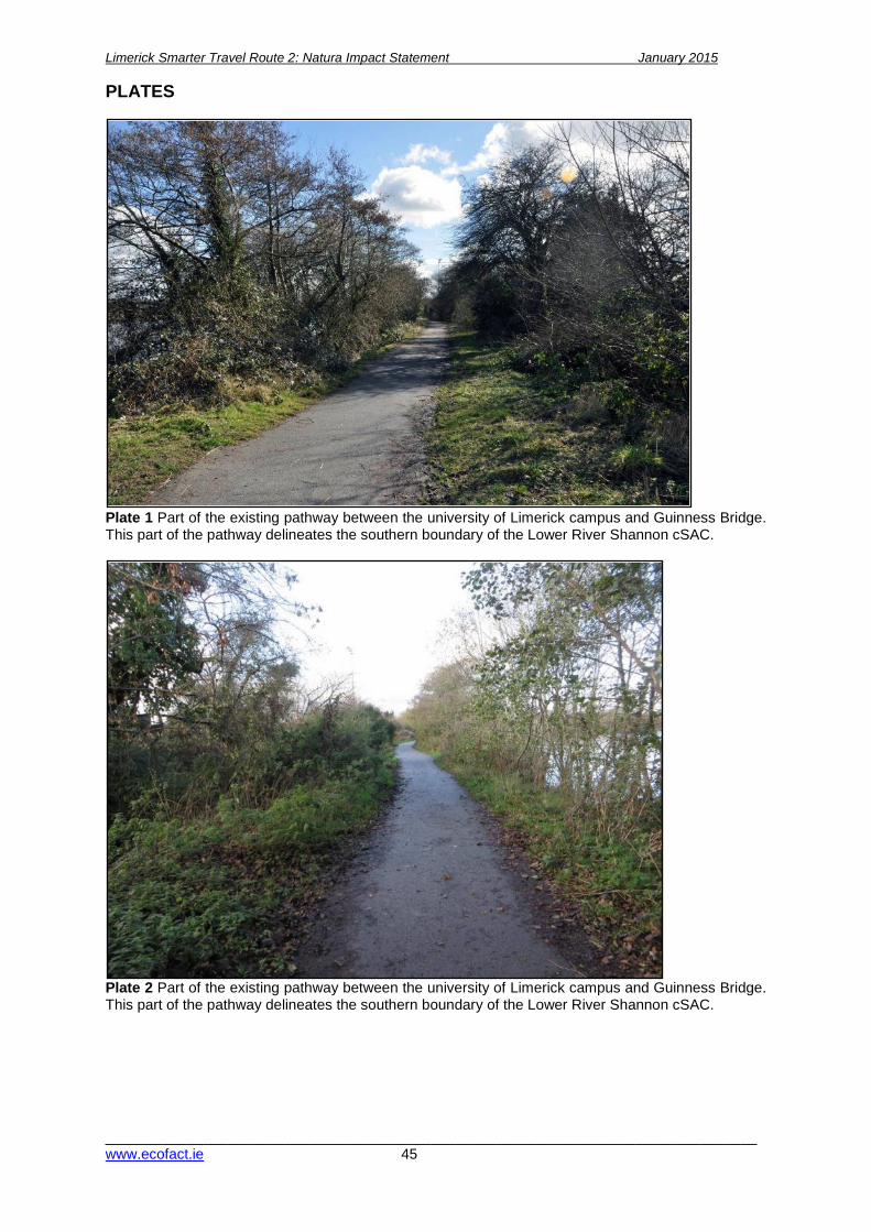
Limerick Smarter Travel Route 2: Natura Impact Statement January 2015
________________________________________________________________________________www.ecofact.ie 45
PLATES
Plate 1 Part of the existing pathway between the university of Limerick campus and Guinness Bridge. This part of the pathway delineates the southern boundary of the Lower River Shannon cSAC.
Plate 2 Part of the existing pathway between the university of Limerick campus and Guinness Bridge. This part of the pathway delineates the southern boundary of the Lower River Shannon cSAC.
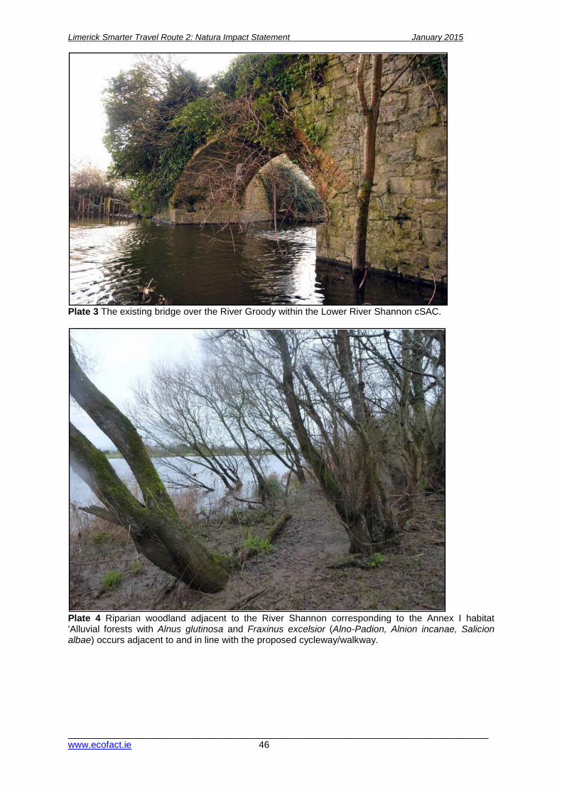
Limerick Smarter Travel Route 2: Natura Impact Statement January 2015
________________________________________________________________________________www.ecofact.ie 46
Plate 3 The existing bridge over the River Groody within the Lower River Shannon cSAC.
Plate 4 Riparian woodland adjacent to the River Shannon corresponding to the Annex I habitat 'Alluvial forests with Alnus glutinosa and Fraxinus excelsior (Alno-Padion, Alnion incanae, Salicion albae) occurs adjacent to and in line with the proposed cycleway/walkway.

Limerick Smarter Travel Route 2: Natura Impact Statement January 2015
________________________________________________________________________________www.ecofact.ie 47
Plate 5 Riparian / alluvial woodland adjacent to the River Shannon flooded (November 2014).
Plate 6 The ecological value of the understory within of woodland habitats within the study area has been compromised due to the colonisation of non-native invasive species, most notably Himalayan balsam. Giant hogweed Heracleum mantegazzianum (shown above) had already began sprouting when in late February.

Limerick Smarter Travel Route 2: Natura Impact Statement January 2015
________________________________________________________________________________www.ecofact.ie 48
Plate 7 Otter footprints recorded within the study area. The otter is a conservation interest of the Lower River Shannon cSAC and hunts in the River Shannon adjacent to the proposed development. No otter holts were found during the current surveys and significant impacts on this species are not envisaged due to the proposed development.
Plate 8 Juvenile River/Brook lampreys Lampetra sp. were recorded at the verge of the River Shannon within the study area. Deposited sediments along the river margins are important for the early life stage of the three species of lampreys present in the study area, all three listed as conservation interests of the Lower River Shannon cSAC.
University of Limerick Boardwalk development: Natura Impact Statement January 2015
__________________________________________________________________________ www.ecofact.ie
APPENDIX 1 Description of proposed scheme and construction methods
Construction Methodology
Introduction
In order to address the concerns of An Bord Pleanala and to reduce any visual or ecological impact of
the proposals, Limerick Smarter Travel has now revised the proposals for this project as follows;
• The 3m wide raised boardwalk structure with associated fencing has now been omitted for
the majority of the path length;
• A tarmac footpath surface with a timber kerb, varying in width from 1.5-3m, is now proposed
along the embankment. The path will not extend by on the top of the existing embankment,
nor will it be raised. There will be no structural intervention required along the towpath to
facilitate the construction of this path.
• Fencing will only be provided only along a short length where it currently exists for safety
reason;
• 2 no. of the proposed bridges (5 and 6) are proposed to remain as boardwalk type structures
but bridge 5 has been relocated to the River Shannon side of the existing bridge to
significantly reduce its impact on the SAC and due to concerns raised by the OPW through
the Section 50 process.
• The remaining bridges (4 and 7) will be widened in-situ as each has already undergone
previous significant structural interventions.
An overview of proposed construction methodology is provided hereafter. The proposals should be
read in conjunction with the accompanying planning drawings.
Mitigations measures outlined in Section 5 of the EcIA and Section 4.3.1 of the NIS should be
adhered too during the construction process.
Site Description
Limerick Smarter Travel – Route 2 is located along a historic towpath which from the University of
Limerick to the Park Canal adjacent to the River Shannon. This proposal seeks to provide an upgrade
to the existing path to function as a shared walk and cycle way between the University and the city.
Four no. existing towpath bridges will also be widened/ bypassed as part of the project. The main site
restriction to construction at the site is the difficulty in accessing the site due to its linear nature,
proximity to the river and limited width.
We note the following key issues relation to the ecology of the site;
• The site is located with of part the lower Shannon cSAC and features priority habitat in the
proposed development area – please refer to the attached ecology reports and habitat
mapping;

Limerick Smarter Travel Route 2: Natura Impact Statement ____January 2015
__________________________________________________________________________ www.ecofact.ie 50
• Japanese knotweed occurs along the Rhebogue access, with the proposed construction
access road running over the stands of the plant which occur here. The contractor will be
required eradicate this plant before entering the site. This requirement will be included in the
contract documents for the works. The preparation of a non-native invasive species
management plan for the site will also be a requirement of the contract.
• The project includes the provision of public lighting along the route to the same standard as
that which has been installed along the adjacent Shannon Field (Limerick Smarter travel
Route 2 Link 1) development. The proposal is to provide 3m high columns with spot-type
lanterns at 30m centres. This public lighting system has been proposed to provide a suitable
level of light for use by pedestrians and cyclists whilst creating minimal light spillage into
these environmentally sensitive locations. In order to further reduce impact on the ecology in
this environment, the proposed lighting will be switched off from April to September each year
and will also be switched off at 11pm in the evening from October to March each year.
Site Access
Due to the restriction imposed by the width of the existing towpath, access from the lands adjacent to
the towpath is required for health and safety reasons. A 10m wide wayleave along the length of the
pathway (refer to planning drawing 131-143-251), agreed with respective landowners, will provide
access and additional working space for construction traffic during the construction stage. It is
proposed that a 3m wide temporary gravel access road be provided within part this wayleave/
easement to allow construction traffic to access the proposed bridge along the route. This 3m access
has been located in the part of the wayleave furthest from the existing treelines to ensure no potential
damage to trees / root structures. The access road will be removed and the land fully reinstated to its
original conditions on completion of the construction works. The access road will terminate (from the
north) at bridge 5 and from the south at bridge 6.
Site Compound Location
It is proposed to locate a site compound adjacent to the University of Limerick Rowing Club Boat
House – please refer to planning drawings for proposed location. Materials will be received at this site
compound initially and will then be delivered to locations along the towpath as required.
Limerick Smarter Travel Route 2: Natura Impact Statement ____January 2015
__________________________________________________________________________ www.ecofact.ie 51
Outline construction methodology – Proposed path
Please refer to planning drawings for details of proposed path design.
Outline methodology proposed:
• The existing pathway will be graded and levelled using a small excavator. Excess material will be
removed from the site by a dumper via the temporary roadway and access easement.
• The proposed timber kerbing arrangement will be installed within the top of the existing
embankment. Pressure treated timber support posts (600mm long) will be driven into the top of
the existing embankment at approx. 1.2m centres. Treated timber kerbs will then be fixed
between each of the support posts.
• Subject to ground conditions, a geotextile material will be laid along the route of the proposed
pathway. Imported granular material will be filled to a thickness of approx. 120mm between the
timber kerbing. The proposed build up will be completed by laying a bitmac surfacing to a depth
of approx. 75mm. The bituminous surface will be machine laid using equipment suitable and will
access the towpath using the temporary roadway or along the top of towpath.
Outline construction methodology – Proposed bridges
Bridge 4
Please refer to planning drawings for details of proposed bridge 4.
Outline methodology proposed:
• The existing pathway will be graded and levelled using a small excavator. Excess material will be
removed from the site by a dumper via the temporary roadway and access easement.
• The existing balustrade will be removed.
• The existing bridge deck will be extended in reinforced concrete with masonry facing to match
existing with structural support provided by the existing abutment walls.
• The existing bridge will be repaired as it is in poor condition due to stone slippage and robbing
out. Where required, missing masonry elements will be replaced using like for like materials.
• A new balustrade will be provided upon completion.
Limerick Smarter Travel Route 2: Natura Impact Statement ____January 2015
__________________________________________________________________________ www.ecofact.ie 52
Bridge 5
Please refer to planning drawings for details of proposed bridge 5.
Outline methodology proposed:
• Excavation for the foundations of the proposed bridge will be undertaken using an excavator and
material will be removed from the site using a dumper. All machinery will access the area around
bridge 5 using the temporary roadway.
• Foundations will be poured using in-situ concrete. All concrete will be mixed off site, brought to
bridge 5 using the temporary roadway and pumped into the excavation from the supplier’s
vehicle.
• Piled foundations will be required to provide support due to poor ground conditions and will be
driven into the ground at locations required.
• The support posts for the footbridge will be bolted to the foundation pads.
• Where spans greater than 4m are required, a prefabricated steel frame will be provided.
• Cross beams and runners will be bolted to the support structure. Decking boards and balustrade
will then be fitted.
• The existing bridge will be cleaned and repaired.
Bridge 6
Please refer to planning drawings for details of proposed bridge 6.
Outline methodology proposed:
• Excavation for the foundations of the proposed bridge will be undertaken using an excavator and
material will be removed from the site using a dumper. All machinery will access the area around
bridge 6 using the temporary roadway.
• Foundations will be poured using in-situ concrete. All concrete will be mixed off site, brought to
bridge 6 using the temporary roadway from the Boat House and pumped into the excavation from
the supplier’s vehicle.
• Piled foundations will be required to provide support due to poor ground conditions and will be
driven into the ground at locations required.
• The support posts for the footbridge will be bolted to the foundation pads.
• Where spans greater than 4m are required, a prefabricated steel frame will be provided.
• Cross beams and runners will be bolted to the support structure. Decking boards and balustrade
will then be fitted.
• The existing bridge will be cleaned and repaired as necessary.

Limerick Smarter Travel Route 2: Natura Impact Statement ____January 2015
__________________________________________________________________________ www.ecofact.ie 53
Bridge 7
Please refer to planning drawings for details of proposed bridge 7.
Outline methodology proposed:
• The existing concrete and steel sections of the bridge and deck will be removed and the bridge
will be widened toward the River Shannon.
• A section of the existing masonry abutment walls will be replaced with reinforced concrete (RC)
abutment walls with masonry facing to match existing. The reinforced concrete retaining walls will
be constructed in-situ using appropriate shuttering and formwork.
• A new pre-cast reinforced concrete deck will be installed adjacent to the existing bridge spanning
between the proposed RC abutment walls. The precast reinforced concrete will be transported to
the site by a supplier truck and moved into position using a crane.
• A new low plastered masonry/ cast in situ reinforced concrete upstand wall will be constructed on
the river side of the widened bridge.
• The existing bridge will be cleaned and repaired as necessary.

Limerick Smarter Travel Route 2: Natura Impact Statement ____January 2015
__________________________________________________________________________ www.ecofact.ie 54

Limerick Smarter Travel Route 2: Natura Impact Statement ____January 2015
__________________________________________________________________________ www.ecofact.ie 55
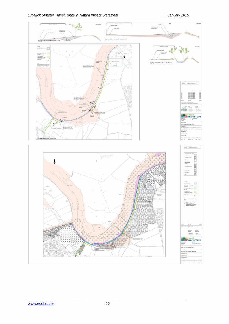
Limerick Smarter Travel Route 2: Natura Impact Statement ____January 2015
__________________________________________________________________________ www.ecofact.ie 56
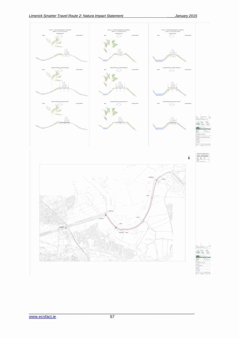
Limerick Smarter Travel Route 2: Natura Impact Statement ____January 2015
__________________________________________________________________________ www.ecofact.ie 57

Limerick Smarter Travel Route 2: Natura Impact Statement ____January 2015
__________________________________________________________________________ www.ecofact.ie 58

Limerick Smarter Travel Route 2: Natura Impact Statement ____January 2015
__________________________________________________________________________ www.ecofact.ie 59

Limerick Smarter Travel Route 2: Natura Impact Statement ____January 2015
__________________________________________________________________________ www.ecofact.ie 60

Limerick Smarter Travel Route 2: Natura Impact Statement ____January 2015
__________________________________________________________________________ www.ecofact.ie 61

Limerick Smarter Travel Route 2: Natura Impact Statement ____January 2015
__________________________________________________________________________ www.ecofact.ie 62
APPENDIX 2 NPWS Site Synopsis SITE NAME: LOWER RIVER SHANNON cSAC SITE CODE: 002165 Qualifying interests: Annex I habitats
• Sandbanks which are slightly covered by sea water all the time [1110] • Estuaries [1130] • Mudflats and sandflats not covered by seawater at low tide [1140] • Coastal lagoons [1150] • Large shallow inlets and bays [1160] • Reefs [1170] • Perennial vegetation of stony banks [1220] • Vegetated sea cliffs of the Atlantic and Baltic coasts [1230] • Salicornia and other annuals colonizing mud and sand [1310] • Spartina swards (Spartinion maritimae) [1320] • Atlantic salt meadows (Glauco-Puccinellietalia maritimae) [1330] • Mediterranean salt meadows (Juncetalia maritimi) [1410] • Water courses of plain to montane levels with the Ranunculion fluitantis and Callitricho-
Batrachion vegetation [3260] • Molinia meadows on calcareous, peaty or clavey-silt-laden soils (Molinion caeruleae) [6410] • Alluvial forests with Alnus glutinosa and Fraxinus excelsior (Alno-Padion, Alnion incanae,
Salicion albae) [91E0] Annex II species
• Freshwater pearl mussel (Margaritifera margaritifera) [1029] • Sea lamprey (Petromyzon marinus) [1095] • Brook lamprey (Lampetra planeri) [1096] • River lamprey (Lampetra fluviatilis) [1099] • Salmon (Salmo salar) [1106] • Bottle-nosed dolphin (Tursiops truncatus) [1349] • Otter (Lutra lutra) [1355]
This very large site stretches along the Shannon valley from Killaloe to Loop Head/ Kerry Head, a distance of some 120km. The site thus encompasses the Shannon, Feale, Mulkear and Fergus Estuaries, the freshwater lower reaches of the River Shannon (between Killaloe and Limerick), the freshwater stretches of much of the Feale and Mulkear catchments and the marine area between Loop Head and Kerry Head. The Shannon and Fergus flow through Carboniferous limestone as far as Foynes, but west of Foynes Namurian shales and flagstones redominate (except at Kerry Head, which is formed from Old Red Sandstone). The eastern sections of the Feale catchment flow through Namurian Rocks and the western stretches through Carboniferous Limestone. The Mulkear flows through Lower Palaeozoic Rocks in the upper reaches before passing through Namurian Rocks, followed by Lower Carboniferous Shales and Carboniferous Limestone. The Mulkear River itself, immediately north of Pallas Green, passes through an area of Rhyolites, Tuffs and Agglomerates. Rivers within the subcatchment of the Feale include the Galey, Smearlagh, Oolagh, Allaughaun, Owveg, Clydagh, Caher, Breanagh and Glenacarney. Rivers within the sub-catchment of the Mulkear include the Killeenagarriff, Annagh, Newport, the Dead River, the Bilboa, Glashacloonaraveela, Gortnageragh and Cahernahallia.
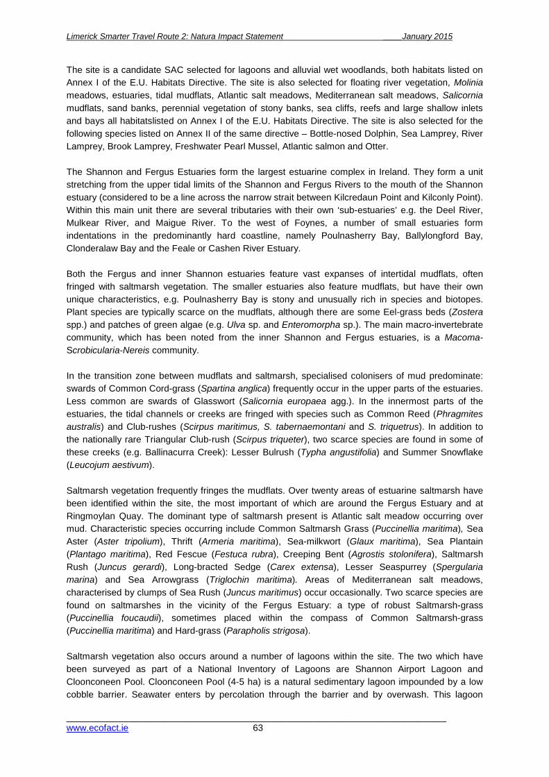
Limerick Smarter Travel Route 2: Natura Impact Statement ____January 2015
__________________________________________________________________________ www.ecofact.ie 63
The site is a candidate SAC selected for lagoons and alluvial wet woodlands, both habitats listed on Annex I of the E.U. Habitats Directive. The site is also selected for floating river vegetation, Molinia meadows, estuaries, tidal mudflats, Atlantic salt meadows, Mediterranean salt meadows, Salicornia mudflats, sand banks, perennial vegetation of stony banks, sea cliffs, reefs and large shallow inlets and bays all habitatslisted on Annex I of the E.U. Habitats Directive. The site is also selected for the following species listed on Annex II of the same directive – Bottle-nosed Dolphin, Sea Lamprey, River Lamprey, Brook Lamprey, Freshwater Pearl Mussel, Atlantic salmon and Otter. The Shannon and Fergus Estuaries form the largest estuarine complex in Ireland. They form a unit stretching from the upper tidal limits of the Shannon and Fergus Rivers to the mouth of the Shannon estuary (considered to be a line across the narrow strait between Kilcredaun Point and Kilconly Point). Within this main unit there are several tributaries with their own ‘sub-estuaries’ e.g. the Deel River, Mulkear River, and Maigue River. To the west of Foynes, a number of small estuaries form indentations in the predominantly hard coastline, namely Poulnasherry Bay, Ballylongford Bay, Clonderalaw Bay and the Feale or Cashen River Estuary. Both the Fergus and inner Shannon estuaries feature vast expanses of intertidal mudflats, often fringed with saltmarsh vegetation. The smaller estuaries also feature mudflats, but have their own unique characteristics, e.g. Poulnasherry Bay is stony and unusually rich in species and biotopes. Plant species are typically scarce on the mudflats, although there are some Eel-grass beds (Zostera spp.) and patches of green algae (e.g. Ulva sp. and Enteromorpha sp.). The main macro-invertebrate community, which has been noted from the inner Shannon and Fergus estuaries, is a Macoma- Scrobicularia-Nereis community. In the transition zone between mudflats and saltmarsh, specialised colonisers of mud predominate: swards of Common Cord-grass (Spartina anglica) frequently occur in the upper parts of the estuaries. Less common are swards of Glasswort (Salicornia europaea agg.). In the innermost parts of the estuaries, the tidal channels or creeks are fringed with species such as Common Reed (Phragmites australis) and Club-rushes (Scirpus maritimus, S. tabernaemontani and S. triquetrus). In addition to the nationally rare Triangular Club-rush (Scirpus triqueter), two scarce species are found in some of these creeks (e.g. Ballinacurra Creek): Lesser Bulrush (Typha angustifolia) and Summer Snowflake (Leucojum aestivum). Saltmarsh vegetation frequently fringes the mudflats. Over twenty areas of estuarine saltmarsh have been identified within the site, the most important of which are around the Fergus Estuary and at Ringmoylan Quay. The dominant type of saltmarsh present is Atlantic salt meadow occurring over mud. Characteristic species occurring include Common Saltmarsh Grass (Puccinellia maritima), Sea Aster (Aster tripolium), Thrift (Armeria maritima), Sea-milkwort (Glaux maritima), Sea Plantain (Plantago maritima), Red Fescue (Festuca rubra), Creeping Bent (Agrostis stolonifera), Saltmarsh Rush (Juncus gerardi), Long-bracted Sedge (Carex extensa), Lesser Seaspurrey (Spergularia marina) and Sea Arrowgrass (Triglochin maritima). Areas of Mediterranean salt meadows, characterised by clumps of Sea Rush (Juncus maritimus) occur occasionally. Two scarce species are found on saltmarshes in the vicinity of the Fergus Estuary: a type of robust Saltmarsh-grass (Puccinellia foucaudii), sometimes placed within the compass of Common Saltmarsh-grass (Puccinellia maritima) and Hard-grass (Parapholis strigosa). Saltmarsh vegetation also occurs around a number of lagoons within the site. The two which have been surveyed as part of a National Inventory of Lagoons are Shannon Airport Lagoon and Cloonconeen Pool. Cloonconeen Pool (4-5 ha) is a natural sedimentary lagoon impounded by a low cobble barrier. Seawater enters by percolation through the barrier and by overwash. This lagoon

Limerick Smarter Travel Route 2: Natura Impact Statement ____January 2015
__________________________________________________________________________ www.ecofact.ie 64
represents a type which may be unique to Ireland since the substrate is composed almost entirely of peat. The adjacent shore features one of the best examples of a drowned forest in Ireland. Aquatic vegetation in the lagoon includes typical species such as Beaked Tasselweed (Ruppia maritima) and green algae (Cladophora sp.). The fauna is not diverse, but is typical of a high salinity lagoon and includes six lagoon specialists (Hydrobia ventrosa, Cerastoderma glaucum, Lekanesphaera hookeri, Palaemonetes varians, Sigara stagnalis and Enochrus bicolor). In contrast, Shannon Airport Lagoon (2 ha) is an artificial saline lake with an artificial barrier and sluiced outlet. However, it supports two Red Data Book species of Stonewort (Chara canescens and Chara cf. connivens). Most of the site west of Kilcredaun Point/Kilconly Point is bounded by high rocky sea cliffs. The cliffs in the outer part of the site are sparsely vegetated with lichens, Red Fescue, Sea Beet (Beta vulgaris), Sea Campion (Silene maritima), Thrift and Plantains (Plantago spp.). A rare endemic Sea Lavender (Limonium recurvum subsp. pseudotranswallinum) occurs on cliffs near Loop Head. Cliff-top vegetation usually consists of either grassland or maritime heath. The boulder clay cliffs further up the estuary tend to be more densely vegetated, with swards of Red Fescue and species such as Kidney Vetch (Anthyllis vulneraria) and Bird’s-foot Trefoil (Lotus corniculatus). The site supports an excellent example of a large shallow inlet and bay. Littoral sediment communities in the mouth of the Shannon Estuary occur in areas that are exposed to wave action and also in areas extremely sheltered from wave action. Characteristically, exposed sediment communities are composed of coarse sand and have a sparse fauna. Species richness increases as conditions become more sheltered. All shores in the site have a zone of sand hoppers at the top and below this each of the shores has different characteristic species giving a range of different shore types in the cSAC. The intertidal reefs in the Shannon Estuary are exposed or moderately exposed to wave action and subject to moderate tidal streams. Known sites are steeply sloping and show a good zonation down the shore. Well developed lichen zones and littoral reef communities offering a high species richness in the sublittoral fringe and strong populations of Paracentrotus lividus are found. The communities found are tolerant to sand scour and tidal streams. The infralittoral reefs range from sloping platforms with some vertical steps to ridged bedrock with gullies of sand between the ridges to ridged bedrock with boulders or a mixture of cobbles, gravel and sand. Kelp is very common to about 18m. Below this it becomes rare and the community is characterised by coralline crusts and red foliose algae. Flowing into the estuaries are a number of tidal rivers. Other coastal habitats that occur within the site include the following:
• Stony beaches and bedrock shores - these shores support a typical zonation of seaweeds (Fucus spp., Ascophyllum nodosum and kelps).
• Shingle beaches - the more stable areas of shingle support characteristic species such as Sea Beet, Sea Mayweed (Matricaria maritima), Sea Campion and Curled Dock (Rumex crispus).
• Sandbanks which are slightly covered by sea water at all times – there is a known occurrence of sand/gravel beds in the area from Kerry Head to Beal Head.
• Sand dunes - a small area of sand dunes occurs at Beal Point. The dominant species is Marram Grass (Ammophila arenaria).
Freshwater rivers have been included in the site, most notably the Feale and Mulkear catchments, the Shannon from Killaloe to Limerick (along with some of its tributaries, including a short stretch of the Kilmastulla River), the Fergus up as far as Ennis, and the Cloon River. These systems are very different in character: the Shannon being broad, generally slow-flowing and naturally eutrophic; the Fergus being smaller and alkaline; while the narrow, fast-flowing Cloon is acid in nature. The Feale
Limerick Smarter Travel Route 2: Natura Impact Statement ____January 2015
__________________________________________________________________________ www.ecofact.ie 65
and Mulkear catchments exhibit all the aspects of a river from source to mouth. Seminatural habitats, such as wet grassland, wet woodland and marsh occur by the rivers, however, improved grassland is most common. One grassland type of particular conservation significance, Molinia meadows, occurs in several parts of the site and the examples at Worldsend on the River Shannon are especially noteworthy. Here are found areas of wet meadow dominated by rushes and sedges and supporting a diverse and species-rich vegetation, including such uncommon species as Blue-eyed Grass (Sisyrinchium bermudiana) and Pale Sedge (Carex pallescens). Floating river vegetation characterised by species of Water-crowfoot (Ranunculus spp.), Pondweeds (Potamogeton spp.) and the moss Fontinalius antipyretica arepresent throughout the major river systems within the site. The rivers contain an interesting bryoflora with Schistidium alpicola var. alpicola recorded from in-stream boulders on the Bilboa, new to county Limerick. Alluvial woodland occurs on the banks of the Shannon and on islands in the vicinity of the University of Limerick. The woodland is up to 50m wide on the banks and somewhat wider on the largest island. The most prominent woodland type is gallery woodland where White Willow (Salix alba) dominates the tree layer with occasional Alder (Alnus glutinosa). The shrub layer consists of various willow species with sally (Salix cinerea ssp. oleifolia) and what appear to be hybrids of S. alba x S. viminalis. The herbaceous layer consists of tall perennial herbs. A fringe of Bulrush (Typha sp.) occurs on the riverside of the woodland. On slightly higher ground above the wet woodland and on the raised embankment remnants of mixed oak-ash-alder woodland occur. These are poorly developed and contain numerous exotic species but locally there are signs that it is invading open grassland. Alder is the principal tree species with occasional Oak (Quercus robur), Elm (Ulmus glabra, U. procera), Hazel (Corylus avellana), Hawthorn (Crataegus monogyna) and the shrubs Guelder-rose (Viburnum opulus) and willows. The ground flora is species-rich. Woodland is infrequent within the site; however Cahiracon Wood contains a strip of old Oak woodland. Sessile Oak (Quercus petraea) forms the canopy, with an understorey of Hazel and Holly (Ilex aquifolium). Great Wood-rush (Luzula sylvatica) dominates the ground flora. Less common species present include Great Horsetail (Equisetum telmeteia) and Pendulous Sedge (Carex pendula). In the low hills to the south of the Slievefelim Mountains, the Cahernahallia River cuts a valley through the Upper Silurian rocks. For approximately 2km south of Cappagh Bridge at Knockanavar, the valley sides are wooded. The woodland consists of Birch (Betula spp.), Hazel, Oak, Rowan (Sorbus aucuparia), some Ash (Fraxinus excelsior) and Willow (Salix spp.). Most of the valley is not grazed by stock, and as a result the trees are regenerating well. The ground flora feature prominent Greater wood-rush and Bilberry (Vaccinium myrtillus) with a typical range of woodland herbs. Where there is more light available, Bracken (Pteridium aquilinum) features. The valley sides of the Bilboa and Gortnageragh Rivers, on higher ground north east of Cappamore, support patches of semi-natural broadleaf woodland dominated by Ash, Hazel, Oak and Birch. There is a good scrub layer with Hawthorn, Willow, Holly and Blackthorn (Prunus spinosa) common. The herb layer in these woodlands is often open with a typically rich mixture of woodland herbs and ferns. Moss species diversity is high. The woodlands are ungrazed. The hazel is actively coppiced in places. There is a small area of actively regenerating cut away raised bog at Ballyrorheen. It is situated approx. 5km north west of Cappamore Co. Limerick. The bog contains some wet areas with good moss (Sphagnum) cover. Species of particular interest include the Cranberry (Vaccinium oxycoccos) and the White Sedge (Carex curta) along with two other regionally rare mosses including S. fimbriatum. The site is being invaded by Birch (Betula pubescens) scrub woodland. Both commercial forestry and the spread of rhododendron has greatly reduced the overall value of the site. A number

Limerick Smarter Travel Route 2: Natura Impact Statement ____January 2015
__________________________________________________________________________ www.ecofact.ie 66
of plant species that are Irish Red Data Book species occur within the site; several are protected under the Flora (Protection) Order, 1999:
• Triangular Club-rush (Scirpus triquetrus) - in Ireland this protected species is only found in the Shannon Estuary, where it borders creeks in the inner estuary.
• Opposite-leaved Pondweed (Groenlandia densa) - this protected pondweed is found in the Shannon where it passes through Limerick City. The stronghold for this plant is the Park canal (NPWS, 2012).
• Meadow Barley (Hordeum secalinum) - this protected species is abundant in saltmarshes at Ringmoylan and Mantlehill.
• Hairy Violet (Viola hirta) - this protected violet occurs in the Askeaton/Foynes area. • Golden Dock (Rumex maritimus) - noted as occurring in the River Fergus Estuary. • Bearded Stonewort (Chara canescens) - a brackish water specialist found in Shannon Airport
lagoon. • Convergent Stonewort (Chara connivens) - presence in Shannon Airport Lagoon to be
confirmed. Overall, the Shannon and Fergus Estuaries support the largest numbers of wintering waterfowl in Ireland. The highest count in 1995-96 was 51,423 while in 1994-95 it was 62,701. Species listed on Annex I of the E.U. Birds Directive which contributed to these totals include: Great Northern Diver (3; 1994/95), Whooper Swan (201; 1995/96), Pale-bellied Brent Goose (246; 1995/96), Golden Plover (11,067; 1994/95) and Bar-tailed Godwit ( 476; 1995/96). In the past, three separate flocks of Greenland White-fronted Goose were regularly found but none were seen in 1993/94. Other wintering waders and wildfowl present include Greylag Goose (216; 1995/96), Shelduck (1,060; 1995/96), Wigeon (5,976; 1995/96); Teal (2,319; 1995-96); Mallard (528; 1995/96), Pintail (45; 1995/96), Shoveler (84; 1995/96), Tufted Duck (272; 1995/96), Scaup (121; 1995/96), Ringed Plover (240; 1995/96), Grey Plover (750; 1995/96), Lapwing (24,581; 1995/96), Knot (800; 1995/96), Dunlin (20,100; 1995/96), Snipe (719, 1995/96), Black-tailed Godwit (1062; 1995/96), Curlew (1504; 1995/96), Redshank (3228; 1995/96), Greenshank (36; 1995/96) and Turnstone (107; 1995/96). A number of wintering gulls are also present, including Black-headed Gull (2,216; 1995/96), Common Gull (366; 1995/96) and Lesser Black-backed Gull (100; 1994/95). This is the most important coastal site in Ireland for a number of the waders including Lapwing, Dunlin, Snipe and Redshank. It also provides an important staging ground for species such as Black-tailed Godwit and Greenshank. A number of species listed on Annex I of the E.U. Birds Directive breed within the site. These include Peregine Falcon (2-3 pairs), Sandwich Tern (34 pairs on Rat Island, 1995), Common Tern (15 pairs: 2 on Sturamus Island and 13 on Rat Island, 1995), Chough (14-41 pairs, 1992) and Kingfisher. Other breeding birds of note include Kittiwake (690 pairs at Loop Head, 1987) and Guillemot (4010 individuals at Loop Head, 1987) There is a resident population of Bottle-nosed Dolphin in the Shannon Estuary consisting of at least 56-68 animals (1996). This is the only known resident population of this E.U. Habitats Directive Annex II species in Ireland. Otter, a species also listed on Annex II of this directive, is commonly found on the site. Five species of fish listed on Annex II of the E.U. Habitats Directive are found within the site. These are Sea Lamprey (Petromyzon marinus), Brook Lamprey (Lampetra planeri), River Lamprey (Lampetra fluviatilis), Twaite Shad (Allosa fallax fallax) and Salmon (Salmo salar). The three lampreys and Salmon have all been observed spawning in the lower Shannon or its tributaries. The Fergus is important in its lower reaches for spring salmon while the Mulkear catchment excels as a grilse fishery though spring fish are caught on the actual Mulkear River. The Feale is important for both types.

Limerick Smarter Travel Route 2: Natura Impact Statement ____January 2015
__________________________________________________________________________ www.ecofact.ie 67
Twaite Shad is not thought to spawn within the site. There are few other river systems in Ireland which contain all three species of Lamprey. Two additional fish of note, listed in the Irish Red Data Book also occur, namely Smelt (Osmerus eperlanus) and Pollan (Coregonus autumnalis pollan). Only the former has been observed spawning in the Shannon. Freshwater Pearl-mussel (Margaritifera margaritifera), a species listed on Annex II of the E.U. Habitats Directive, occurs abundantly in parts of the Cloon River. There is a wide range of landuses within the site. The most common use of the terrestrial parts is grazing by cattle and some areas have been damaged through overgrazing and poaching. Much of the land adjacent to the rivers and estuaries has been improved or reclaimed and is protected by embankments (especially along the Fergus Estuary). Further, reclamation continues to pose a threat as do flood relief works (e.g. dredging of rivers). Gravel extraction poses a major threat on the Feale. In the past, Cord-grass (Spartina sp.) was planted to assist in land reclamation. This has spread widely, and may oust less vigorous colonisers of mud and may also reduce the area of mudflat available to feeding birds. Domestic and industrial wastes are discharged into the Shannon, but water quality is generally satisfactory - except in the upper estuary, reflecting the sewage load from Limerick City. Analyses for trace metals suggest a relatively clean estuary with no influences by industrial discharges apparent. Further industrial development along the Shannon and water polluting operations are potential threats. Fishing is a main tourist attraction on the Shannon and there are a large number of Angler Associations, some with a number of beats. Fishing stands and styles have been erected in places. The River Feale is a designated Salmonid Water under the E.U. Freshwater Fish Directive. Other uses of the site include commercial angling, oyster farming, boating (including dolphin-watching trips) and shooting. Some of these may pose threats to the birds and dolphins through disturbance. Specific threats to the dolphins include underwater acoustic disturbance, entanglement in fishing gear and collisions with fast moving craft. This site is of great ecological interest as it contains a high number of habitats and species listed on Annexes I and II of the E.U. Habitats Directive, including the priority habitat lagoon, the only known resident population of Bottle-nosed Dolphin in Ireland and all three Irish lamprey species. A good number of Red Data Book species are also present, perhaps most notably the thriving populations of Triangular Club-rush. A number of species listed on Annex I of the E.U. Birds Directive are also present, either wintering or breeding. Indeed, the Shannon and Fergus Estuaries form the largest estuarine complex in Ireland and support more wintering wildfowl and waders than any other site in the country. Most of the estuarine part of the site has been designated a Special Protection Area (SPA), under the E.U. Birds Directive, primarily to protect the large numbers of migratory birds present in winter.

Limerick Smarter Travel Route 2: Natura Impact Statement ____January 2015
__________________________________________________________________________ www.ecofact.ie 68
APPENDIX 3 Botanist Report (January 2015)
The composition, structure and condition of woodland habitat
along the River Shannon at the University of Limerick
January 2015
Dr. John Conaghan,
Enviroscope Environmental Consultancy,
11 Dun Ard,
Craughwell,
Co. Galway.

Limerick Smarter Travel Route 2: Natura Impact Statement ____January 2015
__________________________________________________________________________ www.ecofact.ie 69
Table of Contents Page No. 1. INTRODUCTION 3 2. METHODS 3 3. RESULTS 5 4. DISCUSSION AND CONCLUSIONS 12 REFERENCES
Limerick Smarter Travel Route 2: Natura Impact Statement ____January 2015
__________________________________________________________________________ www.ecofact.ie 70
1. Introduction During an Ecological Impact Assessment zone of the Proposed Limerick Smarter Travel
Route an area of wet woodland has been identified along the banks of the River Shannon at
the University of Limerick. The EIS is being conducted for a proposed upgrade of a walking
path which runs along the southern banks of the river Shannon. The woodland consists of a
fringe of riparian woodland which attains a maximum width of 30 metres, but is often much
less than this. The river and associated fringing woodland lies with the Lower River
Shannon Special Area of Conservation (Site No. 002165).
In November of 2014 Dr. John Conaghan was commissioned by Ecofact, Limerick to
conduct a survey of the woodland habitat present in order to determine its composition and
quality and establish whether or not the habitat/vegetation conforms to the priority EU Annex
I habitat ‘alluvial forests with Alnus glutinosa and Fraxinus excelsior (Alno-padnion, Alnion
incanae, Salicion albae) (91E0)’.
2. Methods The survey was visited on the 18/11/2014 with a view to describing the composition,
structure and condition of the habitat present. Although this is late in the year to conduct a
botanical survey most of the main tree, herb and moss species can still be identified. A total
of three relevés (vegetation descriptions) from within the target habitat were described.
These illustrate the species composition and structure of the vegetation present.
Vegetation was sampled according to the Zurich-Montpellier approach (Mueller-Dombois and Ellenberg, 1974). The cover abundance of plants present within releves is estimated according to the Domin scale of cover/abundance outlined in the following table.
Table 1. The Domin scale of cover/abundance
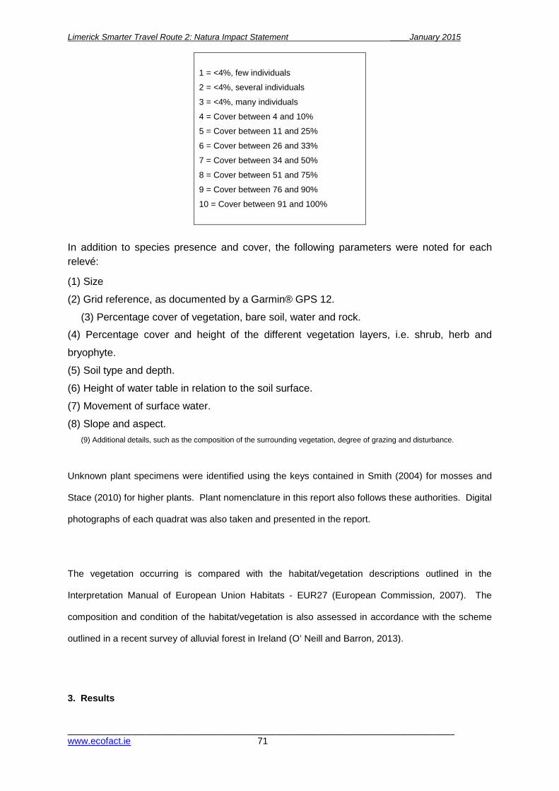
Limerick Smarter Travel Route 2: Natura Impact Statement ____January 2015
__________________________________________________________________________ www.ecofact.ie 71
1 = <4%, few individuals
2 = <4%, several individuals
3 = <4%, many individuals
4 = Cover between 4 and 10%
5 = Cover between 11 and 25%
6 = Cover between 26 and 33%
7 = Cover between 34 and 50%
8 = Cover between 51 and 75%
9 = Cover between 76 and 90%
10 = Cover between 91 and 100%
In addition to species presence and cover, the following parameters were noted for each relevé:
(1) Size
(2) Grid reference, as documented by a Garmin® GPS 12.
(3) Percentage cover of vegetation, bare soil, water and rock.
(4) Percentage cover and height of the different vegetation layers, i.e. shrub, herb and
bryophyte.
(5) Soil type and depth.
(6) Height of water table in relation to the soil surface.
(7) Movement of surface water.
(8) Slope and aspect. (9) Additional details, such as the composition of the surrounding vegetation, degree of grazing and disturbance.
Unknown plant specimens were identified using the keys contained in Smith (2004) for mosses and
Stace (2010) for higher plants. Plant nomenclature in this report also follows these authorities. Digital
photographs of each quadrat was also taken and presented in the report.
The vegetation occurring is compared with the habitat/vegetation descriptions outlined in the
Interpretation Manual of European Union Habitats - EUR27 (European Commission, 2007). The
composition and condition of the habitat/vegetation is also assessed in accordance with the scheme
outlined in a recent survey of alluvial forest in Ireland (O’ Neill and Barron, 2013).
3. Results
Limerick Smarter Travel Route 2: Natura Impact Statement ____January 2015
__________________________________________________________________________ www.ecofact.ie 72
The main trees occurring in the riparian woodland at this site are white willow (Salix alba)
and alder (Alnus glutinosa) with ash (Fraxinus excelsior), sycamore (Acer pseudoplatanus)
and grey willow (Salix cinerea subsp. oleifolia) also locally frequent. The ground layer flora
appears to be generally poorly developed with species such as common nettle (Urtica
dioica), meadowsweet (Filipendula ulmaria), reed canary grass (Phalaris arundinacea) and
the invasive non-native plant species Himalayan balsam (Impatiens glandulifera) locally
frequent. The species-poor nature of the ground layer is probably partly due to the late
timing of the survey and the high water levels. It is likely that if the survey was conducted
during the growing season additional species would be recorded from the woodland areas.
In the following pages the relevés are presented along with an accompanying photograph.
The relevés were taken at three locations along the southern banks of the Shannon where
the riparian woodland habitat was seen to be best developed, i.e. where the woodland strip
is widest and the woodland canopy height is tall. Following the relevé the composition and
structure of the vegetation is assessed according to the approach outlined in O’ Neill and
Barron (2013).

Limerick Smarter Travel Route 2: Natura Impact Statement ____January 2015
__________________________________________________________________________ www.ecofact.ie 73
Releve No. 1
Releve code Shannon 1
Date 18/11/2014
GPS reading R 60509 28367
Size (m2) 100
Slope (degrees) 0
Aspect -
Height of canopy (m) 5 to 8
Vegetation cover (%) 75
Surface water cover (%) 95
Trees/shrub cover (%) 55
Herb cover (%) 35
Bryophyte cover (%) 3
No. of plant species in quadrat 12
Substrate – Flooded mineral soil.
Alnus glutinosa 6
Salix alba 5
Salix cinerea subsp. oleifolia 5
Impatiens glandulifera 4
Filipendula ulmaria 3
Urtica dioica 3
Hedera helix 3

Limerick Smarter Travel Route 2: Natura Impact Statement ____January 2015
__________________________________________________________________________ www.ecofact.ie 74
Fraxinus excelsior 3
Acer pseudoplatanus 2
Thamnobryum alopecurum 2
Angelica sylvestris 2
Rosa sp. 1
Comments – Slow flowing water present. Probably 1 to 2 metres deep.
Assessment table for Releve No. 1
Assessment criteria at the individual plot level for 91E0 woodlands
Assessment criterion 91E0 target for pass
Result Pass/Fail
1. Positive indicator species At least 1 target species 6 positive species
4 target species 4 positive species
Pass Fail
2. Negative species cover <10% cover of plot c. 8% Pass 3. Negative species regeneration
Absent Present Fail
4. Median canopy height
>7 m 7 Pass
5. Total canopy cover >30% of plot 55 Pass 6. Proportion of target species in canopy
>50% of canopy Pass
7. Native shrub layer cover
10-75% of plot, 15 (Salix cinerea) Pass
8. Native dwarf shrub/field layer
> 20% of plot height >20 cm
35 >20
Pass
9. Bryophyte cover > 4% c. 2% Fail 10. Grazing pressure
All 5 indicators absent No grazing Pass
Releve No. 1 passes on 8 criteria but fails on 2.

Limerick Smarter Travel Route 2: Natura Impact Statement ____January 2015
__________________________________________________________________________ www.ecofact.ie 75
Releve No. 2
Releve code Shannon 2
Date 18/11/2014
GPS reading R 60503 58296
Size (m2) 100
Slope (degrees) 0
Aspect -
Height of canopy (m) 10 to 14
Vegetation cover (%) 70
Surface water cover (%) 95
Trees/shrub cover (%) 60
Herb cover (%) 25
Bryophyte cover (%) 0
No. of plant species in quadrat 11
Substrate – Flooded mineral soil.
Salix alba 7
Fraxinus excelsior 5
Acer pseudoplatanus 4
Urtica dioica 4
Calystegia sepium 3
Iris pseudacorus 3
Phalaris arundinacea 3
Impatiens glandulifera 3

Limerick Smarter Travel Route 2: Natura Impact Statement ____January 2015
__________________________________________________________________________ www.ecofact.ie 76
Angelica sylvestris 2
Carex remota 1
Hedera helix 1
Comments – Slow flowing water present. Probably 1 to 2 metres deep.
Assessment table for Releve No. 2
Assessment criteria at the individual plot level for 91E0 woodlands
Assessment criterion 91E0 target for pass
Result Pass/Fail
1. Positive indicator species At least 1 target species 6 positive species
2 target species 5 positive species
Pass Fail
2. Negative species cover <10% cover of plot c. 10 Fail 3. Negative species regeneration
Absent Present Fail
4. Median canopy height
>7 m 12 Pass
5. Total canopy cover >30% of plot 60 Pass 6. Proportion of target species in canopy
>50% of canopy Pass
7. Native shrub layer cover
10-75% of plot, 0 Fail
8. Native dwarf shrub/field layer
> 20% of plot height >20 cm
25 >20
Pass
9. Bryophyte cover > 4% 0% Fail 10. Grazing pressure
All 5 indicators absent No grazing Pass
Releve No. 2 passes on 7 criteria but fails on 3.
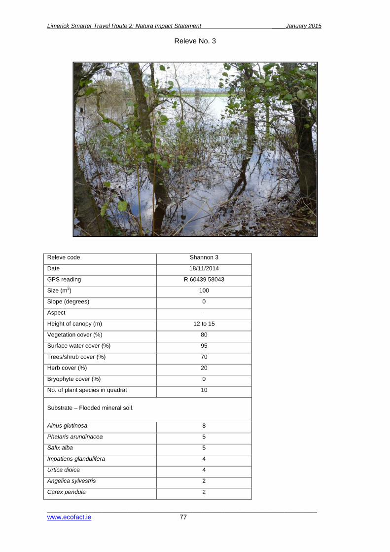
Limerick Smarter Travel Route 2: Natura Impact Statement ____January 2015
__________________________________________________________________________ www.ecofact.ie 77
Releve No. 3
Releve code Shannon 3
Date 18/11/2014
GPS reading R 60439 58043
Size (m2) 100
Slope (degrees) 0
Aspect -
Height of canopy (m) 12 to 15
Vegetation cover (%) 80
Surface water cover (%) 95
Trees/shrub cover (%) 70
Herb cover (%) 20
Bryophyte cover (%) 0
No. of plant species in quadrat 10
Substrate – Flooded mineral soil.
Alnus glutinosa 8
Phalaris arundinacea 5
Salix alba 5
Impatiens glandulifera 4
Urtica dioica 4
Angelica sylvestris 2
Carex pendula 2

Limerick Smarter Travel Route 2: Natura Impact Statement ____January 2015
__________________________________________________________________________ www.ecofact.ie 78
Assessment table for Releve No. 3
Assessment criteria at the individual plot level for 91E0 woodlands
Assessment criterion 91E0 target for pass
Result Pass/Fail
1. Positive indicator species At least 1 target species 6 positive species
2 target species 5 positive species
Pass
2. Negative species cover <10% cover of plot c. 7 Pass 3. Negative species regeneration
Absent Present Fail
4. Median canopy height
>7 m 13 Pass
5. Total canopy cover >30% of plot 65 Pass 6. Proportion of target species in canopy
>50% of canopy Pass
7. Native shrub layer cover
10-75% of plot, 0 Fail
8. Native dwarf shrub/field layer
> 20% of plot height >20 cm
20 >20
Pass
9. Bryophyte cover > 4% 0% Fail 10. Grazing pressure
All 5 indicators absent No grazing Pass
Releve No. 3 passes on 7 criteria but fails on 3.
Hedera helix 2
Crataegus monogyna 1
Taraxacum officinale 1
Comments – Slow flowing water present. Probably 1 to 2 metres deep.

Limerick Smarter Travel Route 2: Natura Impact Statement ____January 2015
__________________________________________________________________________ www.ecofact.ie 79
4. Discussion and conclusions When compared to the classification scheme outlined in ‘A Guide to Habitats in Ireland’
(Fossitt, 2000) it is clear that the woodland surveyed is best accommodated within Riparian
woodland (WN5). The habitat present is clearly an example of a gallery woodland where
there is frequent flooding and fluctuation of the water table. It is of interest that Fossitt op.
cit. does not consider that riparian woodlands correspond to the priority Annex I alluvial
woodland.
When compared to the definition of priority Annex I alluvial woodland given in the
Interpretation Manual of European Union Habitats (European Commission, 2007) it is
evident that the area of woodland surveyed does, on balance, correspond to the
floristic/habitat description given. The vegetation recorded along the banks of the Shannon
contain three of the tree layer species (Alnus glutinosa (alder), Salix alba (white willow) and
Fraxinus excelsior (ash)) and five of the herb layer species (Angelica sylvestris (wild
angelica), Carex pendula (pendulous sedge), Carex remota (remote sedge), Urtica dioica
(nettle) and Filipendula ulmaria (meadowsweet)). It would appear that many of the herb
layer species listed in the manual are absent from the River Shannon samples however it
must be acknowledged that the survey was conducted very late in the season and that
additional indicator herb species would be recorded if the survey was carried out during the
growing season and/or when the river water levels are lower.
In the most recent description and assessment of alluvial forests in Ireland (O Neill and
Barron, 2013) gallery woodland with a high cover of Alnus glutinosa, Salix alba and Fraxinus
excelsior are considered to be examples of Annexed alluvial woodland. The vegetation
recorded in this survey appears to correspond to the Alnus glutinosa – Filipendula ulmaria
group described by Perrin et al. (2008). The species composition of the riparian woodland
surveyed corresponds well to the typical composition of the habitat (see assessment tables).
Although there is generally a low number of positive species present this is partially due to
the species-poor nature of the vegetation. The presence of the invasive non-native species
Himalayan balsam (Impatiens glandulifera) is significant as it lowers the overall value of the
habitat. Although the cover of the species recorded during this survey was only between 5
and 10% generally, it is likely that the cover is higher during the summer months before die-
back of vegetation occurs. The structure of the habitat appears to be poorly developed. A
low shrub layer is not always present and there appears to be low levels of natural
regeneration present.

Limerick Smarter Travel Route 2: Natura Impact Statement ____January 2015
__________________________________________________________________________ www.ecofact.ie 80
It is concluded that the tall riparian woodland that occurs along the banks of the Shannon
river is an example of Annex I Alluvial woodland. The species composition of the vegetation
is typical of the habitat, if somewhat species-poor in terms of the ground flora. However, as
previously noted this could be a result of the late timing of the survey and the high water
levels. The structure of the habitat appears to be poorly developed with a low shrub layer,
regenerating saplings and deadwood all largely absent.
A small area of wetland dominated by reedswamp and occasional low growing willow
bushes occurs between bridge structure 6 and the pond to the south-east. Although some of
the habitat in this area can be described as riparian scrub/woodland the cover of trees is
patchy and a continuous woodland canopy is largely absent. As a result, the small area of
scrubby woodland to the south-east of bridge 6 is not considered to constitute an example of
Annex I Alluvial woodland.
It is clear from the proposed path upgrade construction methodology that there will be no
significant negative effect on the areas of alluvial woodland habitat present. Areas of alluvial
woodland are limited to the margins of the main channel of the river Shannon and no
construction activity is planned for these areas. Access for construction traffic and materials
will be via a temporary access road (c. 3 metres in width) which will run parallel to (and
south/east of) the existing river bank path. It was noted that no areas of alluvial woodland
habitat occur along the proposed route of the temporary access road. The access road will
be constructed in areas dominated by improved agricultural grassland and wet grassland
which are nationally common habitats of relatively low ecological importance.

Limerick Smarter Travel Route 2: Natura Impact Statement ____January 2015
__________________________________________________________________________ www.ecofact.ie 81
REFERENCES
European Commission (2007). Interpretation Manual of European Union Habitats.
Fossitt, J.A. (2000). A Guide to Habitats in Ireland. The Heritage Council, Kilkenny.
Mueller-Dombois, D. & Ellenberg, H. (1974). Aims and Methods in Vegetation Ecology.
Wiley, New York.
O ’Neill, F.H. & Barron, S.J. (2013). Results of monitoring survey of old sessile oak woods
and alluvial forests. Irish Wildlife Manuals, No. 71. National Parks and Wildlife Service,
Department of Arts, Heritage and the Gaeltacht, Dublin, Ireland.
Perrin, P.M, Martin, J.R., Barron, S.J., O’Neill, F.H., McNutt, K.E. & Delaney, A.M. (2008).
National Survey of Native Woodlands 2003-2008: Volume II: Woodland classification. Report
submitted to National Parks & Wildlife Service, Dublin.
Smith, A.J.E. (2004). The Moss Flora of Britain and Ireland. (2nd edition) University Press,
Cambridge.
Stace, C. (2010). New Flora of the British Isles (3rd edition). University Press, Cambridge.
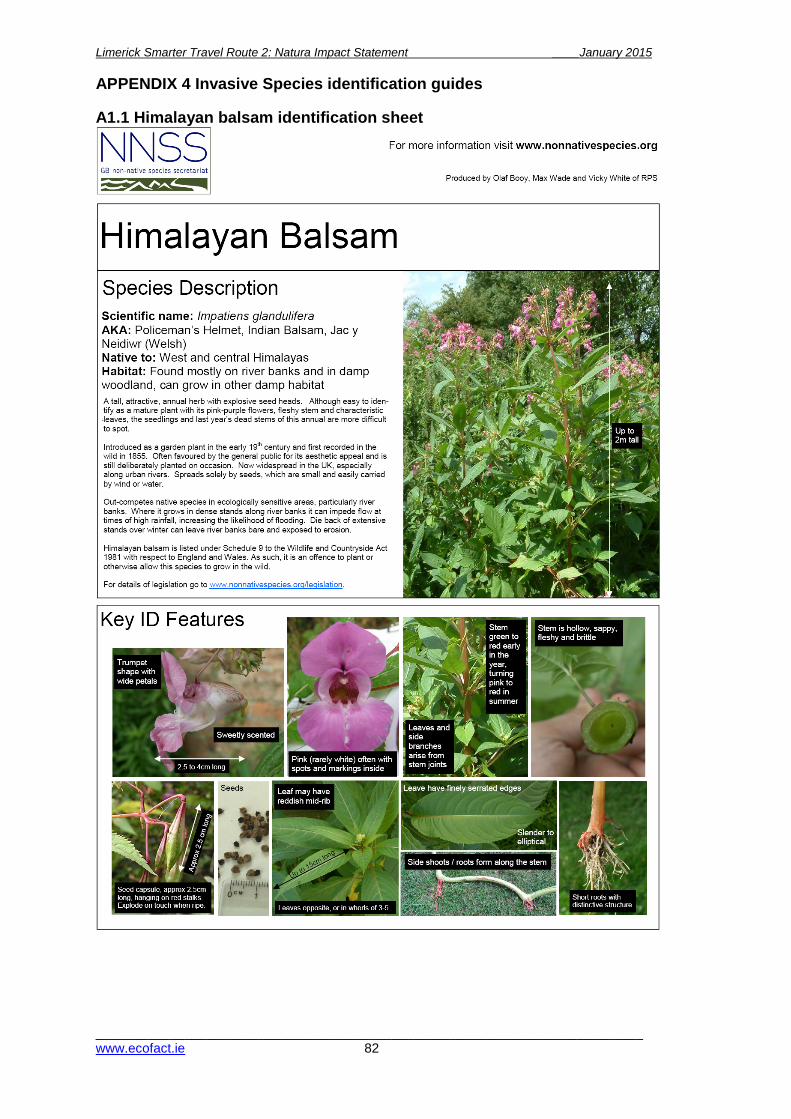
Limerick Smarter Travel Route 2: Natura Impact Statement ____January 2015
__________________________________________________________________________ www.ecofact.ie 82
APPENDIX 4 Invasive Species identification guides A1.1 Himalayan balsam identification sheet

Limerick Smarter Travel Route 2: Natura Impact Statement ____January 2015
__________________________________________________________________________ www.ecofact.ie 83
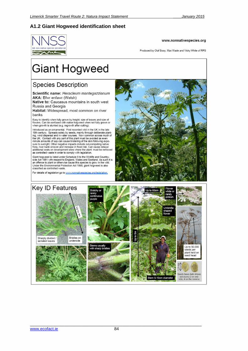
Limerick Smarter Travel Route 2: Natura Impact Statement ____January 2015
__________________________________________________________________________ www.ecofact.ie 84
A1.2 Giant Hogweed identification sheet

Limerick Smarter Travel Route 2: Natura Impact Statement ____January 2015
__________________________________________________________________________ www.ecofact.ie 85
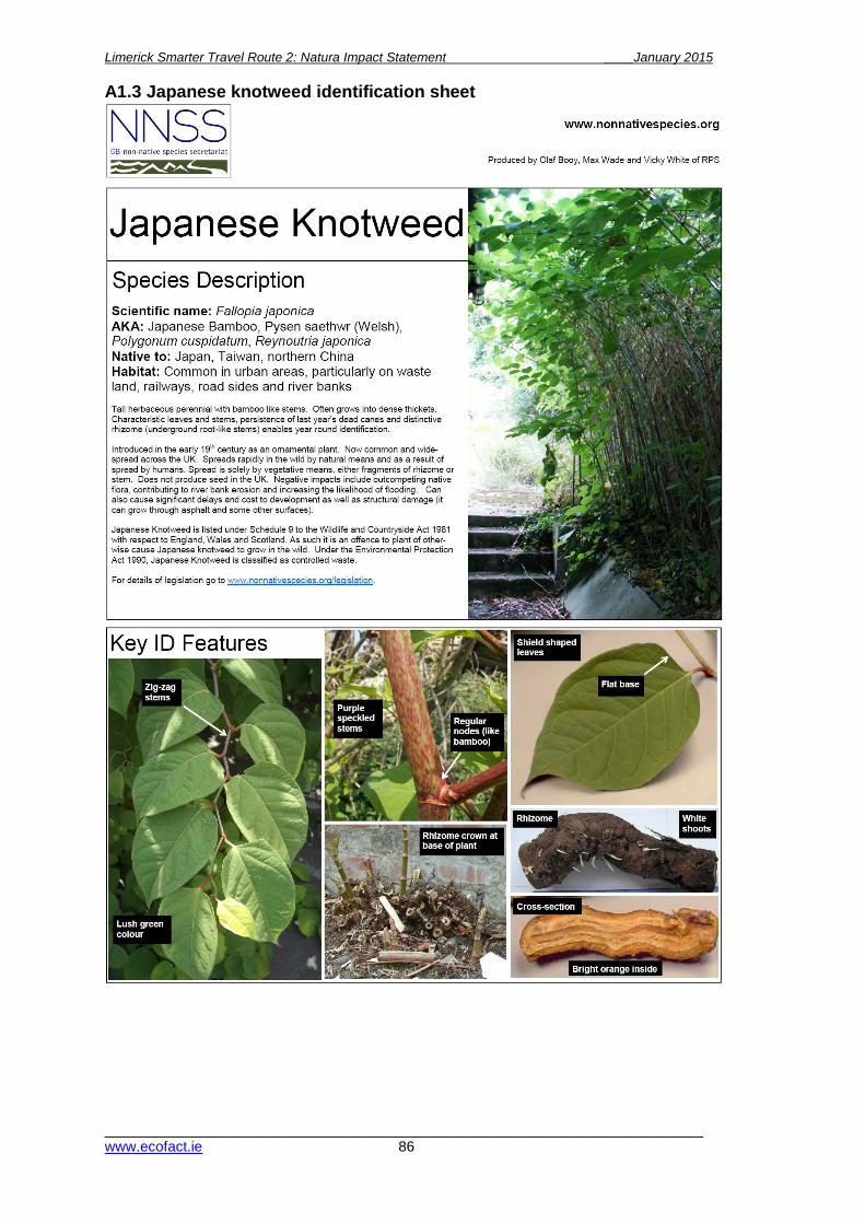
Limerick Smarter Travel Route 2: Natura Impact Statement ____January 2015
__________________________________________________________________________ www.ecofact.ie 86
A1.3 Japanese knotweed identification sheet