natural bridge battlefield historic … natural bridge...natural bridge battlefield historic state...
TRANSCRIPT

NATURAL BRIDGE BATTLEFIELD
HISTORIC STATE PARK
UNIT MANAGEMENT PLAN
APPROVED
STATE OF FLORIDA DEPARTMENT OF ENVIRONMENTAL PROTECTION
Division of Recreation and Parks
SEPTEMBER 5, 2003

Department of Environmental Protection
Jeb Bush Governor
Marjorie Stoneman Douglas Building 3900 Commonwealth Boulevard, MS 140
Tallahassee, Florida 32399-3000
David B. Struhs Secretary
“More Protection, Less Process”
Printed on recycled paper.
September 8, 2003 Ms. BryAnne White Division of Recreation and Parks Office of Park Planning, M.S. 525 3900 Commonwealth Blvd. Tallahassee, Florida 32399 Re: Natural Bridge Battlefield Historic State Park Lease # 3635 Ms. White: On September 5, 2003, the Office of Environmental Services, acting as agent for the Board of Trustees of the Internal Improvement Trust Fund, approved the management plan for Natural Bridge Battlefield Historic State Park. Pursuant to Section 253.034, Florida Statutes, and Chapter 18-2, Florida Administrative Code this plan’s ten-year update will be due on September 5, 2013. Approval of this land management plan does not waive the authority or jurisdiction of any governmental entity that may have an interest in this project. Implementation of any upland activities proposed by this management plan may require a permit or other authorization from federal and state agencies having regulatory jurisdiction over those particular activities. Please forward copies of all permits to this office upon issuance.
Sincerely,
Delmas T. Barber Delmas T. Barber, OMC Manager Office of Environmental Services Division of State Lands
i
TABLE OF CONTENTS
INTRODUCTION 1
PURPOSE AND SCOPE OF PLAN 1
MANAGEMENT PROGRAM OVERVIEW 3
Management Authority And Responsibility 3
Park Goals And Objectives 4
Management Coordination 5
Other Designations 5
RESOURCE MANAGEMENT COMPONENT
INTRODUCTION 7
RESOURCE DESCRIPTION AND ASSESSMENT 7
Natural Resources 7
Cultural Resources 13
RESOURCE MANAGEMENT PROGRAM 14
Special Management Considerations 14
Management Needs And Problems 15
Management Objectives 15
Management Measures For Natural Resources 15
Management Measures For Cultural Resources 17
Research Needs 18
Resource Management Schedule 18

ii
LAND USE COMPONENT
INTRODUCTION 19
EXTERNAL CONDITIONS 19
Existing Use Of Adjacent Lands 19
Planned Use Of Adjacent Lands 20
PROPERTY ANALYSIS 20
Recreation Resource Elements 20
Assessment Of Use 21
CONCEPTUAL LAND USE PLAN 23
Potential Uses And Proposed Facilities 23
Facilities Development 25
Existing Use And Optimum Carrying Capacity 25
Optimum Boundary 26
TABLE
TABLE 1 - Existing Use And Optimum Carrying Capacity 26
LIST OF ADDENDA
ADDENDUM 1
Acquisition History A 1 - 1 ADDENDUM 2
References Cited A 2 - 1
ADDENDUM 3
Soil Descriptions A 3 - 1
iii
ADDENDUM 4
Plant And Animal List A 4 - 1
ADDENDUM 5
Designated Species List A 5 - 1
ADDENDUM 6
Priority Schedule and Cost Estimates A 6 - 1
MAPS
Vicinity Map 2
Soils Map 9
Natural Communities Map 12
Base Map 22
Conceptual Land Use Plan 24
Optimum Boundary Map 27
1
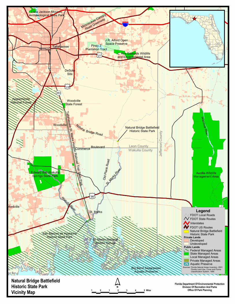
INTRODUCTION Natural Bridge Battlefield Historic State Park is located in Leon County (see Vicinity Map). Access to the park is from Natural Bridge Road off State Road 363 in the Town of Woodville. The vicinity map also reflects significant land and water resources existing near the park. For this plan, park acreage has been calculated based on the composition of natural communities, in addition to ruderal and developed areas. Currently the park contains 9.02 acres. At Natural Bridge, public outdoor recreation and conservation is the designated single use of the property. There are no legislative or executive directives that constrain the use of this property. Acquisition began in 1950 as a donation from the United Daughters of the Confederacy (see Addendum 1). PURPOSE AND SCOPE OF THE PLAN This plan serves as the basic statement of policy and direction for the management of Natural Bridge Battlefield Historic State Park as a unit of Florida's state park system. It identifies the objectives, criteria and standards that guide each aspect of park administration, and sets forth the specific measures that will be implemented to meet management objectives. The plan is intended to meet the requirements of Sections 253.034 and 259.032, Florida Statutes, Chapter 18-2, Florida Administrative Code, and intended to be consistent with the State Lands Management Plan. With approval, this management plan will supercede and replace the current approved plan of June 29, 1998. All development and resource alteration encompassed in this plan is subject to the granting of appropriate permits; easements, licenses, and other required legal instruments. Approval of the management plan does not constitute an exemption from complying with the appropriate local, state, or federal agencies. This plan is also intended to meet the requirements for beach and shore preservation, as defined in Chapter 161, Florida Statutes, and Chapters 62B-33, 62B-36 and 62R-49, Florida Administrative Code. The plan consists of two interrelated components. Each component corresponds to a particular aspect of the administration of the park. The resource management component provides a detailed inventory and assessment of the natural and cultural resources of the park. Resource management problems and needs are identified, and specific management objectives are established for each resource type. This component provides guidance on the application of such measures as prescribed burning, exotic species removal, and restoration of natural conditions. The land use component is the recreational resource allocation plan for the unit. Based on considerations such as access, population, and adjacent land uses, an optimum allocation of the physical space of the park is made, locating use areas and proposing types of facilities and volume of use to be provided. In the development of this plan, the potential of the park to accommodate secondary management purposes (“multiple uses”) was analyzed. These secondary purposes were considered within the context of the Division’s statutory responsibilities and an analysis of the resource needs and values of the park. This analysis considered the park natural and cultural resources, management needs, aesthetic values, visitation, and visitor experiences. For this park, it was determined that no secondary purposes could be accommodated in a manner that would not interfere with the primary purpose of resource-based outdoor recreation and conservation. Uses such as, water resource development projects, water supply projects, stormwater management projects, linear facilities and sustainable agriculture and forestry (other than those forest management activities specifically identified in this plan) are not
������������������� ���������������������������� � � � � � � � ����
� �����!�����"����# �$�%���"���������������
!%����# �&���������'�������# ���# �������������
������������������� �������������������
���������
�����������
���������
���������������������
������� ��� !���!����������"�
#��$���%&����'�� ����%�"���(����������
�����������)���������������������������������������
#����*�����'�������*�����
�� ������*
�����
�����������
�����������������'�� ���� ���
�������'�� �������(��������
�������
%&��������'�������!���������������
��������
� ����
�������
�����������
������������������+�����������"�
�������
���*���!
�
����,�
���&��
#�����������������������������������������
�!�����������������-�����
���. � ) � /0
��12
��34
��5/3��565
'��"���
�& ��"���
��������������!�����������������������
'��"���������-�����
*�((���� �����"��
�����������
-������������������������������������
������������������� �������������������
-� ��7��������
#�����������������
����������
� ��������
7��"���!���"���!�
�����-� ��������������
�+�����������"�
-� ��#���������
��"����������������
�������8�-�������������������.�"������9�100/���������������-�����#���7��9�*�"������-��(����������������*���� �����������(9�/33:
.����������
��
3
consistent with this plan or the management purposes of the park. The potential for generating revenue to enhance management was also analyzed. Visitor fees and charges are the principal source of revenue generated by the park. It was determined that multiple-use management activities would not be appropriate as a means of generating revenues for land management. Instead, techniques such as entrance fees, concessions, and similar measures will be employed on a case-by-case basis as a means of supplementing park management funding. The use of private land managers to facilitate restoration and management of this unit was also analyzed. Decisions regarding this type of management (such as outsourcing, contracting with the private sector, use of volunteers, etc.) will be made on a case-by-case basis as necessity dictates. MANAGEMENT PROGRAM OVERVIEW
Management Authority and Responsibility In accordance with Chapter 258, Florida Statutes, and Chapter 62D-2, Florida Administrative Code, the Division of Recreation and Parks (Division) is charged with the responsibility of developing and operating Florida's recreation and parks system. These are administered in accordance with the following policy:
It shall be the policy of the Division of Recreation and Parks to promote the state park system for the use, enjoyment, and benefit of the people of Florida and visitors; to acquire typical portions of the original domain of the state which will be accessible to all of the people, and of such character as to emblemize the state's natural values; conserve these natural values for all time; administer the development, use and maintenance of these lands and render such public service in so doing, in such a manner as to enable the people of Florida and visitors to enjoy these values without depleting them; to contribute materially to the development of a strong mental, moral, and physical fiber in the people; to provide for perpetual preservation of historic sites and memorials of statewide significance and interpretation of their history to the people; to contribute to the tourist appeal of Florida.
The Trustees have also granted management authority of certain sovereign submerged lands to the Division under Management Agreement MA 68-086 (as amended January 19, 1988). The management area includes a 400-foot zone from the edge of mean high water where a park boundary borders sovereign submerged lands fronting beaches, bays, estuarine areas, rivers or streams. Where emergent wetland vegetation exists, the zone extends waterward 400 feet beyond the vegetation. The agreement is intended to provide additional protection to resources of the park and nearshore areas and to provide authority to manage activities that could adversely impact public recreational uses. Many operating procedures are standard system wide and are set by policy. These procedures are outlined in the Division Operations Procedures Manual (OPM) and cover such areas as personnel management, uniforms and personal appearance, training, signs, communications, fiscal procedures, interpretation, concessions, camping regulations, resource management, law enforcement, protection, safety and maintenance. In the management of Natural Bridge Battlefield Historic State Park, maintenance of conditions that preserve the integrity of the cultural resources is all-important. Cultural resource considerations are given priority over user considerations and development is restricted to the minimum necessary for ensuring its protection and maintenance, limited access, user safety and convenience, and appropriate interpretation. Permitted uses are primarily of a passive nature, related to the educational enjoyment of the historic site,
4
although other compatible uses are permitted in limited amounts. Program emphasis is placed on interpretation of the cultural attributes of the park.
Park Goals and Objectives The following park goals and objectives express the Division long-term intent in managing the state park. At the beginning of the process to update this management plan, the Division reviewed the goals and objectives of the previous plan to determine if they remain meaningful and practical and should be included in the updated plan. This process ensures that the goals and objectives for the park remain relevant over time. Estimates are developed for the funding and staff resources needed to implement the management plan based on these goals, objectives and priority management activities. Funding priorities for all state park management and development activities are reviewed each year as part of the Division legislative budget process. The Division prepares an annual legislative budget request based on the priorities established for the entire state park system. The Division also aggressively pursues a wide range of other funds and staffing resources, such as grants, volunteers, and partnerships with agencies, local governments and the private sector, for supplementing normal legislative appropriations to address unmet needs. The ability of the Division to implement the specific goals, objectives and priority actions identified in this plan will be determined by the availability of funding resources for these purposes. Natural and Cultural Resources 1. Preserve, protect, and interpret the cultural and natural resources of the park.
A. Monitor and maintain conditions that protect the integrity of the park’s cultural resources
B. Plan and develop an interpretive kiosk for the park’s cultural resources C. Improve native plant buffers around the monument. D. Monitor impacts of adjacent trees to the monument. E. Continue prescribe burning and the related restoration of ruderal areas of the park with
adjustments to protect the vegetative buffers of the monument. F. Protect, to the extent possible, the St. Marks River, the river sink area, and the park’s
sinkholes from negative impacts. G. Make a concerted effort to monitor, quantify, and document any impact that the annual
battle reenactment has on the cultural and natural resources of the park. H. Survey the park for cultural resources and record any resources identified during the
survey. Recreational Goals 2. Continue to provide quality resource based outdoor recreational and interpretive
programs and facilities at the state park. A. Review and design best use of park facilities to facilitate and appropriately manage
visitor use of the park. B. Continue to provide recreational opportunities such as picnicking, interpretive
programs, and nature study. 3. Seek funding to expand recreational and interpretive opportunities through the
improvement of programs and the development of new use areas and facilities, as outlined in this management plan.
A. Develop an interpretive plan for the park. B. Improve interpretation of natural and cultural features by constructing displays at the
natural bridge and on the battlefield. C. Construct a large picnic pavilion to accommodate large groups, especially during
special events.
5
D. Promote and market Natural Bridge Battlefield Historic State Park as part of a heritage tour of Tallahassee that includes area state parks and other significant sites.
Park Administration/Operations 4. Continue to provide quality administrative and operational services.
A. Provide necessary administrative support in order to ensure a high quality visitor experience.
B. Continue to ensure that essential maintenance measures are implemented in order to provide attractive, clean, and serviceable facilities for park visitors.
C. Provide staff with appropriate training opportunities in visitor services, resource management, park operations, general maintenance, and interpretation.
D. Maintain park signage and support facilities in good repair. Management Coordination
The park is managed in accordance with all applicable Florida Statutes and administrative rules. Agencies having a major or direct role in the management of the park are discussed in this plan. The Department of Agriculture and Consumer Services, Division of Forestry (DOF), assists Division staff in the development of wildfire emergency plans and provides the authorization required for prescribed burning. The Florida Fish and Wildlife Conservation Commission (FFWCC), assists staff in the enforcement of state laws pertaining to wildlife, freshwater fish and other aquatic life existing within park boundaries. In addition, the FFWCC aids the Division with wildlife management programs, including the development and management of Watchable Wildlife programs. The Department of State, Division of Historical Resources (DHR) assists staff to assure protection of archaeological and historical sites. The Department of Environmental Protection (DEP), Office of Coastal and Aquatic Managed Areas (CAMA) aids staff in aquatic preserves management programs. The DEP, Bureau of Beaches and Wetland Resources aids staff in planning and construction activities seaward of the Coastal Construction Line. In addition, the Bureau of Beaches and Coastal Systems aids the staff in the development of erosion control projects. Emphasis is placed on protection of existing resources as well as the promotion of compatible outdoor recreational uses.
Other Designations Natural Bridge is not within an Area of Critical State Concern as defined in section 380.05, Florida Statutes. Currently it is not under study for such designation. The park is a component of the Florida Greenways and Trails System. All waters within the unit have been designated as Outstanding Florida Waters, pursuant to Chapter 62-302 Florida Administrative Code. Surface waters in this unit are also classified as Class III waters by DEP. This unit is not located within or adjacent to an aquatic preserve as designated under the Florida Aquatic Preserve Act of 1975 (section 258.35, Florida Statutes).
7
RESOURCE MANAGEMENT COMPONENT INTRODUCTION The Division of Recreation and Parks has implemented resource management programs for preserving for all time the representative examples of natural and cultural resources of statewide significance under its administration. This component of the unit plan describes the natural and cultural resources of the park and identifies the methods that will be used to manage them. The stated management measures in this plan are consistent with the Department’s overall mission in ecosystem management. Cited references are contained in Addendum 2. The Division’s philosophy of resource management is natural systems management. Primary emphasis is on restoring and maintaining, to the degree practicable, the natural processes that shape the structure, function and species composition of Florida’s diverse natural communities as they occurred in the original domain. Single species management may be implemented when the recovery or persistence of a species is problematic provided it is compatible with natural systems management. The management goal of cultural resources is to preserve sites and objects that represent all of Florida’s cultural periods as well as significant historic events or persons. This goal may entail active measures to stabilize, reconstruct or restore resources, or to rehabilitate them for appropriate public use. Because park units are often components of larger ecosystems, their proper management is often affected by conditions and occurrences beyond park boundaries. Ecosystem management is implemented through a resource management evaluation program (to assess resource conditions, evaluate management activities, and refine management actions), review of local comprehensive plans, and review of permit applications for park/ecosystem impacts. RESOURCE DESCRIPTION AND ASSESSMENT
Natural Resources Topography This unit is situated in the major physiographic division known as the Gulf Coastal Lowlands. This division is composed of light grey to buff colored loose quartz sands that lie at lower elevations than the yellow orange poorly cemented sandhills to the north. The Coastal Lowlands area is readily divisible into two major units, the Apalachicola Coastal Lowlands and the Woodville Karst Plain. The Woodville Karst Plain is a gently sloping, relatively low (0-60 feet) plain. It is characterized by loose, quartz sands thinly veneering a limestone substrata that has resulted in a sinkhole-sand dune topography. The Woodville Karst Plain is divided into two areas based on elevation. The Lake Munson Hills are found at the western edge of the plain and have a general land surface about 30 to 50 feet higher than areas to the east. At the southern edge of the plain in Leon County, immediately adjacent to the St. Marks River, there exists a series of dunes that are generally 50 feet or less and are probably associated with the Pamlico shore line. This area is called the Wakulla Sand Hills and is where the park is situated. A narrow strip along the St. Marks River that includes its flood plain valley, is called the St. Marks River Valley Lowlands. The river flows upon or is slightly incised into the bedrock. Soils are sandy and wet in this strip. The park slopes gently in an easterly direction to the edge of the St. Marks River. Two small sinkholes, approximately 20-30 feet deep and about 1/10 acre in size, are found within the park. These conical depressions were formed by the collapse of land surface into a limestone void created by the dissolution of the limestone. A portion of
8
another small sinkhole is located on the western boundary. This partial sink has been disturbed and is mapped ruderal. A shallow (10 feet) depression is found on the north boundary. The sinks are not filled with water but can hold rainwater and runoff during rainy periods. Elevation of the park is about 15 feet at the shore of the river and increases to 20-25 feet at the western boundary. Geology Leon County is located along the north central border of the Floridan Plateau which is the emerged portion of sediments of the Florida peninsula. The sediments composing this plateau range in age from early Paleozoic to Recent, and vary in thickness from about 5,000 feet to more than 15,000 feet. The oldest rocks encountered in this area are sedimentary rocks of Silurian and/or Ordovician age at depths of about 7,000 feet. There are about 4,500 feet of Mesozoic clastics and carbonates, sands, and clays. The Quaternary beds are composed of sands and some sandy clays, and are less than 100 feet thick. The upper layer of underlying limestone in the park is the St. Marks Formation which was deposited some 15 million years ago during the early Miocene Tampa State. The Miccosukee and Hawthorn formations which overlay the St. Marks Formation, are no longer present in this area due to erosion and solution. Sediments of the St. Marks Formation are fine to medium grained, silty to sandy limestones which are normally 90% or more calcium carbonate. The St. Marks Formation is exposed along the St. Marks River and in numerous sinks in this area. Suwannee Limestone underlies the St. Marks Formation. The Suwannee Limestone is the only deposit of the Oligocene Age (30 million years old) found in Leon County. It overlies the Crystal River Formation of the Jackson Stage from the Eocene Age. The Suwannee Limestone in Leon County is the principle aquifer and most of the water supply wells penetrate into the formation. Soils A soil survey of Leon County, issued February 1981 was completed in 1979 by the United States Department of Agriculture's Soil conservation Service (SCS) and Forest Service in cooperation with; The University of Florida, Institute of Food and Agricultural Sciences and Agriculture Experimental Stations, Soil Science Department; The Leon County Board of County Commissioners; and the Florida Department of Agriculture and Consumer services. The fieldwork for the survey was performed in the 1975-78 time period. The results of the SCS survey show that two soil map units occur at this site (see Soils Map). The Pamlico-Dorovan complex is present in the flood plains adjacent to the St. Marks river and the Chaires fine sand series is present in the higher flatwoods areas of the western portion of the park. Detailed soil descriptions can be found in Addendum 3. The threat of erosion due to visitor impact at this park poses the greatest challenge to the conservation of soil resources. A plan to safeguard against this impact should be developed in anticipation of increased visitation and implemented as necessary to protect the soil resource. Minerals There is no active mining of minerals in the park or adjacent to it. Quartz sand is present and is relatively clay free, clean, and unconsolidated. Limestone occurs beneath the sand. Most of the limestone bedrock is slightly sandy, argillaceous, and partially dolomitized. The hardness of the limestone varies considerably. Limestone has been used for road base and has the potential for use as agricultural limestone or quick and hydrated lime. Mining of limestone in this area has not proven economic.

���
�� � �� ��� ��� �������
��������� ������������������������������������������������������ �
!����������� ��������"
#
#$%&�$'�(�)�*��($%%'��)�'�+),%!�)-�,%$%���$�. ,!)',�/$�
'�*�#���0�-1����������������0��������0����������� �23��
10
Hydrology The St. Marks River flows through the park. The river is marked by many limestone features including the famous Natural Bridge. The river starts as a very small stream in the Tallahassee Hills area of eastern Leon County and flows south-southeast through a portion of Jefferson county and then back again into Leon County. The river widens below Horn Spring and then flows 2 1/2 miles to Natural Bridge where the river flows into a sink then disappears underground. The St. Marks River flows underground 3/4 of a mile then reemerges at St. Marks Spring. Here the river flows at an average rate of 700 cubic feet per second in a well-defined channel cut into limestone. Along this part of the river, the St. Marks River Valley Lowlands is readily discernible. Between the St. Marks spring and Natural Bridge, there are several other sinkhole and springs. The river runs approximately 11 miles from the St. Marks Spring to its confluence with the Wakulla River in Wakulla County. The St. Marks River traverses approximately 35 miles and drains 661 square miles. The water quality of the upper St. Marks River (north of its confluence of the Wakulla River) is considered good, although there is the possibility of a degrading trend towards increased nitrogen and reduced dissolved oxygen concentrations. Lake Lafayette receives stormwater from Tallahassee, which in turn drains into the St. Marks, thus threatening the historically good water quality of the upper portion. Rapid shoreline development is also a threat to water quality. The St. Marks is an Outstanding Florida Water and a Special Water bordered by the Florida National Scenic Trail. The lower portion of the St. Marks River is threatened by spills from petroleum operations. The City of Tallahassee's Purdom Power Plant discharges into the river downstream from Rattlesnake Branch. Sediments in the river are coated with oil from major and minor spills of barges that routinely dock along the industrial section of the river. On site the greatest potential threat to the water resource is the loss of native vegetation along the riverbank, sink holes and adjacent property that is associated with increased visitation. Vegetative damage leads to erosion and subsequent siltation of the river or stormwater impacts to groundwater through sinkholes. Water resources can be protected at this site through development and implementation of plans which anticipate and safeguard against visitor impacts. A cooperative effort with Leon County and the landowner (St. Joe) to reduce stormwater impacts from Natural Bridge Road to the river and associated sinks will further protect the resource. An effective and visible program at this park may encourage the same effort from citizens throughout the Woodville Karst Plain which would more effectively advance the conservation effort. The St. Marks river is classified as a blackwater stream (FNAI, 1989). Such streams are characterized as having dark colored water with a high content of particulate and dissolved organic matter derived from the river's drainage through swamps and marshes. As the St. Marks flows south, it receives more water from springs, making the river become more like a spring-run stream, with a more neutral pH. A single well and pump is used to supply water for the entire park and facilities. Water is drawn from the Floridan Aquifer and the quality is considered non-potable. Application for a new water treatment system has been made and funded which will increase the quality of the water presently being drawn from the Floridan Aquifer. Daily rainfall is monitored with an on site rain gauge and recorded. Annual rainfall for the park is about 57 inches. Natural Communities The system of classifying natural communities employed in this plan was developed by the Florida Natural Areas Inventory (FNAI) FNAI Descriptions. The premise of this system is that
11
physical factors, such as climate, geology, soil, hydrology and fire frequency generally determine the species composition of an area, and that areas which are similar with respect to these factors will tend to have natural communities with similar species compositions. Obvious differences in species composition can occur, despite similar physical conditions. In other instances, physical factors are substantially different, yet the species compositions are quite similar. For example, coastal strand and scrub--two communities with similar species compositions--generally have quite different climatic environments, and these necessitate different management programs. The park contains three distinct natural communities (see Natural Communities Map) in addition to ruderal and developed areas. Park specific assessments of the existing natural communities are provided in the narrative below. A list of plants and animals occurring in the unit is contained in Addendum 4. Sinkhole. There are two small sinkholes wholly within the park, and a small impacted portion of a third contained on the western boundary line (mapped as ruderal). The sinkholes are conical depressions with steep limestone walls. They greatest depth of the sinks extends approximately 20. The rock walls are covered by mosses, liverworts, and ferns. Typical plants are wax myrtle, sweetgum, southern magnolia, water oak, and maples. Most of these trees occur on the fringe surrounding the sinkhole. Sinkholes are most common in this karst area where the underlying limestone has been riddled with solution cavities created by the action of underground water. As the cavities enlarge they can become interconnected forming large caverns. If the water table drops, the area above the cavern is no longer supported by hydrostatic pressure and may collapse. The deep cylindrical or conical surface depression that results after the collapse is the sinkhole. The sinkhole may occur deep enough to be below the water table. Floodplain forest. The floodplain forest is a hardwood forest that occur on drier soils at slight elevation within floodplains and are usually flooded for a portion of the growing season. The dominant trees found here are southern magnolia, red maple, water oak, American holly and American hornbeam. The understory is open and contains small hardwoods as well as bluestem palmetto native azaleas. East of the river influenced by karst topography the forest is intergraded with Floodplain Swamp. The limited acreage of the site is mapped as Floodplain Forest. Hydroperiod is the primary physical feature of floodplain forests, which are inundated by floodwaters nearly every year for 2 to 50% of the growing season. The floodplain forest at Natural Bridge occasionally floods during seasonal rains and may stay inundated for several weeks. Organic material that accumulates on the forest floor is removed during flooding and redistributed in the floodplain or washed down river. Soil minerals are replenished by floods through deposition on the floodplain. The maintenance of natural hydrologic regimes is critical to insure the proper conditions of the floodplain forest and to the downstream communities with which they are connected. Blackwater stream. The St. Marks River, a blackwater stream, flows through the park. The generally acidic, (pH = 4.0 - 6.0 ) tea-colored waters of these streams are laden with tannins, particulates, dissolved organic matter, and iron derived from drainage through swamps and marshes. The dark colored water inhibits submerged aquatic plants although emergent often occurs. Blackwater streams often have sandy bottoms, however, the St. Marks River at this location flows over primarily limestone. Ruderal and developed. The majority of the land area at Natural bridge Battlefield has been greatly altered by human activity. Ruderal areas are characterized by having the natural

��
��
����
��
�
��������� ������������������������������������������ ���������!����"����� ����#��������������$%��������������������&���������������
�'()$'��*+,,)�-(-� ,'.
�'()$'��!$-��!'((���-��/- (+$-*� ('(��.'$0 �������������#�����1���&����#������.���������
�&�������1�$��������������.����+11�����1�.����.������2
�� � �� ��� ����

13
substrate or biological community overwhelmingly altered as a result of such actions and native vegetation is sparse. These areas would require a long-term restoration effort to be returned to their natural state. The majority of the ruderal area at this site is degraded Mesic Flatwoods. Additional acquisition to the east or north would make the restoration of this community type more achievable. Ruderal areas at the park are the re-enactor camping area, the memorial area, and the battlefield area. Developed areas consist of natural biological communities that have been replaced or nearly replaced. Developed areas at this park include residential area, roads, parking lots, and public use area which includes the monument, picnic area and portions of the riverbank. Designated Species Designated species are those which are listed by the Florida Natural Areas Inventory (FNAI), U.S. Fish and Wildlife Service (USFWS), Florida Fish and Wildlife Conservation Commission (FFWCC), and the Florida Department of Agriculture and Consumer Services (FDA) as endangered, threatened or of special concern. Addendum 5 contains a list of the designated species and their designated status for this park. Management measures will be addressed later in this plan. There are currently no known designated species that occur at this small park. Special Natural Features The St. Marks River, the natural land bridge that is formed when the river goes underground, and the sinkholes found within the park, are special natural features of Natural Bridge Battlefield. The St. Marks River is one of only two streams of any consequence in Leon County, the other being the Ochlockonee River. The flow above Natural Bridge is small and narrow. Below Natural Bridge the flow is increased by additional spring water and the river widens. The gradient of the river in Leon County is 2.5 feet per mile. At the area of Natural Bridge, the St. Marks River flows under ground and reappears as surface water several times before it finally resurfaces as the river about 3/4 of a mile to the south. Sinkholes are common in this area of the Woodville Karst Plain. The porous and permeable sands have permitted rainwater to rapidly move into underlying limestone strata. The limestone is very soluble and undergoes considerable dissolution from the action of weak carbonic acid found in these percolating surface waters. Dissolving limestone has caused some areas to be lowered from their original level as well as sinkhole formation similar to those found at the park.
Cultural Resources Evaluating the condition of cultural resources is accomplished using a three part evaluative scale, expressed as good, fair, poor. These terms describe the present state of affairs, rather than comparing what exists against the ideal, a newly constructed component. Good describes a condition of structural stability and physical wholeness, where no obvious deterioration other than normal occurs. Fair describes a condition in which there is a discernible decline in condition between inspections, and the wholeness or physical integrity is and continues to be threatened by factors other than normal wear. A fair judgment is cause for concern. Poor describe an unstable condition where there is palpable, accelerating decline, and physical integrity is being compromised quickly. A resource in poor condition suffers obvious declines in physical integrity from year to year. A poor condition suggests immediate action to reestablish physical stability. The Natural Bridge Battlefield is recorded as 8Le188 in the Florida Master Site File (FMSF). It was listed on the National Register of Historic Places in 1970. The cultural resources of the
14
State Historic Site are generally or specifically connected with the event commemorated by the park. This was a March 1865 battle of limited scale, in which Confederate troops, volunteers, and militia denied the St. Marks River crossing at the Natural Bridge to Federal troops. Each of the opposing armies fielded at most 1,000 combatants. The field of battle, including Confederate earthworks or defensive embankments, was unequally bisected by an unpaved road now called Natural Bridge Road. The pines of the park area were turpentined and eventually logged, and evidence of this important local industry, in the form of cat faced trees, may be found in the park and scattered through adjacent areas. The road approach to the natural bridge has probably moved slightly; some residential development has approached in recent years. Except for a monument to the defenders of Natural Bridge and improvements consequent to establishing the park in 1950, it is unlikely that the area has changed much since 1865. In the early spring of 1865, the Civil War was nearly over and the ultimate outcome was already clear. By this point in the war, the outcome of the Battle of Natural Bridge was of little strategic importance to either side. However, the battle remains a significant element of Civil War history for Floridians. Today, a portion of the Natural Bridge Battlefield is protected and preserved by the Florida Park Service as a lasting memorial to the battle and those that died there. Earthworks that appear to be Breastwork fortifications are distinguishable on the high ground above the Natural Bridge. The earthwork components appear in fair condition; the definitive identification of these visible features, as well as their condition, awaits completion of a Phase II cultural resources survey. The monument, a product of the first quarter of the twentieth century, is the second major cultural resource of the park. This stone structure, capped by a bronze eagle, and the land parcel which eventually became part of the state park system, are related to a popular movement to memorialize battles and heroes which began during the 1890s and was especially popular from the end of World War I until the Great Depression (1929). The condition of the monument is fair, one component, the metal eagle that crowns the monument, is in poor condition. Its conditon should be addressed soon. Finally, the park may contain evidence of Native American habitation and use. Visitors and park personnel have reported encountering a few pottery shards and apparent stone debitage in the park. Natural Bridge Battlefield has never been subjected to comprehensive cultural resource survey, and hitherto unrecorded resources, unrelated to the battle, may be documented after such survey. RESOURCE MANAGEMENT PROGRAM
Special Management Considerations Timber Management Analysis Chapters 253 and 259, Florida Statutes, require an assessment of the feasibility of managing timber in land management plans for parcels greater than 1,000 acres if the lead agency determines that timber management is not in conflict with the primary management objectives of the land. The feasibility of harvesting timber at this park during the period covered by this plan was considered in context of the Division’s statutory responsibilities, and an analysis of the park’s resource needs and values. The long term management goal for forest communities in the state park system is to maintain or re-establish old-growth characteristics to the degree practicable, with the exception of early successional communities such as sand pine scrub and coastal strand. A timber management analysis was not conducted for this park. The total acreage for the unit is below the 1,000-acre threshold established by Florida Statutes. Timber management will be reevaluated during the next revision of this management plan.
15
Additional Considerations Currently, there are no additional management considerations at this park.
Management Needs and Problems 1. The river sink area, sinkholes, and portions of the river adjacent to the park need to be
protected from negative impacts. 2. The use of prescribed fire should continue as a land management tool to promote
restoration of ruderal areas. 3. Native plant buffers around the monuments require improvements. 4. Impacts of large trees growing directly adjacent to the monument needs to be assessed
by park staff. 5. Interpretive kiosks/signage to inform the public of the historic significance of the site is
needed. 6. Efforts to develop a complete list of park biota should continue. 7. Attempts should be made by park staff to quantify the impact that the annual battle
reenactment has on the natural resources of the park. Management Objectives
The resources administered by the Division are divided into two principal categories: natural resources and cultural resources. The Division primary objective in natural resource management is to maintain and restore, to the extent possible, to the conditions that existed before the ecological disruptions caused by man. The objective for managing cultural resources is to protect these resources from human-related and natural threats. This will arrest deterioration and help preserve the cultural resources for future generations to enjoy. 1. Protect to the extent possible the St. Marks River, the river sink area, and the park's
sinkholes from negative impacts. 2. Continue prescribe burning and the related restoration of ruderal areas of the park with
adjustments to protect the vegetative buffers of the monument. 3. Improve native plant buffers around the monument. 4. Assess impacts of adjacent trees to the monument. 5. Provide interpretive signage to inform the public of the natural features of the site and
their historic significance. 6. Continue efforts to develop a complete inventory of plants and animals occurring at the
park. 7. Attempt to determine and quantify the impact that the annual battle reenactment has on
the natural resources of the park. Management Measures for Natural Resources
Hydrology The St. Marks River, the Natural Bridge feature, and the park sinkholes need to be protected from adverse impacts. Visitor use, mostly fishermen, along the banks of the river have created foot trails and open areas that are void of vegetation. Campfires have left scarified areas where vegetative re-growth is difficult. These foot trails and open areas allow rapid erosion of the unprotected surface soils and increased sedimentation of the river. The sinkhole located on the western boundary line may receive direct water runoff from the County paved road and its intersection with the park road leading to the park residence. Boundaries and outside impacts. Reports of recent leasing of adjacent property for hunting increases the likelihood of impacts originating from outside boundaries and increases the necessity of improved boundary delineation and presence of park staff for prevention of unauthorized activities and access.
16
The park's flora and fauna. An inventory of the park's vegetative and animal populations is needed, in order to identify and protect any listed species or rare endemics. Interpretation of the parks natural features and their historic significance. A thorough explanation of the river and natural bridge feature and their significance to this historic site are needed. Surface soil erosion from visitor use is occurring from the park allowing runoff and siltation to enter the St. Marks River. A plan should be developed and funding pursued to reduce the impacts of visitor access along the river. Parking, method of access, boardwalks and fire rings should be considered. Authorized activities should be reevaluated and amended as necessary to protect resources. Boundaries should be delineated in a manner that will prevent unauthorized activities and access. Access to sensitive areas should be restricted or facilities provided to protect the resource. Plans that are developed should consider increased visitation. The sinkhole on the western boundary at the intersection of the Natural Bridge Road and park graded road, is threatened by runoff from both roads. Joint action between the park, Leon County and the adjacent property owner should be pursued to reduce this threat. Prescribed Burning The objectives of prescribed burning are to create those conditions that are most natural for a particular community, and to maintain ecological diversity within the unit's natural communities. To meet these objectives, the park is partitioned into burn zones, and burn prescriptions are implemented for each zone. The park burn plan is updated annually to meet current conditions. All prescribed burns are conducted with authorization from the Department of Agriculture and Consumer Services, Division of Forestry (DOF). Wildfire suppression activities will be coordinated between the Division and the DOF. There is only one burn zone in this park. The approximately 2-acre burn zone is comprised of ruderal areas (presumed to have been mesic flatwoods). Part of this zone is now used as a camping area by the battle re-enactors. The zone is burned to restore and maintain the natural conditions of mesic flatwoods, emphasize grass production and native plant restoration, control hardwoods, encourage regeneration of pines, and reduce site maintenance by staff. A burn plan is prepared by the District office as required. Care should be taken in the delineation of the burn zone to avoid the monument site plantings, which currently include a hedge of Florida anise-tree backed by a hedge of American holly. The intent of these hedges is to provide a vegetative buffer and backdrop to the monument. In conjunction with burn planning a landscape plan should be developed that will provide a native plant buffer which is both compatible with the restored natural community and the monument. The design of the plan should allow maintenance and replacement without loosing the integrity of the buffer. Funding and or staff time should be procured to implement the plan. It is recommended that this zone be burned on a 2-3 year rotation. Burning should be done during the lightning season with May, June, and July as the most desired months. Timing of the burn should be sensitive to the needs of the reenactment of the battle. Each burn will be followed by a six-month evaluation to determine the results of the burn and scheduling of the next prescribed burn. Designated Species Protection The welfare of designated species is an important concern of the Division. In many cases, these species will benefit most from proper management of their natural communities. At times, however, additional management measures are needed because of the poor condition of some communities, or because of unusual circumstances which aggravate the particular problems of a species. The Division will consult and coordinate with appropriate federal, state
17
and local agencies for management of designated species. Park staff should document the sighting or occurrence any listed species in the park through the use of the Wildlife Observation Report Form. This form is to be completed and submitted to the District Office at each occurrence. Special care should be taken to monitor and report sightings and behavior of listed species that have the potential to become problem species. Exotic Species Control Exotic species are those plants or animals that are not native to Florida, but were introduced as a result of human-related activities. Exotics have fewer natural enemies and may have a higher survival rate than do native species, as well. They may also harbor diseases or parasites that significantly affect non-resistant native species. Consequently, it is the strategy of the Division to remove exotic species from native natural communities. Efforts to eradicate exotic plants at the park should continue. Aquatic exotic plants that have been found to occur in the St. Marks river include, Water Hyacinth (Eichhornia crassipes), Hydrilla (Hydrilla verticillata), Brazilian elodea (Egeria densa), and Eurasian watermilfoil (Myriophyllum spicatum). The park staff should continue to monitor the river's shoreline as well as the upland areas of the park for the detection and eradication of exotic plant species. Problem Species Problem species are defined as native species whose habits create specific management problems or concerns. Occasionally, problem species are also a designated species, such as alligators. The Division will consult and coordinate with appropriate federal, state and local agencies for management of designated species that are considered a threat or problem. The potential for problem species in the park is limited. Alligators are found in the St. Marks River but since there is no authorized public swimming area at the park, likelihood of serious conflict is limited. If poisonous snakes are found in a public use area, they should be removed by park staff and released in a more natural area of the park.
Management Measures for Cultural Resources The management of cultural resources is often complicated because these resources are irreplaceable and extremely vulnerable to disturbances. The advice of historical and archaeological experts is required in this effort. Approval from Department of State, Division of Historical Resources (DHR) must be obtained before taking any actions, such as development or site improvements that could affect or disturb the cultural resources on state lands (see DHR Cultural Management Statement). Actions that require permits or approval from DHR include development, site excavations or surveys, disturbances of sites or structures, disturbances of the substrate, and any other actions that may affect the integrity of the cultural resources. These actions could damage evidence that would someday be useful to researchers attempting to interpret the past. 1. There should be a professionally conducted or supervised comprehensive survey of
cultural resources to at least Level II. This includes the usual literature survey and walking reconnaissance and testing of Level I survey and expands to include delineation of limits of features and more extensive testing to allow definitive reporting and making informed preservation decisions.
2. Park management should continue to follow established Division maintenance guidelines for resources in the park and modify them only in consultation with BNCR.
3. Park management and BNCR should establish guidelines for use of cultural features during reenactment or special events.
4. Park management should adopt guidelines which ensure that cultural features will be used in accordance with information from the Level II cultural resources survey.
18
5. Professionally evaluate the condition of the stone and metal elements of the monument and repair or restore damaged components
Research Needs Natural Resources Any research or other activity that involves the collection of plant or animal species on park property requires a collecting permit from the Department of Environmental Protection. Additional permits from the Florida Fish and Wildlife Conservation Commission, the Department of Agriculture and Consumer Services, or the U.S. Fish and Wildlife Service may also be required. Cultural Resources 1. Professional research in support of cultural resources survey of the park. 2. Extensive research about transportation routes at the time of the battle and possible modern
deviations from those routes 3. Extensive research about turpentining and turpentine leases at the present-day park and in the
area nearby. This would involve legal and anthropological research, as well as the usual technological investigations.
4. It must be noted that no research or investigation(s) which involve disturbance of the ground surface can be allowed unless such research results from a permit issued by the office of the State Archaeologist in DHR.
Resource Management Schedule A priority schedule for conducting all management activities which is based on the purposes for which these lands were acquired, and to enhance the resource values, is contained in Addendum 6. Cost estimates for conducting priority management activities are based on the most cost effective methods and recommendations currently available (see Addendum 6).
Land Management Review Section 259.036, Florida Statutes, established land management review teams to determine whether conservation, preservation, and recreation lands titled in the name of the Board of Trustees of the Internal Improvement Trust Fund (board) are being managed for the purposes for which they were acquired and in accordance with a land management plan adopted pursuant to s. 259.032, the board of trustees, acting through the Department of Environmental Protection (department). The managing agency shall consider the findings and recommendations of the land management review team in finalizing the required 10-year update of its management plan. Natural Bridge Battlefield State Historical Site has not been the subject of a land management review.
19
LAND USE COMPONENT INTRODUCTION Land use planning and park development decisions for the state park system are based on the dual responsibilities of the Division of Recreation and Parks. These responsibilities are to preserve representative examples of original natural Florida and its cultural resources, and to provide outdoor recreation opportunities for Florida's citizens and visitors. The general planning and design process begins with an analysis of the natural and cultural resources of the unit, and then proceeds through the creation of a conceptual land use plan that culminates in the actual design and construction of park facilities. Input to the plan is provided by experts in environmental sciences, cultural resources, park operation and management, through public workshops, and environmental groups. With this approach, the Division objective is to provide quality development for resource-based recreation throughout the state with a high level of sensitivity to the natural and cultural resources at each park. This component of the unit plan includes a brief inventory of the external conditions and the recreational potential of the unit. Existing uses, facilities, special conditions on use, and specific areas within the park that will be given special protection, are identified. The land use component then summarizes the current conceptual land use plan for the park, identifying the existing or proposed activities suited to the resource base of the park. Any new facilities needed to support the proposed activities are described and located in general terms. EXTERNAL CONDITIONS An assessment of the conditions that exist beyond the boundaries of the unit can identify any special development problems or opportunities that exist because of the unit's unique setting or environment. This also provides an opportunity to deal systematically with various planning issues such as location, regional demographics, adjacent land uses and the park’s interaction with other facilities. Natural Bridge Battlefield Historic State Park is located within Leon County, about 10 miles southeast of Tallahassee in the panhandle of the state. The populations of Leon County and the adjacent Jefferson, Wakulla, and Gadsden Counties have grown 24 percent since 1990, and are projected to grow an additional 15 percent by 2010 (BEBR, University of Florida, 2000). As of 2000, 18 percent of residents in these counties were in the 0-14 age group, 51 percent in the 15-44 age group, 21 percent in the 45-64 age group, and 9 percent were aged 65 and over, which indicates a younger community than the state average for these groupings (BEBR, University of Florida, 2000). Nearly 360,200 Floridians reside within 50 miles of the park, which includes the cities of Tallahassee, Quincy, Perry, Madison, and Monticello (Census, 2000). Natural Bridge Battlefield Historic State Park recorded 14,131 visitors in 2001/2002. Visitation has remained relatively stable over the last five years. By Division estimates, these visitors contributed $394,890 in direct economic impact and the equivalent of 7.9 jobs to the local economy (Florida Department of Environmental Protection, 2002).
Existing Use of Adjacent Lands Natural Bridge Battlefield State Historic State Park is located in southeast Leon County, about one mile north of Wakulla County. The park is approximately six miles east of the town of Woodville, on Natural Bridge Road. This paved road becomes a dirt road as it enters the park and currently receives little traffic. A lumber company owns most of the land surrounding the park to the north, west, and east. Much of the land due north of the
20
park is associated with the St. Marks River floodplain and is unsuitable for development. To the south, along the St. Marks River, there are several single-family residences. Less than half a mile northwest of the site is a single-family residential development. The park is about six miles from the Tallahassee-St. Marks Historic Railroad Trail State Park that is a popular place for bicycling, roller-skating, walking, and jogging. Fishing and boating is a popular pursuit on the St. Marks River that sinks underground within the park boundary. The park is also within a short drive of Edward Ball Wakulla Springs State Park, San Marcos de Apalache Historic State Park, Lake Jackson Mounds Archaeological State Park, Alfred B. Maclay Gardens State Park, Letchworth Mounds, Apalachicola National Forest, and Woodville State Forest. Some hunting occurs on private adjacent lands. This activity can present the problems of noise pollution, a decrease in visitor safety, and stray dogs entering the park.
Planned Use of Adjacent Lands Most of the land surrounding the park is designated “Rural Agriculture” (Leon County, 2002). Very low residential density and minimal commercial development is allowed, as well as passive recreational land uses. The single-family residential development northwest of the park is designated as “Residential Preservation” (Leon County, 2002). Future development of this area is limited to only adding residential units within the confines of the existing residential area. Additional residential development is anticipated on undeveloped private lands around the park as the city of Woodville and nearby Wakulla County continues to grow. Potential negative impacts from additional development could include a decrease in the quality and supply of ground and surface water. The dirt portion of Natural Bridge Road is scheduled for paving in 2003. State Park personnel need to be involved in the planning and design of this road. This should improve the current siltation problem at the St. Marks River sink. On the other hand, paving will likely increase traffic thus raising safety concerns for park visitors crossing the street. In addition, increased traffic has the potential to compromise visitor experience, especially during the annual reenactment. PROPERTY ANALYSIS Effective planning requires a thorough understanding of the unit's natural and cultural resources. This section describes the resource characteristics and existing uses of the property. The unit's recreation resource elements are examined to identify the opportunities and constraints they present for recreational development. Past and present uses are assessed for their effects on the property, compatibility with the site, and relation to the unit's classification.
Recreation Resource Elements This section assesses the unit’s recreation resource elements those physical qualities that, either singly or in certain combinations, supports the various resource-based recreation activities. Breaking down the property into such elements provides a means for measuring the property's capability to support individual recreation activities. This process also analyzes the existing spatial factors that either favor or limit the provision of each activity. Land Area Natural Bridge Battlefield Historic State Park contains 8.4 acres. This small site contains a combination of both natural and cultural features. The site contains mesic flatwoods, floodplain forest, sinkholes, and ruderal and developed communities. Water Area The St. Marks River flows through the eastern half of the park, disappearing underground to form the feature from which the site was named.
21
Natural Scenery Approximately 2.4 acres of the park, east of the St. Marks River and north of Natural Bridge Road, is leased from the St. Joe Paper Company. This area is an integral part of the scenic view of the river sink. Natural Features The river, the natural land bridge, and the sinkholes found within the park are special natural features. The majority of the land area at Natural Bridge Battlefield has been greatly altered by human activity. Archaeological and Historical Features During the final weeks of the Civil War, the Battle of Natural Bridge preserved Tallahassee as the only Confederate Capitol east of the Mississippi River never to fall into Union hands. Considered quite an accomplishment by historians, the five-day battle concluded when a motley militia of old men and young boys defeated seasoned Union troops. The site includes a portion of the Confederate earthworks, a monument from the first quarter of the twentieth century dedicated to the Confederate defenders, and the battlefield area. The area encompassing Natural Bridge Battlefield is listed in the National Register of Historic Places. The Confederate earthworks are located in the southern portion of the unit. It takes the form of a low hillock that interrupts the land’s gradual slope toward the St. Marks River. This feature continues on to the east and south on private property. The monument is located slightly north and west of the center of the park. The granite structure is surrounded by a paved apron, which is bounded on the east by a raised earthen berm. A Florida Historic Marker is located between the eastern edge of the apron and the berm. The park has not been surveyed for cultural resources; hence, no sites are recorded within its boundaries. It is possible that sites of aboriginal hunting camps or semi-permanent occupation occurred on park lands since it is adjacent to the St. Marks River, and a natural land crossing.
Assessment of Use All legal boundaries, significant natural features, structures, facilities, roads, trails and easements existing in the unit are delineated on the base map (see Base Map). Specific uses made of the unit are briefly described in the following sections. Past Uses Prior to acquisition by the state in 1950, the site was managed by the United Daughters of the Confederacy. Recreational Uses Natural Bridge Battlefield Historic State Park serves as a monument for the famous battle that took place there. Touring the historic battlefield and viewing the monument are year round activities at the park. The Battle of Natural Bridge is reenacted every year in March on a weekend near the anniversary of the actual battle, and visitors can view authentic Confederate and Union encampments. Picnicking is a popular activity in the small picnic area near the southwest side of the park. Some fishing occurs along the banks of the St. Marks River. The historic site also provides limited opportunities for wildlife viewing and nature study. The natural bridge feature provides visitors a chance to observe some of the region’s karst geography.
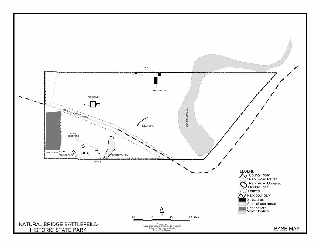
EARTHWORKS
MONUMENT
PICNIC SHELTERS
GRILLS
PICKET LINE
RESIDENCE
SHED
ST. M
AR
KS
RIV
ER
NATURAL BRIDGE ROAD
PUMPHOUSERESTROOM
NATURAL BRIDGE BATTLEFEILDHISTORIC STATE PARK BASE MAP
Prepared by:Florida Department of Environmental Protection
Division of Recreation and ParksOffice of Park Planning
90 0 90 180 FeetN
Parking lotsSpecial use areasStructuresPark boundary
Water bodies
Fences
0 Electric lines
County RoadPark Road PavedPark Road Unpaved
LEGEND

23
Protected Zones A protected zone is an area of high sensitivity or outstanding character from which most types of development are excluded as a protective measure. Generally, facilities requiring extensive land alteration or resulting in intensive resource use, such as parking lots, camping areas, shops or maintenance areas, are not permitted in protected zones. Facilities with minimal resource impacts, such as trails, interpretive signs and boardwalks are generally allowed. All decisions involving the use of protected zones are made on a case-by-case basis after careful site planning and analysis. At Natural Bridge Battlefield Historic State Park, the Confederate earthworks, the monument, and the battlefield area have been designated as protected zones due to their cultural significance. The St. Marks River, the natural bridge, the sinkholes, and the floodplain forest area also designated as protected zones due to their ecological significance and sensitivity as delineated on the Natural Communities Map. Existing Facilities Recreation facilities. The picnic area contains three small picnic shelters, a small restroom building, and unpaved parking for about 25 vehicles. Support facilities. Support facilities include a ranger residence and a small utility shed on the north side of the park, and a pump house located in the picnic area is used to supply water to the restroom and the ranger residence. CONCEPTUAL LAND USE PLAN The following narrative represents the current conceptual land use proposal for this park. As new information is provided regarding the environment of the park, cultural resources, recreational use, and as new land is acquired, the conceptual land use plan may be amended to address the new conditions (see Conceptual Land Use Plan). A detailed development plan for the park and a site plan for specific facilities will be developed based on this conceptual land use plan, as funding becomes available. During the development of the unit management plan, the Division assesses potential impacts of proposed uses on the resources of the property. Uses that could result in unacceptable impacts are not included in the conceptual land use plan. Potential impacts are more thoroughly identified and assessed through the site planning process once funding is available for the development project. At that stage, design elements, such as sewage disposal and stormwater management, and design constraints, such as designated species or cultural site locations, are more thoroughly investigated. Advanced wastewater treatment or best available technology systems are applied for on-site sewage disposal. Stormwater management systems are designed to minimize impervious surfaces to the greatest extent feasible, and all facilities are designed and constructed using best management practices to avoid impacts and to mitigate those that cannot be avoided. Federal, state and local permit and regulatory requirements are met by the final design of the projects. This includes the design of all new park facilities consistent with the universal access requirements of the Americans with Disabilities Act (ADA). After new facilities are constructed, the park staff monitors conditions to ensure that impacts remain within acceptable levels.
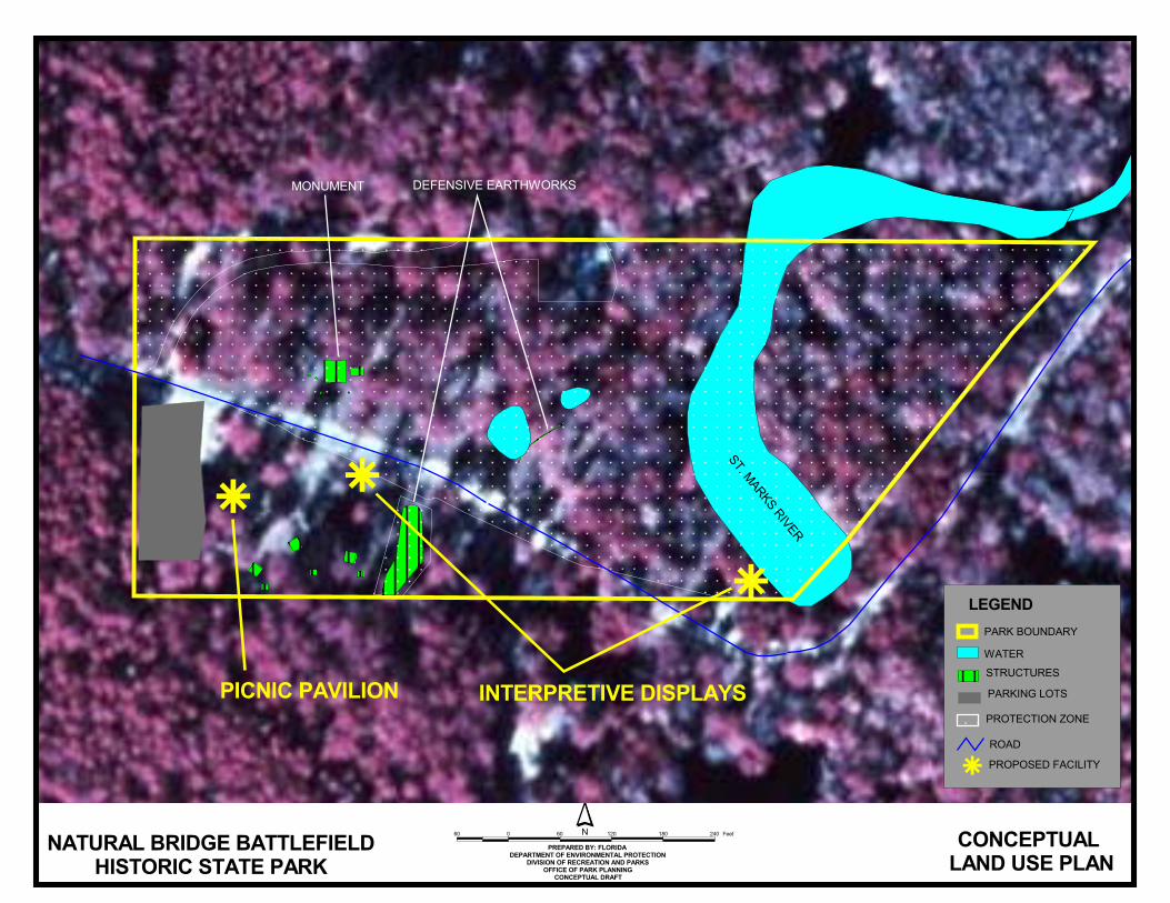
Potential Uses and Proposed Facilities At Natural Bridge State Historic Site, the primary emphasis is placed on protection and maintenance of the cultural resources, while allowing the public an opportunity to experience these historic features. The current low-impact public use of the site is appropriate and should continue. In addition, the following park development is recommended.
����������������������� ������������������
�����������������������
��������������������������������������������������������
����������������������������������������������������
���������������
�
�
��
�����������������������������������
�������������
��� ���� ������������������
������� �����
�������������� �� ���
����
��������������
�����
� �������������������
�� � �� ��� ��� ��� ���
25
Recreation Facilities Large picnic shelter. One large picnic shelter is recommended in the existing picnic area. The proposed picnic shelter will help meet the current demand for this popular activity and provide opportunities for group picnicking and support special events. Interpretive improvements. A thorough explanation of the river and natural bridge feature and their significance to this historic site are needed. An interpretive kiosk is recommended at the sink of the St. Marks River. Another interpretive display is recommended to describe the battle, its purpose and significance. It should also include a map of the historic battlefield. This new display will be located in the picnic area so it does not interfere with the annual Civil War battle reenactment. Discuss future of the “boat ramp” with Leon County. With no public boat ramp available on the St. Marks River north of the sink, local residents have been launching their boats from a small cleared area in the northeast corner of the park off Natural Bridge Road. It is recommended that park personnel discuss the future of this “boat ramp” with Leon County and the lessor to decide if this point of access should be denied, maintained, or improved. Promote/Market Tallahassee Heritage Tour. There is an opportunity to capitalize on the close proximity of numerous prehistoric and historic sites under state management. Letchworth Mounds, Lake Jackson Mounds, DeSoto Site, San Marcos de Apalachee, Tallahassee-St. Marks Historic Railroad Trail, Natural Bridge Battlefield, Maclay Gardens, and Edward Ball Wakulla Springs State Parks as well as Mission San Luis de Apalachee collectively convey the long history of inhabitation of the Tallahassee area. Promoting these sites as stops along a Heritage Tour should increase visitation while providing a more thorough and accurate depiction of the history of the area. Publication of a brochure to be made available at each site is recommended to market the Heritage Tour. In preparation of this effort, each site should revisit their interpretation program to ensure they are adequately telling their portion of the story of Tallahassee’s heritage. Support Facilities Pave the parking lot. When the county paves Natural Bridge Road, it is recommended that the small parking area be paved as well.
Facilities Development Preliminary cost estimates for the following list of proposed facilities are provided in Addendum 6. These cost estimates are based on the most cost-effective construction standards available at this time. The preliminary estimates are provided to assist the Division in budgeting future park improvements, and may be revised as more information is collected through the planning and design processes. Recreation Facilities Interpretive Display/Kiosk (2) Large Picnic Shelter Support Facilities Paved Parking Lot
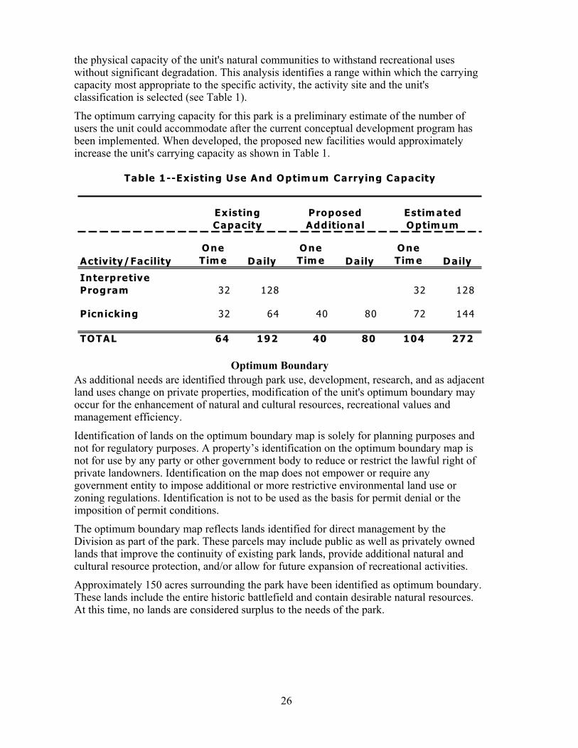
Existing Use and Optimum Carrying Capacity Carrying capacity is an estimate of the number of users a recreation resource or facility can accommodate and still provide a high quality recreational experience and preserve the natural values of the site. The carrying capacity of a unit is determined by identifying the land and water requirements for each recreation activity at the unit, and then applying these requirements to the unit's land and water base. Next, guidelines are applied which estimate
26
the physical capacity of the unit's natural communities to withstand recreational uses without significant degradation. This analysis identifies a range within which the carrying capacity most appropriate to the specific activity, the activity site and the unit's classification is selected (see Table 1). The optimum carrying capacity for this park is a preliminary estimate of the number of users the unit could accommodate after the current conceptual development program has been implemented. When developed, the proposed new facilities would approximately increase the unit's carrying capacity as shown in Table 1.
Activity/FacilityOne Tim e Daily
One Tim e Daily
One Tim e Daily
Interpretive Program 32 128 32 128
Picnicking 32 64 40 80 72 144
TOTAL 64 192 40 80 104 272
Table 1--Existing Use And Optim um Carrying Capacity
Proposed Additional
Existing Capacity
Estim ated Optim um
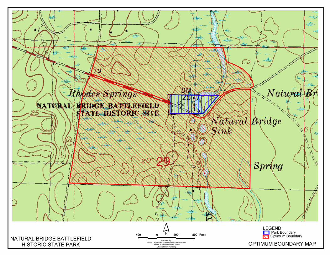
Optimum Boundary As additional needs are identified through park use, development, research, and as adjacent land uses change on private properties, modification of the unit's optimum boundary may occur for the enhancement of natural and cultural resources, recreational values and management efficiency. Identification of lands on the optimum boundary map is solely for planning purposes and not for regulatory purposes. A property’s identification on the optimum boundary map is not for use by any party or other government body to reduce or restrict the lawful right of private landowners. Identification on the map does not empower or require any government entity to impose additional or more restrictive environmental land use or zoning regulations. Identification is not to be used as the basis for permit denial or the imposition of permit conditions. The optimum boundary map reflects lands identified for direct management by the Division as part of the park. These parcels may include public as well as privately owned lands that improve the continuity of existing park lands, provide additional natural and cultural resource protection, and/or allow for future expansion of recreational activities. Approximately 150 acres surrounding the park have been identified as optimum boundary. These lands include the entire historic battlefield and contain desirable natural resources. At this time, no lands are considered surplus to the needs of the park.
��� � ��� ��� ��������������
�� ���������������� ������� ���������� ����� ������� �� ���������� �����������
������� ���������������
������ ���!�"������ ��!� �#!$���!%�$��������& ���!'�'��������(�'��
� �"���
�����)��� )���������� )����

Addendum 1—Acquisition History
Natural Bridge Battlefield Historic State Park Acquisition History
A 1 - 1
Sequence of Acquisition On March 8, 1950, the Division of Recreation and Parks (Division), obtained title to a 6-acre property that became Natural Bridge Battlefield Historic State Park. The property was acquired by a donation from the United Daughters of the Confederacy. On February 4, 1970, the Division acquired a new property from St. Joe Paper Company by a letter of authorization. According to this letter, the Division would pay the company five dollars ($5) per year and manage the property until the company decided to cancel the authorization. The two acquisitions constitute the current area of Natural Bridge Battlefield Historic State Park, which is 9.01 acres. On September 28, 1967, the Division transferred its title interest in Natural Bridge Battlefield Historic State Park to the Board of Trustees of the Internal Improvement Trust Fund (Trustees), On January 23, 1968, the state leased the park to the Division under Lease No. 2324 for a period of ninety-nine (99) years. In 1988, the Trustees assigned a new lease number, Lease No.3635, to Natural Bridge Battlefield Historic State Park without making any changes to the terms and conditions of Lease No. 2324. The new lease will expire on January 22, 2067. Title Interest The Trustees hold fee simple title to Natural Bridge Battlefield Historic State Park. Special Conditions on Use Natural Bridge Battlefield Historic State Park is designated single-use to provide resource-based public outdoor recreation and other related uses. Uses such as water resource development projects, water supply projects, storm-water management projects, and linear facilities and sustainable agriculture and forestry (other than those forest management activities specifically identified in the park’s unit management plan) are not consistent with this plan or the management purposes of the park. Outstanding Reservations There are no outstanding rights, reservations, and encumbrances that apply to Natural Bridge Battlefield Historic State Park.

Addendum 2—References Cited
Natural Bridge Battlefield Historic State Park References Cited
A 2 - 1
Bureau of Economic and Business Research (BEBR), University of Florida. 2001. Florida Statistical Abstract 2001. Gainesville, Florida.
Florida Department of Environmental Protection. 2002. Florida State Park System Economic
Impact Assessment for Fiscal Year 2001/2002. Tallahassee, Florida. Florida Natural Areas Inventory and the Florida Department of Natural Resources, 1990. Guide to
the natural communities of Florida. Tallahassee, FL. 111 pp. Leon County. 2002. Leon County Comprehensive Plan 2002. Leon County, Florida. Tebeau Charlton, W. A History of Florida, University of Miami Press, Coral Gables, Florida. 1971 U. S. Department of Commerce, Bureau of the Census. 2000. U. S. Census 2000.

Addendum 3—Soils Descriptions
Natural Bridge Battlefield Historic State Park Soil Descriptions
A 3 - 1
7 - Chaires fine sand - This nearly level, poorly drained soil is on broad flatwoods. Slopes are 0 to 2 percent. Typically, the surface layer is dark brown fine sand about 7 inches thick. The subsurface layer is fine sand to a depth of 28 inches - the upper 10 inches is dark grayish brown, and the lower 11 inches is light gray. The upper part of the subsoil, to about 54 inches, is very dark brown, dark reddish brown, and dark yellowish brown fine sand. The lower park of the subsoil is gray and light greenish gray sandy clay loam that extends to a depth of 80 inches or more. Included with this soil in mapping are small areas of Talquin, Leon, Pelham, Sapelo, Plummer, and Lutterloh soils. These inclusions make up less than 20 percent of the map unit. This Chaires soil has a water table at a depth of 10 inches for 1 to 3 months during high rainfall and within 20 to 40 inches for 6 months or more in most years. Permeability is rapid in the surface and subsurface layers, moderate in the upper part of the subsoil, and moderately slow to slow in the lower part. Natural fertility is low. Available water capacity is very low in the surface and subsurface layers and medium in the subsoil. The native trees include scattered bluejack, blackjack, laurel oak, water oak, longleaf pine, and sweetgum; in the understory are saw palmetto, dwarf blueberry, greenbrier, fetterbush, gallberry, bromegrass, and pineland threeawn. This soil has very severe limitations for cultivated crops. Because of wetness and sandy texture, good water control and soil-improving crops are necessary. A water control system that removes excess water after heavy rainfall and serves to supply subsurface irrigation during dry seasons is needed. This soil is well suited for pasture and hay crops; however, a good water control system is needed to remove excess water. regular applications of fertilizer and lime are needed. Controlled grazing helps maintain vigorous plant growth. This soil has a moderately high potential for pine trees. Slash pines are the best suited trees to plant for commercial woodland production. Equipment use limitations, seedling mortality, and plant competition are management concerns. Planting the trees on beds lowers the effective depth of the water table. This Chaires soil is in the capability subclass IVw. 38 - Pamlico-Dorovan complex - This map unit consists of nearly level, very poorly drained Dorovan and Pamlico soils that are so intermixed that separating them was not practical at the scale selected for mapping. These soils are irregularly shaped areas of 20 to 200 acres in the flatwoods, along some flood plains, and along the edges of gently sloping to sloping soils on uplands. Individual areas of each soil in this unit range from about 1/8 to 3 acres in size. Pamlico mucky peat makes up about 40 to 50 percent of each mapped area. Typically, the soil has a black mucky peat surface layer about 4 inches thick. The next layer to about 28 inches is very dark brown muck. The substratum is very dark gray and dark gray sand that extends to a depth of 80 inches or more. The Pamlico soil has a water table above the surface for 5 to 8 months in most years and 10 inches below the surface most of the remaining time. Organic matter content is very high. Permeability is
Natural Bridge Battlefield Historic State Park Soil Descriptions
A 3 - 2
moderate in the organic layers and rapid in the sandy substratum. Available water capacity is very high in the organic layers and very low in the substratum. The Dorovan mucky peat makes up about 30 to 40 percent of each mapped area. Typically, the surface layer is black mucky peat about 5 inches thick. The next layer to about 16 inches is black muck and then is very dark brown muck to a depth of 65 inches. The upper part of the substratum is very dark gray sandy loam about 4 inches thick; then black sand extends to a depth of 80 inches or more. The Dorovan soil has a water table above the surface 5 to 8 months in most years and 10 inches below the surface most of the remaining time. Permeability is moderate in the organic layers and rapid in the substratum. Available water capacity is very high. Organic matter content is very high. Minor soils make up about 5 to 20 percent of the unit. Most of these soils have similar drainage but some are sandy and have a thin organic surface layer less than 16 inches thick. Native trees include mostly water-tolerant hardwoods such as water oak, sweetbay, blackgum, sweetgum, red maple, black willow, common alder, and cypress. At the perimeter of areas, the trees are pond pine, shortleaf pine, and slash pine. Almost all areas are still in native trees. They provide a wildlife habitat. The Pamlico and Dorovan soils have very severe limitations for cultivated crops. Generally, these soils are not suitable for cultivation, but with adequate water control, they are suitable for some row crops and most vegetable crops. A well designed and maintained water control system is needed. The water control system should remove excess water when row crops are on the soils and keep the soils saturated with water at all other times. Fertilizers that contain phosphates, potash, and minor elements are needed. Water-tolerant cover crops should be on the soils when row crops are not being grown. Crop residue and cover crops should be used to protect the soil from erosion. Most adapted improved grasses and clovers grow well on these soils when water is properly controlled. Water control should maintain the water table near the surface to prevent excessive oxidation of the organic horizons. Fertilizers high in potash, phosphorus, and minor elements are needed. Controlled grazing helps maintain vigorous plants. The potential of these soils is low for use as woodland. Seedling mortality and equipment limitations are management concerns. The best suited trees to plant for commercial woodland production are baldcypress on the Dorovan soils and slash and loblolly pine on the Pamlico soils. The Pamlico and Dorovan soil are in capability subclass IVw.

Addendum 4—Plant And Animal List

Natural Bridge Battlefield Historic State Park Plants
Primary Habitat Codes Common Name Scientific Name (for designated species)
*Non-native Species A 4 - 1
Resurrection fern Polypodium polypodioides Southern red cedar; Eastern red ceder Juniperus silicicola Longleaf pine Pinus palustris Loblolly pine Pinus taeda American baldcypress Taxodium distichum Broomsedge Andropogon virginicus Cane Arundinaria gigantea Soft rush; Lamp rush Juncus effusus Duckweed Lemna sp. Cabbage palm Sabal palmetto Saw palmetto Serenoa repens Blue-eyed grass Sisyrinchium nashii Greenbrier; Catbrier Smilax sp. St. Augustine grass Stenotaphrum secundatum Red Maple Acer rubrum Common ragweed Ambrosia artemisiifolia Pawpaw Asimina parviflora Beauty berry Callicarpa americana Trumpet vine Campsis radicans Deer's tongue Carphephorus odoratissimus Blue beech Carpinus caroliniana Pignut hickory Carya glabra Sugarberry Celtis laevigata Buttonbush Cephalanthus occidentalis Redbud Cercis canadensis Fringe-tree Chionanthus virginicus Flowering dogwood Cornus florida Stinging nettle Cnidoscolus stimulosus Rabbit-bells Crotalaria rotundifolia Beggar's lice Desmodium rotundifolium Persimmon Diospyros virginiana Euphorbia Euphorbia inundata American beech Fagus grandifolia Cottonweed Froelichia floridana Southern garua Garua angustifolia Rabbit-tobacco Gnaphalium obtusifolium Loblolly bay Gordonia lasianthus American holly Ilex opaca Yaupon Ilex vomitoria Florida anise-tree Illicium floridanum 81 Virginia willow Itea virginica Sweetgum Liquidambar styraciflua Southern magnolia, bullbay Magnolia grandiflora Partridge berry Mitchella repens Wax myrtle; Southern bayberry Myrica cerifera Black gum Nyssa biflora Black tupelo Nyssa sylvatica Sorrel Oxalis dillenii Virginia creeper Parthenocissus quinquefolia Mistletoe Phoradendron serotinum
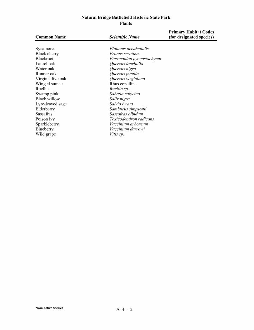
Natural Bridge Battlefield Historic State Park Plants
Primary Habitat Codes Common Name Scientific Name (for designated species)
*Non-native Species A 4 - 2
Sycamore Platanus occidentalis Black cherry Prunus serotina Blackroot Pterocaulon pycnostachyum Laurel oak Quercus laurifolia Water oak Quercus nigra Runner oak Quercus pumila Virginia live oak Quercus virginiana Winged sumac Rhus copallina Ruellia Ruellia sp. Swamp pink Sabatia calycina Black willow Salix nigra Lyre-leaved sage Salvia lyrata Elderberry Sambucus simpsonii Sassafras Sassafras albidum Poison ivy Toxicodendron radicans Sparkleberry Vaccinium arboreum Blueberry Vaccinium darrowi Wild grape Vitis sp.
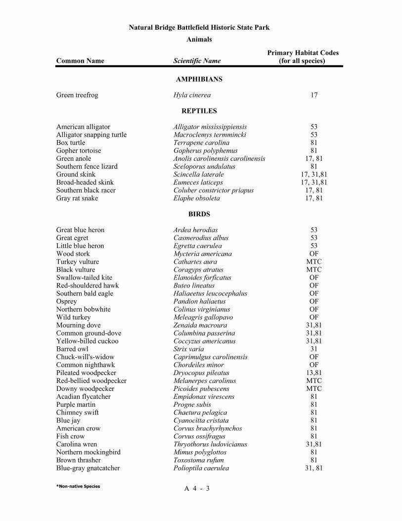
Natural Bridge Battlefield Historic State Park
Animals Primary Habitat Codes Common Name Scientific Name (for all species)
*Non-native Species A 4 - 3
AMPHIBIANS Green treefrog Hyla cinerea 17
REPTILES
American alligator Alligator mississippiensis 53 Alligator snapping turtle Macroclemys termmincki 53 Box turtle Terrapene carolina 81 Gopher tortoise Gopherus polyphemus 81 Green anole Anolis carolinensis carolinensis 17, 81 Southern fence lizard Sceloporus undulatus 81 Ground skink Scincella laterale 17, 31,81 Broad-headed skink Eumeces laticeps 17, 31,81 Southern black racer Coluber constrictor priapus 17, 81 Gray rat snake Elaphe obsoleta 17, 81
BIRDS Great blue heron Ardea herodias 53 Great egret Casmerodius albus 53 Little blue heron Egretta caerulea 53 Wood stork Mycteria americana OF Turkey vulture Cathartes aura MTC Black vulture Coragyps atratus MTC Swallow-tailed kite Elanoides forficatus OF Red-shouldered hawk Buteo lineatus OF Southern bald eagle Haliaeetus leucocephalus OF Osprey Pandion haliaetus OF Northern bobwhite Colinus virginianus OF Wild turkey Meleagris gallopavo OF Mourning dove Zenaida macroura 31,81 Common ground-dove Columbina passerina 31,81 Yellow-billed cuckoo Coccyzus americanus 31,81 Barred owl Strix varia 31 Chuck-will's-widow Caprimulgus carolinensis OF Common nighthawk Chordeiles minor OF Pileated woodpecker Dryocopus pileatus 13,81 Red-bellied woodpecker Melanerpes carolinus MTC Downy woodpecker Picoides pubescens MTC Acadian flycatcher Empidonax virescens 81 Purple martin Progne subis 81 Chimney swift Chaetura pelagica 81 Blue jay Cyanocitta cristata 81 American crow Corvus brachyrhynchos 81 Fish crow Corvus ossifragus 81 Carolina wren Thryothorus ludovicianus 31,81 Northern mockingbird Mimus polyglottos 81 Brown thrasher Toxostoma rufum 81 Blue-gray gnatcatcher Polioptila caerulea 31, 81

Natural Bridge Battlefield Historic State Park
Animals Primary Habitat Codes Common Name Scientific Name (for all species)
*Non-native Species A 4 - 4
American robin Turdus migratorius 31, 81 European starling Sturnus vulgaris* 81 White-eyed vireo Vireo griseus 31 Red-eyed vereo Vereo olivaceus 31 Northern parula Parula americana 31, 81 Pine warbler Dendroica pinus 31, 81 Prothonotary warbler Prothonotaria citrea 31, 81 Red-winged blackbird Agelaius phoeniceus 81 Summer tanager Piranga rubra 31 Northern cardinal Cardinalis cardinalis 31, 81 Rufous-sided towhee Pipilo erythrophthalmus 81 Tufted titmouse Parus bicolor 31, 81
MAMMALS Virginia oppossum Didelphis virginiana 31, 81 Nine-banded armadillo Dasypus novemcinctus * 81 Gray squirrel Sciurus carolinensis 31, 81 Raccoon Procyon lotor MTC River otter Lutra canadensis 53

Addendum 5—Designated Species List
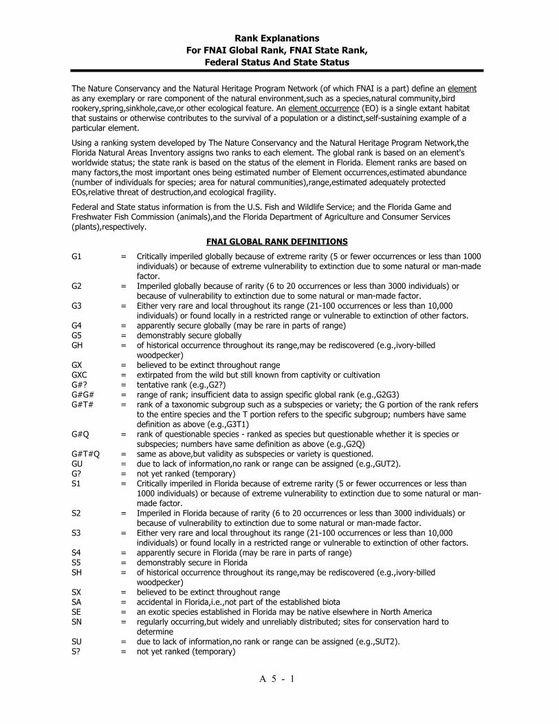
Rank Explanations For FNAI Global Rank, FNAI State Rank,
Federal Status And State Status
A 5 - 1
The Nature Conservancy and the Natural Heritage Program Network (of which FNAI is a part) define an element as any exemplary or rare component of the natural environment,such as a species,natural community,bird rookery,spring,sinkhole,cave,or other ecological feature. An element occurrence (EO) is a single extant habitat that sustains or otherwise contributes to the survival of a population or a distinct,self-sustaining example of a particular element. Using a ranking system developed by The Nature Conservancy and the Natural Heritage Program Network,the Florida Natural Areas Inventory assigns two ranks to each element. The global rank is based on an element's worldwide status; the state rank is based on the status of the element in Florida. Element ranks are based on many factors,the most important ones being estimated number of Element occurrences,estimated abundance (number of individuals for species; area for natural communities),range,estimated adequately protected EOs,relative threat of destruction,and ecological fragility. Federal and State status information is from the U.S. Fish and Wildlife Service; and the Florida Game and Freshwater Fish Commission (animals),and the Florida Department of Agriculture and Consumer Services (plants),respectively.
FNAI GLOBAL RANK DEFINITIONS G1 = Critically imperiled globally because of extreme rarity (5 or fewer occurrences or less than 1000
individuals) or because of extreme vulnerability to extinction due to some natural or man-made factor.
G2 = Imperiled globally because of rarity (6 to 20 occurrences or less than 3000 individuals) or because of vulnerability to extinction due to some natural or man-made factor.
G3 = Either very rare and local throughout its range (21-100 occurrences or less than 10,000 individuals) or found locally in a restricted range or vulnerable to extinction of other factors.
G4 = apparently secure globally (may be rare in parts of range) G5 = demonstrably secure globally GH = of historical occurrence throughout its range,may be rediscovered (e.g.,ivory-billed
woodpecker) GX = believed to be extinct throughout range GXC = extirpated from the wild but still known from captivity or cultivation G#? = tentative rank (e.g.,G2?) G#G# = range of rank; insufficient data to assign specific global rank (e.g.,G2G3) G#T# = rank of a taxonomic subgroup such as a subspecies or variety; the G portion of the rank refers
to the entire species and the T portion refers to the specific subgroup; numbers have same definition as above (e.g.,G3T1)
G#Q = rank of questionable species - ranked as species but questionable whether it is species or subspecies; numbers have same definition as above (e.g.,G2Q)
G#T#Q = same as above,but validity as subspecies or variety is questioned. GU = due to lack of information,no rank or range can be assigned (e.g.,GUT2). G? = not yet ranked (temporary) S1 = Critically imperiled in Florida because of extreme rarity (5 or fewer occurrences or less than
1000 individuals) or because of extreme vulnerability to extinction due to some natural or man-made factor.
S2 = Imperiled in Florida because of rarity (6 to 20 occurrences or less than 3000 individuals) or because of vulnerability to extinction due to some natural or man-made factor.
S3 = Either very rare and local throughout its range (21-100 occurrences or less than 10,000 individuals) or found locally in a restricted range or vulnerable to extinction of other factors.
S4 = apparently secure in Florida (may be rare in parts of range) S5 = demonstrably secure in Florida SH = of historical occurrence throughout its range,may be rediscovered (e.g.,ivory-billed
woodpecker) SX = believed to be extinct throughout range SA = accidental in Florida,i.e.,not part of the established biota SE = an exotic species established in Florida may be native elsewhere in North America SN = regularly occurring,but widely and unreliably distributed; sites for conservation hard to
determine SU = due to lack of information,no rank or range can be assigned (e.g.,SUT2). S? = not yet ranked (temporary)
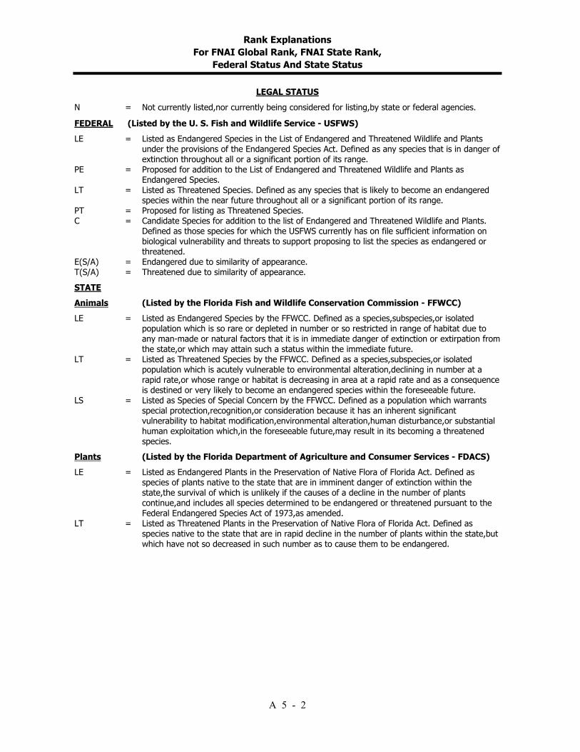
Rank Explanations For FNAI Global Rank, FNAI State Rank,
Federal Status And State Status
A 5 - 2
LEGAL STATUS N = Not currently listed,nor currently being considered for listing,by state or federal agencies. FEDERAL (Listed by the U. S. Fish and Wildlife Service - USFWS) LE = Listed as Endangered Species in the List of Endangered and Threatened Wildlife and Plants
under the provisions of the Endangered Species Act. Defined as any species that is in danger of extinction throughout all or a significant portion of its range.
PE = Proposed for addition to the List of Endangered and Threatened Wildlife and Plants as Endangered Species.
LT = Listed as Threatened Species. Defined as any species that is likely to become an endangered species within the near future throughout all or a significant portion of its range.
PT = Proposed for listing as Threatened Species. C = Candidate Species for addition to the list of Endangered and Threatened Wildlife and Plants.
Defined as those species for which the USFWS currently has on file sufficient information on biological vulnerability and threats to support proposing to list the species as endangered or threatened.
E(S/A) = Endangered due to similarity of appearance. T(S/A) = Threatened due to similarity of appearance. STATE Animals (Listed by the Florida Fish and Wildlife Conservation Commission - FFWCC) LE = Listed as Endangered Species by the FFWCC. Defined as a species,subspecies,or isolated
population which is so rare or depleted in number or so restricted in range of habitat due to any man-made or natural factors that it is in immediate danger of extinction or extirpation from the state,or which may attain such a status within the immediate future.
LT = Listed as Threatened Species by the FFWCC. Defined as a species,subspecies,or isolated population which is acutely vulnerable to environmental alteration,declining in number at a rapid rate,or whose range or habitat is decreasing in area at a rapid rate and as a consequence is destined or very likely to become an endangered species within the foreseeable future.
LS = Listed as Species of Special Concern by the FFWCC. Defined as a population which warrants special protection,recognition,or consideration because it has an inherent significant vulnerability to habitat modification,environmental alteration,human disturbance,or substantial human exploitation which,in the foreseeable future,may result in its becoming a threatened species.
Plants (Listed by the Florida Department of Agriculture and Consumer Services - FDACS) LE = Listed as Endangered Plants in the Preservation of Native Flora of Florida Act. Defined as
species of plants native to the state that are in imminent danger of extinction within the state,the survival of which is unlikely if the causes of a decline in the number of plants continue,and includes all species determined to be endangered or threatened pursuant to the Federal Endangered Species Act of 1973,as amended.
LT = Listed as Threatened Plants in the Preservation of Native Flora of Florida Act. Defined as species native to the state that are in rapid decline in the number of plants within the state,but which have not so decreased in such number as to cause them to be endangered.
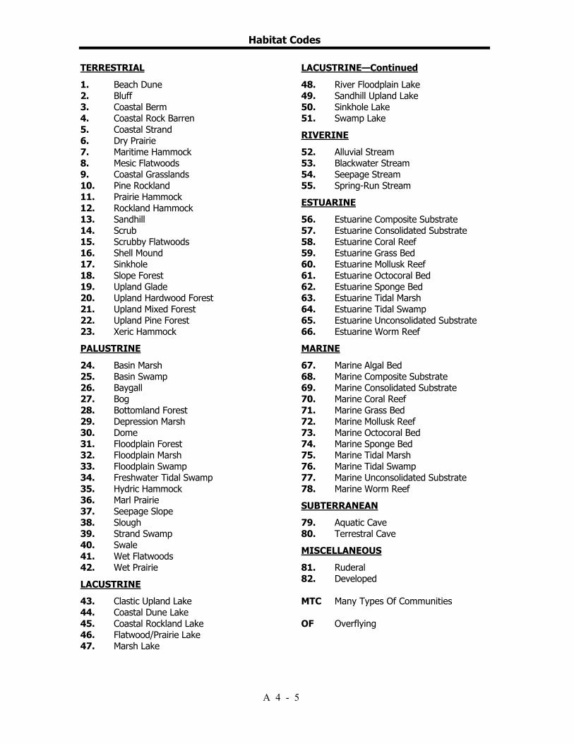
Habitat Codes
A 4 - 5
TERRESTRIAL 1. Beach Dune 2. Bluff 3. Coastal Berm 4. Coastal Rock Barren 5. Coastal Strand 6. Dry Prairie 7. Maritime Hammock 8. Mesic Flatwoods 9. Coastal Grasslands 10. Pine Rockland 11. Prairie Hammock 12. Rockland Hammock 13. Sandhill 14. Scrub 15. Scrubby Flatwoods 16. Shell Mound 17. Sinkhole 18. Slope Forest 19. Upland Glade 20. Upland Hardwood Forest 21. Upland Mixed Forest 22. Upland Pine Forest 23. Xeric Hammock PALUSTRINE 24. Basin Marsh 25. Basin Swamp 26. Baygall 27. Bog 28. Bottomland Forest 29. Depression Marsh 30. Dome 31. Floodplain Forest 32. Floodplain Marsh 33. Floodplain Swamp 34. Freshwater Tidal Swamp 35. Hydric Hammock 36. Marl Prairie 37. Seepage Slope 38. Slough 39. Strand Swamp 40. Swale 41. Wet Flatwoods 42. Wet Prairie LACUSTRINE 43. Clastic Upland Lake 44. Coastal Dune Lake 45. Coastal Rockland Lake 46. Flatwood/Prairie Lake 47. Marsh Lake
LACUSTRINE—Continued 48. River Floodplain Lake 49. Sandhill Upland Lake 50. Sinkhole Lake 51. Swamp Lake RIVERINE 52. Alluvial Stream 53. Blackwater Stream 54. Seepage Stream 55. Spring-Run Stream ESTUARINE 56. Estuarine Composite Substrate 57. Estuarine Consolidated Substrate 58. Estuarine Coral Reef 59. Estuarine Grass Bed 60. Estuarine Mollusk Reef 61. Estuarine Octocoral Bed 62. Estuarine Sponge Bed 63. Estuarine Tidal Marsh 64. Estuarine Tidal Swamp 65. Estuarine Unconsolidated Substrate 66. Estuarine Worm Reef MARINE 67. Marine Algal Bed 68. Marine Composite Substrate 69. Marine Consolidated Substrate 70. Marine Coral Reef 71. Marine Grass Bed 72. Marine Mollusk Reef 73. Marine Octocoral Bed 74. Marine Sponge Bed 75. Marine Tidal Marsh 76. Marine Tidal Swamp 77. Marine Unconsolidated Substrate 78. Marine Worm Reef SUBTERRANEAN 79. Aquatic Cave 80. Terrestral Cave MISCELLANEOUS 81. Ruderal 82. Developed MTC Many Types Of Communities OF Overflying

Natural Bridge Battlefield Historic State Park Designated Species
Animals Common Name/ Designated Species Status Scientific Name FFWCC USFWS FNAI
A 5 - 3
REPTILES American alligator Alligator mississippiensis LS T(S/A) G5, S4 Gopher tortoise Gopherus polyphemus LS G3, S3 Alligator snapping turtle Macroclemys temminckii LS G3G4, S3
BIRDS Little Blue Heron Egretta caerulea LS G5, S4 Bald Eagle Haliaeetus leucocephalus LT LT G4, S3 Wood Stork Mycteria americana LE LE G4, S2
Addendum 6—Priority Schedule And Cost Estimates
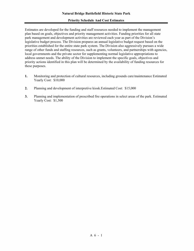
Natural Bridge Battlefield Historic State Park
Priority Schedule And Cost Estimates
A 6 - 1
Estimates are developed for the funding and staff resources needed to implement the management plan based on goals, objectives and priority management activities. Funding priorities for all state park management and development activities are reviewed each year as part of the Division’s legislative budget process. The Division prepares an annual legislative budget request based on the priorities established for the entire state park system. The Division also aggressively pursues a wide range of other funds and staffing resources, such as grants, volunteers, and partnerships with agencies, local governments and the private sector for supplementing normal legislative appropriations to address unmet needs. The ability of the Division to implement the specific goals, objectives and priority actions identified in this plan will be determined by the availability of funding resources for these purposes. 1. Monitoring and protection of cultural resources, including grounds care/maintenance Estimated
Yearly Cost: $10,000 2. Planning and development of interpretive kiosk.Estimated Cost: $15,000 3. Planning and implementation of prescribed fire operations in select areas of the park. Estimated
Yearly Cost: $1,500
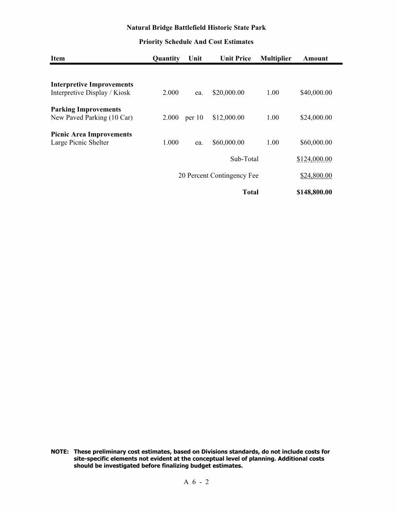
Natural Bridge Battlefield Historic State Park
Priority Schedule And Cost Estimates
Item Quantity Unit Unit Price Multiplier Amount
NOTE: These preliminary cost estimates, based on Divisions standards, do not include costs for site-specific elements not evident at the conceptual level of planning. Additional costs should be investigated before finalizing budget estimates.
A 6 - 2
Interpretive Improvements Interpretive Display / Kiosk 2.000 ea. $20,000.00 1.00 $40,000.00 Parking Improvements New Paved Parking (10 Car) 2.000 per 10 $12,000.00 1.00 $24,000.00 Picnic Area Improvements Large Picnic Shelter 1.000 ea. $60,000.00 1.00 $60,000.00 Sub-Total $124,000.00 20 Percent Contingency Fee $24,800.00 Total $148,800.00