natural heritage & environmental management strategy€¦ · natural heritage system is a key...
TRANSCRIPT


C i t y o f B r a m p t o n N a t u r a l H e r i t a g e a n d E n v i r o n m e n t a l M a n a g e m e n t S t r a t e g y ( N H E M S ) I m p l e m e n t a t i o n A c t i o n P l a n ( D e c e m b e r 2 0 1 5 )
Natural Heritage and Environmental Management Strategy Contents and Organization
The Natural Heritage and Environmental Management Strategy (NHEMS) for the City of Brampton is a compendium of
three documents: Conservation Authority Natural Heritage System, a Background Report and an Implementation Action
Plan.
The Conservation Authority Natural Heritage System Mapping for the City of Brampton – Final Technical Report – 2014
(CA NHS) was prepared under separate cover. The CA NHS was developed using the city’s natural heritage features and
areas (as per Schedule D, Official Plan 2006) and local natural heritage system planning (as per approved secondary and
block plans), with recommended expansions based on current science in landscape ecology and monitoring data. The CA
NHS was prepared with the objective to improve the health, resilience and connectedness of existing areas and features
to form a robust natural heritage system.
The NHEMS Background Report, available under separate cover, provides an overview of natural heritage system
planning in Brampton, a snapshot of the current state of the environment, including Brampton’s Natural Heritage
System (NHS), open space system, green infrastructure and urban forest, and an overview of the NHEMS framework. The
Background Report also contains a series of appendices that include a summary of the policy gaps in the Brampton
Official Plan 2006, a summary of the stakeholder consultation that helped shape the strategy, a presentation of best
practices relating to infrastructure, open space and urban forests, as well as a series of maps that illustrate watershed
NHS components and subwatershed studies in support of the NHEMS.
This Implementation Action Plan identifies the goals, objectives and actions to realize the mission of the NHEMS. It is
organized under the following sections:
Executive Summary contains highlights of the Background Report and Implementation Action Plan.
Section 1 contains a brief introduction linking the Background Report to the Implementation Action Plan.
Section 2 defines the NHEMS framework including the NHEMS mission, guiding principles, and targets to guide decision-
making and measuring the impact of the NHEMS.
Section 3 defines four strategic goals and 19 objectives. Each objective includes an outcome-based statement, an
assessment of current conditions related to the NHEMS, and best practices related to the objective.
Section 4 identifies 116 actions, and timelines for implementation under specific goals and objectives.
Section 5 defines how the City of Brampton will share successes.
Section 6 identifies that the NHEMS is a living document and is intended to evolve.
Section 7 provides a Glossary of Terms that defines the technical terms used throughout the report. Note terms
included in the glossary are italicized for the first use only.

C i t y o f B r a m p t o n N a t u r a l H e r i t a g e E n v i r o n m e n t a l M a n a g e m e n t S t r a t e g y ( N H E M S ) I m p l e m e n t a t i o n A c t i o n P l a n ( D e c e m b e r 2 0 1 5 )
Table of Contents
Executive Summary ..................................................................................................................................................... i
Implementation Action Plan
1. Introduction ................................................................................................................................................... 1
2. NHEMS Framework ........................................................................................................................................ 1
2.1 Mission ........................................................................................................................................................... 4
2.2 Guiding Principles........................................................................................................................................... 4
2.3 NHEMS Targets .............................................................................................................................................. 5
3. NHEMS Strategic Goals ................................................................................................................................ 12
3.1 Planning and Policy ...................................................................................................................................... 12
3.2 Management ................................................................................................................................................ 21
3.3 Collaboration, Engagement, and Partnerships ............................................................................................ 33
3.4 Tracking and Monitoring .............................................................................................................................. 43
4. Implementation Action Plan ........................................................................................................................ 47
5. Sharing Environmental Performance ........................................................................................................... 64
6. How the NHEMS will Evolve ......................................................................................................................... 65
7. Glossary of Terms ......................................................................................................................................... 66
Figures
Figure 1: Framework for Brampton’s Natural Heritage and Environmental Management Strategy
Figure 2: Brampton in the context of regional natural systems (Source: City of Brampton, 2015)
Figure 3: Proposed Credit River Valley Heritage Trail (Source: City of Brampton, 2015)
Figure 4: Hypothetical example aerial map of removed woodland “fingers” (outlined in red) and restoration of non-treed area (outlined in yellow) (Source: North-South Environmental, 2014)
Figure 5: Diagrammatic representation of a natural heritage system illustrating the connection of natural “core” areas with three different types of ecological “corridors” (Source: Bennett and Mulonguoy, 2006)
Figure 6: Example of granular trail cross-section
Figure 7: Habitat core (interior) and edge (Source: How Much Habitat is Enough?, Environment Canada, 2013)
C i t y o f B r a m p t o n N a t u r a l H e r i t a g e E n v i r o n m e n t a l M a n a g e m e n t S t r a t e g y ( N H E M S ) I m p l e m e n t a t i o n A c t i o n P l a n ( D e c e m b e r 2 0 1 5 )
Tables
Table 1: Comparative ecosystem services for value-based target setting (Source: Adapted from Toronto and Region
Conservation Authority, 2015)
Table 2: NHEMS Targets
Table 3: NHEMS Strategic Goals
Photo Credits
All photos in this document were provided courtesy of the City of Brampton and North-South Environmental unless
otherwise noted.
C i t y o f B r a m p t o n N a t u r a l H e r i t a g e a n d E n v i r o n m e n t a l M a n a g e m e n t S t r a t e g y ( N H E M S ) I m p l e m e n t a t i o n A c t i o n P l a n ( D e c e m b e r 2 0 1 5 ) P a g e | i
Brampton by the Numbers
1 of the fastest growing
communities
3rd largest community in the GTA
9th largest city in Canada
89 languages
209 ethnic backgrounds
600,000 population (2013)
899,500 population (expected for
2041)
Executive Summary
Introduction
As Canada’s Flower City, Brampton is known for its quality natural,
open and built spaces; innovative programs; and spirited and proud
community. It is one of the fastest growing communities in Canada,
the third largest community in the Greater Toronto Area and the
ninth-largest city in the country, with a population of more than
600,000 residents. Brampton benefits from a rich, diverse,
multicultural population representing 209 distinct ethnic backgrounds
and speaking 89 different languages. The Provincial Growth Plan for
the Greater Golden Horseshoe suggests that there will also be
significant population and employment growth in Peel Region through
2041. A considerable portion of that growth will occur in Brampton.
Preliminary forecasts call for Brampton to grow to a population of 899,
500 residents by 2041. Rapid urbanization and population growth brings environmental impacts and threats to our
remaining natural areas and ecosystems. Finding a balance between managing growth and resources and protecting the
natural heritage system is a key component of creating complete, healthy and livable communities.
Brampton’s Natural Heritage and Environmental Management Strategy (NHEMS) is a proactive approach to ensure that
the abundance of natural heritage and built green spaces found in the city are conserved, restored, connected and
enhanced to support the health and diversity of the natural and built environments. To do so, this Strategy examines the
city’s natural heritage with a full systems approach that recognizes the challenges and opportunities presented by
conserving natural features, functions and linkages in an urban setting. The NHEMS addresses the implementation,
management and enhancement of the city’s open space, green infrastructure and urban forest that contribute to
sustaining the natural heritage system (NHS) and ecosystem services. As such the Strategy contributes to, and informs
the objectives within the City’s Strategic Plan, Official Plan policies, as well as contributes to achieving the vision of
Brampton Grow Green, the City’s first Environmental Master Plan.
Components of the Natural Heritage and Environmental Management Strategy
The living landscape in Brampton is made up of the natural environment and built environment. These two
environments are distinct, yet interconnected, mutually supporting and overlapping, as illustrated below. The Natural
Heritage System (NHS) is a network of conservation lands and waters that includes the remaining wild spaces
throughout the city. These wild spaces include woodlands, valleys, rivers, streams, meadows and wetlands, where
natural processes occur relatively uninterrupted by adjacent land uses and are linked by natural and restored corridors.
Water, air, aquatic and terrestrial systems are connected and shared with surrounding regional and area municipalities,
and also fall under the jurisdiction of various authorities, including the Toronto and Region Conservation Authority
(TRCA), Credit Valley Conservation (CVC), and provincial and regional agencies.

C i t y o f B r a m p t o n N a t u r a l H e r i t a g e a n d E n v i r o n m e n t a l M a n a g e m e n t S t r a t e g y ( N H E M S ) I m p l e m e n t a t i o n A c t i o n P l a n ( D e c e m b e r 2 0 1 5 ) P a g e | ii
Brampton’s NHS is part of the larger regional-watershed landscape including Lake Ontario, the Greenbelt, Niagara
Escarpment and Oak Ridges Moraine. As such, the NHEMS emphasizes shared responsibilities, collaboration,
partnerships and stewardship where stakeholders can work together to protect natural systems.
Brampton’s living landscape is comprised of functionally interconnected natural (wild)
and built green spaces and built (hard) spaces
The City of Brampton recognizes that its natural heritage system is functionally related to its built open space, green
infrastructure and urban forest, as these areas are interconnected and overlap in providing ecosystem services to the
community. The City further recognizes that the way the built green spaces and hard spaces are designed, constructed
and maintained on public and private lands can have a profound impact on the functionality and biodiversity of
Brampton’s natural environment, as well as the community’s public health and well-being. With this Strategy, the City is
demonstrating its commitment to protecting, restoring and enhancing its natural environment, as well as developing
and managing its built environment, to provide a range of ecosystem services that will result in a more complete,
healthy and liveable community.
Brampton’s open space and parks provide residents and visitors with a range of recreation and outdoor activities in
public and private spaces that vary in their degree of naturalness, from manicured tableland sports fields and City parks
(e.g. Chingaucousy Park), to naturalized recreation open spaces (e.g. Eldorado Park and golf courses that are adjacent to
and within valleylands). Open space and parks provide contributions to the health of the NHS by cycling water, providing
habitat for native plants and animals, supporting ecological linkages between natural areas, buffering the NHS from
adjacent land uses and contributing to the urban forest canopy.
Green infrastructure provides necessary services to Brampton’s built environment and, in the context of the NHEMS,
means the lands associated with stormwater management facilities, hydro transmission lines, gas pipelines and major
transportation corridors. The major infrastructure corridors that traverse the city provide habitat for native plants and
animals, and have the potential to serve as important ecological linkages between the natural valley systems in the city,
to buffer the NHS from adjacent land uses, and to contribute to the urban forest canopy. In addition to linking natural
systems, the corridors connect neighbourhoods and communities through pedestrian and trail networks on a local and
regional scale.

C i t y o f B r a m p t o n N a t u r a l H e r i t a g e a n d E n v i r o n m e n t a l M a n a g e m e n t S t r a t e g y ( N H E M S ) I m p l e m e n t a t i o n A c t i o n P l a n ( D e c e m b e r 2 0 1 5 ) P a g e | iii
Brampton’s urban forest includes natural woodlands and provides numerous services to the city’s natural and built
environments, such as habitat for wildlife, linkages between natural areas, improved air quality, reduced energy use in
homes and businesses, and special places for people to enjoy. This Strategy focuses on the urban forest within the built
environment on public and private lands, including parks, infrastructure corridors and stormwater management ponds,
street boulevards, parking lots, front and backyards, and manicured areas of businesses and institutions.
Process to Develop the NHEMS
Developing the NHEMS has been undertaken in two distinct phases. Phase 1 involved the
development of a science-based Natural Heritage System for the City of Brampton that
was led by CVC and TRCA in consultation with City staff, Region of Peel and Ontario
Ministry of Natural Resources and Forestry (MNRF). The Conservation Authority Natural
Heritage System Mapping for the City of Brampton – Final Technical Report – 2014 (CA
NHS) was prepared under separate cover and is briefly described in Sections 2.2.4 and
3.1.3 of the Background Report. TRCA and CVC refined their watershed-based natural
heritage systems using current science in landscape ecology and current conservation
values. The CA NHS will be used to inform the City’s 2006 Official Plan Review.
Phase 2 of the NHEMS was led by City of Brampton in collaboration with North-South
Environmental and Lura Consulting, and includes the Background Report and this Implementation Action Plan. The
preparation of these documents has involved research and collaboration with conservation partners and key
stakeholders. The mission, goals, objectives and actions were informed through consultation activities held directly as
part of this process, as well as those for the development of Brampton Grow Green and the City’s Strategic Plan.
The process included a review of:
Current plans, policies, initiatives and practices of the City of Brampton and those of partner agencies (i.e.
neighbouring municipalities, the Region of Peel and Conservation Authorities);
The state of Brampton’s NHS, open space, green infrastructure and urban forest today;
Best practices in natural heritage, environmental management, infrastructure, open space, urban forest and
stewardship; and
Recommended actions to strengthen the City’s NHS and green spaces within the built environment.
Consultation with City staff and a wide range of stakeholders was important to developing the NHEMS. During Phase 1
of the project, the Conservation Authority Natural Heritage System for Brampton (CA NHS) was developed by a
Conservation Authority Technical Working Group and an inter-agency Steering Committee with expertise in planning,
natural heritage, geographic information systems (GIS), forestry, parks and engineering. Additional staff consultations
were held with City of Brampton planning, engineering, open space, operational and communications staff throughout
the process.
During Phase 2, an Engagement Plan was developed and implemented that included consultations with key stakeholders
on the development of the Strategy mission, guiding principles, objectives, issues and opportunities. Input on the draft
NHEMS was obtained through a stakeholder workshop to confirm and revise the Strategy’s guiding principles,
C i t y o f B r a m p t o n N a t u r a l H e r i t a g e a n d E n v i r o n m e n t a l M a n a g e m e n t S t r a t e g y ( N H E M S ) I m p l e m e n t a t i o n A c t i o n P l a n ( D e c e m b e r 2 0 1 5 ) P a g e | iv
Brampton in the context of regional natural systems
(Source: City of Brampton, 2015)
objectives, targets and recommendations, and foster environmental stewardship. Participant feedback was incorporated
into the final Strategy and Implementation Action Plan.
Regional Context of Natural Heritage System Planning
Local natural heritage system planning is best undertaken
as a community-based activity that involves senior
government (i.e. Province, regional municipality) and
Conservation Authorities, and includes residents,
landowners and community groups (e.g. naturalist clubs),
all working cooperatively with the municipality. Local
natural heritage system plans need to recognize ecological
ties to other physical features and areas in the regional
landscape, including urban green spaces, in order to
support the overall diversity, health and interconnectivity
of natural areas, features and functions and contribute to
human health and well-being. Several provincial and
watershed-based natural systems and plans (as described
in the Background Report) guide Brampton’s natural
heritage system planning and policies.
Brampton’s Natural Heritage System
The City of Brampton comprises an area of approximately
269 square kilometres and is characterized by the
numerous river and valley corridors of the Credit River,
Etobicoke Creek, Mimico Creek, and the Humber/West
Humber River watersheds that connect the city to some of
Ontario’s most significant landscapes and regional
ecosystems, including the Greenbelt, Niagara Escarpment,
Oak Ridges Moraine and Lake Ontario.
Brampton’s NHS is a network of conservation lands and
waters, linked by natural and restored corridors that
become the natural landscape for future generations. The
success of a community’s natural landscape is measured
by its biological diversity and landscape health, as well as the health of the city’s built environment.

C i t y o f B r a m p t o n N a t u r a l H e r i t a g e a n d E n v i r o n m e n t a l M a n a g e m e n t S t r a t e g y ( N H E M S ) I m p l e m e n t a t i o n A c t i o n P l a n ( D e c e m b e r 2 0 1 5 ) P a g e | v
Current and proposed land uses in Brampton (Source: Compilation of City of Brampton, CVC and TRCA data)
State of the Environment in Brampton
Current Land Cover
Natural Cover Agriculture Manicured Open
Space Urban
17% 21% 7% 55%
Current Natural Heritage Land Ownership
Public Private
57% (2,650 ha) 43% (1,990 ha)
Current Public Natural Heritage Land Ownership
City Conservation Authority
64% (1,690 ha) 43% (960 ha)
Natural Heritage System
Existing NHS Conservation Authority NHS (proposed)
17% 21%
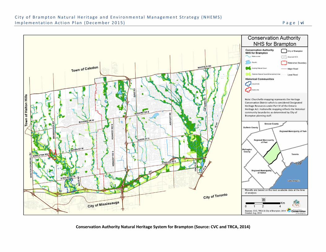
The NHEMS Phase 1 proposed Conservation Authority NHS (CA NHS) for Brampton, as shown in the figure below (and
Figure 13 provided in the Background Report) was developed using the City’s current natural heritage features and areas
(as per Schedule D, Official Plan 2006) and local natural heritage system planning (as per approved secondary and block
plans), with recommended expansions, based on current science in landscape ecology and monitoring data. The CA NHS
was prepared with the objective of improving the health, resilience and connectedness of existing areas and features to
form a robust natural heritage system, and will be used to inform the 2006 Official Plan Review.
Brampton and its conservation partners must work collaboratively to achieve mutual environmental goals to protect the
watershed, regional and local natural heritage systems and conserve ecosystem services through the delivery of agency
mandates and legislative responsibilities, through educating and engaging residents and the public, and organizing
community programs. The NHEMS focuses on what the City of Brampton can do itself to improve its environmental
performance, and recognizes that as the environment transcends political borders, the City must work with all levels of
government, including adjacent municipalities and community partners, to advance the goals of the NHEMS.
C i t y o f B r a m p t o n N a t u r a l H e r i t a g e a n d E n v i r o n m e n t a l M a n a g e m e n t S t r a t e g y ( N H E M S ) I m p l e m e n t a t i o n A c t i o n P l a n ( D e c e m b e r 2 0 1 5 ) P a g e | vi
Conservation Authority Natural Heritage System for Brampton (Source: CVC and TRCA, 2014)
C i t y o f B r a m p t o n N a t u r a l H e r i t a g e a n d E n v i r o n m e n t a l M a n a g e m e n t S t r a t e g y ( N H E M S ) I m p l e m e n t a t i o n A c t i o n P l a n ( D e c e m b e r 2 0 1 5 ) P a g e | vii
Brampton’s Open Space System
Brampton’s Open Space System includes the NHS as discussed above, and Recreational Open Space lands such as Public
Parkland (active and passive tableland areas), Conservation Areas and Private Commercial Recreation Areas as shown on
Schedule E of the Official Plan, 2006 (refer to Figure 16, Background Report). Public and private open space provides
social and economic benefits for Brampton’s urban population and ecological benefits for the NHS. Open space can be
strategically managed for human use as well as its ecological features, functions and linkages.
Open space areas provide a spectrum of ecosystem services that support natural features and functions, and a land base
for natural vegetation communities and the urban forest. There are many ways open space can be enhanced and/or
managed to be more sustainable, including implementation of stormwater management (i.e. LID measures –
swales/infiltration galleries) to store water, increase infiltration and enhance the quality of surface water runoff;
reduced mowing to reduce greenhouse gas (GHG) emissions; and naturalization with trees and shrubs to increase the
urban forest canopy, reduce the urban heat island effect and improve local air quality.
Open Space provides important ecological linkages between natural heritage features, and buffers the NHS from
adjacent land uses. Naturalizing linkage and buffer areas within open space through tree planting and reduced mowing,
and the creation of natural habitats such as meadows, can greatly improve the ecological linkage and buffering functions
provided by these areas.
In addition, the majority of Brampton’s trail network is located within the NHS and recreational open space. In
combination with multi-use and on-road pathways, this trail network links neighbourhoods and connects the City to
adjacent municipalities. Inter-regional trails are being implemented along the Humber/West Humber Rivers, Etobicoke
Creek and Credit River linking Lake Ontario to the Oak Ridges Moraine, Greenbelt and Niagara Escarpment.
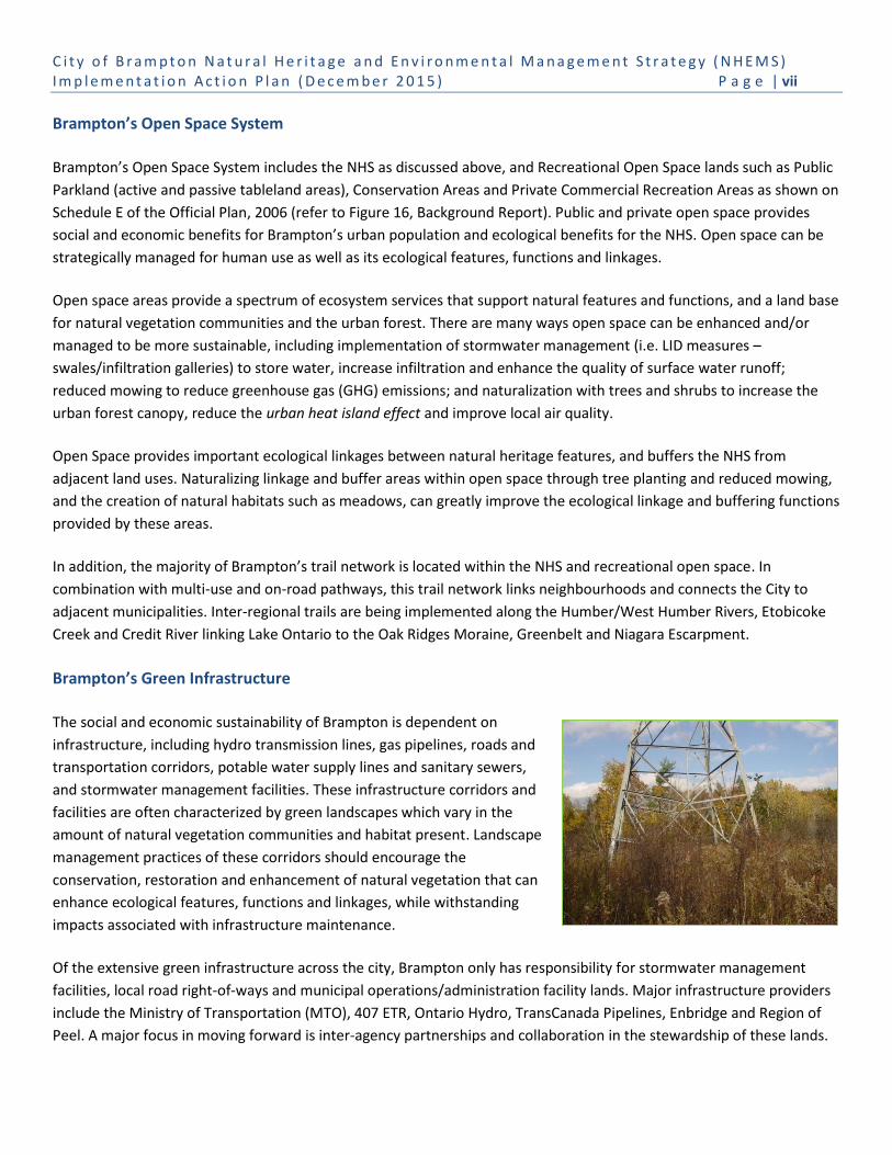
Brampton’s Green Infrastructure
The social and economic sustainability of Brampton is dependent on
infrastructure, including hydro transmission lines, gas pipelines, roads and
transportation corridors, potable water supply lines and sanitary sewers,
and stormwater management facilities. These infrastructure corridors and
facilities are often characterized by green landscapes which vary in the
amount of natural vegetation communities and habitat present. Landscape
management practices of these corridors should encourage the
conservation, restoration and enhancement of natural vegetation that can
enhance ecological features, functions and linkages, while withstanding
impacts associated with infrastructure maintenance.
Of the extensive green infrastructure across the city, Brampton only has responsibility for stormwater management
facilities, local road right-of-ways and municipal operations/administration facility lands. Major infrastructure providers
include the Ministry of Transportation (MTO), 407 ETR, Ontario Hydro, TransCanada Pipelines, Enbridge and Region of
Peel. A major focus in moving forward is inter-agency partnerships and collaboration in the stewardship of these lands.

C i t y o f B r a m p t o n N a t u r a l H e r i t a g e a n d E n v i r o n m e n t a l M a n a g e m e n t S t r a t e g y ( N H E M S ) I m p l e m e n t a t i o n A c t i o n P l a n ( D e c e m b e r 2 0 1 5 ) P a g e | viii
Brampton’s Urban Forest
All of the trees present throughout the City of Brampton on public and private lands constitute its urban forest, including
vegetation within natural woodlands, open space and green infrastructure. The urban forest can also be found in the
most urbanized parts of the city, including street trees in road boulevards and parking lots, and vegetation planted on
institutional lands such as hospitals and schools, employment lands such as head office properties, commercial centres,
and industrial areas and the thousands of trees planted in the front and back yards of residential neighbourhoods.
Within Brampton, 41% of the tree cover is located in natural woodlands, most of which are protected within the NHS.
Surprisingly, the majority of the urban forest canopy (59%) is located within open space, green infrastructure, and/or on
private lands representing trees that have been intentionally planted.
There remain many areas in Brampton where tree planting can be expanded to increase the total tree cover, including
the NHS, recreational open space and parks, front and back yards, and industrial, commercial and institutional lands. The
Brampton Urban Forest Study (2011) shows broad areas of low existing tree cover (TC) for which municipal,
conservation agency and private stewardship and tree planting programs can make a substantial improvement to
Brampton’s total possible tree cover, as shown below.
Trees and other natural vegetation communities present throughout Brampton provide significant contributions to
healthy, ecologically diverse and resilient natural areas and healthy communities. Landscaping on public and private land
makes a substantial contribution to the urban forest, and there are many areas of the city where tree cover can be
expanded.
Percentage of existing and possible tree cover (TC) in Brampton (Source: Brampton Urban Forest Study, 2011)

C i t y o f B r a m p t o n N a t u r a l H e r i t a g e a n d E n v i r o n m e n t a l M a n a g e m e n t S t r a t e g y ( N H E M S ) I m p l e m e n t a t i o n A c t i o n P l a n ( D e c e m b e r 2 0 1 5 ) P a g e | ix
Components of the NHEMS framework
NHEMS Mission
Brampton will protect, restore, connect and enhance the health and biodiversity of our natural heritage and urban
forest system. We will look for opportunities to integrate natural heritage within open space systems and green
infrastructure [areas]. We will develop creative and feasible solutions centered on collaboration, partnership and
stewardship that contribute to a healthy, sustainable city.
Guiding Principles
The following principles will help guide decision-making and actions
as the City implements the NHEMS.
Leadership – we will be innovative, lead by example, and
integrate community and natural systems sustainability into
everything we do within and beyond our community.
Sustainability – we are mindful that the actions we take
today must meet the needs of the present community
without compromising the ability of future generations to
meet their own needs to enjoy, interact with and benefit
from the ecological services provided by our natural heritage
system, urban forest and green spaces.
Innovative – we will take calculated risks and advocate best
practices to shape our natural heritage and environmental
management policies and plans and guide our operations.
Integration – we will ensure that the NHEMS builds on and
integrates with other plans and policies at the City of
Brampton, including the vision and goals of the Strategic Plan
and Brampton Grow Green.
Partnership – we recognize the need for, and value of, collaboration within the municipality, across departments
and with other levels of government, conservation agencies, community groups and the public, to protect, restore,
connect and enhance the natural heritage, urban forest and green spaces in Brampton.
Shared ownership – we aim to inspire, educate, and engage citizens to participate in public and personal
environmental conservation and management actions in the community or at home, as well as support actions
taken by the City.
Science-based adaptive management – we will use science to increase our understanding of the city’s
environmental natural systems and green spaces, to inform our decision-making and to evaluate the consequences
of our actions and inactions on the natural environment, community health and well-being. We will use a systematic
process to continuously update our management policies and plan implementation, and improve our operational
programs and practices.
Climate ready – we will identify and consider climate change risks and municipal vulnerabilities and opportunities
when developing services and implementing actions to reduce impacts (e.g. flooding, extreme heat days, new
invasive species, drought) and increase ecosystem services associated with public and private areas of natural
heritage, urban forest, open space and green infrastructure systems. Brampton’s green spaces will help support the
city’s ability to adapt to and mitigate the impacts of climate change.
C i t y o f B r a m p t o n N a t u r a l H e r i t a g e a n d E n v i r o n m e n t a l M a n a g e m e n t S t r a t e g y ( N H E M S ) I m p l e m e n t a t i o n A c t i o n P l a n ( D e c e m b e r 2 0 1 5 ) P a g e | x
Targets
The NHEMS has set targets for the NHS and open space, green infrastructure and urban forest that provide important
supporting ecosystem functions and services which contribute to a healthy sustainable city. Wherever possible, the
NHEMS targets are linked to Brampton Grow Green metrics and targets in three key areas: People, Water and Land.
Strategic Goals and Objectives
A healthy, resilient and ecologically diverse NHS and built green spaces will be achieved through the implementation of
actions led by the City and supported by its conservation partners and community. The NHEMS has identified four
strategic goals that address key challenges for the city.
For each goal, objectives and actions have been identified. A total of 19 objectives addressing the four NHEMS goals are
provided below. Specific actions addressing each objective can be found in the Implementation Action Plan.
Goal 1: Establish an Effective Policy and Planning Framework for the NHEMS
Objective 1.1: Review and strengthen Official Plan policies to improve the protection, restoration and enhancement of
the Natural Heritage System, urban forest, recreational open space, green infrastructure, connected water features (e.g.
wetlands, creeks) and green development standards.
Objective 1.2: Investigate opportunities for expansion of the Provincial Greenbelt in Brampton and a connected trail
network linked with Mississauga and Caledon.
Objective 1.3: Expand on Official Plan policies to address the mitigation and compensation for loss of natural heritage
features, functions and linkages, and urban forest vegetation to facilitate development.
Goal 2: Manage Natural Heritage, Urban Forests, Open Space and Green Infrastructure to Maximize Ecosystem
Services
Objective 2.1: Enhance and expand the understanding of Council, stakeholders, and the public about the need for the
NHS and associated management issues.
Objective 2.2: Actively restore natural features, functions and linkages in the natural heritage and open space systems,
green infrastructure and urban forest.
Objective 2.3: Develop and implement an Urban Forest Management Strategy.
Objective 2.4: Implement actions that enhance the supporting role of green infrastructure to the NHS and urban forest.
Objective 2.5: Develop and implement an Open Space Naturalization Program to prioritize areas to be naturalized in the
city, including recreational open spaces, as well as regionally-owned lands and school sites.
Goal 3: Collaborate, Engage and Create Partnerships with All Interested Stakeholders in the Implementation of
NHEMS Actions
Objective 3.1: Engage Council for funding to support natural heritage protection and environmental management of the
city’s natural and built green spaces.
C i t y o f B r a m p t o n N a t u r a l H e r i t a g e a n d E n v i r o n m e n t a l M a n a g e m e n t S t r a t e g y ( N H E M S ) I m p l e m e n t a t i o n A c t i o n P l a n ( D e c e m b e r 2 0 1 5 ) P a g e | xi
Objective 3.2: Improve inter-departmental and inter-agency information sharing and coordination to prioritize and
implement programs and actions for natural heritage and environment management issues.
Objective 3.3: Develop and deliver a coordinated natural heritage and environmental management communications,
education and implementation strategy with conservation agencies (e.g. CAs, Region of Peel, Province).
Objective 3.4: Develop a Community Environmental Stewardship Network to support and expand private and public land
stewardship and partnerships activities. This includes:
Province, Region of Peel and Conservation Authorities for public and private lands;
Infrastructure Service providers (i.e. Hydro One Brampton, TransCanada Pipeline, Enbridge, MTO to enhance
ecosystem functions in utility and infrastructure corridors; and
NGOs and other community groups such as Ontario Streams, Sierra Club Peel, etc.
Objective 3.5: Develop a strategy that fosters and supports homeowner and landowner environmental and sustainable
stewardship.
Objective 3.6: Support Provincial, Region of Peel, and CA corporate green programs and initiatives.
Objective 3.7: Engage schools and youth in natural heritage stewardship as part of the development and
implementation of the Grow Green Partnership Strategy.
Objective 3.8: Pursue external funding opportunities to implement NHEMS actions in conjunction with partners.
Goal 4: Track and Monitor the Performance of the NHEMS
Objective 4.1: Establish an ongoing monitoring and adaptive management framework for the NHS, open space and
green infrastructure.
Objective 4.2: Establish a monitoring program and adaptive management framework for the urban forest.
Objective 4.3: Integrate NHEMS reporting with Brampton Grow Green and conservation partners.
How the NHEMS will Evolve
Developing the Natural Heritage and Environmental Management Strategy represents the City’s first comprehensive
framework to conserve, restore and enhance the ecosystem services of its natural heritage and open space systems,
green infrastructure and the urban forest. The Strategy, like other City master plans, will be required to be updated every
five years to ensure the document remains current, relevant and reflective of the City’s changing ecological goals and
priorities. The NHEMS Performance Framework has the flexibility to add additional indicators and metrics that may track
different data and targets that become more relevant as the City’s priorities or environmental conditions shift.
The evolution of the NHEMS will be largely found in the targets and related actions which are expected to grow over
time. As the City becomes more accustomed to measuring and tracking environmental data, it may add additional
targets to its list of priorities and, in turn, add or modify the actions identified to help reach those targets. The NHEMS
reflects the best practices and ambitions for the City and community at this time of the Strategy’s creation, but
provides flexibility for improvement, enhancement and change over time to support the community it serves.

C i t y o f B r a m p t o n N a t u r a l H e r i t a g e a n d E n v i r o n m e n t a l M a n a g e m e n t S t r a t e g y ( N H E M S ) I m p l e m e n t a t i o n A c t i o n P l a n ( D e c e m b e r 2 0 1 5 ) P a g e | 1
1. Introduction
The Natural Heritage and Environmental Management Strategy (NHEMS) for the City of Brampton is a compendium of
three documents: Conservation Authority Natural Heritage System, a Background Report and this Implementation
Action Plan. Brampton’s NHEMS provides a framework to ensure that the abundance of natural heritage and built green
spaces found in the city are conserved, restored, connected and enhanced to support the health and diversity of the
natural and built environments. It aligns and builds on Brampton Grow Green, the City’s first Environmental Master Plan.
The Conservation Authority Natural Heritage System (CA NHS) refined the Credit Valley Conservation (CVC) and Toronto
and Region Conservation Authority (TRCA) watershed Natural Heritage Systems (NHS) for the City of Brampton,
including recognizing the city’s natural heritage features and areas (as per Schedule D, Official Plan 2006) and local
natural heritage system planning (as per approved secondary and block plans), with recommended expansions based on
current science in landscape ecology and monitoring data. The CA NHS was prepared with the objective to improve the
health, resilience and connectedness of existing areas and features to form a robust natural heritage system. The
resulting CA NHS for Brampton is comprised of existing natural cover as well as areas with the potential to be restored
or managed (e.g. potential natural cover or enhancement areas) for improved ecosystem function and will be used to
inform the City’s 2006 Official Plan Review.
The Background Report examines the city’s natural heritage within a full systems approach and recognizes the
challenges and opportunities presented by conserving natural features, functions and linkages in an urban setting. It
provides the foundation for the recommended goals, objectives and actions.
This Implementation Action Plan’s framework identifies guiding principles as well as a series of goals, objectives and
actions to realize the mission of the Strategy. It provides examples of current practices within the City of Brampton, as
well as best practices from other municipalities. The Implementation Action Plan also identifies targets for monitoring
and timelines for implementation.
2. NHEMS Framework
The Brampton NHEMS has been developed through a comprehensive review of municipal and conservation agency
current policies, plans, practices and resources; the CA NHS prepared by CVC and TRCA; research of best practices; and
dialogue and workshops with City of Brampton staff, conservation agencies, stakeholders and the public. An overview of
the development of the Strategy is provided in Section 1 and details relating to the consultations are provided in
Appendix A of the NHEMS Background Report.
The components of the NHEMS are outlined below:
Mission – The aspirational stake in the ground that defines Brampton’s NHEMS.
Guiding Principles – A set of “accepted truths” that provided guidance for development of the NHEMS, and are the
basis for policy development and decision-making for the City’s operations and management of green spaces.
Targets – Simple, measureable and intended to track the success of implementing the NHEMS mission.
Goals – Major themes of the Strategy that define the context and direction for municipal priorities. The Strategy
includes four goals that describe the desired results when the mission is achieved.

C i t y o f B r a m p t o n N a t u r a l H e r i t a g e a n d E n v i r o n m e n t a l M a n a g e m e n t S t r a t e g y ( N H E M S ) I m p l e m e n t a t i o n A c t i o n P l a n ( D e c e m b e r 2 0 1 5 ) P a g e | 2
Objectives – Bridge between how things are in 2014/2015 and the goals set by the NHEMS. The Strategy includes 19
objectives that relate to each of the city’s green spaces (natural heritage, urban forest, open space and green
infrastructure), and which will be specific, attainable and relevant.
Actions – Recommended activities that are directly aligned to the achievement of goals, objectives and targets.
These actions are reflective of understanding the environmental needs in Brampton, municipal and conservation
agency mandates, best practices and stakeholder feedback. Actions are presented in a detailed implementation
table in Section 3.
The framework builds on the “Smart Growth” goal of the 2016-2018 Strategic Plan and supports the vision as well as the
people, land and water core areas of the Brampton Grow Green Environmental Master Plan.

C i t y o f B r a m p t o n N a t u r a l H e r i t a g e a n d E n v i r o n m e n t a l M a n a g e m e n t S t r a t e g y ( N H E M S ) I m p l e m e n t a t i o n A c t i o n P l a n ( D e c e m b e r 2 0 1 5 ) P a g e | 3
Figure 1: Framework for Brampton’s Natural Heritage and Environmental Management Strategy

C i t y o f B r a m p t o n N a t u r a l H e r i t a g e a n d E n v i r o n m e n t a l M a n a g e m e n t S t r a t e g y ( N H E M S ) I m p l e m e n t a t i o n A c t i o n P l a n ( D e c e m b e r 2 0 1 5 ) P a g e | 4
2.1 Mission
Brampton will protect, restore, connect and enhance the health and biodiversity of our natural heritage and urban
forest system. We will look for opportunities to integrate natural heritage within open space systems and green
infrastructure [areas]. We will develop creative and feasible solutions centered on collaboration, partnership and
stewardship that contribute to a healthy, sustainable city.
Brampton’s NHEMS mission describes the ideal future for natural heritage conservation and built green space
sustainability in the city, including public and private lands. It is based on the priorities and aspirations of the community
as expressed by the Strategic Plan goal for “Smart Growth”, and builds on the vision of Brampton Grow Green, the City’s
first Environmental Master Plan (EMP). It was developed through consultation with City of Brampton staff, conservation
agencies and partners, and community stakeholders.
2.2 Guiding Principles
Guiding principles describe the corporate values that direct natural heritage conservation and environmental
management in the City of Brampton. The following principles will help guide decision-making and actions as the City
implements the NHEMS.
Leadership – we will be innovative, lead by example, and integrate community and natural systems sustainability
into everything we do within and beyond our community.
Sustainability – we are mindful that the actions we take today must meet the needs of the present community
without compromising the ability of future generations to meet their own needs to enjoy, interact with and benefit
from the ecological services provided by our natural heritage system, urban forest and green spaces.
Innovative – we will take calculated risks and advocate best practices to shape our natural heritage and
environmental management policies and plans and guide our operations.
Integration – we will ensure that the NHEMS
builds on and integrates with other plans and
policies at the City of Brampton, including the
vision and goals of the Strategic Plan and
Brampton Grow Green.
Partnership – we recognize the need for, and
value of, collaboration within the municipality,
across departments and with other levels of
government, conservation agencies, community
groups and the public, to protect, restore, connect
and enhance the natural heritage, urban forest
and green spaces in Brampton.
Shared ownership – we aim to inspire, educate,
and engage citizens to participate in public and
personal environmental conservation and management actions in the community or at home, as well as support
actions taken by the City.

C i t y o f B r a m p t o n N a t u r a l H e r i t a g e a n d E n v i r o n m e n t a l M a n a g e m e n t S t r a t e g y ( N H E M S ) I m p l e m e n t a t i o n A c t i o n P l a n ( D e c e m b e r 2 0 1 5 ) P a g e | 5
Science-based adaptive management – we will use science to increase our understanding of the city’s
environmental natural systems and green spaces, to inform our decision-making and to evaluate the consequences
of our actions and inactions on the natural environment, community health and well-being. We will use a systematic
process to continuously update our management policies and plan implementation, and improve our operational
programs and practices.
Climate ready – we will identify and consider climate change risks and opportunities when developing services and
implementing actions to reduce impacts (e.g. flooding, extreme heat days, new invasive species, drought) and
increase benefits associated with public and private areas of natural heritage, urban forest, open space and green
infrastructure systems. Brampton’s green spaces will help support the city’s ability to adapt to and mitigate the
impacts of climate change.
2.3 NHEMS Targets
Setting Targets
Establishing targets is an essential component of adaptive management, as the targets allow us to monitor progress
through repeated measurement that assesses the success of natural heritage conservation and environmental
management programs and actions. Adaptive management is an approach whereby new information and monitoring
data are used to assess the adequacy of management programs and actions and indicate where refinement is required
to meet goals and objectives. NHS and environmental management targets have been identified by various levels of
government, to address scales of ecosystem conservation, and to manage different environmental features and
functions using an adaptive management approach.
Environment Canada has recommended targets, at a regional level, for woodlands, wetlands and watercourses in the
Canadian Wildlife Service publication “How Much Habitat is Enough?” (Environment Canada 2013). This document
provides science-based and habitat-specific guidance intended to sustain functional wetlands, riparian areas, forests and
grasslands in the fragmented land use context of southern Ontario.
While many municipalities across Ontario have set tree cover targets that support tree planting programs, targets that
more broadly represent healthy natural systems and sustainable communities are lacking.
Setting environmental targets and measuring progress is still a new process for many municipalities. In developing a
monitoring program, the municipality’s choice of metrics, benchmarks, standards and criteria should be based on an
adaptive management approach. The metrics selected should provide flexibility in measuring environmental
performance at different scales: internal (i.e. corporate progress), how neighbourhoods are performing (i.e. the
community at large), and how Brampton may compare to other municipalities.
Establishing municipal targets should be based on a broad understanding of the ecosystem services currently provided
by the City’s (2014) NHS, open space, green infrastructure and urban forest (the status quo), and the potential benefits
that Brampton’s natural and built green spaces can provide if the City and our conservation partners implement the
recommended NHEMS restoration, enhancement and stewardship actions (by 2050). Recognizing these potential
ecosystem services, as illustrated in Table 1, can help Brampton and our conservation partners identify annual
environmental priorities and projects to be supported through staff and budget allocation.
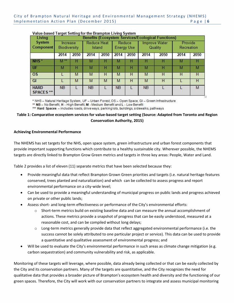
C i t y o f B r a m p t o n N a t u r a l H e r i t a g e a n d E n v i r o n m e n t a l M a n a g e m e n t S t r a t e g y ( N H E M S ) I m p l e m e n t a t i o n A c t i o n P l a n ( D e c e m b e r 2 0 1 5 ) P a g e | 6
Table 1: Comparative ecosystem services for value-based target setting (Source: Adapted from Toronto and Region
Conservation Authority, 2015)
Achieving Environmental Performance
The NHEMS has set targets for the NHS, open space system, green infrastructure and urban forest components that
provide important supporting functions which contribute to a healthy sustainable city. Wherever possible, the NHEMS
targets are directly linked to Brampton Grow Green metrics and targets in three key areas: People, Water and Land.
Table 2 provides a list of eleven (11) separate metrics that have been selected because they:
Provide meaningful data that reflect Brampton Grown Green priorities and targets (i.e. natural heritage features
conserved, trees planted and naturalization) and which can be collected to assess progress and report
environmental performance on a city-wide level;
Can be used to provide a meaningful understanding of municipal progress on public lands and progress achieved
on private or other public lands;
Assess short- and long-term effectiveness or performance of the City’s environmental efforts:
o Short-term metrics build on existing baseline data and can measure the annual accomplishment of
actions. These metrics provide a snapshot of progress that can be easily understood, measured at a
reasonable cost, and can be compiled without long delays;
o Long-term metrics generally provide data that reflect aggregated environmental performance (i.e. the
success cannot be solely attributed to one particular project or service). This data can be used to provide
a quantitative and qualitative assessment of environmental progress; and
Will be used to evaluate the City’s environmental performance in such areas as climate change mitigation (e.g.
carbon sequestration) and community vulnerability and risk, as applicable.
Monitoring of these targets will leverage, where possible, data already being collected or that can be easily collected by
the City and its conservation partners. Many of the targets are quantitative, and the City recognizes the need for
qualitative data that provides a broader picture of Brampton’s ecosystem health and diversity and the functioning of our
green spaces. Therefore, the City will work with our conservation partners to integrate and assess municipal monitoring

C i t y o f B r a m p t o n N a t u r a l H e r i t a g e a n d E n v i r o n m e n t a l M a n a g e m e n t S t r a t e g y ( N H E M S ) I m p l e m e n t a t i o n A c t i o n P l a n ( D e c e m b e r 2 0 1 5 ) P a g e | 7
data with the results of regional and watershed monitoring programs to provide both a quantitative and qualitative
assessment of Brampton’s environmental progress.
In moving forward, the City will ensure that each department clearly understands its responsibility for data collection,
and how data should be organized and maintained for annual monitoring purposes, and for the long-term Sustainable
Brampton Report. In reporting on environmental performance and progress, the City will ensure that the information
provided for the indicators, metrics and targets is easily understood and relates to tangible outcomes. Where
appropriate, the data will be stated in absolutes and will be extrapolated to reference information as percentages of the
total land area/population/other to ensure it remains relevant as the city grows. Further, the reporting will ensure the
connection and description of the interrelationships between metrics, including those listed for other EMP goals.

C i t y o f B r a m p t o n N a t u r a l H e r i t a g e a n d E n v i r o n m e n t a l M a n a g e m e n t S t r a t e g y ( N H E M S ) I m p l e m e n t a t i o n A c t i o n P l a n ( D e c e m b e r 2 0 1 5 ) P a g e | 8
The measures, targets and baseline information presented in Table 2 below are primarily derived from Brampton Grow Green Environmental Master Plan
including the baseline year, unless otherwise noted.
Table 2: NHEMS Targets
Component
Metric Current Performance (2014)
Target Performance
Comments 2016
2021 (Every 5 years)
Natural Heritage
Cit
y
Area (ha) protected within the NHS System (ha/%)
Total municipal land base
26,900 ha
NHS in public ownership March
2010 - 2,130 ha (8% of municipal
land base)
x% the city
2,400-4,200 ha TBD
Cit
y
Watercourse channel remediation (metres/%)
TBD
Identify extent of existing hardened channels by watercourse
TBD TBD
Co
mm
un
ity Biodiversity restoration
and enhancement within the NHS (ha/%)
Baseline TBD
14 ha/year public land habitat restoration and invasive species management
16 – 25 ha/year
public land habitat restoration and invasive species management
x ha/year private land stewardship initiatives
TBD

C i t y o f B r a m p t o n N a t u r a l H e r i t a g e a n d E n v i r o n m e n t a l M a n a g e m e n t S t r a t e g y ( N H E M S ) I m p l e m e n t a t i o n A c t i o n P l a n ( D e c e m b e r 2 0 1 5 ) P a g e | 9
Component
Metric Current Performance (2014)
Target Performance
Comments 2016
2021 (Every 5 years)
Open Space
Cit
y
Reduction of mowing in active parkland and passive open space (ha/%)
x ha/% of active parkland mowed
x ha/% of passive open space mowed
reduce x% of active parkland mown
reduce x% of passive open space mown
TBD
Cit
y Naturalization of open space/parkland
x ha x ha TBD
Urban Forest
Co
mm
un
ity
Urban forest canopy coverage
11%1 25%2 TBD
The City will be updating the Urban Canopy Coverage Assessment in 2016 as a result of recent Emerald Ash Borer infestation and the extensive damage suffered in the Ice Storm 2013.
1 City of Brampton Urban Forest Study 2011
2 City of Brampton Urban Forest Study 2011

C i t y o f B r a m p t o n N a t u r a l H e r i t a g e a n d E n v i r o n m e n t a l M a n a g e m e n t S t r a t e g y ( N H E M S ) I m p l e m e n t a t i o n A c t i o n P l a n ( D e c e m b e r 2 0 1 5 ) P a g e | 10
Component
Metric Current Performance (2014)
Target Performance
Comments 2016
2021 (Every 5 years)
Cit
y Tree planting on public land3
Trees planted on City land: 1,000 trees or shrubs/year (Valley Naturalization Strategy)
1,000 trees/year planted by Scouts
800 parkland trees
x trees planted/year on City lands
TBD
Co
mm
un
ity
Tree planting on private land
TBD x trees
planted/year city-wide4
TBD
Green Infrastructure
Cit
y
Stormwater management (SWM) facilities water quality improvement
x SWM facilities
x SWM facility outfalls
x SWM facilities retrofitted
x SWM facility outfalls retrofitted
TBD
Co
mm
un
ity
Implementation of Low Impact Development (LID) measures
x m2 green roof
x ha permeable pavement
x ha enhanced infiltration areas
x ha ‘at source’ SWM5
x m2 green roof
x ha permeable pavement
x ha enhanced infiltration areas
x ha ‘at source’ SWM
TBD
3 Metric excludes road boulevards, as this is captured in the green infrastructure metrics.
4 This will include recognition of plantings on Conservation Authority lands, private properties/businesses, etc.
5 “At source” control refers to onsite stormwater management that reduces or eliminates the need for offsite large, centralized stormwater management facilities/ponds.
C i t y o f B r a m p t o n N a t u r a l H e r i t a g e a n d E n v i r o n m e n t a l M a n a g e m e n t S t r a t e g y ( N H E M S ) I m p l e m e n t a t i o n A c t i o n P l a n ( D e c e m b e r 2 0 1 5 ) P a g e | 11
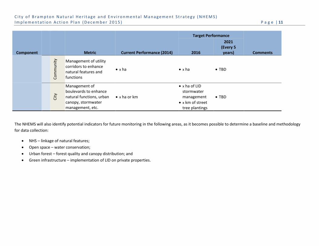
Component
Metric Current Performance (2014)
Target Performance
Comments 2016
2021 (Every 5 years)
Co
mm
un
ity Management of utility
corridors to enhance natural features and functions
x ha x ha TBD
Cit
y
Management of boulevards to enhance natural functions, urban canopy, stormwater management, etc.
x ha or km
x ha of LID stormwater management
x km of street tree plantings
TBD
The NHEMS will also identify potential indicators for future monitoring in the following areas, as it becomes possible to determine a baseline and methodology
for data collection:
NHS – linkage of natural features;
Open space – water conservation;
Urban forest – forest quality and canopy distribution; and
Green infrastructure – implementation of LID on private properties.
C i t y o f B r a m p t o n N a t u r a l H e r i t a g e a n d E n v i r o n m e n t a l M a n a g e m e n t S t r a t e g y ( N H E M S ) I m p l e m e n t a t i o n A c t i o n P l a n ( D e c e m b e r 2 0 1 5 ) P a g e | 12
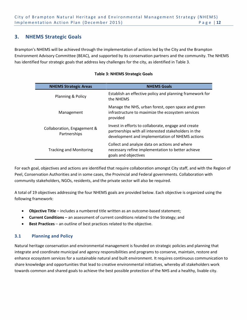
3. NHEMS Strategic Goals
Brampton’s NHEMS will be achieved through the implementation of actions led by the City and the Brampton
Environment Advisory Committee (BEAC), and supported by its conservation partners and the community. The NHEMS
has identified four strategic goals that address key challenges for the city, as identified in Table 3.
Table 3: NHEMS Strategic Goals
NHEMS Strategic Areas NHEMS Goals
Planning & Policy Establish an effective policy and planning framework for the NHEMS
Management Manage the NHS, urban forest, open space and green infrastructure to maximize the ecosystem services provided
Collaboration, Engagement & Partnerships
Invest in efforts to collaborate, engage and create partnerships with all interested stakeholders in the development and implementation of NHEMS actions
Tracking and Monitoring Collect and analyze data on actions and where necessary refine implementation to better achieve goals and objectives
For each goal, objectives and actions are identified that require collaboration amongst City staff, and with the Region of
Peel, Conservation Authorities and in some cases, the Provincial and Federal governments. Collaboration with
community stakeholders, NGOs, residents, and the private sector will also be required.
A total of 19 objectives addressing the four NHEMS goals are provided below. Each objective is organized using the
following framework:
Objective Title – includes a numbered title written as an outcome-based statement;
Current Conditions – an assessment of current conditions related to the Strategy; and
Best Practices – an outline of best practices related to the objective.
3.1 Planning and Policy
Natural heritage conservation and environmental management is founded on strategic policies and planning that
integrate and coordinate municipal and agency responsibilities and programs to conserve, maintain, restore and
enhance ecosystem services for a sustainable natural and built environment. It requires continuous communication to
share knowledge and opportunities that lead to creative environmental initiatives, whereby all stakeholders work
towards common and shared goals to achieve the best possible protection of the NHS and a healthy, livable city.
C i t y o f B r a m p t o n N a t u r a l H e r i t a g e a n d E n v i r o n m e n t a l M a n a g e m e n t S t r a t e g y ( N H E M S ) I m p l e m e n t a t i o n A c t i o n P l a n ( D e c e m b e r 2 0 1 5 ) P a g e | 13
Goal 1: Establish an Effective Policy and Planning Framework for the NHEMS
Objective 1.1: Review and strengthen Official Plan policies to improve the protection, restoration and
enhancement of the Natural Heritage System, urban forest, recreational open space, green infrastructure,
connected water features (e.g. wetlands, creeks) and green development standards.
Current Conditions: The Brampton 2006 Official Plan recognizes the city as a major urban centre in the Greater Toronto
and Hamilton Area (GTAH) and that part of being a sustainable city includes healthy, diverse interconnected natural
heritage and open space systems. These systems, in combination with green infrastructure and the urban forest,
represent the city’s green spaces and green linkages.
Section 4.6 of the Official Plan, Natural Heritage and Environmental Management policies for new development,
addresses protection of the city’s natural and built environments through ecosystem-based land use planning that
includes the completion of watershed plans and subwatershed studies, Environmental Implementation Reports,
Stormwater Management Plans, and Community Design and Infrastructure Servicing plans. Section 4.6 of the Official
Plan also includes a section addressing the natural heritage system that recognizes:
A natural heritage system is made up of natural heritage features and areas that are linked by corridors;
The importance of restoration areas with the potential to be enhanced, improved or restored to a natural state,
thus contributing to the enhancement of the city’s NHS; and
The needs to manage, restore, enhance and connect existing open space and natural areas within the existing
urban area of the city.
Schedule D of the Official Plan (refer to Figure 10 provided in the Background Report) identifies the following natural
features and areas that present a framework for modelling a Natural Heritage System:
Valleylands and watercourse corridors;
Woodlands;
Wetlands (Provincially Significant and other wetlands);
Environmentally Sensitive/Significant Areas;
Areas of Natural and Scientific Interest (ANSI); and
Greenbelt Plan Natural Heritage System.
The City of Brampton Official Plan 2006 policies support the science-based concept of a NHS made up of features and
areas, including linkage corridors and enhancement areas; however, there is no formal identification or designation of a
complete Natural Heritage System.
City of Brampton undertook an Official Plan Gap Analysis (summarized in Appendix B of the Background Report) that
recognizes the need for additional policies and updating policies that address best management practices for
sustainability, naturalization, invasive species, road ecology, noise and light pollution, stormwater management that
adopts a ‘treatment train’ approach, and mitigation/compensation for impacts to, and loss of, natural features and
urban forest (refer to Objective 1.3).

C i t y o f B r a m p t o n N a t u r a l H e r i t a g e a n d E n v i r o n m e n t a l M a n a g e m e n t S t r a t e g y ( N H E M S ) I m p l e m e n t a t i o n A c t i o n P l a n ( D e c e m b e r 2 0 1 5 ) P a g e | 14
Brampton is currently undertaking the 2006 Official Plan Review. As part of this review, the City will update its natural
heritage, environmental management and sustainability policies in conformity with provincial and regional direction;
address the Brampton Grow Green Master Plan, this NHEMS and the Sustainable Community Development Guidelines;
consideration to the Conservation Authority watershed studies and policies; and current City planning and management
standards and practices.
Best Practices: Environmental planning based on a systems approach recognizes the importance of maintaining and
protecting: ecological features in the environment (i.e. woodlands, wetlands, watercourses, etc.); ecological functions of
the environment (i.e. water storage and water quality enhancement by wetlands, winter deer yards provided by dense
cedar woodlands, amphibian breeding habitat in ephemeral forest ponds, etc.); and ecological interactions that occur
over varying scales of time and space (i.e. animal predation and herbivory; the daily, seasonal and long-term movement
patterns of plants and animals; the role of ecological disturbance mechanisms such as fire, wind, water, and disease;
etc.).
The 2014 Provincial Policy Statement (Section 2.1.3.) includes the following new policy which supports the City’s
initiative to identify a natural heritage system: Natural heritage systems shall be identified in Ecoregions 6E & 7E1,
recognizing that natural heritage systems will vary in size and form in settlement areas, rural areas, and prime
agricultural areas.
TRCA and CVC have developed a science-based foundation for NHS planning in Brampton (CVC and TRCA, 2014) as
described in the NHEMS Background Report, Section 3.1.3. The Conservation Authority Natural Heritage System
Mapping for the City of Brampton – Final Technical Report – 2014 (CA NHS) and associated mapping, produced under
separate cover, identifies lands in existing natural cover, corridors and linkages, and lands with the potential to be
enhanced or restored. The CA NHS report provides a foundation for the City to define a NHS for Brampton, in
accordance with applicable provincial and regional policies and directives, and approved planning.
Natural areas in expanding urban communities experience new and additional pressures as land use changes from a
rural-agricultural setting to intensive urban uses. A municipal planning framework and policies that recognize emerging
issues and identify protection, as well as actions to mitigate impacts to and the loss of natural areas provide the best
opportunity for long-term conservation of natural features and functions. As well, policies that direct the sustainability
of the built environment as part of the development process are crucial to ensuring that built hard and green spaces can
provide ecosystem services and/or support ecosystem functions.
Land management is critical in urbanizing communities, as the anticipated increase in number and diversity of natural
area users can lead to overuse and damage to natural features and functions, some of which may be located within
sensitive natural habitats (i.e. including habitat for species at risk), on steep slopes susceptible to erosion, and in wet
areas with stabilizing vegetation and light soil subject to compaction.
Public use of natural areas can be managed through an investment in trail planning and construction, including
education signage. The adoption and implementation of City policies and guidelines that address public use can manage
and mitigate impacts, such as the City of London Planning and Design Standards for Trails in Environmentally Significant
Areas (2012).

C i t y o f B r a m p t o n N a t u r a l H e r i t a g e a n d E n v i r o n m e n t a l M a n a g e m e n t S t r a t e g y ( N H E M S ) I m p l e m e n t a t i o n A c t i o n P l a n ( D e c e m b e r 2 0 1 5 ) P a g e | 15
Heart Lake Road Ecology Monitoring Project (HLREMP)
The Heart Lake Road Ecology Monitoring Project (HLREMP) was undertaken by the Toronto and Region Conservation Authority (TRCA) and the Etobicoke-Mimico Coalition – Brampton Etobicoke Working Group (BEWG) in collaboration with the Ontario Road Ecology group and Fleming College. In 2010, and again in 2012, the HLREMP conducted intensive surveys of Heart Lake Road, between Mayfield Road and Sandalwood Parkway. The results of these surveys demonstrate that, annually, thousands of incidents of wildlife mortality are directly related to wildlife-vehicle collisions.
The HLREMP recommends the installation of eco-passage culverts at three hotspots located on a stretch of Heart Lake Road between Sandalwood Parkway and Countryside Drive where the greatest percentage of wildlife mortality occurred. These three “hotspots” correspond with three large wetlands/wildlife habitats that are bisected by Heart Lake Road. Other recommendations include traffic calming and management.
In 2016, the City of Brampton will undertake a study of Heart Lake Road to examine long-term requirements for road infrastructure and management improvements, habitat improvement, active transportation, conserving the cultural heritage Landscape, and maintaining its rural character.
Active management can be successful in
controlling invasive species that have the ability to
significantly reduce native biodiversity and alter
ecosystem functions. The Ontario Invasive Species
Strategic Plan (2012) and CVC Invasive Species
Strategy (2009) provide guidance for the
management of invasive species.
The emerging field of road ecology is
demonstrating that barriers to wildlife movement
created by roads can be mitigated through careful
design and the installation of appropriate wildlife
crossing structures. Eco-passages can be
considered for new developments through the
installation of wildlife crossing structures beneath
roads. These can facilitate the movement of
amphibians, reptiles and mammals (e.g.
Environmental Implementation Report for Block
48-1 Countryside Villages; Beacon Environmental,
Schaffers Consulting Engineers, Dillon Consulting,
GHD, 2012), and they can be retrofitted for
existing roads where significant wildlife mortality
has been documented (e.g. Heart Lake Road
Ecology Monitoring Project, TRCA 2011).
Noise and light pollution can affect normal
patterns of behaviour in animals and physiology of
plants. Noise can come from stationary sources
(e.g. industrial operations, fixed equipment and
construction), mobile sources (e.g. mainly
transport-related road traffic, aircraft, and trains)
or the community (e.g. parties, pets). Sound, just
like the availability of food and habitat, plays an
important role in the ecosystem. Wildlife
activities, such as finding desirable habitat and
mates, avoiding predators, protecting young and
establishing territories, are all influenced by the
acoustic environment6.
The Province has established noise control guidelines for land use planning, and has authorized municipalities to create
and implement municipal plans and noise-control by-laws. Ontario’s Environmental Protection Act (EPA) prohibits the 6 National Parks Service, United States Department of the Interior, Effects of Noise, http://www.nature.nps.gov/sound/effects.cfm

C i t y o f B r a m p t o n N a t u r a l H e r i t a g e a n d E n v i r o n m e n t a l M a n a g e m e n t S t r a t e g y ( N H E M S ) I m p l e m e n t a t i o n A c t i o n P l a n ( D e c e m b e r 2 0 1 5 ) P a g e | 16
discharge of a contaminant into the natural environment if the discharge causes or may cause an adverse effect. Under
the EPA, “discharge” means emitting, “contaminant” can mean sound, and an “adverse effect” includes harm or material
discomfort (i.e. to a person), adverse health effects, and loss of enjoyment of normal use of property. Protection of
soundscapes and managing acoustic environments related to ecosystem health is receiving growing attention from
policy makers and land managers, particularly in national parks. Examining these initiatives and identifying appropriate
policy and management guidance at the municipal level is necessary.
The International Dark-Sky Association seeks to: “Improve the night-time environment by reducing light pollution
through better lighting practices that provide:
Energy savings resulting in economic benefits
Superb night-time ambience and quality of life
Conservation of nocturnal wildlife and ecosystems
Safeguarding of scientific and educational opportunities, such as astronomy
Preservation of cultural heritage and inspiration for the arts
Increased visibility, safety, and security at night by reducing glare.”
These objectives resonate with municipalities which are responsible for community lighting for the health and safety of
residents, as well as maintaining the health of the natural and built environments. Strategies to reduce or eliminate and
manage light pollution are necessary on public and private lands.
Surface and groundwater quality affects fish and wildlife habitat and ecosystem health and diversity along its entire flow
path. Where traditional stormwater management captures surface runoff from large catchment areas, advanced LID
measures for stormwater management use “treatment train” strategies that begin at the source of surface runoff. Areas
of new urban development provide opportunities to implement best management practices at multiple points along the
path of stormwater runoff, retaining water onsite, enhancing infiltration and evapotranspiration and improving the
quality, quantity and timing of surface water flow to, and within, natural watercourses.
Objective 1.2: Investigate opportunities for expansion of the Provincial Greenbelt in Brampton and a
connected trail network linked with Mississauga and Caledon.
Current Conditions: The Greenbelt Plan shows external river valley connections within Brampton along the Credit River,
Etobicoke Creek and West Humber River (three tributaries) that connect the Greenbelt to Lake Ontario (as shown in
Figure 2). On January 9, 2013, the Province passed Amendment #1 to the Plan which allows municipalities to request
designation of public valleylands as Urban River Valleys (URV) under the Greenbelt Plan, provided they have support
from the applicable upper-tier jurisdiction (i.e. in this case the Region of Peel). These lands could be part of the
Greenbelt, but continue to be governed by applicable municipal Official Plan policies, which are consistent with the
Greenbelt Plan.
As the URV designation only applies to public land it could, if applied, result in a patchwork of Greenbelt protected lands
within Brampton and adjacent municipalities, such as Mississauga (i.e. Credit River and Etobicoke Creek) and Toronto
(i.e. Etobicoke Creek and West Humber/Humber River), which are traversed by these urban river valley systems.
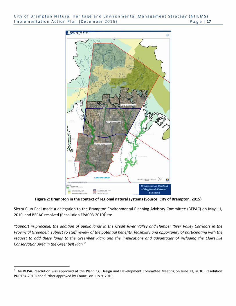
C i t y o f B r a m p t o n N a t u r a l H e r i t a g e a n d E n v i r o n m e n t a l M a n a g e m e n t S t r a t e g y ( N H E M S ) I m p l e m e n t a t i o n A c t i o n P l a n ( D e c e m b e r 2 0 1 5 ) P a g e | 17
Figure 2: Brampton in the context of regional natural systems (Source: City of Brampton, 2015)
Sierra Club Peel made a delegation to the Brampton Environmental Planning Advisory Committee (BEPAC) on May 11,
2010, and BEPAC resolved (Resolution EPA003-2010)7 to:
“Support in principle, the addition of public lands in the Credit River Valley and Humber River Valley Corridors in the
Provincial Greenbelt, subject to staff review of the potential benefits, feasibility and opportunity of participating with the
request to add these lands to the Greenbelt Plan; and the implications and advantages of including the Claireville
Conservation Area in the Greenbelt Plan.”
7 The BEPAC resolution was approved at the Planning, Design and Development Committee Meeting on June 21, 2010 (Resolution
PDD154-2010) and further approved by Council on July 9, 2010.

C i t y o f B r a m p t o n N a t u r a l H e r i t a g e a n d E n v i r o n m e n t a l M a n a g e m e n t S t r a t e g y ( N H E M S ) I m p l e m e n t a t i o n A c t i o n P l a n ( D e c e m b e r 2 0 1 5 ) P a g e | 18
In the City of Mississauga, a feasibility analysis for expansion of the Provincial Greenbelt Plan Area was received by
General Committee on February 5, 2014 (GC-0021-2014) and the analysis identified the location of public lands within
the Credit River and Etobicoke Creek, and assessed the implications of designating public lands as Urban River Valleys
(URV). In February 2014, City of Mississauga staff was further directed by City Council (Resolution 022-2014) to outline a
plan and cost estimates to designate selected public lands as URV, as outlined in the Greenbelt Plan. Staff has brought
forward several reports (i.e. June 2014 and December 2015) that identified 76 parcels (i.e. 194 ha) of City and
Conservation Authority-owned lands in the Credit River corridor to be designated as Urban River Valleys. These public
lands that are not necessarily contiguous.
In the City of Toronto, City Council voted in February 2014 to have City staff develop a plan to formally designate
Toronto’s ravine system, specifically the Humber and Don River Valleys and Etobicoke Creek, as a permanent part of the
Greenbelt.
Best Practices: The Greenbelt Plan acknowledges river valleys that run through existing or approved urban areas as a key
component of the long-term health of the Greenbelt’s Natural System. In recognition of the function of the URVs, the
Greenbelt Plan encourages municipalities to protect and manage these areas in a manner that maximizes the protection
and enhancement of their ecological features and functions.
As part of its Provincial Growth Plan conformity exercise8, Brampton’s Official Plan was updated to recognize Greenbelt External Connections (i.e. urban river valleys) and included a policy for the City to examine development of a Special Policy framework that builds upon the intent of the Greenbelt Plan, to promote restoration, enhancement, buffering and stewardship measures for these river valley connections. Comprehensive municipal recognition of the City’s urban valleys in relationship to the Provincial Greenbelt Plan would serve to elevate the profile of these rivers, raise public awareness of the importance of these local and regional natural systems, and support educational and stewardship opportunities. It is important to recognize that the protection of both public and private lands is critical in conserving the ecosystem features, functions and linkages of urban river valleys. Amendment 1 to the Greenbelt Plan only directs the designation of public lands as Urban River Valleys. City staff will further review its urban river valleys and present a report to Council in 2016, with recommendations for
policies as appropriate, and to be undertaken as part the 2006 Official Plan Review.
The City of Brampton is a member of the Credit Valley Trail Consortium, a partnership of Credit Valley Conservation, the
Credit Valley Heritage Society and other watershed municipalities, to create a Credit Valley Heritage Trail Plan, as shown
in Figure 3. The plan will establish an inter-regional, tourism heritage trail through the Credit River valley from Lake
Ontario to Orangeville. The development of the Credit Valley Heritage Trail will expand Brampton’s diverse valley trail
network, educate and engage residents and visitors about the city’s natural heritage system, and showcase the rich
tapestry of Brampton’s cultural heritage resources.
8 The City of Brampton implemented the Provincial Growth Plan through Official Plan Amendment 43 and 74 (hereinafter referenced
as “the Growth Plan Amendments”).
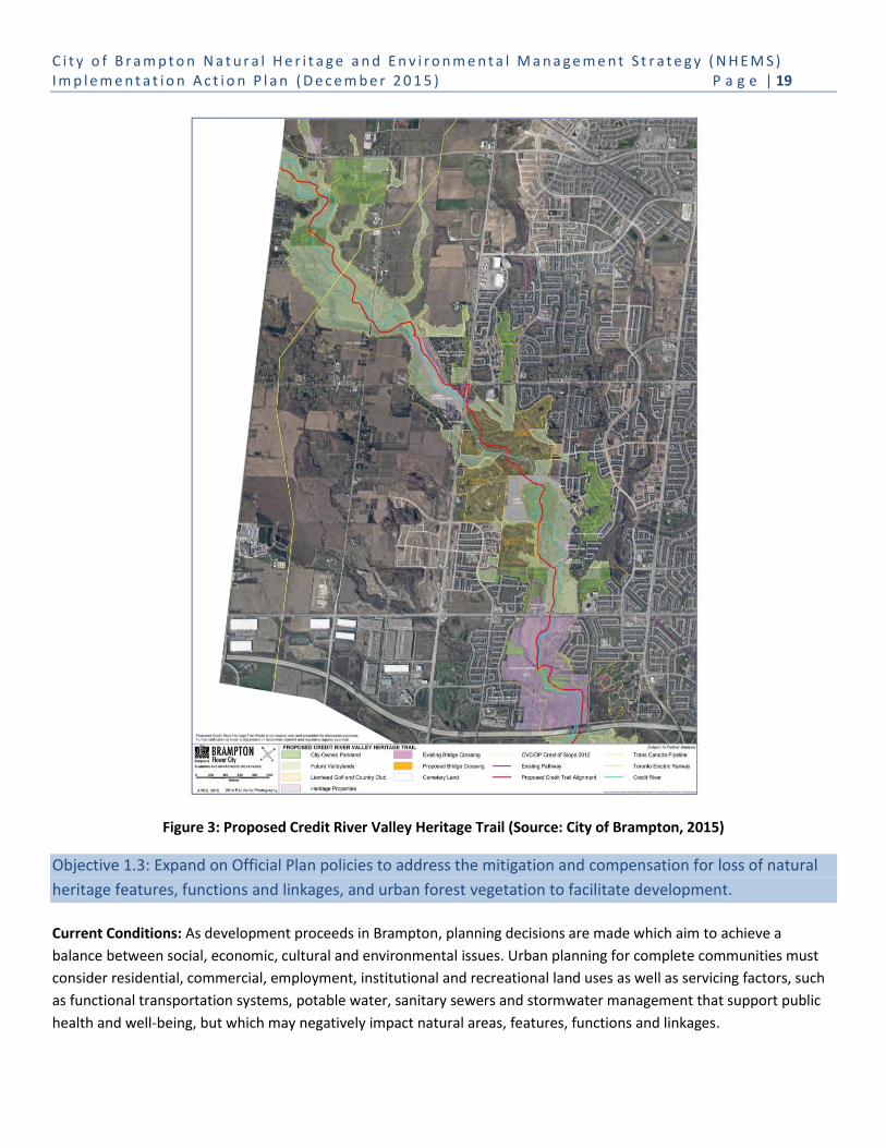
C i t y o f B r a m p t o n N a t u r a l H e r i t a g e a n d E n v i r o n m e n t a l M a n a g e m e n t S t r a t e g y ( N H E M S ) I m p l e m e n t a t i o n A c t i o n P l a n ( D e c e m b e r 2 0 1 5 ) P a g e | 19
Figure 3: Proposed Credit River Valley Heritage Trail (Source: City of Brampton, 2015)
Objective 1.3: Expand on Official Plan policies to address the mitigation and compensation for loss of natural
heritage features, functions and linkages, and urban forest vegetation to facilitate development.
Current Conditions: As development proceeds in Brampton, planning decisions are made which aim to achieve a
balance between social, economic, cultural and environmental issues. Urban planning for complete communities must
consider residential, commercial, employment, institutional and recreational land uses as well as servicing factors, such
as functional transportation systems, potable water, sanitary sewers and stormwater management that support public
health and well-being, but which may negatively impact natural areas, features, functions and linkages.

C i t y o f B r a m p t o n N a t u r a l H e r i t a g e a n d E n v i r o n m e n t a l M a n a g e m e n t S t r a t e g y ( N H E M S ) I m p l e m e n t a t i o n A c t i o n P l a n ( D e c e m b e r 2 0 1 5 ) P a g e | 20
The City’s current NHS policies in the 2006 Official Plan provide good direction for environmental protection of the NHS.
incorporating the principle to strive for “no net loss and if possible a net gain in natural heritage features and areas” (i.e.
Section 4.6.6.20 and 4.6.6.21) as a means to address long-term impacts and fragmentation of natural heritage features,
functions and linkages as a result of urban development, including infrastructure servicing. The City will evolve these
policies to clearly articulate how mitigation and compensation provide a means to help design communities to ensure
that ecosystem services and benefits are not lost from Brampton’s natural and built environments.
Best Practices: Currently there are federal and provincial compensation requirements for proposals that negatively
impact species and/or habitat in order to fulfill regulatory requirements (i.e. federal Fisheries Act, Ontario’s Endangered
Species Act). These requirements formalize and standardize compensation in policies and guidelines and have helped to
establish principles of compensation9 that include:
Ecosystem services compensation must be considered within the established conservation hierarchy of Avoid, Minimize, Mitigate, and Compensate.
Compensation outcomes should strive to fully replace the same level of lost ecosystem services in proximity to where the loss occurs.
The compensation decision process should be open and transparent. Compensation decisions should be consistent and replicable. Ecosystem services compensation should be directed to on-the-ground ecosystem restoration and be informed
by strategic watershed and restoration planning; and Implementation should be completed promptly.
In southern Ontario, urban development usually involves a land use change from rural and agricultural uses to more
intensive urban development forms. Urban land use planning policies protect natural features and functions, but, how
this is accomplished can vary. For natural features that are degraded, unprotected by federal, provincial or municipal
policy, or approved for removal (e.g. grandfathered) under previous policy regimes, land use planning is best served by
recognizing flexibility in how natural heritage is conserved. Natural Heritage System conservation acknowledges that, in
these cases, opportunities to protect ecosystem services may be achieved through the removal of a portion of natural
features and undertaking ecological restoration in another location to better provide long-term ecosystem services and
the connection and enhancement of natural areas, functions and linkages. For example the removal of woodland
“fingers” (e.g. outlined in red) and the restoration of a non-treed area (e.g. outlined in yellow) would result in reduced
woodland polygon edge and increased woodland interior (refer to Figure 4).
It is best to determine the loss, mitigation and/or compensation of natural features and urban tree canopy vegetation
through comprehensive environmental reports to ensure no net loss of the NHS and to identify opportunities to achieve
net gain in natural features, functions, linkages, and ecosystem services.
9 As adapted from the (Draft) Terrestrial Ecosystem Services Compensation Protocol, Toronto and Region Conservation Authority June 2015.

C i t y o f B r a m p t o n N a t u r a l H e r i t a g e a n d E n v i r o n m e n t a l M a n a g e m e n t S t r a t e g y ( N H E M S ) I m p l e m e n t a t i o n A c t i o n P l a n ( D e c e m b e r 2 0 1 5 ) P a g e | 21
In recently approved secondary plan and block plan areas, the City is receiving 1:1 ha compensation for the removal of
tableland natural features. The TRCA is currently working on the development of a Terrestrial Ecosystem Services
Compensation Protocol to help formalize and standardize compensation in policies and guidelines.
The City of Brampton’s Guidelines for the Assessment of Existing Tableland Vegetation, Rev. October 2014 recognizes
that through implementation of the City’s Woodlot Conservation By-law and the Tree Preservation By-law, the City has
established a mitigation practice of three (3) trees as replacement for each existing healthy tree removed that is greater
than 15 cm diameter at breast height (dbh). This mitigation practice also applies to the removal of non-native tree
species. Current City practice should be reflected in Official Plan policies, as appropriate.
3.2 Management
Long-term protection of the NHS requires adaptive management strategies that monitor natural and built green spaces
to assess where management prescriptions need refinement and to initiate appropriate actions. Urban natural areas,
open space/parkland, green infrastructure and the urban forest are subject to stresses (including human use) and are
rarely large enough to be self-sustaining. To maintain biodiversity and ecological function, and to provide ecosystem
services in the long-term, these green spaces require ongoing management, including enforcement of protection by-
laws, maintenance, restoration and enhancement of ecosystem services to provide healthy, diverse natural communities
and, where publicly accessible, provide safe recreation, nature appreciation and education opportunities.
Figure 4: Hypothetical example aerial map of removed woodland “fingers” (outlined in red) and restoration of
non-treed area (outlined in yellow) (Source: North-South Environmental, 2014)

C i t y o f B r a m p t o n N a t u r a l H e r i t a g e a n d E n v i r o n m e n t a l M a n a g e m e n t S t r a t e g y ( N H E M S ) I m p l e m e n t a t i o n A c t i o n P l a n ( D e c e m b e r 2 0 1 5 ) P a g e | 22
Goal 2: Manage Natural Heritage, Urban Forests, Open Space and Green Infrastructure to Maximize
Ecosystem Services
Objective 2.1: Enhance and expand the understanding of Council, stakeholders, and the public about the need
for the NHS and associated management issues.
Current Conditions: The City of Brampton Official Plan Schedule D illustrates Natural Heritage Features and Areas
mapped at a relatively coarse scale, showing valleylands, watercourses, woodlands and wetlands. More information is
available for areas of the city where detailed planning studies and local natural heritage system planning have been
undertaken (i.e. Mount Pleasant Secondary Plan). As noted, the NHEMS recommends a city-wide NHS developed on the
basis of a science-based review of natural heritage features and functions. The CA NHS prepared for Brampton has been
developed using current landscape ecology principles and conservation values. This has resulted in consistent mapping
across the city based on a watershed natural heritage system approach.
CVC and TRCA, in collaboration with the Region of Peel and City of Brampton,
respectively, are undertaking the Credit River Watershed and Region of Peel Natural
Areas Inventory and Brampton Natural Areas Inventory. The NAIs provide excellent
baseline information for many natural areas within Brampton’s natural heritage and
open space systems, and green infrastructure. Site summaries and mapping will provide
detailed information on vegetation communities, species presence, site condition and
disturbance, ecological features and functions, and opportunities for restoration and
stewardship.
Conservation Authorities in collaboration with Conservation Ontario have developed a
set of guidelines and a grading system to evaluate key indicators of watershed health.
The standardized reporting now used in Watershed Report Cards, provides an opportunity to compare the health of an
individual CA watershed with other watersheds in Ontario. Watershed Report Cards and fisheries management plans
produced by CAs are existing tools that contribute to informing and expanding readers’ understanding of the health of
the NHS. The CAs also undertake watershed monitoring that provides direction in guiding conservation activities to
improve ecosystem health and functions.
At present, there is no city-wide monitoring and/or reporting program for the NHS. The aforementioned Natural Areas
Inventories, comprehensive environmental studies (e.g. subwatershed studies), and development applications (e.g.
environmental impact studies) include information on site conditions and disturbances and provide general
recommendations for remediation and enhancement for individual sites where issues (e.g. invasive species control,
ecological restoration or trail management) have been identified.
Best Practices: Developing and managing a detailed inventory of the City’s biota is essential for evaluating natural
heritage significance and conservation. Follow-up monitoring, implementing management initiatives, and maintaining all
this information and associated mapping in a comprehensive database in a format that is accessible to a wide variety of
users will facilitate best practice for environmental management.

C i t y o f B r a m p t o n N a t u r a l H e r i t a g e a n d E n v i r o n m e n t a l M a n a g e m e n t S t r a t e g y ( N H E M S ) I m p l e m e n t a t i o n A c t i o n P l a n ( D e c e m b e r 2 0 1 5 ) P a g e | 23
Inventories are critical to understanding and valuing the city’s NHS, its features, functions and linkages, including those
provided by Brampton’s built green spaces, and to supporting future development, management and stewardship.
Ecological Land Classification (ELC) at the Vegetation Type level provides detailed information required for site level
management. An inventory of breeding birds and breeding amphibians provides information on key indicator species
that may be used to identify, protect and manage important ecological functions, such as significant wildlife habitat,
interior woodland habitat, critical function zone of wetlands, riparian area of watercourses, etc. Regular monitoring of
urban natural areas is needed to document environmental impacts associated with unregulated and/or excessive use,
encroachment, adjacent land use impacts, ecological impacts arising from invasive species and the success of
management actions intended to improve the ecological health of urban natural areas.
Reporting on the city’s environmental conditions (i.e. the health, biodiversity and connectedness of the municipality’s
NHS and the sustainability of the built environment) is necessary to inform and expand the understanding of Council,
City staff, stakeholders, and the public about the importance and value of the NHS and the city’s built green spaces.
Brampton Grow Green will report on the City’s environmental initiatives and progress to the community as a way to
continually promote environmental awareness, share and celebrate successes, demonstrate conformity with City and
other policy directions, and build strong community support for the City’s environmental priorities. The EMP proposes to
use an annual Canvas of Environmental Initiatives, an annual report to Council on implementing EMP actions and a
Sustainable Brampton Report to report on EMP metrics/targets and share long-range monitoring data. The City’s success
in implementing the NHEMS including actions, metrics and targets should be combined with the EMP reporting.
The Peel Climate Change Strategy (2011), which was endorsed by Brampton City Council, has identified the need for
proactive and responsive planning and leadership (Action 1.0) to address municipal climate change mitigation and
adaptation. Numerous sub-actions have been identified, such as:
Undertaking vulnerability risk assessments for natural heritage, infrastructure and agriculture;
Updating municipal official plans, by-laws, policies and plans to reflect climate change adaptation targeted to
reduce vulnerabilities to projected impacts; and
Enhancing emergency management plans (e.g. mitigation, response, preparedness and recovery) to adapt to
climate change considerations.
Objective 2.2: Actively restore natural features, functions and linkages in the natural heritage and open space
systems, green infrastructure and urban forest.
Current Conditions: Similar to many areas of southern Ontario, Brampton’s natural landscape has been fragmented by
historical agricultural and urban development. It is currently made up of linear north-south valley and watercourse
corridors, altered and hardened stream channels, isolated natural woodland and wetland patches within a matrix of
successional communities (e.g. meadows and woody regeneration), and agricultural and urban land uses. Within the
NHS valley corridors, heritage communities (i.e. Churchville and Huttonville), agriculture, legal non-conforming land uses
and private and public active recreation facilities (e.g. golf courses, sports fields) exist. Many riparian areas along
watercourses are without natural vegetation cover due to past agricultural and urban activities.
C i t y o f B r a m p t o n N a t u r a l H e r i t a g e a n d E n v i r o n m e n t a l M a n a g e m e n t S t r a t e g y ( N H E M S ) I m p l e m e n t a t i o n A c t i o n P l a n ( D e c e m b e r 2 0 1 5 ) P a g e | 24
Development in Brampton is resulting in a landscape dominated by urban land use which will have an environmental
impact on the remaining natural areas, particularly when they remain as isolated features or without adequate
protective buffers.
As part of urbanization in the 1950s and 1960s, accepted engineering practice resulted in the alteration and hardening
of watercourses with concrete or other hard bed and bank treatments as a means to convey water quickly downstream
and avoid local flooding. Often, servicing infrastructure such as sanitary sewer and water systems were also constructed
in valley and watercourse corridors. Stormwater management was not yet part of city building, and natural area
conservation focused more on providing recreational space than ecosystem health.
The area municipalities have varying responsibilities for stormwater management, the condition of stream channels
and/or adjacent and buried infrastructure within natural corridors. Current knowledge recognizes that hardening of
watercourses has impacted the overall health of the aquatic system. In addition, the design life (50+ years) of many of
these hardened channels is ending with some major failures already experienced. In anticipation of weather systems
increasing in intensity within southern Ontario, the rate of deterioration may accelerate, and major failures have already
been observed, including channel structure, along Spring Creek after the storm event on July 8, 2013 (as illustrated in
the Background Report).
An increasing population and the associated desire to access natural areas for a variety of active and passive uses can
lead to the establishment of informal trail networks. Uncontrolled public use results in negative impacts to natural areas
where trails:
Are too close to sensitive features such as watercourses or significant wildlife habitat;
Traverse steep slopes or wet areas that causes erosion and soil compaction;
Result in localized trampling of native vegetation, including damaging of exposed roots with the potential for
destabilization of trees;
Include unnecessary branched and multiple trails in one natural area;
Contain unconnected trail segments;
Compromise public safety where trails are located within frequent flood prone areas; and
Increase the presence of invasive species introduced by trail users.
CVC and TRCA have produced report cards for the Credit River and Etobicoke, Mimico and Humber watersheds in
Brampton. The report cards include a grading system for surface and ground water quality, and aquatic and terrestrial
conditions, including forest cover.
The CAs generally lead initiatives that municipalities and the general public (e.g. Credit River Anglers Association) can
participate in to protect and improve the health of aquatic ecosystems, including watercourses and wetlands. The City is
also working with other environmental groups (e.g. Ontario Streams) that have fisheries biologists/aquatic habitat
specialists that have the resources and capability to undertake management of aquatic habitat.

C i t y o f B r a m p t o n N a t u r a l H e r i t a g e a n d E n v i r o n m e n t a l M a n a g e m e n t S t r a t e g y ( N H E M S ) I m p l e m e n t a t i o n A c t i o n P l a n ( D e c e m b e r 2 0 1 5 ) P a g e | 25
Kilmanagh Creek / Humber River Watershed Redside Dace Recovery Project
Kilmanagh Creek, a tributary of the West Humber River, is unique in the Humber River watershed as it supports
coldwater fish species, including the provincially endangered Redside Dace. Kilmanagh Creek originates in
Caledon where it flows through north Brampton to its confluence with the West Humber River. Increasing
urbanization has had significant impacts on this creek, altering flows, creating erosion, and increasing
sedimentation. These changes threaten existing populations of Redside Dace and other sensitive coldwater fish
species, such as Brook Trout. Ontario Streams and its partners, working under the Redside Dace Habitat
Rehabilitation Initiative, have endeavored to enhance and restore Kilmanagh Creek to protect existing Redside
Dace populations, while at the same time improving habitat for other native fish species.
To date, Ontario Streams has restored and enhanced approximately 4 kilometers of the creek from Castlemore
Road to Countryside Drive. Rehabilitation work has included, but is not limited to: debris jam and beaver dam
removals, stream bank stabilization, riparian plantings, and garbage removal. Ontario Streams undertook this
work using volunteers from the Ontario Stewardship Rangers and Sandalwood Heights Secondary School
students. Ontario Streams is now supporting the City’s efforts to improve Fletcher’s Creek for Redside Dace.
Through the Endangered Species Act (2007) and regulations, the Province is providing specific guidance for aquatic
ecosystem health for new development and construction related to loss of instream and riparian habitat, and stream
temperature and turbidity (e.g. Guidelines for Development in Redside Dace Habitat). Mitigation, compensation and
management measures are required for physical encroachment into habitat, loss of vegetation, soil disturbance and
release of stormwater. Requirements for overall benefit to habitat may also mean retrofitting of existing development
and infrastructure that is within and/or contributing to regulated habitat (e.g. stormwater). Stream restoration and
enhancement has the opportunity to recover habitat and/or expand habitat for species at risk (e.g. Redside Dace - East
Huttonville Creek channel restoration, Mount Pleasant Community).
Best Practices: Conservation biology includes two foundational principles for natural heritage system conservation in
urbanizing environments: first, protect, restore and enhance the remaining patches present in a fragmented landscape,
and second, identify and restore ecological corridors to connect the patches (Figure 5). Typically in southern Ontario,
ecological corridors are associated with watercourses and valleylands.
Where possible, natural heritage systems should include upland linkages to: connect tableland woodlands/wetlands;
and establish linkages between watersheds and valley corridors. Opportunities for the establishment of upland linkages
may be associated with areas outside the NHS, including open space, green infrastructure and urban forest. Areas of
green infrastructure within the CA NHS that can provide upland linkages include the Parkway Belt West/Highway 407
lands.

C i t y o f B r a m p t o n N a t u r a l H e r i t a g e a n d E n v i r o n m e n t a l M a n a g e m e n t S t r a t e g y ( N H E M S ) I m p l e m e n t a t i o n A c t i o n P l a n ( D e c e m b e r 2 0 1 5 ) P a g e | 26
Figure 5: Diagrammatic representation of a natural
heritage system illustrating the connection of
natural “core” areas with three different types of
ecological “corridors” (Source: Bennett and
Mulonguoy, 2006)
Watercourses and valleylands form the backbone of the
natural heritage system by providing the majority of
forests and wetlands and forming natural corridors to
provide ecological linkage. Healthy aquatic environments
are sustained by careful management of the terrestrial
environment, including carefully planned urban
communities that take full advantage of sustainable best
management practices (e.g. stormwater LID measures),
and a well-planned and managed NHS. Conservation
agencies take the lead on aquatic habitat protection and
management, while municipalities take the lead on
planning for urban development. As such, it is best
practice when municipalities collaborate and partner with
the Province and Conservation Authorities and
conservation organizations, and participate in joint
protection and management initiatives that achieve
multiple objectives related to the health of aquatic and
terrestrial systems.
The TRCA, in partnership with the Region of Peel and area
municipalities, is developing a Peel Region Channel
Remediation Strategy to identify and prioritize where
hardened and altered watercourses can be naturalized
without additional flood risk, while potentially improving
flood management and infrastructure protection and
maximizing ecological services to municipalities and
residents, and wildlife and fish communities. The
development of stream remediation and implementation
recommendations will be: based on using natural channel
design principles, promoting adaptive and asset
management, linking environmental health with human well-being, forming partnerships, and achieving system
resiliency at the watershed scale.
In addition to the Peel Channel Remediation Strategy, the City will be undertaking a city-wide Watercourse Erosion
Assessment Study and Master Plan that will document both hardened channels and naturally eroding channels that
threaten municipal infrastructure.
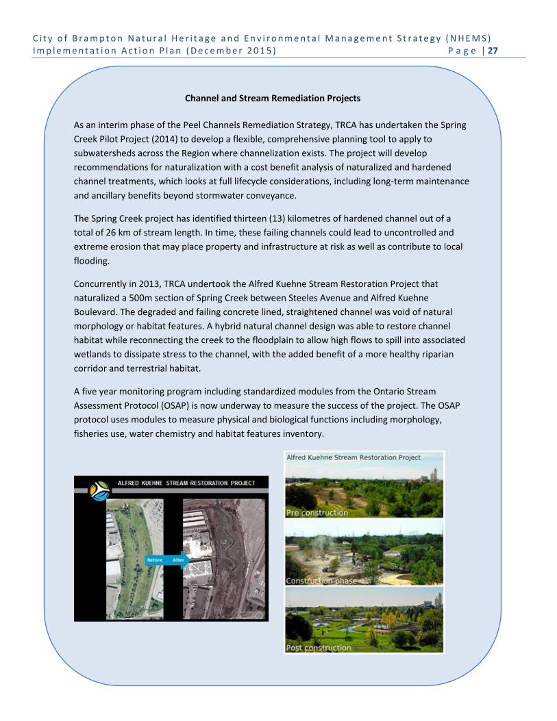
C i t y o f B r a m p t o n N a t u r a l H e r i t a g e a n d E n v i r o n m e n t a l M a n a g e m e n t S t r a t e g y ( N H E M S ) I m p l e m e n t a t i o n A c t i o n P l a n ( D e c e m b e r 2 0 1 5 ) P a g e | 27
Channel and Stream Remediation Projects
As an interim phase of the Peel Channels Remediation Strategy, TRCA has undertaken the Spring
Creek Pilot Project (2014) to develop a flexible, comprehensive planning tool to apply to
subwatersheds across the Region where channelization exists. The project will develop
recommendations for naturalization with a cost benefit analysis of naturalized and hardened
channel treatments, which looks at full lifecycle considerations, including long-term maintenance
and ancillary benefits beyond stormwater conveyance.
The Spring Creek project has identified thirteen (13) kilometres of hardened channel out of a
total of 26 km of stream length. In time, these failing channels could lead to uncontrolled and
extreme erosion that may place property and infrastructure at risk as well as contribute to local
flooding.
Concurrently in 2013, TRCA undertook the Alfred Kuehne Stream Restoration Project that
naturalized a 500m section of Spring Creek between Steeles Avenue and Alfred Kuehne
Boulevard. The degraded and failing concrete lined, straightened channel was void of natural
morphology or habitat features. A hybrid natural channel design was able to restore channel
habitat while reconnecting the creek to the floodplain to allow high flows to spill into associated
wetlands to dissipate stress to the channel, with the added benefit of a more healthy riparian
corridor and terrestrial habitat.
A five year monitoring program including standardized modules from the Ontario Stream
Assessment Protocol (OSAP) is now underway to measure the success of the project. The OSAP
protocol uses modules to measure physical and biological functions including morphology,
fisheries use, water chemistry and habitat features inventory.

C i t y o f B r a m p t o n N a t u r a l H e r i t a g e a n d E n v i r o n m e n t a l M a n a g e m e n t S t r a t e g y ( N H E M S ) I m p l e m e n t a t i o n A c t i o n P l a n ( D e c e m b e r 2 0 1 5 ) P a g e | 28
Municipalities and partner agencies must also consider trails system planning and maintenance as part of the overall
management objectives. A trail system must be well planned and designed for long-term sustainability. Trail planning
must consider issues of ecological features, site conditions and drainage, maintenance, access, pedestrian accessibility,
safety, visibility and aesthetics. Good trail planning can avoid sensitive natural areas and/or significant features, and
using sustainable construction techniques can mitigate disturbances to the surrounding environment. By providing users
with an accessible, defined path and varied user experiences combined with educational signage can ensure that new
trails do not result in any permanent loss of natural features or ecological functions within protected natural areas. Trail
designs that include pervious surface treatments are promoted by conservation agencies in sensitive areas, as illustrated
in Figure 6.
Research on natural area trail impacts has identified that a properly managed trail system will limit the areal extent and
severity of recreation impacts by concentrating traffic on resilient trail surfaces and through the use of appropriate
structures such as bridges, fences, and boardwalks (Leung & Marion 2000). Depending on the type of trail system
developed, the visitor experience may vary from one that is primitive and intimate with nature to one that is more
developed and separate from nature (Stankey and Schreyer 1987; Hendee and Dawson 2002). Within the Brampton
NHS, the intent should be to continue to create trail systems that protect key ecological features and functions while
permitting passive nature-based recreation opportunities.
Figure 6: Example of granular trail cross-section
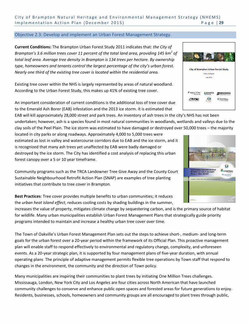
C i t y o f B r a m p t o n N a t u r a l H e r i t a g e a n d E n v i r o n m e n t a l M a n a g e m e n t S t r a t e g y ( N H E M S ) I m p l e m e n t a t i o n A c t i o n P l a n ( D e c e m b e r 2 0 1 5 ) P a g e | 29
Objective 2.3: Develop and implement an Urban Forest Management Strategy.
Current Conditions: The Brampton Urban Forest Study 2011 indicates that: the City of
Brampton’s 3.6 million trees cover 11 percent of the total land area, providing 145 km2 of
total leaf area. Average tree density in Brampton is 134 trees per hectare. By ownership
type, homeowners and tenants control the largest percentage of the city’s urban forest.
Nearly one third of the existing tree cover is located within the residential area.
Existing tree cover within the NHS is largely represented by areas of natural woodland.
According to the Urban Forest Study, this makes up 41% of existing tree cover.
An important consideration of current conditions is the additional loss of tree cover due
to the Emerald Ash Borer (EAB) infestation and the 2013 ice storm. It is estimated that
EAB will kill approximately 28,000 street and park trees. An inventory of ash trees in the city’s NHS has not been
undertaken; however, ash is a species found in most natural communities in woodlands, wetlands and valleys due to the
clay soils of the Peel Plain. The ice storm was estimated to have damaged or destroyed over 50,000 trees – the majority
located in city parks or along roadways. Approximately 4,000 to 5,000 trees were
estimated as lost in valley and watercourse corridors due to EAB and the ice storm, and it
is recognized that many ash trees yet unaffected by EAB were badly damaged or
destroyed by the ice storm. The City has identified a cost analysis of replacing this urban
forest canopy over a 5 or 10 year timeframe.
Community programs such as the TRCA Landowner Tree Give Away and the County Court
Sustainable Neighbourhood Retrofit Action Plan (SNAP) are examples of tree planting
initiatives that contribute to tree cover in Brampton.
Best Practices: Tree cover provides multiple benefits to urban communities; it reduces
the urban heat island effect, reduces cooling costs by shading buildings in the summer,
increases the value of property, mitigates climate change by sequestering carbon, and is the primary source of habitat
for wildlife. Many urban municipalities establish Urban Forest Management Plans that strategically guide priority
programs intended to maintain and increase a healthy urban tree cover over time.
The Town of Oakville’s Urban Forest Management Plan sets out the steps to achieve short-, medium- and long-term
goals for the urban forest over a 20-year period within the framework of its Official Plan. This proactive management
plan will enable staff to respond effectively to environmental and regulatory change, complexity, and unforeseen
events. As a 20-year strategic plan, it is supported by four management plans of five-year duration, with annual
operating plans The principle of adaptive management permits flexible tree operations by Town staff that respond to
changes in the environment, the community and the direction of Town policy.
Many municipalities are inspiring their communities to plant trees by initiating One Million Trees challenges.
Mississauga, London, New York City and Los Angeles are four cities across North American that have launched
community challenges to conserve and enhance public open spaces and forested areas for future generations to enjoy.
Residents, businesses, schools, homeowners and community groups are all encouraged to plant trees through public,

C i t y o f B r a m p t o n N a t u r a l H e r i t a g e a n d E n v i r o n m e n t a l M a n a g e m e n t S t r a t e g y ( N H E M S ) I m p l e m e n t a t i o n A c t i o n P l a n ( D e c e m b e r 2 0 1 5 ) P a g e | 30
community and organizational events, or by creating their own planting event on public and private land. As of
December 6, 2015, Mississauga has planted 163,169 trees.10
The South Nation Conservation Authority in eastern Ontario has challenged its 13 watershed municipalities to each plant 100,000 trees over 10 years on municipal properties for a total of 1.3 million trees.
Objective 2.4: Implement actions that enhance the supporting role of green infrastructure to the natural
heritage system and urban forest.
Current Conditions: The City of Brampton is traversed by many green infrastructure corridors including gas, hydro,
water, and utility corridors, the Parkway Belt West lands, the roads network, and stormwater management facilities. In
some measure these areas are soft green landscapes that provide valued environmental services, such as cleaning and
cycling water, supporting habitat for wildlife, and ecological linkages between natural areas.
Brampton currently has 143 end-of-pipe stormwater management facilities (ponds) and expects that an additional 370
facilities will be constructed to support full urban build-out by 2031. The City’s Stormwater Management Retrofit &
Enhancement Study (SWRES) recognizes the important contribution of ponds, but also recommends continued
improvements to the stormwater management system, including retrofitting existing outfalls and implementing LIDs to
enhance environmental benefits and protect environmental functions in receiving watercourses.
The County Court SNAP, led by the TRCA in partnership with the City of Brampton and Region of Peel, is an example of a
comprehensive sustainability and green landscape enhancement plan for existing older urban communities. SNAP
develops a program that integrates issues and opportunities for the natural heritage and open space systems, green
infrastructure, and urban forest for the neighbourhood with regard to residential, commercial, employment and
institutional properties and public spaces. The project engages private sector sponsors including utilities, water, energy,
landscape and green building industry associations in neighbourhood actions. The County Court SNAP was the first
program of its kind initiated by the TRCA and municipal partners. Since that time, four other SNAP programs are
underway in the GTA.
Currently, there is no city-wide approach that identifies all green infrastructure lands and the potential for enhanced
management that would increase the supporting role of these areas to the NHS and urban forest, and their overall
ecological services to Brampton.
Best Practices: Approaches to enhance the ecological functions of green
infrastructure have been demonstrated through the implementation of
innovative programs implemented often as pilot projects or area specific
programs throughout southern Ontario (e.g. CVC LID Case Studies at
http://www.creditvalleyca.ca/low-impact-development/low-impact-
development-support/green-technology-projects/lid-case-studies/).
10
Retrieved from the City of Mississauga website: http://www.onemilliontrees.ca/.
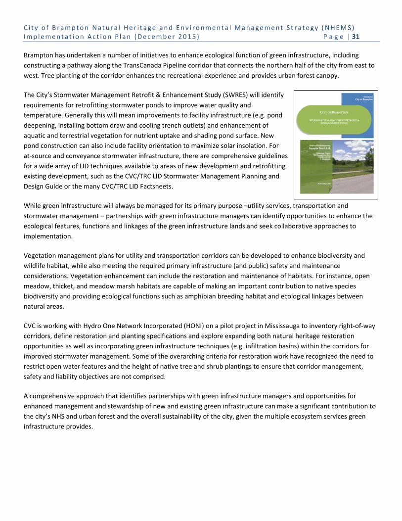
C i t y o f B r a m p t o n N a t u r a l H e r i t a g e a n d E n v i r o n m e n t a l M a n a g e m e n t S t r a t e g y ( N H E M S ) I m p l e m e n t a t i o n A c t i o n P l a n ( D e c e m b e r 2 0 1 5 ) P a g e | 31
Brampton has undertaken a number of initiatives to enhance ecological function of green infrastructure, including
constructing a pathway along the TransCanada Pipeline corridor that connects the northern half of the city from east to
west. Tree planting of the corridor enhances the recreational experience and provides urban forest canopy.
The City’s Stormwater Management Retrofit & Enhancement Study (SWRES) will identify
requirements for retrofitting stormwater ponds to improve water quality and
temperature. Generally this will mean improvements to facility infrastructure (e.g. pond
deepening, installing bottom draw and cooling trench outlets) and enhancement of
aquatic and terrestrial vegetation for nutrient uptake and shading pond surface. New
pond construction can also include facility orientation to maximize solar insolation. For
at-source and conveyance stormwater infrastructure, there are comprehensive guidelines
for a wide array of LID techniques available to areas of new development and retrofitting
existing development, such as the CVC/TRC LID Stormwater Management Planning and
Design Guide or the many CVC/TRC LID Factsheets.
While green infrastructure will always be managed for its primary purpose –utility services, transportation and
stormwater management – partnerships with green infrastructure managers can identify opportunities to enhance the
ecological features, functions and linkages of the green infrastructure lands and seek collaborative approaches to
implementation.
Vegetation management plans for utility and transportation corridors can be developed to enhance biodiversity and
wildlife habitat, while also meeting the required primary infrastructure (and public) safety and maintenance
considerations. Vegetation enhancement can include the restoration and maintenance of habitats. For instance, open
meadow, thicket, and meadow marsh habitats are capable of making an important contribution to native species
biodiversity and providing ecological functions such as amphibian breeding habitat and ecological linkages between
natural areas.
CVC is working with Hydro One Network Incorporated (HONI) on a pilot project in Mississauga to inventory right-of-way
corridors, define restoration and planting specifications and explore expanding both natural heritage restoration
opportunities as well as incorporating green infrastructure techniques (e.g. infiltration basins) within the corridors for
improved stormwater management. Some of the overarching criteria for restoration work have recognized the need to
restrict open water features and the height of native tree and shrub plantings to ensure that corridor management,
safety and liability objectives are not comprised.
A comprehensive approach that identifies partnerships with green infrastructure managers and opportunities for
enhanced management and stewardship of new and existing green infrastructure can make a significant contribution to
the city’s NHS and urban forest and the overall sustainability of the city, given the multiple ecosystem services green
infrastructure provides.
C i t y o f B r a m p t o n N a t u r a l H e r i t a g e a n d E n v i r o n m e n t a l M a n a g e m e n t S t r a t e g y ( N H E M S ) I m p l e m e n t a t i o n A c t i o n P l a n ( D e c e m b e r 2 0 1 5 ) P a g e | 32
Objective 2.5: Develop and implement an Open Space Naturalization Program to prioritize areas to be
naturalized in the city, including recreational open spaces, as well as regionally-owned lands and school sites.
Current Conditions: The pre-settlement landscape of Brampton was characterized by large woodlands and wetlands
with limited disturbance from First Nations communities. European settlement and an ever expanding urban population
in southern Ontario has resulted in extensive loss and alteration of native vegetation which, by the 1940’s, left only
about 6% of the landscape in Brampton in natural vegetation.
The City’s Valley Naturalization Planting Program (2003 – 2014) has naturalized approximately 161 ha in the NHS by
planting over 29,000 native trees; 224,000 native shrubs; and 100,000 native perennials, as illustrated in Appendix F of
the NHEMS Background Report. The program demonstrates Brampton’s commitment and capacity to enhance the NHS
to improve ecological health and diversity. The long-term challenges for open space naturalization include: maintaining
open space for active recreation needs, securing funding to support naturalization programs, educating Council and the
community to understand the benefits of naturalization, and engaging the community to assist in implementation.
The CVC and TRCA have also been undertaking naturalization throughout the city’s NHS, with focused efforts in
Brampton’s valleylands, in accordance with subwatershed plans, as well as the Heart Lake and Claireville Conservation
Areas (TRCA), in accordance with Management Plans, through stewardship programs with community groups and local
schools.
Best Practices: The need to improve the ecosystem services provided by open space, particularly public parkland, will
benefit the natural environment and human health.
The NHS provides “cool islands”, areas of respite from the urban heat island effect experienced during long, hot summer
days. The City’s open space and parkland is certainly cooler than hard urban spaces (e.g. asphalt and concrete surfaces),
but these areas can be improved to provide/extend the NHS “cool island” effect through naturalization efforts – tree
planting that expands and buffers the NHS, urban tree canopy along trails and throughout passive areas, and converting
mown areas into wildflower meadows and pollinator gardens. These efforts will support a resilient NHS capable of
withstanding the pressures of the surrounding urban landscape, expand the urban forest, and improve ecosystem
services provided by parkland.
Naturalization targets the establishment of larger core natural areas, the creation of functional ecological linkages and
buffering of the NHS from adjacent land uses (Figure 7).

C i t y o f B r a m p t o n N a t u r a l H e r i t a g e a n d E n v i r o n m e n t a l M a n a g e m e n t S t r a t e g y ( N H E M S ) I m p l e m e n t a t i o n A c t i o n P l a n ( D e c e m b e r 2 0 1 5 ) P a g e | 33
Figure 7: Habitat core (interior) and edge (Source: How Much
Habitat is Enough?, Environment Canada, 2013)
The City’s Community Stewardship program is currently developing pollinator gardens in partnership with local schools.
The newest garden is located in the Churchville Tributary corridor, north of Queen Street West, and was created in
collaboration with the David Suzuki Secondary School.
Naturalizing programs within Brampton’s recreational open space can also make important contributions to the NHS by:
reducing the amount of edge of natural areas which can result in an increase of interior habitat within core natural
areas; creating stronger ecological linkages or multiple linkages between natural areas allowing them to function as a
single large core area; and enhancing areas along watercourses and within valleylands to improve ecological functions
such as temperature regulation, addition of food sources to watercourses, and filtering of surface water run-off before
entering watercourses.
Naturalization programs reduce the need for mowing, which reduces the annual operating budget; reduce the
environmental costs of park maintenance; reduce greenhouse gas emissions from mowing equipment; and increase the
ecosystem services provided by open space and parkland.
3.3 Collaboration, Engagement, and Partnerships
Protecting and managing the city’s NHS, open space, green infrastructure and urban forest is a shared responsibility. The
level of success of environmental management is linked to the level of active support and engagement of all
stakeholders; particularly those that live, work, and play in Brampton, as well as conservation agencies, organizations
and businesses.

C i t y o f B r a m p t o n N a t u r a l H e r i t a g e a n d E n v i r o n m e n t a l M a n a g e m e n t S t r a t e g y ( N H E M S ) I m p l e m e n t a t i o n A c t i o n P l a n ( D e c e m b e r 2 0 1 5 ) P a g e | 34
Goal 3: Collaborate, Engage and Create Partnerships with All Interested Stakeholders in the Implementation
of NHEMS Actions
Objective 3.1: Engage Council for funding to support natural heritage protection and environmental
management of the City’s natural and built green spaces.
Current Practices: City staff generally engages Council and senior leadership and management teams in the
development of master plans and studies through regular project progress updates, presentations (as appropriate) and
staff reports to Council. Staff reports identify corporate implications, including financial and operational, as well as
achievement of objectives of the City’s EMP and Strategic Plan. Staff will begin reporting on the implementation of the
EMP actions in 2015.
The City has a number of advisory committees that provide support to the decisions of Council. The Brampton
Environment Advisory Committee (BEAC) will continue to provide advice to City Council on strategic environmental
planning and policy matters, and will also function as an “action team”, with the goal of implementing Brampton Grow
Green EMP community actions, including promoting the protection and enhancement of all aspects of the environment.
Best Practices: Environmental decision-making is complex, multi-disciplinary and involves a variety of stakeholders with
different priorities or objectives. Good decision-making must understand, consider and balance environmental
information, potential risks and benefits, costs, and stakeholder preferences and needs.
It is important that decision makers recognize and embrace their role in multi-criteria decision analysis and that there
are mechanisms to assist them in understanding new concepts and tools that may aid in decision-making related to
complex environmental issues.
Objective 3.2: Improve inter-departmental and inter-agency information sharing and coordination to prioritize
and implement programs and actions for natural heritage and environment management issues.
Current Practices: Corporate understanding of strategic plans, targets and actions is critical for successful
implementation, including capital and operational budgeting and allocating staff resources. However, sharing
information and coordinating priorities and activities across departments can be challenging without senior
management buy-in, support and direction to departmental programs and operations.
Staff working in planning, parks maintenance, community stewardship, environmental education, roads operations and
by-law enforcement recognize that engagement and education is a part of their municipal role, and providing these
services to internal staff is just as important as providing to the community. The City prepares standard operating
procedures (SOPs) for corporate operations and provides general information to staff on the City website and internal
portal. However, implementation of strategic plans requires dedicated long-term coordinated communication and
feedback of recommended programs, actions and results. Inter-departmental coordination of overlapping
environmental mandates, responsibilities and initiatives must be fostered by senior management.
Best Practices: Municipalities across Ontario are facing increased pressures to identify cost-effective solutions to provide
outreach and stewardship activities. By providing staff with appropriate information and materials, the City has an
C i t y o f B r a m p t o n N a t u r a l H e r i t a g e a n d E n v i r o n m e n t a l M a n a g e m e n t S t r a t e g y ( N H E M S ) I m p l e m e n t a t i o n A c t i o n P l a n ( D e c e m b e r 2 0 1 5 ) P a g e | 35
excellent opportunity to further its corporate outreach and education goals in a cost-effective way. To make this
effective, there needs to be a clear set of key messages relating to policies, standards and guidelines for natural heritage
protection and built green space management that are supported and understood at all levels of the organization.
Objective 3.3: Develop and deliver a coordinated natural heritage and environmental management
communications, education and implementation strategy with conservation agencies (e.g. CAs, Region of Peel,
Province).
Current Practices: Public information about natural heritage and built green space assets, including environmental
protection, management and stewardship programs, are not promoted in a comprehensive way beyond information
posted on various City websites. In particular, there is poor distinction between information provided for natural areas,
major recreational open space, green infrastructure lands and the urban forest.
As noted in the Background Report, Brampton is one of the fastest growing cities in the GTA with over 600,000 residents
from over 209 distinct ethnic backgrounds and 89 different languages. With such social and cultural diversity, the City
will be challenged to engage, educate and communicate with both the existing community and the expected newcomer
population (i.e. projected population of 899,500 by 2041). Cultural diversity and community growth also means that the
City will encounter many differing attitudes, behaviours, beliefs and values in relation to natural heritage, open
space/parkland and environmental practices.
Research was conducted on citizen’s attitudes, behaviour and concerns about environmental issues in 2007 by Ispos
Reid. At the time, residents were concerned with providing more parks, trees and green space, limiting development
and urban sprawl, air quality/pollution, garbage, traffic and recycling. More recently, the City has undertaken a number
of community consultations through various projects including the Strategic Plan and the EMP that provide project
specific recommendations but do not provide information on barriers and benefits to environmental protection based
on attitudes, values and beliefs.
Key challenges identified through stakeholder discussion included knowledge that residents may have different beliefs
and values associated with natural heritage features and environmental stewardship in general, and that multiple
languages can make communications a challenge. There is a sense that residents are not connected to the communities
they live in, or that those residing in newer homes may be less aware of Brampton's natural heritage.
Brampton Parks, the Region of Peel, TRCA and CVC provide annual environmental educational initiatives, programs and
activities that are focused on residents, youth and school groups. Parks and Urban Forestry engage residents and schools
in annual planting events, and will organize Spring and Harvest Clean-ups to engage thousands of residents annually in
cleaning public green spaces. City staff and volunteers foster environmental awareness and responsibility through
programs, and activities directed at youth, residents, businesses and institutions, and to city neighbourhoods.
The City’s current website provides environmental information under the ‘Resident’ section under headings that were
developed based on web user feedback (i.e. Parks and Trails, Environment, Trees, Plants and Flowers, Garbage). The
Brampton Grow Green webpages are being updated to provide information on the City’s monitoring of its
environmental performance (i.e. priority metrics and targets), as well as community environmental groups and
initiatives.

C i t y o f B r a m p t o n N a t u r a l H e r i t a g e a n d E n v i r o n m e n t a l M a n a g e m e n t S t r a t e g y ( N H E M S ) I m p l e m e n t a t i o n A c t i o n P l a n ( D e c e m b e r 2 0 1 5 ) P a g e | 36
The City actively participates in social media. Corporate accounts provide general information about the City of
Brampton through Twitter, while topic-specific information is available through departmental channels. Departments
are using a range of tools including Twitter, Facebook, LinkedIn, YouTube and a blog. Individual departmental
management of social media is variable, as is communicating environmental information. Coordination of
communications is key to successfully engaging the community and stakeholders.
Best Practices: The City of Kitchener is a leader in clearly distinguishing its publicly accessible natural areas from its
active recreational parks. Natural areas are managed very differently from active parklands, and also have their own
promotional program. Kitchener’s Natural Areas Program is designed to engage the community in environmental
stewardship projects, educate people about Kitchener's natural areas, and create opportunities for people to experience
nature in the city.
Kitchener also provides educational resources for residents on
urban wildlife interactions. Kitchener’s Coyote Factsheet
provides information on living with coyotes and what residents
should do if they encounter one. This educational resource
aims to increase understanding and respect for the animals in
order to co-exist without conflicts.
Websites are cost-effective tools to rapidly disseminate a wide
range of information related to a municipality’s natural
heritage assets and related environmental management
initiatives. Examples of jurisdictions with comprehensive urban
forestry websites include Toronto, Ottawa and Edmonton. Other jurisdictions have posted tree inventories on-line,
including Oakville, London and Ottawa. Both the City of Calgary, and the Toronto-based non-profit organization LEAF,
use short video clips to share information (e.g. how to plant a tree) and engage viewers in urban forestry.
The City has launched an environment exclusive Twitter account, @bramgrowgreen that will be used to promote
Brampton’s EMP, NHEMS, BEAC and our many corporate and community initiatives with our conservation partners that
support climate change adaptation and mitigation, the urban forest, and natural system restoration and enhancement.
Objective 3.4: Develop and implement a Community Environmental Stewardship Network to support and
expand private and public land stewardship and partnerships activities. This includes:
Province, Region of Peel and Conservation Authorities for public and private lands;
Infrastructure Service providers (i.e. Hydro One Brampton, TransCanada Pipeline, Enbridge, MTO to
enhance ecosystem functions in utility and infrastructure corridors; and
NGOs and other community groups such as Ontario Streams, Sierra Club Peel, etc.
Brampton is fortunate to have many conservation organizations and community groups that focus on environmental
initiatives in support of the NHEMS (i.e. organizations such as MNRF, CVC, TRCA, Sierra Club Peel, Evergreen, Ontario
Streams, school boards and a number of naturalist and environmental organizations). City departments are regularly

C i t y o f B r a m p t o n N a t u r a l H e r i t a g e a n d E n v i r o n m e n t a l M a n a g e m e n t S t r a t e g y ( N H E M S ) I m p l e m e n t a t i o n A c t i o n P l a n ( D e c e m b e r 2 0 1 5 ) P a g e | 37
approached by Conservation Authorities, conservation organizations, and institutional and community groups to
participate in stewardship and partnership projects for natural heritage and environmental management activities.
Partnerships with Province, Region of Peel, Conservation Authorities and Municipalities
Current Practices: The City of Brampton works in partnership with the Region of Peel, TRCA and CVC on a wide variety of
initiatives and programs. All partners are involved in: Peel Climate Change Strategy and Implementation; Peel Urban
Forestry Strategy and Implementation; Credit River Watershed and Peel Natural Areas Inventory; Greenland Securement
Strategy; and Climate Change Mitigation Communication Plan – “Your Car, Your Home, Your Health” (which evolved
from the Let Your Green Show Campaign).
Brampton has partnered with TRCA on the County Court SNAP, Peel Channels Remediation Study, Brampton Urban
Forest Study and various subwatershed studies (i.e. Countryside Villages). Brampton has partnered with CVC on various
subwatershed studies (i.e. Mount Pleasant), Brampton Natural Areas Inventory, Fletcher’s Creek SNAP, Hickory Wood
Invasive Species Management Project (in conjunction with Provincial Stewardship Rangers) and the Mount Pleasant
Natural Capital Study.
CVC and TRCA deliver programs that support the sustainability of the City’s urban forest on private lands including
Greening Corporate Grounds, Your Green Yard/Heathy Yards, and Watershed on Wheels. Each of these programs could
benefit from greater municipal support and involvement.
The City is participating in and contributing to numerous plans, studies and initiatives in adjacent municipalities as part
of technical advisory committees or stakeholder groups, including recent contributions to the City of Mississauga Natural
Heritage and Urban Forestry Strategy.
Best Practices: The City is currently employing best practices in this area. One of the best and most recent examples of
municipal partnerships to achieve shared environmental goals is the City of Brampton, City of Vaughan and the Town of
Richmond Hill “Measuring the Sustainability of New Development” framework. The framework aims to reduce the
overall environmental footprint of new developments and redevelopment projects in Brampton. Sustainability
Guidelines address activities to reduce energy consumption and GHG emissions, and focus on compact urban form,
water conservation, waste reduction, improved mobility and connectivity, and enhancing natural heritage systems and
the urban forest. This framework includes a Sustainability Assessment Tool – a dynamic, secure Webtool that identifies
Sustainability Performance Metrics that apply to a range of planning application types (e.g. block plans, draft plans of
subdivision, site plans). Each municipality will identify incentives to offer applicants to encourage implementation of the
recommended minimum or aspirational sustainability thresholds11. The Sustainability Guidelines and Sustainability
Assessment Tool have been completed and are being implemented through planning processes. This project has
capitalized on co-benefits from the sharing of resources to undertake guidelines development.
Partnership with Infrastructure Service Providers
11
Measuring the Sustainability Performance of New Development Final Comprehensive Report Prepared for the Cities of Brampton and Vaughan and Town of Richmond Hill. Halsall Associates, July 2013.

C i t y o f B r a m p t o n N a t u r a l H e r i t a g e a n d E n v i r o n m e n t a l M a n a g e m e n t S t r a t e g y ( N H E M S ) I m p l e m e n t a t i o n A c t i o n P l a n ( D e c e m b e r 2 0 1 5 ) P a g e | 38
Current Practices: Utility and infrastructure corridors are recognized as part of the city’s green infrastructure system and
play a role in providing natural features and functions, as well as linkages between natural areas. Infrastructure
managers undertake naturalization and management activities for the corridors, often in conjunction with new and
infrastructure upgrade projects. However, knowledge of these efforts is largely unknown to the adjacent municipalities.
Best Practices: In 1997, Ontario Hydro Services Company partnered with Land Care Niagara, a non-profit organization
dedicated to the care and appreciation of Niagara’s unique ecosystem, to develop a Natural Heritage Framework for
Niagara Region. Ontario Hydro had a biodiversity strategy and associated programs to protect and/or enhance
biodiversity using an ecosystem approach. By partnering with local interest groups, a framework was developed that
addressed issues of habitat fragmentation and biodiversity, defined opportunities and established the basis for the
implementation of restoration projects.
CVC’s pilot project with Hydro One in Mississauga to inventory the corridors, develop restoration and planting
specifications and implement green infrastructure measures for improved stormwater management is a program that
can be expanded to Brampton. Developing partnerships with Hydro One, TransCanada Pipelines, Enbridge Gas and the
Ministry of Transportation would cover off the major green infrastructure corridors that traverse Brampton.
Partnership with NGOs and Other Community Groups
Current Practices: Brampton aims to foster environmental awareness and responsibility by successfully promoting and
coordinating opportunities for neighbourhood and community pride in Brampton. City staff organizes and manages
community and youth focused stewardship initiatives such as the annual Spring and Harvest Cleanup campaigns and the
Adopt-a-Park program.
City Parks and Forestry staff supports numerous community planting activities that restore natural areas and increase
the city’s tree canopy. Plantings are coordinated in collaboration with Conservation Authorities, Scouts Canada, Toronto
Tourism, Peel Aboriginal Network, Rogers, Telus, Sierra Club Peel, Brampton Horticultural Society, Friends of Claireville,
and numerous Brampton schools. A number of other organizations have hosted their own planting initiatives including
Evergreen, Rotary Club, etc.
TRCA supports community-based volunteers committed to protecting and regenerating TRCA’s watersheds. Their
watershed activities help to achieve The Living City vision of healthy rivers and shorelines, regional biodiversity, and
sustainable communities. Volunteers are comprised of residents and representatives from community groups, schools,
municipalities, government agencies and elected officials, and business.
Past volunteer efforts have focused on restoration, stewardship, passive recreation and environmental education
activities in the Claireville and Heart Lake Conservation Areas, and along the Etobicoke Creek and Spring Creek in
collaboration with TRCA and City staff, including the implementation of the Heart Lake Road Ecology Monitoring Project.
Learn more about TRCA’s Environmental Volunteer Network by contacting Dash Paja at [email protected].
Stream restoration, habitat conservation and species at risk programs are also being completed in partnership with
Ontario Streams. These programs provide volunteers with opportunities to participate in stream restoration activities. In
addition, organizations such as Sierra Club Peel have been involved in invasive species management events.
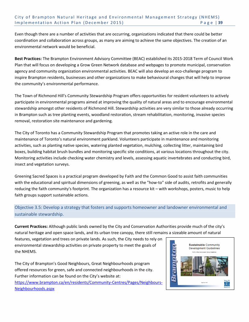
C i t y o f B r a m p t o n N a t u r a l H e r i t a g e a n d E n v i r o n m e n t a l M a n a g e m e n t S t r a t e g y ( N H E M S ) I m p l e m e n t a t i o n A c t i o n P l a n ( D e c e m b e r 2 0 1 5 ) P a g e | 39
Even though there are a number of activities that are occurring, organizations indicated that there could be better
coordination and collaboration across groups, as many are aiming to achieve the same objectives. The creation of an
environmental network would be beneficial.
Best Practices: The Brampton Environment Advisory Committee (BEAC) established its 2015-2018 Term of Council Work
Plan that will focus on developing a Grow Green Network database and webpages to promote municipal, conservation
agency and community organization environmental activities. BEAC will also develop an eco-challenge program to
inspire Brampton residents, businesses and other organizations to make behavioural changes that will help to improve
the community’s environmental performance.
The Town of Richmond Hill’s Community Stewardship Program offers opportunities for resident volunteers to actively
participate in environmental programs aimed at improving the quality of natural areas and to encourage environmental
stewardship amongst other residents of Richmond Hill. Stewardship activities are very similar to those already occurring
in Brampton such as tree planting events, woodland restoration, stream rehabilitation, monitoring, invasive species
removal, restoration site maintenance and gardening.
The City of Toronto has a Community Stewardship Program that promotes taking an active role in the care and
maintenance of Toronto’s natural environment parkland. Volunteers participate in maintenance and monitoring
activities, such as planting native species, watering planted vegetation, mulching, collecting litter, maintaining bird
boxes, building habitat brush bundles and monitoring specific site conditions, at various locations throughout the city.
Monitoring activities include checking water chemistry and levels, assessing aquatic invertebrates and conducting bird,
insect and vegetation surveys.
Greening Sacred Spaces is a practical program developed by Faith and the Common Good to assist faith communities
with the educational and spiritual dimensions of greening, as well as the "how-to" side of audits, retrofits and generally
reducing the faith community's footprint. The organization has a resource kit – with workshops, posters, music to help
faith groups support sustainable actions.
Objective 3.5: Develop a strategy that fosters and supports homeowner and landowner environmental and
sustainable stewardship.
Current Practices: Although public lands owned by the City and Conservation Authorities provide much of the city’s
natural heritage and open space lands, and its urban tree canopy, there still remains a sizeable amount of natural
features, vegetation and trees on private lands. As such, the City needs to rely on
environmental stewardship activities on private property to meet the goals of
the NHEMS.
The City of Brampton’s Good Neighbours, Great Neighbourhoods program
offered resources for green, safe and connected neighbourhoods in the city.
Further information can be found on the City’s website at:
https://www.brampton.ca/en/residents/Community-Centres/Pages/Neighbours-
Neighbourhoods.aspx

C i t y o f B r a m p t o n N a t u r a l H e r i t a g e a n d E n v i r o n m e n t a l M a n a g e m e n t S t r a t e g y ( N H E M S ) I m p l e m e n t a t i o n A c t i o n P l a n ( D e c e m b e r 2 0 1 5 ) P a g e | 40
The City of Brampton has developed Sustainable Community Development Guidelines – a framework that recognizes
that sustainable community development consists of the built environment, mobility, natural environment, open space,
green infrastructure and green building. Environmental indicators for the city’s natural heritage and open space systems,
urban forest and green infrastructure promote:
NHS planning that ensures Brampton’s NHS is part of the provincial, regional and watershed natural systems;
Contiguous NHS integrated with the city’s open spaces;
Creation of NHS linkages and terrestrial connections;
Integration of trails for passive recreation;
Naturalization of open space and parkland;
Planting of native species including local seed banks and salvaged materials;
Walkable streets with increased urban tree canopy;
Water management and conservation;
Stormwater management and LID measures;
Groundwater recharge;
Community stewardship and education;
Dark sky night lighting; and
Conservation of cultural heritage landscapes, hedgerows and swales.
The County Court SNAP contributes to fostering and supporting homeowner and landowner environmental and
sustainable stewardship. A key action of the County Court SNAP was the Green Home Makeover pilot project, the
renovation of one neighbourhood home to demonstrate affordable green renovations that any homeowner can adopt.
The Green Home Makeover:
Showcases innovative eco-friendly home and yard improvements;
Educates homeowners and the building industry on new technology installation and maintenance;
Supports monitoring and evaluation of innovative sustainable technologies; and
Provides an on-the-ground illustration of retrofit benefits and connects people with how-to information.
Renovations took place over fall and winter 2011 with a ribbon cutting celebration in spring 2012. Over the following
two years, TRCA hosted tours of the house for those interested in learning more about sustainable home improvements.
These types of programs and guidelines provide stakeholders, residents and businesses with strategic opportunities to
participate in sustainability and environment activities on private lands.
Best Practices: The City’s Sustainability Guidelines and Sustainability Assessment Tool are best practices currently being
explored by other municipalities in the GTA.
There are a number of municipalities, organizations and businesses that have explored sustainable home makeover
programs similar to the Green Home Makeover. Most of these have been initiated or focused on energy efficiency and
conservation as the primary driver for action. One of the key best practice elements of the Green Home Makeover
program is the inclusion of sustainable landscaping practices. The Region of Peel fusion landscaping program brings

C i t y o f B r a m p t o n N a t u r a l H e r i t a g e a n d E n v i r o n m e n t a l M a n a g e m e n t S t r a t e g y ( N H E M S ) I m p l e m e n t a t i o n A c t i o n P l a n ( D e c e m b e r 2 0 1 5 ) P a g e | 41
together traditional gardens with modern, eco-friendly plants, flowers, colours and textures. The program offers in-
home consultations, gardening workshops, rain barrel sales and a step-by-step guide to fusion gardening. County Court
SNAP community events offered landscape workshops, free tree giveaways and free tree installations.
Similarly, CVC’s Your Green Yard program and the David Suzuki Foundation's Help Bring Nature Home program provide
workshops and other resources to assist homeowners with native plant gardening, environmental maintenance and
ecological landscaping.
Objective 3.6: Support Provincial, Region of Peel, and CA corporate green programs and initiatives.
Current Practices: CVC, TRCA and Evergreen developed and now offer the Greening Corporate Grounds program that
helps corporations, businesses and institutions take environmentally positive steps to enhance their property landscape.
The program includes access to on-the-ground ecological experts who work with participants, as well as workshops,
seminars and fact sheets. The program includes support for the development of site concept plans, technical advice to
landscape consultants or in-house personnel, maintenance guidelines, assistance with planting and maintenance events,
and program recognition.
Best Practices: Partners in Project Green (PPG) is often identified
as best practice for large-scale corporate business sustainability
through the Pearson Eco-Business Zone – an internationally
recognized community known for its competitive, high
performance and eco-friendly business climate.
PPG is a public-private partnership led by the TRCA and the Greater Toronto Airport Authority (GTAA). The business
community surrounding Toronto Pearson International Airport, together with the TRCA, GTAA, Region of Peel, and Cities
of Toronto, Mississauga and Brampton, drive the environmental programs and services. PPG program objectives identify
actions for increasing the participation of business in natural heritage stewardship, no net loss of natural heritage areas
or features, increased riparian zone protection, green infrastructure, water and energy conservation, and waste reuse
and recycling.
The Partners in Project Green program has expanded beyond the Pearson Eco-Business Zone with the participation of
CVC and the Town of Caledon.
There are substantial opportunities for naturalization and tree planting among the city’s industrial, commercial and
institutional properties which can be achieved through ongoing collaboration with the conservation agencies and non-
profit groups (e.g. Conservation Authorities, Evergreen, Greening Sacred Spaces Network) who have programs
specifically targeting these stakeholders. Additional opportunities exist along utility corridors and right-of-ways, but
require better communication between the green infrastructure managers and the City to ensure opportunities that do
not compromise infrastructure and management needs, and safety considerations.
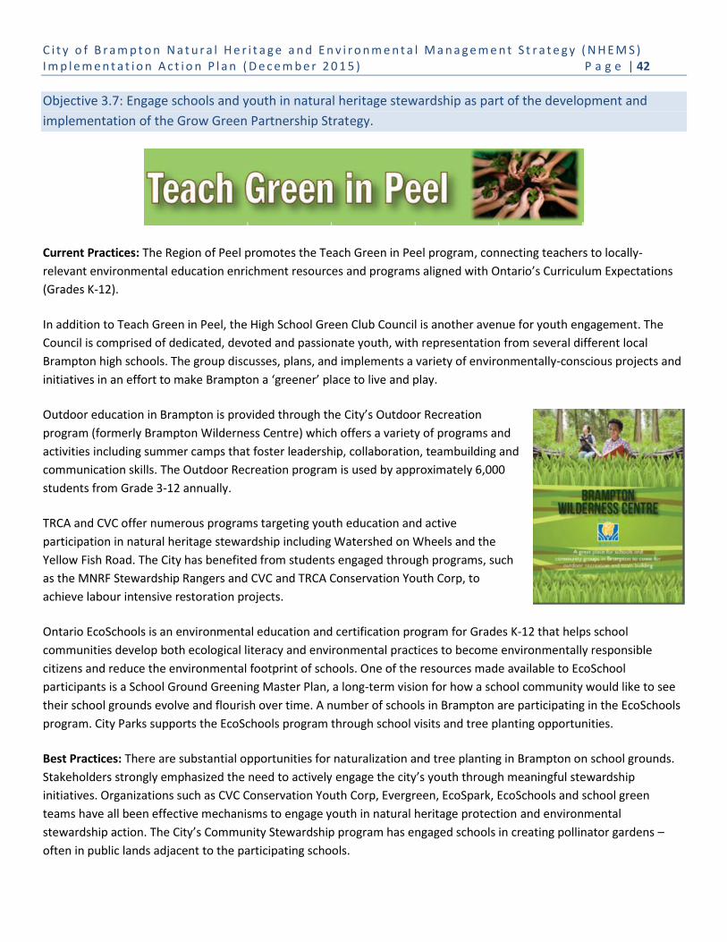
C i t y o f B r a m p t o n N a t u r a l H e r i t a g e a n d E n v i r o n m e n t a l M a n a g e m e n t S t r a t e g y ( N H E M S ) I m p l e m e n t a t i o n A c t i o n P l a n ( D e c e m b e r 2 0 1 5 ) P a g e | 42
Objective 3.7: Engage schools and youth in natural heritage stewardship as part of the development and
implementation of the Grow Green Partnership Strategy.
Current Practices: The Region of Peel promotes the Teach Green in Peel program, connecting teachers to locally-
relevant environmental education enrichment resources and programs aligned with Ontario’s Curriculum Expectations
(Grades K-12).
In addition to Teach Green in Peel, the High School Green Club Council is another avenue for youth engagement. The
Council is comprised of dedicated, devoted and passionate youth, with representation from several different local
Brampton high schools. The group discusses, plans, and implements a variety of environmentally-conscious projects and
initiatives in an effort to make Brampton a ‘greener’ place to live and play.
Outdoor education in Brampton is provided through the City’s Outdoor Recreation
program (formerly Brampton Wilderness Centre) which offers a variety of programs and
activities including summer camps that foster leadership, collaboration, teambuilding and
communication skills. The Outdoor Recreation program is used by approximately 6,000
students from Grade 3-12 annually.
TRCA and CVC offer numerous programs targeting youth education and active
participation in natural heritage stewardship including Watershed on Wheels and the
Yellow Fish Road. The City has benefited from students engaged through programs, such
as the MNRF Stewardship Rangers and CVC and TRCA Conservation Youth Corp, to
achieve labour intensive restoration projects.
Ontario EcoSchools is an environmental education and certification program for Grades K-12 that helps school
communities develop both ecological literacy and environmental practices to become environmentally responsible
citizens and reduce the environmental footprint of schools. One of the resources made available to EcoSchool
participants is a School Ground Greening Master Plan, a long-term vision for how a school community would like to see
their school grounds evolve and flourish over time. A number of schools in Brampton are participating in the EcoSchools
program. City Parks supports the EcoSchools program through school visits and tree planting opportunities.
Best Practices: There are substantial opportunities for naturalization and tree planting in Brampton on school grounds.
Stakeholders strongly emphasized the need to actively engage the city’s youth through meaningful stewardship
initiatives. Organizations such as CVC Conservation Youth Corp, Evergreen, EcoSpark, EcoSchools and school green
teams have all been effective mechanisms to engage youth in natural heritage protection and environmental
stewardship action. The City’s Community Stewardship program has engaged schools in creating pollinator gardens –
often in public lands adjacent to the participating schools.

C i t y o f B r a m p t o n N a t u r a l H e r i t a g e a n d E n v i r o n m e n t a l M a n a g e m e n t S t r a t e g y ( N H E M S ) I m p l e m e n t a t i o n A c t i o n P l a n ( D e c e m b e r 2 0 1 5 ) P a g e | 43
Objective 3.8: Pursue external funding opportunities to implement NHEMS actions in conjunction with
partners.
Current Practices: How Brampton budgets for, and makes decisions about, environmental initiatives and programs will
be key to the implementation of the NHEMS. The decision-making framework of each City department, the Executive
Leadership Team and City Council, needs to consider the NHEMS’s environmental framework, directions and priorities,
as well as the environmental cost of its actions and inactions.
Best Practices: The City’s Sustainability Guidelines and Sustainability Assessment Tool were developed in partnership
with the City of Vaughan and Town of Richmond Hill. This project combined shared municipal staff and budget
resources, and leveraged funding from the Federation of Canadian Municipalities’ Green Municipal Fund. The Peel
Climate Change partnership projects (e.g. Corporate and Community greenhouse gas emissions inventories) and the Peel
Urban Forest partnership projects (e.g. Priority Tree Planting Tool, 2011 and 2015 Urban Canopy Assessment) exemplify
sharing municipal staff and budget resources to achieve desired regional and area municipal initiatives.
The Region of Peel also contributes to the Conservation Authorities annual budgets that support watershed planning,
protection and additional projects.
3.4 Tracking and Monitoring
The impact of the NHEMS cannot be assessed without baseline data collection, ongoing monitoring and a refinement of
the environmental performance framework and strategies over time to ensure effectiveness. Integration and
coordination of the NHEMS and the EMP monitoring will demonstrate whether the City is making progress towards its
environmental goals and provide powerful evidence to support additional environmental initiatives. The following
actions are required to establish the basis for a successful long-term monitoring of the City’s environmental progress:
Determine baseline data, and confirm and/or develop targets for all priority metrics;
Identify departmental and corporate responsibilities for monitoring targets, including data management and
reporting;
Identify annual staff and budget resources necessary to implement NHEMS actions;
Establish protocols for data collection, analysis and reporting for each target;
Annually update the Canvas of Environmental Initiatives, a snapshot of current ways in which Brampton and its
conservation partners are improving the City’s environmental performance;
Prepare an annual Council report that describes the status of the implementation of the NHEMS and EMP; and
Prepare a Sustainable Brampton Report that describes and shares the status of the City’s environmental
performance, issued at 5-year intervals.

C i t y o f B r a m p t o n N a t u r a l H e r i t a g e a n d E n v i r o n m e n t a l M a n a g e m e n t S t r a t e g y ( N H E M S ) I m p l e m e n t a t i o n A c t i o n P l a n ( D e c e m b e r 2 0 1 5 ) P a g e | 44
Goal 4: Track and Monitor the Performance of the NHEMS
Objective 4.1: Establish an ongoing monitoring and adaptive management framework for the NHS, open space
and green infrastructure.
Current Practices: There is currently no comprehensive city-wide monitoring program for the NHS, or for the
contributions that recreational open space or green infrastructure provides to support natural heritage conservation and
management, and ecosystem services.
The Credit River Watershed and Region of Peel and Brampton Natural Areas Inventories (NAIs) currently include
information on site conditions and disturbances for many natural areas within the NHS, naturalizing parkland,
stormwater management facilities, and green infrastructure corridors. These NAIs will also incorporate information
regarding the condition of natural areas that may be reported through site specific studies associated with
comprehensive environmental studies (e.g. subwatershed studies) and development applications (e.g. environmental
impact studies). While not specifically designed for a monitoring program, a baseline of existing conditions is provided,
including recommendations for the improvement of natural features and functions, that can be used in future trend
analyses.
Environmental management may be initiated for individual sites where issues have been identified, such as invasive
species control, ecological restoration or trail management. Currently, Brampton administers the maintenance and
mowing of active and passive open space through annual contracts. The City maintains an inventory and GIS database
and will respond to site specific (individual) requests for mowing as received from Councillors, senior management and
residents.
CVC and TRCA each conduct incidental, development specific and/or long-term watershed monitoring programs across
their areas of responsibility such as: streamflow, water quality, wetland hydrology, terrestrial (i.e. forest, wetland and
riparian ecosystems), marsh monitoring, and fauna (i.e. fish, birds and amphibians). This data is used in watershed
reporting and provincial monitoring programs (e.g. Provincial Water Quality Network).
The City’s Valleyland Naturalization Program (as described under Objective 2.5) and the CVC and TRCA restoration and
stewardship programs track the hectares of plantings, including the number native trees, native shrubs and native
perennials that are annually planted. However, these programs do not include specific monitoring of the success of the
plantings over the long-term and are, as currently implemented, of limited value for determining long-term
naturalization trends.
Brampton’s Stormwater Management Facilities Assessment and Maintenance Study (2010) provided a summary of the
existing conditions observed at the City’s stormwater management facilities. The study recommended maintenance
tasks and estimated costs associated with required work for each facility. The study also prioritized the ponds that
needed to be dredged. The study included bathymetric surveys of wet ponds to assess existing sediment volumes and
the remaining capacity of each pond to accept additional sediment, as well as an inspection survey including photo
records of all stormwater facility infrastructure.

C i t y o f B r a m p t o n N a t u r a l H e r i t a g e a n d E n v i r o n m e n t a l M a n a g e m e n t S t r a t e g y ( N H E M S ) I m p l e m e n t a t i o n A c t i o n P l a n ( D e c e m b e r 2 0 1 5 ) P a g e | 45
Best Practices: The City of Mississauga has a natural heritage database that reflects more than 15 years of monitoring
and understanding of its natural heritage features. Regular monitoring of urban natural areas is needed to document
environmental impacts associated with unregulated use, encroachment, adjacent land use impacts, ecological impacts
arising from invasive species and the success of management actions intended to improve the ecological health of urban
natural areas.
Watershed Report Cards produced by Conservation Authorities provide an opportunity to compare the health of an
individual CA watershed with other watersheds in Ontario. The report cards track and report on the surface and
groundwater quality, forest conditions and stormwater management. Watershed monitoring enables Conservation
Authorities, municipalities, and other partners to target priorities and measure environmental change. The reports also:
Help inform local watershed plans and programs;
Identify issues and project future conditions;
Focus natural resource management actions where they are needed most; and
Track progress over time.
The City will be able to use both its quantitative data collected through the NHEMS and EMP in combination with the
CVC and TRCA’s watershed monitoring data to assist in identifying qualitative trends, issues and challenges for
Brampton’s natural and built environments.
Creating a GIS database of annual naturalization and/or restoration projects conducted by the City’s Community
Stewardship, Brampton’s conservation partners and that which is implemented through development approvals, will
enable the City to supplement the Brampton Natural Areas Inventory and fully assess the extent of NHS, open space and
green infrastructure naturalization and enhancement that is being undertaken, as well as track improvements to the
urban forest.
The development of Park Naturalization Plans and low-maintenance management criteria are the first steps to eliminate
or reduce mowing in the NHS, open space and green infrastructure. Tracking those lands through the park inventory
database will allow the City to begin to evaluate the benefits of reduced mowing as it relates to GHG emissions, and staff
and budget resources. Future inventories of those lands can occur through the Brampton Natural Areas Inventory that
can begin to identify the improved ecological features and functions, and ecosystem services.
Objective 4.2: Establish a monitoring program and adaptive management framework for the urban forest.
Current Practices: The Brampton Urban Forest Study – Technical Report 2011 was prepared by TRCA in partnership with
the City of Brampton. A suite of tools created by the US Department of Agriculture (USDA) Forest Services and the
University of Vermont was used to quantify the distribution, structure and function of the city’s urban forest.
Brampton’s 3.6 million trees cover 11% of the total land area of the city, providing 1,456 km2 of total leaf area. Average
tree density is 134 trees per hectare. The report also quantified tree cover by land use, most common tree species by
land use, general tree size, structural value, carbon storage and sequestration, air pollution removal, residential energy
savings and hydrologic effects in two subwatershed areas.
C i t y o f B r a m p t o n N a t u r a l H e r i t a g e a n d E n v i r o n m e n t a l M a n a g e m e n t S t r a t e g y ( N H E M S ) I m p l e m e n t a t i o n A c t i o n P l a n ( D e c e m b e r 2 0 1 5 ) P a g e | 46
Best Practices: Urban forest studies and analyses provide an excellent understanding of a municipality’s urban forest at
a point in time, and can provide management recommendations for enhancing the sustainability of both the urban
forest resource and the community as a whole. However, from this study, work must continue through activities such as:
Inventorying urban forest and tracking trends in structure and distribution;
Updating the urban forest canopy coverage study;
Reviewing and updating species lists, including species selection, using a pest vulnerability matrix;
Establishing specifications for species diversity at the site, neighbourhood, and city-wide scale;
Increasing genetic diversity;
Prioritizing tree planting;
Assessing forest maintenance activities; and
Assessing or updating planting standards (i.e. improving soil structure and quality, and enhancing planting or
rooting environment).
The Peel Urban Forest Working Group, a partnership of the Region of Peel, Cities of Brampton and Mississauga, the
Town of Caledon, and CVC and TRCA, has prepared a Priority Tree Planting Tool, a GIS map-based tool to help identify
potential areas for tree planting based on environmental, economic and/or social (including human health)
considerations within Peel’s urban areas.
In 2015, the City of Brampton in partnership with the Region of Peel, Town of Caledon and CVC and TRCA will be
updating the 2011 Urban Forest Canopy Coverage Analysis. The 2011 analysis, based on 2007 satellite imagery, is now
outdated in Brampton as a result of the construction of greenfield areas and implementation of naturalization projects
where trees are now of a sufficient size to have identifiable canopies, and the severe loss of canopy from the EAB
infestation and 2013 ice storm that have destroyed thousands of trees across the city.
Objective 4.3: Integrate NHEMS reporting with Brampton Grow Green and conservation partners.
Current Practices: Brampton Grow Green recommends reporting on the City's environmental progress. An annual
report to Council is to identify what NHEMS actions have been completed, the extent to which they have been
successful (if and where known), as well as identify priorities for the coming year. The actions completed will also be
illustrated in the Canvas of Environmental Initiatives (i.e. comprehensive list of City and conservation partner programs
and activities) updated annually. Every five years the City will prepare the Sustainable Brampton Report that will not
only include information on Brampton’s metrics and targets, but is also a natural place to share long-range data and
monitoring provided by the City’s conservation partners.
The City engages with CA partners on an ongoing basis to collaborate on natural heritage inventories, projects, programs
and tracking of progress.
Best Practices: Reporting current condition of the natural heritage system (i.e. features, functions and linkages) is an
essential component of an adaptive management approach. Regular reporting provides:
The information and summary of analyses essential to undertake an adaptive management approach;
A basis for supporting recommendations for the continuation, refinement, and in some cases where objectives
are achieved, termination of management programs;
An opportunity for review and comment by a wide range of stakeholders and the public;
C i t y o f B r a m p t o n N a t u r a l H e r i t a g e a n d E n v i r o n m e n t a l M a n a g e m e n t S t r a t e g y ( N H E M S ) I m p l e m e n t a t i o n A c t i o n P l a n ( D e c e m b e r 2 0 1 5 ) P a g e | 47
An unbiased, transparent record of the performance of management programs that can be communicated to
council, City staff, agency partners, stakeholders, and the public;
A record of available information and management programs that may be useful to the private sector, advocacy
groups and others; and
An education tool that could be used by educators, advocacy groups and the City to raise awareness of the
condition and needs of the city’s natural heritage.
Municipalities have a responsibility to share and disseminate information on their programs and resources; this includes
reporting on the success of long-term sustainability of natural heritage and the ecosystem services they provide.
In determining the frequency of reporting and content of reports, it is important to consider the use and function of
reporting, and the work load and capacity of the target audience to absorb a comprehensive report. Information that is
highly technical and which is primarily to inform staff (internal to the City as well as agency partners), can be more
detailed and should be undertaken often enough to enable timely responses to management needs identified through
monitoring. Reporting on trends and the degree to which program goals and objectives are met should be concise and of
a length that enables them to be easily read and absorbed. A more comprehensive analysis of trends and evaluation of
overall program performance can be undertaken at less frequent intervals (e.g. every 5 years).
4. Implementation Action Plan
An Implementation Action Table has been developed in support of the NHEMS that identifies each goal, its objectives
and actions and provides the timing for implementation over a ten-year time period, including those actions (i.e.
programs, initiatives and activities) that are ongoing.
Prioritizing NHEMS actions should be based on:
Supporting environmental priorities (i.e. Strategic Plan, Brampton Grow Green);
Building on current environmental success (i.e. master plans, initiatives, programs and partnerships);
Building partnerships and collaboration;
Engaging the community and raising public awareness; and
Collecting baseline data.
The City must also recognize that resources are necessary to implement the NHEMS – resources that may include staff
coordinating and developing plans, operationalizing actions and monitoring environmental progress, and capital budget
funding. The allocation of funds is a cost-effective and necessary investment in Brampton’s environmental sustainability
of its ‘green assets’. This investment recognizes that the City’s continued growth and economic development are reliant
on, and enhanced by, ecosystem services that are provided by healthy and diverse natural heritage and open space
systems, green infrastructure and the urban forest. These ‘green assets’ provide ecosystem services that support the
physical and mental well-being of the Brampton community – our residents, employees and visitors – while helping
Brampton mitigate and adapt to a changing climate.
As such, Brampton will need to develop a process to ensure that annual capital funding requests are supported by
information that indicates how proposed studies, projects and operational programs, as feasible, relate to the NHEMS,
as well as to the Brampton Grow Green Environmental Master Plan. The information to be provided should identify
C i t y o f B r a m p t o n N a t u r a l H e r i t a g e a n d E n v i r o n m e n t a l M a n a g e m e n t S t r a t e g y ( N H E M S ) I m p l e m e n t a t i o n A c t i o n P l a n ( D e c e m b e r 2 0 1 5 ) P a g e | 48
whether the proposed funding request supports and/or will accomplishment any of the NHEMS approved actions, or
how it will improve the City’s performance to achieve its environmental targets as expressed in the NHEMS and EMP.
Information of this nature should be incorporated into both the annual capital budget preparation, as well as long-term
budget forecasts to ensure that staff, senior management and Council are aware of the environmental implications and
opportunities during budget discussions.
The process will also involve staff providing supporting information to explain how the City’s proposed studies, projects
and operational programs integrate with, and/or complement the City’s environmental stewardship relative to the roles
and responsibilities of its conservation partners - the Conservation Authorities and Region of Peel. The intent is to
ensure there is an efficient use of resources and coordination, as feasible among many various studies and projects to
effectively advance the management of our shared responsibilities to improve Brampton’s natural heritage system,
urban forest and green infrastructure.

C i t y o f B r a m p t o n N a t u r a l H e r i t a g e a n d E n v i r o n m e n t a l M a n a g e m e n t S t r a t e g y ( N H E M S ) I m p l e m e n t a t i o n A c t i o n P l a n ( D e c e m b e r 2 0 1 5 ) P a g e | 49
Goal, Objectives and Actions
Timeline
Ongoing Year 1 Year 2-3
Year 4-5
Year 6-10
Goal 1 Establish an Effective Policy and Planning Framework for the NHEMS
O1.1 Review and strengthen Official Plan policies to improve the protection, restoration and enhancement of the Natural Heritage System, urban forest, recreational open space, green infrastructure, connected water features (e.g. wetlands, creeks) and green development standards.
A1.1.1 Review policy implications and potential Natural Heritage and environmental management Official Plan policy changes to incorporate CA NHS into the Official Plan policies and schedules, including: o Revising Schedule D mapping to reflect the results of the CA NHS mapping; and o Defining a process to bring the CA NHS into the Official Plan with ongoing support and
involvement of CA partners/region/MNRF.
A1.1.2 Incorporate the recommendations of the NHEMS into the 2006 Official Plan Review including: o Undertaking public and stakeholder consultation; and o Updating Official Plan policies and schedules to address natural heritage, open space,
urban forest and green infrastructure regulatory, policy and program gaps.
A1.1.3 Develop Official Plan policies that direct development of Trail Guidelines in order to plan and design the City’s trails network.
A1.1.4 Develop Official Plan policies to require development applications to undertake invasive species management prior to dedication of NHS and/or open space lands, as appropriate.
A1.1.5 Develop Official Plan policies to require road ecology to be considered for new development and for municipal road reconstruction and expansion projects, including: o Reviewing pre-development or existing information on animal movement patterns; o Where data is not available or is outdated, requiring collection of animal movement
information to consider best practices, e.g. installation of eco-passages, traffic calming measures, signage to mitigate impacts; and
o Monitoring the efficacy of mitigation measures to improve our understanding of road ecology.
A1.1.6 Update Official Plan policies and standards that require a stormwater management “treatment train” approach and the implementation of LID measures for new development applications.
A1.1.7 Develop Official Plan policies and guidelines to eliminate, as feasible, reduce, and/or manage noise and light pollution.
A1.1.8 Develop Low-Maintenance policies and criteria for areas within the NHS, open space and green infrastructure to eliminate or reduce mowing in order to enhance open grassland and successional habitat where possible.

C i t y o f B r a m p t o n N a t u r a l H e r i t a g e a n d E n v i r o n m e n t a l M a n a g e m e n t S t r a t e g y ( N H E M S ) I m p l e m e n t a t i o n A c t i o n P l a n ( D e c e m b e r 2 0 1 5 ) P a g e | 50
Goal, Objectives and Actions
Timeline
Ongoing Year 1 Year 2-3
Year 4-5
Year 6-10
A1.1.9 Update Official Plan policies to support green development standards.
O1.2 Investigate opportunities for expansion of the Provincial Greenbelt in Brampton and a connected trail network linked with Mississauga and Caledon.
A1.2.1 Complete a study to determine the feasibility of expanding the boundaries of the Greenbelt using the new Urban River Valleys (URV) designation of the Greenbelt Plan. Study steps would include: o Mapping public lands within the Credit River, Etobicoke Creek, West Humber River – 3
tributaries valley corridors; o Assessing whether the proposed URV designation addresses the vision and goals of the
City’s Official Plan; and o Consulting with the public, key stakeholders, public bodies such as CAs, adjacent
landowners and Aboriginal communities.
A1.2.2 Present the results of the Greenbelt URV assessment and mapping (Action 1.2.1.) to City Council in consideration of a formal request to the Region of Peel (and Province) to expand the Greenbelt Plan along URVs.
A1.2.3 Develop Official Plan policies that address protection and enhancement of the City’s urban river valleys as outlined in the Greenbelt Plan, including: o Within existing urban areas, promoting stewardship, remediation and appropriate park
and trail initiatives which maintain and, to the extent possible, enhance the ecological features and functions found within these valley systems;
o Within new urban areas, adopting planning approaches that: a) Establish or increase the extent or width of vegetation protection zones in natural self-
sustaining vegetation, especially in the most ecologically sensitive areas (i.e. near the stream and below the stable top of bank );
b) Increase or improve fish habitat in streams and in the adjacent riparian lands; c) Include landscaping and habitat restoration that increase the ability of native plants
and animals to use valley systems as both wildlife habitat and movement corridors; and
d) Seek to avoid, minimize or mitigate impacts associated with the quality and quantity of urban run-off into the valley systems.
O1.3 Expand on Official Plan policies to address the mitigation and compensation for loss of natural heritage features, functions and linkages, and urban forest vegetation to facilitate development.
A1.3.1 Develop an Official Plan policy to maintain natural heritage features and lands in public ownership. The policy will require the following prior to the sale of public land: o Preparation of a report documenting the existing natural heritage features and functions
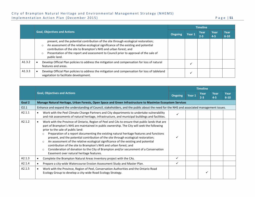
C i t y o f B r a m p t o n N a t u r a l H e r i t a g e a n d E n v i r o n m e n t a l M a n a g e m e n t S t r a t e g y ( N H E M S ) I m p l e m e n t a t i o n A c t i o n P l a n ( D e c e m b e r 2 0 1 5 ) P a g e | 51
Goal, Objectives and Actions
Timeline
Ongoing Year 1 Year 2-3
Year 4-5
Year 6-10
present, and the potential contribution of the site through ecological restoration; o An assessment of the relative ecological significance of the existing and potential
contribution of the site to Brampton’s NHS and urban forest; and o Presentation of the report and assessment to Council prior to approval of the sale of
public land.
A1.3.2 Develop Official Plan policies to address the mitigation and compensation for loss of natural features and areas.
A1.3.3 Develop Official Plan policies to address the mitigation and compensation for loss of tableland vegetation to facilitate development.
Goal, Objectives and Actions
Timeline
Ongoing Year 1 Year 2-3
Year 4-5
Year 6-10
Goal 2 Manage Natural Heritage, Urban Forests, Open Space and Green Infrastructure to Maximize Ecosystem Services
O2.1 Enhance and expand the understanding of Council, stakeholders, and the public about the need for the NHS and associated management issues.
A2.1.1 Work with the Peel Climate Change Partners and City departments to undertake vulnerability and risk assessments of natural heritage, infrastructure, and municipal buildings and facilities.
A2.1.2 Work with the Province of Ontario, Region of Peel and CAs to ensure that public lands that are part of Brampton’s NHS are maintained in public ownership. The City will seek the following prior to the sale of public land: o Preparation of a report documenting the existing natural heritage features and functions
present, and the potential contribution of the site through ecological restoration; o An assessment of the relative ecological significance of the existing and potential
contribution of the site to Brampton’s NHS and urban forest; and o Consideration of donation to the City of Brampton and/or securement of a Conservation
Easement over natural heritage features.
A2.1.3 Complete the Brampton Natural Areas Inventory project with the CAs.
A2.1.4 Prepare a city-wide Watercourse Erosion Assessment Study and Master Plan.
A2.1.5 Work with the Province, Region of Peel, Conservation Authorities and the Ontario Road Ecology Group to develop a city-wide Road Ecology Strategy.
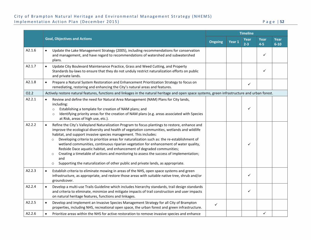
C i t y o f B r a m p t o n N a t u r a l H e r i t a g e a n d E n v i r o n m e n t a l M a n a g e m e n t S t r a t e g y ( N H E M S ) I m p l e m e n t a t i o n A c t i o n P l a n ( D e c e m b e r 2 0 1 5 ) P a g e | 52
Goal, Objectives and Actions
Timeline
Ongoing Year 1 Year 2-3
Year 4-5
Year 6-10
A2.1.6 Update the Lake Management Strategy (2005), including recommendations for conservation and management, and have regard to recommendations of watershed and subwatershed plans.
A2.1.7 Update City Boulevard Maintenance Practice, Grass and Weed Cutting, and Property Standards by-laws to ensure that they do not unduly restrict naturalization efforts on public and private lands.
A2.1.8 Prepare a Natural System Restoration and Enhancement Prioritization Strategy to focus on remediating, restoring and enhancing the City’s natural areas and features.
O2.2 Actively restore natural features, functions and linkages in the natural heritage and open space systems, green infrastructure and urban forest.
A2.2.1 Review and define the need for Natural Area Management (NAM) Plans for City lands, including: o Establishing a template for creation of NAM plans; and o Identifying priority areas for the creation of NAM plans (e.g. areas associated with Species
at Risk, areas of high use, etc.).
A2.2.2 Refine the City’s Valleyland Naturalization Program to focus plantings to restore, enhance and improve the ecological diversity and health of vegetation communities, wetlands and wildlife habitat, and support invasive species management. This includes: o Developing criteria to prioritize areas for naturalization such as: the re-establishment of
wetland communities, continuous riparian vegetation for enhancement of water quality, Redside Dace aquatic habitat, and enhancement of degraded communities;
o Creating a timetable of actions and monitoring to assess the success of implementation; and
o Supporting the naturalization of other public and private lands, as appropriate.
A2.2.3 Establish criteria to eliminate mowing in areas of the NHS, open space systems and green infrastructure, as appropriate, and restore those areas with suitable native tree, shrub and/or groundcover.
A2.2.4 Develop a multi-use Trails Guideline which includes hierarchy standards, trail design standards and criteria to eliminate, minimize and mitigate impacts of trail construction and user impacts on natural heritage features, functions and linkages.
A2.2.5 Develop and implement an Invasive Species Management Strategy for all City of Brampton properties, including NHS, recreational open space, the urban forest and green infrastructure.
A2.2.6 Prioritize areas within the NHS for active restoration to remove invasive species and enhance
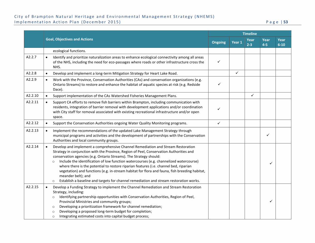
C i t y o f B r a m p t o n N a t u r a l H e r i t a g e a n d E n v i r o n m e n t a l M a n a g e m e n t S t r a t e g y ( N H E M S ) I m p l e m e n t a t i o n A c t i o n P l a n ( D e c e m b e r 2 0 1 5 ) P a g e | 53
Goal, Objectives and Actions
Timeline
Ongoing Year 1 Year 2-3
Year 4-5
Year 6-10
ecological functions.
A2.2.7 Identify and prioritize naturalization areas to enhance ecological connectivity among all areas of the NHS, including the need for eco-passages where roads or other infrastructure cross the NHS.
A2.2.8 Develop and implement a long-term Mitigation Strategy for Heart Lake Road.
A2.2.9 Work with the Province, Conservation Authorities (CAs) and conservation organizations (e.g. Ontario Streams) to restore and enhance the habitat of aquatic species at risk (e.g. Redside Dace).
A2.2.10 Support implementation of the CAs Watershed Fisheries Management Plans.
A2.2.11 Support CA efforts to remove fish barriers within Brampton, including communication with residents, integration of barrier removal with development applications and/or coordination with City staff for removal associated with existing recreational infrastructure and/or open space.
A2.2.12 Support the Conservation Authorities ongoing Water Quality Monitoring programs.
A2.2.13 Implement the recommendations of the updated Lake Management Strategy through municipal programs and activities and the development of partnerships with the Conservation Authorities and local community groups.
A2.2.14 Develop and implement a comprehensive Channel Remediation and Stream Restoration Strategy in conjunction with the Province, Region of Peel, Conservation Authorities and conservation agencies (e.g. Ontario Streams). The Strategy should: o Include the identification of low function watercourses (e.g. channelized watercourse)
where there is the potential to restore riparian features (i.e. channel bed, riparian vegetation) and functions (e.g. in-stream habitat for flora and fauna, fish breeding habitat, meander belt); and
o Establish a baseline and targets for channel remediation and stream restoration works.
A2.2.15 Develop a Funding Strategy to implement the Channel Remediation and Stream Restoration Strategy, including: o Identifying partnership opportunities with Conservation Authorities, Region of Peel,
Provincial Ministries and community groups; o Developing a prioritization framework for channel remediation; o Developing a proposed long-term budget for completion; o Integrating estimated costs into capital budget process;

C i t y o f B r a m p t o n N a t u r a l H e r i t a g e a n d E n v i r o n m e n t a l M a n a g e m e n t S t r a t e g y ( N H E M S ) I m p l e m e n t a t i o n A c t i o n P l a n ( D e c e m b e r 2 0 1 5 ) P a g e | 54
Goal, Objectives and Actions
Timeline
Ongoing Year 1 Year 2-3
Year 4-5
Year 6-10
o Building partnerships to increase funding from non-traditional sources (public, private, other);
o Exploring alternative funding mechanisms for remediation and restoration activities; and o Securing federal and provincial funding where possible.
A2.2.16 Work with infrastructure service providers such as the MTO/407 ETR, TransCanada Pipeline and Ontario Hydro to restore and enhance ecological functions and linkages along infrastructure corridors to connect Brampton’s NHS.
O2.3 Develop and implement an Urban Forest Management Strategy.
A2.3.1 Implement the Peel Urban Forest Strategy and support the Peel Urban Forest Working Group.
A2.3.2 Develop an Urban Forest Management Plan drawing on the study results and recommendations of the recently completed Brampton Urban Forest Study (2011). This includes: o Reviewing and updating the Brampton Urban Forest Study and recommendations for
urban forest improvements every ten years; o Developing a range of tree canopy targets for the city; including identifying tree cover
priorities and diversity targets; o Establishing a monitoring protocol for the total of number of trees planted city-wide and
on public lands per year; and o Identifying implementation needs for planting programs, including financial, human
resources, training and equipment.
A2.3.3 Develop a Priority Planting Tool to assist municipal staff and community partners to identify planting sites to maximize urban forest benefits across the city.
A2.3.4 Develop and implement a strategic plan to address the Emerald Ash Borer infestation, including priority removal of hazard trees, removal of other trees and the replacement of removed trees.
A2.3.5 Update the Landscape Standards and Guidelines to increase tree planting for new residential, commercial, industrial and institutional sites based on urban forest potential tree cover and species diversity targets.
A2.3.6 Update the Landscape Standards to increase tree planting requirements for City and regional arterial road projects.
A2.3.7 Update the Landscape Standards to increase soil quantity and quality for park and boulevard tree planting.

C i t y o f B r a m p t o n N a t u r a l H e r i t a g e a n d E n v i r o n m e n t a l M a n a g e m e n t S t r a t e g y ( N H E M S ) I m p l e m e n t a t i o n A c t i o n P l a n ( D e c e m b e r 2 0 1 5 ) P a g e | 55
Goal, Objectives and Actions
Timeline
Ongoing Year 1 Year 2-3
Year 4-5
Year 6-10
A2.3.8 Work with CAs to target actions intended to improve forest cover as recommended by the Watershed Report Card.
O2.4 Implement actions that enhance the supporting role of green infrastructure to the NHS and urban forest.
A2.4.1 Develop a Green Infrastructure Management Plan that includes: o Identifying the types and locations of green infrastructure and potential contribution to
NHS; o Establishing partnerships with agencies currently managing green infrastructure; and o Identifying and prioritizing actions to enhance natural features and functions associated
with green infrastructure.
A2.4.2 Identify, prioritize and implement actions within areas of existing green infrastructure that have the capacity to improve ecological linkage and/or buffering of the NHS through active restoration and management.
A2.4.3 Establish targets for the implementation of LID measures in new development, such as green roofs, permeable pavement, bioretention swales, rainwater harvesting, etc. to increase onsite groundwater infiltration, evapotranspiration and retention of stormwater.
A2.4.4 Partner with Conservation Authorities to implement a LID Strategy and encourage the adoption of LID measures in all new developments (i.e. greenfield, intensification, infill) and explore opportunities to retrofit LID measures in established neighbourhoods.
A2.4.5 Implement LID boulevard pilot projects in conjunction with the City’s Road Repaving Program.
A2.4.6 Expand the SNAP program, particularly for those communities that can benefit most, such as communities identified through Action 2.3.3 as having potential for enhancement of tree canopy cover and Action 2.4.3 having potential for LID retrofit.
A2.4.7 Continue to implement and update the City’s Salt and Snow Management programs to develop decision-making tools that address: o Material storage and handling; o Salt application timing and rates; o Snow storage and disposal; o Equipment and operational considerations; and o Training.
A2.4.8 Undertake pilot projects in City boulevards and right-of-ways, parks and open spaces to demonstrate the benefits of naturalized landscapes.
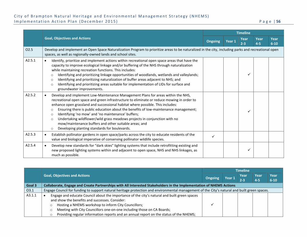
C i t y o f B r a m p t o n N a t u r a l H e r i t a g e a n d E n v i r o n m e n t a l M a n a g e m e n t S t r a t e g y ( N H E M S ) I m p l e m e n t a t i o n A c t i o n P l a n ( D e c e m b e r 2 0 1 5 ) P a g e | 56
Goal, Objectives and Actions
Timeline
Ongoing Year 1 Year 2-3
Year 4-5
Year 6-10
O2.5 Develop and implement an Open Space Naturalization Program to prioritize areas to be naturalized in the city, including parks and recreational open spaces, as well as regionally-owned lands and school sites.
A2.5.1 Identify, prioritize and implement actions within recreational open space areas that have the capacity to improve ecological linkage and/or buffering of the NHS through naturalization while maintaining recreation functions. This includes: o Identifying and prioritizing linkage opportunities of woodlands, wetlands and valleylands; o Identifying and prioritizing naturalization of buffer areas adjacent to NHS; and o Identifying and prioritizing areas suitable for implementation of LIDs for surface and
groundwater improvements.
A2.5.2 Develop and implement Low-Maintenance Management Plans for areas within the NHS, recreational open space and green infrastructure to eliminate or reduce mowing in order to enhance open grassland and successional habitat where possible. This includes: o Ensuring there is public education about the benefits of low-maintenance management; o Identifying ‘no mow’ and ‘no maintenance’ buffers; o Undertaking wildflower/wild grass meadows projects in conjunction with no
mow/maintenance buffers and other suitable areas; and o Developing planting standards for boulevards.
A2.5.3 Establish pollinator gardens in open space/parks across the city to educate residents of the value and biological imperative of conserving pollinator wildlife species.
A2.5.4 Develop new standards for “dark skies” lighting systems that include retrofitting existing and new proposed lighting systems within and adjacent to open space, NHS and NHS linkages, as much as possible.
Goal, Objectives and Actions
Timeline
Ongoing Year 1 Year 2-3
Year 4-5
Year 6-10
Goal 3 Collaborate, Engage and Create Partnerships with All Interested Stakeholders in the Implementation of NHEMS Actions
O3.1 Engage Council for funding to support natural heritage protection and environmental management of the City’s natural and built green spaces.
A3.1.1 Engage and educate Council about the importance of the city’s natural and built green spaces and show the benefits and successes. Consider: o Hosting a NHEMS workshop to inform City Councillors; o Meeting with City Councillors one-on-one including those on CA Boards; o Providing regular information reports and an annual report on the status of the NHEMS;

C i t y o f B r a m p t o n N a t u r a l H e r i t a g e a n d E n v i r o n m e n t a l M a n a g e m e n t S t r a t e g y ( N H E M S ) I m p l e m e n t a t i o n A c t i o n P l a n ( D e c e m b e r 2 0 1 5 ) P a g e | 57
Goal, Objectives and Actions
Timeline
Ongoing Year 1 Year 2-3
Year 4-5
Year 6-10
o Using a variety of communication means to provide Council with information about new and emerging issues, threats to green spaces, etc. as they arise;
o Orienting new City Councillors to the NHEMS when elected; o Providing FAQs to be able to respond to citizen inquiries or concerns; and o Providing examples of natural heritage protection, urban forest and best practices from
other communities.
A3.1.2 Secure Council support for the NHEMS strategies and initiatives through Council resolutions and endorsing the NHEMS.
A3.1.3 Link NHEMS initiatives/programs/actions to achieving goals of the Strategic Plan, EMP, other master plans, sustainability guidelines, etc.
O3.2 Improve inter-departmental and inter-agency information sharing and coordination to prioritize and implement programs and actions for natural heritage and environment management issues.
A3.2.1 Create multi-disciplinary municipal and conservation agency implementation teams to address NHEMS actions for corporate operations and community stewardship. These teams should: o Have appropriate representation of City and agency staff from planning, engineering,
maintenance and operations, enforcement, communications, recreation, culture, and stewardship and education;
o Provide forums to deliberate any NHEMS proposed actions to ensure they are feasible and supported by those designing, implementing, monitoring, enforcing or communicating about the initiatives;
o Define and refine annual municipal and agency implementation plans and capital budgeting to expressly identify how NHEMS actions and targets are being achieved;
o Collect municipal, regional and watershed information for status updates; o Identify municipal and agency priorities for upcoming years; and o Identify mechanisms to ensure that other strategies, plans and budgets align with the
NHEMS.
A3.2.2 Hold interdepartmental and interagency working sessions to allow senior staff an opportunity to share programs and initiatives, and discuss opportunities for collaboration or cross-promotion.
A3.2.3 Develop a Natural Heritage Training Program in collaboration with external partners for key municipal staff on new and emerging environmental issues as they are identified, such as: o Current policies, guidelines and by-laws related to natural heritage and environmental
management to ensure consistent messaging to proponents and the public, e.g. Compliance with Ontario’s Endangered Species Act (2007) on both public and private projects; application of the Migratory Birds Convention Act where it relates to timing restrictions for tree removals;

C i t y o f B r a m p t o n N a t u r a l H e r i t a g e a n d E n v i r o n m e n t a l M a n a g e m e n t S t r a t e g y ( N H E M S ) I m p l e m e n t a t i o n A c t i o n P l a n ( D e c e m b e r 2 0 1 5 ) P a g e | 58
Goal, Objectives and Actions
Timeline
Ongoing Year 1 Year 2-3
Year 4-5
Year 6-10
o Climate change adaptation and mitigation measures, e.g. best practices to avoid / minimize spread of invasive species when working within or adjacent to natural areas;
o Best practices for operational and maintenance issues, e.g. Species selection and soil volume / quality requirements for tree establishment; and
o Using outreach materials for current key issues and challenges, and program promotion and implementation, to address public questions and concerns.
A3.2.4 Establish an Internal Natural Heritage portal that is coordinated with the EMP to provide staff with targets, data, research, contacts, guidelines, standards, policies, studies, etc.
O3.3 Develop and deliver a coordinated natural heritage and environmental management communications, education and implementation strategy with the conservation agencies (e.g. CAs, Region of Peel, Province).
A3.3.1 Integrate the EMP and NHEMS education and communications materials to: o Develop a series of awareness and education campaign materials relating to EMP goals for
People, Land and Water with each of the four green space components, as appropriate. o Provide clear, concise and plain language for each target audience (i.e. Council, municipal
partners, community groups and residents); and o Use the EMP icons for all signs and interpretive and education materials.
A3.3.2 Coordinate with conservation partners a Natural Heritage and Environmental Management Communication and Engagement Strategy to educate and motivate the city’s stakeholders, residents and businesses to participate in stewardship, restoration and enhancement activities on public and private lands. The communications, outreach and education should: o Adopt a multi-media approach that integrates print (brochures, maps), video, web, and
social media to promote the NHEMS and EMP People, Land and Water components; o Promote natural heritage and Urban Forest workshops, stewardship events, and other
public activities, including launches of new publications and website pages, as well as the availability of updated tree protection/planting guidelines; and
o Communicate highlights from the EMP/NHEMS initiatives, programs and Update Reports.
A3.3.3 Develop a database of environmental resources, services, activities and events and create a more interactive platform and easier access to environmental program information.
A3.3.4 Conduct research to better understand the attitudes, behaviours, beliefs and values of different cultures in Brampton towards natural heritage protection and enhancement to better shape effective communication and education messages and mechanisms.
A3.3.5 Expand Brampton’s Environmental Education Program to highlight the EMP and NHEMS strategies through workshops and presentations for children, youth and adults on a broad range of environmental stewardship initiatives.
A3.3.6 Develop a NHEMS Interpretative Signage Strategy to raise awareness about the city's rivers,
C i t y o f B r a m p t o n N a t u r a l H e r i t a g e a n d E n v i r o n m e n t a l M a n a g e m e n t S t r a t e g y ( N H E M S ) I m p l e m e n t a t i o n A c t i o n P l a n ( D e c e m b e r 2 0 1 5 ) P a g e | 59
Goal, Objectives and Actions
Timeline
Ongoing Year 1 Year 2-3
Year 4-5
Year 6-10
other natural features and green spaces.
A3.3.7 Develop a Human and Wildlife Conflict Strategy aimed at educating residents and City staff about how to resolve and prevent annoying and threatening human/wildlife interactions.
O3.4 Develop and implement a Community Environmental Stewardship Network to support and expand private and public land stewardship and partnerships activities. This includes:
Province, Region of Peel and Conservation Authorities for public and private lands;
Infrastructure Service providers (i.e. Hydro One Brampton, TransCanada Pipeline, Enbridge, MTO to enhance ecosystem functions in utility and infrastructure corridors; and
NGOs and other community groups such as Ontario Streams, Sierra Club Peel, etc.
A3.4.1 Establish and coordinate a Community Environmental Stewardship Network (through the Brampton Environment Advisory Committee) of NGO’s, Region, Conservation Authorities, conservation organizations, businesses, faith groups, and school boards to communicate about stewardship activities and deliver a range of programming to undertake stewardship on private and public lands.
A3.4.2 Create a Community Stewardship Strategy to support the Community Environmental Stewardship Network. The strategy should: o Invite community groups to public meetings/workshops/networking events to learn about
projects and provide input. Identify strategies for shared communications and information sharing to further reach of programs and initiatives; and
o Establish a database of priority community stewardship projects, interested residents and community groups involved in stewardship that is accessible by the environmental network.
A3.4.3 Develop and maintain an inventory of NHEMS supportive Community Environmental Programs from organizations in Brampton for both communication and recruitment programs.
A3.4.4 Build a network of businesses that are seeking to sponsor stewardship programs, events and activities on public and/or private lands.
A3.4.5 Create a forum that builds on relationships with the Region of Peel, Conservation Authorities, and neighbouring municipalities to facilitate information sharing and shared action on appropriate region and watershed-wide natural heritage and environmental management issues.
A3.4.6 Support and collaborate with local Conservation Authorities and Region of Peel to collect and share baseline natural heritage inventory data, research findings, implementation strategies, monitoring activities as well as education and outreach opportunities.
A3.4.7 Support and collaborate with watershed-focused volunteer groups.
A3.4.8 Support and coordinate with Conservation Authorities and Region of Peel to develop a

C i t y o f B r a m p t o n N a t u r a l H e r i t a g e a n d E n v i r o n m e n t a l M a n a g e m e n t S t r a t e g y ( N H E M S ) I m p l e m e n t a t i o n A c t i o n P l a n ( D e c e m b e r 2 0 1 5 ) P a g e | 60
Goal, Objectives and Actions
Timeline
Ongoing Year 1 Year 2-3
Year 4-5
Year 6-10
community education and awareness campaign for water quality impacts of stormwater runoff, including runoff from private properties impacted by fertilizers, pesticides, car washing, pets, swimming pool care, etc.
A3.4.9 Expand and develop partnerships with Hydro One, TransCanada Pipeline, Enbridge, MTO/407, and other providers to enhance ecosystem functions in utility and infrastructure corridors.
A3.4.10 Host workshops and meetings with infrastructure providers in collaboration with Conservation Authorities, to explore opportunities to enhance ecological features and functions associated with green infrastructure.
A3.4.11 Identify municipal and Conservation Authority programs for naturalization of infrastructure lands to prioritize and allocate budget for enhancement activities.
A3.4.12 Establish permissions with infrastructure service providers to inventory corridors and monitor enhancement measures.
O3.5 Develop a strategy that fosters and supports homeowner and landowner environmental and sustainable stewardship.
A3.5.1 Expand the County Court SNAP framework to other neighbourhoods in Brampton in conjunction with CVC, TRCA and Peel to promote social, cultural, recreational and environmental benefits.
A3.5.2 Coordinate with Conservation Authorities and Region of Peel an Urban Naturalization Program to: o Support and expand existing Conservation Authority and Peel residential ‘greening’
programs (i.e. CVC’s Greening Your Yard, TRCA’s Healthy Yards, and Peel’s Fusion Gardens); and
o Identify assistance for homeowners to facilitate naturalization (e.g. develop an annual private tree planting program that includes discounted trees and planting advice for homeowners).
A3.5.3 Engage homebuilders to promote environmental options to home buyers to enable sustainable home choices (e.g. rain gardens, naturalization, etc.)
A3.5.4 Support Conservation Authorities and Region of Peel programs that provide new home buyers with a suite of landscaping options and other environmental features.
A3.5.5 Host events to promote and showcase new environmental initiatives and practices for homeowners (i.e. environmental trade show).
A3.5.6 Develop a Naturalization Communication Strategy to improve the community’s acceptance of naturalization measures. This should include: o Distributing communication materials to existing neighbourhoods that describes municipal
and Conservation Authority naturalization efforts on public and private lands; o Focusing on the benefits of naturalization and Brampton’s urban forest specifically, and

C i t y o f B r a m p t o n N a t u r a l H e r i t a g e a n d E n v i r o n m e n t a l M a n a g e m e n t S t r a t e g y ( N H E M S ) I m p l e m e n t a t i o n A c t i o n P l a n ( D e c e m b e r 2 0 1 5 ) P a g e | 61
Goal, Objectives and Actions
Timeline
Ongoing Year 1 Year 2-3
Year 4-5
Year 6-10
how residents and businesses can assist in maintaining its health; o Distributing communication materials that promotes naturalization programs for private
homeowners including the Conservation Authorities ‘green yards’ and the Region of Peel ‘Fusion Landscaping’; and
o Developing a signage program to educate residents of the benefits of naturalized landscapes.
O3.6 Support Provincial, Region of Peel, and Conservation Authority corporate green programs and initiatives.
A3.6.1 Support the Conservation Authorities ‘Greening Corporate Grounds’ and ‘Partners in Project Green’ programs, to restore, expand and enhance natural heritage features on their properties, through the following activities: o Continuing to support and expand targeted stewardship of local business, industry and
institutional lands; o Establishing and maintaining a green business database to facilitate outreach initiatives
aimed at greening management practices; and o Creating stewardship material specifically directed to corporations with large private land
holdings, that outlines the benefits of naturalizing and low-energy maintenance practices, and the role those lands can play in providing and supporting ecosystem benefits.
A3.6.2 Promote the development of eco-business districts across the city.
A3.6.3 Support the Region's Fusion Landscaping Program to encourage the planting of native species to reduce watering requirements for residents.
A3.6.4 Continue to support and expand engagement of youth and stewardship of school grounds and in the community: o Support TRCA and CVC school-directed programs (e.g. Ontario EcoSchools Certification
Program); o Work with schools/school boards to restore, expand and enhance natural heritage
features and urban forest on their properties; and o Explore opportunities for school grounds greening.
O.3.7 Engage schools and youth in natural heritage stewardship as part of the development and implementation of the Grow Green Partnership Strategy.
A3.7.1 Coordinate with the Conservation Authorities a NHEMS Youth Engagement Strategy that: o Connects with Eco-schools and green clubs; o Supports Ecomentors and Ecochallenges; o Designs and delivers events that support youth participation (e.g. competition, specific
events for school yard clean-ups); o Integrates social media; o Identifies and partners with environmental champions among teachers; and o Includes a train-the-trainer program for school champions.

C i t y o f B r a m p t o n N a t u r a l H e r i t a g e a n d E n v i r o n m e n t a l M a n a g e m e n t S t r a t e g y ( N H E M S ) I m p l e m e n t a t i o n A c t i o n P l a n ( D e c e m b e r 2 0 1 5 ) P a g e | 62
Goal, Objectives and Actions
Timeline
Ongoing Year 1 Year 2-3
Year 4-5
Year 6-10
A3.7.2 Encourage youth representatives for BEAC.
A3.7.3 Develop programs and projects with the MNR Stewardship Rangers and CVC Conservation Youth Corp.
A3.7.4 Expand the City’s Outdoor Education programs to encourage student participation in municipal and Conservation Authority environmental programs and activities.
A3.7.5 Identify potential partnerships with different school boards and private schools as well as local youth groups (e.g. Peel Environmental Youth Alliance, community groups).
A3.7.6 Provide support for school-led funding applications for natural heritage or urban forest projects.
A3.7.7 Explore opportunities for local schools to become involved in NHEMS education, stewardship and monitoring activities.
O3.8 Pursue external funding opportunities to implement NHEMS actions in conjunction with partners.
A3.8.1 Collaborate with conservation agencies and organizations to broaden the search for governmental and non-governmental funding opportunities.
A3.8.2 Provide support to conservation organizations, schools and businesses as they seek funding when projects align with the NHEMS goals.
A3.8.3 Explore opportunities to partner with different departments in the City and inter-municipally to pursue different funding avenues.
Goal, Objectives and Actions
Timeline
Ongoing Year 1 Year 2-3
Year 4-5
Year 6-10
Goal 4 Track and Monitor the Performance of the NHEMS
O4.1 Establish an ongoing monitoring and adaptive management framework for the Natural Heritage System, open space and green infrastructure.
A4.1.1 Establish baselines and update information required to assess NHEMS targets for the NHS, open space, green infrastructure and urban forest.
A4.1.2 Measure sustainability in Brampton based on the combined contribution of the NHS, recreational open space, urban forest, and green infrastructure (managed, restored and/or naturalized) using established NHEMS baseline and targets.
A4.1.3 Maintain the City of Brampton Natural Areas Inventory to continually update site information related to the ecological condition of natural areas, the success of management actions and current threats to ecological integrity.
A4.1.4 Maintain a GIS inventory of all existing and future restoration, enhancement and planting projects including municipal, CA and community organizations and development in the NHS,
C i t y o f B r a m p t o n N a t u r a l H e r i t a g e a n d E n v i r o n m e n t a l M a n a g e m e n t S t r a t e g y ( N H E M S ) I m p l e m e n t a t i o n A c t i o n P l a n ( D e c e m b e r 2 0 1 5 ) P a g e | 63
Goal, Objectives and Actions
Timeline
Ongoing Year 1 Year 2-3
Year 4-5
Year 6-10
open space and green infrastructure (by area and planting numbers on public and private lands).
O4.2 Establish a monitoring program and adaptive management framework for the urban forest.
A4.2.1 Review and update the Brampton Urban Forest Study every ten years, including the urban forest canopy assessment and recommendations for urban forest improvements.
A4.2.2 Develop and maintain a street and park tree inventory.
A4.2.3 Develop a range of tree canopy targets for the city (as identified in A2.3.2).
O4.3 Integrate NHEMS reporting with Brampton Grow Green and conservation partners.
A4.3.1 Coordinate NHEMS monitoring and reporting with Brampton Grow Green to share environmental progress including the preparation of; Canvas of Environmental Initiatives, Annual Report to Council; and Sustainable Brampton Report. The report will clearly outline what actions of the NHEMS our conservation partners have implemented, and how this work aligns with each agency/organization’s stewardship roles and responsibilities.
A.4.3.2 Integrate information and results from provincial, regional and Conservation Authority monitoring programs (e.g. Watershed Reports Card) into Brampton’s environmental performance monitoring and reporting.
A.4.3.3 Support the Conservation Authorities ongoing Water Quality Monitoring programs by communicating monitoring results with residents and actions that can be taken to contribute to improved water quality.
C i t y o f B r a m p t o n N a t u r a l H e r i t a g e a n d E n v i r o n m e n t a l M a n a g e m e n t S t r a t e g y ( N H E M S ) I m p l e m e n t a t i o n A c t i o n P l a n ( D e c e m b e r 2 0 1 5 ) P a g e | 64
5. Sharing Environmental Performance
As stated in Brampton Grow Green, the City’s Environmental Master Plan: “Reporting the City’s environmental initiatives
and progress to the community is a way to continually promote environmental awareness, share and celebrate success
and build strong community support. Reporting on what is measured and monitored creates a dialogue between Council,
municipal departments, and the public. Providing information that the community can easily access increases
engagement, generates new ideas and instills ownership for Brampton’s environmental future.”
Brampton Grow Green has identified three communications tools to showcase the City’s environmental progress; these
tools are equally relevant to reporting the implementation, and showcase the progress made through the NHEMS. They
are:
1. Canvas of Environmental Initiatives
2. Annual Report to Council
3. Sustainable Brampton Report
Canvas of Environmental Initiatives
A key step in understanding the extent and nature of current environmental initiatives in Brampton was the
development of the Canvas of Environmental Initiatives through the EMP. The Canvas provides a snapshot of the many
studies, programs, and activities that Brampton and its conservation partners (i.e. Region of Peel, TRCA and CVC) are
undertaking to improve the City’s environmental performance. The Canvas was developed for Brampton Grow Green
and was updated in 2014. The Canvas is a ‘working list’ that will be updated annually to reflect new environmental and
sustainable initiatives as they are identified and implemented. The Canvas can be found in the Appendix of the
Brampton Grow Green Environmental Master Plan: Implementation Action Plan and at
www.brampton.ca/bramptongrowgreen.
Annual Council Report
An annual report to Council will focus on what actions from the EMP and NHEMS have been implemented over the
preceding year. This report will clearly and plainly describe what elements of the NHEMS the City has implemented, where
and how the City will concentrate its efforts in the coming year to move the Strategy ahead, and what are the resourcing
challenges and constraints, as well as lessons learned during implementation.
The report will also clearly outline what actions of the NHEMS our conservation partners have implemented, and how
this work aligns with each agency/organization’s stewardship roles and responsibilities. The intent is to ensure the
maximization of each agency’s resources and better management of our shared responsibilities for Brampton’s natural
heritage system, urban forest and green infrastructure.
Sustainable Brampton Report
The Sustainable Brampton Report will not only include information that Brampton is collecting regarding NHEMS (and
EMP) metrics and targets, but will also be a natural place to share long-term data and monitoring provided by the City’s
partners such as the Province (e.g. Transportation for Tomorrow), Region of Peel (e.g. Water Management Systems) and
Conservation Authorities (e.g. Watershed Report Cards). This report will be available in a variety of languages and will
C i t y o f B r a m p t o n N a t u r a l H e r i t a g e a n d E n v i r o n m e n t a l M a n a g e m e n t S t r a t e g y ( N H E M S ) I m p l e m e n t a t i o n A c t i o n P l a n ( D e c e m b e r 2 0 1 5 ) P a g e | 65
clearly and plainly describe what elements of the NHEMS the City has implemented, what progress is being made to
achieve the targets, and where and how the City will concentrate its efforts in the coming years to move the NHEMS
ahead. Over time, members of the community will look to the Sustainable Brampton Report to get the most
comprehensive picture of Brampton’s environmental progress.
The City encourages residents, businesses, institutions and visitors to connect with conservation partners to understand
what is happening in and around the province, Region of Peel and within the Conservation Authorities’ watersheds that
contributes to the health of Brampton’s built and natural environments. The conservation agencies websites provide
information regarding new and ongoing initiatives, including legislation and regulations, plans, policies and programs.
6. How the NHEMS will Evolve
Developing the Natural Heritage and Environmental Management Strategy represents the City’s first comprehensive
framework to conserve, restore and enhance the ecological services of its natural heritage and open space systems,
green infrastructure and the urban forest. The Strategy, like other City master plans, will be required to be updated every
five years to ensure the document remains current, relevant and reflective of the City’s changing ecological goals and
priorities. The NHEMS Performance Framework has the flexibility to add additional indicators and metrics that may track
different data and targets that become more relevant as priorities or environmental conditions shift.
The evolution of the NHEMS will be largely found in the targets and related actions which are expected to grow over
time. As the City becomes more accustomed to measuring and tracking environmental data, it may add additional
targets to its list of priorities and in turn, add or modify the actions identified to help reach those targets. The NHEMS
reflects the best practices and ambitions for the City and community at this time of the Strategy’s creation, but
provides flexibility for improvement, enhancement and change over time to reflect the community it serves.
C i t y o f B r a m p t o n N a t u r a l H e r i t a g e a n d E n v i r o n m e n t a l M a n a g e m e n t S t r a t e g y ( N H E M S ) I m p l e m e n t a t i o n A c t i o n P l a n ( D e c e m b e r 2 0 1 5 ) P a g e | 66
7. Glossary of Terms
Active transportation – Human-powered travel, including but not limited to, walking, cycling, inline skating and travel
with the use of mobility aids, including motorized wheelchairs and other power-assisted devices moving at a comparable
speed (Provincial Policy Statement, 2014).
Adaptive management – A tool for land use/resource managers that acknowledges that our understanding of natural
systems and ecosystem services is incomplete, and that a systematic process is necessary to continually assess and
improve management policies and practices to best ensure robust decision making in the face of uncertainty, and
enables a balance between gaining knowledge to improve management in the future and achieving the best short-term
outcome based on current knowledge. Description adapted from: United Nations Millennium Ecosystem Assessment
2005, and Allan & Stankey 2009. (Catherine Allan and George H. Stankey (2009). Adaptive Environmental Management:
A Practitioner’s Guide. The Netherlands: Dordrecht. ISBN 978-90-481-2710-8).
Aquatic systems – Water based systems such as rivers, streams, ponds and lakes.
Biodiversity – All living things and the ways they interact with each other and their environment. Three levels of
biodiversity are noted: genetic diversity — the variety of genetic information contained in individual plants, animals and
micro-organisms; species diversity — the variety of species; and ecosystem diversity — the variety of habitats, ecological
communities and ecological processes (Ontario Biodiversity Strategy 2011).
Ecological features – Environmental components which are most visible, both living things like plants and animals, as
well as non-living things such as soil, topography, water, rock, etc.
Ecological functions – The natural processes, products or services that living and non-living environments provide or
perform within or between species, ecosystems and landscapes. These may include biological, physical and socio-
economic interactions (Provincial Policy Statement, 2014).
Ecological interactions – The relation between species that live together in a community; specifically, the effect an
individual of one species may exert on an individual of another species.
Eco-passage – A series of guidewalls and under-highway tunnels that allow wildlife to safely cross roadways.
Edge – Most often considered along the perimeter of a woodland patch, but may also be associated with other habitat
types such as wetlands or meadow habitats. The concern is edge effects may not provide ideal habitat conditions due to
a different micro-environment of light, wind, humidity, temperature, etc., and due to the presence of competing and/or
invasive species that invade edge habitat.
Fish habitat – As defined in the Fisheries Act , c. F-14 , means spawning grounds and nursery, rearing, food supply, and
migration areas on which fish depend directly or indirectly in order to carry out their life processes (Provincial Policy
Statement, 2014).

C i t y o f B r a m p t o n N a t u r a l H e r i t a g e a n d E n v i r o n m e n t a l M a n a g e m e n t S t r a t e g y ( N H E M S ) I m p l e m e n t a t i o n A c t i o n P l a n ( D e c e m b e r 2 0 1 5 ) P a g e | 67
Fusion landscaping – A landscaping and garden design that brings together the lush splendour of traditional gardens
with modern, eco-friendly plants, flowers, colours and textures.
Greenbelt – An area of permanently protected green space, farmland, communities, forests, wetlands and watersheds.
The Greenbelt protects environmentally sensitive land and farmland in Ontario’s Golden Horseshoe area from urban
development, and serves as a legacy for all Ontarians by preserving and enhancing our natural and cultural heritage.
Green infrastructure – Natural and human-made elements that provide ecological and hydrological functions and
processes. Green infrastructure (GI) can include components such as natural heritage features and systems, parklands,
stormwater management systems, street trees, urban forests, natural channels, permeable surfaces, and green roofs
(Provincial Policy Statement, 2014). The Green Infrastructure Coalition also notes that GI means to incorporate natural
vegetation and vegetative technologies in the built environment http://www.greeninfrastructureontario.org/report. For
the purposes of the NHEMS, Green infrastructure is referring only to lands associated with infrastructure service
corridors, road boulevards and stormwater management facilities.
Interior habitat – Also known as core habitat, the habitat that is most representative of the woodland, wetland or open
habitat patch, providing the most suitable or preferred habitat of native plants and animals. Interior habitat is not
influenced by edge effects.
Invasive species – A plant or animal that is not native to a specific location (an Introduced species), and has a tendency
to spread, which is believed to cause impacts and/or damage to the environment, human economy and/or human
health.
Natural heritage system – A system made up of natural heritage features and areas, with linkages intended to provide
connectivity (at the regional or site level) and support natural processes, which are necessary to maintain biological and
geological diversity, natural functions, viable populations of indigenous species, and ecosystems (Provincial Policy
Statement, 2014).
Niagara Escarpment – Ontario’s Niagara Escarpment is a working countryside and a cornerstone of Ontario’s Greenbelt.
It is a protected area, recognized provincially and internationally as a significant landform with a system of development
control in place to guide development in its area.
Nutrient cycling – The movement and exchange of organic and inorganic matter back into the production of living
matter. The process is regulated by food web pathways that decompose matter into mineral nutrients.
Oak Ridge Moraine - An environmentally sensitive, geological landform in south central Ontario, covering 190,000
hectares.
Open space system – Components include parks, open space links, the multi-use trail system, natural features and
stormwater management facilities. Open space systems provide a key structural element of the community, and
perform several principle functions, including establishing the character of neighbourhoods, enhancing the built
environment, and providing both passive and active recreational opportunities within the various types of open space
and parks.

C i t y o f B r a m p t o n N a t u r a l H e r i t a g e a n d E n v i r o n m e n t a l M a n a g e m e n t S t r a t e g y ( N H E M S ) I m p l e m e n t a t i o n A c t i o n P l a n ( D e c e m b e r 2 0 1 5 ) P a g e | 68
Riparian cover – Also called riparian vegetation; refers to plant communities along the river margins and banks.
Soil formation – The process by which soil is made.
Soundscape – Refers to both the natural acoustic environment that consists of natural sounds, such as the sounds of
weather and other natural elements including animal vocalizations, and environmental sounds created by humans
including ordinary human activities (e.g. conversation, work, music), and mechanical sounds resulting from technology
(e.g. industry, vehicles, equipment). The disruption of these acoustic environments results in noise pollution.
Stable top of bank – The edge of the channel or bank, if there is a sharp change from the steep slope of the channel or
bank to the shallower slope of the field area, or the normal full extent of the watercourse when it contains the
maximum volume of water without flooding, if the change in slope does not exist (Greenbelt Plan, 2005).
Systems approach – The management of natural heritage as a unified, purposeful system composed of interrelated
parts.
Tableland – Any land that does not contain hazard, open space, or other limiting features that would prohibit
development.
Terrestrial systems – Land based systems such as forests, thickets, meadows and wetlands.
Urban forest – Includes all trees, shrubs, understory plants, as well as the soils that sustain them (Peel Urban Forest
Strategy, 2011).
Urban heat island effect – A condition that occurs when the average temperature in a city is higher than nearby rural
areas. The temperature is mostly caused by materials in urban areas like concrete and asphalt that absorb sunlight and
store it in large thermal masses. A secondary cause is waste heat generated by buildings, traffic, etc. The difference
between urban temperatures over regional averages is most striking at night, and especially during the winter.
Valleyland – A natural area that occurs in a valley or other landform depression that has water flowing through or
standing for some period of the year (Provincial Policy Statement, 2014).
Vegetation protection zone – A vegetated buffer area surrounding a key natural heritage feature or key hydrologic
feature within which only those land uses permitted within the feature itself are permitted. The width of the vegetation
protection zone is to be determined when new development or site alteration occurs within 120 metres of a key natural
heritage feature or key hydrologic feature, and is to be of sufficient size to protect the feature and its functions from the
impacts of the proposed change and associated activities that will occur before, during, and after, construction, and
where possible, restore or enhance the feature and/or its function (Greenbelt Plan, 2005).
Wildlife habitat – Areas where plants, animals and other organisms live, and find adequate amounts of food, water,
shelter and space needed to sustain their populations. Specific wildlife habitats of concern may include areas where
species concentrate at a vulnerable point in their annual life cycle; and areas that are important to migratory and non-
migratory species (Provincial Policy Statement, 2014).