navstar global positioning system (gps) documents/other services/sbb/case... · case study 3...
TRANSCRIPT


3CASE STUDY
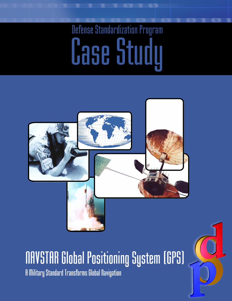
NAVSTAR Global Positioning System (GPS)Standardization Case StudyA Military Standard Transforms Global Navigation
On rare occasions military standards have the power to transform how the world does business.
One military system, the NAVSTAR (Navigation Satellite Timing and Ranging) Global Posi-
tioning System (GPS), is an example. It helped transform military strategy and logistics, affect-
ed many commercial industries, and became the worldwide standard for navigation.
This case study demonstrates the far-reaching benefits of strategic standardization. Strategic
standardization is the use of standard items across different weapon systems, Military Services,
or applications to achieve strategic objectives such as interoperability, logistics readiness, or cost
savings. GPS, the largest avionics procurement and installation program in the history of DoD,
illustrates how strategic standardization can have global impact. When integration and installa-
tion are complete, GPS will be
◆ in the hands of every warfighter,
◆ available in about 18,000 aircraft (more than 100 different types, models, and series), and
◆ on board most other weapon systems that include 435 ships, 35,000 vehicles, and numer-
ous precision guided weapons.
GPS is a government developed and operated system of satellites, ground stations, and user
equipment that provides accurate position, velocity, and time (PVT) information to government
and civilian users. In 1983, after the Soviet Union shot down Korean Flight 007 when it acci-
dentally strayed across Soviet airspace, President Ronald Reagan issued a directive that made
GPS receiver and signal specifications available to the public. This act opened the doors to
open-market competition for the design and manufacture of GPS equipment and fostered an
estimated $8 billion global market for GPS-related goods and services, a demand that doubles
every 3 years. The development of civilian and industrial GPS receivers had important military
benefits. During the Persian Gulf War, the military need for GPS equipment exceeded the sup-
ply available in the military inventory. Because the receiver design was in the public domain, the
military was able to obtain the additional units it needed through the commercial market.
By providing precise, instantaneous PVT information anywhere on the globe at any time, in
any weather, GPS, designed for a military need, now serves a broad range of civilian industries
4 DEFENSE STANDARDIZATION PROGRAM
including construction, agriculture, mining, transportation, and telecom-
munications.
Because the U.S. government realized the vast potential of the technol-
ogy and allowed free public use of the signal and receiver design specifi-
cations, GPS became the worldwide navigation standard. GPS is
available for all nations, making it possible for developed and developing
nations alike to benefit in the areas of safe aviation, maritime navigation,
precise time distribution, and many other applications.
GPS Development HistoryDuring the Cold War (1945–1991), DoD needed precise navigation and
positioning capabilities to accurately strike enemy missile silos and other
targets. GPS provided the solution. Navigation and positioning have
always been difficult to accomplish, and no other system has approached
the ease and accuracy of GPS.
Throughout the 1960s, the Navy and Air Force worked on numerous
systems that could provide navigation for various applications. Many of
these systems were incompatible with one another. In 1973, DoD direct-
ed the Military Services to unify or standardize their systems. The result
was a joint effort to develop GPS under the direction of the Joint Pro-
gram Office (JPO) and the U.S. Air Force Space Division located at
Los Angeles AFB, California. The first operational GPS satellite was
launched in February 1989. The final satellite for Initial Operational
Capability was launched in June 1993.
GPS burst into public awareness during the Persian Gulf War in 1991.
The celebrated accuracy of U.S. weapons used during that conflict is
due in large part to GPS. When commercial receivers were used during
the conflict, no changes were required to adapt them for military use.
The ability to rapidly employ commercial GPS equipment for military
purposes underscored the wisdom and importance of making the tech-
nology and standards commercially available.
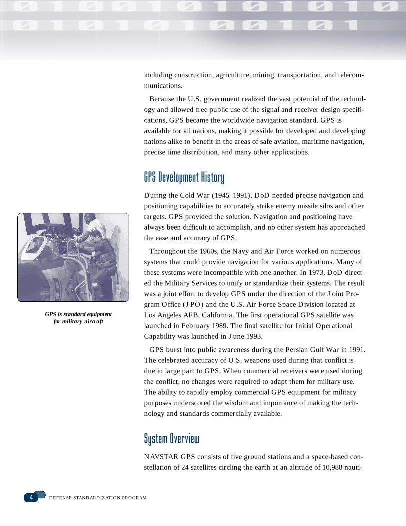
System OverviewNAVSTAR GPS consists of five ground stations and a space-based con-
stellation of 24 satellites circling the earth at an altitude of 10,988 nauti-
GPS is standard equipment for military aircraft
5CASE STUDY
cal miles, each transmitting standard radio signals. The NAVSTAR sys-
tem permits users on land, at sea, and in the air to determine their three-
dimensional position, velocity, and time 24 hours a day, 7 days a week,
in all weather, anywhere in the world with precision and accuracy. The
signals are so accurate that time can be figured to within 100 nanosec-
onds, velocity can be figured to within a fraction of a mile per hour, and
location can be figured to within meters.
GPS has three segments: space, control, and user equipment. The
space segment consists of satellites and the signals they emit. The GPS
satellites serve as reference points in space. A user’s GPS receiver can
see between five and eight satellites from any point on the earth. Each
satellite transmits signals that carry time and position data.
The control segment consists of one Master Control Station (MCS),
located in Colorado Springs, Colorado, and several remotely controlled
monitoring stations around the world that enable communication with
the satellites.
The user equipment segment consists of GPS receivers and related
antennas, test equipment, and software used on aircraft, ships, ground
vehicles, or hand carried by individuals. This segment provides users
with the capability to receive, decode, and process GPS signals.
Two types of GPS service are available: Standard Positioning Service
(SPS) and Precise Positioning Service (PPS), which provides the high-
est level of dynamic positioning accuracy. Civil users access SPS without
charge or restrictions. Commercial receivers use the SPS signal. Autho-
rized users with cryptographic equipment and keys use specially
equipped PPS receivers. U.S. and Allied military, certain U.S. govern-
ment agencies, and selected civil applications specifically approved by
the U.S. government can use the PPS.
GPS ProgramDoD directs and funds the GPS program. The JPO employs more than
400 personnel from the U.S. Air Force, U.S. Army, U.S. Navy, U.S.
Coast Guard, NATO, and Australia. Through its close working relation-
ships with the Military Services and Allies, the JPO has ensured inter-
operability and commonality through standardization across diverse
aircraft, ground vehicles, ships, submarines, and hand-held receivers for
Standardization and commonality
reduce acquisition costs for users
by spreading development costs
and lowering life-cycle costs.
U.S. and Allied forces. In addition, the JPO manages the sales of GPS
technology, hardware, and services for member countries. By using a
standard system and a single buying activity, the United States and its
Allies realize significant economies of scale and buying leverage, lower-
ing total ownership cost.
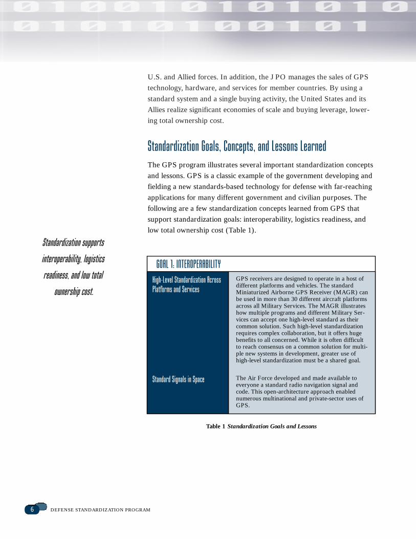
Standardization Goals, Concepts, and Lessons LearnedThe GPS program illustrates several important standardization concepts
and lessons. GPS is a classic example of the government developing and
fielding a new standards-based technology for defense with far-reaching
applications for many different government and civilian purposes. The
following are a few standardization concepts learned from GPS that
support standardization goals: interoperability, logistics readiness, and
low total ownership cost (Table 1).
6 DEFENSE STANDARDIZATION PROGRAM
GOAL 1: INTEROPERABILITY
High-Level Standardization AcrossPlatforms and Services
GPS receivers are designed to operate in a host ofdifferent platforms and vehicles. The standardMiniaturized Airborne GPS Receiver (MAGR) canbe used in more than 30 different aircraft platformsacross all Military Services. The MAGR illustrateshow multiple programs and different Military Ser-vices can accept one high-level standard as theircommon solution. Such high-level standardizationrequires complex collaboration, but it offers hugebenefits to all concerned. While it is often difficultto reach consensus on a common solution for multi-ple new systems in development, greater use ofhigh-level standardization must be a shared goal.
The Air Force developed and made available toeveryone a standard radio navigation signal andcode. This open-architecture approach enablednumerous multinational and private-sector uses ofGPS.
Standard Signals in Space
Table 1 Standardization Goals and Lessons
Standardization supports
interoperability, logistics
readiness, and low total
ownership cost.
7CASE STUDY
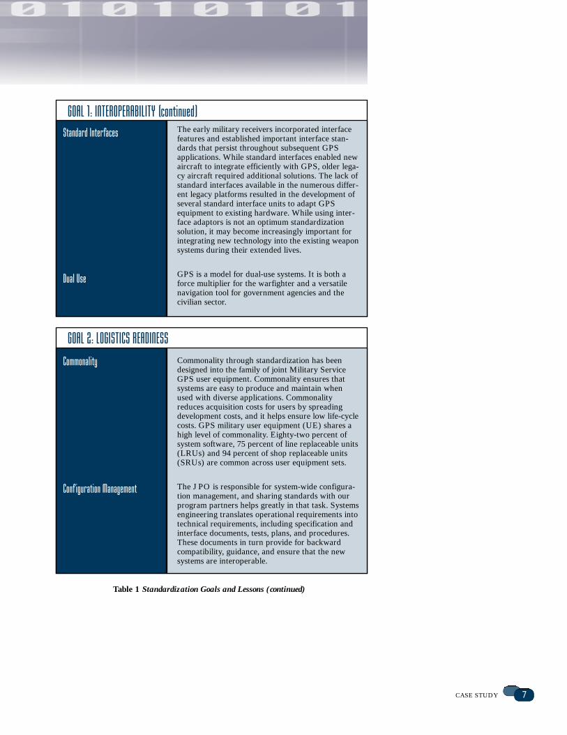
Standard Interfaces
GOAL 1: INTEROPERABILITY (continued)The early military receivers incorporated interfacefeatures and established important interface stan-dards that persist throughout subsequent GPSapplications. While standard interfaces enabled newaircraft to integrate efficiently with GPS, older lega-cy aircraft required additional solutions. The lack ofstandard interfaces available in the numerous differ-ent legacy platforms resulted in the development ofseveral standard interface units to adapt GPSequipment to existing hardware. While using inter-face adaptors is not an optimum standardizationsolution, it may become increasingly important forintegrating new technology into the existing weaponsystems during their extended lives.
GPS is a model for dual-use systems. It is both aforce multiplier for the warfighter and a versatilenavigation tool for government agencies and thecivilian sector.
Dual Use
GOAL 2: LOGISTICS READINESS
Commonality
Conf iguration Management
Commonality through standardization has beendesigned into the family of joint Military ServiceGPS user equipment. Commonality ensures thatsystems are easy to produce and maintain whenused with diverse applications. Commonalityreduces acquisition costs for users by spreadingdevelopment costs, and it helps ensure low life-cyclecosts. GPS military user equipment (UE) shares ahigh level of commonality. Eighty-two percent ofsystem software, 75 percent of line replaceable units(LRUs) and 94 percent of shop replaceable units(SRUs) are common across user equipment sets.
The JPO is responsible for system-wide configura-tion management, and sharing standards with ourprogram partners helps greatly in that task. Systemsengineering translates operational requirements intotechnical requirements, including specification andinterface documents, tests, plans, and procedures.These documents in turn provide for backwardcompatibility, guidance, and ensure that the newsystems are interoperable.
Table 1 Standardization Goals and Lessons (continued)
8 DEFENSE STANDARDIZATION PROGRAM
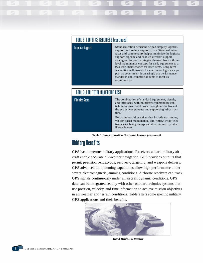
Military Benef itsGPS has numerous military applications. Receivers aboard military air-
craft enable accurate all-weather navigation. GPS provides outputs that
permit precision rendezvous, recovery, targeting, and weapons delivery.
GPS advanced anti-jamming capabilities allow high performance under
severe electromagnetic jamming conditions. Airborne receivers can track
GPS signals continuously under all aircraft dynamic conditions. GPS
data can be integrated readily with other onboard avionics systems that
use position, velocity, and time information to achieve mission objectives
in all weather and terrain conditions. Table 2 lists some specific military
GPS applications and their benefits.
Logistics Support
GOAL 2: LOGISTICS READINESS (continued)Standardization decisions helped simplify logisticssupport and reduce support costs. Standard inter-faces and commonality helped minimize the logisticssupport pipeline and enabled creative supportstrategies. Support strategies changed from a three-level maintenance concept for early equipment to atwo-level maintenance for later items. Long-termwarranties will provide for contractor logistics sup-port as government increasingly use performancestandards and commercial items to meet its requirements.
Minimize Costs
GOAL 3: LOW TOTAL OWNERSHIP COSTThe combination of standard equipment, signals,and interfaces, with multilevel commonality con-tribute to lower total costs throughout the lives ofthe system components and supporting infrastruc-ture.
Best commercial practices that include warranties,vendor-based maintenance, and “throw-away” elec-tronics are being incorporated to minimize productlife-cycle cost.
Hand-Held GPS Receiver
Table 1 Standardization Goals and Lessons (continued)
9CASE STUDY
Civil Benef itsCivil applications include air, road, rail, and marine navigation; precision
agriculture and mining; oil exploration; environmental research and
management; telecommunications; electronic data transfer; construction;
recreation; emergency response; and users who need precise position,
velocity, and time information. Civilian uses have proliferated. GPS sup-
ports worldwide air traffic management, navigation at sea, and land
transportation management. Farmers use GPS to map and tailor applica-
tions of seed and chemicals. Oil companies use GPS to identify drilling
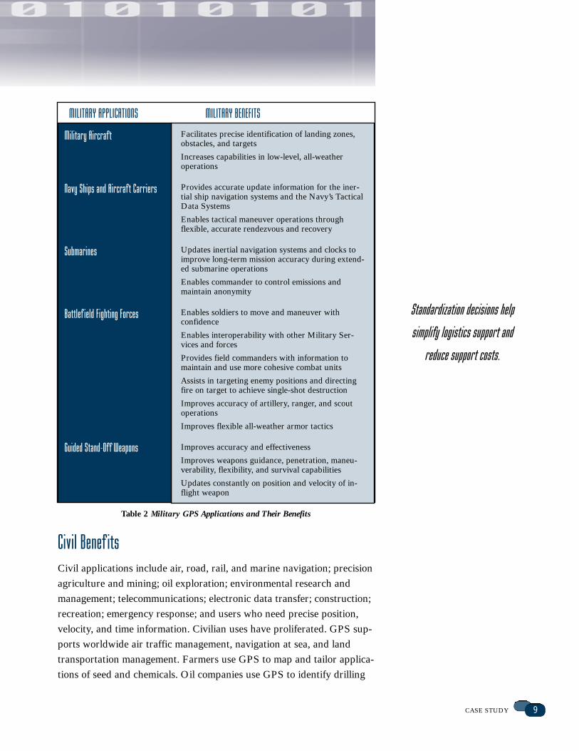
Military Aircraf t
Navy Ships and Aircraf t Carriers
Submarines
Battlef ield Fighting Forces
Guided Stand-Of f Weapons
Facilitates precise identification of landing zones,obstacles, and targets
Increases capabilities in low-level, all-weather operations
Provides accurate update information for the iner-tial ship navigation systems and the Navy’s TacticalData Systems
Enables tactical maneuver operations through flexible, accurate rendezvous and recovery
Updates inertial navigation systems and clocks toimprove long-term mission accuracy during extend-ed submarine operations
Enables commander to control emissions and maintain anonymity
Enables soldiers to move and maneuver with confidence
Enables interoperability with other Military Ser-vices and forces
Provides field commanders with information tomaintain and use more cohesive combat units
Assists in targeting enemy positions and directingfire on target to achieve single-shot destruction
Improves accuracy of artillery, ranger, and scoutoperations
Improves flexible all-weather armor tactics
Improves accuracy and effectiveness
Improves weapons guidance, penetration, maneu-verability, flexibility, and survival capabilities
Updates constantly on position and velocity of in-flight weapon
MILITARY APPLICATIONS MILITARY BENEFITS
Table 2 Military GPS Applications and Their Benefits
Standardization decisions help
simplify logistics support and
reduce support costs.
10 DEFENSE STANDARDIZATION PROGRAM
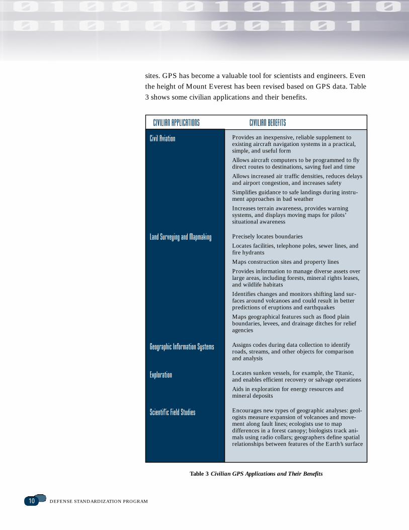
sites. GPS has become a valuable tool for scientists and engineers. Even
the height of Mount Everest has been revised based on GPS data. Table
3 shows some civilian applications and their benefits.
Civil Aviation
Land Surveying and Mapmaking
Geographic Information Systems
Exploration
Scientif ic Field Studies
Provides an inexpensive, reliable supplement toexisting aircraft navigation systems in a practical,simple, and useful form
Allows aircraft computers to be programmed to flydirect routes to destinations, saving fuel and time
Allows increased air traffic densities, reduces delaysand airport congestion, and increases safety
Simplifies guidance to safe landings during instru-ment approaches in bad weather
Increases terrain awareness, provides warning systems, and displays moving maps for pilots’ situational awareness
Precisely locates boundaries
Locates facilities, telephone poles, sewer lines, andfire hydrants
Maps construction sites and property lines
Provides information to manage diverse assets overlarge areas, including forests, mineral rights leases,and wildlife habitats
Identifies changes and monitors shifting land sur-faces around volcanoes and could result in betterpredictions of eruptions and earthquakes
Maps geographical features such as flood plainboundaries, levees, and drainage ditches for reliefagencies
Assigns codes during data collection to identifyroads, streams, and other objects for comparisonand analysis
Locates sunken vessels, for example, the Titanic,and enables efficient recovery or salvage operations
Aids in exploration for energy resources and mineral deposits
Encourages new types of geographic analyses: geol-ogists measure expansion of volcanoes and move-ment along fault lines; ecologists use to mapdifferences in a forest canopy; biologists track ani-mals using radio collars; geographers define spatialrelationships between features of the Earth’s surface
CIVILIAN APPLICATIONS CIVILIAN BENEFITS
Table 3 Civilian GPS Applications and Their Benefits
11CASE STUDY
By making the GPS interface
standard available to the entire
world, the GPS program produced
a global economic impact too
large to calculate.
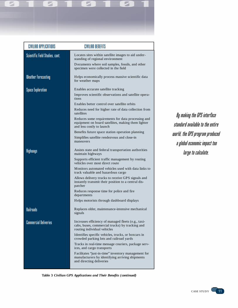
Scientif ic Field Studies, cont.
Weather Forecasting
Space Exploration
Highways
Railroads
Commercial Deliveries
Locates sites within satellite images to aid under-standing of regional environment
Documents where soil samples, fossils, and otherspecimen were collected in the field
Helps economically process massive scientific datafor weather maps
Enables accurate satellite tracking
Improves scientific observations and satellite opera-tions
Enables better control over satellite orbits
Reduces need for higher rate of data collection fromsatellites
Reduces some requirements for data processing andequipment on board satellites, making them lighterand less costly to launch
Benefits future space station operation planning
Simplifies satellite rendezvous and close-in maneuvers
Assists state and federal transportation authoritiesmaintain highways
Supports efficient traffic management by routingvehicles over most direct route
Monitors automated vehicles used with data links totrack valuable and hazardous cargo
Allows delivery trucks to receive GPS signals andinstantly transmit their position to a central dis-patcher
Reduces response time for police and fire departments
Helps motorists through dashboard displays
Replaces older, maintenance-intensive mechanicalsignals
Increases efficiency of managed fleets (e.g., taxi-cabs, buses, commercial trucks) by tracking androuting individual vehicles
Identifies specific vehicles, trucks, or boxcars incrowded parking lots and railroad yards
Tracks in real-time message couriers, package serv-ices, and cargo transports
Facilitates “just-in-time” inventory management formanufacturers by identifying arriving shipmentsand directing deliveries
CIVILIAN APPLICATIONS CIVILIAN BENEFITS
Table 3 Civilian GPS Applications and Their Benefits (continued)
12 DEFENSE STANDARDIZATION PROGRAM
The cost of strategic
standardization that enabled
a single technological solution
to a shared problem was
inf initesimal compared to
the benef it.
Investments and Payof fsGPS cost more than $12 billion to develop and deploy. The current
annual cost for DoD to operate, sustain, and modernize the GPS is
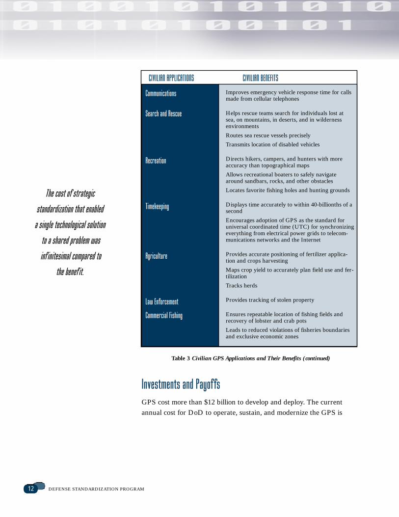
Communications
Search and Rescue
Recreation
Timekeeping
Agriculture
Law Enforcement
Commercial Fishing
Improves emergency vehicle response time for callsmade from cellular telephones
Helps rescue teams search for individuals lost atsea, on mountains, in deserts, and in wildernessenvironments
Routes sea rescue vessels precisely
Transmits location of disabled vehicles
Directs hikers, campers, and hunters with moreaccuracy than topographical maps
Allows recreational boaters to safely navigatearound sandbars, rocks, and other obstacles
Locates favorite fishing holes and hunting grounds
Displays time accurately to within 40-billionths of asecond
Encourages adoption of GPS as the standard foruniversal coordinated time (UTC) for synchronizingeverything from electrical power grids to telecom-munications networks and the Internet
Provides accurate positioning of fertilizer applica-tion and crops harvesting
Maps crop yield to accurately plan field use and fer-tilization
Tracks herds
Provides tracking of stolen property
Ensures repeatable location of fishing fields andrecovery of lobster and crab pots
Leads to reduced violations of fisheries boundariesand exclusive economic zones
CIVILIAN APPLICATIONS CIVILIAN BENEFITS
Table 3 Civilian GPS Applications and Their Benefits (continued)
13CASE STUDY
about $500 million. The cost of strategic standardization that enabled all
the Military Services and our program partners to use a single techno-
logical solution to our mutual military problems was infinitesimal com-
pared to the shared benefits. Strategic standardization provides powerful
leverage for increased interoperability, improved logistics readiness, and
reduced total ownership cost.
Around the world, numerous commercial users share in the benefits
for a relatively small investment in receiver equipment. Receiver costs
vary depending on capabilities. In 1997, merely 2 years after the GPS
was declared fully operational, commercial hand-held receivers running
on two AA batteries became available for about $100 each. Geodetic-
quality dual-frequency receivers that were initially priced at $100,000 in
the mid-1980s are now available for less than $5,000. The most sophisti-
cated receivers now cost up to $40,000.
The development of GPS is still in its infancy. The surface of possibili-
ties is barely scratched. Research promises even greater benefits from
increasing use of GPS. Some projects seem as amazing as an Isaac
Asimov science-fiction novel, for example earthquake warning systems
using high-density grids of GPS monitoring stations and GPS data com-
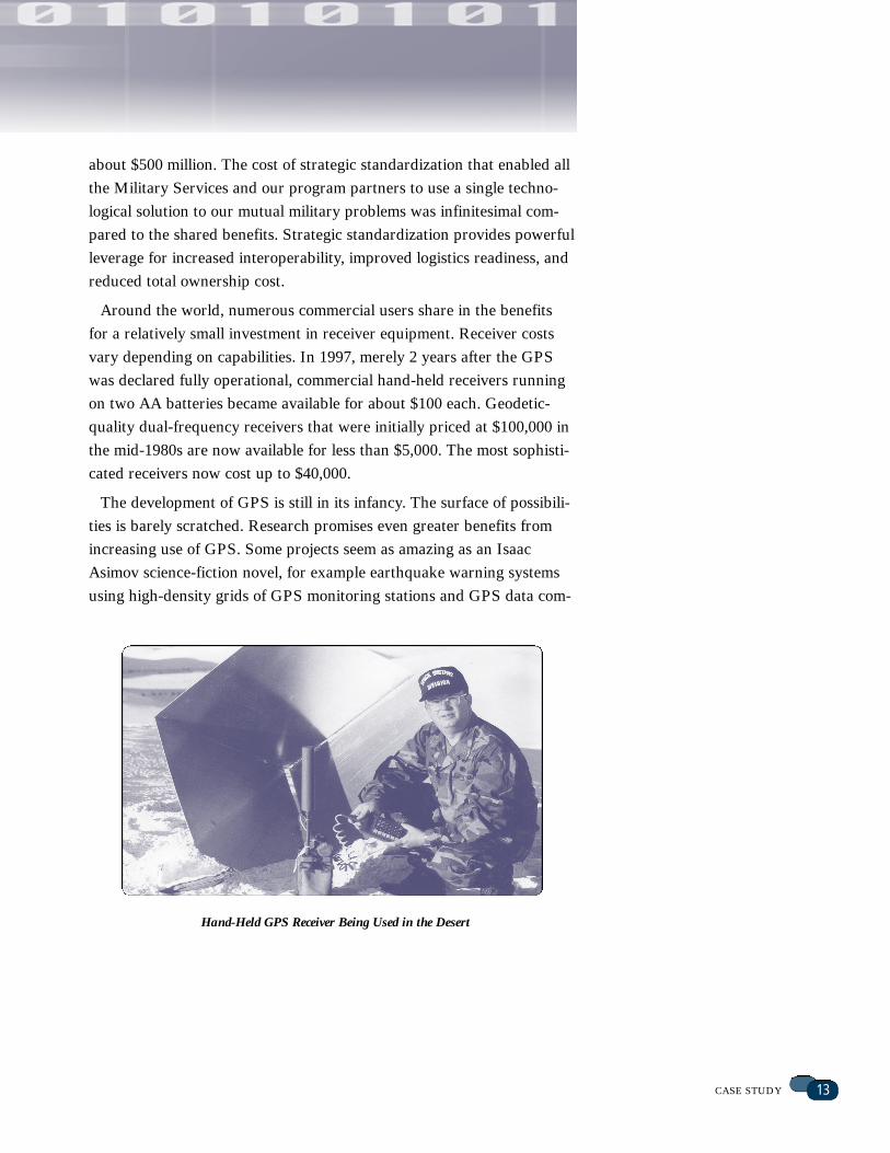
Hand-Held GPS Receiver Being Used in the Desert
14 DEFENSE STANDARDIZATION PROGRAM
bined with computer mapping techniques that will identify and help
manage natural resources. Intelligent vehicle location and navigation
systems will help drivers avoid each other and congested freeways by
finding more efficient routes, saving millions of dollars in gasoline and
tons of air pollution. Travel aboard ships and aircraft will be safer in all
weather conditions. Businesses will be able to manage their resources
more efficiently, reducing consumer costs. GPS has and will change lives
in many ways.
The total value of GPS is incalculable, and total dollar savings
unknowable, but the potential for GPS is enormous.
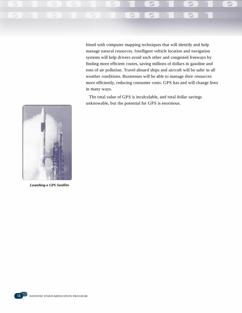
Launching a GPS Satellite