ncees fs practice exam - terrametra resourcesterrametra.com/documents/plsc/fs practice exam...
TRANSCRIPT

NCEES FS Practice Exam
Terrametra Resources Lynn Patten

Practice Exam
1. One corner of a 60-ft. × 120-ft. lot, otherwise rectangular, is a curve with a
radius of 20 ft. and a central angle of 90°.
The area (ft.2) of the lot is most nearly:
A. 6,872
B. 6,886
C. 7,114
D. 7,200
2

120
20 60
20 60 × 120 = 7200
− 20 × 20 = 400
6800
+ 𝜋 20 2
4 = 314
7114
Practice Exam

Practice Exam
2. A client wants to create a 1-acre parcel by establishing a North-South line,
BC, as shown in the figure.
The length (ft.) of Side AB is most nearly:
A. 299.96
B. 352.84
C. 358.73
D. 366.20
4

𝐴𝑟𝑒𝑎 =𝑐2 sin𝐴 sin𝐵
2 sin 𝐶
43560 =𝑐2 sin 50 sin 55
2 sin 75
𝑐2 = 2 43560 sin 75
sin 50 sin 55
= 134,104.44
𝑐 = 366.20
c
A
55°
75°
50°
75°
55°
B
C
Practice Exam

3. The center of a circle with a radius of 4 is at x = 5, y = –2.
The equation of the circle is:
A. (x – 5)2 + (y – 2)2 – 4 = 0
B. (x + 5)2 + (y + 2)2 – 4 = 0
C. (x – 5)2 + (y + 2)2 – 16 = 0
D. (x – 5)2 + (y + 2)2 + 16 = 0
6
Practice Exam
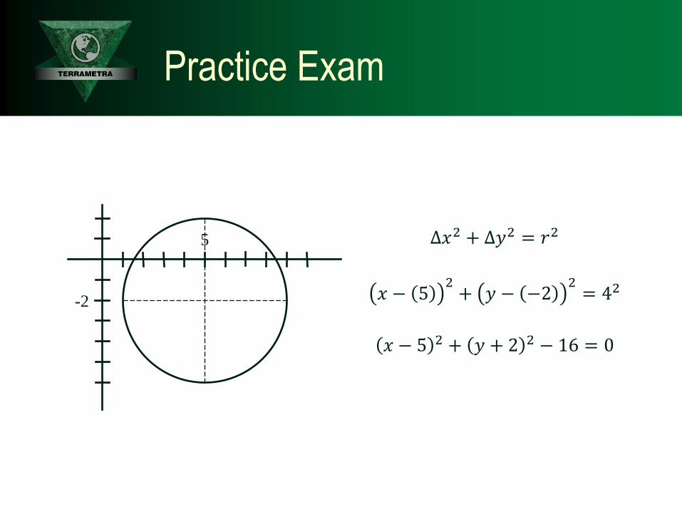
∆𝑥2 + ∆𝑦2 = 𝑟2
𝑥 − 52+ 𝑦 − −2
2= 42
𝑥 − 5 2 + 𝑦 + 2 2 − 16 = 0
-2
5
Practice Exam

Practice Exam
4. A thin-walled tank is constructed as a body of revolution of a parabola, as
shown in the figure. The base diameter is 20 ft., and the height of the tank is
25 ft.
The volume (ft.3) of water in the tank when full is most nearly:
A. 500
3π
B. 625
2π
C. 625
29 − 4 2 π
D. 6875
6π
8

𝜋 𝑅2𝑑ℎ
𝑏
𝑎
= 𝜋 10 − 𝑦 2𝑑𝑦
25
0
= 𝜋 100 − 20 𝑦 + 𝑦 𝑑𝑦
25
0
= 𝜋 100 𝑑𝑦 − 20
25
0
𝜋 𝑦12 𝑑𝑦
25
0
+ 𝜋 𝑦 𝑑𝑦
25
0
= 100𝜋𝑦
25
0
− 20𝜋𝑦32
32
25
0
+ 𝜋𝑦2
2
25
0
= 2500𝜋 −40
3𝜋 125 +
𝜋
2625 =
15,000
6𝜋 −
10,000
6𝜋 +
1875
6𝜋
= 6875
6𝜋
Practice Exam

Practice Exam
5. Which object described below will subtend the greatest angle at your eye?
A. A tree 18 feet tall at 100 yards away
B. A house 12 feet tall at 180 feet away
C. A 1/2-inch-diameter coin at 10 inches away
D. The 2,170-mile-diameter moon at 240,000 miles away
10

18
100 3=18
300= 0.0600
12
180= 0.0667
0.5
10=1
20= 0.0500
2,170
240,000= 0.0090
Practice Exam

Practice Exam
6. An island is formed by the intersections of Birch, Oak, and Ash Streets.
Specific details of the intersection are shown in the figure below.
The length (ft.) of the right-of-way line along the Birch Street side of the island
is most nearly:
A. 46.95
B. 47.35
C. 47.70
D. 47.90
12

180° − 136°24′ = 43°36′
43°36′
2= 21°48′
tan21°48′ =25
𝑥
𝑥 = 62.50
137.59 − 25.00 − 62.50
= 50.09
tan43°36′ =𝑦
50.09
𝑦 = 47.70
136°24’
25
Practice Exam

Practice Exam
7. A thermometer, which is also known to read 3°F too high, records a
temperature of 46°F.
The correct temperature is most nearly:
A. 6.1°C
B. 7.8°C
C. 9.4°C
D. 25.2°C
14

𝐶 =5
9𝐹 − 32
𝐶 =5
943 − 32 =
5
911 =
55
9= 6.1℃
Practice Exam

Practice Exam
8. Two brass monuments set on a shady sidewalk have a known, verified
horizontal separation of 99.96 ft. A surveyor measures between the
monuments with a tape and reads 99.99 ft. at a temperature of 83°F, holding a
tension of 15 lb. while the tape is fully supported.
The length (ft.) of the surveyor’s tape between the 0 and 100 marks while the
temperature remains at 83°F is most nearly:
A. 99.95
B. 99.97
C. 100.03
D. The question cannot be answered with the information given.
16

99.96’ true
99.99’ measured
100.00’ measured
x’ true
99.96
99.99=
𝑥
100.00
𝑥 = 99.97
Practice Exam
Practice Exam
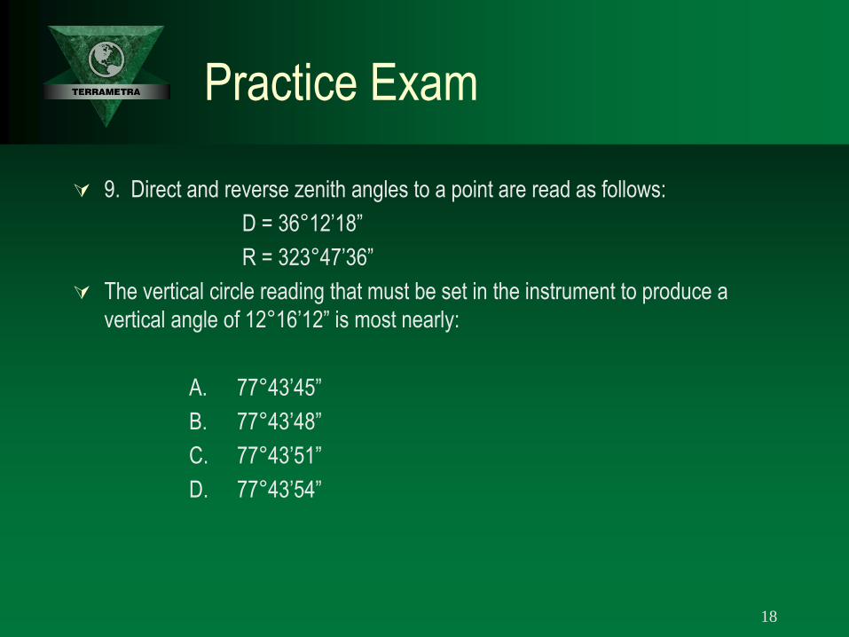
9. Direct and reverse zenith angles to a point are read as follows:
D = 36°12’18”
R = 323°47’36”
The vertical circle reading that must be set in the instrument to produce a
vertical angle of 12°16’12” is most nearly:
A. 77°43’45”
B. 77°43’48”
C. 77°43’51”
D. 77°43’54”
18
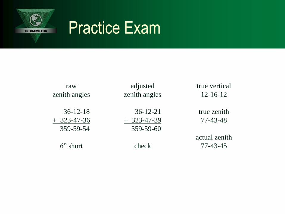
raw
zenith angles
36-12-18
+ 323-47-36
359-59-54
6” short
adjusted
zenith angles
36-12-21
+ 323-47-39
359-59-60
check
true vertical
12-16-12
true zenith
77-43-48
actual zenith
77-43-45
Practice Exam
Practice Exam
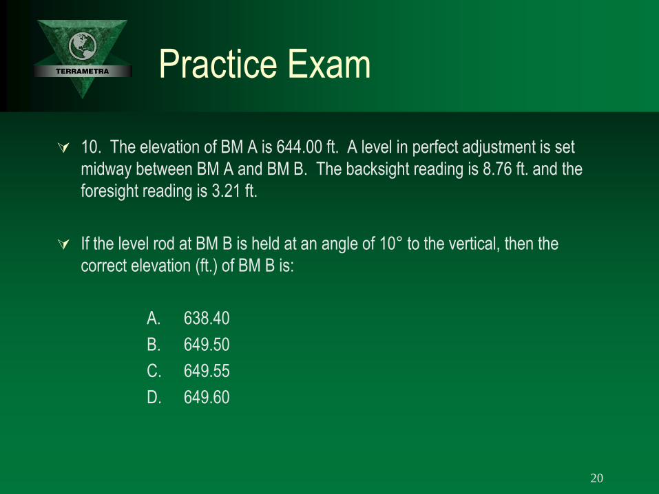
10. The elevation of BM A is 644.00 ft. A level in perfect adjustment is set
midway between BM A and BM B. The backsight reading is 8.76 ft. and the
foresight reading is 3.21 ft.
If the level rod at BM B is held at an angle of 10° to the vertical, then the
correct elevation (ft.) of BM B is:
A. 638.40
B. 649.50
C. 649.55
D. 649.60
20
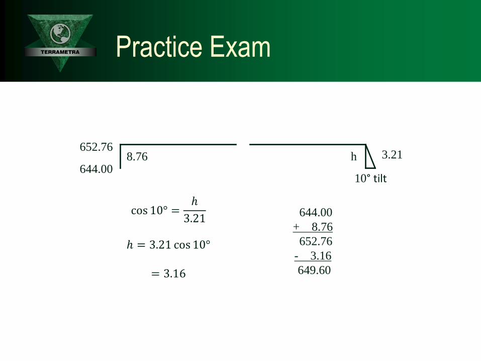
644.00
cos 10° =ℎ
3.21
ℎ = 3.21 cos 10°
= 3.16
652.76 8.76 h
10° tilt
3.21
644.00
+ 8.76
652.76
- 3.16
649.60
Practice Exam

Practice Exam
11. Consider the following
A = B*C + D/C^2
Where: B = 2 C = 0.5 D = 127
The following notation applies to this question:
* = multiply / = divide ^ = raise to exponent
If the question were executed by a spreadsheet or computer, the value of A
would be most nearly:
A. 509
B. 512
C. 130,050
D. 299,081
22

𝐴 = 𝐵 ∗ 𝐶 + 𝐷/𝐶^2
= 2 ∙ 0.5 + 127/ 0.5 2
= 1 +127
0.25 = 1 + 127 4
= 1 + 508 = 509
Practice Exam

Practice Exam
12. A survey party has set offset stakes for construction of an 8-in. sewer
shown in the design plan. When the existing 12-in. sewer line is uncovered for
the construction of Maintenance Hole (MH) 1, it is found that the actual flow
line elevation is 1,228.69 ft. rather than the design elevation of 1,228.47 ft.
The gradient must be revised, holding the flow line elevation of 1,229.27 ft. at
MH 2. If the elevation of the grade stake is 1,235.06 ft., the cut (ft.) to the flow
line that you would mark on the stake at Station 1+25 is most nearly:
A. 5.98
B. 6.08
C. 6.18
D. 6.25
24

1228.98 invert
- 1235.06 stake
- 6.08 cut
1228.69
0+00
0.29
1229.27
1228.47
1+25
2+47.55
invert
1228.98
Practice Exam

Practice Exam
13. A traverse was run from Point A to Point E, and the coordinates of each
point were computed with the following results:
The distance and bearing, respectively, of a straight line from Point A to
Point E are most nearly:
A. 517.06 ft., S 09°54’ E
B. 517.06 ft., S 80°06’ E
C. 521.65 ft., S 12°23’ E
D. 521.65 ft., S 77°37’ E
26
Point X Coordinate Y Coordinate
A 100.00 100.00
B 250.55 232.66
C 388.26 95.98
D 466.15 2.15
E 609.50 -11.92

Angle = atan509.50
111.92 = S 77-36-39 E
Distance = 509.50 2 + 111.92 2 = 521.65
100.00 N
100.00 E
+509.50
-111.92
A
-11.92 N
609.50 E E
Practice Exam

Practice Exam
14. The coordinates of Point Q on a highway spiral relative to the TS are:
X = 200, Y = 5.
The deflection angle from the TS to Point Q is most nearly:
A. 0°28’38”
B. 1°25’55”
C. 2°50’00”
D. 4°05’02”
28

Deflection = atan5.00
200.00 = 01-25-56
200.00 TS
5.00
Practice Exam

Practice Exam
15. The following deflection angles were measured in a closed traverse:
P: 92°24’ R
Q: 150°42’ R
R: 15°37’ L
S: 132°35’ R
The balanced deflection angle at R is most nearly:
A. 15°36’ L
B. 15°37’ L
C. 15°38’ L
D. 15°39’ L
30

92-24
150-42
-(15-37)
137-35
360-04
4 minutes
too much
92-24 R
132-35 R
15-37 L 150-42 R
92-23
150-41
-(15-38)
137-34
360-00
check
= 15-38 L
Practice Exam

Practice Exam
16. A clear zone avigation easement with a 34:1 slope begins at ground level
200 ft. from the end of an active airport runway. The natural ground slope
moving away from a point 200 ft. from the end of the runway is 0.5% in an
uphill direction.
At what distance (ft.) from the end of the runway can a 35-ft-tall structure be
located and not violate the clear zone easement?
A. 1,434
B. 1,593
C. 1,634
D. 1,675
32

1
34𝑥 − 35 =
0.5
100𝑥
1
34𝑥 −
1
200𝑥 = 35
200 − 34
6800𝑥 = 35
𝑥 = 1434 (200’ from runway)
𝑥 + 200 = 1634
200.00 x
x + 200.00
1
34
100
0.5
35.00
Practice Exam
Practice Exam
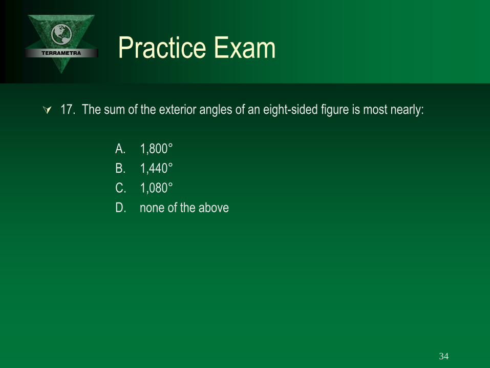
17. The sum of the exterior angles of an eight-sided figure is most nearly:
A. 1,800°
B. 1,440°
C. 1,080°
D. none of the above
34

exterior angles
= 180 𝑛 + 2
= 180 8 + 2
= 180 10
= 1800°
Practice Exam

Practice Exam
18. You are to set slope stakes along the roads within a subdivision. At
Station 2+00 the finish grade elevation is 110.31 at the edge of the road, and
the distance from the centerline to the edge of the road is 12.0 ft. The rod is
being held at a distance of 28.5 ft. from the centerline and the rod reading is
12.1 ft. while the H.I. is 119.77 ft. Typical cut and fill sections are shown
below.
Your next step would be to:
A. move in about 6 ft. and try again
B. move in about 10 ft. and try again
C. move out about 6 ft. and try again
D. drive in a stake since you are at the slope stake
36

3.14 ∙ 2 = 6.28
1.49 ∙ 4 = 5.96
move in 6 feet
119.77
1
4
3
12 110.31
107.31
105.31
28.5
6
3
1 110.81
106.18
107.67
Practice Exam

Practice Exam
19. A small rectangular lot measures 120.00 ± 0.04 ft. by 144.00 ± 0.05 ft.
The area (ft.2) of the lot is best stated as:
A. 17,280 ± 4.7
B. 17,280 ± 8.3
C. 17,280 ± 49.7
D. 17,280 ± 87
38

144 ∙ 120 = 17,280
144 ∙ 0.04 2 + 120 ∙ 0.05 2 = 8.3
17,280 ± 8.3
120.00 ± 0.04
144.00 ± 0.05
144.00 ∙ 0.04
120.00 ∙ 0.05
Practice Exam
Practice Exam
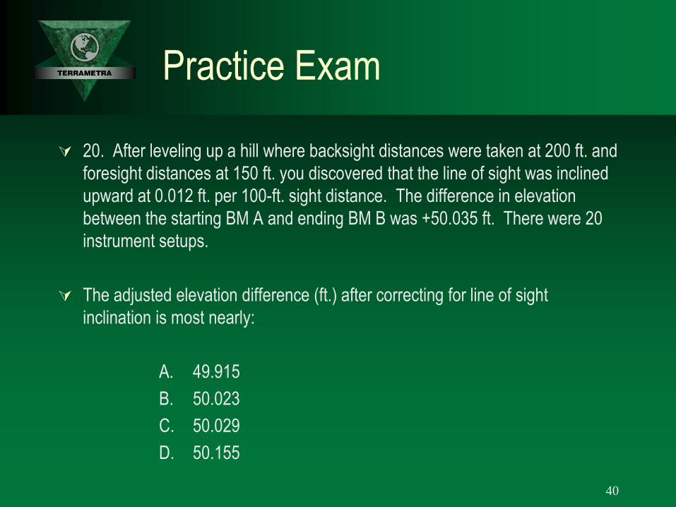
20. After leveling up a hill where backsight distances were taken at 200 ft. and
foresight distances at 150 ft. you discovered that the line of sight was inclined
upward at 0.012 ft. per 100-ft. sight distance. The difference in elevation
between the starting BM A and ending BM B was +50.035 ft. There were 20
instrument setups.
The adjusted elevation difference (ft.) after correcting for line of sight
inclination is most nearly:
A. 49.915
B. 50.023
C. 50.029
D. 50.155
40
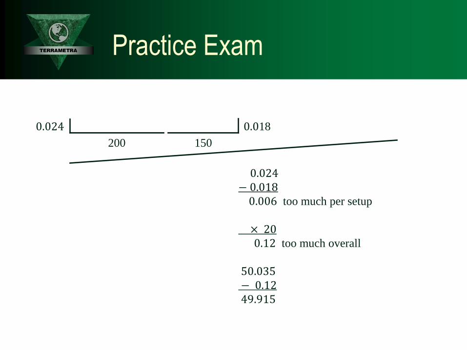
0.024
− 0.018
0.006 too much per setup
× 20
0.12 too much overall
50.035
− 0.12
49.915
200
0.024
150
0.018
Practice Exam

Practice Exam
21. An angle is measured with a 1” theodolite twelve times with the following
results:
223°14’56” 223°14’53” 223°14’58”
223°14’52” 223°14’55” 223°14’59”
223°14’58” 223°15’02” 223°14’55”
223°14’59” 223°15’00” 223°14’54”
The standard deviation of the mean is most nearly:
A. ±0.9”
B. ±1.5”
C. ±2.8”
D. ±3.3”
42
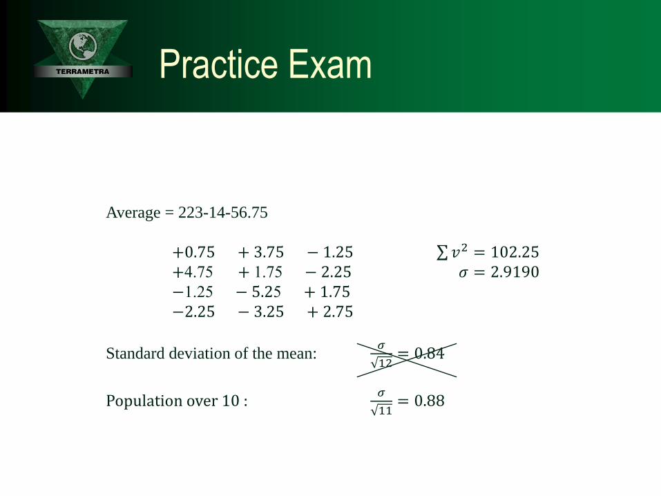
Average = 223-14-56.75
+0.75 + 3.75 − 1.25 𝑣2 = 102.25
+4.75 + 1.75 − 2.25 𝜎 = 2.9190 −1.25 − 5.25 + 1.75 −2.25 − 3.25 + 2.75
Standard deviation of the mean: 𝜎
12= 0.84
Population over 10 : 𝜎
11= 0.88
Practice Exam

Practice Exam
22. An EDM distance of 1 mile is measured at an elevation of 1 mile.
The earth’s radius R is assumed to be 20,906,000 ft.
The sea level distance (ft.) is most nearly:
A. 5,270.02
B. 5,278.67
C. 5,280.00
D. 5,281.33
44

SLF =𝑅
𝑅 + 𝐻=20,906,000
20,911,280= 0.9997
SLD = 5,280 ∙𝑅
𝑅 + 𝐻= 5,280 ∙ 0.9997 = 5,278.67
SLD
20,906,000
5,280
5,280
Practice Exam

Practice Exam
23. The original government record of a fractional lot in the northwest quarter
of Section 5 shows the following dimensions in chains:
north side 19.83
east side 19.09
west side 19.31
south side 20.14
The area (acres) of the lot on the original township plat would be most nearly:
A. 38.33
B. 38.35
C. 38.37
D. 38.39
46

19.83
20.14
19.3
1
19.0
9
19.985
19.2
00
19.985 ∙ 19.200 = 383.712 𝑠𝑞. 𝑐ℎ𝑎𝑖𝑛𝑠
= 38.37 acres
Practice Exam

Practice Exam
24. Section 18 of T21N, R6W, was subdivided for the first time about 20 years
ago. You wish to retrace that survey. The official distance shown in
government notes for the north line of Section 18 is 78.39 chains.
The measurement (chains) that should have been used for the north line of the
NW 1/4 of the NW 1/4 (also called Lot 1) is most nearly:
A. 18.39
B. 19.20
C. 19.60
D. 38.39
48

20 20 20
78.39
18.39
SEC 18
Practice Exam
Practice Exam
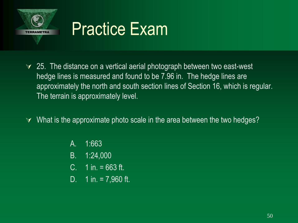
25. The distance on a vertical aerial photograph between two east-west
hedge lines is measured and found to be 7.96 in. The hedge lines are
approximately the north and south section lines of Section 16, which is regular.
The terrain is approximately level.
What is the approximate photo scale in the area between the two hedges?
A. 1:663
B. 1:24,000
C. 1 in. = 663 ft.
D. 1 in. = 7,960 ft.
50

5,280
7.96= 663
𝑓𝑡.
𝑖𝑛
1 𝑖𝑛. = 663 𝑓𝑡.
7.96”
5,280’
Practice Exam

Practice Exam
26. You plan to plot the following traverse on a sheet with dimensions of 18 in.
wide x 24 in. long.
AB: S 0° 25’ E, 1,380.02 ft.
BC: N 88°31’W, 2,495.00 ft.
CD: N 0°25’W, 1,380.02 ft.
DA: S 88°31’ E, 2,495.00 ft.
The scale best suited to show maximum detail and to allow for a 1/2-in. margin
is:
A. 1:1,440
B. 1:1,200
C. 1:960
D. 1:600
52
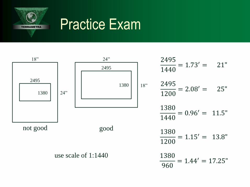
2495
1440= 1.73′ = 21"
2495
1200= 2.08′ = 25"
1380
1440= 0.96′ = 11.5"
1380
1200= 1.15′ = 13.8"
1380
960= 1.44′ = 17.25"
18”
18”
24”
24”
2495
2495
1380
1380
not good good
use scale of 1:1440
Practice Exam

Practice Exam
27. The area of a lake is obtained by planimeter as 10 in.2 on a map at scale
1:50,000.
The area (sq. mi.) covered by the lake is most nearly:
A. 6.23
B. 7.89
C. 9.47
D. 10.00
54

1: 50,000
1 𝑖𝑛. = 4,166.67 𝑓𝑡.
1 𝑖𝑛. = 0.79 𝑚𝑖.
1 𝑠𝑞. 𝑖𝑛. = 0.623 𝑠𝑞.𝑚𝑖.
10 𝑠𝑞. 𝑖𝑛. = 6.23 𝑠𝑞.𝑚𝑖.
Practice Exam

Practice Exam
28. On an aerial photograph, the measured distance between two points is
5.134 in. On a 7.5-min topographic map (1:24,000 scale), the measured
distance between these same two points is 1.689 in.
The nominal scale ratio of the photo is most nearly:
A. 1:658
B. 1:7,896
C. 1:7,920
D. 1:24,000
56

1: 24,000
1.689 ∙ 24,000 = 40,536
40,536
5.134 = 7,896
1: 7,896
Practice Exam