ncep mesoscale modeling: where we are and where we’re going
TRANSCRIPT
Mesoscale Modeling Branch:Where We Are andWhere We’re Going
Geoff DiMego [email protected] ext7221
7 December 2004
NCEP
Where the Nation’s climate and weather services begin

Who We Are• Contractor Scientists
– Nashat Ahmad– Mike Baker– Stacie Bender– Hui-Ya Chuang– Jun Du– Brad Ferrier– S. Gopalakrishnan– Dusan Jovic– Pius Lee– Curtis Marshall– Manuel Pondeca– Jim Purser– Matt Pyle– Perry Shafran– Marina Tsidulko– Binbin Zhou
• Government Scientists– Tom Black– Dennis Keyser– Ying Lin– Geoff Manikin– Jeff McQueen– Dave Parrish– Eric Rogers– Wan-Shu Wu
• Visiting Scientists– Mike Ek– Zavisa Janjic– Fedor Mesinger
• Contractor Scientists– Sajal Kar

T O P I C S• Recent Changes in Operations
– Observation Processing in 2004– Eta “Winter” Upgrade package - March– DGEX (Downscaled GFS by Eta Extension) April+June– Fire Weather / IMET Support using NMM– SPC / NSSL Spring Program runs of WRF-NMM– SREF Upgrade – 17 August– WRF in HiResWindow – 21 September
• Development & Other Highlights– Air Quality Forecast System – 17 September – North American Regional Reanalysis
• Plans for the Future [most interspersed above]– Final Eta Upgrade Package– Real Time Mesoscale Analysis– North American Mesoscale WRF-NMM

Observation Processing in 2004this is only a small fraction of the year’s activities
• Feb Implemented new BUFRLIB• Feb Eliminated early RUC analysis
at 00z & 12z and Fixed radar dup check for 88D radar winds
• Mar Fixed Aerosol, ozone, snow & sst processing
• Apr CRISIS eliminate virtual temp error above tropopause
• Apr CDAS processing & editbufr• May 4 Fixed ITMI & ISND• May AWS mesonet data stop due
to MOU expiration• Jul Implemented processing of 88D
Level 2.5 radial winds
• Jun Fixed Tropical Cyclone vitals processing
• Jun Sat ingest monitoring webpage• August • Sep 13 Release of AIRNOW
prepbufr job• Oct AWS mesonet data begin to
arrive again• TBD Move BUFR Mnemonic
Table to fixed-field• Nov 16 15z CRISIS-fixed
duplicate checker for marine data
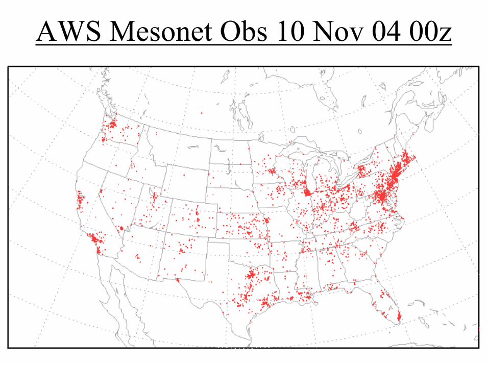
AWS Mesonet Obs 10 Nov 04 00z

Non-AWS Mesonet Obs 10 Nov 04 00z

GPS IPW (Integrated Precipitable Water) Ob Density

Boundary Layer Profiler Ob Density

How are PIREPs used?
• Two conditions must be met for use of a PIREP in NCEP’s data assimilation system
• Temp, wind +/or moisture are reported and • They are observed by sensors
• However, PIREPs are used extensively by AWC for validation of turbulence and icing using FSL’s RTVS
• Current PIREP ob counts are small: ~600 per day versus >100,000 other aircraft

Non-Satellite Data Used in GDAS

Aircraft Observation DensityCurrent ACARS temp reports Current AIREP+PIREP wind reports

Upper-Air Observation DensityCurrent Radiosonde wind reports Current profiler wind reports
Current 88D VAD wind reports Current IR GOES wind reports

Surface Observation DensityCurrent sfc synoptic wind reports Current sfc marine wind reports
Current sfc w/no sta p wind reports Current metar w/no sta p wind reports
Operational Implementationof Winter 2004 Meso Eta
Change PackageGeoff DiMego & Eric Rogers
10 March 2004http://wwwt.emc.ncep.noaa.gov/mmb/briefings/EtaWinter2004.briefing.h
tml
NCEP
Where the Nation’s climate and weather services begin

Contents of Eta Winter 2004 Bundle
• Precip Assimilation change– Use of daily gauge data for bias adjustment of multi-sensor
precipitation analyses input to the EDAS
• 3DVAR analysis changes– Assimilate GOES-12 radiances– More efficient code using less memory
• Eta model / post-processor changes– Feed fraction of frozen precip from Ferrier microphysics into land-
surface model– Fixed radiation driver for downward LW fluxes in presence of fog– Fixed ½ hour error in zenith angle used to posted Eta solar fluxes
• Output / Diagnostic changes– Add eddy diffusivity to Eta output file on AQ model sigma surfaces
for CMAQ (Ozone/Air Quality )

Improving Precipitation Assimilation
Hourly multi-sensor (radar+gauges) precip analysis used as input for Eta/EDAS precipitation assimilation tends to have a low bias, leading to drier soil:
July 2003 Total Rainfall
In EDAS (deficient) From Daily Gauge analysis

Bias Adjustment of Hourly Analyses for EDAS
1. Each day, compare 24h EDAS precip (12Z-12Z) to daily gauge analysis
2. Add the difference to a precipitation budget history file
3. Use the budget history file to adjust hourly precip input. Goal: to ‘pay off the debt’ in 1 day. Limit of adjustment: +/-20% of pre-adjustment total

Impact in 32km Parallels: Oct 6 – Dec 4 2003EDAS precip scores: w/adjustment; control
Equitable Threat Scorew/adjustment
controlBias

Precipitation Type used in Noah LSMUse predicted Ferrier type instead of diagnosed type
• Based on study by Lackmann et al. (2002 WAF)– Before: precipitation type based on air temperature in the
lowest model layer (Tsfc)• Snow if Tsfc < 0C, rain otherwise
– Change: precipitation type based on model microphysics (Ffroz, fraction of frozen precipitation)
• Snow if Ffroz ≥ 0.5, rain otherwise
• Leads to:1. Warmer surface temperatures in freezing rain events (latent
heating warming ground, self-limiting process)2. Cooler surface temperatures when snow falls on surface
above 0ºC (melting of snow cooling ground)

Impact of Lackmann change on Eta snow cover
Old formulation : no snow cover where
T > 0C
18-h Eta forecast From 18Z 3/1/03
New formulation : snow cover in regions
with T > 0C

Assimilation of GOES-12 radiancesChannel 1 Brightness Temperatures 06Z 2/15/04 – 00z 2/16/04

Eta-12 Parallel (blue) vs Ops Eta (red) QPF Scores : 1/10/ – 2/18/04
12-36 h 36-60 h
All fcsts
Eq Threat
Bias
Eq Threat
Bias
Eq Threat
Bias

48-h forecast RMS fits to CONUS raobs : 1/10 – 2/24/04
Height
Temp
RH
Black = Ops, Red = Parallel
wind
height
temp
RH

Downscaled GFS by Eta Extension(DGEX) Project Objective
• Provide NWS Forecast Offices With a First Guess National Digital Forecaster Database (NDFD) Eight Day Forecast Grid Derived from the Meso EtaForecast Model
• Reduce the Effort Required for the WFO Forecaster to Create an Eight Day Forecast Grid for the Interactive Forecast Preparation System (IFPS)– GFS Grids Currently Distributed are Too Coarse in
Vertical and Horizontal Resolution to Provide an Acceptable First Guess – Especially in Areas of Complex Terrain

Downscaled GFS by Eta Extension (DGEX) Design
• Run 12 km Meso Eta out to 192 hr on 1/6th (or smaller) of North American domain using GFS lateral boundary conditions (LBC)
• Effectively downscaling GFS (providing LBC) since GFS synoptic scale will dominate Eta solution in its interior especially on reduced (1/6th) domain
• Start DGEX at 78 hr to allow for adjustment to smaller grid by 90 hr (first output time for distribution)
• 78-174 hr uses 3-hr GFS LBC; 174-192 hr uses 6-hr GFS LBC

Wx Production Suite Made Up of Four Uniform Cycles per Day
Proposed NCEP Production SuiteWeather Forecast Systems
Version 1.2 January 15, 2003
0
20
40
60
80
100
0:00 0:30 1:00 1:30 2:00 2:30 3:00 3:30 4:00 4:30 5:00 5:30 6:00
6 Hour Cycle
Perc
ent U
sed
HawaiiFIREWXCOFSRUCEDASWavesGFSensHUR/NWMGFSfcstGFSanalETAfcstETAanalSREFGDAS
Large block Eta 0-60hr Small block Eta 60-84hr GFS analysis
Unused cpu’sSlot for DGEX

DGEX Configuration• Cycle times – run twice per day per domain
– 06 and 18Z (00 and 12Z GFS LBC) for CONUS– 00 and 12Z (06 and 18Z GFS LBC) for OCONUS
• Initial Evaluation Phase (March 2004)– Single run per day– Run off EMC’s 00Z parallel
• First Development Phase (April 2004) – Extend current 0-60 hr off-hour Eta out to 84 hr,
freeing up old 60-84 hr time slot for DGEX

DGEX CONUS DomainWith Regional Distribution Tiles
Regional subsets were generated by EMC only during field evaluation period
Final distribution is on grid #218 with GRIB2 compression via new AWIPS SBN

DGEX Domains

DGEX versus GFS (providing LBC)
500 mbht/Vort
850 mbwind

Alaska DGEX versus GFS (providing LBC)
500 mbht/Vort
SLP

DGEX SBN/AWIPS Timeline• Late May: DVB-S efforts free up SBN bandwidth• June 1: DGEX operational at NCEP• June-July: OB3.2 upgrade to AWIPS configuration to
allow unpacking of GRIB2 compressed files• Products Disseminated Through the TOC to the NCF
Onto the SBN TG2 Channel– Formatted in GRIB2 With Compression– Output from 90-192 hr in Six Hour Increments– Limited Number of Forecast Parameters Output for Intended
Use Within IFPS/NDFD
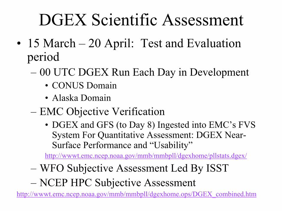
• 15 March – 20 April: Test and Evaluation period– 00 UTC DGEX Run Each Day in Development
• CONUS Domain• Alaska Domain
– EMC Objective Verification• DGEX and GFS (to Day 8) Ingested into EMC’s FVS
System For Quantitative Assessment: DGEX Near-Surface Performance and “Usability”
http://wwwt.emc.ncep.noaa.gov/mmb/mmbpll/dgexhome/pllstats.dgex/
– WFO Subjective Assessment Led By ISST– NCEP HPC Subjective Assessment
http://wwwt.emc.ncep.noaa.gov/mmb/mmbpll/dgexhome.ops/DGEX_combined.htm
DGEX Scientific Assessment

EMC Objective Verification Summary
• Upper-level Verification vs Raobs– DGEX Errors Comparable or Slightly Better Than
6-h Old GFS Run Providing the Lateral Boundary Conditions
• Near-Surface Verification of Temperature Winds– Mean DGEX 2-m Temperature Forecasts Closer to
Observed Mean Than GFS for All Regions Except Nighttime Minimum in Alaska
• DGEX Does Best in Western Region– Much More Diurnal 10-m Wind Speed Variations
Then GFS• WFOs Liked DGEX Wind Directions Over GFS

LaCrosse Example – from Dan Baumgardt
• Eta Snow Cover Reflected in the Day 4 Max-T Grid• Verified Temps in Blue• DGEX Very Useful to Modify Forecast Max-T
54 5251
62
6264
61
6363
65
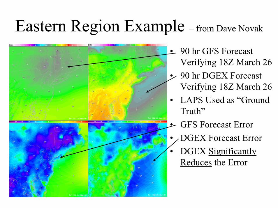
Eastern Region Example – from Dave Novak
• 90 hr GFS Forecast Verifying 18Z March 26
• 90 hr DGEX Forecast Verifying 18Z March 26
• LAPS Used as “Ground Truth”
• GFS Forecast Error• DGEX Forecast Error • DGEX Significantly
Reduces the Error

ISST Subjective Assessment• 10 WFOs Participated in Assessment
– 9 CONUS WFOs and Fairbanks, Alaska• Data Sent via Regional WANs• On-line Survey to Subjectively Assess DGEX
on Daily Basis– 11 Questions– Filed After Shift Responsible for Inputting Day 7
Into the Grids– 135 Surveys Returned With Feedback

ISST Assessment Summary
• Majority of Forecasters Found DGEX to be Useful– Many Positive Comments on Realism and Value of
Forced Mesoscale Detail– Wind Grids Were Used Most Often and Deemed to
be of the Best Quality– Favorable Assessment Even with a Few Drawbacks
• Timeliness• Data Outages• Limited Availability
Fire Weather / IMET Support From NCEP: Selectable Runs of Nonhydrostatic Mesoscale Model
Geoff DiMego Mesoscale Modeling Branch EMC [email protected] 301-763-8000 ext7221
NCEP
Where the Nation’s climate and weather services begin

Nonhydrostatic Mesoscale Model (NMM)
• See Janjic, Gerrity,and Nickovic, 2001 for model equations, solution techniques & other test results [MWR,Vol. 29, No. 5, 1164-1178]
• Highly refined version of nonhydrostatic option released in May 2000 upgrade to NCEP’s workstation Eta
• NMM retains full hydrostatic capability– Incorporate nonhydrostatic effects through ε where ε=(1/g) dw/dt
– Then split prognostic equations into:• hydrostatic parts plus • corrections due to vertical acceleration
– Set ε to zero to run in hydrostatic mode

Nonhydrostatic Mesoscale ModelFeature Comparison With Meso Eta
Feature Meso Eta Model Nonhydrostatic Meso ModelDynamics Hydrostatic Hydrostatic plus complete
nonhydrostatic correctionsHorizontal grid spacing
12 km E-grid 8 km E-grid for FireWx/IMET4 km E-grid for Homeland Security
Vertical coordinate
60 step-mountain eta levels
60 sigma-pressure hybrid levels
Terrain Unsmoothed withSilhouette treatment lateral boundary set to sea-level
Unsmoothed Grid-cell mean everywhere

Hybrid versus Step (Eta) CoordinatesPtopPtop
0 = 0
ground
Pressure domain
F = 0 420mb
MSL
ground
Sigma domain
0 = 1F = 1

Nonhydrostatic Mesoscale ModelPhysics Features Comparison With Meso EtaPhysics Feature
Meso Eta Model Nonhydrostatic Meso Model
Turbulent mixing
Mellor-Yamada Level 2.5 dry
Mellor-Yamada Level 2.5 including moist processes
Surface exchange
…+ Paulson functions
…+ Holtslag and de Bruin functions
Land-sfc NOAH LSM NOAH LSMGridscale Ferrier Ferrier
Convective B-M-J B-M-J’ (some retuning)Radiation GFDL GFDL’ (some retuning)

Design Considerations
• Fire Wx/IMET Support run designed to run over the top of the Eta at all four runtimes of 00z, 06z, 12z & 18z
• Better than using HiResWindow because it has no conflict with hurricane runs and finishes earlier
• Established reduced domain nests patterned after NCEP’s On-Call Emergency Response capability for Homeland Security
• Nests to run at 8 km resolution like the HiResWindow• Only downside is smaller domain than HiResWindow

26 Selectable 8 km Domains For Fire Weather / IMET Support Identical To
4 km Homeland Security Domains

12 km Terrain 4 km Terrain
Dots represent water points Domain is San Francisco Bay

12 km Terrain 4 km Terrain
Dots represent water points Domain is Chesapeake Bay

12 km Terrain 4 km Terrain
Dots represent water points Domain is Puget Sound

Fire Weather / IMET Run OutputThe FireWx grids are available out to 48 hours on the TOC ftp server (tgftp.nws.noaa.gov) under the following format: /SL.us008001/ST.opnl/MT.nmm_CY.{CC}/RD.{YYYYMMDD}/PT.grid_DF.gr1_AR.nest{xx} where
CC = 00, 06, 12, or 18 YYYYMMDD = the current date xx = 01 - 26 (geographic location)
Filenames follow the convention: fh.{hhhh}_tl.press_gr.awpreg wherehhhh = 0000, 0003, 0006, ... , 0048File on TOC with gif of region

Current Plans for 2004 Season:Training Given to IMETs,
IMETs to Provide Feedback Following FX-Net Upgrade

Fire Weather / IMET Support Run2004 Readiness Review
• Brief Description: The FWNM runs will only be available on the WR FX-NET server. The WR FX-NET domain covers the western U.S., roughly west of Colorado/Kansas border. The IMET selects and displays the FWNM fields using the laptop based FX-NET client called AMRS. The FWNM fields displayable in FX-NET are:– Temperature (2 m)– Dewpoint (2 m)– RH (2 m, 700 mb)– Winds UW/VW(10 m, 850 mb, 700 mb)– Sea-Level Pressure - emsp (Eta reduction)– Sea-Level Pressure - pmsl (NWS reduction)– Total Precipitation– Cape– Precipitable Water (PW)

Fire Weather / IMET Support Run2004 Readiness Review
• The emphasis is on the near surface fields. We are not replicating the synoptic scale ETA fields already available through the AWIPS SBN fields. The FWNM is run over one of 26 sectors spread across the U.S. - of which 9 cover the WR domain of interest. The selected domain of the FWNM is relatively small, on the order of a few states. The IMETscan view the FWNM by selecting the larger regional sector and zooming in – this accommodates the possibility that the nest may change from run-to-run. The data files are stored in /data/fxa/Grid/LOCAL/netCDF/ETA08 , /awips/fxa/data/eta08.cdl , and /awips/fxa/data//localization/SLC/SLC-eta08.sup . (NOTE: these names have legacy roots and reflect Eta but will be changed next year to reflect FWNM to avoid confusion.)

Fire Weather / IMET Support Run2004 Readiness Review
• The fire weather program leaders, Rusty and Larry, call the SDM with a request for a specific FWNM nest. The SDM who enters latitude- longitude information for the selected run at 00z, 06z, 12z and/or 18z. Test runs can be made at anytime. The only other users of this FWNM system are SPC, HPC and OPC, but their use is not continuous during the fire weather season. Central Region, which supports IMETs over the rest of CONUS, is expected to connect in FY05. Alaska Region and Pacific Region will hopefully connect in the future because FWNM nests are available centered over Fairbanks, Anchorage, Juneau, Honolulu as well as Puerto Rico.

Fire Weather / IMET Support Run2004 Readiness Review
Item Date Activity/deliverable Personnel 1) 12/09 Initial coordination Cook/DiMego/Billingsley 2) 01/07 Telecon Edman/Billingsley/Cook/DiMego3) 02/20 Dry run of NMM Training Jascourt4) 01/12 Finalize output fields Billingsley/DiMego 5) 02/04 Test end-to-end comm's Cook/DiMego/SDM/TOC6) 04/06 NCO/TOC coordination Dave Caldwell7) 02/18 Coordinate changes to FX-NET Edman8) 04/01 Re-localization + FX-NET upgrades Cook/FSL/Billingsley9) 03/14 Fire Wx / IMET Workshop: Billingsley et al
Jascourt presents training on NMM IMETs directed to enter daily feedback in daily log
10) 04/15 Repeat end-to-end test Cook/SDM/WR

Special WRF-NMM Runs for SPC/NSSL Spring Program
• Beginning in April, EMC ran:– 4.5 km version of its WRF-NMM– Without any calls to parameterized convection– Initialized off 12 km Eta (at 40 km resolution)– Daily runs to 30 hours from 00z– Central/Eastern US domain
• SPC requested that this run be continued as long as possible

Domains of Integration for Spring ProgramNCEP NMM (red), NCAR (blue), CAPS (cyan)

Spring Program 21 hr Forecast Examplehttp://www.nssl.noaa.gov/etakf/compare/wrf/
NMM
ARW
OBS
CAPS

Example of Explicit 4.5 km WRF-NMMcourtesy of Jack Kain
WRF 24 hour 4.5 km forecast of 1 hour accumulated precipitation valid at
00Z April 21, 2004 (better than 12 hour forecasts by operational models)
4.5 km WRF-NMM Verifying 2 km radar reflectivity

Web Site Displaying 4.5 km WRF-NMMhttp://www.emc.ncep.noaa.gov/mmb/mmbpll/cent4km/

Manikin’s Convective Forecasting Pagehttp://wwwt.emc.ncep.noaa.gov/mmb/svrfcst/index.html
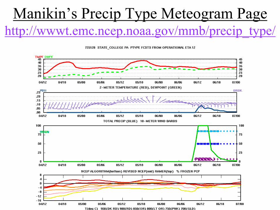
Manikin’s Precip Type Meteogram Pagehttp://wwwt.emc.ncep.noaa.gov/mmb/precip_type/

Soon to be added 2-D plots

SREF System UpgradeJeff McQueen, Jun Du, B. Zhou, B. Ferrier, G. Manikin, E. Rogers
G. DiMego, H. Juang, Z. Toth, B. Bua
where the nation’s climate and weather services begin

Previous NCEP SREF System• Multi-model (Eta and RSM), multi-analysis (gdas and edas),
multi-Ics (breeding) and multi-physics (BMJ, KF and SAS): • Eta_BMJ (5) -- ctl + 2 breeding pair from edas• Eta_KF (5) -- ctl + 2 breeding pair from edas• RSM_SAS (5) – ctl + 2 breeding pair from gdas
• 48km, 63h fcst, twice per day (09z and 21z), large NA domain with CONUS grib 212 output
• Grib data (NCEP centers), ftp and web (outsider users)• Special products: aviation and summer NE energy project
• Two related problems:• lack of spread due to clustering by model especially in summer • IC perturbation size too small in summer while it can get too
big in winter

Upgraded NCEP SREF System17 August 2004
• Six convective schemes: BMJ / SAT, KF / DET and SAS / RAS• Eta_BMJ (3): ctl + 1 breeding pair (BMJ = Betts-Miller-Janjic)• Eta_SAT (2): 1 breeding pair (modified saturated profiles within BMJ)
• Eta_KF (3): ctl + 1 breeding pair (KF = Kain-Fritsch)• Eta_DET (2): 1 breeding pair (partial detrainment added to KF)
• RSM_SAS (3): ctl + 1 breeding pair (SAS=simplified Arakawa-Schubert)• RSM_RAS (2): 1 breeding pair (RAS = relaxed Arakawa-Schubert)
• New scaled breeding (prevents IC pert size from being too small in summer and from being too big in winter but always consistent with typical analysis error magnitude)
• Increase resolution from 48km to 32km (L45 to L60 for Eta)• Up-to-date model codes & physics for both Eta and RSM• Extended & Corrected SREF product output
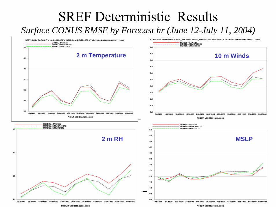
SREF Deterministic Results Surface CONUS RMSE by Forecast hr (June 12-July 11, 2004)
2 m Temperature 10 m Winds
2 m RH MSLP

SREF Deterministic Results Upper-Level 48 h RMSE (June 12-July 11, 2004)
TemperatureWind
RH Heights

SREF Probabilistic Results Spread Plots (June 12-July 11, 2004)
SLP 500H
850T 850U
250U 850RH

SREF Probabilistic Results Ranked Histograms (June 12-July 11, 2004)
Operational Experimental
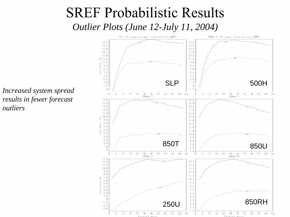
SREF Probabilistic Results Outlier Plots (June 12-July 11, 2004)
SLP 500H
850T 850U
250U 850RH
Increased system spread results in fewer forecast outliers

SREF Probabilistic ResultsPrecipitation Ranked Histograms (June 12-July 11, 2004)
Operational Experimental

SREF Probabilistic Results 12h Precipitation- 0.1” threshold (June 12-July 11, 2004)
12 h qpfRPSS
12 h qpfSpread
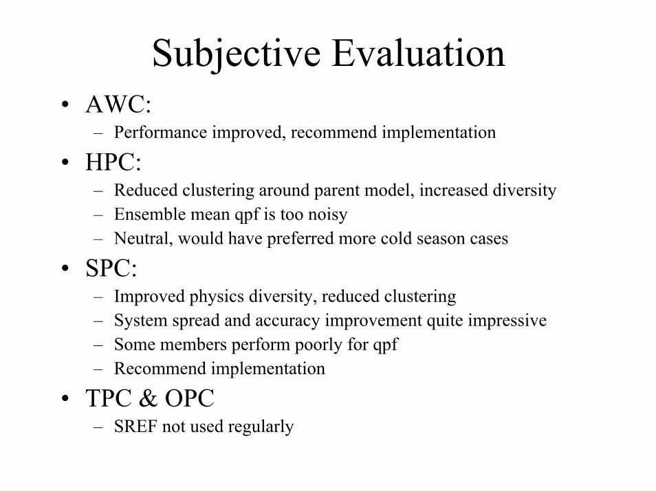
Subjective Evaluation• AWC:
– Performance improved, recommend implementation
• HPC: – Reduced clustering around parent model, increased diversity– Ensemble mean qpf is too noisy– Neutral, would have preferred more cold season cases
• SPC: – Improved physics diversity, reduced clustering– System spread and accuracy improvement quite impressive– Some members perform poorly for qpf– Recommend implementation
• TPC & OPC – SREF not used regularly

SHORT-RANGE ENSEMBLE FORECASTING (SREF)http://wwwt.emc.ncep.noaa.gov/mmb/SREF/SREF.html

SREF Aviation Page


SREF Example courtesy of Geoff Manikin
Eta has heaviest rain over DC / Vadue to too much warm sector convection leaving less moisture available for overrunning
SREF mean has the axis of heaviest precipitation slightly too far north and west, but it clearly gives the idea where heaviest amounts will occur with the overrunning region in PA.
SREF
OBS
Eta
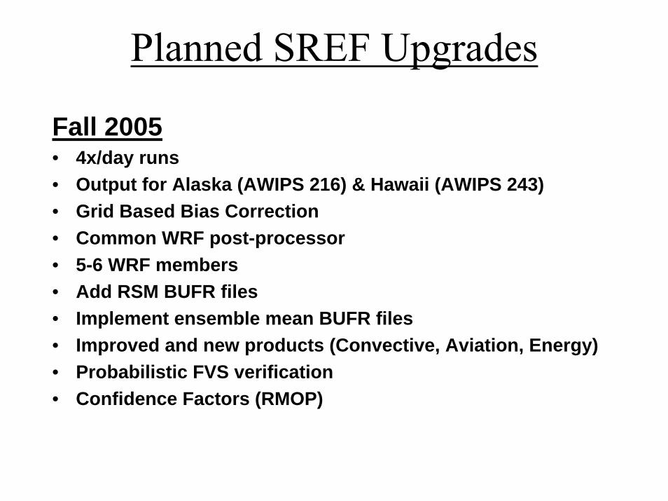
Planned SREF Upgrades
Fall 2005• 4x/day runs• Output for Alaska (AWIPS 216) & Hawaii (AWIPS 243)• Grid Based Bias Correction• Common WRF post-processor• 5-6 WRF members• Add RSM BUFR files• Implement ensemble mean BUFR files• Improved and new products (Convective, Aviation, Energy) • Probabilistic FVS verification• Confidence Factors (RMOP)

HiResWindow Fixed-Domain Nested Runs21 September Became WRF Runs of Two Control Configurations
• Routine runs made at the same time every day
• 00Z : Alaska-8 & Hawaii-8
• 06Z : Western-8 & Puerto Rico-8
• 12Z : Central-8 & Hawaii-8
• 18Z : Eastern-8 & Puerto Rico-8
• Everyone gets a daily high resolution run when <2 hurricane runs need to be made
http://www.emc.ncep.noaa.gov/mmb/mmbpll/nestpage/Alaska-8 domain is smaller than depicted

Weather Research and Forecasting (WRF)• End-to-end Common Modeling Infrastructure
– Observations and analysis– Prediction model– Post-processing, product generation and display– Verification and archive
• For the community to perform research• For Operations to generate NWP guidance• USWRP sponsorship - many partners: NCAR, NCEP,
FSL, OU/CAPS, AFWA, FAA, NSF and Navy• Initial implementation in HiResWindow in 4QFY04• Ensemble approach to be taken instead of single-run
deterministic approach
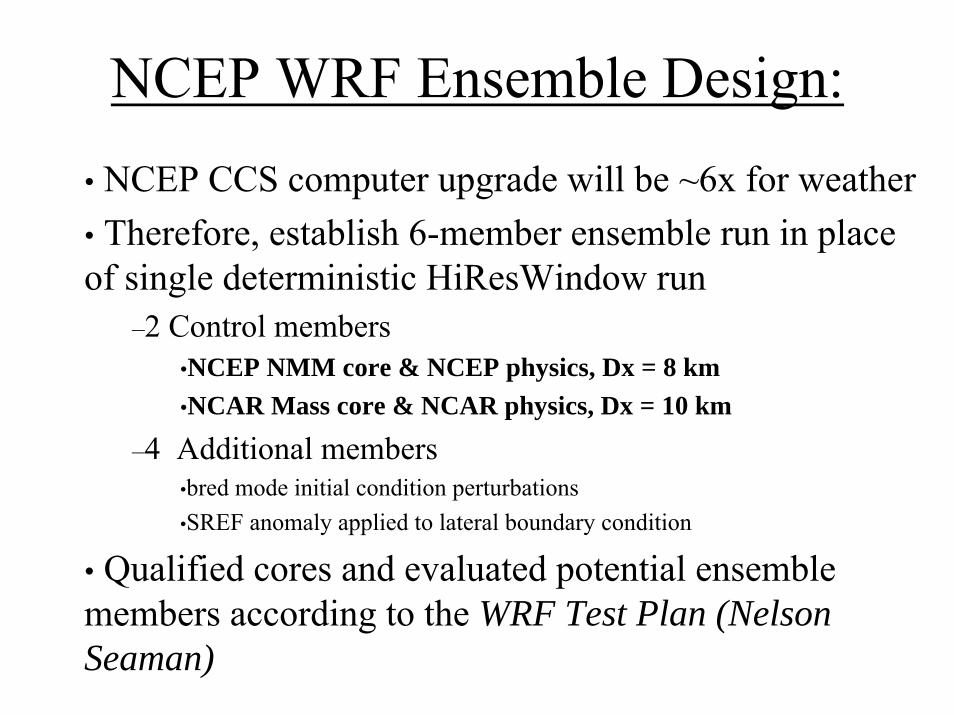
NCEP WRF Ensemble Design:• NCEP CCS computer upgrade will be ~6x for weather• Therefore, establish 6-member ensemble run in place of single deterministic HiResWindow run
–2 Control members•NCEP NMM core & NCEP physics, Dx = 8 km•NCAR Mass core & NCAR physics, Dx = 10 km
–4 Additional members•bred mode initial condition perturbations•SREF anomaly applied to lateral boundary condition
• Qualified cores and evaluated potential ensemble members according to the WRF Test Plan (Nelson Seaman)

Two cores currently in WRF Infrastructure
Eulerian Mass core V1.0 (Eulerian MC), [ V2.0 released May’03]- Terrain following hydrostatic mass-
field vertical coordinate, arbitraryvertical resolution
- Arakawa C-grid- Two-way nesting under evaluation- 3rd order Runge-Kutta time-split
differencing- Conserves mass, momentum, dry
entropy and scalars using 5th order(or 6th order) upwind spatialdifferencing to advect fluxes
Nonhydrostatic MesoscaleModel (NMM)
- Hybrid sigma-to-pressure terrain following vertical coordinate
- Arakawa E-grid- Two-way nesting under develop’mt- Adams-Bashforth time differ’cing,
time splitting- Conserves rotational kinetic energy,
total energy, mass, enstrophy and momentum using 2nd ordernine-point differencing for advection

Two WRF Physics Packages
Eulerian Mass-Core: NCAR physics package (MM5 & Eta conversions) (w/options)
NOAH unified 5-layer land-surface modelFerrier gridscale cloud and microphysicsKain-Fritsch convectionYong-Sei University PBLDudhia shortwaveRRTM longwave[Also adapted to use NCEP physics]
NMM Core: NCEP physics package (NMM = modified Eta)
NOAH unified 5-layer land-surface modelFerrier gridscale cloud and microphysicsBetts-Miller-Janjic convectionMellor-Yamada-Janjic 2.5 PBLLacis-Hansen shortwaveFels-Schwartzkopf longwave[Also adapted to use NCAR physics]

Evaluation Studies: The WRF Test PlanPurpose: Rigorously evaluate principal configurations of WRF
to validate model for future research and operations.Results: NCEP will select six members for its initial WRF
ensemble in Hi-Resolution Windows from eight options run under the WRF Test Plan:
• 2 Control members:• WRF-NMM with NMM physics and Eta IC/BCs• WRF-MC with NCAR physics, RUC ICs, Eta BCs
• 2 Cross-bred physics members:• WRF-NMM with NCAR physics and Eta IC/BCs• WRF-MC with NMM physics , RUC ICs, Eta BCs
• 2 WRF NMM runs, like NMM control, but with positive and negative bred perturbations.
• 2 WRF MC runs, like MC control, but with positive and negative bred perturbations.

Month/ Year &Source
U.S. Hi-Resol.Domains
WRF-EM & NCARPhysics
WRF-EM & NCEP Physics
WRF-EM & NCAR Phys + perturba.
WRF-EM & NCAR Phys -perturba.
WRF-NM & NCEP Physics
WRF-NM & NCAR Physics
WRF-NM & NCEP Physics + perturba
WRF-NM & NCEP Physics +-perturba
Feb ’03 FSL
East 28/28 28/28 28/28 28/28 28/28 28/28 28/28 28/28
Feb ’03 FSL
West 28/28 28/28 28/28 28/28 28/28 28/28 28/28 28/28
May’03 AFWA
Central 31/31 31/31 31/31 31/31 31/31 31/31 31/31 31/31
May’03 AFWA
East 31/31 31/31 31/31 31/31 31/31 31/31 31/31 31/31
Aug’03 AFWA
Central 31/31 31/31 31/31 31/31 31/31 31/31 31/31 31/31
Aug’03 AFWA
West 31/31 31/31 31/31 31/31 31/31 31/31 31/31 31/31
Oct ’03 AFWA
East 31/31 31/31 31/31 31/31 31/31 31/31 31/31 31/31
Oct ’03 AFWA
Alaska 31/31 31/31 31/31 31/31 31/31 31/31 31/31
The WRF Test Plan: A collaboration of AFWA, NAVO, FSL, NCAR and NCEP for 1936 runs covering all seasons and 4 domains at 8 km
31/31

Example of Ensemble Probability Product
Courtesy NOAA-SPC
CAPE > 1000j/kg Prob0-6km Shear >40kts Prob
Conv Precip >0.01” Prob Severe Convection Prob

WRF Test Plan Evaluations:Average RMSE for Wind Speed vs. Pressure
August 200242-h Forecast, West Domain6-h Forecast, West Domain
Operational Eta
WRF-MC, NCAR Physics WRF-MC, NCEP Physics
WRF-NMM, NCEP Physics
http://wwwt.emc.ncep.noaa.gov/mmb/WRFretro/html/test.html

WRF Test Plan Evaluations:Average RMSE for Temperature vs. Pressure
August 200242-h Forecast, West Domain6-h Forecast, West Domain
Operational Eta
WRF-MC, NCAR Physics WRF-MC, NCEP Physics
WRF-NMM, NCEP Physics
http://wwwt.emc.ncep.noaa.gov/mmb/WRFretro/html/test.html

Verification Statistics for the NCEP WRF Pre-implementation Test:
Part 2 Ensemble ResultsGeoffrey DiMego, Marina Tsidulko, Hui-Ya Chuang, Keith Brill, and S.
GopalakrishnanNOAA/NWS/NCEP/Environmental Modeling Center, Camp Springs, MD
Louisa Nance Development Testbed Center
National Center for Atmospheric Research, Boulder, CO
Ligia Bernardet and Andy LougheNOAA/OAR/Forecast Systems Laboratory, Boulder, CO
Chris DavisNational Center for Atmospheric Research, Boulder, CO
Dan Lohaus and Frank Olson,Northrup-Grummann, Inc., at Air Force Weather Agency, Offutt AFB, NB
The Remainder of the Developmental Testbed Center Team

P U R P O S E
• Combine various groups of the 8 retrospective runs into ensembles
• Evaluate ensembles • Verify mean using deterministic
scores• Verify using ensembles scores
• Choose best 6 member combination

Eight WRF Retrospective Runs• Four Physics Diversity (PD) runs of WRF Ensemble:
– Initial conditions• RUC for WRF-MC runs• Eta for WRF-NMM runs
– Crossbred physics• WRF-MC run with NCAR & NCEP physics• WRF-NMM run with NCEP & NCAR physics
– Lateral boundary conditions from Eta• Four Initial Perturbation (IP) runs of WRF Ensemble:
– Initial condition breeding cycle produces a pair of runs for each core• WRF-MC with NCAR physics and RUC base initial conditions• WRF-NMM with NCEP physics and Eta base initial conditions
– Apply 4 SREF based anomalies to Eta Lateral boundary conditions

WRF Ensemble Processing• Based on NCEP experience with SREF, the five
state variables (u, v, T, q and Ps), are perturbed• Accomplished within the WRF common
modeling infrastructure via a single utility -diffwrf
• Given three input files: File0 (the base field), File1 and File2, the general functionality of diffwrf can be writtenModified Original variable - variable variable = variable + α in File1 in File2in File0 in File0

Initial Condition Breeding Cycle• Required modification of WRF restart file processing.• File1 and File2 are forecasts made from a pair (+/-) of
perturbed states from previous cycle.• The factor, α, depends on the domain-averaged
magnitude of the difference field.• Rescaling (α < 1) is only done if the magnitude is
larger than a prescribed value (~ analysis error standard deviation) following procedures developed for NCEP’s medium-range ensemble forecast system (Toth and Kalnay, 1997).
• The breeding cycle involves adding scaled perturbations in positive and negative sense from the pair of 24 hours forecast onto initial conditions of the next cycle yielding 2 runs from each control.

Lateral Boundary Condition Anomaly• WRF-SI outputs and NeTCDF variables
modified• File1 and File2 are forecasts made from a
perturbed state and the control of NCEP’sSREF (basically the SREF member’s anamoly with respect to its control run)
• The factor, α, is usually set to 1

Breeding Pairs with LBC Anomalies• Lateral boundary condition anomaly applied
to WRF-SI’s vinterp NeTCDF outputs using 4 SREF forecasts, namely, p1, p2, n1 and n2 and the control applied to either Eta12 or RUC initial condition forecast, yielding 4 perturbed forecasts, i.e.,
eta12 = eta12 + α [p1 - ct1] NMMeta12 = eta12 + α [n2 - ct1] core eta12 = eta12 + α [p2 - ct1] Masseta12 = eta12 + α [n1 - ct1] core

WRF Ensemble ProcessingBreeding – Perturbation Data Flow -- Schematic
LBC = ETA2183,6,…,48 for 17 files
LBC = CTL Sref datafiles3 – 51 for 17 files9 – 57 for 17 files
LBC = N1 Sref datafile3 – 51 for 17 files9 – 57 for 17 files
LBC = P2 Sref datafiles3 – 51 for 17 files
9 – 57 for 17 files
GRIDS non -perturbations Vertical & Horizontal
scripttouchdiffwrf
scripttouchdiffwrf
SI Processing
GRIDS CTLVertical & Horizontal
GRIDS N1Vertical & Horizontal
GRIDS P2Vertical & Horizontal
N1 wrfbdy_d01 P2 wrfbdy-d01W rfbdy_d01
W RFReal
W rf_real_input_em_N 1 (16 files ) Wrf_real_input_em_P2… .
(16 files)
W rf_real_input_em… .(17 files)
W RFReal
W RFReal
Diffwrf process each time step for a of 16 times skipping over the 0 hour file
SI Processing

Deterministic Verification of Ensemble Means Versus Radiosonde Obs
Color Codes

T Wind
Z RH

T
Z
Wind
RH
500 hPa Vector Wind for FH = all (west and east ensembles)
500 hPa Height for FH = all (west and east ensembles)
500 hPa RH for FH = all (west and east ensembles)
500 hPa Temperature for FH = all (west and east ensembles)

Ensemble Verification
Based on verification vs radiosonde obs
4 Initial Perturbation (IP) vs 4 Physics Diversity (PD)
IP More Uniform Ranked Histograms
300 mb300 mb
Legend for Subsequent SummariesAll Forecast Ranges Combined
400 mb 400 mb
500 mb 500 mb
700 mb 700 mb
850 mb 850 mb

Equally Likely Central Summer RH
4IP 4PD
Equally Likely Eastern Winter RH
4IP 4PD
Equally Likely Western Winter Temp
4IP 4PD
Equally Likely Eastern Winter Temp
4IP 4PD
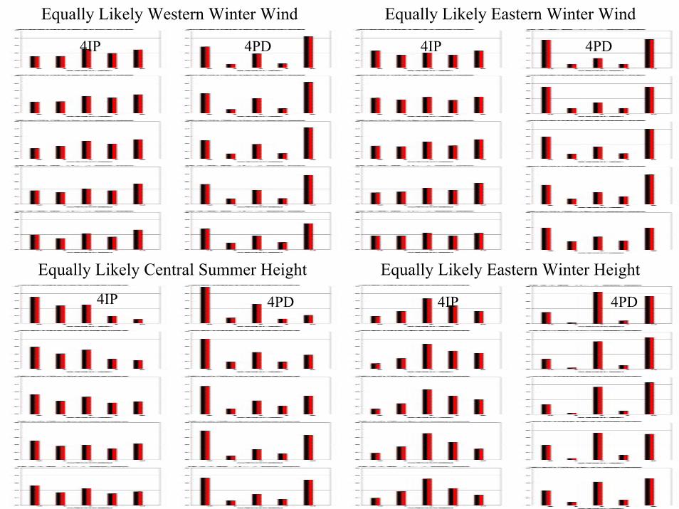
Equally Likely Western Winter Wind
4IP 4PD
Equally Likely Eastern Winter Wind
4IP 4PD
Equally Likely Central Summer Height
4IP 4PD
Equally Likely Eastern Winter Height
4IP 4PD

CHOICE OF SIX MEMBERS2 Controls + 2 IP-Breeding PairsThis 6 Member Ensemble Is Almost As Good
As The Complete 8 Member EnsembleNearest Truth Western Winter Wind
6 8
Nearest Truth Central Summer Temp
6 8

WRF System Description – HRW Implementation
Description: The WRF modeling system consists of…
Component Source Code History_• Two dynamical cores NCEP & NCAR new• Two complete physics suites NCEP & NCAR modified MM5 & Eta• Preprocessing for ICs/BCs FSL & NCEP new• Post-processing for product NCEP modified Eta
generation• Statistical evaluation package NCEP modified Eta• Software engineering infrastructure NCAR new• Ensembling software NCEP new

Implementation Strategy – Phase 1
• Phase 1— Implement new model (Threshold): IOC (21 September 2004)
• Two deterministic “control” versions of WRF will run four times daily,once for each of four large windows (twice for small windows).
- NCAR EM core: 10-km horizontal resolution, 50 layers- NCEP NMM core: 8-km horizontal resolution, 60 layers
• 80-min run window (clock time) shared with GFDL Hurricane model• Availability contingent on tropical weather situation.
- If 1 tropical storm present, WRF runs for HI & PR will be dropped out.- If 2 tropical storms present, WRF-EM run will be dropped.- If 3 or more tropical storms present, both WRF runs will be dropped.

Implementation Strategy – Phase 2
• Phase 2— Implement 6 member WRF ensemble target Feb/March 2005
• Two “control” versions & two breeding cycle pairs will run four times daily,once for each of four large windows (twice for small windows).
- NCAR EM core: 10-km horizontal resolution, 50 layersPositive bred mode plus Negative bred mode
- NCEP NMM core: 8-km horizontal resolution, 60 layersPositive bred mode plus Negative bred mode
• 80-min run window (clock time) shared with GFDL Hurricane model but with increased computer power with CCS upgrade complete• Availability still contingent on tropical weather situation.
- If 1/2 tropical storm present, WRF-EM bred mode runs will be dropped.- If 3/4 tropical storms present, WRF-NMM bred mode runs will be dropped.
• Two control versions ALWAYS run
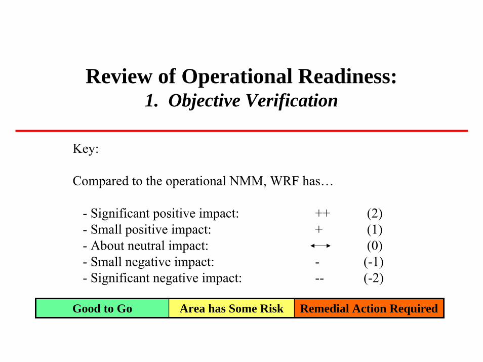
Review of Operational Readiness:1. Objective Verification
Key:
Compared to the operational NMM, WRF has…
- Significant positive impact: ++ (2)- Small positive impact: + (1)- About neutral impact: (0)- Small negative impact: - (-1)- Significant negative impact: -- (-2)
Good to Go Area has Some Risk Remedial Action Required

Review of Operational Readiness:1. Objective Verification
Variable Season West HRW Domain East HRW Domain NET
Wind profile Jan-Mar 04 Bias: ++ RMSE: - Bias: ++ RMSE: 3
Height profile Jan-Mar 04 Bias: -- RMSE: Bias: ++ RMSE:++ 2
-4
1
3
3
-2
Temp. profile May-Aug 04 Bias: - RMSE: - Bias: - RMSE: -
Rel. Hum. profile
May-Aug 04 Bias: RMSE: Bias: + RMSE
10-m Winds Jan-Mar 04 Bias: ++ RMSE: + Bias: + RMSE: -
2-m Temp. All Jan-AugFcst-Obs.
May-Aug:+Fcst-Obs.
Jan-Aug+Fcst-Obs.
May-Aug+Fcst-Obs.
Large Scale*Precipitation
Jan-Mar 04 ETS: - Bias: -- ETS: Bias: +
Large Scale*Precipitation
May-Aug 04 ETS: Bias: -- ETS: + Bias: -- -4
*No mature objective score for SMALL Scale Precipitation
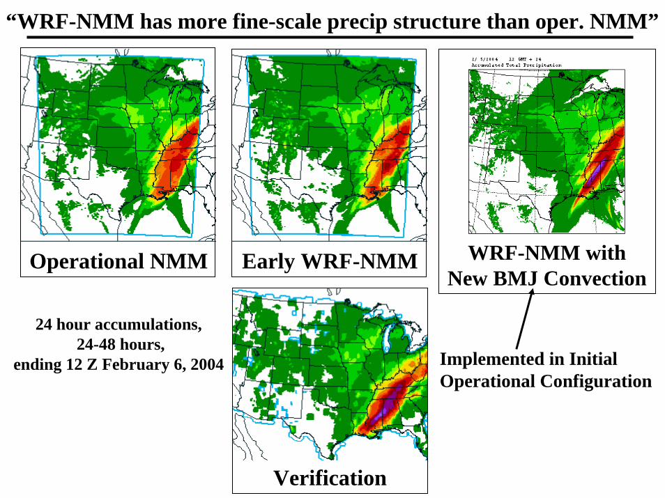
“WRF-NMM has more fine-scale precip structure than oper. NMM”
Operational NMM
Verification
24 hour accumulations,24-48 hours,
ending 12 Z February 6, 2004
Early WRF-NMM WRF-NMM with New BMJ Convection
Implemented in InitialOperational Configuration

24 Hour Accumulated Precipitation Valid 12Z 6 September, 2004, 42 Hour Forecast
OPS. NMM WRF NMM
OPS. Eta WRF EM
CPC RFC 1/8 deg Verification
Tropical Storm
Francis:
Subjective Comparison

24 Hour Accumulated Precipitation Valid 12Z 30 August, 2004, 42 Hour Forecast
OPS. NMM
WRF EM
WRF NMM
OPS. Eta
CPC RFC 1/8 deg Verification
Tropical Storm Gaston:
Subjective Comparison

Air Quality Prediction at NCEPJeff McQueen, Pius Lee, Marina Tsildilko, with Geoff DiMego,
Hui-Ya Chuang and Eric Rogers
CONGRESSIONAL EARMARKPaula Davidson – NWS/HQ/OST Program Manager
VisionNational Air Quality Forecast System which provides the US with ozone, particulate matter and other pollutant forecasts with enough accuracy and advance notice to take action to prevent or reduce adverse effects
StrategyWork with EPA, State and Local Air Quality agencies and private sector to develop end-to-end air quality forecast capability for the Nation

National Air Quality ForecastingPlanned Capabilities
• Initial (1-5 years started FY2003) : – 1-day forecasts of surface ozone (O3) concentration– Develop and validate in Northeastern US in 2 years– Deploy Nationwide within 5 years
• Intermediate (5-7 years):– Develop and test capability to forecast particulate matter (PM)
concentration • Particulate size < 2.5 microns
• Longer range (within 10 years):– Extend air quality forecast range to 48-72 hours– Include broader range of significant pollutants
• Program has purchased additional computer power to perform AQF and promised this increment for perpetuity

AQFS Implementation• IOC Northeastern US Domain NAM/Eta driving
CMAQ 12 km grid spacing on 22 vertical sigma levels• Development Test & Evaluation was run in 2003• Operational Test & Evaluation was run in 2004• AQFS Declared Operational 17 September 2004• Eastern US upgraded AQFS DT&E in 2004 -- ready
for Implementation in March-April 2005

NCEP Regional Reanalysishttp://wwwt.emc.ncep.noaa.gov/mmb/rreanl/index.html
Fedor Mesinger1, Geoff DiMego2, Eugenia Kalnay3, Perry Shafran4, Dusan Jovic4, Wesley Ebisuzaki5, Jack
Woollen4, Yun Fan6, Robert Grumbine2, Wayne Higgins5, Hong Li3, Ying Lin2, Kenneth Mitchell2, David
Parrish2, Eric Rogers2, Wei Shi6, and Diane Stokes2
1NCEP/EMC and UCAR, 2NCEP/EMC, 3Univ. of MD, 4NCEP/EMC and SAIC/GSO, 5NCEP/CPC, 6NCEP/CPC and RSIS
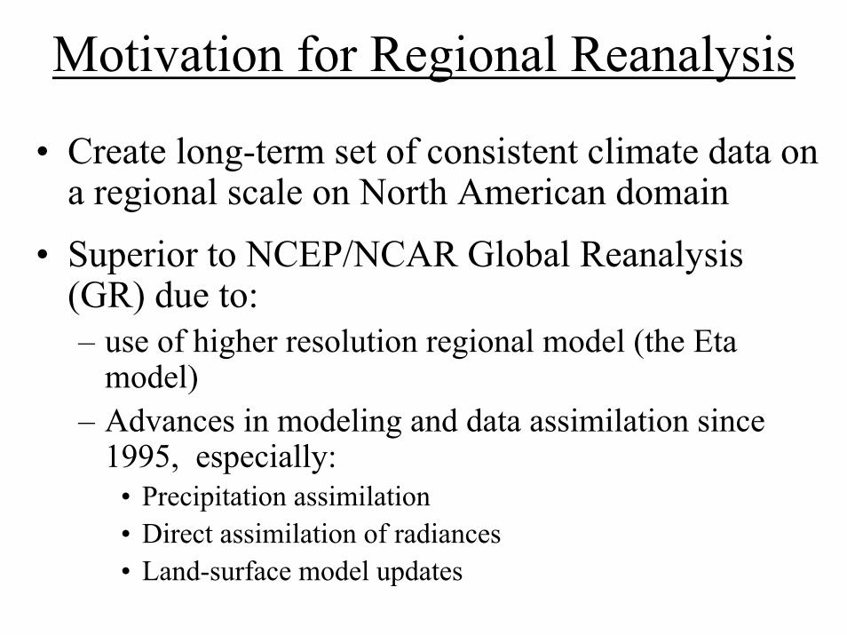
Motivation for Regional Reanalysis
• Create long-term set of consistent climate data on a regional scale on North American domain
• Superior to NCEP/NCAR Global Reanalysis (GR) due to:– use of higher resolution regional model (the Eta
model)– Advances in modeling and data assimilation since
1995, especially:• Precipitation assimilation• Direct assimilation of radiances• Land-surface model updates

http://wwwt.emc.ncep.noaa.gov/mmb/rreanl/index.html

Contents of Final NAM/Eta (&DGEX) Bundle Expected by Spring 2005
• 3DVAR analysis changes– Assimilate Level 2.5 88D radial wind – superobs generated onsite– Add 2D-VAR analysis of surface land temperature observations
• Precip Assimilation change– Drive surface energy balance directly with observed precipitation– Stop aggressive attempts to add latent heat/moisture to create precip
• Eta model - Radiation and Cloud Changes– Lower limit on optical depth for stable liquid water clouds is being
removed with large effect– Water & ice absorption coefficients in Lacis-Hansen shortwave
scheme modified to be more consistent with those in the GFS radiation scheme
– Calculations of optical depths (used for calculating absorption) are made to be consistent with those used in Hou et al. (2002) for GFS
• Eta model – Land-surface model upgrades

“THE PHYSICS WHEEL OF PAIN”
Radiation
Cu Scheme Sfc & PBL
Grid Scale Microphysics
1. - Hydrometeor type (phase)
- Cloud optical properties
- Cloud overlap (merging Cu, grid-scale cloudiness)
- Cloud fractions
2. - Precipitation
3. - Sfc energy fluxes
4. - Convection, PBL evolution,precipitation
Compliments of Dr. Jaiyu Zhou (NOAA/OST)
http://wwwt.emc.ncep.noaa.gov/mmb/mmbpll/paralog/paralog.etax.winter2005.html
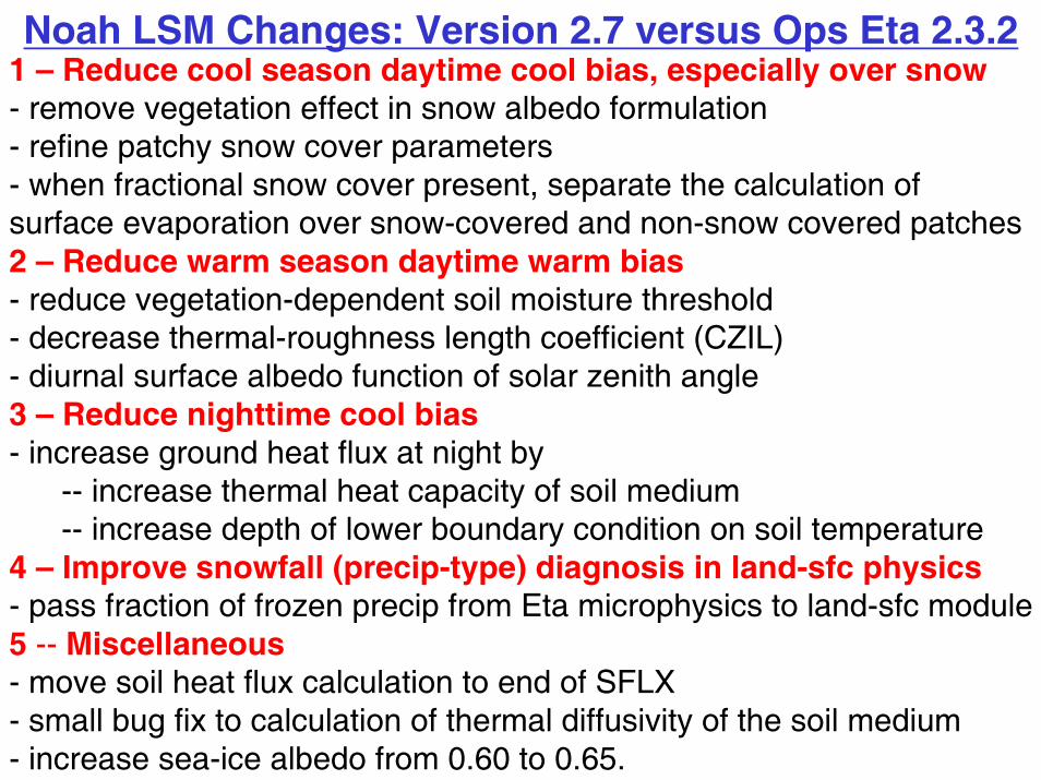
Noah LSM Changes: Version 2.7 versus Ops Eta 2.3.21 – Reduce cool season daytime cool bias, especially over snow- remove vegetation effect in snow albedo formulation- refine patchy snow cover parameters- when fractional snow cover present, separate the calculation ofsurface evaporation over snow-covered and non-snow covered patches2 – Reduce warm season daytime warm bias- reduce vegetation-dependent soil moisture threshold- decrease thermal-roughness length coefficient (CZIL)- diurnal surface albedo function of solar zenith angle3 – Reduce nighttime cool bias- increase ground heat flux at night by
-- increase thermal heat capacity of soil medium-- increase depth of lower boundary condition on soil temperature
4 – Improve snowfall (precip-type) diagnosis in land-sfc physics- pass fraction of frozen precip from Eta microphysics to land-sfc module5 -- Miscellaneous- move soil heat flux calculation to end of SFLX- small bug fix to calculation of thermal diffusivity of the soil medium- increase sea-ice albedo from 0.60 to 0.65.
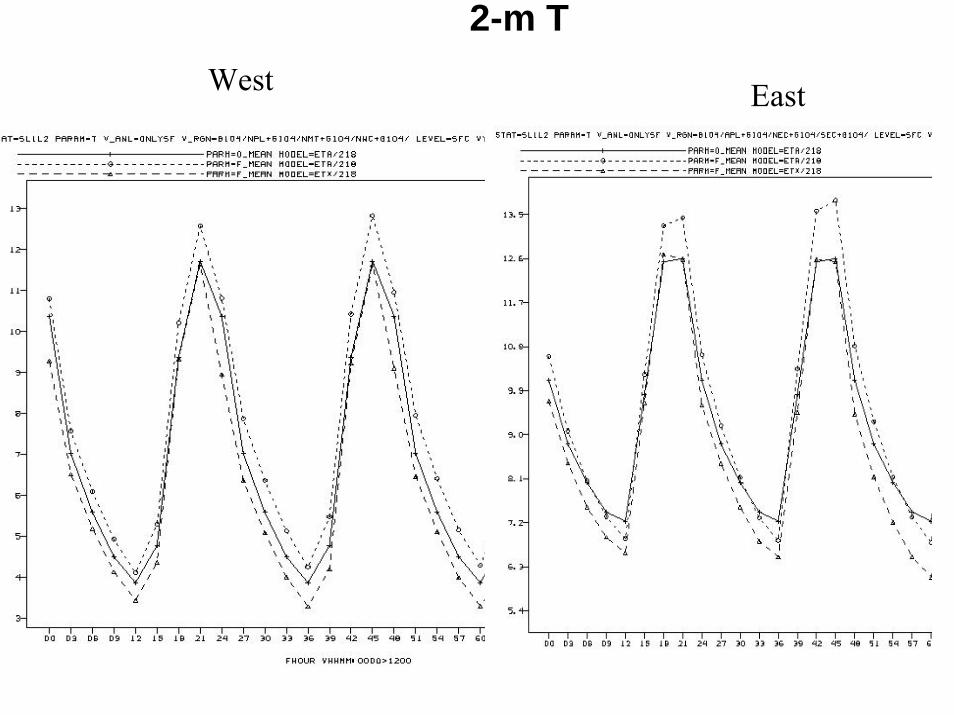
2-m T
EastWest

NOAH LSM Version 2.8Vegetation / Surface Type Class1. Urban and Built-Up Land 2. Dryland Cropland and Pasture 3. Irrigated Cropland and Pasture 4. Mixed Dryland/Irrigated Cropland and
Pasture 5. Cropland/Grassland Mosaic 6. Cropland/Woodland Mosaic 7. Grassland 8. Shrubland9. Mixed Shrubland/Grassland 10. Savanna 11. Deciduous Broadleaf Forest 12. Deciduous Needleleaf Forest 13. Evergreen Broadleaf Forest 14. Evergreen Needleleaf Forest 15. Mixed Forest 16. Water Bodies 17. Herbaceous Wetland 18. Wooded Wetland 19. Barren or Sparsely Vegetated 20. Herbaceous Tundra 21. Wooded Tundra 22. Mixed Tundra 23. Bare Ground Tundra 24. Snow or Ice 25. Playa 26. Lava 27. White Sand
SOIL TYPE CLASS1. SAND 2. LOAMY SAND 3. SANDY LOAM 4. SILT LOAM 5. SILT 6. LOAM 7. SANDY CLAY LOAM 8. SILTY CLAY LOAM 9. CLAY LOAM 10. SANDY CLAY 11. SILTY CLAY 12. CLAY 13. ORGANIC MATERIAL 14. WATER 15. BEDROCK 16. OTHER(land-ice) 17. PLAYA 18. LAVA 19. WHITE SAND

NCEP
Brad Colman & John Horel & ISSTMesoscale Analysis Committee
Meeting
Geoff DiMego13 October 2004
where the nation’s climate and weather services begin

Workshop Conclusions• NCEP’s Rolls Royce Concept
– NDFD resolution– 4-D Data Assimilation System
• Too Costly – Target this solution for true AoR• Real-Time Mesoscale Analysis
– Accepted as Phase I solution– To produce timely analyses for WFO’s
• FSL + NCEP to partner in producing RTMA– Hourly RUC analysis downscaled to 5 km (FSL)– 5 km 2D-VAR analysis using anisotropic covariances,
mesonet obs and downscaled RUC as first-guess (NCEP)• Subject to Availability of Resources – people & cpu’s

NCEP Has Total Data Access• Continuous data collection from all sources
– Radiosondes, dropsondes, pibals, Profilers, RASS, VAD– Surface land (SYNOPs, METARs, mesonets)– Surface marine (ships, fixed & drifting buoys, CMANs, XBTs)– Aircraft (ACARS, AMDAR, AIREP, RECCO)– Satellite cloud-drift winds (visible, microwave, moisture)– Satellite radiances (DOD/NOAA/NASA polar + geostationary)– GPS IPW, SSM/I precip, scatterometer ocean sfc wind speed– Level II 88D radial velocity, reflectivity & spectrum width
• Anything available locally via LDAD can and should be sent to TOC in Silver Spring, MD and on to NCEP – this only takes seconds - most of these data are already getting to NCEP via FSL.

EMC Outreach and Leveraging
• EMC is partnering with Steve Lazarus and others who helped develop / adapt the ADAS to complex terrain at University of Utah
• Expect to partner with FSL on use of WRF-GSI in Rapid Refresh WRF application
• NCEP’s 3DVAR / GSI is being adapted to use anisotropic covariance structures that follow the terrain, depend on atmospheric flow and stability.
• EMC leverages all the strengths of co-located Joint Center for Satellite Data Assimilation

Isotropic Error Correlation in ValleyPlotted Over Utah Topography
ob’s influence extends into mountains indiscriminately

Anisotropic Error Correlation in ValleyPlotted Over Utah Topography
ob’s influence restricted to areas of similar elevation

Anisotropic Error Correlation on Slope Plotted Over Utah Topography
ob’s influence restricted to areas of similar elevation

Anisotropic Error Correlation on Mt Top Plotted Over Utah Topography
ob’s influence restricted to areas of similar elevation

Anisotropic Error Correlation on Mt Top Plotted Over Utah Topography
ob’s influence restricted to areas of similar elevation
x

North American Mesoscale WRF Plans
• Date of Eta replacement moved to March 2006• Increase horizontal resolution from 12 km to 10
km• Move model top from 25 mb to 2 mb (will help
assimilation of satellite radiances)• Eta 3D-VAR to be replaced by Gridpoint
Statistical Interpolation (GSI)• Assimilate mesonets, GPS IPW, boundary layer
Profilers and (hopefully) Level II radial velocity

North American Mesoscale WRF Plans
• Minimize transition tasks - produce complete set of existing NAM look-alike output
• Extend BUFR sounding files to 84 hour with only slight (5 minute?) delay compared to current 60 hr BUFR file delivery
• Replace non-WRF NMM applications in Fire Weather / IMET Support and On-Call Emergency Response nested runs
• Maintain ability to quickly run a replacement 12 km Eta (run 12 km EDAS in background mode) in the event of an ‘infrastructure related’ failure for which a quick solution is unlikely

PLANS FOR THE FUTURE
For each of the possible upgrades/phases of the CCS
contract with IBM

North American Meso Guidance SystemPrediction Model (DGEX included)
Analysis andData Assimilation
Computer Phase
12 km 60 level MesoEta earlier delivery
12 km 3DVAR improved use of surface observations
Current Phase I
10 km 60 level WRF2mb top, nonhydrostaticdynamics, imp. physics called more frequently
10 km GSI analysis, 2 mbtop, cloud analysis, AIRS, GOES imagery
Phase II
8 km 70 level WRFfire weather IMET support incorporated, improved physics
8 km, 88D reflectivity, hydrometeor analysis, cloud and aerosol absorption and scattering in radiative transfer
Phase III
6.5 km 85 level WRF.2 mb top, OCER incorporated, improved physics, ozone + aerosols
6.5 km .2 mb top, advanced4DDA, NPP, NPOESS, IASI + air quality
Phase IV

HiResWindow and Fire Wx/IMETHiResWindow Fire Weather IMET
SupportComputer Phase
8 km WRF 6 member ensemble
8 km nested WRF-NMM
Current Phase I
7 km WRF8 member ensemble
6.5 km nested WRFwith improved physics
Phase II
6 km WRF10 member ensemble
5.5 km included in NAM-WRF run
Phase III
5 km WRF12 member ensemble
4.5 km included in NAM-WRF run
Phase IV

Hurricane, Rapid Refresh & Air QualityHurricane Model Rapid Refresh (RR) Air Quality
2 nests 18 + 55 km L 42, coupled Atl & Pac with GFS physics
12 km Sfcozone, New England10 km Sfcozone National8 km Sfcozone, particulates6.5 km Sfcozone, particulates
2 nests 12 + 40 km L64 Hurricane-WRF & new ocean (HYCOM)
2 nests 8 + 30 km L64 Hurricane-WRF with 4DDA
2 nests 5 + 20 km L100 Hurricane-WRF with imp. physics & enhanced ocean model
Computer Phase
20 km 50 level RUC 3DVAR
Current Phase I
13 km 60 level RUC improved physics
Phase II
10 km 60 level Rapid Refresh-WRF
Phase III
8 km 70 level RR-WRF improved physics
Phase IV