ncer 2004 wetland and tidal channel evolution affecting critical habitats at cape sable everglades...
TRANSCRIPT

NCER 2004
Wetland and tidal channel evolution affecting critical habitats at Cape Sable
Everglades National ParkEverglades National Park
Wetland and tidal channel evolution affecting critical habitats at Cape Sable
Brigitte VlaswinkelBrigitte Vlaswinkel
Harold WanlessHarold Wanless
NCER 2004

NCER 2004
Wetland and tidal channel evolution affecting critical habitats at Cape SableWetland and tidal channel evolution affecting critical habitats at Cape Sable
10 km
Study areaStudy area
Southwest FloridaSouthwest Florida
Everglades National ParkEverglades National Park

NCER 2004
What is happening?
3) Major hurricanes
Rapid ecosystem changes in past 80 years, due to…
1) Human modifications
(canals)
2) Sea level rise
NCER 2004
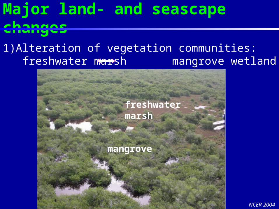
Major land- and seascape changes
1)Alteration of vegetation communities: freshwater marsh mangrove wetland
mangrove
freshwatermarsh

NCER 2004
Major land- and seascape changes
2) Small canals become large tidal inlets…
and new creeks evolve

NCER 2004
Major land- and seascape changes
3) Lagoons fill up with muddy sediments
N

NCER 2004
Take Home Message
Man-made canals acted as catalysts for interior freshwater marsh collapse (but with sea level rise, this would now be happening in any case)
Large amounts of organic material are released from collapsed freshwater marsh and redistributed within the system
Complicated connectivity of processes and products. Cape Sable may serve as an analog for other sensitive channeled saline-to-freshwater wetland complexes

NCER 2004
Main question is…
What are the sediment dynamics of
the system?
Sediment from where?Sediment from where?Where to?Where to?How fast?How fast?
MARL RIDGE
LAGOON
COLLAPSEDFRESHWATERMARSH

NCER 2004
1928
500 m
2002
Aerial photographs (1928, 1935, 1953, 1964, 1973, 1990, 1999) Ikonos high resolution satellite images (2002, 2004)
Geomorphologic changes (± 80 yrs)

NCER 2004
Geomorphologic changes (± 80 yrs)
1928 2002
pond
pond

NCER 2004
Collapse of interior freshwater marsh
and
redistribution of the released organic
material
Focus of talk
Marl ridgeMarl ridge

NCER 2004
Narrow canals were dredged across the interior of Cape Sable in the 1920s to drain the wetland
1973
Marl Ridge
Marl Ridge
Homestead Canal
East Cape Canal
NCER 2004
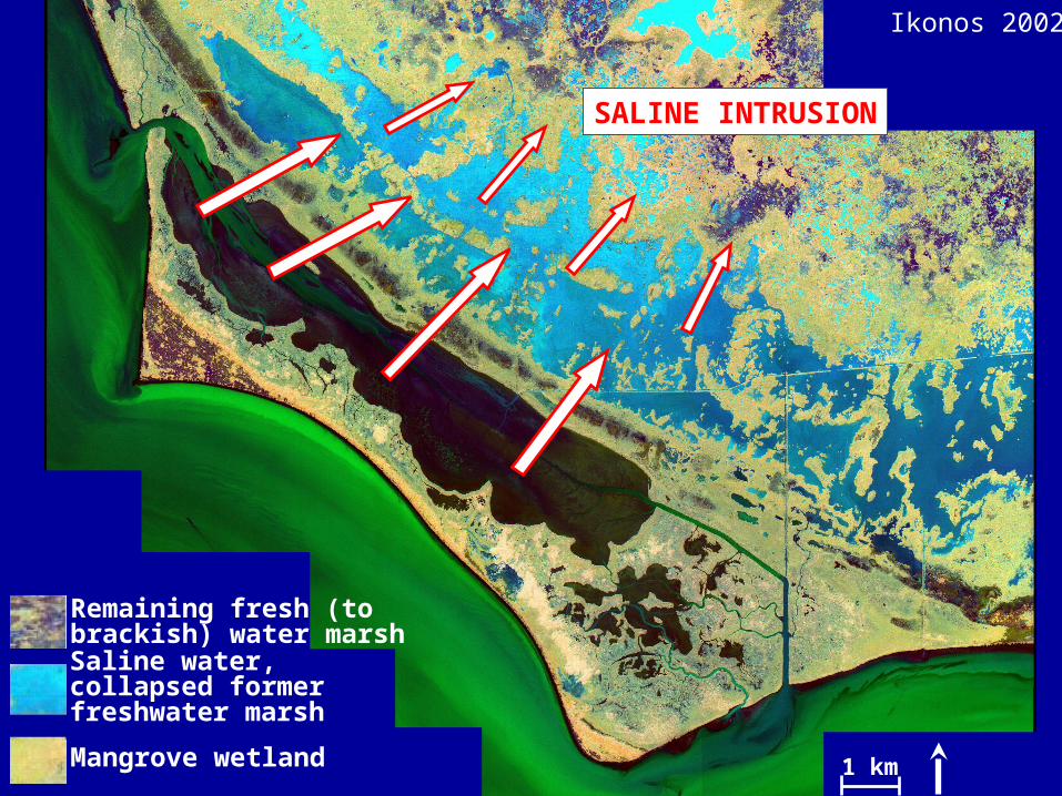
Remaining fresh (to brackish) water marsh
Saline water, collapsed former freshwater marsh
Mangrove wetland 1 km
Ikonos 2002
SALINE INTRUSION

NCER 2004
Lake IngrahamLake Ingraham
Coastal RidgeCoastal Ridge
NE
SWNE
SW
NCER 2004
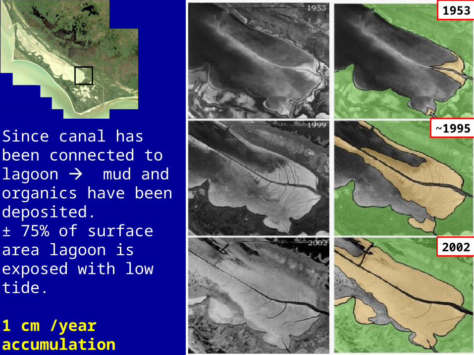
2002
~1995
1953
Since canal has been connected to lagoon mud and organics have been deposited. ± 75% of surface area lagoon is exposed with low tide.
1 cm /year accumulation
Rate of infill is increasing!

NCER 2004
Extremely high!
5 cm5 cm
40 cm 40 cm40 cm

NCER 2004
Remaining fresh (to brackish) water marsh
Saline water, collapsed former freshwater marsh
Mangrove wetland
WATER MASS 1
WATER MASS 1
WATER MASS 2WATER MASS 2
NCER 2004
0
20
40
60
80
100
120
140
160
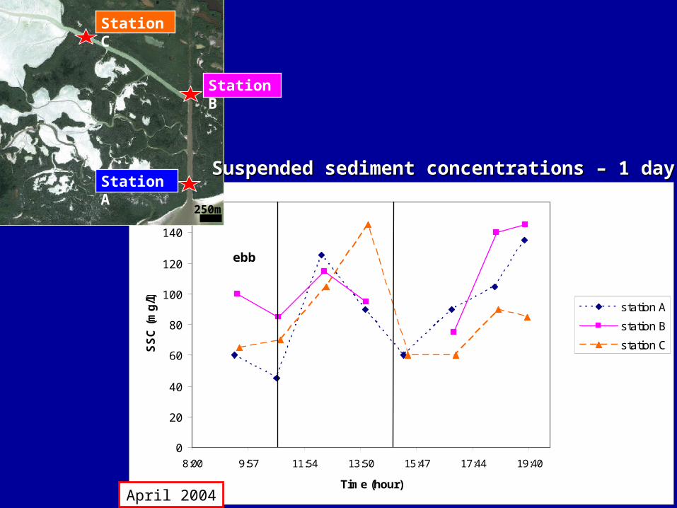
8:00 9:57 11:54 13:50 15:47 17:44 19:40
Time (hour)
SS
C (
mg
/l) station A
station B
station C
ebb
flood
ebb
Station A
250m
Station C
Station B
April 2004
Suspended sediment concentrations – 1 daySuspended sediment concentrations – 1 day

NCER 2004
Year Day
Suspended sediment concentrations – 2 weeksSuspended sediment concentrations – 2 weeks
Station A
250m
Station C
Station A
Station C
SSC(mg/l)
ebbpeak
August 2004 Year Day
floodpeak
IMPORTANT
Station A: Not much sediment during flood
Station C: A lot of sediment during flood!

NCER 2004
SedSedOMOM
+ SedSedCARBCARB
SedSedCARBCARB
SedSedCARBCARB
Collapsed freshwater marsh
SedSedOMOM
SedSedOMOM = organic matter sediments
SedSedCARBCARB = carbonate sediments
Geochemical analyses:Geochemical analyses:70% organics70% organics30% carbonate30% carbonate
NCER 2004
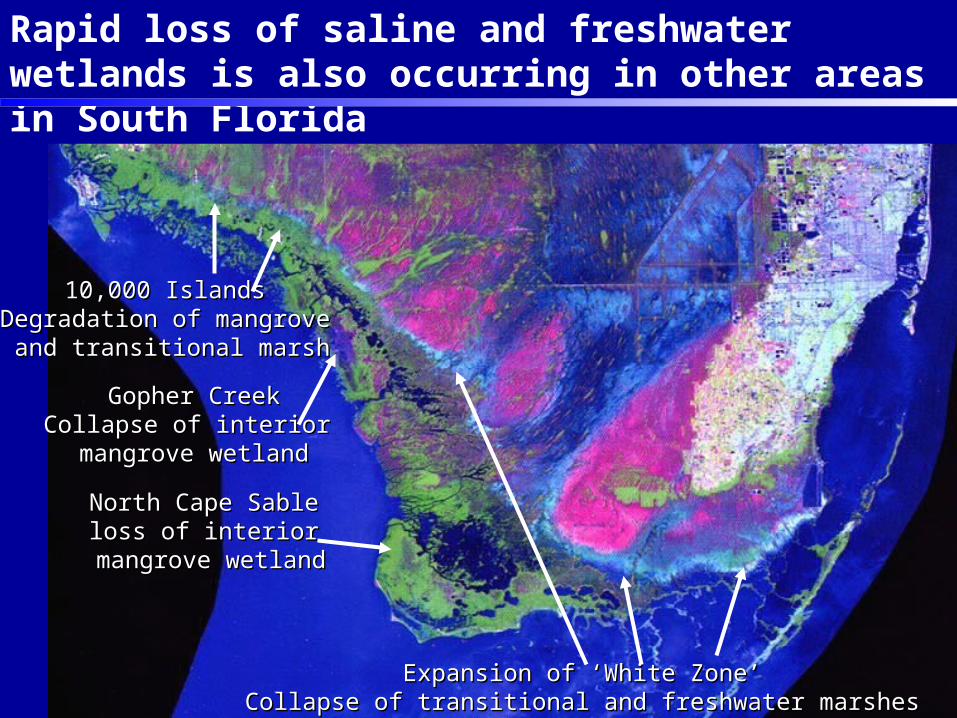
10,000 Islands10,000 IslandsDegradation of mangroveDegradation of mangrove and transitional marshand transitional marsh
Gopher CreekGopher CreekCollapse of interior Collapse of interior mangrove wetlandmangrove wetland
Expansion of ‘White Zone’Expansion of ‘White Zone’ Collapse of transitional and freshwater marshes Collapse of transitional and freshwater marshes
North Cape Sable North Cape Sable loss of interior loss of interior
mangrove wetlandmangrove wetland
Rapid loss of saline and freshwater wetlands is also occurring in other areas in South Florida

NCER 2004
Impact of released organic matter ?
NCER 2004
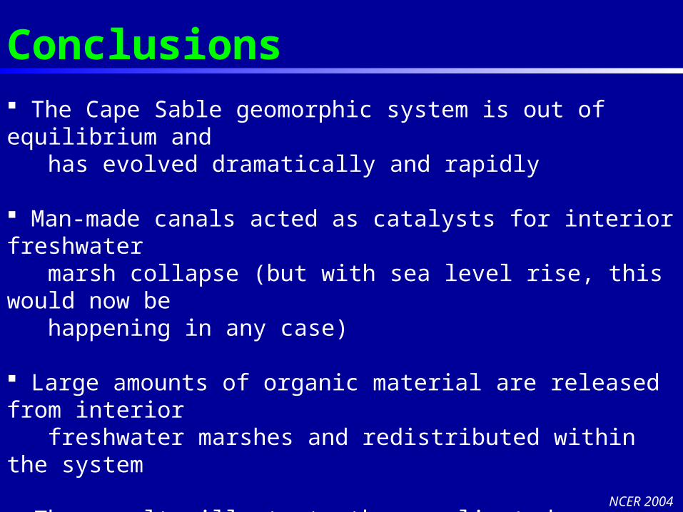
Conclusions The Cape Sable geomorphic system is out of equilibrium and has evolved dramatically and rapidly
Man-made canals acted as catalysts for interior freshwater marsh collapse (but with sea level rise, this would now be happening in any case)
Large amounts of organic material are released from interior freshwater marshes and redistributed within the system
• The results illustrate the complicated connectivity of processes and products on this coast. Cape Sable area may serve as an analog for other sensitive channeled mangrove-to-freshwater wetland complexes

NCER 2004
AcknowledgementsEverglades National ParkStable Isotope Lab at RSMASMany field assistantsCape Sable Seaside Sparrow
With water, water everywhere, and no time left to think,Your battle will wage on
Among cash and good intentions.Slowly flying, slowly dying,
While the lifeblood of the River drainsPast the sawgrass bent in discontent.
Tom Fucigna

NCER 2004
1928• A narrow drainage
ditch was cut across the freshwater marsh in the 1920s
• It also cut across the marl ridge to the west
Mar
l Rid
ge

NCER 2004
1953• By 1953 the marsh
adjacent to the marl ridge had collapsed
Mar
l Rid
ge
1953

NCER 2004
1928
1999

NCER 2004
Sediment dynamic patterns on decadal scale
Soft sediment cores• Sediment constituents• Depositional processes (grain size, storm layers)• Average sedimentation rate through time
Geochemical analyses• Ratio carbonate/organic matter/insolubles• Organic carbon isotopic composition (δ13C )
Source of sediment

NCER 2004
Sediment dynamic patterns on short time scale
Sediment dynamicsIn situ sedimentationShoreline dynamics
HydrodynamicsWind dataWater levelCurrent flowDischargeSediment in suspension