near space communications systems · fill gaps in terrestrial wireless networks ... total payload...
TRANSCRIPT

Near Space Communications Systems
Heartland Security ConferenceMinneapolis, Minnesota
11 July 2007
Jerry QuennevilleVice President, Business Development
Space Data Corporation460 South Benson LaneChandler, Arizona 85224
(480) 722-2100www.spacedata.net

Overview
• Provide emergency response communications within 30 minutes and coverage over hundreds of miles within 2 hours
• Require minimal or no infrastructure, a capability that’s critical in post-disaster scenarios and remote locations
• Support voice, data and asset tracking
• Have been in commercial operation for more than 3 years and are now being purchased in quantity by the U.S. Air Force
• Are cost-effective, recoverable and immediately available
• Can be tailored to users’ specific needs and support interoperability
Space Data produces high-altitude communications platforms that:
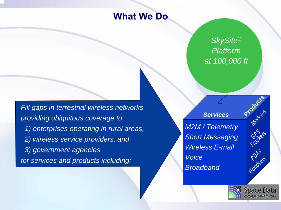
What We Do
Fill gaps in terrestrial wireless networks providing ubiquitous coverage to 1) enterprises operating in rural areas, 2) wireless service providers, and3) government agencies
for services and products including:
Modems
SkySite®
Platformat 100,000 ft
Services Produc
ts
M2M / TelemetryShort MessagingWireless E-mailVoiceBroadband
GPS_
Tracke
rs
Handset
sPDAs

The Solution Simply Integrates 3 Proven Technologies
+ +
Weather Balloons GPS NetworkEver Shrinking
Wireless Devices1990: 1365 gramsSingle Ch. Analog Radio
2005: 95 grams3 bands + Bluetooth + + MP3 + TV + Organizer + GPS +Mpixel Camera
• 20-Mile Altitude• A Century of Experience
• Simple Logistics• All Weather Operations
• FAA Acceptance of two 6 lb payloads
• Precise Timing• Location
• Inexpensive
• Base Station Radiosare also Shrinking
(i.e. Picocells and Femtocells)• Expendable
• Infrastructure keeps pace with Moore’s Law
• Integrated with proprietary altitude / network control & logistic systems
93% Weight Reductionover 15 yrs. + more functions

• 880 worldwide sites launch 2X / day at noon / midnight• Over 800,000 launches / yr with no incidents of Aircraft Damage • FAA rules permit unmanned use in National Air Space (NAS) if:
– 1) Total payload mass suspended from balloon < 12 lb– 2) Each payload package must be < 6 lbs– 3) Payloads must separate with 50 lb force
• FAA Regulations bar winged UAVs from NAS– Est. will take more than a decade and more than $400 M to gain approval
Weather Balloons: over 80 Years of Reliable Launch Experience with Worldwide Coverage
Developing a UAS collision-avoidance system will be a more complex task than the development of TCAS. It took the aviation community more than a decade and about $400 million to develop TCAS, notes Andrew Lacher, MitreCorp. UAS program lead. Aviation Week 2-21-07

Space Data’s Coverage SolutionOur network consists of transceivers on weather balloons at 100,000 feet
– A single SkySite® covers everything under a 420-mile diameter circle• Single SkySite = 300 terrestrial towers
– Only 41 M2M or 200 Voice SkySites needed to cover the entire US– Uses industry standard protocols:
• Interoperates with existing carriers who utilize towers• Interoperates with existing user devices
– In 24 x 7 operations for the past 39 months• Over 180,000 flight-hours of cumulative near-space operations• Over 13,000 flights to date
Each SkySite rises to 100,000 feet and levels off. In the uniform winds at that altitude, a constellation of interlocking SkySites float in unison to blanket large regions with coverage. New SkySites are launched every 12-24 hours to replace the previous constellation which is taken down, recovered and reused.
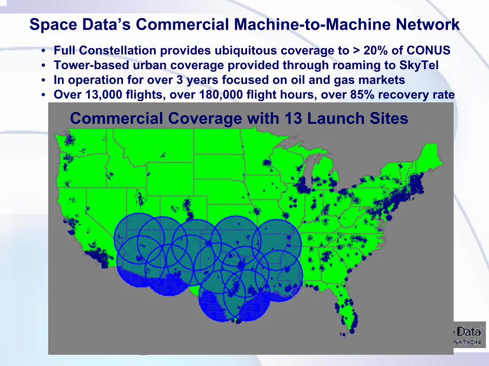
Space Data’s Commercial Machine-to-Machine Network• Full Constellation provides ubiquitous coverage to > 20% of CONUS• Tower-based urban coverage provided through roaming to SkyTel• In operation for over 3 years focused on oil and gas markets• Over 13,000 flights, over 180,000 flight hours, over 85% recovery rate
█ SkySite Platform Coverage█ Roaming Coverage through Skytel
Commercial Coverage with 13 Launch Sites

Tethered DescentControlled Platform Descent
Low RiskLow Payoff
High RiskHigh Payoff
Parachute DescentControlled Parachute Descent
Parafoil DescentGlider Descent
Tethered Aerostats Free-Floating Weather Balloon
Altitude Control, Free-Floating
Weather Balloon
Altitude Control, Free-Floating Hi-Altitude Balloon
Station-Keeping Hi-Altitude
Airship• Limited mission
envelope• Already militarily
exploited
• Limited mission envelope
• Already exploited
• Moderate mission envelope
• Limited military exploitation
• Broad mission envelope
• Technology not mature
• Moderate mission envelope
• Technology commercially mature and military deployment imminent
Platforms
Recovery Method
Continuum of Near-Space Assets
Types of Near Space Platforms
Courtesy of Air Force Space Battle Lab

RGS acts as gateway
Remote Ground Stationand mission launch
LandLine
Chandler, AZ
NOC
Recovery Vehicles
Dual PayloadSkySat Platform
Two Linked PRC-148’s
Combat SkySat Demonstration, March 2005
AM – Aeronautical Band
FM – Terrestrial Band
• Demonstrated Forward Air Controller Mission• Interoperability of Modulations and Bands

435 Miles
10 milesNormal LOS
Combat SkySat Demo: March ‘05
Graphic courtesy of Air Force Space Battlelab

JEFX 06 Mar 06 Spiral II Comms between Phoenix, Nellis AFB, and Coronado Island
Approx 270 miles
Approx 270 miles
Approx 380 miles
Courtesy of Air Force Space Battle Lab
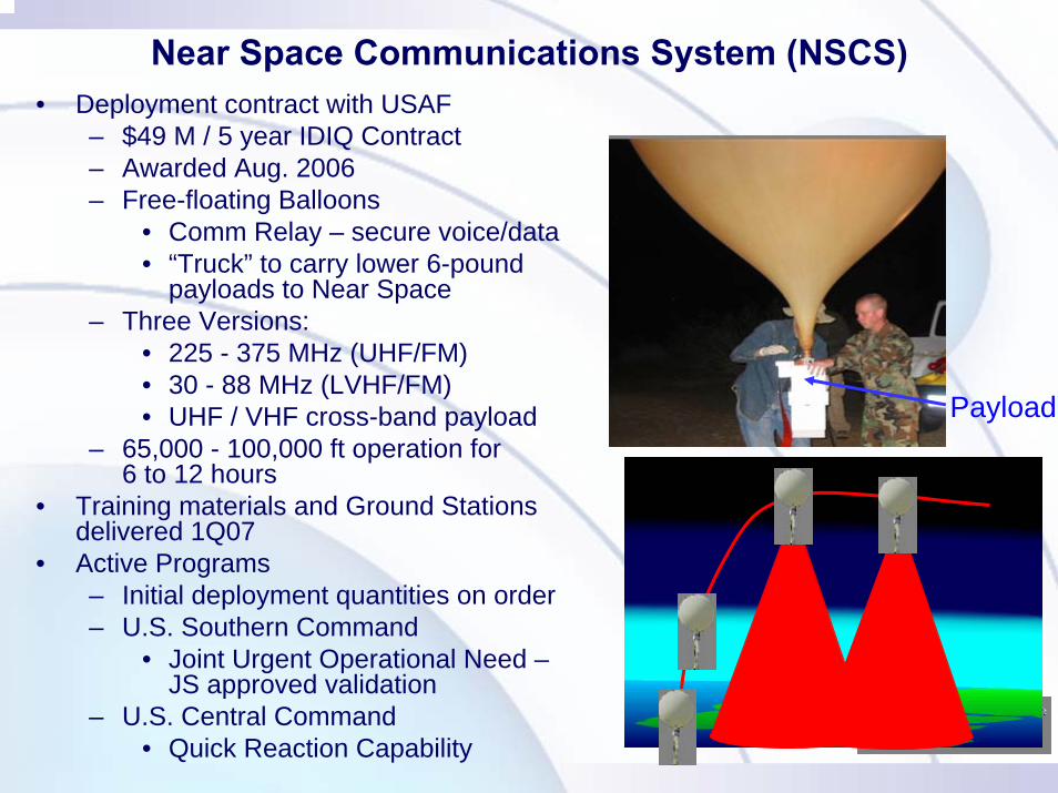
Near Space Communications System (NSCS)• Deployment contract with USAF
– $49 M / 5 year IDIQ Contract– Awarded Aug. 2006– Free-floating Balloons
• Comm Relay – secure voice/data• “Truck” to carry lower 6-pound
payloads to Near Space– Three Versions:
• 225 - 375 MHz (UHF/FM)• 30 - 88 MHz (LVHF/FM)• UHF / VHF cross-band payload
– 65,000 - 100,000 ft operation for 6 to 12 hours
• Training materials and Ground Stations delivered 1Q07
• Active Programs– Initial deployment quantities on order– U.S. Southern Command
• Joint Urgent Operational Need –JS approved validation
– U.S. Central Command• Quick Reaction Capability
Payload

Support FEMA, State/Federal agencies in contingencies(power outage, hurricanes, earthquakes, etc.)
Enhance border and coast monitoring efforts, filling incoverage gaps and tracking assets
Extend comms and personnel/asset tracking for wildland fires
Provide extended communications for transportation security
Applications for Homeland Security
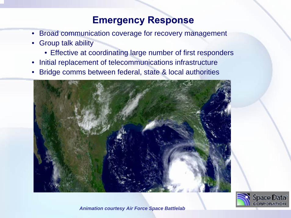
Emergency Response• Broad communication coverage for recovery management• Group talk ability
• Effective at coordinating large number of first responders• Initial replacement of telecommunications infrastructure• Bridge comms between federal, state & local authorities
Animation courtesy Air Force Space Battlelab

SkySat Coverage at 77K
Courtesy Det 2 Arizona Air National Guard

SkySite® Voice Repeater Kit• Demonstrated at Assoc. of Public safety Comm. Officers (APCO) Conference
– August 2006 in Orlando, Florida• Responsive communications for disaster recovery operations

Demonstrated Demonstrated Coverage of Single Coverage of Single
Payload to Standard Payload to Standard Motorola Handheld Motorola Handheld
Radios at APCO 2006Radios at APCO 2006

Border Protection
• Digital, encrypted voice for Border Patrol agents
• Covers deep canyons & extends battery life
• Supports agent comms. & asset tracking
• Responsively tasked

400400--mile Diametermile DiameterCoverage FootprintCoverage Footprint
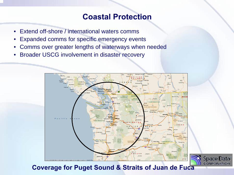
Coverage for Puget Sound & Straits of Juan de Fuca
• Extend off-shore / international waters comms• Expanded comms for specific emergency events• Comms over greater lengths of waterways when needed• Broader USCG involvement in disaster recovery
Coastal Protection
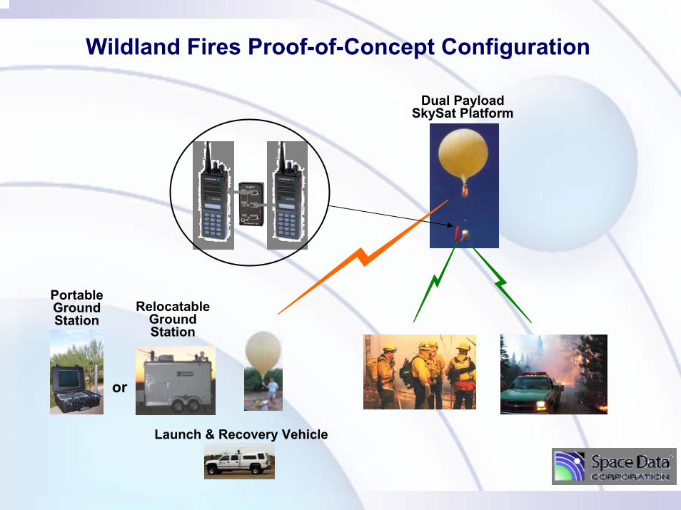
RelocatableGround Station
PortableGroundStation
Launch & Recovery Vehicle
Dual PayloadSkySat Platform
Wildland Fires Proof-of-Concept Configuration
or

Transportation Security
• Asset tracking
• Rapid dissemination of information over broad areas
• Facilitate interoperability
• Coordinate protection activities sector-wide
• Support specific transportation security events
• Support broad secure comms architectures
• Improve security across all modes of transportation
• Support mobile command post
• Coordination across federal, state & local agencies

Typical Near Space Platform Launch

Near Space Platform Applications
• Emergency Response• Border Patrol Comm. / ISR• Wildland Fire Comm/Tracking• Tactical Ground-to-Ground Comms.
– Convoy Support– Special Operations
• Intelligence, Surveillance & Reconnaissance (ISR)– “Truck” to carry special payloads to altitude – Visual / IR Imagery
• Tactical Air-to-Ground – Supports low-flying aircraft
• High Bandwidth Data Relay• Other satellite-like missions

• Cross-banding• Coordination• Broad coverage• Responsive
PublicSafety
Military
InteroperabilityBridging Repeater supports communication between security agencies

Good Coverage in Challenging Topography
• 220 Mile link from bottom of Grand Canyon on Aug 3, 2006– Used 900 MHz, 2-way handheld radio– Only “5 palms” of sky visible
• LEO Sat phone only worked 2 out of 15 min
• Walls too high for GEO Sat Comms.
5691 ft1770 ft
1.3 miles
3921 Feet
SkySite at80,000 Feet

Applications & Devices

Near-Space: High Resolution, Low Cost
* Not strictly an apples-to-apples comparison
QuickBird 60 cm natural color SkySite® natural color demo$60,000,000 vehicle $600 for vehicle construction*$15,000,000 launch $50 launch*
Conclusion/Recommendations
• Responsive platform exists now to provide broad wireless coverage safely above affected areas– No reliance on infrastructure– Store until required… launch as needed
• Homeland Security suited payload version available for demo now– System can be tailored to specific user needs
• Incorporate into disaster response plans now– Experience shows “real time integration” nearly impossible
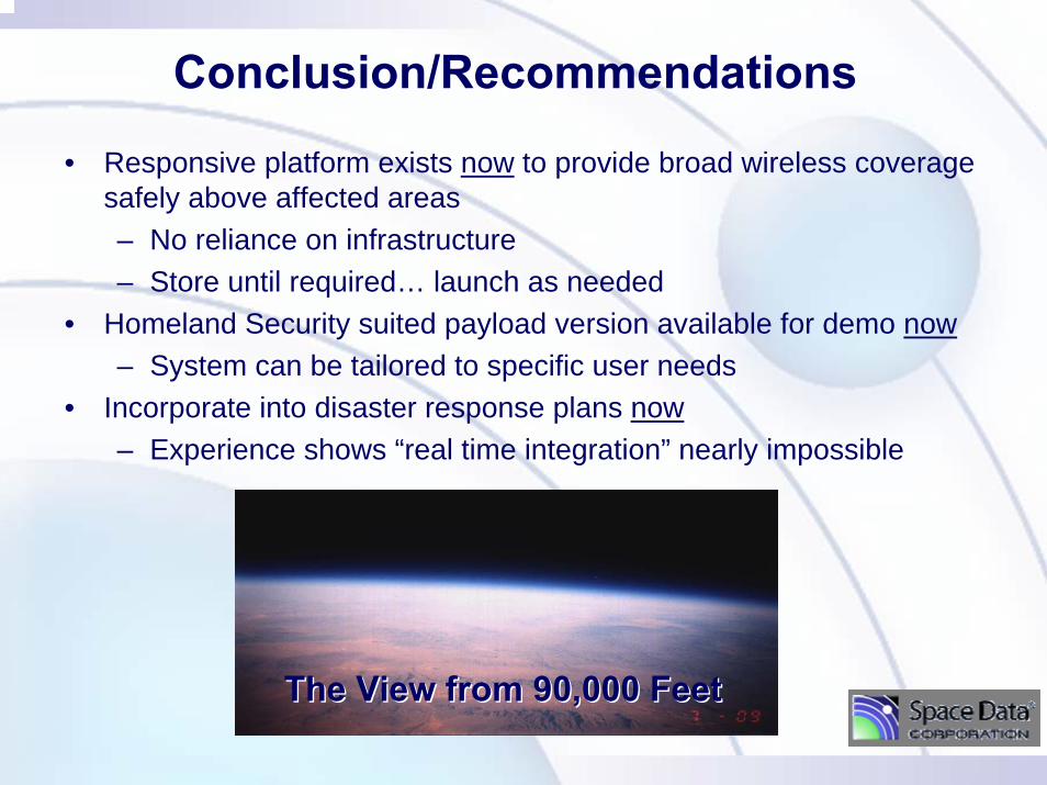
The View from 90,000 FeetThe View from 90,000 Feet