neighborhood parks: community parks
TRANSCRIPT
PR-1
The provision of plentiful, well-designed, and well-maintained parks and recreation facilities
significantly contributes to the quality of life in a community. Parks fulfill a number of
important functions – they provide green “breathing” spaces within the city which promote
healthy lifestyles; they provide children and families a place to play and explore; they provide
areas for active sport uses and civic functions; and they provide areas for passive recreation and
relaxation. Parks may also incorporate natural features and visual assets of the landscape, in
addition to preserving habitat areas that are vital to the city's identity, history, and environmental
health. Other recreational facilities such as special-purpose facilities, accessible open spaces,
and trails fulfill specific community needs that formal developed parks typically cannot provide.
The Parks and Recreation Element is an optional element under State law. It contains goals and
policies that strengthen the City’s commitment to providing a high level of parks and recreation
facilities and services to Vacaville residents, and provides guidance for new development to
incorporate additional recreational facilities as needed to maintain this level of service. These
policies reflect the diversity of recreational needs historically desired by Vacaville residents, and
attempt to provide flexibility in Vacaville’s parks and recreational services so as to appropriately
respond when new recreational needs are desired by Vacaville’s changing population.
The City’s current inventory of parks and recreation facilities is classified into six basic
categories:
Neighborhood Parks: Smaller parks that are primarily intended to serve the recreation
needs of residential areas within ½ mile (an approximate 10-minute walking distance) of
the park. Park facilities are usually oriented towards the recreation needs of children and
typically include a multipurpose playfield, a playground, and picnic facilities. When
neighborhood parks are located adjacent to schools, they may also include a small
recreation building, and be designed for joint use with the school-owned property.
Existing neighborhood park sites generally range in size from 1 to 10 acres. However,
new neighborhood parks should be designed within a 6- to 9-acre size range, depending
upon the neighborhood park needs of the part of the city in which they are located.
Community Parks: Mid-sized parks designed to provide major active-use recreational
facilities such as lighted sports fields, sport courts, community buildings, swimming
pools, spaces for community festivals, civic events, organized sports, and athletic
C I T Y O F V A C A V I L L E
V A C A V I L L E G E N E R A L P L A N
P A R K S A N D R E C R E A T I O N E L E M E N T
PR-2
competitions. Community parks should ideally also include areas for passive recreation
including walking paths with benches, shaded picnic areas, and preserved or created
natural areas such as creeks, habitat areas, and unique landforms. Community parks
often include appropriate support facilities such as parking areas, restroom buildings, and
concession stands. Community parks generally range in size from 12 to 60 acres and are
intended to serve the population living within a 1½-mile radius. A community park can
also function as a neighborhood park for nearby residential areas.
Regional Park: A large, nature-themed park that is focused on balancing the natural
environment with related recreational activities. Lagoon Valley Park is the city’s only
regional park and is designed to serve the city’s entire population and the greater
Vacaville region. It includes a wide variety of passive recreation opportunities and
amenities, including a 106-acre lake and open fields that are used for many large and
regional events. The park is defined by its natural environment of hills, creeks, the
lagoon, and the valley. It is intended to provide the public with access and use of these
areas while sensitively preserving the habitat and natural environment for which the park
is recognized. The historic Pena Adobe and its surrounding grounds are considered a
sub-area of the park that provides additional space for group picnics and other events.
The park provides trailheads and access to many acres of open space with miles of
hiking, biking, and equestrian trails.
Accessible Open Space: Land owned by the City of Vacaville (or other non-profit or
public agency) that includes public access for limited recreational use and is maintained
in a natural or non-intensive developed state. Publically accessible open space includes
lands of geologic, agricultural, ecologic, and scenic significance, and includes certain
lands that are used jointly as creekways, drainages, detention basins, and other specific
dual purposes. Accessible open space areas are made available to the public for self-
guided and low-impact activities that typically include hiking, biking, horseback riding,
bird watching, sky gazing, and nature appreciation. Accessible open space often includes
developed nature trails that provide the public with defined access and utility of the open
space while minimizing negative impacts to the environment. The Land Use Element
includes a designation called “Public Open Space,” which includes both these accessible
open space lands as well as undeveloped areas that are not made accessible to the public
for reasons related to public safety or other special concerns. Open space related to
biological resources, agricultural lands, cultural resources, and scenic resources is also
addressed in the Conservation and Open Space Element. Open space related to public
health and safety, including ridgelines and areas with steep slopes, is addressed in the
Safety Element.
Special Purpose Facilities: Buildings that house recreational programs and/or facilities
targeted to meet the needs of a certain sector of the population or neighborhood. Most of
these facilities are located within the boundaries of a park. However, others may be
located on properties that are not owned by the City, but operated by the Community
Services Department and/or under contract to the Department for its programs.
C I T Y O F V A C A V I L L E
V A C A V I L L E G E N E R A L P L A N
P A R K S A N D R E C R E A T I O N E L E M E N T
PR-3
Bikeways, Multi-Use Trails, and Nature Trails
Bikeways: Most of the city’s paved, off-street bikeways are officially designated as off-
street bike paths; however, they also function as multi-use trails and are appropriately
shared with walkers, runners, skaters, and other non-motorized forms of transportation.
Vacaville follows Caltrans definitions for its paved bikeways; therefore, these facilities
are more completely defined and discussed in the Transportation Element. For both
recreation and transportation purposes, it is important that bikeways provide logical
connections to various destination points and make connections to regional bikeways that
are outside of city limits. In some cases, a paved bikeway may be incorporated within a
park (or accessible open space) as part of that individual facility’s circulation plan.
Multi-Use Trails: In addition to the paved bike paths built to accommodate a broad range
of recreational activities related to walking, running, and bicycle riding, there are a
number of unpaved trails that do not qualify as formal bike paths, but they are used by
bicyclists, pedestrians. Where appropriate, a multi-use path can include an adjacent but
separate bridle path if the width of the right-of-way is sufficient to prevent conflict
between bicyclists, pedestrians, and horseback riders. Some of these trails are not much
more than informal dirt or gravel maintenance roads, but due to significant use by the
public, they may be considered important recreational elements within a park or
accessible open space.
Nature Trails: Nature trails are used by bicycle riders, hikers, and in many cases
equestrians, but these unpaved trails tend to primarily serve recreational users who are
interested in traversing challenging terrain. Because these trails are typically located in
the steep and rugged environment of open space, they are discussed more thoroughly
within the accessible open space component of this Element.
In addition, the local school districts own and operate a number of fields and specialized
facilities that, in some cases, are made available for public use through policies set by the
individual school district. The City recognizes the public ownership of these school facilities
and has previously utilized a joint-use agreement with the Vacaville Unified School District to
make a wider range of facilities available for the public’s use. However, as of the publication of
this General Plan, there is not currently an active joint-use agreement between the two agencies.
There are also many privately owned recreational facilities in Vacaville, such as golf courses;
swim, tennis, and fitness clubs; ice skating and hockey rinks; bowling alleys; and equestrian
centers. While recognizing the availability of the private recreational facilities, this Element
focuses primarily on the City’s provision of public park and recreation facilities.
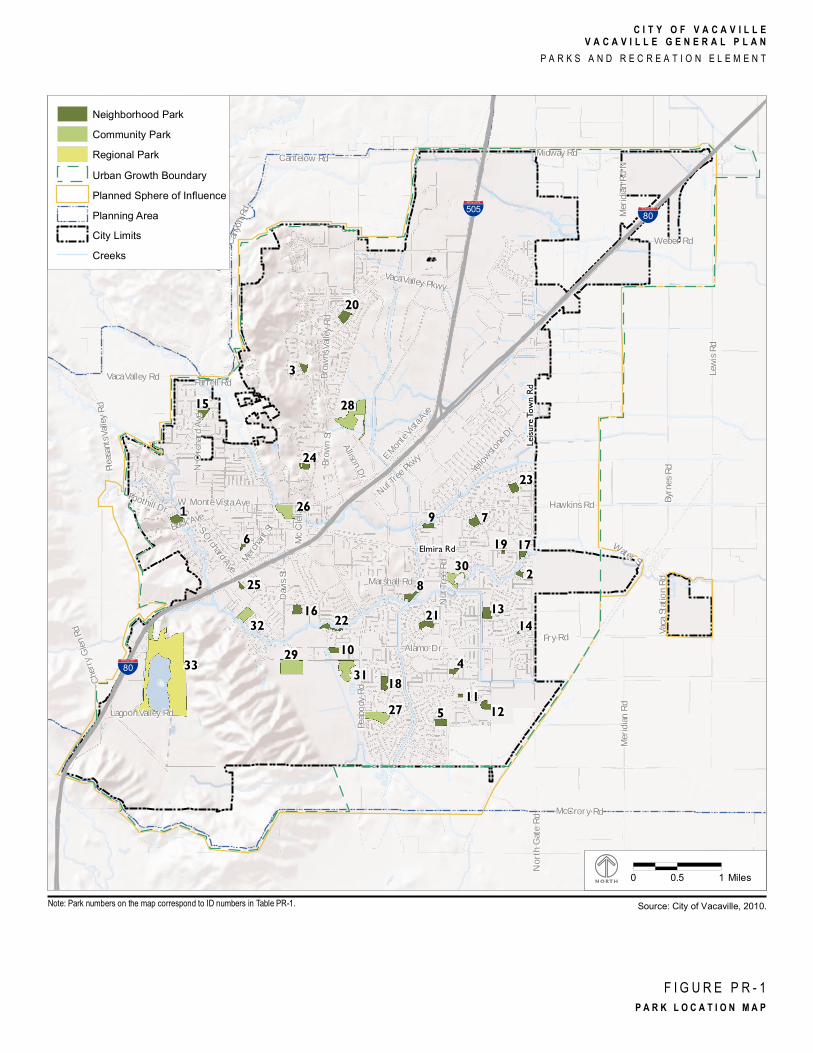
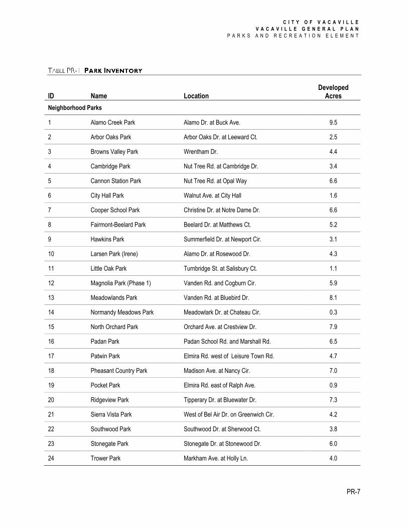
The locations of the city’s parks are illustrated in Figure PR-1 (page 6), and a complete inventory
of existing neighborhood, community, and regional parks are listed in Table PR-1 (page 7).
C I T Y O F V A C A V I L L E
V A C A V I L L E G E N E R A L P L A N
P A R K S A N D R E C R E A T I O N E L E M E N T
PR-4
The natural setting of the city is characterized by the ridges and hillsides west and south of the
city, the agricultural valley lands to the north and east, and free-flowing creeks crossing though
the city. As the city continues to grow, it is important to consider the impact urbanization can
have on the accessible open space areas and to consider how to best preserve and enhance their
character and uses. Policies in the Land Use Element express the City’s vision for urban form
and growth management. Policies in the Conservation and Open Space and Safety Elements
help guide the protection of open spaces, particularly hillside and ridge areas.
Accessible open space includes natural landscapes that are essentially undeveloped, but suitable
for passive recreational activities that do not require substantial facilities or improvements.
This includes lands that are owned, leased, or otherwise controlled by the City of Vacaville, or
by some other public or non-profit entity, and are made accessible to the public for recreation,
nature preservation, education, viewshed, and other open space purposes.
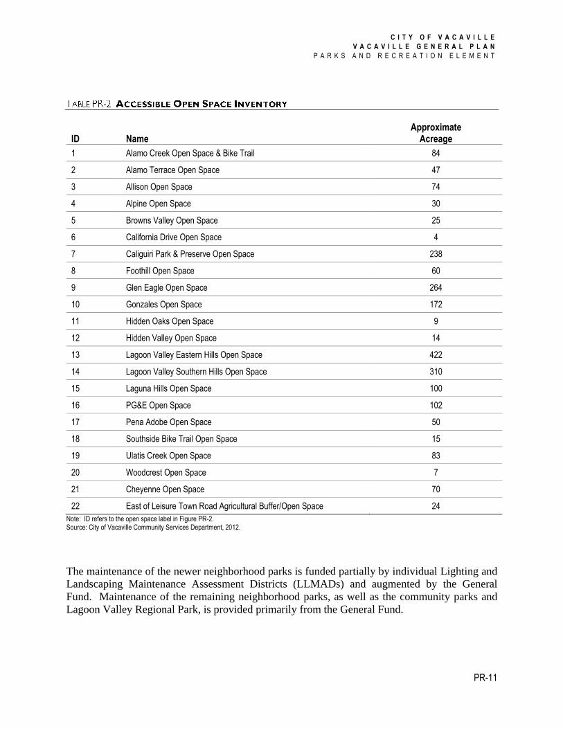
Figure PR-2 (page 10) illustrates the locations of the publicly-accessible open space areas in
Vacaville. Table PR-2 (page 11) lists their acreages.
Hiking, biking and walking are popular recreational activities for Vacaville residents. Trails
provide an important recreational resource in-and-of themselves, but many trails also serve as a
support facility in providing access between neighborhoods and important destinations, and in
the case of paved trails, can also serve as part of the city’s transportation network. Trail use is
most often a self-directed recreational activity, but there is also a recognized trend toward
increased use of trails by organized groups for special events.
As part of the effort to better serve the needs of Vacaville residents who choose to hike, bike, and
walk for recreation, the City seeks to link the neighborhoods of the city to recreational resources
in a comprehensive network of pedestrian facilities, bikeways, hiking trails, and multi-use trails,
and to accommodate both bicycle and equestrian users wherever appropriate. Although it is a
citywide system, each section of the trails system should relate to its immediate surroundings in
design and function. Trails within the open spaces and hillsides are typically rustic and
particularly conducive to hiking, mountain biking, and horseback riding; by their nature (rugged,
steep, and unpaved), most cannot be made to accommodate Americans with Disability Act
(ADA) access. By contrast, most of the multi-use trails along the creekways, trails that provide
linkages to neighborhood facilities, and those within developed parks are hard surfaced and
designed for easy access for all. Most of these paved trails are designed to accommodate
maintenance and emergency vehicles, and some also serve a dual purpose of providing
maintenance vehicle access to city utilities such as sewer, water, and drainage facilities.
C I T Y O F V A C A V I L L E
V A C A V I L L E G E N E R A L P L A N
P A R K S A N D R E C R E A T I O N E L E M E N T
PR-5
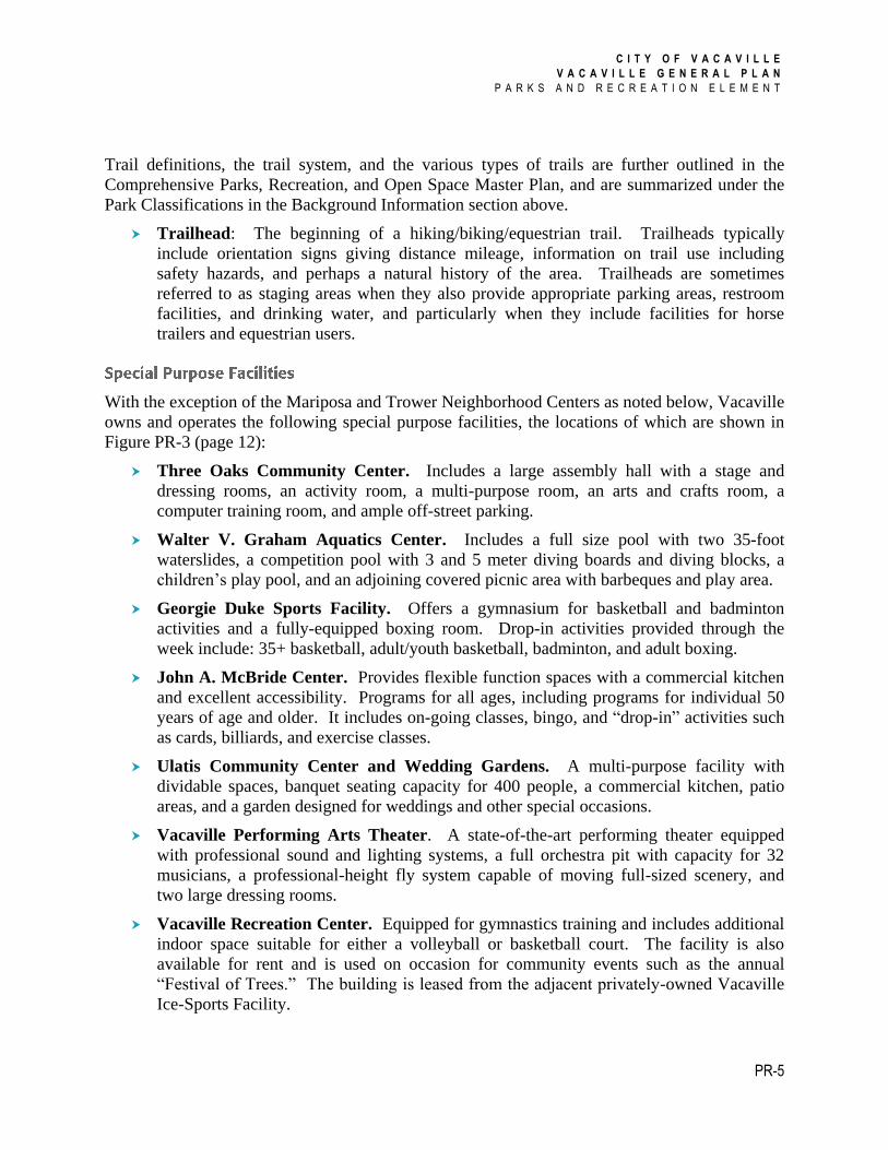
Trail definitions, the trail system, and the various types of trails are further outlined in the
Comprehensive Parks, Recreation, and Open Space Master Plan, and are summarized under the
Park Classifications in the Background Information section above.
Trailhead: The beginning of a hiking/biking/equestrian trail. Trailheads typically
include orientation signs giving distance mileage, information on trail use including
safety hazards, and perhaps a natural history of the area. Trailheads are sometimes
referred to as staging areas when they also provide appropriate parking areas, restroom
facilities, and drinking water, and particularly when they include facilities for horse
trailers and equestrian users.
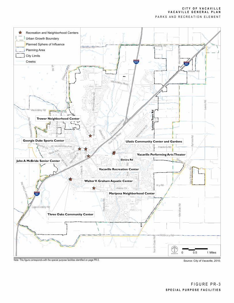
With the exception of the Mariposa and Trower Neighborhood Centers as noted below, Vacaville
owns and operates the following special purpose facilities, the locations of which are shown in
Figure PR-3 (page 12):
Three Oaks Community Center. Includes a large assembly hall with a stage and
dressing rooms, an activity room, a multi-purpose room, an arts and crafts room, a
computer training room, and ample off-street parking.
Walter V. Graham Aquatics Center. Includes a full size pool with two 35-foot
waterslides, a competition pool with 3 and 5 meter diving boards and diving blocks, a
children’s play pool, and an adjoining covered picnic area with barbeques and play area.
Georgie Duke Sports Facility. Offers a gymnasium for basketball and badminton
activities and a fully-equipped boxing room. Drop-in activities provided through the
week include: 35+ basketball, adult/youth basketball, badminton, and adult boxing.
John A. McBride Center. Provides flexible function spaces with a commercial kitchen
and excellent accessibility. Programs for all ages, including programs for individual 50
years of age and older. It includes on-going classes, bingo, and “drop-in” activities such
as cards, billiards, and exercise classes.
Ulatis Community Center and Wedding Gardens. A multi-purpose facility with
dividable spaces, banquet seating capacity for 400 people, a commercial kitchen, patio
areas, and a garden designed for weddings and other special occasions.
Vacaville Performing Arts Theater. A state-of-the-art performing theater equipped
with professional sound and lighting systems, a full orchestra pit with capacity for 32
musicians, a professional-height fly system capable of moving full-sized scenery, and
two large dressing rooms.
Vacaville Recreation Center. Equipped for gymnastics training and includes additional
indoor space suitable for either a volleyball or basketball court. The facility is also
available for rent and is used on occasion for community events such as the annual
“Festival of Trees.” The building is leased from the adjacent privately-owned Vacaville
Ice-Sports Facility.
Lewis R
d
Pleasa
nts Va
lley Rd
Midway Rd
Peabo
dy Rd
Cantelow Rd
Fry Rd
Hawkins Rd
Gibson
Canyo
n Rd
Nut Tr
ee Rd
Merid
ian Rd
Alamo Dr
Brown
s Valle
y Rd
Marshall Rd
Vaca Valley Pkwy
Allison Dr
Buck Ave
E Mont
e Vista A
ve
Stieger Hill Rd
Brown
St
N Or
chard
Ave
Vaca Valley Rd
Davis
St
Merid
ian Rd
N
Weber Rd
McCrory Rd
Yellowston
e Dr
S Orchard Ave
Foothill Dr W Monte Vista Ave
Merchan
t St
Cherr
y Glen
Rd
Farrell Rd
North
Gate
Rd
Mc Cl
ellan
Nut Tree P
kwy
Vaca S
tation
RdByr
nes Rd
Lagoon Valley Rd
Water St
%&'(505%&'(80
%&'(80
Leisu
re To
wn Rd
Elmira Rd
1
12
33
28
2931
27
26
30
32
20
1321
185
7
16
15
23
8
2210
3
4
917
24
225
6
11
19
14
Copyright:© 2013 Esri
C I T Y O F V A C A V I L L EV A C A V I L L E G E N E R A L P L A N
P A R K S A N D R E C R E A T I O N E L E M E N T
F I G U R E P R - 1P A R K L O C A T I O N M A P
Neighborhood ParkCommunity ParkRegional ParkUrban Growth BoundaryPlanned Sphere of InfluencePlanning AreaCity LimitsCreeks
0 0.5 1 Miles
Note: Park numbers on the map correspond to ID numbers in Table PR-1. Source: City of Vacaville, 2010.
C I T Y O F V A C A V I L L E
V A C A V I L L E G E N E R A L P L A N
P A R K S A N D R E C R E A T I O N E L E M E N T
PR-7
ID Name Location Developed
Acres
Neighborhood Parks
1 Alamo Creek Park Alamo Dr. at Buck Ave. 9.5
2 Arbor Oaks Park Arbor Oaks Dr. at Leeward Ct. 2.5
3 Browns Valley Park Wrentham Dr. 4.4
4 Cambridge Park Nut Tree Rd. at Cambridge Dr. 3.4
5 Cannon Station Park Nut Tree Rd. at Opal Way 6.6
6 City Hall Park Walnut Ave. at City Hall 1.6
7 Cooper School Park Christine Dr. at Notre Dame Dr. 6.6
8 Fairmont-Beelard Park Beelard Dr. at Matthews Ct. 5.2
9 Hawkins Park Summerfield Dr. at Newport Cir. 3.1
10 Larsen Park (Irene) Alamo Dr. at Rosewood Dr. 4.3
11 Little Oak Park Turnbridge St. at Salisbury Ct. 1.1
12 Magnolia Park (Phase 1) Vanden Rd. and Cogburn Cir. 5.9
13 Meadowlands Park Vanden Rd. at Bluebird Dr. 8.1
14 Normandy Meadows Park Meadowlark Dr. at Chateau Cir. 0.3
15 North Orchard Park Orchard Ave. at Crestview Dr. 7.9
16 Padan Park Padan School Rd. and Marshall Rd. 6.5
17 Patwin Park Elmira Rd. west of Leisure Town Rd. 4.7
18 Pheasant Country Park Madison Ave. at Nancy Cir. 7.0
19 Pocket Park Elmira Rd. east of Ralph Ave. 0.9
20 Ridgeview Park Tipperary Dr. at Bluewater Dr. 7.3
21 Sierra Vista Park West of Bel Air Dr. on Greenwich Cir. 4.2
22 Southwood Park Southwood Dr. at Sherwood Ct. 3.8
23 Stonegate Park Stonegate Dr. at Stonewood Dr. 6.0
24 Trower Park Markham Ave. at Holly Ln. 4.0
C I T Y O F V A C A V I L L E
V A C A V I L L E G E N E R A L P L A N
P A R K S A N D R E C R E A T I O N E L E M E N T
PR-8
ID Name Location Developed
Acres
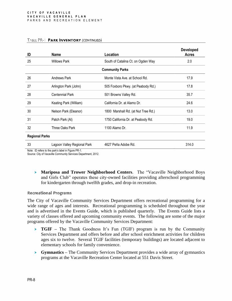
25 Willows Park South of Catalina Ct. on Ogden Way 2.0
Community Parks
26 Andrews Park Monte Vista Ave. at School Rd. 17.9
27 Arlington Park (John) 505 Foxboro Pkwy. (at Peabody Rd.) 17.8
28 Centennial Park 501 Browns Valley Rd. 35.7
29 Keating Park (William) California Dr. at Alamo Dr. 24.6
30 Nelson Park (Eleanor) 1800 Marshall Rd. (at Nut Tree Rd.) 13.0
31 Patch Park (Al) 1750 California Dr. at Peabody Rd. 19.0
32 Three Oaks Park 1100 Alamo Dr. 11.9
Regional Parks
33 Lagoon Valley Regional Park 4627 Peña Adobe Rd. 314.0
Note: ID refers to the park’s label in Figure PR-1. Source: City of Vacaville Community Services Department, 2012.
Mariposa and Trower Neighborhood Centers. The “Vacaville Neighborhood Boys
and Girls Club” operates these city-owned facilities providing afterschool programming
for kindergarten through twelfth grades, and drop-in recreation.
The City of Vacaville Community Services Department offers recreational programming for a
wide range of ages and interests. Recreational programming is scheduled throughout the year
and is advertised in the Events Guide, which is published quarterly. The Events Guide lists a
variety of classes offered and upcoming community events. The following are some of the major
programs offered by the Vacaville Community Services Department:
TGIF – The Thank Goodness It’s Fun (TGIF) program is run by the Community
Services Department and offers before and after school enrichment activities for children
ages six to twelve. Several TGIF facilities (temporary buildings) are located adjacent to
elementary schools for family convenience.
Gymnastics – The Community Services Department provides a wide array of gymnastics
programs at the Vacaville Recreation Center located at 551 Davis Street.
C I T Y O F V A C A V I L L E
V A C A V I L L E G E N E R A L P L A N
P A R K S A N D R E C R E A T I O N E L E M E N T
PR-9
Aquatics – Various aquatic programs, such as swim lessons, water polo, and water
aerobics, take place at the Graham Aquatic Center.
Early Childhood Enrichment – This program offers activities and classes for children
ages 18 months to 5 years.
Youth Sports – These sports programs are designed to introduce participants to a variety
of traditional sports and focus on health and fitness. Camps, classes, and leagues are
available.
Adult Sports and Fitness – Instructional classes such as tennis, yoga, and martial arts
are offered, as well as league volleyball, flag football, basketball, and softball.
Cultural Arts – Music, dance, drama, painting, and drawing classes are offered, as well
as a variety of camps.
Adult Services/Active Aging – A variety of classes ranging from computer training to
driver safety and foot care to Tai Chi are offered to adults at the McBride Center. A
multitude of free services are also available, including legal consultation and health
insurance counseling.
Vacaville’s “Comprehensive Parks, Recreation, and Open Space Master Plan” was developed in
1992 to guide the development of parks, recreation, and open space facilities throughout the city.
The Master Plan describes the condition of parks and recreation facilities as they existed in 1992,
proposes new facilities, and includes policies to implement the Plan. The Plan establishes
service standards for parks, recreation, and open space facilities and includes policies for the
development of new facilities, and for distributing these amenities throughout the city.
The City of Vacaville has identified locations for future parks in areas that are underserved and
areas where future development is anticipated, as well as future open space. Table PR-3 (page
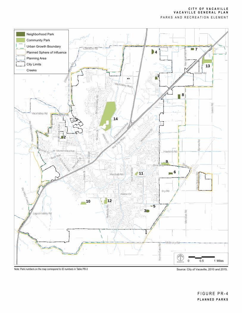
15) and Figure PR-4 (page 14) identify the planned parks and open space in Vacaville.
Funding for the acquisition and development of parks is derived primarily from park
development impact fees as authorized under the Mitigation Fee Act (Govt. code 66000), and in
some cases by Mello Roos Community Facilities Districts, and grants. However, Action PR-
A1.3 directs the City to adopt a Quimby Ordinance, which will also provide funding for park
acquisition. Operation of the City’s parks, including programs, staff, and other operations, is
provided by the Community Services Department and funded through the City’s General Fund
and user fees. Maintenance of all City parks and recreation facilities is provided by the Public
Works Department and funded primarily through the General Fund and numerous maintenance
districts as authorized by the Lighting and Landscaping Act of 1972.

Lewis R
d
Pleasa
nts Va
lley Rd
Midway Rd
Peabo
dy Rd
Cantelow Rd
Fry Rd
Hawkins Rd
Gibson
Canyo
n Rd
Nut Tr
ee Rd
Elmira Rd
Merid
ian Rd
Alamo Dr
Brown
s Valle
y Rd
Marshall Rd
Vaca Valley Pkwy
Allison Dr
Buck Ave
E Mont
e Vista A
ve
Stieger Hill Rd
Brown
St
N Or
chard
Ave
Vaca Valley Rd
Davis
St
Leisur
e Tow
n Rd
Merid
ian Rd
N
Weber Rd
McCrory Rd
Yellowston
e Dr
S Orchard Ave
Foothill Dr W Monte Vista Ave
Merchan
t St
Cherr
y Glen
Rd
Farrell Rd
North
Gate
Rd
Mc Cl
ellan
Nut Tree P
kwy
Vaca S
tation
RdByr
nes Rd
Lagoon Valley Rd
Water St
14
9
7
10
3
15
2
16
417
19
1
20
11
12
5
18
6
8
16
13
1
Copyright:© 2013 Esri
C I T Y O F V A C A V I L L EV A C A V I L L E G E N E R A L P L A N
P A R K S A N D R E C R E A T I O N E L E M E N T
F I G U R E P R - 2A C C E S S I B L E O P E N S P A C E L O C A T I O N M A P
Urban Growth BoundaryPlanned Sphere of InfluencePlanning AreaCity LimitsAccessible Open SpaceCreeks
0 0.5 1 Miles
Note: Open space numbers on the map correspond to ID numbers in Table PR-2 Source: City of Vacaville, 2010 and 2015.
21
22
C I T Y O F V A C A V I L L E
V A C A V I L L E G E N E R A L P L A N
P A R K S A N D R E C R E A T I O N E L E M E N T
PR-11
ID Name Approximate
Acreage
1 Alamo Creek Open Space & Bike Trail 84
2 Alamo Terrace Open Space 47
3 Allison Open Space 74
4 Alpine Open Space 30
5 Browns Valley Open Space 25
6 California Drive Open Space 4
7 Caliguiri Park & Preserve Open Space 238
8 Foothill Open Space 60
9 Glen Eagle Open Space 264
10 Gonzales Open Space 172
11 Hidden Oaks Open Space 9
12 Hidden Valley Open Space 14
13 Lagoon Valley Eastern Hills Open Space 422
14 Lagoon Valley Southern Hills Open Space 310
15 Laguna Hills Open Space 100
16 PG&E Open Space 102
17 Pena Adobe Open Space 50
18 Southside Bike Trail Open Space 15
19 Ulatis Creek Open Space 83
20 Woodcrest Open Space 7
21 Cheyenne Open Space 70
22 East of Leisure Town Road Agricultural Buffer/Open Space 24
Note: ID refers to the open space label in Figure PR-2. Source: City of Vacaville Community Services Department, 2012.
The maintenance of the newer neighborhood parks is funded partially by individual Lighting and
Landscaping Maintenance Assessment Districts (LLMADs) and augmented by the General
Fund. Maintenance of the remaining neighborhood parks, as well as the community parks and
Lagoon Valley Regional Park, is provided primarily from the General Fund.
Lewis R
d
Pleasa
nts Va
lley Rd
Midway Rd
Peabo
dy Rd
Cantelow Rd
Fry Rd
Hawkins Rd
Gibson
Canyo
n Rd
Nut Tr
ee Rd
Merid
ian Rd
Alamo Dr
Brown
s Valle
y Rd
Marshall Rd
Vaca Valley Pkwy
Allison Dr
Buck Ave
E Mont
e Vista A
ve
Stieger Hill Rd
Brown
St
N Or
chard
Ave
Vaca Valley Rd
Davis
St
Merid
ian Rd
N
Weber Rd
McCrory Rd
Yellowston
e Dr
S Orchard Ave
Foothill Dr W Monte Vista Ave
Merchan
t St
Cherr
y Glen
Rd
Farrell Rd
North
Gate
Rd
Mc Cl
ellan
Nut Tree P
kwy
Vaca S
tation
RdByr
nes Rd
Lagoon Valley Rd
Water St
_̂̂_
_̂_̂_̂̂_
_̂
_̂
_̂
%&'(505 %&'(80
%&'(80
Leisu
re To
wn R
d
Elmira Rd
Trower Neighborhood Center
John A McBride Senior Center
Mariposa Neighborhood Center
Ulatis Community Center and Gardens
Vacaville Performing Arts Theater
Georgie Duke Sports Center
Three Oaks Community Center
Walter V. Graham Aquatic Center
Vacaville Recreation Center
C I T Y O F V A C A V I L L EV A C A V I L L E G E N E R A L P L A N
P A R K S A N D R E C R E A T I O N E L E M E N T
F I G U R E P R - 3S P E C I A L P U R P O S E F A C I L I T I E S
_̂ Recreation and Neighborhood CentersUrban Growth BoundaryPlanned Sphere of InfluencePlanning AreaCity LimitsCreeks
0 0.5 1 Miles
Source: City of Vacaville, 2010.Note: This figure corresponds with the special purpose facilities identified on page PR-5.
C I T Y O F V A C A V I L L E
V A C A V I L L E G E N E R A L P L A N
P A R K S A N D R E C R E A T I O N E L E M E N T
PR-13
Park standards provide a means to measure how much park land should be set aside for
recreational use as the city develops. This section establishes the acreage, size, and service area
standards for neighborhood, community, and regional parks. No standards are established for the
provision of trails and open space. However, the Comprehensive Parks, Recreation, and Open
Space Master Plan includes standards for certain special purpose facilities and individual
recreation facilities.
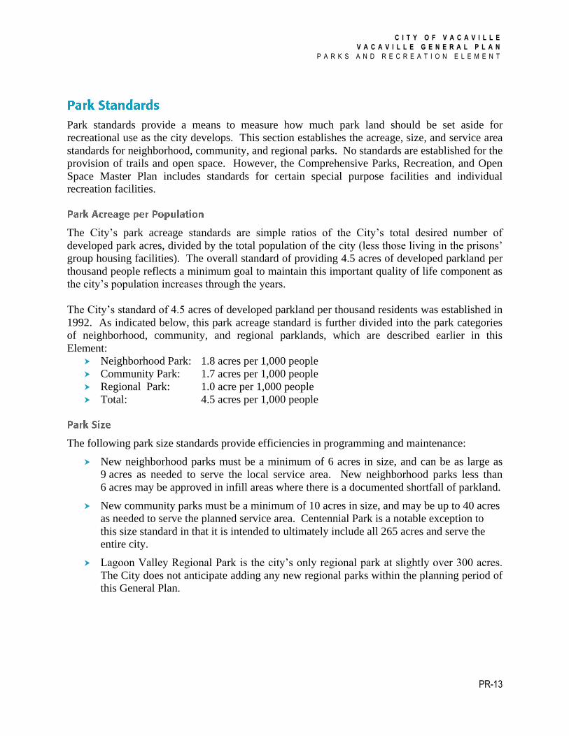
The City’s park acreage standards are simple ratios of the City’s total desired number of
developed park acres, divided by the total population of the city (less those living in the prisons’
group housing facilities). The overall standard of providing 4.5 acres of developed parkland per
thousand people reflects a minimum goal to maintain this important quality of life component as
the city’s population increases through the years.
The City’s standard of 4.5 acres of developed parkland per thousand residents was established in
1992. As indicated below, this park acreage standard is further divided into the park categories
of neighborhood, community, and regional parklands, which are described earlier in this
Element:
Neighborhood Park: 1.8 acres per 1,000 people
Community Park: 1.7 acres per 1,000 people
Regional Park: 1.0 acre per 1,000 people
Total: 4.5 acres per 1,000 people
The following park size standards provide efficiencies in programming and maintenance:
New neighborhood parks must be a minimum of 6 acres in size, and can be as large as
9 acres as needed to serve the local service area. New neighborhood parks less than
6 acres may be approved in infill areas where there is a documented shortfall of parkland.
New community parks must be a minimum of 10 acres in size, and may be up to 40 acres
as needed to serve the planned service area. Centennial Park is a notable exception to
this size standard in that it is intended to ultimately include all 265 acres and serve the
entire city.
Lagoon Valley Regional Park is the city’s only regional park at slightly over 300 acres.
The City does not anticipate adding any new regional parks within the planning period of
this General Plan.
Lewis R
d
Pleasa
nts Va
lley Rd
Midway Rd
Peabo
dy Rd
Cantelow Rd
Fry Rd
Hawkins Rd
Gibson
Canyo
n Rd
Nut Tr
ee Rd
Elmira Rd
Merid
ian Rd
Alamo Dr
Brown
s Valle
y Rd
Marshall Rd
Vaca Valley Pkwy
Allison Dr
Buck Ave
E Mont
e Vista A
ve
Stieger Hill Rd
Brown
St
N Or
chard
Ave
Vaca Valley Rd
Davis
St
Leisur
e Tow
n Rd
Merid
ian Rd
N
Weber Rd
McCrory Rd
Yellowston
e Dr
S Orchard Ave
Foothill Dr W Monte Vista Ave
Merchan
t St
Cherr
y Glen
Rd
Farrell Rd
North
Gate
Rd
Mc Cl
ellan
Nut Tree P
kwy
Vaca S
tation
RdByr
nes Rd
Lagoon Valley Rd
Water St9
10 12
4
3
1
2
11
5
C I T Y O F V A C A V I L L EV A C A V I L L E G E N E R A L P L A N
P A R K S A N D R E C R E A T I O N E L E M E N T
F I G U R E P R - 4P L A N N E D P A R K S
Source: City of Vacaville, 2010 and 2015.
Neighborhood ParkCommunity ParkUrban Growth BoundaryPlanned Sphere of InfluencePlanning AreaCity LimitsCreeks
0 0.5 1 Miles
Note: Park numbers on the map correspond to ID numbers in Table PR-3
6
8
7
13
14
C I T Y O F V A C A V I L L E
V A C A V I L L E G E N E R A L P L A N
P A R K S A N D R E C R E A T I O N E L E M E N T
PR-15
ID Name Location Acres
Neighborhood Parks
1 Corderos Park 1100 Parkside Dr. (North Village) 7.2
2 Fruitvale Park South of Fruitvale Rd. 6.0
3 Magnolia Park (Phase 2) (Southtown) Vanden Rd. and Cogburn Cir. 6.9
4 North Village AP-2 East of North Village Pkwy. TBD
5 Redbud Park (Southtown) Northeast of Magnolia Park 1.3
6 East of Leisure Town Road Park East of Leisure Town Road Growth Area 6.0
7 Northeast Area Park - North Northeast Growth Area 6.0
8 Northeast Area Park – South Northeast Growth Area 9.0
Community Parks
9 Elmira Park Elmira Rd. east of Leisure Town Rd. 17.0
10 Keating Park (expansion) California Dr. and Alamo Dr. 21.0
11 Nelson Park (Eleanor) (expansion) Nut Tree Rd. and Marshall Rd. 6.0
12 Patch Park (Al) (expansion) 1750 California Dr. (west of Peabody Rd). 15.0
13 Northeast Area Park Northeast Growth Area 36.0
14 Centennial Park 501 Brown’s Valley Rd. 265.1
Notes: ID refers to the park or open space label in Figure PR-4. Since these parks are not yet built, final names may be different. Source: City of Vacaville Community Services Department, 2012.
For analysis purposes, the service area standard is represented as a radius drawn around a
neighborhood or community park, rather than as travel time; although significant barriers to
transportation, such as freeways and canals, should be taken into consideration. All residential
areas of the city should be served by a neighborhood and a community park within the service
area standards provided below; although, a community park may serve the residents within ½
mile as their neighborhood park. There is no service area standard for regional parks because
Lagoon Valley Regional Park serves the greater Vacaville region and it is expected that most
users will need to travel a distance to access the park.
Neighborhood Park: ½ mile maximum (approximately a 10-minute walk)
Community Park: 1½ miles maximum
C I T Y O F V A C A V I L L E
V A C A V I L L E G E N E R A L P L A N
P A R K S A N D R E C R E A T I O N E L E M E N T
PR-16
The Comprehensive Parks, Recreation, and Open Space Master Plan specifies long-range facility
standards and programming recommendations for all the listed parks. Service ratios are provided
for a variety of specific recreation facilities, including gymnasia, tennis courts, baseball/softball
fields, golf courses, and community centers, among others. Additionally, the Master Plan makes
general recommendations for the provision of programming based on education, demographic,
and recreation trends. Since the Master Plan was approved in 1992, many of the listed
recommendations have been accomplished, a number of planned facilities have been constructed,
and trends and other changes in recreational activities suggest that this document should be
updated to better reflect the current recreational needs of the city’s residents.
Goal PR-1 Develop and maintain a high-quality public park system that provides
varied recreational opportunities for city residents, workers, and visitors.
Policies
Policy PR-P1.1 Provide new parks according to the standards established in this Element to
ensure adequate distribution, size, and access.
Policy PR-P1.2 Provide neighborhood parks to serve the unique recreational, cultural, and
educational needs of Vacaville’s diverse neighborhoods. Design new
neighborhood parks to have a unique character, appeal to children, and avoid
standardized, programmatic designs.
Policy PR-P1.3 Provide community parks to encompass a range of uses, including active high-
investment (e.g. gymnasiums and swimming pools), active low-investment
(e.g. playfields and picnic facilities), and passive recreational facilities (e.g.
natural areas suitable for quiet reflection). Community parks shall serve large
portions of the city by providing facilities suitable for recreational and cultural
activities beyond those supplied by neighborhood parks.
Policy PR-P1.4 Maintain, improve, and preserve Vacaville’s Lagoon Valley Regional Park to
serve the region with a variety of nature-oriented and passive recreational
opportunities.
Policy PR-P1.5 Support and encourage the location of special use recreation facilities, such as
community gardens, dog parks, and skate parks, on available park or other
public lands, where compatible with the existing and planned uses of
surrounding properties.

C I T Y O F V A C A V I L L E
V A C A V I L L E G E N E R A L P L A N
P A R K S A N D R E C R E A T I O N E L E M E N T
PR-17
Policy PR-P1.6 Make provisions for elderly and disabled individuals to freely access and
utilize parks and recreational facilities, according to local, State, and federal
codes.
Policy PR-P1.7 Encourage the development of private and commercial recreational facilities
at appropriate locations. However, private recreational facilities shall not
count towards the park standards established in this Element.
Policy PR-P1.8 Make designated open spaces more accessible to the public with a linked park
and trail system that takes advantage of surrounding open space.
Policy PR-P1.9 Maintain recreational fishing at Lagoon Valley Regional Park.
Actions
Action PR-A1.1 Update the Comprehensive Parks, Recreation, and Open Space Master Plan to
include a broader description of desired park facilities and allow staff the
flexibility to include the facilities desired by the public, and continue to
implement this Master Plan.
Action PR-A1.2 Develop the Trails and Trailhead system as outlined in the Comprehensive
Parks, Recreation and Open Space Master Plan. Provide additional trails and
facilities where they are feasible and appropriate. Connect the trails system to
the bikeways system wherever feasible and appropriate.
Action PR-A1.3 Implement a Quimby Ordinance requiring that park provision be considered
and incorporated in the subdivision process.
Goal PR-2 Ensure that new development is responsible for providing new parks and
recreation facilities in accordance with the City’s park and recreation
standards and for providing its fair share of neighborhood park
maintenance costs.
Policies
Policy PR-P2.1 All parks and recreation facilities required by the park standards in this
Element shall be publicly owned, operated, and maintained, except as
otherwise allowed by the Quimby Act.
Policy PR-P2.2 New parks and recreation facilities shall be funded, at least in part, by fees
paid by new development, or as turn-key facilities with new development, as
described in Policy PR-P2.5.
C I T Y O F V A C A V I L L E
V A C A V I L L E G E N E R A L P L A N
P A R K S A N D R E C R E A T I O N E L E M E N T
PR-18
Policy PR-P2.3 Require that proponents of large projects subject to Specific Plans and/or
Development Agreements work with City staff early in the planning process
to ensure that the project includes an adequate amount of developed parkland
to satisfy the City’s standards.
Policy PR-P2.4 Require all residential developers, including apartment builders, to provide
sufficient parks and other recreational facilities to meet the standards
established by the Comprehensive Parks, Recreation, and Open Space
Facilities Master Plan by dedicating land and/or paying in-lieu fees for land
acquisition, and by paying Park Development Impact Fees for the construction
of new facilities.
Policy PR-P2.5 Encourage development of turn-key neighborhood parks, which are completed
in conjunction with development of a new subdivision, rather than payment of
impact fees.
Policy PR-P2.6 Work with residential developers to ensure that parks and recreational
facilities planned to serve new development will be available concurrently
with need.
Policy PR-P2.7 Encourage new non-residential development that would bring workers to
Vacaville to incorporate park and recreation facilities into the project design.
Policy PR-P2.8 Ensure that all new residential development will either annex into or set up a
new park maintenance district in accordance with the Landscaping and
Lighting Act of 1972.
Actions
Action PR-A2.1 Adjust park impact fees to reflect a more accurate cost of developing parkland
based on real development costs. Include an adjustment factor for the cost of
responding to changing requirements, such as the Americans with Disabilities
Act, playground safety standards, CEQA requirements, and new building
technology that combats vandalism (e.g. concrete tables and video
surveillance systems).
Goal PR-3 Locate new parks to maximize safety, site efficiency, public safety, and
convenient public access.

C I T Y O F V A C A V I L L E
V A C A V I L L E G E N E R A L P L A N
P A R K S A N D R E C R E A T I O N E L E M E N T
PR-19
Policies
Policy PR-P3.1 Locate new neighborhood parks adjacent to new elementary schools where
possible. Whenever possible, work with the school district to design both the
park and school to maximize the benefits for the public.
Policy PR-P3.2 Prohibit new neighborhood parks adjacent to arterial streets.
Policy PR-P3.3 Wherever possible, site new parks and recreation facilities to promote
pedestrian and bicycle access and prevent the need to cross major roadways.
Policy PR-P3.4 Locate parks and recreation facilities to take advantage of natural features,
adjoining open space, trail access, lands that may be jointly-used for
recreation purposes, land use buffers (i.e. areas of open space or low-intensity
uses between potentially conflicting land uses), urban separators, and
easements.
Actions
Action PR-A3.1 Coordinate with public safety staff in the design of parks and in the
development of standards for park design. Incorporate these standards into the
Update to the City’s Comprehensive Parks, Recreation, and Open Space
Master Plan.
Goal PR-4 Provide and maintain parks that reflect, preserve, and respect Vacaville's
natural setting and the public’s investment in each facility.
Policies
Policy PR-P4.1 Provide the public with clear signage regarding appropriate usage of parks,
open space, trails, and other recreational facilities. Ensure that park
regulations and local laws are appropriate and enforceable.
Policy PR-P4.2 Promote the environmental and recreational qualities of Lagoon Valley
Regional Park through outreach to Vacaville residents and employees, as well
as to the greater Vacaville region.
Policy PR-P4.3 Develop and follow operations policies to prevent the degradation or
despoilment of the City’s parklands through inappropriate uses.

C I T Y O F V A C A V I L L E
V A C A V I L L E G E N E R A L P L A N
P A R K S A N D R E C R E A T I O N E L E M E N T
PR-20
Policy PR-P4.4 Preserve and enhance the natural areas and biotic resources within parks, such
as riparian corridors, wildlife habitat, and oak woodlands. Integrate these
resources into the recreational experience in ways that emphasize their
importance and enjoyment to park users, such as providing trails, viewing
platforms, and interpretive signage.
Goal PR-5 Engage in coordinated and cooperative park planning efforts.
Policies
Policy PR-P5.1 Involve interested members of the public, other public agencies, and private
organizations in park and recreational facility planning.
Policy PR-P5.2 Work with the local school district to design parks located adjacent to schools
to maximize the public benefits of both the park and school.
Policy PR-P5.3 Cooperate with special districts, Solano County, the State, and other agencies
that provide recreational facilities to ensure that Vacaville residents have
access to recreational facilities outside of those that can be provided by the
City.
Policy PR-P5.4 In the event that local school districts decide to sell surplus property, the City
shall consider acquiring the land for use as a public park or other recreational
facility, subject to available funding, local park needs and the suitability of the
site.
Goal PR-6 Provide parks and recreational programs that promote and support a
healthy lifestyle in Vacaville.
Policies
Policy PR-P6.1 Encourage public and private providers of recreational activities in Vacaville
to collaborate with Solano County Public Health and other public health
agencies to design healthy recreation programs that incorporate physical
activity and healthy eating.
Policy PR-P6.2 Design parks to ensure that Vacaville continues to provide a combination of
both active and passive recreational opportunities for all age levels, including
walking, jogging, organized team sports, and informal group sports.
C I T Y O F V A C A V I L L E
V A C A V I L L E G E N E R A L P L A N
P A R K S A N D R E C R E A T I O N E L E M E N T
PR-21
Actions
Action PR-A6.1 Conduct a review of park and recreation facilities to identify ways that they
could be utilized to promote healthy lifestyles and activities for all age levels,
including diet, exercise, and mental well-being.

C I T Y O F V A C A V I L L E
V A C A V I L L E G E N E R A L P L A N
P A R K S A N D R E C R E A T I O N E L E M E N T
PR-22