neighborhood transit-oriented development plan neighborhood
TRANSCRIPT
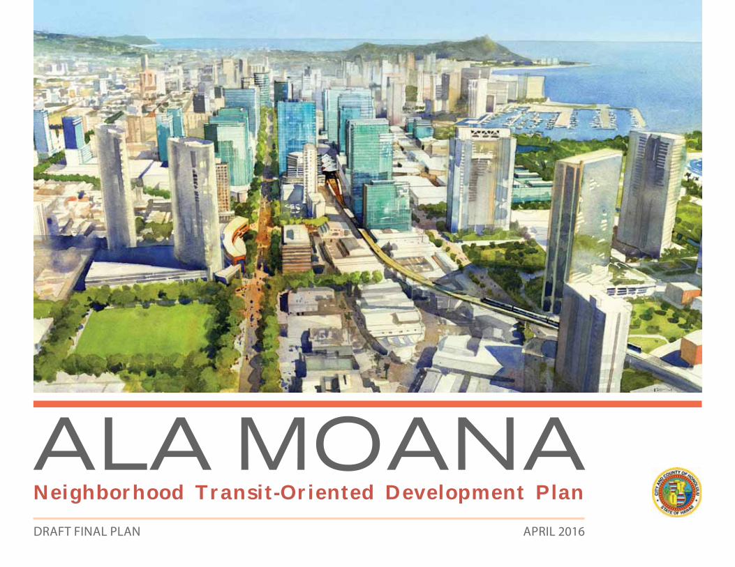
A L A M O A N ANeighborhood Transit-Oriented Development PlanDRAFT FINAL PLAN APRIL 2016
A L A M O A N A
ALA MOANA Neighborhood Transit-Oriented Development Plan
2
ALA MOANANeighborhood Transit-Oriented Development Plan
Prepared for the City and County of Honolulu by:
CallisonRTKL Los Angeles - Planning and Urban Design Studio
In collaboration with:Belt Collins Hawaii
Fehr & Peers
Keyser Marston Associates
DRAFT FINAL PLAN
DRAFT FINAL PLAN
3
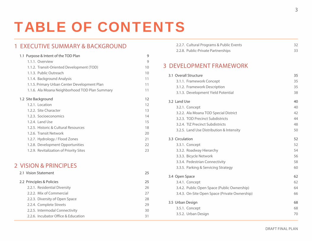
1 EXECUTIVE SUMMARY & BACKGROUND1.1 Purpose & Intent of the TOD Plan 9
1.1.1. Overview 91.1.2. Transit-Oriented Development (TOD) 101.1.3. Public Outreach 101.1.4. Background Analysis 111.1.5. Primary Urban Center Development Plan 111.1.6. Ala Moana Neighborhood TOD Plan Summary 11
1.2 Site Background 121.2.1. Location 121.2.2. Site Character 131.2.3. Socioeconomics 141.2.4. Land Use 151.2.5. Historic & Cultural Resources 181.2.6. Transit Network 201.2.7. Hydrology / Flood Zones 211.2.8. Development Opportunities 221.2.9. Revitalization of Priority Sites 23
2 VISION & PRINCIPLES2.1 Vision Statement 25
2.2 Principles & Policies 252.2.1. Residential Diversity 262.2.2. Mix of Commercial 272.2.3. Diversity of Open Space 282.2.4. Complete Streets 292.2.5. Intermodal Connectivity 302.2.6. Incubator Office & Education 31
2.2.7. Cultural Programs & Public Events 322.2.8. Public-Private Partnerships 33
3 DEVELOPMENT FRAMEWORK3.1 Overall Structure 35
3.1.1. Framework Concept 353.1.2. Framework Description 353.1.3. Development Yield Potential 38
3.2 Land Use 403.2.1. Concept 403.2.2. Ala Moana TOD Special District 423.2.3. TOD Precinct Subdistricts 443.2.4. TIZ Precinct Subdistricts 483.2.5. Land Use Distribution & Intensity 50
3.3 Circulation 523.3.1. Concept 523.3.2. Roadway Hierarchy 543.3.3. Bicycle Network 563.3.4. Pedestrian Connectivity 583.3.5. Parking & Servicing Strategy 60
3.4 Open Space 623.4.1. Concept 623.4.2. Public Open Space (Public Ownership) 643.4.3. On-Site Open Space (Private Ownership) 66
3.5 Urban Design 683.5.1. Concept 683.5.2. Urban Design 70
TABLE OF CONTENTS

ALA MOANA Neighborhood Transit-Oriented Development Plan
4
TABLE OF CONTENTS4.3.5. Kona Street & Mahukona Street 1124.3.6. Kapiolani Boulevard & Kalakaua Avenue 114
4.4 Station Connectivity Strategy 1164.4.1. Mauka-Makai Connections 1164.4.2. Transit Plaza Concept 120
5 ZONING RECOMMENDATIONS5.1 TOD Special District 125
5.1.1. Purpose 1255.1.2. TOD Ordinance Requirement 1255.1.3. Applicability 1255.1.4. District Boundaries 125
5.2 Zoning Districts & Use 1265.2.1. Intent 1265.2.2. Zoning Districts 1265.2.3. New Permissible Land Uses 1265.2.4. Conditional Land Uses 1265.2.5. Non-Permissible Land Uses 126
5.3 Building Envelope Standards 1285.3.1. Intent 1285.3.2. Floor Area Ratio (FAR) 1285.3.3. Building Heights 1305.3.4. Building Form & Massing 132
5.4 Parking Standards 1345.4.1. Intent 1345.4.2. Parking Ratios 1345.4.3. Parking Management 134
3.5.3. Viewshed Analysis 723.5.4. Building Form 743.5.5. Shadow Study 77
3.6 Infrastructure 783.6.1. Intent 783.6.2. Water System 783.6.3. Wastewater System 793.6.4. Storm water Drainage System 793.6.5. Electric / CATV / Telephone (E/C/T) & Natural Gas 82
4 PUBLIC REALM IMPROVEMENT CONCEPTS4.1 Concept 85
4.2 Streetscape Concepts 864.2.1. Kapiolani Boulevard 864.2.2. Kalakaua Avenue 884.2.3. Piikoi Street 904.2.4. Pensacola Street 924.2.5. Keeaumoku Street 944.2.6. Kona Street 964.2.7. Sheridan Street 984.2.8. Rycroft Street 1004.2.9. Makaloa Street 102
4.3 Intersection Concepts 1044.3.1. Ala Moana Boulevard & Atkinson Drive (Option 1) 1044.3.2. Ala Moana Boulevard & Atkinson Drive (Option 2) 1064.3.3. Ala Moana Boulevard & Piikoi Street 1084.3.4. Kalakaua Avenue & King Street 110
DRAFT FINAL PLAN
5
5.4.4. On-Street Parking 1345.4.5. Bicycle Parking 135
5.5 On-Site Amenity Space Standards 1365.5.1. Intent 1365.5.2. Total Amenity Space Requirement 136
5.6 Community Benefits Bonus 1385.6.1. Intent 1385.6.2. Summary Process 1385.6.3. Community Benefits Implementation Alternatives 138
5.7 Affordable Housing 1395.7.1. Intent 1395.7.2. Existing & New Standards 1395.7.3. Incentives 1395.7.4. Affordable Housing Fund 139
5.8 Architectural Character Guidelines 1405.8.1. Intent 1405.8.2. Ensure Neighborhood Compatibility 1405.8.3. Respect Historical Landmarks 1405.8.4. Ensure Interaction with Adjacent Buildings 1405.8.5. Building Orientation to Street & Public Spaces 1415.8.6. Provide Pedestrian-Oriented Streetscape 1415.8.7. Reduce Visual Impact of Vehicular Circulation 1425.8.8. Screen / Buffer Service & Loading Facilities from Public Streets 1425.8.9. Avoid Blank Walls 142
5.9 Tall Building Guidelines 1435.9.1. Intent 1435.9.2. Design Guidelines for the Podium, Middle, & Top of Tower 1435.9.3. Promote Natural Air Circulation & Ventilation While Minimizing Adverse Wind Conditions 1435.9.4. Provide Proper Setbacks for Towers 1435.9.5. Orient Towers in Mauka-Makai Direction 143
6 IMPLEMENTATION6.1 Overall Structure 145
6.1.1. Implementation Description 145
6.2 Phasing 1466.2.1. Phase 1 - Creating a Transit Node 1466.2.2. Phase 2 - Developing a Backbone 1476.2.3. Phase 3 - Improving Arterial Connections 1486.2.4. Phase 4 - Strengthening Neighborhood Connections 149
6.3 Funding Sources 1506.3.1. Intent 1506.3.2. Funding Sources 150
6.4 Strategic Partners 1516.4.1. Intent 1516.4.2. Federal Agencies 1516.4.3. State Agencies 1516.4.4. City Agencies 1516.4.5. Ala Moana Residents & Community Groups 1516.4.6. Landowners / Private Developers 1526.4.7. Local Businesses 152
6.5 Ala Moana TOD Action Plan 1526.5.1. Intent 1526.5.2. Summary Process 152
ALA MOANA Neighborhood Transit-Oriented Development Plan
6
LIST OF FIGURES1 EXECUTIVE SUMMARY & BACKGROUND
Figure 1-1: Planning Area Context 12
Figure 1-2: Site Character 13
Figure 1-3: Existing Land Use 15
Figure 1-4: Community Facilities 17
Figure 1-5: Historic / Cultural Sites 19
Figure 1-6: Transit Network 20
Figure 1-7: Hydrology / Flood Zones 21
Figure 1-8: Hard / Soft Analysis 22
Figure 1-9: Redevelopment Opportunities 23
2 VISION & PRINCIPLES
3 DEVELOPMENT FRAMEWORKFigure 3-1: Key Activity Nodes & Proposed Public Improvements 37
Figure 3-2: Yield Summary by Land Use 38
Figure 3-3: Yield Summary By Building Type 39
Figure 3-4: Planning Area 43
Figure 3-5: Subdistrict Designations 45
Figure 3-6: Proposed Land Use Type & Intensity 51
Figure 3-7: Existing Roadway Hierarchy 54
Figure 3-8: Proposed Roadway Hierarchy 55
Figure 3-9: Existing Bike Network 56
Figure 3-10: Proposed Bicycle Network 57
Figure 3-11: Proposed Pedestrian Improvements 59
Figure 3-12: Proposed Parking & Servicing Concept 61
Figure 3-13: Open Space Concept 65
Figure 3-14: Open Space Types 67
Figure 3-15: Urban Design Concept 71
Figure 3-16: Viewshed From Ala Moana Park 72
Figure 3-17: Important Views & Viewsheds 73
Figure 3-18: New Development Intensity Strategy 75
Figure 3-19: Street Wall Orientation 76
Figure 3-20: Shadow Study of Buildout Scenario 77
Figure 3-21: Wastewater System 81
Figure 3-22: Green Street Enhancements 83
4 PUBLIC REALM IMPROVEMENT CONCEPTSFigure 4-1: Featured Streetscape & Intersection Improvements 85
Figure 4-2: Kapiolani Boulevard Streetscape Enhancements 87
Figure 4-3: Kalakaua Avenue Streetscape Enhancements 89
Figure 4-4: Piikoi Street Streetscape Enhancements 91
Figure 4-5: Pensacola Street Streetscape Enhancements 93
Figure 4-6: Keeaumoku Street Streetscape Enhancements 95
Figure 4-7: Kona Street Streetscape Enhancements 97
Figure 4-8: Sheridan Street Streetscape Enhancements 99
Figure 4-9: Rycroft Street Streetscape Enhancements 101
Figure 4-10: Makaloa Street Streetscape Enhancements 103
Figure 4-12: Ala Moana Boulevard & Atkinson Drive Intersection Improvements (Option 1) 105
Figure 4-13: Ala Moana Boulevard & Atkinson Drive Intersection Improvements (Option 2) 107
DRAFT FINAL PLAN
7
LIST OF TABLESFigure 4-14: Ala Moana Boulevard & Piikoi Street Intersection Improvements 109
Figure 4-15: Kalakaua Avenue & King Street Intersection Improvements 111
Figure 4-16: Kona Street & Mahukona Street Intersection Improvements 113
Figure 4-17: Kapiolani Boulevard & Kalakaua Avenue Intersection Improvements 115
Figure 4-18: Station Connectivity Strategy 116
Figure 4-19: View Showing Mauka-Makai Connections through Ala Moana Center 117
Figure 4-20: View Showing Elevated Station Connection 119
Figure 4-21: Transit Plaza Concept: Ground / Concourse Level 122
Figure 4-22: Section Through Kona Street, Looking Diamond Head 123
5 ZONING RECOMMENDATIONSFigure 5-1: TOD & TIZ Precincts 125
Figure 5-2: Proposed Zoning Map 127
Figure 5-3: Proposed FAR Zone Map 129
Figure 5-4: Proposed Building Height Zone Map 131
Figure 5-5: Proposed Build-To Lines 133
6 IMPLEMENTATIONFigure 6-1: Phase 1 - Creating a Transit Node 146
Figure 6-2: Phase 2 - Developing a Backbone 147
Figure 6-3: Phase 3 - Arterial Connections 148
Figure 6-4: Phase 4 - Neighborhood Connections 149
1 EXECUTIVE SUMMARY & BACKGROUNDTable 1-1: Demographics of Ala Moana 14
2 VISION & PRINCIPLES
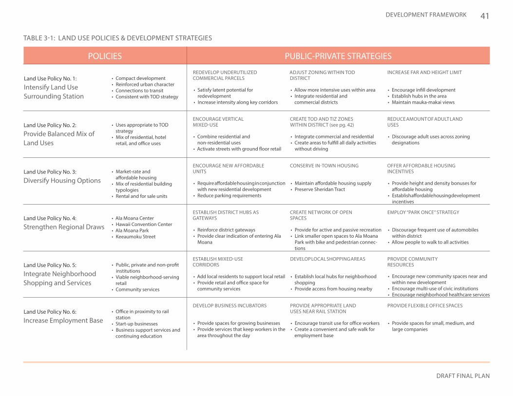
3 DEVELOPMENT FRAMEWORKTable 3-1: Land Use Policies & Development Strategies 41
Table 3-2: Circulation Policies & Development Strategies 53
Table 3-3: Proposed Parking Counts 60
Table 3-4: Open Space Policies & Development Strategies 63
Table 3-5: Urban Design Policies & Development Strategies 69
4 PUBLIC REALM IMPROVEMENT CONCEPTS
5 ZONING RECOMMENDATIONSTable 5-1: Proposed Building Envelope Standards 132
Table 5-2: Proposed Bicycle Parking Ratios 135
Table 5-3: Proposed Amenity Space Regulations 137
6 IMPLEMENTATIONTable 6-1: Ala Moana TOD Action Plan 153
8
ALA MOANA Neighborhood Transit-Oriented Development Plan
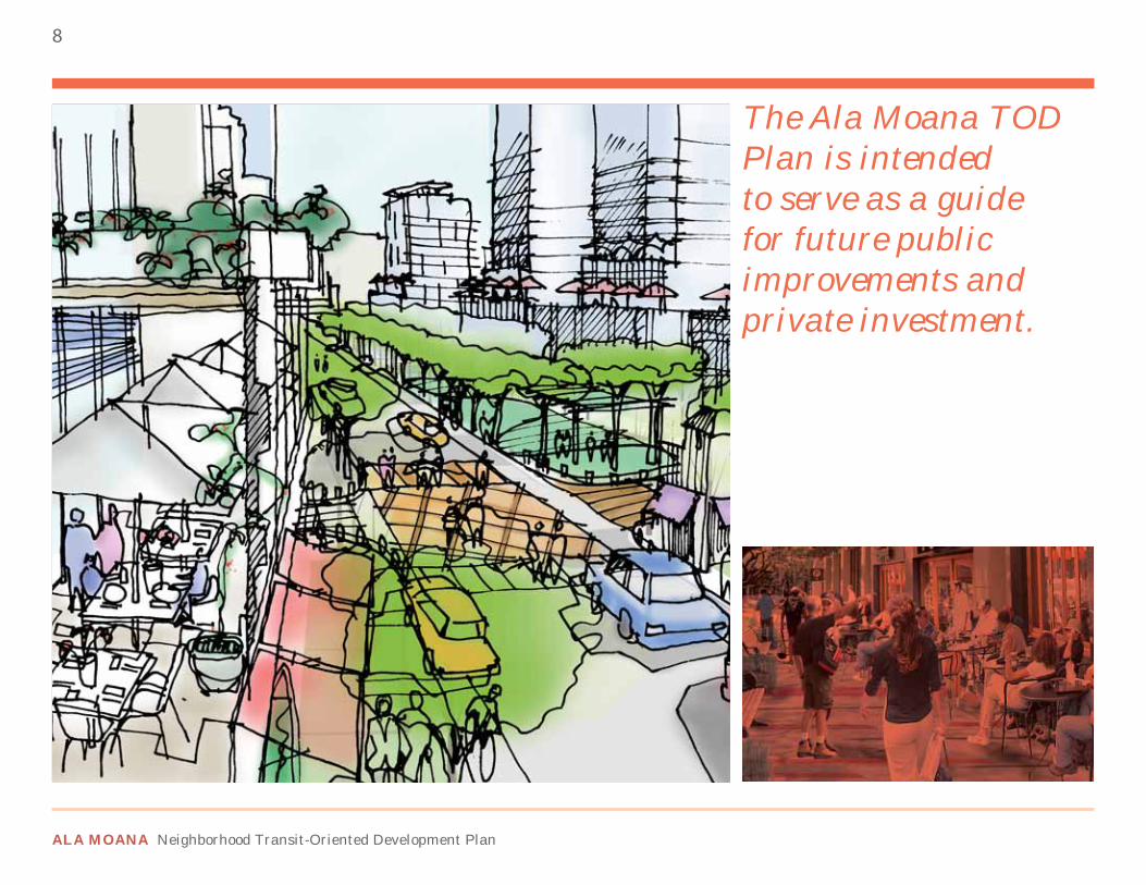
The Ala Moana TOD Plan is intended to serve as a guide for future public improvements and private investment.
DRAFT FINAL PLAN
9
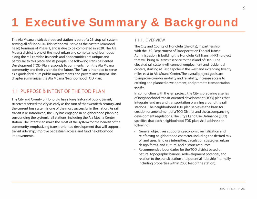
1 Executive Summary & BackgroundThe Ala Moana district’s proposed station is part of a 21-stop rail system serving all of Honolulu. This station will serve as the eastern (diamond head) terminus of Phase 1, and is due to be completed in 2020. The Ala Moana district is one of the most urban and complex neighborhoods along the rail corridor. Its needs and opportunities are unique and particular to this place and its people. The following Transit-Oriented Development (TOD) Plan responds to comments from the Ala Moana community and their vision for the future. The Plan is intended to serve as a guide for future public improvements and private investment. This chapter summarizes the Ala Moana Neighborhood TOD Plan.
1.1 PURPOSE & INTENT OF THE TOD PLANThe City and County of Honolulu has a long history of public transit; streetcars served the city as early as the turn of the twentieth century, and the current bus system is one of the most successful in the nation. As rail transit is re-introduced, the City has engaged in neighborhood planning surrounding the system’s rail stations, including the Ala Moana Center station. The intent is to make the most of the system for the benefit of the community, emphasizing transit-oriented development that will support transit ridership, improve pedestrian access, and fund neighborhood improvements.
1.1.1. OVERVIEWThe City and County of Honolulu (the City), in partnership with the U.S. Department of Transportation Federal Transit Administration, is building the Honolulu Rail Transit (HRT) project that will bring rail transit service to the island of Oahu. The elevated rail system will connect employment and residential centers, starting at East Kapolei in the west and extending twenty miles east to Ala Moana Center. The overall project goals are to improve corridor mobility and reliability, increase access to existing and planned development, and promote transportation equity.
In conjunction with the rail project, the City is preparing a series of neighborhood transit-oriented development (TOD) plans that integrate land use and transportation planning around the rail stations. The neighborhood TOD plan serves as the basis for creation or amendment of a TOD District and the accompanying development regulations. The City’s Land Use Ordinance (LUO) specifies that each neighborhood TOD plan shall address the following:
• General objectives supporting economic revitalization and reinforcing neighborhood character, including the desired mix of land uses, land use intensities, circulation strategies, urban design forms, and cultural and historic resources.
• Recommended boundaries for the TOD district based on natural topographic barriers, redevelopment potential, and relation to the transit station and potential ridership (normally including properties within 2000 feet of the station).
ALA MOANA Neighborhood Transit-Oriented Development Plan
10
• Recommended zoning controls, including architectural and community design principles, open space requirements, parking standards, and other modifications to existing zoning.
• A strategy for preservation and creation of affordable housing.• A general program for implementation, covering phasing, as
well as approximate cost and potential financing mechanisms.
A recent economic study suggests that more than any other station along the line, the Ala Moana Center station offers the opportunity to capitalize on Honolulu’s “Value Capture Strategy” to leverage public investment in the rail system. Although not scheduled for operation until 2020, development surrounding this station site has considerable potential to increase property values and tax revenues. The Ala Moana Neighborhood TOD Plan will guide development in such a manner that optimizes value capture while ensuring community benefits.
1.1.2. TRANSIT-ORIENTED DEVELOPMENT (TOD)TOD typically refers to development within comfortable walking distance of a major transit stop. This is important because urban transit ridership relies heavily upon pedestrian access within a 5- to 10-minute walking distance, or a roughly ¼- to ½-mile radius from the station. Higher densities are an important characteristic of TOD and may be achieved through development of vacant land or redevelopment of low-density sites. Additionally, TOD should focus on creating a pedestrian scaled urban environment that is safe and appealing to persons on foot. Ideally, this involves a vibrant mix of land uses, generally encompassing residential and commercial activities, while featuring ground floor uses that maintain street vitality. Moreover, improved pedestrian and bicycle connections should readily link the transit station with major destinations and activity centers such as shopping centers and schools. Collectively, these measures will promote efficient use of land, encourage transit ridership, as well as support a diversity of land uses that are easily accessible and meet daily needs.
1.1.3. PUBLIC OUTREACHPublic input through various outreach efforts has been an essential aspect of preparation of the Ala Moana Neighborhood TOD Plan. Key stakeholders and interested groups and individuals had multiple opportunities to participate in the development of the Plan.
To date, three major community workshops, dozens of stakeholder meetings, several steering committee meetings, and a project-based website (http://www.honolulu.gov/tod/) have been used to solicit inputs that have been incorporated into this plan. The outreach program also included a resident survey. This survey was offered in Korean, and the City partnered with the United Korean Association do reach out to ethnic businesses in the area.
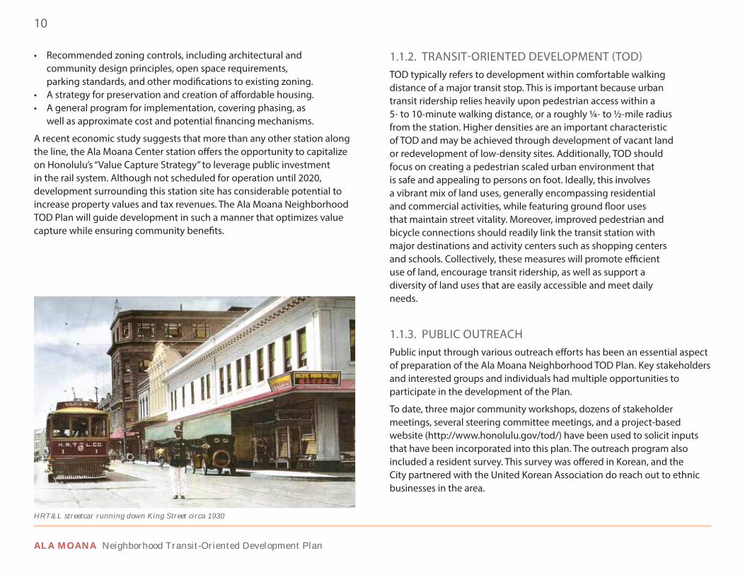
HRT&L streetcar running down King Street circa 1930
DRAFT FINAL PLAN
11EXECUTIVE SUMMARY & BACKGROUND
1.1.4. BACKGROUND ANALYSISThe neighborhood TOD planning process began with a comprehensive background analysis for preparation of neighborhood TOD plans, including “population, economic, and market analysis and infrastructure analysis.” The Existing Conditions Report summarized the surrounding physical and demographic context, identifies opportunities and constraints related to land use, circulation, open space, infrastructure, and physical design, and explores the potential of transit-oriented development. The Alternatives Report that followed emphasized the vision and principles for the Ala Moana district, which were carried out through streetscape concepts and development scenarios around the station. This work has been integrated within the Ala Moana Neighborhood TOD Plan.
1.1.5. PRIMARY URBAN CENTER DEVELOPMENT PLANThe Primary Urban Center Development Plan (June 2004) consists of policies and guidelines to guide land use and infrastructure decisions in a manner consistent with applicable General Plan provisions. According to the General Plan, the Primary Urban Center (PUC) is intended to host major economic activity and accommodate approximately 46 percent of the island’s population by the year 2025, while encouraging a variety of homes to people of different income levels and families of various sizes. As of 2015, the actual resident population for the PUC was 427,429, or 45 percent of the island. TOD in the Ala Moana area could increase dwelling units by 5,600 units or 13,160 residents (using an average household size of 2.35), which, when projected to the year 2025 and a larger island population, would retain its 45 percent share. However, it is important to note that this increase will be market driven and will occur incrementally over many years.
The PUC Development Plan identifies the land uses in the Ala Moana study area as District Commercial, and Medium and Higher-Density Residential/Mixed Use. It also calls for the development of a rapid transportation
system with high-density mixed land uses around rail stations, creating vibrant and convenient neighborhoods synonymous with transit-oriented developments. An enhanced pedestrian and bicycle network would improve multimodal mobility in the PUC and Ala Moana area. Envisioned are in-town housing choices that are affordable and varied in scale, coupled with schools and publicly accessible open spaces, which are critical amenities in compact urban areas. The Ala Moana Neighborhood TOD Plan envisions such a livable urban community that is not only consistent with, but also refines, the policies of the PUC Development Plan.
1.1.6. ALA MOANA NEIGHBORHOOD TOD PLAN SUMMARYThe Ala Moana TOD Plan comprises of six chapters that illustrate the full potential of the Ala Moana neighborhood:
• Chapter 1 provides background and an executive summary.• Chapter 2 outlines the eight principles that should guide future
growth in the Ala Moana neighborhood. Principles range from expanding land use diversity, complete street concepts, and promoting public-private partnerships.
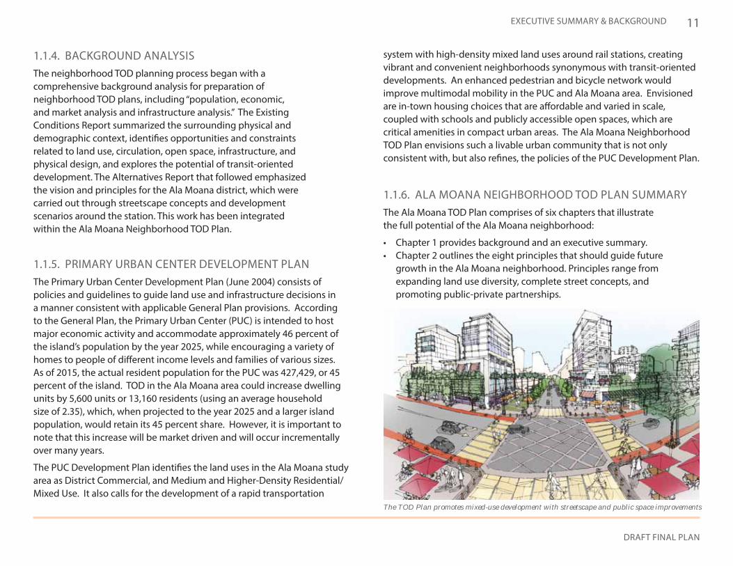
The TOD Plan promotes mixed-use development with streetscape and public space improvements
ALA MOANA Neighborhood Transit-Oriented Development Plan
12
PRIMARY URBAN CENTER
MAUKA
MAKAIEWA
DIAMOND HEAD
ISLAND OF OAHU / CITY & COUNTY OF HONOLULU
ALA MOANA CENTER STATION (PLANNING AREA)WAIKIKI BEACH
EAST KAPOLEI STATION
HONOLULU INTERNATIONAL AIRPORT
FIXED GUIDEWAY RAIL LINE
DOWNTOWN HONOLULU
1.2 SITE BACKGROUND
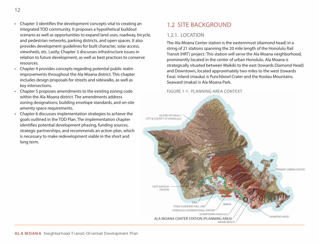
1.2.1. LOCATIONThe Ala Moana Center station is the easternmost (diamond head) in a string of 21 stations spanning the 20 mile length of the Honolulu Rail Transit (HRT) project. This station will serve the Ala Moana neighborhood, prominently located in the center of urban Honolulu. Ala Moana is strategically situated between Waikiki to the east (towards Diamond Head) and Downtown, located approximately two miles to the west (towards Ewa). Inland (mauka) is Punchbowl Crater and the Koolau Mountains. Seaward (makai) is Ala Moana Park.
FIGURE 1-1: PLANNING AREA CONTEXT
• Chapter 3 identifies the development concepts vital to creating an integrated TOD community. It proposes a hypothetical buildout scenario as well as opportunities to expand land uses, roadway, bicycle, and pedestrian networks, parking districts, and open spaces. It also provides development guidelines for built character, solar access, viewsheds, etc. Lastly, Chapter 3 discusses infrastructure issues in relation to future development, as well as best practices to conserve resources.
• Chapter 4 provides concepts regarding potential public realm improvements throughout the Ala Moana district. This chapter includes design proposals for streets and sidewalks, as well as key intersections.
• Chapter 5 proposes amendments to the existing zoning code within the Ala Moana district. The amendments address zoning designations, building envelope standards, and on-site amenity space requirements.
• Chapter 6 discusses implementation strategies to achieve the goals outlined in the TOD Plan. The implementation chapter identifies potential development phasing, funding sources, strategic partnerships, and recommends an action plan, which is necessary to make redevelopment viable in the short and long term.
DRAFT FINAL PLAN
13EXECUTIVE SUMMARY & BACKGROUND
FIGURE 1-2: SITE CHARACTER
Fixed Guideway
Ambiguous Interse
ction
Dangerous Interse
ction
Need for Wayfinding
Major Node
Strong Distr
ict
Weak District
Hard Edge
Chaotic / Characterless
Unclear Path
Clear Path
Strong Path
Disconnected Waterfront
Bus Transit Statio
n
Tree Lined Walkway
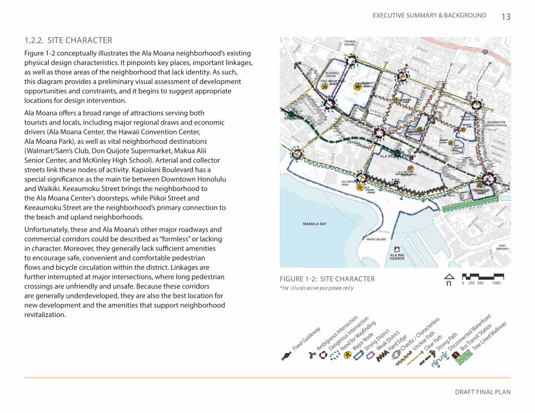
1.2.2. SITE CHARACTERFigure 1-2 conceptually illustrates the Ala Moana neighborhood’s existing physical design characteristics. It pinpoints key places, important linkages, as well as those areas of the neighborhood that lack identity. As such, this diagram provides a preliminary visual assessment of development opportunities and constraints, and it begins to suggest appropriate locations for design intervention.
Ala Moana offers a broad range of attractions serving both tourists and locals, including major regional draws and economic drivers (Ala Moana Center, the Hawaii Convention Center, Ala Moana Park), as well as vital neighborhood destinations (Walmart/Sam’s Club, Don Quijote Supermarket, Makua Alii Senior Center, and McKinley High School). Arterial and collector streets link these nodes of activity. Kapiolani Boulevard has a special significance as the main tie between Downtown Honolulu and Waikiki. Keeaumoku Street brings the neighborhood to the Ala Moana Center’s doorsteps, while Piikoi Street and Keeaumoku Street are the neighborhood’s primary connection to the beach and upland neighborhoods.
Unfortunately, these and Ala Moana’s other major roadways and commercial corridors could be described as “formless” or lacking in character. Moreover, they generally lack sufficient amenities to encourage safe, convenient and comfortable pedestrian flows and bicycle circulation within the district. Linkages are further interrupted at major intersections, where long pedestrian crossings are unfriendly and unsafe. Because these corridors are generally underdeveloped, they are also the best location for new development and the amenities that support neighborhood revitalization.
n 0 250 500 1000 *for illustrative purposes only
ALA MOANA Neighborhood Transit-Oriented Development Plan
14
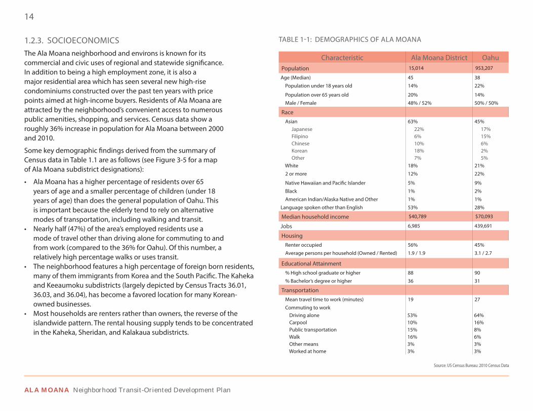
1.2.3. SOCIOECONOMICSThe Ala Moana neighborhood and environs is known for its commercial and civic uses of regional and statewide significance. In addition to being a high employment zone, it is also a major residential area which has seen several new high-rise condominiums constructed over the past ten years with price points aimed at high-income buyers. Residents of Ala Moana are attracted by the neighborhood’s convenient access to numerous public amenities, shopping, and services. Census data show a roughly 36% increase in population for Ala Moana between 2000 and 2010.
Some key demographic findings derived from the summary of Census data in Table 1.1 are as follows (see Figure 3-5 for a map of Ala Moana subdistrict designations):
• Ala Moana has a higher percentage of residents over 65 years of age and a smaller percentage of children (under 18 years of age) than does the general population of Oahu. This is important because the elderly tend to rely on alternative modes of transportation, including walking and transit.
• Nearly half (47%) of the area’s employed residents use a mode of travel other than driving alone for commuting to and from work (compared to the 36% for Oahu). Of this number, a relatively high percentage walks or uses transit.
• The neighborhood features a high percentage of foreign born residents, many of them immigrants from Korea and the South Pacific. The Kaheka and Keeaumoku subdistricts (largely depicted by Census Tracts 36.01, 36.03, and 36.04), has become a favored location for many Korean-owned businesses.
• Most households are renters rather than owners, the reverse of the islandwide pattern. The rental housing supply tends to be concentrated in the Kaheka, Sheridan, and Kalakaua subdistricts.
Characteristic Ala Moana District OahuPopulation 15,014 953,207
Age (Median) 45 38
Population under 18 years old 14% 22%
Population over 65 years old 20% 14%
Male / Female 48% / 52% 50% / 50%
Race Asian 63% 45% Japanese 22% 17% Filipino 6% 15% Chinese 10% 6% Korean 18% 2% Other 7% 5% White 18% 21%
2 or more 12% 22%
Native Hawaiian and Pacific Islander 5% 9%
Black 1% 2%
American Indian/Alaska Native and Other 1% 1%
Language spoken other than English 53% 28%
Median household income $40,789 $70,093
Jobs 6,985 439,691
Housing Renter occupied 56% 45%
Average persons per household (Owned / Rented) 1.9 / 1.9 3.1 / 2.7
Educational Attainment % High school graduate or higher 88 90
% Bachelor’s degree or higher 36 31
Transportation Mean travel time to work (minutes) 19 27
Commuting to work Driving alone 53% 64% Carpool 10% 16% Public transportation 15% 8% Walk 16% 6% Other means 3% 3% Worked at home 3% 3%
Source: US Census Bureau: 2010 Census Data
TABLE 1-1: DEMOGRAPHICS OF ALA MOANA
DRAFT FINAL PLAN
15EXECUTIVE SUMMARY & BACKGROUND
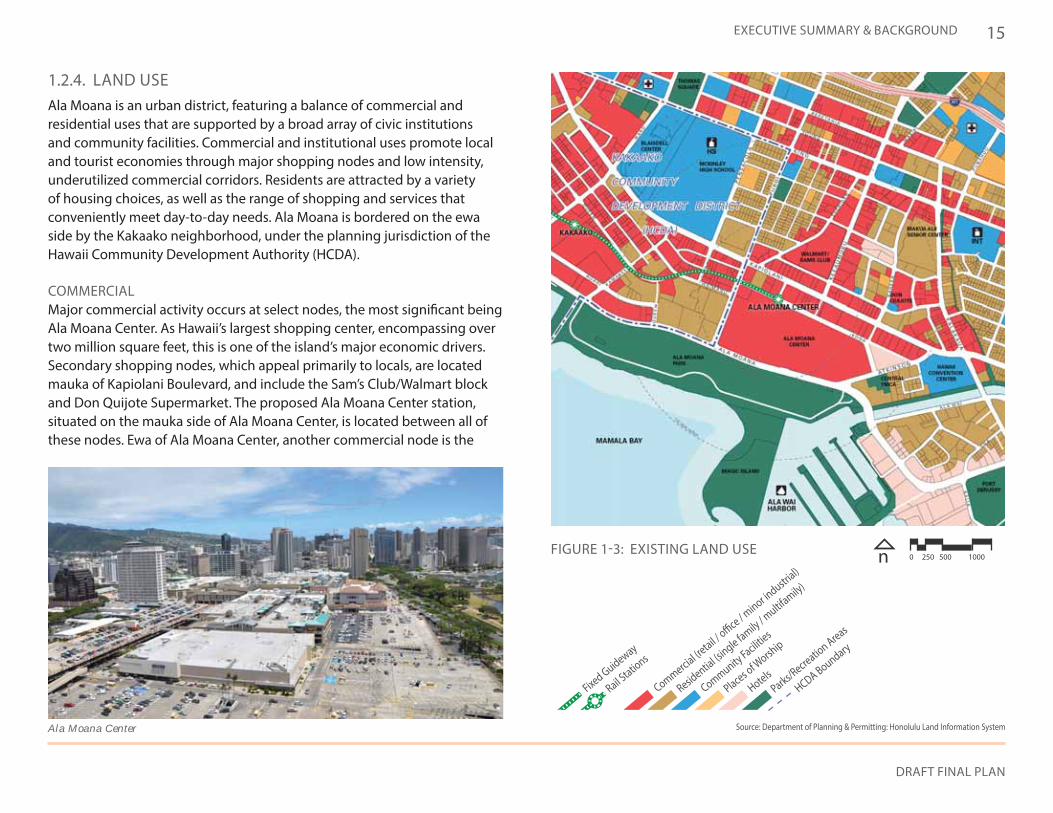
1.2.4. LAND USEAla Moana is an urban district, featuring a balance of commercial and residential uses that are supported by a broad array of civic institutions and community facilities. Commercial and institutional uses promote local and tourist economies through major shopping nodes and low intensity, underutilized commercial corridors. Residents are attracted by a variety of housing choices, as well as the range of shopping and services that conveniently meet day-to-day needs. Ala Moana is bordered on the ewa side by the Kakaako neighborhood, under the planning jurisdiction of the Hawaii Community Development Authority (HCDA).
COMMERCIALMajor commercial activity occurs at select nodes, the most significant being Ala Moana Center. As Hawaii’s largest shopping center, encompassing over two million square feet, this is one of the island’s major economic drivers. Secondary shopping nodes, which appeal primarily to locals, are located mauka of Kapiolani Boulevard, and include the Sam’s Club/Walmart block and Don Quijote Supermarket. The proposed Ala Moana Center station, situated on the mauka side of Ala Moana Center, is located between all of these nodes. Ewa of Ala Moana Center, another commercial node is the
Fixed Guideway
Rail Statio
ns
Commercial (retail /
office / minor in
dustrial)
Residential (s
ingle family / multifa
mily)
Community Facilities
Places of W
orship
HotelsParks/R
ecreation Areas
HCDA Boundary
FIGURE 1-3: EXISTING LAND USE n 0 250 500 1000
Ala Moana Center Source: Department of Planning & Permitting: Honolulu Land Information System
ALA MOANA Neighborhood Transit-Oriented Development Plan
16
Ward Centers retail and entertainment development, which will be served by the Kakaako rail station. In addition to these shopping attractions, low-intensity commercial activity is found along the area’s arterial and collector roadways. Kapiolani Boulevard in particular functions as the area’s primary commercial corridor with older, low-rise buildings gradually being replaced by newer, higher value high-rise mixed-use buildings. Keeaumoku, Sheridan, Kalakaua, and King Streets are similarly underdeveloped with low-density commercial uses.
RESIDENTIAL:Residential use is concentrated ewa and diamond head of the Keeaumoku Corridor. The area diamond head of Keeaumoku is developed at a higher density, and includes the Kalakaua Homes public housing project and a number of high-rise apartment buildings. The area ewa of Keeaumoku Street is the Sheridan Tract, characterized by low- to medium-density residential uses, including a number of single-family dwellings. Further afield, high concentrations of housing are found in the Makiki and McCully neighborhoods, while high-rise condominiums are emerging in Kakaako.
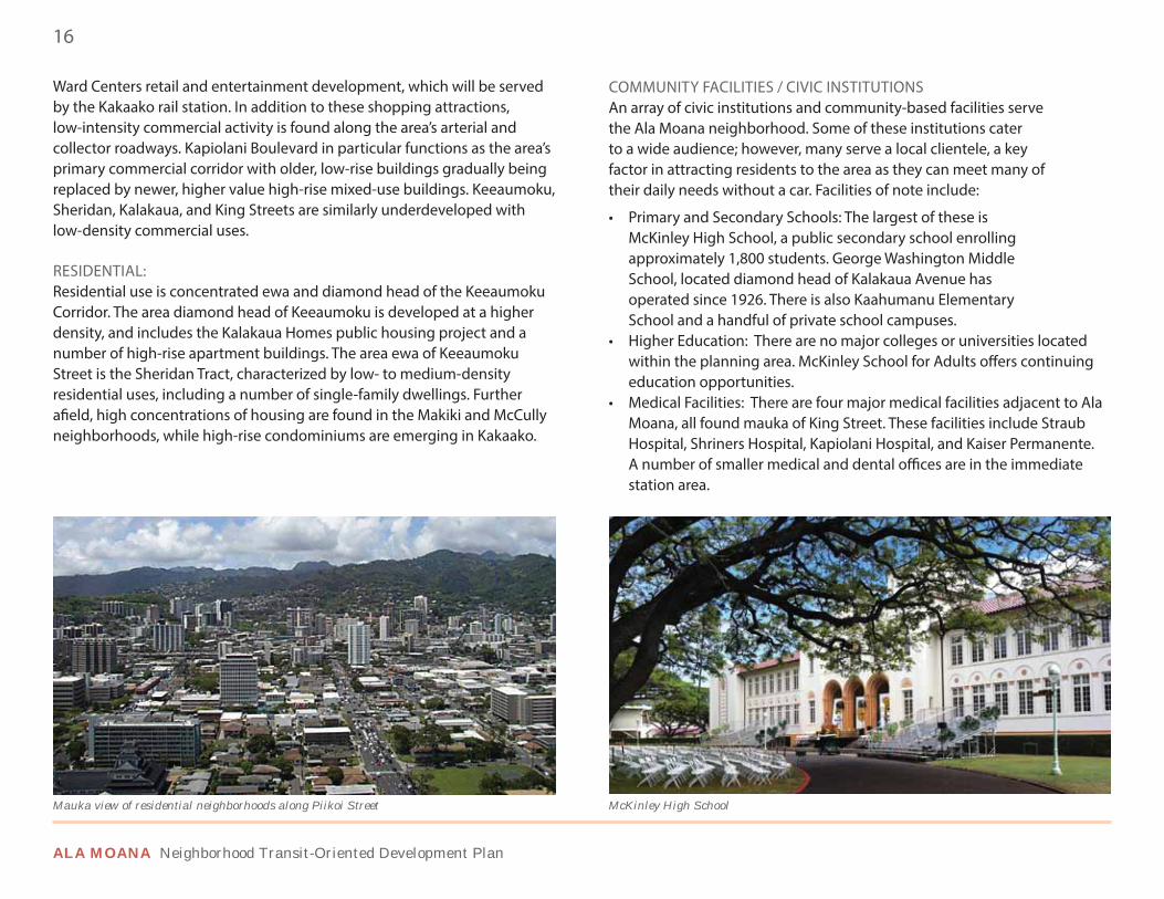
COMMUNITY FACILITIES / CIVIC INSTITUTIONSAn array of civic institutions and community-based facilities serve the Ala Moana neighborhood. Some of these institutions cater to a wide audience; however, many serve a local clientele, a key factor in attracting residents to the area as they can meet many of their daily needs without a car. Facilities of note include:
• Primary and Secondary Schools: The largest of these is McKinley High School, a public secondary school enrolling approximately 1,800 students. George Washington Middle School, located diamond head of Kalakaua Avenue has operated since 1926. There is also Kaahumanu Elementary School and a handful of private school campuses.
• Higher Education: There are no major colleges or universities located within the planning area. McKinley School for Adults offers continuing education opportunities.
• Medical Facilities: There are four major medical facilities adjacent to Ala Moana, all found mauka of King Street. These facilities include Straub Hospital, Shriners Hospital, Kapiolani Hospital, and Kaiser Permanente. A number of smaller medical and dental offices are in the immediate station area.
Mauka view of residential neighborhoods along Piikoi Street McKinley High School
DRAFT FINAL PLAN
17EXECUTIVE SUMMARY & BACKGROUND
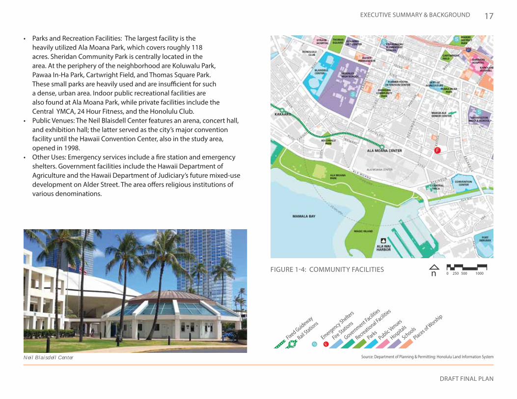
• Parks and Recreation Facilities: The largest facility is the heavily utilized Ala Moana Park, which covers roughly 118 acres. Sheridan Community Park is centrally located in the area. At the periphery of the neighborhood are Koluwalu Park, Pawaa In-Ha Park, Cartwright Field, and Thomas Square Park. These small parks are heavily used and are insufficient for such a dense, urban area. Indoor public recreational facilities are also found at Ala Moana Park, while private facilities include the Central YMCA, 24 Hour Fitness, and the Honolulu Club.
• Public Venues: The Neil Blaisdell Center features an arena, concert hall, and exhibition hall; the latter served as the city’s major convention facility until the Hawaii Convention Center, also in the study area, opened in 1998.
• Other Uses: Emergency services include a fire station and emergency shelters. Government facilities include the Hawaii Department of Agriculture and the Hawaii Department of Judiciary’s future mixed-use development on Alder Street. The area offers religious institutions of various denominations.
S FFixed Guideway
Rail Statio
ns
Emergency Shelters
Fire Stations
Government Facilities
Recreational Faciliti
es
ParksPublic Venues
Hospitals
Schools
Places of W
orship
FIGURE 1-4: COMMUNITY FACILITIES n 0 250 500 1000
Neil Blaisdell Center Source: Department of Planning & Permitting: Honolulu Land Information System
ALA MOANA Neighborhood Transit-Oriented Development Plan
18
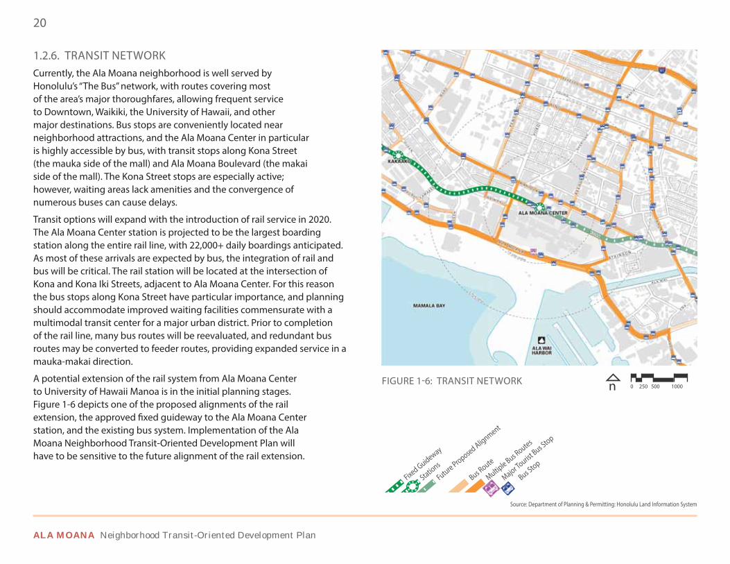
1.2.5. HISTORIC & CULTURAL RESOURCESA considerable number of historically and culturally significant sites are found throughout the Ala Moana neighborhood, some of which are shown in Figure 1-5. Additionally, the Ala Moana-Sheridan Community Plan (May 2009) provides a concise history of the area. Several sites are either listed or eligible for listing in the Hawaii or National Register of Historic Places. The most noteworthy are listed on both State and National Registers:
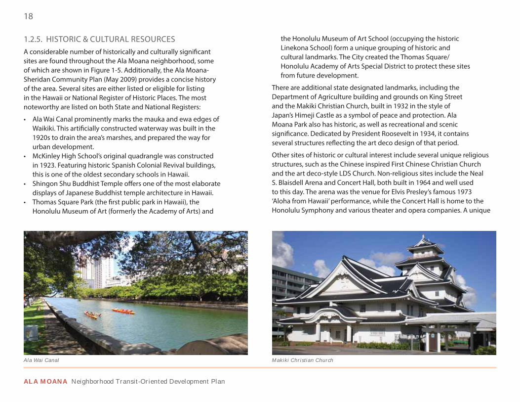
• Ala Wai Canal prominently marks the mauka and ewa edges of Waikiki. This artificially constructed waterway was built in the 1920s to drain the area’s marshes, and prepared the way for urban development.
• McKinley High School’s original quadrangle was constructed in 1923. Featuring historic Spanish Colonial Revival buildings, this is one of the oldest secondary schools in Hawaii.
• Shingon Shu Buddhist Temple offers one of the most elaborate displays of Japanese Buddhist temple architecture in Hawaii.
• Thomas Square Park (the first public park in Hawaii), the Honolulu Museum of Art (formerly the Academy of Arts) and
the Honolulu Museum of Art School (occupying the historic Linekona School) form a unique grouping of historic and cultural landmarks. The City created the Thomas Square/Honolulu Academy of Arts Special District to protect these sites from future development.
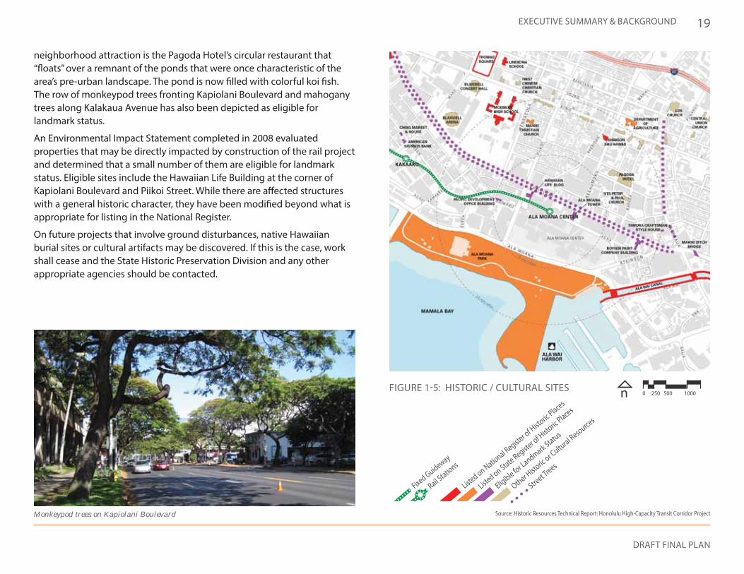
There are additional state designated landmarks, including the Department of Agriculture building and grounds on King Street and the Makiki Christian Church, built in 1932 in the style of Japan’s Himeji Castle as a symbol of peace and protection. Ala Moana Park also has historic, as well as recreational and scenic significance. Dedicated by President Roosevelt in 1934, it contains several structures reflecting the art deco design of that period.
Other sites of historic or cultural interest include several unique religious structures, such as the Chinese inspired First Chinese Christian Church and the art deco-style LDS Church. Non-religious sites include the Neal S. Blaisdell Arena and Concert Hall, both built in 1964 and well used to this day. The arena was the venue for Elvis Presley’s famous 1973 ‘Aloha from Hawaii’ performance, while the Concert Hall is home to the Honolulu Symphony and various theater and opera companies. A unique
Ala Wai Canal Makiki Christian Church
DRAFT FINAL PLAN
19EXECUTIVE SUMMARY & BACKGROUND
Fixed Guideway
Rail Statio
ns
Listed on Natio
nal Register of H
istoric Places
Listed on State Registe
r of Histo
ric Places
Eligible for Landmark Status
Other Histo
ric or Cultu
ral Resources
Street Trees
Source: Historic Resources Technical Report: Honolulu High-Capacity Transit Corridor Project
FIGURE 1-5: HISTORIC / CULTURAL SITES n 0 250 500 1000
neighborhood attraction is the Pagoda Hotel’s circular restaurant that “floats” over a remnant of the ponds that were once characteristic of the area’s pre-urban landscape. The pond is now filled with colorful koi fish. The row of monkeypod trees fronting Kapiolani Boulevard and mahogany trees along Kalakaua Avenue has also been depicted as eligible for landmark status.
An Environmental Impact Statement completed in 2008 evaluated properties that may be directly impacted by construction of the rail project and determined that a small number of them are eligible for landmark status. Eligible sites include the Hawaiian Life Building at the corner of Kapiolani Boulevard and Piikoi Street. While there are affected structures with a general historic character, they have been modified beyond what is appropriate for listing in the National Register.
On future projects that involve ground disturbances, native Hawaiian burial sites or cultural artifacts may be discovered. If this is the case, work shall cease and the State Historic Preservation Division and any other appropriate agencies should be contacted.
Monkeypod trees on Kapiolani Boulevard
ALA MOANA Neighborhood Transit-Oriented Development Plan
20
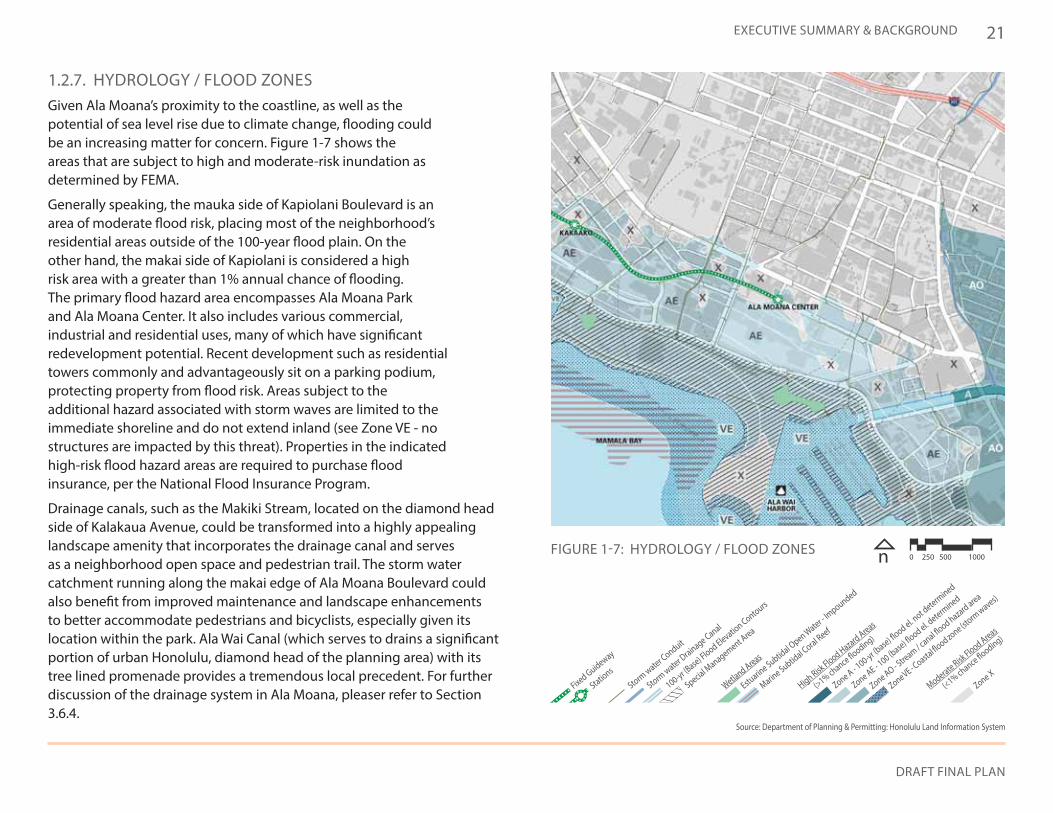
1.2.6. TRANSIT NETWORKCurrently, the Ala Moana neighborhood is well served by Honolulu’s “The Bus” network, with routes covering most of the area’s major thoroughfares, allowing frequent service to Downtown, Waikiki, the University of Hawaii, and other major destinations. Bus stops are conveniently located near neighborhood attractions, and the Ala Moana Center in particular is highly accessible by bus, with transit stops along Kona Street (the mauka side of the mall) and Ala Moana Boulevard (the makai side of the mall). The Kona Street stops are especially active; however, waiting areas lack amenities and the convergence of numerous buses can cause delays.
Transit options will expand with the introduction of rail service in 2020. The Ala Moana Center station is projected to be the largest boarding station along the entire rail line, with 22,000+ daily boardings anticipated. As most of these arrivals are expected by bus, the integration of rail and bus will be critical. The rail station will be located at the intersection of Kona and Kona Iki Streets, adjacent to Ala Moana Center. For this reason the bus stops along Kona Street have particular importance, and planning should accommodate improved waiting facilities commensurate with a multimodal transit center for a major urban district. Prior to completion of the rail line, many bus routes will be reevaluated, and redundant bus routes may be converted to feeder routes, providing expanded service in a mauka-makai direction.
A potential extension of the rail system from Ala Moana Center to University of Hawaii Manoa is in the initial planning stages. Figure 1-6 depicts one of the proposed alignments of the rail extension, the approved fixed guideway to the Ala Moana Center station, and the existing bus system. Implementation of the Ala Moana Neighborhood Transit-Oriented Development Plan will have to be sensitive to the future alignment of the rail extension.
Source: Department of Planning & Permitting: Honolulu Land Information System
FIGURE 1-6: TRANSIT NETWORK n 0 250 500 1000
Fixed Guideway
Stations
Future Proposed Alignment
Bus Route
Multiple Bus R
outes
Major Tourist Bus Stop
Bus Stop
DRAFT FINAL PLAN
21EXECUTIVE SUMMARY & BACKGROUND
Fixed Guideway
Stations
Storm water C
onduit
Storm water D
rainage Canal
100-yr (Base) Flood Elevatio
n Contours
Special Management A
rea
Wetland Areas
Estuarin
e Subtidal O
pen Water - Impounded
Marine Subtid
al Coral Reef
High Risk Flood Hazard Areas
(>1% chance flooding)
Zone A - 100-yr (b
ase) flood el. n
ot determ
ined
Zone AE - 100 (base) flo
od el. determ
ined
Zone AO - Stre
am / canal flo
od hazard area
Zone VE - Coasta
l flood zone (st
orm waves)
Moderate Risk Flood Areas
(<1% chance flooding)
Zone X
Source: Department of Planning & Permitting: Honolulu Land Information System
1.2.7. HYDROLOGY / FLOOD ZONESGiven Ala Moana’s proximity to the coastline, as well as the potential of sea level rise due to climate change, flooding could be an increasing matter for concern. Figure 1-7 shows the areas that are subject to high and moderate-risk inundation as determined by FEMA.
Generally speaking, the mauka side of Kapiolani Boulevard is an area of moderate flood risk, placing most of the neighborhood’s residential areas outside of the 100-year flood plain. On the other hand, the makai side of Kapiolani is considered a high risk area with a greater than 1% annual chance of flooding. The primary flood hazard area encompasses Ala Moana Park and Ala Moana Center. It also includes various commercial, industrial and residential uses, many of which have significant redevelopment potential. Recent development such as residential towers commonly and advantageously sit on a parking podium, protecting property from flood risk. Areas subject to the additional hazard associated with storm waves are limited to the immediate shoreline and do not extend inland (see Zone VE - no structures are impacted by this threat). Properties in the indicated high-risk flood hazard areas are required to purchase flood insurance, per the National Flood Insurance Program.
Drainage canals, such as the Makiki Stream, located on the diamond head side of Kalakaua Avenue, could be transformed into a highly appealing landscape amenity that incorporates the drainage canal and serves as a neighborhood open space and pedestrian trail. The storm water catchment running along the makai edge of Ala Moana Boulevard could also benefit from improved maintenance and landscape enhancements to better accommodate pedestrians and bicyclists, especially given its location within the park. Ala Wai Canal (which serves to drains a significant portion of urban Honolulu, diamond head of the planning area) with its tree lined promenade provides a tremendous local precedent. For further discussion of the drainage system in Ala Moana, pleaser refer to Section 3.6.4.
FIGURE 1-7: HYDROLOGY / FLOOD ZONES n 0 250 500 1000
ALA MOANA Neighborhood Transit-Oriented Development Plan
22
Fixed Guideway
Stations
Low Redevelopment Potential
Landmark / Significant Building
High Value
Moderate Value
Low Value
Possible Redevelopment Sites
Low Value / High Redevelopment Potential
Surface Parking Lots
Vacant Lots
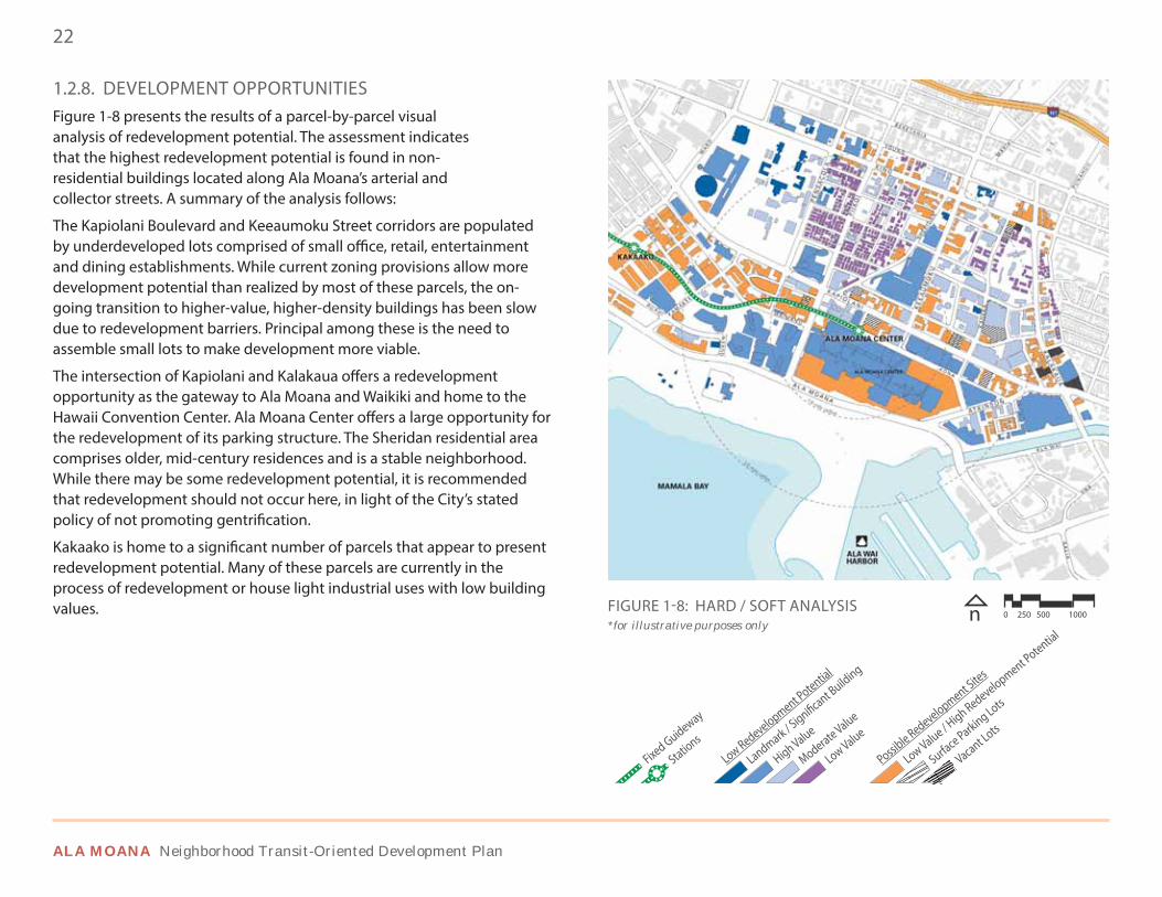
1.2.8. DEVELOPMENT OPPORTUNITIESFigure 1-8 presents the results of a parcel-by-parcel visual analysis of redevelopment potential. The assessment indicates that the highest redevelopment potential is found in non-residential buildings located along Ala Moana’s arterial and collector streets. A summary of the analysis follows:
The Kapiolani Boulevard and Keeaumoku Street corridors are populated by underdeveloped lots comprised of small office, retail, entertainment and dining establishments. While current zoning provisions allow more development potential than realized by most of these parcels, the on-going transition to higher-value, higher-density buildings has been slow due to redevelopment barriers. Principal among these is the need to assemble small lots to make development more viable.
The intersection of Kapiolani and Kalakaua offers a redevelopment opportunity as the gateway to Ala Moana and Waikiki and home to the Hawaii Convention Center. Ala Moana Center offers a large opportunity for the redevelopment of its parking structure. The Sheridan residential area comprises older, mid-century residences and is a stable neighborhood. While there may be some redevelopment potential, it is recommended that redevelopment should not occur here, in light of the City’s stated policy of not promoting gentrification.
Kakaako is home to a significant number of parcels that appear to present redevelopment potential. Many of these parcels are currently in the process of redevelopment or house light industrial uses with low building values. FIGURE 1-8: HARD / SOFT ANALYSIS n 0 250 500 1000
*for illustrative purposes only
DRAFT FINAL PLAN
23EXECUTIVE SUMMARY & BACKGROUND
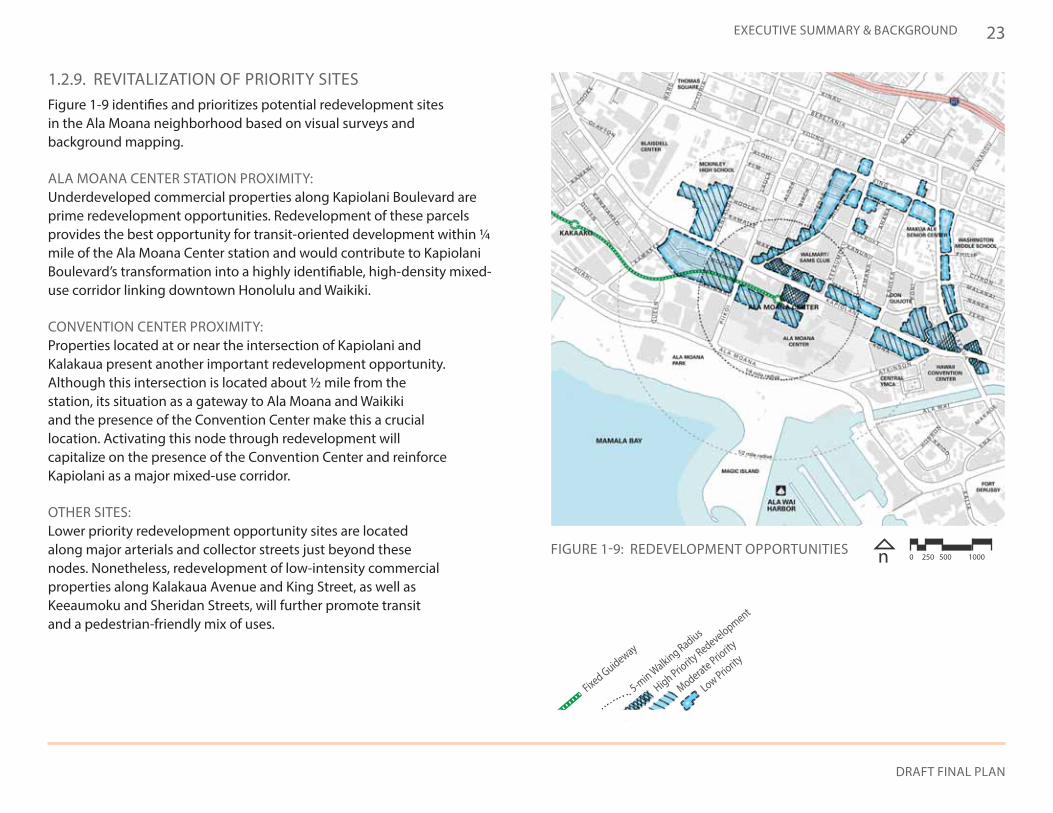
1.2.9. REVITALIZATION OF PRIORITY SITESFigure 1-9 identifies and prioritizes potential redevelopment sites in the Ala Moana neighborhood based on visual surveys and background mapping.
ALA MOANA CENTER STATION PROXIMITY: Underdeveloped commercial properties along Kapiolani Boulevard are prime redevelopment opportunities. Redevelopment of these parcels provides the best opportunity for transit-oriented development within ¼ mile of the Ala Moana Center station and would contribute to Kapiolani Boulevard’s transformation into a highly identifiable, high-density mixed-use corridor linking downtown Honolulu and Waikiki.
CONVENTION CENTER PROXIMITY: Properties located at or near the intersection of Kapiolani and Kalakaua present another important redevelopment opportunity. Although this intersection is located about ½ mile from the station, its situation as a gateway to Ala Moana and Waikiki and the presence of the Convention Center make this a crucial location. Activating this node through redevelopment will capitalize on the presence of the Convention Center and reinforce Kapiolani as a major mixed-use corridor.
OTHER SITES: Lower priority redevelopment opportunity sites are located along major arterials and collector streets just beyond these nodes. Nonetheless, redevelopment of low-intensity commercial properties along Kalakaua Avenue and King Street, as well as Keeaumoku and Sheridan Streets, will further promote transit and a pedestrian-friendly mix of uses.
Fixed Guideway
5-min Walking Radius
High Priority
Redevelopment
Moderate Priority
Low Priority
FIGURE 1-9: REDEVELOPMENT OPPORTUNITIES n 0 250 500 1000
24
ALA MOANA Neighborhood Transit-Oriented Development Plan
Ala Moana is envisioned as a livable urban community and a model for walking, biking, and transit usage.
DRAFT FINAL PLAN
25
2 Vision & Principles
Residential Diversity
Mix of Commercial
Usable Open Space
Complete Streets
Cultural Programs & Public Events
Public-Private Partnerships
2.1 VISION STATEMENT
Ala Moana is envisioned as a livable urban community and a model for walking, biking, and transit usage. The new rail station and surrounding TOD district will include a mix of uses, spur redevelopment where appropriate, help revitalize neighborhoods, and provide infrastructure improvements for increased safety, better mobility, and a sustainable environment. The Ala Moana neighborhood will embody cultural and income diversity, convenience, and the aloha spirit - continuing its role as the place where locals and visitors gather together. It will continue to serve as a regional retail destination, and new mixed-use development will improve the physical environment, safety, and mobility by providing community benefits as a part of each’s project’s implementation.
2.2 PRINCIPLES & POLICIES
1234
6Intermodal Connectivity5
78
ALA MOANA Neighborhood Transit-Oriented Development Plan
26
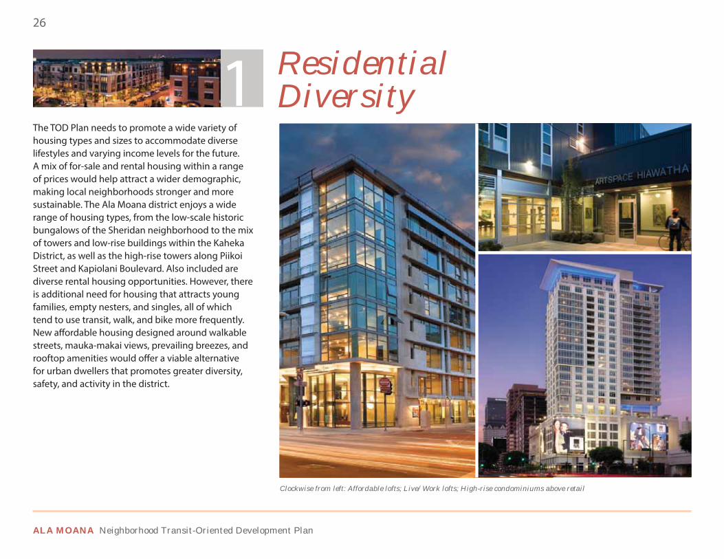
2.2.1. RESIDENTIAL DIVERSITY
Clockwise from left: Affordable lofts; Live/Work lofts; High-rise condominiums above retail
The TOD Plan needs to promote a wide variety of housing types and sizes to accommodate diverse lifestyles and varying income levels for the future. A mix of for-sale and rental housing within a range of prices would help attract a wider demographic, making local neighborhoods stronger and more sustainable. The Ala Moana district enjoys a wide range of housing types, from the low-scale historic bungalows of the Sheridan neighborhood to the mix of towers and low-rise buildings within the Kaheka District, as well as the high-rise towers along Piikoi Street and Kapiolani Boulevard. Also included are diverse rental housing opportunities. However, there is additional need for housing that attracts young families, empty nesters, and singles, all of which tend to use transit, walk, and bike more frequently. New affordable housing designed around walkable streets, mauka-makai views, prevailing breezes, and rooftop amenities would offer a viable alternative for urban dwellers that promotes greater diversity, safety, and activity in the district.
Live/Work • Townhouses Low-rise Flats
High-rise Condominiums • Apartments
Residential Diversity1
DRAFT FINAL PLAN
27VISION, PRINCIPLES, & POLICIES
Local Retail • Personal Services Restaurants • Coffee Shops Graphic Design/Print Shops
Business Hotel
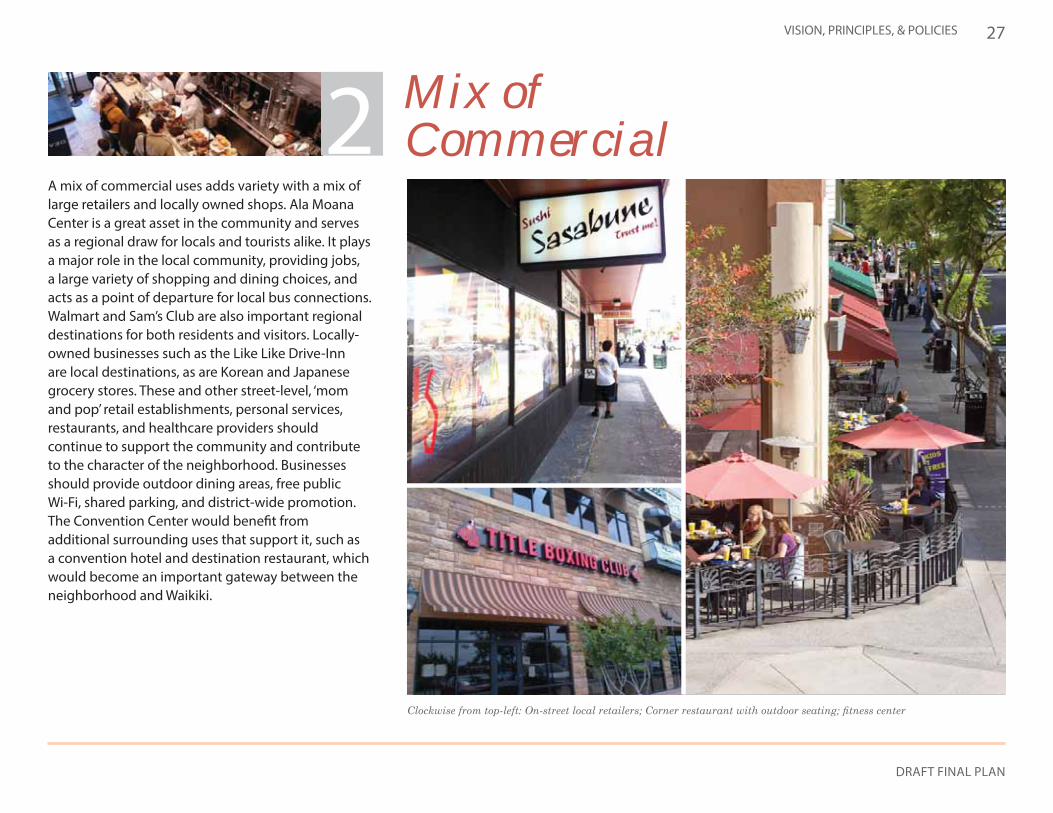
2.2.2. MIX OF COMMERCIAL
A mix of commercial uses adds variety with a mix of large retailers and locally owned shops. Ala Moana Center is a great asset in the community and serves as a regional draw for locals and tourists alike. It plays a major role in the local community, providing jobs, a large variety of shopping and dining choices, and acts as a point of departure for local bus connections. Walmart and Sam’s Club are also important regional destinations for both residents and visitors. Locally-owned businesses such as the Like Like Drive-Inn are local destinations, as are Korean and Japanese grocery stores. These and other street-level, ‘mom and pop’ retail establishments, personal services, restaurants, and healthcare providers should continue to support the community and contribute to the character of the neighborhood. Businesses should provide outdoor dining areas, free public Wi-Fi, shared parking, and district-wide promotion. The Convention Center would benefit from additional surrounding uses that support it, such as a convention hotel and destination restaurant, which would become an important gateway between the neighborhood and Waikiki.
Mix of Commercial2
ALA MOANA Neighborhood Transit-Oriented Development Plan
28
2.2.3. DIVERSITY OF OPEN SPACE
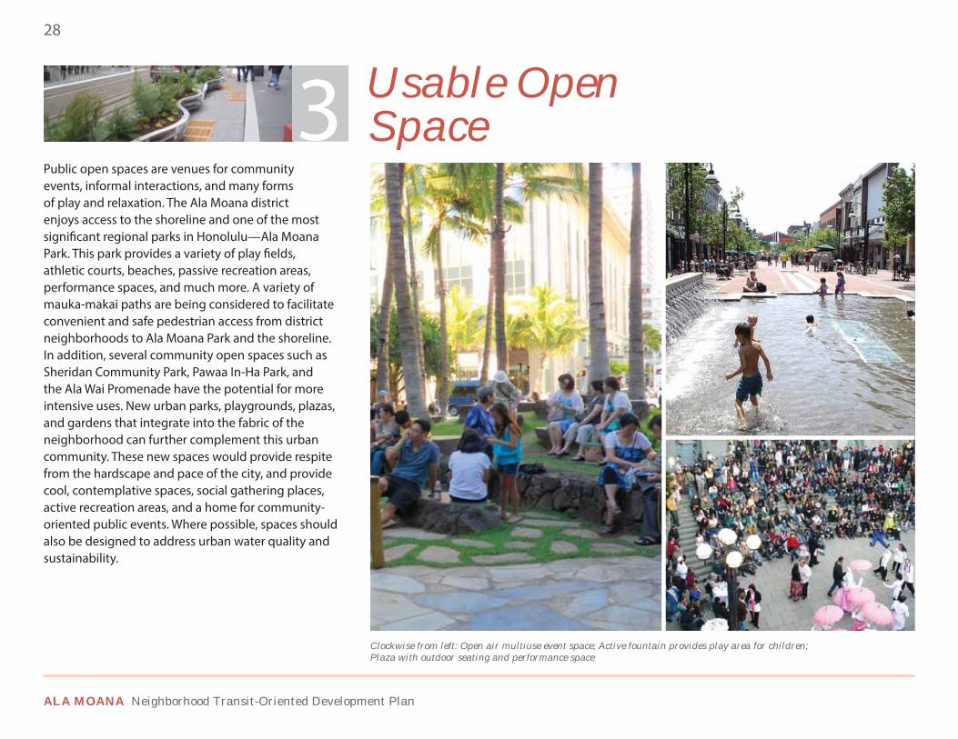
Public open spaces are venues for community events, informal interactions, and many forms of play and relaxation. The Ala Moana district enjoys access to the shoreline and one of the most significant regional parks in Honolulu—Ala Moana Park. This park provides a variety of play fields, athletic courts, beaches, passive recreation areas, performance spaces, and much more. A variety of mauka-makai paths are being considered to facilitate convenient and safe pedestrian access from district neighborhoods to Ala Moana Park and the shoreline. In addition, several community open spaces such as Sheridan Community Park, Pawaa In-Ha Park, and the Ala Wai Promenade have the potential for more intensive uses. New urban parks, playgrounds, plazas, and gardens that integrate into the fabric of the neighborhood can further complement this urban community. These new spaces would provide respite from the hardscape and pace of the city, and provide cool, contemplative spaces, social gathering places, active recreation areas, and a home for community-oriented public events. Where possible, spaces should also be designed to address urban water quality and sustainability.
Mauka-Makai Connections Open Air Event Plaza • Pocket Parks Community Gardens • Play Courts
Community Pool
Usable Open Space
Clockwise from left: Open air multiuse event space; Active fountain provides play area for children; Plaza with outdoor seating and performance space
3
DRAFT FINAL PLAN
29VISION, PRINCIPLES, & POLICIES
2.2.4. COMPLETE STREETS
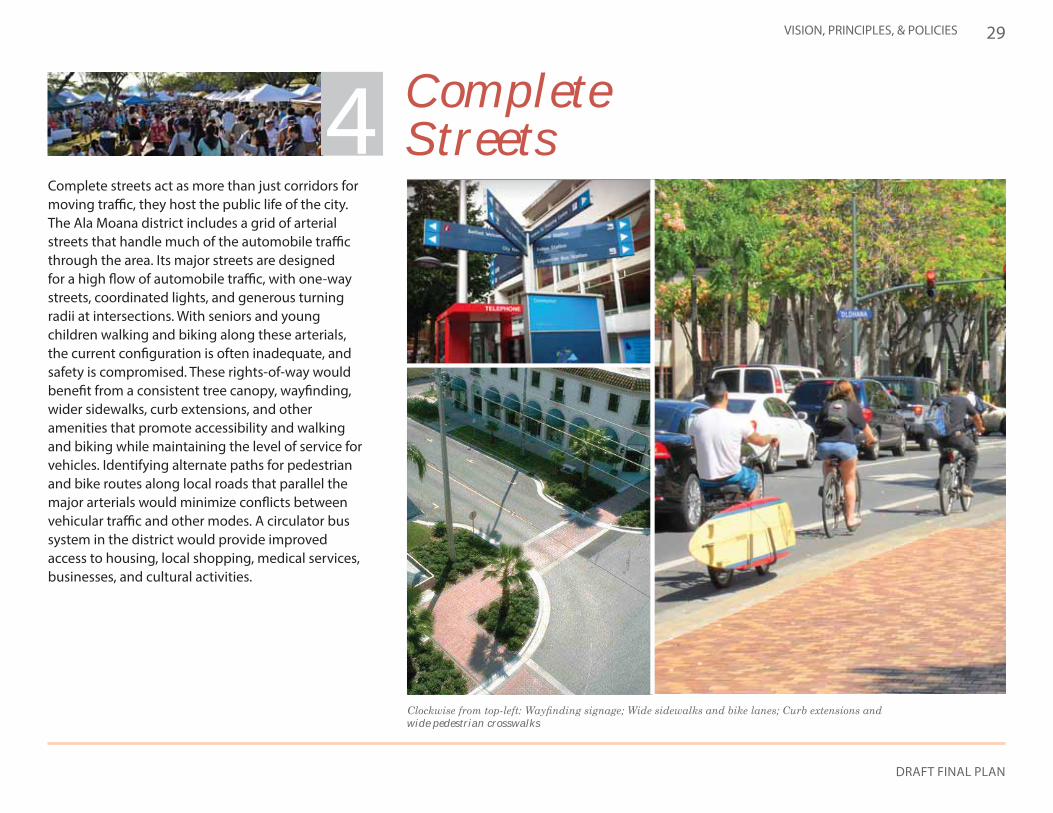
Complete streets act as more than just corridors for moving traffic, they host the public life of the city. The Ala Moana district includes a grid of arterial streets that handle much of the automobile traffic through the area. Its major streets are designed for a high flow of automobile traffic, with one-way streets, coordinated lights, and generous turning radii at intersections. With seniors and young children walking and biking along these arterials, the current configuration is often inadequate, and safety is compromised. These rights-of-way would benefit from a consistent tree canopy, wayfinding, wider sidewalks, curb extensions, and other amenities that promote accessibility and walking and biking while maintaining the level of service for vehicles. Identifying alternate paths for pedestrian and bike routes along local roads that parallel the major arterials would minimize conflicts between vehicular traffic and other modes. A circulator bus system in the district would provide improved access to housing, local shopping, medical services, businesses, and cultural activities.
Pedestrian Seating & AmenitiesConsistent Tree Canopy • Loop Bus System • Wayfinding • Bike LanesCycle Tracks • Widened Sidewalks
Complete Streets
wide pedestrian crosswalks
4
ALA MOANA Neighborhood Transit-Oriented Development Plan
30
2.2.5. INTERMODAL CONNECTIVITY
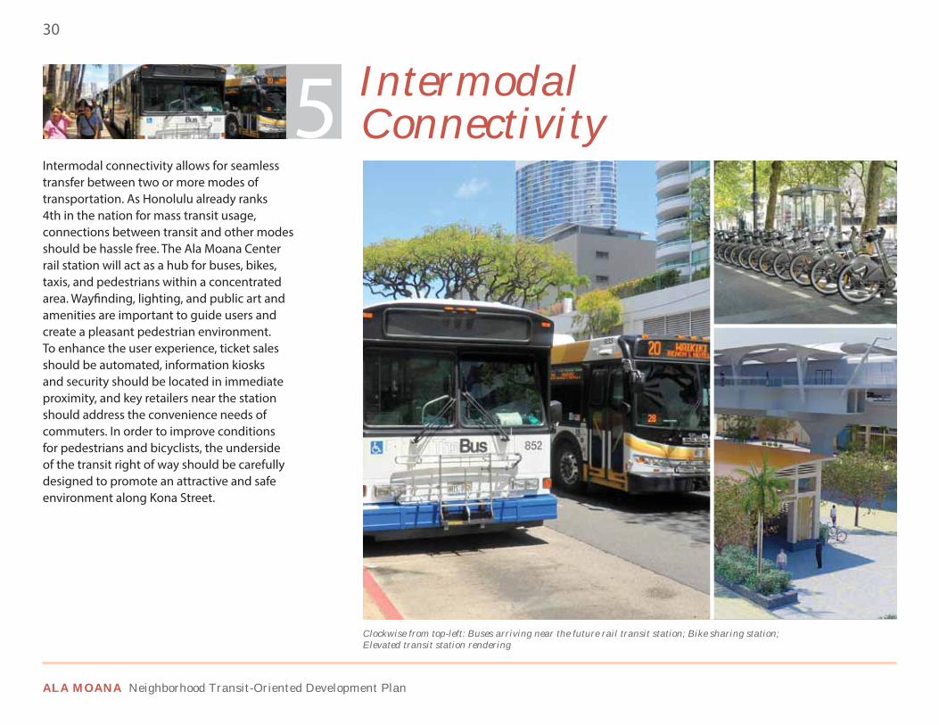
Intermodal connectivity allows for seamless transfer between two or more modes of transportation. As Honolulu already ranks 4th in the nation for mass transit usage, connections between transit and other modes should be hassle free. The Ala Moana Center rail station will act as a hub for buses, bikes, taxis, and pedestrians within a concentrated area. Wayfinding, lighting, and public art and amenities are important to guide users and create a pleasant pedestrian environment. To enhance the user experience, ticket sales should be automated, information kiosks and security should be located in immediate proximity, and key retailers near the station should address the convenience needs of commuters. In order to improve conditions for pedestrians and bicyclists, the underside of the transit right of way should be carefully designed to promote an attractive and safe environment along Kona Street.
Multilevel Rail Station • Ticket Sales, Route Information, Security • Shared Parking
Bike Storage • Bus Transfers • Complete Streets • Pedestrian & Bike Connections
Intermodal Connectivity
Clockwise from top-left: Buses arriving near the future rail transit station; Bike sharing station; Elevated transit station rendering
5

DRAFT FINAL PLAN
31VISION, PRINCIPLES, & POLICIES
2.2.6. INCUBATOR OFFICE & EDUCATION
Bringing rail transit to the Ala Moana district will make office space within the station area even more desirable. A mix of office spaces that complements the residential and retail in the area, allowing for business start-ups or incubator facilities, would attract a younger population to the area. Flexspace would allow small businesses to grow while supporting local businesses already established in the area. A suite of support services—clerical, legal, graphic design, printing and shipping, catering, and other services—would help incubator office tenants become more efficient. High-speed broadband internet access would also facilitate high-tech economic development. Additional opportunities for continuing education should be located within the district, providing options for career advancement or career changes. McKinley Community School for Adults offers basic and secondary education, English as a second language (ESL), and substitute teacher training. Ensuring convenient access to these new office and education uses would support both the existing residential population and students, and attract a larger daytime workforce to the area, which would in turn support local businesses. Finally, new development may require new or expanded primary and secondary schools.
Live/Work • Flex Space • Office Above Retail • Support Commercial
Continuing Education & Training
6 Incubator Office & Education
ALA MOANA Neighborhood Transit-Oriented Development Plan
32
Clockwise from top-left: Local art fair; Korean Festival in Kapiolani Park; Concerts in the plaza
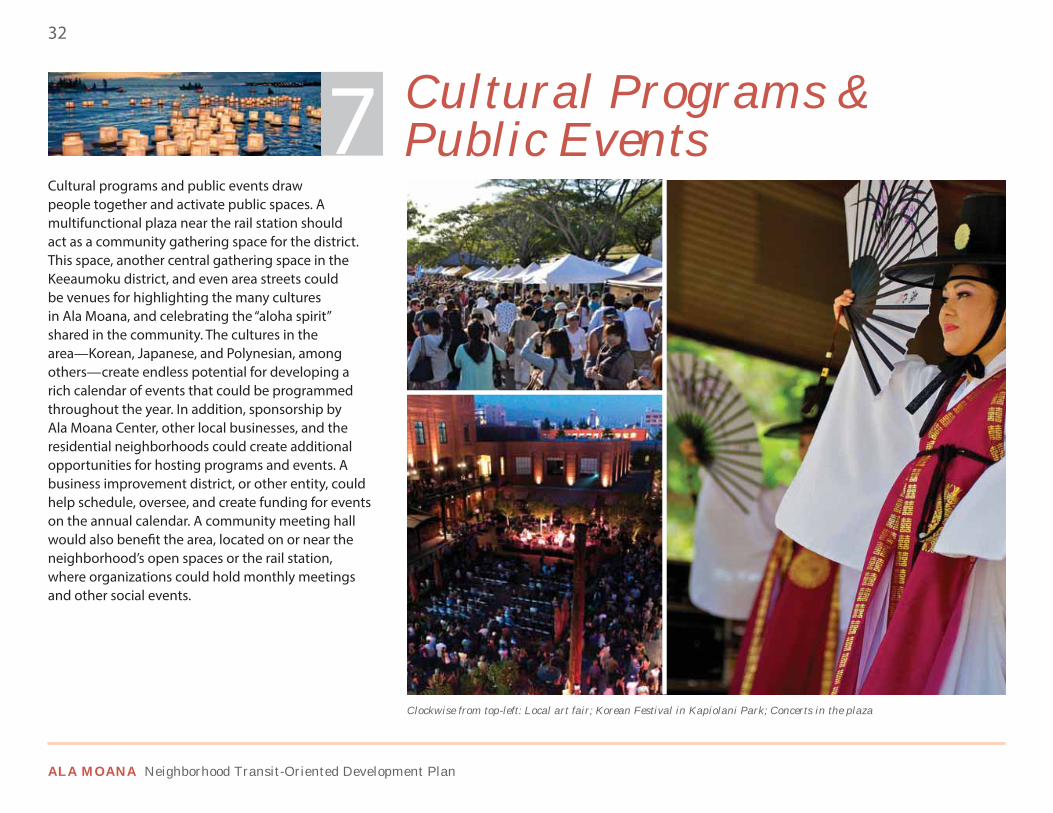
Cultural programs and public events draw people together and activate public spaces. A multifunctional plaza near the rail station should act as a community gathering space for the district. This space, another central gathering space in the Keeaumoku district, and even area streets could be venues for highlighting the many cultures in Ala Moana, and celebrating the “aloha spirit” shared in the community. The cultures in the area—Korean, Japanese, and Polynesian, among others—create endless potential for developing a rich calendar of events that could be programmed throughout the year. In addition, sponsorship by Ala Moana Center, other local businesses, and the residential neighborhoods could create additional opportunities for hosting programs and events. A business improvement district, or other entity, could help schedule, oversee, and create funding for events on the annual calendar. A community meeting hall would also benefit the area, located on or near the neighborhood’s open spaces or the rail station, where organizations could hold monthly meetings and other social events.
Farmers Markets • Concerts Holiday Parties • Block PartiesCultural Celebrations & Events
Fun Runs • Community Meetings
Cultural Programs & Public Events7
2.2.7. CULTURAL PROGRAMS & PUBLIC EVENTS
DRAFT FINAL PLAN
33VISION, PRINCIPLES, & POLICIES
A public workshop at McKinley High School fosters dialogue between residents, businesses, and city leaders.
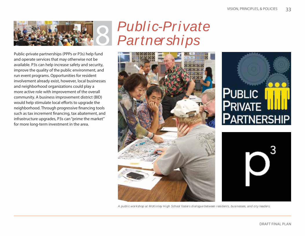
Public-private partnerships (PPPs or P3s) help fund and operate services that may otherwise not be available. P3s can help increase safety and security, improve the quality of the public environment, and run event programs. Opportunities for resident involvement already exist, however, local businesses and neighborhood organizations could play a more active role with improvement of the overall community. A business improvement district (BID) would help stimulate local efforts to upgrade the neighborhood. Through progressive financing tools such as tax increment financing, tax abatement, and infrastructure upgrades, P3s can “prime the market” for more long-term investment in the area.
Tax Incentive Programs Special Financing Districts
Public Infrastructure InvestmentBusiness Improvement Districts
Code Enforcement Zoning Changes and Incentives
Land Assembly
Public-Private Partnerships8
2.2.8. PUBLIC-PRIVATE PARTNERSHIPS
34
ALA MOANA Neighborhood Transit-Oriented Development Plan
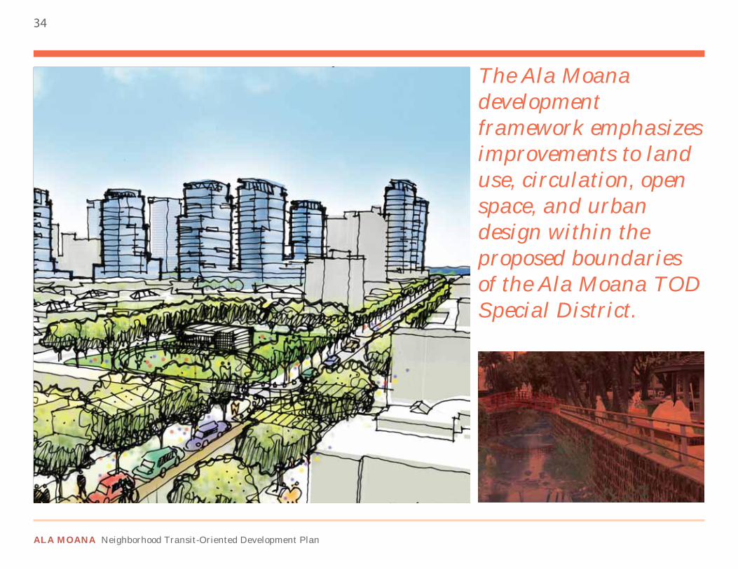
The Ala Moana development framework emphasizes improvements to land use, circulation, open space, and urban design within the proposed boundaries of the Ala Moana TOD Special District.
35
DRAFT FINAL PLAN
3 Development Framework3.1 OVERALL STRUCTURE
3.1.1. FRAMEWORK CONCEPT
The Ala Moana TOD Plan intends to guide public investment and target redevelopment activities in the district by integrating land use and transportation planning within close proximity to the Ala Moana Center rail station. This plan does so by providing an illustrative plan to visualize one potential physical outcome of TOD in this neighborhood. This preferred vision for development should optimize value captured while ensuring community benefits occur in conjunction with new development. Recommendations are made with regards to zoning designations, land use, circulation, open space and urban design. The Ala Moana development framework integrates the following three principles:
TRANSIT-ORIENTED DEVELOPMENTTransit-oriented development around the Ala Moana Center station will support increased transit ridership, improved pedestrian access, and funding for neighborhood improvements. These transit-oriented developments will:
• Emphasize compact mixed-use development• Expand mobility options by investing in and supporting an accessible
multimodal transportation network• Focus on making Ala Moana a model ride, walk and bike community
URBAN REDEVELOPMENTRedevelopment of underutilized parcels within Ala Moana will improve the character of the neighborhood’s arterial and collector roadways while keeping the existing character of the larger neighborhood. These
redevelopment efforts should:
• Focus on areas near the transit station• Focus on key corridors• Achieve the highest and best land uses
INCENTIVIZED DEVELOPMENTWith barriers such as high land acquisition costs to both development and redevelopment in Ala Moana, incentivizing transit-oriented development can help to stimulate private investment. More specifically, the incentives should directly:
• Offer density and height bonuses• Support on and off-site nexus fees or physical improvements that
provide community benefits• Enhance the public realm through streetscape improvements
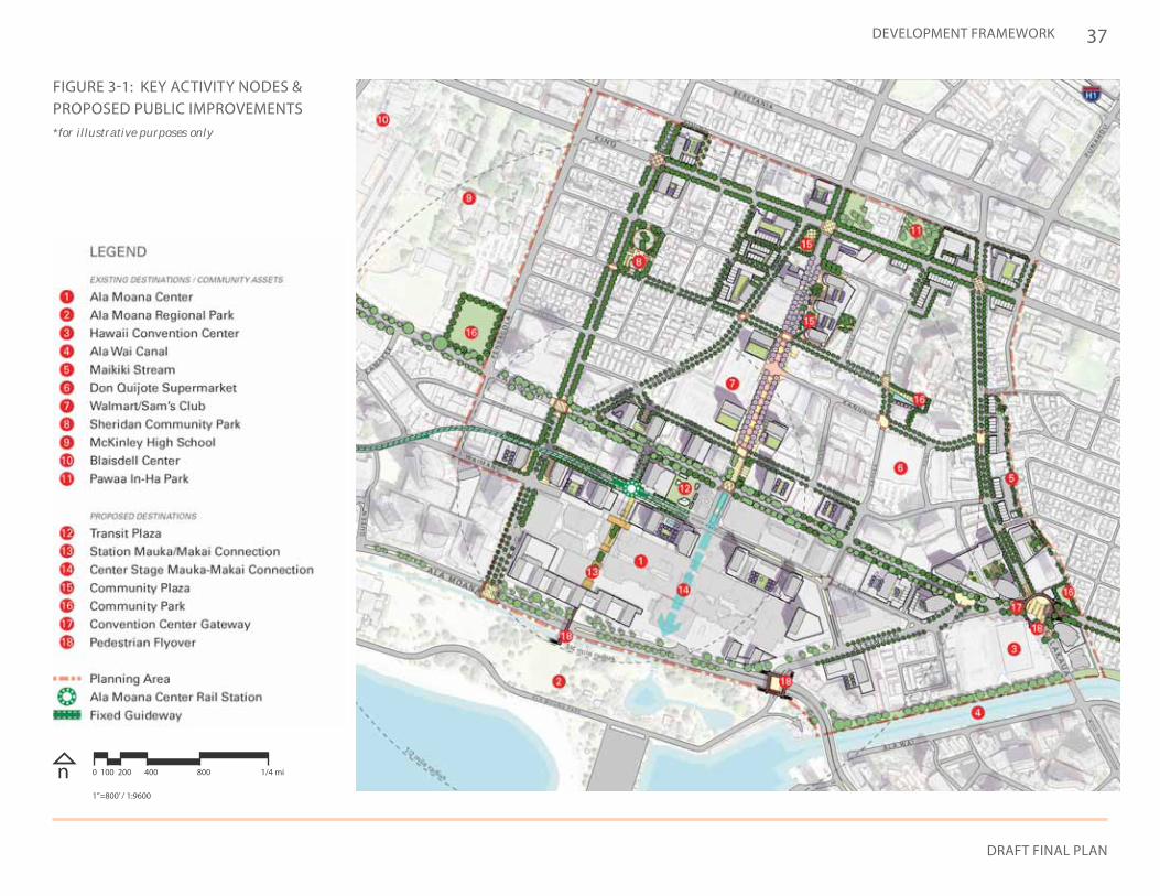
3.1.2. FRAMEWORK DESCRIPTIONThe Ala Moana development framework emphasizes public improvement projects and infill development around key existing destinations while identifying strategic locations for new community facilities. The combination of public and private investment is vital to the district’s success.
EXISTING DESTINATIONS:There are two types of existing destinations that serve as key elements of the Ala Moana development framework: private developments and community assets. Private developments include places that serve daily residential and business needs for locals and tourists. Some of these facilities include:
• Ala Moana Center• Walmart/Sam’s Club• Don Quijote
36
ALA MOANA Neighborhood Transit-Oriented Development Plan
The Ala Moana district is made up of communities of various densities and land uses, and is a key connection between downtown Honolulu and Waikiki.
COMMUNITY ASSETS:Community assets provide cultural and recreational opportunities within Ala Moana. Some of these community assets include:
• Ala Moana Park• Ala Wai Canal Promenade• Hawaii Convention Center• Blaisdell Center
PROPOSED DESTINATIONS:New attractions within the Ala Moana district will better serve the existing community, as well as new residents. Private developments could offer new shopping and dining choices, and new public facilities may include:
• Community parks and plazas• Transit plaza and connections to the rail station• Complete street improvements
37
DRAFT FINAL PLAN
DEVELOPMENT FRAMEWORK
n 0 100 200 400 800 1/4 mi
1”=800’ / 1:9600
FIGURE 3-1: KEY ACTIVITY NODES & PROPOSED PUBLIC IMPROVEMENTS*for illustrative purposes only
38
ALA MOANA Neighborhood Transit-Oriented Development Plan
TOTAL
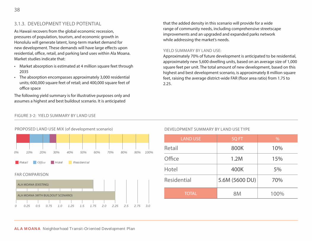
3.1.3. DEVELOPMENT YIELD POTENTIALAs Hawaii recovers from the global economic recession, pressures of population, tourism, and economic growth in Honolulu will generate latent, long-term market demand for new development. These demands will have large effects upon residential, office, retail, and parking land uses within Ala Moana. Market studies indicate that:
• Market absorption is estimated at 4 million square feet through 2035
• The absorption encompasses approximately 3,000 residential units; 600,000 square feet of retail; and 400,000 square feet of office space
The following yield summary is for illustrative purposes only and assumes a highest and best buildout scenario. It is anticipated
FIGURE 3-2: YIELD SUMMARY BY LAND USE
LAND USE SQ FT %
Retail
Office
Hotel
Residential
800K
1.2M
400K
5.6M (5600 DU)
8M
10%
15%
5%
70%
100%
DEVELOPMENT SUMMARY BY LAND USE TYPEPROPOSED LAND USE MIX (of development scenario)
FAR COMPARISON
0%
0
10%
0.25
Retail Hotel Residential
20%
0.5
30%
0.75
40%
1.0
50%
1.25
60%
1.5
70%
1.75
80%
2.0
90%
2.25
100%
2.5 2.75 3.0
that the added density in this scenario will provide for a wide range of community needs, including comprehensive streetscape improvements and an upgraded and expanded parks network while addressing the market’s needs.
YIELD SUMMARY BY LAND USE:Approximately 70% of future development is anticipated to be residential, approximately new 5,600 dwelling units, based on an average size of 1,000 square feet per unit. The total amount of new development, based on this highest and best development scenario, is approximately 8 million square feet, raising the average district-wide FAR (floor area ratio) from 1.75 to 2.25.
ALA MOANA (EXISTING)
ALA MOANA (WITH BUILDOUT SCENARIO)
39
DRAFT FINAL PLAN
DEVELOPMENT FRAMEWORK
FIGURE 3-3: YIELD SUMMARY BY BUILDING TYPE
High-rise (residential & hotel)
Podium (retail & parking) Townhouse (residential & retail)
TOD PRECINCT
TOTAL SQ FOOTAGE WITH PARKING
TOTAL SQ FOOTAGE WITHOUT PARKING
HIGH-RISE
LOW-RISE
PODIUM
TOWNHOUSE
4,800,000
1,000,000
500,000
30,000
8,200,000
6,200,000
TIZ PRECINCT
TOTAL SQ FOOTAGE WITH PARKING
TOTAL SQ FOOTAGE WITHOUT PARKING
HIGH-RISE
LOW-RISE
PODIUM
TOWNHOUSE
500,000
800,000
100,000
300,000
2,100,000
1,800,000
ALA MOANA TOD DISTRICT
TOTAL SQ FOOTAGE WITH PARKING
TOTAL SQ FOOTAGE WITHOUT PARKING
10,300,000
8,000,000
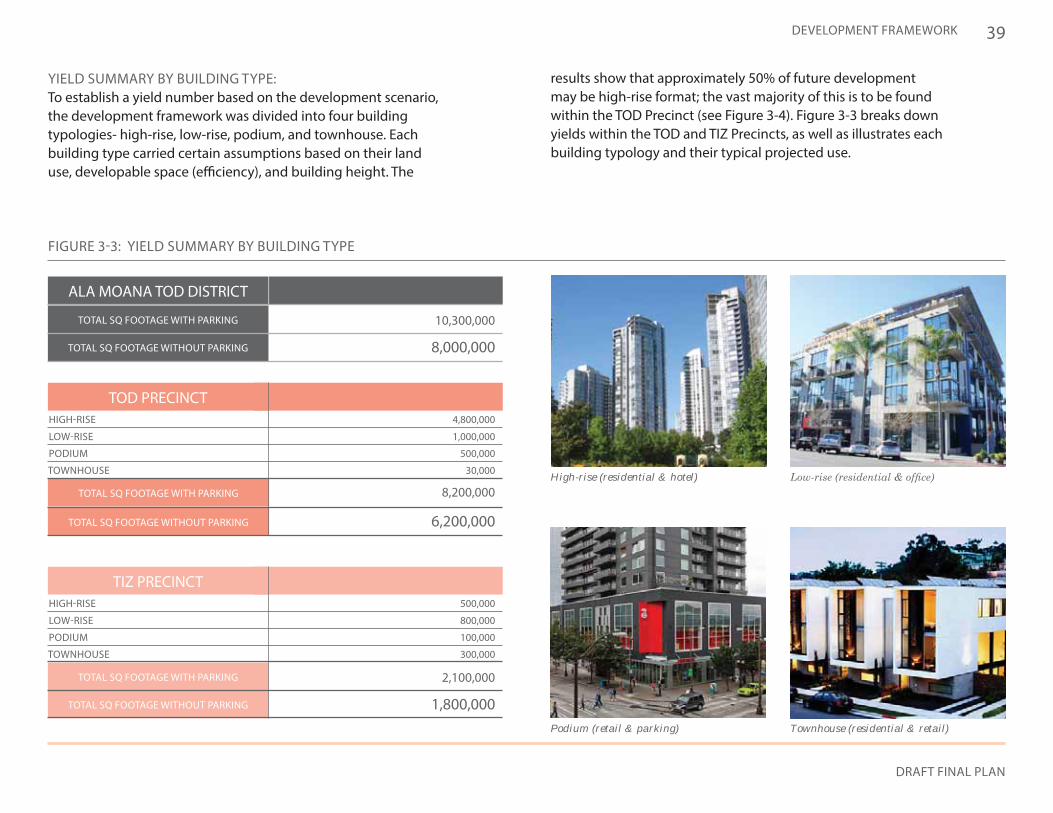
YIELD SUMMARY BY BUILDING TYPE:To establish a yield number based on the development scenario, the development framework was divided into four building typologies- high-rise, low-rise, podium, and townhouse. Each building type carried certain assumptions based on their land use, developable space (efficiency), and building height. The
results show that approximately 50% of future development may be high-rise format; the vast majority of this is to be found within the TOD Precinct (see Figure 3-4). Figure 3-3 breaks down yields within the TOD and TIZ Precincts, as well as illustrates each building typology and their typical projected use.
40
ALA MOANA Neighborhood Transit-Oriented Development Plan
3.2 LAND USE
3.2.1. CONCEPTThe Ala Moana district, among the most urban neighborhoods along the rail corridor, is one of Honolulu’s major centers. Adding new transit-oriented land uses within the area is imperative both to revitalizing the neighborhood and creating a truly livable urban community with the following attributes.
URBAN ENVIRONMENT:Located between Waikiki and the downtown area, Ala Moana is characterized as having:
• A dense, urban development pattern• A mosaic of places and activities • A diverse urban living environment with urban-scale housing
TRANSIT-ORIENTED DISTRICT:With the eminent opening of the Ala Moana Center rail station, any new development should leverage the presence of the rail station into creating a more transit-oriented district that features:
• Compact development within close walking distance of the rail station
• Amenities that make urban living convenient and pleasant • A mix of uses and housing types• Public parks and gathering spaces• A balanced multimodal transportation system
COMPLEMENTARY SUBDISTRICTS:Within the Ala Moana district there are specific subdistricts that offer a diversity of housing and retail types. Each with their own distinct character, these subdistricts:
• Incorporate a wide range of shopping and services• Address both tourist needs and local/resident needs• Allow residents to meet daily needs without automobiles
MIXED-USE CORRIDORS:Revitalization of underutilized parcels along major travel corridors, such as Kapiolani Boulevard, Keeaumoku Street, Kalakaua Avenue, and King Street can positively impact the Ala Moana district. These mixed-use corridors should aim to:
• Transform travel corridors into multimodal corridors featuring a higher-density mixed-use character
• Create vertical mixed-use development with active ground floor uses
RESIDENTIAL LIVABILITY:According to the community survey conducted as part of this planning process, residents are drawn to this neighborhood because of its proximity to jobs, shopping and services, civic and community facilities, and transit service. To preserve this convenience, and improve housing affordability, the Plan encourages diversity in land uses and residential products, thereby supporting an urban lifestyle choice.
41
DRAFT FINAL PLAN
DEVELOPMENT FRAMEWORK
REDEVELOP UNDERUTILIZED COMMERCIAL PARCELS
ADJUST ZONING WITHIN TOD DISTRICT
INCREASE FAR AND HEIGHT LIMIT
ENCOURAGE VERTICAL MIXED-USE
ENCOURAGE NEW AFFORDABLE UNITS
ESTABLISH DISTRICT HUBS AS GATEWAYS
ESTABLISH MIXED-USE CORRIDORS
DEVELOP BUSINESS INCUBATORS
CREATE TOD AND TIZ ZONES WITHIN DISTRICT (see pg. 42)
CONSERVE IN-TOWN HOUSING
CREATE NETWORK OF OPEN SPACES
DEVELOP LOCAL SHOPPING AREAS
PROVIDE APPROPRIATE LAND USES NEAR RAIL STATION
REDUCE AMOUNT OF ADULT LAND USES
OFFER AFFORDABLE HOUSING INCENTIVES
EMPLOY “PARK ONCE” STRATEGY
PROVIDE COMMUNITY RESOURCES
PROVIDE FLEXIBLE OFFICE SPACES
• Satisfy latent potential for redevelopment
• Increase intensity along key corridors
• Allow more intensive uses within area• Integrate residential and
commercial districts
• Encourage infill development • Establish hubs in the area• Maintain mauka-makai views
• Combine residential and non-residential uses
• Activate streets with ground floor retail
• Require affordable housing in conjunction with new residential development
• Reduce parking requirements
• Reinforce district gateways• Provide clear indication of entering Ala
Moana
• Add local residents to support local retail• Provide retail and office space for
community services
• Provide spaces for growing businesses• Provide services that keep workers in the
area throughout the day
• Integrate commercial and residential• Create areas to fulfill all daily activities
without driving
• Maintain affordable housing supply• Preserve Sheridan Tract
• Provide for active and passive recreation• Link smaller open spaces to Ala Moana
Park with bike and pedestrian connec-tions
• Establish local hubs for neighborhood shopping
• Provide access from housing nearby
• Encourage transit use for office workers• Create a convenient and safe walk for
employment base
• Discourage adult uses across zoning designations
• Provide height and density bonuses for affordable housing
• Establish affordable housing development incentives
• Discourage frequent use of automobiles within district
• Allow people to walk to all activities
• Encourage new community spaces near and within new development
• Encourage multi-use of civic institutions• Encourage neighborhood healthcare services
• Provide spaces for small, medium, and large companies
POLICIES
Land Use Policy No. 1:
Intensify Land Use Surrounding Station
• Compact development• Reinforced urban character• Connections to transit• Consistent with TOD strategy
Land Use Policy No. 3:
Diversify Housing Options • Market-rate and
affordable housing• Mix of residential building
typologies• Rental and for sale units
Land Use Policy No. 4:
Strengthen Regional Draws
Land Use Policy No. 5:
Integrate Neighborhood Shopping and Services
Land Use Policy No. 6:
Increase Employment Base
• Ala Moana Center• Hawaii Convention Center• Ala Moana Park• Keeaumoku Street
• Public, private and non-profit institutions
• Viable neighborhood-serving retail
• Community services
• Office in proximity to rail station
• Start-up businesses• Business support services and
continuing education
Land Use Policy No. 2:
Provide Balanced Mix of Land Uses
• Uses appropriate to TOD strategy
• Mix of residential, hotel retail, and office uses
TABLE 3-1: LAND USE POLICIES & DEVELOPMENT STRATEGIES
PUBLIC-PRIVATE STRATEGIES
42
ALA MOANA Neighborhood Transit-Oriented Development Plan
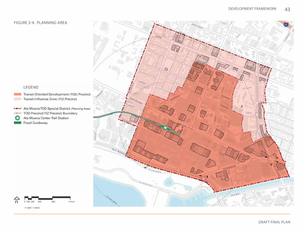
3.2.2. ALA MOANA TOD SPECIAL DISTRICTThe Ala Moana transit station will serve as a magnet for urban development that increases transit ridership while delivering community benefits throughout Ala Moana. The creation of a “Special District” will encompass properties located within a roughly one-half mile radius. Separate core and peripheral precincts are identified, with various zoning incentives targeting redevelopment of the core, while proposed design standards and public realm improvements are applicable district-wide.
TRANSIT-ORIENTED DEVELOPMENT (TOD) PRECINCT: The TOD Precinct surrounds the Ala Moana station with boundaries based upon proximity to the rail station and targeted redevelopment areas. Urban-scale housing will populate this zone, while retail and office activities will serve the local population and reinforce Ala Moana’s position as a major employment center and destination. Achieving this vibrant urban center primarily relies on:
• Redevelopment of underutilized commercial properties• Incorporating major centers of activity (i.e., Ala Moana Center and the
Hawaii Convention Center)• New development along key corridors (especially Kapiolani
Boulevard and Keeaumoku Street)
TRANSIT-INFLUENCE ZONE (TIZ) PRECINCT: The TIZ Precinct is situated at the periphery of the transit station’s influence outside of the TOD Precinct. Emphasis is placed on creating livable residential areas, offering a range of in-town housing choices supported by local shopping and services. This area incorporates the low-density Sheridan Tract, higher-density housing along Kalakaua Avenue, and the range of commercial services that currently define King Street. Within the TIZ Precinct, it should be noted that:
• Compatible mixed-use and residential infill development is favored, but at intensities less than in the TOD Precinct.
• Properties located within the HCDA Kakaako Community Development District are governed by the Hawaii Community Development Authority (HCDA), however, the City has an interest in creating a walkable and vibrant public realm that connects this district seamlessly to the Ala Moana district.
43
DRAFT FINAL PLAN
DEVELOPMENT FRAMEWORK
n 0 100 200 400 800 1/4 mi
1”=800’ / 1:9600
FIGURE 3-4: PLANNING AREA
44
ALA MOANA Neighborhood Transit-Oriented Development Plan
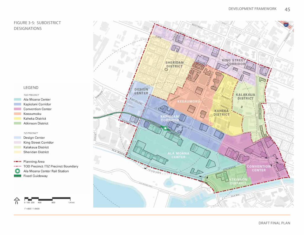
3.2.3. TOD PRECINCT SUBDISTRICTS
Opportunities and envisioned characteristics of the subdistricts within the TOD Precinct are described in this section.
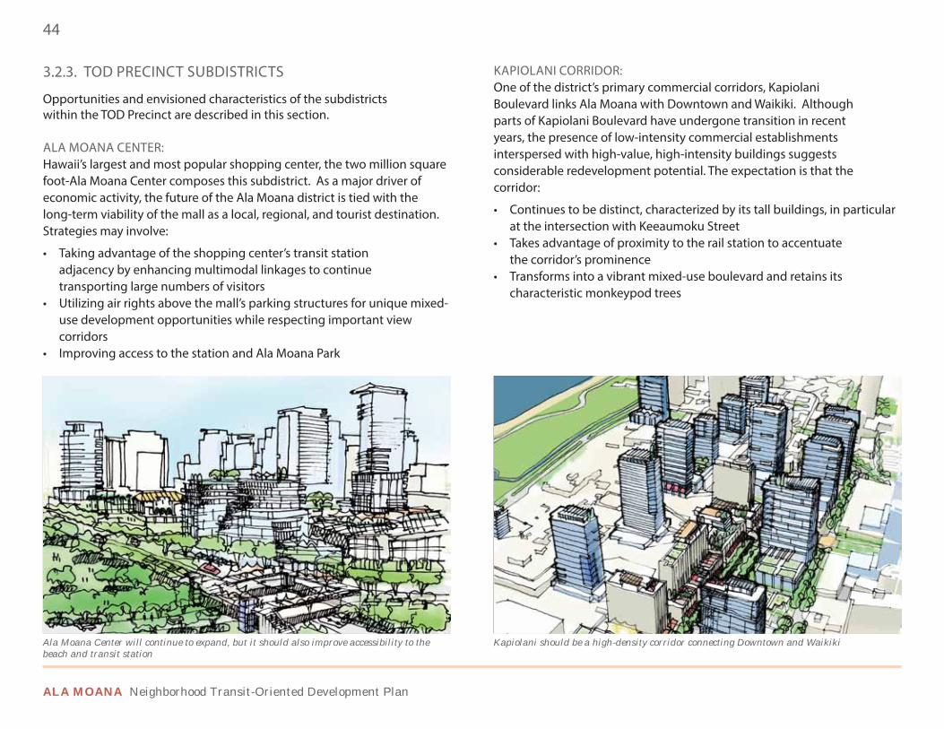
ALA MOANA CENTER: Hawaii’s largest and most popular shopping center, the two million square foot-Ala Moana Center composes this subdistrict. As a major driver of economic activity, the future of the Ala Moana district is tied with the long-term viability of the mall as a local, regional, and tourist destination. Strategies may involve:
• Taking advantage of the shopping center’s transit station adjacency by enhancing multimodal linkages to continue transporting large numbers of visitors
• Utilizing air rights above the mall’s parking structures for unique mixed-use development opportunities while respecting important view corridors
• Improving access to the station and Ala Moana Park
KAPIOLANI CORRIDOR: One of the district’s primary commercial corridors, Kapiolani Boulevard links Ala Moana with Downtown and Waikiki. Although parts of Kapiolani Boulevard have undergone transition in recent years, the presence of low-intensity commercial establishments interspersed with high-value, high-intensity buildings suggests considerable redevelopment potential. The expectation is that the corridor:
• Continues to be distinct, characterized by its tall buildings, in particular at the intersection with Keeaumoku Street
• Takes advantage of proximity to the rail station to accentuate the corridor’s prominence
• Transforms into a vibrant mixed-use boulevard and retains its characteristic monkeypod trees
Kapiolani should be a high-density corridor connecting Downtown and WaikikiAla Moana Center will continue to expand, but it should also improve accessibility to the beach and transit station
45
DRAFT FINAL PLAN
DEVELOPMENT FRAMEWORK
FIGURE 3-5: SUBDISTRICT DESIGNATIONS
n 0 100 200 400 800 1/4 mi
1”=800’ / 1:9600
46
ALA MOANA Neighborhood Transit-Oriented Development Plan
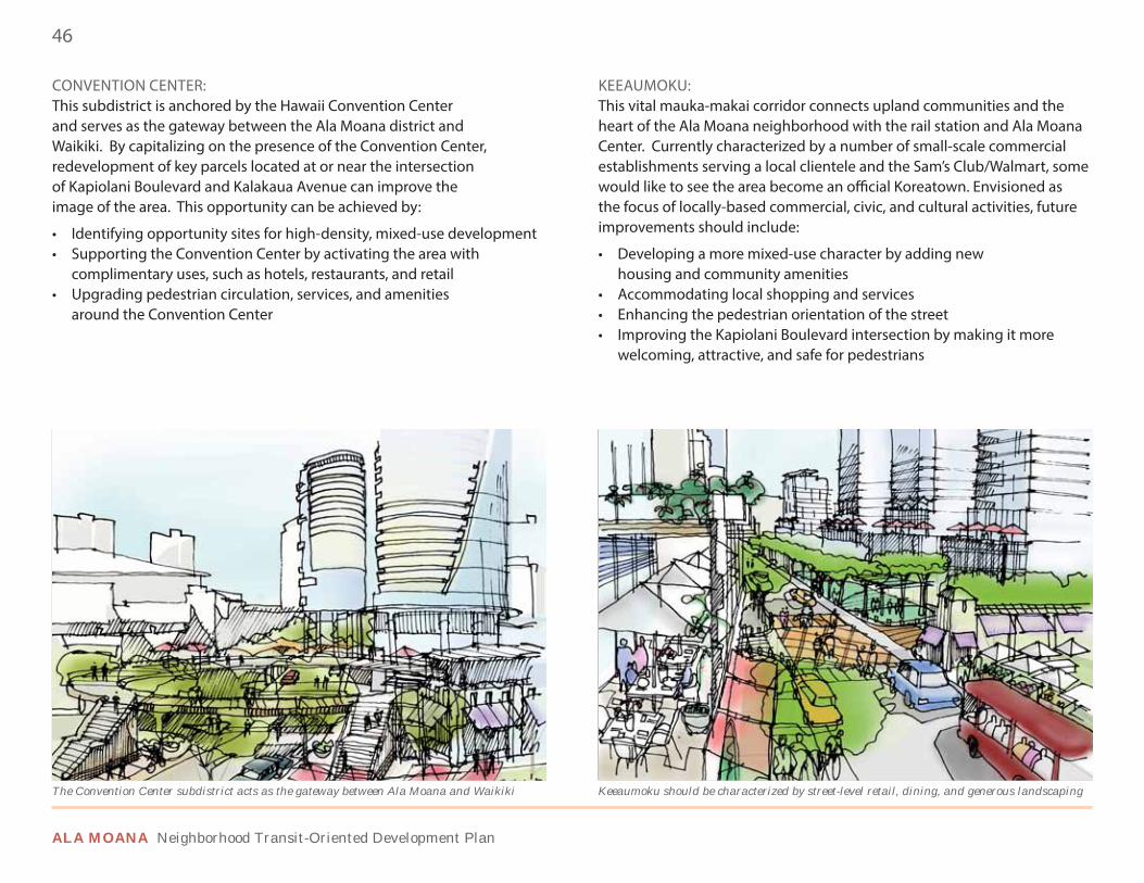
CONVENTION CENTER: This subdistrict is anchored by the Hawaii Convention Center and serves as the gateway between the Ala Moana district and Waikiki. By capitalizing on the presence of the Convention Center, redevelopment of key parcels located at or near the intersection of Kapiolani Boulevard and Kalakaua Avenue can improve the image of the area. This opportunity can be achieved by:
• Identifying opportunity sites for high-density, mixed-use development• Supporting the Convention Center by activating the area with
complimentary uses, such as hotels, restaurants, and retail • Upgrading pedestrian circulation, services, and amenities
around the Convention Center
KEEAUMOKU: This vital mauka-makai corridor connects upland communities and the heart of the Ala Moana neighborhood with the rail station and Ala Moana Center. Currently characterized by a number of small-scale commercial establishments serving a local clientele and the Sam’s Club/Walmart, some would like to see the area become an official Koreatown. Envisioned as the focus of locally-based commercial, civic, and cultural activities, future improvements should include:
• Developing a more mixed-use character by adding new housing and community amenities
• Accommodating local shopping and services• Enhancing the pedestrian orientation of the street• Improving the Kapiolani Boulevard intersection by making it more
welcoming, attractive, and safe for pedestrians
The Convention Center subdistrict acts as the gateway between Ala Moana and Waikiki Keeaumoku should be characterized by street-level retail, dining, and generous landscaping
47
DRAFT FINAL PLAN
DEVELOPMENT FRAMEWORK
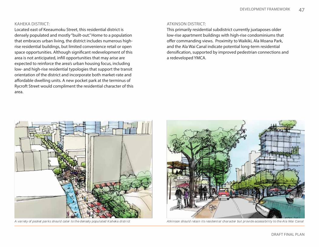
KAHEKA DISTRICT: Located east of Keeaumoku Street, this residential district is densely populated and mostly “built-out.” Home to a population that embraces urban living, the district includes numerous high-rise residential buildings, but limited convenience retail or open space opportunities. Although significant redevelopment of this area is not anticipated, infill opportunities that may arise are expected to reinforce the area’s urban housing focus, including low- and high-rise residential typologies that support the transit orientation of the district and incorporate both market-rate and affordable dwelling units. A new pocket park at the terminus of Rycroft Street would compliment the residential character of this area.
ATKINSON DISTRICT: This primarily residential subdistrict currently juxtaposes older low-rise apartment buildings with high-rise condominiums that offer commanding views. Proximity to Waikiki, Ala Moana Park, and the Ala Wai Canal indicate potential long-term residential densification, supported by improved pedestrian connections and a redeveloped YMCA.
A variety of pocket parks should cater to the densely populated Kaheka district Atkinson should retain its residential character but provide accessibility to the Ala Wai Canal
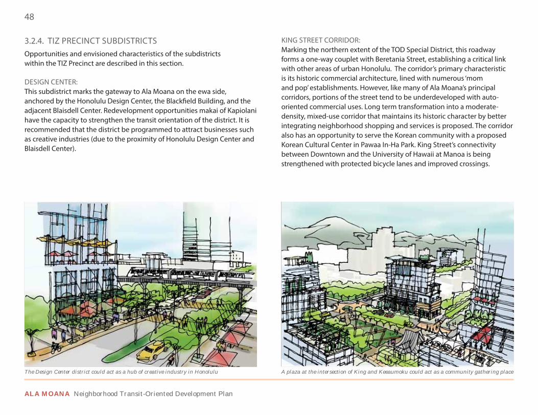
48
ALA MOANA Neighborhood Transit-Oriented Development Plan
3.2.4. TIZ PRECINCT SUBDISTRICTSOpportunities and envisioned characteristics of the subdistricts within the TIZ Precinct are described in this section.
DESIGN CENTER: This subdistrict marks the gateway to Ala Moana on the ewa side, anchored by the Honolulu Design Center, the Blackfield Building, and the adjacent Blaisdell Center. Redevelopment opportunities makai of Kapiolani have the capacity to strengthen the transit orientation of the district. It is recommended that the district be programmed to attract businesses such as creative industries (due to the proximity of Honolulu Design Center and Blaisdell Center).
KING STREET CORRIDOR: Marking the northern extent of the TOD Special District, this roadway forms a one-way couplet with Beretania Street, establishing a critical link with other areas of urban Honolulu. The corridor’s primary characteristic is its historic commercial architecture, lined with numerous ‘mom and pop’ establishments. However, like many of Ala Moana’s principal corridors, portions of the street tend to be underdeveloped with auto-oriented commercial uses. Long term transformation into a moderate-density, mixed-use corridor that maintains its historic character by better integrating neighborhood shopping and services is proposed. The corridor also has an opportunity to serve the Korean community with a proposed Korean Cultural Center in Pawaa In-Ha Park. King Street’s connectivity between Downtown and the University of Hawaii at Manoa is being strengthened with protected bicycle lanes and improved crossings.
A plaza at the intersection of King and Keeaumoku could act as a community gathering place The Design Center district could act as a hub of creative industry in Honolulu
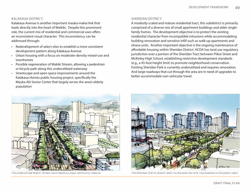
49
DRAFT FINAL PLAN
DEVELOPMENT FRAMEWORK
KALAKAUA DISTRICT: Kalakaua Avenue is another important mauka-makai link that leads directly into the heart of Waikiki. Despite this prominent role, the current mix of residential and commercial uses offers an inconsistent visual character. This inconsistency can be addressed through:
• Redevelopment of select sites to establish a more consistent development pattern along Kalakaua Avenue
• Urban housing with a focus on moderate-density mixed-use and townhomes
• Possible regeneration of Makiki Stream, allowing a pedestrian or bicycle path along this underutilized waterway
• Streetscape and open space improvements around the Kalakaua Homes public housing project, specifically the Mauka Alii Senior Center that largely serves the area’s elderly population
SHERIDAN DISTRICT: A modestly scaled and mature residential tract, this subdistrict is primarily comprised of a diverse mix of small apartment buildings and older single-family homes. The development objective is to protect the existing residential character from incompatible intrusions while accommodating building renovation and sensitive infill such as walk-up apartments and ohana units. Another important objective is the ongoing maintenance of affordable housing within Sheridan District. HCDA has land use regulatory jurisdiction over a portion of the Sheridan Tract between Piikoi Street and McKinley High School, establishing restrictive development standards (e.g., a 45-foot height limit) to promote neighborhood conservation. Existing Sheridan Park is currently underutilized and requires renovation. And large roadways that cut through the area are in need of upgrades to better accommodate non-vehicular travel.
The underutilized Makiki Stream could become a major community resource The Sheridan district should retain its character but with improvements to the public realm
50
ALA MOANA Neighborhood Transit-Oriented Development Plan
3.2.5. LAND USE DISTRIBUTION & INTENSITY
The following are generalized land use types envisioned for the Ala Moana TOD Special District. Height and density limits are further detailed in Chapter 5.
HIGH-DENSITY COMMERCIAL MIXED USE: This land use classification concentrates density closest to the transit station. The Kapiolani and Keeaumoku corridors, as well as the Convention Center subdistrict, are specifically identified. Part of Ala Moana Center is also included to support regional-scale uses. To support these subdistricts, a focus is placed on high-density development of up to 400 feet in height for projects providing community benefits. It is anticipated that these developments would serve local, regional, and tourist populations and include a dense mix of apartment/condo towers, office buildings, hotels, and destination retail.
MODERATE-DENSITY COMMERCIAL MIXED USE: This land use type supports areas with a focus on local neighborhood use while still reflecting the influence of the transit station. Specifically, the King Street corridor and Ala Moana Center along Ala Moana Boulevard are identified. Moderate-density mixed-use developments would include housing, retail, and smaller commercial buildings up to 150 feet in height.
HIGH-DENSITY RESIDENTIAL: This land use type is envisioned for areas with a primarily residential character while integrating convenience shopping and local services. More specifically, the established residential areas diamond head of Keeaumoku Street, including portions of the Kaheka, Kalakaua and Atkinson districts, are identified for multifamily dwellings, including low-rise and residential towers up to 350 feet in height.
MODERATE-DENSITY RESIDENTIAL: This land use designation supports areas that are primarily residential in character but have a diverse set of housing types. More specifically, the established residential areas such as the Sheridan district and Kalakaua district are identified. By accommodating a diverse residential product with heights up to 150 feet in height, this land use allows for limited integration of supporting retail, office, and community facilities.
CIVIC/INSTITUTIONAL: This land use type supports areas that provide a public benefit or service. Institutions such as the Hawaii Convention Center, McKinley High School, and the fire station on Makaloa Street are represented in the area.
PARKS & OPEN SPACE:This land use type is composed of existing and proposed public realm parks and open spaces. No residential is allowed but limited commercial development may be encouraged to support park maintenance, upgrades, and programming.
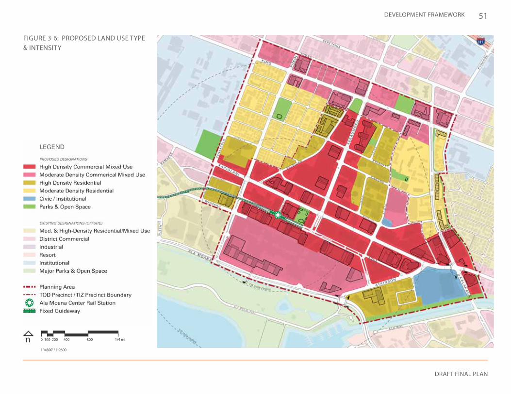
51
DRAFT FINAL PLAN
DEVELOPMENT FRAMEWORK
FIGURE 3-6: PROPOSED LAND USE TYPE & INTENSITY
n 0 100 200 400 800 1/4 mi
1”=800’ / 1:9600
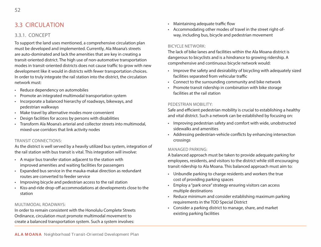
52
ALA MOANA Neighborhood Transit-Oriented Development Plan
3.3 CIRCULATION
3.3.1. CONCEPTTo support the land uses mentioned, a comprehensive circulation plan must be developed and implemented. Currently, Ala Moana’s streets are auto-dominated and lack the amenities that are key in creating a transit-oriented district. The high use of non-automotive transportation modes in transit-oriented districts does not cause traffic to grow with new development like it would in districts with fewer transportation choices. In order to truly integrate the rail station into the district, the circulation network must:
• Reduce dependency on automobiles• Promote an integrated multimodal transportation system• Incorporate a balanced hierarchy of roadways, bikeways, and
pedestrian walkways• Make travel by alternative modes more convenient• Design facilities for access by persons with disabilities• Transform Ala Moana’s arterial and collector streets into multimodal,
mixed-use corridors that link activity nodes
TRANSIT CONNECTIONS: As the district is well served by a heavily utilized bus system, integration of the rail station with bus transit is vital. This integration will involve:
• A major bus transfer station adjacent to the station with improved amenities and waiting facilities for passengers
• Expanded bus service in the mauka-makai direction as redundant routes are converted to feeder service
• Improving bicycle and pedestrian access to the rail station • Kiss-and-ride drop-off accommodations at developments close to the
station
MULTIMODAL ROADWAYS: In order to remain consistent with the Honolulu Complete Streets Ordinance, circulation must promote multimodal movement to create a balanced transportation system. Such a system involves:
• Maintaining adequate traffic flow• Accommodating other modes of travel in the street right-of-
way, including bus, bicycle and pedestrian movement
BICYCLE NETWORK: The lack of bike lanes and facilities within the Ala Moana district is dangerous to bicyclists and is a hindrance to growing ridership. A comprehensive and continuous bicycle network would:
• Improve the safety and desirability of bicycling with adequately sized facilities separated from vehicular traffic
• Connect to the surrounding community and bike network• Promote transit ridership in combination with bike storage
facilities at the rail station
PEDESTRIAN MOBILITY: Safe and efficient pedestrian mobility is crucial to establishing a healthy and vital district. Such a network can be established by focusing on:
• Improving pedestrian safety and comfort with wide, unobstructed sidewalks and amenities
• Addressing pedestrian-vehicle conflicts by enhancing intersection crossings
MANAGED PARKING: A balanced approach must be taken to provide adequate parking for employees, residents, and visitors to the district while still encouraging transit ridership to Ala Moana. This balanced approach must aim to:
• Unbundle parking to charge residents and workers the true cost of providing parking spaces
• Employ a “park once” strategy ensuring visitors can access multiple destinations
• Reduce minimum and consider establishing maximum parking requirements in the TOD Special District
• Consider a parking district to manage, share, and market existing parking facilities
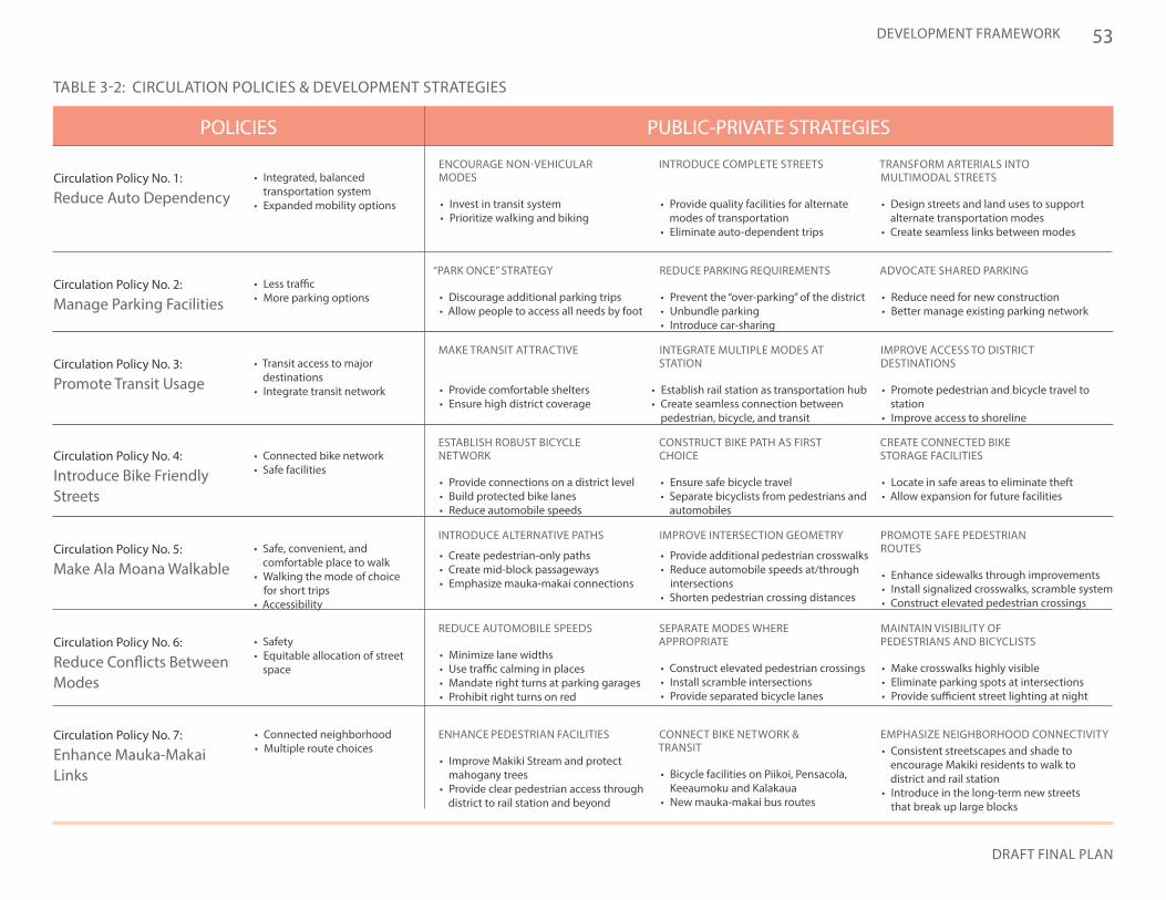
53
DRAFT FINAL PLAN
DEVELOPMENT FRAMEWORK
PUBLIC-PRIVATE STRATEGIESPOLICIES
Circulation Policy No. 7:
Enhance Mauka-Makai Links
• Connected neighborhood• Multiple route choices
TABLE 3-2: CIRCULATION POLICIES & DEVELOPMENT STRATEGIES
ENCOURAGE NON-VEHICULAR MODES
INTRODUCE COMPLETE STREETS TRANSFORM ARTERIALS INTO MULTIMODAL STREETS
“PARK ONCE” STRATEGY
MAKE TRANSIT ATTRACTIVE
ESTABLISH ROBUST BICYCLE NETWORK
INTRODUCE ALTERNATIVE PATHS
REDUCE AUTOMOBILE SPEEDS
ENHANCE PEDESTRIAN FACILITIES
REDUCE PARKING REQUIREMENTS
INTEGRATE MULTIPLE MODES AT STATION
CONSTRUCT BIKE PATH AS FIRST CHOICE
IMPROVE INTERSECTION GEOMETRY
SEPARATE MODES WHERE APPROPRIATE
CONNECT BIKE NETWORK & TRANSIT
ADVOCATE SHARED PARKING
IMPROVE ACCESS TO DISTRICT DESTINATIONS
CREATE CONNECTED BIKE STORAGE FACILITIES
PROMOTE SAFE PEDESTRIAN ROUTES
MAINTAIN VISIBILITY OF PEDESTRIANS AND BICYCLISTS
EMPHASIZE NEIGHBORHOOD CONNECTIVITY
• Invest in transit system• Prioritize walking and biking
• Provide quality facilities for alternate modes of transportation
• Eliminate auto-dependent trips
• Design streets and land uses to support alternate transportation modes
• Create seamless links between modes
• Discourage additional parking trips• Allow people to access all needs by foot
• Provide comfortable shelters• Ensure high district coverage
• Provide connections on a district level• Build protected bike lanes• Reduce automobile speeds
• Create pedestrian-only paths• Create mid-block passageways• Emphasize mauka-makai connections
• Minimize lane widths • Use traffic calming in places• Mandate right turns at parking garages• Prohibit right turns on red
• Improve Makiki Stream and protect mahogany trees
• Provide clear pedestrian access through district to rail station and beyond
• Prevent the “over-parking” of the district• Unbundle parking• Introduce car-sharing
• Establish rail station as transportation hub• Create seamless connection between
pedestrian, bicycle, and transit
• Ensure safe bicycle travel• Separate bicyclists from pedestrians and
automobiles
• Provide additional pedestrian crosswalks• Reduce automobile speeds at/through
intersections• Shorten pedestrian crossing distances
• Construct elevated pedestrian crossings• Install scramble intersections• Provide separated bicycle lanes
• Bicycle facilities on Piikoi, Pensacola, Keeaumoku and Kalakaua
• New mauka-makai bus routes
• Reduce need for new construction• Better manage existing parking network
• Promote pedestrian and bicycle travel to station
• Improve access to shoreline
• Locate in safe areas to eliminate theft• Allow expansion for future facilities
• Enhance sidewalks through improvements• Install signalized crosswalks, scramble system• Construct elevated pedestrian crossings
• Make crosswalks highly visible• Eliminate parking spots at intersections• Provide sufficient street lighting at night
• Consistent streetscapes and shade to encourage Makiki residents to walk to district and rail station
• Introduce in the long-term new streets that break up large blocks
Circulation Policy No. 1:
Reduce Auto Dependency• Integrated, balanced
transportation system• Expanded mobility options
Circulation Policy No. 3:
Promote Transit Usage • Transit access to major
destinations• Integrate transit network
Circulation Policy No. 4:
Introduce Bike Friendly Streets
Circulation Policy No. 5:
Make Ala Moana Walkable
Circulation Policy No. 6:
Reduce Conflicts Between Modes
• Connected bike network• Safe facilities
• Safe, convenient, and comfortable place to walk
• Walking the mode of choice for short trips
• Accessibility
• Safety• Equitable allocation of street
space
Circulation Policy No. 2:
Manage Parking Facilities• Less traffic• More parking options
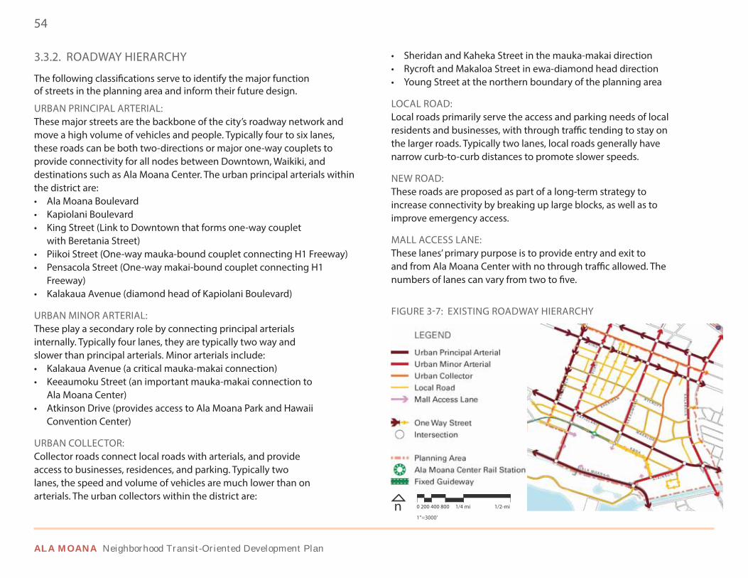
54
ALA MOANA Neighborhood Transit-Oriented Development Plan
3.3.2. ROADWAY HIERARCHY
The following classifications serve to identify the major function of streets in the planning area and inform their future design.
URBAN PRINCIPAL ARTERIAL: These major streets are the backbone of the city’s roadway network and move a high volume of vehicles and people. Typically four to six lanes, these roads can be both two-directions or major one-way couplets to provide connectivity for all nodes between Downtown, Waikiki, and destinations such as Ala Moana Center. The urban principal arterials within the district are:• Ala Moana Boulevard• Kapiolani Boulevard• King Street (Link to Downtown that forms one-way couplet
with Beretania Street)• Piikoi Street (One-way mauka-bound couplet connecting H1 Freeway)• Pensacola Street (One-way makai-bound couplet connecting H1
Freeway)• Kalakaua Avenue (diamond head of Kapiolani Boulevard)
URBAN MINOR ARTERIAL:These play a secondary role by connecting principal arterials internally. Typically four lanes, they are typically two way and slower than principal arterials. Minor arterials include:• Kalakaua Avenue (a critical mauka-makai connection)• Keeaumoku Street (an important mauka-makai connection to
Ala Moana Center)• Atkinson Drive (provides access to Ala Moana Park and Hawaii
Convention Center)
URBAN COLLECTOR:Collector roads connect local roads with arterials, and provide access to businesses, residences, and parking. Typically two lanes, the speed and volume of vehicles are much lower than on arterials. The urban collectors within the district are:
FIGURE 3-7: EXISTING ROADWAY HIERARCHY
n 1”=3000’
0 200 400 800 1/4 mi 1/2-mi
• Sheridan and Kaheka Street in the mauka-makai direction• Rycroft and Makaloa Street in ewa-diamond head direction• Young Street at the northern boundary of the planning area
LOCAL ROAD: Local roads primarily serve the access and parking needs of local residents and businesses, with through traffic tending to stay on the larger roads. Typically two lanes, local roads generally have narrow curb-to-curb distances to promote slower speeds.
NEW ROAD:These roads are proposed as part of a long-term strategy to increase connectivity by breaking up large blocks, as well as to improve emergency access.
MALL ACCESS LANE: These lanes’ primary purpose is to provide entry and exit to and from Ala Moana Center with no through traffic allowed. The numbers of lanes can vary from two to five.
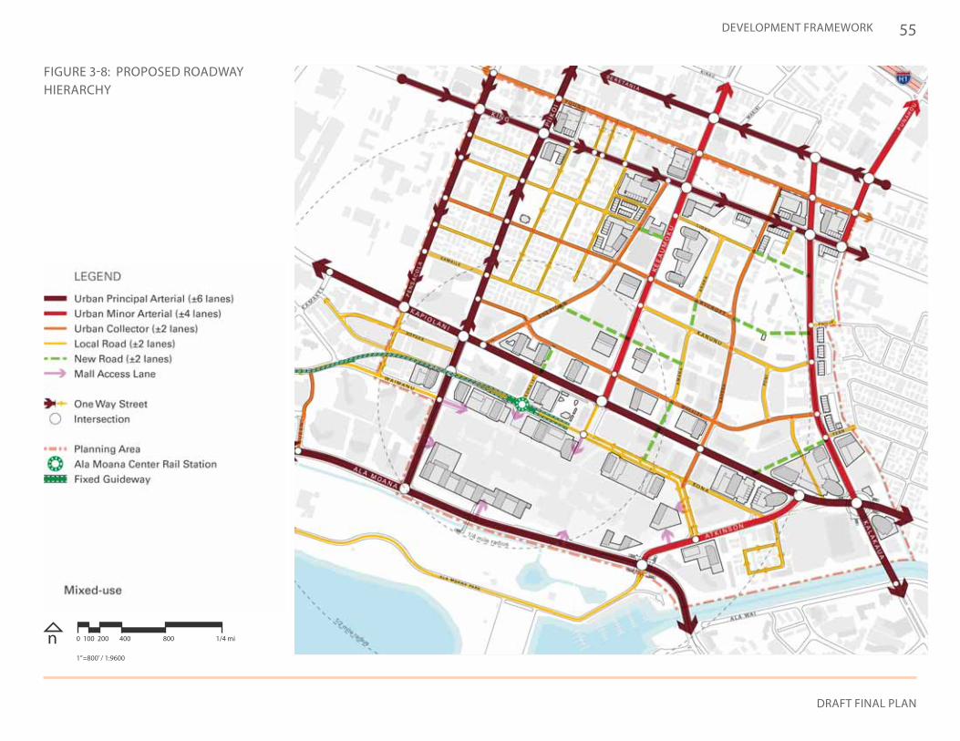
55
DRAFT FINAL PLAN
DEVELOPMENT FRAMEWORK
FIGURE 3-8: PROPOSED ROADWAY HIERARCHY
n 0 100 200 400 800 1/4 mi
1”=800’ / 1:9600
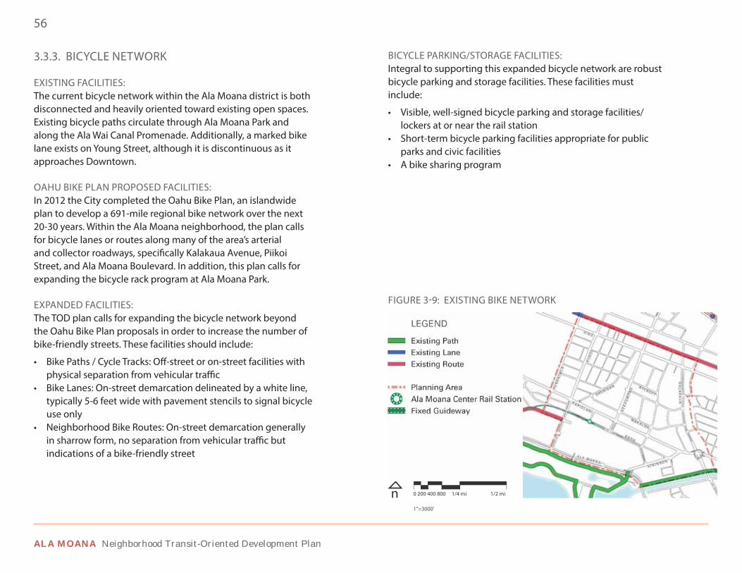
56
ALA MOANA Neighborhood Transit-Oriented Development Plan
3.3.3. BICYCLE NETWORK
EXISTING FACILITIES: The current bicycle network within the Ala Moana district is both disconnected and heavily oriented toward existing open spaces. Existing bicycle paths circulate through Ala Moana Park and along the Ala Wai Canal Promenade. Additionally, a marked bike lane exists on Young Street, although it is discontinuous as it approaches Downtown.
OAHU BIKE PLAN PROPOSED FACILITIES: In 2012 the City completed the Oahu Bike Plan, an islandwide plan to develop a 691-mile regional bike network over the next 20-30 years. Within the Ala Moana neighborhood, the plan calls for bicycle lanes or routes along many of the area’s arterial and collector roadways, specifically Kalakaua Avenue, Piikoi Street, and Ala Moana Boulevard. In addition, this plan calls for expanding the bicycle rack program at Ala Moana Park.
EXPANDED FACILITIES: The TOD plan calls for expanding the bicycle network beyond the Oahu Bike Plan proposals in order to increase the number of bike-friendly streets. These facilities should include:
• Bike Paths / Cycle Tracks: Off-street or on-street facilities with physical separation from vehicular traffic
• Bike Lanes: On-street demarcation delineated by a white line, typically 5-6 feet wide with pavement stencils to signal bicycle use only
• Neighborhood Bike Routes: On-street demarcation generally in sharrow form, no separation from vehicular traffic but indications of a bike-friendly street
BICYCLE PARKING/STORAGE FACILITIES: Integral to supporting this expanded bicycle network are robust bicycle parking and storage facilities. These facilities must include:
• Visible, well-signed bicycle parking and storage facilities/lockers at or near the rail station
• Short-term bicycle parking facilities appropriate for public parks and civic facilities
• A bike sharing program
FIGURE 3-9: EXISTING BIKE NETWORK
n 1”=3000’
0 200 400 800 1/4 mi 1/2 mi
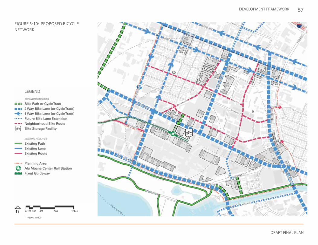
57
DRAFT FINAL PLAN
DEVELOPMENT FRAMEWORK
FIGURE 3-10: PROPOSED BICYCLE NETWORK
n 0 100 200 400 800 1/4 mi
1”=800’ / 1:9600
58
ALA MOANA Neighborhood Transit-Oriented Development Plan
3.3.4. PEDESTRIAN CONNECTIVITY
One of the community’s most important goals is improving the quality and safety of the walking environment in the Ala Moana district. These improvements are important for short pedestrian trips, transit trips, and the character of the neighborhood. More specific improvement concepts are depicted in Chapter 4.
SIGNALIZED CROSSWALK: Located at areas with high pedestrian flows, these allow safe travel across busy streets. Two are proposed along Rycroft Street to improve neighborhood connections with McKinley High School and Sheridan Community Park. Additionally, signalized crosswalks are proposed where pedestrian paths intersect streets.
CROSSWALK ENHANCEMENTS: Comprehensive crosswalk enhancements contribute to safe pedestrian street crossings and improve pedestrian connections to existing destinations. ADA compliant crosswalks across all legs of an intersection, additional signalization, and highly visible crosswalk markings can help achieve these goals.
SCRAMBLE INTERSECTION: Scramble intersections, or “Barnes Crossings”, allow for a safer, more efficient flow of pedestrian and vehicular traffic by separating the two into alternating time periods. The Kapiolani Boulevard and Keeaumoku Street intersection, due to its high pedestrian and vehicular traffic, would be ideal for this strategy.
INTERSECTION IMPROVEMENTS / RECONFIGURATION: Through the reconfiguration of intersection geometry (such as reduced turning radii), intersections in the Ala Moana neighborhood can experience improved pedestrian and bike safety by decreasing vehicular speeds. The high priority intersections are:• King Street at Pensacola Street and Kalakaua Avenue• Kapiolani Boulevard at Pensacola Street and Kalakaua Avenue
• Ala Moana Boulevard at Piikoi Street and Atkinson Boulevard• Kona Street at Kaheka Street
ELEVATED PEDESTRIAN CROSSINGS: When reconfiguration is unable to provide pedestrian safety at the busiest intersections, grade separation may allow improved safety while maintaining high traffic flow. These would work best where land uses have destinations on upper levels, such as Ala Moana Center and the Hawaii Convention Center. Elevated crossings are considered for:• Connection between transit station and Ala Moana Center• Ala Moana Boulevard and Atkinson Drive• Kapiolani Boulevard and Kalakaua Avenue
TRANSIT PLAZA: In order to provide a pedestrian-friendly environment for those traveling via rail, a transition from the elevated station to street level is needed. An elevated or street level plaza can both create that transitory space while tying the station to the busy Kapiolani Boulevard and Keeaumoku Street intersection.
SIDEWALK IMPROVEMENTS: Sidewalk improvements can create pedestrian-friendly outdoor environments at the street level. Ample, ADA-compliant sidewalks and enhanced streetscape amenities such as trees, pedestrian-scale lighting, and furniture can accommodate heavy pedestrian flows while enhancing commercial activity within mixed-use, multimodal arterials, and local streets. Permeable paving should be utilized to minimize storm water runoff.
PEDESTRIAN PATHS: Mauka-makai pedestrian paths can provide trails adjacent to existing amenities such as Makiki Stream or help to physically unite disjointed areas. Allowing more mauka-makai connections and shoreline access, such as through Ala Moana Center, visual and physical barriers to the shoreline can be broken down.
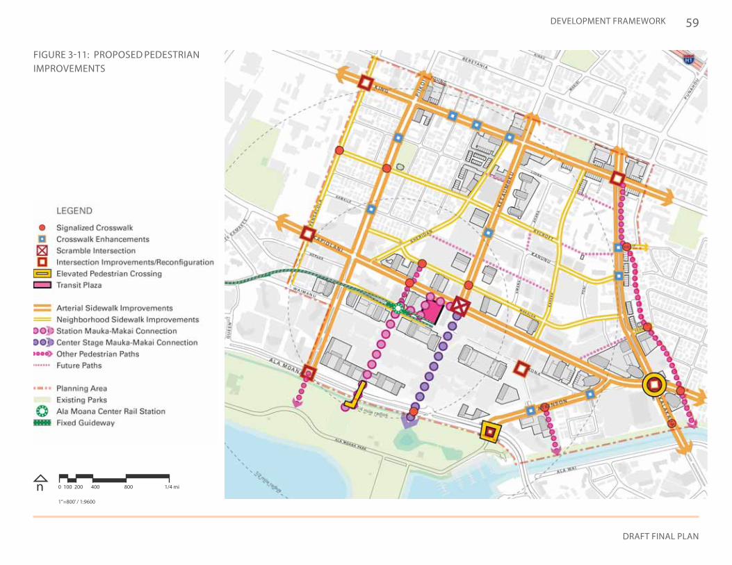
59
DRAFT FINAL PLAN
DEVELOPMENT FRAMEWORK
FIGURE 3-11: PROPOSED PEDESTRIAN IMPROVEMENTS
n 0 100 200 400 800 1/4 mi
1”=800’ / 1:9600
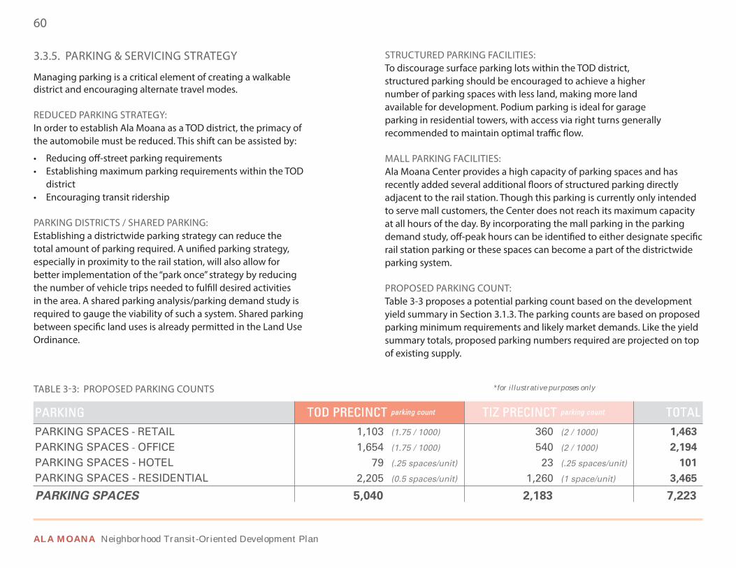
60
ALA MOANA Neighborhood Transit-Oriented Development Plan
TABLE 3-3: PROPOSED PARKING COUNTS *for illustrative purposes only
3.3.5. PARKING & SERVICING STRATEGY
Managing parking is a critical element of creating a walkable district and encouraging alternate travel modes.
REDUCED PARKING STRATEGY: In order to establish Ala Moana as a TOD district, the primacy of the automobile must be reduced. This shift can be assisted by:
• Reducing off-street parking requirements• Establishing maximum parking requirements within the TOD
district• Encouraging transit ridership
PARKING DISTRICTS / SHARED PARKING: Establishing a districtwide parking strategy can reduce the total amount of parking required. A unified parking strategy, especially in proximity to the rail station, will also allow for better implementation of the “park once” strategy by reducing the number of vehicle trips needed to fulfill desired activities in the area. A shared parking analysis/parking demand study is required to gauge the viability of such a system. Shared parking between specific land uses is already permitted in the Land Use Ordinance.
STRUCTURED PARKING FACILITIES: To discourage surface parking lots within the TOD district, structured parking should be encouraged to achieve a higher number of parking spaces with less land, making more land available for development. Podium parking is ideal for garage parking in residential towers, with access via right turns generally recommended to maintain optimal traffic flow.
MALL PARKING FACILITIES: Ala Moana Center provides a high capacity of parking spaces and has recently added several additional floors of structured parking directly adjacent to the rail station. Though this parking is currently only intended to serve mall customers, the Center does not reach its maximum capacity at all hours of the day. By incorporating the mall parking in the parking demand study, off-peak hours can be identified to either designate specific rail station parking or these spaces can become a part of the districtwide parking system.
PROPOSED PARKING COUNT: Table 3-3 proposes a potential parking count based on the development yield summary in Section 3.1.3. The parking counts are based on proposed parking minimum requirements and likely market demands. Like the yield summary totals, proposed parking numbers required are projected on top of existing supply.
TOD PRECINCT parking count TIZ PRECINCT parking count TOTAL1,103 (1.75 / 1000) 360 (2 / 1000) 1,463
1,654 (1.75 / 1000) 540 (2 / 1000) 2,194
79 (.25 spaces/unit) 23 (.25 spaces/unit) 101
2,205 (0.5 spaces/unit) 1,260 (1 space/unit) 3,465
PARKINGPARKING SPACES - RETAILPARKING SPACES OFFICEPARKING SPACES - HOTELPARKING SPACES - RESIDENTIAL
PARKING SPACES 5,040 2,183 7,223
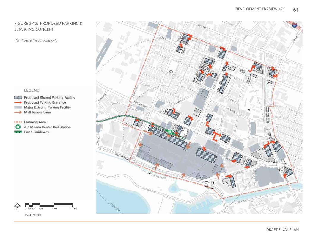
61
DRAFT FINAL PLAN
DEVELOPMENT FRAMEWORK
*for illustrative purposes only
FIGURE 3-12: PROPOSED PARKING & SERVICING CONCEPT
n 0 100 200 400 800 1/4 mi
1”=800’ / 1:9600
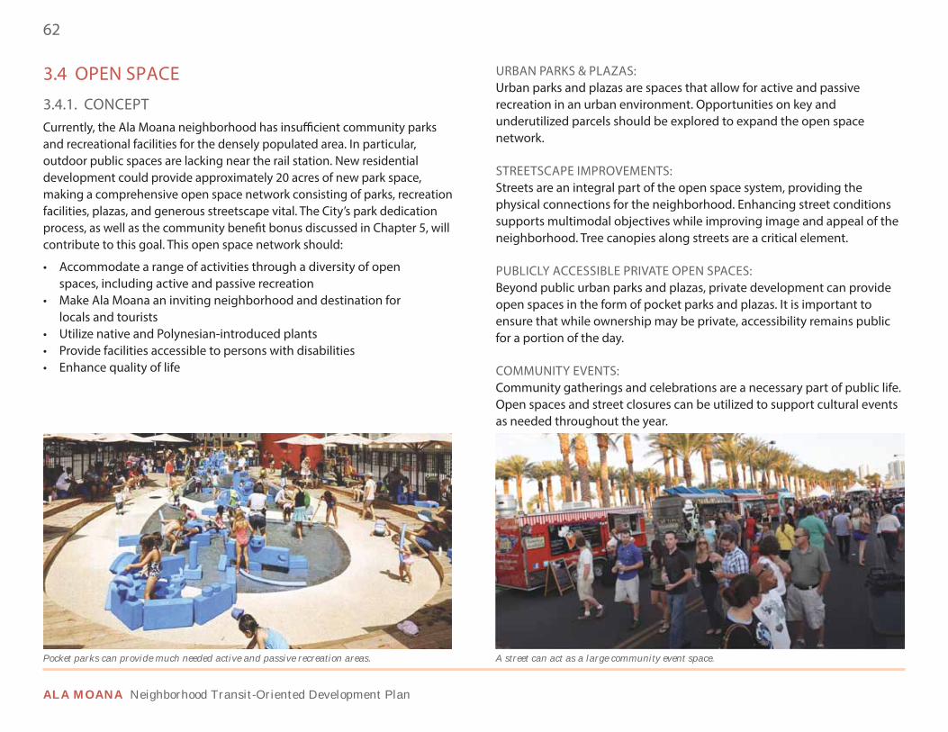
62
ALA MOANA Neighborhood Transit-Oriented Development Plan
3.4 OPEN SPACE
3.4.1. CONCEPTCurrently, the Ala Moana neighborhood has insufficient community parks and recreational facilities for the densely populated area. In particular, outdoor public spaces are lacking near the rail station. New residential development could provide approximately 20 acres of new park space, making a comprehensive open space network consisting of parks, recreation facilities, plazas, and generous streetscape vital. The City’s park dedication process, as well as the community benefit bonus discussed in Chapter 5, will contribute to this goal. This open space network should:
• Accommodate a range of activities through a diversity of open spaces, including active and passive recreation
• Make Ala Moana an inviting neighborhood and destination for locals and tourists
• Utilize native and Polynesian-introduced plants• Provide facilities accessible to persons with disabilities• Enhance quality of life
URBAN PARKS & PLAZAS: Urban parks and plazas are spaces that allow for active and passive recreation in an urban environment. Opportunities on key and underutilized parcels should be explored to expand the open space network.
STREETSCAPE IMPROVEMENTS: Streets are an integral part of the open space system, providing the physical connections for the neighborhood. Enhancing street conditions supports multimodal objectives while improving image and appeal of the neighborhood. Tree canopies along streets are a critical element.
PUBLICLY ACCESSIBLE PRIVATE OPEN SPACES: Beyond public urban parks and plazas, private development can provide open spaces in the form of pocket parks and plazas. It is important to ensure that while ownership may be private, accessibility remains public for a portion of the day.
COMMUNITY EVENTS: Community gatherings and celebrations are a necessary part of public life. Open spaces and street closures can be utilized to support cultural events as needed throughout the year.
A street can act as a large community event space.Pocket parks can provide much needed active and passive recreation areas.
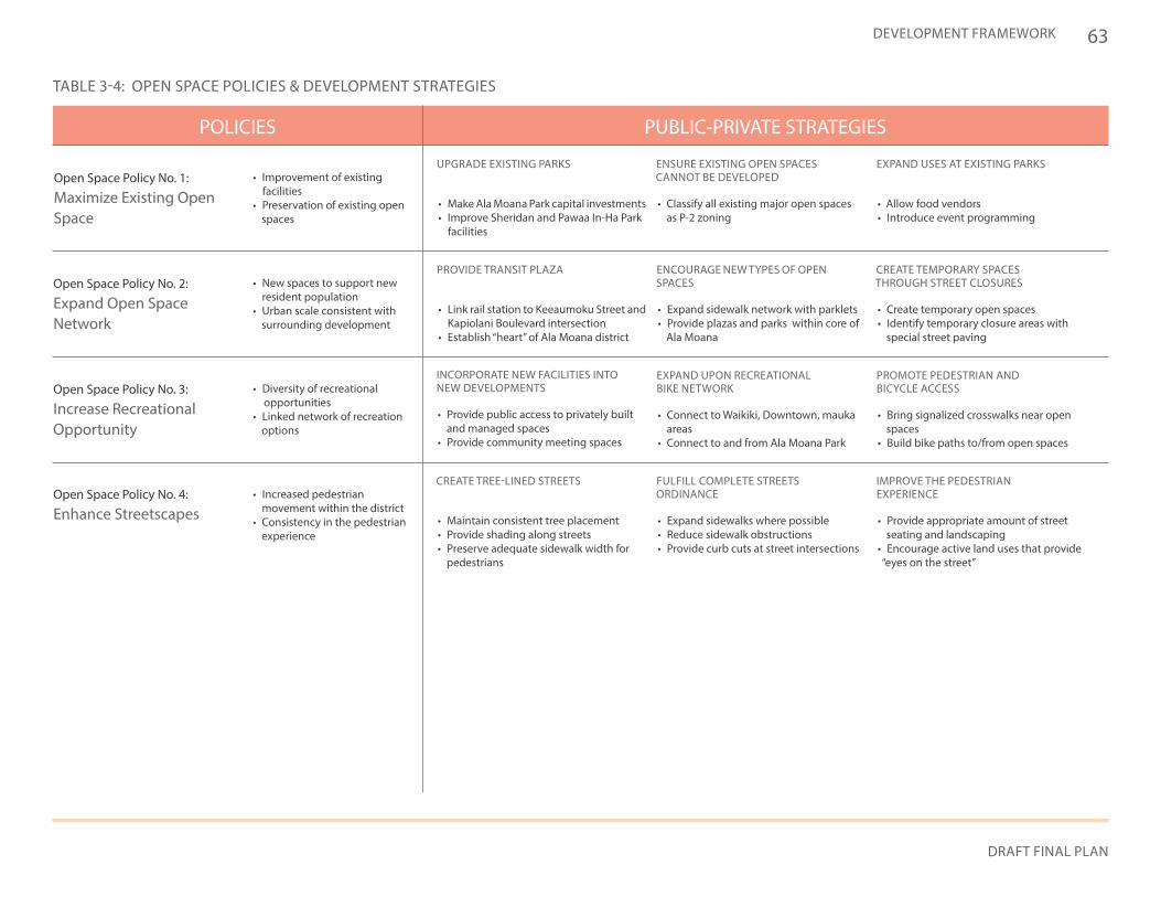
63
DRAFT FINAL PLAN
DEVELOPMENT FRAMEWORK
PUBLIC-PRIVATE STRATEGIESPOLICIES
TABLE 3-4: OPEN SPACE POLICIES & DEVELOPMENT STRATEGIES
UPGRADE EXISTING PARKS
PROVIDE TRANSIT PLAZA
ENSURE EXISTING OPEN SPACES CANNOT BE DEVELOPED
EXPAND USES AT EXISTING PARKS
INCORPORATE NEW FACILITIES INTO NEW DEVELOPMENTS
CREATE TREE-LINED STREETS
ENCOURAGE NEW TYPES OF OPEN SPACES
EXPAND UPON RECREATIONAL BIKE NETWORK
FULFILL COMPLETE STREETS ORDINANCE
CREATE TEMPORARY SPACES THROUGH STREET CLOSURES
PROMOTE PEDESTRIAN AND BICYCLE ACCESS
IMPROVE THE PEDESTRIAN EXPERIENCE
• Make Ala Moana Park capital investments• Improve Sheridan and Pawaa In-Ha Park
facilities
• Link rail station to Keeaumoku Street and Kapiolani Boulevard intersection
• Establish “heart” of Ala Moana district
• Classify all existing major open spaces as P-2 zoning
• Allow food vendors• Introduce event programming
• Provide public access to privately built and managed spaces
• Provide community meeting spaces
• Maintain consistent tree placement• Provide shading along streets• Preserve adequate sidewalk width for
pedestrians
• Expand sidewalk network with parklets• Provide plazas and parks within core of
Ala Moana
• Connect to Waikiki, Downtown, mauka areas
• Connect to and from Ala Moana Park
• Provide appropriate amount of street seating and landscaping
• Encourage active land uses that provide “eyes on the street”
• Create temporary open spaces• Identify temporary closure areas with
special street paving
• Bring signalized crosswalks near open spaces
• Build bike paths to/from open spaces
• Expand sidewalks where possible• Reduce sidewalk obstructions• Provide curb cuts at street intersections
Open Space Policy No. 1:
Maximize Existing Open Space
• Improvement of existing facilities
• Preservation of existing open spaces
Open Space Policy No. 3:
Increase Recreational Opportunity
• Diversity of recreational opportunities
• Linked network of recreation options
Open Space Policy No. 4:
Enhance Streetscapes• Increased pedestrian
movement within the district• Consistency in the pedestrian
experience
Open Space Policy No. 2:
Expand Open Space Network
• New spaces to support new resident population
• Urban scale consistent with surrounding development
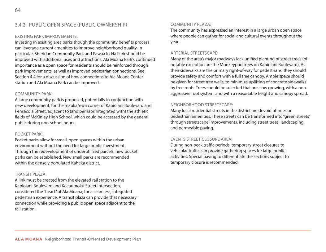
64
ALA MOANA Neighborhood Transit-Oriented Development Plan
3.4.2. PUBLIC OPEN SPACE (PUBLIC OWNERSHIP)
EXISTING PARK IMPROVEMENTS: Investing in existing area parks though the community benefits process can leverage current amenities to improve neighborhood quality. In particular, Sheridan Community Park and Pawaa In-Ha Park should be improved with additional uses and attractions. Ala Moana Park’s continued importance as a open space for residents should be reinforced through park improvements, as well as improved pedestrian connections. See Section 4.4 for a discussion of how connections to Ala Moana Center station and Ala Moana Park can be improved.
COMMUNITY PARK:A large community park is proposed, potentially in conjunction with new development, for the mauka/ewa corner of Kapiolani Boulevard and Pensacola Street, adjacent to (and perhaps integrated with) the athletic fields of McKinley High School, which could be accessed by the general public during non-school hours.
POCKET PARK: Pocket parks allow for small, open spaces within the urban environment without the need for large public investment. Through the redevelopment of underutilized parcels, new pocket parks can be established. New small parks are recommended within the densely populated Kaheka district.
TRANSIT PLAZA: A link must be created from the elevated rail station to the Kapiolani Boulevard and Keeaumoku Street intersection, considered the “heart” of Ala Moana, for a seamless, integrated pedestrian experience. A transit plaza can provide that necessary connection while providing a public open space adjacent to the rail station.
COMMUNITY PLAZA: The community has expressed an interest in a large urban open space where people can gather for social and cultural events throughout the year.
ARTERIAL STREETSCAPE: Many of the area’s major roadways lack unified planting of street trees (of notable exception are the Monkeypod trees on Kapiolani Boulevard). As their sidewalks are the primary right-of-way for pedestrians, they should provide safety and comfort with a full tree canopy. Ample space should be given for street tree wells, to minimize uplifting of concrete sidewalks by tree roots. Trees should be selected that are slow growing, with a non-aggressive root system, and with a reasonable height and canopy spread.
NEIGHBORHOOD STREETSCAPE: Many local residential streets in the district are devoid of trees or pedestrian amenities. These streets can be transformed into “green streets” through streetscape improvements, including street trees, landscaping, and permeable paving.
EVENTS STREET CLOSURE AREA: During non-peak traffic periods, temporary street closures to vehicular traffic can provide gathering spaces for large public activities. Special paving to differentiate the sections subject to temporary closure is recommended.
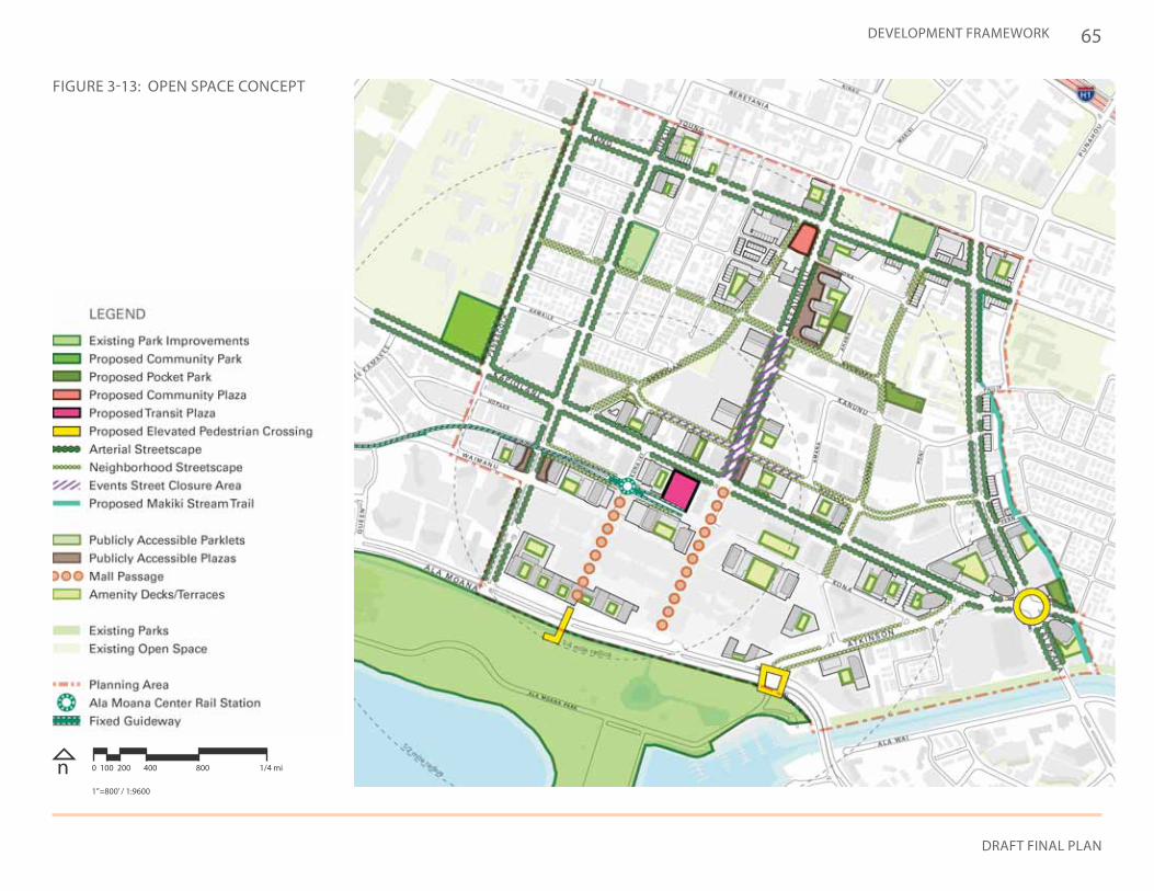
65
DRAFT FINAL PLAN
DEVELOPMENT FRAMEWORK
FIGURE 3-13: OPEN SPACE CONCEPT
n 0 100 200 400 800 1/4 mi
1”=800’ / 1:9600
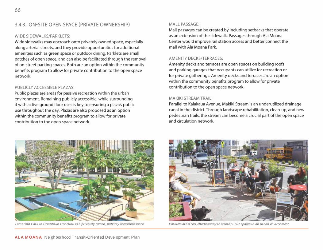
66
ALA MOANA Neighborhood Transit-Oriented Development Plan
3.4.3. ON-SITE OPEN SPACE (PRIVATE OWNERSHIP)
WIDE SIDEWALKS/PARKLETS: Wide sidewalks may encroach onto privately owned space, especially along arterial streets, and they provide opportunities for additional amenities such as green space or outdoor dining. Parklets are small patches of open space, and can also be facilitated through the removal of on-street parking spaces. Both are an option within the community benefits program to allow for private contribution to the open space network.
PUBLICLY ACCESSIBLE PLAZAS: Public plazas are areas for passive recreation within the urban environment. Remaining publicly accessible, while surrounding it with active ground floor uses is key to ensuring a plaza’s public use throughout the day. Plazas are also proposed as an option within the community benefits program to allow for private contribution to the open space network.
Tamarind Park in Downtown Honolulu is a privately owned, publicly accessible space. Parklets are a cost-effective way to create public spaces in an urban environment.
MALL PASSAGE: Mall passages can be created by including setbacks that operate as an extension of the sidewalk. Passages through Ala Moana Center would improve rail station access and better connect the mall with Ala Moana Park.
AMENITY DECKS/TERRACES: Amenity decks and terraces are open spaces on building roofs and parking garages that occupants can utilize for recreation or for private gatherings. Amenity decks and terraces are an option within the community benefits program to allow for private contribution to the open space network.
MAKIKI STREAM TRAIL: Parallel to Kalakaua Avenue, Makiki Stream is an underutilized drainage canal in the district. Through landscape rehabilitation, clean-up, and new pedestrian trails, the stream can become a crucial part of the open space and circulation network.
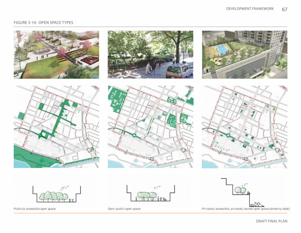
67
DRAFT FINAL PLAN
DEVELOPMENT FRAMEWORK
FIGURE 3-14: OPEN SPACE TYPES
Privately accessible, privately owned open space (amenity deck)Semi-public open spacePublicly accessible open space
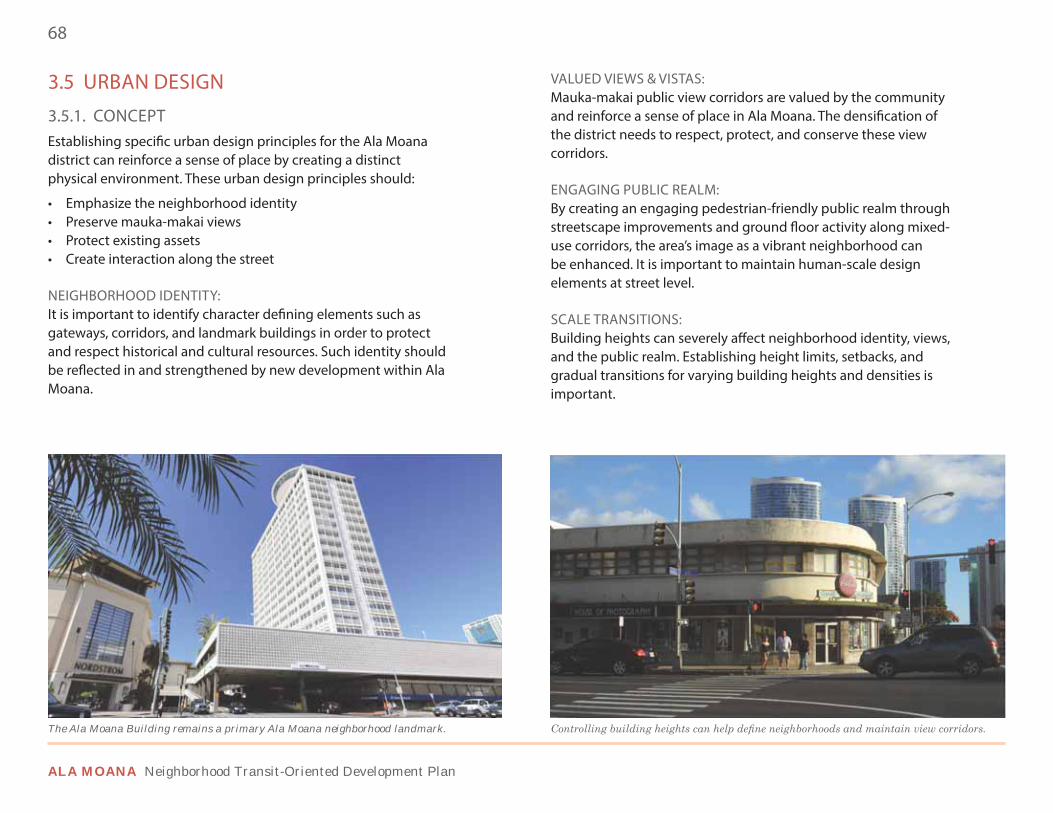
68
ALA MOANA Neighborhood Transit-Oriented Development Plan
3.5 URBAN DESIGN
3.5.1. CONCEPTEstablishing specific urban design principles for the Ala Moana district can reinforce a sense of place by creating a distinct physical environment. These urban design principles should:
• Emphasize the neighborhood identity• Preserve mauka-makai views• Protect existing assets • Create interaction along the street
NEIGHBORHOOD IDENTITY: It is important to identify character defining elements such as gateways, corridors, and landmark buildings in order to protect and respect historical and cultural resources. Such identity should be reflected in and strengthened by new development within Ala Moana.
VALUED VIEWS & VISTAS: Mauka-makai public view corridors are valued by the community and reinforce a sense of place in Ala Moana. The densification of the district needs to respect, protect, and conserve these view corridors.
ENGAGING PUBLIC REALM: By creating an engaging pedestrian-friendly public realm through streetscape improvements and ground floor activity along mixed-use corridors, the area’s image as a vibrant neighborhood can be enhanced. It is important to maintain human-scale design elements at street level.
SCALE TRANSITIONS: Building heights can severely affect neighborhood identity, views, and the public realm. Establishing height limits, setbacks, and gradual transitions for varying building heights and densities is important.
The Ala Moana Building remains a primary Ala Moana neighborhood landmark.
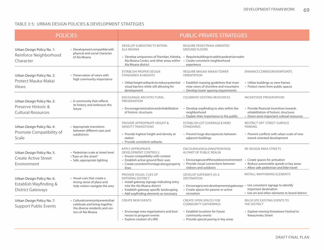
69
DRAFT FINAL PLAN
DEVELOPMENT FRAMEWORK
PUBLIC-PRIVATE STRATEGIESPOLICIES
TABLE 3-5: URBAN DESIGN POLICIES & DEVELOPMENT STRATEGIES
Urban Design Policy No. 7:
Support Public Events• Cultural community events that
celebrate and bring together the diverse residents and visi-tors of Ala Moana
DEVELOP SUBDISTRICTS WITHIN ALA MOANA
REQUIRE PEDESTRIAN-ORIENTED GROUND FLOORS
ESTABLISH PROPER DESIGN STANDARDS & HEIGHTS
ENCOURAGE ARCHITECTURAL PRESERVATION
PROVIDE APPROPRIATE HEIGHT & DENSITY TRANSITIONS
APPLY APPROPRIATE DEVELOPMENT CONTROLS
PROVIDE VISUAL CUES OF ENTERING DISTRICT
CREATE NEW EVENTS
REQUIRE MAUKA-MAKAI TOWER ORIENTATION
CELEBRATE EXISTING RESOURCES
ESTABLISH LOT COVERAGE & YARD STANDARDS
RE-DESIGN AREA STREETS
CREATE OPEN SPACES FOR COMMUNITY GATHERINGS
ENHANCE CORRIDOR VIEWPOINTS
INCENTIVIZE PRESERVATION
RESTRICT OFF-STREET SURFACE PARKING
ENCOURAGE BUILDING FRONTAGE AS PART OF PUBLIC REALM
DEVELOP GATEWAYS AS A DESTINATION
RELOCATE EXISTING EVENTS TO THE DISTRICT
• Develop uniqueness of Sheridan, Kaheka, Ala Moana Center, and other areas within Ala Moana district
• Require buildings to add to pedestrian realm• Create consistent neighborhood
experience
• Utilize height setbacks to reduce potential visual barriers while still allowing for development
• Encourage restoration and rehabilitation of historic structures
• Provide highest height and density at station
• Provide consistent setbacks
• Ensure compatibility with context• Establish active ground floor uses• Create consistent frontage along property
lines
• Install gateway signage indicating entry into the Ala Moana district
• Establish gateway-specific landscaping• Add wayfinding elements as necessary
• Encourage area organizations and busi-nesses to program events
• Explore creation of a BID
• Establish massing guidelines that maxi-mize views of shoreline and mountains
• Develop tower spacing requirements
• Develop wayfinding to sites within the neighborhood
• Explain their importance to the public
• Prevent huge discrepancies between adjacent buildings
• Create spaces for activation• Reduce automobile speeds in key areas• Allow safe pedestrian and bike travel
• Establish locations for future community events
• Provide special paving in key areas
• Utilize buildings as view frames • Protect views from public spaces
• Provide financial incentives towards rehabilitation of historic structures
• Down-zone important cultural resources
• Prevent conflicts with urban scale of new transit-oriented development
• Encourage use of the outdoor environment• Provide visual connections between
indoors and outdoors
• Encourage iconic development at gateways • Create spaces for passive or active
recreation
• Explore moving Koreatown Festival to Keeaumoku Street
Urban Design Policy No. 1:
Reinforce Neighborhood Character
• Development compatible with physical and social character of Ala Moana
Urban Design Policy No. 3:
Preserve Historic & Cultural Resources
• A community that reflects its history and embraces the future
Urban Design Policy No. 4:
Promote Compatibility of Scale
Urban Design Policy No. 5:
Create Active Street Environment
Urban Design Policy No. 6:
Establish Wayfinding & District Gateways
• Appropriate transitions between different uses and subdistricts
• Pedestrian scale at street level• “Eyes on the street”• Safe, appropriate lighting
• Visual cues that create a strong sense of place and help visitors navigate the area
Urban Design Policy No. 2:
Protect Mauka-Makai Views
• Preservation of views with high community importance
INSTALL WAYFINDING ELEMENTS
• Use consistent signage to identify important destination
• Use art and other elements to brand district
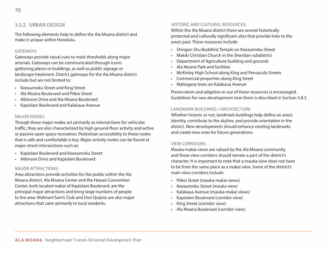
70
ALA MOANA Neighborhood Transit-Oriented Development Plan
3.5.2. URBAN DESIGN
The following elements help to define the Ala Moana district and make it unique within Honolulu.
GATEWAYS: Gateways provide visual cues to mark thresholds along major arterials. Gateways can be communicated through iconic gathering places or buildings, as well as public signage or landscape treatment. District gateways for the Ala Moana district include but are not limited to:
• Keeaumoku Street and King Street• Ala Moana Boulevard and Piikoi Street• Atkinson Drive and Ala Moana Boulevard• Kapiolani Boulevard and Kalakaua Avenue
MAJOR NODES: Though these major nodes act primarily as intersections for vehicular traffic, they are also characterized by high ground-floor activity and active or passive open space recreation. Pedestrian accessibility to these nodes that is safe and comfortable is key. Major activity nodes can be found at major street intersections such as:
• Kapiolani Boulevard and Keeaumoku Street• Atkinson Drive and Kapiolani Boulevard
MAJOR ATTRACTIONS: Area attractions provide activities for the public within the Ala Moana district. Ala Moana Center and the Hawaii Convention Center, both located makai of Kapiolani Boulevard, are the principal major attractions and bring large numbers of people to the area. Walmart/Sam’s Club and Don Quijote are also major attractions that cater primarily to local residents.
HISTORIC AND CULTURAL RESOURCES: Within the Ala Moana district there are several historically protected and culturally significant sites that provide links to the area’s past. These resources include:
• Shingon Shu Buddhist Temple on Keeaumoku Street• Makiki Christian Church in the Sheridan subdistrict• Department of Agriculture building and grounds• Ala Moana Park and facilities• McKinley High School along King and Pensacola Streets• Commercial properties along King Street• Mahogany trees on Kalakaua Avenue
Preservation and adaptive re-use of these resources is encouraged. Guidelines for new development near them is described in Section 5.8.3.
LANDMARK BUILDINGS / ARCHITECTURE: Whether historic or not, landmark buildings help define an area’s identity, contribute to the skyline, and provide orientation in the district. New developments should enhance existing landmarks and create new ones for future generations.
VIEW CORRIDORS: Mauka-makai views are valued by the Ala Moana community and these view corridors should remain a part of the district’s character. It is important to note that a mauka view does not have to be from the same place as a makai view. Some of the district’s main view corridors include:
• Piikoi Street (mauka-makai views)• Keeaumoku Street (mauka view)• Kalakaua Avenue (mauka-makai views)• Kapiolani Boulevard (corridor view)• King Street (corridor view)• Ala Moana Boulevard (corridor view)
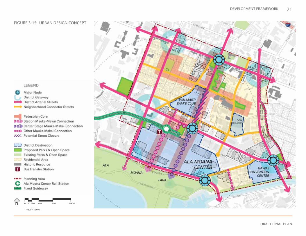
71
DRAFT FINAL PLAN
DEVELOPMENT FRAMEWORK
FIGURE 3-15: URBAN DESIGN CONCEPT
n 0 100 200 400 800 1/4 mi
1”=800’ / 1:9600
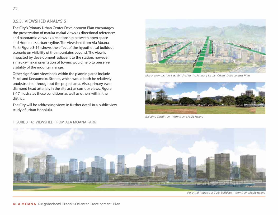
72
ALA MOANA Neighborhood Transit-Oriented Development Plan
3.5.3. VIEWSHED ANALYSISThe City’s Primary Urban Center Development Plan encourages the preservation of mauka-makai views as directional references and panoramic views as a relationship between open space and Honolulu’s urban skyline. The viewshed from Ala Moana Park (Figure 3-16) shows the effect of the hypothetical buildout scenario on visibility of the mountains beyond. The view is impacted by development adjacent to the station; however, a mauka-makai orientation of towers would help to preserve visibility of the mountain range.
Other significant viewsheds within the planning area include Piikoi and Keeaumoku Streets, which would both be relatively unobstructed throughout the project area. Also, primary ewa-diamond head arterials in the site act as corridor views. Figure 3-17 illustrates these conditions as well as others within the district.
The City will be addressing views in further detail in a public view study of urban Honolulu.
Major view corridors established in the Primary Urban Center Development Plan
Potential impacts of TOD buildout - View from Magic Island
Existing Condition - View from Magic Island
FIGURE 3-16: VIEWSHED FROM ALA MOANA PARK
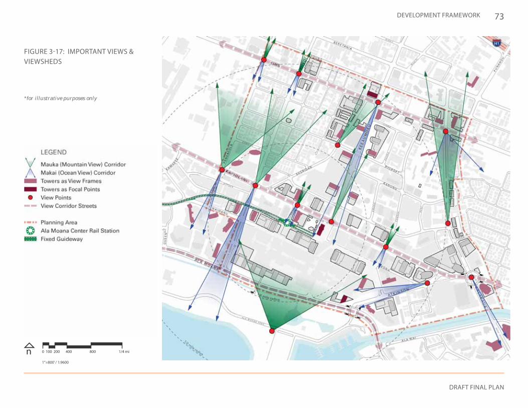
73
DRAFT FINAL PLAN
DEVELOPMENT FRAMEWORK
FIGURE 3-17: IMPORTANT VIEWS & VIEWSHEDS
n 0 100 200 400 800 1/4 mi
1”=800’ / 1:9600
*for illustrative purposes only
74
ALA MOANA Neighborhood Transit-Oriented Development Plan
3.5.4. BUILDING FORM
New buildings in the district should be built following these guidelines so as to accommodate additional density near the rail station while advancing the community’s vision.
TOWER ORIENTATION:To define and protect mauka-makai views, tall buildings should maintain a consistent orientation in order to frame primary arterials and view corridors. Towers should be oriented mauka-makai to maximize ocean views for its occupants as well as to ensure that the important viewshed at Ala Moana Park maintains mountain views.
DEVELOPMENT INTENSITY: Towers in the district should fall within specific height ranges to differentiate parts of the district as focal points. In general, the tallest buildings should be nearest to the rail station and the Convention Center, and should step down to reinforce the Kapiolani and Keeaumoku corridors. Figure 3-19 illustrates how proposed towers in the conceptual development scenario follow this rule. Towers should be taller in height along Kapiolani Boulevard and Atkinson Street, and step back in height along Keeaumoku Street to preserve mauka views. No towers located along Ala Moana Boulevard or King Street should be over 150 feet in height. Please refer to Section 5.3.3 for a further discussion on required building heights and how community benefits can allow buildings to be built at a greater height.
BUILDING MASSING: As buildings move up in height, setbacks on upper floors should allow ample sunshine, light, and blue skies to be seen from street level. Reducing the perceived presence of buildings and their shadows along roads is key. Tall buildings should adhere to design guidelines found in Section 5.9.
GROUND FLOOR ACTIVATION:At the street level, buildings should engage the public realm to create a pedestrian-friendly environment. Ground floor uses, especially along streets with high pedestrian traffic, should be active and visible from the sidewalk to create interest and improve safety.
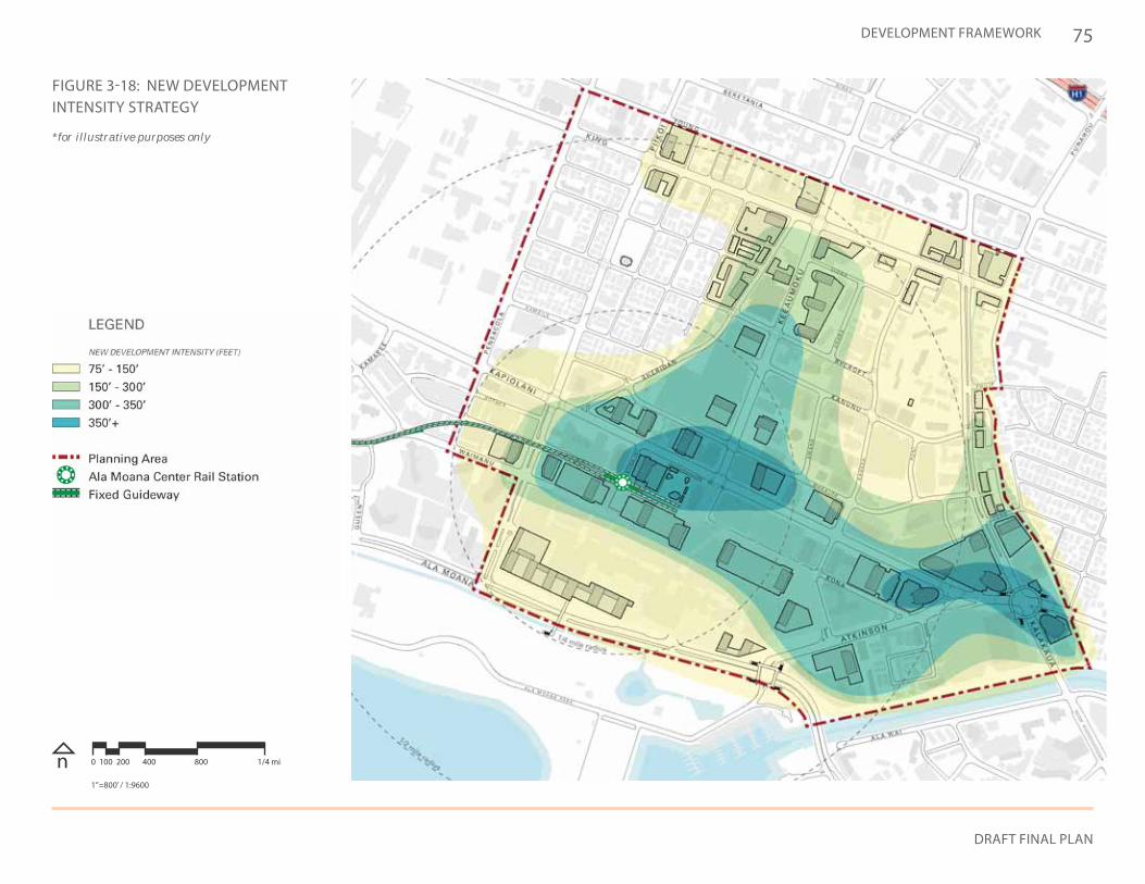
75
DRAFT FINAL PLAN
DEVELOPMENT FRAMEWORK
FIGURE 3-18: NEW DEVELOPMENT INTENSITY STRATEGY
n 0 100 200 400 800 1/4 mi
1”=800’ / 1:9600
*for illustrative purposes only
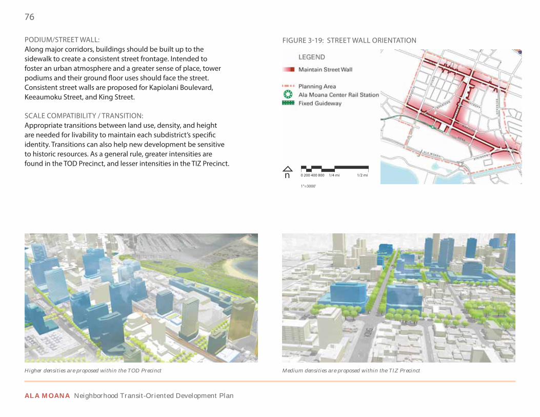
76
ALA MOANA Neighborhood Transit-Oriented Development Plan
PODIUM/STREET WALL: Along major corridors, buildings should be built up to the sidewalk to create a consistent street frontage. Intended to foster an urban atmosphere and a greater sense of place, tower podiums and their ground floor uses should face the street. Consistent street walls are proposed for Kapiolani Boulevard, Keeaumoku Street, and King Street.
SCALE COMPATIBILITY / TRANSITION: Appropriate transitions between land use, density, and height are needed for livability to maintain each subdistrict’s specific identity. Transitions can also help new development be sensitive to historic resources. As a general rule, greater intensities are found in the TOD Precinct, and lesser intensities in the TIZ Precinct.
Medium densities are proposed within the TIZ PrecinctHigher densities are proposed within the TOD Precinct
FIGURE 3-19: STREET WALL ORIENTATION
n 1”=3000’
0 200 400 800 1/4 mi 1/2 mi
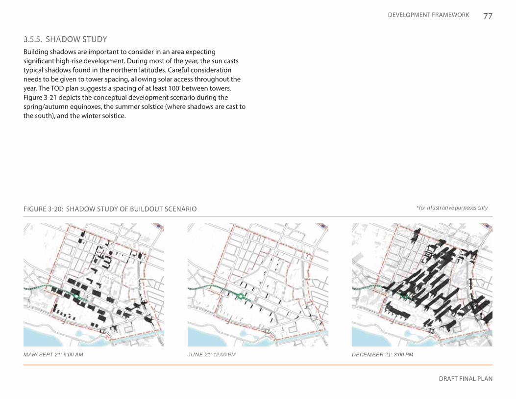
77
DRAFT FINAL PLAN
DEVELOPMENT FRAMEWORK
FIGURE 3-20: SHADOW STUDY OF BUILDOUT SCENARIO *for illustrative purposes only
MAR/SEPT 21: 9:00 AM JUNE 21: 12:00 PM DECEMBER 21: 3:00 PM
3.5.5. SHADOW STUDYBuilding shadows are important to consider in an area expecting significant high-rise development. During most of the year, the sun casts typical shadows found in the northern latitudes. Careful consideration needs to be given to tower spacing, allowing solar access throughout the year. The TOD plan suggests a spacing of at least 100’ between towers. Figure 3-21 depicts the conceptual development scenario during the spring/autumn equinoxes, the summer solstice (where shadows are cast to the south), and the winter solstice.
78
ALA MOANA Neighborhood Transit-Oriented Development Plan
3.6 INFRASTRUCTURE
3.6.1. INTENTThe following section summarizes the requirements for utility infrastructure to support transit-oriented development in the Ala Moana neighborhood. In summary, current conditions of the water and sewer systems, and the electric and gas networks, will be able to handle the demand generated by the significant development proposed in the Plan, if certain provisions and regulations are met.
3.6.2. WATER SYSTEMThe majority of the public water system, including fire hydrants, on the island of Oahu is owned and operated by the Honolulu Board of Water Supply (BWS). Potable water is drawn from underground aquifers and, to a lesser extent, collected from surface water sources. Raw water is treated and pumped to enclosed water reservoirs located at various locations and elevations throughout the island. Transmission pipelines deliver potable water from the reservoirs to the service areas.
WATER FACILITIESThe water mains within the Ala Moana neighborhood consist of 8- and 12-inch diameter mains with a limited number of 6- and 16-inch diameter mains. The 12- and 16-inch diameter mains generally form a backbone network coinciding with the major roadways. The 6- and 8-inch diameter mains serve as local supply lines for individual parcels along the smaller streets. The extent of the water system within Ala Moana is adequate with supply lines on virtually every street and a backbone line within a block or two thereof.
SYSTEM CAPACITYThe water system in the Ala Moana neighborhood will have capacity to support an even more intensive urban environment. The water system is
typically sized to provide for the maximum density allowed by zoning. Ala Moana is largely zoned with variations of commercial, medium- and high-density apartment, and commercial/residential mixed use, designations—typically characterized by higher water consumption.
The water infrastructure is able to deliver the maximum fire flow demand of 2,000 gallons per minute as cited in the BWS Water System Standards, 2002, for high rise and commercial use areas. The fire hydrant network is well developed with hydrants spaced at a maximum of 250 feet based on zoning.
DEVELOPMENT CONSIDERATIONSAny planning efforts should consider how the resulting new redevelopment will impact water quality and the beneficial use of the State’s water resources.
For new developments, the BWS must verify that adequate water resources are available. A general request for water availability should be made in the early project planning phase. New developments will be obligated to pay a Water System Facility Charge (WSFC) based on the net number and type of plumbing fixtures planned.
WATER CONSERVATIONWater conservation measures are required for all proposed developments. These measures may include utilization of non-potable water for irrigation using rain catchment and chiller/air handler condensate, cooling tower conductivity meters and water softening recycling systems, drought tolerant plants, xeriscaped landscaping, and efficient irrigation systems. Wherever practicable, alternate water sources should be utilized.
In addition, water efficient, or low flow plumbing fixtures should be installed throughout new and existing developments in Ala Moana to reduce the increased demand on the island’s freshwater resources.
79
DRAFT FINAL PLAN
DEVELOPMENT FRAMEWORK
3.6.3. WASTEWATER SYSTEMWastewater in the metropolitan areas of Oahu is typically collected by a system of gravity mains and sewage pump stations and conveyed to the Sand Island Wastewater Treatment Plant, located between the Honolulu International Airport and downtown Honolulu. The sewer system is maintained by the City Department of Environmental Services. The City Department of Planning and Permitting (DPP) Wastewater Branch manages sewer connection requests.
SEWER SYSTEM The sewer system within the Ala Moana neighborhood consists of a combination of local collection mains from 6-inch up to 12-inch diameter pipe and regional trunk sewers of 36-, 48-, and 69-inch diameter. Three trunk sewers cross the planning area, generally parallel to the shoreline, effectively creating three service zones. The upper third is served by the 48-inch diameter East End Relief Sewer along Rycroft Street. The middle zone is served by a 36-inch diameter sewer under Kapiolani Boulevard. The makai most zone is served by a 69-inch diameter sewer tunnel in Ala Moana Regional Park. These trunk sewers convey wastewater originating from properties diamond head of Ala Moana. Figure 3-21 depicts the existing wastewater system in the Ala Moana neighborhood.
SYSTEM CAPACITYWhile the existing trunk system in Ala Moana as a whole will have adequate capacity to serve new developments, there are capacity limitations in certain reaches of the local collection mains and, in some cases, specific reaches of the trunk sewers. Known limitations identified by the DPP Wastewater Branch are indicated on Figure 3-21. These limitations are typically addressed by construction of local relief sewers, or upsizing of existing mains.
Privately funded sewer improvements were made by a consortium of developers several years ago, increasing capacity in certain sections of the
Kapiolani Boulevard and Kalakaua Avenue trunk sewers. Much of the sewer credits associated with the excess capacity is held by the members of the consortium, however, the DPP Wastewater Branch indicated some excess capacity is currently available to the general public. Alternatively, sewer credits held by the consortium may be available for purchase through private transactions.
DEVELOPMENT CONSIDERATIONSAll new connections to the sewer system will incur a Wastewater System Facility Charge (WWSFC). The WSFC is a function of the number of units for a residential development and the size of the potable water meter for non-residential units. The construction cost of an off-site improvement may be credited against the WWSFC provided the improvement will be a public benefit, rather than just the individual development.
3.6.4. STORM WATER DRAINAGE SYSTEMCommunity planning must recognize storm water as an asset that sustains and protects natural ecosystems.
STORM WATER FACILITIESThe municipal drainage system in the Ala Moana neighborhood consists of open drainage channels and underground drainage conduits, and it is separate from the sewer system. All storm water runoff ultimately discharges to the ocean at various points along the shoreline.
The DPP Civil Engineering Branch (CEB) conducts review of proposed developments to ensure the neighboring properties are not adversely impacted by runoff generated by the improvements, and impacts to the environment by storm water pollutants are minimized. The basis for their review is the Rules Relating to Storm Drainage Standards, January 2000 (amended June 1, 2013).
80
ALA MOANA Neighborhood Transit-Oriented Development Plan
SYSTEM CAPACITYThe capacity of the storm drain system is adequate for the existing condition. Proposed developments must demonstrate that proposed improvements will not discharge runoff to the municipal system in excess of the current condition, commonly referred to as a “no net increase” in runoff. Any increase in storm water runoff in excess of the existing condition is typically retained or disposed of on-site.
A related component of storm water runoff managed by the CEB is storm water quality, under the City’s Municipal Separate Storm Sewer System (MS4) National Pollutant Discharge Elimination System (NPDES) Permit. The MS4 NPDES permit requires the City to minimize the quantity of pollutants entering the municipal drain system and ultimately the ocean through the use of best management practices, or BMPs.
The City has implemented low-impact development (LID) standards to minimize the impact of development to an area’s hydrology, while maintaining on-site infiltration and preventing polluted runoff from storm events. LID strategies are utilized to manage and control “…stream channel instability, streambank or shoreline erosion, loss of habitat, increased sediment transport and deposition, and increased flooding.” Developments will be required to retain storm water runoff on-site through the use of infiltration or rain harvesting methods, or may be allowed to discharge runoff through an appropriate filter such as a rain garden, green roof, tree box filters, or hydrodynamic separators.
FLOOD HAZARDSMuch of the planning area makai of Kapiolani Boulevard is in the Federal Emergency Management Agency (FEMA) VE and AE flood hazard districts, as depicted in Figure 1-7. The flood zone in this particular area is determined by the anticipated impact of flood waters resulting from a tsunami or hurricane. Flood elevations range from 5 feet above mean sea level (msl) inland to 12-feet (msl) at the shoreline.
FEMA regulates the development of residential dwellings in the flood hazard district, requiring flood proofing measures to protect life safety,
a flood study to validate that proposed developments will not alter the character of the flood zone, and residential property owners to purchase flood insurance. Non-residential developments within the flood hazard district are subject to certain flood proofing construction requirements, however, they are not required by FEMA to purchase flood insurance. Flood insurance may be required by lenders or other parties to the development team. Areas outside of the VE and AE flood zones within the Ala Moana area are classified as Zone X and are not subject to flood proofing or FEMA flood insurance requirements.
GREEN STREETSLandscape features, such as streetscapes, should be designed with storm water BMP approaches. For example, improvements to existing streets in Ala Moana are intended to utilize the “green street” concept, as depicted in Figure 3-22. Green streets are intended to serve as a primary channel for storm water capture, improving ocean water quality, while providing natural areas for community enjoyment. Large rain gardens, planters, and permeable paving define this street typology. In addition, bike lanes and upgraded street elements throughout the neighborhood may also reduce paved asphalt traffic lanes for automobiles. This provides the opportunity to introduce porous surfaces either in the form of pavers or landscaping, mitigating storm water runoff to the ocean and the heat island effect. Figure 3-22 also depicts the potential to reduce hazardous substances. Further discussion of streetscape elements proposed for Ala Moana’s major streets is located in Section 4.2.
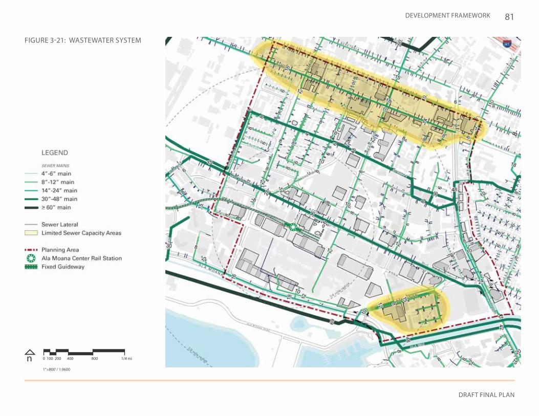
81
DRAFT FINAL PLAN
DEVELOPMENT FRAMEWORK
FIGURE 3-21: WASTEWATER SYSTEM
n 0 100 200 400 800 1/4 mi
1”=800’ / 1:9600
82
ALA MOANA Neighborhood Transit-Oriented Development Plan
3.6.5. ELECTRIC / CATV / TELEPHONE (E/C/T) & NATURAL GASE/C/T services are provided by three major public utility companies. Hawaiian Electric is the sole electric utility on the island. Oceanic Time Warner and Hawaiian Telcom both provide cable TV service, broadband internet, and digital telephone service. Hawaii Gas is the sole supplier of natural gas.
As the Ala Moana neighborhood is located within the primary urban center, underground and overhead E/C/T service and underground gas service is widely available. Gas service can also be provided via above ground storage tanks where underground service is not available. Service requests must be made with the applicable utility provider.
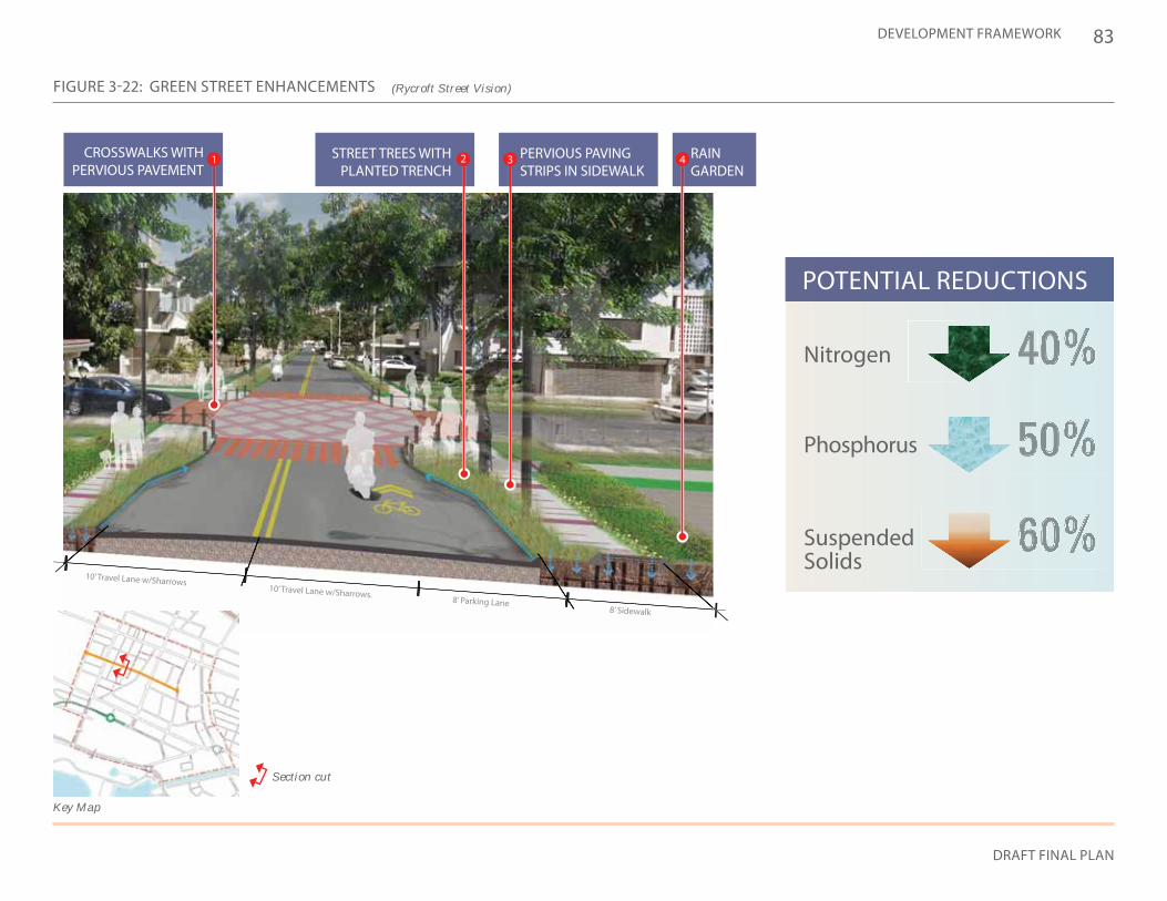
83
DRAFT FINAL PLAN
DEVELOPMENT FRAMEWORK
8’ Sidewalk8’ Parking Lane
10’ Travel Lane w/Sharrows.
10’ Travel Lane w/Sharrows
2 43CROSSWALKS WITH PERVIOUS PAVEMENT
PERVIOUS PAVING STRIPS IN SIDEWALK
RAIN GARDEN
1
POTENTIAL REDUCTIONS
Nitrogen
Phosphorus
Suspended Solids
Key Map
Section cut
FIGURE 3-22: GREEN STREET ENHANCEMENTS (Rycroft Street Vision)
STREET TREES WITH PLANTED TRENCH
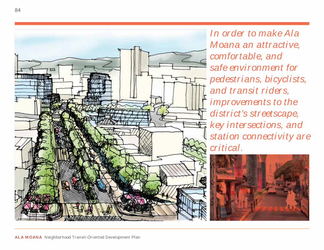
84
ALA MOANA Neighborhood Transit-Oriented Development Plan
In order to make Ala Moana an attractive, comfortable, and safe environment for pedestrians, bicyclists, and transit riders, improvements to the district’s streetscape, key intersections, and station connectivity are critical.
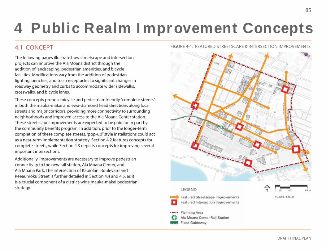
85
DRAFT FINAL PLAN
4.1 CONCEPTThe following pages illustrate how streetscape and intersection projects can improve the Ala Moana district through the addition of landscaping, pedestrian amenities, and bicycle facilities. Modifications vary from the addition of pedestrian lighting, benches, and trash receptacles to significant changes in roadway geometry and curbs to accommodate wider sidewalks, crosswalks, and bicycle lanes.
These concepts propose bicycle and pedestrian-friendly ”complete streets” in both the mauka-makai and ewa-diamond head directions along local streets and major corridors, providing more connectivity to surrounding neighborhoods and improved access to the Ala Moana Center station. These streetscape improvements are expected to be paid for in part by the community benefits program. In addition, prior to the longer-term completion of these complete streets, “pop-up” style installations could act as a near-term implementation strategy. Section 4.2 features concepts for complete streets, while Section 4.3 depicts concepts for improving several important intersections.
Additionally, improvements are necessary to improve pedestrian connectivity to the new rail station, Ala Moana Center, and Ala Moana Park. The intersection of Kapiolani Boulevard and Keeaumoku Street is further detailed in Section 4.4 and 4.5, as it is a crucial component of a district-wide mauka-makai pedestrian strategy.
FIGURE 4-1: FEATURED STREETSCAPE & INTERSECTION IMPROVEMENTS
n 0 200 600 1/4 mi
1”=1200’ / 1:14400
4 Public Realm Improvement Concepts
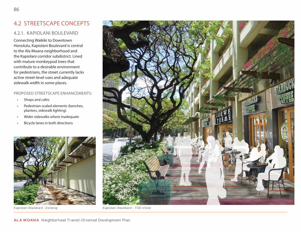
86
ALA MOANA Neighborhood Transit-Oriented Development Plan
Kapiolani Boulevard - TOD VisionKapiolani Boulevard - Existing
4.2 STREETSCAPE CONCEPTS
4.2.1. KAPIOLANI BOULEVARDConnecting Waikiki to Downtown Honolulu, Kapiolani Boulevard is central to the Ala Moana neighborhood and the Kapiolani corridor subdistrict. Lined with mature monkeypod trees that contribute to a desirable environment for pedestrians, the street currently lacks active street-level uses and adequate sidewalk width in some places.
PROPOSED STREETSCAPE ENHANCEMENTS:• Shops and cafes
• Pedestrian-scaled elements (benches, planters, sidewalk lighting)
• Wider sidewalks where inadequate
• Bicycle lanes in both directions
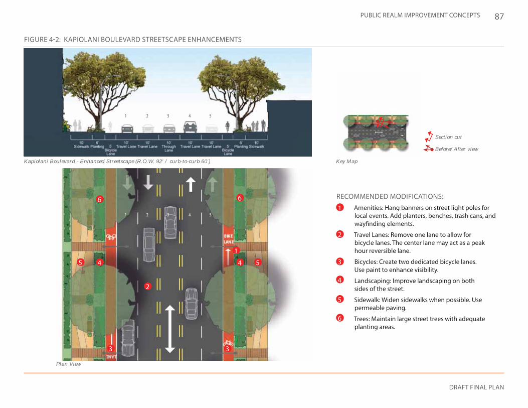
87
DRAFT FINAL PLAN
PUBLIC REALM IMPROVEMENT CONCEPTS
FIGURE 4-2: KAPIOLANI BOULEVARD STREETSCAPE ENHANCEMENTS
Key Map
Section cut
Before/After view
RECOMMENDED MODIFICATIONS:• Amenities: Hang banners on street light poles for
local events. Add planters, benches, trash cans, and wayfinding elements.
• Travel Lanes: Remove one lane to allow for bicycle lanes. The center lane may act as a peak hour reversible lane.
• Bicycles: Create two dedicated bicycle lanes. Use paint to enhance visibility.
• Landscaping: Improve landscaping on both sides of the street.
• Sidewalk: Widen sidewalks when possible. Use permeable paving.
• Trees: Maintain large street trees with adequate planting areas.
1
2
4
5
6
3
Kapiolani Boulevard - Enhanced Streetscape (R.O.W. 92' / curb-to-curb 60')
Plan View
1
1
2
2
3
3
4
4
5
5
1
2
4 45 5
66
33
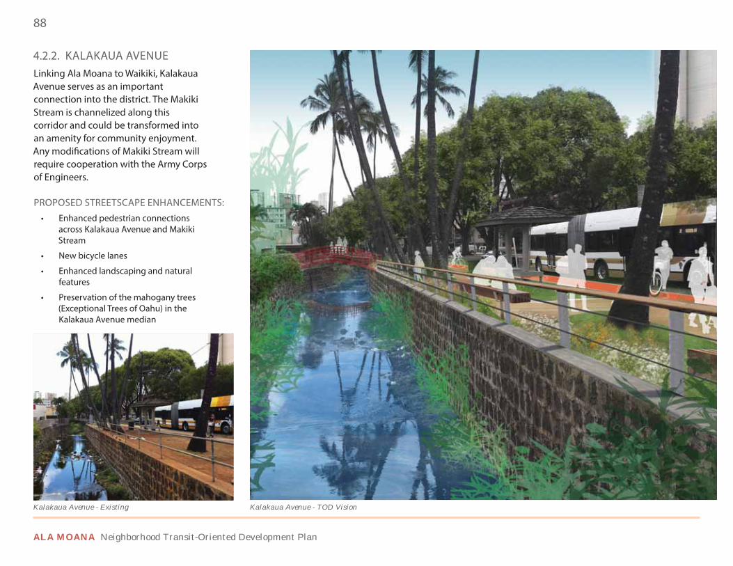
88
ALA MOANA Neighborhood Transit-Oriented Development Plan
4.2.2. KALAKAUA AVENUELinking Ala Moana to Waikiki, Kalakaua Avenue serves as an important connection into the district. The Makiki Stream is channelized along this corridor and could be transformed into an amenity for community enjoyment. Any modifications of Makiki Stream will require cooperation with the Army Corps of Engineers.
PROPOSED STREETSCAPE ENHANCEMENTS:• Enhanced pedestrian connections
across Kalakaua Avenue and Makiki Stream
• New bicycle lanes
• Enhanced landscaping and natural features
• Preservation of the mahogany trees (Exceptional Trees of Oahu) in the Kalakaua Avenue median
Kalakaua Avenue - TOD VisionKalakaua Avenue - Existing
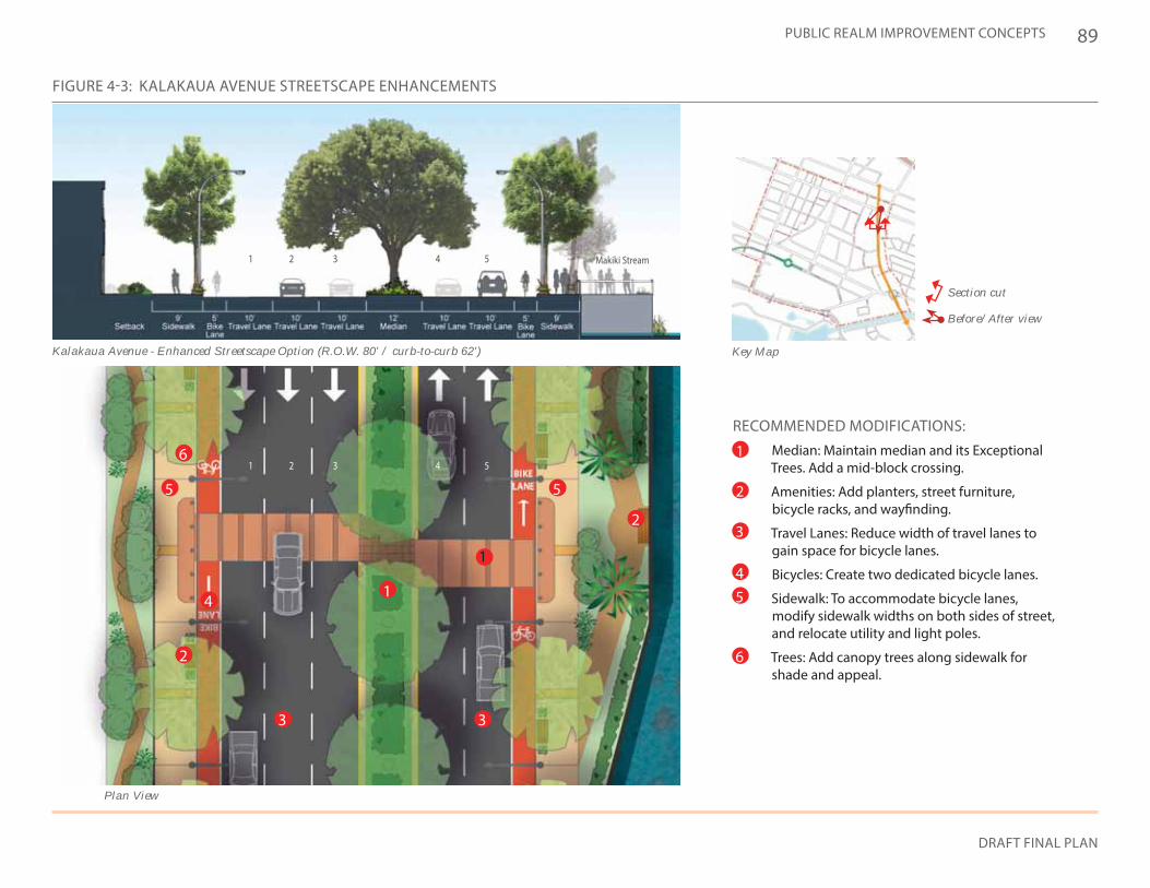
89
DRAFT FINAL PLAN
PUBLIC REALM IMPROVEMENT CONCEPTS
FIGURE 4-3: KALAKAUA AVENUE STREETSCAPE ENHANCEMENTS
Key Map
Section cut
Before/After view
Kalakaua Avenue - Enhanced Streetscape Option (R.O.W. 80' / curb-to-curb 62')
Makiki Stream
RECOMMENDED MODIFICATIONS:• Median: Maintain median and its Exceptional
Trees. Add a mid-block crossing.
• Amenities: Add planters, street furniture, bicycle racks, and wayfinding.
• Travel Lanes: Reduce width of travel lanes to gain space for bicycle lanes.
• Bicycles: Create two dedicated bicycle lanes.
• Sidewalk: To accommodate bicycle lanes, modify sidewalk widths on both sides of street, and relocate utility and light poles.
• Trees: Add canopy trees along sidewalk for shade and appeal.
1
2
45
6
3
1
1
2
2
3
3
4
4
5
5
Plan View
1
2
2
1
5 5
4
6
3 3
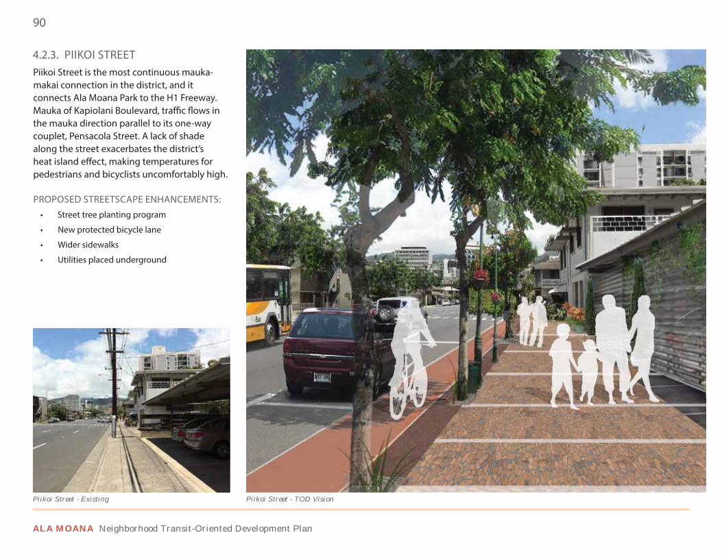
90
ALA MOANA Neighborhood Transit-Oriented Development Plan
4.2.3. PIIKOI STREETPiikoi Street is the most continuous mauka-makai connection in the district, and it connects Ala Moana Park to the H1 Freeway. Mauka of Kapiolani Boulevard, traffic flows in the mauka direction parallel to its one-way couplet, Pensacola Street. A lack of shade along the street exacerbates the district’s heat island effect, making temperatures for pedestrians and bicyclists uncomfortably high.
PROPOSED STREETSCAPE ENHANCEMENTS:• Street tree planting program
• New protected bicycle lane
• Wider sidewalks
• Utilities placed underground
Piikoi Street - TOD VisionPiikoi Street - Existing
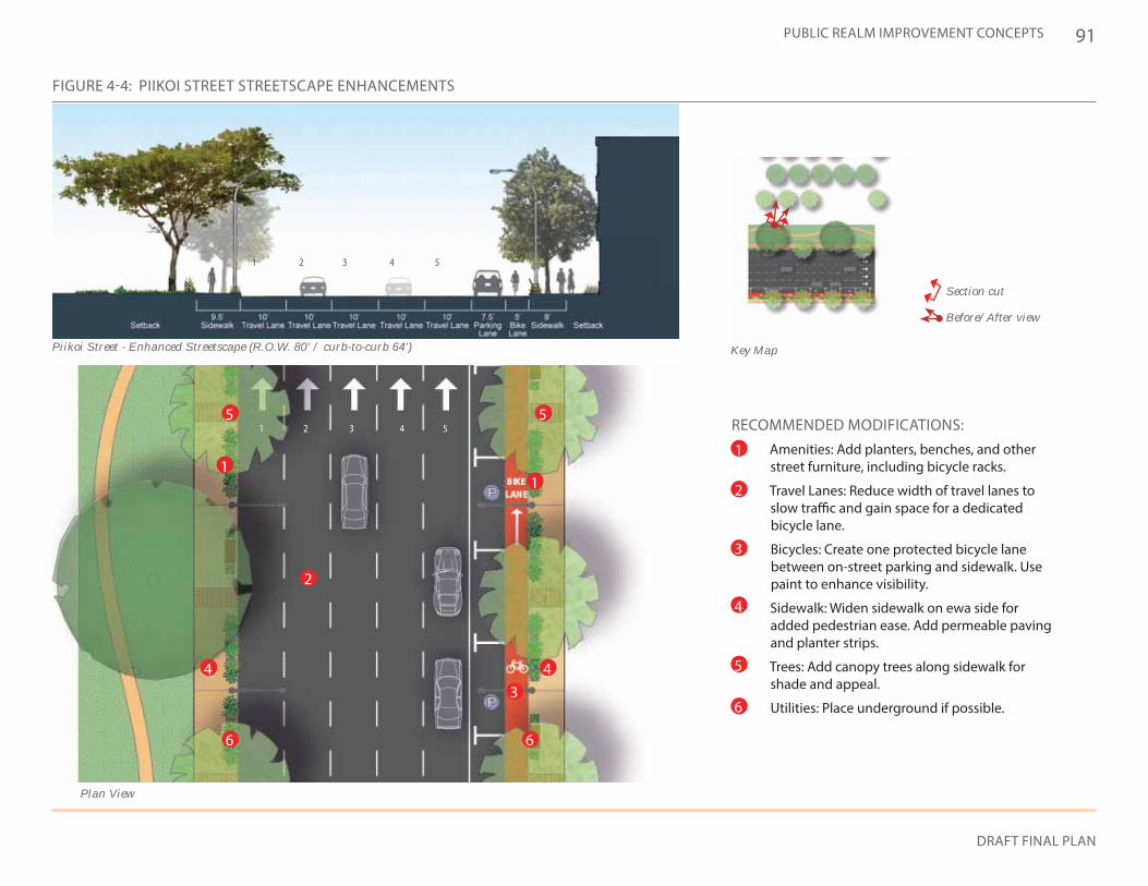
91
DRAFT FINAL PLAN
PUBLIC REALM IMPROVEMENT CONCEPTS
Key Map
Section cut
Before/After view
FIGURE 4-4: PIIKOI STREET STREETSCAPE ENHANCEMENTS
1 2 3 4 5
Piikoi Street - Enhanced Streetscape (R.O.W. 80' / curb-to-curb 64')
RECOMMENDED MODIFICATIONS:• Amenities: Add planters, benches, and other
street furniture, including bicycle racks.
• Travel Lanes: Reduce width of travel lanes to slow traffic and gain space for a dedicated bicycle lane.
• Bicycles: Create one protected bicycle lane between on-street parking and sidewalk. Use paint to enhance visibility.
• Sidewalk: Widen sidewalk on ewa side for added pedestrian ease. Add permeable paving and planter strips.
• Trees: Add canopy trees along sidewalk for shade and appeal.
• Utilities: Place underground if possible.
1
2
4
5
6
3
Plan View
1 2 3 4 5
11
2
4 4
5 5
66
3
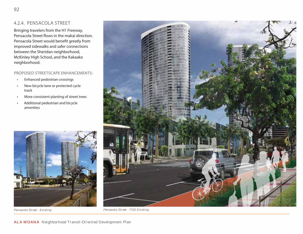
92
ALA MOANA Neighborhood Transit-Oriented Development Plan
4.2.4. PENSACOLA STREETBringing travelers from the H1 Freeway, Pensacola Street flows in the makai direction. Pensacola Street would benefit greatly from improved sidewalks and safer connections between the Sheridan neighborhood, McKinley High School, and the Kakaako neighborhood.
PROPOSED STREETSCAPE ENHANCEMENTS:• Enhanced pedestrian crossings
• New bicycle lane or protected cycle track
• More consistent planting of street trees
• Additional pedestrian and bicycle amenities
Pensacola Street - TOD ExistingPensacola Street - Existing
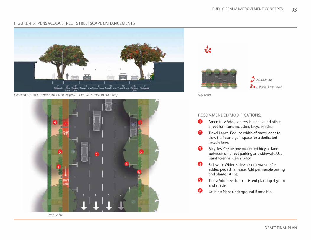
93
DRAFT FINAL PLAN
PUBLIC REALM IMPROVEMENT CONCEPTS
Key Map
Section cut
Before/After view
FIGURE 4-5: PENSACOLA STREET STREETSCAPE ENHANCEMENTS
Pensacola Street - Enhanced Streetscape (R.O.W. 78' / curb-to-curb 60')
RECOMMENDED MODIFICATIONS:• Amenities: Add planters, benches, and other
street furniture, including bicycle racks.
• Travel Lanes: Reduce width of travel lanes to slow traffic and gain space for a dedicated bicycle lane.
• Bicycles: Create one protected bicycle lane between on-street parking and sidewalk. Use paint to enhance visibility.
• Sidewalk: Widen sidewalk on ewa side for added pedestrian ease. Add permeable paving and planter strips.
• Trees: Add trees for consistent planting rhythm and shade.
• Utilities: Place underground if possible.
1
2
4
5
6
3
1
1
2
2
3
3
4
4
1
1
2 55
4
4
6
3
Plan View
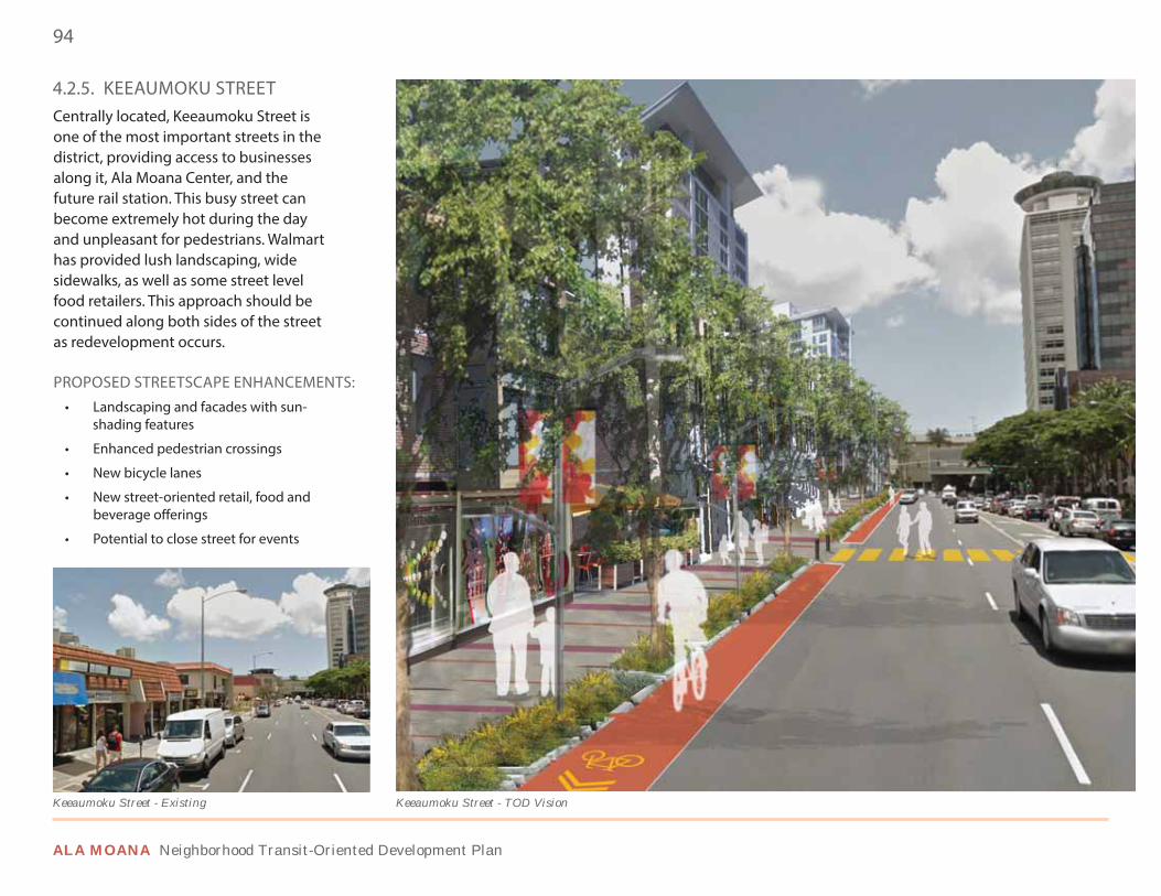
94
ALA MOANA Neighborhood Transit-Oriented Development Plan
Keeaumoku Street - TOD VisionKeeaumoku Street - Existing
4.2.5. KEEAUMOKU STREETCentrally located, Keeaumoku Street is one of the most important streets in the district, providing access to businesses along it, Ala Moana Center, and the future rail station. This busy street can become extremely hot during the day and unpleasant for pedestrians. Walmart has provided lush landscaping, wide sidewalks, as well as some street level food retailers. This approach should be continued along both sides of the street as redevelopment occurs.
PROPOSED STREETSCAPE ENHANCEMENTS:• Landscaping and facades with sun-
shading features
• Enhanced pedestrian crossings
• New bicycle lanes
• New street-oriented retail, food and beverage offerings
• Potential to close street for events
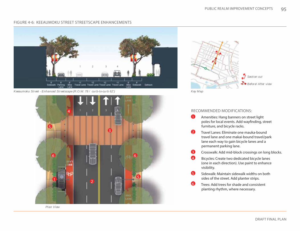
95
DRAFT FINAL PLAN
PUBLIC REALM IMPROVEMENT CONCEPTS
Key Map
Section cut
Before/After view
FIGURE 4-6: KEEAUMOKU STREET STREETSCAPE ENHANCEMENTS
Keeaumoku Street - Enhanced Streetscape (R.O.W. 78 / curb-to-curb 62')
RECOMMENDED MODIFICATIONS:• Amenities: Hang banners on street light
poles for local events. Add wayfinding, street furniture, and bicycle racks.
• Travel Lanes: Eliminate one mauka-bound travel lane and one makai-bound travel/park lane each way to gain bicycle lanes and a permanent parking lane.
• Crosswalk: Add mid-block crossings on long blocks.
• Bicycles: Create two dedicated bicycle lanes (one in each direction). Use paint to enhance visibility.
• Sidewalk: Maintain sidewalk widths on both sides of the street. Add planter strips.
• Trees: Add trees for shade and consistent planting rhythm, where necessary.
1
2
4
5
6
3
1
1
2
2
3
3
4
4
Plan View
1 2
5
5
66
4
3
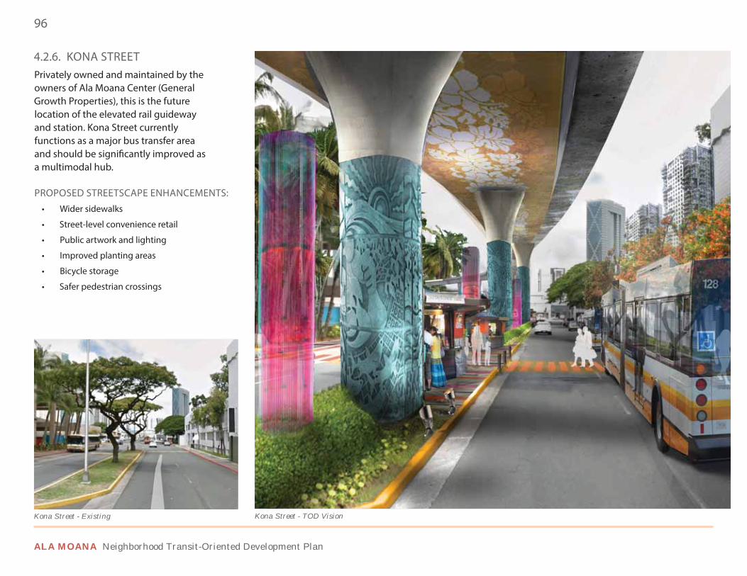
96
ALA MOANA Neighborhood Transit-Oriented Development Plan
4.2.6. KONA STREETPrivately owned and maintained by the owners of Ala Moana Center (General Growth Properties), this is the future location of the elevated rail guideway and station. Kona Street currently functions as a major bus transfer area and should be significantly improved as a multimodal hub.
PROPOSED STREETSCAPE ENHANCEMENTS:• Wider sidewalks
• Street-level convenience retail
• Public artwork and lighting
• Improved planting areas
• Bicycle storage
• Safer pedestrian crossings
Kona Street - TOD VisionKona Street - Existing
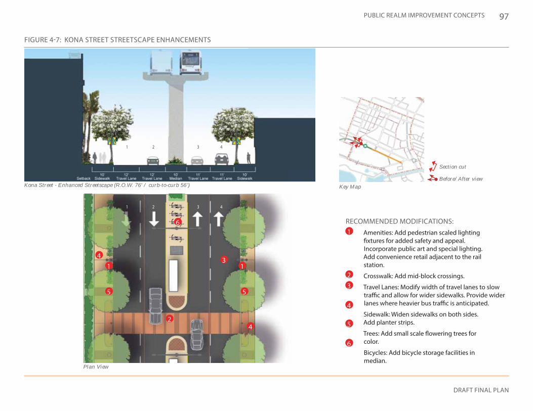
97
DRAFT FINAL PLAN
PUBLIC REALM IMPROVEMENT CONCEPTS
Key Map
Section cut
Before/After view
FIGURE 4-7: KONA STREET STREETSCAPE ENHANCEMENTS
Kona Street - Enhanced Streetscape (R.O.W. 76' / curb-to-curb 56')
RECOMMENDED MODIFICATIONS:• Amenities: Add pedestrian scaled lighting
fixtures for added safety and appeal. Incorporate public art and special lighting. Add convenience retail adjacent to the rail station.
• Crosswalk: Add mid-block crossings.
• Travel Lanes: Modify width of travel lanes to slow traffic and allow for wider sidewalks. Provide wider lanes where heavier bus traffic is anticipated.
• Sidewalk: Widen sidewalks on both sides. Add planter strips.
• Trees: Add small scale flowering trees for color.
• Bicycles: Add bicycle storage facilities in median.
1
23
4
5
6
1
1
2
2
3
3
4
4
Plan View
1 1
2
6
4
4
3
5 5
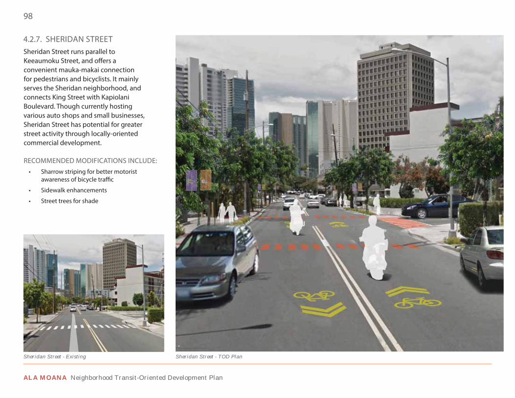
98
ALA MOANA Neighborhood Transit-Oriented Development Plan
4.2.7. SHERIDAN STREETSheridan Street runs parallel to Keeaumoku Street, and offers a convenient mauka-makai connection for pedestrians and bicyclists. It mainly serves the Sheridan neighborhood, and connects King Street with Kapiolani Boulevard. Though currently hosting various auto shops and small businesses, Sheridan Street has potential for greater street activity through locally-oriented commercial development.
RECOMMENDED MODIFICATIONS INCLUDE:• Sharrow striping for better motorist
awareness of bicycle traffic
• Sidewalk enhancements
• Street trees for shade
Sheridan Street - TOD PlanSheridan Street - Existing
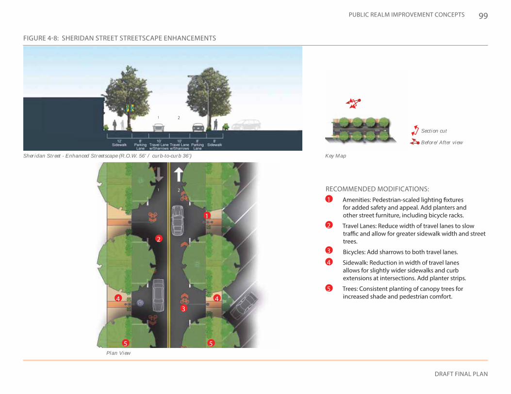
99
DRAFT FINAL PLAN
PUBLIC REALM IMPROVEMENT CONCEPTS
Key Map
Section cut
Before/After view
FIGURE 4-8: SHERIDAN STREET STREETSCAPE ENHANCEMENTS
Sheridan Street - Enhanced Streetscape (R.O.W. 56' / curb-to-curb 36')
RECOMMENDED MODIFICATIONS:• Amenities: Pedestrian-scaled lighting fixtures
for added safety and appeal. Add planters and other street furniture, including bicycle racks.
• Travel Lanes: Reduce width of travel lanes to slow traffic and allow for greater sidewalk width and street trees.
• Bicycles: Add sharrows to both travel lanes.
• Sidewalk: Reduction in width of travel lanes allows for slightly wider sidewalks and curb extensions at intersections. Add planter strips.
• Trees: Consistent planting of canopy trees for increased shade and pedestrian comfort.
1
2
3
4
5
Plan View
1
1
2
2
1
2
34 4
55
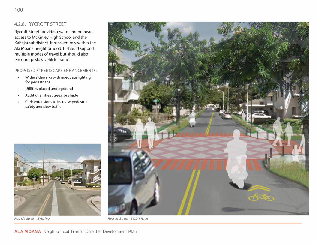
100
ALA MOANA Neighborhood Transit-Oriented Development Plan
4.2.8. RYCROFT STREETRycroft Street provides ewa-diamond head access to McKinley High School and the Kaheka subdistrict. It runs entirely within the Ala Moana neighborhood. It should support multiple modes of travel but should also encourage slow vehicle traffic.
PROPOSED STREETSCAPE ENHANCEMENTS:• Wider sidewalks with adequate lighting
for pedestrians
• Utilities placed underground
• Additional street trees for shade
• Curb extensions to increase pedestrian safety and slow traffic
Rycroft Street - TOD VisionRycroft Street - Existing
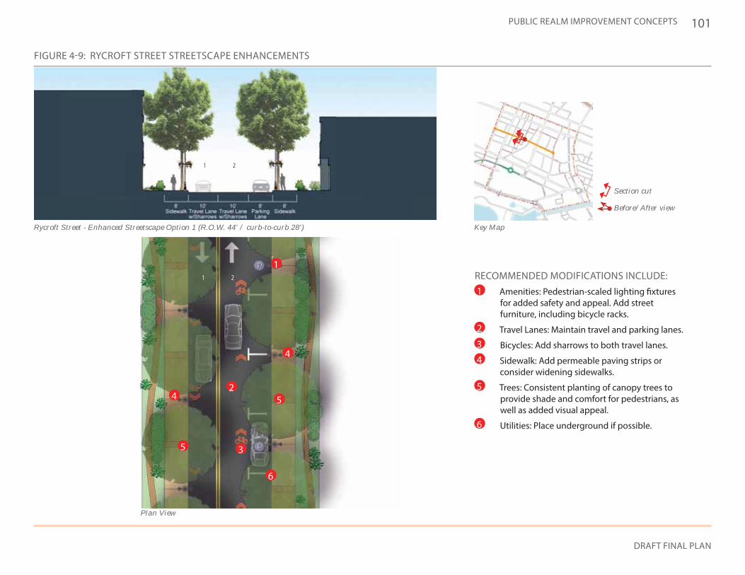
101
DRAFT FINAL PLAN
PUBLIC REALM IMPROVEMENT CONCEPTS
Key Map
Section cut
Before/After view
FIGURE 4-9: RYCROFT STREET STREETSCAPE ENHANCEMENTS
Rycroft Street - Enhanced Streetscape Option 1 (R.O.W. 44' / curb-to-curb 28')
1 2
RECOMMENDED MODIFICATIONS INCLUDE:• Amenities: Pedestrian-scaled lighting fixtures
for added safety and appeal. Add street furniture, including bicycle racks.
• Travel Lanes: Maintain travel and parking lanes.
• Bicycles: Add sharrows to both travel lanes.
• Sidewalk: Add permeable paving strips or consider widening sidewalks.
• Trees: Consistent planting of canopy trees to provide shade and comfort for pedestrians, as well as added visual appeal.
• Utilities: Place underground if possible.
1
2
3
4
5
6
Plan View
1 2
1
2
3
4
4
6
5
5
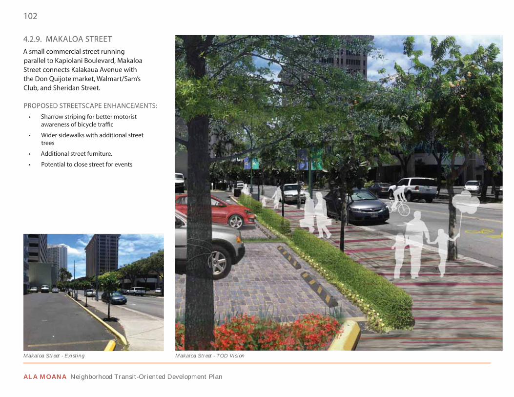
102
ALA MOANA Neighborhood Transit-Oriented Development Plan
4.2.9. MAKALOA STREETA small commercial street running parallel to Kapiolani Boulevard, Makaloa Street connects Kalakaua Avenue with the Don Quijote market, Walmart/Sam’s Club, and Sheridan Street.
PROPOSED STREETSCAPE ENHANCEMENTS:• Sharrow striping for better motorist
awareness of bicycle traffic
• Wider sidewalks with additional street trees
• Additional street furniture.
• Potential to close street for events
Makaloa Street - TOD VisionMakaloa Street - Existing
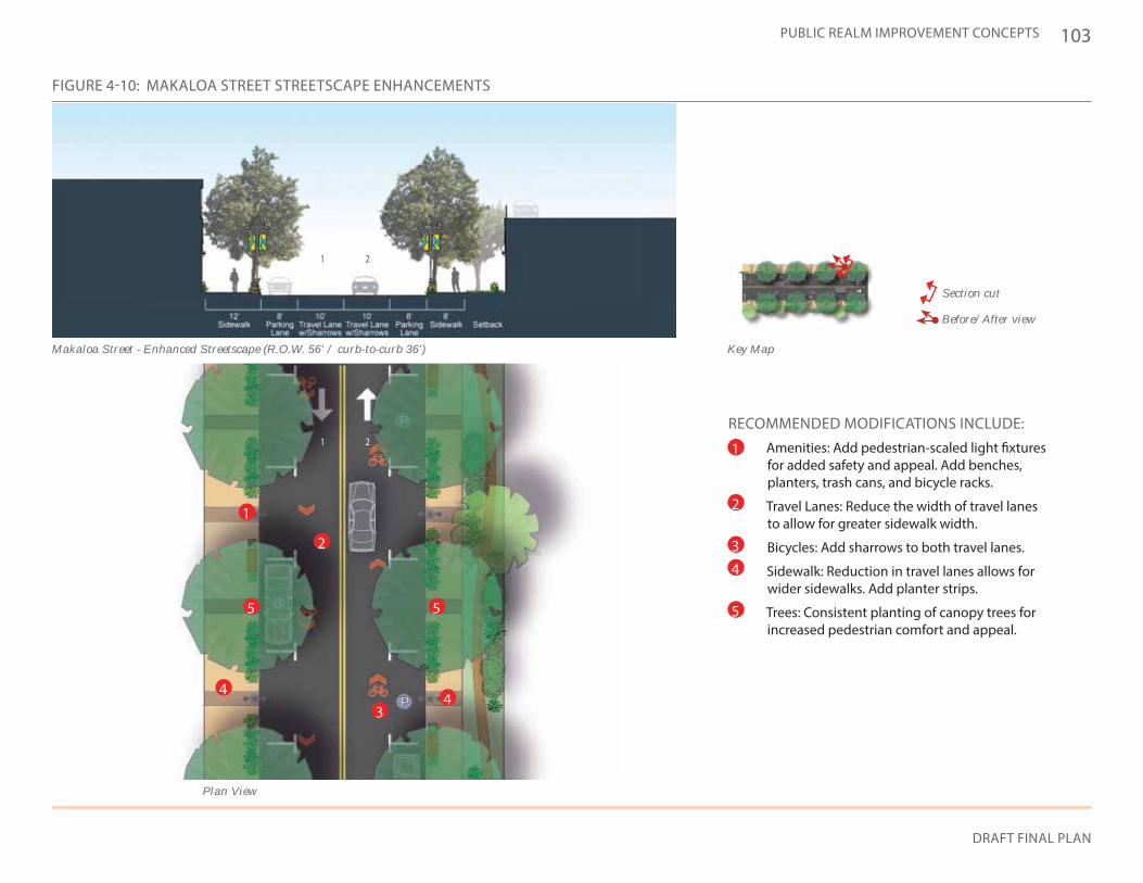
103
DRAFT FINAL PLAN
PUBLIC REALM IMPROVEMENT CONCEPTS
FIGURE 4-10: MAKALOA STREET STREETSCAPE ENHANCEMENTS
Key Map
Section cut
Before/After view
Makaloa Street - Enhanced Streetscape (R.O.W. 56' / curb-to-curb 36')
RECOMMENDED MODIFICATIONS INCLUDE:• Amenities: Add pedestrian-scaled light fixtures
for added safety and appeal. Add benches, planters, trash cans, and bicycle racks.
• Travel Lanes: Reduce the width of travel lanes to allow for greater sidewalk width.
• Bicycles: Add sharrows to both travel lanes.
• Sidewalk: Reduction in travel lanes allows for wider sidewalks. Add planter strips.
• Trees: Consistent planting of canopy trees for increased pedestrian comfort and appeal.
1
2
34
5
Plan View
1
1
2
2
1
2
34
4
5 5

104
ALA MOANA Neighborhood Transit-Oriented Development Plan
Street View
ALA MOANA BLVD
Roadway Geometry - Existing
KEY FEATURES:• Additional crosswalk
• Shortened crossing distances
• Reduced turning radii at all corners
• Eliminated free right hand turns
Roadway Geometry - TOD Plan Recommendation
4.3 INTERSECTION CONCEPTS
Several key intersections deserve special attention in order to improve the non-vehicular connectivity and safety of the Ala Moana district. In addition to new pedestrian design elements and improved roadway geometry, elevated crossings are explored where pedestrian and automobile conflicts warrant grade separation, and where there are destinations at the elevated level.
4.3.1. ALA MOANA BOULEVARD & ATKINSON DRIVE (OPTION 1)This important intersection handles significant vehicular and pedestrian traffic along Ala Moana Boulevard, a state right of way. Decreasing the turning radii and reducing crosswalk lengths will maintain traffic flow while improving pedestrian and bicycle safety.
26’
ALA MOANA BLVD
ATKINSON DRATKINSON DR
BEFORE AAFFFTTTEEERRR
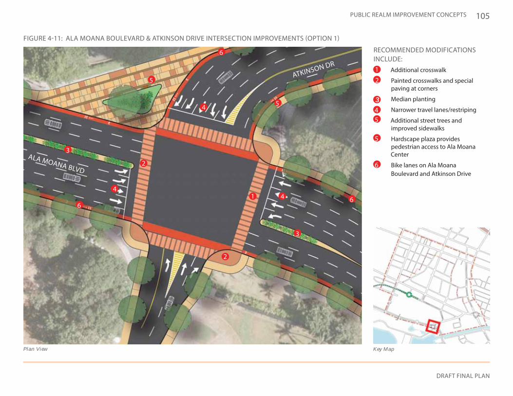
105
DRAFT FINAL PLAN
PUBLIC REALM IMPROVEMENT CONCEPTS
Key Map
RECOMMENDED MODIFICATIONS INCLUDE:
• Additional crosswalk
• Painted crosswalks and special paving at corners
• Median planting
• Narrower travel lanes/restriping
• Additional street trees and improved sidewalks
• Hardscape plaza provides pedestrian access to Ala Moana Center
• Bike lanes on Ala Moana Boulevard and Atkinson Drive
ATKINSON DR
Plan View
FIGURE 4-11: ALA MOANA BOULEVARD & ATKINSON DRIVE INTERSECTION IMPROVEMENTS (OPTION 1)
ALA MOANA BLVD
1
1
2
2
2
3
3
45
5
5
6
66
6
5
4
4
4
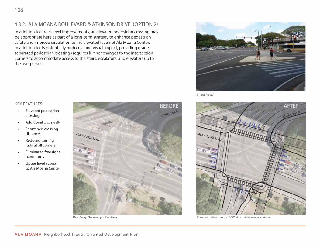
106
ALA MOANA Neighborhood Transit-Oriented Development Plan
4.3.2. ALA MOANA BOULEVARD & ATKINSON DRIVE (OPTION 2)In addition to street-level improvements, an elevated pedestrian crossing may be appropriate here as part of a long-term strategy to enhance pedestrian safety and improve circulation to the elevated levels of Ala Moana Center. In addition to its potentially high cost and visual impact, providing grade-separated pedestrian crossings requires further changes to the intersection corners to accommodate access to the stairs, escalators, and elevators up to the overpasses.
Street View
ALA MOANA BLVD
ALA MOANA BLVD
Roadway Geometry - Existing Roadway Geometry - TOD Plan Recommendation
26’
KEY FEATURES:• Elevated pedestrian
crossing
• Additional crosswalk
• Shortened crossing distances
• Reduced turning radii at all corners
• Eliminated free right hand turns
• Upper level access to Ala Moana Center
ATKINSON DRATKINSON DR
BEFORE AAFFFTTTEEERRR
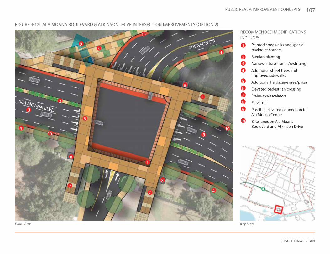
107
DRAFT FINAL PLAN
PUBLIC REALM IMPROVEMENT CONCEPTS
RECOMMENDED MODIFICATIONS INCLUDE:
• Painted crosswalks and special paving at corners
• Median planting
• Narrower travel lanes/restriping
• Additional street trees and improved sidewalks
• Additional hardscape area/plaza
• Elevated pedestrian crossing
• Stairways/escalators
• Elevators
• Possible elevated connection to Ala Moana Center
• Bike lanes on Ala Moana Boulevard and Atkinson Drive
FIGURE 4-12: ALA MOANA BOULEVARD & ATKINSON DRIVE INTERSECTION IMPROVEMENTS (OPTION 2)
Key MapPlan View
ALA MOANA BLVD
ATKINSON DR1
1
2
2
4
3
4
4
4
5
5
6
6
77
77
8
9
10
1010
10
9
8
8
8
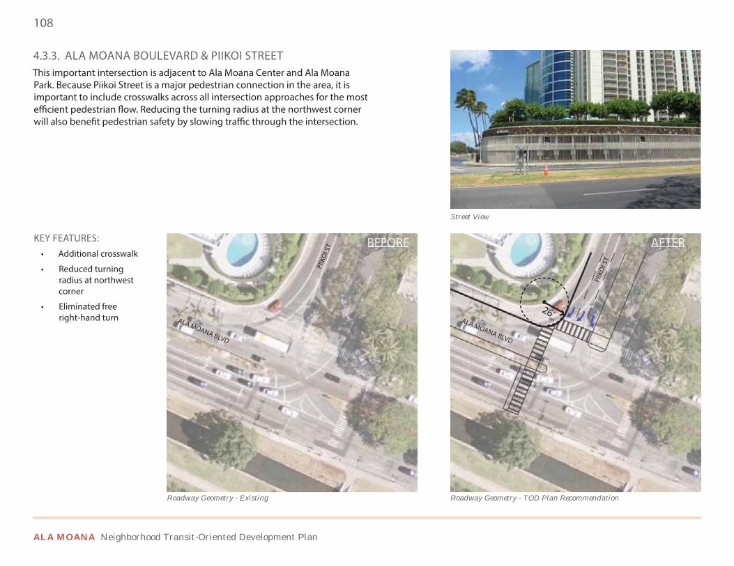
108
ALA MOANA Neighborhood Transit-Oriented Development Plan
4.3.3. ALA MOANA BOULEVARD & PIIKOI STREETThis important intersection is adjacent to Ala Moana Center and Ala Moana Park. Because Piikoi Street is a major pedestrian connection in the area, it is important to include crosswalks across all intersection approaches for the most efficient pedestrian flow. Reducing the turning radius at the northwest corner will also benefit pedestrian safety by slowing traffic through the intersection.
STREET VIEW
ALA MOANA BLVD
Roadway Geometry - Existing
KEY FEATURES:• Additional crosswalk
• Reduced turning radius at northwest corner
• Eliminated free right-hand turn ALA MOANA BLVD
PIIK
OI S
T
PIIK
OI S
T
Roadway Geometry - TOD Plan Recommendation
Street View
26’
BEFOORE AFTEER
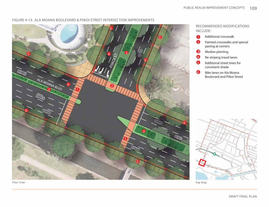
109
DRAFT FINAL PLAN
PUBLIC REALM IMPROVEMENT CONCEPTS
ALA MOANA BLVD
RECOMMENDED MODIFICATIONS INCLUDE:
• Additional crosswalk
• Painted crosswalks and special paving at corners
• Median planting
• Re-striping travel lanes
• Additional street trees for consistent shade
• Bike lanes on Ala Moana Boulevard and Piikoi Street
PIIK
OI S
T
FIGURE 4-13: ALA MOANA BOULEVARD & PIIKOI STREET INTERSECTION IMPROVEMENTS
Key MapPlan View
1
1
2
2
2
3
3
3
44
4
5
6
6
6
6
6
5
5
5
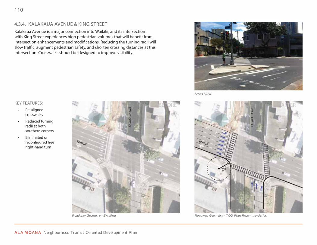
110
ALA MOANA Neighborhood Transit-Oriented Development Plan
4.3.4. KALAKAUA AVENUE & KING STREETKalakaua Avenue is a major connection into Waikiki, and its intersection with King Street experiences high pedestrian volumes that will benefit from intersection enhancements and modifications. Reducing the turning radii will slow traffic, augment pedestrian safety, and shorten crossing distances at this intersection. Crosswalks should be designed to improve visibility.
KALA
KAU
A A
VE
Roadway Geometry - Existing
KEY FEATURES:• Re-aligned
crosswalks
• Reduced turning radii at both southern corners
• Eliminated or reconfigured free right-hand turn
Street View
KING STKING ST
KALA
KAU
A A
VE
Roadway Geometry - TOD Plan Recommendation
26’
BEFORE AFTER
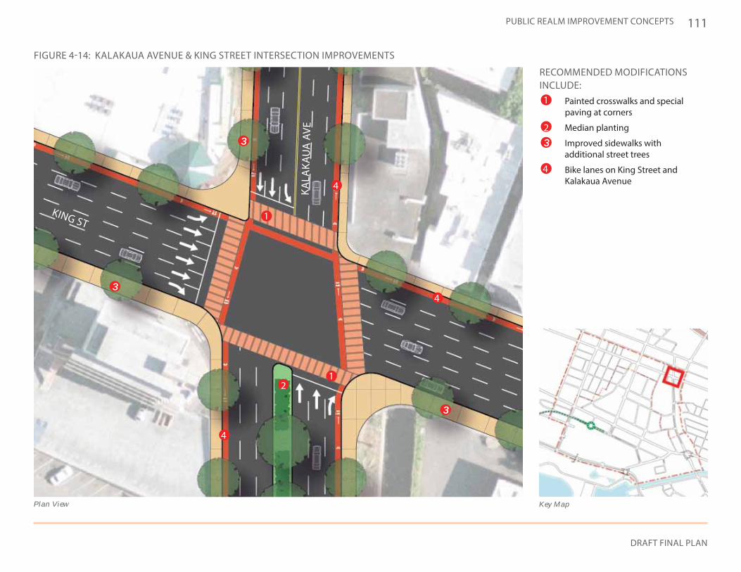
111
DRAFT FINAL PLAN
PUBLIC REALM IMPROVEMENT CONCEPTS
RECOMMENDED MODIFICATIONS INCLUDE:
• Painted crosswalks and special paving at corners
• Median planting
• Improved sidewalks with additional street trees
• Bike lanes on King Street and Kalakaua Avenue
KING ST
KALA
KAU
A A
VE
FIGURE 4-14: KALAKAUA AVENUE & KING STREET INTERSECTION IMPROVEMENTS
Key MapPlan View
1
1
1
2
2
4
4
4
4
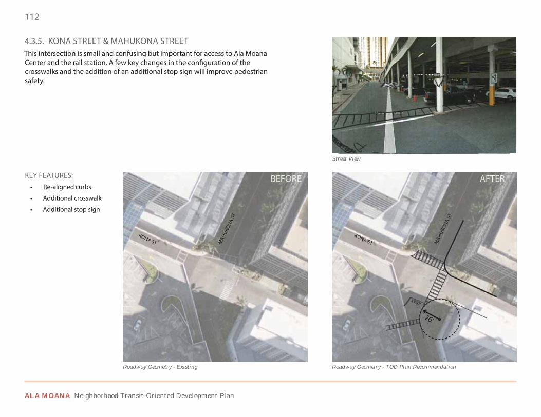
112
ALA MOANA Neighborhood Transit-Oriented Development Plan
4.3.5. KONA STREET & MAHUKONA STREETThis intersection is small and confusing but important for access to Ala Moana Center and the rail station. A few key changes in the configuration of the crosswalks and the addition of an additional stop sign will improve pedestrian safety.
Street View
KEY FEATURES:• Re-aligned curbs
• Additional crosswalk
• Additional stop sign
KONA STKONA ST M
AHUK
ON
A ST
MAH
UKO
NA
ST
Roadway Geometry - TOD Plan RecommendationRoadway Geometry - Existing
26’
BEFORE AFTER
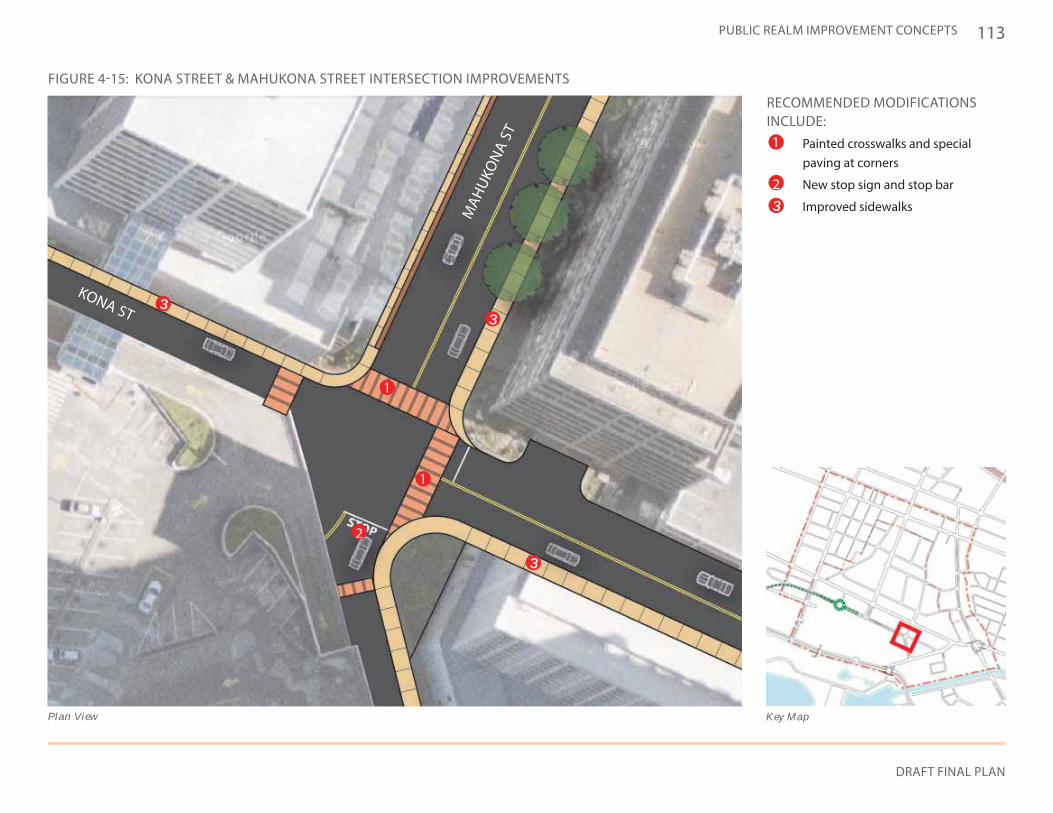
113
DRAFT FINAL PLAN
PUBLIC REALM IMPROVEMENT CONCEPTS
KONA ST
MAH
UKO
NA
ST
FIGURE 4-15: KONA STREET & MAHUKONA STREET INTERSECTION IMPROVEMENTS
Key MapPlan View
RECOMMENDED MODIFICATIONS INCLUDE:
• Painted crosswalks and special paving at corners
• New stop sign and stop bar
• Improved sidewalks
1
1
1
2
2
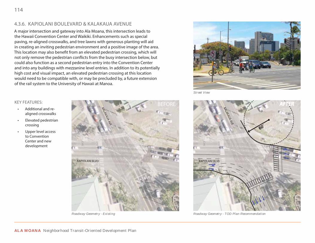
114
ALA MOANA Neighborhood Transit-Oriented Development Plan
4.3.6. KAPIOLANI BOULEVARD & KALAKAUA AVENUE A major intersection and gateway into Ala Moana, this intersection leads to the Hawaii Convention Center and Waikiki. Enhancements such as special paving, re-aligned crosswalks, and tree lawns with generous planting will aid in creating an inviting pedestrian environment and a positive image of the area. This location may also benefit from an elevated pedestrian crossing, which will not only remove the pedestrian conflicts from the busy intersection below, but could also function as a second pedestrian entry into the Convention Center and into any buildings with mezzanine level entries. In addition to its potentially high cost and visual impact, an elevated pedestrian crossing at this location would need to be compatible with, or may be precluded by, a future extension of the rail system to the University of Hawaii at Manoa.
KAPIOLANI BLVD
KALAKAUA AVE
Roadway Geometry - Existing
KEY FEATURES:• Additional and re-
aligned crosswalks
• Elevated pedestrian crossing
• Upper level access to Convention Center and new development
KAPIOLANI BLVD
KALAKAUA AVE
Roadway Geometry - TOD Plan Recommendation
Street View
60’
BEFORE AFTER
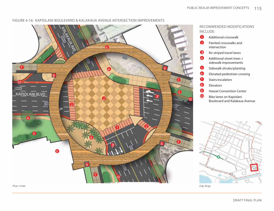
115
DRAFT FINAL PLAN
PUBLIC REALM IMPROVEMENT CONCEPTS
RECOMMENDED MODIFICATIONS INCLUDE:
• Additional crosswalk
• Painted crosswalks and intersection
• Re-striped travel lanes
• Additional street trees + sidewalk improvements
• Sidewalk shrubs/planting
• Elevated pedestrian crossing
• Stairs/escalators
• Elevators
• Hawaii Convention Center
• Bike lanes on Kapiolani Boulevard and Kalakaua Avenue
KAPIOLANI BLVD
KALAKAUA AVE
FIGURE 4-16: KAPIOLANI BOULEVARD & KALAKAUA AVENUE INTERSECTION IMPROVEMENTS
Key MapPlan View
1
1
2
2
2
2
4
4
4
4 5
5
5
6
6
7
7
7
7
78
8
8
8
8
9
9
1010
10
10
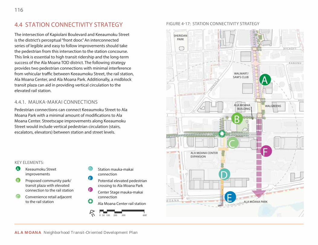
116
ALA MOANA Neighborhood Transit-Oriented Development Plan
KEY ELEMENTS:• Keeaumoku Street
improvements
• Proposed community park/ transit plaza with elevated connection to the rail station
• Convenience retail adjacent to the rail station
• Station mauka-makai connection
• Potential elevated pedestrian crossing to Ala Moana Park
• Center Stage mauka-makai connection
• Ala Moana Center rail station
4.4 STATION CONNECTIVITY STRATEGYThe intersection of Kapiolani Boulevard and Keeaumoku Street is the district’s perceptual “front door.” An interconnected series of legible and easy to follow improvements should take the pedestrian from this intersection to the station concourse. This link is essential to high transit ridership and the long-term success of the Ala Moana TOD district. The following strategy provides two pedestrian connections with minimal interference from vehicular traffic between Keeaumoku Street, the rail station, Ala Moana Center, and Ala Moana Park. Additionally, a midblock transit plaza can aid in providing vertical circulation to the elevated rail station.
4.4.1. MAUKA-MAKAI CONNECTIONSPedestrian connections can connect Keeaumoku Street to Ala Moana Park with a minimal amount of modifications to Ala Moana Center. Streetscape improvements along Keeaumoku Street would include vertical pedestrian circulation (stairs, escalators, elevators) between station and street levels.
FIGURE 4-17: STATION CONNECTIVITY STRATEGY
n 0 50 100 200 300 600’
B
A
C
E
SHERIDANPARK
WALGREENSALA MOANA BUILDING
WALMART/SAM’S CLUB
ALA MOANA CENTER EXPANSION
ALA MOANA PARK
F
DB
A
C
D
E
F
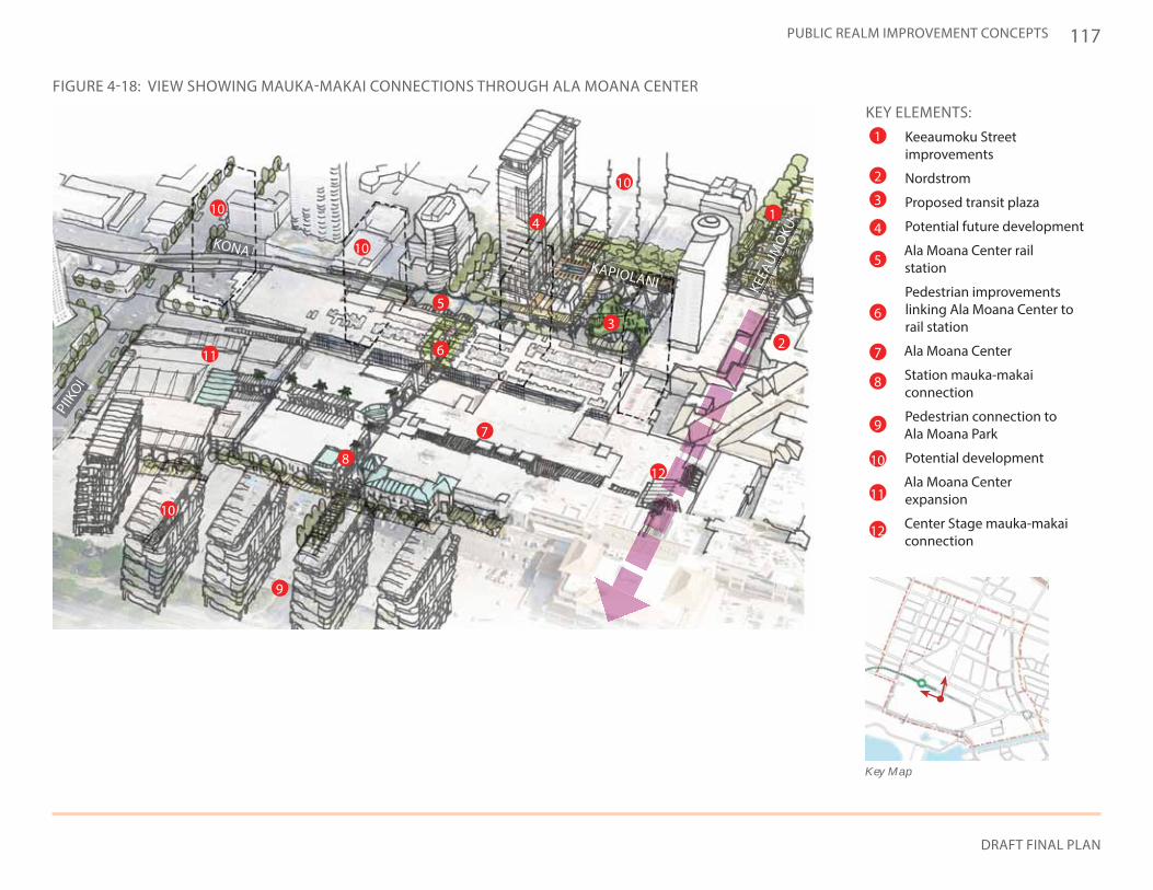
117
DRAFT FINAL PLAN
PUBLIC REALM IMPROVEMENT CONCEPTS
KEY ELEMENTS:• Keeaumoku Street
improvements
• Nordstrom
• Proposed transit plaza
• Potential future development
• Ala Moana Center rail station
• Pedestrian improvements linking Ala Moana Center to rail station
• Ala Moana Center
• Station mauka-makai connection
• Pedestrian connection to Ala Moana Park
• Potential development
• Ala Moana Center expansion
• Center Stage mauka-makai connection
FIGURE 4-18: VIEW SHOWING MAUKA-MAKAI CONNECTIONS THROUGH ALA MOANA CENTER
2
KONA
KEEA
UMO
KU
PIIK
OI
KAPIOLANI
3
41
5
6
9
7
8
10
10
10
10
11
12
1
2
3
4
5
6
7
8
9
10
11
12
Key Map
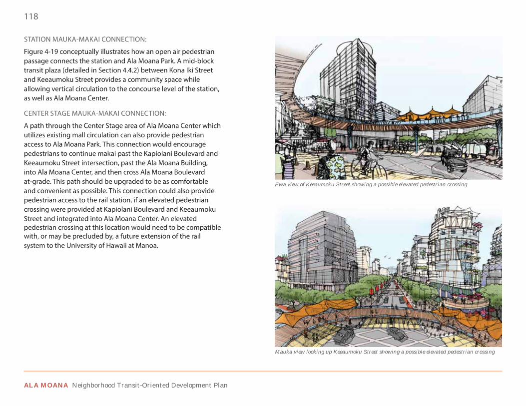
118
ALA MOANA Neighborhood Transit-Oriented Development Plan
Mauka view looking up Keeaumoku Street showing a possible elevated pedestrian crossing
Ewa view of Keeaumoku Street showing a possible elevated pedestrian crossing
STATION MAUKA-MAKAI CONNECTION:
Figure 4-19 conceptually illustrates how an open air pedestrian passage connects the station and Ala Moana Park. A mid-block transit plaza (detailed in Section 4.4.2) between Kona Iki Street and Keeaumoku Street provides a community space while allowing vertical circulation to the concourse level of the station, as well as Ala Moana Center.
CENTER STAGE MAUKA-MAKAI CONNECTION:
A path through the Center Stage area of Ala Moana Center which utilizes existing mall circulation can also provide pedestrian access to Ala Moana Park. This connection would encourage pedestrians to continue makai past the Kapiolani Boulevard and Keeaumoku Street intersection, past the Ala Moana Building, into Ala Moana Center, and then cross Ala Moana Boulevard at-grade. This path should be upgraded to be as comfortable and convenient as possible. This connection could also provide pedestrian access to the rail station, if an elevated pedestrian crossing were provided at Kapiolani Boulevard and Keeaumoku Street and integrated into Ala Moana Center. An elevated pedestrian crossing at this location would need to be compatible with, or may be precluded by, a future extension of the rail system to the University of Hawaii at Manoa.
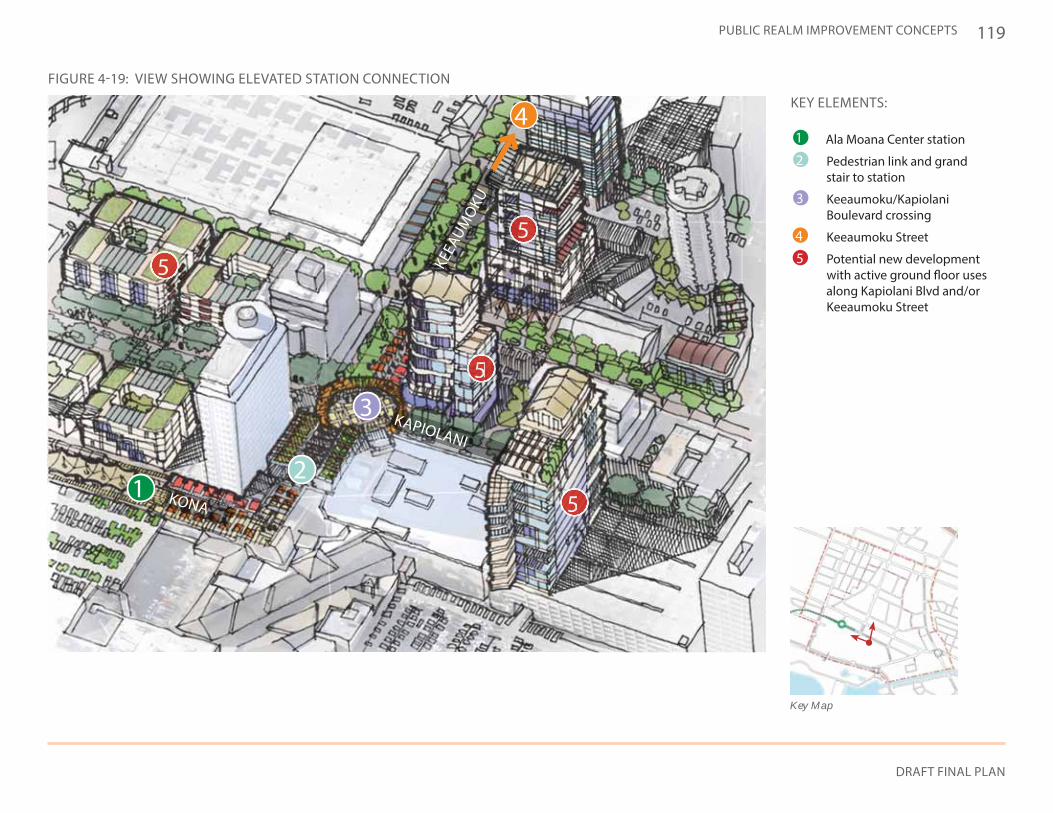
119
DRAFT FINAL PLAN
PUBLIC REALM IMPROVEMENT CONCEPTS
4
3
21
KEEA
UMO
KU
KAPIOLANI
KONA
5555555
5555
555
5555555
KEY ELEMENTS:
• Ala Moana Center station
• Pedestrian link and grand stair to station
• Keeaumoku/Kapiolani Boulevard crossing
• Keeaumoku Street
• Potential new development with active ground floor uses along Kapiolani Blvd and/or Keeaumoku Street
Key Map
FIGURE 4-19: VIEW SHOWING ELEVATED STATION CONNECTION
1
2
3
4
5
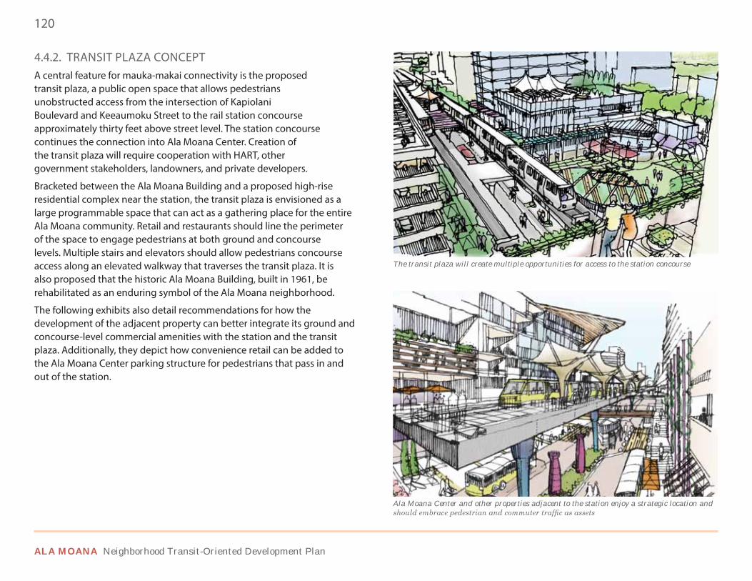
120
ALA MOANA Neighborhood Transit-Oriented Development Plan
4.4.2. TRANSIT PLAZA CONCEPT A central feature for mauka-makai connectivity is the proposed transit plaza, a public open space that allows pedestrians unobstructed access from the intersection of Kapiolani Boulevard and Keeaumoku Street to the rail station concourse approximately thirty feet above street level. The station concourse continues the connection into Ala Moana Center. Creation of the transit plaza will require cooperation with HART, other government stakeholders, landowners, and private developers.
Bracketed between the Ala Moana Building and a proposed high-rise residential complex near the station, the transit plaza is envisioned as a large programmable space that can act as a gathering place for the entire Ala Moana community. Retail and restaurants should line the perimeter of the space to engage pedestrians at both ground and concourse levels. Multiple stairs and elevators should allow pedestrians concourse access along an elevated walkway that traverses the transit plaza. It is also proposed that the historic Ala Moana Building, built in 1961, be rehabilitated as an enduring symbol of the Ala Moana neighborhood.
The following exhibits also detail recommendations for how the development of the adjacent property can better integrate its ground and concourse-level commercial amenities with the station and the transit plaza. Additionally, they depict how convenience retail can be added to the Ala Moana Center parking structure for pedestrians that pass in and out of the station.
The transit plaza will create multiple opportunities for access to the station concourse
Ala Moana Center and other properties adjacent to the station enjoy a strategic location and
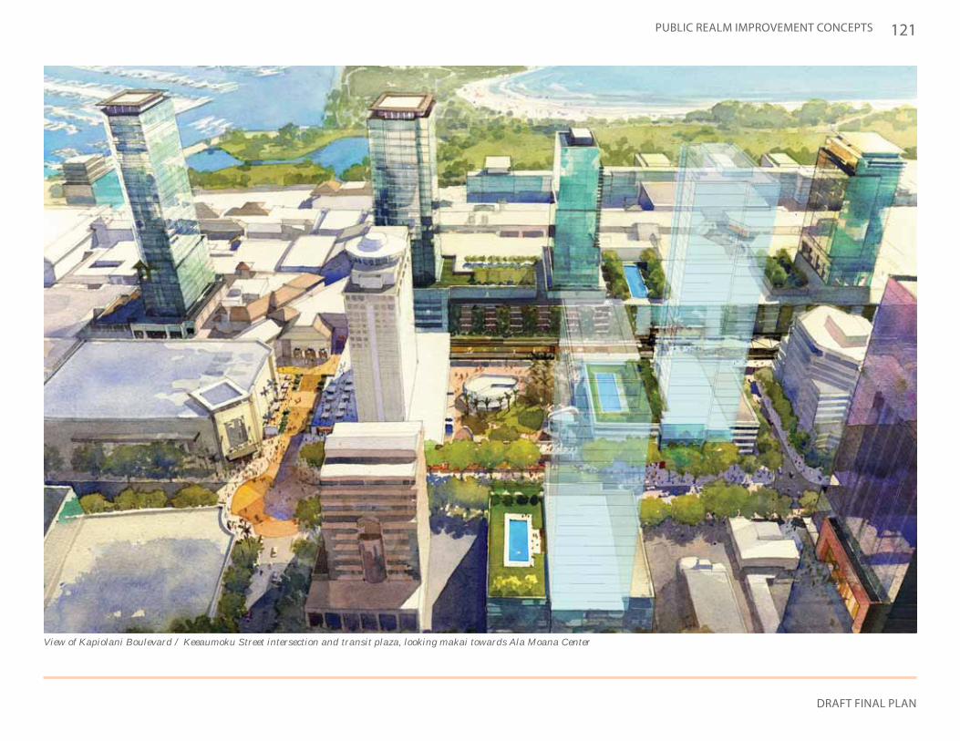
121
DRAFT FINAL PLAN
PUBLIC REALM IMPROVEMENT CONCEPTS
View of Kapiolani Boulevard / Keeaumoku Street intersection and transit plaza, looking makai towards Ala Moana Center
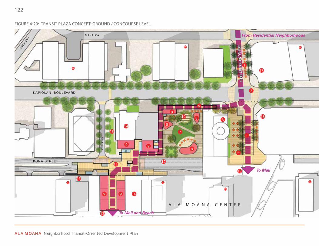
122
ALA MOANA Neighborhood Transit-Oriented Development Plan
KAPIOLANI BOULEVARD
MAKALOA
S
HER
IDA
N
KONA STREET
KO
NA
IK
I
KE
EA
UM
OK
U S
TR
EE
T
To Mall and Beach
To Mall
From Residential Neighborhoods
2
1
3
4
5
6
7
8
8
8
8
9
9 9
9
10
1112
13
13
14
15
15
18
19
19
1919
19
19 19
17
16
FIGURE 4-20: TRANSIT PLAZA CONCEPT: GROUND / CONCOURSE LEVEL
A L A M O A N A C E N T E R
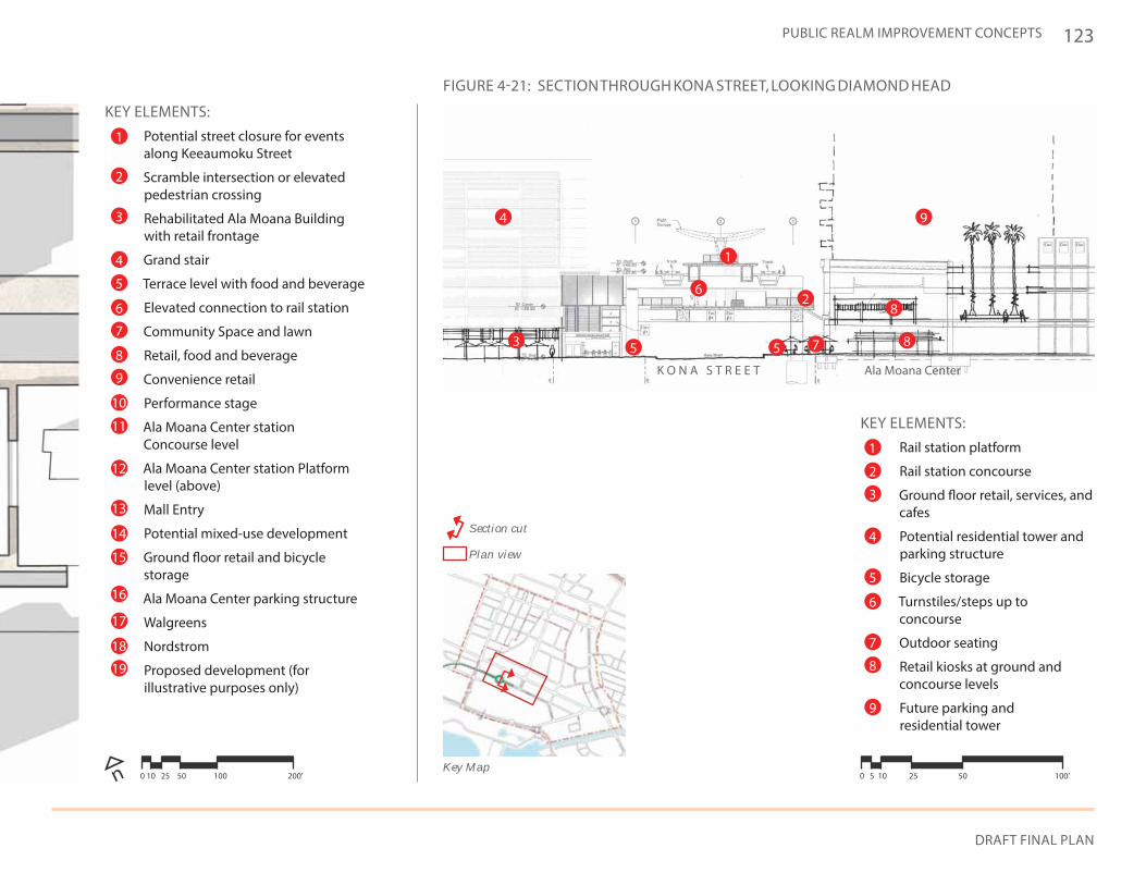
123
DRAFT FINAL PLAN
PUBLIC REALM IMPROVEMENT CONCEPTS
KEY ELEMENTS:• Potential street closure for events
along Keeaumoku Street
• Scramble intersection or elevated pedestrian crossing
• Rehabilitated Ala Moana Building with retail frontage
• Grand stair
• Terrace level with food and beverage
• Elevated connection to rail station
• Community Space and lawn
• Retail, food and beverage
• Convenience retail
• Performance stage
• Ala Moana Center station Concourse level
• Ala Moana Center station Platform level (above)
• Mall Entry
• Potential mixed-use development
• Ground floor retail and bicycle storage
• Ala Moana Center parking structure
• Walgreens
• Nordstrom
• Proposed development (for illustrative purposes only)
2
1
3
4
5
6
7
8
9
10
11
12
13
14
15
17
18
19
16
n 0 10 25 50 100 200’
FIGURE 4-21: SECTION THROUGH KONA STREET, LOOKING DIAMOND HEAD
KEY ELEMENTS:• Rail station platform
• Rail station concourse
• Ground floor retail, services, and cafes
• Potential residential tower and parking structure
• Bicycle storage
• Turnstiles/steps up to concourse
• Outdoor seating
• Retail kiosks at ground and concourse levels
• Future parking and residential tower
Key Map
Section cut
Plan view
K O N A S T R E E T Ala Moana Center
1
1
2
2
3
3
4
4
5
5 5
6
6
7
7
8
8
8
9
9
0 5 10 25 50 100’
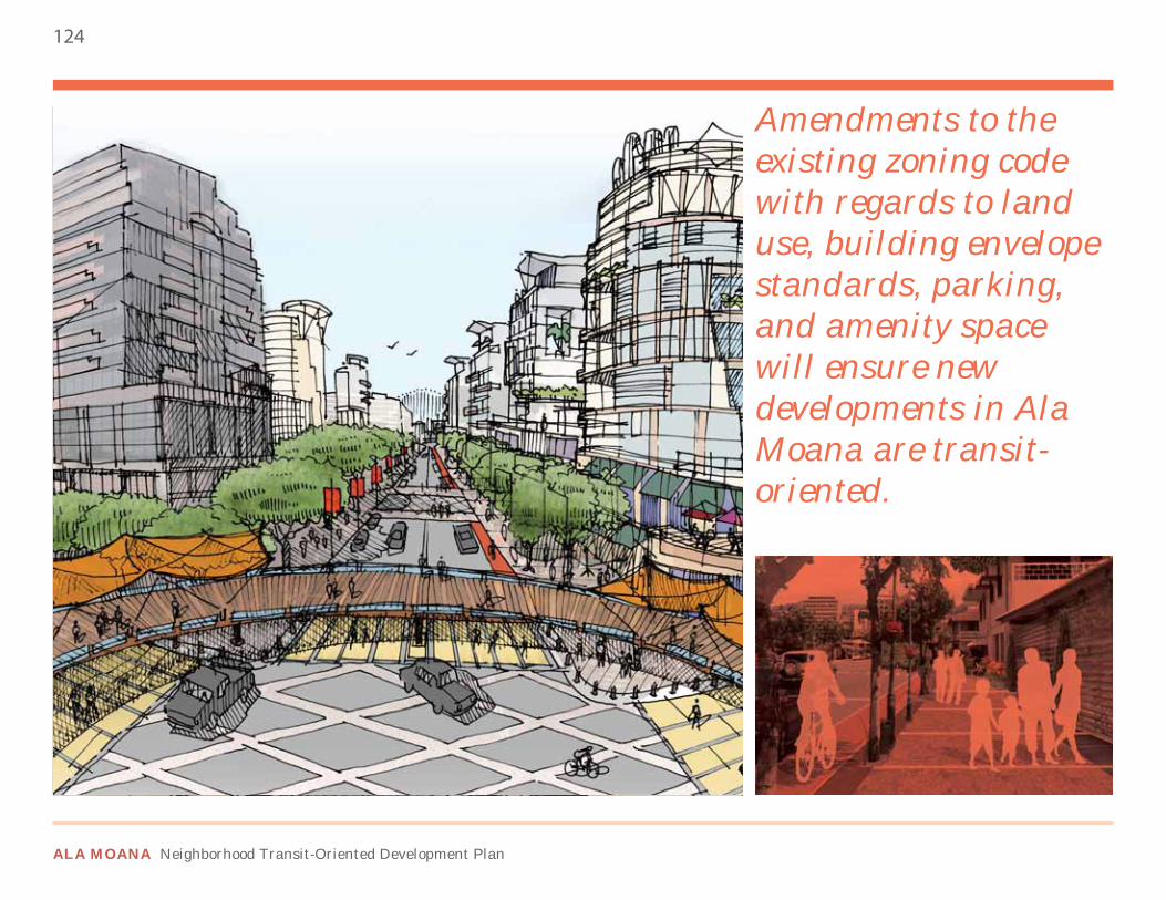
124
ALA MOANA Neighborhood Transit-Oriented Development Plan
Amendments to the existing zoning code with regards to land use, building envelope standards, parking, and amenity space will ensure new developments in Ala Moana are transit-oriented.
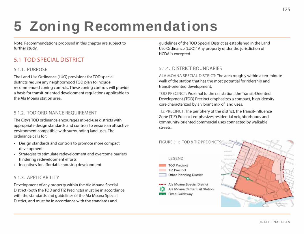
125
DRAFT FINAL PLAN
Note: Recommendations proposed in this chapter are subject to further study.
5.1 TOD SPECIAL DISTRICT
5.1.1. PURPOSEThe Land Use Ordinance (LUO) provisions for TOD special districts require any neighborhood TOD plan to include recommended zoning controls. These zoning controls will provide a basis for transit-oriented development regulations applicable to the Ala Moana station area.
5.1.2. TOD ORDINANCE REQUIREMENTThe City’s TOD ordinance encourages mixed-use districts with appropriate design standards and controls to ensure an attractive environment compatible with surrounding land uses. The ordinance calls for:
• Design standards and controls to promote more compact development
• Strategies to stimulate redevelopment and overcome barriers hindering redevelopment efforts
• Incentives for affordable housing development
5.1.3. APPLICABILITYDevelopment of any property within the Ala Moana Special District (both the TOD and TIZ Precincts) must be in accordance with the standards and guidelines of the Ala Moana Special District, and must be in accordance with the standards and
guidelines of the TOD Special District as established in the Land Use Ordinance (LUO).” Any property under the jurisdiction of HCDA is excepted.
5.1.4. DISTRICT BOUNDARIESALA MOANA SPECIAL DISTRICT: The area roughly within a ten-minute walk of the station that has the most potential for ridership and transit-oriented development.
TOD PRECINCT: Proximal to the rail station, the Transit-Oriented Development (TOD) Precinct emphasizes a compact, high-density core characterized by a vibrant mix of land uses.
TIZ PRECINCT: The periphery of the district, the Transit-Influence Zone (TIZ) Precinct emphasizes residential neighborhoods and community-oriented commercial uses connected by walkable streets.
FIGURE 5-1: TOD & TIZ PRECINCTS
5 Zoning Recommendations
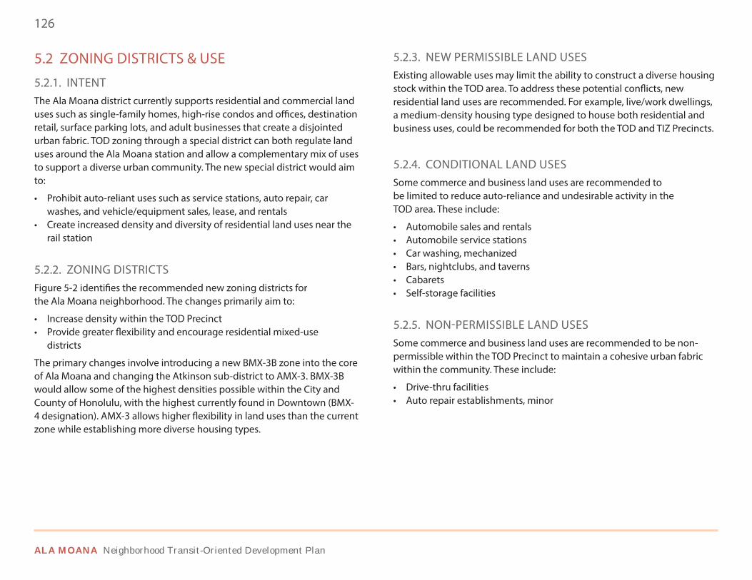
126
ALA MOANA Neighborhood Transit-Oriented Development Plan
5.2 ZONING DISTRICTS & USE
5.2.1. INTENTThe Ala Moana district currently supports residential and commercial land uses such as single-family homes, high-rise condos and offices, destination retail, surface parking lots, and adult businesses that create a disjointed urban fabric. TOD zoning through a special district can both regulate land uses around the Ala Moana station and allow a complementary mix of uses to support a diverse urban community. The new special district would aim to:
• Prohibit auto-reliant uses such as service stations, auto repair, car washes, and vehicle/equipment sales, lease, and rentals
• Create increased density and diversity of residential land uses near the rail station
5.2.2. ZONING DISTRICTSFigure 5-2 identifies the recommended new zoning districts for the Ala Moana neighborhood. The changes primarily aim to:
• Increase density within the TOD Precinct• Provide greater flexibility and encourage residential mixed-use
districts
The primary changes involve introducing a new BMX-3B zone into the core of Ala Moana and changing the Atkinson sub-district to AMX-3. BMX-3B would allow some of the highest densities possible within the City and County of Honolulu, with the highest currently found in Downtown (BMX-4 designation). AMX-3 allows higher flexibility in land uses than the current zone while establishing more diverse housing types.
5.2.3. NEW PERMISSIBLE LAND USESExisting allowable uses may limit the ability to construct a diverse housing stock within the TOD area. To address these potential conflicts, new residential land uses are recommended. For example, live/work dwellings, a medium-density housing type designed to house both residential and business uses, could be recommended for both the TOD and TIZ Precincts.
5.2.4. CONDITIONAL LAND USESSome commerce and business land uses are recommended to be limited to reduce auto-reliance and undesirable activity in the TOD area. These include:
• Automobile sales and rentals• Automobile service stations• Car washing, mechanized• Bars, nightclubs, and taverns• Cabarets• Self-storage facilities
5.2.5. NON-PERMISSIBLE LAND USESSome commerce and business land uses are recommended to be non-permissible within the TOD Precinct to maintain a cohesive urban fabric within the community. These include:
• Drive-thru facilities• Auto repair establishments, minor
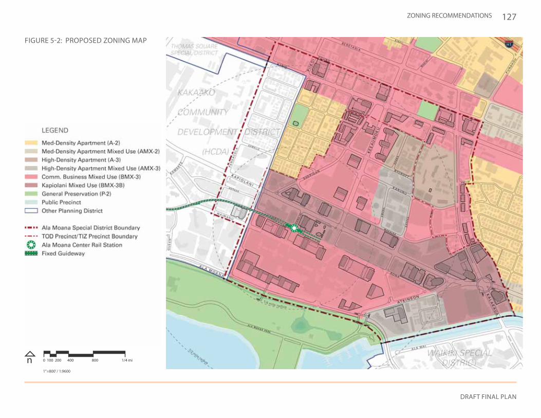
127
DRAFT FINAL PLAN
ZONING RECOMMENDATIONS
FIGURE 5-2: PROPOSED ZONING MAP
n 0 100 200 400 800 1/4 mi
1”=800’ / 1:9600
128
ALA MOANA Neighborhood Transit-Oriented Development Plan
5.3 BUILDING ENVELOPE STANDARDS
5.3.1. INTENTCurrently, many developments within the planning area are below maximum standards for floor area ratio and height. Floor area ratio, or FAR, is a quantifiable measure of building intensity, and is expressed by the ratio of building floor area to land area. Current building envelope standards do not encourage urban development to reach its highest and best use. Therefore, new development standards should be set to better regulate the height, bulk, and location of buildings. These standards aim to:
• Focus more intense development within the TOD Precinct• Stimulate development and community benefits through FAR
and height bonuses• Create active urban street edges through strong street
frontages• Preserve mauka-makai corridors through consistent building
form and massing regulations• Encourage highest and best use
These goals can be achieved by amending the existing zoning code. Within the existing zoning structure, allowing for higher FAR in exchange for mitigation measures allows for direct community benefits while encouraging a more urban environment. Establishing new height regulations, building frontages, lot coverage, and building setbacks can create a more cohesive urban environment while maintaining key community features such as mauka-makai connections, historic and cultural sites, and major attractions. A summary of the proposed building envelope standards can be found in Table 5-1.
5.3.2. FLOOR AREA RATIO (FAR)Floor area ratios (FAR) assign maximum building intensities for specific zoning designations. Throughout the district a base FAR per zone is established for potential development. Within the TOD Precinct, key areas have the potential for a higher FAR if certain conditions and mitigation measures are met.
FAR ZONE BOUNDARIESFigure 5-3 identifies the recommended base and maximum FAR limits for the Ala Moana district. The proposed TOD zoning allows for greater development standards only within the TOD Precinct with the highest density targeted along Kapiolani Boulevard and Kona Street.
BASE FAR LIMITThe base FAR limits within the TOD and TIZ Precincts are generally consistent with the existing FAR limits in the Ala Moana district. It should be noted that for purposes of FAR allowances and calculation, there is no distinction between residential and nonresidential uses.
MAXIMUM FAR LIMITAdditional floor area may be granted within the TOD Precinct, provided development adheres to the community benefits bonus rules described in Section 5.6. The FAR of 10.0 should only be used on select projects with exceptional community benefits and/or catalytic potential.
FAR CALCULATIONSThe proposed FAR limits are based on the City’s LUO, which excludes parking areas from this calculation. The idea of including parking in FAR calculations to incentivize less parking and higher densities should be considered.
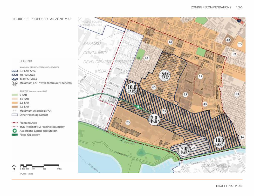
129
DRAFT FINAL PLAN
ZONING RECOMMENDATIONS
(See page 124)
FIGURE 5-3: PROPOSED FAR ZONE MAP
n 0 100 200 400 800 1/4 mi
1”=800’ / 1:9600
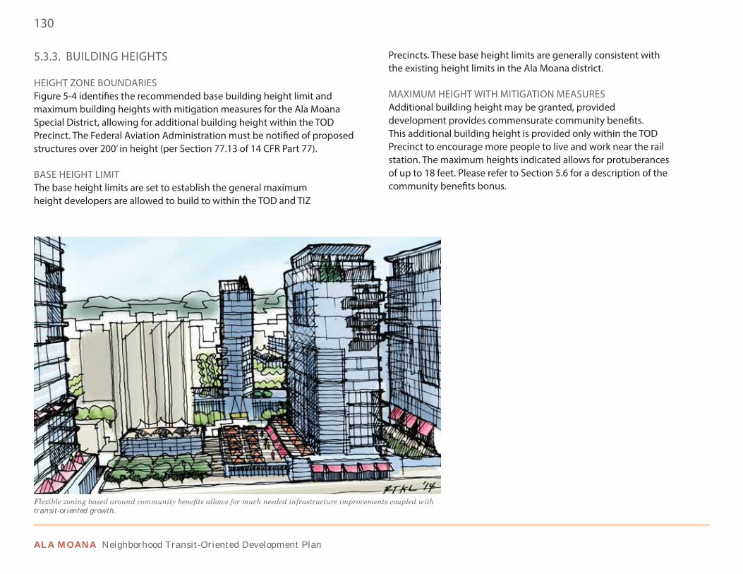
130
ALA MOANA Neighborhood Transit-Oriented Development Plan
5.3.3. BUILDING HEIGHTS
HEIGHT ZONE BOUNDARIESFigure 5-4 identifies the recommended base building height limit and maximum building heights with mitigation measures for the Ala Moana Special District, allowing for additional building height within the TOD Precinct. The Federal Aviation Administration must be notified of proposed structures over 200’ in height (per Section 77.13 of 14 CFR Part 77).
BASE HEIGHT LIMITThe base height limits are set to establish the general maximum height developers are allowed to build to within the TOD and TIZ
Precincts. These base height limits are generally consistent with the existing height limits in the Ala Moana district.
MAXIMUM HEIGHT WITH MITIGATION MEASURESAdditional building height may be granted, provided development provides commensurate community benefits. This additional building height is provided only within the TOD Precinct to encourage more people to live and work near the rail station. The maximum heights indicated allows for protuberances of up to 18 feet. Please refer to Section 5.6 for a description of the community benefits bonus.
transit-oriented growth.
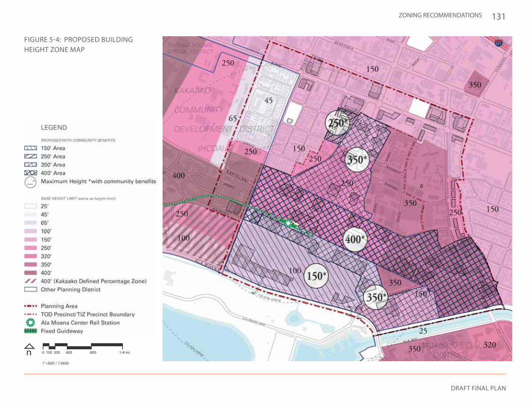
131
DRAFT FINAL PLAN
ZONING RECOMMENDATIONS
FIGURE 5-4: PROPOSED BUILDING HEIGHT ZONE MAP
n 0 100 200 400 800 1/4 mi
1”=800’ / 1:9600
132
ALA MOANA Neighborhood Transit-Oriented Development Plan
5.3.4. BUILDING FORM & MASSING
YARDS / BUILDING SETBACKSYards and building setbacks should allow for safe, comfortable circulation along the street and between buildings, where necessary, and preserve mauka-makai view corridors through height setbacks above the street level. However, a case-by-case basis may be appropriate for properties around gateways and certain major streets. Proposed building setbacks, frontages, and transparencies for the Ala Moana Special District can be found in Table 5-1. It is further recommended that the current street centerline setback for BMX-3 be eliminated.
BUILDING FRONTAGEContinuous building frontage assists in providing an engaging ground-level environment for pedestrians. The frontage should
BUILDING STANDARDTOD PRECINCT TIZ PRECINCT
A-3 A-2AMX-3 A-3BMX-3 AMX-2BMX-3B P-2 P-2
FAR REFER TO FIGURE 5-3
REFER TO FIGURE 5-3
REFER TO FIGURE 5-4
REFER TO FIGURE 5-4
REFER TO FIGURE 5-5
REFER TO FIGURE 5-5
REFER TO FIGURE 5-3
REFER TO FIGURE 5-3
REFER TO FIGURE 5-4
REFER TO FIGURE 5-4
REFER TO FIGURE 5-5
REFER TO FIGURE 5-5FRONT YARD / SETBACK
MAX FAR IN MITIGATION AREA
SIDE YARD / SETBACK
MAXIMUM HEIGHT
HEIGHT SETBACK ABOVE 60’
MAXIMUM HEIGHT IN MITIGATION AREA
REAR YARD / SETBACK
STREET-LEVEL TRANSPARENCY PERCENTAGE
FRONTAGE
LOT COVERAGE MINIMUM
5’ 5’ - - - 10’ 10’ - -
10’ 10’ 15’ 20’ - - - - -
5’ 5’ 10’ 10’ - 15’ 15’ 15’ -
70% 75% 90% 90% - 60% 60% 70% -
25% 50% 75% 75% - 25% 25% 50% -
meet the building build-to line in the building envelope standards below. Figure 5-5 identifies the recommended building frontage percentages proposed for the Ala Moana district.
STREET-LEVEL TRANSPARENCYTransparency allows for buildings to engage pedestrians and contribute to a vibrant public realm. Transparency can take the form of windows, open air connections, and outdoor dining.
LOT COVERAGE MINIMUMLot coverage ensures the building footprint on each parcel maintains a uniform minimum size to reduce large variations in the urban fabric. Transitions must be set for buildings in one zoning designation that abut the boundary of another designation.
TABLE 5-1: PROPOSED BUILDING ENVELOPE STANDARDS
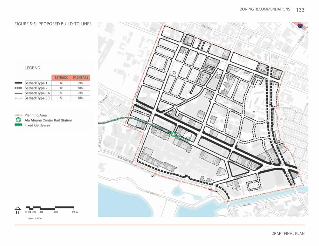
133
DRAFT FINAL PLAN
ZONING RECOMMENDATIONS
FIGURE 5-5: PROPOSED BUILD-TO LINES
n 0 100 200 400 800 1/4 mi
1”=800’ / 1:9600
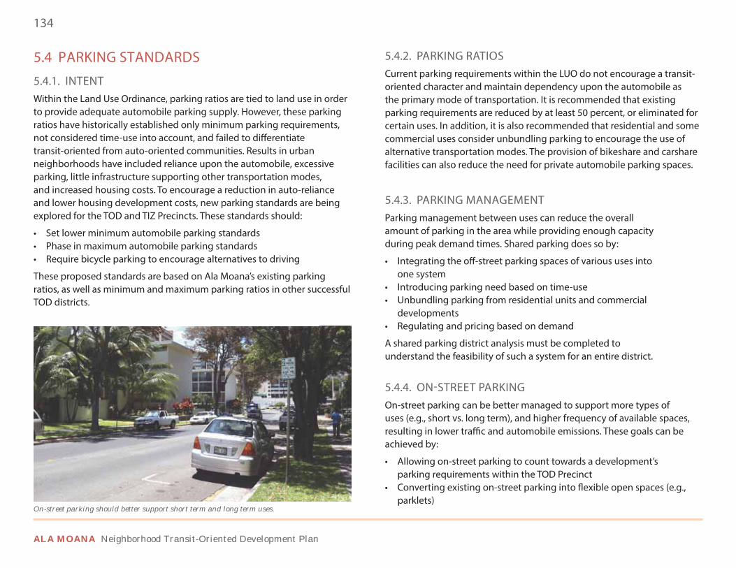
134
ALA MOANA Neighborhood Transit-Oriented Development Plan
5.4 PARKING STANDARDS
5.4.1. INTENTWithin the Land Use Ordinance, parking ratios are tied to land use in order to provide adequate automobile parking supply. However, these parking ratios have historically established only minimum parking requirements, not considered time-use into account, and failed to differentiate transit-oriented from auto-oriented communities. Results in urban neighborhoods have included reliance upon the automobile, excessive parking, little infrastructure supporting other transportation modes, and increased housing costs. To encourage a reduction in auto-reliance and lower housing development costs, new parking standards are being explored for the TOD and TIZ Precincts. These standards should:
• Set lower minimum automobile parking standards• Phase in maximum automobile parking standards• Require bicycle parking to encourage alternatives to driving
These proposed standards are based on Ala Moana’s existing parking ratios, as well as minimum and maximum parking ratios in other successful TOD districts.
5.4.2. PARKING RATIOSCurrent parking requirements within the LUO do not encourage a transit-oriented character and maintain dependency upon the automobile as the primary mode of transportation. It is recommended that existing parking requirements are reduced by at least 50 percent, or eliminated for certain uses. In addition, it is also recommended that residential and some commercial uses consider unbundling parking to encourage the use of alternative transportation modes. The provision of bikeshare and carshare facilities can also reduce the need for private automobile parking spaces.
5.4.3. PARKING MANAGEMENTParking management between uses can reduce the overall amount of parking in the area while providing enough capacity during peak demand times. Shared parking does so by:
• Integrating the off-street parking spaces of various uses into one system
• Introducing parking need based on time-use• Unbundling parking from residential units and commercial
developments• Regulating and pricing based on demand
A shared parking district analysis must be completed to understand the feasibility of such a system for an entire district.
5.4.4. ON-STREET PARKINGOn-street parking can be better managed to support more types of uses (e.g., short vs. long term), and higher frequency of available spaces, resulting in lower traffic and automobile emissions. These goals can be achieved by:
• Allowing on-street parking to count towards a development’s parking requirements within the TOD Precinct
• Converting existing on-street parking into flexible open spaces (e.g., parklets)
On-street parking should better support short term and long term uses.
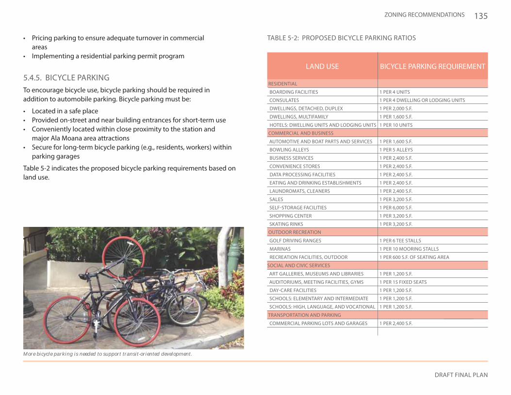
135
DRAFT FINAL PLAN
ZONING RECOMMENDATIONS
• Pricing parking to ensure adequate turnover in commercial areas
• Implementing a residential parking permit program
5.4.5. BICYCLE PARKINGTo encourage bicycle use, bicycle parking should be required in addition to automobile parking. Bicycle parking must be:
• Located in a safe place• Provided on-street and near building entrances for short-term use• Conveniently located within close proximity to the station and
major Ala Moana area attractions• Secure for long-term bicycle parking (e.g., residents, workers) within
parking garages
Table 5-2 indicates the proposed bicycle parking requirements based on land use.
More bicycle parking is needed to support transit-oriented development.
TABLE 5-2: PROPOSED BICYCLE PARKING RATIOS
OUTDOOR RECREATION
SOCIAL AND CIVIC SERVICES
TRANSPORTATION AND PARKING
RESIDENTIAL
COMMERCIAL AND BUSINESS
LAND USE BICYCLE PARKING REQUIREMENT
DATA PROCESSING FACILITIES 1 PER 2,400 S.F.
ART GALLERIES, MUSEUMS AND LIBRARIES 1 PER 1,200 S.F.
SELF-STORAGE FACILITIES 1 PER 6,000 S.F.
BOARDING FACILITIES 1 PER 4 UNITS
AUDITORIUMS, MEETING FACILITIES, GYMS 1 PER 15 FIXED SEATS
SHOPPING CENTER 1 PER 3,200 S.F.
COMMERCIAL PARKING LOTS AND GARAGES 1 PER 2,400 S.F.
CONSULATES 1 PER 4 DWELLING OR LODGING UNITS
EATING AND DRINKING ESTABLISHMENTS 1 PER 2,400 S.F.
DAY-CARE FACILITIES 1 PER 1,200 S.F.
AUTOMOTIVE AND BOAT PARTS AND SERVICES 1 PER 1,600 S.F.
SKATING RINKS 1 PER 3,200 S.F.
DWELLINGS, DETACHED, DUPLEX 1 PER 2,000 S.F.
DWELLINGS, MULTIFAMILY 1 PER 1,600 S.F.
HOTELS: DWELLING UNITS AND LODGING UNITS 1 PER 10 UNITS
LAUNDROMATS, CLEANERS 1 PER 2,400 S.F.
SCHOOLS: ELEMENTARY AND INTERMEDIATE 1 PER 1,200 S.F.
BOWLING ALLEYS 1 PER 5 ALLEYS
CONVENIENCE STORES 1 PER 2,400 S.F.
MARINAS 1 PER 10 MOORING STALLS
SALES 1 PER 3,200 S.F.
SCHOOLS: HIGH, LANGUAGE, AND VOCATIONAL 1 PER 1,200 S.F.
BUSINESS SERVICES 1 PER 2,400 S.F.
RECREATION FACILITIES, OUTDOOR 1 PER 600 S.F. OF SEATING AREA
GOLF DRIVING RANGES 1 PER 6 TEE STALLS
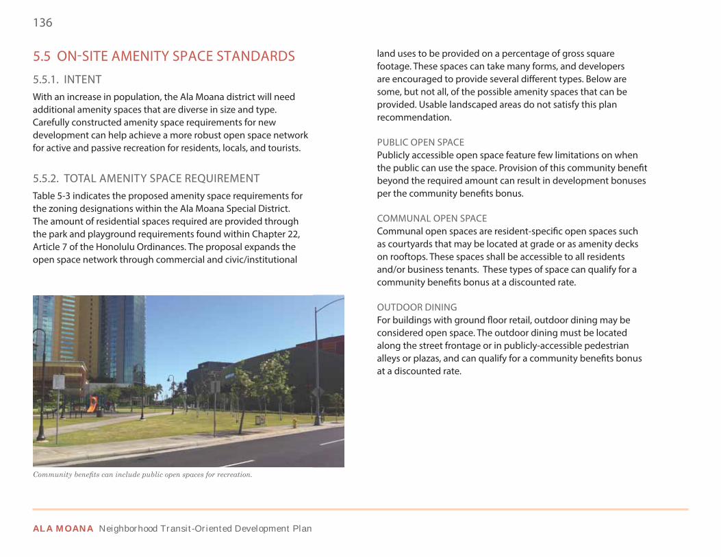
136
ALA MOANA Neighborhood Transit-Oriented Development Plan
5.5 ON-SITE AMENITY SPACE STANDARDS
5.5.1. INTENTWith an increase in population, the Ala Moana district will need additional amenity spaces that are diverse in size and type. Carefully constructed amenity space requirements for new development can help achieve a more robust open space network for active and passive recreation for residents, locals, and tourists.
5.5.2. TOTAL AMENITY SPACE REQUIREMENTTable 5-3 indicates the proposed amenity space requirements for the zoning designations within the Ala Moana Special District. The amount of residential spaces required are provided through the park and playground requirements found within Chapter 22, Article 7 of the Honolulu Ordinances. The proposal expands the open space network through commercial and civic/institutional
land uses to be provided on a percentage of gross square footage. These spaces can take many forms, and developers are encouraged to provide several different types. Below are some, but not all, of the possible amenity spaces that can be provided. Usable landscaped areas do not satisfy this plan recommendation.
PUBLIC OPEN SPACEPublicly accessible open space feature few limitations on when the public can use the space. Provision of this community benefit beyond the required amount can result in development bonuses per the community benefits bonus.
COMMUNAL OPEN SPACECommunal open spaces are resident-specific open spaces such as courtyards that may be located at grade or as amenity decks on rooftops. These spaces shall be accessible to all residents and/or business tenants. These types of space can qualify for a community benefits bonus at a discounted rate.
OUTDOOR DININGFor buildings with ground floor retail, outdoor dining may be considered open space. The outdoor dining must be located along the street frontage or in publicly-accessible pedestrian alleys or plazas, and can qualify for a community benefits bonus at a discounted rate.
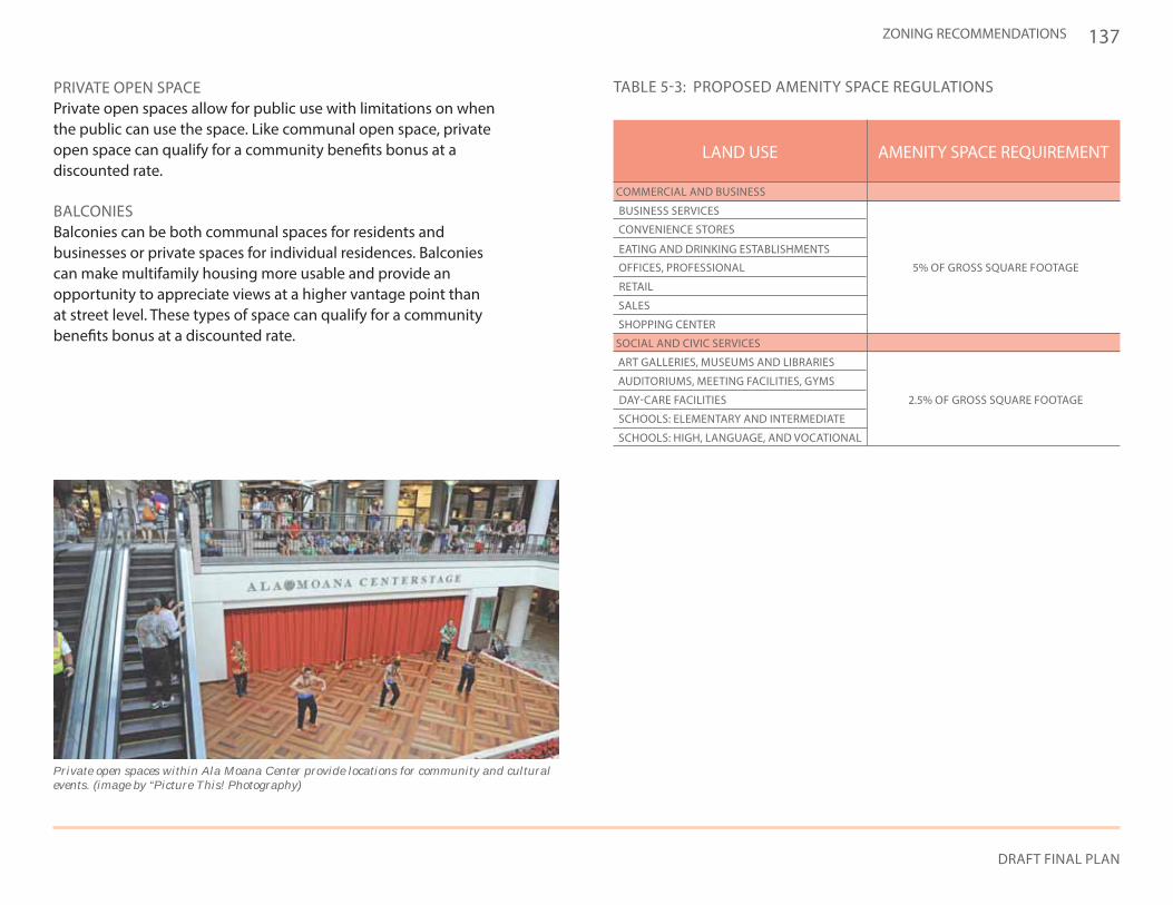
137
DRAFT FINAL PLAN
ZONING RECOMMENDATIONS
PRIVATE OPEN SPACEPrivate open spaces allow for public use with limitations on when the public can use the space. Like communal open space, private open space can qualify for a community benefits bonus at a discounted rate.
BALCONIESBalconies can be both communal spaces for residents and businesses or private spaces for individual residences. Balconies can make multifamily housing more usable and provide an opportunity to appreciate views at a higher vantage point than at street level. These types of space can qualify for a community benefits bonus at a discounted rate.
Private open spaces within Ala Moana Center provide locations for community and cultural events. (image by “Picture This! Photography)
TABLE 5-3: PROPOSED AMENITY SPACE REGULATIONS
SOCIAL AND CIVIC SERVICES
COMMERCIAL AND BUSINESS
LAND USE AMENITY SPACE REQUIREMENT
ART GALLERIES, MUSEUMS AND LIBRARIES
AUDITORIUMS, MEETING FACILITIES, GYMS
SHOPPING CENTER
EATING AND DRINKING ESTABLISHMENTS
DAY-CARE FACILITIES 2.5% OF GROSS SQUARE FOOTAGE
OFFICES, PROFESSIONAL 5% OF GROSS SQUARE FOOTAGE
SCHOOLS: ELEMENTARY AND INTERMEDIATE
RETAIL
CONVENIENCE STORES
SALES
SCHOOLS: HIGH, LANGUAGE, AND VOCATIONAL
BUSINESS SERVICES
138
ALA MOANA Neighborhood Transit-Oriented Development Plan
5.6 COMMUNITY BENEFITS BONUS
5.6.1. INTENTA community benefits bonus leverages development potential to incentivize transit-oriented development, meet community goals and objectives, and mitigate development impacts. The City is proposing such a program as a means of encouraging the implementation of many of the design concepts identified in this document through the LUO.
5.6.2. SUMMARY PROCESSTo promote community benefits within Ala Moana, the City can use incentives (i.e., density or height bonuses, parking reductions) to support higher yields and promote redevelopment in desired locations (i.e., station proximity) that go above and beyond in providing defined community benefits. This can be achieved by:
• Tying incentives to community goals and objectives that reinforce TOD and enhance neighborhood livability
• Prioritizing desired community benefits and establishing nexus with incentivized development
• Assigning mitigation measures or “nexus fees” to offset impacts of additional development and promote community goals and objectives
• Encouraging a balanced mix of uses (that market forces might not otherwise support) to strengthen TOD, including affordable and workforce housing, incubator office space, neighborhood shops and services, accessible open space (i.e., parks and plazas), and civic and cultural facilities
• Funding neighborhood programs and improvement projects that enhance livability, including infrastructure upgrades, multimodal improvements/streetscape enhancements, public park and open space upgrades, paths and trails, and traffic demand management
5.6.3. COMMUNITY BENEFITS IMPLEMENTATION ALTERNATIVES Implementation of community benefits bonus should be established through a “menu” of benefits combined with zoning incentives. With this approach, benefits are selected by the applicant from an available list. This list:
• Assigns point values to various mitigation measures (e.g., square feet of publicly accessible park space, affordable housing units)
• Ties the mitigation measures to additional development yield
This approach may be administered “as-of-right” or through discretionary review depending on the desired level of flexibility. However, if a project building footprint is greater than 75,000 square feet, a negotiated agreement with the City should take place. To help frame this discussion, the following questions are common obstacles that are faced when establishing the “Menu of Benefits.”
• What is the potential value capture associated with the Ala Moana Center station? How much development yield will maximize value capture?
• How much additional development yield is considered desirable for Ala Moana?
• What specific locations should be targeted for redevelopment?• How much additional yield may be effectively realized at
targeted locations? • What are the anticipated impacts of additional development?
How are positive impacts to be leveraged? How may negative impacts be mitigated?
• Next steps require that the City set up a scorecard of community benefits and determine how they would allow development interests to have a series of predictable outcomes based on this scorecard as a part of the development cycle.
139
DRAFT FINAL PLAN
ZONING RECOMMENDATIONS
5.7 AFFORDABLE HOUSING
5.7.1. INTENTThe community has expressed a clear desire for TOD to provide a balance of housing types, including more affordable housing. Affordable housing can help to preserve the diversity of people within the neighborhood central to the district’s overall vision.
5.7.2. EXISTING & NEW STANDARDSCurrently, any new development seeking a change of zoning must provide 30% of the units sold or rented as affordable housing units regardless of the development type. Of the 30%:
• 10% or more of units must be provided to households earning 80% or less of the area median income
• No less than 20% of the units must be provided to households earning 120% or less of the area median income
New standards for the TOD Special District should require that all developments providing more than 10 residential units provide a percentage of affordable housing units, with an emphasis on rental housing, for at least a 30 year affordability period. If developers do not want to construct affordable housing, an affordable housing impact fee could be assessed for deposit into an affordable housing fund. The fee should:
• Be based on a $/sf scale per unit• Create standard sf sizes for different unit types
5.7.3. INCENTIVESIncentives can encourage developers to both reach and exceed the affordable housing requirement rather than pay an impact fee. Potential incentives include:
• Density and height bonuses• Parking reductions• Property tax abatement
5.7.4. AFFORDABLE HOUSING FUNDAn affordable housing fund should be funded by impact fees for developers unable to provide affordable housing on-site. This fund would be maintained by the City and potentially localized to the Ala Moana TOD Special District. This fund could be utilized in several ways, including:
• Providing financial support to developers providing affordable housing
• Allowing the City to pursue affordable housing developments• Helping maintain existing affordable housing
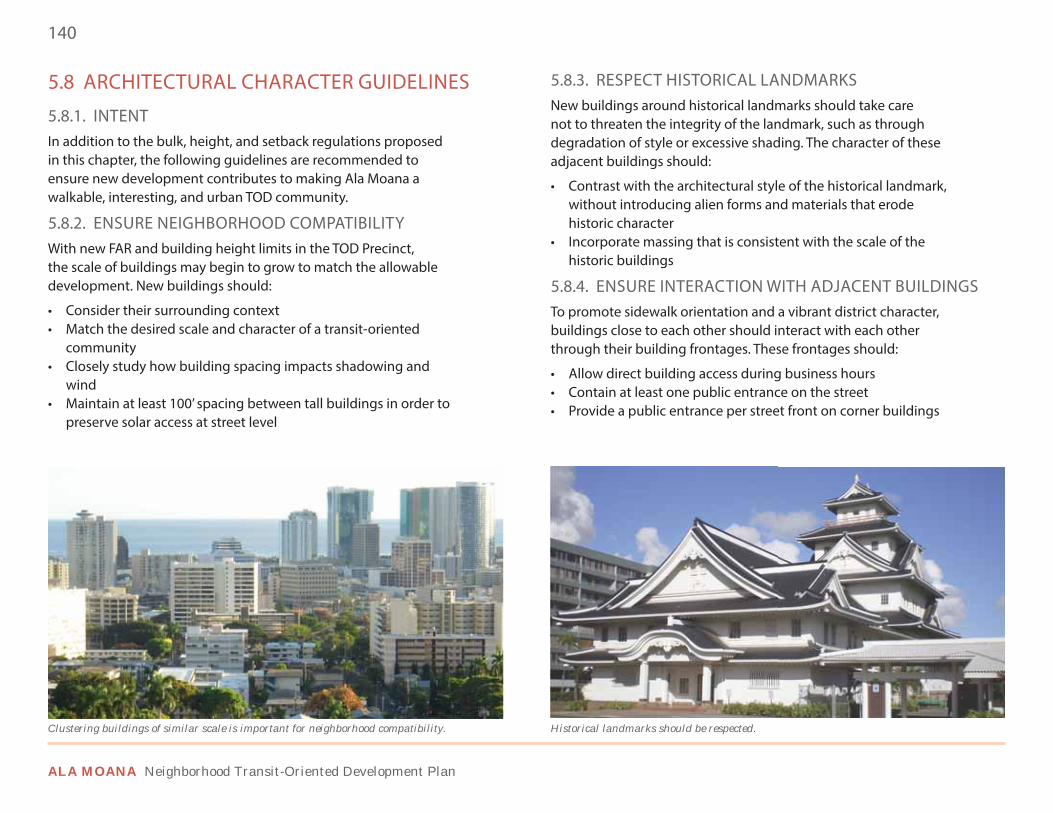
140
ALA MOANA Neighborhood Transit-Oriented Development Plan
5.8 ARCHITECTURAL CHARACTER GUIDELINES
5.8.1. INTENTIn addition to the bulk, height, and setback regulations proposed in this chapter, the following guidelines are recommended to ensure new development contributes to making Ala Moana a walkable, interesting, and urban TOD community.
5.8.2. ENSURE NEIGHBORHOOD COMPATIBILITYWith new FAR and building height limits in the TOD Precinct, the scale of buildings may begin to grow to match the allowable development. New buildings should:
• Consider their surrounding context • Match the desired scale and character of a transit-oriented
community• Closely study how building spacing impacts shadowing and
wind• Maintain at least 100’ spacing between tall buildings in order to
preserve solar access at street level
5.8.3. RESPECT HISTORICAL LANDMARKSNew buildings around historical landmarks should take care not to threaten the integrity of the landmark, such as through degradation of style or excessive shading. The character of these adjacent buildings should:
• Contrast with the architectural style of the historical landmark, without introducing alien forms and materials that erode historic character
• Incorporate massing that is consistent with the scale of the historic buildings
5.8.4. ENSURE INTERACTION WITH ADJACENT BUILDINGSTo promote sidewalk orientation and a vibrant district character, buildings close to each other should interact with each other through their building frontages. These frontages should:
• Allow direct building access during business hours• Contain at least one public entrance on the street• Provide a public entrance per street front on corner buildings
Clustering buildings of similar scale is important for neighborhood compatibility. Historical landmarks should be respected.

141
DRAFT FINAL PLAN
ZONING RECOMMENDATIONS
5.8.5. BUILDING ORIENTATION TO STREET & PUBLIC SPACESTo sustain street-level activity and promote pedestrian traffic, buildings should be oriented to the street and public spaces. This orientation should include:
• Pedestrian design elements along building frontages• Tenant spaces oriented to the street and public spaces• Retail storefronts along streets and public spaces• Open air seating at ground-level restaurants• Wide sidewalks and support amenities (e.g., waste bins, lighting)• Storefront transparency at ground level• Human-scaled architectural features (awnings,
canopies,overhangs) that help activate storefronts
5.8.6. PROVIDE PEDESTRIAN-ORIENTED STREETSCAPE It is important that streetscapes throughout the Ala Moana Special District make the public realm both attractive and safe for pedestrians. Landscape buffers against the building with sidewalks at the curb are inappropriate. A preferable streetscape alignment includes:
• Street trees and planting zones along the curb• Sidewalks set back against the building• A clear differentiation of 1) curb line/planting areas, 2) middle
walking areas, and 3) building face,display, and outdoor seating areas
Features such as signage, lighting, and awnings promote pedestrian activity. Green spaces with seating areas contribute to the street environment.
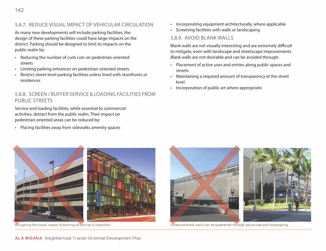
142
ALA MOANA Neighborhood Transit-Oriented Development Plan
5.8.7. REDUCE VISUAL IMPACT OF VEHICULAR CIRCULATIONAs many new developments will include parking facilities, the design of these parking facilities could have large impacts on the district. Parking should be designed to limit its impacts on the public realm by:
• Reducing the number of curb cuts on pedestrian-oriented streets
• Limiting parking entrances on pedestrian-oriented streets• Restrict street-level parking facilities unless lined with storefronts or
residences
5.8.8. SCREEN / BUFFER SERVICE & LOADING FACILITIES FROM PUBLIC STREETSService and loading facilities, while essential to commercial activities, detract from the public realm. Their impact on pedestrian-oriented areas can be reduced by:
• Placing facilities away from sidewalks amenity spaces
• Incorporating equipment architecturally, where applicable• Screening facilities with walls or landscaping
5.8.9. AVOID BLANK WALLSBlank walls are not visually interesting and are extremely difficult to mitigate, even with landscape and streetscape improvements. Blank walls are not desirable and can be avoided through:
• Placement of active uses and entries along public spaces and streets
• Maintaining a required amount of transparency at the street level
• Incorporation of public art where appropriate
Mitigating the visual impact of parking structures is important. Extensive blank walls can be augmented through active uses and landscaping.Extensive blank walls can be augmented throMitigating the visual impact of parking struc
143
DRAFT FINAL PLAN
ZONING RECOMMENDATIONS
5.9 TALL BUILDING GUIDELINES
5.9.1. INTENTWith over eight million square feet of new construction projected in the Ala Moana district, a significant portion of new development will likely be in the form of high-rise towers. How these towers are designed in relation to mauka-makai view corridors, the public realm, and shadowing will play a key role in the future urban environment of the district. There are several key issues that should be addressed when establishing architectural guidelines for tall buildings (generally defined as buildings over 150’ in height).
5.9.2. DESIGN GUIDELINES FOR THE PODIUM, MIDDLE, & TOP OF TOWERThe design of tall buildings generally consists of three sections: base, middle (tower), and top. Design principles should be established for each building section to address how:
• The podium will affect the experience of the building at street level. Podium heights should be massed in a way to maintain street-level solar access.
• The middle will affect the building’s shadows on the urban environment.
• The tower top will affect the building’s aesthetic and experiential contribution to the urban skyline.
5.9.3. PROMOTE NATURAL AIR CIRCULATION & VENTILATION WHILE MINIMIZING ADVERSE WIND CONDITIONSTall buildings have the ability to capture natural breezes that can provide benefits through reduced energy consumption and higher indoor air quality. Tower design should also evaluate wind tunnelling impacts that may have negative effects at the street level. At minimum, a 100’ dimension should be maintained between tall buildings to preserve views and solar access.
5.9.4. PROVIDE PROPER SETBACKS FOR TOWERSTall buildings can create imposing facades along street frontages. As such, tower placement is key to ensuring the public realm remains a comfortable environment. By setting back upper stories in towers away from street frontages, parks, trees, or open spaces, the perceived impact of the tower on the urban environment can be significantly reduced. For example, along Kapiolani Boulevard, a 20’ setback from the property line above the first story can provide room for the street’s Monkeypod trees.
5.9.5. ORIENT TOWERS IN MAUKA-MAKAI DIRECTIONMauka-makai view corridors may be impacted by new tower development in the Ala Moana district. Tall buildings should orient themselves in a mauka-makai direction to preserve view corridors in the public realm, as well as to create mauka-makai visual connections for people at street level and those occupying tall buildings.
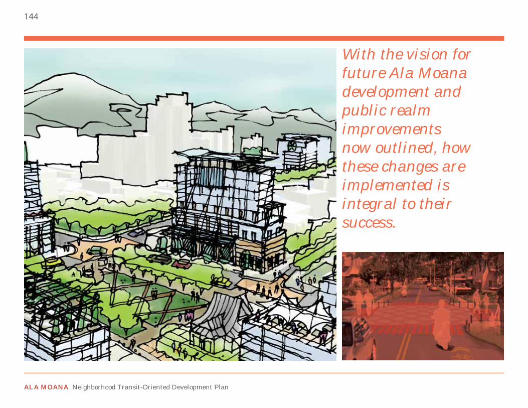
144
ALA MOANA Neighborhood Transit-Oriented Development Plan
With the vision for future Ala Moana development and public realm improvements now outlined, how these changes are implemented is integral to their success.
145
DRAFT FINAL PLAN
6.1 OVERALL STRUCTURE
6.1.1. IMPLEMENTATION DESCRIPTIONThe implementation of the Ala Moana TOD Plan will involve various players at different times during the process. This chapter outlines:
• How development should be phased in the Special District• Who the players are to advance the Plan• How specific projects can be funded for construction and
maintenance
DEVELOPMENT PHASINGAs not all the objectives of the Ala Moana TOD Plan can be completed at the same time, a phased approach can allow for the full extent of the Plan to roll out over the short, medium, and long-term development of the district. The phasing schemes outlined in this chapter are suggested, and actual implementation timing may vary.
STRATEGIC PARTNERSThe Ala Moana TOD Plan crosses multiple jurisdictions and involves key private sector partners as well. Identifying who these partners are and their responsibilities in the district’s development gives accountability to each player in the process.
FUNDING SOURCESWith the large extent of infrastructure projects proposed in the plan, funding is a key issue in moving these improvements forward. Identifying various local, state, federal, and private funding sources for construction, operation, and maintenance will help advance implementation.
ACTION PLANThe final part of this chapter synthesizes the different initiatives of the Ala Moana TOD Plan. It summarizes what initiatives should be completed; what government agencies should be involved; and short, mid, and long-term goals.
6 Implementation

146
ALA MOANA Neighborhood Transit-Oriented Development Plan
6.2 PHASING
6.2.1. PHASE 1 - CREATING A TRANSIT NODEThe initial phase of the TOD Plan establishes the new rail and bus stations as a transit node. The rail station needs to function for both daily and occasional users that are both locals and tourists. The transit experience to/from Ala Moana should be simple and direct. To make the station accessible and enjoyable, this phase includes:
• Constructing a transit plaza adjacent to the station
• Constructing pedestrian at-grade improvements along Kona Street and Ala Moana Boulevard to provide improved access to Ala Moana Park
• Providing multimodal multilevel connections to the rail station such as vehicle parking, bicycle storage areas, and key pedestrian entry points
FIGURE 6-1: PHASE 1 - CREATING A TRANSIT NODE
n 0 200 600 1/4 mi
1”=1200’ / 1:14400
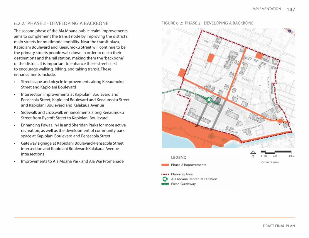
147
DRAFT FINAL PLAN
IMPLEMENTATION
6.2.2. PHASE 2 - DEVELOPING A BACKBONEThe second phase of the Ala Moana public realm improvements aims to complement the transit node by improving the district’s main streets for multimodal mobility. Near the transit plaza, Kapiolani Boulevard and Keeaumoku Street will continue to be the primary streets people walk down in order to reach their destinations and the rail station, making them the “backbone” of the district. It is important to enhance these streets first to encourage walking, biking, and taking transit. These enhancements include:
• Streetscape and bicycle improvements along Keeaumoku Street and Kapiolani Boulevard
• Intersection improvements at Kapiolani Boulevard and Pensacola Street, Kapiolani Boulevard and Keeaumoku Street, and Kapiolani Boulevard and Kalakaua Avenue
• Sidewalk and crosswalk enhancements along Keeaumoku Street from Rycroft Street to Kapiolani Boulevard
• Enhancing Pawaa In-Ha and Sheridan Parks for more active recreation, as well as the development of community park space at Kapiolani Boulevard and Pensacola Street
• Gateway signage at Kapiolani Boulevard/Pensacola Street intersection and Kapiolani Boulevard/Kalakaua Avenue intersections
• Improvements to Ala Moana Park and Ala Wai Promenade
FIGURE 6-2: PHASE 2 - DEVELOPING A BACKBONE
n 0 200 600 1/4 mi
1”=1200’ / 1:14400
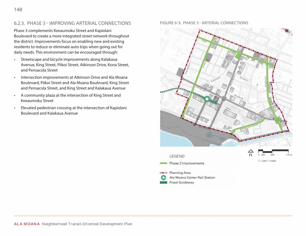
148
ALA MOANA Neighborhood Transit-Oriented Development Plan
6.2.3. PHASE 3 - IMPROVING ARTERIAL CONNECTIONSPhase 3 complements Keeaumoku Street and Kapiolani Boulevard to create a more integrated street network throughout the district. Improvements focus on enabling new and existing residents to reduce or eliminate auto trips when going out for daily needs. This environment can be encouraged through:
• Streetscape and bicycle improvements along Kalakaua Avenue, King Street, Piikoi Street, Atkinson Drive, Kona Street, and Pensacola Street
• Intersection improvements at Atkinson Drive and Ala Moana Boulevard, Piikoi Street and Ala Moana Boulevard, King Street and Pensacola Street, and King Street and Kalakaua Avenue
• A community plaza at the intersection of King Street and Keeaumoku Street
• Elevated pedestrian crossing at the intersection of Kapiolani Boulevard and Kalakaua Avenue
FIGURE 6-3: PHASE 3 - ARTERIAL CONNECTIONS
n 0 200 600 1/4 mi
1”=1200’ / 1:14400
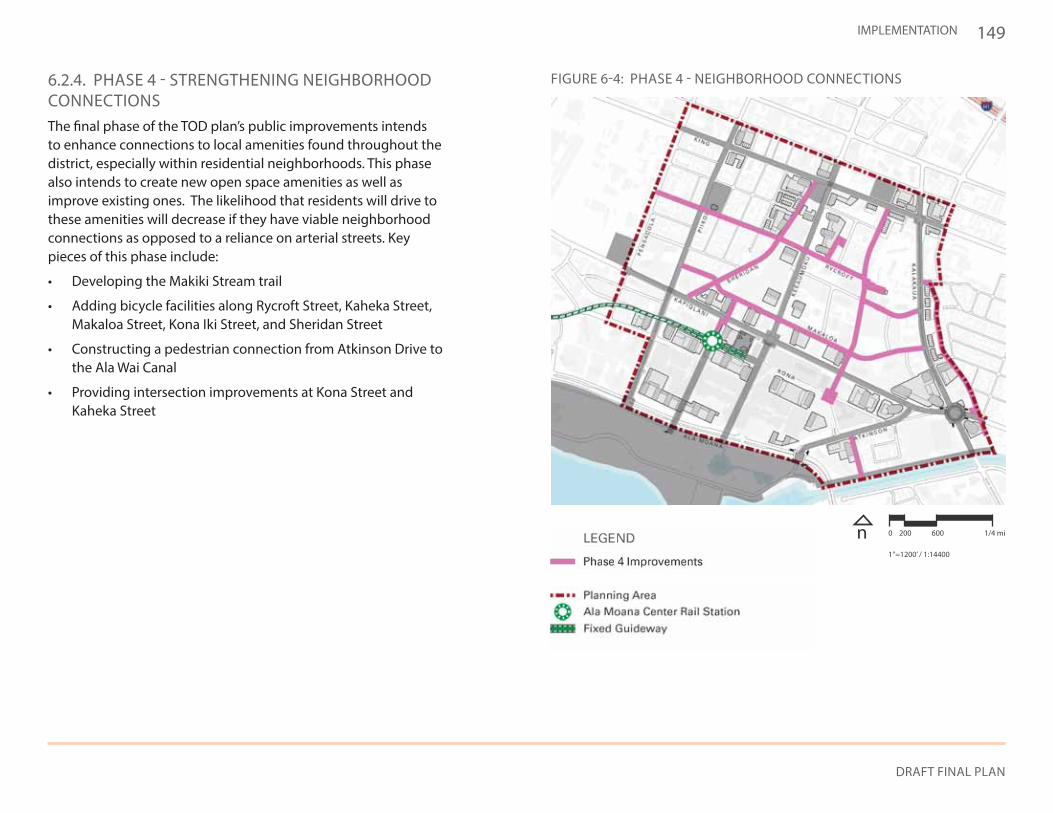
149
DRAFT FINAL PLAN
IMPLEMENTATION
6.2.4. PHASE 4 - STRENGTHENING NEIGHBORHOOD CONNECTIONSThe final phase of the TOD plan’s public improvements intends to enhance connections to local amenities found throughout the district, especially within residential neighborhoods. This phase also intends to create new open space amenities as well as improve existing ones. The likelihood that residents will drive to these amenities will decrease if they have viable neighborhood connections as opposed to a reliance on arterial streets. Key pieces of this phase include:
• Developing the Makiki Stream trail
• Adding bicycle facilities along Rycroft Street, Kaheka Street, Makaloa Street, Kona Iki Street, and Sheridan Street
• Constructing a pedestrian connection from Atkinson Drive to the Ala Wai Canal
• Providing intersection improvements at Kona Street and Kaheka Street
FIGURE 6-4: PHASE 4 - NEIGHBORHOOD CONNECTIONS
n 0 200 600 1/4 mi
1”=1200’ / 1:14400
150
ALA MOANA Neighborhood Transit-Oriented Development Plan
6.3 FUNDING SOURCES
6.3.1. INTENTIn order to fund and maintain infrastructure projects proposed in the Ala Moana TOD Plan, various funding sources will be necessary. These funding sources provide for capital improvements, operation, and maintenance.
6.3.2. FUNDING SOURCESSAFE ROUTES TO SCHOOL (SRTS)SRTS funds state and local programs for infrastructure and non-infrastructure projects to provide students safe pedestrian and bicycle access to schools, such as McKinley High School and Washington Middle School.
COMMUNITY BENEFITSCommunity benefits are neighborhood improvements developers provide in exchange for higher height and FAR bonuses. The community benefits bonus is discussed in Section 5.6.
MOVING AHEAD PROGRESS IN THE 21ST CENTURY ACT (MAP-21)MAP-21 is a federal program intended to establish multimodal connections for more efficient transportation systems. While MAP-21 acts as an umbrella program for some of the other programs mentioned here, it also provides infrastructure improvement funding separate from them.
HIGHWAY SAFETY IMPROVEMENT PROGRAM (HSIP)A piece of MAP-21, HSIP is a federal program intended to reduce traffic fatalities and serious injuries on all public roads. HSIP funds can be used to provide intersection improvements.
SURFACE TRANSPORTATION PROGRAM (STP)STP is a federally-funded, state-run program that can be used for the construction of bicycle and pedestrian facilities or non-construction projects related to safe bicycle and pedestrian travel.
TRANSIT ENHANCEMENT ACTIVITIES (TEAs)Ten percent of a state’s STP funds must to go TEAs. TEAs include bicycle and pedestrian facility construction or non-construction projects related to safe bicycle and pedestrian travel.
RECREATIONAL TRAILS PROGRAM (RTP)RTP is a federally-funded, state-run program to develop and maintain recreational trails, such as along Makiki Stream.
CONGESTION MITIGATION AND AIR QUALITY (CMAQ)CMAQ is a federally-funded, state-run program providing air quality improvements and congestion relief. CMAQ funds may be used for bicycle and pedestrian facilities or non-construction projects for safe bicycle use.
TAX INCREMENT FINANCING (TIF)TIF is used to leverage future increased property taxes to pay for projects within a geographic area. Establishing an Ala Moana TIF District can pay for and maintain capital improvement programs.
COMMUNITY FACILITIES DISTRICT (CFD)CFDs are an assessment tool used by local governments to obtain community funding for neighborhood-specific improvements. These funds can also be used for public services.
BUSINESS IMPROVEMENT DISTRICT (BID)BIDs are an organizational tool used by businesses to pay additional taxes for improvements such as marketing, security, and street maintenance. Establishing a BID within the area can help in the maintenance of capital improvement projects.
151
DRAFT FINAL PLAN
IMPLEMENTATION
EXISTING LOCALIZED REVENUE STREAMSWithin the Ala Moana Special District are revenue sources (such as parking revenues) that go to the City’s General Fund. Localizing these types of funds can provide a steady revenue stream for projects in the area.
6.4 STRATEGIC PARTNERS
6.4.1. INTENTThere are many different strategic partners who will be key players in making Ala Moana a successful TOD district. A few, but not all, of them are described below. Coordination at the city level will be conducted by a TOD working group of relevant agencies and departments.
6.4.2. FEDERAL AGENCIESCooperation with the Army Corps of Engineers will be crucial in their ongoing effort to improve the channelized Makiki Stream and mitigate flooding. Any aesthetic improvements to the stream as proposed in this plan should be coordinated with the Corps.
6.4.3. STATE AGENCIESState agencies are responsible for planning, constructing, and operating transportation systems such as highways, harbors, and airports. Specific to Ala Moana, these responsibilities can include, but are not limited to:
• Coordinating planning, infrastructure and transportation issues in the adjacent Kakaako neighborhood
• Maintaining and improving Ala Moana Boulevard, a state highway, and providing input on the design of elevated crossings of Ala Moana Boulevard
• Planning for additional primary and secondary school capacity to accommodate increased demand
• Continuing administration of the Hawaii Convention Center (contracted out for private operation)
• Funding affordable housing
6.4.4. CITY AGENCIESCity agencies are responsible for planning, construction, and maintenance of public facilities and capital improvement projects as well as regulating new residential and commercial development. These responsibilities, coordinated internally by the existing TOD Subcabinet of relevant city department heads, can include, but are not limited to:
• Constructing rail stations, including the Ala Moana station• Providing efficient and timely rail service to Ala Moana Center• Coordinating planned rail extensions • Providing city services, such as police, fire and trash pickup• Supporting cultural programs and small businesses• Improving city infrastructure such as streetscapes, multimodal
connections, and bicycle lanes• Maintaining streets, parks, rail infrastructure, and trees• Increasing water and sewer capacity, to allow Plan realization• Partnering with the private sector to provide high-speed broadband
internet service • Enforcing zoning designations, regulations, and standards• Coordinating bus and rail timetables for efficient transfers• Improving vehicular travel and pedestrian safety• Planning new bicycle facilities• Providing plan updates and implementation actions to all affected
neighborhood boards, as well as area residents, businesses, etc. • Providing property tax abatements and other financial tools as
incentives for TOD projects• Adopting new affordable housing policies and incentives
6.4.5. ALA MOANA RESIDENTS & COMMUNITY GROUPSThe citizens of Ala Moana are responsible for participating in government processes to ensure community input continues to be a part of plan implementation. These responsibilities can include, but are not limited to:
• Attending community meetings• Providing input on community context for development projects
152
ALA MOANA Neighborhood Transit-Oriented Development Plan
6.5 ALA MOANA TOD ACTION PLAN
6.5.1. INTENTCoordinating different government agencies within a TOD working group is vital to creating a transit-oriented environment in Ala Moana. An action plan identifying short-term, mid-term, and long-term actions can help guide this process.
6.5.2. SUMMARY PROCESSThe actions that can be taken by the City are broken down into three categories: policy initiatives, administrative programs, and capital investment.
POLICY INITIATIVESCertain policies within the existing Honolulu Land Use Ordinance or Primary Urban Center Development Plan conflict or do not take into account the tenets of transit-oriented development. The City should take steps to change city ordinances to reflect the changes in development goals.
ADMINISTRATIVE PROGRAMSThere are actions the City can take internally to help move the Ala Moana TOD Plan forward. These actions can involve communication between agencies, hosting public programs and events within Ala Moana, and working with the private sector to attract new development into the area. The TOD working group should coordinate city-level actions. Additional city services like police, fire and trash pickup will also be needed with additional development.
CAPITAL INVESTMENTSThe physical changes necessary to make Ala Moana transit-oriented should provide investment in pedestrian, bicycle, and multimodal infrastructure improvements, as well as public spaces and utility infrastructure necessary for new development.
6.4.6. LANDOWNERS / PRIVATE DEVELOPERSLandowners and private developers are responsible for maintaining existing buildings and constructing new ones that reflect the new transit-oriented vision for the area. These responsibilities can include, but are not limited to:
• Building new housing, offices, and commercial businesses• Property maintenance, including privately-owned open spaces
and potentially streetscapes and other landscaping• Maintenance of privately-owned Kona Street• Providing community benefits in conjunction with new development,
including elements that help implement the City’s Complete Streets ordinance.
6.4.7. LOCAL BUSINESSESBusiness owners are responsible for participating in government processes to ensure business input is taken into account to keep Ala Moana a competitive place for business. As well, they should collaborate with the City to make the district more attractive to customers. These responsibilities can include, but are not limited to:
• Attending community meetings• Providing insight into market trends• Maintaining a clean environment in the area• Forming BIDs as necessary• Sharing in ownership and programming of public spaces
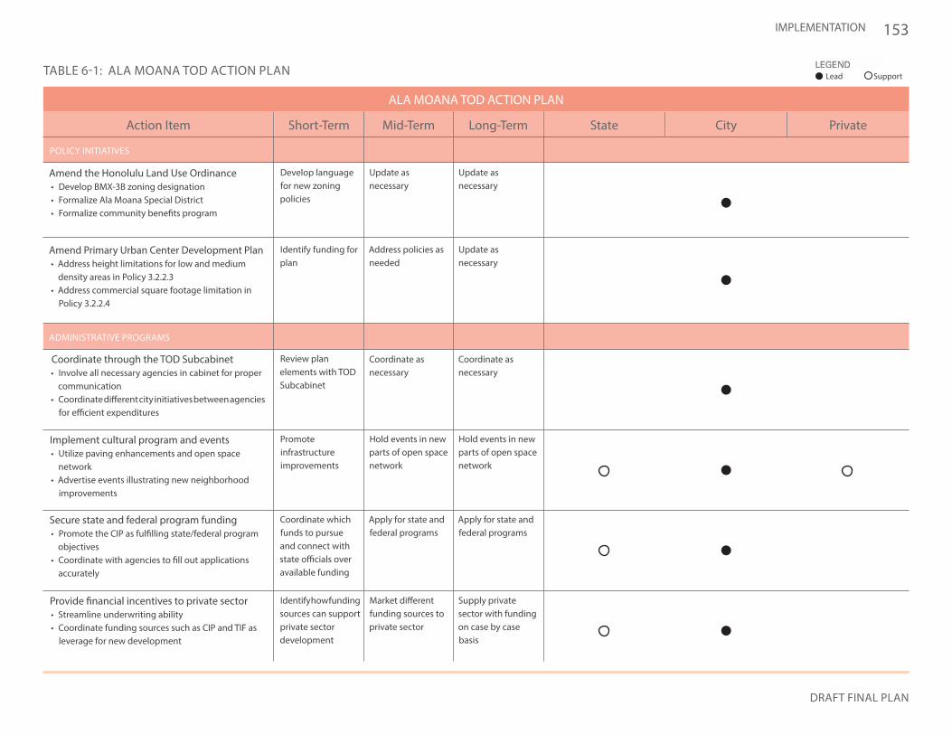
153
DRAFT FINAL PLAN
IMPLEMENTATION
Lead Support
State City PrivateLong-TermMid-TermShort-TermAction Item
ALA MOANA TOD ACTION PLAN
POLICY INITIATIVES
ADMINISTRATIVE PROGRAMS
Amend the Honolulu Land Use Ordinance• Develop BMX-3B zoning designation• Formalize Ala Moana Special District• Formalize community benefits program
Coordinate through the TOD Subcabinet• Involve all necessary agencies in cabinet for proper
communication• Coordinate different city initiatives between agencies
for efficient expenditures
Implement cultural program and events• Utilize paving enhancements and open space
network• Advertise events illustrating new neighborhood
improvements
Amend Primary Urban Center Development Plan• Address height limitations for low and medium
density areas in Policy 3.2.2.3• Address commercial square footage limitation in
Policy 3.2.2.4
Secure state and federal program funding• Promote the CIP as fulfilling state/federal program
objectives• Coordinate with agencies to fill out applications
accurately
Provide financial incentives to private sector• Streamline underwriting ability• Coordinate funding sources such as CIP and TIF as
leverage for new development
Develop language for new zoning policies
Identify funding for plan
Review plan elements with TOD Subcabinet
Promoteinfrastructureimprovements
Coordinate which funds to pursue and connect with state officials over available funding
Identify how funding sources can support private sector development
Update as necessary
Address policies as needed
Coordinate as necessary
Hold events in new parts of open space network
Apply for state and federal programs
Market different funding sources to private sector
Update as necessary
Update as necessary
Coordinate as necessary
Hold events in new parts of open space network
Apply for state and federal programs
Supply private sector with funding on case by case basis
TABLE 6-1: ALA MOANA TOD ACTION PLAN
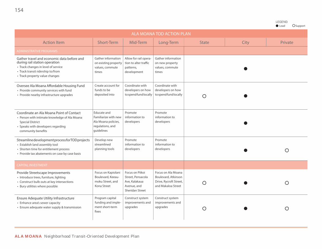
154
ALA MOANA Neighborhood Transit-Oriented Development Plan
Long-TermMid-TermShort-TermAction Item
ALA MOANA TOD ACTION PLAN
ADMINISTRATIVE PROGRAMS
CAPITAL INVESTMENT
Gather travel and economic data before and during rail station operation• Track changes in level of service• Track transit ridership to/from• Track property value changes
Provide Streetscape Improvements• Introduce trees, furniture, lighting• Construct bulb outs at key intersections• Bury utilities where possible
Ensure Adequate Utility Infrastructure• Enhance area’s sewer capacity• Ensure adequate water supply & transmission
Gather information on existing property values, commute times
Focus on Kapiolani Boulevard, Keeau-moku Street, and Kona Street
Program capital funding and imple-ment short-term fixes
Create account for funds to bedeposited into
Educate andFamiliarize with new Ala Moana policies, regulations, and guidelines
Develop new streamlinedplanning tools
Allow for rail opera-tion to alter traffic patterns,development
Focus on Piikoi Street, Pensacola Ave, Kalakaua Avenue, and Sheridan Street
Construct system improvements and upgrades
Coordinate withdevelopers on how to spend fund locally
Promoteinformation to developers
Promoteinformation to developers
Gather information on new property values, commute times
Focus on Ala Moana Boulevard, Atkinson Drive, Rycroft Street, and Makaloa Street
Construct system improvements and upgrades
Coordinate withdevelopers on how to spend fund locally
Promoteinformation to developers
Promoteinformation to developers
Oversee Ala Moana Affordable Housing Fund• Provide community services with fund• Provide nearby infrastructure upgrades
Coordinate an Ala Moana Point of Contact• Person with intimate knowledge of Ala Moana
Special District• Speaks with developers regarding
community benefits
Streamline development process for TOD projects• Establish land assembly tool• Shorten time for entitlement process• Provide tax abatements on case by case basis
State City Private
Lead Support
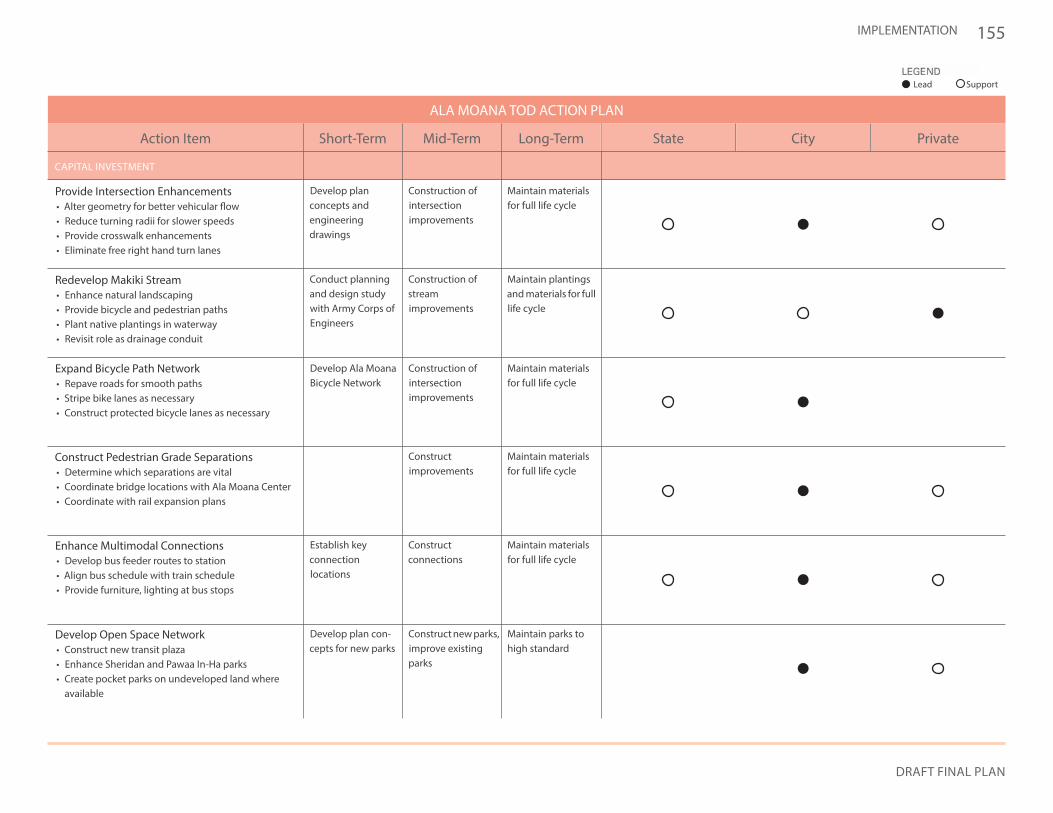
155
DRAFT FINAL PLAN
IMPLEMENTATION
Develop planconcepts andengineeringdrawings
Develop Ala Moana Bicycle Network
Establish keyconnectionlocations
Develop plan con-cepts for new parks
Construction of intersectionimprovements
Construction of streamimprovements
Conduct planning and design study with Army Corps of Engineers
Construction of intersectionimprovements
Constructconnections
Construct new parks, improve existing parks
Construct improvements
Maintain materials for full life cycle
Maintain plantings and materials for full life cycle
Maintain materials for full life cycle
Maintain materials for full life cycle
Maintain parks to high standard
Maintain materials for full life cycle
Provide Intersection Enhancements• Alter geometry for better vehicular flow• Reduce turning radii for slower speeds• Provide crosswalk enhancements• Eliminate free right hand turn lanes
Redevelop Makiki Stream• Enhance natural landscaping• Provide bicycle and pedestrian paths• Plant native plantings in waterway• Revisit role as drainage conduit
Expand Bicycle Path Network• Repave roads for smooth paths• Stripe bike lanes as necessary• Construct protected bicycle lanes as necessary
Construct Pedestrian Grade Separations• Determine which separations are vital• Coordinate bridge locations with Ala Moana Center• Coordinate with rail expansion plans
Enhance Multimodal Connections• Develop bus feeder routes to station• Align bus schedule with train schedule• Provide furniture, lighting at bus stops
Develop Open Space Network• Construct new transit plaza• Enhance Sheridan and Pawaa In-Ha parks• Create pocket parks on undeveloped land where
available
Long-TermMid-TermShort-TermAction Item
ALA MOANA TOD ACTION PLAN
CAPITAL INVESTMENT
State City Private
Lead Support
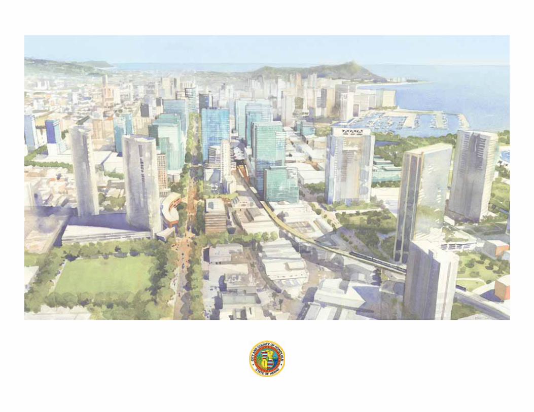
A L A M O A N A