neighborhood voices: using community engagement to address
TRANSCRIPT

Neighborhood Voices: Using Community Engagement to Address Transportation, Infrastructure and Safety Concerns in Near Northside, Houston
Building Better Cities Building Better Lives
Photo: Geli la Haile

February 2020
Rice University Kinder Institute for Urban Research MS 208 6100 Main St., Houston, Texas 77005 Telephone: 713-348-4132 http://kinder.rice.edu For more information, contact [email protected].
Copyright ©2020 by Rice University Kinder Institute for Urban Research. All rights reserved.
Contributors: Dian Nostikasari, Gelila Haile, Kyle Shelton
https://doi.org/10.25611/fzkt-y354

1Neighborhood Voices: Using Community Engagement to Address Transportation, Infrastructure and Safety Concerns in Near Northside, Houston
TABLE OF CONTENTS
Table of Contents
2 Executive Summary
4 Introduction
6 Neighborhood Safety Concerns
9 Use and Access to Existing Transportation Infrastructure
12 Moving Forward: Policy Implications
14 Conclusion
15 Endnotes

2 Rice University Kinder Institute for Urban Research
Executive Summary
Over the span of 11 months, the Kinder Institute for Urban Research
collaborated with various community partners such as LINK Houston,
BakerRipley and the University of Houston’s Psychological Health and Learning
Sciences department to conduct a two-part assessment of the Near Northside
neighborhood. This effort mirrors one conducted by the Kinder Institute and
neighborhood partners in Gulfton in 2018.1 The first part of the assessment and
the focus of this report revolved around a survey of community residents to gather
input on street safety concerns of the neighborhood. The second part of the effort,
which is documented in an accompanying report, used a detailed walk audit to
create an inventory of pedestrian, bicycle and public transit street infrastructure in
the Near Northside.
The information revealed through this report can complement the public infrastructure work in Near Northside by providing a more in-depth understanding of critical transportation safety issues and highlighting what areas residents see as key issues with local infrastructure. Ultimately, this information can be used to discern what specific street safety improvements should be a priority in the Near Northside.
Key Findings
Street safety, which is tied to dangerous traffic, ADA accessibility and crime, is perceived as a major issue in the neighborhood by surveyed residents.
• Most of the pedestrian- and bicyclist-involved crashes, including resident-identified crashes and near-miss incidents, are concentrated in the southern part of the neighborhood where schools, grocery stores, bus stops and other public neighborhood hubs such libraries and community centers are located.
• Of respondents to this study, about 24% of those who live in the neighborhood and adjacent areas did not drive, instead they rely on walking, biking or taking the bus to work. This compares to the city’s overall rate of 9%.
• 67% of neighborhood respondents drive and/or carpool to work regularly, while 59% drive and/or carpool to non-work destinations.
• 12% of residents have experienced or witnessed a crash or near-miss incident.
• All of the reported near-miss incidents involved automobiles and pedestrians.
EXECUTIVE SUMMARY

3Neighborhood Voices: Using Community Engagement to Address Transportation, Infrastructure and Safety Concerns in Near Northside, Houston
Methodology
Researchers at the Kinder Institute, in collaboration with the Psychological Health and Learning Sciences department from the University of Houston, conducted surveys at key locations around the Near Northside neighborhood. Our team reached out to neighborhood residents and other respondents by attending a local food drive at Castillo Park and visiting the Moody Park community center during group exercise times as well as during the week of the 2018 midterm elections. The interview process ran from September 2018 to March 2019.
Participants were selected at random and had the option to opt-out of taking the survey. Of the 304 respondents surveyed, 175 (57.5%) lived in Near Northside. The remaining respondents either worked in or frequently visited Near Northside or did not provide an address. To maintain consistency and reliability in our analysis, our team used the same survey used in the earlier Gulfton
street safety study, which included questions about daily travel modes to work and non-work places and perceptions of infrastructure and facilities including sidewalks, METRO services and bike paths. Respondents were also asked to identify problem areas and places to which they will not walk to and provide reasons behind their decision to avoid identified locations. They provided information about any near-miss or crash incidents that they witnessed or experienced in the last six months within the community. Additionally, they were asked to list strategies that would lessen their dependence on private automobile travel. The data collection process was conducted in either English or Spanish.
Following the survey collection, researchers at the Kinder Institute geocoded and mapped the data into an ArcGIS tool to map locations where crashes and near-miss incidents occurred. Analysis of detailed comments in the survey using Dedoose, a program for systematic analysis of text, revealed common themes and supporting comments related to safety issues.
EXECUTIVE SUMMARY
Near Northside photos captured during the walk audit courtesy of University of Houston students.
4 Rice University Kinder Institute for Urban Research
INTRODUCTION
Introduction
Studies have shown that lower-income neighborhoods like Near Northside
often lack adequate pedestrian infrastructure.2 At the same time, such
neighborhoods tend to have higher concentrations of people of color and people
with lower-incomes, groups that face a higher risk of pedestrian injury and death.3
This study aims to highlight community perceptions of the conditions, issues and
transportation needs of Near Northside. Through this survey, residents were asked
to respond to several questions about the condition of streets in the community for
people walking, biking and taking transit.
First, what are the challenges faced by people in Near Northside who walk, bike and use public transportation? Second, which key improvements are suggested by residents about transportation infrastructure and services? Finally, how can residents’ input complement other efforts to improve the livelihood and well-being of residents, including safety and accessibility goals identified by the city’s Complete Communities initiative? In addition to these questions, the survey collected information about problem areas and sites of previous
crashes or near-misses. The results show that while there are many challenges and gaps in the existing system, there is a need and desire for Near Northside to implement better street infrastructure that accounts for the safety of people biking, walking and taking transit. Such improvements can also help address issues residents identified in the broader Complete Community Action Plan around access to healthcare, education and employment opportunities.4
5Neighborhood Voices: Using Community Engagement to Address Transportation, Infrastructure and Safety Concerns in Near Northside, Houston
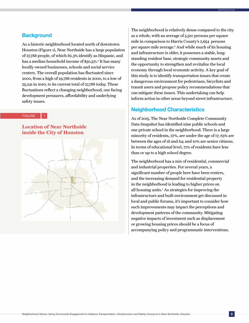
Background
As a historic neighborhood located north of downtown Houston (Figure 1), Near Northside has a large population of 27,788 people, of which 82.3% identify as Hispanic, and has a median household income of $30,571.5 It has many locally owned businesses, schools and social service centers. The overall population has fluctuated since 2000, from a high of 29,788 residents in 2000, to a low of 25,241 in 2010, to its current total of 27,788 today. These fluctuations reflect a changing neighborhood, one facing development pressures, affordability and underlying safety issues.
The neighborhood is relatively dense compared to the city as a whole, with an average of 5,510 persons per square mile in comparison to Harris County’s 2,654 persons per square mile average.6 And while much of its housing and infrastructure is older, it possesses a stable, long-standing resident base, strategic community assets and the opportunity to strengthen and revitalize the local economy through local economic activity. A key goal of this study is to identify transportation issues that create a dangerous environment for pedestrians, bicyclists and transit users and propose policy recommendations that can mitigate these issues. This undertaking can help inform action in other areas beyond street infrastructure. Neighborhood Characteristics
As of 2015, The Near Northside Complete Community Data Snapshot has identified nine public schools and one private school in the neighborhood. There is a large minority of residents, 27%, are under the age of 17; 63% are between the ages of 18 and 64; and 10% are senior citizens. In terms of educational level, 71% of residents have less than or up to a high school degree.
The neighborhood has a mix of residential, commercial and industrial properties. For several years, a significant number of people here have been renters, and the increasing demand for residential property in the neighborhood is leading to higher prices on all housing units.7 As strategies for improving the infrastructure and built environment get discussed in local and public forums, it’s important to consider how such improvements may impact the perceptions and development patterns of the community. Mitigating negative impacts of investment such as displacement or growing housing prices should be a focus of accompanying policy and programmatic interventions.
INTRODUCTION
FIGURE 1
Location of Near Northside inside the City of Houston

6 Rice University Kinder Institute for Urban Research
NEIGHBORHOOD SAFETY CONCERNS
Neighborhood Safety Concerns
When asked, respondents identified a number of issues with the street
infrastructure in their neighborhood. These concerns were best captured by
responses to the survey question that asked residents why they chose not to walk
more in the neighborhood. The top two deterrents for walking in the neighborhood,
according to respondents, are the fear of crime and/or unpleasant contact with
others and concerns about being hit by a car (see Figure 2). Aside from simply
preferring to drive, the rest of the list consists of numerous safety concerns as the
primary deterrent to walking. Looking more closely at how these different concerns
manifest in the Near Northside helps paint a picture of the issues the community
faces with its street infrastructure.
FIGURE 2 Cited Reasons for Not Walking
Fear of crime/unpleasant contact with others
Fear of being hit or nearly hit by a car
I prefer to drive
Drivers don’t obey school zone speed
No convenient or safe street crossings
Too many physical barriers to get there
Other
Not able to safely use wheelchair
I have to cross highway I-45 to get there 7%
13%
14%
16%
25%
28%
31%
32%
47%
I have to cross highway I-45 to get there
Not able to safely use wheelchair
Other
Too many physical barriers to get there
No convenient or safe street crossings
Drivers don't obey school zone speed
I prefer to drive
Fear of being hit or nearly hit by a car
Fear of crime/unpleasant contact with others
Cited Reasons for Not Walking

7Neighborhood Voices: Using Community Engagement to Address Transportation, Infrastructure and Safety Concerns in Near Northside, Houston
NEIGHBORHOOD SAFETY CONCERNS
Resident-Identified Problem Areas
Physical safety concerns and fear of crime are the top deterrents for walking in the community. The 2016 murder of Josue Flores, an 11-year-old boy who was killed while walking home from school, has been a touchstone for organization around this issue. Residents created a community group called Safe Walk Home in response.8 The group organizes adults to monitor streets during high student traffic times. They have also been focusing on advocating for better monitoring and enforcement with the Houston Police Department, Metro Transit Police and their city councilmember. The community’s safety concerns can be supported by data collected by the city of Houston around safety and crime in the neighborhood. One of the findings from the Complete Community Action Plan indicates that residents experience high crime intensity around the MetroRail Red Line, according to data provided by CrimeReports.
The map to the right outlines the intensity of crime in the neighborhood from that year in relation to its proximity to the Red MetroRail line, which could contribute to the low transit ridership rates in the neighborhood.9 According to the Action Plan, the neighborhood had 1,051 violent crime rate per 100,000 in 2016 in comparison to the 1,026 violent crime rate per 100,000 in Houston for the same year.10 Collecting community information on street safety issues is paramount because official crash data reported by public agencies typically undercount pedestrian and bicyclist crashes despite the greater vulnerability of those road users. Official crash data only captures reported
incidents on public roads and leaves out incidents that occur on private roads, in driveways or in parking lots. The heat map created by the Kinder Institute further showcases the location pattern of crime from data collected between 2010-2017.
FIGURE 3
Near Northside Crime Map published in the Complete Community Action Plan

8 Rice University Kinder Institute for Urban Research
Figure 4 shows three areas where concentrations of pedestrian- and bicyclist-involved crashes have occurred from 2010-2017, according to Texas Department of Transportation (TxDOT) records and the resident-identified crashes and near-miss incidents collected in the survey. Most of these incidents are concentrated in the southern part of the neighborhood where schools, grocery stores, bus stops and neighborhood hubs are located. To a great extent, self-reported crash and near-miss incidents overlap with crash data from TxDOT. Other areas with a higher density of crashes or incidents are near major commercial streets like Fulton Street and Irvington Boulevard. The intersection of Irvington Boulevard and the Loop 610 service road is an area with a high number of crashes recorded by TxDOT.
Feeling unsafe on the street, whether due to fears of crime or out of concern for being hit by a vehicle, can affect future travel behaviors. The Houston region has seen increases in pedestrian fatalities since 2010 and has also witnessed a steady rate of bicycle fatalities. Neighborhoods that lack safe street infrastructure feel this danger even more.
Our survey also revealed that 12% of the 167 Near Northside resident respondents have either witnessed or experienced an accident or a near-miss accident in the last six months since the date of the survey. Of that 12%, the majority stated that the accident involved a car and a person walking when they reported the crash or near-miss accident.
The experience of witnessing or being involved in near-miss or crash incidents can potentially affect decisions
about future travel choices. Likewise, quality of travel experiences such as the perception of safety, comfort and aesthetics can either encourage or discourage future walking and biking trips (see Figure 2). Unsafe or unwelcoming streets can feed into a cycle where problematic streets lead people to walk less, which reduces the number of residents calling for improving the streets for pedestrians, which, in turn, leads to less investment to improve the streets.
FIGURE 4
Concentrated Areas where Pedestrian and Bicyclist-involved Crashes Occurred, 2010-2017
NEIGHBORHOOD SAFETY CONCERNS

9Neighborhood Voices: Using Community Engagement to Address Transportation, Infrastructure and Safety Concerns in Near Northside, Houston
USE AND ACCESS TO EXISTING TRANSPORTATION INFRASTRUCTURE
Use and Access to Existing Transportation Infrastructure
The following section details additional key findings related to how people living
in Near Northside commute to work and other important locations. It also
looks at their satisfaction with walking, biking and using public transportation. This
section then examines differences by travel mode to understand how experiences
and concerns vary across those groups. Finally, it provides insights into what would
make getting around without a car easier.
Transportation to Work
Based on our survey, Figure 5 shows the distribution of transportation modes used by residents to get to work and other destinations in the neighborhood. Approximately 64% of residents drive to work and 55% drive to other destinations. However, 12% of respondents
get to work using public transit, 9% walk and 3% bike. All rates are above the city average for each mode. Those numbers are even higher when looking at all trips. Given the inadequate infrastructure of the community for pedestrians and people on bikes (see the infrastructure audit) this is a significant proportion.
FIGURE Modes of Transportation
64%
12%9%
3% 3%9%
55%
17% 15%8%
4%1%
Drive Transit Walk Bike Carpool Other
Modes of Transporation
Work Other Destinations
5
10 Rice University Kinder Institute for Urban Research
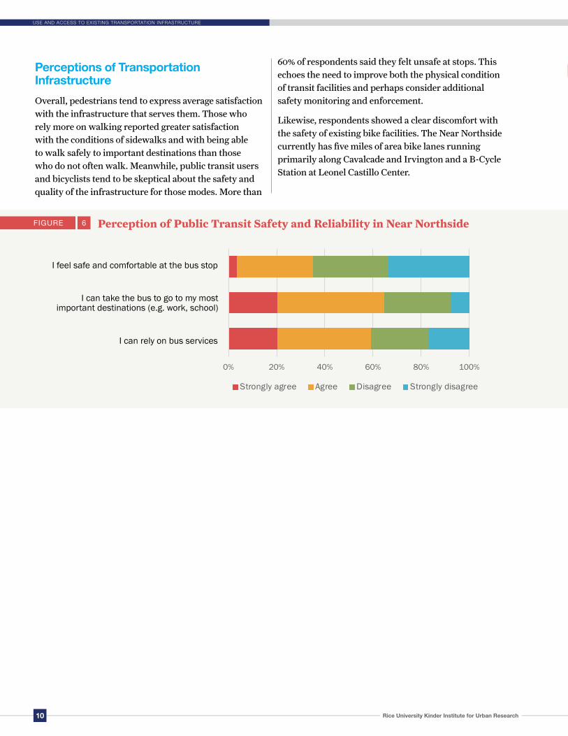
Perceptions of Transportation Infrastructure
Overall, pedestrians tend to express average satisfaction with the infrastructure that serves them. Those who rely more on walking reported greater satisfaction with the conditions of sidewalks and with being able to walk safely to important destinations than those who do not often walk. Meanwhile, public transit users and bicyclists tend to be skeptical about the safety and quality of the infrastructure for those modes. More than
60% of respondents said they felt unsafe at stops. This echoes the need to improve both the physical condition of transit facilities and perhaps consider additional safety monitoring and enforcement.
Likewise, respondents showed a clear discomfort with the safety of existing bike facilities. The Near Northside currently has five miles of area bike lanes running primarily along Cavalcade and Irvington and a B-Cycle Station at Leonel Castillo Center.
FIGURE 6 Perception of Public Transit Safety and Reliability in Near Northside
USE AND ACCESS TO EXISTING TRANSPORTATION INFRASTRUCTURE
I can rely on bus services
I can take the bus to go to my most important destinations (e.g. work, school)
I feel safe and comfortable at the bus stop
0% 20% 40% 60% 80% 100%
I can rely on bus services
I can take the bus to go to my most importantdestinations (e.g. work, school)
I feel safe and comfortable at the bus stop
Strongly agree Agree Disagree Strongly disagree

11Neighborhood Voices: Using Community Engagement to Address Transportation, Infrastructure and Safety Concerns in Near Northside, Houston
USE AND ACCESS TO EXISTING TRANSPORTATION INFRASTRUCTURE
FIGURE 7 Perception of Bike Routes and Safety
I feel safe riding a bicycle to my most important destinations (e.g. work, school)
I feel safe walking or biking to bus stops
I have a bike route that connects me to bus stops
My bike routes are in good condition (e.g. smooth surface with minimal car traffic)
Perception of Walking Facilities and Safety
Sidewalks are connected with minimal obstructions
Sidewalks connect me to bus stops
There are enough streetlights
There are sidewalks on most neighborhood streets
FIGURE 8
0% 20% 40% 60% 80% 100%
I feel safe riding a bicycle to my most importantdestinations (e.g. work, school)
I feel safe walking or biking to bus stops
I have a bike route that connects me to bus stops
My bike routes are in good condition (e.g. smoothsurface, with minimal car traffic)
Strongly agree Agree Disagree Strongly disagree
0% 20% 40% 60% 80% 100%
Sidewalks are connected with minimalobstructions
Sidewalks connect me to bus stops
There are enough streetlights
There are sidewalks on most neighborhood streets
Strongly agree Agree Disagree Strongly disagree

12 Rice University Kinder Institute for Urban Research
Moving Forward: Policy Implications
As one of the original five complete communities designated by the mayor’s
office, Near Northside has seen renewed interest in improving the quality of
services and amenities available to residents and business owners. Additionally,
Near Northside identified the following focus areas within Plan Houston’s 32
citywide goals: nurturing a safe and secure neighborhood; access to parks and
public spaces; an attractive, healthy and walkable neighborhood; and affordable
housing. Non-profit organizations, local government and businesses are joining the
effort to create an equitable, healthy, safe and thriving neighborhood.
The Kinder Institute’s focus on the street safety and infrastructure assessment complements this and adds a layer of safety assessment from the perspective of neighborhood residents. The survey corroborates the three mobility and infrastructure goals outlined in the Near Northside Action Plan through the Complete Communities Initiative — a push for adequate sidewalks, expanded bike lanes and lighted streets.11 All of these elements were at the top of the list of ideas residents’ offered about what would encourage them to travel without a car. (Figure 9). Improved transportation infrastructure, when coupled with other investments part of the broader Complete Community effort, could encourage residents to take more active transportation options.
Parks, businesses and community centers are accessible by walking, biking and transit in the Near Northside. Creating infrastructure that makes using those modes safer can help people lead active and healthy lives. The community organizations and the city already promote events in the neighborhood that encourage biking or walking, including the Tour de Northside and Sunday Streets. These efforts could be aided by improving neighborhood sidewalks and bike amenities. The objective outlined in the Action Plan for 71% of residents to engage in regular physical activity by 2023 can be greatly aided by improving the infrastructure for pedestrians and people on bikes.
MOVING FORWARD: POLICY IMPLICATIONS

13Neighborhood Voices: Using Community Engagement to Address Transportation, Infrastructure and Safety Concerns in Near Northside, Houston
MOVING FORWARD: POLICY IMPLICATIONS
FIGURE 9 Ways to Improve Ease of Getting Around Without a Car Among Near Northside Residents
Safer streets with more lighting, crosswalks, and separation from cars
Less worry about crime or unpleasant contact with others
More or improved sidewalks and/or bike routes
Slower car traffic
More frequent and reliable bus services
More accurate and easy to understand information about bus schedules and routes
Friendlier and more helpful bus drivers
Other
0% 10% 20% 30% 40% 50% 60%
S u p p o r t f o r n o n- car t r i ps O t he r
F r i en dl i e r a n d m ore h e l p f ul b u s d r i v ers
M o r e a c cu rat e a n d e a sy t o u n ders t and i n fo r mat i on a b o u t b u s s c h ed ul es a n d r o ut es
M o r e f r equ ent a n d r e l i ab l e b u s s e rv i ces
S l o w e r c a r t r a ff i c
M o r e o r i m prov ed s i de wal k s a n d/ or b i k e r ou te s
L e s s w o r r y a b ou t c r i me o r u n pl eas an t c o n t act w i t h o t h e r s
S a f e r s t r eet s w i th m or e l i g ht i n g, c r oss w al k s, a nd s e p a ra ti on f r om c a rs
Wa ys to i m prove e ase o f g e tting a round w i thou t a c a r a m ong N ear N orths ide r es idents

14 Rice University Kinder Institute for Urban Research
Conclusion
Members of the community are often faced with challenges in their daily
routines that require a deeper understanding and assessment outside of
official crash data collected by external auditors. The process of surveying residents
and providing the opportunity to expand on their built environment experiences
creates a cohesive story that supplements the quantitative data gathered by the
city and other organizations. This study highlights the relationship between street
infrastructure and the perception of safety from crime and unpleasant contact.
While the top-cited reason for not walking in the neighborhood was fear of crime
and/or unpleasant contact with others, residents also cited the top improvement as
safer streets with more lighting, crosswalks and separation from cars.
The Complete Communities initiative has included public participation in its planning process. However, opportunities exist to build on these processes and overcome persistent challenges to public participation in neighborhoods such as Near Northside. Further outreach strategies that include collecting original data from residents is needed in order to include those who struggle to participate in more formal public input processes. The outcomes of this study support the idea that adding such approaches to the participation toolkit can further improve and democratize decision making in the future.
CONCLUSION
15Neighborhood Voices: Using Community Engagement to Address Transportation, Infrastructure and Safety Concerns in Near Northside, Houston
ENDNOTES
Endnotes
1. Dian Nostikasari, Grant Patterson and Kyle Shelton,“Planning from Inside Out: Using Community Input to Address Transportation, Infrastructure, and Safety Concerns.” Kinder Institute for Urban Research, 2017.
2. Mike Maciag, “Pedestrian Deaths in Poorer Neighborhoods Report,” Governing Magazine, 2014.
3. “Dangerous By Design 2016,” Smart Growth America. 2016.
4. City of Houston, Near Northside - Complete Community Action Plan, 2018.
5. City of Houston, Near Northside DataSnapshot.
6. Houston Commuinity Data Connections, Kinder Institute for Urban Research, Near Northside Profile, https://www.datahouston.org/neighborhood/K002.html
7. Erin Mulvaney, “Near Northside neighborhood braces for change,” Houston Chronicle, April 24, 2015
8. Gail Delaughter, “Three Years After A Shocking Crime, Near Northside Residents Work To Keep Their Neighborhood Safe,” Houston Public Media, June 12, 2019.
9. City of Houston, Near Northside - Complete Community Action Plan, 2018.
10. Houston Crime Report - CrimeReports is the nation’s largest collection of law enforcement agencies committed to transparency, public access, and citizen engagement.
11. City of Houston, Near Northside - Complete Community Action Plan, 2018.

MissionThe Kinder Institute for Urban Research builds better cities and improves people’s lives by bringing together data, research, engagement and action.
6100 Main Street MS-208 • Houston, TX 77005 • Phone 713-348-4132 • Email [email protected]