netc 18-3 integration of unmanned aircraft departments of
TRANSCRIPT

Page 1
New England Transportation Consortium (NETC)
NETC 18-3
Integration of Unmanned Aircraft Systems (UAS) Into Operations Conducted by New England Departments of Transportation
Task 1 Report
Exploration of UAS Applications to Support State DOT Missions
September 16th, 2019
This report, prepared in cooperation with the New
England Transportation Consortium, does not constitute a
standard, specification, or regulation. The contents of this
report reflect the views of the authors who are
responsible for the facts and the accuracy of the data
presented herein. The contents do not necessarily reflect
the views of the New England Transportation Consortium
or the Federal Highway Administration
INTERIM
REPORT
Integration of UAS Into Operations Conducted by New England Departments of Transportation (NETC 18-3)
Task 1 Report: Exploration of UAS Applications to Support State DOT Missions
Page i
ACKNOWLEDGMENTS
The following are the members of the Technical Committee that developed the scope of work for the
project and provided technical oversight throughout the course of the research:
• Dr. Jeffrey DeCarlo, Massachusetts Department of Transportation (Technical Committee Chair)
• Pamela Cotter, Rhode Island Department of Transportation
• Carol Niewola, New Hampshire Department of Transportation
• Matt Philbrick, Maine Department of Transportation
• Amy Stula, Connecticut Department of Transportation
• David Tillberg, Vermont Agency of Transportation
• Dr. Emily Parkany, Vermont Agency of Transportation (Advisory Committee Liaison)
INTERIM
REPORT

Integration of UAS Into Operations Conducted by New England Departments of Transportation (NETC 18-3)
Task 1 Report: Exploration of UAS Applications to Support State DOT Missions
Page ii
TECHNICAL REPORT DOCUMENTATION PAGE
1. Report No.
N/A
2. Government Accession No.
N/A
3. Recipient's Catalog No.
N/A
4. Title and Subtitle
Integration of UAS Into Operations Conducted by New England
Departments of Transportation - Exploration of UAS Applications to
Support State DOT Missions (Task 1 Report)
5. Report Date
September 2019
6. Performing Organization Code
N/A
7. Author(s)
Jonathan Gustafson and Bharathwaj Sankaran
8. Performing Organization Report No.
N/A
9. Performing Organization Name and Address
WSP USA, Inc.
428 Dow Highway
Eliot, ME 03903
10. Work Unit No. (TRAIS)
N/A
11. Contract or Grant No.
N/A
12. Sponsoring Agency Name and Address
New England Transportation Consortium
C/O Transportation Research Center
University of Vermont, Farrell Hall
210 Colchester Avenue
Burlington, VT 05405
13. Type of Report and Period Covered
Task 1 Report
April 2019 to September 2019
14. Sponsoring Agency Code
NETC 18-3
15. Supplementary Notes
N/A
16. Abstract
Safety, accountability, and transparency are key guiding principles of State DOTs in their stewardship responsibilities. These
principles are embodied in their mission areas to provide an effective and reliable transportation system. Unmanned aircraft
systems technology is proving to enhance State DOT’s practices as an innovative and inexpensive solution that improves
safety and accessibility, reduces cost, streamlines processes, improves workforce utilization and accelerates several
transportation operations activities. A few studies have been conducted at the national level, but little guidance has been
published on incremental steps to integrating UAS in various applications. The objective of this research is to provide
guidance to New England State DOTs regarding effective practices when incorporating UAS into daily operations. The first
phase of this research reflected in this Task 1 report provides a literature review, targeted interviews, and an analysis on the
efficacy of selected transportation applications for implementing UAS technology. Subsequent phases of this research will
evaluate market-ready technologies and support systems necessary to implement UAS technology, investigate traditional
workflows, address challenges with regulatory compliance, and develop procedures for the selected transportation
applications.
17. Key Words
Unmanned aircraft systems, UAS, transportation, inspection, monitoring,
surveying and mapping, emergency response, construction, public
outreach
18. Distribution Statement
No restriction.
19. Security Classif. (of this report)
Unclassified
20. Security Classif. (of this page)
Unclassified
21. No. of Pages
88
22. Price
N/A
Form DOT F 1700.7 (8-72) Reproduction of completed page authorized.
INTERIM
REPORT

Integration of UAS Into Operations Conducted by New England Departments of Transportation (NETC 18-3)
Task 1 Report: Exploration of UAS Applications to Support State DOT Missions
Page iii
SI* (MODERN METRIC) CONVERSION FACTORS APPROXIMATE CONVERSIONS TO SI UNITS
Symbol When You Know Multiply By To Find Symbol
LENGTH in inches 25.4 millimeters mm
ft feet 0.305 meters m
yd yards 0.914 meters m mi miles 1.61 kilometers km
AREA in
2square inches 645.2 square millimeters mm
2
ft2
square feet 0.093 square meters m2
yd2
square yard 0.836 square meters m2
ac acres 0.405 hectares ha
mi2
square miles 2.59 square kilometers km2
VOLUME fl oz fluid ounces 29.57 milliliters mL
gal gallons 3.785 liters L ft
3 cubic feet 0.028 cubic meters m
3
yd3
cubic yards 0.765 cubic meters m3
NOTE: volumes greater than 1000 L shall be shown in m3
MASS oz ounces 28.35 grams g
lb pounds 0.454 kilograms kg
T short tons (2000 lb) 0.907 megagrams (or "metric ton") Mg (or "t")
TEMPERATURE (exact degrees) oF Fahrenheit 5 (F-32)/9 Celsius
oC
or (F-32)/1.8
ILLUMINATION fc foot-candles 10.76 lux lx fl foot-Lamberts 3.426 candela/m
2 cd/m
2
FORCE and PRESSURE or STRESS lbf poundforce 4.45 newtons N
lbf/in2
poundforce per square inch 6.89 kilopascals kPa
APPROXIMATE CONVERSIONS FROM SI UNITS
Symbol When You Know Multiply By To Find Symbol
LENGTHmm millimeters 0.039 inches in
m meters 3.28 feet ft
m meters 1.09 yards yd
km kilometers 0.621 miles mi
AREA mm
2 square millimeters 0.0016 square inches in
2
m2 square meters 10.764 square feet ft
2
m2 square meters 1.195 square yards yd
2
ha hectares 2.47 acres ac
km2
square kilometers 0.386 square miles mi2
VOLUME mL milliliters 0.034 fluid ounces fl oz
L liters 0.264 gallons gal
m3
cubic meters 35.314 cubic feet ft3
m3
cubic meters 1.307 cubic yards yd3
MASS g grams 0.035 ounces oz
kg kilograms 2.202 pounds lbMg (or "t") megagrams (or "metric ton") 1.103 short tons (2000 lb) T
TEMPERATURE (exact degrees) oC Celsius 1.8C+32 Fahrenheit
oF
ILLUMINATION lx lux 0.0929 foot-candles fc
cd/m2
candela/m2
0.2919 foot-Lamberts fl
FORCE and PRESSURE or STRESS N newtons 0.225 poundforce lbf
kPa kilopascals 0.145 poundforce per square inch lbf/in2
*SI is the symbol for th International System of Units. Appropriate rounding should be made to comply with Section 4 of ASTM E380. e
(Revised March 2003)
INTERIM
REPORT
Integration of UAS Into Operations Conducted by New England Departments of Transportation (NETC 18-3)
Task 1 Report: Exploration of UAS Applications to Support State DOT Missions
Page iv
TABLE OF CONTENTS
1.0 Introduction ...................................................................................................................................... 1
2.0 UAS Program Components ............................................................................................................... 1
2.1 Organizational Structure ............................................................................................................... 1
2.2 Competencies and Training Framework ....................................................................................... 5
2.3 State Policies, Legislative Priorities, and Funding ......................................................................... 6
2.4 Technology/Data Policy .............................................................................................................. 10
2.5 Safety Management System/Operational Risk Assessment ....................................................... 11
2.6 Quality Management .................................................................................................................. 14
2.7 Collaboration Frameworks with Partners ................................................................................... 15
3.0 New England State Departments of Transportation Profiles ......................................................... 16
3.1 Connecticut Department of Transportation ............................................................................... 17
3.2 Maine Department of Transportation ........................................................................................ 20
3.3 Massachusetts Department of Transportation ........................................................................... 24
3.4 New Hampshire Department of Transportation ......................................................................... 27
3.5 Rhode Island Department of Transportation .............................................................................. 29
3.6 Vermont Transportation Agency ................................................................................................ 32
4.0 Transportation Applications ........................................................................................................... 35
4.1 Monitoring traffic and safety operations .................................................................................... 37
4.2 Structural Inspection ................................................................................................................... 41
4.3 Construction Inspection .............................................................................................................. 47
4.4 Surveying and Mapping .............................................................................................................. 51
4.5 Environmental Assessments ....................................................................................................... 56
4.6 Emergency and Incident Response/Recovery – Natural Disasters ............................................. 59
4.7 Emergency and Incident Response/Recovery – Human-caused Disasters ................................. 63
4.8 Public Outreach and Engagement............................................................................................... 67
5.0 Selected Transportation Applications and Next Steps .................................................................... 70
6.0 References ...................................................................................................................................... 71
INTERIM
REPORT

Integration of UAS Into Operations Conducted by New England Departments of Transportation (NETC 18-3)
Task 1 Report: Exploration of UAS Applications to Support State DOT Missions
Page v
LIST OF FIGURES
Figure 2-1 Illustration. VDOT's UAS Program - Organizational Chain of command and Responsibilities ..... 3
Figure 2-2. Illustration. UDOT UAS governance structure. (Federal Highway Administration, 2019) .......... 4
Figure 2-3. Illustration. Order of legislative influences for UAS operations (Mallela, et al., In Press.). ....... 7
Figure 2-4. Map. States with UAS legislations/Bills. (Association for Unmanned Vehicle Systems
International, 2019) ...................................................................................................................................... 8
Figure 2-5. Illustration. Data and systems governance model (Maine Department of
Transportation, 2014). ............................................................................................................................. 11
Figure 2-6. Flowchart. FAA hazard identification and risk assessment process chart. (Federal Aviation
Administration, 2016a). .............................................................................................................................. 12
Figure 2-7. Illustration. Alaska Center of UAS Integration’s project risk assessment matrix. (Banks et al.,
2018) ........................................................................................................................................................... 14
Figure 4-1. Photo. Traffic monitoring of an intersection using a UAS. ....................................................... 38
Figure 4-2. Illustration. UAS communication system. ................................................................................. 39
Figure 4-3. Photo. UAS data sets for traffic monitoring. ............................................................................ 39
Figure 4-4. Screenshot. Highway mapping using Pix4Dmapper. ................................................................ 44
Figure 4-5. Illustration. Inspection Costs and Manhours for Traditional and UAS assisted inspections.
(Lovelace, 2018) .......................................................................................................................................... 45
Figure 4-6. Illustration. DRBA UAS Program Cost-Benefit Assessment. (Sullivan, 2017) ............................ 46
Figure 4-7. Image. Utah DOT's As-built point cloud model for SR-20. (Mallela, et al., In Press.) ............... 49
Figure 4-8. Illustration. NCDOT UAS Program Summary for Construction Site. (Snyder et al., 2016) ........ 50
Figure 4-9. Image. 3D Point Cloud of Moki Dugway. (Banks et al., 2018) .................................................. 53
Figure 4-10. Image. Model and Camera View positions. (Beal, 2019) ........................................................ 54
Figure 4-11. Images. Slope stability analysis _data processing using SfM. (Xiao et al., 2012) ................... 55
Figure 4-12. Illustration. Trade-offs between cost and resolution of UAS with comparable technologies
(Source: (Global Unmanned Systems, 2015) .............................................................................................. 57
Figure 4-13. Photo. Image captured using UAV showing damaged nuclear power plant (Source: Smith,
2011). .......................................................................................................................................................... 61
Figure 4-14. Imagery (left) and 3D DEM (Right). (Center for Robot-Assisted Search and Rescue (CRASAR))
.................................................................................................................................................................... 62
Figure 4-15. Photo. 3D Print of accident scenes. Source: Erin Easterling /Purdue University ................... 65
Figure 4-16. Image. 3D mesh model of accident scenes (Kamga et al., 2017). .......................................... 66
Figure 4-17. Photo. UAV being used for time-lapse videos of construction progress. ............................... 69
INTERIM
REPORT

Integration of UAS Into Operations Conducted by New England Departments of Transportation (NETC 18-3)
Task 1 Report: Exploration of UAS Applications to Support State DOT Missions
Page vi
LIST OF TABLES
Table 2-1 Organizational location of UAS program. Modified from (Federal Highway Administration,
2018) ............................................................................................................................................................. 2
Table 2-2. New England state UAS laws. ....................................................................................................... 8
Table 2-3. FAA sample severity and likelihood criteria (Federal Aviation Administration, 2016a). ........... 13
Table 3-1. Summary of New England state DOT profiles. ........................................................................... 17
Table 3-2. Connecticut climate data for 2018 and elevation data. (National Oceanic and Atmospheric
Administration, 2019) ................................................................................................................................. 18
Table 3-3. Maine climate data for 2018 and elevation data. (National Oceanic and Atmospheric
Administration, 2019) ................................................................................................................................. 20
Table 3-4. Massachusetts climate data for 2018 and elevation data. (National Oceanic and Atmospheric
Administration, 2019) ................................................................................................................................. 24
Table 3-5. New Hampshire climate data for 2018 and elevation data. (National Oceanic and Atmospheric
Administration, 2019) ................................................................................................................................. 27
Table 3-6. Rhode Island climate data for 2018 and elevation data. (National Oceanic and Atmospheric
Administration, 2019) ................................................................................................................................. 30
Table 3-7. Vermont climate data for 2018 and elevation data. (National Oceanic and Atmospheric
Administration, 2019) ................................................................................................................................. 32
Table 4-1. Summary of UAS Applications. (McGuire, Rhys, & Rhys, 2016) ................................................. 35
Table 4-2. Summary of analysis on the efficacy of using UAS compared with traditional methods of
performing each application. ...................................................................................................................... 36
Table 4-3. Efficacy of using UAS for monitoring traffic and safety operations. Sources: ........................... 40
Table 4-4. Summary of data acquisition mission. ....................................................................................... 43
Table 4-5. Efficacy of using UAS for inspection. Sources: Minnesota Department of Transportation
(2018), DRBA UAS Pilot Study Program (2018), UAS Research Program (2017), and Michigan DOT (2018).
.................................................................................................................................................................... 46
Table 4-6. Efficacy of using UAS for construction inspection. Sources: Federal Highway Administration
(2017), Snyder (2016), and Gheisari et al. (2014)) ...................................................................................... 51
Table 4-7. Efficacy of using UAS for surveying and mapping. Sources: Federal Highway Administration
(2017), Banks et al. (2018). ......................................................................................................................... 56
Table 4-8. Efficacy of using UAS for environmental assessments. Sources: Global Unmanned Systems
(2015), Mandreda et al. (2018). .................................................................................................................. 58
Table 4-9. Efficacy of using UAS for emergency response (natural). Sources: Murphy (2019) .................. 62
Table 4-10. Aeryon Scout specifications (Kamga et al., 2017). ................................................................. 65
Table 4-11. Efficacy of using UAS for emergency response (human-caused). Sources: Kamga et al. (2017),
North Carolina Department of Transportation (2017) ............................................................................... 67
INTERIM
REPORT

Integration of UAS Into Operations Conducted by New England Departments of Transportation (NETC 18-3)
Task 1 Report: Exploration of UAS Applications to Support State DOT Missions
Page vii
LIST OF TABLES (cont'd)
Table 4-12. Efficacy of using UAS for public outreach and engagement. Sources: North Carolina
Department of Transportation (2019), Khaled (2018). ............................................................................... 70
Table 5-1. Recommended applications for investigation. .......................................................................... 70
INTERIM
REPORT

Integration of UAS Into Operations Conducted by New England Departments of Transportation (NETC 18-3)
Task 1 Report: Exploration of UAS Applications to Support State DOT Missions
Page 1
1.0 INTRODUCTION
Unmanned aircraft systems (UAS)1 are widely viewed as a versatile remote sensing tool for quickly
capturing accurate data whether for inspection, monitoring, or general site mapping including confined
space environments. Over the past several years, commercialization and proliferation of this technology
has risen considerably in the transportation industry. Many service providers and departments of
transportation (DOT) have come to rely on this technology in support of their missions. The applications
of this technology are tightening given limitations in the technology as well as restrictions in the
regulatory ecosystem. However, the technology landscape is dynamic with new capabilities being
deployed seemingly every month. As illustrated in this report, those applications ripe for integration into
transportation operations are plentiful and can improve DOT service areas in profound ways.
This report investigates the various applications of UAS to support DOT missions as well as the various
support constructs (e.g. program components, relevant policies, and distinct New England State DOT
characteristics) that enable the use of UAS. The outcomes of this report are to bring clarity to the
efficacy of using UAS for certain applications, analyze the most effective uses of UAS for high-potential
applications, and identify the DOT missions best served by combining UAS with traditional methods.
2.0 UAS PROGRAM COMPONENTS
State DOTs are continually evaluating the viability of creating a UAS program for their agencies, but few
have dedicated resources to specific programs. In order to understand the support constructs that are
foundational components to a UAS program, the research team investigated several areas including the
organizational structure, competencies and training frameworks, state/legislative policies and funding,
technology/data policies, safety management systems and operational risk assessments, quality
management, and collaboration frameworks with partners. This section discusses in detail each of the
foundational components necessary to deploy and sustain an UAS program.
2.1 Organizational Structure
The organizational structure of a UAS program is an important consideration to ensure the technology
can be promulgated across perceived or actual organizational boundaries.
A recent AASHTO Survey that scanned the state of practice of UAS program at 50 State DOTs revealed
that 36 out of 50 State DOTs are utilizing UAS for data collection to support various transportation
applications. State DOTs have taken different approaches to organizing their UAS activities. Since UAS
operations are atypical of traditional DOT functions, there has been some difficulty in staffing the UAS
program. Many State DOTs have chosen to assign authority for UAS programmatic functions under their
aviation or aeronautics division. During a recent peer exchange, several participating State DOTs
recommended that a full staff assessment should preface any investment in additional resources
because current staff may already have core competencies to enable UAS activities (Federal Highway
Administration, 2018). Table 2-1 shows the organizational location of some State DOT UAS programs.
1 For the purposes of this research, UAS refers to small UAS as defined in Title 14, Code of Federal Regulations (CFR), Part 107 (Part 107).
INTERIM
REPORT

Integration of UAS Into Operations Conducted by New England Departments of Transportation (NETC 18-3)
Task 1 Report: Exploration of UAS Applications to Support State DOT Missions
Page 2
Table 2-1 Organizational location of UAS program. Modified from (Federal Highway Administration, 2018)
State DOT UAS Proponent
Alabama Department of Transportation Aeronautics Bureau
California Department of Transportation Division of Aeronautics
Connecticut Department of Transportation Bureau of Engineering and Construction
Maine Department of Transportation Chief Engineer
Massachusetts Department of Transportation Aeronautics Division
Minnesota Department of Transportation Division of Aeronautics
New Jersey Department of Transportation Division of Multimodal Grants & Programs Office of Aeronautics
North Carolina Department of Transportation Division of Aviation
Ohio Department of Transportation Ohio/Indiana UAS Center
Utah Department of Transportation Technology Advancement
Vermont Agency of Transportation Rail and Aviation Bureau
Washington State Department of Transportation Aviation Division
A few state DOTs have also laid out detailed organizational structure required to be in place to establish
and monitor the UAS program. Virginia DOT’s draft UAS operations manual includes a proposed
organizational structure clearly delineating the authorities and chain of command for agency-wide
deployment of their UAS Program. It includes a UAS Program Director, an UAS Section Manager at VDOT
Central Office coordinating UAS activities of VDOT field staff and consultants for various transportation
applications. Figure 2-1 displays the organizational structure in VDOT’s manual along with primary
responsibilities of the levels of authority (Virginia Department of Transportation, 2019).
INTERIM
REPORT

Integration of UAS Into Operations Conducted by New England Departments of Transportation (NETC 18-3)
Task 1 Report: Exploration of UAS Applications to Support State DOT Missions
Page 3
Figure 2-1 Illustration. VDOT's UAS Program - Organizational Chain of command and Responsibilities
The Alabama DOT has a more elaborate organizational structure including a Section Manager, UAS
operations team (with standardized instructor operators, senior, and junior operators), UAS
maintenance team (lead maintenance operator, and junior maintenance personnel), pilot in command
(PIC), and visual observer (VO) carefully selected, approved, and certified by ALDOT (Alabama
Department of Transportation, 2017). Furthermore, Utah DOT (UDOT) developed a unique approach to
organizing their UAS activities (Figure 2-2) and enumerates the responsibilities of the following
authorities entrusted with handling UAS issues for the agency within their UAS policy manual:
• Deputy Director that approves UAS requests and provides updates on UAS use to the
legislature.
• UAS committee that recommends approval for UAS use requests and manages UAS
procedural manuals.
• UAS Coordinator that manages agency-wide procurement of UAS, operation plans,
databases of flights conducted and data recorded.
INTERIM
REPORT

Integration of UAS Into Operations Conducted by New England Departments of Transportation (NETC 18-3)
Task 1 Report: Exploration of UAS Applications to Support State DOT Missions
Page 4
Source: Federal Highway Administration
Figure 2-2. Illustration. UDOT UAS governance structure. (Federal Highway Administration, 2019a)
Other State DOTs follow similar organizational structure and hierarchy in terms of flow of
responsibilities from office to field operations. The UAS Program is structured like VDOT with minor
variations at the highest level of command with the executive authority residing with Department of
Aviation. Pennsylvania DOT (PennDOT) designated their Bureau of Aviation (BOA) as the lead office for
establishing UAS policies and program objectives. The BOA works in collaboration with their Office of
Chief Counsel to interpret federal regulations and assist with review of Certificate of Authorizations
(COA) or Part 107 waivers (Pennsylvenia Department of Transportation, 2019). PennDOT also involves
their public affairs office to assist with the dissemination of project information to the public as
necessary. In California, the Caltrans Division of Aeronautics develops and implements processes and
procedures for operating UAS in a manner that is safe and consistent with applicable statutes and
regulations. In Iowa, the Office of Aviation guides the integration of UAS for Iowa DOT transportation
operations. In Kansas, the Joint Task Force (JTF), led by the Division of Aviation and comprising of
representation from academia, executive, and legislative departments, manages UAS integration
initiatives Statewide. Similar organizational structures exist in Minnesota, New Jersey, and North
Carolina.
A few state DOTs have attempted innovative approaches in developing UAS program and procurement
procedures. After obtaining Section 333 exemption, the Kentucky Transportation Commission (KYTC)’s
Department of Aviation completed several proof-of-concept flights and became the point of contact for
questions from the public, hobbyists, entrepreneurs, and landowners. CDOT has outsourced its UAS
Program since 2016 through a statewide procurement for services required for various CDOT’s
programs. The contracts are structured as price agreements with vendors essentially retaining
equipment liability for deploying latest hardware and software and CDOT personnel focusing more on
the data management aspect of the Program.
NCHRP Project 20-68 A, Scan 17-01, summarized the key strategies of a successful UAS program having a
centralized authority and complete top-down support for the UAS program (Banks et al., 2018). It
INTERIM
REPORT
Integration of UAS Into Operations Conducted by New England Departments of Transportation (NETC 18-3)
Task 1 Report: Exploration of UAS Applications to Support State DOT Missions
Page 5
reiterated that a strong relationship with FAA is vital and having dedicated staff assigned to the UAS
program is often required to interpret and keep up with federal, state, and local regulations.
2.2 Competencies and Training Framework
Operating a UAS for transportation applications requires skilled personnel that are specifically trained to
understand specific areas of minimum aviation competencies including applicable regulations, airspace,
weather information sources and related effects on UAS operations, UAS loading, emergency
procedures, flight crew resource management, radio communications procedures, determining the
performance of UAS, physiological/human factors, aeronautical decision-making and judgment, airport
operations, and aircraft maintenance and inspections. Beyond these minimum competencies, subject
matter expertise in relevant transportation operations is important so that the data being collected is
contextually accurate for decision-making. The Scan report recommend the state DOTs require the
following competencies/qualifications:
• Pilot in Command (PIC) is required to be certified under the Part 107 Remote Pilot’s Certificate
with a small UAS rating. In addition to FAA certification, Pilots have qualifying hours flying the
UAS of similar type to be used in the field, with a recommended five hours of flight time for a
rotary-wing aircraft and a minimum of 20 takeoffs and landing with minimum altitude of 50 feet,
reaching cruise speed on all flights, for operations of a fixed-wing or hybrid aircraft.
Recertification of remote pilots with a small UAS rating is required every 24 months. A recurrent
test on aeronautical knowledge is required for non-Part 61 pilot certificate holders covering
topics such as regulations, airspace, emergency procedures, crew resource management,
aeronautical decision-making and judgment, airport operations, and aircraft maintenance and
inspections.
• Demonstrate understanding of the State agency’s UAS policy, flight planning, and risk
assessment procedures and pass the DOT’s UAS written exam as necessary. PennDOT and
NCDOT requires clearing such exams for both government and commercial operators. Ohio DOT,
in addition, requires knowledge in data aspects related to UAV operation such as knowledge of
data processing software, video and 2D software packages, knowledge of reading and
interpreting thermal data. MaineDOT and MassDOT also require specific knowledge and
proficiency and have implemented training frameworks discussed in greater detail in
subsequent sections.
• Complete flights with a UAS trainer and conduct solo flights with a UAS aircraft. Some DOTs
require demonstration of certain maneuvers before flight operation. PennDOT for example,
requires successful take-off and landing for the following flight maneuvers:
o Maneuver vertically and horizontally around an object;
o Maintain camera orientation on object while flying 360° around the object;
o Fly a figure eight while maintaining camera forward;
o Perform flight maneuvers at high altitude and at extended distances; and
o Perform evasive and emergency recovery maneuvers.
The Scan Report recommends state DOTs establish and maintain initial and continuing training program.
VDOT recommends the RPIC undergo a UAS refresher training once every 24 months following the
receipt of FAA remote pilot certification and maintain relevant documentations (Banks et al., 2018).
INTERIM
REPORT

Integration of UAS Into Operations Conducted by New England Departments of Transportation (NETC 18-3)
Task 1 Report: Exploration of UAS Applications to Support State DOT Missions
Page 6
PennDOT requires training following every 3 months of operator flight inactivity and the training will be
administered by Bureau of Aviation. Interestingly, the Scan Report found that the most competent and
robust training programs became part of the state DOTs that included commercial pilots in their UAS
program. Other resources to become a remote pilot are also reconciled in detail and promulgated by
third-party consultants, law firms, and non-profit organizations (Rupprecht Law P.A., 2019).
Some of the state DOTs have developed performance specifications for the data and left it to the
contractor to use any method that complies with the requirements. Ohio DOT includes the performance
criteria such as safety on jobsites, data quality, cost, professionalism, quality of operations, availability,
and UAS maintenance plan.
2.3 State Policies, Legislative Priorities, and Funding
Understanding and compliance with various legislative requirements is critical to successful deployment
of UAS program at state DOTs. The relevant rules and regulations for UAS operations are those enacted
by the various levels of government including Federal, State, Local, County, City, and township, with
Federal regulations generally overriding the requirements from State and other local entities with
respect to the UAS.
The primary federal regulation influencing the non-hobby UAS operations is the FAA small UAS rule (Part
107) that was enacted on August 29,2016. Part 107 first requires that the UAS be registered either
through the “FAA DroneZone Portal” or through the legacy paper-based registration process
(Federal Aviation Administration, 2016). This regulation enables commercial firms seeking UAS
operations for transportation applications to obtain a remote Pilot Certificate that meets the following
criteria
• UAS rating generally limited to flights under 400 ft. AGL or within 400 ft. of a structure (Part
107.51).
• ground speeds less than 100 mph (87 Knots) and weight of aircraft less than 55 lbs. (25 Kg),
• Operations within visual line of sight (without an exemption) (Part 107.31),
• Daylight and civil twilight only, with minimum visibility of 3 miles (Part 107.29)
• No operations over any persons not directly participating, not under a covered structure, and
not inside covered stationary vehicle (Part 107.39)
• Operations within Class G airspace (uncontrolled) with coordination required from ATC for using
Class B, C, D, and E airspace (commercial airspace) (Part 107.41)
Part 107 also simplified requirements for flying UAS by eliminating the need for airworthiness
certification mandated under pilot certification requirements defined under 14 CFR 61 (Part 61). Section
333 exemptions and public Certificate of Authorization (COA) request represent other avenues used
prior to Part 107 to obtain permissions for UAS operations although these pathways would take as long
as six months without the guarantee of an exemption being granted. They were primarily used between
2014 and 2016. Examples include exemptions granted for AerialZeus to collect remote sensing data and
aerial imagery for Caltrans (June 30, 2015), KYTC’s exemption for conducting aerial surveying and
inspection (October 28, 2015), and Ohio/Indiana UAS Center and Test Complex (November 16, 2015).
INTERIM
REPORT

Integration of UAS Into Operations Conducted by New England Departments of Transportation (NETC 18-3)
Task 1 Report: Exploration of UAS Applications to Support State DOT Missions
Page 7
FAA evaluates applications for waivers and Certificate of Authorizations (COAs) to deviate from some of
the 107 rule sets on a case-by-case basis. The Scan report states that Waivers to §107.29 and §107.41
were the most common waivers granted to date with adequate representations from state DOTs. Iowa
DOT was issued 18 waivers between November 2016 and May 2017 for Part 107.41. GDOT was issued a
waiver for Part 107.29, Daylight Operation, effective 13 March 2017 with some special provisions to
ensure safe operations in night time (illumination, VO presence, anti-collision lighting for UAS).
The Office of Airport Safety and Standards at FAA has provided additional guidance for airports to
enhance their security through technologies and strategies for detection and countering of UAS at
airports. The detection of these technologies at airport environments presents operational challenges
for civil use. Nonetheless FAA rolled out the beta version of Low Altitude Authorization and Notification
Capability (LAANC) in September 2018 at around 400 air traffic controls covering 600 airports to enable
UAS operators automate the authorization of airspace near airports (Federal Aviation Administration,
2019) .
The local regulations from State, County etc. usually focus on aspects that relate to law enforcement
and other issues concerning safe and successful UAS operations for the State (Figure 2-3). The FAA
regulations supersede them in the order of priority.
Source: Federal Highway Administration
Figure 2-3. Illustration. Order of legislative influences for UAS operations (Mallela, et al., In Press.).
2.3.1 Legislation
Most States also have some legislation impacting UAS operations. Arizona State Legislature has one-
statewide law (SB 1449, 2016) that contains additional provisions to be met for use of drones in the
State. Some of them include
• UAS cannot interfere with police, firefighters, or manned aircraft.
• Flying a drone in “dangerous proximity” to a person or property is defined as Disorderly
Conduct.
• UAS cannot fly within 500 feet horizontally or 250 feet vertically of any critical facility. These
include but are not limited to oil and gas facilities, water treatment facilities, power plants,
courthouses, military installations, and hospitals.
INTERIM
REPORT

Integration of UAS Into Operations Conducted by New England Departments of Transportation (NETC 18-3)
Task 1 Report: Exploration of UAS Applications to Support State DOT Missions
Page 8
• Cities and towns in the state of Arizona that contain more than one park must allow drones in at
least one of them.
• Cities and towns in Arizona are prohibited from creating their own drone laws. The Arizona State
Legislature claims pre-emption for the creation of any regulations concerning drones.
California General Assembly have passed special provisions to provide immunity for first responders if
they damaged an UAS that was interfering with their services. It also imposes prohibition of an UAS
entering an airspace of an individual breaching his/her privacy and familial space. Other detailed
provisions concerning State laws can be found here. At Operational level, many DOTs include
documentation and approval requirements for seamless planning and execution of UAS activity. VDOT
and TxDOT operations require a Project Risk Assessment, A Flight Plan, A Traffic Control Plan, an in-flight
emergency plan, a Downed Aircraft Recovery Plan (DARP), and procedures for accident reporting. Figure
2-4 shows the States that has legislations in place concerning use of UAS.
© 2019 AUVSI
Figure 2-4. Map. States with UAS legislations/Bills.(Association for Unmanned Vehicle Systems International, 2019)
The following table is a digest of select UAS laws at the state level for the New England States, as of
2017. This list is for informational purposes only and is meant to illustrate actions taken by relevant
state legislatures to enable or restrict the use of UAS. Other rules/regulations may exist.
Table 2-2. New England state UAS laws.
State Reference Comments
Connecticut Public Act 17-52 (2017) Restricting ratification/ enforcement of municipal rules unless authorized by state/federal law without conflict of Connecticut Airport Authority. (Rupprecht Law P.A., 2017e)
INTERIM
REPORT

Integration of UAS Into Operations Conducted by New England Departments of Transportation (NETC 18-3)
Task 1 Report: Exploration of UAS Applications to Support State DOT Missions
Page 9
State Reference Comments
Maine MRS Title 25 §4501 (2015) Regulations, provisions, and minimum standards for use of UAS by a law enforcement agency. (Rupprecht Law P.A., 2017a)
Massachusetts None Judge in Singer v. City of Newton case ruled (conflict preempted) against including provisions to local ordinances related to UAS registration, complete UAS bans, regulating navigable airspace, and limiting “the methods of piloting a drone beyond that which the FAA has already designated”. (Rupprecht Law P.A., 2017b)
New Hampshire Title XVIII §207:57 (2016) Restricting the use of UAS for surveilling private citizens who are lawfully hunting/fishing (not applicable to a law enforcement agency). (Rupprecht Law P.A., 2017c)
Rhode Island Title 1 §1-8-1 (2016) State of Rhode Island and the Rhode Island airport corporation has exclusive legal authority to regulate UAS (subject to FAA). (Rupprecht Law P.A., 2017d)
Vermont Title 20 Chapter 205 (2018)
Restricting the use of UAS by a law enforcement agency for investigating, detecting, or prosecuting crime (other noted uses are allowed). FAA requirements and guidelines are to be followed for use of UAS. (State of Vermont, n.d.)
2.3.2 Funding
Identification of dedicated funding sources for initial implementation and continued sustenance of UAS
program is critical to enhance predictability and success in UAS operations. This section documents
funding strategies and pathways state DOTs utilized to establish a dedicated UAS program.
The UAS Integration Pilot Program established through a presidential memorandum for Secretary of
Transportation included ten participants to test the integration of UAS in their functional requirements.
Three out of the ten participants in the program were state DOTs from North Carolina, North Dakota,
and Kansas. This Pilot program provided expertise and financial assistance for these DOTs to develop
their UAS program. The Scan report that looked at funding opportunities for state DOTs concluded that
many agencies found their initial funding in an existing operating budget or in the office’s overhead
budget(Banks et al., 2018).
Some state DOTs managed to partner with other relevant, external stakeholders including academic
institutions and use research grants/funding for initial deployment. As an example, University of Idaho
and Idaho Companies Partner to Expand Unmanned Aerial System Capabilities reported joint effort to
study the State’s capabilities in terms of technologies and data acquisition methods for UAS. This study
was funded by Department of Commerce’s Idaho Global Entrepreneurial Mission (University of Idaho,
2016). The University of Delaware in collaboration with and funding from Delaware DOT worked on a
project that investigated the State’s alignment for UAS integration and the factors needed to safely and
INTERIM
REPORT
Integration of UAS Into Operations Conducted by New England Departments of Transportation (NETC 18-3)
Task 1 Report: Exploration of UAS Applications to Support State DOT Missions
Page 10
efficiently integrate UASs into national airspace (Barnes & Turkel, 2017). FDOT worked with Florida
Institute of Technology to conduct a proof-of-concept study to support bridge inspections (Otero, 2015).
State DOTs have also managed to obtain federal grants to support UAS implementation in their
operations. With the federal innovation technology grant, Arizona DOT has acquired eight aerial UAS to
assist variety of operations including bridge inspection and surveying and enhance safety and efficiency
of highway project delivery and asset management. The Arizona Council for Transportation Innovation
in Spring 2018 approved the use of $18,100 in federal funds (FHWA) and $4,525 in state matching funds
for the new ADOT drones (Govdelivery.com, 2018). NJDOT secured funding from three grant programs
of FHWA, shown below, to invest in equipment and train employees (Federal Highway Administration,
2018)
• FHWA’s Technology and Innovation Deployment Program
• FHWA’s State Transportation Innovation Councils (STIC) Incentive Program
• FHWA’s State Planning and Research (SP&R) Program
State DOTs that are concerned with ensuring public safety can use grants available under Homeland
Security/Federal Emergency Management Agency (FEMA) to purchase UAS if its intended use is to
support first responders, Emergency Medical Service (EMS), and pre-disaster mitigation. The program
pays only for the purchase of the customary and specialized equipment and the costs for operation and
maintenance of such equipment should be usually paid through other support. Funding through this
program also requires operational compliance to a COA under Section 333 or Part 107 (Federal
Emergency Management Agency, 2019). An UAS program dedicated for disaster surveillance and rescue
efforts could also be funded through the FEMA’s Hazard Mitigation Grant Program (HMGP)
2.4 Technology/Data Policy
State DOTs have developed operation manuals and policies that has given some considerations towards
governing technology and data management practices at agency-level. Montana DOT has prescribed
general procedures for flight data records related to format for data storage and timeline for archival
(Montana Department of Transportation, 2017). Flight log files used on construction projects should be
stored permanently while all other files are retained for 3 months and deleted. Video files are stored
permanently only when necessary and often transmitted to portable storage devices if they are of low
importance. TxDOT has laid out recommendations in their operations manual that mandates
maintaining pilot logs of all UAS flights (containing flight date, aircraft model, FAA, total number of
minutes, and a general description of the flight mission). The retention timeline of records has been
subjected to the agency guidelines for the same and there are no specific guidelines for archiving UAS
data.
Maine DOT released their data and systems governance framework to outline their vision, resource
needs and framework for data and systems governance. This framework covers all data and information
used to manage the state’s transportation infrastructure. The governance model (Figure 2-5) illustrates
the tiers of authority along with their responsibilities. The tactical level of authority focuses on defining
data quality processes and standards, providing funding recommendations, communicating policy and
guidance and data use, and implementing policies (Maine Department of Transportation, 2014).
INTERIM
REPORT

Integration of UAS Into Operations Conducted by New England Departments of Transportation (NETC 18-3)
Task 1 Report: Exploration of UAS Applications to Support State DOT Missions
Page 11
Source: Maine Department of Transportation
Figure 2-5. Illustration. Data and systems governance model (Maine Department of Transportation, 2014).
2.5 Safety Management System/Operational Risk Assessment
Identification and management of safety risks inherent in UAS operations is an important pre-requisite
to the integration of UAS with work processes of various state DOTs. FAA’s revision to the Safety
Management System Voluntary Program (SMSVP) outlined the four general components of a federally
compliant and successfully managed Safety Management System including safety policy, safety risk
management, safety assurance, and safety promotion. (Federal Aviation Administration, 2017)
• Safety Policy defines the organization’s commitment to safety and identifies the accountable
personnel for accepting safety risks for UAS operations at office and field level. TxDOT and VDOT
utilize a Project Risk Assessment (PRA) process that captures the essential project information that
are relevant for UAS operations and determines whether a pre-approval is required from UAS
District Coordinator for flight operations. This information includes FAA airspace classification,
INTERIM
REPORT

Integration of UAS Into Operations Conducted by New England Departments of Transportation (NETC 18-3)
Task 1 Report: Exploration of UAS Applications to Support State DOT Missions
Page 12
proximity to airports, complexity of hazards, project characteristics (e.g. traffic speed, volume, driver
line-of-sight, etc.), and other alternative technologies available for consideration. Additionally, it is
important to note that having insurance for UAS operations will provide liability coverage for
mishaps and incidents while operating UAS for projects. UDOT’s specific directives are documented
in their Policy Manual and are outlined below (Utah Department of Transportation, 2017):
o UAS use will follow all requirements as listed in Part 107.
o UAS use in a manner not defined in Part 107 will obtain FAA approval through a Certificate of
Waiver or Authorization (COA).
o All UAS flights require a flight plan detailing, date, time, area to be flown, altitude, and
purpose of flight.
o Prior to any UAS flight the UAS maintenance log must be reviewed and accepted.
o Prior to any UAS flight the study area will be reviewed using the FAA B4UFly App to ensure
flight is not prohibited in the area.
o A preflight inspection of the UAS by the pilot is required prior to takeoff to ensure the UAS is
airworthy for flight.
o A post flight inspection of the UAS by the pilot is required after flight to document any
problems or deviations from the original flight plan.
o Prior to use all UAS pilots will receive Department approved training on proper operation and
care.
o UAS pilots must understand the Department’s policy and procedures on UAS operations
before flight is conducted.
• Safety Risk Management Procedure consists of tools and components to identify, evaluate and
control the safety risks from an UAS. Typically, it involves a system analysis to identify hazards,
methods to assess/quantify risks, and strategies to mitigate/manage risks. The FAA developed a
hazard identification and risk assessment process chart to help UAS remote PICs analyze hazards
related to the equipment being used and the environment in which the UAS is being operated. See
Figure 2-6 for the process chart.
Figure 2-6. Flowchart. FAA hazard identification and risk assessment process chart. (Federal Aviation Administration, 2016a).
There are many methods and approaches to identifying hazards directly for PICs when flying UAS, but
one effective method is to use a “personal minimums” checklist that covers personal hazards (e.g.
illness, medication, stress, alcohol consumption, fatigue, and lack of nourishment), aircraft hazards (e.g.
preflight check, UAS operational condition, etc.), environment hazards (e.g. weather, emergency
INTERIM
REPORT

Integration of UAS Into Operations Conducted by New England Departments of Transportation (NETC 18-3)
Task 1 Report: Exploration of UAS Applications to Support State DOT Missions
Page 13
mitigations, etc.), and external pressures (e.g. timing, unhealthy safety culture, awareness of true
abilities, etc.) (Federal Aviation Administration, 2016a).
As part of the hazard identification and risk assessment process, measuring the severity of the hazard
and likelihood of occurrence is a crucial step. Severity can be measures in terms of impact on multiple
dimensions including reputation, violation, injury level, environmental damage and other factors.
Likelihood can be rated ranging from the possibility risk occurring almost every UAS flight to rare
occurrences. These metrics are effective in capturing the risks system-wide or program-wide. Table 2-3
provides sample severity and likelihood criteria for assessing hazards.
Table 2-3. FAA sample severity and likelihood criteria (Federal Aviation Administration, 2016a).
Severity of Consequences Likelihood of Occurrence
Severity Level Definition Value Likelihood Level
Definition Value
Catastrophic Equipment destroyed, multiple deaths.
5 Frequent Likely to occur many times
5
Hazardous Large reduction in safety margins, physical distress, or a workload such that crewmembers cannot be relied upon to perform their tasks accurately or completely. Serious injury or death. Major equipment damage.
4 Occasional Likely to occur sometimes
4
Major Significant reduction in safety margins, reduction in the ability of crewmembers to cope with adverse operating conditions as a result of an increase in workload, or as result of conditions impairing their efficiency. Serious incident. Injury to persons.
3 Remote Unlikely, but possible to occur
3
Minor Nuisance. Operating limitations. Use of emergency procedures. Minor incident.
2 Improbable Very unlikely to occur 2
INTERIM
REPORT

Integration of UAS Into Operations Conducted by New England Departments of Transportation (NETC 18-3)
Task 1 Report: Exploration of UAS Applications to Support State DOT Missions
Page 14
Severity of Consequences Likelihood of Occurrence
Negligible Little consequence. 1 Extremely Improbable
Almost inconceivable that the event will occur
1
Caltrans has developed a hazards identification form with checklist of 21 items that is used to evaluate
and control UAS safety risks. MnDOT has used an aviation Flight Risk Assessment Tool (FRAT) that
assists the agency in evaluating the UAS risks, identifies accountable personnel for approval and
empowers pilot to take a final call on decision to fly. The Alaska Center of UAS Integration’s Risk Analysis
Workbook includes a Project Risk Assessment Matrix as shown below to identify safety risks, classify
them by severity and likelihood and develop mitigation strategies (see Figure 2-7). (Banks et al., 2018)
Source: National Academies of Sciences
Figure 2-7. Illustration. Alaska Center of UAS Integration’s project risk assessment matrix. (Banks et al., 2018)
• Safety Assurance consists of processes that ensure that safety risks are controlled and management
measures are effective and exceed organization’s objectives to identify and eliminate new hazards.
• Safety Promotion requires agencies to invest in training and communication of current UAS policies
to its employees, any revisions to existing UAS polices, and ensuring their preparedness to manage
mistakes in the field.
2.6 Quality Management
Successful UAS programs have integrated quality management activities throughout their deployment of
technology including development of policies, operation manuals, and other activities related to the
field operations. UAS operation manuals and policies at DOTs and other associated guidance documents
should take a holistic approach to managing quality throughout programmatic and operational activities
INTERIM
REPORT
Integration of UAS Into Operations Conducted by New England Departments of Transportation (NETC 18-3)
Task 1 Report: Exploration of UAS Applications to Support State DOT Missions
Page 15
as well as mitigate procedural or policy barriers and uncertainties. The DOT should provide adequate
guidelines on risk assessment, general rules for UAS operations, and bolster other planning documents
to support UAS flights including traffic control plan, in-flight emergency plan, downed aircraft recovery
plan (DARP), and incident management plans.
The Scan report emphasizes the significance of the training programs for UAS operations to ensure the
flight procedures as well as the data collection and processing activities produce high quality results
(Banks et al., 2018). It also outlines the importance of having agency commitment at executive level in
championing quality management throughout the UAS program.
The FAA Remote Pilot Study Guide contains information regarding operational parameters that could
influence the flight and the quality of the resulting products from the UAS operation (Federal Aviation
Administration, 2016b). It provides assessment on effects of weather on UAS performance including the
impact of atmospheric pressure, wind shear, temperature, clouds, icing, ceiling and general visibility. It
also provides ideal specifications for aircraft characteristics regarding weight. Stability, load factors
(approx. ratio between its lift and weight), and weight and balance affect the quality of the aircraft
performance during flight.
2.7 Collaboration Frameworks with Partners
While UAS programs may be a core mission area to DOTs, it is common to have a support framework in
place to balance workload/workforce requirements and bolster interagency collaboration. This support
framework consists of partnerships with academia, consultants/vendors through procurement of goods
and services, contractors, and other state agencies.
UAS goods and services are procured through an established public procurement framework at State
DOTs and in accordance with the polices and regulations for general procurement at DOTs. UDOT’s UAS
Policy provides general recommendations concerning procurement and contracting for UAS services.
UDOT procurement of an UAS owned by the agency should be approved by the Deputy Director or the
designee and in accordance with the State’s statutes, rules, policies and procedures (Utah Department
of Transportation, 2017). Many other state DOTs (e.g. MnDOT) require the Division submit a request
UAS form to District Coordinator detailing the purpose and type of aircraft, intended use and benefits.
Contracting for UAS will follow similar request procedures and approval from the Deputy Director or
designee and follow additional policies and procedures of the agency concerning the UAS Consultant
Services.
PennDOT’s procurement policies require that the District Office should contact Bureau of Aviation (BOA)
for their recommendations prior to purchase of UAS equipment (Pennsylvenia Department of
Transportation, 2019). Furthermore, all the employees responsible for negotiating, writing, awarding,
and managing the contract must follow the DOT’s procedures.
All the State DOTs require UAS purchased and owned by agency be registered with FAA and have its
registration number displayed externally on UAS and the District is responsible for ensuring compliance.
In addition, some state DOTs, like PennDOT, require contractors to complete registration with both FAA
and the authority in charge for UAS polices within the Department (BOA for PennDOT)
INTERIM
REPORT

Integration of UAS Into Operations Conducted by New England Departments of Transportation (NETC 18-3)
Task 1 Report: Exploration of UAS Applications to Support State DOT Missions
Page 16
The decision to fly using agency resources compared to consultant resources is a decision that should be
made early in the mission planning stage. The decision support construct that facilitates this process is
largely based on certain requirements including project characteristics, available resources, capabilities,
and data governance. Relying solely on agency resources limits scalability, affects workload balancing,
and increases agency exposure to liability, but can accelerate integration across service areas. Relying
solely on consultant resources is a prudent first step with integrating UAS technology into workflows
and limits agency liability, but surveilling the quality of services and deliverables should fall to a qualified
agency staff in the spirit of fiduciary stewardship to the public. To retain proficiency and optimize
flexibility in using UAS technology, a hybrid approach with agency and consultant resources is likely the
best option.
Interagency collaboration is vital during an emergency event, so bringing comparative resources
together during preparedness exercises will ensure that response and recovery activities are
consistently supported by UAS technology, where needed. There are opportunities to share UAS
resources beyond emergency events including public outreach and engagement, public safety, economic
development, information technology governance, etc. Furthermore, partnering with neighboring state
DOTs can help bolster capability maturity and advance integration efforts. Regardless of how the UAS
program governance model is structured, a partnership framework is vital to its origination and
scalability.
3.0 NEW ENGLAND STATE DEPARTMENTS OF TRANSPORTATION PROFILES
Throughout the transportation industry, the use of UAS technology varies widely and DOTs continue to
find new applications to support their missions. These uses are driven by several factors including
organization priorities and strategic outlook, the current capabilities of the organization in utilizing UAS
for its operations, and areas of interest for integrating UAS technology in the future. This section
provides an overview of each New England State DOT that describes agency characteristics and
capability maturity levels used to identify opportunities for integrating UAS technology. This will ensure
that implementation strategies are aligned with overall agency priorities and with effective practices
throughout the industry. Furthermore, this information will identify areas of collaboration between the
state agencies to conduct joint operations/exercises.
Table 3-1 provides a summary of each New England state DOT profile described in subsequent sections.
Climate impact, agency alignment, UAS program maturity, and implementation challenges are
showcased for providing a synopsis of these profile dimensions at each agency.
• Climate impact illustrates the general level of mitigation (i.e. additional batteries for cold
weather UAS flights) that may be required to fly a UAS. This dimension can be minimal,
moderate, or significant. The climate differences between the New England states are minimal;
however, higher elevations will increase impact level given the thin air (high density altitude).
• Agency alignment illustrates the support level from agency priorities and can be weak,
moderate, or strong. For example, explicit inclusion of UAS (or related terms) in agency
strategies and goals would constitute a strong alignment.
• Program maturity state illustrates the perceived capability maturity level and can be ad-hoc,
managed, integrated, or optimized. For example, a UAS program that has processes in place and
INTERIM
REPORT

Integration of UAS Into Operations Conducted by New England Departments of Transportation (NETC 18-3)
Task 1 Report: Exploration of UAS Applications to Support State DOT Missions
Page 17
consistently delivers on expectations has achieved a “managed” state of maturity. A program
that is “integrated” has alignment with agency objectives, processes are documented, and is
measuring performance against defined metrics. (Federal Highway Administration, 2016a)
Table 3-1. Summary of New England state DOT profiles.
State DOT Climate Agency Alignment
UAS Program Maturity
Implementation Challenges
CTDOT Moderate Moderate Ad-hoc Ensuring proper credentialing and training
MaineDOT Moderate Moderate Ad-hoc Defining training, understanding technology advancements, and defining procurement specifications.
MassDOT Moderate Strong Managed Establishing UAS program vision for the agency.
NHDOT Moderate Moderate Ad-hoc Securing management support.
RIDOT Moderate Moderate Ad-hoc Securing management support and defining IT infrastructure requirements.
VTrans Moderate Strong Ad-hoc Procurement of hardware and software while staying nimble for technology advancements.
3.1 Connecticut Department of Transportation
Connecticut DOT’s capital program is worth $11 Billion (FY 2017-2021) with 58 percent being spent on
highway and bridge infrastructure improvements, 40 percent planned to be spent on public
transportation and the rest to be disbursed for general facility improvements. The agency manages
approximately 3719 centerline miles of pavement that carry 87% of vehicle traffic, over 4,016 bridges,
2,783 traffic signals and 1625 Sign supports (Connecticut Department of Transportation, 2018b)
CTDOT generally relies on funding from several sources including Federal, highway trust fund, state
bonding (Fix-it-first Road and Bridge Programs), and other innovative state legsilative initatives such as
2015 Legislative Let’s Go CT! Ramp-Up initiative (Connecticut Department of Transportation, 2018a)
3.1.1 Climate
UAS operations are generally sensitive to climate conditions such as precipitation, cold temperatures,
windy conditions, etc. Based on available information from 2018, the climate characteristics for
Connecticut are shown in Table 3-2. It can be inferred from this climate data that weather-resistant
mitigation measures would bolster the use of UAS technology year-round including purchasing weather-
resistant UAS hardware, purchasing/cycling additional batteries to balance battery discharge capacity,
and implementing acclimation protocols for hardware (to avoid condensation build up on sensor
payloads). Operating UAS at higher altitudes will impact UAS performance and durability.
INTERIM
REPORT

Integration of UAS Into Operations Conducted by New England Departments of Transportation (NETC 18-3)
Task 1 Report: Exploration of UAS Applications to Support State DOT Missions
Page 18
Table 3-2. Connecticut climate data for 2018 and elevation data. (National Oceanic and Atmospheric Administration, 2019)
Measure Data
Average wind speed 7 mph
Average wind gust speed 23 mph
Average maximum 5-second wind gust speed 56 mph
Average annual precipitation 54.71 inches
Average days of precipitation > 0.1 inch 87 days
Average maximum precipitation 2.72 inches
Average minimum temperature -7° F
Average temperature 52° F
Annual clear/scattered cloud sky conditions2 165 days
Highest/lowest elevation 2,380 feet/ Sea Level
3.1.2 Mission, Vision, and Goals
The mission of Connecticut DOT is to provide a safe and efficient intermodal transportation network
that improves the quality of life and promotes economic vitality for the State and the region. The values
embraced by the agency to guide its pathway to achieve its mission include (Connecticut Department of
Transportation, 2019)
• Technology-driven preservation of integrity of asset for safe and efficient multimodal
transportation
• Open and transparent decision-making and information sharing to support excellent customer
service.
• Enhanced quality of life through commitment to maintaining character of communities and
ensuring responsible and sustainable growth
• Commitment to safety and preservation while managing and allocating human and financial
resources.
• Continuous evaluation of mission, values, performance, and priorities to reinforce the
importance of being innovative and responsive to changing needs
3.1.3 Strategic Priorities
The Department’s Strategic Five-Point Action Plan to address systemic challenges also identifies the
system maintenance in State-of-Good repair as its highest priority followed by ensuring safety and
modernization of assets. The Agency’s Transportation Asset Management Plan indicates the necessity to
incorporate changes into the business practices and develop implementation plans that capture the
landscape of changing technologies.
2 Day and night. Weather station observation records without sky condition data were retained for chronological integrity. There was no indication why sky condition data was not recorded for some observation times.
INTERIM
REPORT

Integration of UAS Into Operations Conducted by New England Departments of Transportation (NETC 18-3)
Task 1 Report: Exploration of UAS Applications to Support State DOT Missions
Page 19
While the agency does not identify UAV explicity as a game-changer in planning level, it has engaged
UAV in pilot efforts for performing visual bridge inspection as part of its ongoing mission to improve and
evaluate its operations and determine its usefulness and functionality.
3.1.4 Unmanned Aircraft System (UAS) Operations
In August 2016, CTDOT had recorded its first official use of UAV using a consultant. In May 2019, they
had performed the first in-house flight using its staffs. The agency had since then reported to have
developed an UAS policy and a Standard Operating Procedure for enabling consistent and safe operation
of UAS by its staffs and contractors using an UAS on behalf of the department (although they are
informal languages). Besides meeting the requirements of Part 107 and FAA Advisory Circular 107-2. The
State of Connecticut also necessities adherence to SB 975 (2017) law that empowers a municipal water
company to enact ordinances that regulate or prohibit use of UAS over the facility’s water supply and
land, and DEEP $23-4-1 (2017) that prohibits use of UAS in Connecticut State Parks, State Forests or
other lands under the control of Department of Energy and Environmental Protection, unless
specifically authorized by the Commissioner in a Special Use License (UAV Coach, 2019a).
3.1.5 UAS Program Structure
The Chief of the Department’s Bureau of Engineering and Construction will designate an UAS Program
Coordinator (PC), who will then administer the UAS Program across the agency and ensure the flight
missions conducted by, or on behalf of, the Department adheres to procedures outlined in the SOP and
other relevant directives or policy documents. The Bureau also has 2 FAA Certified Remote Pilots with
UAS ratings to assist operations in-house. Currently, there is one full-time equivalent (FTE) staff for the
Connecticut DOT UAS program who is assisted by other personnel as needed.
3.1.6 Implementation Challenges
CTDOT points out that ensuring the pilot has appropriate FAA certification with UAS rating on all project
sites has been one of its key implementation challenges. Ensuring proper insurance/coverage for UAS
activities by consultants/contractors, managing liability, and addressing privacy concerns remain other
primary issues.
3.1.7 UAS Program Funding
Currently, the agency does not dedicate funding for a UAS program.
3.1.8 UAS Equipment and Software
While the agency permits their consultants to operate their own UAS to meet certain needs, recently,
they have purchased two drones for in-house operations.
• Two - DJI® Phantom 4 (multicopter)
The following software packages are used to support Connecticut DOT UAS operations:
• Equipment-related software for flight operations and data collection.
• DroneLogBook – mission planning, compliance and maintenance reporting, and custom forms.
INTERIM
REPORT

Integration of UAS Into Operations Conducted by New England Departments of Transportation (NETC 18-3)
Task 1 Report: Exploration of UAS Applications to Support State DOT Missions
Page 20
• Other standalone image and video editing software.
3.1.9 UAS Training
Currently, Connecticut DOT does not have dedicated training manuals for flight crew members and data
processing technicians. The legal framework outlined in the FAA Part 107 and pertinent state laws
govern the training requirements for Remote Pilot, flight crews and other members of the program
3.1.10 Transportation Applications and Priorities for Integrating UAS Technology
Some permitted uses include (but are not limited to) photogrammetry/3D modeling, aerial photography
(topographic/bathymetry), construction inspection, emergency response, environmental analyses, slope
failure analysis, and confined space inspections. The high-priority applications for CTDOT are as follows:
• Bridge maintenance and structural inspection. Currently, consultants are being used to provide
UAS services in support of their maintenance inspections.
• Aerial mapping. The agency currently uses UAS technology for topographic mapping for material
stockpile for construction projects and maintenance operations.
• Monitoring traffic and safety operations
• Public outreach and engagement efforts
3.2 Maine Department of Transportation
Maine DOT employs approximately 1,900 people and expends or disburses more than $800 million per
year to deliver its responsibilities and obligations. Maine DOT has nearly 18,000 lane miles that carry
80% of vehicle traffic, over 2,970 bridges, six commercial airports, and over 490 state-owned track.
Maine DOT generally relies on funding from several sources including Federal, highway trust fund, state
bonding, multimodal state funding, grants, and municipal partnerships. Nearly 60% of their funding is
spent on highway and bridge captial projects, 27% spent on maintenance and operations, and the
remaining spent on other activities (Maine Department of Transportation, 2019b).
3.2.1 Climate
UAS operations are generally sensitive to climate conditions such as precipitation, cold temperatures,
windy conditions, etc. Based on available information from 2018, the climate characteristics for Maine
are shown in Table 3-3. It can be inferred from this climate data that weather-resistant mitigation
measures would bolster the use of UAS technology year-round including purchasing weather-resistant
UAS hardware, purchasing/cycling additional batteries to balance battery discharge capacity, and
implementing acclimation protocols for hardware (to avoid condensation build up on sensor payloads).
Operating UAS at higher altitudes will impact UAS performance and durability.
Table 3-3. Maine climate data for 2018 and elevation data. (National Oceanic and Atmospheric Administration, 2019)
Measure Data
Average wind speed 6 mph
Average wind gust speed 24 mph
INTERIM
REPORT

Integration of UAS Into Operations Conducted by New England Departments of Transportation (NETC 18-3)
Task 1 Report: Exploration of UAS Applications to Support State DOT Missions
Page 21
Measure Data
Average maximum 5-second wind gust speed 51 mph
Average annual precipitation 47.12 inches
Average days of precipitation > 0.1 inch 85 days
Average maximum precipitation 2.57 inches
Average minimum temperature -16° F
Average temperature 44° F
Annual clear/scattered cloud sky conditions3 167 days
Highest/lowest elevation 5,276 feet/ Sea Level
3.2.2 Mission, Vision, and Goals
The mission of Maine DOT is to responsibly provide the customers the safest and most reliable
transportation system possible, given available resources. The goals Maine DOT has set forth include the
following (Maine Department of Transportation, 2018):
• Effectively manage Maine's existing transportation system for safety and effectiveness within
reliable funding levels.
• Sensibly invest available resources to support economic opportunity for their customers.
• Demonstrate their core values of integrity, competence, and service, both individually and
organizationally.
3.2.3 Strategic Priorities
The recently released work plan for 2019, 2020, and 2021 reflects two relevant priorities of Maine DOT
including safety and innovation (Maine Department of Transportation, 2019b) . Safety performance will
be improved through data-driven analysis and mitigation of hazards. Maine DOT also recognizes that
innovation is required to help meet the needs and demands of the transportation system.
Consistent with Maine DOT’s goal for managing the existing system, Maine DOT has developed ten key
asset management strategies to drive their asset management program including finalizing and
implementing asset inventories, condition assessments, and corridor management strategies and
develop short and long-range funding Strategies for each asset type to minimize life-cycle cost (Maine
Department of Transportation, 2019c). MaineDOT believes UAS technology could become a key part of
achieving these objectives.
3.2.4 Unmanned Aircraft System (UAS) Operations
In 2018, Maine DOT started using UAS on their projects. In April 2019, Maine DOT published their
standard UAS policy to provide uniformity for Maine DOT employees and third parties using UAS on
behalf of the Department. Maine DOT permits the use of UAS by their employees and third parties for
the purpose of conducting business for the Department. The UAS Coordinator, Pilot in Command (PIC),
3 Day and night. Weather station observation records without sky condition data were retained for chronological integrity. There was no indication why sky condition data was not recorded for some observation times.
INTERIM
REPORT
Integration of UAS Into Operations Conducted by New England Departments of Transportation (NETC 18-3)
Task 1 Report: Exploration of UAS Applications to Support State DOT Missions
Page 22
Visual Observers (VOs), and any other personnel involved in UAS flight operations are required to follow
procedures outlined in Maine DOT’s Standard Operating Procedures document, Part 107, and FAA
Advisory Circular 107-2. The UAS Coordinator reserves the right to deny any proposed UAS flight
operation if operational risk exceeds acceptable tolerances or the operation will violate FAA regulations
or Department policy. UAS policy, guidelines, procedures, and implementation are reviewed annually.
3.2.5 UAS Program Structure
The Chief Engineer (or designee) serves as the Maine DOT UAS coordinator. The UAS unit is comprised
of those personnel approved by MaineDOT Bureau/Office Directors and includes PICs, VOs, and others
deemed necessary and have assignment as part of the UAS crew. Assignment to the UAS flight crew is
selected by MaineDOT from specially trained staff members of MaineDOT with knowledge of the
airspace within which the operation will take place and how that airspace fits into the National Airspace
System (NAS). All PICs are required to hold FAA Part 107 certification and valid training hours prior to
operation of the UAS. Currently, there are no dedicated full-time equivalent (FTE) staff for the Maine
DOT UAS program. However, Maine DOT does have approximately less than five FAA-certified remote
pilots with small UAS ratings.
3.2.6 Implementation Challenges
Maine DOT recognizes that the biggest challenges with implementing a UAS program are understanding
and defining training requirements, keeping up with the technology advancements, and establishing
equipment specifications for competitive procurements.
3.2.7 UAS Program Funding
Currently, Maine DOT does not dedicate funding for a UAS program.
3.2.8 UAS Equipment and Software
Maine DOT owns the following fleet of aircraft:
• Two - DJI® Phantom 4 (multicopter)
The following software packages are used to support Maine DOT UAS operations:
• DroneLogBook – mission planning, compliance and maintenance reporting, and custom forms.
• DJI Go 4 App – flight operations and data collection/sharing.
• DJI Assistant 2 software – manage firmware, calibrate sensors, view flight data, and simulate
flights.
• Other standalone image and video editing software.
3.2.9 UAS Training
Maine DOT provides a framework for their training activities in their standard operating procedure
manual including instructor responsibilities, training plans, initial training requirements, and recurrent
training requirements (Maine Department of Transportation, 2019a). Maine DOT believes the key to
INTERIM
REPORT

Integration of UAS Into Operations Conducted by New England Departments of Transportation (NETC 18-3)
Task 1 Report: Exploration of UAS Applications to Support State DOT Missions
Page 23
continued safe operations is by maintaining a professional level of competency starting with establishing
minimum qualifications for selecting members, and then providing training.
Instructor duties are designated by the UAS Coordinator. Also, other instructional materials deemed
necessary for safe UAS operations are determined by the UAS Coordinator and will be administered at
their discretion.
All members have a training plan on file that outlines training objectives for the upcoming year. This
training plan will be held in conjunction with the member's normal training file per Maine DOT policy.
The approved training plan is developed by the UAS Coordinator. All deployments or exercises are
documented and count toward a member's training requirements and it is the member's responsibility
to verify their training file is complete and up-to-date.
Initial training requirements defined by Maine DOT cover both observers and pilots. Observers must
have completed sufficient training to effectively communicate with the pilot any instructions required to
remain clear of conflicting air traffic. This training, at a minimum, shall include knowledge of the rules
and responsibilities described in 14 CFR 91.111 (Operating Near Other Aircraft), 14 CFR 91.113 (Right-of-
Way Rules – Except Water Operations), and 14 CFR 91.155 (Basic VFR Weather Minimums).
Furthermore, observers are required to have knowledge of air traffic and radio communications
(including the use of approved ATC/pilot terminology) and knowledge of appropriate sections of the
Aeronautical Information Manual. In conjunction with fulfilling all training requirements for
PIC/observer duties, new members must also become familiar with UAS operations, the aircraft, and its
equipment. Any new member who fails to successfully complete the initial training may be not be
allowed to become a member of the UAS flight crew.
Before a member can fly as an PIC, they must complete training before operating the aircraft and obtain
FAA Part 107 certification through an approved testing facility. They must also demonstrate their ability
and knowledge of the UAS through sufficient training in operating the aircraft safely and effectively, as
determined by the UAS Coordinator.
Recurrent training requirements are meant to ensure all members within the unit maintain proficiency
in their PIC/observer abilities. Recurrent training is not limited to actual operating/observer skills but
includes knowledge of all pertinent UAS/aviation matters. Failure to prove proficiency can result in
removal from UAS responsibilities.
3.2.10 Transportation Applications and Priorities for Integrating UAS Technology
Some permitted uses include (but are not limited to) photogrammetry/3D modeling, aerial
photography, infrastructure inspection, environmental analyses, slope failure analysis, confined space
inspections, disaster response, and training exercises. The high-priority applications for Maine DOT are
as follows:
• Bridge maintenance and structural inspection. Currently, consultants are being used to provide
UAS services in support of their maintenance inspections.
INTERIM
REPORT

Integration of UAS Into Operations Conducted by New England Departments of Transportation (NETC 18-3)
Task 1 Report: Exploration of UAS Applications to Support State DOT Missions
Page 24
• Aerial mapping. MaineDOT currently uses UAS technology for topographic mapping for stockpile
sites. Bathymetric mapping requires sensor payloads that are currently cost prohibitive for the
agency.
• Emergency/incident response. Maine DOT is planning for the use of UAS technology in support
of their emergency response activities (natural and human-caused).
• Other planned applications or applications with perceived value to Maine DOT include public
outreach and engagement, inspection of confined spaces, environmental assessments, and
slope stability along rivers.
3.3 Massachusetts Department of Transportation
MassDOT employs around 10,000 employees with its highway Division Capital Program worth annually
around $1.3 Billion. The Highway Division of MassDOT has nearly 9,600 lane miles and captal
responsibility of over 5,000 bridges owned by the Commonwealth and by municipalities. MassDOT also
owns seven tunnels and approx. 5000 culverts , 250,000 signs and 1,531 traffic signals (Massachusetts
Department of Transportation, 2018).
MassDOT obtains its funding for transportation programs through a variety of federal sources, State
funds and grant programs ,and private funding enabled through various Foundations and Iniatives
(Massachusetts Department of Transportation, 2019a). Nearly 66% of their funding is spent on highway
and bridge projects for congestion mitigation and reliability improvements, 27% spent on modernization
projects, and the remaining spent on expansion and other activities (Massachusetts Department of
Transportation, 2018).
3.3.1 Climate
UAS operations are generally sensitive to climate conditions such as precipitation, cold temperatures,
windy conditions, etc. Based on available information from 2018, the climate characteristics for
Massachusetts are shown in Table 3-4. It can be inferred from this climate data that weather-resistant
mitigation measures would bolster the use of UAS technology year-round including purchasing weather-
resistant UAS hardware, purchasing/cycling additional batteries to balance battery discharge capacity,
and implementing acclimation protocols for hardware (to avoid condensation build up on sensor
payloads). Operating UAS at higher altitudes will impact UAS performance and durability.
Table 3-4. Massachusetts climate data for 2018 and elevation data. (National Oceanic and Atmospheric Administration, 2019)
Measure Data
Average wind speed 8 mph
Average wind gust speed 25 mph
Average maximum 5-second wind gust speed 62 mph
Average annual precipitation 54.36 inches
Average days of precipitation > 0.1 inch 91 days
Average maximum precipitation 3.09 inches
Average minimum temperature -6° F
Average temperature 51° F
INTERIM
REPORT

Integration of UAS Into Operations Conducted by New England Departments of Transportation (NETC 18-3)
Task 1 Report: Exploration of UAS Applications to Support State DOT Missions
Page 25
Measure Data
Annual clear/scattered cloud sky conditions4 165 days
Highest/lowest elevation 3,487 feet/ Sea Level
3.3.2 Mission, Vision, and Goals
The mission of MassDOT is to deliver excellent customer service to people traveling in the
Commonwealth by providing transportation infrastructure which is safe, reliable, robust and resilient.
The agency supports programs and projects that yield a high return on investment. MassDOT supports
the economic, quality of life, and environmental goals of the Commonwealth.
3.3.3 Strategic Priorities
The Commonwealth’s recently released draft STIP (FFY 2020-2024) and CIP (2020-2024) outlines the
reliability investments as its highest priority followed by modernization and expansion. These are
investments made to enhance the overall condition and reliability of the transportation assets and it
includes projects for routine and capital maintenance, State of Good Repair, asset management and
system preservation (Massachusetts Department of Transportation, 2019b).
While the agency does not identify UAV explicity as a game-changer in planning level, it has a chartered
UAS program that resides within it’s aeronautics division that monitors the operations of UAS in flight
services.
3.3.4 Unmanned Aircraft System (UAS) Operations
In October 2017, MassDOT developed an interim drone policy to enable development of legal and
standard methods to access drones and provide required support for safe and effective operation of
UAS (DeCarlo, 2017). The policy applies broadly to both employees and contractors performing
MassDOT work. It ensures commitment to safety, addressing privacy concerns, and policies concerning
retention and use of flight data, and cooperation with law enforcement agencies. The policy mandates
compliance with all applicable Federal (CFR Part 107) and State regulations (no current State-specific
laws exist in the Commonwealth)
MassDOT’s Aeronautics Division is conducting an Unmanned Aerial Vehicle Pilot program to examine the
use cases of UAS for transportation applications and to facilitate the adoption of drones in a safe and
cost-effective manner (Mihaley, 2019).The objective also includes documenting best practices and
lessons learned and promoting applied research to support UAS operations and develop counter-UAS
missions. The pilot program focused on multiple use cases including Incident response, airport
pavement evaluation and construction site monitoring
4 Day and night. Weather station observation records without sky condition data were retained for chronological integrity. There was no indication why sky condition data was not recorded for some observation times.
INTERIM
REPORT

Integration of UAS Into Operations Conducted by New England Departments of Transportation (NETC 18-3)
Task 1 Report: Exploration of UAS Applications to Support State DOT Missions
Page 26
3.3.5 UAS Program Structure
MassDOT’s UAS program is managed and administered by Aeronautics Division. The Drone Program is
overseen by a nine-member Steering committee that meet quarterly and incorporate required changes
to the Policy and other governing documents. The agency also has 5-8 employees who possess FAA’s
Remote Pilot Certification excluding those who are currently enrolled in the UAS program and pursuing
the certificate. It performs approximately 90 percent of the UAS work in-house and remaining work
completed by consulting services
3.3.6 Implementation Challenges
Initial implementation challenges included establishing a vision for their UAS program given the dynamic
regulatory environment and technology advancements.
3.3.7 UAS Program Funding
Currently, MassDOT reported they have a dedicated funding source for the UAS program.
3.3.8 UAS Equipment and Software
MassDOT owns the following fleet of aircraft:
• Five - DJI® Phantom 4
• Two – DJI® Inspire 2
• One each of DJI® Matrice 210, Yuneec H520, SenseFly eBee, Delair UX11
The following software packages are used to support MassDOT UAS operations:
• DroneLogBook – mission planning, compliance and maintenance reporting, and custom forms.
• DJI Go 4 App – flight operations and data collection/sharing.
• DJI Assistant 2 software – manage firmware, calibrate sensors, view flight data, and simulate
flights.
• PiX4D and Autodesk suites – Photogrammetry and image processing
• Other standalone image and video editing software.
3.3.9 UAS Training
MassDOT stipulates adherence to additional training needs as determined by Part 107. Before a
member can fly as an PIC, they must complete training and obtain FAA Part 107 certification through an
approved testing facility. They must also demonstrate their ability and knowledge of the UAS through
sufficient training in operating the aircraft safely and effectively.
Recurrent training requirements are meant to ensure all members within the unit maintain proficiency
in their PIC/observer abilities. Recurrent training is not limited to actual operating/observer skills but
includes knowledge of all pertinent UAS/aviation matters. Failure to prove proficiency can result in
removal from UAS responsibilities.
INTERIM
REPORT

Integration of UAS Into Operations Conducted by New England Departments of Transportation (NETC 18-3)
Task 1 Report: Exploration of UAS Applications to Support State DOT Missions
Page 27
3.3.10 Transportation Applications and Priorities for Integrating UAS Technology
Some permitted uses include (but are not limited to) photogrammetry/3D modeling, aerial
photography, structural inspection, and monitoring traffic and safety operations. The high-priority
applications for MassDOT are as follows:
• Construction inspection
• Emergency and incident response during natural and human-caused disaster
• Environmental Assessment
• Slope stability analysis and change detection
3.4 New Hampshire Department of Transportation
NHDOT employs around 1,326 staffs and expended approximately $732 M (FY 2018) in its investment on
highway, pavements, and bridges. The agency manages nearly 4,606 Centerline miles of pavements and
2,162 bridges
NH DOT generally relies on funding from several sources including Federal highway trust fund, State
sources such as General Fund, Turnpike Fund, General Obligation Bonds, multimodal state funding,
grants, and municipal partnerships. Nearly 34% of their funding in the decade from 2009-18 is spent on
construction of new projects, 29% spent on Operations budget (that includes adminstration, project
development, and Operations and Maintenance costs), and the remaining spent on other activities (such
as debt services, Department of Safety etc) (New Hampshire Department of Transportation, 2019).
3.4.1 Climate
UAS operations are generally sensitive to climate conditions such as precipitation, cold temperatures,
windy conditions, etc. Based on available information from 2018, the climate characteristics for New
Hampshire are shown in Table 3-5. It can be inferred from this climate data that weather-resistant
mitigation measures would bolster the use of UAS technology year-round including purchasing weather-
resistant UAS hardware, purchasing/cycling additional batteries to balance battery discharge capacity,
and implementing acclimation protocols for hardware (to avoid condensation build up on sensor
payloads). Operating UAS at higher altitudes will impact UAS performance and durability.
Table 3-5. New Hampshire climate data for 2018 and elevation data. (National Oceanic and Atmospheric Administration, 2019)
Measure Data
Average wind speed 6 mph
Average wind gust speed 29 mph
Average maximum 5-second wind gust speed 46 mph
Average annual precipitation 47.60 inches
Average days of precipitation > 0.1 inch 93 days
Average maximum precipitation 2.61 inches
Average minimum temperature -19° F
Average temperature 46° F
INTERIM
REPORT

Integration of UAS Into Operations Conducted by New England Departments of Transportation (NETC 18-3)
Task 1 Report: Exploration of UAS Applications to Support State DOT Missions
Page 28
Measure Data
Annual clear/scattered cloud sky conditions5 145 days
Highest/lowest elevation 6,288 feet/ Sea Level
3.4.2 Mission, Vision, and Goals
The mission of NHDOT is to achieve transportation excellence enhancing the quality of life in New
Hampshire. The strategic goals NHDOT has set forth include the following (New Hampshire Department
of Transportation, 2019):
• Increase Customer Satisfaction providing transparent communication and being responsive to
the citizens of New Hampshire and users of the systems.
• Improve Performance in all business operations including asset conditions, mobility, system
safety and security, department efficiency, and stakeholder engagement.
• Improve Resource Management by effectively managing financial resources, protecting and
enhancing the environment, and implementing strategic workforce planning.
• Implement Employee Development strategies that increase bench strength, optimize employee
health and safety, and align employees around the department’s mission.
3.4.3 Strategic Priorities
The recently released NHDOT’s Asset Management Plan outlines the mission to provide efficient
tracking and inventory of assets and develop efficient resource management strategies to minimize cost
while achieving State of Good Repair. The Long-Range Transportation Plan of the agency also reiterates
the agency’s commitment towards its goal area of ensuring safety and system preservation and
maintenance recognizes that innovation is required to help meet the needs and demands of the
transportation system.
While NHDOT have not identified UAV as a key enabler at the planning level, the agency has been
developing policy and operational guidelines for enhancing its use for various applications.
3.4.4 Unmanned Aircraft System (UAS) Operations
In New Hampshire DOT, the UAS operations is monitored by Bureau of Aeronautics. However, the
agency has not formally planned for or operated its first flight. Most of the policy guidelines and
regulations are redirected to Part 107 requirements. The State also requires compliance with 14 CFR 101
and FAA Advisory Circular 91-57A for recreational UAS operations.
The State law, statutes RSA Chapter 422 and Code of Administrative Rules Chapter Tra 900, requires all
aircrafts owned by New Hampshire residents and/or businesses must be registered annually with the
Bureau of Aeronautics regardless of whether the aircraft is in flyable condition or is based or physically
located in New Hampshire.
5 Day and night. Weather station observation records without sky condition data were retained for chronological integrity. There was no indication why sky condition data was not recorded for some observation times.
INTERIM
REPORT

Integration of UAS Into Operations Conducted by New England Departments of Transportation (NETC 18-3)
Task 1 Report: Exploration of UAS Applications to Support State DOT Missions
Page 29
3.4.5 UAS Program Structure
The NHDOT does not have a chartered UAS program. The Bureau of Aeronautics handles all the
registration requests for residents and businesses willing to operate UAS. The agency reported to have
developed an UAS policy that governs the UAV deployment. The agency has requested 1 FTE UAS
Specialist (with the approval still in process). Notably, the agency includes the requirements for UAS in
any jobs that would require UAS operations. At present, all the UAS services at NHDOT is provided by
consultants. The agency has a dedicated on-call contract for UAS services and it has conducted around
5-8 UAS flights in the past one year. On August 2019, the agency had posted a project to develop an UAS
program that is currently soliciting proposal from interested consultants.
3.4.6 Implementation Challenges
NHDOT feels garnering the management support towards developing a dedicated UAS program is an
important challenge in effective implementation
3.4.7 UAS Program Funding
Currently, NHDOT does not dedicate funding for a UAS program.
3.4.8 UAS Equipment and Software
Currently, NHDOT does not own dedicated fleet of UAS equipment and software
3.4.9 UAS Training
Besides the training required as part of Part 107 requirements, the agency does not have an established
training program for UAS.
3.4.10 Transportation Applications and Priorities for Integrating UAS Technology
Some permitted uses include (but are not limited to) photogrammetry/3D modeling, aerial
photography, infrastructure inspection, environmental analyses, slope failure analysis, confined space
inspections, disaster response, and training exercises. The high-priority applications for NHDOT are as
follows:
• Topographic mapping.
• Monitoring traffic and safety operations.
• Other planned applications or applications with perceived value to NHDOT include public
outreach and engagement, inspection of confined spaces, environmental assessments, and
slope stability along rivers.
3.5 Rhode Island Department of Transportation
Rhode Island DOT employs approximately 700 people and expends or disburses more than $570 million
per year to deliver its responsibilities and obligations. The agency has nearly 1,100 centerline miles of
roadway and over 1,178 bridges, and five rail stations (Rhode Island Department of Transportation,
2019a).
INTERIM
REPORT

Integration of UAS Into Operations Conducted by New England Departments of Transportation (NETC 18-3)
Task 1 Report: Exploration of UAS Applications to Support State DOT Missions
Page 30
RIDOT generally relies on funding from several sources including Federal formula funds, GARVEE bonds
repaid by federal formula funds, and various other state revenues through gas tax, RICAP Funds, toll
revenues and others. Nearly 68% of their funding is spent on bridge captial and highway projects, 32%
spent on pavement maintenance and preservation and repair and rehabilitation works (Rhode Island
Department of Transportation, 2019b)
3.5.1 Climate
UAS operations are generally sensitive to climate conditions such as precipitation, cold temperatures,
windy conditions, etc. Based on available information from 2018, the climate characteristics for Rhode
Island are shown in Table 3-6. It can be inferred from this climate data that weather-resistant mitigation
measures would bolster the use of UAS technology year-round including purchasing weather-resistant
UAS hardware, purchasing/cycling additional batteries to balance battery discharge capacity, and
implementing acclimation protocols for hardware (to avoid condensation build up on sensor payloads).
Table 3-6. Rhode Island climate data for 2018 and elevation data. (National Oceanic and Atmospheric Administration, 2019)
Measure Data
Average wind speed 8 mph
Average wind gust speed 24 mph
Average maximum 5-second wind gust speed 63 mph
Average annual precipitation 59.39 inches
Average days of precipitation > 0.1 inch 92 days
Average maximum precipitation 2.89 inches
Average minimum temperature -4° F
Average temperature 52° F
Annual clear/scattered cloud sky conditions6 167 days
Highest/lowest elevation 812 feet/ Sea Level
3.5.2 Mission, Vision, and Goals
To facilitate the safe and efficient movement of people and goods through Rhode Island, the
Department’s primary objective is achieving and maintaining a State of Good Repair for its network of
roads and bridges. The goals RIDOT has set forth include the following (Rhode Island Department of
Transportation, 2019b):
• Achieve and maintain a State of Good Repair
• Improve Public Safety
• Coordinate effectively across divisions and agencies
• Improve Technological Capabilities
6 Day and night. Weather station observation records without sky condition data were retained for chronological integrity. There was no indication why sky condition data was not recorded for some observation times.
INTERIM
REPORT

Integration of UAS Into Operations Conducted by New England Departments of Transportation (NETC 18-3)
Task 1 Report: Exploration of UAS Applications to Support State DOT Missions
Page 31
3.5.3 Strategic Priorities
The passage of Rhodeworks, a State law enacted to restructure the agency to address the deteriorating
condition of RIDOT’s assets, created a paradigm shift in agency’s approach to asset management. The $5
Billion program led the agency to develop first-ever transportation plan for the state and provided the
needed resources to plan and execute projects that will lead to State of Good Repair by 2025 (Rhode
Island Department of Transportation, 2019a).
Consistent with RIDOT’s goal of enhancing its state of good repair and technological capabilities and
keeping in pace with the Rhodeworks’ expectations, RIDOT has acknowledged the importance of UAS
technolgy and is developing an implementation program and building support from its management.
3.5.4 Unmanned Aircraft System (UAS) Operations
RIDOT is evolving in terms of developing a UAS Program with its major components. The agency
reported to have conducted its first flight in 2016 and has been since then averaging one flight a year.
The regular Part 107 UAS regulations apply to the State. According to the Rhode Island General
Assembly, the State law [HB 7511 (2016)] grants exclusive authority over UAS operational regulations
and policies to the State legislature and Rhode Island Airport Corporation and pre-empts local
governments from creating their own laws (UAV Coach, 2019b). The State DOT reportedly has a one FTE
dedicated for UAS operations and one FAA Certified Pilot for UAS flights
3.5.5 UAS Program Structure
The RIDOT does not have an established UAS program, training structure or managed fleet of hardware
and software.
3.5.6 Implementation Challenges
RIDOT reported that obtaining management support for program scalability and creating necessary
information technology infrastructure remains the biggest challenge for implementation.
3.5.7 UAS Program Funding
Currently, RIDOT does not dedicate funding for a UAS program. However, the agency plans to apply for
FHWA’S EDC-5 innovation grant in the future
3.5.8 UAS Equipment and Software
Currently, RIDOT does not have its own formal fleets of equipment and software.
3.5.9 UAS Training
Besides the requirements of the FAA, the RIDOT does not mandate any specific UAS training program
INTERIM
REPORT

Integration of UAS Into Operations Conducted by New England Departments of Transportation (NETC 18-3)
Task 1 Report: Exploration of UAS Applications to Support State DOT Missions
Page 32
3.5.10 Transportation Applications and Priorities for Integrating UAS Technology
RIDOT has reported application of UAS for public outreach and engagement, topographic mapping, and
bathymetric surveying as integral to its mission. Other applications perceived of importance to the
agency’s mission include bridge and structural inspection, construction inspection, emergency and
incident response, and environmental assessment
3.6 Vermont Transportation Agency
VTrans’ Transportation Programs are worth $611M for FY2019 to deliver its responsibilities and
obligations. The Agency has nearly 14,174 lane miles of roadways, over 4050 bridges and culverts, 578
miles of rail lines, 16 public airports (Vermont Agency of Transportation, 2019). The Agency’s Highway
Department constructs and maintains its highways and bridges . It has 850 staffs and had $492M
allocated to meet its obligations in SFY 2019.
VTrans generally relies on funding from several sources including Federal highway trust fund, state
bonding, interdeprtmental transfers,and other local sources (Vermont Agency of Transportation, 2019) .
3.6.1 Climate
UAS operations are generally sensitive to climate conditions such as precipitation, cold temperatures,
windy conditions, etc. Based on available information from 2018, the climate characteristics for
Vermont are shown in Table 3-7. It can be inferred from this climate data that weather-resistant
mitigation measures would bolster the use of UAS technology year-round including purchasing weather-
resistant UAS hardware, purchasing/cycling additional batteries to balance battery discharge capacity,
and implementing acclimation protocols for hardware (to avoid condensation build up on sensor
payloads). Operating UAS at higher altitudes will impact UAS performance and durability.
Table 3-7. Vermont climate data for 2018 and elevation data. (National Oceanic and Atmospheric Administration, 2019)
Measure Data
Average wind speed 5 mph
Average wind gust speed 22 mph
Average maximum 5-second wind gust speed 50 mph
Average annual precipitation 41.87 inches
Average days of precipitation > 0.1 inch 93 days
Average maximum precipitation 1.92 inches
Average minimum temperature -23° F
Average temperature 45° F
Annual clear/scattered cloud sky conditions7 142 days
Highest/lowest elevation 4,393 feet/ 95 feet
7 Day and night. Weather station observation records without sky condition data were retained for chronological integrity. There was no indication why sky condition data was not recorded for some observation times.
INTERIM
REPORT

Integration of UAS Into Operations Conducted by New England Departments of Transportation (NETC 18-3)
Task 1 Report: Exploration of UAS Applications to Support State DOT Missions
Page 33
3.6.2 Mission, Vision, and Goals
The mission of VTrans is to provide excellent customer service for the safe and efficient movement of
people and goods. The Vision is to provide a safe, reliable, and multimodal transportation system that
grows the economy, is affordable to use and operate, and serves vulnerable population. The goals
VTrans has set forth include the following:
• Promote organizational excellence by attracting, developing, and retaining a talented, diverse,
and engaged workforce.
• Grow Vermont’s economy by providing a safe, reliable, and efficient transportation system in a
state of good repair.
• Make Vermont more affordable and serve the vulnerable by providing accessible, convenient,
and affordable travel choices.
• Transition to an energy efficient, advanced technology transportation system.
• Modernize and improve government efficiency through innovation, continuous improvement,
and quality customer service.
3.6.3 Strategic Priorities
The recently released 2040 Long Range Transportation Plan recognized the growth and integration of
innovative technologies such as Autonomous Vehicles, 5G cellular networks, and their implications on
planning, building and managing the transportation system. It also specifically highlights the positive
impact of technological innovation on enhancing the safety and security across all transportation modes,
preserving state of good repair of critical assets, and ensuring overall mobility and accessibility (Vermont
Agency of Transportation, 2018). The State has an established UAS program to support flight missions
that could align well with its strategic long term priorities.
3.6.4 Unmanned Aircraft System (UAS) Operations
Between 2014 and 2016, Vtrans had conducted a major research intiative that studied deployment of
UAS for transportation decision-making (O’Neil-Dunne, 2017).The study documented the processes used
to deploy UAS for bridge inspections and highlighted it’s cost-effectiveness and efficiency in producing
variety of data products. Vtrans require compliance with CFR Part 107 regulations for operating UAS to
support any of the State transportation work. The State’s UAS Program Coordinator reserves the right to
deny any proposed UAS flight operation if operational risk exceeds acceptable tolerances or the
operation will violate FAA regulations or Department policy. UAS policy, guidelines, procedures, and
implementation are reviewed annually.
3.6.5 UAS Program Structure
The agency reports to have an established UAS program under Rail and Aviation Bureau that is
comprised of 11 members including a Program Coordinator, FAA certified remote pilots, Vtrans-trained
Visual Observers, Airport Operation Specialists, Civil Engineer, and a GIS mapping and data processing
specialist (Delabruere, 2019). The agency reported to have started its first formal UAS operation in July
2018 and intends to have steady state operations by Dec. 2020 with its internal feet and contractor
support to manage various applications such as emergency response, infrastructure inspection,
INTERIM
REPORT
Integration of UAS Into Operations Conducted by New England Departments of Transportation (NETC 18-3)
Task 1 Report: Exploration of UAS Applications to Support State DOT Missions
Page 34
construction site monitoring, and aerial imagery. The agency performs 90 percent of UAS work in-house
and the remaining through consultants. In the past one year, the agency had conducted 100+ UAS flights
through its in-house capabilities and consultants. The agency also works with Department of Public
Safety in integration of UAS operations.
3.6.6 Implementation Challenges
According to VTrans, procurement of hardware and software and ensuring the department remains
flexible to accommodate the needs of an UAS program are the key implementation challenges
3.6.7 UAS Program Funding
VTrans’ Rail and Aviation Bureau had received State funds to set up the UAS program. Currently, VTrans
had also applied for FHWA’s State Transportation Innovative Council (STIC) Grant for supporting the
financial requirements of UAS program.
3.6.8 UAS Equipment and Software
VTrans owns a DJI® Phantom 4 (multicopter) with HD Video and a 12 MP camera that is being used for
training and current missions. VTrans intends to increase its equipment fleet to 5-7 UAS by 2020
The following DJI-related software packages are used to support Vtrans UAS operations:
• DJI Go 4 App – flight operations and data collection/sharing.
• DJI Assistant 2 software – manage firmware, calibrate sensors, view flight data, and simulate
flights.
3.6.9 UAS Training
Before a member can fly as an PIC, they must complete training and obtain FAA Part 107 certification
through an approved testing facility. They must also demonstrate their ability and knowledge of the
UAS through sufficient training in operating the aircraft safely and effectively, as determined by the UAS
Program Coordinator.
3.6.10 Transportation Applications and Priorities for Integrating UAS Technology
Some permitted uses include (but are not limited to) photogrammetry/3D modeling, aerial
photography, infrastructure inspection, environmental analyses, slope failure analysis, confined space
inspections, disaster response, and training exercises. The high-priority applications for VTrans are as
follows:
• Bridge maintenance and structural inspection. VTrans research initiative to evaluate UAS for
inspection yielded positive results for continued deployment of UAS
• Aerial mapping.
• Emergency/incident response. VTrans is planning for the use of UAS technology in support of
their emergency response activities (natural and human-caused).
INTERIM
REPORT

Integration of UAS Into Operations Conducted by New England Departments of Transportation (NETC 18-3)
Task 1 Report: Exploration of UAS Applications to Support State DOT Missions
Page 35
• Other planned applications or applications with perceived value to VTrans include public
outreach and engagement, inspection of confined spaces, environmental assessments, and
slope stability along rivers.
4.0 TRANSPORTATION APPLICATIONS
State DOTs have shown increased interest in utilizing UAS for various transportation applications over
the past decade. Recognizing the potential benefits, many state DOTs have explored implementation of
UAS through pilot projects and several of them have developed operation manuals and policies to
support systematic use of UAS in their transportation projects. Currently, the more popular use cases for
integrating UAS technology for transportation activities include monitoring traffic, structural inspection,
construction progress monitoring and inspection, crash scenes reconstruction, emergency
response/recovery, public outreach and engagement.
Research by Kansas State University in 2016 noted several applications that would benefit from the use
of UAS technology (shown in Table 4-1). While the regulatory (before Part 107 enacted) and
technological fabrics have advanced since this was published, it provides a benchmark of key
considerations to be evaluated.
Table 4-1. Summary of UAS Applications. (McGuire, Rhys, & Rhys, 2016)
KDOT Tasks UAS Application
Cost Savings
Safety Enhancement
Increased Efficiencies
Challenges
Bridge Inspection
Yes TBD Yes Yes Learning new software, changing roles, regulation of not flying above people not involved in operation.
Radio Tower Inspection
Yes TBD Yes Yes Learning new software, changing roles, battery life, and flight time ability.
Surveying Yes TBD Yes Yes Learning new software, changing roles, battery life and flight time of UAS can’t provide continuous data collection, regulation of not flying above people not involved in operation.
Road Mapping
Yes TBD Yes Yes Can only use photogrammetry in November-April (less vegetation), regulation of not flying above people not involved in operation.
High-Mast Light Tower Inspection
Yes TBD Yes Yes Learning new software, changing roles, flight time ability, regulation of not flying above people not involved in operation.
INTERIM
REPORT
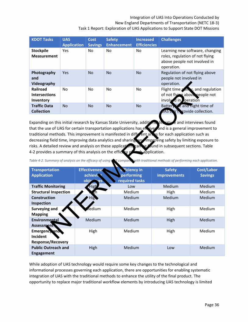
Integration of UAS Into Operations Conducted by New England Departments of Transportation (NETC 18-3)
Task 1 Report: Exploration of UAS Applications to Support State DOT Missions
Page 36
KDOT Tasks UAS Application
Cost Savings
Safety Enhancement
Increased Efficiencies
Challenges
Stockpile Measurement
Yes No No No Learning new software, changing roles, regulation of not flying above people not involved in operation.
Photography and Videography
Yes No No No Regulation of not flying above people not involved in operation.
Railroad Intersections Inventory
No No No No Flight time ability, and regulation of not flying above people not involved in operation
Traffic Data Collection
No No No No Battery life and flight time of UAS can’t provide collection.
Expanding on this initial research by Kansas State University, additional literature and interviews found
that the use of UAS for certain transportation applications has evolved and is a general improvement to
traditional methods. This improvement is manifested in different areas for each application such as
decreasing field time, improving data analytics and sharing, and improving safety by limiting exposure to
risks. A detailed review and analysis on these applications can be found in subsequent sections. Table
4-2 provides a summary of this analysis on the efficacy of each application.
Table 4-2. Summary of analysis on the efficacy of using UAS compared with traditional methods of performing each application.
Transportation Application
Effectiveness in achieving objectives
Efficiency in performing
required tasks
Safety improvements
Cost/Labor Savings
Traffic Monitoring High Low Medium Medium
Structural Inspection High Medium High Medium
Construction Inspection
High Medium Medium Medium
Surveying and Mapping
Medium Medium High Medium
Environmental Assessment
Medium Medium High Medium
Emergency and Incident Response/Recovery
High Medium High Medium
Public Outreach and Engagement
High Medium Low Medium
While adoption of UAS technology would require some key changes to the technological and
informational processes governing each application, there are opportunities for enabling systematic
integration of UAS with the traditional methods to enhance the utility of the final product. The
opportunity to replace major traditional workflow elements by introducing UAS technology is limited
INTERIM
REPORT

Integration of UAS Into Operations Conducted by New England Departments of Transportation (NETC 18-3)
Task 1 Report: Exploration of UAS Applications to Support State DOT Missions
Page 37
and was not supported by evidence. This section discusses the high-potential transportation applications
ripe for UAS integration with traditional methods.
4.1 Monitoring traffic and safety operations
4.1.1 Traditional Methods
Monitoring traffic to support effective traffic management and control operations remains one of the
key objectives for many state DOTs and emergency responders. Highways experiencing traffic
congestion from an imbalance of facility capacity and demand or because of emergency incidents
causing gridlocks, which often lead to significant economic impact for drivers and businesses. There are
many technologies to monitor traffic and collect real-time traffic data to including closed-circuit
television cameras, loop sensors, radar detectors, and other tools. State DOTs also resort to active traffic
management strategies such as ramp metering, variable speed limit, traffic signal control, dynamic lane
reversal, queue warning, etc. (Federal Highway Administration, 2019b). Most of these strategies often
require accurate information on field conditions to work efficiently.
FHWA developed a traffic monitoring guide that describes two methodologies for traffic counting
including continuous and short duration. Continuous count stations collect data 24 hours each day over
the entire year and can be used to develop adjustment factors, track traffic volume trends on important
roadway segments, and provide inputs to traffic management and traveler information systems. Short
duration count stations focus on collecting data for 24 hours each day up to a few weeks. (Federal
Highway Administration, 2016). Using UAS technology strictly for traffic counts is not suitable given the
limitations with flight duration and visual line of sight requirements. (Federal Highway Administration,
2016b)
4.1.2 UAS Integration Opportunities
Operating UAS for traffic monitoring can largely be performed under Part 107 requirements without a
need to secure any waivers. Some waivers to Part 107 that could potentially be required or obtained to
improve use of UAS for traffic monitoring include operating a UAS at night (Part 107.29), beyond visual
line of sight (Part 107.31), limiting the use of a visual observer (Part 107.33), operating multiple UAS
with a single remote pilot (Part 107.35), operating over people (Part 107.39), and operating outside
speed, altitude, and visibility thresholds (Part 107.51). The challenges in securing these waivers vary
significantly and may require significant analysis to prove safe operations, which could limit integration
opportunities. UAS can effectively monitor intersections and small areas within range of the sensor
payload, but are limited in monitoring larger areas and in areas where airspace access is restrictive.
Small UAS can prove to be a flexible tool for traffic monitoring applications with its ability to quickly
collect the data required for further analysis and decision-making support. UAS can be conveniently (or
strategically) positioned at various intersections to monitor traffic especially during traffic hours (see
Figure 4-1). UAS can be used to monitor congestion and collect information on traffic flow to augment
the operational efficiencies of other sensor technologies and enhance the performance of various active
traffic management technologies. This data can be processed and used for improved decision making
and provide valuable information for commuters.
INTERIM
REPORT

Integration of UAS Into Operations Conducted by New England Departments of Transportation (NETC 18-3)
Task 1 Report: Exploration of UAS Applications to Support State DOT Missions
Page 38
© 2018 WSP USA, Inc.
Figure 4-1. Photo. Traffic monitoring of an intersection using a UAS.
Several instances exist in the literature where UAS had been piloted to study traffic operations
monitoring and the associated policy implications.
• USDOT and NASA sponsored a research program for an unmanned Airborne Data Acquisition
System (ADAS) for traffic surveillance, monitoring and traffic management. The ADAS developed
had a maximum flight time of 2 hours and could carry payloads up to 20 punds, and had nine
interchangeable sensor platforms. The ADAS platform is capable of flying under a combination
of pre-programmed Differential Global Positioning Satellite (DGPS)-based navigation and manual
direct ground control. ADAS was fully tested and was planned for use in several US Department
of Defense base-monitoring studies that year (Carroll & Rathbone, 2008). Virginia DOT had
implemented ADAS to do real time traffic surveillance and monitor incidents.
• The Georgia DOT in collaboration with Georgia Technological University commissioned a
$75,000 pilot study to test the potential for drones for uses related to traffic management and
found UAS technology can be used for congestion monitoring, traffic signal inspection, and
vehicle speed sampling (Roads&Bridges, 2014).
• The Michigan DOT, in collaboration with Western Michigan University, deployed UAS for traffic
monitoring and emergency response to design a transmission system for sending live images to
traffic management agencies for enabling expedited decision-making. They deployed a BAT III
platform from the MLB company. The communication system of the technology is shown below
(Kamga, Sapphire, Moghimidarzi, & Khryashchev, 2017).
INTERIM
REPORT

Integration of UAS Into Operations Conducted by New England Departments of Transportation (NETC 18-3)
Task 1 Report: Exploration of UAS Applications to Support State DOT Missions
Page 39
Figure 4-2. Illustration. UAS communication system.
• Many state DOTs and universities are also deploying UAS for traffic data collection (counting)
using DataFromSky, a video analytics platform that leverages the capabilities of machine
learning and Artificial Intelligence to automatically extract traffic data from cameras and process
it to obtain valuable information. This platform can provide traffic counts, vehicle flows, vehicle
classification, gap time, follow-time and Origin-destination information. Examples of
origin/destination data and travel speed information are shown below (DataFromSky, 2019)
© 2019 DataFromSky
Figure 4-3. Photo. UAS data sets for traffic monitoring.
INTERIM
REPORT
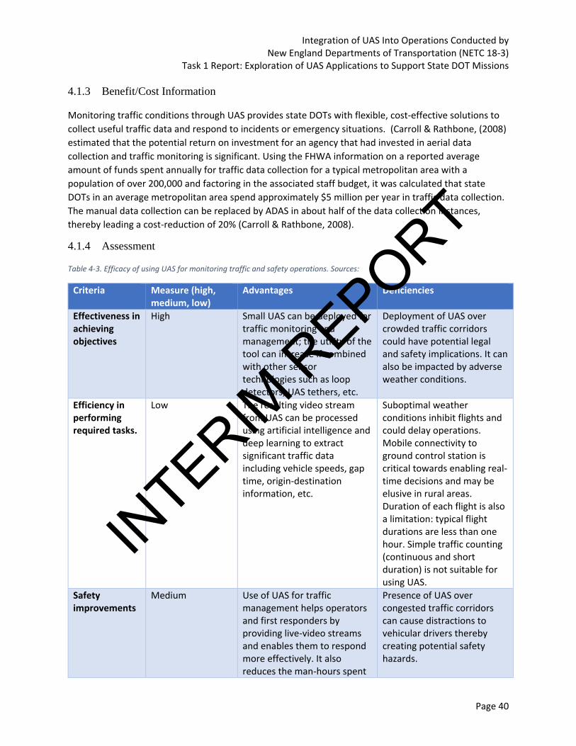
Integration of UAS Into Operations Conducted by New England Departments of Transportation (NETC 18-3)
Task 1 Report: Exploration of UAS Applications to Support State DOT Missions
Page 40
4.1.3 Benefit/Cost Information
Monitoring traffic conditions through UAS provides state DOTs with flexible, cost-effective solutions to
collect useful traffic data and respond to incidents or emergency situations. (Carroll & Rathbone, (2008)
estimated that the potential return on investment for an agency that had invested in aerial data
collection and traffic monitoring is significant. Using the FHWA information on a reported average
amount of funds spent annually for traffic data collection for a typical metropolitan area with a
population of over 200,000 and factoring in the associated staff budget, it was calculated that state
DOTs in an average metropolitan area spend approximately $5 million per year in traffic data collection.
The manual data collection can be replaced by ADAS in about half of the data collection instances,
thereby leading a cost-reduction of 20% (Carroll & Rathbone, 2008).
4.1.4 Assessment
Table 4-3. Efficacy of using UAS for monitoring traffic and safety operations. Sources:
Criteria Measure (high, medium, low)
Advantages Deficiencies
Effectiveness in achieving objectives
High Small UAS can be deployed for traffic monitoring and management; the utility of the tool can increase if combined with other sensor technologies such as loop detectors, UAS tethers, etc.
Deployment of UAS over crowded traffic corridors could have potential legal and safety implications. It can also be impacted by adverse weather conditions.
Efficiency in performing required tasks.
Low The resulting video stream from UAS can be processed using artificial intelligence and deep learning to extract significant traffic data including vehicle speeds, gap time, origin-destination information, etc.
Suboptimal weather conditions inhibit flights and could delay operations. Mobile connectivity to ground control station is critical towards enabling real-time decisions and may be elusive in rural areas. Duration of each flight is also a limitation: typical flight durations are less than one hour. Simple traffic counting (continuous and short duration) is not suitable for using UAS.
Safety improvements
Medium Use of UAS for traffic management helps operators and first responders by providing live-video streams and enables them to respond more effectively. It also reduces the man-hours spent
Presence of UAS over congested traffic corridors can cause distractions to vehicular drivers thereby creating potential safety hazards.
INTERIM
REPORT

Integration of UAS Into Operations Conducted by New England Departments of Transportation (NETC 18-3)
Task 1 Report: Exploration of UAS Applications to Support State DOT Missions
Page 41
Criteria Measure (high, medium, low)
Advantages Deficiencies
in the field thereby increasing the safety of the commuters and agency staffs.
Cost/Labor Savings
Medium Cost savings due to labor hours spent on data collection and safety improvements for commuters and field personnel.
Potential higher cost for data processing of video-stream, especially to use the information for real-time traffic management and incident response.
4.2 Structural Inspection
4.2.1 Traditional Methods
State DOTs follow National Bridge Inventory Standards (NBIS) for inspecting and assessing a variety of in-
service bridges. Bridge inspection plays a key role in ensuring public safety and confidence in bridge
structural capacity and integrity to effectively perform maintenance and rehabilitation operations.
Legislatively, bridge inspection needs to comply with federal standards to receive federal funding for
bridge rehabilitation and replacement. State DOTs In order to receive federal funding for bridge
maintenance, rehabilitation, or replacement, bridge inspection processes/methods need to comply with
federal standards. Also, state DOTs establish more detailed guidelines for short-term periodic
inspections including hands-on bridge inspection processes, close-up reviews, and collecting
quantitative bridge data. The basis of these guidelines is the condition of bridges in the state, their
defects, and local postings. Some states develop their customized inspection procedures that goes
beyond the minimum requirements promulgated by FHWA.
As described in the Bridge Inspector’s Reference Manual, conventional procedures for routine bridge
inspection follows evaluating conditions of various elements of a bridge, calculating the rating of the
bridge, and recording them in the inspection report for state DOTs/asset owners, which ultimately gets
submitted to the National Bridge Inventory (Federal Highway Administration, 2012). Special safety
precautions need to be taken for ensuring safety of the personnel involved through temporary traffic
control and ensuring various access control measures. Inspectors often use variety of equipment for
data collection depending on the type of the bridge and the nature of the inspection (routine/fracture
critical/underwater). These tools include:
• Tools for Cleaning
• Tools for Inspection
• Tools for Visual Aid
• Tools for Measuring
• Rotary Percussion
• Scour Monitoring Collar
• Scour Monitoring Collar Schematic
• Remote Camera
INTERIM
REPORT

Integration of UAS Into Operations Conducted by New England Departments of Transportation (NETC 18-3)
Task 1 Report: Exploration of UAS Applications to Support State DOT Missions
Page 42
• High Speed Underclearance Measurement System
• Tablet PC Used to collect inspection data
The Bridge Inspector’s Reference Manual also mentions recent developments in equipment that
includes deployment of remote cameras and laser scanners for data collection and recording. Remote
cameras can be used to collect spatial information and conduct surface analysis that can distinctly
identify the flaw/defect in surface using its size, shape, location, and other attributes. Laser scanners
collect point cloud data that can be used to construct 3D as-builts providing realistic representation of
the facility and assist field inspection such as targeting discrete areas of concern.
4.2.2 UAS Integration Opportunities
Operating UAS for structural inspection can largely be performed under Part 107 requirements without
a need to secure any waivers. Some waivers to Part 107 that could potentially be required or obtained
to improve use of UAS for structural inspection include operating a UAS at night (Part 107.29), beyond
visual line of sight (Part 107.31), limiting the use of a visual observer (Part 107.33), operating multiple
UAS with a single remote pilot (Part 107.35), operating over people (Part 107.39), and operating outside
speed, altitude, and visibility thresholds (Part 107.51). The challenges in securing these waivers vary
significantly and may require significant analysis to prove safe operations, which could limit integration
opportunities. The UAS can effectively support structural inspection workflows, but there are concerns
about data resolution and quality, especially when dust is agitated by downdrafts from propellers.
Pairing structural inspection experts with UAS technology is an opportunity to ensure the data being
captured supports their decision support construct. UAS technology is likely an enhancement to the
inspection process (i.e. identifying areas for more focused inspection) and not a replacement for visual
inspection.
Literature identifies several initiatives where state DOTs have utilized UAS for carrying our structural
bridge inspections. Oregon DOT conducted UAS flights for inspecting four bridges as part of a research
project. These inspections validated the utility of the UAS for visual and routine bridge inspections while
acknowledging the technology’s limitations for fracture-critical inspection that requires “arm’s length”.
With the installation of appropriate sensors and control technology, UAS can often perform efficiently
and produce high-resolution imagery at various angles helping in identifying the defects of bridge
elements. (Mallela, et al., In Press.)
A UAS can also be effectively deployed to collect data through a variety of sensors especially during
routine inspections and in areas where there are severe accessibility constraints. State DOTs have used
UAS flights to replace human operations when risk assessment showed that the flights equipped with
proper sensors can work with greater productivity and safety than workers using suspended ropes.
Alaska Center for Unmanned Aerial System Integration (ACUASI) built a hexacopter equipped with Sony
NEX-7 and GoPro camera to conduct inspection of the 280ft long Place River Bridge that had accessibility
only through a railroad and required inspectors to climb up and rappel under the structure (Banks et al.,
2018). In this project, UAS minimized the time spent on site and increased safety by obviating
potentially dangerous situations. The table below summarizes the results of the data acquisition
mission.
INTERIM
REPORT

Integration of UAS Into Operations Conducted by New England Departments of Transportation (NETC 18-3)
Task 1 Report: Exploration of UAS Applications to Support State DOT Missions
Page 43
Table 4-4. Summary of data acquisition mission.
Data Type Sensor Type Number of Images/Scans
Data Size (GB)
Comments
Images Nikon® D800E Sony® Alpha NEX-7
2222 2626
34.9 24.7
Ground-based imagery UAS-based imagery
Video GoPro® 10 7.57 -
Laser Scanning FARO® Focus 24 4.26 -
3D Point Cloud - 5 13.71 -
A research team from Carnegie Melon University and Northeastern University developed the Aerial
Robotic Infrastructure Analyst (ARIA), a table-sized drone that uses image cameras and laser scanners to
create high-resolution model of bridges. Also, MnDOT has been working on a three-phase research
project that aims at demonstrating and standardizing use of drones for selected bridge inspection. The
research phases focused on rules and regulations, drone hardware, and ability of drones to collect
quality inspection data and enable a workflow to transform the data into actionable inspection
deliverables. The pilot inspection was carried out for 17 bridges. Various alternatives for UAS hardware
was used including mapping and photogrammetry UAS (SenseFly Albris), commercial inspection drones
(senseFly albris, Intel Falcon 8+, DJI M200 Series), consumer grade drones, and a Collision-tolerant UAS
(Elios UAS) that was used to access areas that had safety concerns and prohibitive for a large-mapping
UAS. The resulting data was processed in several software applications such as Pix4D, ContextCapture,
Recap, Intel Insight, and Propeller to produce digital surface models, ortho-imageries, and 3D Point
clouds. (Lovelace, 2018)
While MnDOT observed successful testing of UAS in routine inspection of many bridges, there was an
instance in Minneapolis, Minnesota where deployment was unsuccessful. It was reported that when
UAS flew under bridge superstructure (e.g. girders, etc.) the drafts from propellers agitated the dust and
debris, which obscured sensors and diminishes quality of data. Also, some sensors could not
identify/locate marks made by bridge inspectors identifying deficiencies (cracks, etc.), the deficiencies
were demarcated prior to UAS flight by inspectors using rope access. As a proof of concept, the UAS was
deployed to locate these marks, but was not successful. (Lovelace, 2018)
Besides meeting the regular structural inspection requirements, the popularity of the UAS is also on the
rise for collecting asset inventory data. The asset management team at state DOTs stands to benefit
considerably by deploying drones for tracking locations and conditions of various highway assets
including traffic signs, signal heads, guardrails etc. Reconciling the asset data along with characteristics
of an asset management system helps produce a more accurate asset inventory, enables compliance
checks with various operational requirements, and helps define appropriate maintenance schedules.
Using drones for mapping assets reduces the cost of traffic disruption, decreases the cost of expensive
equipment and labor spent on survey time in the field, and improves overall safety and efficiency of
asset tracking. Figure 4-4 below shows the 3D mapping of a highway collected using a senseFly eBee
Plus RTK drone with the mission planned using eMotion planning software. Utilizing an UAS for mapping
this highway helped the team overcome challenging topographic conditions and meet the accuracy
requirements.
INTERIM
REPORT

Integration of UAS Into Operations Conducted by New England Departments of Transportation (NETC 18-3)
Task 1 Report: Exploration of UAS Applications to Support State DOT Missions
Page 44
© 2018 GeoSense
Figure 4-4. Screenshot. Highway mapping using Pix4Dmapper.
4.2.3 Benefit/Cost Information
Oregon DOT reported the main benefits as an average $10,200 per project in the following categories
• Savings in traffic control ($3,500).
• Savings in Equipment rentals such as cranes ($2800).
• Savings in personnel time for travel, lodging, data collection, and potential incidents ($3,900).
The major costs included the UAS cost (SenseFly Albris UAS), travel costs for any additional pilot/Visual
observer per project (if some existing personnel in the team is not trained) and marginal increase in
office time for image/video processing. The analysis of the data revealed that the breakeven for
investing in this technology occurs quickly (Banks et al., 2018) .
MnDOT findings through the research program also included detailed evaluation of savings in cost
between UAS assisted and traditional inspections and the variation in man-hours as shown in Figure 4-5
(Lovelace, 2018)
INTERIM
REPORT
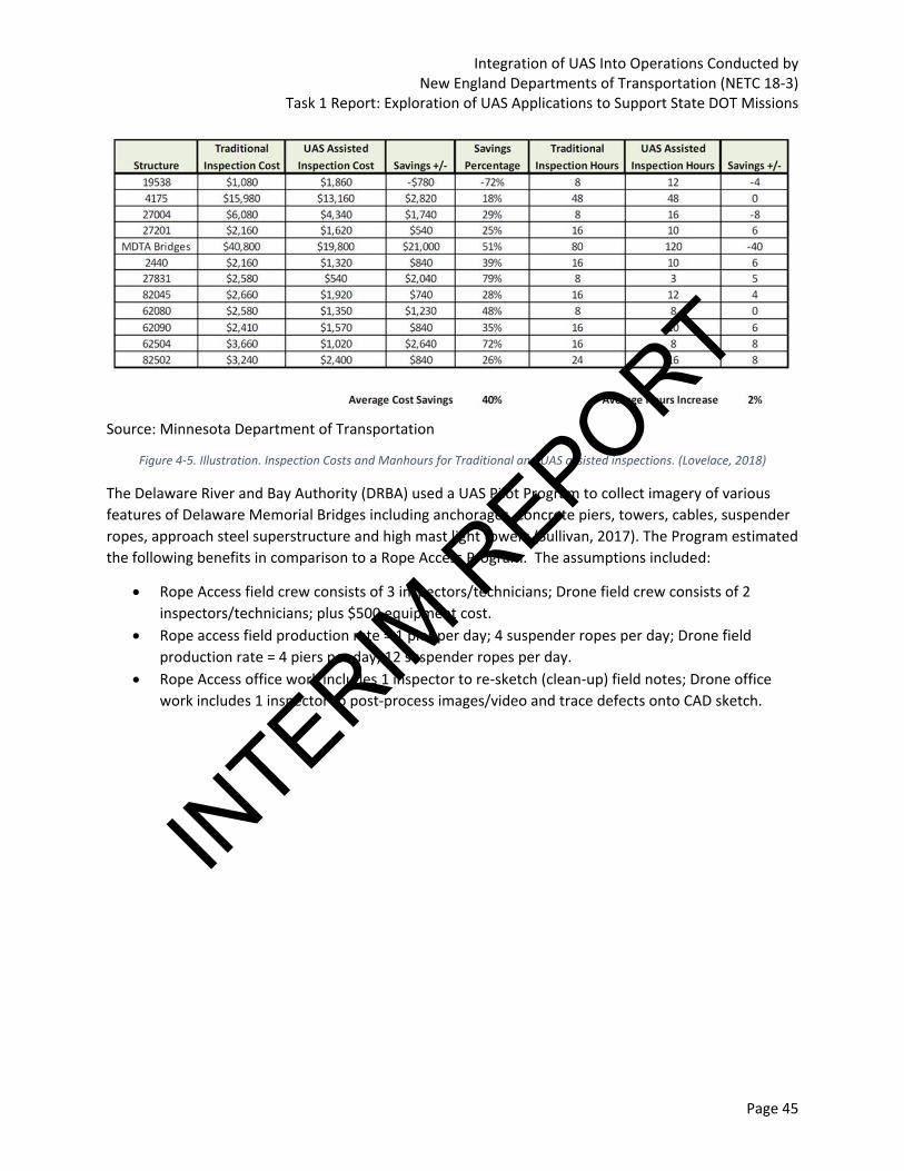
Integration of UAS Into Operations Conducted by New England Departments of Transportation (NETC 18-3)
Task 1 Report: Exploration of UAS Applications to Support State DOT Missions
Page 45
Source: Minnesota Department of Transportation
Figure 4-5. Illustration. Inspection Costs and Manhours for Traditional and UAS assisted inspections. (Lovelace, 2018)
The Delaware River and Bay Authority (DRBA) used a UAS Pilot Program to collect imagery of various
features of Delaware Memorial Bridges including anchorages, concrete piers, towers, cables, suspender
ropes, approach steel superstructure and high mast light towers (Sullivan, 2017). The Program estimated
the following benefits in comparison to a Rope Access Program. The assumptions included:
• Rope Access field crew consists of 3 inspectors/technicians; Drone field crew consists of 2
inspectors/technicians; plus $500 equipment cost.
• Rope access field production rate = 1 pier per day; 4 suspender ropes per day; Drone field
production rate = 4 piers per day; 12 suspender ropes per day.
• Rope Access office work includes 1 inspector to re-sketch (clean-up) field notes; Drone office
work includes 1 inspector to post-process images/video and trace defects onto CAD sketch.
INTERIM
REPORT

Integration of UAS Into Operations Conducted by New England Departments of Transportation (NETC 18-3)
Task 1 Report: Exploration of UAS Applications to Support State DOT Missions
Page 46
Concrete Pier Inspection
Time Required Unit Cost Field Time Required Unit Cost Office
Inspection Method (days) (day) Cost (days) (day) Cost Total Cost
Rope Access 1 $3,000 $3,000 0.5 $1,000 $500 $3,500
(one pier)
Drone 0.25 $2,500 $625 1.5 $1,000 $1,500 $2,125
(one pier)
Drone 3 $2,500 $7,500 4.5 $1,000 $4,500 $12,000
Rope Access 7 $3,000 $21,000 3 $1,000 $3,000 $24,000
Total Savings = $12,000
Suspender Rope Inspection
Time Required Unit Cost Field Time Required Unit Cost Office
Inspection Method (days) (day) Cost (days) (day) Cost Total Cost
Rope Access 3 $3,000 $9,000 0.5 $1,000 $500 $9,500
(12 Ropes Inspected)
Drone 1 $2,500 $2,500 2 $1,000 $2,000 $4,500
(12 Ropes Inspected)
Drone 4 $2,500 $10,000 8 $1,000 $8,000 $18,000
Rope Access 24 $3,000 $72,000 4 $1,000 $4,000 $76,000
Total Savings = $58,000
Note: Costs do not include any potential access costs such as traffic control or equipment/boats.
Cost Comparison of
Industrial Rope Access vs. Unmanned Aircraft Systems (Drones)
Total Cost To Inspect All Ropes
Total Cost To Inspect All Large Piers
Office Work
Field Work
Field Work
Office Work
© 2017 WSP USA, Inc.
Figure 4-6. Illustration. DRBA UAS Program Cost-Benefit Assessment. (Sullivan, 2017)
Michigan DOT has compared the cost savings of deploying an UAS to support inspection of a 4-lane
divided highway bridge in metro area to the traditional manual inspection process that involved heavy
equipment. It was reported that the manual inspection costed around $4,600 with a 2-person crew and
necessary equipment for 8 hours while a 2-person crew using drone had effectively completed similar
process in one hour at a cost of $1200, resulting in 74% savings (American Association of State Highway
and Transportation Officials, 2019).
4.2.4 Assessment
UAS technology is widely used for structural inspection and has proven to be a versatile tool that
delivers value to the inspection process for non-fracture critical components. The following table
illustrates an assessment of the efficacy of UAS technology for structural inspection applications.
Table 4-5. Efficacy of using UAS for inspection. Sources: MnDOT (2018), DRBA UAS Pilot Study Program (2018), UAS Research Program (2017), and Michigan DOT (2018).
Criteria Measure (high, medium, low)
Advantages Deficiencies
Effectiveness in achieving objectives
High Performing a structural inspection strictly from UAS data is not recommended.
Fracture critical inspection requires arms-length inspection, which precludes
INTERIM
REPORT
Integration of UAS Into Operations Conducted by New England Departments of Transportation (NETC 18-3)
Task 1 Report: Exploration of UAS Applications to Support State DOT Missions
Page 47
Criteria Measure (high, medium, low)
Advantages Deficiencies
However, pairing UAS technology with traditional methods allows inspectors to achieve the objective.
the use of UAS. There are regulatory constraints that limit the use of UAS to with line of sight, unless a waiver is granted.
Efficiency in performing required tasks.
Medium UAS technology can be deployed quickly and gather massive amounts of high-resolution imagery and video in a short period. Collecting the data is much quicker that traditional methods using rope access or snooper trucks.
The battery life is a limiting factor in performing inspections. The larger the structure, the more flights are required. Suboptimal weather conditions inhibit flights and could delay operations.
Safety improvements
High The use of UAS technology can limit time spent climbing on the structure or implementing traffic control. Collecting the data from a safe vantage location without the need for traffic control is beneficial.
The presence of UAS flying around structures has the potential to distract drivers and cause incidents. Also, the risks of injury from a UAS impact are a consideration even for the most seasoned remote pilots.
Cost/Labor Savings
Medium The use of UAS for structural inspection saves on overall costs for the inspection effort.
There is increased data processing time to analyze the imagery/video and derive actionable insight.
4.3 Construction Inspection
Construction engineering and inspection services can widely benefit from adoption of UAS technologies
specifically for tasks such as progress monitoring, quantity measurements, safety monitoring and quality
control assessment processes. While the application is not as mature as traditional methods of
monitoring construction sites, it is being actively researched upon as an innovative alternative and
supplement that can facilitate rapid data collection and at scale.
4.3.1 Traditional Methods
The standard methods of construction review and inspection involves getting acquainted with the
project underway through review of pertinent documents before performing the required field
activities. The field activities to collect verification data depends on the required granularity of detail
about each of the construction elements. Both photographs and sketches are typically recommended to
record progress in adequate level of detail to support quality checks against specifications and verifying
pay quantities. Inspection reports are then generated and submitted to the appropriate personnel in
the project (e.g. quality assurance manager, project manager etc.) to determine further course of action
including payments, change orders, claims, or corrective actions.
INTERIM
REPORT
Integration of UAS Into Operations Conducted by New England Departments of Transportation (NETC 18-3)
Task 1 Report: Exploration of UAS Applications to Support State DOT Missions
Page 48
4.3.2 UAS Integration Opportunities
Operating UAS for construction inspection can largely be performed under Part 107 requirements
without a need to secure any waivers. Some waivers to Part 107 that could potentially be required or
obtained to improve use of UAS for construction inspection include operating a UAS at night (Part
107.29), beyond visual line of sight (Part 107.31), limiting the use of a visual observer (Part 107.33),
operating multiple UAS with a single remote pilot (Part 107.35), operating over people (Part 107.39),
and operating outside speed, altitude, and visibility thresholds (Part 107.51). The challenges in securing
these waivers vary significantly and may require significant analysis to prove safe operations, which
could limit integration opportunities. The UAS can effectively support construction inspection, but there
are considerations for developing training requirements for inspection staff and implementing protocols
for using UAS technology to verify certain contractor placement activities. Providing access to UAS
technology is likely the key component for integrating UAS into construction inspection workflows, not
necessarily equipping inspectors with the technology.
UAS technology with high-resolution video cameras and laser scanners can augment the data collection
to assist some of the tasks performed as part of site inspection and progress mentoring. The technique
can supplement the needs of data collection specifically on large construction sites with numerous
construction activities with limitations of coverage with just using conventional inspection methods. The
data collected can also be used to compare reliability and accuracy of the estimates produced using the
traditional methods.
Several state DOTs and researchers have attempted to integrate the UAS technology with the workflow
for measuring quantities, monitoring construction progress, and performing safety verification
opportunities. Many of these studies reported both qualitative and quantitative benefits that have been
recorded in the literature. UAS is often used for estimation of earthwork quantities through low-altitude
photogrammetry (or photogrammetry-based structure from motion (SfM). It is not uncommon to fuse
the UAS data with data from other surveying sources (esp. Static Lidar or MTLS) to enhance the details in
the resulting model. Utah DOT has deployed UAS for assisting inspection and estimation of quantities on
multiple projects. The agency deployed SenseFly eBee Plus fixed-wing UAS that has a camera to achieve
2.9cm/pixel ground-sampling distance flying at 400 ft. AGL. The resulting data was processed using
Pix4D (Mallela, et al., In Press.). They had also produced final as-builts which provides detailed roadway
surface (Figure 4-7)
INTERIM
REPORT

Integration of UAS Into Operations Conducted by New England Departments of Transportation (NETC 18-3)
Task 1 Report: Exploration of UAS Applications to Support State DOT Missions
Page 49
Source: Utah Department of Transportation
Figure 4-7. Image. Utah DOT's As-built point cloud model for SR-20. (Mallela, et al., In Press.)
Oregon DOT has followed similar approach for quantity estimation and payment of quantities. Common
areas of integration include measuring earthwork, stockpile volumes, and general area (e.g. clearing and
grubbing) and linear-type pay items. It was noted in one of their pilot efforts that using UAS to measure
quantities is more suitable for smaller segments of roadway constructed under visual line of sight
whereas larger segments often require other supplemental technologies such as traditional GNSS
surveys or lidar.
The use of UAS for active construction progress monitoring is also increasingly tested across many
highway projects primarily because of the ability to obtain large quantity of data very quickly. The
imagery captured can be often used for public outreach (time-lapse videos of construction progress). If
the UAS has sensors installed to create point clouds, it is possible to compare as-planned 3D model to
determine the progress of various construction element.
NCDOT had utilized UAS for construction inspections and progress monitoring through its research
program for a construction site (Snyder, Zajkowski, & Divakaran, 2016). In partnership with NextGen Air
Transportation Program (NGAT) at North Carolina State University, the agency conducted a 30-min flight
operation to collect orthomosaic image and a DSM of a 150-acre construction site. The key details of the
flight operation are shown in Figure 4-8. The digital model of the site was used for monitoring
construction progress, volumetric analysis, and establishing strategies and lessons learned to increase
UAS use in construction workflows.
INTERIM
REPORT

Integration of UAS Into Operations Conducted by New England Departments of Transportation (NETC 18-3)
Task 1 Report: Exploration of UAS Applications to Support State DOT Missions
Page 50
Source: North Carolina Department of Transportation
Figure 4-8. Illustration. NCDOT UAS Program Summary for Construction Site. (Snyder et al., 2016)
The use of UAS for enhancing safety on construction jobsites and avoiding fatalities and injuries is also
being investigated. A quadcopter UAS was used to provide real-time visual access to construction
jobsites using a large-size interface one tablet devoice. Key components for such a system included
autonomous navigation, vocal interaction, high-resolution cameras, and collaborative user-interface
environment. (Gheisari, Irizarry, & Walker, 2014)
4.3.3 Benefit/Cost Information
UAS can fly lower than traditional aircraft and achieve the same, if not better, quality data at lower cost
for small to medium size surveys. UDOT utilized a combination of UAS and GNSS rovers for collecting
digital data during construction on their SR-20 project and observed qualitative improvements in daily
reports, visualization for public information, and the overall data collection process. The efficiency
improvements in construction inspector’s tasks were quantified including efficiencies in labor
productivity using labor savings in average time spent by field staffs collecting the information from the
field through the project duration and savings in processing time due to automated photogrammetric
process. The costs included purchasing the software, hardware, annual maintenance staffs, and full-time
equivalent staff to process the data. It resulted in an estimated 2.58% savings in the pilot project
contract amount (totaling to $82k) and a 28% return on investment over a period of five years for the
annual construction program (Mallela, et al., In Press.).
INTERIM
REPORT

Integration of UAS Into Operations Conducted by New England Departments of Transportation (NETC 18-3)
Task 1 Report: Exploration of UAS Applications to Support State DOT Missions
Page 51
4.3.4 Assessment
There is increased interest in using UAS technology for construction inspection applications such as
quantity measurement/verification and monitoring construction progress. The following table illustrates
an assessment of the efficacy of UAS technology for construction inspection applications.
Table 4-6. Efficacy of using UAS for construction inspection. Sources: Federal Highway Administration (2017), Snyder (2016), and Gheisari et al. (2014))
Criteria Measure (high, medium, low)
Advantages Deficiencies
Effectiveness in achieving objectives
High High-resolution video cameras and sensors used in traditional methods can be paired with an UAS to achieve similar objectives for construction inspection.
Suboptimal weather conditions inhibit flights and could delay operations. Sensor occlusion is possible in limiting its effectiveness to capture construction elements.
Efficiency in performing required tasks.
Medium The UAS technology provides rapid assessment of earthwork and stockpile quantities, helps monitor progress on large jobsites in a safe, cost-effective manner.
The technology may require augmentation with other tools when used for payments and measurement of volumes for key elements (such as layers of pavements).
Safety improvements
Medium Use of UAS for construction inspection can help identify potential safety hazards in jobsites and reduce chances of injury rates by reducing manhours.
The presence of UAS flying around jobsites has the potential to distract workers and cause incidents.
Cost/Labor Savings
Medium Labor savings due to less manhours spent in collecting g large sample of site data.
Processing time in the office may be higher and labors and personnel may have to be trained.
4.4 Surveying and Mapping
The use of UAS for surveying and mapping is also increasingly becoming a common application for transportation projects. While it is not the preferred method for creating accurate basemaps for engineering design or estimates of quantities, the technology produces a quick scan of the project site to enable the development of 3D mapping products. As the sensors evolve and become cost-effective with increased resolution and accuracy, the technology is likely to become widespread in supporting conventional methods to achieve required objectives.
INTERIM
REPORT

Integration of UAS Into Operations Conducted by New England Departments of Transportation (NETC 18-3)
Task 1 Report: Exploration of UAS Applications to Support State DOT Missions
Page 52
4.4.1 Traditional Methods
While surveying techniques have evolved over past few decades, surveyors typically use a variety of
electronic distance measurement (EDM) devices to measure distances and angles in GNSS-denied areas.
Some of the commonly used approaches for surveying include electronic levels, total stations, aerial
photogrammetry, remote sensing, laser scanners, and RTK GNSS surveys, among others. They rely
predominantly on propagation of light waves or radio waves for direct measurement of distances and
angular measurements.
The total station and GNSS are the most pervasive surveying instruments in use throughout the industry
to conduct field surveying on many transportation projects irrespective of the scale and complexity.
They are light-weight, compact, and fully integrated electronic instruments that can collect positional
information on discrete field points and store data as an electronic log book for transmittal and further
processing. Robotic total stations (RTS) are also popular given the ability to be remotely controlled
requiring only one operator to conduct surveying and inspection operations (Crumal, 2017).
Photogrammetry involves combining images taken over an aerial survey to produce 2D or 3D terrain
models that is often used to create preliminary estimate of quantities for project developments. In
remote sensing, satellite or aircraft-based sensor technologies are deployed to collect and classify
information about objects on Earth. Aerial photogrammetry and remote sensing help in collecting vast
amount of data about project sites quickly; however, the accuracy of the quantities often require
augmentation with other techniques if used for estimation of quantities for bidding and payment
In recent years, lidar surveying has also seen considerable surge in transportation projects. Lidar survey
uses laser scanners that emits pulses or waves of light to measure geometry and light reflectance of an
object, ultimately creating 3D representation (e.g. point cloud) of the object. The scanner is mounted in
multiple configurations making it static (mounted on a Tripod), mobile (mounted on a moving vehicle
with other control sensors), and aerial (mounted on an aircraft). Most of these sensors can also be
mounted on an Unmanned Aerial Vehicle with necessary support established in the ground can be
deployed to conduct aerial survey and obtain rich information about the project site such as
orthomosaics, DSMs, and 3D models (Mallela, et al., In Press.). It can make the process cost-effective
and quicker than a manned mission for the sane
4.4.2 UAS Integration Opportunities
Operating UAS for surveying and mapping can be performed under Part 107 requirements without a
need to secure any waivers; however, some common waivers needed include operating a UAS at night
(Part 107.29) and operating outside speed, altitude, and visibility thresholds (Part 107.51). Some other
waivers to Part 107 that could potentially be required or obtained to improve use of UAS for surveying
and mapping include beyond visual line of sight (Part 107.31), limiting the use of a visual observer (Part
107.33), operating multiple UAS with a single remote pilot (Part 107.35), and operating over people
(Part 107.39). The challenges in securing these waivers vary significantly and may require significant
analysis to prove safe operations, which could limit integration opportunities. UAS can effectively map
small areas of topography and bathymetry for developing 3D models. Feature extraction using
photogrammetric techniques is a significant improvement over traditional methods given the high-
resolution of imagery that can be achieved with low-altitude flights. Lidar technology (although more
INTERIM
REPORT

Integration of UAS Into Operations Conducted by New England Departments of Transportation (NETC 18-3)
Task 1 Report: Exploration of UAS Applications to Support State DOT Missions
Page 53
expensive than imagery) provides vegetation penetration and high-resolution point clouds from which
to conduct analysis. The coordinate accuracies that can be achieved from imagery and lidar datasets are
sufficient for most surveying and mapping applications; however, the elevation accuracies of imagery
datasets (and derivative products) is still an area of debate and ambiguity.
With increased penetration of UAS in the market and the improvements in accuracy and efficiency in
data collection, surveyors across many state DOTs are testing deployment of UAS technology in
surveying and mapping workflows with success. Several DOTs have used UAS for surveying and
topographic mapping and developed strategies to integrate the technology into their traditional
workflow
UDOT experimented supplementing the existing tools with UAS to enhance the productivity of surveyors
while ensuring minimum exposure to dangerous environments (congested traffic conditions in active
roadways). The objective was to gather high-quality surveying data that can be used to accomplish
various tasks on projects. The sensor package included high-definition cameras (DJI Phantom 12 MP),
thermal sensors (SenseFly. Albris TripleView, 38MP), and RGB sensors (Sony RX1RII/35-mm lens, full-
frame sensor, 42 MP) mounted on Wingtra Fixed-wing UAS. The agency found that the UAS can fly lower
than conventional aircraft and creates opportunities for collecting better quality data including high-
resolution imagery and point clouds. The workflow included data collection and automated processing
of the data with vendor software. It was also reported that with the help of Ground Control Points, real-
time kinematics, and post processing kinematics (PPK) the deliverables can be made with survey-grade
quality (Banks et al., 2018) .
Source: Utah Department of Transportation
Figure 4-9. Image. 3D Point Cloud of Moki Dugway. (Banks et al., 2018)
Montana DOT deployed two UAS equipped with survey-grade GNSS on Lincoln-Rd-West of Green
Meadow Project to understand the workflow this technology, compare its accuracy and reliability to the
INTERIM
REPORT

Integration of UAS Into Operations Conducted by New England Departments of Transportation (NETC 18-3)
Task 1 Report: Exploration of UAS Applications to Support State DOT Missions
Page 54
survey data obtained through conventional methods (Beal, 2019). The agency deployed ground control
points (GCPs) at not more than 500 feet intervals and post processed kinematics (PPKs). PPK applies
correction to the location data from the cameras through the flight location information obtained from
a Trimble Base Station set up on a known Control Point. PPK helped maximize the accuracies (vertical:
0.34 feet, horizontal: 0.12 feet) and also reduced the dependency on GCPs to achieve measurements
with lowest errors. It was also noted that processing and removal of vegetation data from the site
determines the quality of the final model from the survey.
The UAS deployed was a DJI Inspire 2 UAV equipped with a Zenmuse X4S camera and an aftermarket
GNSS receiver (LOKI), a remote controller, a mobile device and two software applications (apps)
installed on the mobile device (e.g. DJI Go and Map Pilot). Around 1000 photos of the project site were
collected and incorporated PPK corrections to enhance accuracy of coordinates in the photos. Pix4D
was used to process the images and create a point cloud, orthomosaic, and a DSM. Virtual Surveyor
software was used to clean up of DSM of various noises (including Vegetation, People, Buildings etc.) to
produce DTM, TIN, and 3D mesh files. Figure 4-10 shows the model along with camera positions during
the UAS flights
Source: Montana Department of Transportation
Figure 4-10. Image. Model and Camera View positions. (Beal, 2019)
UAS had also been used to delineate landslides and ascertain risks for highway construction. UAS can be
deployed to collect accurate and high-resolution geometric data especially at inaccessible sites. Multiple
instances exist in literature where UAS flights were captured images of excavation sites and algorithms
such as Structure from motion are used to obtain 3D point clouds of the terrain is extracted to evaluate
planes of interest in further detail to estimate the parameters concerning slope stability (Xiao, Kamat, &
Lee, 2012), (Danzi, Di Crescenzo, Ramondini, & Santo, 2012) . Figure 4-11 shows the end result after the
excavation data is processed using the photogrammetric software INTERIM
REPORT
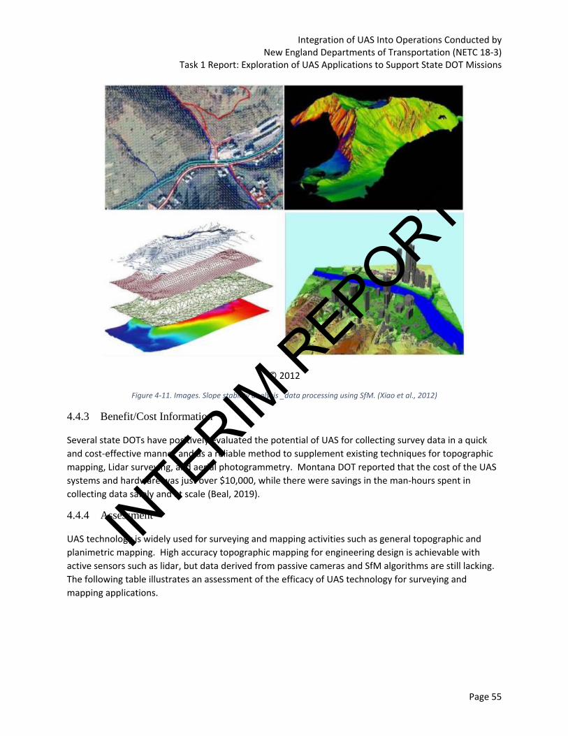
Integration of UAS Into Operations Conducted by New England Departments of Transportation (NETC 18-3)
Task 1 Report: Exploration of UAS Applications to Support State DOT Missions
Page 55
© 2012
Figure 4-11. Images. Slope stability analysis _data processing using SfM. (Xiao et al., 2012)
4.4.3 Benefit/Cost Information
Several state DOTs have positively evaluated the potential of UAS for collecting survey data in a quick
and cost-effective manner and as a reliable method to supplement existing techniques for topographic
mapping, Lidar surveying, and aerial photogrammetry. Montana DOT reported that the cost of the UAS
systems and hardware was just over $10,000, while there were savings in the man-hours spent in
collecting data safely and at scale (Beal, 2019).
4.4.4 Assessment
UAS technology is widely used for surveying and mapping activities such as general topographic and
planimetric mapping. High accuracy topographic mapping for engineering design is achievable with
active sensors such as lidar, but data derived from passive cameras and SfM algorithms are still lacking.
The following table illustrates an assessment of the efficacy of UAS technology for surveying and
mapping applications.
INTERIM
REPORT

Integration of UAS Into Operations Conducted by New England Departments of Transportation (NETC 18-3)
Task 1 Report: Exploration of UAS Applications to Support State DOT Missions
Page 56
Table 4-7. Efficacy of using UAS for surveying and mapping. Sources: Federal Highway Administration (2017), Banks et al. (2018).
Criteria Measure (high, medium, low)
Advantages Deficiencies
Effectiveness in achieving objectives
High UAS can be used for surveying large mapping areas; it can be used to support and augment the information provided by lidar surveys, Total Stations etc.
Vertical accuracy of UAS and augmenting the details of the resulting models with outputs from other surveying methods may be required.
Efficiency in performing required tasks.
Medium UAS can fly lower compared to traditional aircrafts, collect information of better quality and produce mapping grade results if augmented with GCPs and PPK.
Post-processing tasks (coordinate correction, noise removal etc.) may involve additional efforts and integrating with other surveying techniques.
Safety improvements
High UAS for surveying and mapping minimizes the exposure of surveyors to dangerous conditions including active roadways, steep terrains, land slide areas etc.
The presence of UAS flying around structures has the potential to distract drivers and cause incidents. Also, the risks of injury from a UAS impact are a consideration even for the most seasoned remote pilots.
Cost/Labor Savings
Medium The process maximizes the productivity of labors in data collection process and minimizes the manhours required.
There is increased data processing time to analyze the imagery/video and derive actionable insight.
4.5 Environmental Assessments
Recent developments in imaging and positional accuracy of sensors and data processing techniques
have fostered the application of UAS for observation, mapping and assessment of natural and built
environments. Potential applications include vegetation mapping, coastline assessment, river
morphology assessment, forest management, plant and animal conservation studies. The ability to offer
quick, easy, and cost-effective insights about the environment is ushering in an increased use of UAS by
researchers, environmental engineers, and conservationists. The use of UAS is usually the preferred
alternative especially in areas where manned aircraft services are unavailable or lower resolution
satellite imageries would not be able to accomplish the objective.
4.5.1 Traditional Methods
Environmental monitoring and assessment plays a vital role in estimating climate and management
impacts on natural and built systems, efficiently allocate and manage water resources, and enhances
our disaster preparedness for natural events (Manfreda et al., 2018). While the application of satellite
imageries has been on the increase, lower spatial resolution would make the resultant products not
INTERIM
REPORT

Integration of UAS Into Operations Conducted by New England Departments of Transportation (NETC 18-3)
Task 1 Report: Exploration of UAS Applications to Support State DOT Missions
Page 57
suitable for many quantitative applications. Although recent advances in Earth Observations such as
CubeSat promises to provide recommended spatial and temporal resolution with maximum spatial
coverage, these are operated by private organizations and are often not cost-effective for high-
frequency monitoring. Manned aircraft missions present another viable alternative that can provide
outputs with requisite resolutions and adequate coverage, their sustained deployment is also often
limited by operational complexity, increased safety risks, challenges in logistical planning and potentially
higher costs. Use of terrestrial Lidar surveys are less common and used predominantly to conduct
detailed studies of smaller areas.
4.5.2 UAS Integration Opportunities
Operating UAS for environmental assessments can be performed under Part 107 requirements without
a need to secure any waivers; however, some common waivers needed include operating a UAS at night
(Part 107.29) and operating outside speed, altitude, and visibility thresholds (Part 107.51). Some other
waivers to Part 107 that could potentially be required or obtained to improve use of UAS for surveying
and mapping include beyond visual line of sight (Part 107.31), limiting the use of a visual observer (Part
107.33), operating multiple UAS with a single remote pilot (Part 107.35), and operating over people
(Part 107.39). The challenges in securing these waivers vary significantly and may require significant
analysis to prove safe operations, which could limit integration opportunities. UAS can effectively map
areas of interest less than 1000 acres in size and derive meaningful insights on environmental conditions
using a different sensor types.
UAS technology have considerable potential to cater to a variety of environmental applications given its
ability to generate images of significantly higher spatial resolution than satellite solutions (although
limited by spatial coverage). Once the initial investment on drone procurement is complete with
hardware and software, the datasets can also be delivered at high temporal resolutions by conducting
recurring flights at a relatively lower incremental cost. Figure 4-12 compares the coverage capabilities
of UAS with other related technologies and identifies the trade-offs between their costs and spatial and
temporal resolution.
Figure 4-12. Illustration. Trade-offs between cost and resolution of UAS with comparable technologies (Source: (Global Unmanned Systems, 2015)
INTERIM
REPORT
Integration of UAS Into Operations Conducted by New England Departments of Transportation (NETC 18-3)
Task 1 Report: Exploration of UAS Applications to Support State DOT Missions
Page 58
Like other UAS applications, deployment of UAS for environmental monitoring applications involve the
following activities (Manfreda et al., 2018):
Preflight Planning
• Platform specifications, study extents, ground sampling distance, payload characteristics, site
topography, weather and atmospheric conditions, local regulations, dereferencing (GCPs),
Onboard control (survey-grade GNSS, IMUs),
• Sensors selection: Optical cameras, multispectral cameras, hyperspectral cameras, thermal
cameras, laser scanners, SARs
Surveying
• In-flight data collection: Goal of the study, number and frequency of flights (power
supply/battery capacity), Radiometric calibration and ground correction.
Post-survey processing:
• Atmospheric correction, orthorectification and image mosaicking, Product extraction
• Data processing Software: Agisoft Photoscan, Pix4D, Open-source SfM software (e.g. VisualSfM,
Bundler, Apero-MicMac, OpenDroneMap), Cloud-based platforms (e.g. DroneDeploy or
DroneMapper)
4.5.3 Benefit/Cost Information
The typical costs include initial investment of UAV procurement, the processing software, data storage
and associated field expenses. The principal benefit of UAS for environmental applications arise from its
ability to deliver high-quality datasets with adequate spatial and temporal resolution of the mapping
area (vegetation site, coastline.) at necessary frequency. The method is non-intrusive and provides an
option to conduct survey of inaccessible areas and dense forest lines. It poses reduced health and safety
risks.
4.5.4 Assessment
UAS technology is widely used for mapping environmental conditions given is versatility of rapid
deployment and high-resolution data outputs. The following table illustrates an assessment of the
efficacy of UAS technology for environmental applications.
Table 4-8. Efficacy of using UAS for environmental assessments. Sources: Global Unmanned Systems (2015), Mandreda et al. (2018).
Criteria Measure (high, medium, low)
Advantages Deficiencies
Effectiveness in achieving objectives
Medium UAS is a cost-effective support mission and objectives of environmental mapping with adequate resolutions of areas less than 1000 acres.
Areas of interest larger than 1000 acres, are best suited for mapping from a manned aircraft.
INTERIM
REPORT

Integration of UAS Into Operations Conducted by New England Departments of Transportation (NETC 18-3)
Task 1 Report: Exploration of UAS Applications to Support State DOT Missions
Page 59
Criteria Measure (high, medium, low)
Advantages Deficiencies
Efficiency in performing required tasks.
Medium Data can be collected at high level of detail (spatial and temporal resolution) and accuracy if supported by onboard control units and GCPs.
Spatial coverage is generally less than manned aircraft missions and satellite imageries; Processing time could be higher.
Safety improvements
High It can fly at lower altitude and poses reduced safety risks than manned missions in maneuvering areas of narrower margins.
Line-of-sight UAS are generally applicable for studies in limited areas, less than 1000 acres, as it has potential safety implication and operational constraints.
Cost/Labor Savings
Medium Reduced labor costs due to savings in man-hours spent on in-field; Cost savings due to reduced operator costs for recurring flights to increase temporal resolution.
Increased data processing time at the office and lower spatial coverage.
4.6 Emergency and Incident Response/Recovery – Natural Disasters
The use of UAS has made significant strides in providing valuable insights for emergency responders
during various natural disasters including flooding, wildfires, landslides and other events. Many of these
situations poses operational, safety, and accessibility challenges for surveying and reconnaissance
efforts to monitor impacted areas. The characteristics of UAS technology is suitable to assist in such
operations for enhanced situational awareness, risk assessment for response activities, and to collect
data to assess the damage for repair and rehabilitation efforts.
4.6.1 Traditional Methods
Emergency response is mission critical for all DOTs and a crucial stage in the disaster management cycle
predominantly focusing on warning, evacuation, search and rescuing efforts, and damage assessments
to ensure appropriate repair and rehabilitation efforts are being put into action. Damage assessment is
vital to request federal emergency declarations for both FHWA Emergency Relief program and FEMA’s
Public Assistance (PA) programs. Typical methods of damage assessment include aerial surveys using
manned aircraft missions or satellite vehicles to collect images and videos of affected areas. Depending
on the extent of the damage, deploying manned aircraft may not be cost-effective and often be
inadequate to provide complete and detailed information of the extent and severity of damages
involved. Remote sensing for disaster response is another potential alternative if the impacted area is
large and the objective of the survey is to identify and rescue victims and obtain damage information
over extended period. In the U.S., such information comes from National Oceanic and Atmospheric
Administration, to commercial providers such as DigitalGlobe, Planet, and Cubesat (Duffy, 2018)
INTERIM
REPORT

Integration of UAS Into Operations Conducted by New England Departments of Transportation (NETC 18-3)
Task 1 Report: Exploration of UAS Applications to Support State DOT Missions
Page 60
To obtain complete picture of the damage, imagery from multiple service providers, both public and
private must be combined including other sensors such as SAW (that collects damage information
regardless of lighting and weather condition), shortwave Infrared Band (SIWR) band of optical sensors
(that illuminates hot spots in a region of wildfire. Most of these sensors can be conveniently deployed
on a UAS to survey the areas with adequate spatial and temporal resolution in a cost-effective manner.
4.6.2 UAS Integration Opportunities
Operating UAS for emergency and incident response/recovery likely requires additional flexibility
beyond Part 107 requirements. Access to airspace (to avoid conflicts with search and rescue efforts) and
securing Part 107 waivers are important considerations for using UAS during response and recovery
operations to obtain sufficient situational awareness and assess risk. Some waivers to Part 107 that
could be required or obtained to improve use of UAS for emergency and incident response/recovery
include operating a UAS at night (Part 107.29), beyond visual line of sight (Part 107.31), limiting the use
of a visual observer (Part 107.33), operating multiple UAS with a single remote pilot (Part 107.35),
operating over people (Part 107.39), and operating outside speed, altitude, and visibility thresholds (Part
107.51). The challenges in securing these waivers vary significantly and may require significant analysis
to prove safe operations, which could limit integration opportunities. Establishing the required protocols
and safety management systems early in the preparedness stage are important so when the
disaster/incident occurs, rapid deployment is achievable.
During preparedness activities, interagency agreements (e.g. memorandums of
agreement/understanding) can be structured to incorporate specific UAS tasking protocols to ensure
UAS technology is an integral part of the planning and eventual response/recovery efforts. This
streamlines the construction of temporary facilities immediate after the event.
UAS has proven to be valuable tool for emergency response during major natural disasters including
flooding, landslides, avalanches, hurricanes, and wildfires among others. Broadly speaking, UAS was
used for damage assessment studies post the natural disaster, assist in rescue and rehabilitation efforts
and supply of relief and welfare services. Following are some of the noted applications of UAS in
response to natural disaster events
• Nuclear reactors damage assessment: In Fukushima, Japan, Engineers used an UAV with a
camera to obtain images of the damaged reactors during an earthquake triggered by Tsunami in
March 2011 across northern Japan. Drones provided images of the reactors that are used to
assess the extent of the damage and pools of spent fuel inside (Smith, 2011). They were able to
provide immediate extent of the destruction, delivering assistance in monitoring radiation
exposure and repair and rehabilitation efforts of the destroyed areas. There were also reports
that UAS technology was deployed to provide food and medical assistance to residents of a
town where access to shops is limited (“Drone delivers food to Fukushima town,” 2017)
INTERIM
REPORT

Integration of UAS Into Operations Conducted by New England Departments of Transportation (NETC 18-3)
Task 1 Report: Exploration of UAS Applications to Support State DOT Missions
Page 61
Figure 4-13. Photo. Image captured using UAV showing damaged nuclear power plant (Source: Smith, 2011).
• Flood mapping and assessment: UAS have also been increasingly used to collect imageries and
3D mapping especially in areas where manned aircraft missions and satellite are operationally
infeasible or inadequate to meet the resolution needs. Several variety of UAS use have been
recorded in the Y.S. during flood events 2005. FHWA found that at least 12 state DOTs used UAS
in response to flooding (Murphy, 2019). A few notable examples are listed below
o Hurricane Katrina 2005: Rotorcraft and Fixed-wing UAS deployment to study flood crest
of Pearl River in Louisiana and Mississippi and estimate risk to surrounding communities
o Hurricane Wilma 2005: Examine the bridge to Fort Myers Beach off the southwest
Florida
o Blanco River, Texas, 2015: UAS used to search for missing persons swept away in floods
into inaccessible areas of floods
o Hurricane Harvey, 2017: UAS was deployed by Office of Emergency Management, Fort
bend, TX, to support emergency management pre-, during, and post-flood (around 112
flights were made in Total). Figure 4-14 below shows imagery and 3D DEM created
during the flood event in Hurricane Harvey.
o Hurricane Florence, 2018: NCDOT had deployed UAS to assess the extent of flooding on
major roadways. NCDOT flew more than 260 drone missions and capture more than
8,000 videos and images of roads, bridges, and dams. NCDOT assisted other state
agencies in a range of condition assessments. (North Carolina Department of
Transportation, 2018)
o UAS also has significant potential in monitoring erosion over riverbeds on the aftermath
of flooding. A three-year study conducted by a team from UVM’s Special Analysis Lab
flew 50 miles of the Winooski, New Haven, and Mad Rivers and monitoring one
particular site prone to significant erosion so that mitigation strategies can be
developed (Viglienzoni, 2019).
INTERIM
REPORT

Integration of UAS Into Operations Conducted by New England Departments of Transportation (NETC 18-3)
Task 1 Report: Exploration of UAS Applications to Support State DOT Missions
Page 62
Figure 4-14. Imagery (left) and 3D DEM (Right). (Center for Robot-Assisted Search and Rescue (CRASAR))
• Managing Wildfires: UAS can eliminate the safety risks that pilots face and help develop
effective strategies to combat forest fires, and provide greater situational awareness. They can
also fly at lower altitudes to drop fire retardants accurately and safely. Drones can also act as
intermediary communication systems between command center and rescue operators on the
ground. The Los Angeles Fire Department used two drones to combat Southern California
Wildfires, the first quadcopter enabled survey of damaged property and map the path of the
fire, and the second one with an infrared camera to spot hotspots precisely to extinguish them
4.6.3 Benefit/Cost Information
Literature does not indicate specific studies where the costs to benefits were compared for using UAV to
emergency response rising from natural disasters. Most of the costs are incurred as initial investments
of purchasing UAS and developing operational protocols for using them for surveys. Benefits are often
invaluable that would include potential life and property savings through elimination of manned survey
missions into the areas that are dangerous for human access, lives saved from rescue and relief efforts.
Benefits also arise due to improved data quality in terms of adequate spatial and temporal resolution for
damage assessment, continuous monitoring, and planning for rescue and rehabilitation efforts.
4.6.4 Assessment
UAS technology is continually being evaluated by emergency responders given its ability to deliver
heightened situational awareness and assess risks. The following table illustrates an assessment of the
efficacy of UAS technology for natural disaster emergency response applications.
Table 4-9. Efficacy of using UAS for emergency response (natural). Sources: Murphy (2019)
Criteria Measure (high, medium, low)
Advantages Deficiencies
Effectiveness in achieving objectives
High UAS can effectively support for post-disaster survey and reconnaissance efforts and will be invaluable for assisting rescue and rehabilitation efforts.
Spatial coverage may be a limiting factor in data. UAS operations may be limited especially in case if BLOS operations are not allowed.
Efficiency in performing required tasks.
Medium UAS can provide 3D mapping and imagery data of the affected areas with high spatial and
It requires trained personnel who could operate drones
INTERIM
REPORT

Integration of UAS Into Operations Conducted by New England Departments of Transportation (NETC 18-3)
Task 1 Report: Exploration of UAS Applications to Support State DOT Missions
Page 63
Criteria Measure (high, medium, low)
Advantages Deficiencies
temporal resolution necessary to assess damages and support relief and welfare efforts.
efficiently in constrained environments.
Safety improvements
High Potential life and property savings due to avoidance of manned surveys, life savings from assisted rescue and relief efforts.
Trained operations crew required to create successful flight plans and execute them.
Cost/Labor Savings
Medium Labor savings due to Rapid data collection of situations arising from natural disaster and reduction in direct labor costs (manhours) involved in data collection.
Increased data processing time in the office to make actionable insights.
4.7 Emergency and Incident Response/Recovery – Human-caused Disasters
Human-caused disasters on transportation systems, such as traffic crashes or hazardous chemical spills
create intricate challenges in monitoring them and planning for restoration strategies. It is often needed
to record evidences from the scene of disaster to use them for evaluating the causes to support any
legal requirements. UAS can be deployed effectively in such situations to assist human operators and
law enforcement agencies in collecting the required information quickly and safely.
4.7.1 Traditional Methods
Traditional methods of evaluating scenes of human-caused disasters often involve site investigation to
determine the primary causes of accident, assess injuries, potential fatalities, and property damages,
and record all key details that would help in subsequent investigation process off site. The site
investigation procedure often entails fencing off and detailed recording (tour) off the crash site to
record status and condition of the vehicles, commuters, and damage to assets (if any). Manual sketching
or photographs of the scene is often taken to support the crash documentation. The methodology, as a
whole, could be time-consuming and interrupt, delay the restoration of the transportation link to free-
flow of traffic. Hazardous Chemical spills also represent another potential situation that adversely
impact the safety of the moving traffic in the highway system. While crash statistics at the national level
indicate such incidences are relatively rare than vehicular collisions on highways, the ensuing danger
from such occurrences pose significant challenge in ensuring safe vehicular travel.
While UAS cannot support all the information requirements necessary to understand the scene and do
not provide, by itself, all the background evidence required to support an investigation, they can be used
to recreate crash scenes with significant level of detail. As such, it can be successfully integrated with
other modes of data collection. FHWA has reported that secondary crashes, that occur in the
scenes/queues of the crash site due to the hours spent in conventional record/mapping, are often much
higher than the original source. Drones can assist in drastically reducing the likelihood of secondary
crashes (Cynthia, 2019)
INTERIM
REPORT

Integration of UAS Into Operations Conducted by New England Departments of Transportation (NETC 18-3)
Task 1 Report: Exploration of UAS Applications to Support State DOT Missions
Page 64
4.7.2 UAS Integration Opportunities
Operating UAS for emergency and incident response/recovery likely requires additional flexibility
beyond Part 107 requirements. Access to airspace (to avoid conflicts with search and rescue efforts) and
securing Part 107 waivers are important considerations for using UAS during response and recovery
operations to obtain sufficient situational awareness and assess risk. Some waivers to Part 107 that
could be required or obtained to improve use of UAS for emergency and incident response/recovery
include operating a UAS at night (Part 107.29), beyond visual line of sight (Part 107.31), limiting the use
of a visual observer (Part 107.33), operating multiple UAS with a single remote pilot (Part 107.35),
operating over people (Part 107.39), and operating outside speed, altitude, and visibility thresholds (Part
107.51). The challenges in securing these waivers vary significantly and may require significant analysis
to prove safe operations, which could limit integration opportunities. Establishing the required protocols
and safety management systems early in the preparedness stage are important so when the
disaster/incident occurs, rapid deployment is achievable.
During preparedness activities, interagency agreements (e.g. memorandums of
agreement/understanding) can be structured to incorporate specific UAS tasking protocols to ensure
UAS technology is an integral part of the response/recovery efforts. This streamlines the site
documentation and data sharing between agencies.
UAS technology has been piloted for crash scene reconstruction in many DOTs, local transportation
agencies, Counties, and law enforcement officials. A research team in Purdue University developed
photogrammetric procedures for processing and mapping crash scenes from the data collected using a
UAS in five to eight minutes (Cynthia, 2019). The Tippecanoe County Sheriff’s Office had used UAS to
map crash scenes around 35 times in 2018 to support law enforcement officials in the county and
neighboring jurisdictions. In some instances, they also created 3D Printed models to support engineers
and public safety officials study (mimic) the crash scenes (Figure 4-15)
INTERIM
REPORT

Integration of UAS Into Operations Conducted by New England Departments of Transportation (NETC 18-3)
Task 1 Report: Exploration of UAS Applications to Support State DOT Missions
Page 65
Figure 4-15. Photo. 3D Print of accident scenes. Source: Erin Easterling /Purdue University
The Ontario Provincial Police (OPP), uses UAV technology for multiple objectives in incident
management including forensic identification and collision scene mapping which was made necessary as
part of rapid clearance mandate within the Highway Safety Division (HSD). The imageries so obtained
from these UAV flights can be stitched together using multiple vintage points to create 3-D visual
reconstruction of the collision scene with competent accuracy (1 cm/pixel). The specifications of the
UAV used, Aeryon Scout, are mentioned in Table 4-10.
Table 4-10. Aeryon Scout specifications (Kamga et al., 2017).
General Characteristics
Length 80 cm (28.2 in)
Rotor Diameter 80 cm (28.2 in)
Height 30 cm (1 ft.)
Loaded Weight 1.4 kg (3.1 lbs.)
Maximum Takeoff Weight 1.7 kg (3.74 lbs.)
Propulsion 4 x electric motor with intelligent LiPo battery
Propeller Diameter 30 cm (1 ft.)
Maximum Speed 50 km/hr. (31 mph)
Cruise Speed 40 km/hr. (25 mph)
Range 3 km (2 mi)
Service Ceiling 3000 m (1000 ft.) AGL/5000 m (15000 ft.) ASL
Rate of Climb 2 m/s (6 ft./s)
INTERIM
REPORT

Integration of UAS Into Operations Conducted by New England Departments of Transportation (NETC 18-3)
Task 1 Report: Exploration of UAS Applications to Support State DOT Missions
Page 66
Michigan DOT conducted demonstrations of UAV implementation for multiple local agencies and law
enforcement authorities including Michigan State Police, Southeast Oakland County using small
quadcopters and hexacopter (DJI Phantoms equipped with GoPro cameras and quick and lower
resolution images). The collected imageries can be processed using photogrammetric software such as
PiX4D to perform various evaluations and create datasets supporting the incident management
initiatives. Figure below shows the 3D mesh model created from an accident scene (Kamga et al.,
2017).
Figure 4-16. Image. 3D mesh model of accident scenes (Kamga et al., 2017).
TxDOT worked with researchers from Texas A&M Transportation Institute to demonstrate use of UAS
for Traffic Incident Management including several missions such as traffic monitoring, incident detection
and response, enhance situational awareness, and map crash scenes. While they observed that the
image quality was not significantly higher than currently used camera, they were beneficial since the
system is mobile, easily repairable (than fixed systems), and enable innovative ways of scene
reconstruction in greater detail. Key factors to consider include response time, remote launching, UAS
for special events and public facilities, and UAS use over people, vehicles, and property (Stevens Jr. &
Blackstock, 2017).
4.7.3 Benefit/Cost Information
Using UAS for incident management is an emerging thrust area among various applications of UAS with
significant potential to provide a variety of information on crash scenes- orthomosaics, videos 3D mesh
models, 3D printed models, etc. The major cost involved is investment to procure and deploy the UAS
on scene, along with operational standards and permits to safely operate over the site of active traffic.
Benefits include comprehensive and faster documentation of crash sense leading to time saved in
inspecting the scene and collecting relevant information, potential reduction in number of secondary
crashes, and measurable digital outputs that can be used as evidence in court.
NCDOT in collaboration with NC Highway Safety Patrol simulated a head-on crash in controlled
environment. While the HSP’s Collision Reconstruction Unit took 2 hours in data collection, pilots using
UAS took 25 minutes. The savings were also monetized by considering $8,600 per hour per lane in lost
productivity if the crash had to occur on I-95. While traditional methods would have costed $12,900,
INTERIM
REPORT

Integration of UAS Into Operations Conducted by New England Departments of Transportation (NETC 18-3)
Task 1 Report: Exploration of UAS Applications to Support State DOT Missions
Page 67
UAS use would have costed $3,600 or resulted in $9,300 savings (North Carolina Department of
Transportation, 2017).
4.7.4 Assessment
UAS technology is continually being evaluated by emergency responders given its ability to deliver
heightened situational awareness and assess risks. The following table illustrates an assessment of the
efficacy of UAS technology for human-caused disaster emergency response applications.
Table 4-11. Efficacy of using UAS for emergency response (human-caused). Sources: Kamga et al. (2017), NCDOT (2017)
Criteria Measure (high, medium, low)
Advantages Deficiencies
Effectiveness in achieving objectives
High Incident management and scene recreation through UAS technology presents a safe, quicker approach for traffic monitoring and data collection to support forensic investigations.
The managerial practices and legal protocols enabling frequent use of UAS for traffic incident management is still being developed in many state DOTs.
Efficiency in performing required tasks.
Medium Collected data assist in obtaining situational awareness and can be processed to obtain a variety of digital outputs including videos, orthomosaics, 3D models to support investigations.
The information may need to be supplemented by other form of manual inputs to ensure all the key background information is captured.
Safety improvements
High Use of UAS for incident management leads to direct safety benefits by reducing the time spent in onsite investigation, reducing the likelihood of secondary crashes, and assisting in quick clearance of the impacted corridor.
UAS operations for mapping crash scenes may cause distraction to other drivers in live traffic and could pose a safety threat that can lead to other incidents.
Cost/Labor Savings
Medium Time savings in onsite investigation and documentation of necessary evidence.
There is a potential for increased processing time if there is a need to collect accurate and detailed information on crash site.
4.8 Public Outreach and Engagement
Public outreach and engagement efforts for transportation projects plays an important role in successful
project delivery aligning with the original objective of benefitting the communities. It is not uncommon
to utilize a separate public information and communication team at the agency-level or at least on
INTERIM
REPORT

Integration of UAS Into Operations Conducted by New England Departments of Transportation (NETC 18-3)
Task 1 Report: Exploration of UAS Applications to Support State DOT Missions
Page 68
projects of large scale and complexity to assist in dispensation of timely information and garner public
buy-in for the concept and continuous support during various phases of project delivery.
4.8.1 Traditional Methods
State DOTs and consultants deploy a wide variety of outreach mediums to communicate the status of
the project from conception through design and construction. These engagement techniques include
project websites, videos, social media, news reports, public information meetings that provides timely
awareness and valuable information about the anticipated improvements and temporary disruptions a
project can cause. Some state DOTs also perform extensive community outreach initiatives to
communicate and harness support of impacted communities including goody bags containing pamphlets
describing the benefits of project, and importance of stakeholder’s participation in success of projects.
UAS can play a significant role in enhancing the efficiency of the public outreach and demonstration
efforts as described below in a few case studies
4.8.2 UAS Integration Opportunities
Operating UAS for public outreach and engagement can largely be performed under Part 107
requirements without a need to secure any waivers. Some waivers to Part 107 that could potentially be
required or obtained to improve use of UAS for public outreach and engagement include beyond visual
line of sight (Part 107.31), limiting the use of a visual observer (Part 107.33), operating multiple UAS
with a single remote pilot (Part 107.35), operating over people (Part 107.39), and operating outside
speed, altitude, and visibility thresholds (Part 107.51). The challenges in securing these waivers vary
significantly and may require significant analysis to prove safe operations, which could limit integration
opportunities. UAS can provide timely aerial imagery and video at a high resolution for a more
immersive perspective of undeveloped land for upcoming projects, for monitoring projects under
construction, or for other activities that have significant public interest. This immersive perspective is
hard to achieve from ground-based photography/video or from manned aerial platforms such as
helicopters or fixed-wing aircraft.
NCDOT had used videos obtained from an UAV to create a bird’s-eye perspective of a roundabout
project to demonstrate to public about working characteristics, mobility enhancement, and increased
safety offered by roundabouts. The videos were proven effective to engage and educate public about
the roundabout. The videos were hosted in website and social media platform making them available at
the convenience of any user beyond the timeline of the public meetings. NCDOT also reported that the
video played a crucial role in harnessing buy-in of public stakeholders, who are initially opposed to the
idea of roundabouts (North Carolina Department of Transportation, 2019).
Instances exist in literature where images and videos obtained from UAV deployed on construction job-
sites were used to generate time-lapse videos that can be used for public information. A simple video
obtained from an UAV can assist the viewer in understanding project details from various perspectives
and gather holistic details that cannot be obtained otherwise from the ground. They can also be more
effective in creating affirmative atmosphere communicating project progress in place of flyers or
information bullets (Khaled, 2018).
INTERIM
REPORT
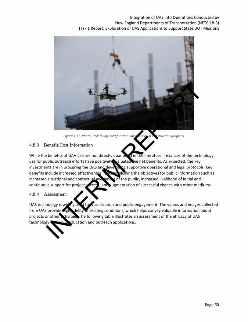
Integration of UAS Into Operations Conducted by New England Departments of Transportation (NETC 18-3)
Task 1 Report: Exploration of UAS Applications to Support State DOT Missions
Page 69
Figure 4-17. Photo. UAV being used for time-lapse videos of construction progress.
4.8.3 Benefit/Cost Information
While the benefits of UAV use are not directly quantified in the literature, instances of the technology
use for public outreach efforts have positively evaluated the net benefits. As expected, the key
investments are in procuring the UAS and developing supportive operational and legal protocols. Key
benefits include increased effectiveness in accomplishing the objectives for public information such as
increased situational and contextual awareness of the public, increased likelihood of initial and
continuous support for project success, and augmentation of successful chance with other mediums.
4.8.4 Assessment
UAS technology is widely used for visualization and public engagement. The videos and images collected
from UAS provide high fidelity of existing conditions, which helps convey valuable information about
projects or other activities. The following table illustrates an assessment of the efficacy of UAS
technology for public education and outreach applications.
INTERIM
REPORT

Integration of UAS Into Operations Conducted by New England Departments of Transportation (NETC 18-3)
Task 1 Report: Exploration of UAS Applications to Support State DOT Missions
Page 70
Table 4-12. Efficacy of using UAS for public outreach and engagement. Sources: NCDOT (2019), Khaled (2018).
Criteria Measure (high, medium, low)
Advantages Deficiencies
Effectiveness in achieving objectives
High UAS can be used to support the effectiveness of various public outreach and engagement techniques in obtaining stakeholder buy-ins and increased awareness of the project.
The technology has limitations in being a stand-alone tool for stakeholder engagement.
Efficiency in performing required tasks.
Medium Data collected include videos that can be used for project demonstration and time-lapse images that can be used to communicate project progress with ease and adequate level of detail.
Understanding of time-lapse videos and drone footage may need supplementation with other techniques.
Safety improvements
Low Deploying UAS for collecting data for public outreach likely has similar safety risks for pilots and commuters in comparison to photos and videos obtained by any other means.
Operating UAS over jobsite/traffic may be a source of distraction for workers/drives and could act as a new source of hazard increasing the likelihood of accidents.
Cost/Labor Savings
Medium Savings in man-hours spent in collecting detailed images and videos for public demonstration.
Potential increase in the processing time of the data collected to deliver actionable items for public outreach efforts.
5.0 SELECTED TRANSPORTATION APPLICATIONS AND NEXT STEPS
Based on the findings from the literature review, the preferences of New England state DOTs, and the
interviews with notable DOTs with mature practices, the research team was able to identify applications
ripe for implementation. The research team was able to assign a use case for each New England state
DOT for further investigation as shown below in Table 5-1. Once the research team receives concurrence
on these use cases, the research team will identify and analyze the UAS technologies that are necessary
to implement the use cases (including relevant support systems or infrastructure).
Table 5-1. Recommended applications for investigation.
New England State DOT Use Case
Connecticut DOT Construction inspection
Maine DOT Bridge inspection
Massachusetts DOT Traffic analysis (speed limits and work zones)
New Hampshire DOT Surveying and mapping for highway design
Rhode Island DOT Public engagement and outreach
Vermont Agency of Transportation Emergency response and recovery
INTERIM
REPORT

Integration of UAS Into Operations Conducted by New England Departments of Transportation (NETC 18-3)
Task 1 Report: Exploration of UAS Applications to Support State DOT Missions
Page 71
6.0 REFERENCES
Alabama Department of Transportation. (2017). Unmanned Aircraft System—Standard Operating
Procedure.
American Association of State Highway and Transportation Officials. (2019, May). Special Report: The
Evolution of Drones Part 3: Building Highways in the Sky. Retrieved from
https://www.transportation.org/the-evolution-of-drones-part-3/
Association for Unmanned Vehicle Systems International. (2019). STATE LEGISLATION MAP: UNMANNED
SYSTEMS. Retrieved August 8, 2019, from
https://public.tableau.com/views/AUVSI/PriorityBills?:embed=y&:showVizHome=no&:host_url=
https%3A%2F%2Fpublic.tableau.com%2F&:tabs=yes&:toolbar=no&:animate_transition=yes&:di
splay_static_image=no&:display_spinner=no&:display_overlay=yes&:display_count=yes&:loadO
rderID=0
Banks, E., Cook, S. J., Fredrick, G., Gill, S., Gray, J. S., Larue, T., … Snyder, P. R. (2018). Successful
Approaches for the Use of Unmanned Aerial Systems by Surface Transportation Agencies.
Barnes, P., & Turkel, E. (2017). Autonomous Vehicles in Delaware: Analyzing the Impact and Readiness
for the First State. Institute for Public Administration, University of Delaware.
Beal, F. (2019, February). Small Unmanned Aerial System (sUAS or UAS) Mapping Accuracy Test.
Retrieved from
https://www.mdt.mt.gov/other/webdata/external/research/DOCS/RESEARCH_PROJ/UAV/REF_
MAT/8939_LINCOLN.pdf
Carroll, E. A., & Rathbone, D. B. (2008, June 3). Using an Unmanned Airborne Data Acquisition System
(ADAS) for Traffic Surveillance, Monitoring, and Management. 145–157.
https://doi.org/10.1115/IMECE2002-32916
INTERIM
REPORT

Integration of UAS Into Operations Conducted by New England Departments of Transportation (NETC 18-3)
Task 1 Report: Exploration of UAS Applications to Support State DOT Missions
Page 72
Crumal, Z. (2017, April). What is a Robotic Total Station? Here’s Everything You Need to Know. Retrieved
August 8, 2019, from https://connect.bim360.autodesk.com/what-is-a-robotic-total-station
Connecticut Department of Transportation. (2018a, March). CTDOT, Long Range Transportation Plan,
2018-2040. Retrieved from https://portal.ct.gov/-
/media/DOT/documents/dpolicy/lrp/2018lrp/FINALConnecticutSLRTP20180313pdf.pdf?la=en
Connecticut Department of Transportation. (2018b, July). CTDOT Highway Transportation Asset
Management Plan. Retrieved from https://portal.ct.gov/-
/media/DOT/documents/dplansprojectsstudies/plans/CTDOTTAMPFHWAcertified20180724pdf.
Connecticut Department of Transportation. (2019). About Connecticut DOT: Our Mission, Values.
Retrieved August 12, 2019, from CT.gov—Connecticut’s Official State Website website:
http://portal.ct.gov/DOT/General/Commissioners-Greeting
Cynthia, S. (2019, January). Drones shown to make traffic crash site assessments safer, faster and more
accurate. Retrieved August 9, 2019, from Purdue News Service website:
https://www.purdue.edu/newsroom/releases/2019/Q1/drones-shown-to-make-traffic-crash-
site-assessments-safer,-faster-and-more-accurate.html
Danzi, M., Di Crescenzo, G., Ramondini, M., & Santo, A. (2012). Use of unmanned aerial vehicles (UAVs)
for photogrammetric surveys in rockfall instability studies. Rend. Online Soc. Geol. Ital, 24, 82–
85.
DataFromSky. (2019). Traffic counting. Retrieved September 5, 2019, from DataFromSky website:
http://datafromsky.com/applications/traffic-counting/
DeCarlo, J. (2017, October). Drone Interim Policy. Presented at the MassDOT Board Meeting. Retrieved
from https://www.mass.gov/files/documents/2017/10/17/DronePolicy_101617.pdf
INTERIM
REPORT

Integration of UAS Into Operations Conducted by New England Departments of Transportation (NETC 18-3)
Task 1 Report: Exploration of UAS Applications to Support State DOT Missions
Page 73
Delabruere, D. (2019, March). VTRANS UAS UNMANNED AIRCRAFT SYSTEMS. Presented at the
Workgroup: Senate Transportation Vtrans Aviation Testimony. Retrieved from
https://legislature.vermont.gov/Documents/2020/WorkGroups/Senate%20Transportation/VTra
ns%20Aviation%20Testimony/W~Dan%20Delabruere~VTrans%20Unmanned%20Aircraft%20Sys
tems%20(UAS)~3-14-2019.pdf
Drone delivers food to Fukushima town. (2017, November 1). BBC News. Retrieved from
https://www.bbc.com/news/business-41827634
Duffy, L. (2018, October). Fighting Natural Disasters with Satellite Imagery. Retrieved August 8, 2019,
from https://www.pobonline.com/articles/101492-fighting-natural-disasters-with-satellite-
imagery
Federal Aviation Administration. (2016). E-CFR Title 14 Part 107. Retrieved August 5, 2019, from ECFR.io
website: https://ECFR.io/Title-14/cfr107_main
Federal Aviation Administration. (2016a, June). AC-107-2: Small Unmanned Aircraft Systems (sUAS).
Retrieved from https://www.faa.gov/uas/resources/policy_library/media/AC_107-2_AFS-
1_Signed.pdf
Federal Aviation Administration. (2016b, August). Remote Pilot – Small Unmanned Aircraft Systems
Study Guide. Retrieved from
https://www.faa.gov/regulations_policies/handbooks_manuals/aviation/media/remote_pilot_s
tudy_guide.pdf
Federal Aviation Administration. (2017). Safety Management System – Components [Template].
Retrieved August 5, 2019, from
https://www.faa.gov/about/initiatives/sms/explained/components/
INTERIM
REPORT
Integration of UAS Into Operations Conducted by New England Departments of Transportation (NETC 18-3)
Task 1 Report: Exploration of UAS Applications to Support State DOT Missions
Page 74
Federal Aviation Administration. (2019). UAS Data Exchange (LAANC) [Template]. Retrieved August 5,
2019, from https://www.faa.gov/uas/programs_partnerships/data_exchange/
Federal Emergency Management Agency. (2019). 03OE-07-SUAS | FEMA.gov. Retrieved September 5,
2019, from https://www.fema.gov/authorized-equipment-list-item/03oe-07-suas
Federal Highway Administration. (2012). Bridge Inspector’s Reference Manual. Retrieved from
https://www.fhwa.dot.gov/bridge/nbis/pubs/nhi12049.pdf
Federal Highway Administration. (2016a). Capability Maturity Frameworks for Transportation Systems
Management and Operations Program Areas. Retrieved September 13, 2019, from
https://ops.fhwa.dot.gov/publications/fhwahop16031/index.htm
Federal Highway Administration. (2016b, October). Traffic Monitoring Guide. Retrieved from
https://www.fhwa.dot.gov/policyinformation/tmguide/tmg_fhwa_pl_17_003.pdf
Federal Highway Administration. (2018). Use of Unmanned Aerial Systems (UAS) by State DOTs.
Retrieved from https://www.fhwa.dot.gov/uas/peer/2018peer.pdf
Federal Highway Administration. (2019a). Peer-to-Peer Exchange: Delaware, Michigan, and Utah
Departments of Transportation; Kentucky Transportation Cabinet; Ohio Facilities Construction
Commission; and New York State Thruway Authority. Retrieved from
https://www.fhwa.dot.gov/construction/econstruction/hif19065.pdf
Federal Highway Administration. (2019b). Active Traffic Management: Approaches: Active
Transportation and Demand Management—FHWA Operations. Retrieved September 5, 2019,
from https://ops.fhwa.dot.gov/atdm/approaches/atm.htm
Gheisari, M., Irizarry, J., & Walker, B. N. (2014). UAS4SAFETY: The potential of unmanned aerial systems
for construction safety applications. Construction Research Congress 2014: Construction in a
Global Network, 1801–1810.
INTERIM
REPORT

Integration of UAS Into Operations Conducted by New England Departments of Transportation (NETC 18-3)
Task 1 Report: Exploration of UAS Applications to Support State DOT Missions
Page 75
Global Unmanned Systems. (2015, April). Use of Unmanned Aerial Vehicles (UAVs) in Impact Assessment.
Presented at the International Association for Impact Assessment, Florence, Italy. Retrieved
from https://conferences.iaia.org/2015/Final-
Papers/Use%20of%20UAVs%20in%20Impact%20Assessment.pdf
Govdelivery.com. (2018, April 25). ADOT gains drones through federal innovation program. Retrieved
August 5, 2019, from Arizona Department of Transportation website:
https://content.govdelivery.com/accounts/AZDOT/bulletins/1ec2ada
Kamga, C., Sapphire, J., Moghimidarzi, B., & Khryashchev, D. (2017). Exploring Applications for
Unmanned Aerial Systems and Unmanned Ground Systems in Enhanced Incident Management,
Bridge nspection, and Other Transportation-related Operations (No. C-15–01). NY: New York
State Department Transportation.
Khaled, P. (2018, February 8). Construction Time Lapse Videos through a drone—An Unmanned Aerial
Vehicle (UAV). Retrieved August 9, 2019, from Medium website:
https://medium.com/@mdstudio52/construction-time-lapse-videos-through-a-drone-an-
unmanned-aerial-vehicle-uav-75015d061289
Lovelace, B. (2018). Improving the Quality of Bridge Inspections Using Unmanned Aircraft Systems (UAS).
Retrieved from Minnesota DOT website:
http://www.dot.state.mn.us/research/reports/2018/201826.pdf
Maine Department of Transportation. (2014). Data and Systems Governance Framework.
Maine Department of Transportation. (2018). About MaineDOT. Retrieved August 20, 2019, from
https://www.maine.gov/mdot/about/
Maine Department of Transportation. (2019a). UAS Standard Operating Procedure.
INTERIM
REPORT

Integration of UAS Into Operations Conducted by New England Departments of Transportation (NETC 18-3)
Task 1 Report: Exploration of UAS Applications to Support State DOT Missions
Page 76
Maine Department of Transportation. (2019b, February). Work Plan Calendar Years 2019-2020-2021.
Retrieved from https://www.maine.gov/mdot/projects/workplan/docs/2019/Work-Plan-2019-
2020-2021-Feb-2019.pdf
Maine Department of Transportation. (2019c, June). Transportation Asset Management Plan. Retrieved
from https://www.maine.gov/mdot/publications/docs/plansreports/MaineDOT-Transportation-
Asset-Management-Plan-final.pdf
Mallela, J., Mitchell, A., Gustafson, J., Olsen, M., Parrish, M., Kumpula, M., & Roe, G. (In Press). Effective
Use of Geospatial Tools in Highway Construction. McLean VA: FHWA. Draft Final Report
Retrieved from https://research.transportation.org/wp-
content/plugins/AASHTO_RAC/download_file.php?fileid=571
Manfreda, S., McCabe, M., Miller, P., Lucas, R., Pajuelo Madrigal, V., Mallinis, G., … Ciraolo, G. (2018). On
the use of unmanned aerial systems for environmental monitoring. Remote Sensing, 10(4), 641.
Massachusetts Department of Transportation. (2018). Performance and Asset Management Advisory
Council: ANNUAL REPORT. Retrieved from
https://www.mass.gov/files/documents/2019/01/02/2018_PAMAC_AnnualReport.pdf?_ga=2.2
483760.1802688114.1565723152-2140278237.1565723152
Massachusetts Department of Transportation. (2019a). Funding considerations. Retrieved August 13,
2019, from Mass.gov website: https://www.mass.gov/service-details/funding-considerations
Massachusetts Department of Transportation. (2019b, May 21). 2020-2024 Draft State Transportation
Improvement Program. Retrieved from
https://www.mass.gov/files/documents/2019/05/21/FFY20_24STIP.pdf
INTERIM
REPORT

Integration of UAS Into Operations Conducted by New England Departments of Transportation (NETC 18-3)
Task 1 Report: Exploration of UAS Applications to Support State DOT Missions
Page 77
McGuire, M., Rhys, M., & Rhys, A. (2016, August). A Study of How Unmanned Aircraft Systems Can
Support the Kansas Department of Transportation’s Efforts to Improve Efficiency, Safety, and
Cost Reduction. Retrieved from https://rosap.ntl.bts.gov/view/dot/31030/dot_31030_DS1.pdf
Mihaley, A. (2019, April). Massachusetts Drone Program: Expanding Operations Across the
Commonwealth. Presented at the 2019 MassDOT Innovation Conference. Retrieved from
https://www.umasstransportationcenter.org/Document.asp?DocID=687
Montana Department of Transportation. (2017). Construction Engineering Services Bureau UAS
Standard Operating Procedures 8-18-17 Updated. Retrieved from
https://transportation.libguides.com/ld.php?content_id=41793076
Murphy, R. (2019, May). Tech Brief: USE OF SMALL UNMANNED AERIAL SYSTEMS FOR EMERGENCY
MANAGEMENT OF FLOODING. Retrieved from
https://www.fhwa.dot.gov/uas/resources/hif19019.pdf
National Oceanic and Atmospheric Administration. (2019). Climate Monitoring | National Centers for
Environmental Information (NCEI). Retrieved September 5, 2019, from
https://www.ncdc.noaa.gov/climate-monitoring/national/43/3/201907
New Hampshire Department of Transportation. (2019, June). Asset Management Plan for Pavements &
Bridges on the National Highway System. Retrieved from
https://www.nh.gov/dot/org/commissioner/amps/documents/tamp-2019-nhdot.pdf
North Carolina Department of Transportation. (2017, August). COLLISION SCENE RECONSTRUCTION &
INVESTIGATION USING UNMANNED AIRCRAFT SYSTEMS. Retrieved from
https://www.ncdot.gov/divisions/aviation/Documents/ncshp-uas-mapping-study.pdf
North Carolina Department of Transportation. (2019, April). NCDOT Roundabouts—YouTube. Retrieved
August 9, 2019, from https://www.youtube.com/watch?v=eZyccYCsyZM&feature=youtu.be
INTERIM
REPORT

Integration of UAS Into Operations Conducted by New England Departments of Transportation (NETC 18-3)
Task 1 Report: Exploration of UAS Applications to Support State DOT Missions
Page 78
O’Neil-Dunne, J. (2017). Vtrans Fact Sheet: Unmanned Aerial Systems for Transportation Decision
Support. Retrieved from
https://vtrans.vermont.gov/sites/aot/files/planning/documents/planning/UAS%20for%20Trans
portation%20Fact%20Sheet.pdf
Otero, L. D. (2015). Proof of concept for using unmanned aerial vehicles for high mast pole and bridge
inspections. Florida. Dept. of Transportation. Research Center.
Pennsylvania Department of Transportation. (2019, April). Unmanned Aircraft System (UAS) Policy,
Version 1.0. Retrieved from http://www.paconstructors.org/wp-
content/uploads/2019/06/PennDOT-UAS-Policy-Ver-1.0Apr2019.pdf
Rhode Island Department of Transportation. (2019a). About Us—Rhode Island Rhode Island Department
of Transportation. Retrieved August 16, 2019, from http://www.dot.ri.gov/about/index.php
Rhode Island Department of Transportation. (2019b, June). TRANSPORTATION ASSET MANAGEMENT
PLAN Rhode Island Department of Transportation. Retrieved from
http://www.dot.ri.gov/documents/RhodeWorks/RIDOT_TAMP_2019.pdf
Roads&Bridges. (2014, June). TRAFFIC MANAGEMENT: Georgia DOT contemplating drones for traffic
control | Roads & Bridges. Retrieved from https://www.roadsbridges.com/traffic-management-
georgia-dot-contemplating-drones-traffic-control
Rupprecht Law P.A. (2017a, May 8). Maine Drone Laws from Attorney & Pilot -. Retrieved September 13,
2019, from https://jrupprechtlaw.com/maine-drone-laws/
Rupprecht Law P.A. (2017b, May 8). Massachusetts Drone Laws from Attorney & Pilot -. Retrieved
September 13, 2019, from https://jrupprechtlaw.com/massachusetts-drone-laws/
Rupprecht Law P.A. (2017c, May 10). New Hampshire Drone Laws from Attorney & Pilot -. Retrieved
September 13, 2019, from https://jrupprechtlaw.com/new-hampshire-drone-laws/
INTERIM
REPORT

Integration of UAS Into Operations Conducted by New England Departments of Transportation (NETC 18-3)
Task 1 Report: Exploration of UAS Applications to Support State DOT Missions
Page 79
Rupprecht Law P.A. (2017d, May 15). Rhode Island Drone Laws from Attorney & Pilot -. Retrieved
September 13, 2019, from https://jrupprechtlaw.com/rhode-island-drone-laws/
Rupprecht Law P.A. (2017e, July 1). Connecticut Drone Laws from Attorney & Pilot -. Retrieved
September 13, 2019, from https://jrupprechtlaw.com/connecticut-drone-laws/
Rupprecht Law P.A. (2019, July 18). Free Part 107 Test Study Guide For FAA Remote Pilot Airmen
Certificate (Updated 2019) -. Retrieved August 5, 2019, from https://jrupprechtlaw.com/part-
107-test-study-guide/
Smith, M. (2011, April). Flying drone peers into Japan’s damaged reactors. CNN. Retrieved from
http://www.cnn.com/2011/WORLD/asiapcf/04/10/japan.nuclear.reactors/index.html
Snyder, K., Zajkowski, T., & Divakaran, D. (2016). Unmanned Aircraft Systems (UAS) Operations Support.
Retrieved from North Carolina State University, Raleigh, NC website:
https://connect.ncdot.gov/resources/Aviation%20Resources%20Documents/NCDOT%20Final%2
0Report%2057808%20final.pdf
State of Vermont. (n.d.). Vermont Laws. Retrieved September 13, 2019, from
https://legislature.vermont.gov/statutes/fullchapter/20/205
Stevens Jr., C. R., & Blackstock, T. (2017). Demonstration of Unmanned Aircraft Systems Use for Traffic
Incident Management (UAS-TIM) Final Report. Retrieved from Texas A&M Transportation
Institute website: https://static.tti.tamu.edu/tti.tamu.edu/documents/PRC-17-69-F.pdf
Sullivan, M. (2017, June). Drone Implementation Within the DRBA and RITBA Inspection Programs.
Presented at the International Bridge Conference 2017, National Harbor, MD.
UAV Coach. (2019a). Drone Laws in Connecticut (2019). Retrieved August 13, 2019, from UAV Coach
website: https://uavcoach.com/drone-laws-connecticut/
INTERIM
REPORT

Integration of UAS Into Operations Conducted by New England Departments of Transportation (NETC 18-3)
Task 1 Report: Exploration of UAS Applications to Support State DOT Missions
Page 80
UAV Coach. (2019b). Drone Laws in Rhode Island (2019). Retrieved August 16, 2019, from UAV Coach
website: https://uavcoach.com/drone-laws-rhode-island/
Utah Department of Transportation. (2017, March 22). Unmanned Aerial Systems: Policies and
Procedures. Retrieved from
https://www.udot.utah.gov/main/uconowner.gf?n=33805627207740213
University of Idaho. (2016, July). UI, INL and Idaho Companies Partner to Expand Unmanned Aerial
Systems Capabilities. Retrieved August 5, 2019, from
https://www.uidaho.edu/news/archive/news-releases/2016-july/071416-drones
Vermont Agency of Transportation. (2018). Vermont Long-Range Transportation Plan. Retrieved from
https://vtrans.vermont.gov/sites/aot/files/planning/documents/planning/2040_LRTP_%20Final.
Vermont Agency of Transportation. (2019). FY19 Transportation Program. Retrieved from
https://vtrans.vermont.gov/sites/aot/files/portal/documents/aboutus/capprog/19a/FY19Transp
ortationProgram.pdf
Vermont Agency of Transportation. (2019, January). VERMONT AGENCY OF TRANSPORTATION 2019
FACT BOOK and Annual Report. Retrieved from
https://vtrans.vermont.gov/sites/aot/files/AOTFactBook2019web.pdf
Virginia Department of Transportation. (2019, January). UAS Operations Manual: Draft.
Viglienzoni, C. (2019, June). UVM researchers make key use of drones. Wcax.Com. Retrieved from
https://www.wcax.com/content/news/UVM-Spatial-Analysis-Lab-makes-key-use-of-drones--
511795302.html
Xiao, Y., Kamat, V. R., & Lee, S. (2012). Monitoring Excavation Slope Stability Using Drones. Construction
Research Congress 2018, 169–179.
INTERIM
REPORT