network analysis methods for mobile gis
TRANSCRIPT
University of West Hungary
Thesis of PhD dissertation
Network Analysis Methods for
Mobile GIS
Mohamed A. Eleiche
Advisor
Prof. Dr. Bela Markus
Sopron 2011
2
1. INTRODUCTION
The mobile GIS emerged at the intersection of the evolution of mobility
with development of geoinformatics, it represents the user demand and
ambition to exploit the geographic knowledge in decision support
everywhere and anytime. Network analysis is a major requirement for
more than half of the world population moving with mobile devices,
they need to comprehend their nearby location and manage their trips
and movement.
This research defines the mobile GIS, its architecture and major
applications with focus on the network analysis and optimal path. Also,
it presents a new approach for the Travelling Salesman Problem (TSP)
and tackles the multi-objective navigation problems, and finally it
covers the mobile geovisualization.
Aims of Study
1) Exploit the power of mobile GIS
The mobile GIS is a new paradigm in Geography and it has the
power to deliver the geospatial data to the mobile user everywhere
and anytime.
2) Emphasize the role of network analysis in mobile
geoinformation
The network analysis provides the quantitative base for the decision
support in transportation and public utilities. Also, the study
presents a new approach to solve the travelling salesman problem.
3) Analyse the optimal path for mobile user
The mobile user is always moving, and his/her time and energy are
limited, and it is required to determine the optimal path in realtime
to minimize the time and energy consumed in navigating from
origin to destination.
3
2. BACKGROUND
The mobile GIS is a new paradigm in geoinformatics that has a unique
feature, it is held by the user anytime and everywhere. The mobile user
knows its location, has a small screen, and may be connected to the
internet or other device/networks or in offline mode and this normal
user is a consumer and source for geospatial data. Although in some
literature they may refer to the same system, two differences exist
between mobile GIS and Web-GIS. The Web-GIS does not have any
GIS software neither application at the client side, and needs to be
connected to the internet for functionality. The mobile GIS requires
GIS applications and software to be installed on the mobile device, and
from communications aspect, the mobile GIS can be online (connected
mode) or offline (standalone mode).
The criteria for mobile GIS problem are: 1) geodatabases are matured
and available (locally or remotely), 2) mobile device is aware of its
position, and 3) geospatial functions and algorithms are available on
mobile device. The mobile GIS was developed as an extension to
classical GIS systems and is a part from it. The mobile device is
spreading, and the demand on mobile GIS is increasing.
The mobile GIS is evolving and its advancement will be in several
aspects like hardware, geodatabases, positional techniques, wireless
networking and algorithms. The areas of applications will increase also,
in both directions vertically and horizontally. Horizontally, new
applications areas for mobile GIS will be applied, such as medical
applications and education, while vertically, in the penetration of
mobile GIS as main tool same as notebook and PC for enterprises with
heavy geoinformatics applications like public utilities and oil
companies.
The privacy of location is violated by mobile devices, and the
protection of the privacy required special considerations. This issue is
beyond the scope of this research and it requires a dedicated research.
4
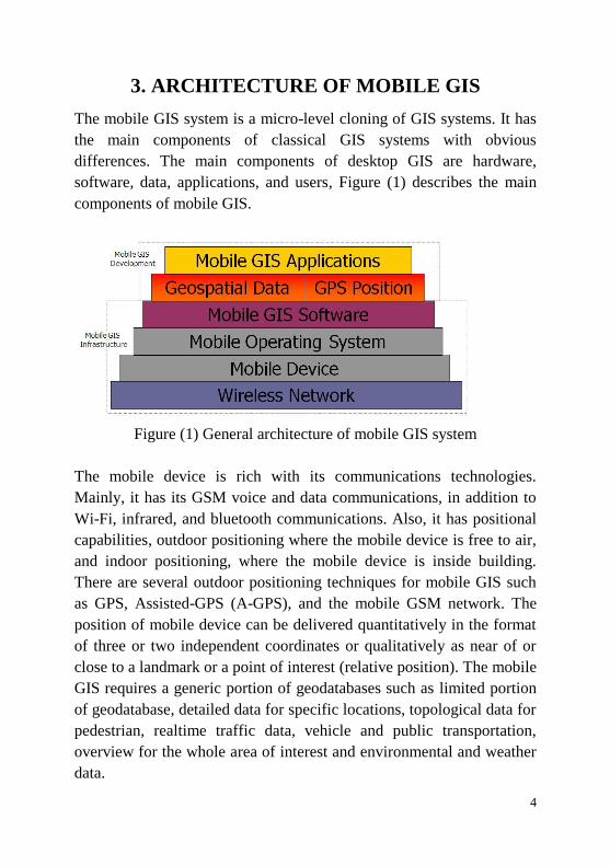
3. ARCHITECTURE OF MOBILE GIS
The mobile GIS system is a micro-level cloning of GIS systems. It has
the main components of classical GIS systems with obvious
differences. The main components of desktop GIS are hardware,
software, data, applications, and users, Figure (1) describes the main
components of mobile GIS.
Figure (1) General architecture of mobile GIS system
The mobile device is rich with its communications technologies.
Mainly, it has its GSM voice and data communications, in addition to
Wi-Fi, infrared, and bluetooth communications. Also, it has positional
capabilities, outdoor positioning where the mobile device is free to air,
and indoor positioning, where the mobile device is inside building.
There are several outdoor positioning techniques for mobile GIS such
as GPS, Assisted-GPS (A-GPS), and the mobile GSM network. The
position of mobile device can be delivered quantitatively in the format
of three or two independent coordinates or qualitatively as near of or
close to a landmark or a point of interest (relative position). The mobile
GIS requires a generic portion of geodatabases such as limited portion
of geodatabase, detailed data for specific locations, topological data for
pedestrian, realtime traffic data, vehicle and public transportation,
overview for the whole area of interest and environmental and weather
data.
5
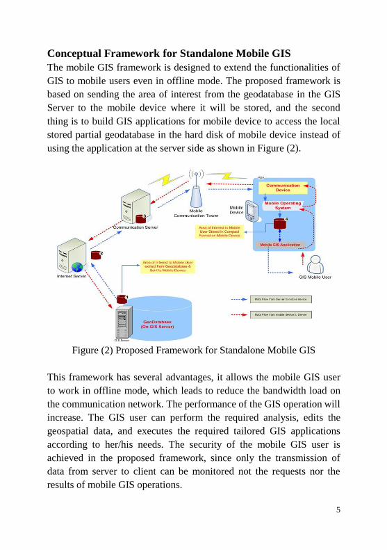
Conceptual Framework for Standalone Mobile GIS
The mobile GIS framework is designed to extend the functionalities of
GIS to mobile users even in offline mode. The proposed framework is
based on sending the area of interest from the geodatabase in the GIS
Server to the mobile device where it will be stored, and the second
thing is to build GIS applications for mobile device to access the local
stored partial geodatabase in the hard disk of mobile device instead of
using the application at the server side as shown in Figure (2).
Figure (2) Proposed Framework for Standalone Mobile GIS
This framework has several advantages, it allows the mobile GIS user
to work in offline mode, which leads to reduce the bandwidth load on
the communication network. The performance of the GIS operation will
increase. The GIS user can perform the required analysis, edits the
geospatial data, and executes the required tailored GIS applications
according to her/his needs. The security of the mobile GIS user is
achieved in the proposed framework, since only the transmission of
data from server to client can be monitored not the requests nor the
results of mobile GIS operations.
6
4. MOBILE GIS APPLICATIONS
The mobile GIS has a wide range of different applications such as
spatial query, proximity analysis, navigation, optimal path,
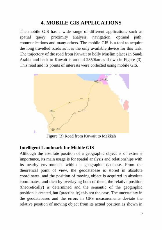
communications and many others. The mobile GIS is a tool to acquire
the long travelled roads as it is the only available device for this task.
The trajectory of the road from Kuwait to holly Muslim places in Saudi
Arabia and back to Kuwait is around 2850km as shown in Figure (3).
This road and its points of interests were collected using mobile GIS.
Figure (3) Road from Kuwait to Mekkah
Intelligent Landmark for Mobile GIS
Although the absolute position of a geographic object is of extreme
importance, its main usage is for spatial analysis and relationships with
its nearby environment within a geographic database. From the
theoretical point of view, the geodatabase is stored in absolute
coordinates, and the position of moving object is acquired in absolute
coordinates, and then by overlaying both of them, the relative position
(theoretically) is determined and the semantic of the geographic
position is created, but (practically) this not the case. The uncertainty in
the geodatabases and the errors in GPS measurements deviate the
relative position of moving object from its actual position as shown in
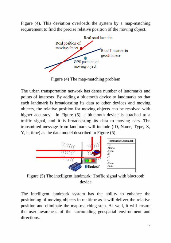
7
Figure (4). This deviation overloads the system by a map-matching
requirement to find the precise relative position of the moving object.
Figure (4) The map-matching problem
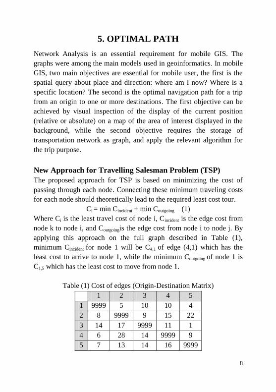
The urban transportation network has dense number of landmarks and
points of interests. By adding a bluetooth device to landmarks so that
each landmark is broadcasting its data to other devices and moving
objects, the relative position for moving objects can be resolved with
higher accuracy. In Figure (5), a bluetooth device is attached to a
traffic signal, and it is broadcasting its data to moving cars. The
transmitted message from landmark will include (ID, Name, Type, X,
Y, h, time) as the data model described in Figure (5).
Figure (5) The intelligent landmark: Traffic signal with bluetooth
device
The intelligent landmark system has the ability to enhance the
positioning of moving objects in realtime as it will deliver the relative
position and eliminate the map-matching step. As well, it will ensure
the user awareness of the surrounding geospatial environment and
directions.
8
5. OPTIMAL PATH
Network Analysis is an essential requirement for mobile GIS. The
graphs were among the main models used in geoinformatics. In mobile
GIS, two main objectives are essential for mobile user, the first is the
spatial query about place and direction: where am I now? Where is a
specific location? The second is the optimal navigation path for a trip
from an origin to one or more destinations. The first objective can be
achieved by visual inspection of the display of the current position
(relative or absolute) on a map of the area of interest displayed in the
background, while the second objective requires the storage of
transportation network as graph, and apply the relevant algorithm for
the trip purpose.
New Approach for Travelling Salesman Problem (TSP)
The proposed approach for TSP is based on minimizing the cost of
passing through each node. Connecting these minimum traveling costs
for each node should theoretically lead to the required least cost tour.
Ci = min Cincident + min Coutgoing (1)
Where Ci is the least travel cost of node i, Cincident is the edge cost from
node k to node i, and Coutgoingis the edge cost from node i to node j. By
applying this approach on the full graph described in Table (1),
minimum Cincident for node 1 will be C4,1 of edge (4,1) which has the
least cost to arrive to node 1, while the minimum Coutgoing of node 1 is
C1,5 which has the least cost to move from node 1.
Table (1) Cost of edges (Origin-Destination Matrix)
1 2 3 4 5
1 9999 5 10 10 4
2 8 9999 9 15 22
3 14 17 9999 11 1
4 6 28 14 9999 9
5 7 13 14 16 9999
9
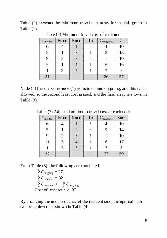
Table (2) presents the minimum travel cost array for the full graph in
Table (1).
Table (2) Minimum travel cost of each node
Cincident From Node To Coutgoing Ci
6 4 1 5 4 10
5 1 2 1 8 13
9 2 3 5 1 10
10 1 4 1 6 16
1 3 5 1 7 8
31 26 57
Node (4) has the same node (1) as incident and outgoing, and this is not
allowed, so the second least cost is used, and the final array is shown in
Table (3).
Table (3) Adjusted minimum travel cost of each node
Cincident From Node To Coutgoing Sum
6 4 1 5 4 10
5 1 2 3 9 14
9 2 3 5 1 10
11 3 4 1 6 17
1 3 5 1 7 8
32 27 59
From Table (3), the following are concluded:
outgoing = 27
incident = 32
incident > outgoing
Cost of least tour > 32
By arranging the node sequence of the incident side, the optimal path
can be achieved, as shown in Table (4).

10
Table (4) Second Convergence
Cincident From Node
6 4 1
5 1 2
9 2 3
1 3 5
16 5 4
37
Algorithm for TSP Problem
In this section, the algorithm for this solution is presented, and it has the
following steps:
1. Create node, link, and sub-graph arrays
2. Assign a status of “new” for all nodes
3. Create the minimum travel cost array
4. Exclude the part with minimum sum and start from the maximum
sum
5. Join possible nodes from minimum travel cost array
6. Fill sub-graph array with joined nodes
7. Update the status of nodes to be “new” for non-processed nodes,
“start” for nodes at the start of sub-graph, “end” for nodes at the
end of sub-graph, and “finished” for nodes at the middle of sub-
graph.
8. Create a new minimum travel array by excluding “finished” nodes
considering the status of nodes
9. Exclude the part with minimum sum and start from the maximum
sum
10. Join possible nodes and sub-graphs from minimum travel cost array
11. Go to step 8 until the existence of single sub-graph which is the
required solution of the problem
The algorithm discovers also the possible realizations for the minimum
cycle.
11
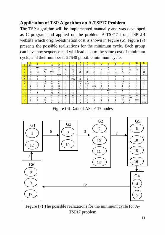
Application of TSP Algorithm on A-TSP17 Problem
The TSP algorithm will be implemented manually and was developed
as C program and applied on the problem A-TSP17 from TSPLIB
website which origin-destination cost is shown in Figure (6). Figure (7)
presents the possible realizations for the minimum cycle. Each group
can have any sequence and will lead also to the same cost of minimum
cycle, and their number is 27648 possible minimum cycle.
Figure (6) Data of ASTP-17 nodes
Figure (7) The possible realizations for the minimum cycle for A-
TSP17 problem
5
6
G1
1
12
G3
3
14
G4
4
5
G2
2
10
11
13
G5
6
10
15
16 G6
8
17
9
5 3
12
8
12
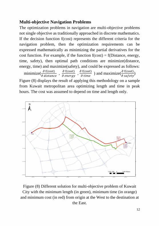
Multi-objective Navigation Problems
The optimization problems in navigation are multi-objective problems
not single objective as traditionally approached in discrete mathematics.
If the decision function f(cost) represents the different criteria for the
navigation problem, then the optimization requirements can be
expressed mathematically as minimizing the partial derivatives for the
cost function. For example, if the function f(cost) = f(Distance, energy,
time, safety), then optimal path conditions are minimize(distance,
energy, time) and maximize(safety), and could be expressed as follows:
minimize( , , ) and maximize( )
Figure (8) displays the result of applying this methodology on a sample
from Kuwait metropolitan area optimizing length and time in peak
hours. The cost was assumed to depend on time and length only.
Figure (8) Different solution for multi-objective problem of Kuwait
City with the minimum length (in green), minimum time (in orange)
and minimum cost (in red) from origin at the West to the destination at
the East.
13
Figure (9) North direction in
mobile GIS
Figure (10) Holography
display on mobile device
6. MOBILE GEOVISUALIZATION
The visualization of the geospatial
data is the main concern of the mobile
user. In 1990, the Cartography faced
up the challenge of displaying the
geographic information on the small
size screen of mobile device for
mobile GIS applications. The main
objective of mobile cartography is to
make the user aware of his/her
location, direction, and important
features around, and this is for the realtime display of geographic
information. Figure (9) displays the two orientations in mobile GIS.
Holography
Holography is an active imaging senor
technique that creates for a 3D object its
hologram which is a 2D storage for the
3D data and it can be retrieved and
rendered as 3D image such as the 3D
surface in Figure (10). The holography is
a promising technique expected to
provide mobile GIS with an important 3D geovisualization tool.
Metric System for Geographic Coordinates in Mobile GIS
The geoinformatics inherited an ancient sexagesimal system for
geographic position from Babylon civilization. The use of this system
for mobile user is not suitable as he/she requires a simple quantity that
reflects the accuracy of navigator GPS. The latitude (or longitude) on
earth surface is defined as three quantities, which are degrees, minutes,
and seconds, and most often 100 parts of a second or as decimal degree.
The South-West corner of great pyramid of Khufu in Giza, Egypt has
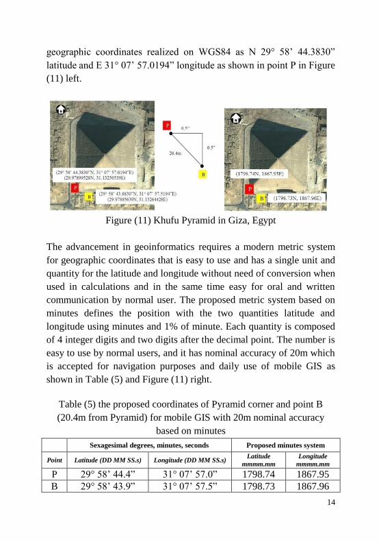
14
geographic coordinates realized on WGS84 as N 29° 58’ 44.3830”
latitude and E 31° 07’ 57.0194” longitude as shown in point P in Figure
(11) left.
Figure (11) Khufu Pyramid in Giza, Egypt
The advancement in geoinformatics requires a modern metric system
for geographic coordinates that is easy to use and has a single unit and
quantity for the latitude and longitude without need of conversion when
used in calculations and in the same time easy for oral and written
communication by normal user. The proposed metric system based on
minutes defines the position with the two quantities latitude and
longitude using minutes and 1% of minute. Each quantity is composed
of 4 integer digits and two digits after the decimal point. The number is
easy to use by normal users, and it has nominal accuracy of 20m which
is accepted for navigation purposes and daily use of mobile GIS as
shown in Table (5) and Figure (11) right.
Table (5) the proposed coordinates of Pyramid corner and point B
(20.4m from Pyramid) for mobile GIS with 20m nominal accuracy
based on minutes
Sexagesimal degrees, minutes, seconds Proposed minutes system
Point Latitude (DD MM SS.s) Longitude (DD MM SS.s) Latitude
mmmm.mm
Longitude
mmmm.mm
P 29° 58’ 44.4” 31° 07’ 57.0” 1798.74 1867.95
B 29° 58’ 43.9” 31° 07’ 57.5” 1798.73 1867.96
15
7. CONCLUSION
The mobile GIS is evolving and is driving the science and technology
to a new horizon. The mobile device is rich in its communications
capabilities with the increasing bandwidth of present wireless networks,
and it is a handy tool to geospatially transfer knowledge online as it
connects the owner of the knowledge to the requester.
The mobile GIS is an important tool in the acquisition of geospatial
data, gathering its attributes data, and collecting the trajectories of
moving objects even by non-experts. The acquisition of accurate 3D
coordinates in realtime, the orthometric height, indoor coordinates, and
the discovery of surrounding location environment are challenges
facing mobile device and require more research. The mobile GIS
software requires adding more spatial functionalities and specifically
network analysis and multi-objective optimal path modules to enable
the user to control these functions in mobility. The holography is a
promising 3D visualization tool and will have important role in the
future of mobile GIS.
The standalone framework was presented as a concept to release the
GIS functionality in mobility from the dependency on the
communications network and to allow the mobile user to perform
geospatial functions in offline mode. The intelligent landmark was
proposed as relative positioning tool for tracking vehicles precisely and
to avoid the map-matching required in traditional tracking. The current
sexagesimal system for the quantitative representation of geographic
position in longitude and latitude requires revision to a more generic
system based on the contemporary decimal system. In this study, a new
metric system based on geographic minute was proposed to overcome
the difficulties associated with the sexagesimal system. However, the
proposed system needs to compute the lengths and areas from this
metric system, and it requires new mathematical handling. The research
presented a new approach for the Travelling Salesman Problem (TSP)
and multi-objective navigation problems.
16
8. NEW SCIENTIFIC RESULTS
1) Conceptual framework for standalone mobile GIS
The use of mobile GIS in offline mode is vital, and the standalone
framework provides the solution for this problem.
2) Intelligent landmark for relative positioning
The relative position of the moving object provides the geospatial
semantic to the user, and it can be acquired using intelligent landmark.
3) New approach for Travelling Salesman Problem (TSP)
The least travel cost for each node is a new approach for tackling the
TSP.
4) Multi-objective navigation problems
The function model for the representation of navigation should
optimize all the criteria for optimal path not only single criterion.
5) Metric minutes system for geographic coordinates
The use of metric minutes as a base for geographic coordinates is easier
for normal user and will expand the use of geographic data.
Applications Presented
1. The geospatial acquisition of the international road from Kuwait to
Mekkah and returning back using mobile GIS.
2. The design and data model for intelligent landmark.
3. The application of the algorithm for solving the Travelling
Salesman Problem (TSP) using the least travel cost approach.
4. A C program was developed to implement the algorithm and
applied on 17-nodes problem.
5. The application of multi-objective optimal path on sample from
Kuwait City metropolitan area.
6. Example on metric geographic minute application in pedestrian
movement.