new evidence for a large prehistoric settlement in a caldera-like geomorphological structure in
TRANSCRIPT

New Evidence for a Large Prehistoric Settlement in a Caldera-Like Geomorphological Structure in Southwest Morocco
M. Huebner and S. Huebner
asalas.org, Germany
ABSTRACT
In this article, the results of two expeditions to a prehistoric settlement in southwest Morocco are sum-marized. It is situated in the Souss-Massa plain inside an annular (circular) geomorphological structure and once covered about 20 km2. The center was densely populated and surrounded by a 9 km long wall. The authors found many ruins of houses, large monuments, caverns, cisterns, kilns, tumuli, paths, rock carvings and various types of landscaping.
Four very unusual constructions are highlighted: a large stone-circle complex (≈ 130 x 110m) with a triangular shaped construction nearby (≈ 280 x 200m), a massive oval building (≈ 30 x 15m), a large earth wall (≈ 9km) and a grand scale earthwork (5400m long) that traverses the annular structure from the southeast to the top of the central hill.
Findings include various types of stone tools as well as incised Wavy Line pottery, typical for other parts of the Sahara region. At current, this is the westernmost example of Mesolithic Wavy Line decoration. The combination of stone-circles combined with isosceles triangles is frequent at numerous Neolithic sites in East Africa and in particular on the Arabian Peninsula.
Plato highlighted a number of very rare features, the capital of Atlantis has had. Many of these can be matched to this settlement: (1) Circular geomorphology, diameter and distance to the ocean; (2) A cent-ral hill surrounded by a town wall with a temple on top; (3) Springs and bathes; (4) Buildings made of red, white and black stones; (5) An avenue that leads up to the central hill where the king's palace was located; (6) A port in which boats were sheltered in caves; (7) Very old age & connection to Egypt.
This agglomeration of rare and striking geological and archeological features is unique throughout the world. It suggests that Plato was precise in his main points, and only few misconceptions with regard to the capital of Atlantis have been incorporated into his dialogues. Unfortunately the archeological site is subject to systematic destruction by local stone grinding mills. Immediate protection and serious inves-tigation are necessary to understand and preserve the site.
1. INTRODUCTION
In this article, the results of two expeditions to an ancient settlement in southwest Morocco are summarized. The expeditions took place from September 10th to 16th 2008, and from May 19th to 29th 2010. In the field, we came upon a great manifold of ruins with prehistoric features. Unfortunately, many of these monuments are currently being demolished by stone grinding mills. In publishing this article, the authors wish to emphasize the importance of the site and hope to encourage future scientific
1

investigations. The caldera-like annular geomorphological structure is located in South Morocco, 8 km east of Agadir in a landscape called Tagragra. It is situated between the shore of the Atlantic Ocean (distance: 13km), the Souss River (distance: 5km) and the western Atlas Mountains (distance: 2km). All ruins and monuments found in situ are located either on a hill inside the annular geomorphological structure, or on the surrounding ring of hills. The geological origin of the structure appears to be an anticline. It has a diameter of ≈ 3km (≈ 5km including the ring of hills) and strongly resembles a crater, although no evidence of volcanism has been found in this particular area (Ambroggi, 1963). On the central hill several dried up springs are located. The surrounding hills are 100-255m in height.
Figure 1: Panorama of the annular geomorphological structure
2. OVERVIEW
Inside the geomorphological structure and on the surrounding hills, hundreds of ancient stone constructions of different types are present. We found large numbers of ruined buildings, caverns, cisterns, stone heaps and traces of agricultural landscaping. Next to these ruins, a multitude of stone tools were found. In addition, we discovered some rather unusual constructions: a large stone circle complex, a 9 km long earth wall, an avenue-like structure, stone floorings and a place with rock carvings. The dimension of the entire ensemble is rather town-sized than village-sized. This size and the presence of several unique monuments make the settlement very distinct from neighboring archaeological sites.
For the most part, the buildings were found in the central area of the annular structure. In some aspects, their construction patterns are reminiscent of prehistoric architecture found in Europe (e.g. in the British Isles or in Sardinia). Basic features of the ruined buildings are: (1) Foundation walls were accurately manufactured and are very solid (diameter: 120-260cm); (2) Foundation walls are covered by large amounts of debris; (3) Both large and small stones are present; (4) Oval, circular and triangular ground plans are present; (5) Few rectangular ground plans are present (some of these seem to be recent, but may have been built on top of earlier walls); (6) Absence of regularly worked stones; (7) Predominantly white, reddish and black stones used; (8) Stones are weather-beaten, deeply eroded and covered by large lichens; (9) The walls are overgrown by centuries-old Argan trees; (10) All buildings are in a very bad state of preservation.
2

3

Figure 2 (previous page): Schematic sketch of the annular geomorphological structure including artifact finds. Squares = various types of ruins; Circles = circular constructions; Lorries = stone evacuation; Blue, red, yellow and green diamonds = artifact findings; Dark line = earth wall; Straight line = long avenue, Question marks = unexplored items; Satellite image: Google Earth.
Until now, we have not found any mention of a town or village within this particular region in late-antique, medieval and recent literature including many maps. The settlement might have been mentioned in ancient sources e.g. in Ptolemy’s Geographike Hyphegesis "Town of the Gaetuli Autololes/Autolata" or Diodorus Siculus’ "Town of Menê" (gr. Mene = Moon, which may correspond to the circular geomorphology of the structure) and, of course, in Plato's account on Atlantis. Possibly, the settlement has been abandoned within a short time in antiquity. A reason for this could be the destruction by an earthquake or the drying out of water sources (wells and springs).
3. MONUMENTS
In this section we will highlight four very remarkable grand monuments that were found at the site. Each of these monuments is exceptional and may help us to bring this settlement into line with other archeological sites.
3.1 The stone-circle complex and the triangular construction A remarkable stone circle complex was once located in the very center of the central area. The complex has almost completely been destroyed by stone grinding mills, but it still can be seen on Google-Earth (30°26’19.35”N; 9°27’27.09”W). The circular structure A had a diameter of 50 m and the entire complex measured 130 m x 110 m. Inside the structure A, several caverns and stone heaps are situated. In 2008, we were able to photograph some of the last large stone plates of the central circular structure still present at that time. In May 2010, none of these plates were leftover.
Figure 3: Megaliths in part B of the stone circle complex (l) and the stone circle complex (130 m x 110 m) from space (r). Source: Google Earth
4

In part B of the stone circle complex several megaliths including a 3 m long menhir were found. These megaliths are surrounded by a rectangular shaped 130 cm thick wall. The menhir is tapering towards the top and probably once stood perpendicularly. We assume that the stones in part B were arranged next to a spring (today almost dried up).
Next to this complex, in the southwest of the central hill, a large triangular shaped low wall is located. In 2008, remains of the southern wall (thickness ≈ 260 cm) were still present. In May 2010, the whole wall was dismantled. The triangular construction still can be seen on Google-Earth (30°26’1.59"N; 9°27’28.38"W). Inside the isosceles triangle, a multitude of ruins, stone tools and ceramic fragments were found. In part these ruins were still present in 2010.
Figure 4: Aerial view of the isosceles triangle (280 m x 200 m). Source: Google Earth
The combination of a stone circle with an isosceles triangular shaped low wall is a common construction pattern in Neolithic East Africa and specifically in Saudi Arabia (e.g. in the Harrat Khaybar area). Indeed, hundreds of these constructions have already been discovered [see e.g. Sparavigna A. C. (2010), Kennedy (2009) and others]. The purpose of the shapes is, as far as the authors know, not yet understood. However, most of the circles were identified as tombs. Kennedy (2009) states: “The keyhole tombs usually consist of a circular enclosure at the head of stone walls that form an isosceles triangle. There are numerous variations in size and in the relationships of circles and courtyards: In a few places the two are completely separated, and in others the triangle has been elongated so much it begins to look similar to the general form of some pendant tombs.”
5
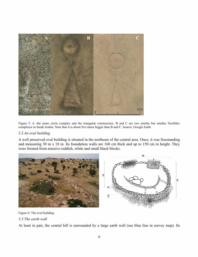
Figure 5: A -the stone circle complex and the triangular construction. B and C are two similar but smaller Neolithic complexes in Saudi Arabia. Note that A is about five times bigger than B and C. Source: Google Earth
3.2 An oval buildingA well preserved oval building is situated in the northeast of the central area. Once, it was freestanding and measuring 30 m x 18 m. Its foundation walls are 160 cm thick and up to 150 cm in height. They were formed from massive reddish, white and small black blocks.
Figure 6: The oval building
3.3 The earth wallAt least in part, the central hill is surrounded by a large earth wall (see blue line in survey map). Its
6

remains are about 5 m wide and up to 2 m in height. We estimate that the length of the wall exceeds 9 km. Remarkably, we found pieces of a reddish plaster containing sparkling mica next to this wall.
Figure 7: Part of the earth wall.
3.4 The avenueA grand scale earthwork (5400m long) traverses the annular structure from the southeast to the top of the central hill (see red line in survey map). The earthwork is similar to a long straight avenue, sometimes with two paths (ways) running in parallel. At current, we are not able to date this structure.
Figure 8: Avenue leading up the central hill.
7

4. FINDINGS
For legal reasons, we did not make any excavations in the area. Nevertheless, we were able to photograph many fragments of pottery, bones and prehistoric stone tools. Selected findings were sent to the Institut National des Sciences de l’Archéoloqie et du Patrimoine in Rabat for further investigation.
(I) The most remarkable finding was an fragmentary earthenware pot containing flint tools. At current, this pot is the westernmost example of incised Wavy Line pottery. The distinctive Wavy Line pottery was first identified at Khartoum in 1944 and dates back to early Holocene populations of North Africa. According to Edwards (2007) incised Wavy Line pottery is "found across much of Sudanic and Saharan Africa (see also Sutton (1977)) and is some of the oldest pottery in the world, with radiocarbon dates as early as 8000 BC." According to Abbas and Khabir (2003), ceramics "characterized by wavy line and dotted wavy line decoration, formed a cornerstone for identifying Mesolithic-Neolithic components along the Central Nile and across the Sahara-Sahel Belt. Moreover, they [...] suggested a level of cultural uniformity for the Nilo-Sahara-Sahel Belt from the eighth to the fourth millennia BC." (II) A stone axe was found in the central area (III) Several Køkkenmøddingers were found in- and outside the annular structure as well as in nearby caves. They contain great numbers of flints, stone tools, microliths, sea- and snail-shells. None of the Køkkenmøddingers, however, was situated inside or next to prehistoric ruins.
Figure 9: Examples of findings. Incised Wavy Line pottery, flint tools, sherds and a stone axe.
8

5. ROCK CARVINGS
Inside the annular structure a place with rock carvings does exist. The place is not located in the immediate vicinity of prehistoric ruins. One of the rock carvings resembles a footprint-petrosomatoglyph (= image of parts of a human or animal body incised in rock. Such were created by Celtic peoples - Picts, Scots, Irish, etc. in the Early Middle Ages. Others of uncertain purpose date back to Megalithic times. They were used in religious and secular ceremonies, such as the crowning of kings.) At current, there is no evidence that permits dating of these rock carvings.
Figure 10: Some rock carvings. The rock carving at the right resembles a footprint-petrosomatoglyph.
6. DESTRUCTION OF THE SITE
Unfortunately, the entire site is subject to massive destruction. The authors spotted fresh excavations (probably illicit) and two large hydrotechnical constructions that date back to the 1960s. Moreover, the area is used as quarry by the local building industry which every day is carrying away hundreds of large stones. In May 2010, quarrying activity was concentrated in the Northeast of the central area where the oval building is situated. The authors calculated that every day 10-15 lorries full of stones are carried away from the site.
We wish to express our conviction that the settlement is worth protection from further destruction. Moroccan and international authorities should adopt efficient protective measures to stop stone evacuation from the site as soon as possible. An important step could be to include the site on the List of World Heritage in Danger (in accordance with Art.11 §4 of the Convention). Fortunately we were able to show a small part of the ensemble to Moroccan authorities in May 2010. These authorities expressed their interest in running a university based joint Moroccan/International investigation of the site (contact: [email protected])
9

Figure 11: Every day 10-15 lorries full of stones are carried away from the site. Stones are pulverized to reddish, white and gray powder.
7. HARBOUR
About 45 km to the North-West, at the shore of the Atlantic Ocean, 5 km East of Cape Ghir, we found a number of interesting caves and bays that once may have been served as a harbor or dock for ships. In Timaeus, Plato described docks with a clear resemblance to those that are shown below: “One kind of stone was white, another black, and a third red; and, as they quarried, they at the same time hollowed out docks double within, having roofs formed out of the native rock.”
8. CONCLUSIONS
8.1 OriginsThe following evidence suggests that the settlement has prehistoric origins: (1) Findings of a great manifold of prehistoric stone tools inside and next to the ruins; (2) Findings of Mesolithic and Neolithic-style ceramics inside the ruins and in their immediate vicinity; (3) Absence of wood and metal findings; (4) Oval, circular and curvy ground plans of buildings; (5) Extremely eroded building stones despite semiarid climate; (6) Presence of very unusual and monumental stone constructions at the site (see below). (7) Similarities to Neolithic sites in Saudi Arabia;
8.2 Plato’s accountPlato highlighted a number of unique and rare features of the capital of Atlantis, which may be matched to this settlement:
1. Circular shape, diameter and distance to the ocean: The settlement lies inside a circular geomorphological structure similar to a caldera. Shape, diameter of the structure and distance to the Ocean do match Plato's specifications.
2. Central hill and town wall: Inside the circular structure a large hill surrounded by a 9 km long
10

earth wall is situated.
3. Temple on top of the central hill: On top of the hill, a large stone complex (130 x 110m) with a stone circle in it's middle was found. Plato reported that on top of the central hill was a “Barbaric looking”-Poseidon temple.
4. Springs and bathes: Two rectangular extensions are attached to this stone circle. Inside one of them, a menhir is situated and it's subsoil is humid. In prehistory, menhirs marked springs and nearby deep wholes (3 x 6m and larger) are carved into the subsoil.
5. Buildings made of red, white and black stones: The subsoil in the area is composed of white, red and black stone. The walls of many ruined houses consist of these three types of stone.
6. Avenue: The area is traversed by a 5800 m long grand scale earthwork, similar to an Avenue, sometimes with two paths running in parallel and consequently ignoring difficulties in terrain. This might be related to the avenue leading up to the royal palace mentioned by Plato.
7. Ports in which boats were sheltered in caves: Nearby, at the shore of the Ocean, rows of caves are situated. These caves are suitable to be used as shelter for boats. Here, the subsoil also consists out of red, white and black bedrock.
8. Very old age and connection to Egypt: Incised Wavy Line pottery was found at the site. This Mesolithic pottery is found across much of Saharan Africa till the upper Nile. It is some of the oldest pottery in the world, with radiocarbon dates as early as 8000 BC. In addition the circle-triangle construction pattern is common in Neolithic East Africa and on the Arabian Peninsula.
This agglomeration of striking geological and archeological features is unique throughout the world. It suggests that Plato was precise in his main points, though some misconceptions with regard to the capital of Atlantis seem to have been incorporated into his dialogues. For example, the harbor is detached from the capital itself. In addition, 44 of a total of 51 attributes mentioned by Plato can be matched to the Souss-Massa area. This is statistically significant and provides more evidence that Plato used detailed descriptions of this particular settlement in his dialogues [see Huebner M. (2012) this volume].
11

Figure 12: Rock formations and bays suitable to be used as shelter for boats. Note that the caves are 4 to 6 m in height and some of them are more than 10 m deep. The row of caves in the top image is 70 m long. In the aerial view 2 of 9 such bays are shown. Satellite image: Google Earth.
LITERATUREAmbroggi R. (1963). Etude géologique du versant méridional du haut Atlas Occidental et de la plaine de Souss. Notes et Mémoires du Service Géologique du Maroc 157. 321p.
Abbas S. M. and Abdel-Rahim M. K. (2003). The Wavy Line and the Dotted Wavy Line Pottery in the Prehistory of the Central Nile and the Sahara-Sahel Belt. African Archaeological Review. Vol. 20, Number 1, 25-58
Edwards D. N. (2007). The Archaeology of Sudan and Nubia. Annual Review of Anthropology. Vol. 36:211-228
Huebner M., Huebner S. (2011). New evidence for a large prehistoric settlement in an annular geomorphological structure in Southwest Morocco.- Almogaren XLII (Institutum Canarium), Wien, 43-49
Kennedy D. L. (2009). Desktop Archaeology. See:
12

http://www.saudiaramcoworld.com/issue/200904/desktop.archeology.htmSutton J. (1977). The African Aqualithic. Antiquity. Vol. 51:25-33 Usai D. and Salvatori S. (2007). The oldest representation of a Nile boat. Vol. 81 Number 314 21
Sparavigna A. C. (2010). Arabia: from craters to stone circles. See:http://www.archaeogate.org/classica/article/1327/1/arabia-from-craters-to-stone-circles-di-amelia-carolina.html
Many additional information including photos, movies and papers can be found here: www.asalas.org
13