new i-79 interchange · 1-1 no building average daily traffic volumes 2-1 i-79 los under no build...
TRANSCRIPT

Environmental Assessment
New I-79 Interchange Morgantown, West Virginia
Prepared for: U.S. Department of Transportation Federal Highway Administration West Virginia Department of Transportation Division of Highways
December 2013


West Virginia Department of Transportation Environmental Assessment December 2013 TABLE OF CONTENTS
Project No. 52354 ii
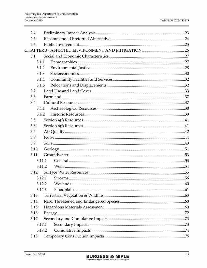
TABLE OF CONTENTS Page
TABLE OF CONTENTS .................................................................................................................... ii EXECUTIVE SUMMARY ................................................................................................................ vii
ES.1 Project Description ........................................................................................................ vii ES.2 Purpose ........................................................................................................................... vii ES.3 Need ................................................................................................................................ vii ES.4 Economic Conditions .................................................................................................. viii ES.5 Preliminary Alternatives Considered ......................................................................... ix
ES.6 Environmental Impacts .................................................................................................. x
ES.7 Preferred Alternative ...................................................................................................... x
CHAPTER 1 - INTRODUCTION AND PURPOSE AND NEED ................................................ 1
1.1 Introduction ......................................................................................................................1
1.1.1 Existing Highway Network .....................................................................................1
1.1.2 University Town Centre and Long Range Development Plan ...........................1
1.1.3 Project Funding ..........................................................................................................3
1.2 Purpose ..............................................................................................................................3
1.3 Need ...................................................................................................................................3
1.3.1 Reduce Traffic and Congestion ...............................................................................3
1.3.2 Improve Safety ...........................................................................................................4
1.3.3 Consistency with Local Land Use Plans ................................................................5
CHAPTER 2 - ALTERNATIVES ...................................................................................................... 8
2.1 No-Build ............................................................................................................................8
2.2 Transportation System Management (TSM) ..............................................................10
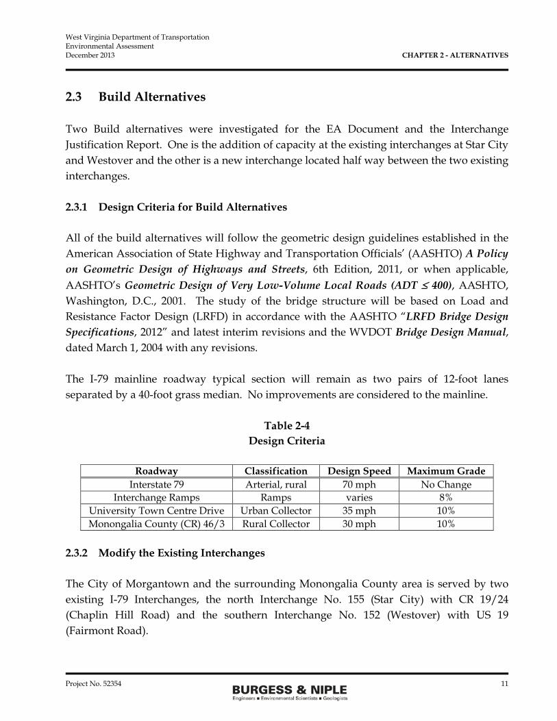
2.3 Build Alternatives ..........................................................................................................11
2.3.1 Design Criteria for Build Alternatives .................................................................11
2.3.2 Modify the Existing Interchanges .........................................................................11
2.3.3 Construct a New Interchange ................................................................................14
2.3.4 New Interchange Types..........................................................................................17
2.3.4.1 Tight Diamond Interchange ..........................................................................18
2.3.4.2 Diamond Interchange with Roundabout ....................................................19
2.3.4.3 Wide Diamond Interchange .........................................................................20
2.3.4.4 Split Diamond Interchange ............................................................................21
2.3.4.5 Trumpet for Ramp D .....................................................................................21
2.3.4.6. Single Point Urban Interchange ..................................................................22
2.3.4.7 Diverging Diamond Interchange ..................................................................23
West Virginia Department of Transportation Environmental Assessment December 2013 TABLE OF CONTENTS
Project No. 52354 iii
2.4 Preliminary Impact Analysis .......................................................................................23
2.5 Recommended Preferred Alternative .........................................................................24
2.6 Public Involvement ........................................................................................................25
CHAPTER 3 - AFFECTED ENVIRONMENT AND MITIGATION ......................................... 26
3.1 Social and Economic Characteristics ...........................................................................27
3.1.1 Demographics ..........................................................................................................27
3.1.2 Environmental Justice .............................................................................................28
3.1.3 Socioeconomics ........................................................................................................30
3.1.4 Community Facilities and Services .......................................................................32
3.1.5 Relocations and Displacements .............................................................................32
3.2 Land Use and Land Cover ............................................................................................33
3.3 Farmland .........................................................................................................................37
3.4 Cultural Resources .........................................................................................................37
3.4.1 Archaeological Resources ......................................................................................38
3.4.2 Historic Resources ...................................................................................................39
3.5 Section 4(f) Resources ....................................................................................................41
3.6 Section 6(f) Resources ....................................................................................................41
3.7 Air Quality ......................................................................................................................42
3.8 Noise ................................................................................................................................44
3.9 Soils ..................................................................................................................................49
3.10 Geology ...........................................................................................................................51
3.11 Groundwater ..................................................................................................................53
3.11.1 General ..................................................................................................................53
3.11.2 Wells ......................................................................................................................54
3.12 Surface Water Resources ...............................................................................................55
3.12.1 Streams ..................................................................................................................56
3.12.2 Wetlands ...............................................................................................................60
3.12.3 Floodplains ...........................................................................................................61
3.13 Terrestrial Vegetation & Wildlife ................................................................................63
3.14 Rare, Threatened and Endangered Species ................................................................68
3.15 Hazardous Materials Assessment ...............................................................................69
3.16 Energy ..............................................................................................................................72
3.17 Secondary and Cumulative Impacts ...........................................................................73
3.17.1 Secondary Impacts ...............................................................................................73
3.17.2 Cumulative Impacts ............................................................................................74
3.18 Temporary Construction Impacts ...............................................................................76

West Virginia Department of Transportation Environmental Assessment December 2013 TABLE OF CONTENTS
Project No. 52354 iv
3.19 Impact Summary ............................................................................................................76
CHAPTER 4 - REFERENCES ......................................................................................................... 78
CHAPTER 5 – LIST OF PREPARERS AND REVIEWERS ......................................................... 79
CHAPTER 6 – DISTRIBUTION LIST ............................................................................................ 81

West Virginia Department of Transportation Environmental Assessment December 2013 TABLE OF CONTENTS
Project No. 52354 v
List of Tables
1-1 No Building Average Daily Traffic Volumes 2-1 I-79 LOS Under No Build 2-2 Urban Streets LOS under No Build 2-3 Intersection LOS under No Build 2-4 Design Criteria 2-5 I-79 LOS Adding Capacity 2-6 Urban Streets LOS Adding Capacity 2-7 Intersection LOS Adding Capacity 2-8 New Interchange Average Daily Traffic Volumes 2-9 I-79 LOS New Interchange 2-10 Urban Streets LOS New Interchange 2-11 Intersection LOS New Interchange 2-12 Preliminary Impacts of Preferred Alternative 3-1 Demographic Overview Year 2010 3-2 Ten Largest Employers 2011 Monongalia County, WV 3-3 Land Use and Cover Types I-79 Study Area 3-4 VMT No Build and Preferred Alternative 3-5 FHWA Noise Abatement Criteria (NAC) 3-6 Mapped Soil Types 3-7 Stream Summary 3-8 Stream Impacts 3-9 Wetland Resources 3-10 Wetland Impacts 3-11 Terrestrial Vegetation Communities 3-12 Terrestrial Vegetation 3-13 Wildlife Observations 3-14 Habitat Impacts 3-15 Areas of Opportunity/Future Development 3-16 Summary of Impacts and Mitigation for Preferred Alternative

West Virginia Department of Transportation Environmental Assessment December 2013 TABLE OF CONTENTS
Project No. 52354 vi
List of Figures 1 Project Area Map 2 Proposed Development 3-1 EJ Analysis 3-2 Land Use/Land Cover 3-3 Land Use/Land Cover Alternative 3 3-4 Noise Receptor Location Map 3-5 Soil Types 3-6 Geological Resources of Project Area 3-7 Stream and Wetlands Alternative 3 3-8 FEMA Flood Plain 3-9 Hazardous Waste Location Map
List of Appendices Appendix A - NRCS Farmland Letter Appendix B - Cultural Resources
Division of Culture and History Concurrence Letter Archaeological and Historic Reports (On CD) Appendix C - EDR Well Search Report Monongalia County Health Department Letters Appendix D - Wetland Delineation And Aquatic Resources Inventory Report
(on CD) Appendix E - WVDNR Rare, Threatened & Endangered Species - Correspondence
Dated 6/18/2013 U.S. Fish & Wildlife Service - Correspondence Dated 8/5/2013 Indiana Bat Survey Report (on CD) Appendix F - Hazardous Materials Assessment Report (on CD) Appendix G - Typical Cross Sections of Roadways

West Virginia Department of Transportation Environmental Assessment December 2013 EXECUTIVE SUMMARY
Project No. 52354 vii
EXECUTIVE SUMMARY ES.1 Project Description The West Virginia Department of Transportation (WVDOT), in cooperation with the Federal Highway Administration (FHWA) are proposing to construct a new interchange on Interstate (I)-79 between Interchange No. 155 (Star City) and Interchange No. 152 (Westover). The purpose of the new interchange on I-79 is to reduce traffic conflicts, improve safety, and increase traffic capacity. The proposed new interchange will allow both freight and people to be moved efficiently and safely, to and from I-79. The Morgantown, West Virginia area, including Monongalia County and the Cities of Morgantown, Star City, Westover, and Granville are served by I-79 that runs north-south through the western part of the area. The two interchanges currently experience congestion during peak hours, and the congestion is expected to increase as the University Town Centre development continues to progress. The development is served by University Town Centre Drive which intersects with Monongalia County (County Road [CR]) 19/24 (Chaplin Hill Road) just to the east of the Star City interchange. Figure 1 shows the current roadway network within the Morgantown area. ES.2 Purpose The purpose of the project is to reduce traffic and congestion by improving the Level of Service (LOS) at the existing I-79 interchanges at Star City and Westover, improve safety by reducing crashes, and accommodate future traffic volumes that are consistent with local and regional land use plans. ES.3 Need Reduce Traffic and Congestion The Average Dailey Traffic and the Average Peak Hour Traffic volumes were used to estimate the LOS for the Interstate, intersections, and the adjacent urban streets in the years 2015, 2025, and 2035 (preferred alternative only). A LOS “A” is the best where traffic is free flowing and drivers do not experience delays due to heavy traffic volumes. A LOS “F” is the worst case where drivers will experience delays of over 50 seconds to move through intersections or to enter/exit the interstate. The No Build LOS for intersections goes from a

West Virginia Department of Transportation Environmental Assessment December 2013 EXECUTIVE SUMMARY
Project No. 52354 viii
range of B to F in 2015 to a range of D to F in 2025; Interstate LOS goes from a range of B to D in 2015 to a range of D to F in 2025; and the adjacent urban streets LOS goes from a range of C to E in 2015 to E or F in 2025. Over the next 10 years, the LOS goes from acceptable levels for most streets, intersections, and the Interstate to unacceptable levels (E and F) at most of the same locations. Improve Safety Comparing the accident rates from January 1, 2009 to December 31, 2011 to the Statewide average crash rates, the accident rates in the project area exceeds the statewide averages on all routes. Within the project area, the injury accident rate was exceeded for all routes, except US 19. The accident rate for CR 19/24 (Chaplin Hill Road) was over five times the statewide average. There are existing issues with CR 19/24 area that cannot be addressed by this project. However, any improvement in the area that would draw traffic away from CR 19/24 can only have a positive impact to the current situation seen for CR 19/24. Consistency with Local Land Use Plans The Morgantown Monongalia Metropolitan Planning Organization (MMMPO) has prepared land use plans for the County which shows the land adjacent to I-79 between the two interchanges as prime for development. With the development as proposed shown on Figure 2, additional traffic will be generated within the study area. ES.4 Economic Conditions The developer of the University Town Centre has constructed about 50 percent of the development area to date on the east side of I-79. The developer has been working with the West Virginia University to construct athletic facilities as part of the development. The proposal includes a baseball field that will be adjacent to the extension of the University Town Centre Drive. The developer has identified additional parcels for the construction of additional office buildings, medical facilities, restaurants, motels, and gas stations along the extension of the University Town Centre Drive. The developer has also identified areas on the west side of I-79 between the existing interchanges that would be accesses by CR 19/24, CR 46/1, and CR 46/3. The start date for construction of the west side development has not been established but is expected to be started within the 20-year planning period. The
West Virginia Department of Transportation Environmental Assessment December 2013 EXECUTIVE SUMMARY
Project No. 52354 ix
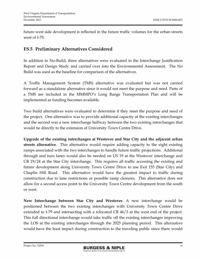
future west side development is reflected in the future traffic volumes for the urban streets west of I-79. ES.5 Preliminary Alternatives Considered In addition to No-Build, three alternatives were evaluated in the Interchange Justification Report and Design Study and carried over into the Environmental Assessment. The No Build was used as the baseline for comparison of the alternatives. A Traffic Management System (TMS) alternative was evaluated but was not carried forward as a standalone alternative since it would not meet the purpose and need. Parts of a TMS are included in the MMMPO’s Long Range Transportation Plan and will be implemented as funding becomes available. Two build alternatives were evaluated to determine if they meet the purpose and need of the project. One alternative was to provide additional capacity at the existing interchanges and the second was a new interchange halfway between the two existing interchanges that would tie directly to the extension of University Town Centre Drive. Upgrade of the existing interchanges at Westover and Star City and the adjacent urban streets alternative. This alternative would require adding capacity to the eight existing ramps associated with the two interchanges to handle future traffic projections. Additional through and turn lanes would also be needed on US 19 at the Westover interchange and CR 19/24 at the Star City interchange. This requires all traffic accessing the existing and future development along University Town Centre Drive to use Exit 155 (Star City) and Chaplin Hill Road. This alternative would have the greatest impact to traffic during construction due to lane restrictions or possible ramp closures. This alternative does not allow for a second access point to the University Town Centre development from the south or west. New Interchange between Star City and Westover. A new interchange would be positioned between the two existing interchanges with University Town Centre Drive extended to I-79 and intersecting with a relocated CR 46/3 at the west end of the project. This full directional interchange would take traffic off the existing interchanges improving the LOS at the existing interchanges through the 2025 planning period. This alternative would have the least impact during construction to the traveling public since there would

West Virginia Department of Transportation Environmental Assessment December 2013 EXECUTIVE SUMMARY
Project No. 52354 x
be no work at the existing interchanges. Temporary lane closures may occur on I-79 during the construction of the interchange which includes a bridge over the interstate. This alternative would result in the best LOS for the urban streets, interchange ramps, and intersections around the interchanges. As part of the Design Study, different interchange types were evaluated at the preliminary design level. The diamond interchange with a roundabout at the southbound ramps and University Town Centre Drive intersection was selected as the preferred alternative. ES.6 Environmental Impacts A comparison of the impacts of the preferred alternative and the No Build is shown in Table ES-1.
Table ES-1 Summary of Impacts for the Preferred Alternative
I-79 Study Area
Resource/Element No-Build Option Build Preferred
Alternative No. 3 Residential/ Commercial Displacements 0 0 Earthwork 0 cy 2,000,000 cy Land Area Impacted 20 acres 51.37 acres Stream Impacts 0 lf 2,426 lf Wetland Impacts 0 acres 0.07 acres Noise Receptors Impacted 0 0 Terrestrial Habitats 0 acres 40.2 acres Hazardous Waste Sites 0 1 Acid Mine Drainage Line
9 Illegal Dump Sites Improved Access to Development No Yes Environmental Justice Population No No
cy = cubic yards lf = linear feet
ES.7 Preferred Alternative As on the result of the preliminary evaluation and the Design Study, the new interchange using a diamond configuration with a roundabout at the southbound ramps was carried forward for environmental analysis as the preferred alternative. CR 46/3 will be moved

West Virginia Department of Transportation Environmental Assessment December 2013 EXECUTIVE SUMMARY
Project No. 52354 xi
approximately 300 feet to the west of the roundabout to allow for access from University Town Centre Drive to the future development parcels between the southbound ramps and CR 46/3.

West Virginia Department of Transportation Environmental Assessment December 2013 CHAPTER 1 - INTRODUCTION AND PURPOSE AND NEED
Project No. 52354 1
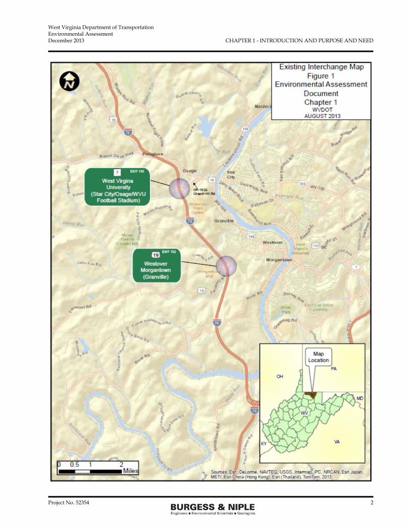
CHAPTER 1 - INTRODUCTION AND PURPOSE AND NEED 1.1 Introduction The West Virginia Department of Transportation (WVDOT), in cooperation with the Federal Highway Administration (FHWA) are proposing to construct a new interchange on Interstate (I)-79 between Interchange No. 155 (Star City) and Interchange No. 152 (Westover). The purpose of the new interchange on I-79 is to reduce traffic conflicts, improve safety, improve the Level of Service (LOS), and accommodate local land use planning documents. The proposed new interchange will allow both freight and people to be moved efficiently and safely, to and from I-79. 1.1.1 Existing Highway Network The Morgantown, West Virginia area, including Monongalia County and the Cities of Morgantown, Star City, Westover, and Granville are served by I-79 that runs north-south through the western part of the area. The two interchanges currently experience congestion during peak hours, and the congestion is expected to increase as the University Town Centre development continues to progress. The development is served by University Town Centre Drive which intersects with Monongalia County (County Road [CR]) 19/24 (Chaplin Hill Road) just to the east of the Star City interchange. Figure 1 shows the current roadway network within the Morgantown area. 1.1.2 University Town Centre and Long Range Development Plan The developer of the University Town Centre has constructed about 50 percent of the development area on the east side of I-79 to date. The developer has identified the remaining area on the east side for office buildings, medical facilities, restaurants, hotels, and gas stations along the extension of the University Town Centre Drive. The developer has been working with West Virginia University to include athletic facilities as part of the development. The University proposal includes a baseball field and a multi-use athletic facility. The developer has also identified areas on the west side of I-79 between the existing interchanges that would be accesses by CR 19/24, CR 46/1, and CR 46/3. The start date for construction of the west side development has not been established but is expected to be started within the 20-year planning period. The future west side development is reflected in the future traffic volumes for the urban streets west of I-79.
West Virginia Department of Transportation Environmental Assessment December 2013 CHAPTER 1 - INTRODUCTION AND PURPOSE AND NEED
Project No. 52354 2
West Virginia Department of Transportation Environmental Assessment December 2013 CHAPTER 1 - INTRODUCTION AND PURPOSE AND NEED
Project No. 52354 3
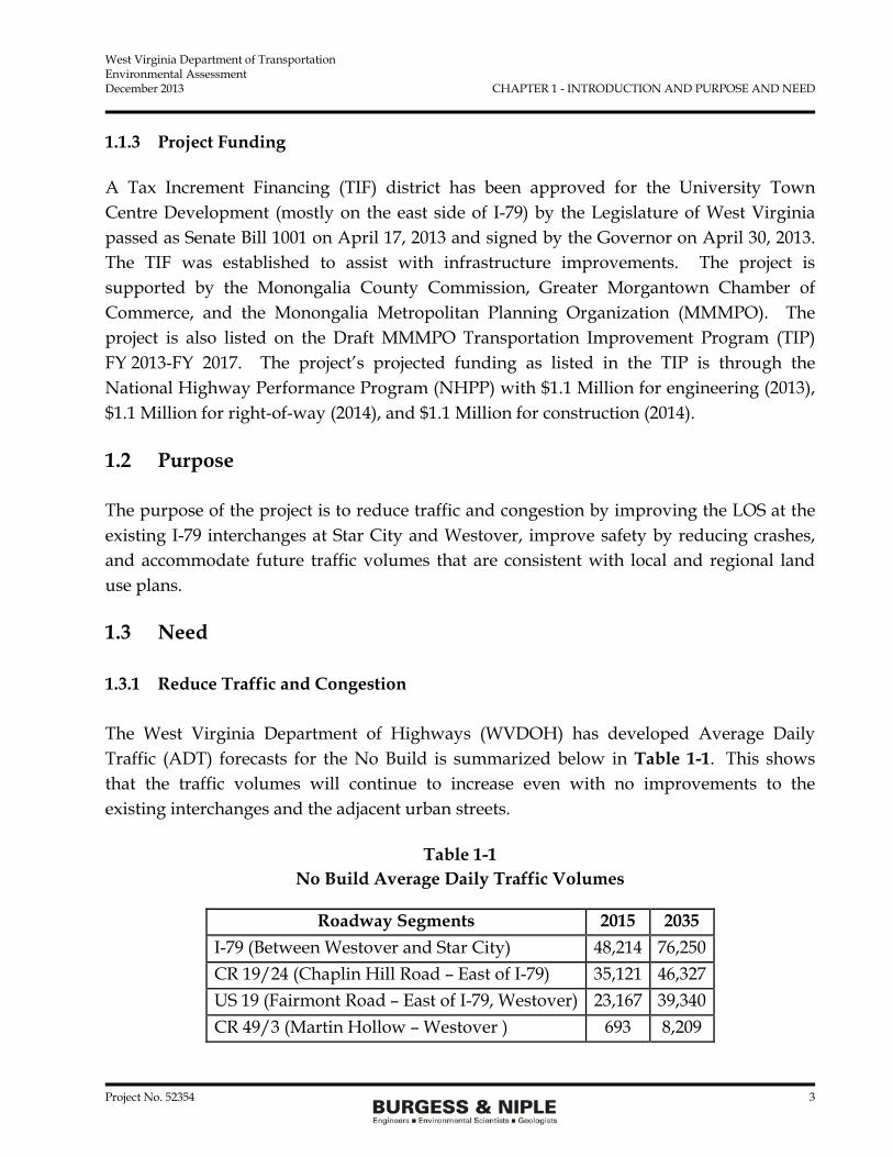
1.1.3 Project Funding A Tax Increment Financing (TIF) district has been approved for the University Town Centre Development (mostly on the east side of I-79) by the Legislature of West Virginia passed as Senate Bill 1001 on April 17, 2013 and signed by the Governor on April 30, 2013. The TIF was established to assist with infrastructure improvements. The project is supported by the Monongalia County Commission, Greater Morgantown Chamber of Commerce, and the Monongalia Metropolitan Planning Organization (MMMPO). The project is also listed on the Draft MMMPO Transportation Improvement Program (TIP) FY 2013-FY 2017. The project’s projected funding as listed in the TIP is through the National Highway Performance Program (NHPP) with $1.1 Million for engineering (2013), $1.1 Million for right-of-way (2014), and $1.1 Million for construction (2014).
1.2 Purpose The purpose of the project is to reduce traffic and congestion by improving the LOS at the existing I-79 interchanges at Star City and Westover, improve safety by reducing crashes, and accommodate future traffic volumes that are consistent with local and regional land use plans.
1.3 Need 1.3.1 Reduce Traffic and Congestion The West Virginia Department of Highways (WVDOH) has developed Average Daily Traffic (ADT) forecasts for the No Build is summarized below in Table 1-1. This shows that the traffic volumes will continue to increase even with no improvements to the existing interchanges and the adjacent urban streets.
Table 1-1 No Build Average Daily Traffic Volumes
Roadway Segments 2015 2035 I-79 (Between Westover and Star City) 48,214 76,250 CR 19/24 (Chaplin Hill Road – East of I-79) 35,121 46,327 US 19 (Fairmont Road – East of I-79, Westover) 23,167 39,340 CR 49/3 (Martin Hollow – Westover ) 693 8,209

West Virginia Department of Transportation Environmental Assessment December 2013 CHAPTER 1 - INTRODUCTION AND PURPOSE AND NEED
Project No. 52354 4
The ADT and the Peak Hour Traffic volumes were used to estimate the LOS for the Interstate, intersections, and the adjacent urban streets in the years 2015, 2025, and 2035 (preferred alternative only). A LOS “A” is the best where traffic is free flowing and drivers do not experience delays due to heavy traffic volumes. A LOS “F” is the worst case where drivers will experience delays of over 50 seconds to move through intersections or to enter/exit the interstate. The LOS continues to decline over the 10-year period to the point that certain intersections, ramps, and streets are at an unacceptable level of E and F. The LOS tables are included in Chapter 2. 1.3.2 Improve Safety WVDOT reviewed the crash history for a 3-year period from January 1, 2009 to December 31, 2011. The roads and interstate included in the crash analysis are: • North and southbound I-79 between the Star City and Westover Interchanges • East and westbound US 19 • North and southbound CR 49 • West and eastbound CR 19/24 • North and southbound CR 49/1.
The number of crashes during the three-year period was: • 121 crashes on I-79 (1 fatality) • 610 crashes on US 19 • 16 crashes CR 49 • 95 Crashes CR 19/24 • 9 crashes CR 49/1. Comparing the accident rates from January 1, 2009 to December 31, 2011 to the Statewide average crash rates, the accident rates in the project area exceeds the statewide averages on all routes. Within the project area, the injury accident rate was exceeded for all routes, except US 19. The accident rate for CR 19/24 (Chaplin Hill Road) was over five times the statewide average. We are aware that there are existing issues with the CR 19/24 area that cannot be addressed by this project. However, any improvement in the area that would draw traffic away from CR 19/24 can only have a positive impact to the current situation

West Virginia Department of Transportation Environmental Assessment December 2013 CHAPTER 1 - INTRODUCTION AND PURPOSE AND NEED
Project No. 52354 5
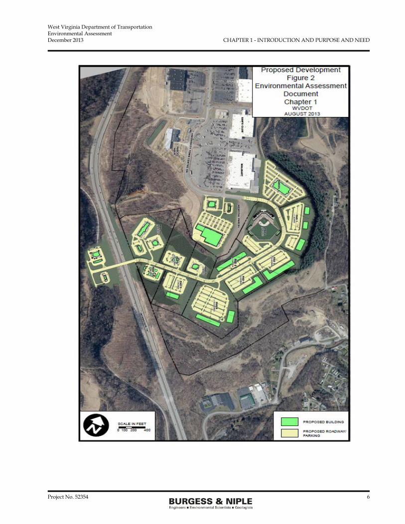
seen for CR 19/24. The accident and injury rates shown for CR 49/1 are exaggerated due to the low ADT. Under No Build, congestion will worsen over the years as traffic volumes increase, the number of crashes will likely increase. 1.3.3 Consistency with Local Land Use Plans The MMMPO has prepared land use plans for the County which shows the land adjacent to I-79 between the two interchanges as prime for development. With the development as proposed shown on Figure 2, additional traffic will be generated within the study area.
West Virginia Department of Transportation Environmental Assessment December 2013 CHAPTER 1 - INTRODUCTION AND PURPOSE AND NEED
Project No. 52354 6
West Virginia Department of Transportation Environmental Assessment December 2013 CHAPTER 1 - INTRODUCTION AND PURPOSE AND NEED
Project No. 52354 7
The traffic projects by WVDOT indicate the potential development area will be 100 percent built out over the next 10 years. In addition, a reasonably foreseeable future development will occur to the west of CR 46/3. These traffic volumes have been included in the 2035 traffic projects. The development and the projected land uses are consistent with the MMMPO plans.

West Virginia Department of Transportation Environmental Assessment December 2013 CHAPTER 2 - ALTERNATIVES
Project No. 52354 8
CHAPTER 2 - ALTERNATIVES Three alternatives were considered along with No Build to address the purpose and need of the project. The most feasible solutions to address current congestion, safety and accommodate the future traffic volumes from identified in regional plans were evaluated. The alternatives investigated included Transportation Management Systems, capacity improvements at the existing interchanges, and construction of a new interchange. The impacts of the preferred alternative will be further discussed in following chapters. 2.1 No-Build The No-Build requires the existing highway and roadway infrastructure to remain as is. Only maintenance of the existing roadways would be carried out over the next 20 years. The existing interchanges at Star City and Westover will handle greater traffic volumes resulting in drivers experiencing long delays to exit or enter the interstate due to the increased congestion by the design year of 2025. The projected LOS for the interstate (Table 2.1), Urban Streets (Table 2.2), and Intersections (Table 2.3) for the opening year (2015) and the 10-year after opening year (2025) was determined by WVDOT1.
Table 2-1
I-79 LOS Under No Build
Location LOS
2015 E+C LOS
2025 E+C I-79 NB B F I-79 SB C E I-79 NB Diverging E E I-79 NB Merging D E I-79 SB Diverging B E I-79 SB Merging B D
E+C- existing plus committed development
1 West Virginia Department of Transportation Division of Highways, Interchange Justification Report for the I-79/Morgantown Interchange, Monongalia County, West Virginia, December 2013.

West Virginia Department of Transportation Environmental Assessment December 2013 CHAPTER 2 - ALTERNATIVES
Project No. 52354 9
Table 2-2 Urban Streets LOS Under No Build
Location LOS
2015 E+C LOS
2025 E+C Chaplin Hill Road EB E F Chaplin Hill Road WB E E US 19 EB C E US 19 WB C E E+C- existing plus committed development
Table 2-3
Intersection LOS Under No Build
Location LOS
2015 E+C LOS
2025 E+C I-79 Exit 155 NB Ramp @ Chaplin Hill Road F F
I-79 Exit 155 SB Ramp @ Chaplin Hill Road E F
Chaplin Hill Road @ Monongahela Blvd F F
Chaplin Hill Road and University Town Centre Drive
D F
I-79 Exit 152 SB Ramp @ US 19 B E
I-79 Exit 152 NB Ramp @ US 19 B D
E+C- existing plus committed development The I-79 mainline and the existing ramps will become more congested as the number of vehicles increases thus traffic modeling shows LOS “E” and “F” which indicates major delays. The same holds true for the existing urban streets and intersections that connect to the interstate. With No build, there will be no construction so no environmental impacts associated with construction activities will occur. The No Build does not address the existing and future congestion causing greater delays and increased accident potential, and possible loss of

West Virginia Department of Transportation Environmental Assessment December 2013 CHAPTER 2 - ALTERNATIVES
Project No. 52354 10
future development opportunities as included in the local land use planning documents. For these reasons, the No Build is not recommended. 2.2 Transportation System Management (TSM) The TSM includes making improvements to the existing highway and roadway system to optimizing traffic flow without undertaking major construction projects. The TSM may include modernized signals/signal progression, access management throughout the roadway network, the use of high occupancy vehicle (HOV) lanes, and electronic messaging. The MMMPO has developed the 2013-2040 Long Range Transportation Plan2 (LRTP) that identified projects to be funded over the next 27 years to maximize the current roadway network. TSM has been implemented on I-79 with message boards as vehicles approach the Morgantown interchanges from the north and south. No such TMS messaging components have been implemented on the non-interstate roadways within the project area. The LRTP has identified a Region-Wide Traffic Signal Upgrades as an aggressive short-term plan to upgrade all signals to utilize state-of-the-art vehicle detection and vehicle responsiveness systems, corridor and system timing optimization, and a central system control.3 These projects will be funded over a period of years. TSM may include improvements and expansion of the transit systems, improved non-vehicular access, and institute complete streets or “road diets” without undertaking major road construction projects. Expansion of the transit system will rely on federal funding and the needs expressed by the ridership. No expansion is envisioned at this time. The LRTP addresses the pedestrian and bicycle improvements throughout the entire Monongalia County area. As new roads are constructed or existing roads reconstructed, the complete streets scenario will be addressed at that time. At this time, there are no projects specifically within the study area to improve transit, pedestrian, or bike facilities. The use of TSM will continue to be implemented throughout the roadway network, but TSM alone will not be able to improve efficiencies, eliminate the current and future congestion within the study area, improve safety, and address future traffic volumes consistent with the Regional Plan. This alternative was not carried forward as a standalone alternative since it does not meet the purpose and need of the project.
2 2013-2040 Long Range Transportation Plan, MMMPO, Prepared by Burgess & Niple, Inc, 2013. 3 2013-2040 Long Range Transportation Plan, MMMPO, Prepared by Burgess & Niple, Inc, 2013, page 9-4.
West Virginia Department of Transportation Environmental Assessment December 2013 CHAPTER 2 - ALTERNATIVES
Project No. 52354 11
2.3 Build Alternatives Two Build alternatives were investigated for the EA Document and the Interchange Justification Report. One is the addition of capacity at the existing interchanges at Star City and Westover and the other is a new interchange located half way between the two existing interchanges. 2.3.1 Design Criteria for Build Alternatives All of the build alternatives will follow the geometric design guidelines established in the American Association of State Highway and Transportation Officials’ (AASHTO) A Policy on Geometric Design of Highways and Streets, 6th Edition, 2011, or when applicable, AASHTO’s Geometric Design of Very Low-Volume Local Roads (ADT ≤ 400), AASHTO, Washington, D.C., 2001. The study of the bridge structure will be based on Load and Resistance Factor Design (LRFD) in accordance with the AASHTO “LRFD Bridge Design Specifications, 2012” and latest interim revisions and the WVDOT Bridge Design Manual, dated March 1, 2004 with any revisions. The I-79 mainline roadway typical section will remain as two pairs of 12-foot lanes separated by a 40-foot grass median. No improvements are considered to the mainline.
Table 2-4 Design Criteria
Roadway Classification Design Speed Maximum Grade
Interstate 79 Arterial, rural 70 mph No Change Interchange Ramps Ramps varies 8%
University Town Centre Drive Urban Collector 35 mph 10% Monongalia County (CR) 46/3 Rural Collector 30 mph 10%
2.3.2 Modify the Existing Interchanges The City of Morgantown and the surrounding Monongalia County area is served by two existing I-79 Interchanges, the north Interchange No. 155 (Star City) with CR 19/24 (Chaplin Hill Road) and the southern Interchange No. 152 (Westover) with US 19 (Fairmont Road).

West Virginia Department of Transportation Environmental Assessment December 2013 CHAPTER 2 - ALTERNATIVES
Project No. 52354 12
The north interchange serves the Cities of Star City and Morgantown and West Virginia University. Approximately 0.5 mile east of the interchange, CR 19/24 intersects with US 19/State Route (SR) 7. On Chaplin Hill Road between the Interchange 155 and US 19/SR 7 is the intersection with the University Town Centre Drive. The existing interchange ramps at Chaplin Hill Road operates at a LOS of B during the peak hour and by the year 2025, the interchange is projected to operate at a LOS E for the north and southbound diverge and D for the southbound merge with no improvements. Based on the projected LOS of the interchange and the adjacent intersections and urban streets that serve Star City, Morgantown, and the University Town Centre Drive development, Interchange No. 155 would have to be improved to provide: • Additional eastbound turn lanes on Chaplin Hill Road. • Additional westbound turn lanes on Chaplin Hill Road at both the south and
northbound ramps on I-79. • New right turn lane on southbound I-79 ramp. • New turn lanes on Malone Drive. • Realign the northbound exit ramp from I-79. • Signalize the southbound ramps at Chaplin Hill Road. • Signalize the northbound ramps at Chaplin Hill Road. • New driveway across from the southbound ramps to serve the new development. Since the Westover exit does not have a connection to the University Town Centre Drive and the proposed development, no improvements would be made to the existing ramps and US 19. This interchange will operate as shown in the No Build tables. Tables 2-5 to 2-7 show the LOS for the upgraded the existing interchange alternative.
Table 2-5 I-79 LOS Adding Capacity
Location LOS
2015 E+C LOS
2025 E+C I-79 NB B F I-79 SB C E I-79 NB Diverging B E I-79 NB Merging B E I-79 SB Diverging B E I-79 SB Merging B D
E+C- existing plus committed development.

West Virginia Department of Transportation Environmental Assessment December 2013 CHAPTER 2 - ALTERNATIVES
Project No. 52354 13
Table 2-6 Urban Streets LOS Adding Capacity
Location LOS
2015 E+C LOS
2025 E+C Chaplin Hill Road EB D F Chaplin Hill Road WB D E US 19 EB B E US 19 WB B D E+C- existing plus committed development
Table 2-7
Intersection LOS Adding Capacity
Location LOS
2015 E+C LOS
2025 E+C I-79 Exit 155 NB Ramp @ Chaplin Hill Road C E I-79 Exit 155 SB Ramp @ Chaplin Hill Road D F Chaplin Hill Road @ Monongahela Blvd F F Chaplin Hill Road and University Town Centre Drive D F I-79 Exit 152 SB Ramp @ US 19 C E I-79 Exit 152 NB Ramp @ US 19 B D
E+C- existing plus committed development The reconstruction of the existing interchange to handle the future traffic volumes is the only alternative that would require the relocation of residences. Depending on the side of the road that would be widened, relocation of businesses could also be required. By 2025, WVDOT will need to assess the I-79 mainline to see if additional capacity is needed. The urban streets and the intersections around the interchanges will need additional improvements to operate at a LOS D or better by the year 2025. This alternative would require less right-of-way acres compared to the new interchange alternatives, but would impact a greater number of private property owners. This alternative would also have the greatest impact of all alternatives to the traveling public during construction. This alternative will require ramps, lanes, and roadway closures resulting in increased travel times and distances until construction is completed.

West Virginia Department of Transportation Environmental Assessment December 2013 CHAPTER 2 - ALTERNATIVES
Project No. 52354 14
One other major drawback to this alternative is that the development along University Town Centre Drive will have only the one current access point at the intersection of Chaplin Hill Road and University Town Centre Drive. All traffic will have to use that one intersection to access the development. In the short term, this alternative would allow for development to continue as identified in the Regional Plans. Based on the amount of potential right of way needs from private landowners, possible residential and business relocations, travel delays during construction, only address congestion and safety to 2025, and only one access point to the development, this alternative was not carried forward. 2.3.3 Construct a New Interchange The new interchange alternative will position the interchange location between the two existing interchanges and allow connection to a relocated CR 46/3 to the west of the interchange and an extension of University Town Centre Drive to the east of the interchange. The developers of the University Town Centre on the east side of the interstate own the land on the west of I-79, and has long-range plans to develop the area west of CR 46/3 into a mixed land use development. Development will occur on lots between the interchange and CR 46/3 as part of the current build plan for the east side of the interchange. The traffic volumes have been projected for the opening year and the design year for the adjacent interchanges as well as the proposed new interchange. The ADT forecasts are summarized below in Table 2-8.
Table 2-8 New Interchange
Average Daily Traffic Volumes
Roadway Segments 2015 2035 I-79 (Between New I/C and Star City) 52,544 57,654 I-79 (Between Westover and New I/C) 57,028 81,541 CR 19/24 (Chaplin Hill Road – Star City) 27,929 30,778 US 19 (Fairmont Road, Westover) 20,003 40,525 CR 49/3 (Martin Hollow) North of New I/C 6,815 7,963 CR 49/3 (Martin Hollow) South of New I/C 1,644 11,300

West Virginia Department of Transportation Environmental Assessment December 2013 CHAPTER 2 - ALTERNATIVES
Project No. 52354 15
The WVDOT Division of Highway have projected the LOS for the construction of the new interchange for the opening year 2015, the 10 year design period 2025, and the design year 2035 in the Interchange Justification Report (IJR)4. The Division of Highway only prepared 2035 LOS for the new interchange alternative. All of the other alternatives and No Build were only projected to 2025. In the IJR the new interchange connector road is referred to as “Mountaineer Park Connector” which is the same road as used in this document “University Town Centre Drive”. The developer will be using University Town Centre Drive as the official name of the connector road. This evaluation is based on no changes to the two existing interchanges. The LOS is shown on Tables 2-9 to 2-11.
Table 2-9 I-79 LOS New Interchange
Location LOS
2015 E+C LOS
2025 E+C LOS
2035 100% Build I-79 NB between new Interchange (I/C) and Exit 155 B C E
I-79 NB merge between new I/C & Exit 155 B C C I-79 NB diverge between new I/C & Exit 155 B C D I-79 NB between Exit 152 & new I/C A C F I-79 NB merge between Exit 152 & new I/C B C E I-79 NB diverge between Exit 152 & new I/C B C E I-79 SB between Exit 155 & new I/C C C D I-79 SB merge between Exit 155 & new I/C B B D I-79 SB diverge between Exit 155 & new I/C B C E I-79 SB between new I/C and Exit 152 C C E I-79 SB merge between new I/C and Exit 152 C D E I-79 SB diverge between new I/C and Exit 152 C D E
E+C- existing plus committed development.
4 West Virginia Department of Transportation Division of Highways, Interchange Justification Report for the I-79/Morgantown interchange, Monongalia County, West Virginia, December 2013.

West Virginia Department of Transportation Environmental Assessment December 2013 CHAPTER 2 - ALTERNATIVES
Project No. 52354 16
Table 2-10 Urban Streets LOS New Interchange
Location LOS
2015 E+C LOS
2025 E+C LOS
2035 100% Build Chaplin Hill Road EB C F F Chaplin Hill Road WB D D F US 19 EB B C D US 19 WB C C D University Town Centre Drive EB B C D University Town Centre Drive WB B C D
E+C- existing plus committed development
Table 2-11 Intersection LOS New Interchange
Location LOS
2015 E+C LOS
2025 E+C LOS
2035 100% Build I-79 Exit 155 NB Ramp @ Chaplin Hill Road B D F I-79 Exit 155 SB Ramp @ Chaplin Hill Road D E F Chaplin Hill Road @ Monongahela Blvd F F F Chaplin Hill Road and University Town Centre Drive D D F
I-79 Exit 152 SB Ramp @ US 19 C C D I-79 Exit 152 NB Ramp @ US 19 B C E New I/C NB ramp @ University Town Centre Drive B B C
New I/C SB ramp @ University Town Centre Drive A B D
E+C- existing plus committed development The LOS evaluation indicates that with the new interchange the I-79 mainline, the existing interchanges, and the urban streets will operate at a higher LOS then the No build and upgrading the existing interchange alternative. The University Town Centre Drive will intersect with the new interchange ramps. All of the new interchange ramps will operate at a LOS A, B, or C through 2025.

West Virginia Department of Transportation Environmental Assessment December 2013 CHAPTER 2 - ALTERNATIVES
Project No. 52354 17
With the new and existing road network operating at the same LOS or better than the No Build and the upgrade the existing interchanges alternative, this alternative will address the congestion and safety concerns as stated in the purpose and need. This alternative will allow for additional connections to the University Town Centre Drive from I-79 and CR 46/3 Martin Hollow Road. The construction of the project will only impact land currently owned by the private development group. The area within the footprint of the interchange has no residents or businesses so no relocations are required. The land was previously disturbed by mining activities. The transformation of the mined land to developable land is consistent with the Regional Plans. 2.3.4 New Interchange Types During the preliminary engineering stage, a series of alternatives were evaluated for the new interchange. The design requirements as stated in Section 2.3.1 were followed for the design of the new interchange. A total of 7 interchange configurations were evaluated during the preliminary engineering stage. The detailed analysis of the interchange types was included in the Burgess & Niple, Inc. (B&N) New I-79 Interchange Design Study dated November 2013. All of the alternatives include a shared bicycle lane for the westbound and a dedicated bicycle lane for the eastbound as well as a sidewalk along the north side of University Town Centre Drive. The typical cross section of University Town Centre Drive east of the interchange is shown below.

West Virginia Department of Transportation Environmental Assessment December 2013 CHAPTER 2 - ALTERNATIVES
Project No. 52354 18
Typical cross-sections of University Town Centre Drive and the County Routes are shown on the plan sheet in Appendix G. All of the new interchange types were designed to accommodate the design traffic as proposed by WVDOT. All interchanges would accommodate full access to the interstate. This means that each type will meet the purpose and need by reducing congestion and improving safety within the project area as discussed previously in this section. Each of the following interchange descriptions gives basic information about the interchange type and advantages and disadvantages of each as presented in the Design Study. All of the new interchanges include relocating CR 46/3 to the west to intersect with University Town Centre Drive west of the interchange. The location of the interchange and the amount of fill required to construct the project will require placing the unnamed tributary to Dents Run in a culvert for each interchange type. A small wetland will also be impacted by each of the new interchange types. 2.3.4.1 Tight Diamond Interchange The tight diamond interchange provides 400 feet of separation between the ramp intersections along university town Centre Drive. Holding the ramps horizontally close to the interstate provides the maximum area of developable property. Both ramp intersections will be signalized. The bridge over I-79 will have a length of 356 feet and carry five lanes of traffic. The bridge will carry a single through lane eastbound and single through lane westbound, with a single eastbound left turn lanes onto the northbound entrance ramp

West Virginia Department of Transportation Environmental Assessment December 2013 CHAPTER 2 - ALTERNATIVES
Project No. 52354 19
and dual left turn lanes westbound onto the southbound entrance ramp. The 78-foot roadway width on the bridge will accommodate one additional future eastbound lane with the potential of providing a second left turn lane to the northbound entrance ramp. The exit ramps expand to two lanes at the intersections with a continuous right turn lane from the northbound exit ramp. All Right-of way takes will be acquired from the developer, Mon-View, LLC. The Tight Diamond Interchange is a viable alternative and was carried forward for additional evaluation. 2.3.4.2 Diamond Interchange with Roundabout This type is similar to the tight diamond but utilizes a roundabout to replace the signal at
the southbound ramp intersection. The bridge will still have a length of 356 feet, as the case in the tight diamond. However, the bridge will only need to carry four lanes of traffic, one less lane compared to the tight diamond because the presence of the roundabout means independent dual left turn lanes westbound to southbound are not required. The goal was to provide better access management by promoting right-in right-out access on the east side of the interchange and allow
travelers to go through the roundabout to essentially negotiate the left-turn movement.

West Virginia Department of Transportation Environmental Assessment December 2013 CHAPTER 2 - ALTERNATIVES
Project No. 52354 20
The diamond interchange with a roundabout is a viable alternative and has been carried forward for additional evaluation. 2.3.4.3 Wide Diamond Interchange The wide diamond interchange increases the spacing between the ramp intersections to 800-foot along University Town Centre Drive. Spreading the ramps allows both intersections to reduce to single left turn lanes onto the entrance ramps which will reduce the width of the bridge. However, the developable property is negatively impacted and cut excavation is increased with the relocation of CR 46/3 farther to the west then the previous tight diamond types. Additional right-of-way will be required for CR 46/3 as compared to the previous two interchanges. Due to the loss of developable land, impacts to property not owned by the developer thus increasing the right-of-way costs, the wide diamond interchange is not a viable option. Therefore, no further investigation was performed and is not carried forward.
West Virginia Department of Transportation Environmental Assessment December 2013 CHAPTER 2 - ALTERNATIVES
Project No. 52354 21
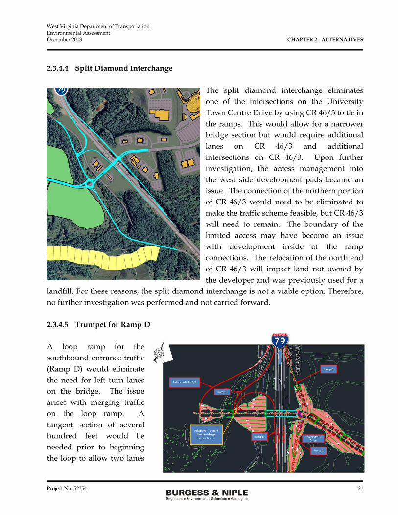
2.3.4.4 Split Diamond Interchange
The split diamond interchange eliminates one of the intersections on the University Town Centre Drive by using CR 46/3 to tie in the ramps. This would allow for a narrower bridge section but would require additional lanes on CR 46/3 and additional intersections on CR 46/3. Upon further investigation, the access management into the west side development pads became an issue. The connection of the northern portion of CR 46/3 would need to be eliminated to make the traffic scheme feasible, but CR 46/3 will need to remain. The boundary of the limited access may have become an issue with development inside of the ramp connections. The relocation of the north end of CR 46/3 will impact land not owned by the developer and was previously used for a
landfill. For these reasons, the split diamond interchange is not a viable option. Therefore, no further investigation was performed and not carried forward. 2.3.4.5 Trumpet for Ramp D A loop ramp for the southbound entrance traffic (Ramp D) would eliminate the need for left turn lanes on the bridge. The issue arises with merging traffic on the loop ramp. A tangent section of several hundred feet would be needed prior to beginning the loop to allow two lanes

West Virginia Department of Transportation Environmental Assessment December 2013 CHAPTER 2 - ALTERNATIVES
Project No. 52354 22
of traffic on the ramp to merge into a single lane prior to merging onto I-79. Another option would be to carry a two-lane loop ramp then merge it down to a single lane prior to merging it on the interstate. However, two-lane loop can cause safety concerns where heavy truck traffic is present due to off-tracking and vehicular conflicts. Also, the loop occupies valuable real estate for development. Similar to the previous alternative (split diamond), additional right-of-way would be needed for relocation of CR 46/3. The Trumpet for Ramp D is not a viable option due to the ramp and right-of-way concerns. Therefore, no further investigation was performed and not carried forward. 2.3.4.6. Single Point Urban Interchange
Although a single point urban interchange may offer operational benefits to the interchange by decreasing the number of intersections, this type of interchange would have the highest cost compared to other types evaluated. Due to the mountainous terrain at this location, the overpass bridge needs to be approximately 60 feet above the interstate. The profile of the University Town Centre Drive climbs at 8 percent to reach the development pad elevations. The cost increase for the additional bridge area and wall-type abutments required for a single point urban interchange would be magnified at this location. The single point is not a viable option. Therefore, no further investigation was performed and
this interchange type is not being carried forward.

West Virginia Department of Transportation Environmental Assessment December 2013 CHAPTER 2 - ALTERNATIVES
Project No. 52354 23
2.3.4.7 Diverging Diamond Interchange Although a diverging diamond interchange would provide very good traffic operations and a low number of potential conflict points at the intersections, it has high adjacent property impacts and is a relatively new type of interchange that has not been designed or constructed in West Virginia. This interchange type does not allow for access points near the interchange to accommodate the independent right turn lanes thus decreasing the area available for development. The short distance between ramp intersection and CR 46/3 intersection combined with the curved approach constrains developing the area between the CR and the ramps. Diverging diamond interchange is not a viable option. Therefore, no further investigation was performed and Alternative 8 was not carried forward. 2.4 Preliminary Impact Analysis The WVDOT reviewed the preliminary new interchange types as described above and as discussed in the New I-79 Interchange Design Study decided that many of the interchanges would reduce the amount of developable land adjacent to the interchange due to approach roadway alignments and driveway restrictions to support the TIF District. Alternatives that tie the south bound ramps to County Road 46/3 will create a safety concern as the land on the west side of CR 46/3 develops. Alternatives with loop ramps create a safety concern with large trucks as then negotiate the curve on a steep grade. While not directly related to the purpose and need for the project, alternatives using the Split Diamond configuration for the south bound ramps will require the relocation of CR 46/3 further north on to property not owned by the developer that was a former landfill. Based on this preliminary

West Virginia Department of Transportation Environmental Assessment December 2013 CHAPTER 2 - ALTERNATIVES
Project No. 52354 24
review, two interchange types were carried forward for additional evaluation, the tight diamond and the diamond with a roundabout at the southbound ramps. 2.5 Recommended Preferred Alternative In the Design Study, the evaluation of the tight diamond and the diamond with a roundabout were investigated. Both meet the purpose and need and both maximize developable land adjacent to the interchange. The biggest difference was the use of a roundabout for the southbound ramp intersection with University Town Centre Drive that requires only two west bound lanes instead of three in the tight diamond. The roundabout option will have a slightly better LOS in the 2025 10 year period, eliminates a signalized intersection, and will have slightly lower cost compared to the Tight Diamond. The CR 46/3 intersection will be 300 feet west of the roundabout allowing for right in and right out driveways along University Town Centre Drive to allow development consistent with the local development plans. As a result of the preliminary comparison of the two interchange types, the diamond interchange with a roundabout at the southbound ramps was preferred and carried forward for environmental analysis. CR 46/3 will be relocated west of the current location and will be the west terminus of University Town Centre Drive on the west side of the new interchange. The preliminary impacts of the preferred alternative are listed in Table 2-12.
Table 2-12 Preliminary Impacts of Preferred Alternative
Alternative
Residential/ Commercial
Displacements Earthwork Area
Impacted Stream Impacts
Wetland Impacts
Construction Costs
Diamond Interchange with Roundabout
0 2,000,000 cy 51 acres 2,660 lf 0.07 Acres $30,000,000
cy = cubic feet lf = linear feet
West Virginia Department of Transportation Environmental Assessment December 2013 CHAPTER 2 - ALTERNATIVES
Project No. 52354 25
2.6 Public Involvement An informational workshop public meeting was held on June 26, 2013 in the Jerry West Room at the West Virginia University Coliseum from 4:00 p.m. to 7:00 p.m. No public presentation was made at the public meeting. The meeting handout information included:
1) The purpose and need for the project 2) Possible alternatives and figures 3) Known environmental concerns 4) Schedule
No comments were received from the public during the public meeting or within the 30 day public comment period. The next public meeting will be held in January after the Federal Highway Administration has approved the Environmental Assessment (EA) Document but prior to the finalization of the EA Document.
West Virginia Department of Transportation Environmental Assessment December 2013 CHAPTER 3 - AFFECTED ENVIRONMENT AND MITIGATION
Project No. 52354 26
CHAPTER 3 - AFFECTED ENVIRONMENT AND MITIGATION The following sections summarize background information that is available for the proposed project area as well as site specific information that was obtained during field investigations within the defined study area initially set forth for evaluation of alternatives associated with the new I-79 interchange. This chapter discusses the individual components of the affected environment in relation to an impact analysis conducted for the No-Build and preferred New Interchange Alternative. To comply with Council on Environmental Quality (CEQ) and Federal Highway Administration (FHWA) regulations (40 CFR 1500 and 23 CFR 771, respectively), a general overview is provided for resources that are considered unlikely to be affected in either a positive or negative manner by the proposed action. Resources that would be affected in a positive or negative manner by construction of the Build Alternatives are discussed in greater detail. For purposes of this section, the No Build is retained as a baseline for evaluating the preferred New Interchange Alternative. Under the No Build, existing highway and roadway infrastructure would remain as is. Only maintenance of the existing roadways would be carried out over the next 20 years. The existing interchanges at Star City and Westover would be expected to handle greater traffic volumes over time, resulting in drivers experiencing long delays to exit or enter I-79 due to increased congestion by the design year 2035. The existing and future LOS was discussed in Chapter 2 for the No Build. The preferred alternative, which was carried forward for detailed environmental evaluation was identified in Chapter 2. Preferred alternative is a tight diamond interchange with a roundabout at the southbound ramp intersection. CR 46/3 (Martin Hollow Road) will be relocated to the west to connect with University Town Centre Drive west of the proposed new interchange. This will be the west terminus of University Town Centre Drive until the development west of CR 46/3 begins construction.

West Virginia Department of Transportation Environmental Assessment December 2013 CHAPTER 3 - AFFECTED ENVIRONMENT AND MITIGATION
Project No. 52354 27
3.1 Social and Economic Characteristics 3.1.1 Demographics The proposed project is located along I-79 in the northern portion of Monongalia County, west/northwest of downtown Morgantown, West Virginia. Other towns, cities and unincorporated communities located in close proximity to the project include Star City, Osage, Granville, and Westover. Work is generally to occur between two existing exits along I-79 including Exit 152 (Westover-Morgantown) at the south end of the project and Exit 155 (Osage/Star City) at the north end. The surrounding area is generally rural in nature with most residential and commercial developments occurring in conjunction with Morgantown, Westover and Star City. Remaining areas consist of open space that is wooded with low-density residential development, reclaimed mine land and mature woods. Within the project limits for the preferred alternative, there are no residents or businesses and all of the land is either Interstate right-of-way or owned by the developer. West Virginia had an estimated population of 1,855,413 in 2012 (U.S. Census Bureau) and the City of Morgantown had an estimated population of 31,000. While the state experienced a 0.1 percent change in population between April 1, 2010 to July 1, 2012, Morgantown grew by 4.5 percent during this same time period. Table 3-1 provides a demographic overview for the city of Morgantown, Monongalia County and the state of West Virginia for the year 2010.
Table 3-1 Demographic Overview
Year 2010
Area Population Characteristics
Individuals Below
Poverty Level Housing
Total
Population* White African
American Other
Minority Age 65 & Over Percent
Individual Units
Morgantown 31,000 89.7% 4.1% 6.2% 8.1% 36.4% 12,664 Monongalia County
100,332 91.2% 3.8% 5.2% 10.2% 21.0% 43,875
West Virginia
1,855,413 93.9% 3.4% 2.1% 16.0% 17.5% 881,917
*2012 Estimate

West Virginia Department of Transportation Environmental Assessment December 2013 CHAPTER 3 - AFFECTED ENVIRONMENT AND MITIGATION
Project No. 52354 28
Based on the U.S. Census Bureau statistics (2007-2011), there were 10,082 households in Morgantown with 2.23 persons per household and 35,266 households in Monongalia County with 2.47 persons per household. The median household income for Morgantown was listed as $25,948. This number increased to $39,550 when looking at the state level statistics and $41,325 for Monongalia County. The number of persons per square mile in 2010 was listed as 2,917 for the Morgantown area, while this number drops to 77.1 when considering the state of West Virginia as a whole. 3.1.2 Environmental Justice Executive Order (EO) 12898, Federal Actions to Address Environmental Justice in Minority Populations and Low-Income Populations was established in 1994 as a formal federal policy.
This policy requires that federal agencies consider and address disproportionately high and adverse environmental effects of proposed federal projects on minority and low-income populations. The study area is located in Monongalia County, West Virginia. Environmental Justice (EJ) populations were identified through the review of 2010 Census block group data. The most recent American Community Survey (ACS) 5-year Estimate (2007-2011) data was analyzed in relation to TIGER block group shape files for Monongalia County. Since there are no residences located within the project limits, the following categories of census information were used to
FIGURE 3-1

West Virginia Department of Transportation Environmental Assessment December 2013 CHAPTER 3 - AFFECTED ENVIRONMENT AND MITIGATION
Project No. 52354 29
identify potential EJ populations near the project study area: race, Hispanic/Latino, and poverty status. Based on these categories, census block groups were classified as either an EJ block group or a non-EJ block group. For the purposes of distinguishing between these two classes, the county average of 21 percent was used to establish low income populations and the county average of 10.2 percent was used to establish minority populations. Anything above either of these thresholds may include an EJ population. The EJ analysis utilized information from the U.S. Census Block Groups for the year 2010 shown on Figure 3-1. Only Block Groups ending in 3003 (purple) and 2002 (blue) are within the project area. Block Groups 2001 (green) and 3001 (yellow) are just south of the project area but were include in the analysis because of their proximity to the study area. None of the identified populations are located within the project area. The results of the EJ analysis indicate that block groups included in the analysis include EJ populations as depicted in following graphs.
Block Group 3003 (purple bar) includes the area west of I-79 is well below the County average percent for both minority and low income populations; therefore, it is unlikely that an EJ population exist in the Block Group. Block Group 2002 (blue) has a 10.8 percent minority population which is slightly above the County average of 10.2 percent. The low income population percent is well below the county average, thus this block group is not likely to contain an EJ low income population. Since there are no residences within the study area, the Block Group EJ minority population is not located within the study area. The proposed project work is limited to the construction of a new interchange that is considered an investment in infrastructure and will benefit the local communities through less traffic congestion, better access to the existing development, and an increase in economic development potential. No positive or negative impacts to identified EJ

West Virginia Department of Transportation Environmental Assessment December 2013 CHAPTER 3 - AFFECTED ENVIRONMENT AND MITIGATION
Project No. 52354 30
populations that exist outside of the study area would result from the No Build since no work would be completed. The preferred alternative will not impact the EJ population since no residences are located within the study area. There will be no relocation of residences, businesses, or retail areas due to the preferred alternative. Any indirect impacts to EJ populations resulting from implementation of the preferred alternative are considered to be positive in nature as the project will provide additional access to existing developments, enhance the local traffic patterns, and create employment opportunities with new development in the project area. No mitigation is necessary for the positive impact to identified EJ populations associated with the preferred alternative. Positive benefits as a result of the project, include new jobs and revenue sources that will increase local income, increase local tax revenues, and contribute to the local standard of living for the general public. Numerous opportunities for public involvement have been offered and future public involvement opportunities will occur during development and design of the project. Information will be made readily available to all members of the public, including minority and low-income populations. 3.1.3 Socioeconomics As presented in the Strategic Plan for the Morgantown Area Economic Partnership (MAP) & Monongalia County Development Authority (MCDA) (July 2012), the ten largest employers for Monongalia County are listed in Table 3-2.
Table 3-2 Ten Largest Employers (2011)
Monongalia County, WV
Company Name Approximate Employment 1 West Virginia University 6,800 2 West Virginia University Hospitals 4,400 3 Mylan Pharmaceuticals, Inc. 2,500 4 Monongalia County Board of Education 1,700 5 Monongalia General Hospital 1,500 6 WVU Medical Corporation 1,400 7 Teletech Customer Care Management (WV) 800

West Virginia Department of Transportation Environmental Assessment December 2013 CHAPTER 3 - AFFECTED ENVIRONMENT AND MITIGATION
Project No. 52354 31
Company Name Approximate Employment 8 Wal-Mart Stores, Inc. 700 9 Kroger Company 400
10 Gabriel Brothers, Inc. 400 Existing transportation infrastructure and topography in the project area has somewhat limited the amount of developable land and the opportunity for infrastructure improvements which leads to traffic congestion and increased drive times. The MAP and MCDA developed the 2012 Strategic Plan which places a focus on retaining and expanding existing businesses, recruiting new businesses and investments, and improving the local, regional and state business environment and increasing the capacity to support economic growth and community development. The No Build may have potential negative impacts. Under No build, no changes would be made to the existing road network. As discussed above, there is a focus on retaining and expanding existing businesses in this area of the state. The lack of any infrastructure improvements in this area may make it harder to retain existing businesses and attract new development to the area as congestion on the roadway increases resulting in delays of moving freight and people through the area and businesses move to areas outside of the congested areas. The proposed project will enhance the existing system of transportation infrastructure and benefit local businesses and their employees by offering alternative routes into and out of the area, thus decreasing congestion at the interstate and adjacent intersections. The project will also create new opportunities for development by providing new road connections to the interstate, with new development comes new jobs and benefit motorists traveling through this area of West Virginia. These are considered positive impacts on the economies of local communities, as well as West Virginia residents and tourists who visit the state for recreational opportunities. For these reasons, the preferred alternative is considered to have a positive impact on local economies. No mitigation is being proposed in relation to economic impacts associated with the preferred alternative as it is considered positive in nature.
West Virginia Department of Transportation Environmental Assessment December 2013 CHAPTER 3 - AFFECTED ENVIRONMENT AND MITIGATION
Project No. 52354 32
3.1.4 Community Facilities and Services Police service in and near the project area is provided by the West Virginia State Police, the Monongalia County Sheriff’s Department, the West Virginia University (WVU) Police Department and the cities/towns of Morgantown, Granville, Star City and Westover. Fire protection and EMS services are provided by the Morgantown Fire Department, Monongalia EMS, and multiple volunteer fire departments (Clinton District, Cheat Lake, Blacksville, Cool Springs, Granville, River Road, Star City, Westover and Triune-Halleck). No schools are located within the project limits of the preferred alternative. Schools located closest to the proposed project include Mylan Park Elementary School located northwest of the study area and Westwood Middle School located southeast of the study area. Morgantown High School and WVU are also located east of the proposed project, in addition to numerous preschools, elementary schools, middle schools and high schools. United States Post Offices are located in Morgantown, Westover and Star City. No changes in the operation of community facilities or emergency services would be associated with the No Build. This could be considered a negative impact since access points will remain unchanged and no improvements in response or travel times will result. The preferred alternative will have a direct, but temporary negative impact on traffic patterns which may affect the operation of police and emergency services, as well as school transportation. Old Martin Hollow will need to maintain connection to Martin Hollow (CR 46/3) during the construction to allow access to the homes west of the project area. CR 46/3 will be closed during construction between Old Martin Hollow intersection and the north end of the construction limits. The long term benefits of the new interchange (i.e., improved access and decreased travel time) and rebuilt CR 46/3 to a two lane paved road will outweigh these temporary impacts resulting in an overall net positive impact on the local community facilities and services. No mitigation in relation to community facilities or services will be necessary. 3.1.5 Relocations and Displacements The project study area is generally undeveloped with a small amount of rural residential development located north and west of the study area, outside the proposed project limits.

West Virginia Department of Transportation Environmental Assessment December 2013 CHAPTER 3 - AFFECTED ENVIRONMENT AND MITIGATION
Project No. 52354 33
A residential neighborhood is located south of the project limits on Lawless Road. There are no residences, businesses, or community facilities located within the project area. Neither the No Build nor the preferred alternative will require any relocations or displacements of current residences, businesses or community facilities. No mitigation in relation to relocations or displacements is necessary. 3.2 Land Use and Land Cover Land use is typically defined by categories of human activities occurring upon the land whereas land cover refers to the types of vegetation and constructed improvements that occupy an area. Common types of land use include categories such as residential, industrial, commercial, open-space, agricultural, and forest. Land use in the study area was classified according to categories contained within GIS layers from the West Virginia GIS Technical Center (WVGISTC). This information was developed by the Natural Resource Analysis Center (NRAC) at WVU and utilized information obtained from a variety of sources. Land use and cover information is based on growing season conditions from 2011 as obtained from the National Agricultural Imagery Program (NAIP) orthophotography. Identified land uses and cover types within the study area, along with anticipated impacts resulting from the project are summarized in Table 3-3 and depicted on Figures 3-2 to 3-3.
Table 3-3 Land Use and Cover Types
I-79 Study Area
Land Use and/or Land Cover Category Acres in
Study Area Anticipated Impacts (acres)
Preferred Alternative Forested 112.2 35.7 Low-Density Rural Residential 0 0 Grassland/Pasture/Agr. 7.7 3.8 Reclaimed Mine Land 25.1 6.3 Barren/Developed 7.7 2.5 Open Water 0.8 0.0 Wetlands 0.2 0.07 Roads 13.8 3.0
TOTALS 167.5 51.37

West Virginia Department of Transportation Environmental Assessment December 2013 CHAPTER 3 - AFFECTED ENVIRONMENT AND MITIGATION
Project No. 52354 34
Under No Build, existing land use and land cover conditions within the project study area would remain largely unaffected. Some development may occur in the study area, even in the absence of the new interchange. With no improvements to the road network, development pressure to convert undeveloped lands would be less under the No Build since congestion and access would be limited. The preferred alternative will impact existing land uses and land cover within the project area. As transportation access in the area improves, additional land will become available for development. The preferred alternative will convert most of the current land cover types within the project area to roadway and maintained right-of-way (R/W). Anticipated land use and land cover impacts associated with the preferred alternative are summarized in the above table and the land uses are consistent with local land use plans. The project is located in close proximity to the developed areas of Morgantown, Westover, Granville, Osage and Star City. Development in these areas is expected to continue into the future. In terms of mitigation, impacts to land use and land cover can be minimized through management of access, long-term planning, zoning resolutions, resource management and preservation, and conservation easements. Additional mitigation for impacts to land cover will be completed through the use of appropriate erosion and sediment controls during construction. An Erosion & Sediment Control Plan will be prepared in accordance with WVDEP’s Erosion & Sediment Control Best Management Practice Manual and the WVDOH Erosion and Sediment Control Manual. All disturbed areas will be re-vegetated (using a native seed mixture) upon project completion. No mitigation in relation to land use is being proposed as no residential displacements are anticipated. The development is consistent with local land use plans, and most of the area is former mine land that has been reforested.

West Virginia Department of Transportation Environmental Assessment December 2013 CHAPTER 3 - AFFECTED ENVIRONMENT AND MITIGATION
Project No. 52354 35
FIGURE 3-2

West Virginia Department of Transportation Environmental Assessment December 2013 CHAPTER 3 - AFFECTED ENVIRONMENT AND MITIGATION
Project No. 52354 36
FIGURE 3-3 FIGURE 3-3
West Virginia Department of Transportation Environmental Assessment December 2013 CHAPTER 3 - AFFECTED ENVIRONMENT AND MITIGATION
Project No. 52354 37
3.3 Farmland The federal Farmland Protection Policy Act (FPPA) of 1981, as amended, was enacted to discourage the “unnecessary and irreversible conversion of prime or important farmland to nonagricultural uses, and to assure that Federal programs are operated in a manner that, to the extent practicable, will be compatible with state, local government, and private programs that protect farmland”. The U.S. Department of Agriculture (USDA), Natural Resources Conservation Service (NRCS) provided comments on the proposed project via written letter dated July 24, 2013 (see Appendix A). In this letter, the agency determined that the project area does not contain any prime or important farmland and that the project is not subject to FPPA requirements. The agency indicated that completion of an AD-1006 form is not required. No important farmland was identified for the project area and no impacts to farmland will occur as a result of the No Build or preferred alternative. There is no cropland currently in production within the project limits. All of the land cover listed above is in grassland. Because no impacts will occur, no mitigation is being proposed. 3.4 Cultural Resources Section 106 of the National Historic Preservation Act (NHPA) of 1966, as amended, protects properties that are listed on or eligible for listing on the National Register of Historic Places (NRHP). Cultural resource investigations for the project area were conducted in accordance with the requirements of Section 106, regulations of the Advisory Council on Historic Preservation (ACHP), contained in 36 CFR 800, and procedures established by the West Virginia Division of Culture and History in their Guidelines for Phase I, II, and III Archaeological Investigations and Technical Report Preparation5, including assessments of both historic structures (50 years of age or older) and archaeological sites. Copies of cultural resource reports prepared for the project area are included in Appendix B.
5 Trader, P and J. Wilson. 2001. Guidelines for Phase I, II, and III Archaeological Investigations and Technical Reports. West Virginia State Historic Preservation Office.

West Virginia Department of Transportation Environmental Assessment December 2013 CHAPTER 3 - AFFECTED ENVIRONMENT AND MITIGATION
Project No. 52354 38
3.4.1 Archaeological Resources Archaeological Consultants of the Midwest, Inc. completed a report entitled Phase I Archaeological Literature Review and Reconnaissance Survey for the Proposed New I-79 Interchange between Westover and Star City Interchanges near the City of Morgantown, Monongalia County, West Virginia6 in August 2013. The goal of the investigation was to identify archaeological resources and determine if any identified cultural resources met the NRHP Criteria for evaluation. According to 36 CFR 800.16(d)), the Area of Potential Effect (APE) for cultural resource investigations includes “the geographic area or areas within which an undertaking may directly or indirectly cause alterations in the character or use of historic properties, if any such properties exist”. The APE for the project was defined in the above referenced report as approximately 281 acres. Field activities for the assessment were conducted in July 2013. A review of records maintained at the WV Division of Culture and History identified no known/recorded archaeological sites within the study area or past professional investigations conducted in or within a 1.0-mile radius of the APE for the project. No NRHP properties or cemeteries have been inventoried in the APE. Review of historic topographic maps depicted no buildings or structures within the APE, but did indicate that a large portion of the APE had been disturbed from previous mining activities. Fieldwork confirmed previous disturbance of portions of the study area from past mining, installation of gas pipelines and construction of I-79. As part of field investigations, a total of 92 shovel probes were excavated in portions of the APE that were visually determined to be undisturbed and with the potential for archaeological resources to be present (landforms with less than 20 percent slopes). Analysis of soil profiles completed as part of shovel probes revealed previously disturbed or heavily eroded soils. No sites were documented during the field portion of the investigation. Because no sites were identified during the investigation, it was determined that the proposed project will have no effect on any archaeological resources that are eligible for
6 Vosvick, J. and C. Jackson. 2013. A Phase I Archaeological Literature Review and Reconnaissance Survey for the Proposed New I-79 Interchange between Westover and Star City Interchanges near the City of Morgantown, Monongalia County, West Virginia. Archaeological Consultants of the Midwest, Inc., Wheeling, WV.

West Virginia Department of Transportation Environmental Assessment December 2013 CHAPTER 3 - AFFECTED ENVIRONMENT AND MITIGATION
Project No. 52354 39
inclusion on the NRHP under Criterion D. No further work archaeological investigations were recommended for the APE. Although no cemeteries were identified as a result of the above referenced activities, a local property owner, Mr. John Lynch, who owns property within the project study area, reported one known cemetery located on his property. This cemetery is located on the hillside west of CR 46/3 and north of Old Martin Hollow Road. Multiple head stones for the Breakiron family are located in this cemetery which dates back to the 1800s. The above referenced cemetery is located outside the proposed construction footprint for the project. Based on this information, no impacts to cemeteries or other archaeological resources would result from the Build or No-Build Alternatives. The report was reviewed by WVDOT and then sent to the Division of Culture and History for review. On November 27, 2013, the Division sent a letter to Mr. Ben Hark concerning the Archaeological Resources. The letter concurred with the report by stating “It is our understanding that seven areas were identified where shovel probes were excavated. Disturbed soils were encountered. No archaeological sites were identified. As a result, we concur that no further archaeological work is necessary. In our opinion, no significant archaeological resources are present within the proposed project area.” A copy of the Division of Culture and History letter is attached in Appendix B. No mitigation in relation to archaeological resources is necessary. 3.4.2 Historic Resources Archaeological Consultants of the Midwest, Inc. completed a report entitled A Viewshed Study for the Proposed New I-79 Interchange between Westover and Star City Interchanges near the City of Morgantown, Monongalia County, West Virginia7 in October 2013. An Area of Potential Effect (APE) was located west of the Monongahela River near the community of Granville. The APE radius was 0.5 miles in diameter from the preferred alternative location with a project area of approximately 281 acres. A review of the online records
7 C. Jackson. 2013. A Viewshed Study for the Proposed New I-79 Interchange between Westover and Star City Interchanges near the City of Morgantown, Monongalia County, West Virginia. Archaeological Consultants of the Midwest, Inc., Wheeling, WV.
West Virginia Department of Transportation Environmental Assessment December 2013 CHAPTER 3 - AFFECTED ENVIRONMENT AND MITIGATION
Project No. 52354 40
maintained by Division of Culture and History indicated that no architectural resources or National Register of Historic Places (NRHP) properties have been documented in the APE. Based on the information gathered from the fieldwork, a review of property tax maps, and from the ArcGIS software, one architectural resource that is at least 50 years of age could be visually impacted by the project. An evaluation of the architectural resource indicated that it was not eligible for inclusion on the NRHP under Criteria A to C. One cemetery (Breakiron Cemetery/site 46MG304) was relocated and examined by the investigation. The cemetery is a small rural family cemetery that is located in a woodlot and poorly maintained. Two families are represented: Breakiron and Casey. Based on the data collected from the field investigation and historic research, it was determined that the cemetery is not eligible for the NRHP under Criteria A to D, or under Criteria Considerations C and D. Because neither property is eligible for inclusion on the NRHP, the investigation recommended that the proposed project would have no effect on any historic properties. The report was reviewed by WVDOT and then sent to the Division of Culture and History for review. On November 27, 2013, the Division sent a letter to Mr. Ben Hark concerning the Architectural Resources. The letter concurred with the report by stating “After review of the submitted documentation, including a completed Historic Property Inventory (HPI) form, we concur with this assessment. It is our opinion that there are no architectural resources eligible for or included in the National Register of Historic Places that will be impacted by this project. No further consultation regarding architectural resources is necessary.” In response to the cemetery, the Division stated “After review of the submitted information, including the completed cemetery form, we concur with this assessment. The Breakiron Cemetery is not eligible for inclusion in the National Register of Historic Places under Criteria A-D, Criteria Considerations C and/or D. No further consultation regarding cemetery resources is necessary.” A copy of the Division of Culture and History letter is attached in Appendix B. The Breakiron Cemetery is within the project area but will not be impacted by the project. To prevent disturbing the cemetery, the detailed plan should indicate the location of the cemetery and the cemetery should be fenced during construction to prevent disturbing the cemetery area.

West Virginia Department of Transportation Environmental Assessment December 2013 CHAPTER 3 - AFFECTED ENVIRONMENT AND MITIGATION
Project No. 52354 41
3.5 Section 4(f) Resources Section 4(f) of the U.S. Department of Transportation Act of 1966, as amended, was enacted to preserve publicly owned land including parks, recreation areas, wildlife and waterfowl refuges, and public or privately owned historic sites that are listed on or eligible for the NRHP. The use of these resources is prohibited unless there is a determination that there is no feasible and prudent alternative to the use of land from the property and the action includes all possible planning to minimize harm to the property resulting from such use. Most of the study area has been subject to historic mining activities. Except for the public roads, all of the land within the project area is privately held. No publicly owned parks, recreation areas or wildlife/waterfowl refuges were identified in the study area as a result of literature reviews or on-site field investigations. One cemetery was reported within the study area by a local property owner and its presence was verified in the field. This family cemetery is located on privately owned land west of CR 46/3 and north of Old Martin Hollow Road on the west side of I-79. The cemetery was evaluated by Archaeological Consultants of the Midwest, Inc. in the report titled “A Viewshed Study for the Proposed New I-79 Interchange between Westover and Star City Interchanges near the City of Morgantown, Monongalia County, West Virginia” dated October 2013. The investigation indicated that the cemetery is not eligible for nor listed on the National Register of Historic Places (NRHP). On November 27, 2013, the West Virginia Division of Culture and History concurred with the findings. No Cultural Resources eligible for or included on the NRHP were identified within the project area. Since no Section 4(f) resources are within the project area, the No Build and the preferred alternative will have no impacts to Section 4(f) resources, no mitigation is required. 3.6 Section 6(f) Resources The Land and Water Conservation Fund Act (LWCFA), commonly referred to as Section 6(f), requires that the conversion of lands or facilities acquired with Land and Water Conservation Act funds be coordinated with the Department of the Interior. A detailed listing on grants for the state of West Virginia was reviewed on the website maintained by the National Park Service (NPS). Monongalia County, West Virginia has received a total of six LWCFA grants, all within the cities of Morgantown or Westover. None of these grants were issued for sites or facilities located within the project area.

West Virginia Department of Transportation Environmental Assessment December 2013 CHAPTER 3 - AFFECTED ENVIRONMENT AND MITIGATION
Project No. 52354 42
No impacts to Section 6(f) resources will occur as a result of the No-Build or preferred alternative. No mitigation is necessary. 3.7 Air Quality The Clean Air Act (CAA) Amendments of 1990 and the Final Transportation Conformity Rule (40 CFR Parts 51 and 93) direct the U.S. Environmental Protection Agency (EPA) to implement environmental policies and regulations that will ensure acceptable levels of air quality. Section 107 of the 1977 CAA Amendments requires that the U.S. EPA publish a list of all geographic areas in compliance with the National Ambient Air Quality Standards (NAAQS), as well as those areas not in attainment of the NAAQS. Areas not in compliance with the NAAQS are referred to as “nonattainment areas”. U.S. EPA has identified six pollutants for tracking air quality including particulate matter (PM10 and PM2.5), sulfur dioxide (SO2), nitrogen dioxide (NO2), carbon monoxide (CO), ozone (O3) and lead (Pb). The project is located in an attainment area for all six priority pollutants. The No Build may result in negative air quality impacts due to increased congestion and longer delays in traffic to move through the area resulting in increased air pollution. The preferred alternative will result in temporary negative impacts to air quality from operation of construction equipment and generation of dust from grading and movement of cut and fill material. Slight increases in particulate levels and exhaust emissions may occur during construction. Mitigation in regards to temporary impacts to air quality will be completed through implementation of dust control and other BMP measures outlined in WVDOH standard specifications. The addition of a new interchange is identified as a non-exempt project type for analysis of Mobile Source Air Toxics (MSAT) by the U.S. EPA. The Federal Highway Administration (FHWA) has issued Interim MSAT Guidance for transportation projects. For a project that will include a new interchange connecting an existing roadway with a new roadway, a qualitative assessment is required. For each alternative in the EA, the amount of MSAT emitted would be proportional to the vehicle miles traveled (VMT), assuming that other variables such as fleet mix are the same for each alternative. Because the VMT estimated for the No Build is about the same as the

West Virginia Department of Transportation Environmental Assessment December 2013 CHAPTER 3 - AFFECTED ENVIRONMENT AND MITIGATION
Project No. 52354 43
preferred alternative, higher levels of MSAT are not expected from the preferred alternative compared to the No Build as shown in Table 3-4.
Table 3-4 VMT No Build and Preferred Alternative8
2015
Sce
nari
os
Description VMT No Build: (E+C) 3,672,114 Upgrade Existing Interchanges: (E+C) + 10% East 3,693,211
New Interchange: (E+C) + 10% East + 10% West 3,738,287
2035
Sce
nari
os No Build: (E+C) + 20% East + 20%
West 5,327,880
Upgrade Existing Interchanges: (E+C) + 50% East + 50% West 5,410,166
New interchange: (E+C) + 100% East + 100% West 5,551,503
New Interchange: (E+C) + 100% East 5,429,342
(E+C) Existing + Committed In addition, because the estimated VMT under each of the Build Alternative are nearly the same, varying by less than 1 percent, it is expected there would be no appreciable difference in overall MSAT emissions among the various alternatives. Also, regardless of the alternative chosen, emissions will likely be lower than present levels in the design year as a result of EPA’s national control programs that are projected to reduce annual MSAT emissions by 80 percent from 2010 to 2050. Local conditions may differ from these national projections in terms of fleet mix and turnover, VMT growth rates, and local control measures. However, the magnitude of the EPA-projected reductions is so great even after accounting for VMT growth) that the MSAT emissions in the study area are likely to be lower in the future in virtually all locations. Under each alternative there may be localized areas were VMT would increase, and other areas where VMT would decrease. Therefore, it is possible that localized increases and decreases in MSAT emissions may occur. The localized increases in MSAT emissions
8 West Virginia Department of Transportation Division of Highways, Interchange Justification Report for the I-79/Morgantown interchange, Monongalia County, West Virginia, December 2013, Page 61.
West Virginia Department of Transportation Environmental Assessment December 2013 CHAPTER 3 - AFFECTED ENVIRONMENT AND MITIGATION
Project No. 52354 44
would likely be more pronounced along the extension of the University Town Centre Drive and the new interchange ramps in the preferred alternative and long CR 24/19 and US 19 with the upgrade the existing interchanges alternative. However, even if these increases do occur, they too will be substantially reduced in the future due to implementation of EPA’s vehicle and Fuel regulations. In sum, under the build alternatives in the design year it is expected there would be reduced MSAT emissions in the immediate area of the project, relative to the No Build due to the reduced VMT associated with more direct routing ad due to EPA’s MSAT reduction programs.9 3.8 Noise An in-house review of aerial photographs for the project study area revealed few potential noise sensitive receptors near the area proposed for the preferred alternative. Sensitive receptors are defined as those land uses which are especially susceptible to noise impacts. These include hospitals, schools, residences, motels, hotels, recreational areas, parks, nursing homes, and churches/places of worship. The noise sensitive receptors are located at the extreme north and south ends of the study area. No sensitive land uses are located in the vicinity of the preferred alternatives. Figure 3-4 shows the location of the preferred alternative to the noise sensitive receptors.
9 U.S. EPA Memorandum Interim Guidance Update on Mobile Source Air Toxic Analysis in NEPA, USEPA, Office of Natural Environment, December 6, 2012, Appendix B.

West Virginia Department of Transportation Environmental Assessment December 2013 CHAPTER 3 - AFFECTED ENVIRONMENT AND MITIGATION
Project No. 52354 45
FIGURE 3-4

West Virginia Department of Transportation Environmental Assessment December 2013 CHAPTER 3 - AFFECTED ENVIRONMENT AND MITIGATION
Project No. 52354 46
The project is listed as a Type 1 noise project. Type 1 projects include “(4) The addition or relocation of interchange lanes or ramps added to a quadrant to complete an existing partial interchange; or,” This requires a noise analysis per the FHWA guidelines are set forth in 23 Code of Federal Regulations (CFR) Part 772 procedures for abatement of Highway Traffic Noise and Construction Noise and the West Virginia Department of Transportation, Division of Highways, Design Directive (DD) 253- Noise Analysis and Abatement Guidelines dated August 19, 2011. To determine the degree of impact of highway traffic noise on human activity, the Noise Abatement Criteria (NAC) established by the FHWA regulation were used as shown in Table 3-5 The NAC are given in terms of the hourly, A-weighted, equivalent sound level in dBA. The A-weighted sound level is a single number measure of sound intensity with weighted frequency characteristics that corresponds to human subjective response to noise. Most environmental noise (and the A-weighted sound level) fluctuates from moment to moment, and it is common practice to characterize the fluctuating level by a single number called the Leq. The Leq is the value or level of a steady, non-fluctuating sound that represents the same sound energy as the actual time varying sound evaluated over the same time period. For traffic noise assessment, Leq is typically evaluated over a 1-hour period, and may be denoted as Leq(h).

West Virginia Department of Transportation Environmental Assessment December 2013 CHAPTER 3 - AFFECTED ENVIRONMENT AND MITIGATION
Project No. 52354 47
Table 3-5
FHWA Noise Abatement Criteria (NAC)
Land Use Criterion
Category A: Lands on which serenity and quiet are of extraordinary significance and serve an important public need and where the preservation of those qualities is essential if the area is to continue to serve its intended purpose.
57 dBA Leq(h) Exterior
Category B: Residential. 67 dBA Leq(h) Exterior
Category C: Active sport areas, amphitheaters, auditoriums, campgrounds, cemeteries, day care centers, hospitals, libraries, medical facilities, parks, picnic areas, places of worship, playgrounds, public meeting rooms, public or nonprofit institutional structures, radio stations, recording studios, recreation areas, Section 4(f) sites, schools, television studios, trails, and trail crossings.
67 dBA Leq(h) Exterior
Category D: Auditoriums, day care centers, hospitals, libraries, medical facilities, places of worship, public meeting rooms, public or nonprofit institutional structures, radio stations, recording studios, schools, and television studios.
52 dBA Leq(h) Interior
Category E: Hotels, motels, offices, restaurants/bars, and other developed lands, properties or activities not included in A-D or F.
72 dBA Leq(h) Exterior
Category F: Agriculture, airports, bus yards, emergency services, industrial, logging, maintenance facilities, manufacturing, mining, rail yards, retail facilities, ship yards, utilities (water resources, water treatment, electrical), and warehousing.
No Criteria
Category G: Undeveloped lands that are not permitted. No Criteria
Source: FHWA, 23 CFR 772.
A noise analysis was completed to identify and evaluate the potential noise impacts resulting from the no build option and the Build alternatives. The sensitive receptors identified within the study area or within a 500-foot distance from I-79 were limited to 21 residential structures (Category B), one church (Categories C and D), and one reading in an area of former mine activity (Category F). No receptors were placed around the new interchange because no building permits have been issued within 500 feet of interchange to be evaluated in the noise analysis.

West Virginia Department of Transportation Environmental Assessment December 2013 CHAPTER 3 - AFFECTED ENVIRONMENT AND MITIGATION
Project No. 52354 48
WVDOH developed a traffic noise policy consistent with FHWA guidelines. This policy recommends noise abatement consideration for Category B and Category C exterior areas of human activity where 67 dBA is approached (66 dBA) or exceeded. The FHWA also states that noise abatement must be considered when future noise levels cause significant increases over existing noise levels. WVDOH defines a substantial increase as 15 dBA or greater over existing levels. WVDOH defined the approach as 1 dBA less than the NAC (noise abatement criteria) and a substantial increase as 14 dBA over existing conditions. To determine traffic noise levels in the future, WVDOT require the use of the Traffic Noise Model (TNM 2.5) to predict peak hour noise levels at sensitive receptors within the project area. To verify the TNM, short-term ambient noise readings were conducted at 3 receptor locations within the study area, Ambient Reading 1 noise level at the Riverside Apostolic Church was 58.5 dBA, at the residence at 111 Williams Street 61.3 dBA, and at the Consol Energy sump area along CR 46/3 was 66.0 dBA. Based on the sites be categorized as Category B (Site 2), C (site 1), and F (site 3), the sites were below the NAC impact criteria levels. The TNM predicted noise levels at the three ambient noise reading locations using traffic counts for the Interstate and adjacent local roads within 3 dBA of the ambient readings. This run was used to verify the model was accurately predicting noise levels. The No-build was evaluated with peak hour traffic for the years 2015 and 2035. The preferred alternative was evaluated using the build peak hour traffic again for the years 2015 and 2035. For the No-Build option, no receptors exceeded the NAC for the land use category assigned to the receptor nor was there a 15 dBA increase between existing and future values. For the preferred alternative, five receptors along the east side of Williams Street south of the project limits exceeded the NAC criteria for Category B. In the year 2025, six receptors exceed the NAC for Category B, none of the receptors had a 15 dBA increase. A barrier analysis was conducted on the section of I-79 adjacent to the receptors that were impacted. A barrier is considered reasonable and feasible if it can achieve an 8 dBA reduction at the impacted receptors and the cost of the barrier cannot exceed $35,000 per
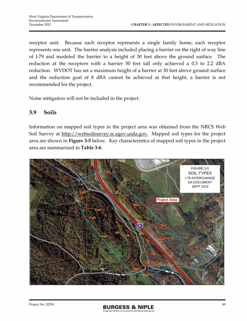
West Virginia Department of Transportation Environmental Assessment December 2013 CHAPTER 3 - AFFECTED ENVIRONMENT AND MITIGATION
Project No. 52354 49
receptor unit. Because each receptor represents a single family home, each receptor represents one unit. The barrier analysis included placing a barrier on the right of way line of I-79 and modeled the barrier to a height of 30 feet above the ground surface. The reduction at the receptors with a barrier 30 feet tall only achieved a 0.3 to 2.2 dBA reduction. WVDOT has set a maximum height of a barrier at 30 feet above ground surface and the reduction goal of 8 dBA cannot be achieved at that height, a barrier is not recommended for the project. Noise mitigation will not be included in the project. 3.9 Soils Information on mapped soil types in the project area was obtained from the NRCS Web Soil Survey at http://websoilsurvey.sc.egov.usda.gov. Mapped soil types for the project area are shown in Figure 3-5 below. Key characteristics of mapped soil types in the project area are summarized in Table 3-6.
FIGURE 3-5 SOIL TYPES
I-79 INTERCHANGE EA DOCUMENT
SEPT 2013

West Virginia Department of Transportation Environmental Assessment December 2013 CHAPTER 3 - AFFECTED ENVIRONMENT AND MITIGATION
Project No. 52354 50
Table 3-6 Mapped Soil Types
I-79 Study Area
Map Unit
Symbol Map Unit Name Drainage
Class Hydric
Soil
Prime /Important Farmland
Soil Limitations CwC Culleoka-
Westmoreland silt loams, 8-15% slopes
Well drained No Important Slope, erosion hazard, slip hazard, shallow depth to bedrock
CwD Culleoka-Westmoreland silt loams, 15-25% slopes
Well drained No Important Slope, erosion hazard, slip hazard, shallow depth to bedrock
CwE Culleoka-Westmoreland silt loams, 25-35% slopes
Well drained No No Slope, erosion hazard, slip hazard, shallow depth to bedrock
CwF Culleoka-Westmoreland silt loams, 35-65% slopes
Well drained No No Slope, erosion hazard, slip hazard, shallow depth to bedrock
DgD Dormont & Guernsey silt loams, 15-25% slopes
Moderately well drained
No Important Slope, erosion hazard, slip hazard, seasonal high water table, slow permeability
GuF Gilpin-Culleoka-Upshur silt loams, 35-65% slopes
Well drained No No Slope, erosion hazard, slip hazard, shallow depth to bedrock, shrink-swell
TlB Tilsit silt loam, 3-8% slopes
Moderately well drained
No Important Erosion hazard, slow permeability, shallow water table
U1 Udorthents, cut & fill Not specified No No Site-specific U2 Udorthents, dump,
low base Not specified No No Site-specific
U4 Udorthents, mudstone & sandstone, high base
Not specified No No Site-specific
U5 Udorthents, mudstone & sandstone, low base
Not specified No No Site-specific
WeE Westmoreland silt loam, 25-35% slopes
Well drained No No Slope, erosion hazard, slip hazard, shallow depth to bedrock
The No Build would not impact soils. The preferred alternative would impact certain soil units identified by NRCS as meeting “farmland of statewide importance” criteria. Potentially affected soil types include Culleoka-Westmoreland silt loams (CwC, CwD), Dormont & Guernsey silt loams (DgD), and Tilsit silt loam (TlB). However, no areas

West Virginia Department of Transportation Environmental Assessment December 2013 CHAPTER 3 - AFFECTED ENVIRONMENT AND MITIGATION
Project No. 52354 51
occupied by these soil types are actually being farmed within the project area. NRCS has indicated the project area does not contain any prime or important farmland and that the project is not subject to FPPA requirements (see Section 3.3). No mitigation in relation to farmland is necessary. The Udorthents (U1, U2, U4, and U5) and the Westmoreland silt loams are the majority of the soils type that will be impacted by the construction. Westmoreland silt loams (WeE) has been identified as having a slip hazard and erosion hazard. Care will need to be taken during the excavation of this soil type to prevent slips during construction and after construction is completed. Benching of the slopes, erosion control, and other best management practices should be implements when working in the Westmoreland silt loams or other soils identified as having a slip hazard. Mitigation for soil slip hazard is implementing best management practices during excavation of the soil and the placement of the soil as fill material. 3.10 Geology The project area is located in the Appalachian Plateau Physiographic Province. This province is characterized by an extensive, mature, unglaciated plateau of great age. The ancient plateau surface has been dissected by streams to form a region of moderate to high relief. Elevations in the project area range from 1,000 to 1,270 feet above mean sea level (amsl). Approximately 60 percent of the project area is comprised of areas with slopes of 20 percent or greater. Underlying bedrock consists of sedimentary rocks of Pennsylvanian age, belonging to the Monongahela and Conemaugh Groups. The Monongahela Group is the more recent, and consists of non-marine cyclic sequences of sandstone, siltstone, red and gray shale, limestone and coal. The Monongahela Group contains the Uniontown and Pittsburgh Formations, which extend from the top of the Waynesburg Coal to the base of the economically important Pittsburgh Coal. The Conemaugh Group underlies the Monongahela Group and consists of cyclic sequences of red and gray shale, siltstone, and sandstone, with thin limestone and coal of mostly non-marine origin. This Group includes the Glenshaw and Casselman Formations, and extends from the base of the Pittsburgh Coal

West Virginia Department of Transportation Environmental Assessment December 2013 CHAPTER 3 - AFFECTED ENVIRONMENT AND MITIGATION
Project No. 52354 52
to the top of the Upper Freeport Coal. The West Virginia Geological Resources Map is shown in Figure 3-6.
Figure 3-6 Geologic Resources of Project Area
The coal seems have been mined within the project area by both deep mine and strip mine methods. The strip mined areas and the deep mine entrances are on both sides of I-79. The mine entrances and the strip mined lands have been extensively mapped within the development area as proposed by the developer. The deep mine shafts are deep enough that the construction of the interchange will not impact the shafts nor the underground mine area. No additional coal mining is being done within the project limits. No impact is anticipated to the former coal mines based on the preferred alternative. Acid mine drainage (AMD) is currently being collected from the former mined area on the east side of I-79. Several surface containments are located in the area and the AMD is

West Virginia Department of Transportation Environmental Assessment December 2013 CHAPTER 3 - AFFECTED ENVIRONMENT AND MITIGATION
Project No. 52354 53
piped to the sump area adjacent to the east side of I-79 where it is pumped into an underground mine on the west side of I-79. The AMD then flows through the underground mine to the treatment plant about 30 miles away. The preferred alternative has been designed to prevent impacting the AMD surface impoundments, the pipeline, and the sump/injection areas. Neither the No Build nor the preferred alternative would adversely impact rare, unique, or important geologic formations or resources, no mitigation is necessary. 3.11 Groundwater 3.11.1 General According to Groundwater Hydrology of the Monongahela River Basin10 the principal source of groundwater in the basin is the underlying sedimentary bedrock. The sedimentary rocks form a layered series of aquifers, each composed of hydraulically connected beds. Intergranular spaces, joints, and rock fractures provide the openings through which ground water circulates and is stored in the rock. Groundwater yields in the basin vary considerably based on local conditions. In general, sandstones yield the most water because they contain both intergranular spaces and joint openings. Shales ordinarily yield little water, but local areas of dense fracturing or wide joints may transmit significant water yields. Shallow groundwater movement also generally follows surface topography; therefore, well yields in valley zones are generally higher than on slopes or hillsides Well yields in the Monongahela Group aquifer are generally adequate for domestic, farm, and small commercial supplies, but not for industrial or community supplies. Well yields range from 1 to 75 gallons per minute (gpm), with a median yield of 13 gpm. Extensive coal mining in this Group has partly drained some areas, and groundwater supplies may continue to be affected where mine pumpage is maintained after mining ceases.
10 Hobba, W.A. Jr. 1984. Ground Water Hydrology of the Monongahela River Basin. U.S. Geological Survey, in cooperation with the West Virginia Department of Natural Resources.
West Virginia Department of Transportation Environmental Assessment December 2013 CHAPTER 3 - AFFECTED ENVIRONMENT AND MITIGATION
Project No. 52354 54
The Conemaugh Group aquifer is the most developed in the basin, providing adequate yields for most uses, except for large scale industrial uses. The highest yields are reported from wells situated in valleys and in the sandstone bedrock at the base of this Group. Well yields range from 1 to 400 gpm, with a median yield of 16 gpm. Groundwater quality in the project area is generally acceptable for domestic use, but may exhibit excessive hardness and chlorides. Coal mining, oil and gas well activities, local dumping, and other activities may allow contaminates to infiltrate the bedrock through mines and fissures which could degrade local groundwater quality. As stated in Section 3.10 Geology, existing underground mines are used to transport AMD from the project area to a treatment plant. Flowing AMD in former mine areas may result in the AMD infiltrating the bedrock and reaching the groundwater supply. No impacts to groundwater are anticipated form the No Build or the preferred alternative. Construction of the project will be completed so that impacts to acid mine drainage (AMD) treatment facilities and the sump area located at the north end of the study area will be avoided. No additional mitigation other than the above avoidance measures are being proposed in relation to groundwater resources. 3.11.2 Wells A Well Search Report prepared by Environmental Data Resources, Inc. (EDR) identified seven well locations in the project area.11 These are historical ambient groundwater monitoring wells installed by the U.S. Geological Survey (USGS) in the 1930’s to 1950’s. The wells are currently inactive. A copy of the EDR Well Search Report is provided in Appendix C. The Monongalia County Health Department (MCHD) is responsible for approving installation of individual potable water wells in the project area. Wells installed before 1985 may not be recorded. There are no occupied residences or businesses currently located within the project area. The MCHD indicated they have no water well records on file for addresses located within 500 feet of the project area limits. Copies of correspondence with MCHD are also included in Appendix C.
11 Environmental Data Resources, Inc. 2013. EDR DataMap Well Search Report, West Virginia DOT New I-79 Interchange, Morgantown, WV 26501, Inquiry Number 3633860.1w. June 13, 2013.

West Virginia Department of Transportation Environmental Assessment December 2013 CHAPTER 3 - AFFECTED ENVIRONMENT AND MITIGATION
Project No. 52354 55
Neither the No Build nor the preferred alternative would impact any known water wells in the project area or immediate vicinity (within 500 feet of the project study area). No mitigation is necessary. 3.12 Surface Water Resources During August 2013, Burgess & Niple, Inc. (B&N) completed a Wetland Delineation & Aquatic Resource Inventory to document surface waters located within the project study area boundary. Streams within the project area were identified based on the presence of an Ordinary High Water Mark (OHWM) and defined bed and bank features. Stream condition was evaluated using U.S. EPA Rapid Bioassessment Protocols (RBP) for Physical Condition and Habitat, West Virginia Stream Condition Index (WVSCI) protocols, West Virginia High Gradient Headwater Stream Assessment (HGM) protocols, and WV DEP Benthic Macroinvertebrate Collection Protocols, as applicable. An overall index score was calculated for each stream using the West Virginia Stream and Wetland Valuation Metric (WVSWVM). In order to be considered a wetland, all three required criteria including hydric soils, hydrology and a predominance of hydrophytic vegetation must be present. Wetlands were delineated in accordance with the United States Army Corps of Engineers (USACE) Wetlands Delineation Manual, Technical Report Y-87-1 (USACE 1987) and the Regional Supplement to the Corps of Engineers Wetland Delineation Manual: Eastern Mountains and Piedmont Region (Version 2.0) (USACE 2012). Wetlands were classified according to the system developed by Cowardin.12 Wetlands identified during review of background literature and field investigations were delineated utilizing the routine on-site determination method. Wetland boundaries were marked with survey flagging and documented using global positioning system (GPS) technology.
12 Cowardin, L.M., et al. 1979. Classification of Wetlands and Deepwater Habitats of the United States. FWS/OBS-79/31.

West Virginia Department of Transportation Environmental Assessment December 2013 CHAPTER 3 - AFFECTED ENVIRONMENT AND MITIGATION
Project No. 52354 56
3.12.1 Streams The study area is located within the watershed of Dents Run, a tributary to the Monongahela River. The Dents Run watershed covers approximately 14.6 square miles (sm) west of Morgantown, encompassing portions of the communities of Westover, Granville, Morgan Heights, and Laurel Point. The Dents Run watershed is dominated by forest and agricultural lands. Coal mining has historically been important in the watershed, but there are currently no active mining operations in the project area. Consolidated Coal Company (Consol) operates a collection of acid mine drainage (AMD) collection and injection facilities (Injection Point Nos. 208/209) at the north end of the study area identified for this project. A total of six stream channels were identified within the study area for construction of the preferred alternative. Detailed information on each of these streams, along with assessment results and assessment data forms are included in the above referenced document prepared by B&N. A copy of this report is included in Appendix D. Stream locations are generally depicted on Figure 3-7. Table 3-7 presents a summary of major characteristics for each stream channel identified.
Table 3-7 Stream Summary I-79 Study Area
Stream ID Stream Name
Stream Class*/Water
Type Receiving
Stream
Estimated Drainage Area (mi2)
Estimated Length in
Project Area (lf)
Stream 1 Flaggy Meadow Run
Perennial (RPW) Dent’s Run 1.54 4,727
Stream 2 UT to Stream 1 Ephemeral Stream 1 0.30 473 Stream 3 UT to Stream 1 Ephemeral Stream 1 0.14 631 Stream 4 UT to Stream 1 Ephemeral Stream 1 0.04 508 Stream 5 UT to Stream 1 Ephemeral Stream 1 0.05 285 Stream 6 UT to Stream 1 Ephemeral Stream 1 0.18 1,011
TOTAL 7,635 *Rating subject to USACE concurrence

West Virginia Department of Transportation Environmental Assessment December 2013 CHAPTER 3 - AFFECTED ENVIRONMENT AND MITIGATION
Project No. 52354 57
Stream 1 was the only perennial channel identified within the project study area. Based on this classification, macroinvertebrate sampling was conducted in Stream 1 in accordance with WVDEP Watershed Assessment Branch (WAB) benthic protocols, and West Virginia Scientific Collecting Permit (No. 2013.237). All samples were collected from best available riffles within the stream reach in order to cover a minimum surface area of 1.0 square meter (m2). Preserved samples were submitted to Pennington & Associates of Cookeville, Tennessee for laboratory sorting, identification, and calculation of the West Virginia Stream Condition Index (WVSCI) metrics. The final WVSCI score calculated for Stream 1 was 63. Based on this score, Stream 1 within the study area is considered significantly different from reference sites sampled throughout the state of West Virginia. The No Build will not result in any stream impacts. Anticipated stream impacts will result from valley fills, culvert extensions, new culvert installations, riprap lining, and channel realignment. Anticipated stream impacts associated with the preferred alternative are summarized below in Table 3-8 and are illustrated on the exhibits in Figure 3-8.
Table 3-8 Stream Impacts
I-79 Study Area13
Stream ID Impact Description
Estimated Impacts
Preferred Alternative
(lf)
Unimpacted Length
Remaining in Project Area
(lf)
Overall WVSWVM Index Score
Stream 1 (PER) 108” diameter culvert installation
1,700 3,027 0.69
Stream 2 (EPH) 72” diameter culvert installation
220 253 0.73
Stream 3 (EPH) Filled 211 420 0.66 Stream 4 (EPH) Rock lined 100 408 0.62 Stream 5 (EPH) Filled 195 90 0.71 Stream 6 (EPH) No impact 0 1,011 0.55
TOTALS -- 2,426 ( 1,560 lf Perennial Stream & 1,100 lf Ephemeral Stream)
5,209
PER = Perennial; EPH = Ephemeral
13 As identified in the Draft US ACE 404 Individual Permit Application.

West Virginia Department of Transportation Environmental Assessment December 2013 CHAPTER 3 - AFFECTED ENVIRONMENT AND MITIGATION
Project No. 52354 58
Most of the streams have been impacted by mining activities over the years. The relative poor condition of the streams is shown by the overall WVSWVM score. A Jurisdictional Determination (JD) will be submitted along with the Section 404/401 Joint Individual Permit to the USACE and WVDEP prior to incurring stream impacts. In addition, a “Stream Activity Permit” will be required from the West Virginia Public Lands Corporation. Compensatory mitigation measures for unavoidable permanent stream impacts will be determined by USACE and WVDEP during the Section 404 and 401 permit process. Mitigation may include utilizing West Virginia’s established in-lieu fee payment program. Mitigation will be consistent with the 2008 Final Rule on Compensatory mitigation for Losses of Aquatic Resources as adopted by the USACE and based on the WVSWVM debit score that will be included in the Section 404 and 401 permit joint applications. Mitigation will be determined by WVDOT in consultation with USACE and WVDEP and can include the in-lieu fee program, stream banks, or on-site mitigation. Temporary construction impacts will be minimized through the use of appropriate Best Management Practices (BMPs) for erosion and sediment control, including prompt restoration of disturbed stream bank areas. A detailed sediment and erosion control plan following guidelines set forth in the WVDOH Erosion and Sediment Control Manual will be developed prior to beginning work on construction of the preferred alternative. Erosion and sediment control measures will also be integrated into project construction drawings.

West Virginia Department of Transportation Environmental Assessment December 2013 CHAPTER 3 - AFFECTED ENVIRONMENT AND MITIGATION
Project No. 52354 59
FIGURE 3-7

West Virginia Department of Transportation Environmental Assessment December 2013 CHAPTER 3 - AFFECTED ENVIRONMENT AND MITIGATION
Project No. 52354 60
3.12.2 Wetlands Two small wetlands totaling 0.20 acre were identified within the project area (Wetland A and Wetland B). Vegetative communities within these wetlands were primarily emergent, with a small scrub-shrub component present in Wetland A. Detailed information on each of these wetlands is included in the previously referenced report prepared by B&N and included in Appendix D. Table 3-9 presents a summary of characteristics for Wetlands A and B and their locations and boundaries are depicted on Figure 3-7.
Table 3-9 Wetland Resources
I-79 Study Area
Wetland ID
Size (Acres)
Cowardin Classification
Connected to “Waters of the U.S”?*
Dominant Vegetation
Wetland A 0.13 Palustrine/ Emergent/ Scrub-Shrub (PEM/SS)
Connected; Adjacent to Stream 6
Salix nigra (black willow) Leersia oryzoides (rice cutgrass) Impatiens pallida (pale touch-me-not) Typha angustifolia (narrow leaf cattail) Carex lurida (lurid sedge)
Wetland B 0.07 Palustrine/ Emergent (PEM)
Isolated Juncus effusus (soft rush) Eupatorium pilosusm (rough boneset) Eupatorium perfoliatum (boneset)
TOTALS 0.20 -- -- -- *Subject to USACE Concurrence The No Build will not result in any impacts to wetlands. The preferred alternative will result in unavoidable impacts to Wetland B, which will be entirely filled. Wetland A will not be impacted by the preferred alternative. Anticipated wetland impacts are summarized in Table 3-10.
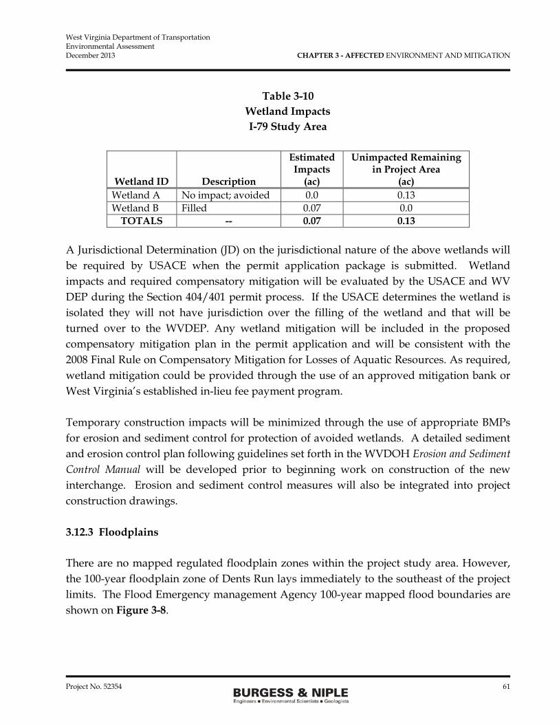
West Virginia Department of Transportation Environmental Assessment December 2013 CHAPTER 3 - AFFECTED ENVIRONMENT AND MITIGATION
Project No. 52354 61
Table 3-10 Wetland Impacts I-79 Study Area
Wetland ID Description
Estimated Impacts
(ac)
Unimpacted Remaining in Project Area
(ac) Wetland A No impact; avoided 0.0 0.13 Wetland B Filled 0.07 0.0
TOTALS -- 0.07 0.13 A Jurisdictional Determination (JD) on the jurisdictional nature of the above wetlands will be required by USACE when the permit application package is submitted. Wetland impacts and required compensatory mitigation will be evaluated by the USACE and WV DEP during the Section 404/401 permit process. If the USACE determines the wetland is isolated they will not have jurisdiction over the filling of the wetland and that will be turned over to the WVDEP. Any wetland mitigation will be included in the proposed compensatory mitigation plan in the permit application and will be consistent with the 2008 Final Rule on Compensatory Mitigation for Losses of Aquatic Resources. As required, wetland mitigation could be provided through the use of an approved mitigation bank or West Virginia’s established in-lieu fee payment program. Temporary construction impacts will be minimized through the use of appropriate BMPs for erosion and sediment control for protection of avoided wetlands. A detailed sediment and erosion control plan following guidelines set forth in the WVDOH Erosion and Sediment Control Manual will be developed prior to beginning work on construction of the new interchange. Erosion and sediment control measures will also be integrated into project construction drawings. 3.12.3 Floodplains There are no mapped regulated floodplain zones within the project study area. However, the 100-year floodplain zone of Dents Run lays immediately to the southeast of the project limits. The Flood Emergency management Agency 100-year mapped flood boundaries are shown on Figure 3-8.

West Virginia Department of Transportation Environmental Assessment December 2013 CHAPTER 3 - AFFECTED ENVIRONMENT AND MITIGATION
Project No. 52354 62
No floodplain impacts will result from the No Build or Build Alternatives. No mitigation in regards to floodplains will be necessary.
FIGURE 3-8

West Virginia Department of Transportation Environmental Assessment December 2013 CHAPTER 3 - AFFECTED ENVIRONMENT AND MITIGATION
Project No. 52354 63
3.13 Terrestrial Vegetation & Wildlife General observations on vegetation and vegetative communities were recorded during field observations conducted between July 22 and July 26, 2013. Three types of general vegetative communities were identified and generally included deciduous forest, riparian forest, and reclaimed mine land. Areas characterized by deciduous forest are generally characterized by steep slopes with a mature overstory, an open understory, little herbaceous ground cover and significant cover from downed trees and woody debris. Riparian forest habitats are associated with stream channels identified in the study area. Areas of reclaimed mine land are also present in the study area consisting of both open field and forested slopes. Table 3-11 presents a general list of dominant species associated with each habitat type and other observations made during the field investigation.
Table 3-11 Terrestrial Vegetative Communities
I-79 Study Area
DECIDUOUS FOREST Common Name Scientific Name Layer Comments
Slippery Elm Ulmus rubra Overstory --- Black Cherry Prunus serotina Understory --- Red Maple Acer rubrum Overstory &
Understory Dominant
Red Oak Fagus grandifolia Overstory Dominant American Beech Fagus grandifolia Overstory --- Tulip Poplar Liriodendron tulipifera Overstory --- European Privet Ligustrum vulgare Shrub --- Multiflora Rose Rosa multiflora Shrub --- Christmas Fern Polystichum acrostichoides Herbaceous --- Enchanter’s Nightshade Circaea quadrisulcata Herbaceous --- Jumpseed Polygonum virginianum Herbaceous --- Virginia Wild Rye Elymus virginicus Herbaceous --- Deer-Tongue Grass Dichanthelium clandestinum Herbaceous --- Japanese Honeysuckle Lonicera japonica Vine --- RIPARIAN FOREST
Common Name Scientific Name Layer Comments Red Maple Acer rubrum Overstory &
Understory Dominant
Basswood Tilia americana Overstory --- Red Oak Quercus rubra Overstory Dominant
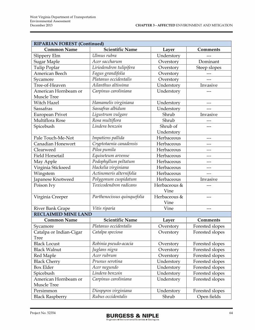
West Virginia Department of Transportation Environmental Assessment December 2013 CHAPTER 3 - AFFECTED ENVIRONMENT AND MITIGATION
Project No. 52354 64
RIPARIAN FOREST (Continued) Common Name Scientific Name Layer Comments
Slippery Elm Ulmus rubra Understory --- Sugar Maple Acer saccharum Overstory Dominant Tulip Poplar Liriodendron tulipifera Overstory Steep slopes American Beech Fagus grandifolia Overstory --- Sycamore Platanus occidentalis Overstory --- Tree-of-Heaven Ailanthus altissima Understory Invasive American Hornbeam or Muscle Tree
Carpinus caroliniana Understory ---
Witch Hazel Hamamelis virginiana Understory --- Sassafras Sassafras albidum Understory --- European Privet Ligustrum vulgare Shrub Invasive Multiflora Rose Rosa multiflora Shrub --- Spicebush Lindera benzoin Shrub of
Understory ---
Pale Touch-Me-Not Impatiens pallida Herbaceous --- Canadian Honewort Cryptotaenia canadensis Herbaceous --- Clearweed Pilea pumila Herbaceous --- Field Horsetail Equiseteum arvense Herbaceous --- May Apple Podophyllum peltatum Herbaceous --- Virginia Stickseed Hackelia virginiana Herbaceous --- Wingstem Actinomeris alternifolia Herbaceous --- Japanese Knotweed Polygonum cuspidatum Herbaceous Invasive Poison Ivy Toxicodendron radicans Herbaceous &
Vine ---
Virginia Creeper Parthenocissus quinquefolia Herbaceous & Vine
---
River Bank Grape Vitis riparia Vine --- RECLAIMED MINE LAND
Common Name Scientific Name Layer Comments Sycamore Platanus occidentalis Overstory Forested slopes Catalpa or Indian-Cigar Tree
Catalpa speciosa Overstory Forested slopes
Black Locust Robinia pseudo-acacia Overstory Forested slopes Black Walnut Juglans nigra Overstory Forested slopes Red Maple Acer rubrum Overstory Forested slopes Black Cherry Prunus serotina Understory Forested slopes Box Elder Acer negundo Understory Forested slopes Spicebush Lindera benzoin Understory Forested slopes American Hornbeam or Muscle Tree
Carpinus caroliniana Understory Forested slopes
Persimmon Diospyros virginiana Understory Forested slopes Black Raspberry Rubus occidentalis Shrub Open fields

West Virginia Department of Transportation Environmental Assessment December 2013 CHAPTER 3 - AFFECTED ENVIRONMENT AND MITIGATION
Project No. 52354 65
RECLAIMED MINE LAND (Continued) Common Name Scientific Name Layer Comments
Multiflora Rose Rosa multiflora Shrub Forested slopes & open fields
Common Burdock Arctium minus Herbaceous Open fields Crown Vetch Coronilla varia Herbaceous Open fields &
slopes Wild Madder Galium mollugo Herbaceous Shaded slopes Late Goldenrod Solidago gigantea Herbaceous Open fields &
slopes Enchanter’s Nightshade Circaea quadrisulcata Herbaceous Shaded woods Pale Touch-Me-Not Impatiens pallida Herbaceous Open fields Christmas Fern Polystichum acrostichoides Herbaceous Shaded woods;
slopes Chinese Bushclover Lespedeza cuneata Herbaceous Open fields Clearweed Pilea pumila Herbaceous Shaded slopes White Avens Geum canadense Herbaceous Shaded slopes Jumpseed Polygonum virginianum Herbaceous Shaded slopes Virginia Stickseed Polygonum virginianum Herbaceous Shaded slopes Virginia Creeper Parthenocissus quinquefolia Herbaceous &
Vine Shaded slopes
Poison Ivy Toxicodendron radicans Herbaceous & Vine
Open fields & forested slopes
Japanese Honeysuckle Lonicera japonica Vine Forested slopes
The No Build would have no impact on terrestrial vegetation. The preferred alternative will have very similar impacts to terrestrial vegetation and will include the land use and land cover quantities presented in Table 3-12.
Table 3-12 Terrestrial Vegetation
I-79 Study Area
Terrestrial Vegetation Categories Acres in
Study Area
Anticipated Impacts (acres)
Preferred Alternative Deciduous/Riparian Forested 112.2 35.7 Reclaimed Mine Land 25.1 6.3 TOTALS 137.3 42.0
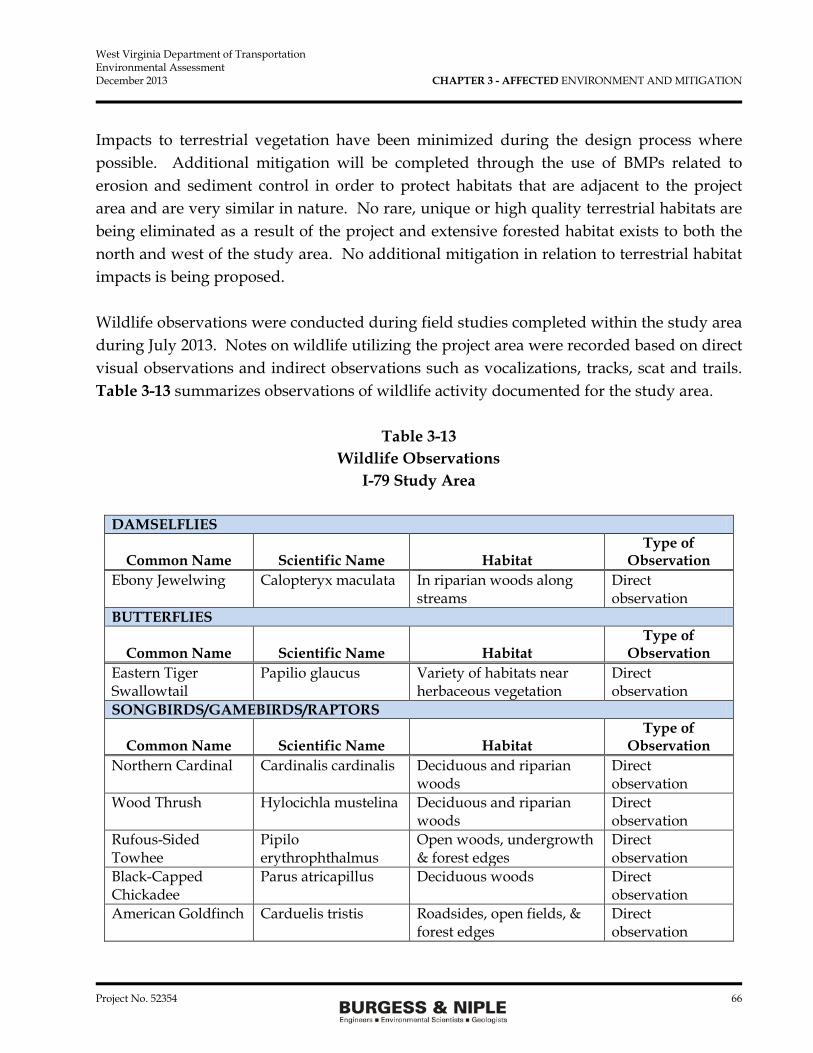
West Virginia Department of Transportation Environmental Assessment December 2013 CHAPTER 3 - AFFECTED ENVIRONMENT AND MITIGATION
Project No. 52354 66
Impacts to terrestrial vegetation have been minimized during the design process where possible. Additional mitigation will be completed through the use of BMPs related to erosion and sediment control in order to protect habitats that are adjacent to the project area and are very similar in nature. No rare, unique or high quality terrestrial habitats are being eliminated as a result of the project and extensive forested habitat exists to both the north and west of the study area. No additional mitigation in relation to terrestrial habitat impacts is being proposed. Wildlife observations were conducted during field studies completed within the study area during July 2013. Notes on wildlife utilizing the project area were recorded based on direct visual observations and indirect observations such as vocalizations, tracks, scat and trails. Table 3-13 summarizes observations of wildlife activity documented for the study area.
Table 3-13 Wildlife Observations
I-79 Study Area
DAMSELFLIES
Common Name Scientific Name Habitat Type of
Observation Ebony Jewelwing Calopteryx maculata In riparian woods along
streams Direct observation
BUTTERFLIES
Common Name Scientific Name Habitat Type of
Observation Eastern Tiger Swallowtail
Papilio glaucus Variety of habitats near herbaceous vegetation
Direct observation
SONGBIRDS/GAMEBIRDS/RAPTORS
Common Name Scientific Name Habitat Type of
Observation Northern Cardinal Cardinalis cardinalis Deciduous and riparian
woods Direct observation
Wood Thrush Hylocichla mustelina Deciduous and riparian woods
Direct observation
Rufous-Sided Towhee
Pipilo erythrophthalmus
Open woods, undergrowth & forest edges
Direct observation
Black-Capped Chickadee
Parus atricapillus Deciduous woods Direct observation
American Goldfinch Carduelis tristis Roadsides, open fields, & forest edges
Direct observation

West Virginia Department of Transportation Environmental Assessment December 2013 CHAPTER 3 - AFFECTED ENVIRONMENT AND MITIGATION
Project No. 52354 67
SONGBIRDS/GAMEBIRDS/RAPTORS (Continued) Blue Jay Cyanocitta cristata Deciduous woods Direct
observation & vocalizations
American Robin Turdus migratorius Deciduous and riparian woods
Direct observation
Mourning Dove Zenaida macroura Woods and roadsides Direct observation & vocalizations
Red-Tailed Hawk Buteo jamaicensis Open fields on hillsides Direct observation & vocalizations
MAMMALS
Common Name Scientific Name Habitat Type of Observation
Eastern Chipmunk Tamias striatus Deciduous & riparian woods near cover
Direct observation
Eastern Cottontail Sylvilagus floridanus Open fields with cover Direct observation
Raccoon Procyon lotor Riparian woods Tracks Eastern Gray Squirrel
Sciurus carolinensis Deciduous & riparian woods
Direct observation & vocalizations
White-Tailed Deer Odocoileus virginianus
Deciduous & riparian woods
Trails & scat
Feral Pig Sus scrofa Open woods Scat & evidence of rooting/foraging
AMPHIBIANS
Common Name Scientific Name Habitat Type of Observation
Eastern American Toad
Bufo americanus Deciduous & riparian woods near cover
Direct observation
Although all of the above species are relatively mobile, some loss of wildlife will most likely occur during clearing of vegetation and construction of the preferred alternative with more mobile species relocating to adjacent habitat areas. Impacts will be limited to species that are considered common in this portion of the state. The No Build would not result in any impacts to wildlife. The preferred alternative would result in minor impacts to wildlife observed within the study area as they will eliminate
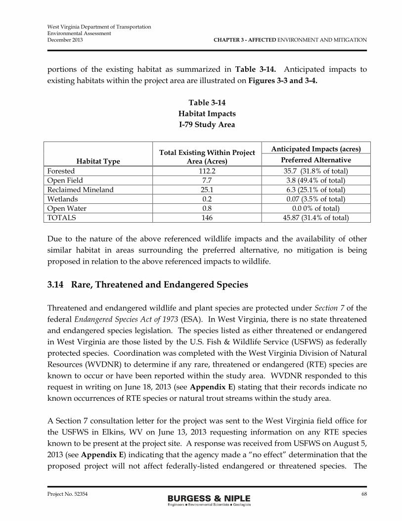
West Virginia Department of Transportation Environmental Assessment December 2013 CHAPTER 3 - AFFECTED ENVIRONMENT AND MITIGATION
Project No. 52354 68
portions of the existing habitat as summarized in Table 3-14. Anticipated impacts to existing habitats within the project area are illustrated on Figures 3-3 and 3-4.
Table 3-14 Habitat Impacts I-79 Study Area
Habitat Type Total Existing Within Project
Area (Acres) Anticipated Impacts (acres)
Preferred Alternative Forested 112.2 35.7 (31.8% of total) Open Field 7.7 3.8 (49.4% of total) Reclaimed Mineland 25.1 6.3 (25.1% of total) Wetlands 0.2 0.07 (3.5% of total) Open Water 0.8 0.0 0% of total) TOTALS 146 45.87 (31.4% of total) Due to the nature of the above referenced wildlife impacts and the availability of other similar habitat in areas surrounding the preferred alternative, no mitigation is being proposed in relation to the above referenced impacts to wildlife. 3.14 Rare, Threatened and Endangered Species Threatened and endangered wildlife and plant species are protected under Section 7 of the federal Endangered Species Act of 1973 (ESA). In West Virginia, there is no state threatened and endangered species legislation. The species listed as either threatened or endangered in West Virginia are those listed by the U.S. Fish & Wildlife Service (USFWS) as federally protected species. Coordination was completed with the West Virginia Division of Natural Resources (WVDNR) to determine if any rare, threatened or endangered (RTE) species are known to occur or have been reported within the study area. WVDNR responded to this request in writing on June 18, 2013 (see Appendix E) stating that their records indicate no known occurrences of RTE species or natural trout streams within the study area. A Section 7 consultation letter for the project was sent to the West Virginia field office for the USFWS in Elkins, WV on June 13, 2013 requesting information on any RTE species known to be present at the project site. A response was received from USFWS on August 5, 2013 (see Appendix E) indicating that the agency made a “no effect” determination that the proposed project will not affect federally-listed endangered or threatened species. The

West Virginia Department of Transportation Environmental Assessment December 2013 CHAPTER 3 - AFFECTED ENVIRONMENT AND MITIGATION
Project No. 52354 69
agency indicated that no biological assessment or further Section 7 consultation under the ESA is required unless there is a change in project plans or additional information on listed and proposed species becomes available. A report entitled Indiana Bat (Myotis sodalis) Mist Net Survey Report (Pittsburgh Wildlife & Environmental, August 23, 2013) was prepared for Mon-View, LLC (see Appendix E). The study area covered for this investigation overlaps with the study area for the new I-79 interchange. A presence/absence mist net survey was conducted from July 9, 2013 to August 13, 2013, including a field reconnaissance to identify open portals (cave or mine openings). A total of 28 mist net locations were identified in the study area that contained at least two of the following: roosting areas, foraging areas, drinking pools and/or flight corridors. A total of 81 net nights (dispersed over 6 sites) were completed from July 19 through August 13, 2013. A total of 87 bats (38 males, 42 females and 7 unknown) were captured and included the following: Big brown bat, Eastern red bat, Little brown bat, and Tri-colored bat. No Indiana bats were captured during the survey. Five documented abandoned mine portals were identified based on literature review and interviews with Mon-View, LLC. These portals were documented during the mist net survey and found to have been previously closed. No other potential winter bat habitat was identified. Since the USFWS did not require the Indiana bat survey, the information is presented here as supplemental data and supports the findings of no Indiana bat within the project area. The No Build will not have an impact on any RTE species. Based on the coordination completed with applicable regulatory agencies and detailed field studies completed by others, no RTE species have been documented for the proposed project area. The preferred alternative will not result in any negative impacts to RTE species. Because no impacts are anticipated, no mitigation is being proposed. 3.15 Hazardous Materials Assessment A Hazardous Materials Assessment (HMA), performed in August 2013, was conducted by B&N to identify evidence of past or present impacts to the property within the study area, in accordance with the American Society for Testing and Materials (ASTM) E1527-05 Standard Practice for Environmental Site Assessments (ESAs): Phase I ESA Process, and generally consisted of a visit to the study area and surrounding areas and a review of reasonably ascertainable environmental and historical record sources. The site visit was

West Virginia Department of Transportation Environmental Assessment December 2013 CHAPTER 3 - AFFECTED ENVIRONMENT AND MITIGATION
Project No. 52354 70
conducted the week of July 22 through 26, 2013. A complete copy of the HMA report is included in Appendix F. ` Review of the Environmental Data Resources, Inc. (EDR) records and confirmation of the properties listed and their locations was conducted. It is concluded that there are no hazardous waste sites within the study area that were listed in the EDR report. No facilities identified within 0.5-mile of the study area pose an environmental risk. The areas of concern for the HMA are the mine sump area (Arkwright Mine Complex), and the multiple illegal dumping areas found within the study area. The Arkwright Mine Complex sump area was previously discussed in the Geology and Groundwater sections of this chapter. The property located in the southwest portion of the study area is owned by Mr. John Lynch. According to Mr. Lynch, there are reclaimed strip mines located on his property. A query on the West Virginia Department of Environmental Protection (WVDEP) Internet Mapping system does not show any mining permits for this property. According to Mr. Lynch, the red stone coal was removed by West Virginia Coal in the late 1980s. After mining was completed, the land was reclaimed. Three retention ponds are present on the Lynch property. Several illegal dumping areas were discovered within the study area during the site visit. The majority of the illegal dumping areas were located within the creeks that flow next to Martin Hollow Road (CR 46/3) and Old Martin Hollow Road. Another dump area was identified just north of the mine injection well area, west of CR 46/3. The contents of these dumps consisted mostly of household trash and some construction debris. One dumping area, along the north side of Old Martin Hollow Road, consisted mostly of tires. These areas should be cleaned up prior to construction activities beginning within the area. It should be noted that since the site visit, additional illegal dumping areas may have been created. The No Build will not impact any hazardous material sites. The preferred alternative will impact land that historically been used for mining and occur in an areas where illegal dumping has taken place. Materials placed as part of illegal dumping actions should be removed prior to construction for proper disposal. The areas identified in the HMA report are shown on Figure 3-9.

West Virginia Department of Transportation Environmental Assessment December 2013 CHAPTER 3 - AFFECTED ENVIRONMENT AND MITIGATION
Project No. 52354 71
FIGURE 3-9
West Virginia Department of Transportation Environmental Assessment December 2013 CHAPTER 3 - AFFECTED ENVIRONMENT AND MITIGATION
Project No. 52354 72
Mitigation measures for transportation projects typically include development of a hazardous materials management plan and/or hazardous waste management provisions that are incorporated into construction bid documents. It is possible that additional analyses and testing may be needed as engineering design moves forward. In addition, former mining features may be exposed during the construction process requiring that additional evaluations be completed. The above recommendations related to the protection of AMD treatment systems, sump areas, and injection points have been made to help avoid impacts to these areas. Materials placed as part of illegal dumping actions within the foot print of the construction limits should be removed prior to construction and properly disposal. No other hazardous waste sites are to be impacted by the preferred alternative. No additional mitigation is proposed. 3.16 Energy Energy expenditures are required during the construction of any highway or infrastructure project. Energy is also used by vehicular traffic that operates on the highway system, with the amount used affected by things such as roadway profile, the alignment, grade, and traffic density. The No Build may increase fuel consumption over the 20 year design period due to increased time idling in traffic due to congestion. Energy use and conditions would slightly higher than they are today. It is anticipated that the preferred alternative will actually decrease the amount of energy used since it will help alleviate traffic congestion, reduce travel times, reduce engine idling time, and provide an additional access point that can be used by motorists to reach their destination. This is considered a positive impact and no mitigation is being proposed. In the short term, during construction energy use will increase due to the use of fossil fuels to power construction equipment. This short term increase will be off-set by the improved movement of traffic after the project is constructed.

West Virginia Department of Transportation Environmental Assessment December 2013 CHAPTER 3 - AFFECTED ENVIRONMENT AND MITIGATION
Project No. 52354 73
3.17 Secondary and Cumulative Impacts 3.17.1 Secondary Impacts Guidelines developed by the Council on Environmental Quality (CEQ) for adhering to NEPA requirements generally define secondary impacts as those that are caused by a planned action and are later in time or further removed in distance, but are still predictable. These impacts are often associated with development that may occur as a result of constructing a particular facility such as a new road or building, but have separate impacts than those resulting from the initial construction work. For this project, the secondary impacts are likely to occur over the next ten years and confined to the project area and the land immediately adjacent to the preferred alternative limits. The No Build may result in negative secondary impacts associated with the congestion on the existing roads and this congestion preventing or slowing the development of the University Town Centre Drive. This congestion could also result in businesses moving out of the development to other locations were the public can more easily reach their business. Secondary impacts would be expected to occur as a result of the preferred alternative because currently undeveloped land will become available for development due to the new interchange. This may lead to increased pressure to convert open space and natural resources to a developed use. Most of the areas near the proposed project that would be subjected to the development pressures are included in the local land use plans for development. Figure 2 in Chapter 1 shows the proposed University Town Centre development plans for the area adjacent to the preferred alternative and east to the existing development. This development is planned and will be constructed with the next ten years. Most of the planned development will occur on reclaimed mine land. There will be some conversion of these areas to paved surfaces, including building pads and possible recreational facilities, primarily east of I-79 where commercial development has continued for the last 10 years. Secondary impacts associated with the project are expected to be similar to those that have historically occurred in the area as new developments are constructed. Much of the land adjacent to the preferred alternative is former mined land that will be converted to buildings lots, roads, and parking lots. The secondary impact to this development is not likely to create an adverse impact. Development resulting from construction of the project is consistent with the local land use plans and is considered a

West Virginia Department of Transportation Environmental Assessment December 2013 CHAPTER 3 - AFFECTED ENVIRONMENT AND MITIGATION
Project No. 52354 74
positive impact that benefits members of the local communities through increased employment opportunities and tax revenues. 3.17.2 Cumulative Impacts Cumulative impacts result from the combined consequences of an action when added to other past, present and future actions. These impacts can result from multiple related actions of the same nature or a variety of unrelated projects (i.e., transportation improvements, commercial development, etc.). When considered as a whole, these impacts can have a combined effect greater than the results of each individual action considered independently from the others. The City of Morgantown Comprehensive Plan, adopted June 2013, identifies “Areas of Opportunity” where a variety of development types are presented for consideration. These development opportunities are located in close proximity to the study area and are summarized in Table 3-15.
Table 3-15 Areas of Opportunity/Future Development
Adapted from City of Morgantown Comprehensive Plan
Location Development Intent Waterfront/Wharf
District Continued infill with employment, entertainment, accommodation and residential uses to serve as gateway to downtown; pedestrian and bicycle access
South High Street & University
Avenue
Construct new infill buildings and mixed-use development (retail/commercial & office/residential)
Beechurst Avenue Corridor
Construct new buildings
North Willey Street/Richwood
Avenue Area
Revitalization and new buildings (primarily residential); Improved pedestrian ways
Steward Street Area
Revitalization, new buildings and redevelopment (primarily residential)
705 University Farms Area
Encourage growth on this WVU-owned agricultural land (mixed housing types, open space and recreation)
Brockway Avenue Corridor (Route 7)
Redevelopment with residential emphasis (live-work structures, commercial/office uses); new parks in floodplain; pedestrian facilities
Sunnyside Revitalization, infill and redevelopment; pedestrian and vehicular infrastructure improvements; parks and open space

West Virginia Department of Transportation Environmental Assessment December 2013 CHAPTER 3 - AFFECTED ENVIRONMENT AND MITIGATION
Project No. 52354 75
Location Development Intent Airport
Technology Park Diversify employment and industry base through development of business/industrial park
Sabraton, Earl L. Core Rd.
Mixed-use development (retail/commercial and office/residential)
University Research Park
Employment related development near WVU
In addition to the above areas that have been identified as development opportunities, the comprehensive plan also discusses multiple transportation projects included on the Long Range Transportation Plan throughout the Morgantown, Westover, Granville and Star City areas. It is anticipated that cumulative impacts will result from the preferred alternative, just as unforeseeable development in the area would result in cumulative impacts when considered as a whole. The preferred alternative will improve local transportation and open up areas for development that were previously inaccessible. This may lead to the use and conversion of natural areas such as wetlands, terrestrial habitat, forested areas, and other types of ecological habitat. The reasonably foreseeable future actions will include additional development on the west side of the relocated CR 46/3. This development is part of the Mon-View long range plan and may or may not be built based on demand for future development. If this development occurs it will be built over the next 20 to 30 years. Because of the terrain of the area and the natural resources in the area, long term impacts to land cover, wildlife, and streams may occur due as developed land acreage increases. Because the developer owns much of the land west of CR 46/3, their long range plan has been discussed. Adjacent property owners to the Mon-View development may also redevelop their property over the long term as land use changes prompt them to change the land use on their property. Currently no other land owners have discussed development potential with local governments. Again long term development that is consistent with the long range plans for the project area will be a beneficial impact for members of the local communities through increased employment opportunities and tax revenues for many years to some. While cumulative impacts may result in the conversion of natural habitats or ecological resources to developed uses, impacts to natural resources can be minimized through proper planning and design of future developments. Adherence to local, state and federal regulatory requirements will help ensure that impacts to these resources are protected to the fullest extent and appropriate mitigation is provided where direct impacts are unavoidable. It is also expected that some of the future development occurring as a result of the project will

West Virginia Department of Transportation Environmental Assessment December 2013 CHAPTER 3 - AFFECTED ENVIRONMENT AND MITIGATION
Project No. 52354 76
include recreational facilities, open/green space, and parks that will enhance opportunities for public use of these areas and result in an overall net benefit to the community. 3.18 Temporary Construction Impacts The No-Build would not result in any temporary construction impacts and would require no mitigation. The preferred alternative will result in short-term impacts during construction of the project. These impacts may include interference with local traffic patterns and drive times particularly for people that use CR 46/6 (Martin Hollow Road) and lane or shoulder closures on I-79 to construct the University Town Centre Drive bridge over the interstate; increased noise and particulate air pollution; and increased erosion. The preferred alternative will also have a positive impact as they will create numerous construction jobs in the area. The advantage of constructing the preferred alternative is that the interchange is in an area where no businesses or residents are located and no local roads will be impacted. To mitigate the impacts associated with the preferred alternative, construction work will be scheduled to minimize disruptions to I-79 and Martin Hollow Road when possible. Traffic control signage and devices will be utilized to make the public aware of construction work and address safety concerns. Coordination with utility companies will be completed during project design and during construction to minimize any disturbance to utility services. Coordination will also be completed with public service providers (schools, post offices, etc.) and emergency services (police, fire, EMS, etc.) that may be affected by the project in order to minimize impacts and protect public safety. 3.19 Impact Summary Table 3-16 presents a tabular summary of the impacts associated with the No-Build and the preferred alternative for the new I-79 interchange.

West Virginia Department of Transportation Environmental Assessment December 2013 CHAPTER 3 - AFFECTED ENVIRONMENT AND MITIGATION
Project No. 52354 77
Table 3-16 Summary of Impacts and Mitigation for the Preferred Alternative
I-79 Study Area
Resource/Element No-Build Preferred Alternative Mitigation Residential/ Commercial Displacements 0 0 None
Earthwork 0 cy 2,000,000 cy Erosion control per WVDOT
specifications Land Area Impacted 20 acres 51.37 acres None Stream Impacts 0 lf 2,426 lf Mitigation per
USACE Rules Wetland Impacts 0 acres 0.07 acres Mitigation per
USACE Rules Noise Receptors Impacted 0 6 None Terrestrial Habitats 0 acres 40.2 acres None Hazardous Waste Sites 0 1 Acid Mine Drainage
Line 9 Illegal Dump Sites
Clean up illegal dumps prior to construction.
Improved Access to Development
No Yes None
Environmental Justice Population
No No None
Public Services No Yes Notify public agencies such as
police, fire, school districts of road
closures and detours.
West Virginia Department of Transportation Environmental Assessment December 2013 CHAPTER 4 - REFERENCES
Project No. 52354 78
CHAPTER 4 - REFERENCES 2013-2040 Long Range Transportation Plan, MMMPO, Prepared by Burgess & Niple, Inc.,
2013. Trader, P and J. Wilson. 2001. Guidelines for Phase I, II, and III Archaeological Investigations
and Technical Reports. West Virginia State Historic Preservation Office. Vosvick, J. and C. Jackson. 2013. A Phase I Archaeological Literature Review and
Reconnaissance Survey for the Proposed New I-79 Interchange between Westover and Star City Interchanges near the City of Morgantown, Monongalia County, West Virginia. Archaeological Consultants of the Midwest, Inc., Wheeling, WV.
Jackson, C 2013. A Viewshed Study for the Proposed New I-79 Interchange between Westover
and Star City Interchanges near the City of Morgantown, Monongalia County, West Virginia. Archaeological Consultants of the Midwest, Inc., Wheeling, WV.
U.S. EPA Memorandum Interim Guidance Update on Mobile Source Air Toxic Analysis in
NEPA, USEPA, Office of natural Environment, December 6, 2012, Appendix B. Hobba, W.A. Jr. 1984. Ground Water Hydrology of the Monongahela River Basin. U.S.
Geological Survey, in cooperation with the West Virginia Department of Natural Resources.
Environmental Data Resources, Inc. 2013. EDR Data Map Well Search Report, West Virginia
DOT New I-79 Interchange, Morgantown, WV 26501, Inquiry Number 3633860.1w. June 13, 2013.
Cowardin, L.M., et al. 1979. Classification of Wetlands and Deepwater Habitats of the United
States. FWS/OBS-79/31. West Virginia Department of Transportation Division of Highways, Interchange Justification
Report for the I-79/Morgantown interchange, Monongalia County, West Virginia, December 2013

West Virginia Department of Transportation Environmental Assessment December 2013 CHAPTER 5 – LIST OF PREPARERS AND REVIEWERS
Project No. 52354 79
CHAPTER 5 – LIST OF PREPARERS AND REVIEWERS Federal Highway Administration Alison M. Rogers M.S. Biological Sciences B.S. Biology 12 years of experience NEPA Review
Jason E. Workman M.S. Environmental Science B.S. Parks and Conservation 9 years of experience FHWA Document Review
West Virginia Division of Highways Lovell R. Facemire, P.E., P.S. B.S. Civil Engineering 21 years of experience WVDOH Document Review Sondra L. Mullins B.A. History
Ben L. Hark M.A. Guidance Counseling B.A. Sociology 39 years of experience WVDOH Document Review
18 years of experience WVDOH Document Review Burgess & Niple, Inc. Krista N. Carter AA of Applied Science 13 years of experience Hazardous Waste Report Richard G. Fitch, AICP B.S. Natural Resources 37 years of experience Noise, Air, Purpose and Need, Alternatives, Document Preparation Katherine E. Fontaine, PWS B.S. Forestry and Wildlife 30 years of experience Aquatic Resources, Wildlife, Document Preparation
David C. Lenzer, P.E. BSE, Civil Engineering 7 years of experience Alternative Evaluation Matthew W. Lewellyn, P.E. MBA-Executive, B.S. Civil Engineering 15 years of experience Alternatives, Document Review C. Kris Popovich B.S. Geography 12 years of experience GIS Mapping, Graphics. Land Use/Land Cover

West Virginia Department of Transportation Environmental Assessment December 2013 CHAPTER 5 – LIST OF PREPARERS AND REVIEWERS
Project No. 52354 80
Ryan I. VanZandt Northeast Career Certificate 23 years of experience Noise Modeling
Jennifer L. Walker, PWS M.S. Environmental Science, B.S. Biology 16 years of experience Natural Environment, Social Economic, Effected Environment, Document Preparer
Archaeological Consultants of the Midwest, Inc.
Jamie Vosvick 22 years of experience Archaeological Investigation
Chris Jackson M.S. History B.S. Anthropology 24 years of experience Principal Investigator

West Virginia Department of Transportation Environmental Assessment December 2013 CHAPTER 6 – DISTRIBUTION LIST
Project No. 52354 81
CHAPTER 6 – DISTRIBUTION LIST FEDERAL AGENCIES William C. Wentworth Remedial Project Manager U.S. Environmental Protection Agency Region 3 Mail Code: 3LC20 1650 Arch Street Philadelphia, PA 19103-2029 Lisa Humphreys Project Technician Coordinator U.S. Army Corps of Engineers Huntington District CELRH-EC-CE 502 8th Street Huntington, WV 25701-2070 Ginger Mullins Chief Regulatory Division U.S. Army Corps of Engineers Huntington District CELRH-RD 502 Eighth Street Huntington, WV 25701-2070 Bill Arguto Federal Facility Program Manager U.S. Environmental Protection Agency Region 3- Environmental Services Div. Office of Environmental Programs Mail Code: 3 WP21 1650 Arch Street Philadelphia, PA 19103-2029
John Schmidt Supervisor U.S. Fish & Wildlife Service West Virginia Field Office 694 Beverly Pike Elkins, WV 26241 Ron Wigal Environmental Specialist Natural Resources Conservation Service U.S. Department of Agriculture 1550 Earl Core Road, Suite 200 Morgantown, WV 26505 May Ann Tierney Regional Administrator Federal Emergency Management Agency Region III 615 Chestnut Street Philadelphia, PA 19106 TRIBAL CONSULTATION Dennis Sisco Executive Director Seneca- Cayuga Tribe of Oklahoma 23701 South 655 Road Grove, OK 74344 Rickey Armstrong Sr. President Seneca Nation of New York 3582 Center Road Salamanca, NY 14779

West Virginia Department of Transportation Environmental Assessment December 2013 CHAPTER 6 – DISTRIBUTION LIST
Project No. 52354 82
TRIBAL CONSULTATION (Cont.) Eastern Shawnee Tribe of Oklahoma P.O. Box 350 Seneca, Missouri 64865 Contact: Robin Dushane, Cultural Preservation Director Eastern Band of Cherokee Indians of North Carolina P.O. Box 455 Cherokee, NC 28719 Contact: Tyler B. Howe Tribal Historic Preservation Specialist Tamara Francis Director Cultural Preservation The Delaware Nation P.O. Box 825 Anadarkfo, OK 73005-0825 WEST VIRGINIA AGENCIES Don Martin West Virginia Department of Environmental Protection Office of Remediation 601 57th St SE Charleston, WV 25304-2345 Greg Phillips District Engineer, District 4 West Virginia Department of Highways I-79 & Meadowbrook Road Clarksburg, WV 26302
Barbara Sargent West Virginia Division of Natural Resources P.O. Box 67 Elkins, WV 26241 Susan Pierce Deputy State Historic Preservation Officer Division of Culture and History 1900 Kanawha Blvd East Charleston, WV 25305 Frank Jezioro Director, West Virginia Division of Natural Resources Building 74 324 Fourth Avenue South Charleston, WV 25303 John A. Benedict Director, Office of Air Quality West Virginia Department of Environmental Protection 601 57th Street, SE Charleston, WV 25304-2345 Scott G. Mandirola Director, Division of Water and Waste Management Permitting and Engineering Branch West Virginia Department of Environmental Protection 601 57th Street, SE Charleston, WV 253041-2345

West Virginia Department of Transportation Environmental Assessment December 2013 CHAPTER 6 – DISTRIBUTION LIST
Project No. 52354 83
WEST VIRGINIA AGENCIES (Cont.)
Randy Huffman Director West Virginia Department of Environmental Protection 601 57th Street, SE Charleston, WV 25304
Charles W. Armstead Environmental Resources Program Manager WV Department of Environmental Protection Division of Land Restoration 601 57th Street, SE Charleston, WV 25304 REGIONAL AGENCIES
Bill Austin, AICP Executive Director Morgantown Monongalia MPO 82 Hart Field Road Suite 105 Morgantown, WV 26505
Eldon A. Callen President Monongalia County Commission 82 Hart Field Road, Suite 105 Morgantown, WV 26505 DELEGATES AND SENATORS Senator Roman Prezioso West Virginia Senate 1806 Dogwood Drive Fairmont, WV 26554
Senator Jeffrey Kessler West Virginia Senate 607 Wheeling Ave. Glen Dale, WV 26038 Senator Robert Beach West Virginia Senate P.O. Box 1620 Morgantown, WV 26501 Senator Larry Edgell West Virginia Senate 600 Fifth Street New Martinsville, WV 26155 Delegate Barbara Fleischauer West Virginia House of Delegates 235 High Street, Suite 618 Morgantown, WV 25305 Delegate Amanda Pasdon West Virginia House of Delegates P.O. Box 106 Morgantown, WV 26507 Delegate Anthony Barill West Virginia House of Delegates 937 Garrison Avenue Morgantown, WV 26501 Delegate Charlene Marshall West Virginia House of Delegates 1010 Ashton Drive Morgantown, WV 26508

West Virginia Department of Transportation Environmental Assessment December 2013 CHAPTER 6 – DISTRIBUTION LIST
Project No. 52354 84
DELEGATES AND SENATORS (Cont.) Delegate Cindy Frich West Virginia House of Delegates 1248 Bakers Ridge Road Morgantown, WV 26505 LOCAL OFFICIALS City of Westover Mayor C. Dave Johnson 500 Dupont Road Westover, WV 26501 Monongalia County Development Authority 955 Hartman Run Road #200 Morgantown, WV 26505 Town of Granville Mayor Patricia A. Lewis P.O. Box 119 Granville, WV 26534 Morgantown Area Chamber of Commerce 1029 University Ave. Morgantown, WV 26505 Monongalia County Planning Commission 82 Hart Field Road, Suite 105 Morgantown, WV 26505

APPENDIX A
NRCS FARMLAND LETTER


APPENDIX B
DIVISION OF CULTURE AND HISTORY CONCURRANCE LETTER CULTURAL RESOURCES
ARCHEOLOGIC AND HISTORIC REPORTS (On CD)

APPENDIX C
EDR WELL SEARCH REPORT MONONGALIA COUNTY HEALTH DEPARTMENT LETTERS

tropeR hcraeS lleW ™paMataD RDE
440 Wheelers Farms RoadMilford, CT 06461Toll Free: 800.352.0050www.edrnet.com
West Virginia DOT New I-79 InterchangeMorgantown, WV 26501 Inquiry Number: 3633860.1wJune 13, 2013

Thank you for your business.Please contact EDR at 1-800-352-0050
with any questions or comments.
Disclaimer - Copyright and Trademark Notice
This Report contains certain information obtained from a variety of public and other sources reasonably available to Environmental DataResources, Inc. It cannot be concluded from this Report that coverage information for the target and surrounding properties does not exist fromother sources. NO WARRANTY EXPRESSED OR IMPLIED, IS MADE WHATSOEVER IN CONNECTION WITH THIS REPORT. ENVIRONMENTALDATA RESOURCES, INC. SPECIFICALLY DISCLAIMS THE MAKING OF ANY SUCH WARRANTIES, INCLUDING WITHOUT LIMITATION,MERCHANTABILITY OR FITNESS FOR A PARTICULAR USE OR PURPOSE. ALL RISK IS ASSUMED BY THE USER. IN NO EVENT SHALLENVIRONMENTAL DATA RESOURCES, INC. BE LIABLE TO ANYONE, WHETHER ARISING OUT OF ERRORS OR OMISSIONS, NEGLIGENCE,ACCIDENT OR ANY OTHER CAUSE, FOR ANY LOSS OF DAMAGE, INCLUDING, WITHOUT LIMITATION, SPECIAL, INCIDENTAL,CONSEQUENTIAL, OR EXEMPLARY DAMAGES. ANY LIABILITY ON THE PART OF ENVIRONMENTAL DATA RESOURCES, INC. IS STRICTLYLIMITED TO A REFUND OF THE AMOUNT PAID FOR THIS REPORT. Purchaser accepts this Report "AS IS". Any analyses, estimates, ratings,environmental risk levels or risk codes provided in this Report are provided for illustrative purposes only, and are not intended to provide, norshould they be interpreted as providing any facts regarding, or prediction or forecast of, any environmental risk for any property. Only a Phase IEnvironmental Site Assessment performed by an environmental professional can provide information regarding the environmental risk for anyproperty. Additionally, the information provided in this Report is not to be construed as legal advice.
Copyright 2013 by Environmental Data Resources, Inc. All rights reserved. Reproduction in any media or format, in wholeor in part, of any report or map of Environmental Data Resources, Inc., or its affiliates, is prohibited without prior written permission.
EDR and its logos (including Sanborn and Sanborn Map) are trademarks of Environmental Data Resources, Inc. or its affiliates. All othertrademarks used herein are the property of their respective owners.

TC3633860.1w Page 1 of 2
0 (0.00%)1 (0.19%)9 (1.73%)20 (3.85%)94 (18.11%)395 (76.11%)
>100 50-100 20-50 10-20 4-10 <4pCi/LpCi/LpCi/LpCi/LpCi/LpCi/L
Minimum Radon Level: -0.5 pCi/L.Maximum Radon Level: 68.3 pCi/L.
Number of sites tested: 519.
EPA Region 3 Statistical Summary Readings for Zip Code: 26505
AREA RADON INFORMATION
39080-F1 OSAGE, WV PA 39080-E1 RIVESVILLE, WV 39079-F8 MORGANTOWN NORTH, WV PA 39079-E8 MORGANTOWN SOUTH, WV
USGS TOPOGRAPHIC MAP(S)
NO WELLS FOUND
PUBLIC WATER SUPPLY SYSTEM INFORMATION
WVOG80000035919 7WVOG80000000108 6WVOG80000103660 5WVOG80000074042 4WVOG80000109284 3WVOG80000109286 2WVOG80000109429 1
STATE OIL/GAS WELL INFORMATION
WELLMAPIDID
NO WELLS FOUND
STATE WATER WELL INFORMATION
WELLMAPIDID
USGS40001305682 7USGS40001305692 6USGS40001305780 5USGS40001305795 4USGS40001305831 3USGS40001305840 2USGS40001305949 1
FEDERAL DATABASE WELL INFORMATION
WELLMAPIDID
GEOCHECK VERSION 2.1SUMMARY
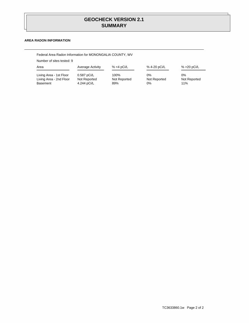
TC3633860.1w Page 2 of 2
11%0%89%4.244 pCi/LBasementNot ReportedNot ReportedNot ReportedNot ReportedLiving Area - 2nd Floor0%0%100%0.587 pCi/LLiving Area - 1st Floor
% >20 pCi/L% 4-20 pCi/L% <4 pCi/LAverage ActivityArea
Number of sites tested: 9
Federal Area Radon Information for MONONGALIA COUNTY, WV
AREA RADON INFORMATION
GEOCHECK VERSION 2.1SUMMARY

TC3633860.1w Page 1 of 7
Not ReportedFormation type:Pennsylvanian aquifersAquifername:
USCountrycode:NGVD29Vert coord refsys:Interpolated from topographic mapVertcollection method:feetVert accmeasure units:
50Vertacc measure val:feetVert measure units:975.00Vert measure val:NAD83Horiz coord refsys:
Interpolated from mapHoriz Collection method:secondsHoriz Acc measure units:1Horiz Acc measure:Not ReportedSourcemap scale:-80.0114544Longitude:39.6448035Latitude:Not ReportedContrib drainagearea units:Not ReportedContrib drainagearea:Not ReportedDrainagearea Units:Not ReportedDrainagearea value:05020003Huc code:
Original station name was 0905074Monloc desc:WellMonloc type:Mng-0294Monloc name:USGS-393841080004201Monloc Identifier:USGS West Virginia Water Science CenterFormal name:USGS-WVOrg. Identifier:2Map ID:
Ground-water levels, Number of Measurements: 0
Not ReportedWellholedepth units:Not ReportedWellholedepth:ftWelldepth units:365Welldepth:19560101Construction date:
Not ReportedAquifer type:Not ReportedFormation type:Pennsylvanian aquifersAquifername:
USCountrycode:NGVD29Vert coord refsys:Interpolated from topographic mapVertcollection method:feetVert accmeasure units:
50Vertacc measure val:feetVert measure units:860.00Vert measure val:NAD83Horiz coord refsys:
Interpolated from mapHoriz Collection method:secondsHoriz Acc measure units:1Horiz Acc measure:Not ReportedSourcemap scale:-80.0122871Longitude:39.6645252Latitude:Not ReportedContrib drainagearea units:Not ReportedContrib drainagearea:Not ReportedDrainagearea Units:Not ReportedDrainagearea value:05020003Huc code:
Original station name was 0905100Monloc desc:WellMonloc type:Mng-0381Monloc name:USGS-393952080004501Monloc Identifier:USGS West Virginia Water Science CenterFormal name:USGS-WVOrg. Identifier:1Map ID:
Water Well Information:
GEOCHECK VERSION 2.1STATE DATABASE WELL INFORMATION

TC3633860.1w Page 2 of 7
Not ReportedSourcemap scale:-79.9822867Longitude:39.6375815Latitude:Not ReportedContrib drainagearea units:Not ReportedContrib drainagearea:Not ReportedDrainagearea Units:Not ReportedDrainagearea value:05020003Huc code:
Original station name was 0905020Monloc desc:WellMonloc type:Mng-0250Monloc name:USGS-393815079585701Monloc Identifier:USGS West Virginia Water Science CenterFormal name:USGS-WVOrg. Identifier:4Map ID:
Ground-water levels, Number of Measurements: 0
Not ReportedWellholedepth units:Not ReportedWellholedepth:ftWelldepth units:95Welldepth:19480101Construction date:
Not ReportedAquifer type:Not ReportedFormation type:Pennsylvanian aquifersAquifername:
USCountrycode:NGVD29Vert coord refsys:Interpolated from topographic mapVertcollection method:feetVert accmeasure units:
50Vertacc measure val:feetVert measure units:980.00Vert measure val:NAD83Horiz coord refsys:
Interpolated from mapHoriz Collection method:secondsHoriz Acc measure units:1Horiz Acc measure:Not ReportedSourcemap scale:-80.006732Longitude:39.6436924Latitude:Not ReportedContrib drainagearea units:Not ReportedContrib drainagearea:Not ReportedDrainagearea Units:Not ReportedDrainagearea value:05020003Huc code:
Original station name was 0905075Monloc desc:WellMonloc type:Mng-0285Monloc name:USGS-393837080002501Monloc Identifier:USGS West Virginia Water Science CenterFormal name:USGS-WVOrg. Identifier:3Map ID:
1948-12-01 23.00
DateFeet belowSurface
Feet toSealevel
-------------------------------------------------
Ground-water levels, Number of Measurements: 1
Not ReportedWellholedepth units:Not ReportedWellholedepth:ftWelldepth units:38Welldepth:19480101Construction date:
Not ReportedAquifer type:
GEOCHECK VERSION 2.1STATE DATABASE WELL INFORMATION

TC3633860.1w Page 3 of 7
Not ReportedSourcemap scale:-79.998677Longitude:39.620082Latitude:Not ReportedContrib drainagearea units:Not ReportedContrib drainagearea:Not ReportedDrainagearea Units:Not ReportedDrainagearea value:05020003Huc code:
Original station name was 0905071Monloc desc:WellMonloc type:Mng-0180Monloc name:USGS-393712079595601Monloc Identifier:USGS West Virginia Water Science CenterFormal name:USGS-WVOrg. Identifier:6Map ID:
Ground-water levels, Number of Measurements: 0
Not ReportedWellholedepth units:Not ReportedWellholedepth:ftWelldepth units:100Welldepth:19480101Construction date:
Not ReportedAquifer type:Not ReportedFormation type:Pennsylvanian aquifersAquifername:
USCountrycode:NGVD29Vert coord refsys:Interpolated from topographic mapVertcollection method:feetVert accmeasure units:
50Vertacc measure val:feetVert measure units:900.00Vert measure val:NAD83Horiz coord refsys:
Interpolated from mapHoriz Collection method:secondsHoriz Acc measure units:1Horiz Acc measure:Not ReportedSourcemap scale:-79.9995098Longitude:39.6356371Latitude:Not ReportedContrib drainagearea units:Not ReportedContrib drainagearea:Not ReportedDrainagearea Units:Not ReportedDrainagearea value:05020003Huc code:
Original station name was 0905073Monloc desc:WellMonloc type:Mng-0243Monloc name:USGS-393808079595901Monloc Identifier:USGS West Virginia Water Science CenterFormal name:USGS-WVOrg. Identifier:5Map ID:
Ground-water levels, Number of Measurements: 0
Not ReportedWellholedepth units:Not ReportedWellholedepth:ftWelldepth units:820Welldepth:19410101Construction date:
Not ReportedAquifer type:Not ReportedFormation type:Not ReportedAquifername:
USCountrycode:NGVD29Vert coord refsys:Interpolated from topographic mapVertcollection method:feetVert accmeasure units:
50Vertacc measure val:feetVert measure units:880.00Vert measure val:NAD83Horiz coord refsys:
Interpolated from mapHoriz Collection method:secondsHoriz Acc measure units:1Horiz Acc measure:
GEOCHECK VERSION 2.1STATE DATABASE WELL INFORMATION

TC3633860.1w Page 4 of 7
Ground-water levels, Number of Measurements: 0
Not ReportedWellholedepth units:Not ReportedWellholedepth:ftWelldepth units:363Welldepth:19300101Construction date:
Not ReportedAquifer type:Conemaugh FormationFormation type:Pennsylvanian aquifersAquifername:
USCountrycode:NGVD29Vert coord refsys:Interpolated from topographic mapVertcollection method:feetVert accmeasure units:
50Vertacc measure val:feetVert measure units:1075.00Vert measure val:NAD83Horiz coord refsys:
Interpolated from mapHoriz Collection method:secondsHoriz Acc measure units:1Horiz Acc measure:Not ReportedSourcemap scale:-79.997288Longitude:39.6195264Latitude:Not ReportedContrib drainagearea units:Not ReportedContrib drainagearea:Not ReportedDrainagearea Units:Not ReportedDrainagearea value:05020003Huc code:
Orig staname was 0905027 GEORGE A POLANDMonloc desc:WellMonloc type:Mng-0171Monloc name:USGS-393710079595101Monloc Identifier:USGS West Virginia Water Science CenterFormal name:USGS-WVOrg. Identifier:7Map ID:
1948-10-01 111.00 1948-10-01 111.00
DateFeet belowSurface
Feet toSealevel
-------------------------------------------------Date
Feet belowSurface
Feet toSealevel
-------------------------------------------------
Ground-water levels, Number of Measurements: 2
Not ReportedWellholedepth units:Not ReportedWellholedepth:ftWelldepth units:200Welldepth:19480101Construction date:
Not ReportedAquifer type:Not ReportedFormation type:Pennsylvanian aquifersAquifername:
USCountrycode:NGVD29Vert coord refsys:Interpolated from topographic mapVertcollection method:feetVert accmeasure units:
50Vertacc measure val:feetVert measure units:1050.00Vert measure val:NAD83Horiz coord refsys:
Interpolated from mapHoriz Collection method:secondsHoriz Acc measure units:1Horiz Acc measure:
GEOCHECK VERSION 2.1STATE DATABASE WELL INFORMATION

TC3633860.1w Page 5 of 7
19500803Issue date:UnknownRecvd date:196Permit:61County:061-00196Api:OPERATOR UNKNOWNResp party:1Well numbr:BIRCHER, G. LESTERFarm name:
NARig type:Not AvailableDepth:NAUse:Not AvailableType:PluggedStatus:ERIS-LLGeosource:
4388064.6Well y:587565.5Well x:3Map ID:
WVOG80000109286Site id:Not ReportedPermit id:6100190Permitid:19490226Issue date:UnknownRecvd date:
190Permit:61County:061-00190Api:PENTRESS GAS LLCResp party:1Well numbr:LOT 12 RIVERSIDEFarm name:
NARig type:Not AvailableDepth:NAUse:Gas WellType:Active WellStatus:ERIS-LLGeosource:
4388064.6Well y:587324.1Well x:2Map ID:
WVOG80000109429Site id:Not ReportedPermit id:6100192Permitid:19500420Issue date:UnknownRecvd date:
192Permit:61County:061-00192Api:OPERATOR UNKNOWNResp party:1Well numbr:SNYDER, CLYDEFarm name:
NARig type:Not AvailableDepth:NAUse:Not AvailableType:Abandoned WellStatus:ERIS-LLGeosource:
4388386.5Well y:587501.2Well x:1Map ID:
Oil/Gas Well Information:
GEOCHECK VERSION 2.1STATE DATABASE WELL INFORMATION

TC3633860.1w Page 6 of 7
19411223Issue date:UnknownRecvd date:136Permit:61County:061-00136Api:OPERATOR UNKNOWNResp party:1Well numbr:HARE, ROBINSON - ESTATEFarm name:
NARig type:Not AvailableDepth:NAUse:Not AvailableType:PluggedStatus:ERIS-LLGeosource:
4386857.6Well y:587082.7Well x:6Map ID:
WVOG80000103660Site id:Not ReportedPermit id:6100142Permitid:20030227Issue date:20030224Recvd date:
142Permit:61County:061-00142Api:UNKNOWN - DEP PAID PLUGGING CONTRACTResp party:SIMPSON 2Well numbr:WESTOVER, CITY OFFarm name:
NARig type:Not AvailableDepth:NAUse:Not AvailableType:PluggedStatus:ERIS-LLGeosource:
4387066.7Well y:587147Well x:5Map ID:
WVOG80000074042Site id:Not ReportedPermit id:6100108Permitid:19380826Issue date:UnknownRecvd date:
108Permit:61County:061-00108Api:OPERATOR UNKNOWNResp party:1Well numbr:PENNSULA CO.Farm name:
NARig type:Not AvailableDepth:NAUse:Not AvailableType:Abandoned WellStatus:ERIS-LLGeosource:
4387066.7Well y:587147Well x:4Map ID:
WVOG80000109284Site id:Not ReportedPermit id:6100196Permitid:
GEOCHECK VERSION 2.1STATE DATABASE WELL INFORMATION
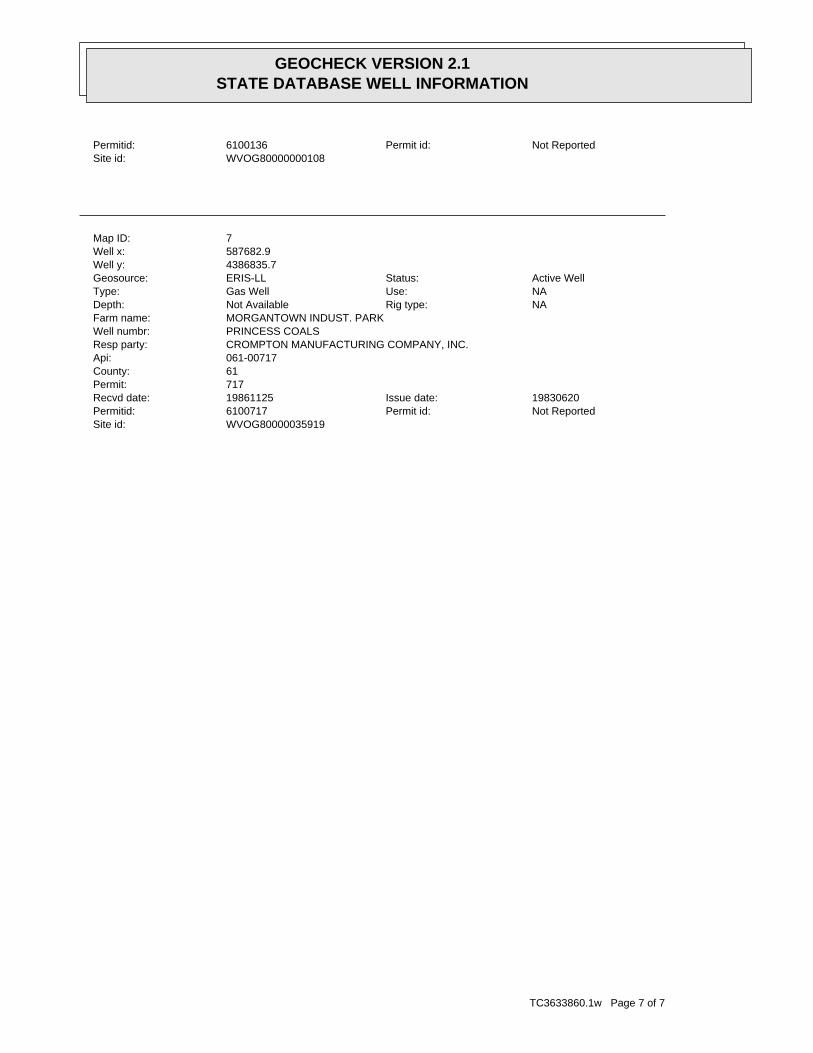
TC3633860.1w Page 7 of 7
WVOG80000035919Site id:Not ReportedPermit id:6100717Permitid:19830620Issue date:19861125Recvd date:
717Permit:61County:061-00717Api:CROMPTON MANUFACTURING COMPANY, INC.Resp party:PRINCESS COALSWell numbr:MORGANTOWN INDUST. PARKFarm name:
NARig type:Not AvailableDepth:NAUse:Gas WellType:Active WellStatus:ERIS-LLGeosource:
4386835.7Well y:587682.9Well x:7Map ID:
WVOG80000000108Site id:Not ReportedPermit id:6100136Permitid:
GEOCHECK VERSION 2.1STATE DATABASE WELL INFORMATION

PWS: Public Water SystemsSource: EPA/Office of Drinking WaterTelephone: 202-564-3750Public Water System data from the Federal Reporting Data System. A PWS is any water system which provides water to at
least 25 people for at least 60 days annually. PWSs provide water from wells, rivers and other sources.
PWS ENF: Public Water Systems Violation and Enforcement DataSource: EPA/Office of Drinking WaterTelephone: 202-564-3750Violation and Enforcement data for Public Water Systems from the Safe Drinking Water Information System (SDWIS) after
August 1995. Prior to August 1995, the data came from the Federal Reporting Data System (FRDS).
Area Radon InformationSource: USGSTelephone: 703-356-4020The National Radon Database has been developed by the U.S. Environmental Protection Agency(USEPA) and is a compilation of the EPA/State Residential Radon Survey and the National Residential Radon Survey.The study covers the years 1986 - 1992. Where necessary data has been supplemented by information collected atprivate sources such as universities and research institutions.
EPA Radon ZonesSource: EPATelephone: 703-356-4020Sections 307 & 309 of IRAA directed EPA to list and identify areas of U.S. with the potential for elevated indoorradon levels.
EPA Region 3 Statistical Summary ReadingsSource: Region 3 EPATelephone: 215-814-2082Radon readings for Delaware, D.C., Maryland, Pennsylvania, Virginia and West Virginia.
USGS Water Wells: USGS National Water Inventory System (NWIS)This database contains descriptive information on sites where the USGS collects or has collected data on surfacewater and/or groundwater. The groundwater data includes information on wells, springs, and other sources of groundwater.
West Virginia Water Well InformationSource: Bureau of Public HealthTelephone: 304-558-6765Community, non-community, non-transient non-community, non-public wells.
West Virginia Oil and Gas Well DatabaseSource: Department of Environmental ProtectionTelephone: 304-926-0450Oil and Gas well locations in the state.
STREET AND ADDRESS INFORMATION
© 2010 Tele Atlas North America, Inc. All rights reserved. This material is proprietary and the subject of copyright protectionand other intellectual property rights owned by or licensed to Tele Atlas North America, Inc. The use of this material is subjectto the terms of a license agreement. You will be held liable for any unauthorized copying or disclosure of this material.
WEST VIRGINIA GOVERNMENT WELL RECORDS SEARCHED

.
40
1320
320
1280
1280
12401200
1200
1040
0
1240
12
00
12
00
1400
0
1360
1360
96088
0
880
920
920
920 920
960
960
96 0
960 960
960
960
1000
960
960
1000
1 000
1000
1
0 00
1000
1
1000
10 00
1040
1 0 401040
1040
1040
1040
0
1040
1040
1200
10 80
1 0 80
1080
1080
108 0
1080
1080
1080
1080
1080
1080
12401120
1280
1200
1120
11 201120
1120
1 120
1120
1120
1120
1120
1120
1120
1 3 20
1320
1320
1240
116 0
1160
13
20
1200
1200
1400
1360
1200
1160
1160
120012001
360
1320
1360
960
132
0
13 20
1320
9
20
960
1000
1000
1000
1040
1040
1040
1040
12401080
1 080
1080
1080
1080
10 80
1120
1120
11
20
1120
1120
1120
1120
1280
1240
1160
1240
108
0
1080
1200
12 00
1200
1120
120 0
1160
1160
1160
11 60
1160
1160
1160
1160
11
60
1160
1160
1160
1160
1160
1280
1280
1280
1280
1280
1280
1280
1280
12
40 1240
1240
124
0
1240
1240
1240
1240
1200
1200
1200
1200
1200
1200
1200
1 2 00
12
00
12
00
1200
1200
1 200
1120
1160
1160
1160 1160 1200
1080
1 1 20
11
20
11
20
1240
1200
1160
1120
1160
1160
1160
1160
1240
1200
1200
1280
1 160
124
120
1200
1160
1120
1 240 120 01160 1120
1 120
10
80
108 0
1040
1040
1000
1000960
960
920
920
840
880
880
840
1000
1280 1000
1240
1 240
1040
1200
1000
1240
1280
1280 1240
1240
1200
1200
840 8 80
1160
1160
1160
1120
1120
11201080
1080
1080
10 40
1040
1040
100 0
10 00
10 00
10 00
9601000
960
960
960
920
920
920
840
1000
960
1160
1120
1
040
1080
12
800
800
800
800
800
800
800
1160
1120
1080
1040
1 040
1000
1000960
960
920
920
880 11201080
10401000 1 2 00
1 160
1160
1120
1080
1080
10401040100010
00
960
960
960
960
920920
920
920
8 80
880
880
880
880
880
840
8
4084
0
840
840
840
840
880
880
880
880
920
920
920
920
969 60
9 60
960
960
960
960
10 00
1000
1 000
1040
1040
1040
1080
1 1 20 120012 00 1240
1200
1
160 1200
1160
1160
1240
1120
1120
1160
12001120
1160
1120
1160
960
1080
1080
1120
1120
1080
1080
1080
1040
1040
1040
1040
9201000
1000
960
1000
1000
1040
10
40
1040
10 80
1080
1080
1120
1120
1120
1240
1 3201280
1160
1160
1160
1240
1200
1200
1280
12 40
1200
12
001120
1240
1000
1200
1040
1160
1080 12
1080
1160
1120
10 80
1 040
1 000
960
920
880
880
1240
8 80
920
920
960
960
280
100 0
1000
10
1040
1040
1080
1080
1120
1120
1240
200
12
00
0
1160
116011
20
1120
1080
080
9
840
1
2 3
4 5
67
EDR DataMap - Well Search
80 00 00
39 3
8 0
039
40
00
39 38
0039
40 00
80 00 00
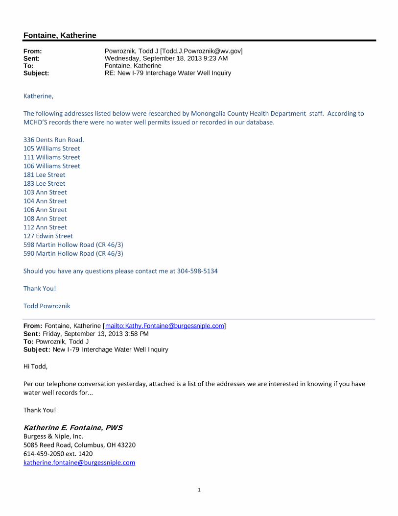
1
Fontaine, Katherine
From: Powroznik, Todd J [[email protected]]Sent: Wednesday, September 18, 2013 9:23 AMTo: Fontaine, KatherineSubject: RE: New I-79 Interchage Water Well Inquiry
Katherine, The following addresses listed below were researched by Monongalia County Health Department staff. According to MCHD’S records there were no water well permits issued or recorded in our database. 336 Dents Run Road. 105 Williams Street 111 Williams Street 106 Williams Street 181 Lee Street 183 Lee Street 103 Ann Street 104 Ann Street 106 Ann Street 108 Ann Street 112 Ann Street 127 Edwin Street 598 Martin Hollow Road (CR 46/3) 590 Martin Hollow Road (CR 46/3) Should you have any questions please contact me at 304‐598‐5134 Thank You! Todd Powroznik
From: Fontaine, Katherine [mailto:[email protected]] Sent: Friday, September 13, 2013 3:58 PM To: Powroznik, Todd J Subject: New I-79 Interchage Water Well Inquiry Hi Todd, Per our telephone conversation yesterday, attached is a list of the addresses we are interested in knowing if you have water well records for... Thank You!
Katherine E. Fontaine, PWS Burgess & Niple, Inc. 5085 Reed Road, Columbus, OH 43220 614‐459‐2050 ext. 1420 [email protected]
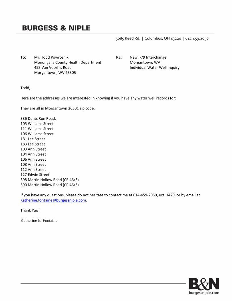
5085 Reed Rd. | Columbus, OH 43220 | 614.459.2050
To: Mr. Todd Powroznik RE: New I-79 Interchange Monongalia County Health Department Morgantown, WV 453 Van Voorhis Road Individual Water Well Inquiry Morgantown, WV 26505 Todd, Here are the addresses we are interested in knowing if you have any water well records for: They are all in Morgantown 26501 zip code. 336 Dents Run Road. 105 Williams Street 111 Williams Street 106 Williams Street 181 Lee Street 183 Lee Street 103 Ann Street 104 Ann Street 106 Ann Street 108 Ann Street 112 Ann Street 127 Edwin Street 598 Martin Hollow Road (CR 46/3) 590 Martin Hollow Road (CR 46/3) If you have any questions, please do not hesitate to contact me at 614-459-2050, ext. 1420, or by email at [email protected]. Thank You! Katherine E. Fontaine

2
Note: These electronic documents are provided by Burgess & Niple (B&N) as a convenience to our clients. It is our professional opinion that this electronic information provides information current as of the date of its release. Any use of this information is at the sole risk and liability of the user. The user is responsible for updating information to reflect any changes in the information following the preparation date of this transmittal.The delivery of this information in electronic format is for the benefit of the owner for whom the services have been performed. Nothing in the transfer should be construed to provide any right to third parties to rely on the information provided, or that the use of this information implies the review and approval of Burgess & Niple.
APPENDIX D (on CD)
WETLAND DELINEATION AND AQUATIC RESOURCES INVENTORY REPORT

APPENDIX E
WVDNR RARE, THREATENED & ENDANGERED SPECIES – CORRESPONDENCE DATED 6/18/2013
U.S. FISH & WILDLIFE SERVICES - CORRESPONDENCE DATED 8/5/2013 INDIANA BAT SURVEY REPORT (On CD)


APPENDIX F (on CD)
HAZARDOUS MATERIALS ASSESSMENT REPORT
APPENDIX G
TYPICAL CROSS SECTIONS OF ROADWAYS

THROUGH LANETHROUGH LANETHROUGH LANE TURNING LANE TURNING LANE
DOWNHILL COASTSHARED BIKE LANE
LANEBIKE
CLIMBUPHILL
WALKSIDE-
CONCRETE DECK8" REINFORCED
2 % 2 %
2 % 2 %
B COUNTY ROUTE 46/3
LANELANE GRAVEL SHOULDER, TYP.
BRIDGE TYPICAL SECTION
THROUGH LANETHROUGH LANETHROUGH LANE TURNING LANE TURNING LANE
DOWNHILL COASTSHARED BIKE LANE
LANEBIKE
CLIMBUPHILL
WALKSIDE-
2 % 2 %
TYPICAL SECTION
THROUGH LANETHROUGH LANETHROUGH LANETHROUGH LANE TURNING LANE
DOWNHILL COASTSHARED BIKE LANE
LANEBIKE
CLIMBUPHILL
WALKSIDE-
2 % 2 %
TYPICAL SECTION
B UNIVERSITY TOWN CENTRE DRIVE
B UNIVERSITY TOWN CENTRE DRIVE
B UNIVERSITY TOWN CENTRE DRIVE
TYPICAL SECTIONS
INSIDE RAMP INTERSECTIONSUNIVERSITY TOWN CENTRE DRIVE
(SIDEWALK MAY TERMINATE AT THE BALLPARK)BEYOND EASTERN RAMP INTERSECTIONS
UNIVERSITY TOWN CENTRE DRIVE
3
46 TYPICAL SECTION COUNTY ROUTE
2 % 2 %
B COUNTY ROUTE 49/1
LANE
1
49 TYPICAL SECTION COUNTY ROUTE
THROUGH LANE
WALKSIDE-
2 % 2 %
TYPICAL SECTION
B UNIVERSITY TOWN CENTRE DRIVE
BEYOND WESTERN RAMP INTERSECTIONSUNIVERSITY TOWN CENTRE DRIVE
STRIPED MEDIAN
VARIES (36’ TO 70’) ROADWAY WIDTH
ALTERNATIVE 2
5’-0"
85’-3"
1’-0"
11’-0"11’-0"11’-0"11’-0"13’-0"
2’-0" SHOULDER
78’-0" ROADWAY WIDTH
13’-0" SHOULDER
1’-3"
6’-0"
78’-0" ROADWAY WIDTH
74’-0"
11’-0"11’-0"11’-0"11’-0"13’-0"
11’-0" SHOULDER
6’-0"
70’-0"
66’-0" ROADWAY WIDTH
13’-0" 11’-0" 14’-0" 11’-0" 11’-0" 6’-0"
13’-0" VARIES (0’ TO 33’) 13’-0" 11’-0"
12’-0"
2’-0"
2’-0" PAVED SHOULDER
10’-0"10’-0"
REQUIREDGUARDRAIL AS
REQUIREDGUARDRAIL AS
REQUIREDGUARDRAIL AS
REQUIREDGUARDRAIL AS
REQUIREDGUARDRAIL AS
G110G3
2’-0" SHOULDER 2’-0" SHOULDER
TURN LANE
SHARED BIKE LANE SHARED BIKE LANE
THROUGH LANE
L
L
L
L
L
L
5’-0"
5’-0"
5’-0"
2’-0" 2’-0"
2’-0" 2’-0"
2’-0"2’-0"
SHOULDER2’-0" PAVED
SHOULDER, TYP.2’-0" GRAVEL
6’ MIN.
PARKERSBURG, WV
J04C23C03-PLAN e
REVISION SHEET
NUMBER NUMBERDATE BYREVISION
Public
Roads
Div.
State
Dist.
No.
ProjectProject No. Year
CountyNo. Sheets
4W.V.U331-
79- MONONGALIA
TotalSheetFiscalFederalState
No.
P:\
PR52354\cadd\
RD
Y_T
YP_I-
79-
Alt
2_2.d
gn
D
D-
MM
M-
YY
YY
HH:M
M
2014
153.30 00
NHPP-0793
(238)
PLAN SHEET
THE WEST VIRGINIA DEPARTMENT OF TRANSPORTATION
DIVISION OF HIGHWAYS