new mapping tools for transportation engineering 2d data... · • 3d autocad files ... new mapping...
TRANSCRIPT

TechTimeNew Mapping Tools for Transportation Engineering
Brendan Walashek
McElhanney Consulting Services Ltd.

Agenda
• A Quick History of 3D Views
• Source Data for 3D Views
• Tools to Make 3D Views
• How We Make 3D Views
• Examples:
o transportation,
o recreation and
o real estate.
TechTimeNew Mapping Tools for Transportation Engineering

A Quick History of 3D Views• Flat draping of imagery on DEM
(typically using satellite imagery or other images
with coarse ground resolution)
• Uses a bare earth DEM
• Image processing and GIS
software provided this
basic capability starting
late 1980‟s
• Example circa 1998
TechTimeNew Mapping Tools for Transportation Engineering

A Quick History of 3D Views• Draping imagery including building heights in DEM
o Gives buildings dimension but other supporting features are flat
o Very quick – still „flat‟
TechTimeNew Mapping Tools for Transportation Engineering

A Quick History of 3D Views• Draping imagery and Placing 3D features on DEM
o Manmade 3D features of interest are typically generated in
AutoCAD or other 3D design tool
o Supporting natural features, (e.g. trees, clouds), and other
manmade
features, (e.g. golf
carts, stop signs),
are stored in a library
Image copyright Marco Gualdrini
TechTimeNew Mapping Tools for Transportation Engineering

Source Data for 3D Views
• Orthophotos
• Satellite imagery
• LiDAR and other DEMs
• Vector GIS data
• 3D AutoCAD files
• Terrestrial based photos
TechTimeNew Mapping Tools for Transportation Engineering

Source Data for 3D Views
• Orthophotoso Multiple resolutions (10cm to 50cm common)
o Multiple formats (TIFF and ECW common)
o Map projections (usually UTM)
• Recommend o 50cm
o ECW format
o UTM
o Single seamless image
TechTimeNew Mapping Tools for Transportation Engineering

Source Data for 3D Views
• Satellite imageryo Multiple resolutions (50cm to 25m common)
o Multiple formats (TIFF and ECW common)
o Map projections (usually UTM)
• Recommend o <1m (foreground), background (25m Landsat)
o ECW format
o UTM
o Single seamless image
TechTimeNew Mapping Tools for Transportation Engineering
Source Data for 3D Views
• LiDAR and other DEMs
o Massive amounts of point cloud data from LiDAR (.LAS format)
o Request bare earth DEM from LiDAR data
o Municipal DEMs from LiDAR and/or photogrammetric processes (high precision)
o Provincial government (1:20,000) DEMs 20m grid
o Federal government (1:50,000) DEMs 0.75 arc seconds or 23m grid (free via GeoBase website)
TechTimeNew Mapping Tools for Transportation Engineering

Source Data for 3D Views
• LiDAR and other DEMs
o LiDAR = best source data = “classification”
• Recommend
o 30m DEM for flights over 300m upward
o for drive throughs (at pavement level) use 5m as more ground detail
is needed.
TechTimeNew Mapping Tools for Transportation Engineering
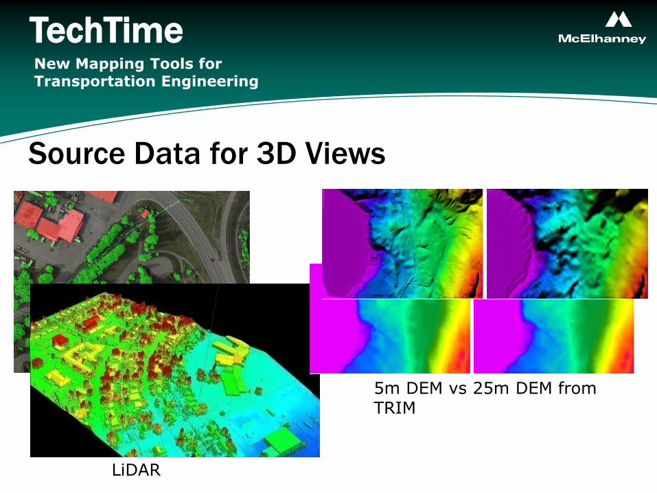
Source Data for 3D Views
• Example DEMs
LiDAR
5m DEM vs 25m DEM from TRIM
TechTimeNew Mapping Tools for Transportation Engineering

Source Data for 3D Views
• Vector GIS data
o 3D Shapefiles are most useful (for VNS software)
o 2D Shapefiles, MapInfo TAB, AutoCAD, DGN are common
• 3D AutoCAD files
o Most 3D structures, such as bridges, are designed in AutoCAD by engineering companies (DWG or DXF formats)
o Structures can be brought into other 3D visualization packages
TechTimeNew Mapping Tools for Transportation Engineering

Tools to Make 3D Views
• KLT
• Visual Nature Studio
• Autodesk 3D Studio Max
• Google SketchUp
• ArcGIS
• MapInfo Professional
• Adobe PhotoShop and Premier Elements
No one tool can do
everything you need.
TechTimeNew Mapping Tools for Transportation Engineering

Tools to Make 3D Views• KLT (WinTINviewer, part of the KLT-TIN package)
o Part of photogrammetric package by KLT Associates
o We use to digitize features from airphotos as 3D objects, (e.g.
buildings, roads, bridges)
TechTimeNew Mapping Tools for Transportation Engineering

Tools to Make 3D Views• Visual Nature Studio
o is a professional photorealistic terrain visualization, modeling &
rendering package developed by 3D Nature LLC
o Also has a real time 3D navigation module
© 3D Nature LLC
TechTimeNew Mapping Tools for Transportation Engineering

Tools to Make 3D Views• Google SketchUp Pro Example
TechTimeNew Mapping Tools for Transportation Engineering

Tools to Make 3D Views• Google SketchUp Pro Example - Textures
TechTimeNew Mapping Tools for Transportation Engineering

Tools to Make 3D Views
• Adobe PhotoShop and Premier Elements
o Photoshop for touching up 3D still views.
o Premier Elements for putting together stills to form a video, adding
annotation, and to convert from one video format to another (avi,
mov, flash, NVW).
TechTimeNew Mapping Tools for Transportation Engineering

3D Flythrough Workflow
3D VirtualFlythrough
3D Object Models
Terrain Model Vegetation Model
Groundtruthed vegetation(wetlands)
Used orthophoto to classify species, density, heights
DEM‘merge & massage’
Design DEM tiles
Existing DEM tiles
Construct bridges in 3D Max from drawings
Apply textures
Position in VNS model
Rendering and Assembly
Setup Cameras
Plan Flight Path
Render frames@ 20 fps
Populated model with vegetation maps
AutoCAD Design Drawing
Assemble movie(titles, stills, frames)

Examples – Real Estate
TechTimeNew Mapping Tools for Transportation Engineering

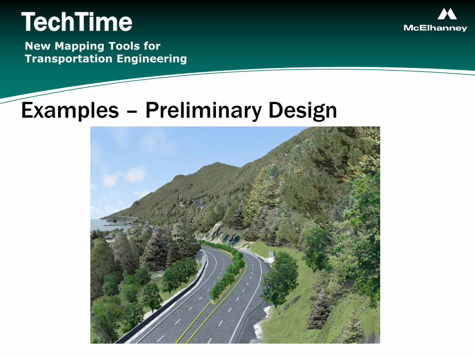
Examples – Preliminary Design
TechTimeNew Mapping Tools for Transportation Engineering

Examples – Impact Assessment
TechTimeNew Mapping Tools for Transportation Engineering
Examples – Preliminary Design
TechTimeNew Mapping Tools for Transportation Engineering

Examples – Preliminary Design
TechTimeNew Mapping Tools for Transportation Engineering

Examples – Preliminary Design
TechTimeNew Mapping Tools for Transportation Engineering
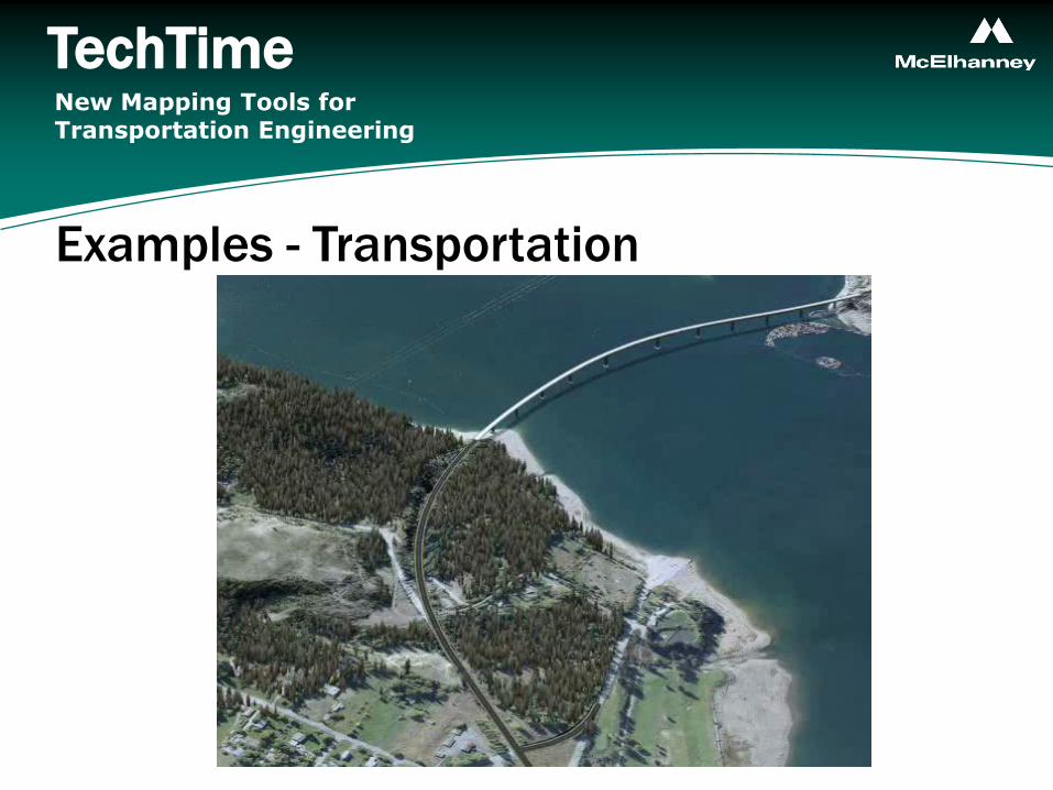
Examples - Transportation
TechTimeNew Mapping Tools for Transportation Engineering

Examples – Mineral Exploration
TechTimeNew Mapping Tools for Transportation Engineering
