new mexico wetland vegetation communities - all about watersheds
TRANSCRIPT

Handbook of Wetland Vegetation Communities of New Mexico
Volume I: Classification and Community Descriptions
Esteban Muldavin, Paula Durkin, Mike Bradley, Mary Stuever and Patricia Mehlhop
New Mexico Natural Heritage Program, Biology Department University of New Mexico, Albuquerque, New Mexico 87131
2000
________________________________________________________________________
Summary In support of the New Mexico Wetlands Conservation Plan, this handbook was developed to aid inventory and assessment of the State's wetland vegetation communities. In Volume I a hierarchical vegetation classification is presented which provides detailed information about individual wetland plant community types of the state (including those of marshes, streamside riparian areas, playas, wet meadows, lakeshores, and peatlands). The classification system is based on six years of fieldwork concentrated in the major river basins of New Mexico, and on information from the literature. The study areas include the main stems and major tributaries of the Pecos, upper and middle Rio Grande, Gila, San Francisco, Mimbres, San Juan, Little Colorado, and Canadian Rivers within New Mexico. This classification identifies a total of 135 plant communities (or associations) which occur within 33 plant alliances (or series). The three major categories include forested wetlands (61 community types), scrub-shrub wetlands (38 community types), and emergent or herbaceous wetlands (36 community types). Descriptions for each community type include information addressing known geographic distribution, species composition, hydrological and soil characteristics, ecological dynamics, and conservation status. Volume II supports this document by describing reference sites where many of these plant communities may be found in relatively good condition. This two-volume reference represents the first major, statewide effort in developing a comprehensive vegetation classification for New Mexico wetlands. However, many of the community types described here are still considered “provisional” and will benefit from additional field inventory. User feedback is encouraged to enhance the classification and provide additional information on the status of these valuable economic and biological resources of the State.
Acknowledgements This work was partially funded by the U.S. Environmental Protection Agency through grant CD-996564-01-1 and previous grants for the protection of wetlands in New Mexico to the New Mexico Environment Department, Surface Water Quality Bureau, Santa Fe, NM, and the New Mexico Natural Heritage Program of the Biology Department, University of New Mexico, Albuquerque, NM. Additional support was provided by the New Mexico Natural Heritage Program, the Bureau of Land Management and the Turner Foundation. We thank the following for their contributions both in the field and to the overall project: Melanie Deason, Stacey Carr, Keith Elliott, Hamilton Smith, and Erik Galloway. Rebecca Keeshen, Noel Sorrell, Elizabeth Milford and Kyleb Wild provided substantial editorial assistance. Chuck Gruver of Belen, NM, provided volunteer aerial reconnaissance support. Special thanks goes to Ted Kline of Photoair Inc., Traverse City, MI, for his dedicated and unselfish contribution to the aerial survey and aerial photography work over the duration of this project.
ii
Table of Contents
SUMMARY ...................................................................................................................................................................i
ACKNOWLEDGEMENT..............................................................................................................................................i
List of Tables............................................................................................................................................................... iii
List of Figures.............................................................................................................................................................. iii
List of Appendices........................................................................................................................................................iv
INTRODUCTION.........................................................................................................................................................1
Wetland Ecosystems..................................................................................................................................................2 Classification and Reference Site Updates ................................................................................................................3
STUDY AREA..............................................................................................................................................................4
Pecos Watershed........................................................................................................................................................5 Rio Grande Watershed...............................................................................................................................................5 Gila, San Francisco, and Mimbres River Watersheds ...............................................................................................7 San Juan and Little Colorado Watersheds .................................................................................................................7 Canadian River Watershed ........................................................................................................................................8 The Central Closed Basins.........................................................................................................................................9
METHODS....................................................................................................................................................................9
Site Delineation and Sampling Strategy ....................................................................................................................9 Plot Sampling ..........................................................................................................................................................10 Stream Channel Cross-section and Flow Measurements .........................................................................................10 Databases .................................................................................................................................................................11 Hydrology Analysis .................................................................................................................................................11
Rosgen Stream Types...........................................................................................................................................11 Recurrence Interval and Discharge Ratio Calculations......................................................................................12
Soils Classification and Wetness Ranking...............................................................................................................13 Wetland Vegetation Classification System..............................................................................................................16 Natural Heritage Conservation Ranking System .....................................................................................................18 Wetlands Assessment and Reference Sites..............................................................................................................18
NEW MEXICO WETLANDS CLASSIFICATION ...................................................................................................20
The Wetland Classification......................................................................................................................................20 Conservation Status .................................................................................................................................................20
KEYS AND COMMUNITY TYPE DESCRIPTIONS ...............................................................................................29
Key to the Wetland Classes .....................................................................................................................................31 Forested Wetlands ...................................................................................................................................................31
Arizona Alder Alliance ........................................................................................................................................33 Arizona Sycamore Alliance..................................................................................................................................37 Arizona Walnut Alliance......................................................................................................................................41 Blue Spruce Alliance ...........................................................................................................................................44 Boxelder Alliance ................................................................................................................................................47 Fremont Cottonwood Alliance.............................................................................................................................50 Goodding Willow Alliance...................................................................................................................................57 Narrowleaf Cottonwood Alliance ........................................................................................................................59 Netleaf Hackberry Alliance .................................................................................................................................69 Plains Cottonwood Alliance ................................................................................................................................71

iii
Russian Olive Alliance.........................................................................................................................................87 Scrub-Shrub Wetlands .............................................................................................................................................90
Bluestem Willow Alliance ....................................................................................................................................91 Coyote Willow Alliance .......................................................................................................................................96 Diamondleaf Willow Alliance ............................................................................................................................105 Emory Baccharis Alliance .................................................................................................................................107 River Birch Alliance ..........................................................................................................................................110 Saltcedar Alliance..............................................................................................................................................112 Seepwillow Alliance...........................................................................................................................................118 Thinleaf Alder Alliance......................................................................................................................................121
Persistent Emergent (Herbaceous) Wetlands.........................................................................................................124 Baltic Rush Alliance ..........................................................................................................................................128 Beaked Sedge Alliance.......................................................................................................................................131 Broadleaf Cattail Alliance .................................................................................................................................133 Common Spikerush Alliance..............................................................................................................................135 Inland Saltgrass Alliance...................................................................................................................................137 Mud Sedge Alliance ...........................................................................................................................................141 Northern Mannagrass Alliance .........................................................................................................................144 Reed Canarygrass Alliance ...............................................................................................................................146 Softstem Bulrush Alliance..................................................................................................................................148 Spreading Yellowcress Alliance.........................................................................................................................150 Threesquare Bulrush Alliance ...........................................................................................................................152 Vine Mesquite Alliance ......................................................................................................................................156 Water Sedge Alliance.........................................................................................................................................158 Woolly Sedge Alliance .......................................................................................................................................162
REFERENCES ..........................................................................................................................................................164
List of Tables Table 1. Rosgen Stream Type Descriptions................................................................................................................12 Table 2. Wetness Characteristics of Sampled Soils. ...................................................................................................15 Table 3. The New Mexico Wetland Classification Hierarchy ....................................................................................17 Table 4. Water Regime Modifiers. .............................................................................................................................18 Table 5. Conservation Status Global and State Element Ranks..................................................................................19 Table 6. New Mexico Wetlands Vegetation Classification ........................................................................................22 Table 7. Canopy Cover Descriptors and Definitions.. ................................................................................................30
List of Figures Figure 1. Survey sample sites for the New Mexico Wetland Vegetation Classification. .............................................4 Figure 2. Distribution of community type global ranks by class ................................................................................28 Figure 3. Arizona Alder/Goodding Willow Community Type...................................................................................33 Figure 4. Arizona Sycamore/Thinleaf Alder-Seepwillow Community Type .............................................................37 Figure 5. Arizona Walnut-Netleaf Hackberry/California Brickellbush Community Type.. .......................................41 Figure 6. Blue Spruce/Thinleaf Alder-Wood Rose Community Type........................................................................44 Figure 7. Boxelder/Thinleaf Alder Community Type. ...............................................................................................47 Figure 8. Fremont Cottonwood-Goodding Willow/Coyote Willow Community Type. .............................................50 Figure 9. Goodding Willow Alliance. ........................................................................................................................57 Figure 10. Narrowleaf Cottonwood-Boxelder/Kentucky Bluegrass Community Type..............................................59

iv
Figure 11. Netleaf Hackberry/California Brickellbush Community Type..................................................................69 Figure 12. Plains Cottonwood/Big Sagebrush Community Type. ..............................................................................71 Figure 13. Russian Olive Alliance.. ............................................................................................................................87 Figure 14. Bluestem Willow/Common Spikerush Community Type .........................................................................91 Figure 15. The Coyote Willow Alliance.....................................................................................................................96 Figure 16. Diamondleaf Willow/Water Sedge Community Type. ...........................................................................105 Figure 17. Emory Baccharis/Inland Saltgrass Community Type..............................................................................107 Figure 18. River Birch-Redosier Dogwood Community Type.................................................................................110 Figure 19. Saltcedar/Alkali Sacaton Community Type. ...........................................................................................112 Figure 20. Seepwillow Alliance. ..............................................................................................................................118 Figure 21. Thinleaf Alder Alliance...........................................................................................................................121 Figure 22. Baltic Rush Alliance................................................................................................................................128 Figure 23. Beaked Sedge-Baltic Rush Community Type .........................................................................................131 Figure 24. Broadleaf Cattail Alliance .......................................................................................................................133 Figure 25. Common Spikerush Alliance...................................................................................................................135 Figure 26. Inland Saltgrass Alliance.........................................................................................................................139 Figure 27. Mud Sedge-Fewflower Spikerush Community Type ..............................................................................142 Figure 38. Northern Mannagrass-Beautiful Spikerush Community Type. ...............................................................144 Figure 29. Reed Canarygrass Alliance. ....................................................................................................................146 Figure 30. Softstem Bulrush-Broadleaf Cattail Community Type. ..........................................................................148 Figure 31. Spreading Yellowcress Alliance..............................................................................................................150 Figure 32. Threesquare Bulrush Alliance. ................................................................................................................152 Figure 33. Vine Mesquite-Blueweed Sunflower Community Type .........................................................................156 Figure 34. Water Sedge-Pointed Sedge Community Type .......................................................................................158 Figure 35. Woolly Sedge-Common Spikerush Community Type. ...........................................................................162
List of Appendices
APPENDIX A. Plant Species List for the New Mexico Wetland Community Classification.
APPENDIX B. Additional Wetland Vegetation Types Possible for New Mexico.
APPENDIX C. New Mexico Wetland Vegetation Community Classification Cooperator Input Forms.

1
Introduction
New Mexico's wetlands are important biological and economic resources because of the unique environments they provide along the state's springs, marshes, lakes, streams and rivers. They lie in the transition from land to water, and help maintain water quality and quantity, stabilize streambanks, provide flood protection, and enhance habitat for fish and wildlife (EPA 1988). Wetlands are highly productive ecosystems that support a wide variety of plants and animals not found elsewhere in the surrounding landscape. Currently, the integrity of these rich and diverse landscapes is threatened by increasing pressures from urbanization and agriculture, by dams, water diversions, channelization, and over-utilization of forage. The recognition of the peril to these ecosystems at both the state and national levels has spurred the development of a Wetlands Conservation Plan for New Mexico to support the long-term sustainability of the biota and associated economic values.
One of the major goals of the State Wetlands Conservation Plan is an inventory and assessment of wetland resources of New Mexico. Accordingly, the New Mexico Natural Heritage Program conducted a series of vegetation surveys of wetlands (including marshes, streamside riparian areas, playas, wet meadows, lakeshores, and peatlands) in the major river basins of the state. Included were the mainstems and major tributaries within the Pecos, upper and middle Rio Grande, Gila, San Francisco, Mimbres, San Juan, Little Colorado, and Canadian drainages (Muldavin 1991; Muldavin, Sims, and Johnson 1993; Muldavin, Wallace and Mehlhop 1993; Durkin et al. 1994a & b; Durkin et al. 1995a & b; Durkin et al. 1996; Durkin et al. 1997). The objective of the surveys was to describe the composition, structure, and environment of the wide variety of wetland vegetation communities of the state, and to begin building a database of wetland/riparian reference sites that best exemplify these communities.
This publication integrates previous years’ work into a two-volume handbook to be used as a tool in the ongoing classification, assessment, and prioritization of wetlands in support of the State's wetlands conservation planning process. Volume I focuses on describing the wide variety of individual wetland plant communities within the state with detailed descriptions and diagnostic keys, along with an overview of the survey history, methods, and analysis. It is organized around a hierarchical wetland vegetation classification system which was developed from field data and literature sources. It draws upon the National Vegetation Classification System (Grossman et al. 1998; Federal Geographic Data Committee 1996) and the Classification of Wetlands and Deepwater Habitats for the United States (Cowardin et al. 1979), along with regional work such as that of Dick-Peddie (1993), Szaro (1989), and Brown, Lowe, and Pase (1979). The classification provides a framework for understanding the range of variability among the wetland vegetation community types of New Mexico, and can be used as an effective tool for inventory and assessment of the state's wetlands. Each community type is described with respect to geographic distribution, species composition, hydrological and soil characteristics, ecological dynamics, and conservation status using the national Heritage Program Network global rarity ranking system (based on the number of overall occurrences of a given community type and their quality). Such detailed descriptions are particularly useful for understanding and assessing the ecological composition and conditions of a given wetland site. The handbook is designed for use by a broad audience in both the field and office. Throughout the handbook, scientific information has been summarized concisely, with a focus on applications for inventory and assessment.
Volume II contains descriptions of 38 reference sites that were identified during the course of our surveys as supporting some of the states finer examples of wetland communities. These reference sites were drawn from a pool of over 300 sites that were evaluated through a combination of ground and aerial reconnaissance, aerial photography interpretation, and vegetation maps. The reference sites were selected based on their quality and condition, and are considered benchmark sites against which other wetland areas can be measured. Detailed descriptions have been developed which include site summaries, photographs, stream channel cross-sections, and a map with provisional site boundaries. Along with the descriptions, site evaluation criteria were outlined as an aid in future assessment work for the statewide Wetlands Conservation Plan.
Although this survey covered a wide area of the state, available resources limited in the number of tributaries and stream segments that could be sampled, and many wetland sites remain to be described and evaluated as part of the wetlands conservation planning process. The majority of the community types described in Volume I lack sufficient data to be given “established” rather than “provisional” status. A comprehensive inventory and assessment remains a great challenge that will require the efforts of many organizations and individuals throughout the state over many years. Our hope is that this handbook and associated database will be a welcome aid in this endeavor.

2
Wetland Ecosystems
Although wetlands and riparian zones occupy only a small portion of a watershed, they are an extremely important ecological component of the landscape (Elmore and Beschta 1987). Wetland/riparian ecosystems are considered to be among the rarest habitats in the Western Hemisphere (Krueper 1996). In the arid and semiarid landscape, wetland and riparian vegetation is estimated to comprise less than one percent of the landscape (Knopf et al. 1988). Yet, despite their rarity, the greatest diversity of native vegetation communities, along with those of birds, fish, and terrestrial vertebrates, occurs in the riparian zones of the Southwest (Hink and Ohmart 1984; Siegel and Brock 1990; Howe and Knopf 1991; Durkin et al. 1995b). In New Mexico and Arizona, "80 percent of all vertebrates use riparian areas for at least half their life cycles; more than half of these are totally dependent on riparian areas" (National Wetlands Inventory 1998). Given the value and importance of the ecosystems, effective tools for their inventory and assessment are critical to the successful development of a statewide Wetlands Conservation Plan.
For the purposes of inventory and assessment, wetlands are defined here as marshes, cienegas, streamside riparian areas, playas, wet meadows, lakeshores, bogs, peatlands, and other ecosystems which hold in common a dependence on flooding or water saturation of the soil for significant periods of time, and an overall immediate connectedness between water table and the expression of vegetation at a site. This is a non-regulatory definition whose intent is to encompass not only communities of marshes and lake shores and other typical lentic wetland landscapes, but also the wide variety of lotic riparian wetland communities that occur along the rivers and streams of New Mexico.1 Riparian zone communities are usually strikingly different from those of their surrounding uplands, and have been included within the concept of wetlands by Minckley and Brown (1982), Brown, Lowe, and Pase (1979), Johnson and Lowe (1985), Lowe, Johnson, and Bennett (1986), Krueper (1996) and Cowardin et al. (1979).2 This contrast with uplands is driven by the presence of obligate or facultative wetland plant species3 that are dependent on either periodic inundation or sub-surface groundwater flows associated with the adjacent rivers and streams. Furthermore, most soils of riparian areas exhibit at least some wetness (hydric) characteristics associated with periodic or long-term saturation by water. Similarly, we also include in our wetlands designation playa lakes that fill with water seasonally, and exhibit a characteristic vegetation dependent on periodic inundation, along with soils that reflect poor drainage conditions (Randall clays).
This definition of wetlands implies that the patterns and processes of these ecosystems are driven by the nature of the impinging hydrological regime—the duration of flooding and its periodicity, the amount of water and how it enters and leaves the system, and how the water shapes the landscape. The dynamics and configuration of channels, periodic flooding, sustained seasonal flows, the nature of the sediments, and the presence or absence of large woody debris result in specific geomorphic settings and associated soil moisture conditions (Heede 1985; Hupp and Osterkamp 1985; Minkley and Rinne 1985; Hupp 1992; Malanson 1993; Muldavin, Sims, and Johnson 1993). Riparian zones in particular are flood-driven environments where the effects of floods can be destructive or constructive to wetland communities (Szaro 1989; Leonard et al. 1992). High water flows can erode stream banks, shift channels, deepen (degrade) and remove sediments from the stream, and disrupt or destroy stands of wetland vegetation. Conversely, floods may deposit sediment and build river bars and terraces where wetland vegetation communities can become established and mature. This leads, under natural hydrological conditions, to dynamic and complex landscapes which can support a wide variety of wetland communities that progress through various stages of development as the sites themselves change ("site progression" of Leonard et al. 1992).
In addition, riparian wetlands require minimum seasonal flows of water for plant recruitment, maintenance, growth and development (Bock and Bock 1985; Brady, Patton, and Paxson 1985; Asplund and Gooch 1988; Szaro 1989; Siegel and Brock 1990; Leonard et al. 1992; Stromberg and Patten 1991; Stromberg et al. 1993; Crawford et
1 For regulatory purposes see the wetland definition given in the 1987 Corps of Engineers Wetlands Delineation Manual (Environmental Laboratory 1987). 2 The U.S. Fish and Wildlife Service National Wetlands Inventory (National Wetlands Inventory 1998) has proposed a "Riparian System" modification to Cowardin et al. (1979) that defines riparian communities as transitional between wetlands and uplands, but that are "contiguous to and affected by surface and subsurface hydrologic features of perennial or intermittent lotic and lentic waterbodies (rivers, streams, lakes, or drainage ways)." 3 Based on the U.S. Fish and Wildlife Service wetlands plant species indicator definitions: obligate wetland species occur almost always (estimated probability >99%) under natural conditions in wetlands; facultative wetland species usually occur in wetlands (estimated probability 67%-99%), but occasionally are not found in wetlands (Reed 1988).

3
al. 1993; Muldavin, Sims and Johnson 1993). In playas, marshes, and along lakesides, the establishment, maintenance and pattern of wetland vegetation communities is also dependent on sustained water levels both on a seasonal and annual basis. Subsurface groundwater and subsurface stream flows further play an integral role in plant establishment, species replacement patterns, maintenance of species, and “patch” diversity, as well as in nutrient cycling and productivity (Leonard et al. 1992; Stromberg et al. 1993; Stromberg, Tiller, and Richter 1996). The result is that any given reach or water body supports an "ecological complex" of wetland community types whose pattern of expression is strongly controlled by the flood-driven geomorphic setting and water-table-linked soil moisture conditions. In any given wetland ecological complex, community types can range from very wet (traditional marshes) to relatively dry (riparian gallery forest of river terraces), but they are all ecologically interdependent (both in space and time) and more closely aligned to one another as a group than they are to surrounding upland communities.
The concepts of wetland "community types" and "ecological complexes" can be applied as an aid in the management, inventory and assessment of the State's wetlands using the tools provided in this handbook. The classification of community types (also referred to as plant associations and habitat types) provides a framework for describing and recognizing patterns in the way vegetation is expressed on the landscape. Furthermore, by grouping land areas based on their ability to support similar plant community types, general management observations and recommendations can be made for each grouping. In the past thirty years, resource managers have found that the classification of vegetation into community types has provided valuable insight into the composition, structure and function of ecosystems, and enhanced our ability to predict vegetative changes to various disturbances (Moir and Ludwig 1984; Maybury 1999).
The classification also provides the foundation for mapping and assessment of wetland ecological complexes. For example, the first step might be to initially define a wetland "site" in terms of the landscape structure, such as a stream segment of uniform gradient and channel morphology; or in terms of the limits of the influence of a water body, such as playa wetland or a pond. Next, the ecological complex at a site can be described in terms of its component vegetation community types using the hierarchical wetland vegetation community classification provided in Table 6. This can take the form of simply using the diagnostic keys to determine the community types present and their relative contribution to the ecological complex, or going further and mapping and/or describing the ecological relationships within and among community types of the complex using information provided in community type descriptions. The last step is to assess the quality of the wetland site in terms of the status of each community type and of the ecological complex as a whole. There are numerous approaches to assessing wetland status that are supported by various agencies and organizations (see Proper Functioning Condition used by the Bureau of Land Management and other land agencies (Prichard et al. 1995), or the Hydrogeomorphic Approach (HGM) developed by the Army Corps' Waterways Experiment Station). We have also provided in Volume II the set of assessment guidelines developed by the New Mexico Natural Heritage Program during the course of this survey for the determination of the wetland "reference sites." These guidelines are based on the National Heritage Network protocols, and focus on evaluating the condition of community type occurrences in terms of intrinsic qualities such as species composition and structure, and of the impinging hydrological regime and surrounding landscape pattern (e.g., degree of hydrological modification, degree of landscape fragmentation, etc.).
Classification and Reference Site Updates
In an effort to further enhance the classification, inventory and evaluation of the state's wetland ecosystems, organizations and individuals are encouraged to contribute directly to the vegetation classification and reference site database. The wetlands database currently being developed by the New Mexico Natural Heritage Program is a dynamic system that can be updated as new information becomes available. Initially, the sites surveyed during this classification project are being entered through a geographic information system (GIS) into the database, and the long-term goal is to catalogue as many reference sites as possible throughout the state. The focus is on identifying the highest quality sites remaining along the rivers, streams and lakes of New Mexico, and on effectively and uniformly tracking their ecological condition and conservation status over time. In Appendix C we have provided instructions and forms to assist those who wish to gather information for submission to the New Mexico Natural Heritage Program at the University of New Mexico for inclusion in the database. Comments on how we might modify the database to better achieve the goals for conservation of the wetland resources of the state are welcome (see the NMNHP web page at http://nmnhp.unm.edu).

4
$T$T$T$T$T$T$T$T$T$T
$T
$T$T$T
$T$T$T$T$T$T
$T$T$T$T$T$T$T$T$T$T$T$T$T$T$T$T$T$T$T$T$T$T$T$T$T$T$T$T
$T$T$T
$T$T$T
$T
$T$T$T
$T
$T
$T
$T$T$T$T$T
$T
$T$T$T
$T$T$T
$T$T$T$T
$T$T$T$T$T$T$T$T$T$T$T$T$T
$T$T$T$T$T$T$T
$T$T$T$T$T$T$T$T$T$T
$T
$T
$T
$T
$T $T$T
$T
$T
$T
$T$T
$T
$T$T
$T
$T
$T
$T$T
$T
$T$T
$T$T
$T
$T
$T
$T
$T$T
$T$T
$T
$T
$T
$T
$T
$T
$T
$T$T
$T$T
$T$T$T
$T
$T$T$T$T
$T$T
$T$T
$T$T
$T
$T
$T
$T
$T
$T
$T
$T
$T
$T$T
$T$T
$T
$T
$T
$T
$T$T$T$T$T
$T$T
$T$T
$T
$T
$T $T$T$T
$T$T
$T
$T
$T
$T
$T$T
$T$T$T$T
$T
$T
$T
$T
$T
$T$T$T$T$T$T
$T
$T$T$T $T$T
$T$T
$T $T
$T
$T
$T
$T
$T
$T
$T
$T$T$T$T$T$T
$T$T$T$T
$T
$T
$T
$T$T$T
$T$T
$T$T$T$T
$T$T$T$T$T$T$T
$T$T
$T$T
$T
$T$T$T$T$T$T$T
$T$T$T
$T$T$T$T$T
$T$T$T$T$T$T$T$T $T$T$T
$T
$T$T$T$T$T$T$T$T$T$T$T
$T
$T$T
$T$T$T$T$T$T
$T
$T$T$T
$T$T$T
$T$T
$T
$T
$T$T$T$T$T
$T$T
$T
$T$T
$T$T
$T $T$T$T$T$T
$T$T$T
$T
$T$T
$T
$T
$T
$T
$T
$T$T$T
$T
$T$T$T
$T
$T$T$T
$T Canadian$T Gila
A$T Pecos$T Rio Grande$T San Juan
0 40 80 KilometersN
Study Area This wetland vegetation classification for New Mexico was developed progressively during the course of
field surveys within five major drainage basins of the state conducted from 1993 to 1997. Each year the survey was confined within a single basin focusing on the main stems and major tributaries (Figure 1). The first classification was developed for the Pecos River Basin in 1991 and 1993. In 1994, the Rio Grande above Elephant Butte Reservoir was added. The Gila was completed in 1995 and included the San Francisco and Mimbres watersheds. The San Juan study along with the Little Colorado Sub-basin was finished in 1996. In 1997, the Canadian River watershed of the Arkansas/Red/White Basin was surveyed, and then playas in the northeastern part of the state were added in 1998 to complete the series. The Central Closed Basins were later included using data collected by the New Mexico Natural Heritage Program on previous projects.
Figure 1. Sample sites for the New Mexico Wetland Vegetation Classification as distributed among the five major basins of the state.

5
Pecos Watershed
Surveys began in 1993 with the Pecos River watershed. It dominates the southern two-thirds of the eastern portion of New Mexico (Figure 1). The mainstem flows 435 miles from the Sangre de Cristo Mountains in northern New Mexico south through eastern New Mexico to Red Bluff Reservoir at the Texas border in Eddy County. The total watershed area is estimated at 25,992 square miles (New Mexico Water Quality Control Commission 1994). Elevations within the watershed range from 13,102 ft (3,994 m) at Truchas Peak in the north to 2,841 ft (866 m) at Red Bluff Reservoir. Within the Pecos River Basin there are eleven Hydrologic Units identified by the U.S. Geological Survey (corresponding to the codes 13060001 to 13060011, USGS 1974).
In addition to the mainstem, six major tributaries were surveyed: Cow Creek, Gallinas Creek, Yeso Creek, Rio Hondo, Rio Ruidoso, and the Black River. Cow Creek and Gallinas Creek, located in the northern part of the basin, flow from the Sangre de Cristo Mountains in a southeasterly trend through steep mountainous terrain and have plunging, perennial flows. Yeso Creek, located in the middle part of the basin, flows sluggishly to the east, draining the Yeso Hills and meeting the Pecos River in the plains of eastern New Mexico. Rio Hondo and Rio Ruidoso are found in the lower basin. Originating in steeper mountainous terrain out of the Sacramento Mountains the Rio Ruidoso and Rio Bonito flow east, and at their confluence form the Rio Hondo. Eventually the Rio Hondo descends underground as it exits the mountains. The last major tributary sampled was the Black River, which flows sluggishly in a northeasterly direction from the Guadalupe Mountains through the Chihuahuan Desert and joins the Pecos River near the Texas border.
Geologically, the Pecos River Basin lies between the Rio Grande Rift to the west and the Llano Estacado, a well-defined escarpment in the eastern plains that border Texas. Sedimentary rocks underlie most of the basin and range in age from Precambrian to Recent. Parts of the western mountainous areas are igneous and for the most part non-water-bearing (New Mexico Water Quality Control Commission 1994). The San Andres limestone, which contains the Roswell-Artesian aquifer, provides much of the water to the basin. Overall, there are few faults or folds, with some minor warping; most of the relief in the basin is provided by the Pecos River and its tributaries, with collapsed underground caverns dissolved in limestone, gypsum, and salts (Chronic 1987).
Climatic conditions of the basin vary considerably along the course of the Pecos, as a result of the wide range in geography and topography. Mountainous regions are climatically sub-humid and cool to frigid, while the southeastern plains have a semiarid, continental climate with hot summer days followed by cool nights. The upper basin receives moisture both from winter snowstorms that create extensive snowpacks, and from late summer rainstorms which are usually brief and intense. Spring runoff from the snowpack can be significant, and has the potential of causing extensive flooding downstream. Snowfall is less important in the lower basin, but summer rains can have a significant impact on short-term stream flow. The lower basin receives most of its moisture from June to August. As in the upper basin, summer storms are brief and intense. Yearly snowfall ranges from three to eight inches (8 to 20 cm) in Eddy County and from 18 to 36 inches (46 to 91 cm) in San Miguel County. Average annual temperatures vary widely across the basin from a low of 350 F (2 0C ) at Las Vegas to 790 F (26 0C ) at Carlsbad. Annual extremes have been recorded from a low of -270 F (-33 0C ) at Ft. Sumner in January 1963, to a high of 1160 F (47 0C ) at Artesia in June 1916 (Houghton 1971 and 1981).
The mainstem of the Pecos River and its tributaries flow through or border three major ecoregions as described by The Nature Conservancy (1997) and based on Bailey et al. (1994). In the upper basin of the Sangre de Cristo Mountains, the watershed lies within the Colorado Rocky Mountains Ecoregion. To the south, the river travels through Southern Shortgrass Prairie into the Chihuahuan Desert (Basin and Range Section). The southern tributaries drain out of the Arizona-New Mexico Ecoregion. With respect to the Omernick and Gallant (1987) ecoregions, the upper Pecos lies within the Southern Rockies, and the middle reach divides the Arizona/New Mexico Plateau of the west from the Southwestern Tablelands to the east. The southern extent is within the Southern Deserts with the tributaries draining the Arizona-New Mexico Mountains to the west.
Rio Grande Watershed
The Rio Grande Basin as a whole is the fifth largest watershed in North America. The mainstem flows nearly 2,000 miles from its headwaters in the San Juan Mountains of southern Colorado through central New Mexico, running along the southwestern edge of Texas as it forms the international border between the United States

6
of America and Mexico, and empties into the Gulf of Mexico near Brownsville, Texas (Crawford et al. 1993). In New Mexico, the most extensive wetlands are found in the “Upper” and “Middle” basins above Cochiti and Elephant Butte reservoirs, respectively, and were intensely surveyed in 1994. The "Lower" segment, from Caballo Dam south to the Texas border, has few natural wetlands and was not surveyed. The Upper Rio Grande begins at the Colorado border where the river enters the Rio Grande Gorge. The roughly 50 miles through the gorge is still considered free-flowing and is protected by the Wild and Scenic Rivers Act of 1968 (Bullard and Wells 1992). South of the gorge, the Rio Grande flows into a wide floodplain at Velarde and down through Española to where it narrows again at White Water Canyon leading to Cochiti Lake and Dam. The Rio Chama is the largest tributary of the upper basin that drains the northwestern portion of the watershed. It is regulated by two major water reservoirs, Abiquiu and El Vado, and water amounts are also augmented by the San Juan River via trans-mountain tunnels to Heron Lake. Other tributaries that were sampled on the upper segment include the Red, Embudo, and Nambe Rivers, which are minimally regulated.
The Middle Rio Grande stretches from Cochiti Dam south to Elephant Butte and Caballo reservoirs, roughly 150 miles. Major sampled tributaries include the Jemez River, the Rio Puerco, Santa Fe and Galisteo Rivers to the north, and the Alamosa, Palomas, and Las Animas Rivers to the south. This reach is intensely managed and hydrologically altered. Nearly every major tributary, with the exception of the Rio Puerco and Rio Salado, contains a reservoir or diversion dam for flood and sediment control, or for irrigation. At Cochiti, significant irrigation diversions occur and extreme channel controls and modifications have been implemented for flood and erosion control, and water delivery. The channel is periodically dredged and straightened, and banks are rip-rapped to prevent erosion. Additionally, river bars have been mowed of their vegetation to maximize water delivery along a 600-foot-wide corridor. Flows are also controlled within a network of flood-control fencing (jetty jacks), levees, and ditches that drain an area of nearly a quarter-million square miles. Despite these major alterations the Rio Grande still overflows its banks within the levees in certain localities (Crawford et al. 1993), and the river supports one of the most extensive and continuous riparian forests or “bosques” in the Southwest (Hink and Ohmart 1984).
Geologically, the Rio Grande and its tributaries in New Mexico traverse varying terrain and two major structural alluvial and bedrock basins. The alluvial basin that comprises much of the Middle Rio Grande is located in a tectonically active region known as the Rio Grande Rift. It is delineated by high heat flow, late Quaternary faults, late Pliocene and younger volcanoes, and deep basins. Highlands are composed of rocks older than the middle Tertiary, and erosion has resulted in the deposition of thick (several thousand feet) middle Tertiary or younger basin fill deposits. Bedrock basins contain many layers of sedimentary rock, ranging from Mississippian to Quaternary in age. The material composing the bedrock was deposited in a wide range of depositional environments ranging from deep water marine to arid continental; consequently, there is a large range of permeability. The Chama drainage forms a major bedrock basin in the Upper Rio Grande; however, there are smaller localized bedrock basins found throughout the study area along smaller tributaries (Anderholm, Radell and Ritchey 1995).
Climatically, the Rio Grande watershed spans zones from high alpine to desert. In the northern mountainous regions, temperatures range from -300F (-340C) in the winter months, to more than 900F (320C) during the summer. In the southern part of the study area, temperatures range from an average of 320F (00C) in the winter months to more than 1000F (370C) in the summer. Over most of study area a frost-free period of 120 days from June through September can be expected. Precipitation patterns vary widely, with extremes in mean annual precipitation ranging from more than 50 inches (130 cm) at high elevations in the headwaters of Colorado to less than 8 inches (10 cm) south of Albuquerque to Elephant Butte Reservoir. The majority of the precipitation, 70-80%, falls in summer as “monsoonal” thunderstorms with moisture derived from the Gulf of Mexico or Gulf of California. The winter precipitation comes in the form of snow and frontal rainstorms. The summer storms can contribute significantly to late summer and fall discharges, but peak runoff usually occurs in late spring (May-June) due to snowmelt (Anderholm, Radell and Ritchey 1995).
The Upper and Middle Rio Grande Basin encompasses two ecoregions as described by The Nature Conservancy (1997) and Bailey et al. (1994). The Upper Rio Grande lies within the Colorado Rocky Mountains Ecoregion. In this Ecoregion, upland vegetation consists largely of coniferous spruce-fir and mixed conifer forests. The Middle Basin encompasses the major ecoregion known as the Arizona/New Mexico Mountains Ecoregion. In this ecoregion upland vegetation consists mainly of grasslands and pinyon/juniper woodlands, with coniferous forests at the highest elevations. The southern end borders on the Chihuahuan Desert Ecoregion. With respect to the Omernick and Gallant (1987) classification, the headwaters are in the Southern Rockies, but the majority of the Upper and Middle Rio Grande lies within the Arizona-New Mexico Plateau, with the southern end within Southern Deserts.

7
Gila, San Francisco, and Mimbres River Watersheds
The Gila River and its tributary the San Francisco River are part of the Lower Colorado River Basin that drains into the Gulf of California, and were surveyed in 1995. The headwaters of the Gila are high in the Mogollon Mountains at approximately 10,000 ft (3,050 m) and within the Gila Wilderness of southwestern New Mexico. The Gila flows west towards Arizona, through the Cliff-Gila valley, then the Redrock valley, exiting the state near Virden at 4,004 ft (1,221 m). The San Francisco River enters New Mexico from the White Mountains of Arizona near Luna, New Mexico at an elevation of approximately 8,300 ft (2,530 m), then loops south through Reserve and Glenwood, NM. It flows back out of New Mexico southwest of Glenwood at approximately 5,000 ft (1,524 m) into Arizona where it converges with the Gila near Safford. The Mimbres River was also surveyed during the same season as the Gila and San Francisco. It originates in the Black Range to the east of the Gila watershed at an elevation of about 10,000 ft (3,050 m), and flows southward into the Southwestern Closed Basin south and east of the Continental Divide. It remains entirely in New Mexico, terminating as a surface entity near the Florida Mountains east of Deming at an elevation of 4,264 ft (1,300 m).
Geologically, the mountains of these watersheds are derived from Cenozoic volcanics, mostly rhyolites and tuffs, with occasional Mesozoic sedimentary sandstones and limestones. The basins are composed mostly of Quaternary basin fill sediments.
The climate of the Gila, San Francisco, and Mimbres basins is semiarid and encompasses two different climatic zones, one mountainous, and the other semiarid desert. In general, as elevation increases, precipitation increases and temperature decreases. In mountainous regions, or in the northern part of the survey area, mean annual temperatures range from 32° F to 45° F (0° C to 7° C) and mean annual precipitation ranges from 20 to 32 inches (50 to 80 cm). In the semiarid desert portions of the southern part of the survey area, mean annual temperatures range from 55° F to 70° F (13° C to 20° C) and mean annual precipitation ranges from 8 to 13 inches (20 to 32 cm ). Approximately half the precipitation stems from moist air over the Gulf of Mexico, and falls from July to September as brief but occasionally heavy monsoonal thunderstorms. While spring and fall are relatively dry, a small increase in precipitation occurs in the winter from moist air over the Pacific Ocean. In the northern section of this area winter precipitation falls as snow from December through February and usually melts fairly rapidly (Parham, Paetzold, and Souders 1979; McNab and Avers 1994). In the southern portion, occasional heavy rainfall from tropical Pacific storms over the Gulf of California during winter can cause local flooding.
With respect to The Nature Conservancy/Bailey Ecoregions, the San Francisco River falls entirely within the Arizona-New Mexico Mountains Ecoregion. The upper portions of the Gila River fall within the Arizona-New Mexico Mountain Ecoregion as well, but near Lordsburg the lower basin drains into the Apache Highland Ecoregion. The Mimbres also begins in the Arizona-New Mexico Mountains, but the lower basin occupies the Chihuahuan Desert Ecoregion (The Nature Conservancy 1997). With respect to Omernick and Gallant (1987), all three watersheds are primarily within the Arizona-New Mexico Mountains Ecoregion, with the lower elevations falling within the Southern Deserts.
San Juan and Little Colorado Watersheds
The San Juan River and its tributaries (Upper Colorado Basin) along with the Rio Nutria, Rio Pescado and Zuni River (Little Colorado River Sub-basin) were surveyed in 1996. These drain much of the northwestern and western parts of the state. The major tributaries of the San Juan Basin include the Animas, La Plata, and Mancos Rivers. The San Juan and the three tributaries originate in the massive San Juan Mountains of southwestern Colorado where snow-melt provides much of the surface flow. Indeed, many of the 12,000 to 14,000 ft (3,650 to 4,270 m) peaks in this range have snow all year. The basin drains an area approximately 9,725 sq. mi. This drainage area encompasses nearly 25% of the Upper Colorado watershed (New Mexico Water Quality Control Commission 1994). In New Mexico, the 90-mile stretch of the San Juan River begins at Navajo Reservoir, which spans the Colorado-New Mexico state line. From the spillway of the dam, the San Juan River flows westward through the communities of Bloomfield, Farmington, and Shiprock until it loops back into Colorado near the Four Corners area of Colorado, Utah, New Mexico, and Arizona. Although flows are entirely regulated along the San Juan itself, the free-flowing Animas and La Plata Rivers both join the San Juan River in Farmington and contribute

8
significant unregulated flows (particularly important to the Navajo Reservation, which diverts much of the water in the summer for upland irrigation).
The overall elevation range is from 4,600 to 9,000 ft to (1,420 to 2,700 m). Most of the basin is arid, receiving ten inches of rain or less, but the higher elevations may be semi-arid, receiving ten to sixteen inches of precipitation (New Mexico Water Quality Control Commission 1994). In the San Juan Valley, average annual rainfall is about seven inches (18 cm), but extreme annual averages range from 2 to 24 inches (5 to 61 cm). Rain usually occurs as summer thunderstorms from July through September. Snowfall can occur between November and April. Summer temperatures can exceed 100° F (38°C), but rarely do, and winter lows are generally above 0°F (-18°C) (Soil Conservation Service 1980).
In western New Mexico, the Little Colorado Sub-basin encompasses the western slope of the Zuni Mountains, the northern part of the San Francisco Mountains, and the western part of the Chuska Mountains, for a total drainage area of approximately 5,150 sq. mi. (New Mexico Water Quality Control Commission 1994). Major tributaries include the Rio Nutria, Rio Pescado, and the Zuni River. In addition, the Chuska Mountains contain many small natural lakes.
Geologically, these watersheds are part of the Colorado Plateau physiographic region that is characterized by expansive plateaus comprised of horizontal sedimentary rocks that lie upon Precambrian granite and gneiss (Chronic 1987). Topographically, the area can generally be described as composed of moderate relief canyons, mesa tops, and broad plateaus. Buttes such as Shiprock and the anticline uplift known as the “Hogback” provide a few feet of steep relief in the generally very flat northwest corner of the study area. Other relief is provided by the Chuska Mountains northwest of Gallup, and the Zuni Mountains southeast of Gallup. The 9,000 ft (2,744 m) summit of the Chuska Mountains on the Navajo Reservation is a narrow, flat, table land capped by Tertiary Chuska sandstone. This unique formation is thought to occur nowhere else in New Mexico or Arizona (Chronic 1987). Averaging just about 8,500 ft (2,592 m), the Zuni Mountains are characterized by long narrow ridges which bisect the range along the Continental Divide. The sedimentary cap on the Zunis, unlike the Chuskas, has eroded away to expose the underlying Precambrian granite (Chronic 1987).
With respect to The Nature Conservancy/Bailey Ecoregions, the San Juan River Basin and Little Colorado Sub-basin lie primarily in the Colorado Plateau Ecoregion with the headwaters in the Colorado Rockies Ecoregion. The Zuni and Chuska Mountains fall within the Arizona/New Mexico Mountains Ecoregion with upland vegetation mostly of pinyon/juniper woodlands, with ponderosa pine and mixed conifer forests at the highest elevations. These also correspond to the Omernick and Gallant (1987) ecoregions (Southern Rockies, Colorado Plateau, Arizona-New Mexico Mountains).
Canadian River Watershed
The Canadian Basin is a sub-basin of the Arkansas/White/Red Rivers Basin and occupies approximately 17,066 square miles in the northeastern portion of the state. The mainstem of the Canadian courses roughly 163 miles from its headwaters high in the Sangre de Cristo Mountains west of Raton at 12,441 ft (3,793 m) to the Ute Reservoir and the Texas border in the eastern plains at an elevation of 3,820 ft (1,165 m). The survey of the basin was conducted in 1997 and included five major tributaries to the Canadian River: Vermejo River, Mora River, Cimarron Creek, Conchas River, and Ute Creek. Reservoirs include Eagle Nest Lake, Conchas Lake, and Ute Reservoir. The survey also included the smaller Dry Cimarron watershed along the northeast Colorado-New Mexico border, and was limited to Oak Creek, a small tributary that enters the Dry Cimarron from the north.
Geologically, the Canadian Basin lies between the Rio Grande Rift to the west and, to the east, the Llano Estacado, a well-defined escarpment in the eastern plains that border Texas. Sedimentary rocks underlie most of the basin and range in age from Precambrian to Recent. There are hundreds of small volcanoes throughout the region that appear as cinder cones, shield volcanoes, and small lava domes. The oldest are Tertiary and deeply eroded, while those that are more recent in age, Pleistocene to Recent, have changed very little (Chronic 1987).
The climate ranges from sub-humid in the mountainous regions to semi-arid in the lower elevation plains. Summers are generally hot and winters are mild. Strong winds blow throughout the region, especially during the spring and fall. More than 50% of the precipitation occurs between May and September, with the greatest amount occurring in July and August as monsoonal storms from the Gulf of Mexico (New Mexico Water Quality Control Commission 1994).

9
With respect to The Nature Conservancy/Bailey ecoregions, the Canadian River begins in the Colorado Rocky Mountain Ecoregion of the Sangre de Cristo Mountains, but largely flows through the Southern Shortgrass Prairie. The Dry Cimarron Basin also lies mostly within the Central Shortgrass Prairie (The Nature Conservancy 1997). These correspond to Omernick and Gallant's (1987) Southern Rockies and Western High Plains Ecoregions.
The Central Closed Basins
The Central Closed Basin east of the Rio Grande and west of the Pecos encompasses 14,605 square miles (37,827 ha) and includes the Western Estancia and Tularosa Valleys (New Mexico Water Quality Control Commission 1994). The Tularosa Valley begins east of the San Andres Mountains extending north to the Gallinas Mountains, where it borders the Western Estancia Basin. The majority of the Tularosa Valley is arid desert basin bottom that receives less than 10 inches (25 cm ) of precipitation, ranging up from 10 to 16 in (25 to 40 cm ) in the higher semi-arid portions above 5,000 ft (1,525 m). Because of its aridity, most of the drainages found in the study area are ephemeral, flowing only in response to storm events. Only Salt Creek of the northern Tularosa has significant perennial, but intermittent flow. Lake Lucero, in the central Tularosa Basin, is the largest of the shallow ephemeral lakes. With an elevation of 3,855 ft (1,175 m), Lake Lucero is the lowest point in either basin. Another important source of water for the Tularosa Basin is Malpais Spring south of the Carrizozo lava flow. This freshwater spring maintains one of the largest low-elevation wetlands in New Mexico. The Central Closed Basin falls almost entirely within the Chihuahuan Desert Ecoregion (The Nature Conservancy 1997 modified from Bailey et al. 1994)
Methods Site Delineation and Sampling Strategy
Sampling was designed to characterize the wetland vegetation communities throughout the study area, and to evaluate their relationship to hydrological regimes and soil characteristics. Initially, sites likely to support significant amounts of wetland/riparian vegetation were identified using the National Wetlands Inventory (NWI) maps and aerial photography when available. While NWI maps provide a broad vegetation type (i.e., forested wetlands, shrublands, herbaceous wetlands, saltcedar woodlands, wet barren flats, or other land-use types, e.g., farmlands), further site analysis was done using aerial reconnaissance. From the air, potential areas were initially ranked as outstanding, satisfactory, or poor in quality. These potential sites were transcribed on USGS 7.5-minute topographic maps. Topographic maps also provided other important features to facilitate site selection such as landform type, relief, streamflow regimen, as well as forested and marshy vegetation. Stream reaches with potential sites were grouped according to stream gradient, elevation, and the hydrologic regime. Within each survey reach potential sites for field sampling were delineated and categorized by structure, gross composition, size, and condition.
The preliminary sampling pool was two to three times larger than the targeted final sample size to account for possible access problems on private and public lands, as well as for encountering unsatisfactory ground conditions not detected by aerial assessments. Prior to field data collection, land ownership information was determined from county tax rolls, BLM land status maps, and interviews with knowledgeable individuals (e.g., agency personnel). Landowners, both public and private, were contacted for permission to access their property.
Final sampling site selection was based on ground reconnaissance and was structured to maximize geographic distribution and floristic variation. Sites selected for plot sampling supported relatively large stands of homogeneous vegetation representative of community types of the reach and watershed. The target was to represent each Community Type with at least five sampled stands, and field sampling was prioritized accordingly. Sites that were drastically altered by human activity such as cultivation, dumping of refuse, livestock holding, logging, and mining were not included in the sampling. Sites dominated by exotic vegetation were not necessarily excluded (e.g., saltcedar and Russian olive woodlands), but once the sampling target was met they received a low priority. A total of 390 plots were established during the survey, and an additional 36 plots were included in the study from previously sampled sites around the state.

10
Plot Sampling Field data was collected following consistent protocols from year to year with only minor modifications
and enhancements. Basic plot sampling techniques followed established Natural Heritage Program methods with respect to measures of species composition and abundance, and site characteristics, but with additional hydrological measurements. At selected sites, transects were established across the floodplain through stands of homogeneous vegetation and across the stream channels. Along each transect, the channel cross-sectional geometry was measured using a level transit and rod for later hydrological modeling of potential stream flows. At the center of each stand to be sampled, 400 m2 rectangular or square plots (depending on the shape of the stand) were established to measure vegetation and soil characteristics. Plots were smaller on occasion to match the natural size of a community type. To maximize sampling efficiency, a plot was established in each community type found along the cross-sections that was represented by a stand of homogeneous vegetation large enough for sampling.
The species present in both the plot and in the surrounding area were recorded, and abundance within the plot estimated using a standardized scale of cover values. Total cover by life form strata (trees, shrubs, graminoids [e.g., grasses, sedges or rushes] and forbs) was also recorded, and where trees were present, stems were tallied in two-inch size classes. All plants not identifiable in the field, particularly those of difficult genera such as willows and sedges or rushes (Salix, Carex, and Juncus), were collected and pressed for later identification. All voucher specimens are archived at the University of New Mexico Herbarium of the Museum of Southwestern Biology. A complete species list of all plants found during the course of the survey is provided in Appendix A.
In addition to species data, a description of community and site was written and the following set of site variables evaluated: elevation; aspect (stream bearing); valley floor width (from topographic maps); ground cover components of bare soil, litter, wood, gravel, rock, bryophyte and non-vascular plants; height of the center of the community above bankfull stage of the channel; distance of the center of the community from bankfull stage of channel; landscape position (point bar, floodplain, old channel, terrace, etc.); signs of wildlife or domestic livestock utilization; signs of disturbances (flooding, fire, erosion, windthrow, logging, etc.); vegetation dynamics where trends are observed; adjacent upland communities; hydrologic and geomorphic features (beaver dams, point bars, etc.); evidence of land-use history (from landowner or manager); and a preliminary ranking based on size, condition, viability, and defensibility. Additionally, plots were documented with 35 mm color photographs. Photos were also taken of the stream reach environment to feature representative species and landforms, as well as unique attributes of the stream and floodplain.
Soil sampling and soil profile descriptions followed guidelines established by the National Soils Handbook (Soil Conservation Service 1991). In each vegetation plot, a 1 m3 soil pit was excavated and soil horizons were determined along with horizon depth. For each horizon, soil structure, color, texture, consistency, percent rock fragments, size and abundance of pores and roots, calcium carbonate (CaCO3) reaction, and any wetness (hydric) soil redoximorphic features (i.e., mottling and gleying, following Vepraskas 1992) were described. Soil colors were compared to Munsell color charts (Kollmorgen Corporation 1975).
Soil samples collected from each horizon were tested in the laboratory for pH and salinity levels. Salinity in each horizon was measured by electrical conductivity (EC) in millisiemens within the top 20 cm (8 in) of the surface. A soil paste (at the water saturation point of the sample) was used to make EC measurements. All soils were then keyed and classified to Order and Family level (Soil Survey Staff 1992). Soils were also ranked in terms of wetness based on Subgroup and Great Group characteristics from the key. Plant-available-water percentages for the moisture control section of the soil profile were calculated based on texture indices provided by Donahue, Miller, and Shickluna (1983).
Stream Channel Cross-section and Flow Measurements One of the most important environmental influences on a wetland community is the flooding environment.
To evaluate potential flows and describe channel geomorphology at a site, a cross-sectional profile of the channel and the adjacent floodplain was surveyed. A transit level and stadia rod were used to measure elevations relative to the transit level, to the nearest inch. Each cross-section extended across the active channel and floodplain and measurements were made at every topographic break. Channel substrate character and significant topographical features or landforms, such as island bars, side bars, and terraces along the cross-section were noted at each point. The elevations of current water surface heights, high water marks, location of flood debris, root crown heights for significant riparian species, and bank heights were measured. Stream gradients were also measured with the transit

11
level and stadia rod. The elevations at varying points along the water’s edge from upstream to downstream positions were measured and the angle of the slope determined. As a supplement to the transit and stadia gradients, stream slopes were also measured using 7.5-minute USGS maps.
Where feasible and at areas particularly distant from a USGS gauging station, discharge measurements of stream flows were taken on the day of site sampling using a Marsh-McBirney Model 2000 Flow Meter. Velocity was measured in feet/second at one- to two-foot intervals depending on channel width and depth. Stream flows in cubic feet/second (cfs) were then estimated using a combination of these measurements.
Databases
All field data were entered into computer databases for storage and retrieval, and are accessible to all participating agencies. Selected information collected during this project is available through the Nature Conservancy’s Biological and Conservation Data System (BCD) maintained by the New Mexico Natural Heritage Program at the University of New Mexico’s Biology Department, Albuquerque (http://nmnhp.unm.edu). The New Mexico Natural Heritage Program seeks to continually update and inventory the biological and ecological features and biodiversity preservations of New Mexico utilizing the BCD. This system houses descriptions of community types and rare plant species, information on their locations in the state, information on high quality examples of plant communities, rarity ranks, and literature relevant to the management and protection of the biodiversity of rare communities and species. Information stored in the BCD is available to biologists, land managers, consultants, and any other interested parties. However, the New Mexico Natural Heritage Program reserves the right to respect the confidentiality of certain data.
Hydrology Analysis Rosgen Stream Types
To better describe and analyze the geomorphologic conditions that contribute to wetland development, all cross-sectional profiles from each site were classified following Rosgen’s (1996) stream classification system. Descriptions of these Rosgen stream classifications are in the hydrological section for each Community Type description. Rosgen stream classifications are also listed for each cross-section completed for the reference sites described in Volume II.
Stream channel parameters collected for use in the classification included: channel gradient (measured as energy slope of the water surface); sinuosity (ratio of channel length to valley length); width/depth ratio (width of bankfull stage divided by bankfull depth); dominant particle size of bed and bank materials; entrenchment of channel and confinement of valley; and landform features including their stability or erodibility and soil texture. Additionally, Rosgen (1996) defines a list of physical characteristics of channels (Level III classification) for delineation to stream sub-types. These criteria were used to further define the channel morphologies and included: (1) riparian vegetation; (2) organic debris and/or channel blockages; (3) stream size (width); (4) flow regimen (i.e. “P” = perennial, “E” = ephemeral, “S” = subterranean, “I” = intermittent channels) streamflow variations and sources (i.e., “1” = snowmelt, “2” = stormflow, or “3” = spring-fed); (5) depositional features; and (6) meander patterns.
All bankfull assessments were based on channel geometry determined from channel cross-sections, field notes on vegetation and substrate, modeled stream flows, and recurrence intervals. The bankfull stage was estimated to be within the two-year flood zone as modeled by XSPRO (Grant et al. 1992). The bankfull height was generally within the vegetated zone of the bank and the highest parts of the active channel as evidenced by scoured channel bars. Width-to-depth and entrenchment ratios (bankfull width to flood-prone width) were calculated from measurements taken from the stream cross section. Channel substrates were based on field notes from the cross-section. A summary of the Rosgen stream types identified in New Mexico is provided in Table 1.
After the stream type was determined, the stream was further classified based on channel materials and slope. Numeric designations (from 1 to 6) were assigned to the stream type based on channel materials. Stream materials range from bedrock (A1, B1, C1, etc.) to silt and clay channels (A6, B6, C6, etc.). Within these types, a lower case letter may be assigned according to slopes of similar adjacent stream types (e.g. B2c or B2a).

12
Table 1. Rosgen Stream Type Descriptions (Rosgen 1996).
Stream Type General Description A These channels are generally low order streams (that is, they occur at the upper
reaches of the watershed), have steep gradients (4 to 10%), are entrenched (bankfull to flood-prone widths are <1.4), and bankfull width to depth ratios are <12. Because of the high relief of these channels, depositional floodplains do not develop.
B These channels have moderately steep gradients (2 to 4%), are moderately entrenched (ratio is between 1.4 and 2.2), and have high bankfull ratios that are >12. Small depositional floodplains are allowed to develop in these moderately sloping channels.
C These channels have gentle gradients (0.1 to 2%), are slightly entrenched (ratio is >2.2), and have high bankfull ratios that are >12. Fluvial terraces and wide floodplains develop in these low relief streams.
D These are braided channels with bankfull ratios >40 and a gradient between 0.1% and 4%. These channels are laterally scoured.
E These channels generally have low gradients (<2%), are slightly entrenched (>2.2), and have low bankfull ratios (<12). They are usually highly sinuous and occur in broad meadows or valleys.
F These channels have low gradients (<2%), are highly entrenched (ratios <1.4), and have moderate to high bankfull ratios (>12). These channels are deeply incised and have highly erodible substrates.
G These channels have moderate gradients (2 to 4%), are highly entrenched (ratios <1.4), and have low bankfull ratios (<12). These are “gully” type streams that are narrow and deep.
______________________________________________________________________________ Recurrence Interval and Discharge Ratio Calculations
For all surveyed cross-sections, each point measured (distance and elevation) was entered into the cross-sectional profile analyzer computer program XSPRO (Grant et al. 1992). The program produces a profile of the channel and associated landforms then models the flows through the cross-section at designated stage heights. Modeling parameters include stream cross-sectional areas, stream gradients, and a user-assigned Manning’s “n” channel roughness coefficient for each cross-section. Manning’s “n” was initially estimated using Barnes (1967).
Modeled flows were calibrated from discharge measurements for the date of sampling or from flows measured on that day from the nearest USGS stream gauge. Manning’s “n” and the stream gradient were adjusted until the modeled flows matched discharges from the stream gauge. For the cross-sections where flows were not directly measured or, where cross-sections were not located near stream gauges, linear extrapolations were made between flow levels of adjacent USGS stream gauges to the point of the cross-section.
Once the flows required to flood the site for the cross-sections were calculated, the estimated return intervals for these flows was determined using the recurrence probabilities calculated at New Mexico stream gauges by Waltemeyer (1986). As with the daily flows, recurrence intervals were only calculated for the sites near gauging stations and then extrapolated to cross-sections not located near stream gauging stations. For the cross-sections located on smaller tributary basins without stream gauging stations, recurrence intervals were calculated by determining the drainage basin area and the average elevation of the stream. These two variables were then entered into Waltemeyer’s (1986) linear regression equations that estimate a recurrence interval for the specific basin in New Mexico. All published stream flows and estimated recurrence intervals should be considered preliminary and not taken as fact.
13
Due to the regulated flows from reservoirs, Waltemeyer linear regression equations could not provide reasonable estimates of the recurrence interval for the flood stages calculated by using XSPRO. These flood stages remain un-modeled. For some parts of the Middle Rio Grande, with the cooperation of the U.S. Bureau of Reclamation (BOR), we were able to make use of several previously ground-surveyed BOR cross-sections and of 1992 Aggradation-Degradation Rangeline Digitizing (Agg-Deg) surveys of the main channel and floodplain. The Agg-Deg survey uses aerial photographs to photogrammetrically determine elevation and distance along a cross-section (U.S. Bureau of Reclamation 1995). Sites that did not have BOR cross-sections of the channel were surveyed by the NM Natural Heritage Program.
As a corollary to recurrence interval, the ratio of the cross-sectional area of the floodplain where sample plots are located to the cross-sectional area of the channel at bankfull height was calculated (discharge ratio). Thus, each Community Type located on a cross-section has, along with recurrence interval, cross-sectional ratios, actual discharges in cfs necessary to flood the type, and an overall Rosgen Stream Type.
Soils Classification and Wetness Ranking
Wetland soils are flood-deposited alluvial sediments that can be classified according to the amount of development (pedogenesis) they have undergone, wetness (hydric) indicators, and their position in the floodplain. One of the most important hydric characteristics of wetland soils is the presence or absence of aquic conditions. Aquic conditions include soil saturation and reduction and the presence of redoximorphic features (Vepraskas 1992). The presence of these conditions, and at what depth in the soil they occur, are important indicators of current and past water saturation in the soil. Redoximorphic features are readily identifiable in the soil profile as reddish, orange, or yellow accumulations caused by iron oxidation with subsiding water levels, or as black or dark brown accumulations caused by manganese reduction under current anaerobic conditions. In addition, black or dark gray streaks in the soil profile are an indication of the oxidation of manganese. Also, gleyed soils are readily identifiable by bluish, greenish, or grayish colors and indicate a markedly reduced soil. While redoximorphic features are very useful in determining the hydric condition of the soil, their presence or absence can be misleading. For instance, soil texture, temperature, pH, and the amount of organic carbon, and iron, can all affect the expression of redoximorphic features (Vepraskas 1992). The identification of relic redoximorphic features is also a problem. For instance, the presence of redoximorphic features is not necessarily an indication of current conditions since they could have been created at a time when the water table was higher.
Using a soil key, soils were classified to the family level of soil taxonomy (Soil Survey Staff 1992). The soil classification is based upon similarity of origin, moisture regime, temperature, color, texture, and structure. Important chemical and mineralogic properties include pH, soil depth, the presence of organic matter, clay, iron, and salts. At the broadest level, soils were classified into a range of soil orders. Once classified, soils were given a wetness rank based on hydric characteristics of the soil taxon as ultimately indicated by the depth of saturated and reduced horizons, as well as by the depth of redoximorphic features. Soils assigned a rank of 1 have surface water for much of the year, while a rank of 13 indicates the driest soils found in the floodplain. Table 2 lists all the soils encountered or sampled (from wettest to driest) along with the depths to which hydric indicators were measured.
Soils inundated either permanently or during the growing season did not fit into any classification in Soil Taxonomy. Instead, they are classified as “ponded,” are permanently saturated, and are assumed to have extreme hydric conditions. Other soils that were also inundated permanently or during the growing season, but that had histic epipedons were classified as Histosols. These soils were sampled in high elevation peat bogs.
Wetness ranks of 2 and 3 were assigned to soil taxa with aquic Suborders (all Aquents [wet Entisols] and Aquepts [wet Inceptisols]). These soils are found along streambanks and within the active channel. Because of their low position in the floodplain, they are generally flooded every one to two years and have low discharge ratios (between .05 and 3.7). Soils classified as riverwash are unconsolidated, non-stratified, and well-drained. Quick, high energy floods prevent the deposition of silts and clays on riverwash, and as a result they tend to be very coarse textured. Based on field measurements, all Aquents have evidence of aquic conditions within 40 cm (15.8 in) of the soil surface. Generally, these soils are finer textured than riverwash, but they tend to occupy the same low positions in the floodplain.

14
Soils classified with Aquic or Oxyaquic subgroups make up the next driest group of soils in the table. They are further differentiated based on their moisture regimes and were assigned wetness ranks from 4 to 9. These are somewhat drier soils as indicated by deeper aquic conditions. Aquic Ustifluvents and Aquic Ustipsamments are the wettest of these soils as they have a reduced horizon within 150 cm (60 in) or have redox depletions within 50 cm (20 in) of the soil surface. Oxyaquic Udifluvents and Oxyaquic Ustifluvents are slightly drier, with aquic conditions between a depth of 50 cm and 150 cm. Oxyaquic Torrifluvents are drier still, with no measured reduced horizons, but evidence of aquic conditions between 50 cm and 150 cm. Generally, this group of soil occupies the same moderate position in the floodplain, which includes islands and side bars as well as low terraces. On average, these soils are flooded every 5 to 25 years and have moderate discharge ratios (between 1.5 and 9.8).
The driest soils sampled were assigned wet ranks between 10 and 13. The most common of these were Fluventic Ustochrepts and Typic Ustifluvents. These soils had very little evidence of aquic conditions within 150 cm, although these conditions may occur at greater depths. These soils were rarely flooded (every 25 to 100 years) and they occupy the highest and driest parts of the floodplain. Their discharge ratios are high as well, between 5.3 and 34.
With respect to the soil classification, most of the soils sampled were from the Entisols order (“ent” suffixes). Entisols made up 75% of all classified soils. These soils are newly deposited, and therefore show little or no development. Entisols were ubiquitous in the floodplain and can be found from streambanks to young terraces. Hydric and texture characteristics as well as climatic factors classify these to the subgroup level. Other less common soils include Inceptisols, Mollisols, Vertisols, and Histosols. Inceptisols (“ept” suffixes) are uncommon, but, when encountered, generally occur on older terraces in the floodplain. In the studies upon which this classification is based, a total of 16 Inceptisols were identified, and these were usually found on high undisturbed terraces in the floodplain. They displayed some development and age with the presence of distinct peds and evidence of clay leaching to subsurface horizons. Mollisols are soils with a thick, dark, organic epipedon. They were generally sampled at high elevations and in areas of high grass or sedge cover. Vertisols are clayey soils that display cracks when dry. They were sampled in playa lakes which are seasonally flooded. Histosols are organic and have formed in peatlands at higher elevations where temperatures are cold and water is abundant through the year.

15
Table 2. Wetness Characteristics of Sampled Soils. Average soil wetness characteristics for Soil Subgroups identified along the rivers, streams, and lakes of New Mexico. Each subgroup is assigned a wetness rank based on a combination of wetness characteristics that include depth to aquic indicators (reduction/oxidation mottles and gleyed horizons), flooding frequency, the position in the floodplain (discharge ratio). N = Number of sample soil pits. NP = Not Present. Soil Subgroup N Wetness
Rank Profile Depth (cm)
Redox Mottles Depth (cm)
Gleyed Horizons Depth (cm)
Flood Recurrence Interval (years)
Discharge Ratio
Histosol 6 1 17.5 NP NP 1.0 4.8Ponded 23 1 0.0 NP NP 0.8 1.0Fluvaquentic Endoaquoll 3 2 81.3 27.3 47.0 10.0 3.6Mollic Fluvaquent 11 2 49.1 4.2 18.3 5.2 2.3Mollic Psammaquent 1 2 42.0 0.0 0.0 -- --Riverwash 23 2 3.5.0 NP NP 2.4 1.2Sulfic Fluvaquent 1 2 70.0 10.0 NP 2.0 1.0Typic Endoaquent 4 2 51.5 3.8 23.0 1.0 8.7Typic Fluvaquent 54 2 51.3 9.1 20.6 2.6 1.2Typic Haplotorrert 6 2 91.1 16.0 NP -- --Typic Psammaquent 7 2.5 103.7 12.3 79.5 1.1 2.0Aeric Endoaquept 1 3 60.0 NP NP 4.0 1.8Aeric Fluvaquent 53 3 79.9 12.6 35.0 6.4 2.2Aquic Dystrochrept 1 4 100.0 NP NP 1.0 1.7Aquic Udifluvent 1 4 68.0 NP NP 5.0 1.5Aquic Ustifluvent 15 5 102.0 20.4 39.0 13.5 2.9Aquic Ustipsamment 7 5.5 92.7 17.3 61.0 4.0 2.9Oxyaquic Haplustoll 2 6 96.0 11.0 NP 37.5 9.8Oxyaquic Udifluvent 10 6 89.1 19.5 74.3 18.0 3.7Aquic Torrifluvent 2 7 100.5 53.5 47.0 2.0 3.4Oxyaquic Ustifluvent 71 7 105.0 33.8 79.2 15.1 4.1Oxyaquic Ustipsamment 1 7.5 99.0 NP NP 2.0 6.4Oxyaquic Torrifluvent 18 9 112.7 46.3 NP 9.9 4.7Oxyaquic Torripsamment 1 9.5 149.0 12.0 NP 100.0 17.3Aquic Camborthid 2 10 102.0 85.0 85.0 100.0 9.7Fluventic Dystrochrept 2 11 92.5 NP NP 87.5 3.8Mollic Udifluvent 2 11 99.5 NP 97.0 17.5 7.3Typic Udipsamment 1 11 10.0 NP NP 100.0 31.2Fluventic Haplustoll 1 12 90.0 NP NP 50.0 33.5Fluventic Ustochrept 11 12 114.2 61.8 NP 35.9 9.2Typic Ustifluvent 20 12 104.2 26.4 NP 44.2 10.6Typic Ustipsamment 1 12 116.0 NP NP 100.0 28.7Typic Ustochrept 9 12 101.6 0.0 NP 65.0 13.0Lithic Ustipsamment 1 12.5 10.0 NP NP 50.0 10.8Aridic Ustochrept 1 13 68.0 NP NP 100.0 9.3Typic Torrifluvent 5 13 105.2 0.0 NP 10.5 5.2

16
Wetland Vegetation Classification System
A hierarchical wetland classification system for New Mexico based on the Classification of Wetlands and Deepwater Habitats of the United States by Cowardin et al. (1979) was adopted by the U.S. Fish and Wildlife Service for use in its National Wetland Inventory (Tiner 1984), and is also the standard for the Environmental Protection Agency. The New Mexico classification is also designed to conform as much as possible to the National Vegetation Classification System (NVCS) adopted by all the federal government agencies and their cooperators (Federal Geographic Data Committee 1996; Grossman et al. 1998). Without comprising either Cowardin et al. (1979) or the NVCS, we have also integrated elements of the regional classifications of Dick-Peddie (1993) and Brown, Lowe, and Pase (1979) to provide a more localized context.
There are seven levels or tiers to the hierarchy that are summarized in Table 3, and cross-referenced to the NVCS and Cowardin et al. (1979). The top level is the overall wetland System and refers to "wetlands and deep water habitats that share the influence of similar hydrologic, geomorphic, chemical, or biological factors" (Cowardin 1979), e.g., Marine, Estuarine, Riverine, Lacustrine and Palustrine Systems. For the vegetated wetlands of New Mexico, only the Palustrine System truly applies, i.e., wetlands dominated by trees, shrubs and persistent emergent herbs, mosses and lichens that occur "shoreward of lakes, river channels or estuaries; on river floodplains; in isolated catchments; or on slopes. They may also occur as islands in lakes or rivers" (Cowardin et al.1979).
The Palustrine System is then divided by Cowardin et al. (1979) into Classes and Subclasses based on the dominant lifeform and morphological characteristics such as an Evergreen Needle-leaved Subclass of a Forested Wetland class, or Broad-leaved Deciduous Subclass of the Scrub-Shrub Wetland Class, etc. The NVCS breaks up Subclass into corresponding Subclass and Group levels (for example Evergreen Forest Class and a Needle-leaved Evergreen Forest Group). The next level down, the Regional Group, although not represented in the NVCS or Cowardin et al. (1979), is used here to help distinguish regionally defined floristic groups of Formations and Alliances. Regional Groups typically follow elevation zones and geographic distributions such as Lowland Interior Southwest Broad-leaved Forested Wetland of the low elevation floodplains of southwest New Mexico and southeast Arizona. These groups have been derived from concepts outlined in Brown, Lowe, and Pase (1979), Minckley and Brown (1982) and Dick-Peddie (1993). The Formation level corresponds to the NVCS Formation which in turn incorporates Cowardin's water regime modifiers (Table 4). Formations are then broken into Alliances defined by "dominant/diagnostic species of the uppermost or dominant stratum" (Grossman et al. 1998). Alliances correspond to Cowardin Dominance Types.
The Community Type (Plant Association of the NVCS) is the fundamental unit of the classification system and is used to describe individual stands of vegetation. Community types are defined on the basis of field plot data. Similar plots representing stands with similar species composition are grouped together into community types using multivariate statistical techniques (primarily agglomerative cluster analysis) and standardized stand table sorting techniques outlined in Mueller-Dombois and Ellenberg (1974). Summary tables were computed from average species values and environmental variables among all plots within a community type. These summary values provide the quantitative basis for the development of community type descriptions. Hydrologic, soil, and other site characteristics were then correlated to the community types. With these data, plant community types could then be described and organized into a vegetation classification scheme. The classification is based on the existing vegetation and is an open-ended system that allows for expansion, deletion, or transference of community types as additional data is accumulated.

17
Table 3. The New Mexico Wetland Classification Hierarchy. Based on the Classification of Wetlands and Deepwater Habitats of the United States by Cowardin et al.(1979), and the National Vegetation Classification System (NVCS) of Grossman et al.(1998).
Level Definition System
Wetlands with similar hydrologic, geomorphic, chemical, or biological factors Example: Palustrine wetlands: vegetation of the shores of lakes, ponds, rivers channels and river floodplains Cowardin: Class NVCS: similar but directly equivalent
Class
Major physiognomic type. Example: Forested Wetlands, Scrub-Shrub Wetlands, Emergent Wetlands Cowardin: Class NVCS: similar e.g., Forest, Shrubland, and Herbaceous Classes
Subclass
Communities whose dominant species have similar morphological characteristics or persistence. Examples: Broad-leaved Deciduous Cowardin: Subclass NVCS: more or less equivalent Subclass and Group levels
Regional Group
Communities with regional floristic and landscape affinities. Example: Montane Rocky Mountain Broad-leaved Deciduous Forested Wetland Cowardin: not defined NVCS: not defined Similar to Brown, Lowe, and Pase (1979) "biotic community" or "biome"
Formation
Communities with similar water regimes defined in terms of the growing season and duration of extended periods of flooding. Examples: Semipermanently Flooded, Seasonally Flooded, Temporarily Flooded, Intermittently Flooded (in order of levels of saturation or periodicity, from high to low) Cowardin: Water regime modifiers (incorporated into NVCS Formation) NVCS: Formation
Alliance
Sets of community types with at least a single common dominant or set of characteristic species. Example: Coyote Willow (Salix exigua) Cowardin: Dominance Type NVCS: Alliance
Community Types
Repeated assemblages of species; the basic unit used to describe individual stands of vegetation, and named by either the dominants or the indicator species. Example: Coyote Willow/Threesquare Bulrush (Salix exigua/Scirpus pungens) Cowardin: not defined NVCS: Plant Association

18
Table 4. Water Regime Modifiers. Flooding and site characteristics of the formation-level water regime modifiers.
Water Regime Flood Characteristics Site Characteristics Temporarily Flooded
Surface water is present for brief periods during the growing season, but the water table usually lies well below the soil surface for most of the season.
Bars and low terraces or flats. Soils are well drained Entisols or riverwash.
Seasonally Flooded Surface water is present for extended periods especially early in the growing season, but is absent by the end of the season in most years. When surface water is absent, the water table is often near the land surface.
Backwater areas, oxbows, overflow channels. Soils are poorly drained Entisols.
Intermittently Flooded The substrate is usually exposed, but surface water is present for variable periods without detectable seasonal periodicity. Weeks, months, or years may pass between periods of inundation.
High terraces, floodplain fringes and arroyo-like habitats. Soils are highly stratified Entisols or older Inceptisols.
Semipermanently Flooded Surface water persists throughout the growing season in most years. When surface water is absent, the water table is usually at or very near the land surface.
Subalpine-alpine areas; soils waterlogged, covered with a deep layer of peat, floating or quaking. Soils are poorly drained Histosols.
Controlled or regulated Lacks a normal hydrograph (seasonal fluctuation of flows absent); sluggish flows.
Usually lowland floodplains. Soils are well drained Entisols or riverwash.
_________________________________________________________________________________________________ Natural Heritage Conservation Ranking System
The Natural Heritage conservation status ranking system is a set of criteria used to rank species and natural communities according to their degree of vulnerability and imperilment (Grossman et al. 1998). Each species or natural community is considered an element of natural diversity, or simply an element. Developed by The Nature Conservancy in cooperation with the national Natural Heritage Network, the ranking system is used by all network data centers and all Conservancy offices, including the New Mexico Natural Heritage Program (NMNHP), as well as by various government agencies and other organizations to support the planning of conservation strategies.
Ranking is based on biological criteria and is applicable at various geographic levels (Table 5). Global element ranks are based on factors such as rarity; quality, condition and viability; size; and identifiable threats that face the community. Each element is assigned a single global (G) rank to indicate its relative degree of imperilment on a five-point scale (e.g., 1 = critically imperiled because of extreme rarity, 5 = demonstrably secure). The primary criteria for ranking community elements is the number of occurrences (the number of known distinct localities) and extant acreage. Also of importance are the size of the geographic range, trends in distribution, and the number of already protected occurrences. However, the emphasis remains on the number of occurrences, such that ranks are, in effect, an index of known biological rarity.
Each of the major Community Types in this wetland classification has been assigned a global and state conservation status rank. The Global ranks for "provisional" types are preliminary and must be reviewed by all programs in the Heritage network that report occurrences of the Community Type. However, it is up to the discretion of each Natural Heritage Program to assign state ranks (S-ranks) based on the same criteria as for the G-rank system. All final element ranks for each Community Type are then stored in the Central Databases of the Natural Heritage Network and updated annually through data exchanges with each Natural Heritage Program.
Wetlands Assessment and Reference Sites Each wetland site that was sampled during the course of the survey was assessed and ranked with respect to ecological status and quality using criteria and protocols developed by the Natural Heritage Network and The Nature Conservancy over the past 25 years. At a site, each vegetation community present was ranked based on condition factors (species composition and structure, fuel loads, and streambank conditions), landscape factors (hydrological and fire regimes, fragmentation, and the diversity of communities in the surrounding landscape), and size (the bigger
19
the better). The average of all community occurrence ranks reflects the overall quality of a site. An "A" or "excellent" site supports a diverse mosaic of natural communities in excellent condition that have been minimally impacted by human disturbance. "B" or "good" sites reflect some disturbance but recovery to A-grade may occur with minimal management. "C" sites are in fair condition, and perhaps lower in diversity of communities, but recovery is possible with proper intervention. "D" sites are considered to be poor, usually highly fragmented and/or severely disturbed sites, and will require intensive intervention for restoration. The details and the rationale behind the assessment and ranking process are presented in Volume II along with benchmark reference site descriptions that help provide a context for evaluating future sites.
_______________________________________________________________________________________________ Table 5. Conservation Status Global and State Element Ranks (G-rank/S-rank). The ranking criteria for evaluating conservation status based on Grossman et al. (1998). The global G-ranks are based on the range-wide status of a community; state ranks (S-ranks) follow the same criteria, but apply only to the within-state distribution.
Rank Definition G1 (S1) Critically Imperiled. Generally 5 or fewer occurrences, and/or very few remaining acres, or
very vulnerable to extinction throughout its range.
G2 (S2) Imperiled. Generally 6-20 occurrences and/or few remaining acres, or very vulnerable to elimination throughout its range.
G3 (S3) Vulnerable. Generally 21-100 occurrences. Either very rare and local throughout its range, or found locally, even abundantly, within a restricted range, or vulnerable to elimination throughout its range due to specific factors.
G4 (S4) Apparently Secure. Uncommon, but not rare (although possibly quite rare in parts of its range, especially at the periphery). Apparently not vulnerable in most of its range.
G5 (S5) Secure. Common, widespread and abundant. Not vulnerable in most of its range.
GH (SH) Presumed Eliminated (Historic) throughout its range, with virtually no likelihood of rediscovery, but with potential for restoration.
GX (SX) Eliminated throughout its range, with no restoration potential due to extinction of dominant or characteristic species.
GD (SD) Ruderal communities resulting from succession following significant human disturbance of an area.
GW (SW) Invasive, dominated by invasive alien species.
GM (SM) Modified/Managed communities resulting from management or modification of natural/near-natural vegetation.
GU Unrankable. Status can not be determined at this time.
G? Unranked. Status not yet determined. Modifiers and Rank Ranges ? When added to rank expresses an uncertainty about the rank in the range of 1 either way on
the 1-5 scale.
G#G# Greater uncertainty about rank is expressed by indicating the full range of ranks which may be appropriate (e.g., G1G4).
Q Denotes questionable taxonomy for the community.

20
New Mexico Wetland Vegetation Communities The Wetland Classification
A wetland vegetation classification of 135 community types for New Mexico is hierarchically outlined in Table 6. The first column contains the various classes, subclasses, etc. (see Table 3). The alliance and community types (CTs) are listed by common name under their respective formations. In the second column is the crosswalk to the National Vegetation Classification System (NVCS) equivalent, plus the scientific names of the alliances and community types and their associated New Mexico Natural Heritage Program (NMNHP) acronyms. The differences between the New Mexico classification and that of the NVCS revolve mostly around minor nomenclature rules. The only significant structural differences are the insertion in the NMNHP classification of the Regional Biome at the third level, and the adoption by the NMNHP of "Forested Wetlands" as defined by Cowardin et al. (1979) which include both forest and woodland classes as they are defined in the NVCS ("Forests" in the NVCS are tree-dominated systems with canopies greater that 60% total cover, and "woodlands" have canopies of 25-60% cover.)
The classification status (S) of each community type is also indicated in Table 6. A community type is accepted as an established type if it is represented by at least five quantitative plots, or if it is reported extensively in the literature. There are a total of 30 "established" community types, mostly represented by Forested and Scrub-Shrub wetlands (Table 6). This reflects to some degree the sampling distribution, but more importantly emphasizes the importance of these types of wetlands in the Southwest where most wetland research and inventory work has focused on streamside riparian zones. There are 105 "provisional" types, many of which are newly described here, but which still need additional supporting documentation before they can be fully accepted as established types. The large number of new herbaceous persistent emergent community types provisionally identified here suggests that these communities in New Mexico may have been somewhat overlooked in the past. In addition, there are several types reported for New Mexico which as yet have only limited supportive documentation. These are alphabetically listed with their sources in Appendix B.
The Forested Wetlands class contains the greatest number of types (61), mostly from streamsides and river floodplains. These types have moderately open (but at least 25% cover) to closed tree canopies dominated by broad-leaved deciduous trees such as cottonwoods (Populus sp.), box elders (Acer negundo) and Arizona sycamores (Platanus wrightii). There are 11 alliances (dominance types) found among five regional groups depending on the alliance floristic composition, elevation, and geographic distribution. The Montane Interior Southwest Broad-leaved Deciduous Forested Wetlands (represented by the Arizona Alder (Alnus oblongifolia) Alliance), and the Lowland Interior Forested Wetlands (Arizona Sycamore, Arizona Walnut, Fremont Cottonwood, Goodding Willow and Netleaf Hackberry Alliances) are distributed primarily in the south-central to southwest portions of the state and in adjacent Arizona. They tend to have close floristic affinities with communities of the Sierra Madre and Chihuahuan Desert to the south in Mexico. In contrast, the Montane Rocky Mountain Forested Wetlands (Box Elder and Narrowleaf Cottonwood (P. angustifolia) Alliances) are characterized by species that have centers of distribution in the Rocky Mountains and northward. Similarly, the Lowland Plains/Great Basin group refers to forested wetland types represented by the plains Cottonwood (P. deltoides) Alliance, and is widely distributed in lowland river valleys of the Colorado Plateau in northeast New Mexico, in the upper and middle upper Rio Grande Valley, and eastward to the shortgrass prairie region of eastern New Mexico. Lowland Exotic Broad-leaved Deciduous Forested Wetlands are represented in New Mexico by communities dominated by the highly invasive Russian olive (Elaeagnus angustifolia). In addition, there is a Montane Rocky Mountain Needle-leaved Evergreen Forested Wetland represented by the Blue Spruce (Picea pungens) Alliance of high elevation, mountainous areas of the state. All of the forested wetland communities are considered to have temporarily flooded water regimes at the Formation level, reflecting only occasional flooding of river bars and terraces. But in most types the water table lies naturally anywhere from just below the soil surface down to as much 3 to 5 meters.
Scrub-shrub Wetlands are represented by 38 community types that occur primarily under seasonally flooded water regimes in a wide range of environments. Many of these communities are considered developmental or successional types leading to mature forest wetlands. Most of the types are dominated by broad-leaved deciduous shrubs such as willows (Salix sp.), seepwillows (Baccharis sp.), and thinleaf alders (Alnus incana) that can form dense thickets along streams and lakes. Eight alliances are found among five regional groups that are similar in concept to the ones formulated for Forested Wetlands. There are high elevation Alpine-Subalpine Rocky Mountain Scrub-Shrub Wetlands in northern New Mexico represented by the semipermanently flooded Diamondleaf Willow

21
(Salix planifolia) Alliance. At lower elevations in northern and central New Mexico are Montane Rocky Mountain Broad-leaved Deciduous Scrub-Shrub Wetlands represented by the River Birch (Betula occidentalis) and Thinleaf Alder Alliances. In the southwest mountainous areas of the state there are Montane Interior Southwest Broad-leaved Deciduous Scrub-Shrub Wetlands represented by the Bluestem Willow (Salix irrorata) Alliance. In lowland valleys throughout the state are found communities of Lowland Western Broad-leaved Deciduous Scrub-Shrub Wetlands. These are represented by the Coyote Willow (Salix exigua) Alliance which is widely distributed in the western U.S. In contrast, Lowland Interior Southwest Broad-leaved Deciduous Scrub-Shrub Wetlands are more restricted and are mostly found in south-central and southwest New Mexico, and in adjacent Arizona and Mexico (Seepwillow and Emory Baccharis Alliances). The exotic Saltcedar Alliance (Tamarisk ramosissima) is classified under the Lowland Exotic Needle-leaved Deciduous Scrub-Shrub Wetland because of saltcedar’s relatively low stature and its scale-like leaves that are shed with the cold. These communities have become widely established in the western United States, replacing many native wetland communities, particularly along rivers and streams that are regulated by dams.
Persistent Emergent (Herbaceous) Wetlands refer primarily to herbaceous communities dominated by graminoids (grasses and grass-like plants such as sedges (Carex sp.) and rushes (Juncus sp.). There are 36 community types described among 14 alliances, most of which have semipermanently flooded or seasonally flooded water regimes, and reflect the more traditional concepts of wetlands in less arid regions. They occur in many environments ranging from alpine lakes, to lowland river valleys and playa lakes, and in general, tend to be more widely distributed than forested or scrub-shrub wetlands. Alpine-Subalpine Rocky Mountain Persistent Emergent Wetlands occur mostly at the highest elevations of the Sangre de Cristo Mountains in northern New Mexico and are represented by the Mud Sedge (Carex limosa) Alliance. Throughout the mountainous areas of the state are Montane Western Persistent Emergent Wetlands represented by the Northern Mannagrass (Glyceria borealis), Beaked Sedge (Carex rostrata), Water Sedge (Carex aquatilis) and Wooly Sedge (Carex lanuginosa) Alliances. These latter three are usually seasonally flooded types that occur along mountain streams, rivers, and lakes. At lower elevations are Lowland Western Persistent Emergent Wetlands which include communities of the playa lakes of interior drained basin bottoms as well as the broad river floodplains and stream-fed lakes. There are the semi-permanently flooded marsh types represented by the Broadleaf Cattail (Typha latifolia), Softstem Bulrush (Scirpus tabernaemontani) and Threesquare Bulrush (Scirpus pungens) Alliances. The Baltic Rush (Juncus balticus), Common Spikerush (Eleocharis palustris) and Reed Canarygrass (Phalaris arundinacea) Alliances are usually only seasonally flooded, and hence tend to be somewhat drier. The Inland Saltgrass (Distichlis spicata) Alliance is found in temporarily flooded and drier terraces and basin bottoms. Western playa lake types are represented here by the Spreading Watercress (Rorippa sinuata) and Vine Mesquite (Panicum obtusum) Alliances
.
22
Table 6. New Mexico Wetlands Vegetation Classification The classification is hierarchical and conforms with the National Vegetation Classification System (Grossman et al. 1998) with cross-references in brackets to the wetlands classification of Cowardin et al. (1979) to each Community Type (CT). "S" refers to the classification status of each CT and is indicated by either (E) for established (accepted based quantitative data), or as (P) for provisional (requiring additional quantitative data for full acceptance). Global and New Mexico state rarity ranks following The Nature Conservancy guidelines have been assigned to each CT and indicate range-wide vulnerability (see Table 5). New Mexico Wetlands Vegetation Classification National Vegetation Classification (NVC) Crosswalk
and Scientific Names NMNHP Acronym S State/Global
Rank Forested Wetland I. Forest – 61 to 100% tree cover; trees > 5 m tall, or II. Woodland - 25 to
60% tree cover
Needle-leaved Evergreen Forested Wetland II.A.4. Temperate or subpolar needle-leaved evergreen woodland - evergreen species > 75% of total tree canopy
Montane Rocky Mountain Needle-leaved Evergreen Forested Wetland
Temporarily Flooded II.A.4.N.d. Temporarily flooded temperate or subpolar needle-leaved evergreen woodland
Blue Spruce Forested Wetland Alliance Picea pungens Temporarily Flooded Woodland Alliance Blue Spruce/Kentucky Bluegrass CT Picea pungens/Poa pratensis Woodland PICPUN/POAPRA P SM/GM Blue Spruce/Thinleaf Alder-Wood Rose CT Picea pungens/Alnus incana ssp. tenuifolia-Rosa woodsii Woodland PICPUN/ALNINCT-
ROSWOO E S3/G3
Broad-leaved Deciduous Forested Wetland I.B.2. or II.B.2. Cold-deciduous Forest or Woodland (cold deciduous species >75% of total tree canopy)
Montane Interior Southwest Broad-leaved Deciduous Forested Wetland
Temporarily Flooded I.B.2.d. Temporarily flooded cold-deciduous forest Arizona Alder Forested Wetland Alliance Alnus oblongifolia Temporarily Flooded Forest Alliance
Arizona Alder/Bluestem Willow CT Alnus oblongifolia/Salix irrorata Forest ALNOBL/SALIRR P S3S4/G3G4 Arizona Alder-Goodding Willow CT Alnus oblongifolia-Salix gooddingii Forest ALNOBL-SALGOO P S3S4/G3G4 Arizona Alder/Rice Cutgrass CT Alnus oblongifolia/Leersia oryzoides Forest ALNOBL/LEEORY P S2?/G2? Arizona Alder/Seepwillow CT Alnus oblongifolia/Baccharis salicifolia Forest ALNOBL/BACSAL P S3S4/G3G4
Montane Rocky Mountain Broad-leaved Deciduous Forested Wetland
Temporarily Flooded I.B.2.d. Temporarily flooded cold-deciduous forest Boxelder Alliance Acer negundo Temporarily Flooded Forest Alliance
Boxelder/Coyote Willow CT Acer negundo/Salix exigua Forest ACENEG/SALEXI P S3?/G3? Boxelder/Thinleaf Alder CT Acer negundo/Alnus incana ssp. tenuifolia Forest ACENEG/ALNINCT P S3?/G3? Boxelder-Velvet Ash CT Acer negundo-Fraxinus velutina Forest ACENEG-FRAVEL P S3?/G3?
Narrowleaf Cottonwood Alliance Populus angustifolia Temporarily Flooded Forest Alliance Narrowleaf Cottonwood-Arizona Alder CT Populus angustifolia-Alnus oblongifolia Forest POPANG-ALNOBL E S3/G4 Narrowleaf Cottonwood/Bluestem Willow CT Populus angustifolia/Salix irrorata Forest POPANG/SALIRR P S2/G2 Narrowleaf Cottonwood-Boxelder/Kentucky Bluegrass CT
Populus angustifolia-Acer negundo/Poa pratensis Forest POPANG-ACENEG/POAPRA
E SM/GM
Narrowleaf Cottonwood/Common Chokecherry CT Populus angustifolia/Prunus virginiana Forest POPANG/PRUVIR P S2S3/G2G3 Narrowleaf Cottonwood/Coyote Willow CT Populus angustifolia/Salix exigua Forest POPANG/SALEXI E S3/G3

23
Table 6 New Mexico Wetlands Vegetation Classification (continued). New Mexico Wetlands Vegetation Classification National Vegetation Classification (NVC) Crosswalk
and Scientific Names NMNHP Acronym S State/Global
Rank Narrowleaf Cottonwood/Kentucky Bluegrass CT Populus angustifolia/Poa pratensis Forest POPANG/POAPRA E SM/GM Narrowleaf Cottonwood/New Mexico Olive CT Populus angustifolia/Forestiera pubescens ssp. pubescens Forest POPANG/FORPUBP P S3?/G3? Narrowleaf Cottonwood-Rocky Mountain Juniper/Sand Dropseed CT
Populus angustifolia-Juniperus scopulorum/Sporobolus cryptandrus Forest
POPANG-JUNSCO/SPOCRY
E S4/G4
Narrowleaf Cottonwood/Thinleaf Alder-Redosier Dogwood CT
Populus angustifolia/Alnus incana ssp. tenuifolia-Cornus sericea ssp. sericea Forest
POPANG/ALNINCT-CORSERS
E S4/G4
Lowland Interior Southwest Broad-leaved Deciduous Forested Wetland
Temporarily Flooded I.B.2.d. Temporarily flooded cold-deciduous forest Arizona Sycamore Alliance Platanus wrightii Temporarily Flooded Forest Alliance
Arizona Sycamore-Arizona Alder/Seepwillow CT Platanus wrightii-Alnus oblongifolia/Baccharis salicifolia Forest PLAWRI-ALNOBL/BACSAL
E S2/G2
Arizona Sycamore/California Brickellbush CT Platanus wrightii/Brickellia californica Forest PLAWRI/BRICAL P S3?/G3? Arizona Sycamore/Sparse CT Platanus wrightii/Sparse Forest PLAWRI/SPARSE P S3?/G3?
Arizona Walnut Alliance Juglans major Temporarily Flooded Forest Alliance Arizona Walnut-Boxelder/Skunkbush Sumac CT Juglans major-Acer negundo/Rhus trilobata var. trilobata Forest JUGMAJ-
ACENEG/RHUTRIT P S3?/G3?
Arizona Walnut-Netleaf Hackberry/California Brickellbush CT
Juglans major-Celtis laevigata var. reticulata/Brickellia californica Forest
JUGMAJ-CELLAER/BRICAL
P S2?/G2?
Arizona Walnut/New Mexico Olive CT Juglans major/Forestiera pubescens ssp. pubescens Forest JUGMAJ/FORPUBP P S2/G2? Arizona Walnut/Sideoats Grama CT Juglans major/Bouteloua curtipendula Forest JUGMAJ/BOUCUR P S?/G?
Fremont Cottonwood Alliance Populus fremontii Temporarily Flooded Forest Alliance Fremont Cottonwood-Arizona Sycamore CT Populus fremontii-Platanus wrightii Forest POPFRE-PLAWRI E S1/G2 Fremont Cottonwood/Deergrass CT Populus fremontii/Muhlenbergia rigens Forest POPFRE/MUHRIG P S3?/G3? Fremont Cottonwood-Goodding Willow/Coyote Willow CT
Populus fremontii-Salix gooddingii/Salix exigua Forest POPFRE-SALGOO/SALEXI
E S1/G2
Fremont Cottonwood-Goodding Willow/Seepwillow CT
Populus fremontii-Salix gooddingii/Baccharis salicifolia Forest POPFRE-SALGOO/BACSAL
E S1/G2
Fremont Cottonwood/Scour CT Populus fremontii/Scour Forest POPFRE/SCOUR P S2?/G3? Fremont Cottonwood/Seepwillow CT Populus fremontii/Baccharis salicifolia Forest POPFRE/BACSAL P S1?/G2? Fremont Cottonwood/Sparse CT Populus fremontii/Sparse Forest POPFRE/SPARSE P S1?/G2? Fremont Cottonwood-Velvet Ash CT Populus fremontii-Fraxinus velutina Forest POPFRE-FRAVEL P S3?/G3?
Goodding Willow Alliance Salix gooddingii Temporarily Flooded Forest Alliance Goodding Willow/Deergrass CT Salix gooddingii/Muhlenbergia rigens Forest SALGOO/MUHRIG P S2?/G2? Goodding Willow/Emory Baccharis CT Salix gooddingii/Baccharis emoryi Forest SALGOO/BACEMO P S2?/G2?
Netleaf Hackberry Alliance Celtis laevigata Temporarily Flooded Forest Alliance Netleaf Hackberry/California Brickellbush CT Celtis laevigata var. reticulata/Brickellia californica Forest CELLAER/BRICAL P S3?/G4? Netleaf Hackberry/Wingleaf Soapberry CT Celtis laevigata var. reticulata/Sapindus saponaria Forest CELLAER/SAPSAP P S?/G?
Lowland Plains/Great Basin Broad-leaved Deciduous Forested Wetland
Temporarily Flooded I.B.2.d Temporarily flooded cold-deciduous forest Rio Grande or Plains Cottonwood Alliance Populus deltoides Temporarily Flooded Forest Alliance
Plains Cottonwood/Alkali Sacaton CT Populus deltoides/Sporobolus airoides Forest POPDEL/SPOAIR P S2/G3

24
Table 6 New Mexico Wetlands Vegetation Classification (continued). New Mexico Wetlands Vegetation Classification National Vegetation Classification (NVC) Crosswalk
and Scientific Names NMNHP Acronym S State/Global
Rank Plains Cottonwood/Big Sagebrush CT Populus deltoides/Artemisia tridentata Forest POPDEL/ARTTRI P S2?/G3? Plains Cottonwood/Coyote Willow CT Populus deltoides/Salix exigua Forest POPDEL/SALEXI E S3/G3 Plains Cottonwood-Goodding Willow CT Populus deltoides-Salix gooddingii Forest POPDEL-SALGOO E S1/G2 Plains Cottonwood/Hoary Rosemarymint CT Populus deltoides/Poliomintha incana/ Forest POPDEL/POLINC P S2?/G2? Plains Cottonwood/Nebraska Sedge CT Populus deltoides/Carex nebrascensis Forest POPDEL/CARNEB P S2?/G3? Plains Cottonwood/New Mexico Bluestem CT Populus deltoides/Schizachyrium neomexicanum Forest POPDEL/SCHNEO P S3?/G3? Plains Cottonwood/New Mexico Olive CT Populus deltoides/Forestiera pubescens ssp. pubescens Forest POPDEL/FORPUBP E S1/G2 Plains Cottonwood-Peachleaf Willow CT Populus deltoides-Salix amygdaloides Forest POPDEL-SALAMY P S?/G? Plains Cottonwood/Rubber Rabbitbrush CT Populus deltoides/Chrysothamnus nauseosus Forest POPDEL/CHRNAU P S3?/G4? Plains Cottonwood-Russian Olive CT Populus deltoides-Elaeagnus angustifolia Forest POPDEL-ELAANG E SM/GM Plains Cottonwood-Russian Olive/New Mexico Olive CT
Populus deltoides-Elaeagnus angustifolia/Forestiera pubescens ssp. pubescens Forest
POPDEL-ELAANG/ FORPUBP
P SM/GM
Plains Cottonwood-Russian Olive/Saltcedar CT Populus deltoides-Elaeagnus angustifolia/Tamarix ramosissima Forest
POPDEL-ELAANG/ TAMRAM
E SM/GM
Plains Cottonwood/Saltcedar CT Populus deltoides/Tamarix ramosissima Forest POPDEL/TAMRAM E SM/GM Plains Cottonwood/Scour CT Populus deltoides/Scour Forest POPDEL/SCOUR P S3?/G3? Plains Cottonwood/Sideoats Grama CT Populus deltoides/Bouteloua curtipendula Forest POPDEL/BOUCUR P S3?/G3? Plains Cottonwood/Silver Buffaloberry CT Populus deltoides/Shepherdia argentea Forest POPDEL/SHEARG P S1?/G2? Plains Cottonwood/Smooth Horsetail CT Populus deltoides/Equisetum laevigatum Forest POPDEL/EQULAE P S2?/G3? Plains Cottonwood/Sparse CT Populus deltoides/Sparse Forest POPDEL/SPARSE P S2?/G2? Plains Cottonwood/Yerba Mansa CT Populus deltoides/Anemopsis californica Forest POPDEL/ANECAL P S1?/G2?
Lowland Exotic Broad-leaved Deciduous Forested Wetland Temporarily Flooded I.B.2.d. Temporarily flooded cold-deciduous forest
Russian Olive Alliance Elaeagnus angustifolia Temporarily Flooded Forest Alliance Russian Olive/Alkali Sacaton CT Elaeagnus angustifolia/Sporobolus airoides Forest ELAANG/SPOAIR P SM/GM Russian Olive/Coyote Willow CT Elaeagnus angustifolia/Salix exigua Forest ELAANG/SALEXI P SM/GM Russian Olive/Redtop CT Elaeagnus angustifolia/Agrostis gigantea Forest ELAANG/AGRGIG P SW/GW Russian Olive/Saltcedar/Sparse CT Elaeagnus angustifolia/Tamarix ramosissima/Sparse Forest ELAANG/TAMRAM/
SPARSE P SW/GW
Scrub-Shrub Wetlands III. Shrubland (shrubs >0.m tall and >25% cover; trees <25% cover) Broad-leaved Deciduous Scrub-Shrub Wetland III.B.2. Cold-deciduous shrubland (deciduous species >75% of total shrub
cover)
Alpine-Subalpine Rocky Mountain Scrub-Shrub Wetland Semipermanently Flooded III.B.2.f. Semipermanently flooded cold-deciduous Shrubland
Diamondleaf Willow Alliance Salix planifolia Semipermanently flooded Shrubland Diamondleaf Willow/Water Sedge CT Salix planifolia/Carex aquatilis Shrubland SALPLA/CARAQU P S4/G5
Montane Interior Southwest Broad-leaved Deciduous Scrub-Shrub Wetland
Temporarily Flooded III.B.2.N.d. Temporarily flooded cold-deciduous shrubland Bluestem Willow Alliance Salix irrorata Temporarily Flooded Shrubland
Bluestem Willow/Beaked Sedge CT Salix irrorata/Carex rostrata Shrubland SALIRR/CARROS P S3?/G3? Bluestem Willow/Common Spikerush CT Salix irrorata/Eleocharis palustris Shrubland SALIRR/ELEPAL P S3?/G3? Bluestem Willow-Coyote Willow CT Salix irrorata-Salix exigua Shrubland SALIRR-SALEXI P S3?/G3? Bluestem Willow-Pacific Willow-CT Salix irrorata - Salix lucida ssp. lasiandra Shrubland SALIRR-SALLUCL P S?/G?
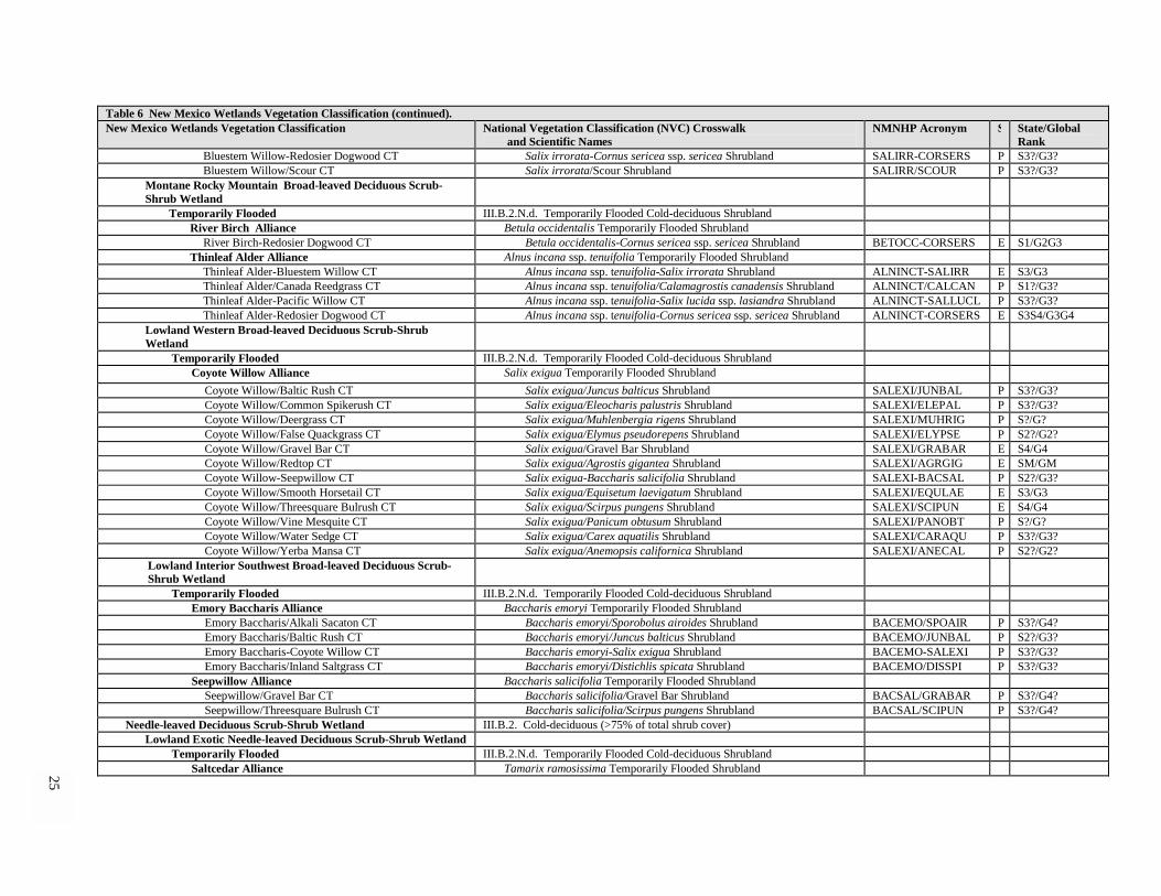
25
Table 6 New Mexico Wetlands Vegetation Classification (continued). New Mexico Wetlands Vegetation Classification National Vegetation Classification (NVC) Crosswalk
and Scientific Names NMNHP Acronym S State/Global
Rank Bluestem Willow-Redosier Dogwood CT Salix irrorata-Cornus sericea ssp. sericea Shrubland SALIRR-CORSERS P S3?/G3? Bluestem Willow/Scour CT Salix irrorata/Scour Shrubland SALIRR/SCOUR P S3?/G3?
Montane Rocky Mountain Broad-leaved Deciduous Scrub-Shrub Wetland
Temporarily Flooded III.B.2.N.d. Temporarily Flooded Cold-deciduous Shrubland River Birch Alliance Betula occidentalis Temporarily Flooded Shrubland
River Birch-Redosier Dogwood CT Betula occidentalis-Cornus sericea ssp. sericea Shrubland BETOCC-CORSERS E S1/G2G3 Thinleaf Alder Alliance Alnus incana ssp. tenuifolia Temporarily Flooded Shrubland
Thinleaf Alder-Bluestem Willow CT Alnus incana ssp. tenuifolia-Salix irrorata Shrubland ALNINCT-SALIRR E S3/G3 Thinleaf Alder/Canada Reedgrass CT Alnus incana ssp. tenuifolia/Calamagrostis canadensis Shrubland ALNINCT/CALCAN P S1?/G3? Thinleaf Alder-Pacific Willow CT Alnus incana ssp. tenuifolia-Salix lucida ssp. lasiandra Shrubland ALNINCT-SALLUCL P S3?/G3? Thinleaf Alder-Redosier Dogwood CT Alnus incana ssp. tenuifolia-Cornus sericea ssp. sericea Shrubland ALNINCT-CORSERS E S3S4/G3G4
Lowland Western Broad-leaved Deciduous Scrub-Shrub Wetland
Temporarily Flooded III.B.2.N.d. Temporarily Flooded Cold-deciduous Shrubland Coyote Willow Alliance Salix exigua Temporarily Flooded Shrubland
Coyote Willow/Baltic Rush CT Salix exigua/Juncus balticus Shrubland SALEXI/JUNBAL P S3?/G3? Coyote Willow/Common Spikerush CT Salix exigua/Eleocharis palustris Shrubland SALEXI/ELEPAL P S3?/G3? Coyote Willow/Deergrass CT Salix exigua/Muhlenbergia rigens Shrubland SALEXI/MUHRIG P S?/G? Coyote Willow/False Quackgrass CT Salix exigua/Elymus pseudorepens Shrubland SALEXI/ELYPSE P S2?/G2? Coyote Willow/Gravel Bar CT Salix exigua/Gravel Bar Shrubland SALEXI/GRABAR E S4/G4 Coyote Willow/Redtop CT Salix exigua/Agrostis gigantea Shrubland SALEXI/AGRGIG E SM/GM Coyote Willow-Seepwillow CT Salix exigua-Baccharis salicifolia Shrubland SALEXI-BACSAL P S2?/G3? Coyote Willow/Smooth Horsetail CT Salix exigua/Equisetum laevigatum Shrubland SALEXI/EQULAE E S3/G3 Coyote Willow/Threesquare Bulrush CT Salix exigua/Scirpus pungens Shrubland SALEXI/SCIPUN E S4/G4 Coyote Willow/Vine Mesquite CT Salix exigua/Panicum obtusum Shrubland SALEXI/PANOBT P S?/G? Coyote Willow/Water Sedge CT Salix exigua/Carex aquatilis Shrubland SALEXI/CARAQU P S3?/G3? Coyote Willow/Yerba Mansa CT Salix exigua/Anemopsis californica Shrubland SALEXI/ANECAL P S2?/G2?
Lowland Interior Southwest Broad-leaved Deciduous Scrub-Shrub Wetland
Temporarily Flooded III.B.2.N.d. Temporarily Flooded Cold-deciduous Shrubland Emory Baccharis Alliance Baccharis emoryi Temporarily Flooded Shrubland
Emory Baccharis/Alkali Sacaton CT Baccharis emoryi/Sporobolus airoides Shrubland BACEMO/SPOAIR P S3?/G4? Emory Baccharis/Baltic Rush CT Baccharis emoryi/Juncus balticus Shrubland BACEMO/JUNBAL P S2?/G3? Emory Baccharis-Coyote Willow CT Baccharis emoryi-Salix exigua Shrubland BACEMO-SALEXI P S3?/G3? Emory Baccharis/Inland Saltgrass CT Baccharis emoryi/Distichlis spicata Shrubland BACEMO/DISSPI P S3?/G3?
Seepwillow Alliance Baccharis salicifolia Temporarily Flooded Shrubland Seepwillow/Gravel Bar CT Baccharis salicifolia/Gravel Bar Shrubland BACSAL/GRABAR P S3?/G4? Seepwillow/Threesquare Bulrush CT Baccharis salicifolia/Scirpus pungens Shrubland BACSAL/SCIPUN P S3?/G4?
Needle-leaved Deciduous Scrub-Shrub Wetland III.B.2. Cold-deciduous (>75% of total shrub cover) Lowland Exotic Needle-leaved Deciduous Scrub-Shrub Wetland
Temporarily Flooded III.B.2.N.d. Temporarily Flooded Cold-deciduous Shrubland Saltcedar Alliance Tamarix ramosissima Temporarily Flooded Shrubland

26
Table 6 New Mexico Wetlands Vegetation Classification (continued). New Mexico Wetlands Vegetation Classification National Vegetation Classification (NVC) Crosswalk
and Scientific Names NMNHP Acronym S State/Global
Rank Saltcedar/Alkali Sacaton CT Tamarix ramosissima/Sporobolus airoides Shrubland TAMRAM/SPOAIR E SM/GM Saltcedar/Buffalograss CT Tamarix ramosissima/Buchloe dactyloides Shrubland TAMRAM/BUCDAC P SM/GM Saltcedar-Coyote Willow CT Tamarix ramosissima-Salix exigua Shrubland TAMRAM-SALEXI P SM/GM Saltcedar/False Quackgrass CT Tamarix ramosissima/Elymus pseudorepens Shrubland TAMRAM/ELYPSE P SM/GM Saltcedar/Inland Saltgrass CT Tamarix ramosissima/Distichlis spicata Shrubland TAMRAM/DISSPI P SM/GM Saltcedar-Pickleweed CT Tamarix ramosissima-Allenrolfea occidentalis Shrubland TAMRAM/ALLOCC P SM/GM Saltcedar/Redtop CT Tamarix ramosissima/Agrostis gigantea Shrubland TAMRAM/AGRGIG P SW/GW Saltcedar/Sparse CT Tamarix ramosissima/Sparse Shrubland TAMRAM/SPARSE E SW/GW
Emergent Wetland V. Herbaceous Vegetation (at least 25% cover, tree and shrubs <25% cover) Persistent Emergent (Herbaceous) Wetland V.A. Perennial Graminoid Vegetation (Perennial graminoids > 50% of total
herbaceous cover)
V.A.5. Temperate or Subpolar Grassland Alpine-Subalpine Rocky Mountain Persistent Emergent Wetland
Semipermanently Flooded V.A.5.n.l. Semipermanently Flooded Temperate or Subpolar Grassland Mud Sedge Alliance Carex limosa Semipermanently Flooded Herbaceous Alliance
Mud Sedge-Fewflower Spikerush CT Carex limosa-Eleocharis quinqueflora Herbaceous Vegetation CARLIM-ELEQUI P S3?/G4? Montane Western Persistent Emergent Wetland
Semipermanently Flooded V.A.5.n.l. Semipermanently Flooded Temperate or Subpolar Grassland Northern Mannagrass Alliance Glyceria borealis Semipermanently Flooded Herbaceous Alliance
Northern Mannagrass-Beautiful Spikerush CT Glyceria borealis-Eleocharis bella Herbaceous Vegetation GLYBOR-ELEBEL P S2?/G3? Seasonally Flooded V.A.5.n.k. Seasonally Flooded Temperate or Subpolar Grassland
Beaked Sedge Alliance Carex rostrata Seasonally Flooded Herbaceous Alliance Beaked Sedge-Baltic Rush CT Carex rostrata-Juncus balticus Herbaceous Vegetation CARROS-JUNBAL P S4/G5
Water Sedge Alliance Carex aquatilis Seasonally Flooded Herbaceous Alliance Water Sedge-Analogue Sedge CT Carex aquatilis-Carex simulata Herbaceous Vegetation CARAQU-CARSIM P S3?/G5? Water Sedge-Common Spikerush CT Carex aquatilis-Eleocharis palustris Herbaceous Vegetation CARAQU-ELEPAL P S3?/G5? Water Sedge-Pointed Sedge CT Carex aquatilis-Carex muricata Herbaceous Vegetation CARAQU-CARMUR P S1/G1 Water Sedge-Smooth Horsetail CT Carex aquatilis-Equisetum laevigatum Herbaceous Vegetation CARAQU-EQULAE P S3?/G5? Water Sedge-Threesquare Bulrush CT Carex aquatilis-Scirpus pungens Herbaceous Vegetation CARAQU-SCIPUN P S3?/G5?
Woolly Sedge Alliance Carex lanuginosa Seasonally Flooded Herbaceous Alliance Woolly Sedge-Common Spikerush CT Carex lanuginosa-Eleocharis palustris Herbaceous Vegetation CARLAN-ELEPAL P S4?/G5?
Lowland Western Persistent Emergent Wetland Semipermanently Flooded V.A.5.n.l. Semipermanently Flooded Temperate or Subpolar grassland
Broadleaf Cattail Alliance Typha latifolia Flooded Herbaceous Alliance Broadleaf Cattail-Threesquare Bulrush CT Typha latifolia-Scirpus pungens Herbaceous Vegetation TYPLAT-SCIPUN E S5/G5
Softstem Bulrush Alliance Scirpus tabernaemontani Flooded Herbaceous Alliance Softstem Bulrush-Broadleaf Cattail CT Scirpus tabernaemontani-Typha latifolia Herbaceous Vegetation SCITAB-TYPLAT E S4/G5
Threesquare Bulrush Alliance Scirpus pungens Flooded Herbaceous Alliance Threesquare Bulrush-Common Spikerush CT Scirpus pungens-Eleocharis palustris Herbaceous Vegetation SCIPUN-ELEPAL E S3/G2G4 Threesquare Bulrush-Inland Saltgrass CT Scirpus pungens-Distichlis spicata Herbaceous Vegetation SCIPUN-DISSPI P S3?/G4? Threesquare Bulrush-Knotgrass CT Scirpus pungens-Paspalum distichum Herbaceous Vegetation SCIPUN-PASDIS P S3?/G4? Threesquare Bulrush Monotype CT Scirpus pungens Monotype Herbaceous Vegetation SCIPUN/MONTYP P S3?/G4?

27
Table 6 New Mexico Wetlands Vegetation Classification (continued). New Mexico Wetlands Vegetation Classification National Vegetation Classification (NVC) Crosswalk
and Scientific Names NMNHP Acronym S State/Global
Rank Threesquare Bulrush-Smooth Horsetail CT Scirpus pungens-Equisetum laevigatum Herbaceous Vegetation SCIPUN-EQULAE E S4/G4?
Seasonally Flooded V.A.5.n.k. Seasonally flooded temperate or subpolar grassland Baltic Rush Alliance Juncus balticus Flooded Herbaceous Alliance
Baltic Rush-Clustered Field Sedge CT Juncus balticus-Carex praegracilis Herbaceous Vegetation JUNBAL-CARPRA P S3?/G4? Baltic Rush-Redtop CT Juncus balticus-Agrostis gigantea Herbaceous Vegetation JUNBAL-AGRGIG P SM/GM Baltic Rush-Smooth Horsetail CT Juncus balticus-Equisetum laevigatum Herbaceous Vegetation JUNBAL-EQULAE P S4?/G4? Baltic Rush-Threesquare Bulrush CT Juncus balticus-Scirpus pungens Herbaceous Vegetation JUNBAL-SCIPUN P S4?/G5? Baltic Rush-Yerba Mansa CT Juncus balticus-Anemopsis californica Herbaceous Vegetation JUNBAL-ANECAL P S3?/G3?
Common Spikerush Alliance Eleocharis palustris Flooded Herbaceous Alliance Common Spikerush-Alkali Mallow CT Eleocharis palustris-Malvella leprosa Herbaceous Vegetation ELEPAL-MALLEP P S2?/G3? Common Spikerush-Knotgrass CT Eleocharis palustris-Paspalum distichum Herbaceous Vegetation ELEPAL-PASDIS P S2?/G3? Common Spikerush-Rice Cutgrass CT Eleocharis palustris-Leersia oryzoides Herbaceous Vegetation ELEPAL-LEEORY P S2?/G3? Common Spikerush-Smooth Horsetail CT Eleocharis palustris-Equisetum laevigatum Herbaceous Vegetation ELEPAL-EQULAE P S4?/G5? Common Spikerush-Vine Mesquite-Povertyweed CT Eleocharis palustris-Panicum obtusum-Iva axillaris Herbaceous
Vegetation ELEPAL-PANOBT-IVAAXI
P S2?/G3?
Common Spikerush-Yerba Mansa CT Eleocharis palustris-Anemopsis californica Herbaceous Vegetation ELEPAL-ANECAL P S2?/G3? Reed Canarygrass Alliance Phalaris arundinacea Flooded Herbaceous Alliance
Reed Canarygrass-Fowl Mannagrass CT Phalaris arundinacea-Glyceria striata Herbaceous Vegetation PHAARU-GLYSTR P S3?/G4? Reed Canarygrass Monotype CT Phalaris arundinacea Monotype Herbaceous Vegetation PHAARU/MONTYP P S4?/G4?
Vine Mesquite Alliance Panicum obtusum Flooded Herbaceous Alliance Vine Mesquite-Blueweed Sunflower CT Panicum obtusum-Helianthus ciliaris Herbaceous Vegetation PANOBT-HELCIL P S2?/G2?
Spreading Yellowcress Alliance Rorippa sinuata Flooded Herbaceous Alliance Spreading Yellowcress-Western Wheatgrass CT Rorippa sinuata-Pascopyrum smithii Herbaceous Vegetation RORSIN-PASSMI P S3?/G3? Spreading Yellowcress-Spike Rush CT Rorippa sinuata-Eleocharis palustris Herbaceous Vegetation RORSIN-ELEPAL P S3?/G3?
Temporarily Flooded V.A.5.n.j. Temporarily flooded temperate or subpolar grassland Inland Saltgrass Alliance Distichlis spicata Flooded Herbaceous Alliance
Inland Saltgrass-Alkali Sacaton CT Distichlis spicata-Sporobolus airoides Herbaceous Vegetation DISSPI-SPOAIR P S3?/G4? Inland Saltgrass-Catchfly Prairie Gentian CT Distichlis spicata-Eustoma exaltatum Herbaceous Vegetation DISSPI-EUSEXA P S2?/G3? Inland Saltgrass Monotype CT Distichlis spicata Monotype Herbaceous Vegetation DISSPI/MONTYP P S5/G5 Inland Saltgrass-Utah Glasswort CT Distichlis spicata-Sarcocornia utahensis Herbaceous Vegetation DISSPI-SALUTA P S4?/G5?

Conservation Status The wetlands of New Mexico are in jeopardy (Figure 2). The majority of the wetland communities of the state are considered globally (G1 or G2 ranks) or state imperiled, or vulnerable to elimination (G3 rank). This is most readily apparent among Forested Wetlands where 42 out of the 50 ranked natural (not GM or GW) communities were ranked G3 and above (Table 6). These types are representative of the more mature vegetation communities in these wetland ecosystems, and their imperilment suggests either over-utilization or a lack of reproduction and sustainability due to alteration of hydrological regimes, or both. The high number of modified (GM) Forested Wetland Communities, with their significant amounts of non-native or invasive species such as Russian olive, may also reflect these deteriorating conditions. Scrub-Shrub Wetlands also have a high number of GM communities (commonly as the result of saltcedar invasion), although they have fewer highly imperiled communities. Persistent Emergent Wetlands have their share of imperiled communities, but these communities tend to be more widely distributed in the western U.S. and hence have overall lower global ranks (G4 and G5). However, within the state these herbaceous communities are still considered to be declining and imperiled with 24 out of the 35 natural community types of conservation concern (S1, S2 & S3 State Ranks). Overall, the complexes of wetland communities of New Mexico that line our lakes and streams are by far the most threatened ecosystems in the state.
28
Global Conservation Rank Distribution New Mexico Wetland Communities
0
5
10
15
20
25
G1 G2 G3 G4 G5 G? GM GW
Global Rank
No.
of C
omm
uniti
es
ForestedScrub-ShrubEmergent
Class
Figure 2. Distribution of community type global ranks by class (Forested, Scrub-Shrub and Emergent Wetlands). Global Conservation Ranks of G1, G2 and G3 are of conservation concern. See Table 5 for definitions of ranks.

29
Keys and Community Type Descriptions
The pattern of wetland vegetation is naturally complex due to the dynamic nature of the plant communities that witness repeated flooding disturbances and shifting groundwater patterns. With the addition of altered hydrological regimes and the invasion of exotic vegetation, the plant communities that form in our wetlands can become even more difficult to identify. In the uplands, community types are often defined as stable communities that have reached a late successional stage, and tend to maintain consistency in species expression over long periods of time (sometimes referred to as the climax plant associations). In wetland/riparian areas, which are prone to frequent disturbance, this may not be the case, and it is useful to define community types in terms of current vegetation composition without the need to speculate on past or future conditions. Therefore, as the plant community matures in a given location, the community type changes to reflect changes in major plant species composition.
As with most vegetation classification systems, this classification attempts to define “typic” vegetation communities, with the understanding that there will much variation within the communities as well as “ecotones” where transitions occur between communities in space and time. When there are abrupt changes in physical site conditions, there are often easily identifiable changes in community types, i.e., narrow ecotones. There are also "successional" ecotones where stands may appear to be in transition from one community type to the next through time. The broad geographic area represented in the state also influences the expression of specific plants in each community type. Furthermore, the impact of disturbances, such as heavy grazing, can alter vegetative expressions of species. Therefore, the identification of wetland community types in the field can be somewhat challenging.
Accurate identification of a community type is dependent on a careful application of the dichotomous keys, and upon comparison of the plant community found with the pertinent community type description. Several of the community types are provisional or incidental, lacking the quantity of data to consider the description as an “established” community type. If one is unable to key out a community, it is possible that the community type has yet to be described. When a community does not fit any community type description, its probably better to call it “unidentified” or “unknown” than to make it “fit” into the classification provided here. In such cases, it is recommended that the NMNHP be contacted with information on what may be a new type for the state (http://nmnhp.unm.edu).
To use the keys, select a portion of the area that best represents the vegetation you are trying to classify. Avoid edges of the community, or areas of extreme disturbance. Community types are more confidently identified with larger homogenous areas, as small fragmented stands have less plant diversity. Identify indicator plant species, noting the approximate cover and composition of these plants within the plant community. Although is not necessary to identify all the plant species present to be able to identify the community type, the user should be familiar with field identification of key plants mentioned in the community type’s names, the keys, and in the descriptions. Grouping plant observations into vegetation layers of trees, shrubs, and herbaceous plants aids in the use of the keys and community descriptions.
The first dichotomous key breaks vegetation into three wetland classes. The major underlying assumption in the use of this key is that the area is indeed influenced by water and is a wetland vegetation community. The three classes are Forest, Shrubland, and Herbaceous Wetlands. Although Forest and Shrubland Wetlands both contain woody species, in forests the prevailing concept is that trees generally have single boles and are at least five meters in height. Shrublands have more of a thicket growth form with multi-stemmed shrubs that are generally less than three meters in height. For situations in between these conditions, the key may need to be worked both ways to find the proper community description. This first key directs the user to one of three wetland class keys.
The wetland class keys break each class into alliances. Descriptions for the alliances are ordered alphabetically by common name within each class (Forests, Shrublands, and Herbaceous). There is a summary description for each alliance followed by a key to the community types (CTs). Community type descriptions follow the alliance key. These are also ordered alphabetically by common name within the alliance. Although provisional types have been included, the user is cautioned that keys may not accurately identify these types.
Full descriptions are provided for established community types and include information on species composition, environmental conditions, and comments (limited space precludes providing full species list and associated cover data for each type, but the data is available upon request from the New Mexico Natural Heritage Program). Established types are represented by five or more vegetation plots, including one with a soil description,
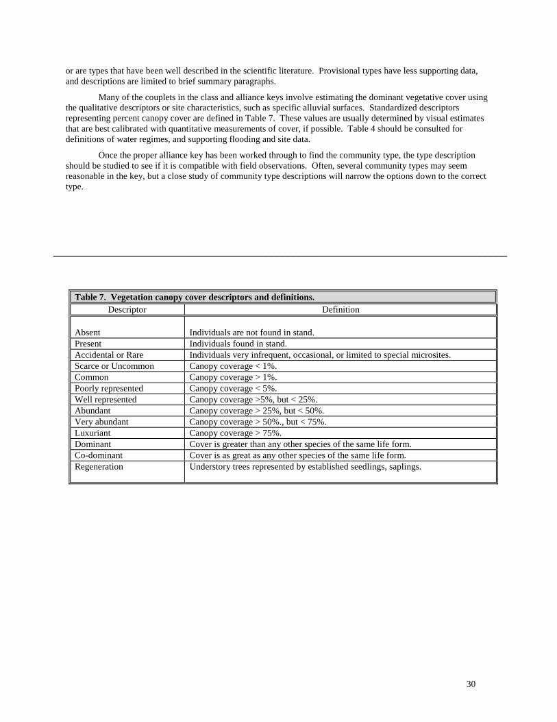
30
or are types that have been well described in the scientific literature. Provisional types have less supporting data, and descriptions are limited to brief summary paragraphs.
Many of the couplets in the class and alliance keys involve estimating the dominant vegetative cover using the qualitative descriptors or site characteristics, such as specific alluvial surfaces. Standardized descriptors representing percent canopy cover are defined in Table 7. These values are usually determined by visual estimates that are best calibrated with quantitative measurements of cover, if possible. Table 4 should be consulted for definitions of water regimes, and supporting flooding and site data.
Once the proper alliance key has been worked through to find the community type, the type description should be studied to see if it is compatible with field observations. Often, several community types may seem reasonable in the key, but a close study of community type descriptions will narrow the options down to the correct type.
___________________________________________________________________________________
Table 7. Vegetation canopy cover descriptors and definitions. Descriptor Definition
Absent
Individuals are not found in stand.
Present Individuals found in stand. Accidental or Rare Individuals very infrequent, occasional, or limited to special microsites. Scarce or Uncommon Canopy coverage < 1%. Common Canopy coverage > 1%. Poorly represented Canopy coverage < 5%. Well represented Canopy coverage >5%, but < 25%. Abundant Canopy coverage > 25%, but < 50%. Very abundant Canopy coverage > 50%., but < 75%. Luxuriant Canopy coverage > 75%. Dominant Cover is greater than any other species of the same life form. Co-dominant Cover is as great as any other species of the same life form. Regeneration Understory trees represented by established seedlings, saplings.

31
Key To The Wetland Classes 1. Total tree cover greater than 25%, or if less than 25%, then trees clearly dominant over, or codominant with,
shrubs or herbs........................................................................................ Forested Wetland Alliances: Page 32 1. Tree cover less than 25% and clearly subordinate to shrubs and herbs ................................................................. (2) 2. Total woody shrub cover greater than 25%, or if less than 25%, then shrubs clearly dominant over, or codominant
with grasses and forbs (herbs generally have less cover than shrubs, or herbs are sparse or absent) ..................... ......................................................................................................... Scrub-Shrub Wetland Alliances: Page 90 2. Woody shrub cover less than 25%, often absent, or clearly subordinate to grasses and forbs .................................. .................................................................. Persistent Emergent (Herbaceous) Wetland Alliances: Page 126
Forested Wetlands Alliance Classification
Needle-leaved evergreen (evergreen tree species generally >75% of total tree cover)
Montane Rocky Mountain (generally above 7,500 ft (2,280 m); mostly mountain canyons and narrow valleys of northern and central New Mexico; occasional in southwestern New Mexico) Temporarily Flooded
Blue Spruce Alliance Broad-leaved Deciduous (broad-leaved deciduous tree species generally >75% of total tree cover)
Montane Interior Southwest (generally above 5,000 ft (1,525 m); mostly mountain canyons and narrow valleys of southwestern New Mexico) Temporarily Flooded
Arizona Alder Alliance Montane Rocky Mountain (generally above 5,500 ft (1,675 m); mostly mountain canyons and narrow valleys of south-central and northern New Mexico) Temporarily Flooded
Boxelder Alliance Narrowleaf Cottonwood Alliance
Lowland Interior Southwest (generally below 6,000 ft (1,825 m); mostly open valleys and broad floodplains of southwestern New Mexico)
Temporarily Flooded Arizona Sycamore Alliance Arizona Walnut Alliance Fremont Cottonwood Alliance Goodding Willow Alliance Netleaf Hackberry Alliance Lowland Plains/Great Basin (generally below 6,500 ft (1,825 m); mostly open valleys and broad floodplains of south-central, southeast and northern New Mexico) Temporarily Flooded
Plains Cottonwood Alliance Lowland Exotic (generally below 5,500 ft (1,675 m); mostly open valleys and broad floodplains of central and northwestern New Mexico) Temporarily Flooded Russian Olive Alliance

32
Key to the Forested Wetland Alliances 1. Blue spruce (Picea pungens), an evergreen conifer, well represented, and dominant or codominant in the
overstory with broad-leaved deciduous trees………………………………………….…..Blue Spruce Alliance 1. Deciduous trees dominate the overstory, blue spruce accidental or absent ...................................................... (2) 2. Narrowleaf cottonwood (Populus angustifolia) or lanceleaf cottonwood (P. acuminata), abundant and
dominant or codominant ................................................................................ Narrowleaf Cottonwood Alliance 2. Narrowleaf or lanceleaf cottonwood poorly represented or absent .................................................................. (3) 3. Fremont cottonwood (Populus fremontii) abundant, or dominant or codominant .................................................. ........................................................................................................................... Fremont Cottonwood Alliance 3. Fremont cottonwood absent or poorly represented and sub-dominant .............................................................. (4) 4. Arizona sycamore (Platanus wrightii) well represented to abundant, and dominant or codominant .................... ..................................................................................................................................Arizona Sycamore Alliance 4. Arizona sycamore absent, or poorly represented and sub-dominant.................................................................. (5) 5. Arizona Alder (Alnus oblongifolia) abundant and dominant or codominant (southwestern New Mexico) ........................................................................................................................................ Arizona Alder Alliance 5. Arizona alder, absent or sub-dominant to other trees ........................................................................................ (6) 6. Arizona walnut (Juglans major) abundant and dominant ........................................... Arizona Walnut Alliance 6. Arizona walnut absent or poorly represented ................................................................................................... (7) 7. Boxelder (Acer negundo) abundant and dominant or codominant............................................Boxelder Alliance 7 . Boxelder uncommon or absent .......................................................................................................................... (8) 8. Plains or Rio Grande cottonwood (Populus deltoides) abundant and dominant or codominant............................. ................................................................................................................................ Plains Cottonwood Alliance 8. Plains or Rio Grande cottonwood poorly represented or absent ........................................................................ (9) 9. Goodding willow (Salix gooddingii) abundant or dominant; cottonwoods are poorly represented or absent ........ .................................................................................................................................. Goodding Willow Alliance 9. Goodding willow absent, or if present, an understory sub-dominant ............................................................ (10) 10. Netleaf hackberry (Celtis laevigata var. reticulata) abundant and dominant .......... Netleaf Hackberry Alliance 10. Netleaf hackberry absent, or poorly represented ............................................................................................. (11) 11. Russian olive (Elaeagnus angustifolia) abundant and dominant .................................... Russian Olive Alliance 11. Russian olive absent, or clearly subordinate to shrubs ........... see Scrub-Shrub Wetlands Alliance Key, Page 90

33
Arizona Alder Alliance (Alnus oblongifolia Torr.)
Photo by Mike Bradley
Figure 3. Arizona Alder/Goodding Willow Community Type in the Black Range along Las Animas Creek, a tributary of the Rio Grande. Arizona alders often form dense stands that line cobbly channels of shaded montane canyons. NM Classification: Montane Rocky Mountain Broad-leaved Deciduous Forested Wetland, Temporarily Flooded NVC: I.B.2.d. Temporarily flooded cold-deciduous forest

34
Distribution: Southwestern New Mexico, primarily in mountain drainages of the Gila River watershed and adjacent Mimbres drainage, also along the eastern slopes of the Black Range (Rio Grande basin). The alliance extends into central and southeastern Arizona, and probably occurs in northern Mexico. Ecology: Arizona alder, a wetland indicator species, is limited in its distribution to the southwestern U.S. and northern Mexico. While it is similar to its northern, shrubbier relative, thinleaf alder (Alnus incana ssp. tenuifolia), it can grow to be a large tree of 60 ft (18 m) or more, and dominate montane riparian communities. Goodding willow (Salix gooddingii) is an obligate wetland species that can occur as a sub-canopy associate, along with Arizona walnut (Juglans major) and velvet ash (Fraxinus velutina). When narrowleaf cottonwood (Populus angustifolia) or Arizona sycamore (Platanus wrightii) codominate, see their respective alliances. Four provisional community types within the alliance are described below which generally have dense tree canopies and a range of understories. Relatively drier sites usually tend to be dominated by the wetland indicator shrubs seepwillow (Baccharis salicifolia) or bluestem willow (Salix irrorata). On wetter sites, the obligate wetland indicator rice cutgrass (Leersia oryzoides) can dominate the community type. The alliance occurs in small to moderate-sized mountain drainages. It has been documented to occur in New Mexico at elevations from as low as 5,000 ft (1,525 m) to upwards of 7,250 ft (2,210 m), with an average of 5,500 ft (1,675 m). It has been recorded as low as 3,500 ft (1,080 m ) in Arizona (Szaro 1989; Laurenzi, Ohmart, and Hink 1983). Arizona alder stands usually occur on cobbly or sandy streambanks and sidebars along channels with perennial or intermittent stream flows. Soils tend to be poorly developed, unconsolidated and non-cohesive deposits of riverwash (sandy-skeletal Entisols), but they are well-drained. Although they may be dry on the surface for several weeks, they usually retain some moisture at lower depths during at least part of the growing season (usually there is evidence in stands of water stains and flood debris, indicating frequent flooding, perhaps on a biannual basis). Arizona alder stands often occur in a complex with Arizona sycamore (Platanus wrightii) communities which may occur on adjacent higher and drier terraces (Brown, Lowe, and Pase 1979; Szaro 1989).
Brown, Lowe, and Pase (1979) designated an Alnus oblongifolia Association in the Mixed Broadleaf Series that forms part of their Interior Southwestern Riparian Deciduous Forests and Woodlands Biome. Laurenzi, Ohmart, and Hink (1983) defined a diverse Alder type for central Arizona, with Arizona sycamore, velvet ash, and Arizona walnut as important codominants. Szaro (1989) also defined a widely distributed and varied Alnus oblongifolia Community Type with boxelder and velvet ash as common canopy associates. The alliance is referred to by Dick-Peddie (1993) as the Alder Series with a mixture of shrub, grass, and forb species. Arizona alder can form a significant component of community types from other alliances in southwestern New Mexico, e.g., the Narrowleaf Cottonwood/Arizona Alder (first described by Boles and Dick-Peddie 1983), the Arizona Sycamore-Arizona Alder/Seepwillow, and the Acer negundo-Alnus oblongifolia community type of Medina (1986).
Key to the Arizona Alder (Alnus oblongifolia) Community Types: 1. Bluestem willow (Salix irrorata) is well represented to abundant ............ Arizona Alder/Bluestem Willow CT 1. Bluestem willow poorly represented to absent .................................................................................................. (2) 2. Goodding willow (Salix gooddingii) is well represented to abundant ......Arizona Alder-Goodding Willow CT 2. Goodding willow poorly represented to absent ................................................................................................. (3) 3. Seepwillow (Baccharis salicifolia) is abundant...................................................Arizona Alder/Seepwillow CT 3. Seepwillow and other shrubs are poorly represented, rice cutgrass (Leersia oryzoides) well represented to very
abundant.......................................................................................................... Arizona Alder/Rice Cutgrass CT

35
Community Type Descriptions:
Common Name Scientific Name
Arizona Alder/Bluestem Willow CT Alnus oblongifolia/Salix irrorata CT
Acronym ALNOBL/SALIRR Status: Provisional Rank: S3S4/G3G4 Distribution Gila River watershed, Saliz Canyon (Catron Co.), and probably elsewhere in the
mountains of southwestern New Mexico. PROVISIONAL DESCRIPTION. Characterized by a moderately closed canopy of Arizona alder, with an abundant understory of bluestem willow. There can also be minor amounts of narrowleaf cottonwood (Populus angustifolia) and boxelder (Acer negundo), mostly as seedlings and saplings. The wetland indicators common spikerush (Eleocharis palustris) and field horsetail (Equisetum arvense) are common. The introduced creeping bentgrass (Agrostis stolonifera) can be well represented Limited data suggest that the type occurs at around 5,270 ft (1,600 m) on cobbly, but well stabilized banks that are subject to frequent flooding. Soils are reported as unconsolidated riverwash.
Common Name Scientific Name
Arizona Alder-Goodding Willow CT Alnus oblongifolia-Salix gooddingii CT
Acronym ALNOBL-SALGOO Status: Provisional Rank: S3S4/G3G4 Distribution Animas Creek and probably elsewhere in the Black Range (Sierra Co.), and other
mountains of southwestern New Mexico. PROVISIONAL DESCRIPTION. This community type has moderately closed canopies of Arizona alder with a sub-canopy of Goodding willow. Velvet ash (Fraxinus velutina) may be common as well, but other tree species are minor or accidental. The dense tree canopies tend to preclude significant undergrowth, although muttongrass (Poa fendleriana) can be abundant. Seepwillow (Baccharis salicifolia) can be well represented, and false indigo-bush (Amorpha fruticosa) can also be common. Preliminary data suggest that stands occur on cobbly sidebars along lower montane streams and overflow channels at elevations of around 5,300 to 5,400 ft (1,620 to 1,650 m). Flooding can be frequent to infrequent (two-year estimated recurrence interval), but the water table usually occurs within a meter of the surface. The type can occur in an ecological complex with community types from the Arizona sycamore (Platanus wrightii) and Arizona walnut (Juglans major) alliances.
Common Name Scientific Name
Arizona Alder/Rice Cutgrass CT Alnus oblongifolia/Leersia oryzoides CT
Acronym ALNOBL/LEEORY Status: Provisional Rank: S2?/G2? Distribution Gila River watershed (Grant Co.), and probably elsewhere in southwestern New
Mexico. PROVISIONAL DESCRIPTION. A closed canopy of Arizona alder and a highly diverse, but variable mix of forbs and graminoids characterize this community (53 species have been reported for the type). Shrubs are generally poorly represented, although false indigo-bush (Amorpha fruticosa) can be common. Rice cutgrass, a wetland indicator species, is abundant and dominates the grassy and undergrowth. Twenty herbaceous wetland indicator species have been reported for the type; water sedge (Carex aquatilis), field horsetail (Equisetum arvense), cutleaf coneflower (Rudbeckia laciniata) and wild mint (Mentha arvensis) are usually present and well represented to abundant. The exotic creeping bentgrass (Agrostis stolonifera), meadow fescue (Festuca pratensis) and yellow sweetclover (Melilotus officinalis) can also be abundant. Preliminary data indicate that this is a lower montane type (5,520 to 5,720 ft; 1,680 to 1,740 m) that occurs on sidebars of moderate-gradient streams where flooding frequently occurs. Soils are reported as unconsolidated riverwash and weakly-developed sandy skeletal Mollic Fluvaquents.

36
Common Name Scientific Name
Arizona Alder/Seepwillow CT Alnus oblongifolia/Baccharis salicifolia CT
Acronym ALNOBL/BACSAL Status: Provisional Rank: S3S4/G3G4 Distribution Palomas Creek and probably elsewhere in the Black Range (Sierra Co.), and the
mountains of southwestern New Mexico and southeastern Arizona. PROVISIONAL DESCRIPTION. This type is characterized by young, open stands of Arizona alder poles and saplings, with abundant seepwillow in the shrub layer. Young Arizona walnut (Juglans major) may also occur. Among the forbs, Indianhemp (Apocynum cannabinum) is well represented, and the vines canyon grape (Vitis arizonica), western white clematis (Clematis ligusticifolia ), and introduced Virginia creeper (Parthenocissus quinquefolia) are common to well represented. Stands are known to occur along moderate gradient (1% to 1.5%), lower montane stream channels at around 5,000 ft (1,525 m). Flooding is probably frequent, at least within a five-year return interval. Soils are cobbly, and have been identified as moist sandy-skeletal Aeric Fluvaquents.

37
Arizona Sycamore Alliance (Platanus wrightii S. Wats.)
Photo by Mike Bradley
Figure 4. Arizona Sycamore/Thinleaf Alder-Seepwillow CT on a terrace on the San Francisco River, in Catron County. NM Classification: Lowland Interior Southwest Broad-leaved Deciduous Forested Wetland, Temporarily Flooded
NVC: I.B.2.d. Temporarily flooded cold-deciduous forest
Distribution: Southwestern New Mexico, primarily in mountain drainages of the Gila River Basin and adjacent Mimbres drainages and the eastern slopes of the Black Range (Rio Grande Basin). The alliance is also known from southern Arizona and northern Mexico. Ecology: Arizona sycamore is a wetland indicator species that occurs along both perennial and intermittent streams in lower montane canyons to broad lowland valleys (4,300 to 5,800 ft; 1,300 m to 1,770 m). Stands are found on a range of sites from in-channel, to sidebars, to high terraces, depending on the community type, and the degree of maturity. Soils tend to be sandy-skeletal with high gravel and cobble content.
Arizona sycamore forested wetlands have moderately closed canopies with various undergrowth structures and compositions. Arizona alder (Alnus oblongifolia) can occur as a canopy codominant, along with Arizona walnut (Juglans major), netleaf hackberry (Celtis laevigata var. reticulata), and oneseed juniper (Juniperus monosperma). For stands that are codominated by cottonwood, see the Fremont Cottonwood Alliance. Understories are variable; commonly they are dominated by grasses, such as sideoats grama (Bouteloua curtipendula) or sand dropseed (Sporobolus cryptandrus), and younger stands in particular can have a significant amounts of seepwillow (Baccharis salicifolia) or California brickellbush (Brickellia californica).
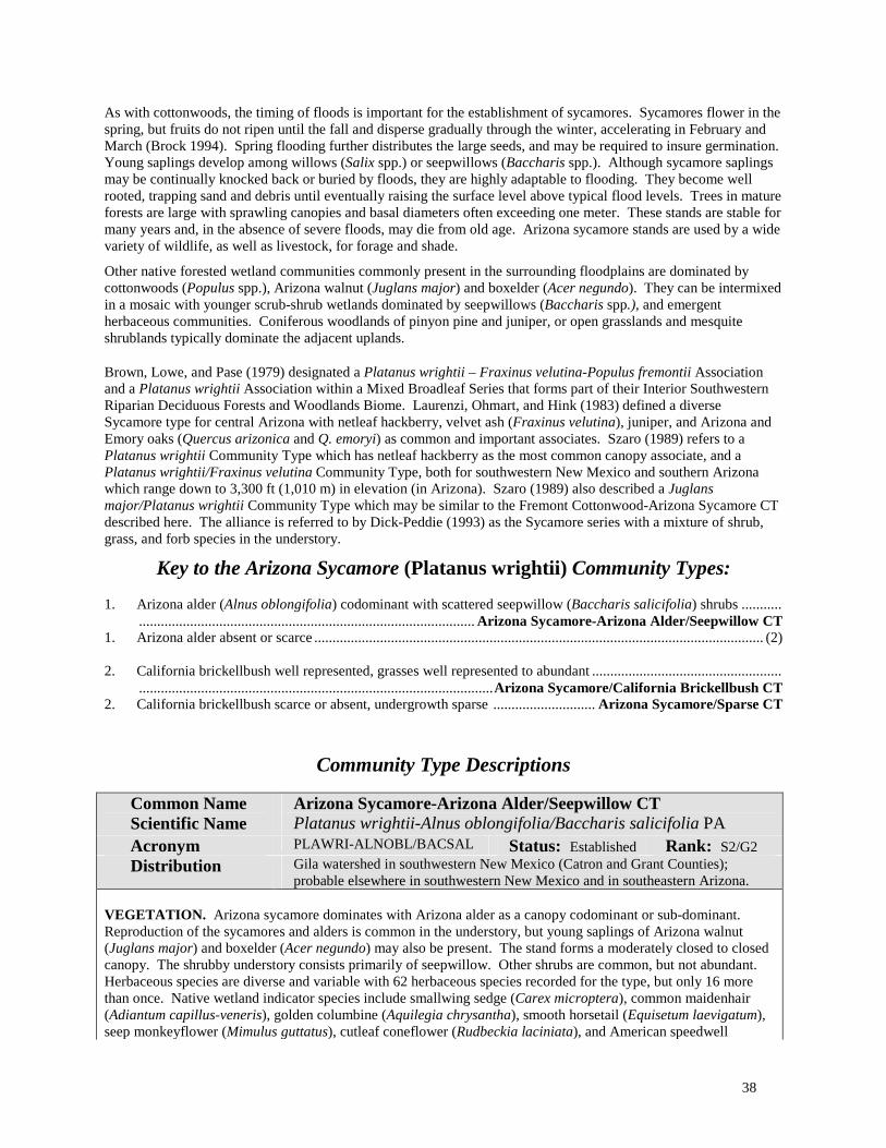
38
As with cottonwoods, the timing of floods is important for the establishment of sycamores. Sycamores flower in the spring, but fruits do not ripen until the fall and disperse gradually through the winter, accelerating in February and March (Brock 1994). Spring flooding further distributes the large seeds, and may be required to insure germination. Young saplings develop among willows (Salix spp.) or seepwillows (Baccharis spp.). Although sycamore saplings may be continually knocked back or buried by floods, they are highly adaptable to flooding. They become well rooted, trapping sand and debris until eventually raising the surface level above typical flood levels. Trees in mature forests are large with sprawling canopies and basal diameters often exceeding one meter. These stands are stable for many years and, in the absence of severe floods, may die from old age. Arizona sycamore stands are used by a wide variety of wildlife, as well as livestock, for forage and shade.
Other native forested wetland communities commonly present in the surrounding floodplains are dominated by cottonwoods (Populus spp.), Arizona walnut (Juglans major) and boxelder (Acer negundo). They can be intermixed in a mosaic with younger scrub-shrub wetlands dominated by seepwillows (Baccharis spp.), and emergent herbaceous communities. Coniferous woodlands of pinyon pine and juniper, or open grasslands and mesquite shrublands typically dominate the adjacent uplands.
Brown, Lowe, and Pase (1979) designated a Platanus wrightii – Fraxinus velutina-Populus fremontii Association and a Platanus wrightii Association within a Mixed Broadleaf Series that forms part of their Interior Southwestern Riparian Deciduous Forests and Woodlands Biome. Laurenzi, Ohmart, and Hink (1983) defined a diverse Sycamore type for central Arizona with netleaf hackberry, velvet ash (Fraxinus velutina), juniper, and Arizona and Emory oaks (Quercus arizonica and Q. emoryi) as common and important associates. Szaro (1989) refers to a Platanus wrightii Community Type which has netleaf hackberry as the most common canopy associate, and a Platanus wrightii/Fraxinus velutina Community Type, both for southwestern New Mexico and southern Arizona which range down to 3,300 ft (1,010 m) in elevation (in Arizona). Szaro (1989) also described a Juglans major/Platanus wrightii Community Type which may be similar to the Fremont Cottonwood-Arizona Sycamore CT described here. The alliance is referred to by Dick-Peddie (1993) as the Sycamore series with a mixture of shrub, grass, and forb species in the understory.
Key to the Arizona Sycamore (Platanus wrightii) Community Types: 1. Arizona alder (Alnus oblongifolia) codominant with scattered seepwillow (Baccharis salicifolia) shrubs ........... ............................................................................................ Arizona Sycamore-Arizona Alder/Seepwillow CT 1. Arizona alder absent or scarce ........................................................................................................................... (2) 2. California brickellbush well represented, grasses well represented to abundant .................................................... .................................................................................................Arizona Sycamore/California Brickellbush CT 2. California brickellbush scarce or absent, undergrowth sparse ............................ Arizona Sycamore/Sparse CT
Community Type Descriptions
Common Name Scientific Name
Arizona Sycamore-Arizona Alder/Seepwillow CT Platanus wrightii-Alnus oblongifolia/Baccharis salicifolia PA
Acronym PLAWRI-ALNOBL/BACSAL Status: Established Rank: S2/G2 Distribution Gila watershed in southwestern New Mexico (Catron and Grant Counties);
probable elsewhere in southwestern New Mexico and in southeastern Arizona. VEGETATION. Arizona sycamore dominates with Arizona alder as a canopy codominant or sub-dominant. Reproduction of the sycamores and alders is common in the understory, but young saplings of Arizona walnut (Juglans major) and boxelder (Acer negundo) may also be present. The stand forms a moderately closed to closed canopy. The shrubby understory consists primarily of seepwillow. Other shrubs are common, but not abundant. Herbaceous species are diverse and variable with 62 herbaceous species recorded for the type, but only 16 more than once. Native wetland indicator species include smallwing sedge (Carex microptera), common maidenhair (Adiantum capillus-veneris), golden columbine (Aquilegia chrysantha), smooth horsetail (Equisetum laevigatum), seep monkeyflower (Mimulus guttatus), cutleaf coneflower (Rudbeckia laciniata), and American speedwell
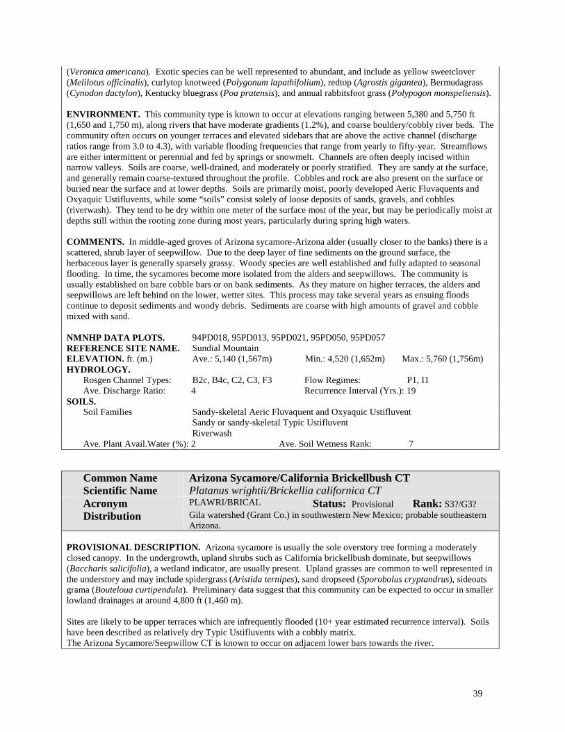
39
(Veronica americana). Exotic species can be well represented to abundant, and include as yellow sweetclover (Melilotus officinalis), curlytop knotweed (Polygonum lapathifolium), redtop (Agrostis gigantea), Bermudagrass (Cynodon dactylon), Kentucky bluegrass (Poa pratensis), and annual rabbitsfoot grass (Polypogon monspeliensis). ENVIRONMENT. This community type is known to occur at elevations ranging between 5,380 and 5,750 ft (1,650 and 1,750 m), along rivers that have moderate gradients (1.2%), and coarse bouldery/cobbly river beds. The community often occurs on younger terraces and elevated sidebars that are above the active channel (discharge ratios range from 3.0 to 4.3), with variable flooding frequencies that range from yearly to fifty-year. Streamflows are either intermittent or perennial and fed by springs or snowmelt. Channels are often deeply incised within narrow valleys. Soils are coarse, well-drained, and moderately or poorly stratified. They are sandy at the surface, and generally remain coarse-textured throughout the profile. Cobbles and rock are also present on the surface or buried near the surface and at lower depths. Soils are primarily moist, poorly developed Aeric Fluvaquents and Oxyaquic Ustifluvents, while some “soils” consist solely of loose deposits of sands, gravels, and cobbles (riverwash). They tend to be dry within one meter of the surface most of the year, but may be periodically moist at depths still within the rooting zone during most years, particularly during spring high waters. COMMENTS. In middle-aged groves of Arizona sycamore-Arizona alder (usually closer to the banks) there is a scattered, shrub layer of seepwillow. Due to the deep layer of fine sediments on the ground surface, the herbaceous layer is generally sparsely grassy. Woody species are well established and fully adapted to seasonal flooding. In time, the sycamores become more isolated from the alders and seepwillows. The community is usually established on bare cobble bars or on bank sediments. As they mature on higher terraces, the alders and seepwillows are left behind on the lower, wetter sites. This process may take several years as ensuing floods continue to deposit sediments and woody debris. Sediments are coarse with high amounts of gravel and cobble mixed with sand. NMNHP DATA PLOTS. 94PD018, 95PD013, 95PD021, 95PD050, 95PD057 REFERENCE SITE NAME. Sundial Mountain ELEVATION. ft. (m.) Ave.: 5,140 (1,567m) Min.: 4,520 (1,652m) Max.: 5,760 (1,756m) HYDROLOGY.
Rosgen Channel Types: B2c, B4c, C2, C3, F3 Flow Regimes: P1, I1 Ave. Discharge Ratio: 4 Recurrence Interval (Yrs.): 19
SOILS. Soil Families Sandy-skeletal Aeric Fluvaquent and Oxyaquic Ustifluvent
Sandy or sandy-skeletal Typic Ustifluvent Riverwash
Ave. Plant Avail.Water (%): 2 Ave. Soil Wetness Rank: 7
Common Name Scientific Name
Arizona Sycamore/California Brickellbush CT Platanus wrightii/Brickellia californica CT
Acronym PLAWRI/BRICAL Status: Provisional Rank: S3?/G3? Distribution Gila watershed (Grant Co.) in southwestern New Mexico; probable southeastern
Arizona. PROVISIONAL DESCRIPTION. Arizona sycamore is usually the sole overstory tree forming a moderately closed canopy. In the undergrowth, upland shrubs such as California brickellbush dominate, but seepwillows (Baccharis salicifolia), a wetland indicator, are usually present. Upland grasses are common to well represented in the understory and may include spidergrass (Aristida ternipes), sand dropseed (Sporobolus cryptandrus), sideoats grama (Bouteloua curtipendula). Preliminary data suggest that this community can be expected to occur in smaller lowland drainages at around 4,800 ft (1,460 m). Sites are likely to be upper terraces which are infrequently flooded (10+ year estimated recurrence interval). Soils have been described as relatively dry Typic Ustifluvents with a cobbly matrix. The Arizona Sycamore/Seepwillow CT is known to occur on adjacent lower bars towards the river.

40
Common Name Scientific Name
Arizona Sycamore/Sparse CT Platanus wrightii/Sparse CT
Acronym PLAWRI/SPARSE Status: Provisional Rank: S3?/G3? Distribution Lower Gila watershed (Mogollon Creek), and Animas Creek of Black Range
(eastern slope in the Rio Grande basin) of southwestern New Mexico. Probable in southeastern Arizona.
PROVISIONAL DESCRIPTION. The dense overstory is dominated by Arizona sycamore with netleaf hackberry a sometimes well represented subcanopy. Characterized by the lack of significant shrub and herbaceous cover. Only honey mesquite (Prosopis glandulosa) is common. Overall diversity is low (22 species), and variable. Litter, woody debris, and sand dominate the shaded forest floor. Known from dry creek and terraces beds at around 4,700 ft (1,740 m). Soils have been described as relatively dry, well drained, weakly-developed entisols and inceptisols (fine-loamy Oxyaquic Torrifluvents and coarse-loamy/sandy-skeletal Fluventic Ustochrepts).

41
Arizona Walnut Alliance (Juglans major (Torr.) Heller)
Photo by Mike Bradley
Figure 5. Arizona Walnut-Netleaf Hackberry/California Brickellbush Community Type on the San Francisco River in the Gila watershed. The Arizona Walnut Alliance is typically located on high terraces, toward the outer floodplain, or at the base of hillslopes as shown here.
NM Classification: Lowland Interior Southwest Broad-leaved Deciduous Forested Wetland, Temporarily Flooded
NVC: I.B.2.d. Temporarily flooded cold-deciduous forest
Distribution: The Arizona Walnut Alliance is limited in distribution to southwestern and south-central New Mexico and southern Arizona, and probably occurs in northern Mexico. In New Mexico it is known to occur in the lower Gila and lower Pecos River basins.
Ecology: Arizona walnut is a wetland indicator species that can dominate forested wetlands toward the outer fringe of floodplains, often at the toe of upland hillslopes. The species can range from 3,500 ft (in Arizona) to 7,500 ft (1,060 to 2,280 m). It forms somewhat open to moderately closed canopies, commonly in association with either boxelder (Acer negundo) or netleaf hackberry (Celtis laevigata var. reticulata). The undergrowth is characteristically shrubby with either skunkbush sumac (Rhus trilobata var. trilobata) or California brickellbush (Brickellia californica) present. Occasionally, the understory includes New Mexico olive (Forestiera pubescens

42
ssp. pubescens) and/or grasses characteristic of drier sites. Several juniper species (Juniperus deppeana, J. monosperma, or J. scopulorum) or oaks (Quercus spp.) may also be present.
The alliance occupies some of the driest sites in the floodplain. These sites may be maintained by seeps or small springs from the adjoining hillslopes. Stands are situated well above the streambed, and are rarely (if ever) flooded. Strahan (1984) suggested that Arizona walnut may replace cottonwoods in the absence of flooding. Sites are often adjacent to old fields or pastures at the edge of the floodplain. Soils reflect dry site conditions with few wetness (hydric) indicators within the top meter. Soils are generally undeveloped Entisols or weakly-developed Inceptisols with textures that vary from coarse loams to sandy-rocky matrices.
This alliance was first recognized by Brown, Lowe, and Pase (1979) as a Juglans major Association within a Mixed Broadleaf Series that forms part of their Interior Southwestern Riparian Deciduous Forests and Woodlands Biome. Similarly, Dick-Peddie (1993) identified a Arizona Walnut Series for New Mexico with two types as part of a montane riparian zone. Hardesty (1985) also defined a Juglans major/Brickellia californica-Chrysothamnus nauseosus/sparse association for the Gila River in New Mexico. Medina (1986) described two community types that belong in the alliance from southwestern New Mexico (Fort Bayard watershed). Szaro (1989) describes Juglans major Community Type for New Mexico and Arizona which approximates the alliance, but may be more specifically related to the Arizona Walnut-Boxelder/Skunkbush Sumac CT described below. Szaro (1989) also describes a Juglans major-Platanus wrightii Community Type that we would consider part of the Arizona Sycamore Alliance.
Key to the Arizona Walnut (Juglans major) Community Types: 1. Shrubs abundant or dominate the undergrowth ................................................................................................. (2) 1. Shrubs scarce, grasses well represented to abundant, typically dominated by sideoats grama (B. curtipendula) ..................................................................................................................Arizona Walnut/Sideoats Grama CT 2. New Mexico olive (Forestiera pubescens ssp. pubescens) well represented to abundant, dominant in the understory .............................................................................................Arizona Walnut/New Mexico Olive CT 2. New Mexico olive scarce or absent ................................................................................................................... (3) 3. Boxelder (Acer negundo) codominant with Arizona walnut, netleaf hackberry (Celtis laevigata var. reticulata)
absent or minor ....................................................................Arizona Walnut-Boxelder/Skunkbush Sumac CT 3. Netleaf hackberry codominant with Arizona walnut, boxelder absent or minor .................................................... .................................................................... Arizona Walnut-Netleaf Hackberry/California brickellbush CT
Community Type Descriptions:
Common Name Scientific Name
Arizona Walnut-Boxelder/Skunkbush Sumac CT Juglans major-Acer negundo/Rhus trilobata var. trilobata CT
Acronym JUGMAJ-ACENEG/RHUTRIT Status: Provisional Rank: S3?/G3? Distribution Lower Gila River (Grant Co.); probable elsewhere in southwestern New Mexico
and southeast Arizona. PROVISIONAL DESCRIPTION. Arizona walnut and boxelder, both wetland indicators, form a closed canopy over a well-represented shrub layer dominated by skunkbush sumac. California brickellbush (Brickellia californica) occasionally codominates. The herbaceous layer diversity is moderate (25 species recorded for the type), but sites may contain many ruderal or weedy species common to nearby agricultural lands. Known from about 6,000 to 6,650 ft (1,830 to 2,030 m) along the outer edges of floodplains on high terraces. Soils tend to be relatively dry, loamy or sandy, and rocky, (Fluventic Ustochrepts and Haplustolls and Typic Ustifluvents). Boxelder was indicated as a major tree associate in the Juglans major Community Type of Szaro (1989), along with skunkbush sumac in the shrub layer. REFERENCE SITE NAME. Bear Canyon Reservoir

43
Common Name Scientific Name
Arizona Walnut-Netleaf Hackberry/California Brickellbush CT Juglans major-Celtis laevigata var. reticulata/Brickellia californica CT
Acronym JUGMAJ-CELLAER/BRICAL Status: Provisional Rank: S2?/G2? Distribution Gila and Pecos River basins; probable elsewhere in southern New Mexico and
southeastern Arizona. PROVISIONAL DESCRIPTION. Arizona walnut dominates the overstory with netleaf hackberry occurring as a codominant, or in the subcanopy (sometimes forming shrub-like thickets). This type tends to have a closed canopy, especially in older stands. California brickellbush (Brickellia californica) is diagnostic and common in the shrub layer. Herbaceous diversity is only moderate (25 species have been recorded for the type), and variable and mostly facultative upland species reflecting the drier site conditions. Known from high alluvial terraces at elevations from 3,240 to 5520 ft (1,000 to 1,680 m). Soils have been described as sandy without a rocky matrix, and can exhibit some moderate development on the older terraces (Fluventic Ustochrepts and Ustipassaments). This type may be synonymous with the Juglans major/Brickellia californica-Chrysothamnus nauseosus/sparse association described by Hardesty (1985) for the Gila River, and the Juglans major/Brickellia californica/MG-F of Dick-Peddie (1993). REFERENCE SITE NAME. Alum Mountain, Gila Lower Valley
Common Name Scientific Name
Arizona Walnut/New Mexico Olive CT Juglans major/Forestiera pubescens ssp. pubescens CT
Acronym JUGMAJ/FORPUBP Status: Provisional Rank: S2?/G2? Distribution San Francisco River in southwestern New Mexico (Catron Co.); probable in
southeastern Arizona. PROVISIONAL DESCRIPTION. Arizona walnut forms a moderately open canopy (35-50% cover); boxelder and netleaf hackberry may be present, but are poorly represented. The shrub layer is strongly dominated by New Mexico olive, with a scattering of other shrubs including skunkbush sumac (Rhus trilobata), and California brickellbush (Brickellia californica). Available data suggest that the herbaceous layer is low in diversity with 17 species recorded for the type, and dominated by annual grasses such as cheatgrass (Bromus tectorum), and little barley (Hordeum pusillum). Perennial species such as blue wildrye (Elymus glauca), and horehound (Marrubium vulgare) may be well represented to abundant. Known from upper terraces at the edge of the floodplain at elevations from 4,800 to 5,370 ft (1,660 to 1,650 m). Soils are deep, well-drained loams that are relatively dry (Fluventic Ustochrepts and Typic Ustifluvents).
Common Name Scientific Name
Arizona Walnut/Sideoats Grama CT Juglans major/Bouteloua curtipendula CT
Acronym JUGMAJ/BOUCUR Status: Provisional Rank: S?/G?
Distribution Eastern slope of the Black Range (Rio Grande basin) in south-central western New Mexico (Sierra Co.). Probable in southwestern New Mexico and southeastern Arizona.
PROVISIONAL DESCRIPTION. In this type, Arizona walnut forms an open canopy with scattered junipers (Juniperus deppeana and J. scopulorum) in the undergrowth. The grassy understory is abundant to luxuriant, and is dominated by sideoats grama, in association with silver beardgrass (Bothriochloa laguroides ssp. torreyana) and Bermudagrass (Cynodon dactylon). Mexican white sagebrush (Artemisia ludoviciana ssp. mexicana) is also well represented. Known from cobbly soils of higher terraces that are infrequently flooded at elevations around 6,200 ft (1,890 m). Soils have been reported as weakly-developed sandy-skeletal over coarse loamy Aquic Camborthids.

44
Blue Spruce Alliance (Picea pungens Engelm.)
Photo by Esteban Muldavin
Figure 6. Blue Spruce/Thinleaf Alder-Wood Rose Community Type. Blue spruce often occurs on the streambanks with obligate wetland and riparian shrubby species, such as thinleaf alder and redosier dogwood, as shown in this photo from the upper Pecos River.
NM Classification: Montane Rocky Mountain Needle-leaved Evergreen Forested Wetland, Temporarily Flooded
NVC: II.A.4.N.d. Temporarily flooded temperate or subpolar needle-leaved evergreen woodland
Distribution: The Blue Spruce Forested Wetland Alliance is widely distributed in the southern Rocky Mountains and the mountains of northern Arizona and southern Utah. In New Mexico, it occurs in most mountainous regions of the state.
Ecology: The alliance occurs at upper elevations ranging between 7,500 and 9,100 ft (2,290 and 2,780 m). Blue spruce, a facultative wetland species, is often found in high mountain drainages where cold air accumulates and water tables are seasonally high. In riparian floodplains along streambanks and on bars, blue spruce commonly develops full canopies and the understory is usually dominated by deciduous shrubs such as thinleaf alder (Alnus incana ssp. tenuifolia), Wood rose (Rosa woodsii), and redosier dogwood (Cornus sericea ssp. sericea). In these wet sites, the herbaceous understory is usually diverse with numerous forbs and graminoids. On drier elevated stream terraces, the canopies are more open and a grass understory prevails (Kentucky bluegrass [Poa pratensis] often dominates).
Soils are usually sandy or cobbly with a sandy surface. Bare areas are covered by mosses. Soil moisture is highest closer to the stream, and on more developed terraces soils become drier and contain more loam. Streams generally have a high gradient (about 2%), and tend to be confined and bedrock controlled.

45
Moir and Ludwig (1979) were the first to described a streamside blue spruce community—the Picea pungens /Poa pratensis Habitat Type in forests of the Southwest (the type is described below). Szaro (1989) described a Picea pungens Community Type which he suggested is perhaps synonymous with the Moir and Ludwig type. Dick-Peddie (1993) recognized a Blue Spruce Series for New Mexico as part of a montane riparian zone with two community types: Picea pungens/Alnus tenuifolia/MG-F and Picea pungens/Cornus sericea/MG-F. Similar blue spruce/alder types are reported from the White River Basin of Colorado (Kittel 1993), the Yampa and San Miguel/Dolores River Basins of Colorado (Kittel and Lederer 1993), and Animas (Walford and Baker 1995). These type are probably very similar or perhaps synonymous with the Blue Spruce/Thinleaf Alder-Wood Rose CT described below. Kittel (1993) also reported a closely related Populus angustifolia-Picea pungens/Alnus incana ssp. tenuifolia-Cornus sericea type.
Key to the Blue Spruce (Picea pungens) Community Types: 1. Understory shrubby; thinleaf alder (Alnus incana) abundant and the dominant tall shrub; Wood rose (Rosa
woodsii) also well represented to abundant in the undergrowth; herbs diverse and well represented .................... ......................................................................................................Blue Spruce/Thinleaf Alder-Wood Rose CT 1. Thinleaf alder and other shrubs poorly represented or absent; understory grassy; Kentucky bluegrass (Poa
pratensis) well represented to abundant....................................................Blue Spruce/Kentucky Bluegrass CT
Community Type Descriptions:
Common Name Scientific Name
Blue Spruce/Kentucky Bluegrass CT Picea pungens/Poa pratensis CT
Acronym PICPUN/POAPRA Status: Provisional Rank: SM/GM Distribution Pecos and Rio Grande basins, north-central New Mexico.
PROVISIONAL DESCRIPTION. This type is characterized by an open canopy of blue spruce (Picea pungens) with grassy understory dominated by Kentucky bluegrass (Poa pratensis), with only scattered, if any, shrubs. Overall species diversity is moderately high with 67 species recorded for the type, of which 14 are introduced exotics, and 12 are native wetland indicators. The type is known to occur at upper elevations ranging between 7,725 and 9,100 ft (2,350-2,775 m). Preliminary data suggest that it occurs on high, flat terraces of narrow montane streams. Terrace formation is usually between low river bars and higher, drier, upland hillslopes. Soils of this type are loamy and silty over a gravelly-cobbly matrix. Soils have high plant-available water and they can have wetness (hydric) indicators, but these are deep in the soil profile. On sites near the active stream channels, soils can be relatively moist (coarse-silty Oxyaquic Ustifluvents); others are drier and more developed (Fluventic Dystrochrepts), particularly on older terraces. Most sites are estimated to flood infrequently (75-100 year flood-recurrence interval). First described by Moir and Ludwig (1979) as a habitat type in forests of the Southwest. Their sites were very diverse (34-49 species), and willows and alders occasionally occurred as shrubs. REFERENCE SITE NAME. Terrero
Common Name Scientific Name
Blue Spruce/Thinleaf Alder-Wood Rose CT Picea pungens/Alnus incana ssp. tenuifolia-Rosa woodsii CT
Acronym PICPUN/ALNINCT-ROSWOO Status: Established Rank: S3/G3 Distribution Widespread in the Pecos and Rio Grande basins, north-central New Mexico.
Widespread in the Rocky Mountains of Colorado, Arizona and Utah.
VEGETATION. In mature stands, this montane, forested wetland has a closed overstory canopy dominated by blue spruce (Picea pungens). Other trees include occasional narrowleaf cottonwood (Populus angustifolia) and white fir (Abies concolor). Reproduction of the cottonwoods and spruces occurs in the protected understory layers.

46
Narrowleaf cottonwoods can also resprout vegetatively after disturbance. Shrubs are abundant and diverse (24 species), and dominated by thinleaf alder (Alnus incana ssp. tenuifolia) along the banks, and Wood rose (Rosa woodsii) within the interior of the stand. Other possible shrubs indicative of the wet environment are redosier dogwood (Cornus sericea ssp. sericea), Booth willow (Salix boothii), bluestem willow (Salix irrorata), Pacific willow (Salix lucida ssp. lasiandra), yellow willow (Salix lutea), bluestem willow (Salix irrorata), and whitestem gooseberry (Ribes inerme). Herbaceous species are also abundant and numerous (59 species recorded for the type). Mesic forbs intermix with scattered grasses and sedges, forming patchy sods in open areas. Some of the more common wetland indicator species include: fowl mannagrass (Glyceria striata), smallwing sedge (Carex microptera), field horsetail (Equisetum arvense), monkshood (Aconitum columbianum), cow parsnip (Heracleum maximum), Fendler cowbane (Oxypolis fendleri), and cutleaf coneflower (Rudbeckia laciniata), plus facultative species such as Kentucky bluegrass (Poa pratensis) can be well represented to abundant. ENVIRONMENT. The community is found along streambanks and low island bars in narrow valleys of the northern mountains (7,525 to 8,450 ft; 2,290-2,570 m) of New Mexico. The associated river channel generally cuts through moderately steep to gently sloped terrain with alternating rapids and deep pools created by bedrock. Large boulders and cobbles line the riverbed and banks. This type is flooded frequently (every 3 years on average). Depositional features are limited through steeper reaches, but well vegetated bars and terraces develop as canyons widen and gradients flatten. Woody debris carried in high energy flows becomes lodged among boulders or piled on streambanks or bars. Small overflow channels often dissect larger bars and partially flood the stands. Soils are shallow and well drained with layers of loams and sands over a rocky matrix that may be as much as 80% gravels, cobbles and stones. Soils are young and undeveloped Entisols with aquic conditions commonly within 40 cm of the surface. COMMENTS. The community relies on an intact hydrological regime for reproduction, growth, and maintenance. Disturbance from recreation, livestock usage, logging or mining should be minimized to maintain the high species presence and high site-quality condition. Severe alterations of the hydrology or upland conditions can contribute to loss of valuable habitat, decrease in streambank stabilization and increased erosion. Along lower canyon segments fewer spruces are present. Narrowleaf cottonwood becomes more dominant and mixes with willow and alder. Often these communities continue to be extremely diverse and contain numerous species. Uplands are typically dominated by mixed coniferous forests of spruce and fir on cooler north-facing aspects, or ponderosa pine on drier slopes. This type is probably synonymous with the Picea pungens/Alnus incana Plant Association described previously by several authors for the southern Rocky Mountains, but with the added specification of Wood rose in the understory (Baker 1986 & 1989, Kittel and Lederer 1993; and Muldavin, Sims, and Johnson 1993). The type is also similar to the Picea pungens/Cornus Sericea type, but in this type, thinleaf alder is either considered successional or poorly represented (DeVelice et al. 1986; Alexander et al.1987; Fitzhugh et al 1987, Stuever and Hayden 1997). NMNHP DATA PLOTS 92HK006, 92HK008, 93PD001, 94PD026, 94PD028 REFERENCE SITE NAME Terrero ELEVATION. ft. (m.) Ave.: 7,980 (2,430m) Min.: 7,520 (2,290m) Max.: 8,440 (2,570m) HYDROLOGY.
Rosgen Channel Types: A3, B3, B3c, C3 Flow Regimes: P1 Ave. Discharge Ratio: 2 Recurrence Interval (Yrs.): 8
SOILS. Soil Families Loamy/sandy skeletal Aeric Fluvaquent
Coarse-loamy/loamy-skeletal Typic Fluvaquent Ave. Plant Avail. Water (%): 4 Ave. Soil Wetness Rank: 3
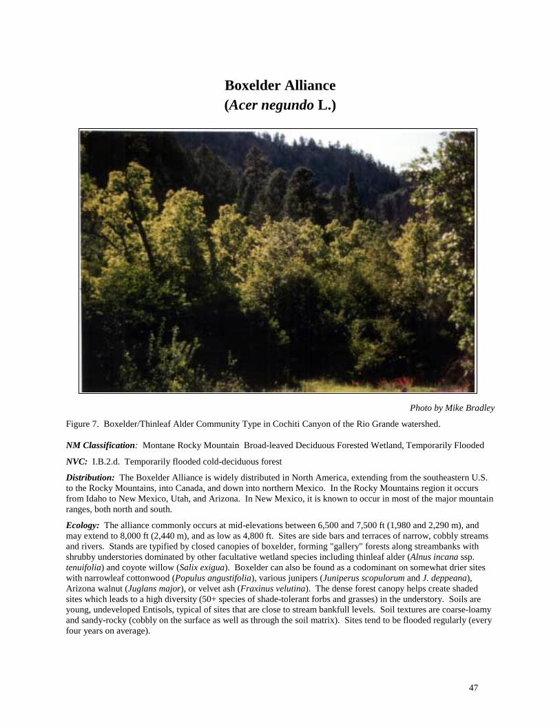
47
Boxelder Alliance (Acer negundo L.)
Photo by Mike Bradley
Figure 7. Boxelder/Thinleaf Alder Community Type in Cochiti Canyon of the Rio Grande watershed. NM Classification: Montane Rocky Mountain Broad-leaved Deciduous Forested Wetland, Temporarily Flooded
NVC: I.B.2.d. Temporarily flooded cold-deciduous forest
Distribution: The Boxelder Alliance is widely distributed in North America, extending from the southeastern U.S. to the Rocky Mountains, into Canada, and down into northern Mexico. In the Rocky Mountains region it occurs from Idaho to New Mexico, Utah, and Arizona. In New Mexico, it is known to occur in most of the major mountain ranges, both north and south.
Ecology: The alliance commonly occurs at mid-elevations between 6,500 and 7,500 ft (1,980 and 2,290 m), and may extend to 8,000 ft (2,440 m), and as low as 4,800 ft. Sites are side bars and terraces of narrow, cobbly streams and rivers. Stands are typified by closed canopies of boxelder, forming "gallery" forests along streambanks with shrubby understories dominated by other facultative wetland species including thinleaf alder (Alnus incana ssp. tenuifolia) and coyote willow (Salix exigua). Boxelder can also be found as a codominant on somewhat drier sites with narrowleaf cottonwood (Populus angustifolia), various junipers (Juniperus scopulorum and J. deppeana), Arizona walnut (Juglans major), or velvet ash (Fraxinus velutina). The dense forest canopy helps create shaded sites which leads to a high diversity (50+ species of shade-tolerant forbs and grasses) in the understory. Soils are young, undeveloped Entisols, typical of sites that are close to stream bankfull levels. Soil textures are coarse-loamy and sandy-rocky (cobbly on the surface as well as through the soil matrix). Sites tend to be flooded regularly (every four years on average).

48
Previously, Brown, Lowe, and Pase (1979) recognized an Acer negundo-Populus angustifolia-mixed deciduous Association as part of a Mixed Broadleaf Series within a Rocky Mountain Riparian Deciduous Forest Biome. A similar Acer negundo-Populus angustifolia/Cornus sericea Association was identified as occurring in Colorado by the Colorado Natural Heritage Program (Baker 1984). These associations are probably very similar to our Narrowleaf Cottonwood-Boxelder/Kentucky Bluegrass Community Type described under the Narrowleaf Cottonwood Alliance. Medina (1986) described an upper elevation Acer negundo/Alnus oblongifolia community type for southeastern New Mexico which had large quantities of Salix bonplandiana. Szaro (1989) described both an Acer negundo Community Type and an Acer negundo – Mixed Deciduous Community Type for southern New Mexico and Arizona with canopy codominants that include Alnus oblongifolia, Salix irrorata, Juglans major, Fraxinus pennsylvanica, Populus fremontii, and Populus angustifolia. Dick-Peddie (1993) suggests that in the Montane Riparian zone of New Mexico there are both the Box Elder Series (with Acer negundo/Alnus tenuifolia/MG-F and Acer negundo/MS/ Poa pratensis community types), and a Box Elder-[Arizona]Alder Series (with an Acer negundo/Alnus oblongifolia/MS/MG-F community type). In addition, boxelder is an important component of Dick-Peddie's Narrowleaf Cottonwood-Mixed Deciduous Series.
In Colorado, Acer negundo/Betula occidentalis communities are reported to occur in the Yampa and San Miguel/Dolores River Basins (Kittel and Lederer 1993). Along the White River Basin in Colorado boxelder occurs sporadically at the series level (Kittel 1993). An Acer negundo/Prunus virginiana habitat type is described as a minor type in the Great Plains region of central and eastern Montana (Hansen et al. 1990). It is also reported to occur in young, successional stands of Salix exigua, cottonwoods, and peach-leaf willows. In Utah, boxelder occurs as minor and incidental types with Cornus sericea in the Wasatch and LaSal Mountains and with Salix exigua occurring as an associate (Padgett, Youngblood and Winward 1989).
Currently, we recognize three provisional community types for the Boxelder Alliance based on our survey work, and suggest there is strong need for additional work to further elucidate community types within the alliance in the Southwest.
Key to the Boxelder (Acer negundo) Community Types:
1. Thinleaf alder abundant and the dominant shrub....................................................Boxelder/Thinleaf Alder CT 1. Thinleaf alder (Alnus incana ssp. tenuifolia) absent or scarce .......................................................................... (2) 2. Velvet ash (Fraxinus velutina) is abundant; coyote willow (Salix exigua) is absent or scarce............................... ...................................................................................................................................... Boxelder-Velvet Ash CT 2. Coyote willow abundant; velvet ash absent or scarce.............................................Boxelder/Coyote Willow CT
Community Type Descriptions:
Common Name Scientific Name
Boxelder/Coyote Willow CT Acer negundo/Salix exigua CT
Acronym ACENEG/SALEXI Status: Provisional Rank: S3?/G3? Distribution Upper Pecos River watershed of northern New Mexico (San Miguel Co.);
probably elsewhere throughout the range of the Alliance. PROVISIONAL DESCRIPTION. Characterized by an open canopy of boxelder with a diverse shrub layer dominated by coyote willow. Other shrubs include yellow willow (Salix lutea), Wood rose (Rosa woodsii), Virginia creeper (Parthenocissus quinquefolia var. quinquefolia), and broom snakeweed (Gutierrezia sarothrae). The herbaceous layer understory is well represented and includes smooth brome (Bromus inermis), Japanese brome (Bromus japonicus), and meadow fescue (Festuca pratensis). Preliminary data suggest that this type occurs on depositional side bars and terraces along streams with moderate entrenchment and stream gradients between 1.2 and 1.5%. This is a lower montane type with elevations estimated to range from 5,400 to 6,500 ft (1,650 to 1,980 m). The soils are reported as loamy to sandy loam in the surface layers with significant cobbles below 30 cm (loamy skeletal Typic Fluvaquent).

49
Common Name Scientific Name
Boxelder/Thinleaf Alder CT Acer negundo/Alnus incana ssp. tenuifolia CT
Acronym ACENEG/ALNINCT Status: Provisional Rank: S3?/G3? Distribution Mountainous regions of northern New Mexico in the Rio Grande and Pecos River
watersheds (Sandoval and San Miguel Counties). PROVISIONAL DESCRIPTION. This type occurs in lower montane regions at elevations documented at between 6,800 and 7,100 ft (2,070 and 2,160 m). Boxelders typically form closed-canopied, well-shaded gallery forests on streambanks and narrow sidebars. Dense thickets of thinleaf alder are characteristic of the undergrowth along with a wide variety of other shrubs (18 species). The herbaceous layer is also very diverse, but variable, with over 70 grasses and forbs reported for the type. The community is at least partially flooded every other year or completely inundated, on average, every 4 years. Flood debris is often evident near the banks as drift lines or larger debris piles. Soils are moist Entisols (Typic Fluvaquents and Oxyaquic Udifluvents) that are shallow and have a sandy to loamy layer over a gravelly/cobbly layer. They have wetness (hydric) indicators within the upper 40 cm. At lower elevations, thinleaf alder tends to decrease in dominance and drop out of the stand; while at upper elevations boxelder will decrease in dominance, being replaced by blue spruce (Picea pungens), or in some cases narrowleaf cottonwood (Populus angustifolia). This type is similar to the Acer negundo/Cornus sericea described by Padgett, Youngblood, and Winward 1989 and reported by Anderson et al. (1998) for Colorado, Utah, and Idaho. REFERENCE SITE NAME. Cochiti Canyon
Common Name Scientific Name
Boxelder-Velvet Ash CT Acer negundo-Fraxinus velutina CT
Acronym ACENEG/FRAVEL Status: Provisional Rank: S3?/G3? Distribution Organ Mountains in south-central New Mexico (Dona Ana Co.); likely elsewhere
in southern New Mexico and Arizona. PROVISIONAL DESCRIPTION. This is a closed-canopy forested wetland dominated by boxelder with velvet ash as a sub-dominant in the canopy. The abundant shrub understory includes whortleleaf snowberry (Symphoricarpos oreophilus), gooseberry currant (Ribes montigenum), common hoptree (Ptelea trifoliata), and tasselflower brickellbush (Brickellia grandiflora). Known to occur at mid-elevations around 7,400 ft (3,000 m), along rocky channels of moderate gradient (2–3%). Closely related to the Acer negundo–Mixed Deciduous Community Type described by Szaro (1989) for southern New Mexico and Arizona.

50
Fremont Cottonwood Alliance (Populus fremontii S. Wats.)
Photo by Mike Bradley
Figure 8. Fremont Cottonwood-Goodding Willow/Coyote Willow Community Type on the San Francisco River (Gila River watershed). NM Classification: Lowland Interior Southwest Broad-leaved Deciduous Forested Wetland, Temporarily Flooded
NVC: I.B.2.d. Temporarily flooded cold-deciduous forest
Distribution: The Fremont Cottonwood Alliance is widely distributed in the Southwest (southwestern New Mexico to southern California). In New Mexico, it occurs primarily in the Gila, San Francisco, and Mimbres River watersheds, and in closed basins in the southwest corner of the state.
Ecology: This alliance is found along perennial streams and rivers of lowland valleys extending into canyons of mountain foothills at elevations ranging between 3,800 and 5,800 ft (1,160 and1,770 m). Stands commonly occupy depositional bars and terraces with gravelly to sandy or finer substrates (rarely cobbly).
Stands are often codominated by Arizona sycamore (Platanus wrightii) or have Goodding willow (Salix gooddingii) in the sub-canopy. Other southwestern riparian species including velvet ash (Fraxinus velutina), Arizona walnut (Juglans major), and netleaf hackberry (Celtis laevigata) may be found in the overstory as well. Understories can be either shrub or herbaceous dominated, or very sparse. Coyote willow (S. exigua) and seepwillow (Baccharis salicifolia) are typical shrub associates of early- to mid-successional communities along with several obligate wetland herbs.
Younger successional community types (Fremont Cottonwood-Goodding Willow/Seepwillow or Fremont Cottonwood-Goodding Willow/Coyote Willow) typically form dense stands on bars adjacent to or in the active channel. These bars consist of coarse sandy sediments mixed with cobbles that are suitable for the development of

51
an herbaceous understory, and for the reproduction of Freemont cottonwood (Asplund and Gooch 1988). Debris piles and sediments are regularly deposited among the basal stems of sapling-sized cottonwood and willow trees. Stem breakage is common as these early successional community types are usually knocked back numerous times by moderate to heavy flooding. As sediments and debris accumulate, sandbars progress towards becoming high terraces. As flooding becomes less frequent, shrubby willows are disconnected from the water table, and drought-tolerant understory species replace the willows. Mature closed forests develop (Fremont Cottonwood-Arizona Sycamore). As older trees begin to die (and are not replaced), these forests make a transition to open woodlands (site progression of Leonard et al. 1992).
Communities of this alliance are commonly imbedded in a diverse mosaic of other vegetative communities. Barren, sandy channels may be lined by desert willow (Chilopsis linearis) and various shrubs and grasses. Flat open cobbly terraces are often dominated by seepwillow (Baccharis), rabbitbrush (Chrysothamnus), or burrobush (Hymenoclea) communities. Sycamore forests, similar to the cottonwood stands, also occur on terraces and bars within the floodplain. Open grasslands and shrublands generally dominate the upland slopes.
This alliance and the closely related Plains Cottonwood Alliance are thought to be declining due to several human-induced factors that interrupt the reproductive cycle and change habitat conditions and functions (Howe and Knopf 1991; Crawford et al. 1993; Bogan et al. 1998). Primary factors include the regulation of rivers that reduces annual flow volumes, changes seasonal peak flows from spring to summer, and disrupts the annual fluctuation in flow volume by diversions during dry years (Stromberg and Patten 1992). Altering the hydrological regime by reducing flooding and minimum flows can have a particular impact on the reproduction and long-term viability of cottonwood forested wetlands. Scouring floods are required to create bare substrates for cottonwood seed germination followed by sustained high moisture conditions to insure establishment (Horton, Mounts, and Kraft.1960). These factors, in concert with shrubby exotic invasions (Everitt 1980), increased fire frequency (Stuever 1997), altered litter decomposition rates (Ellis, Molles and Crawford 1999), and excessive herbivory by livestock and native animals (Krueper 1996), combine to further endanger the biological integrity of wetlands of the Plains Cottonwood Alliance.
Several community types have been previously reported which may belong to this Alliance, but have uncertain placement because of confusion caused by changing names between P. fremontii and P. deltoides over time. Campbell and Dick-Peddie (1964) described two cottonwood-dominated vegetation communities from the Rio Grande drainage (Class IV and V), which they ascribed to P. fremontii that we would probably consider P. deltoides var. wislizeni now. Similarly, Szaro (1989) refers to a Populus fremontii Community Type for Arizona and New Mexico which is inclusive of P. deltoides. Dick-Peddie (1993) recognizes only P. fremontii in New Mexico and identified four series: 1) a Montane Riparian Broadleaf Cottonwood Series; 2) a Montane Riparian Broadleaf Cottonwood-Mixed Deciduous Series; 3) a Floodplains-Plains Riparian Cottonwood Series; and 4) a Floodplains-Plains Riparian Cottonwood-Willow Series. Only the former two series contain references to community types that are similar to those found in our Plains Cottonwood Alliance (the other two series are best represented by our Plains Cottonwood Alliance). Hildebrant and Ohmart (1982) and Hink and Ohmart (1984) define several cottonwood community types (explicitly specified as P. deltoides var. wislizeni) for the Pecos and Rio Grande, respectively. These are based on structural and compositional characteristics of the canopy for the mapping analysis of bird habitat. We have identified 20 community types for this widespread and variable alliance in New Mexico.
Key to the Fremont Cottonwood (Populus fremontii) Community Types: 1 Arizona sycamore (Platanus wrightii) codominant in mature stands of high terraces and/or sites with no signs
of recent flooding....................................................................... Fremont Cottonwood-Arizona Sycamore CT 1. Arizona sycamore absent ................................................................................................................................... (2) 2. Velvet ash (Fraxinus velutina) well represented, dominant of the sub-canopy...................................................... .................................................................................................................. Fremont Cottonwood/Velvet ash CT 2. Velvet ash poorly represented............................................................................................................................ (3) 3. Goodding willow codominant in the canopy or sub-canopy.............................................................................. (4) 3. Goodding willow poorly represented or absent ................................................................................................. (5)

52
4. Seepwillow (Baccharis salicifolia) well represented (flooding evident; stands typically border the active channel) ....................................................................Fremont Cottonwood-Goodding Willow/Seepwillow CT
4. Coyote willow (Salix exigua) well represented to abundant; seepwillow poorly represented or absent ................ ............................................................................Fremont Cottonwood-Goodding Willow/Coyote Willow CT 5. Seepwillow well represented to abundant................................................Fremont Cottonwood/Seepwillow CT 5. Seepwillow and other shrubs poorly represented; undergrowth sparse (<1% cover) ........................................ (6) 6. Sites scoured by flooding, often with a cobbly surface ....................................Fremont Cottonwood/Scour CT 6. Sites not scoured by flooding, usually of upper terraces ............................... Fremont Cottonwood/Sparse CT
Community Type Descriptions.
Common Name Scientific Name
Fremont Cottonwood-Arizona Sycamore CT Populus fremontii-Platanus wrightii CT
Acronym POPFRE-PLAWRI Status: Established Rank: S1/G2 Distribution Gila watershed in southwestern New Mexico (Catron and Grant Counties); also in
southern Arizona. VEGETATION. Fremont cottonwood and Arizona sycamore form open to moderately closed, sprawling canopies (50-75% cover). In older stands, multi-boled trees can attain large sizes with diameters, exceeding one or two meters (3 to 10 feet) at breast height (dbh), and heights of up to 25 m (82 ft). Cottonwood and sycamore regeneration is rare, but other trees such as Arizona walnut (Juglans major), velvet ash (Fraxinus velutina), box elder (Acer negundo) and occasionally the introduced honeylocust (Gleditsia triacanthos) may be present as saplings or sub-canopy associates. On drier sites and in older stands, alligator juniper (Juniperus deppeana) may also be common. Undergrowth is diverse and variable with 79 species reported for the type, but only 23 more than once. With the exception of seepwillow (Baccharis salicifolia), arrowweed (Pluchea sericea) and coyote willow (Salix exigua), shrubs are generally poorly represented. The herbaceous undergrowth is characterized by scattered grasses and forbs and includes the wetland indicators willowleaf aster (Aster praealtus), and cardinalflower (Lobelia cardinalis), along with upland grama grasses (Bouteloua curtipendula, B. eriopoda, and B. gracilis).
ENVIRONMENT. This community type occurs in lowland river valleys at elevations ranging between 3,875 and 5,150 ft (1,180 and 1,570 m). The stream gradients are typically low and channel substrates gravelly or finer, but with pockets of cobbles. Typically, this type occurs as mature stands on older river terraces, that are elevated several meters above the present riverbed and affected by only the largest flood events (25-100 year intervals). Occasionally the type occurs on lower bars that are more frequently flooded. Soils range from weakly developed Entisols on lower bars to more developed Inceptisols (deep, well-drained, stratified soils comprised of sandy, loamy surface soils underlain by finer silt layers) on the upper terraces. Cobbles and rock may be present on the surface, or buried at lower depths. The soils tend to be dry on the surface most of the year, but may be periodically moist at depths within the rooting zone of the dominant trees and shrubs, particularly during spring runnoff periods. COMMENTS. Since Arizona sycamore reproduces on low, cobbly bars in the channel, mature stands of high terraces usually lack young trees. Saplings of walnut, velvet ash or honeylocust, which are drought and shade tolerant, may indicate a successional shift toward a drier community type. Adjacent lower bars are often dominated by early successional communities such as Arizona Sycamore-Arizona Alder/Seepwillow. Where sycamores do not become established, for example on sandy or silty bars, Fremont Cottonwood-Goodding Willow/Coyote Willow or Fremont Cottonwood/ Seepwillow communities may be prevalent. Large, flat and sparsely vegetated cobble bars may dissect the floodplain creating a relatively undulating surface topography. Intermittent channels that dissect the floodplain may be dominated by desert willow and rabbitbrush, while the outer floodplains are typically dominated by forests of Arizona walnut or netleaf hackberry. Dick-Peddie (1993) reports a Populus fremontii/Platanus wrightii/S/MG-F type without description within his Broadleaf Cottonwood-Mixed Deciduous Series. Similarly, Brown, Lowe, and Pase 1979 report a Platanus
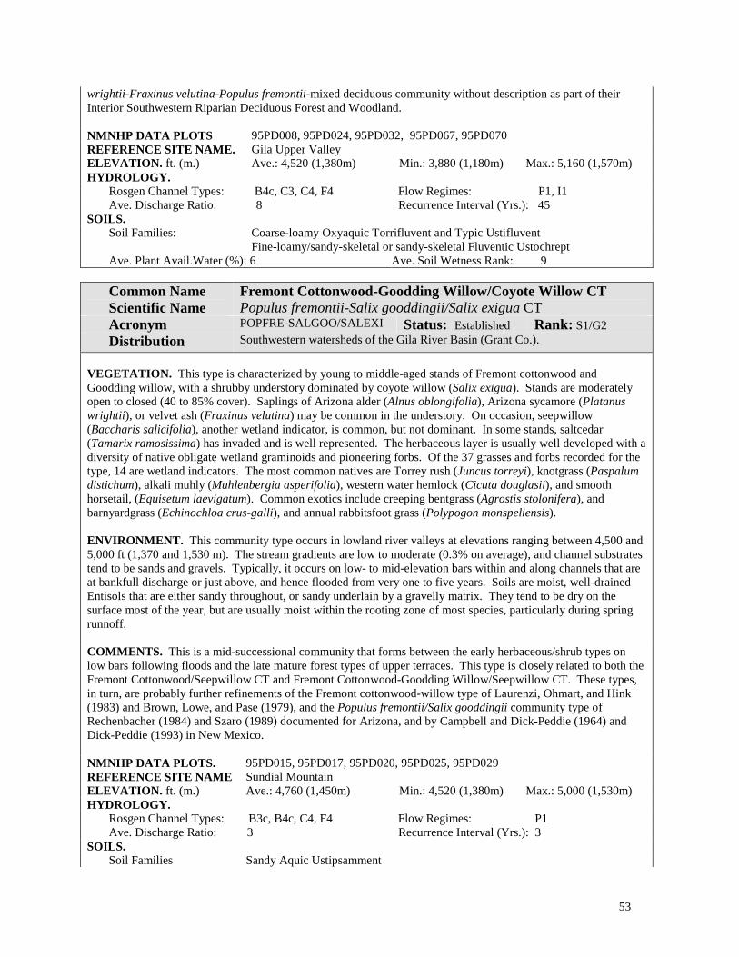
53
wrightii-Fraxinus velutina-Populus fremontii-mixed deciduous community without description as part of their Interior Southwestern Riparian Deciduous Forest and Woodland. NMNHP DATA PLOTS 95PD008, 95PD024, 95PD032, 95PD067, 95PD070 REFERENCE SITE NAME. Gila Upper Valley ELEVATION. ft. (m.) Ave.: 4,520 (1,380m) Min.: 3,880 (1,180m) Max.: 5,160 (1,570m) HYDROLOGY.
Rosgen Channel Types: B4c, C3, C4, F4 Flow Regimes: P1, I1 Ave. Discharge Ratio: 8 Recurrence Interval (Yrs.): 45
SOILS. Soil Families: Coarse-loamy Oxyaquic Torrifluvent and Typic Ustifluvent
Fine-loamy/sandy-skeletal or sandy-skeletal Fluventic Ustochrept Ave. Plant Avail.Water (%): 6 Ave. Soil Wetness Rank: 9
Common Name Scientific Name
Fremont Cottonwood-Goodding Willow/Coyote Willow CT Populus fremontii-Salix gooddingii/Salix exigua CT
Acronym POPFRE-SALGOO/SALEXI Status: Established Rank: S1/G2 Distribution Southwestern watersheds of the Gila River Basin (Grant Co.).
VEGETATION. This type is characterized by young to middle-aged stands of Fremont cottonwood and Goodding willow, with a shrubby understory dominated by coyote willow (Salix exigua). Stands are moderately open to closed (40 to 85% cover). Saplings of Arizona alder (Alnus oblongifolia), Arizona sycamore (Platanus wrightii), or velvet ash (Fraxinus velutina) may be common in the understory. On occasion, seepwillow (Baccharis salicifolia), another wetland indicator, is common, but not dominant. In some stands, saltcedar (Tamarix ramosissima) has invaded and is well represented. The herbaceous layer is usually well developed with a diversity of native obligate wetland graminoids and pioneering forbs. Of the 37 grasses and forbs recorded for the type, 14 are wetland indicators. The most common natives are Torrey rush (Juncus torreyi), knotgrass (Paspalum distichum), alkali muhly (Muhlenbergia asperifolia), western water hemlock (Cicuta douglasii), and smooth horsetail, (Equisetum laevigatum). Common exotics include creeping bentgrass (Agrostis stolonifera), and barnyardgrass (Echinochloa crus-galli), and annual rabbitsfoot grass (Polypogon monspeliensis). ENVIRONMENT. This community type occurs in lowland river valleys at elevations ranging between 4,500 and 5,000 ft (1,370 and 1,530 m). The stream gradients are low to moderate (0.3% on average), and channel substrates tend to be sands and gravels. Typically, it occurs on low- to mid-elevation bars within and along channels that are at bankfull discharge or just above, and hence flooded from very one to five years. Soils are moist, well-drained Entisols that are either sandy throughout, or sandy underlain by a gravelly matrix. They tend to be dry on the surface most of the year, but are usually moist within the rooting zone of most species, particularly during spring runnoff. COMMENTS. This is a mid-successional community that forms between the early herbaceous/shrub types on low bars following floods and the late mature forest types of upper terraces. This type is closely related to both the Fremont Cottonwood/Seepwillow CT and Fremont Cottonwood-Goodding Willow/Seepwillow CT. These types, in turn, are probably further refinements of the Fremont cottonwood-willow type of Laurenzi, Ohmart, and Hink (1983) and Brown, Lowe, and Pase (1979), and the Populus fremontii/Salix gooddingii community type of Rechenbacher (1984) and Szaro (1989) documented for Arizona, and by Campbell and Dick-Peddie (1964) and Dick-Peddie (1993) in New Mexico. NMNHP DATA PLOTS. 95PD015, 95PD017, 95PD020, 95PD025, 95PD029 REFERENCE SITE NAME Sundial Mountain ELEVATION. ft. (m.) Ave.: 4,760 (1,450m) Min.: 4,520 (1,380m) Max.: 5,000 (1,530m) HYDROLOGY.
Rosgen Channel Types: B3c, B4c, C4, F4 Flow Regimes: P1 Ave. Discharge Ratio: 3 Recurrence Interval (Yrs.): 3
SOILS. Soil Families Sandy Aquic Ustipsamment

54
Sandy-skeletal Oxyaquic Ustifluvent Coarse-loamy Aeric Fluvaquent Coarse-loamy Oxyaquic Torrifluvent
Ave. Plant Avail.Water (%): 4 Ave. Soil Wetness Rank: 6
Common Name Scientific Name
Fremont Cottonwood-Goodding Willow/Seepwillow CT Populus fremontii-Salix gooddingii/Baccharis salicifolia CT
Acronym POPFRE-SALGOO/BACSAL Status: Established Rank: S1/G2 Distribution Gila River watershed (Grant Co.); probable elsewhere in southwestern New
Mexico and southern Arizona VEGETATION. This type is characterized by young to middle-aged stands of Fremont cottonwood and Goodding Willow with moderate to closed canopies (usually greater that 60% cover). Netleaf hackberry (Celtis laevigata var. reticulata), velvet ash (Fraxinus velutina), Arizona walnut (Juglans major), oneseed juniper (Juniperus monosperma), and Arizona sycamore (Platanus wrightii) can occur as sub-canopy associates, but are never dominant. Seepwillow is well represented to abundant in the shrub layer and is diagnostic. Other shrubs are scattered and may include desert indigobush (Amorpha fruticosa), rubber rabbitbrush (Chrysothamnus nauseosus), skunkbush sumac (Rhus trilobata), and coyote willow (Salix exigua). The herbaceous layer can range from sparse and species poor, to well represented and species rich, but variable. A total of 54 grasses and forbs have been recorded for the type, 7 of which were wetland indicators. The most common were whorled marsh pennywort (Hydrocotyle verticillata), threesquare bulrush (Scirpus pungens), lanceleaf frogfruit (Phyla lanceolata), Baltic rush (Juncus balticus), and alkali muhly (Muhlenbergia asperifolia).
ENVIRONMENT. This community type occurs in lowland river valleys at elevations ranging 4,000 to 4,625 ft (1,220 to 1,410 m). Stream gradients are moderate (0.3 to 0.9%), and channel substrates gravelly or finer. Occurring on low- to mid-elevation bars within and along channels, flood recurrence intervals vary widely, but typically range between two and five years. Some site are considerably higher in the floodplain and are rarely flooded (25-100 years). Soils are young, weakly developed Entisols that are commonly sandy with a cobbly matrix. Others, particularly those of higher terraces, are sandy or loamy throughout. The soils are generally dry on the surface most of the year, but they may be periodically moist within the rooting zone (40-150 cm). COMMENTS. This is a mid-successional community that forms between the herbaceous/shrub types established on lower bars following floods, and mature forests of upper terraces. The moist, sandy soils are suitable for the development of a rich herbaceous understory. This type is closely related to both the Fremont Cottonwood/Seepwillow CT and Fremont Cottonwood-Goodding Willow/Coyote Willow CT. All three types, in turn, are probably refinements of the Fremont cottonwood-willow type of Laurenzi, Ohmart, and Hink (1983) and Brown, Lowe, and Pase (1979), and the Populus fremontii/Salix gooddingii community type of Rechenbacher (1984) and Szaro (1989) documented for Arizona, and by Campbell and Dick-Peddie (1964) and Dick-Peddie (1993) in New Mexico. NMNHP DATA PLOTS. 95PD027, 95PD060, 95PD063, 95PD066, 95PD071 REFERENCE SITE NAME. Gila Lower Valley, Gila Upper Valley ELEVATION. ft. (m.) Ave.: 4,300 (1,310m) Min.: 3,240 (990m) Max.: 5,360 (1,630m) HYDROLOGY.
Rosgen Channel Types: C3, C4, C5c-, E5, G3c Flow Regimes: P1, P3, I1 Ave. Discharge Ratio: 5 Recurrence Interval (Yrs.): 16
SOILS. Soil Families Clayey/sandy or coarse-loamy or coarse-loamy/sandy or coarse-loamy/sandy-
skeletal or fine-loamy/sandy-skeletal Oxyaquic Torrifluvent Sandy Oxyaquic Torripsamment Sandy-skeletal Oxyaquic Ustifluvent Loamy-skeletal or sandy-skeletal Typic Fluvaquent
Ave. Plant Avail.Water (%): 5 Ave. Soil Wetness Rank: 7

55
Common Name Scientific Name
Fremont Cottonwood/Scour CT Populus fremontii/Scour CT
Acronym POPFRE/SCOUR Status: Provisional Rank: S2?/G3? Distribution Gila and San Francisco Rivers (Catron and Grant Counties); probable elsewhere
in southwestern New Mexico and southeastern Arizona. PROVISIONAL DESCRIPTION. This type is characterized by open to dense, young regeneration stands of Fremont cottonwood with young Goodding willow (Salix gooddingii) in the understory, that occur on low bars or riverwash within the active channel. Sites are seasonally flooded, scouring away much of the undergrowth. Seepwillow (Baccharis salicifolia) remains common, but not abundant. Forbs and grasses are scattered and variously represented by a suite of wetland indicators that may include chufa flatsedge (Cyperus esculentus), barnyardgrass (Echinochloa crus-galli), Baltic rush (Juncus balticus), annual rabbitsfoot grass (Polypogon monspeliensis), beardless rabbitsfoot (Polypogon viridis), threesquare bulrush (Scirpus pungens), softstem bulrush (Scirpus tabernaemontani), field horsetail (Equisetum arvense), curlytop knotweed (Polygonum lapathifolium), roundfruit yellowcress (Rorippa sphaerocarpa), and American speedwell (Veronica americana). Soils are either sandy, moist weakly developed Entisols (Sandy Aquic Ustipsamments), or riverwash composed of non-cohesive and unconsolidated deposits of sands, gravels, or cobbles. Elevations range from 4,000 to 5,370 ft (1,220 to 1,640 m). This type may represent a younger stage of the Fremont Cottonwood-Goodding Willow/Seepwillow CT. It should not be confused with the Fremont Cottonwood/Spare CT of high terraces at the edge of floodplains that are rarely flooded.
Common Name Scientific Name
Fremont Cottonwood/Seepwillow CT Populus fremontii/Baccharis salicifolia CT
Acronym POPFRE/BACSAL Status: Provisional Rank: S1?/G2? Distribution Gila River Basin in southwestern New Mexico (Grant Co.).
PROVISIONAL DESCRIPTION. This lowland, forested wetland is characterized in young to middle-aged stands of Fremont cottonwood with a shrubby understory dominated by seepwillow. Arizona sycamore (Platanus wrightii) and Goodding willow (Salix gooddingii) may be present, but are not well represented or dominant. Coyote willow (Salix exigua) may also be present, but is subordinate to seepwillow. Preliminary data suggest that the community occurs in river valleys at elevations ranging from 4,500 to 5,200 ft (1,370 to 1,590 m). Stream gradients are low (.05-.05%), and channel substrates gravelly or finer. Typically, it occurs on low- to mid-elevation bars within and along the channel that are flooded every two years on average. Soils are either sandy, moist, weakly developed Entisols (Sandy Aquic Ustipsamments), or riverwash composed of non-cohesive and unconsolidated deposits of sands, gravels, or cobbles. This type is closely related to both the Fremont Cottonwood-Goodding Willow/Seepwillow CT and Fremont Cottonwood-Goodding Willow/Coyote Willow CT. All three types, in turn, are probably refinements of the Fremont cottonwood-willow type of Laurenzi, Ohmart, and Hink (1983) and Brown, Lowe, and Pase (1979), and the Populus fremontii/Salix gooddingii community type of Rechenbacher (1984) and Szaro (1989) documented for Arizona, and by Campbell and Dick-Peddie (1964) and Dick-Peddie (1993) in New Mexico. REFERENCE SITE NAME. Sundial Mountain, Gila Upper Valley

56
Common Name Scientific Name
Fremont Cottonwood/Sparse CT Populus fremontii/Sparse CT
Acronym POPFRE/Sparse Status: Provisional Rank: S1?/G2? Distribution San Francisco River watershed (Catron Co.); probable elsewhere in southwestern
New Mexico and southeastern Arizona. PROVISIONAL DESCRIPTION. Fremont cottonwood forms a dense canopy (>60% cover), with only scattered representatives of other floodplain tree species. Although 20 undergrowth species have been recorded for the type, only seepwillow (Baccharis salicifolia) and yellow sweetclover (Melilotus officinalis) are known to exceed 1% cover. Known from high terraces at the edge of the floodplain which are rarely flooded (25-100 year recurrence interval, and discharge ratios of 3.6 to 11.2). In keeping with the high landscape position, soils are deep, sandy and relatively dry (sandy and sandy-skeletal, Oxyaquic Ustifluvents). This type should not be confused with the Fremont Cottonwood/Scour CT that also has a sparse undergrowth, but with the sparseness due to repeated flooding and cobbly substrate.
Common Name Scientific Name
Fremont Cottonwood-Velvet Ash CT Populus fremontii-Fraxinus velutina CT
Acronym POPFRE-FRAVEL Status: Provisional Rank: S3?/G3? Distribution Animas Creek of the eastern slope of the Black Range in the Rio Grande Basin
(Sierra Co.); probable elsewhere in southwestern New Mexico and southeastern Arizona.
PROVISIONAL DESCRIPTION. Fremont cottonwood and velvet ash codominate young, moderate to dense canopies (>50% cover). Goodding willow (Salix gooddingii) can be a canopy codominant. Undergrowth is moderately diverse (26 species recorded for the type), but cover is low. In the shrub layer there are usually scattered individuals of seepwillow (Baccharis salicifolia) and desert indigobush (Amorpha fruticosa). The most common herbs are Rocky Mountain rush (Juncus saximontanus) and prairie wedgescale (Sphenopholis obtusata). Preliminary data suggest that sites are typically rocky banks of moderate gradient streams (1.5%) that are frequently flooded (two-year recurrence interval). Soils have been reported as coarse-loamy over fragmental Typic Torrifluvents, and as cobbly riverwash, reflecting the coarse substrates of sites. Elevations are around 5,000 ft (1,525 m). This type may only be a variant of the Fremont Cottonwood/Goodding Willow CT and similar types. Szaro (1989) describes a Populus fremontii-Fraxinus pennsylvanica Community Type that is probably equivalent. Similarly, Dick-Peddie (1993) reports a Populus fremontii-Fraxinus pennsylvanica-Salix gooddingii type without a description as part of his Montane Riparian, Broadleaf Cottonwood-Mixed Deciduous Series.

57
Goodding Willow Alliance (Salix gooddingii Ball)
Photo by Mike Bradley
Figure 9. Goodding Willow Alliance on Seco Creek of the Rio Grande watershed. NM Classification: Lowland Interior Southwest Broad-leaved Deciduous Forested Wetland, Temporarily Flooded
NVC: I.B.2.d. Temporarily flooded cold-deciduous forest
Distribution: Known from the lower Pecos and lower Rio Grande in New Mexico; probable elsewhere in southern New Mexico and southern Arizona.
Ecology: This provisional alliance is known to occur at elevations ranging between 3,250 and 3,650 ft (990 and 1,110 m). The overstory canopy is open to moderately closed and dominated by Goodding willow; cottonwoods are uncommon or absent. There can be a significant shrub layer commonly dominated by seepwillows (Baccharis emoryi and B. salicifolia), and well represented to abundant herb layers that can support a wide variety of wetland

58
indicators such as Baltic rush (Juncus balticus), Rocky Mountain rush (Juncus saximontanus), alkali muhly (Muhlenbergia asperifolia), threesquare bulrush (Scirpus pungens), common spikerush (Eleocharis palustris), Jamaica swamp sawgrass (Cladium mariscus ssp. jamaicense), cutleaf waterparsnip (Berula erecta), cardinalflower (Lobelia cardinalis), lanceleaf frogfruit (Phyla lanceolata), and sandpaper vervain (Verbena scabra). Stands occur on banks of low-gradient river channels. Most are at least temporarily flooded during most years, showing signs of saturation within the top 40 cm of the surface. Soils are moist and moderately well-drained with a dark and relatively thick surface horizon (approx. 15 cm deep). The soil matrix is loamy-skeletal, but with no more than 35% cobbles or gravels.
Goodding willow is usually found in association with other floodplain trees, forming mixed stands (see the Fremont Cottonwood-Goodding Willow CT). Szaro (1989) first described a Salix gooddingii community type for southern Arizona in which Goodding willow is the overwhelming canopy dominant. At this time only two community types have been identified based on limited data, and the Alliance remains provisional pending additional information
Key to the Goodding Willow (Salix gooddingii) Community Types:
1. Emory baccharis (Baccharis emoryi) the dominant shrub; herbaceous cover abundant; deergrass
(Muhlenbergia rigens) absent or scarce ..............................................Goodding Willow/Emory Baccharis CT 1. Emory baccharis, scarce or absent, deergrass well represented. ........................................................................... ......................................................................................................................... Goodding Willow/Deergrass CT
Community Type Descriptions:
Common Name Scientific Name
Goodding Willow/Deergrass CT Salix gooddingii/Muhlenbergia rigens CT
Acronym SALGOO/MUHRIG Status: Provisional Rank: S2?/G2? Distribution Black River drainage in southeastern New Mexico (Eddy Co.).
PROVISIONAL DESCRIPTION. This type is characterized by an open canopy of Goodding willow overhanging the banks of low gradient streams lined with graminoids that include deergrass, bushy bluestem (Andropogon glomeratus), common spikerush (Eleocharis palustris), and alkali muhly (Muhlenbergia asperifolia). Jamaica swamp sawgrass is prevalent both along the banks and in the channel. Seepwillow (Baccharis salicifolia) is well represented in the shrub layer. Known from around 3,250 ft (990 m) along ponded reaches of the Black River.
Common Name Scientific Name
Goodding Willow/Emory Baccharis CT Salix gooddingii/Baccharis emoryi CT
Acronym SALGOO/BACEMO Status: Provisional Rank: S2?/G2? Distribution Black River drainage in southeastern New Mexico (Eddy Co.).
PROVISIONAL DESCRIPTION. Goodding willow forms a moderately open canopy that overhangs the banks of low-gradient streams lined with Emory baccharis. The herbaceous cover is also abundant and dominated by Bermuda grass (Cynodon dactylon), smooth horsetail (Equisetum laevigatum), Baltic rush (Juncus balticus), Rocky Mountain rush (Juncus saximontanus), threesquare bulrush (Scirpus pungens), alkali muhly (Muhlenbergia asperifolia), annual rabbitsfoot grass (Polypogon monspeliensis), (Typha latifolia), sandpaper vervain (Verbena scabra), and lanceleaf frogfruit (Phyla lanceolata). Known from around 3,660 ft (1110 m) along slow moving reaches of the Black River.

59
Narrowleaf Cottonwood Alliance (Populus angustifolia James)
Photo by Esteban Muldavin
Figure 10. Narrowleaf Cottonwood-Boxelder/Kentucky Bluegrass Community Type at Pecos National Monument on the lower Glorieta Creek near the Pecos River. NM Classification: Montane Rocky Mountain Broad-leaved Deciduous Forested Wetland, Temporarily Flooded
NVC: I.B.2.d. Temporarily flooded cold-deciduous forest
Distribution: The Narrowleaf Cottonwood Alliance is well distributed throughout mountainous regions of the Rocky Mountains, Great Basin, and the Southwest. In New Mexico, it occurs in all of the major watersheds including the Rio Grande, Pecos, Canadian, San Juan, and Gila River Basins.
Ecology: This alliance is characterized by moderate to closed canopies of narrowleaf cottonwood with a wide variety of undergrowth structures and compositions. It includes stands dominated by lanceleaf cottonwood, the

60
hybrid species between narrowleaf and broadleaf cottonwoods such as P. deltoides or P. fremontii. Box elder (Acer negundo) and Arizona alder (Alnus oblongifolia) are common canopy associates, that occasionally codominate. Conifers such as blue spruce (Picea pungens) and white fir (Abies concolor) can also be present.
Younger, regeneration stands can have conspicuous shrub layers dominated by coyote willow (Salix exigua) and thinleaf alders (Alnus incana ssp. tenuifolia). In more mature stands, common chokecherry (Prunus virginiana) and New Mexico olive (Forestiera pubescens ssp. pubescens) are sometime abundant. On drier upper terraces, stands become more open and have grassy understories typically dominated by Kentucky bluegrass (Poa pratensis).
The alliance occurs along perennial, or sometimes intermittent, montane and foothill streams at elevations ranging between 5,650 and 8,900 ft (1,720 and 2,720 m). Sites are often found in narrow canyons cut by moderate to high gradient streams with cobbly or bedrock streambeds (gradients typically range from as low as 0.75% to as high as 5%). In these sites, depositional floodplains are limited, and stands form narrow strands along the channel edge. Occasionally, wider sidebars deposits occur along lower gradient portions of the streams leading to larger, more extensive stands.
Soils range in the degree of development and wetness corresponding more or less to degree of successional development of the vegetation community. The younger, weakly undeveloped soils found in younger stands on low alluvial bars are classified as Entisols. On higher bars and terraces that are less frequently flooded, soils are slightly more developed and darker, and are classified as either Inceptisols or Mollisols (there is usually some indication of soil horizon formation). In general, soils of the alliance tend to be well-drained, with sands and some loams, over a gravelly/rocky layer.
Narrowleaf cottonwood is capable of developing short-lived, but fast-growing tall, dense forests. However, it is more commonly encountered as open stands utilized by livestock and wildlife for shade and cover. Where grazing occurs, these stands tend to have a strong exotic herbaceous component in the understory.
Communities are often found intermixed with old abandoned channels and low side bars that support marshy, emergent herbaceous wetlands and willow-dominated scrub-shrub wetlands. In southern New Mexico, adjacent outer floodplains sometimes support drier communities dominated by Arizona walnut (Juglans major) and netleaf hackberry (Celtis laevigata var. reticulata).
Communities of this alliance are widely distributed on depositional stream terraces and bars of moderate-sized drainages with unregulated flows and few diversions. Typically, it occurs in wider valleys where livestock are common. When heavily grazed, stands may be decadent and lose saplings and shrub species. Under continuous pressure from grazing, these stands have a very limited ability to remain self-sustaining. As these stands are eventually replaced by non-cottonwood-dominated stands, streambanks become more susceptible to erosion. Where these cottonwood communities are carefully managed with moderate and non-continuous grazing, and a buffer strip of cottonwoods is maintained along streambanks, the community becomes self-sustaining for several years until the stand is rejuvenated by flooding. In these situations, re-growth of the cottonwoods is rapid, riparian shrubs return, and streambanks become re-stabilized. This type of management is extremely important for the preservation of biodiversity and valuable habitat. Brown, Lowe, and Pase (1979) designate without description a Populus angustifolia/Salix spp. Association within a Cottonwood-Willow Series of their Rocky Mountain Riparian Deciduous Forest. Medina (1986) described both Populus angustifolia and Populus acuminata community types in southwestern New Mexico. Baker (1984) reports several communities from this alliance for Colorado. Bassett, Larson, and Moir (1987) describe a Populus angustifolia Series for forests of southwestern New Mexico and southern Arizona. Szaro (1989) described a generalized Populus angustifolia Community Type for Arizona and New Mexico. Dick-Peddie (1993) recognizes a Narrowleaf cottonwood Series with two types, primarily from northern New Mexico, and a Narrowleaf-Mixed Deciduous Series with five types from southern portions of the state.
Key to the Narrowleaf Cottonwood (Populus angustifolia) Community Types:
1. Alders are codominant ....................................................................................................................................... (2) 1. Alders absent, or minor ..................................................................................................................................... (3)
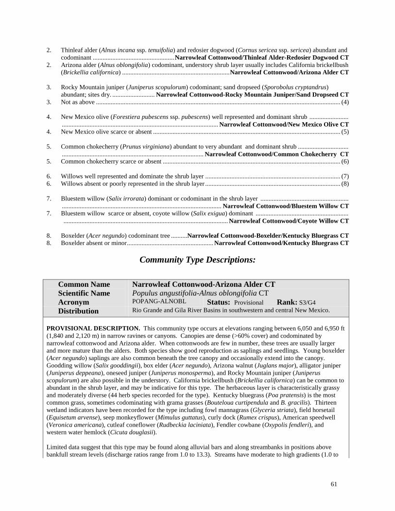
61
2. Thinleaf alder (Alnus incana ssp. tenuifolia) and redosier dogwood (Cornus sericea ssp. sericea) abundant and codominant ..................................................Narrowleaf Cottonwood/Thinleaf Alder-Redosier Dogwood CT
2. Arizona alder (Alnus oblongifolia) codominant, understory shrub layer usually includes California brickellbush (Brickellia californica) ..................................................................Narrowleaf Cottonwood/Arizona Alder CT
3. Rocky Mountain juniper (Juniperus scopulorum) codominant; sand dropseed (Sporobolus cryptandrus)
abundant; sites dry. .......................... Narrowleaf Cottonwood-Rocky Mountain Juniper/Sand Dropseed CT 3. Not as above ...................................................................................................................................................... (4) 4. New Mexico olive (Forestiera pubescens ssp. pubescens) well represented and dominant shrub ........................ ................................................................................................ Narrowleaf Cottonwood/New Mexico Olive CT 4. New Mexico olive scarce or absent ................................................................................................................... (5) 5. Common chokecherry (Prunus virginiana) abundant to very abundant and dominant shrub ............................... ....................................................................................... Narrowleaf Cottonwood/Common Chokecherry CT 5. Common chokecherry scarce or absent ............................................................................................................. (6) 6. Willows well represented and dominate the shrub layer ................................................................................... (7) 6. Willows absent or poorly represented in the shrub layer ................................................................................... (8) 7. Bluestem willow (Salix irrorata) dominant or codominant in the shrub layer ...................................................... .................................................................................................. Narrowleaf Cottonwood/Bluestem Willow CT 7. Bluestem willow scarce or absent, coyote willow (Salix exigua) dominant ......................................................... ..................................................................................................... Narrowleaf Cottonwood/Coyote Willow CT 8. Boxelder (Acer negundo) codominant tree ..........Narrowleaf Cottonwood-Boxelder/Kentucky Bluegrass CT 8. Boxelder absent or minor..................................................... Narrowleaf Cottonwood/Kentucky Bluegrass CT
Community Type Descriptions:
Common Name Scientific Name
Narrowleaf Cottonwood-Arizona Alder CT Populus angustifolia-Alnus oblongifolia CT
Acronym POPANG-ALNOBL Status: Provisional Rank: S3/G4 Distribution Rio Grande and Gila River Basins in southwestern and central New Mexico.
PROVISIONAL DESCRIPTION. This community type occurs at elevations ranging between 6,050 and 6,950 ft (1,840 and 2,120 m) in narrow ravines or canyons. Canopies are dense (>60% cover) and codominated by narrowleaf cottonwood and Arizona alder. When cottonwoods are few in number, these trees are usually larger and more mature than the alders. Both species show good reproduction as saplings and seedlings. Young boxelder (Acer negundo) saplings are also common beneath the tree canopy and occasionally extend into the canopy. Goodding willow (Salix gooddingii), box elder (Acer negundo), Arizona walnut (Juglans major), alligator juniper (Juniperus deppeana), oneseed juniper (Juniperus monosperma), and Rocky Mountain juniper (Juniperus scopulorum) are also possible in the understory. California brickellbush (Brickellia californica) can be common to abundant in the shrub layer, and may be indicative for this type. The herbaceous layer is characteristically grassy and moderately diverse (44 herb species recorded for the type). Kentucky bluegrass (Poa pratensis) is the most common grass, sometimes codominating with grama grasses (Bouteloua curtipendula and B. gracilis). Thirteen wetland indicators have been recorded for the type including fowl mannagrass (Glyceria striata), field horsetail (Equisetum arvense), seep monkeyflower (Mimulus guttatus), curly dock (Rumex crispus), American speedwell (Veronica americana), cutleaf coneflower (Rudbeckia laciniata), Fendler cowbane (Oxypolis fendleri), and western water hemlock (Cicuta douglasii). Limited data suggest that this type may be found along alluvial bars and along streambanks in positions above bankfull stream levels (discharge ratios range from 1.0 to 13.3). Streams have moderate to high gradients (1.0 to

62
4.5), beds that are gravelly/cobbly, and flows that can be either perennial or intermittent. Flooding is estimated to recur anywhere from 2 to 25 years. Soils are poorly developed, well-drained, sandy and rocky. They can be somewhat wet within rooting depths during high flow periods (Oxyaquic Ustifluvents and Torrifluvents). REFERENCE SITE NAME. Bear Canyon Reservoir, Rio Paguate
Common Name Scientific Name
Narrowleaf Cottonwood/Bluestem Willow CT Populus angustifolia/Salix irrorata CT
Acronym POPANG/SALIRR Status: Provisional Rank: S2/G2 Distribution San Francisco River watershed in southwestern New Mexico.
PROVISIONAL DESCRIPTION. Narrowleaf cottonwood and Fremont cottonwood codominate a dense tree canopy (>75% cover). Bluestem willow and coyote willow (Salix exigua) codominate the shrubby understory. The herbaceous cover is well represented, but dominated by invasive annual species such as annual ragweed (Ambrosia artemisiifolia), Fremont goosefoot (Chenopodium fremontii), prickly Russian thistle (Salsola kali), tall tumblemustard (Sisymbrium altissimum), and rough cocklebur (Xanthium strumarium). Native wetland indicators that have been recorded for the type are: threesquare bulrush (Scirpus pungens), and field horsetail (Equisetum arvense). Limited data suggest that this type may occur at mid-elevation (around 5,880 ft; 1,800 m) side bars along low gradient rivers that are flooded perhaps every five years. Soils have been reported as sandy-skeletal, Oxyaquic Ustifluvents. Previously described by Kittel, Rondeau, and McMullin (1996) for Colorado. Salix irrorata is also reported as an important component of the Szaro's (1989) Populus angustifolia Community Type.
Common Name Scientific Name
Narrowleaf Cottonwood-Boxelder/Kentucky Bluegrass CT Populus angustifolia-Acer negundo/Poa pratensis CT
Acronym POPANG-ACENEG/POAPRA Status: Established Rank: SM/GM Distribution Pecos and Gila River Basins north-central and southwestern New Mexico.
VEGETATION. This type is characterized in mature stands by a moderately closed canopy cover (>60%) dominated by narrowleaf cottonwood with boxelder as a codominant. Cottonwood reproduction occurs vegetatively, and boxelder reproduction is common beneath the shaded canopy. Other trees are sparse. Exotic grasses such as Kentucky bluegrass, meadow fescue (Festuca pratensis), and redtop (Agrostis gigantea), among others, are well represented and dominate the undergrowth. Shrubs, particularly twining, woody vines such as western white clematis (Clematis ligusticifolia) or Virginia creeper (Parthenocissus quinquefolia ssp. quinquefolia) are often present, but not abundant. Six native wetland indicators have been recorded for the type: seep monkeyflower (Mimulus guttatus), American speedwell (Veronica americana), cow parsnip (Heracleum maximum), great ragweed (Ambrosia trifida), and cutleaf coneflower (Rudbeckia laciniata ). ENVIRONMENT. This community has been found at elevations ranging from 5,800 to 7,075 ft (1,770 to 2,160 m). It occurs in mountainous regions in moderately wide canyons where the river channel cuts through moderately steep to gently sloped terrain. Streamflows are either perennial or intermittent. Often there are riffles and shallow pools created by the cobbles, gravels, and debris that line the river bed and banks. Depositional features are limited through steeper reaches, but well-vegetated bars and terraces occur through the wider valleys. The type can be found on low terraces with coarse to fine alluvial sediments and an undulating surface topography. Flooding is infrequent (every 10 to 25 years), but woody debris or smaller flood debris, stones, and areas of bare ground are common. In closed canopy stands that are wetter, mosses occur in small patches over bare ground or on rocks and cobbles. In drier, open canopy stands, bare ground is typically loose and sandy. Soils tend to be moist, young, weakly developed Entisols (Ustifluvents and Udifluvents). Some are more developed, moist Inceptisols (Endoaquepts and Ustochrepts). Generally, soils of this type are moderately drained and have moderate plant-available water (8%). They tend to be loamy, but can have a rocky layer with depth. At lower depths soils may be periodically moist between 30 to 70 cm (1 to 2.5 ft), especially during high water events.

63
COMMENTS. The community is naturally distributed along streambanks of moderate-sized streams and river corridors with unregulated river flows and few diversions. It is represented by middle-aged groves of deciduous trees. In southwestern systems, the trees are typically taller than the surrounding upland vegetation and the riparian vegetation is conspicuous within the arid landscape. Reproduction of the cottonwoods is initiated on bare cobble bars or among the bank sediments. As cottonwoods mature and sites develop, boxelders and walnuts are able to reproduce beneath the shaded canopy. Mature cottonwoods may eventually be fewer in number as the boxelders grow up into the higher canopy. While surface flooding may be infrequent within the stand, the community still relies on periodic high flows for continued maintenance. As with all mature riparian stands, reproduction and rejuvenation of the stand depends on high energy floods that scour bars and create moist open areas for germination. The denser shade in some stands and high cover provides excellent wildlife habitat. The presence of Kentucky bluegrass may be indicative of past excessive grazing by livestock. Brown, Lowe, and Pase (1979) recognized an Acer negundo-Populus angustifolia-mixed deciduous Association as part of a Mixed Broadleaf Series within a Rocky Mountain Riparian Deciduous Forest Biome. Similarly, Dick-Peddie (1993) lists a Populus angustifolia/Acer negundo type within a Narrowleaf Cottonwood-Mixed Deciduous Series of Montane Riparian zone for New Mexico. The Acer negundo-Populus angustifolia/Cornus sericea Association identified in Colorado by the Colorado Natural Heritage Program, may have affinities to this type (Baker 1984). Szaro (1989) described both an Acer negundo Community Type and an Acer negundo – Mixed Deciduous Community Type for southern New Mexico and Arizona with canopy codominants that include Alnus oblongifolia, Salix irrorata, Juglans major, Fraxinus pennsylvanica, Populus fremontii, and Populus angustifolia. NMNHP DATA PLOTS. 93PD019, 95PD001, 95PD004, 95PD005, 95PD042 REFERENCE SITE NAME. Bear Canyon Reservoir ELEVATION. ft. (m.) Ave.: 6,440 (1,960m) Min.: 5,800 (1,770m) Max.: 7,080 (2,160m) HYDROLOGY.
Rosgen Channel Types: C3, C4, F3 Flow Regimes: P1, I1 Ave. Discharge Ratio: 5 Recurrence Interval (Yrs.): 24
SOILS. Soil Families Fine-loamy/sandy-skeletal Fluvaquentic Endoaquoll
Sandy-skeletal Oxyaquic Udifluvent Fine-loamy/sandy-skeletal Oxyaquic Ustifluvent Coarse-loamy Typic Ustifluvent Sandy/coarse-loamy Fluventic Ustochrept
Ave. Plant Avail. Water (%): 8 Ave. Soil Wetness Rank: 8
Common Name Scientific Name
Narrowleaf Cottonwood/Common Chokecherry CT Populus angustifolia/Prunus virginiana CT
Acronym POPANG/PRUVIR Status: Provisional Rank: S2S3/G2G3 Distribution San Juan and Canadian River watersheds in northern New Mexico.
PROVISIONAL DESCRIPTION. Narrowleaf cottonwood dominates a moderately open canopy (>50% cover). Ponderosa pine (Pinus ponderosa), Douglas fir (Pseudotsuga menziesii), and Gambel oak (Quercus gambelii) occasionally occur on the fringes of stands. In the undergrowth, common chokecherry is the diagnostic shrub along with redosier dogwood (Cornus sericea ssp. sericea). Willows are poorly represented or absent. Herbaceous cover is well represented to abundant, and typically dominated by exotic grasses such Kentucky bluegrass (Poa pratensis), redtop (Agrostis gigantea), and smooth brome (Bromus inermis). Forb wetland indicators recorded for the type are Fendler waterleaf (Hydrophyllum fendleri), cow parsnip (Heracleum maximum) and field horsetail (Equisetum arvense). Preliminary data suggest that this type occurs at elevations ranging from 6,800 to 7,900 ft (2,070 to 2,400 m) on mid bars to higher terraces that are infrequently flooded (10-100 year estimated recurrence interval). Accordingly, soils vary from wet and rocky Fluvaquentic Endoaquolls to drier Fluventic Ustochrepts. Reported for Colorado by Marriott and Jones (1989). Medina (1986) describes a Populus angustifolia/Prunus Serotina-Salix bonplandiana community from southern New Mexico which shares some similarities to this type The type may not be distinct from the Narrowleaf Cottonwood/Redosier dogwood CT described below.

64
Common Name Scientific Name
Narrowleaf Cottonwood/Coyote Willow CT Populus angustifolia/Salix exigua CT
Acronym POPANG/SALEXI Status: Established Rank: S3/G3 Distribution Widespread in mountainous regions of the San Juan, Pecos, and Rio Grande Basins
in northern and central New Mexico. Widely distributed throughout the Rocky Mountain region and Intermountain West.
VEGETATION. This type is characterized by middle-aged stands of narrowleaf cottonwood in an open upper canopy, with a shrubby understory dominated by coyote willow. Narrowleaf cottonwood saplings (derived from root sprouts) are common beneath the canopy. Other shrubs such as bluestem willow (Salix irrorata) may be well represented, but clearly subordinate to coyote willow. The herbaceous layer is very diverse, with 98 species recorded for the type, 23 of which are native wetland indicators. The most common and abundant native wetland species are: common spikerush (Eleocharis palustris), Baltic rush (Juncus balticus), Rocky Mountain rush (Juncus saximontanus), field horsetail (Equisetum arvense), smooth horsetail (Equisetum laevigatum), hairy willowherb (Epilobium ciliatum), common selfheal (Prunella vulgaris), and bulrushes (Scirpus pungens & S. tabernaemontani). The most consistent grass is the introduced bentgrass (Agrostis stolonifera) or redtop (A. gigantea). Other forb species can also be prevalent, e.g., sweetclover (Melilotus officinalis), wild licorice (Glycyrrhiza lepidota), and cocklebur (Xanthium strumarium). ENVIRONMENT. The type is found in wide to narrow valleys at mid- to upper elevations from 5,950 to 7,750 ft (1,820 to 2,360 m). It occurs on streamside alluvial bars that border perennial rivers and intermittent streams of low to moderate gradients (0.7 to 2.8 %). Sites are typically flooding every five years, sometime more often, and most are within the 25-year floodplain. Stream channel materials are usually coarse and comprised of cobbles or gravel. Soils are young and weakly developed Entisols with wet (aquic) conditions within the top 50 cm, or at least within rooting depth. They are well-drained sands and sandy loams mixed with gravels and cobbles. COMMENTS. The community is widely distributed on younger depositional bars of moderate-sized streams with unregulated flows and few diversions. Since the stands are well adapted to flooding, they are well-suited for streambank stabilization. Typically found in wider valleys where ranches and livestock are common, the coarse-textured soils are not susceptible to compaction. However, the streamside location of these stands make them prone to heavy usage by livestock. Without careful management, woody components such as saplings and shrubs decrease. Under continuous pressure from grazing, these stands have limited self-sustainability, and are eventually replaced by non-cottonwood-dominated stands prone to streambank erosion. Managers should maintain a buffer strip of cottonwoods along streambanks to avoid erosion. When grazing pressure is lessened, re-growth of cottonwoods is rapid, riparian shrubs return, and streambanks become more stable. In addition, species diversity and wildlife habitat increase. Narrowleaf cottonwood and coyote willow are obligate riparian species which require flooding for reproduction, growth, and maintenance. Depending on the depth of the water table, these stands will respond positively to fire disturbance with rapid re-growth. Both species are highly palatable to beaver and livestock, and potential usage is high.
Medina (1986) described a Populus acuminata/Salix exigua community type in southwestern New Mexico that is very similar to this one. A Populus angustifolia/Salix exigua Subseries has been identified by the Forest Service's Terrestrial Ecosystem Survey for northern New Mexico (Stuever and Hayden 1997). This type has been well documented in Colorado (Hess 1981, Baker 1984, Hess and Alexander 1986, Johnston 1987, Kittel and Lederer 1993, Kittel et al. 1994, Kittel, Rondeau, and McMullin 1996, Ramaley 1942, and Woodbury et al. 1961), and in Nevada (Manning and Padgett 1995). NMNHP DATA PLOTS. 92RW023, 92RW024, 92RW026, 93PD023, 94PD084, 96PD035, 97MB021 REFERENCE SITE NAME. Rio Truchas, Upper Chama ELEVATION. ft. (m.) Ave.: 6,820 (2,080m) Min.: 5,900 (1,800m) Max.: 7,740 (2,360m) HYDROLOGY.
Rosgen Channel Types: C3, C3b, C4 Flow Regimes: P1, I1 Ave. Discharge Ratio: 4 Recurrence Interval (Yrs.): 8
SOILS.

65
Soil Families Coarse-loamy Oxyaquic Ustifluvent Coarse-loamy/sandy-skeletal or sandy-skeletal Aeric Fluvaquent and Oxyaquic
Udifluvent Sandy-skeletal Typic Fluvaquent Riverwash
Ave. Plant Avail. Water (%): 3 Ave. Soil Wetness Rank: 4
Common Name Scientific Name
Narrowleaf Cottonwood/Kentucky Bluegrass CT Populus angustifolia/Poa pratensis CT
Acronym POPANG/POAPRA Status: Established Rank: SM/GM Distribution Widespread in mountainous regions of the Rio Grande, Pecos, and Gila River
watersheds. Widely distributed throughout the Rocky Mountain region and Intermountain West.
VEGETATION. The middle-aged to mature stands of narrowleaf cottonwood have moderately open to closed canopies (50-90%). The grassy underlayer is dominated by Kentucky bluegrass which contributes up to 15-20% cover. Junipers (Juniperus scopulorum, J. monosperma, or J. deppeana) may be common. In mature, shaded stands, cottonwood reproduction is limited to root sprouts. Shrubs are absent or present only as scattered individuals. These can include Wood rose (Rosa woodsii), redosier dogwood (Cornus sericea ssp. sericea), or willows (Salix irrorata, S. exigua or S. lutea), and the vine western virginsbower (Clematis ligusticifolia). Herbaceous diversity is moderately high but variable; 66 species have been recorded for the type, but only 17 reported more than once. Eight native wetland indicators are know to occur: owlfruit sedge (Carex stipata), clustered field sedge (Carex praegracilis), shortawn foxtail (Alopecurus aequalis), hairy willowherb (Epilobium ciliatum), field horsetail (Equisetum arvense), smooth horsetail (Equisetum laevigatum), cow parsnip (Heracleum maximum), water speedwell (Veronica anagallis-aquatica), and cutleaf coneflower (Rudbeckia laciniata).
ENVIRONMENT. The community can be found in mountain valleys at mid to upper elevations ranging from 5,700 to 7,750 ft (1,740 to 2,360 m). The cobbly or gravelly stream channel is relatively narrow with moderate gradients (0.7 to 2.7%) and perennial flows. Sites are normally elevated stream terraces or recently aggraded alluvial bars situated well above stream bankfull levels (discharge ratios range from 2.1 to 18.1). Terraces may border the channel, but are elevated several meters above the stream. Consequently, the community is only periodically flooded (10-25 year recurrence interval). On the older elevated terraces soils show some development (Inceptisols), with some beginning to develop a rich organic layer from decomposition and leaching of leaves and branches (mollic epipedons). On recently aggraded bars, soils lack development (Entisols). These soils are located closer to the active channel and therefore can be wet or moist well within rooting depth. Generally, all soils are well-drained sands with river gravels and cobbles mixed within the matrix.
COMMENTS. Adjacent, lower alluvial bars may be dominated by willows (Salix spp.) and alders (Alnus spp.), and occasionally emergent wetlands. Uplands may be open grasslands and hillslopes that support mixed coniferous spruce-fir forests on north-facing aspects, and pine or juniper woodlands on south-facing slopes. This CT is closely related to the Blue Spruce/Kentucky Bluegrass CT. This type has received a global rank of GM (modified) because of the dominance of the exotic Kentucky bluegrass in the undergrowth along with the incursion of a number other exotic species (21 herbaceous exotic have been recorded for the type). As a result it is not tracked in the National Vegetation Classification System (Anderson et al. 1998). Reported in northern New Mexico by Muldavin (1991). It is well documented in the northern Rocky Mountains: Hansen et al. (1990) in Montana; Jones and Walford (1995) in Wyoming; Padgett, Youngblood, and Winward (1989), and Youngblood, Padgett, and Winward (1985a & b) in Utah and Idaho. NMNHP DATA PLOTS. 92EM026, 93PD009, 94PD086, 95PD056, 97RW002 REFERENCE SITE NAME. Macho Canyon, Upper Chama
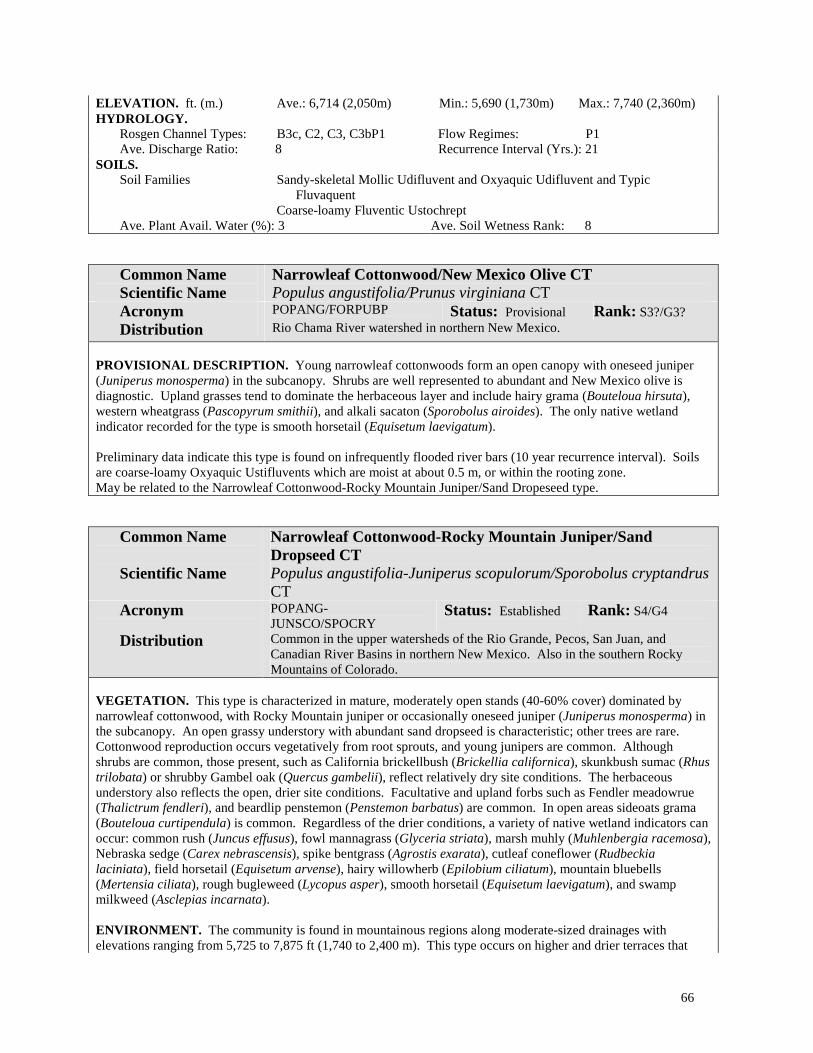
66
ELEVATION. ft. (m.) Ave.: 6,714 (2,050m) Min.: 5,690 (1,730m) Max.: 7,740 (2,360m) HYDROLOGY.
Rosgen Channel Types: B3c, C2, C3, C3bP1 Flow Regimes: P1 Ave. Discharge Ratio: 8 Recurrence Interval (Yrs.): 21
SOILS. Soil Families Sandy-skeletal Mollic Udifluvent and Oxyaquic Udifluvent and Typic
Fluvaquent Coarse-loamy Fluventic Ustochrept
Ave. Plant Avail. Water (%): 3 Ave. Soil Wetness Rank: 8
Common Name Scientific Name
Narrowleaf Cottonwood/New Mexico Olive CT Populus angustifolia/Prunus virginiana CT
Acronym POPANG/FORPUBP Status: Provisional Rank: S3?/G3? Distribution Rio Chama River watershed in northern New Mexico.
PROVISIONAL DESCRIPTION. Young narrowleaf cottonwoods form an open canopy with oneseed juniper (Juniperus monosperma) in the subcanopy. Shrubs are well represented to abundant and New Mexico olive is diagnostic. Upland grasses tend to dominate the herbaceous layer and include hairy grama (Bouteloua hirsuta), western wheatgrass (Pascopyrum smithii), and alkali sacaton (Sporobolus airoides). The only native wetland indicator recorded for the type is smooth horsetail (Equisetum laevigatum). Preliminary data indicate this type is found on infrequently flooded river bars (10 year recurrence interval). Soils are coarse-loamy Oxyaquic Ustifluvents which are moist at about 0.5 m, or within the rooting zone. May be related to the Narrowleaf Cottonwood-Rocky Mountain Juniper/Sand Dropeseed type.
Common Name Scientific Name
Narrowleaf Cottonwood-Rocky Mountain Juniper/Sand Dropseed CT Populus angustifolia-Juniperus scopulorum/Sporobolus cryptandrus CT
Acronym POPANG-JUNSCO/SPOCRY
Status: Established Rank: S4/G4
Distribution Common in the upper watersheds of the Rio Grande, Pecos, San Juan, and Canadian River Basins in northern New Mexico. Also in the southern Rocky Mountains of Colorado.
VEGETATION. This type is characterized in mature, moderately open stands (40-60% cover) dominated by narrowleaf cottonwood, with Rocky Mountain juniper or occasionally oneseed juniper (Juniperus monosperma) in the subcanopy. An open grassy understory with abundant sand dropseed is characteristic; other trees are rare. Cottonwood reproduction occurs vegetatively from root sprouts, and young junipers are common. Although shrubs are common, those present, such as California brickellbush (Brickellia californica), skunkbush sumac (Rhus trilobata) or shrubby Gambel oak (Quercus gambelii), reflect relatively dry site conditions. The herbaceous understory also reflects the open, drier site conditions. Facultative and upland forbs such as Fendler meadowrue (Thalictrum fendleri), and beardlip penstemon (Penstemon barbatus) are common. In open areas sideoats grama (Bouteloua curtipendula) is common. Regardless of the drier conditions, a variety of native wetland indicators can occur: common rush (Juncus effusus), fowl mannagrass (Glyceria striata), marsh muhly (Muhlenbergia racemosa), Nebraska sedge (Carex nebrascensis), spike bentgrass (Agrostis exarata), cutleaf coneflower (Rudbeckia laciniata), field horsetail (Equisetum arvense), hairy willowherb (Epilobium ciliatum), mountain bluebells (Mertensia ciliata), rough bugleweed (Lycopus asper), smooth horsetail (Equisetum laevigatum), and swamp milkweed (Asclepias incarnata). ENVIRONMENT. The community is found in mountainous regions along moderate-sized drainages with elevations ranging from 5,725 to 7,875 ft (1,740 to 2,400 m). This type occurs on higher and drier terraces that
67
have a relatively flat surface topography, and they are mostly comprised of sandy alluvial sediments. As a result, stands are infrequently flooded (10-100 year recurrence intervals). Soils are young, weakly-developed Entisols. Thick organic layers have had time to develop in some stands however (Mollisols). Soils tend to be dry and mostly sandy at the surface, although sandy loams and silts are also common. Soils are well drained and commonly gravelly/cobbly with depth. Some of the lower terraces may be very moist at depths within the rooting zone, particularly during seasonal high water events. COMMENTS. These mature riparian forests occupy some of the driest sites in the floodplain. Some stands may be directly adjacent to the stream, but still situated several meters above it due to downcut streambanks. In these stands, the cottonwoods have limited self-sustaining capabilities except vegetatively by root sprouts. Many of the trees are often dead or dying and junipers are commonly growing up under them, colonizing the drying terraces. Further, the presence of juniper in these and other floodplain communities is often considered invasive. Juniper, as a codominant in these communities, is at least viewed as an indicator that flooding occurs infrequently. Only the largest of floods will remove these communities. In upper canyon segments, floodplain development is minimal along the river, and the coniferous blue spruce becomes more dominant, mixing with thinleaf alder on the streambanks. Lower bars are generally dominated by younger, denser cottonwood forests and willow bars. Uplands are typically dominated by mixed coniferous forests of spruce and fir on cooler north-facing aspects, or ponderosa pine on drier slopes. This type is a refinement of the Populus angustifolia/Juniperus scopulorum Association reported by Muldavin (1991) for northern New Mexico; Kittel et al. (1994) and Kittel, Rondeau, and McMullin (1996) for Colorado. NMNHP DATA PLOTS. 92EM025, 95PD030, 96PD036, 97MB003, 97MB028 REFERENCE SITE NAME. Agua Caliente ELEVATION. ft. (m.) Ave.: 6,830 (2,080m) Min.: 5,720 (1,740m) Max.: 7,940 (2,420m) HYDROLOGY.
Rosgen Channel Types: A3, B3a, C3, C4, E3b Flow Regimes: P1, P2 Ave. Discharge Ratio: 12 Recurrence Interval (Yrs.): 41
SOILS. Soil Families Sandy Typic Udipsamment
Sandy-skeletal Aquic Ustifluvent and Mollic Udifluvent Fine silty and loamy-skeletal Oxyaquic Haplustoll
Ave. Plant Avail.Water (%): 4 Ave. Soil Wetness Rank: 8
Common Name Scientific Name
Narrowleaf Cottonwood/Thinleaf Alder-Redosier Dogwood CT Populus angustifolia/Alnus incana ssp. tenuifolia-Cornus sericea ssp. sericea CT
Acronym POPANG/ALNINCT-CORSERS Status: Established Rank: S4/G4 Distribution Common in the upper Rio Grande and Pecos watersheds in north-central New
Mexico. Widespread in the southern Rocky Mountains. VEGETATION. This type has a moderately closed (50-75% cover), mature tree canopy of narrowleaf cottonwood with a shrubby, thicket-forming understory dominated by abundant thinleaf alder, with redosier dogwood present, and usually well represented. Willows, particularly bluestem willow (Salix irrorata) and coyote ( S. exigua), may also be well represented to abundant Narrowleaf cottonwood reproduces vegetatively in the understory of these stands, and occurs as smaller saplings on moist banksides. Tall coniferous trees such as white fir (Abies concolor) or blue spruce (Picea pungens) may be present, but do not dominate. Other common shrubs include honeysuckle (Lonicera involucrata), raspberries (Rubus leucodermis Rubus neomexicana, Rubus idaeus ssp. strigosus), whitestem gooseberry (Ribes inerme), and trumpet gooseberry (Ribes leptanthum). The herbaceous layer is diverse and often very abundant to luxuriant in cover. Ninety grasses and forbs have been recorded for the type, and include 22 native wetland indicators. The most common indicators are Columbian monkshood (Aconitum columbianum), common selfheal (Prunella vulgaris), Fendler cowbane (Oxypolis fendleri), Franciscan bluebells (Mertensia franciscana), largeleaf avens (Geum macrophyllum), leafybract aster (Aster foliaceus), cutleaf

68
coneflower (Rudbeckia laciniata), cow parsnip (Heracleum maximum), smooth horsetail (Equisetum laevigatum), and field horsetail (Equisetum arvense). Common grasses include Canada bluegrass (Poa compressa) and introduced species from nearby meadows such as Kentucky bluegrass (Poa pratensis), redtop (Agrostis gigantea) and creeping bentgrass (Agrostis stolonifera). ENVIRONMENT. The community is found in narrow valleys along moderate-sized drainages of mountains of northern New Mexico. It occurs at upper elevations ranging from 7,750 to 8,900 ft (2,360 to 2,720 m). The river channel cuts through moderately steep to gently sloped terrain with rapids and deep pools created by the bedrock. Large boulders and cobbles line the riverbed and banks. Depositional features are limited through steeper reaches, but well vegetated bars and terraces develop as the canyon widens. Alluvial sediments are generally coarse, with woody debris carried in high-energy flows that becomes lodged among instream boulders, or on the streambanks or bars. Small overflow channels often dissect larger bars. This community occurs close to stream bankfull levels (1.1 to 2.0 discharge ratios) on sidebars that are within the 3-5 year floodplain. Soils are moist, weakly developed Entisols (Fluvaquents or Udifluvents). The soils are well drained and comprised of a layer of coarse sandy-loams or fine-loams and gravels overlying a rocky layer comprised of gravels, cobbles, and stones. Soils are commonly wet within 1 m, especially during seasonal flooding. COMMENTS. The community is densely shaded and provides valuable cover for wildlife. Seasonally high water tables allow for continued reproduction of the cottonwoods, alders, dogwood and the numerous other obligate riparian shrubs and herbs. Minimal disturbance from recreation, livestock usage, forestry practices, and mining maintain the biodiversity and good condition of the community. Severe alterations of the hydrology or upland conditions can contribute to loss of valuable habitat. In the upper canyon segments, floodplains are narrow along the river and the coniferous blue spruce (Picea pungens) becomes more dominant, mixing with thinleaf alder on the streambanks. In wider valleys, narrowleaf cottonwood will dominate higher and drier terraces which will contain fewer shrubs and more junipers or introduced grasses from nearby hay meadows. Uplands are typically dominated by mixed coniferous forests of spruce and fir on cooler north-facing aspects, or ponderosa pine on drier slopes. This type was first described by Baker (1989) in Colorado, and is part of a group of ecologically related types that include: 1) the Populus angustifolia /Alnus incana type with less Cornus reported for Colorado by Baker 1989, Kittel and Lederer (1993), Kittel et al. (1994), Walford and Baker (1995), Kittel, Rondeau, and McMullin (1996), and Richard et al. (1996); and 2), the Populus angustifolia /Cornus sericea type that generally lacks thinleaf alder and has as been well-documented for the southern Rocky Mountains (Kittel and Lederer 1993; Kittel et al. 1994 Kittel, Rondeau, and Kettler 1995), Hansen et al. 1990, Johnston 1987, Padgett, Youngblood, and Winward 1988 & 1989, and Youngblood, Padgett, and Winward 1985a & 5b). Our type as described here is probably inclusive of the above two types. NMNHP DATA PLOTS. 92HK001, 92HK004, 92HK005, 94PD032, 94PD083, 97MB019 REFERENCE SITE NAME. Middle Ponil, Terrero ELEVATION. ft. (m.) Ave.: 8,310 (2,530m) Min.: 7,720 (2,350m) Max.: 8,900 (2,710m) HYDROLOGY.
Rosgen Channel Types: B3c, C3, D3, E3b, E4b Flow Regimes: P1 Ave. Discharge Ratio: 0.8 Recurrence Interval (Yrs.): 4
SOILS. Soil Families Coarse-loamy/loamy-skeletal Aeric Endoaquept
Coarse-loamy/sandy-skeletal or fine-loamy/sandy-skeletal or sandy-skeletal Aeric Fluvaquent and Aquic Udifluvent
Loamy-skeletal Typic Fluvaquent Ave. Plant Avail.Water (%): 4 Ave. Soil Wetness Rank: 3

69
Netleaf Hackberry Alliance (Celtis laevigata var. reticulata Torr. (L. Benson))
Photo by Mike Bradley
Figure 11. Netleaf Hackberry/California Brickellbush Community Type on the San Francisco River in the Gila watershed. Netleaf hackberry often occurs on the outer fringe of old terraces which abut the toe of upland slopes, as seen here. NM Classification: Lowland Interior Southwest Broad-leaved Deciduous Forested Wetland, Temporarily Flooded
NVC: I.B.2.d. Temporarily flooded cold-deciduous forest
Distribution: In New Mexico, the Netleaf Hackberry Alliance is provisional, occurring in lowlands and foothills of southwestern watersheds in the Gila River Basin and southern foothill tributaries of the Rio Grande watershed. Probable in southern Arizona.
Ecology: The alliance occurs at elevations roughly between 4,500 and 6,200 ft (1370 and 1890 m). Similar to the

70
Arizona Walnut Alliance, it generally occupies on the outer, drier fringe of old terraces which abut the toe of upland hillslopes, or near hillslope springs. This community type rarely occurs directly adjacent to the channel and, therefore, is rarely flooded. Along river terraces, netleaf hackberry is capable of forming dense thickets with closed canopies, especially in mature stands. Soils, which tend to be very dry and shallow, are comprised mostly of sands and sands mixed with a rocky matrix of gravels, cobbles, and stones. The shrub component includes species that are indicative of drier site conditions such as California brickellbush (Brickellia californica), river walnut (Juglans microcarpa), and skunkbush sumac (Rhus trilobata). Despite the relatively dry site conditions several wetland indicators are possible in microsites: Goodding willow (Salix gooddingii), seepwillow (Baccharis salicifolia), clustered field sedge (Carex praegracilis), irisleaf rush (Juncus xiphioides), Torrey rush (Juncus torreyi), California loosestrife (Lythrum californicum), Fendler waterleaf (Hydrophyllum fendleri), and golden columbine (Aquilegia chrysantha).
The Netleaf Hackberry Alliance has had limited documentation in the Southwest. Dick-Peddie (1993) identified a Hackberry Series within a Montane Riparian zone, but elsewhere netleaf hackberry is usually treated as a codominant within other southwestern forested wetland alliances. Hence the alliance is considered provisional and additional information is needed on the composition and ecology of the types in the West.
Key to Netleaf Hackberry (Celtis laevigata var. reticulata) Community Types:
1. California brickellbush (Brickellia californica) well represented in the shrub layer .............................................. .................................................................................................Netleaf Hackberry/California Brickellbush CT 1. Wingleaf soapberry (Sapindus saponaria) well represented. California brickellbush absent or poorly
represented.................................................................................... Netleaf Hackberry/Wingleaf Soapberry CT
Community Type Descriptions:
Common Name Scientific Name
Netleaf Hackberry/California Brickellbush CT Celtis laevigata var. reticulata/Brickellia californica CT
Acronym CELLAER/BRICAL Status: Provisional Rank: S3?/G4? Distribution San Francisco River watershed in southwestern New Mexico.
PROVISIONAL DESCRIPTION. Netleaf hackberry forms moderately closed canopies with shrubby understories dominated by California brickellbush, the canopy with honey mesquite (Prosopis glandulosa) and desert penstemon (Penstemon pseudospectabilis). The herbaceous layer is sparse and characterized by the sporadic occurrence of mostly upland species. Preliminary data suggest that the type occurs on upper terraces that are seldom flooded (25-50 year recurrence intervals) along either perennial, intermittent or ephemeral streams of low to moderate gradients. Elevations range from 4,500 to 6,100 ft (1,370 to 1,860 m). Soils have been identified as rocky Torrifluvents or Ustipsamments.
Common Name Scientific Name
Netleaf Hackberry/Wingleaf Soapberry CT Celtis laevigata var. reticulata/Sapindus saponaria CT
Acronym CELLAER/SAPSAP Status: Provisional Rank: S?/G? Distribution Organ Mountains in south-central New Mexico (Dona Ana Co.).
PROVISIONAL DESCRIPTION. The dense canopy is dominated by netleaf hackberry with wingleaf soapberry (Sapindus saponaria) well represented in the shrub layer along with cerro hawthorn (Crataegus erythropoda), and Texas mulberry (Morus microphylla). Fendler waterleaf (Hydrophyllum fendleri) is a well represented wetland indicator species. The type is known only from small intermittent or ephemeral drainages in the Organ Mountains of southern New Mexico at about 5,380 ft (1,640 m).

71
Plains Cottonwood Alliance (Populus deltoides Bartr. ex Marsh. ssp. monilifera and ssp.
wislizeni)
Photo by Mike Bradley
Figure 12. Plains Cottonwood/Big Sagebrush Community Type in the San Juan watershed. NM Classification: Lowland Plains/Great Basin Broad-leaved Deciduous Forested Wetland, Temporarily Flooded
NVC: I.B.2.d Temporarily flooded cold-deciduous forest
Distribution: Widely distributed from the Rocky Mountains to the Midwest, and southward through the southern states to Florida. In New Mexico, the Alliance includes the Rio Grande cottonwood (P. deltoides ssp. wislizeni) that occupies the Rio Grande and San Juan drainages and extends to the Colorado River drainage in northeastern Arizona, eastern Utah, and western Colorado. The plains cottonwood (P. deltoides ssp. monilifera) occupies the eastern plains drainage basins of the Canadian and Pecos Rivers in New Mexico and northward through the eastern

72
prairie states to the Great Lakes region (Eckenwalder 1977).
In south-central and southwestern New Mexico over into southern Arizona, the Rio Grande Cottonwood Alliance is replaced by the Fremont Cottonwood Alliance (P. fremontii).
Ecology: The alliance occurs in wide valleys of the lowlands at elevations roughly ranging in New Mexico from 3,550 to 6,500 ft (1,080 to 1,980 m). Cottonwoods are established on the lowest alluvial surfaces in the floodplain with the onset and subsidence of early spring floods. As the channel cuts and moves laterally away from these newly established bars, young dense forests quickly grow and take hold, trapping sands, silts and debris from ensuing floods. Early successional communities may be continually knocked back or buried by floods until eventually the bars build higher and higher, becoming stabilized and drier. Mature cottonwood forests may remain stable for many years. Generally, they eventually die from old age, or are removed in a high-energy flood event and replaced by new, young trees (site progression model of Leonard et al. 1992).
Early to mid-successional communities of the alliance typically have sparse or scoured understories, or are codominated by willows (Plains Cottonwood/Scour, Plains Cottonwood/Sparse, Plains Cottonwood/Coyote Willow, and Plains Cottonwood-Goodding Willow). These stands are dominated by young saplings and intermediate-aged cottonwoods, which form dense stands along sidebars and low terraces proximal to the river.
A wide variety of grasses and shrubs, including sideoats grama (Bouteloua curtipendula), Kentucky bluegrass (Poa pratensis), alkali sacaton (Sporobolus airoides), New Mexico olive (Forestiera pubescens), rubber rabbitbrush (Chrysothamnus nauseosus), and oneseed juniper (Juniperus monosperma), codominate the late successional communities of the alliance. These stands are dominated by mature cottonwoods that generally form closed canopies on river terraces.
The alliance is thought to be declining due to several human-induced factors that interrupt the reproductive cycle and change habitat conditions and functions (Howe and Knopf 1991; Crawford et al. 1993; Bogan et al. 1998). Primary factors include the regulation of rivers, which reduces annual flow volumes, changes seasonal peak flows from spring to summer, and disrupts the annual fluctuation in flow volume by diversions during dry years (Stromberg and Patten 1992). The altering of hydrological regime that reduces flooding and minimum flows can have a particular impact on the reproduction and long-term viability of cottonwood-forested wetlands. Scouring floods are required to create bare substrates for cottonwood seed germination followed by sustained high moisture conditions to insure establishment (Horton, Mounts, and Kraft.1960). These factors, in concert with shrubby exotic invasions (Everitt 1980), increased fire frequency (Stuever 1997), altered litter decomposition rates (Ellis, Molles, and Crawford 1999), and excessive herbivory by livestock and native animals (Krueper 1996), combine to further endanger the biological integrity of wetlands of the Plains Cottonwood Alliance.
Community types for the alliance have been described from the Rocky Mountains to the southeastern U.S. (Anderson et al. 1998). With respect to classification in New Mexico, there is some confusion as a result of changing names between P. fremontii and P. deltoides over time. Campbell and Dick-Peddie (1964) described two cottonwood-dominated vegetation communities from the Rio Grande drainage (Class IV and V), which they ascribed to P. fremontii that we would probably consider P. deltoides var. wislizeni now. Similarly, Szaro (1989) refers to a Populus fremontii Community Type for Arizona and New Mexico which is inclusive of P. deltoides. Dick-Peddie (1993) recognizes only P. fremontii in New Mexico and identified four series: 1) a Montane Riparian Broadleaf Cottonwood Series; 2) a Montane Riparian Broadleaf Cottonwood-Mixed Deciduous Series; 3) a Floodplains-Plains Riparian Cottonwood Series; and 4) a Floodplains-Plains Riparian Cottonwood-Willow Series. Only the latter two series contain references to community types that are similar to those found in our Plains Cottonwood Alliance (the other two series are best represented by our Fremont Cottonwood Alliance). Hildebrant and Ohmart (1982) and Hink and Ohmart (1984) define several cottonwood community types (explicitly specified as P. deltoides var. wislizeni) for the Pecos and Rio Grande, respectively. These are based on structural and compositional characteristics of the canopy for the mapping analysis of bird habitat. We have identified 20 community types for this widespread and variable alliance in New Mexico.

73
Key to the Plains Cottonwood (Populus deltoides) Community Types:
1. Yerba mansa (Anemopsis californica) well represented, growing in mats on the forest floor. ................................................................................................................. Plains Cottonwood/Yerba Mansa CT 1. Yerba mansa poorly represented, scattered or absent ........................................................................................ (2) 2. Silver buffaloberry (Shepherdia argentea) abundant. Russian olive maybe well represented .............................. ....................................................................................................... Plains Cottonwood/Silver Buffaloberry CT 2. Silver buffaloberry absent or poorly represented............................................................................................... (3) 3. New Mexico olive (Forestiera pubescens var. pubescens) well represented .................................................... (4) 3. New Mexico olive scarce or absent ................................................................................................................... (5) 4. Russian olive (Elaeagnus angustifolia) more dominant than New Mexico olive................................................... ................................................................................ Plains Cottonwood-Russian Olive/New Mexico Olive CT 4. New Mexico olive more dominant than Russian olive .................... Plains Cottonwood/New Mexico Olive CT 5. Hoary rosemarymint (Poliomintha incana) well represented, and the dominant shrub; sand dunes ..................... ................................................................................................... Plains Cottonwood/Hoary Rosemarymint CT 5. Not as above ...................................................................................................................................................... (6) 6. Willows (Salix spp.) well represented in the understory, and dominant or codominant in the shrub layer ....... (7) 6. Willows poorly represented or absent in the understory.................................................................................... (9) 7. Peachleaf willow (Salix amygdaloides) common to well represented .................................................................... ......................................................................................................... Plains Cottonwood-Peachleaf Willow CT 7. Peachleaf willow scarce or absent ..................................................................................................................... (8) 8. Goodding willow (Salix gooddingii) well represented to abundant, and the dominant sub-canopy tree or shrub .........................................................................................................Plains Cottonwood-Goodding Willow CT 8. Goodding willow scarce or absent, not a dominant; coyote willow (Salix exigua) well represented to very abundant, the dominant shrub; Russian olive and saltcedar (Tamarix ramosissima) may be present, but not ...... dominant ............................................................................................... Plains Cottonwood/Coyote Willow CT 9. Nebraska sedge (Carex nebrascensis) abundant................................. Plains Cottonwood/Nebraska Sedge CT 9. Nebraska sedge absent or poorly represented .................................................................................................. (10) 10. Smooth horsetail (Equisetum laevigatum) common to abundant............................................................................ ......................................................................................................... Plains Cottonwood/Smooth Horsetail CT 10. Smooth horsetail scarce or absent.................................................................................................................... (11) 11. Big sagebrush (Artemisia tridentata) abundant and the understory codominant .................................................... ............................................................................................................... Plains Cottonwood/Big Sagebrush CT 11. Big sagebrush scarce or absent ....................................................................................................................... (12) 12. Rubber rabbitbrush (Chrysothamnus nauseosus) abundant and the understory codominant.................................. .................................................................................................... Plains Cottonwood/Rubber Rabbitbrush CT 12. Rubber rabbitbrush scarce or absent ................................................................................................................ (13) 13. New Mexico bluestem (Schizachyrium neomexicanum) well represented; gypsum dunes .................................... ...................................................................................................Plains Cottonwood/New Mexico Bluestem CT 13. New Mexico bluestem scarce or absent........................................................................................................... (14)

74
14. Alkali sacaton well represented and dominant; sites open; soils alkaline; of bottomlands..................................... .............................................................................................................. Plains Cottonwood/Alkali Sacaton CT 14. Alkali sacaton poorly represented and not dominant ....................................................................................... (15) 15. Sideoats grama (Bouteloua curtipendula) well represented and dominant............................................................. .............................................................................................................Plains Cottonwood/Sideoats Grama CT 15. Sideoats grama poorly represented, not dominant ........................................................................................... (16) 16. Russian olive abundant, dominant or codominant with other sub-canopy trees or shrubs .............................. (17) 16. Russian olive not abundant, other shrubs or small trees dominate, or shrubs absent....................................... (18) 17. Russian olive dominates the sub-canopy and shrub layer, saltcedar is poorly represented or absent ..................... ............................................................................................................... Plains Cottonwood-Russian Olive CT 17. Russian olive and saltcedar (Tamarix ramosissima) are abundant and codominate; understory sparse ................. .............................................................................................. Plains Cottonwood-Russian Olive/Saltcedar CT 18. Saltcedar dominates the shrub layer .............................................................. Plains Cottonwood/Saltcedar CT 18. Saltcedar poorly represented............................................................................................................................ (19) 19. Site recently flooded river bars and low terraces; understory sparse, or dominated by annual forbs ..................... .............................................................................................................................. Plains Cottonwood/Scour CT 19. Infrequently flooded terraces with cottonwood overstory, but understory generally sparse and shaded; woody
and leaf debris may be thick on forest floor........................................................ Plains Cottonwood/Sparse CT
Community Type Descriptions:
Common Name Scientific Name
Plains Cottonwood/Alkali Sacaton CT Populus deltoides/Sporobolus airoides CT
Acronym POPDEL/SPOAIR Status: Established Rank: S2/G3 Distribution Common in the Pecos River Basin in southeastern New Mexico, and occasional in
the middle and lower Rio Grande. VEGETATION. Mature stands of Rio Grande or plains cottonwood have open to moderately open canopies with a grassy understory. Where trees are quite large (up to 1 m diameter at breast height) and old, the canopy may be very open, but the stand still maintains a large basal area. Reproduction of the native cottonwoods is rare or absent. Other trees are generally absent. The exotic saltcedar (Tamarix ramosissima) can occur as scattered shrubby individuals. Herbaceous diversity is moderate (44 species), and alkali sacaton dominates with 30% cover on average, and upwards to as much as 50% . Other grasses include sand dropseed (Sporobolus cryptandrus), other dropseeds (Sporobolus spp.), and Indian ricegrass (Oryzopsis hymenoides). The shrub layer is sparse to well represented with Emory falsewillow (Baccharis emoryi) often common, and, occasionally, rabbitbrush (Chrysothamnus nauseosus) and snakeweed (Gutierrezia sarothrae) are present. Forbs are sparse, and low to moderate in diversity (24 species known from the type). In addition to plains cottonwood, four other native wetland indicator species are known to occur in this community (Baccharis emoryi, Distichlis spicata, Muhlenbergia asperifolia, Scirpus pungens, and Equisetum laevigatum). ENVIRONMENT. This community type occurs primarily along the broad valley floors of large river drainages with low gradient and sandy or silty riverbeds. Elevations are relatively low and are known to range from 3,550 to 4,575 ft (1,080 to 1,400 m). This community occurs mainly on low river terraces that are situated well above stream bankfull levels (discharge ratio well above one). Under unregulated conditions, these sites are probably inundated every 20 years on average. Where rivers are highly regulated, these sites are seldom flooded. The soils are young, poorly developed Entisols that may be sandy throughout, or have sandy or coarse loamy layers overlain by fine clay layers. They are moderate to well-drained. Soils are generally dry at the surface but become more moist with depth (1 m or more), particularly during seasonal high flows.

75
COMMENTS. In the Pecos River Basin, this community represents one of the few remaining native riparian woodlands. A lack of cottonwood reproduction in the understory is indicative of the absence of recent flooding due to the extensive regulation of the Pecos. The invasion of exotic species, primarily saltcedar and Russian olive, has stabilized the riverbank, effectively channeling the river. This situation further reduces the possibility of overbank flooding and leaves the community susceptible to further invasion. A continued lack of annual flooding may eventually result in the mortality of cottonwoods and their virtual replacement by exotics. Effective restoration of these stands to enhance biodiversity, quality, and condition requires mimicking the natural flood regime as closely as possible. This type has not been previously described, but may be similar to the Populus deltoides/Distichlis spicata type described for Colorado, and the Populus deltoides/Muhlenbergia asperifolia type in New Mexico NMNHP DATA PLOTS. 93PD027, 93PD030, 93PD032, 93PD035, 93PD049, 93PD052 REFERENCE SITE NAME Cottonwood Draw ELEVATION. ft. (m.) Ave.: 4,060 (1,240m) Min.: 3,540 (1,080m) Max.: 4,580 (1,400m) HYDROLOGY.
Rosgen Channel Types: B4c, C5 Flow Regimes: P7 Ave. Discharge Ratio: 7 Recurrence Interval (Yrs.): 21
SOILS. Soil Families Sandy Aquic Ustipsamment
Clayey/sandy or sandy Oxyaquic Torrifluvent Coarse-loamy/clayey Oxyaquic Ustifluvent Clayey/sandy Typic Fluvaquent Coarse-loamy Typic Ustifluvent
Ave. Plant Avail.Water (%): 7 Ave. Soil Wetness Rank: 7
Common Name Scientific Name
Plains Cottonwood/Big Sagebrush CT Populus deltoides/Artemisia tridentata CT
Acronym POPDEL/ARTTRI Status: Provisional Rank: S2?/G3? Distribution San Juan River drainage in northwestern New Mexico, and probably present in
adjacent southeastern Utah and northeastern Arizona. PROVISIONAL DESCRIPTION. Mature cottonwood canopies are generally open (ranging between 30 and 40% cover), with Rocky Mountain juniper (Juniperus scopulorum), Russian olive (Elaeagnus angustifolia) and peachleaf willow (Salix amygdaloides) in the sub-canopy. The shrub layer is dominated by big sagebrush with other upland species associates such as rubber rabbitbrush (Chrysothamnus nauseosus) and skunkbush sumac (Rhus trilobata). The presence of sagebrush, a common dominant from surrounding desert uplands, in these floodplain “gallery forests” is an indicator of infrequent flooding, perhaps because of regulated stream flows, or because the channel is actively cutting down or away from the forest. Grasses can be well represented to abundant and are typically dominated by aridland species such as sand dropseed (Sporobolus cryptandrus) and Indian ricegrass (Oryzopsis hymenoides). Although a relatively dry type, some wetland indicator species still occasionally occur, such as threesquare bulrush (Scirpus pungens), inland saltgrass (Distichlis spicata), and alkali muhly (Muhlenbergia asperifolia). Forbs are very scattered and low in diversity (16 species), of which 75% (12 species) are natives. Preliminary data indicate that this type occurs at elevations ranging between 5,375 and 6,025 ft (1,640 and 1,840 m). Stands are located on high terraces well above the active channel (discharge ratio >5), and flooding is infrequent (50-100 year recurrence intervals). Soils have coarse loamy profiles throughout and are mostly young and undeveloped Entisols (Aquic and Typic, Ustifluvents). Inceptisols can occur on higher terraces where soil development has not been disrupted by flooding (Fluventic Ustochrept). This CT has not been previously described; the P. deltoides/Chrysothamnus nauseosus/MG-F type referred to by Dick-Peddie (1993) and described below is similar, but lacks big sagebrush. REFERENCE SITE NAME. Ditch Canyon, Manuel Arroyo
76
Common Name Scientific Name
Plains Cottonwood/Coyote Willow CT Populus deltoides/Salix exigua CT
Acronym POPDEL/SALEXI Status: Established Rank: S3/G3 Distribution Rio Grande, Pecos and Canadian drainages of central and eastern New Mexico.
Probable elsewhere in northern New Mexico. Also occurs in the Great Plains (CO, ND, NE, OK, SD, & TX).
VEGETATION. This type is dominated by relatively young stands of cottonwoods that form open to moderately open overstories (25-50 % cover) with thickets of coyote willow in the understory. False willow (Baccharis salicina) is often well represented to abundant and may codominate with willow. Herbaceous cover is abundant, particularly among graminoids, and numerous (23) native wetland indicators can be present such as bulrushes (Scirpus pungens and S. microcarpus), common spikerush (Eleocharis palustris), rushes (Juncus balticus, J. longistylis, & J. tenuis), fowl mannagrass (Glyceria striata), sedges (Carex aquatilis, C. oreocharis, C. scoparia, & C. stipata) and horsetails (Equisetum arvense & E. laevigatum). Invasive exotic species can also be prevalent such as redtop (Agrostis gigantea), creeping bentgrass (A. stolonifera), Kentucky bluegrass (Poa pratensis) and sweetclover (Melilotus officinalis). Overall, herbaceous diversity is high (90 species), and still predominantly native in composition (66 species, or 73%). ENVIRONMENT. This community type occurs in wide river corridors that have low gradient and primarily sandy/gravelly beds (becoming cobbly with increasing gradients). Elevations range from 4,525 to 6,500 ft (1,380 to 1,980 m). The type is most often found proximal to perennial rivers on low sidebars and streambanks near stream bankfull levels (discharge ratios close to one). Occasionally, it can be found within the active channel or nearby. Because of its low position, the type is flooded frequently (average recurrence interval five years). Most soils are young and undeveloped Entisols, and soils within the active channel are classified as Riverwash. Soils tend to be well-drained sands with mixtures of cobbles and gravels throughout the profile. Most soils tend to be moist or wet within one meter, at least during seasonal high water. In some soils, moisture indicators are found at greater depths. COMMENTS. Initially developing on exposed depositional sandbars, this mid-successional community type depends on periodic flooding for maintenance and growth, even when well established. As sediments and debris become trapped among the woody stems, the bar becomes more stable. In this community type, the cottonwoods overtop the shrubby willows. Because the willows are limited to lower riverside bars or cutoff channels, the community type eventually changes as the trees develop into mature forests on higher terraces without the willow understory. Historically, when cottonwoods eventually died from old age or were removed in high-energy flood events, they were replaced by new, young trees. For this cycle to occur under regulated conditions, flows should mimic the natural flood regime as closely as possible. Hink and Ohmart (1984) describe a cottonwood/coyote willow mapping unit with four structural sub-types for the middle Rio Grande. Dick-Peddie (1993) refers to a Populus fremontii/Salix exigua/MG-F community as part of a Floodplains-Plains Riparian group that is probably inclusive of this type. NMNHP DATA PLOTS. 92EM017, 94PD017, 94PD031, 94PD039, 94PD042, 94PD049, 94PD057,
94PD097, 94PD102 REFERENCE SITE NAME. Agua Caliente, Embudo, Lower Palomas ELEVATION. ft. (m.) Ave.: 5,508 (1,680m) Min.: 4,525 (1,380m) Max.: 6,500 (1,980m) HYDROLOGY.
Rosgen Channel Types: B3a, B3c, C3, C3b, C4, C5 C5c-
Flow Regimes: P1, P7
Ave. Discharge Ratio: 3 Recurrence Interval (Yrs.): 5 SOILS.
Soil Families Sandy-skeletal Aeric Fluvaquent and Aquic Ustifluvent Coarse-loamy Oxyaquic Torrifluvent Sandy-skeletal Oxyaquic Ustifluvent Sandy Typic Psammaquent
Ave. Plant Avail.Water (%): 5 Ave. Soil Wetness Rank: 5

77
Common Name Scientific Name
Plains Cottonwood-Goodding Willow CT Populus deltoides-Salix gooddingii CT
Acronym POPDEL-SALGOO Status: Established Rank: S1/G2 Distribution Pecos and Rio Grande basins.
VEGETATION. Middle-aged to mature stands of Rio Grande or plains cottonwood and Goodding willow form closed canopies (85% or greater cover) that reach heights of 20 to 25 m (65-82 ft). Other deciduous trees are generally absent. Russian olive (Elaeagnus angustifolia) and saltcedar (Tamarix ramosissima) can become invasive and reproduce in the understory. Smaller cottonwood and willow saplings may be present in the understory, but seedlings are absent. Understory shrub and herbaceous layers are sparse, not well represented, and low in diversity. There may be scattered coyote willows (Salix exigua) or seepwillows (Baccharis spp.) and patches of grass, but generally the forest floor is sparse and covered with leaf litter. Six wetland indicator species are known to occur (Salix gooddingii, Baccharis salicifolia, Salix exigua, Carex aquatilis, Distichlis spicata & P. deltoides). ENVIRONMENT. Elevations range from 3,250 to 5,350 ft (990 to 1,630 m). Stream gradients are generally low (<1%), and riverbeds tend to be mostly sandy. Gravels and cobbles are more frequent as the gradient increases. The type is found on elevated sidebars and low terraces that are situated above the active channel (discharge ratios range from two to six). Flooding frequency ranges widely, from as low as every two years on lower bars to more than 50 on elevated terraces. Soils of young fluvial landforms are poorly developed Entisols. Soils may be coarse-loamy throughout or overlain by a sandy layer. Gravels and cobbles are generally scattered throughout the profile. Soils are dry within one meter, but, upon approaching the ground water, become moist, particularly during seasonal flooding events. COMMENTS. Due to large-scale alterations of the floodplain (i.e., flow regulations and diversions) the extent of this community type’s natural distribution is limited and, therefore, considered highly threatened. Much of its former habitat in the southern reaches of New Mexico’s larger rivers is now occupied by vast areas of homogeneous stands of saltcedar or farmland. In these areas, cottonwoods are very scarce. Alternatively, communities in the northern reaches of these rivers are threatened by invasion of Russian olive. River controls and alterations that limit the movement of the river within the floodplain have minimized areas available for cottonwood-willow reproduction. Where reproduction does occur in the spring, subsequent flows remove seedlings before their root systems are established. The community type may be critical habitat for several bird species. Effective restoration of these stands to enhance biodiversity, quality, and condition requires emulating a natural hydrological regime. Although this Plains Cottonwood type has not been previously described, Laurenzi, Ohmart, and Hink (1983) and Szaro (1989) describe a Populus fremontii/Salix gooddingii Community Type which is probably similar and perhaps inclusive of the type described here. Dick-Peddie (1993) also refers to a Populus fremontii/Salix gooddingii/MG-F type as part of his Cottonwood-Willow Series. Campbell and Dick-Peddie (1964) describe a cottonwood type with Goodding willow (Class IV) for the Rio Grande. NMNHP DATA PLOTS. 93PD062, 93PD066, 94PD006, 94PD012, 94PD015, 94PD074, 94PD080,
94PD099, 94PD100 REFERENCE SITE NAME. Lower Palomas ELEVATION. ft. (m.) Ave.: 4,300 (1,310m) Min.: 3,240 (990m) Max.: 5,360 (1,630m) HYDROLOGY.
Rosgen Channel Types: B3c, C5, C5c- Flow Regimes: P1, P7 Ave. Discharge Ratio: 5 Recurrence Interval (Yrs.): 30
SOILS. Soil Families Coarse-loamy Aeric Fluvaquent
Clayey/sandy or coarse-loamy or sandy/coarse-loamy Oxyaquic Ustifluvent Coarse-loamy Typic Ustifluvent
Ave. Plant Avail. Water (%): 8 Ave. Soil Wetness Rank: 6

78
Common Name Scientific Name
Plains Cottonwood/Hoary Rosemarymint CT Populus deltoides/Poliomintha incana CT
Acronym POPDEL/POLINC Status: Provisional Rank: S2?/G2? Distribution Tularosa Basin in south-central New Mexico.
PROVISIONAL DESCRIPTION. The type is known only from gypsum dunelands of the Tularosa Basin at elevations around 4,000 ft (1,220 m). Mature cottonwood trees form very open canopies (30% or less cover), and may be partially to deeply buried by shifting gypsum sands with only the upper portions of the trees exposed. Scattered to well represented hoary rosemarymint (Poliomintha incana) typifies the understory, along with an occasional rubber rabbitbrush (Chrysothamnus nauseosus). Herbs are low in diversity (five species) and cover, and include scattered bunches Indian ricegrass (Oryzopsis hymenoides) and New Mexico bluestem (Schizachyrium neomexicanum). Large open, bare areas are common. In interdune areas water accumulates during the summer rainy season, and the water table remains near the surface (0.5 m). This may represent a buried version of the Plains Cottonwood/New Mexico Bluestem type that occurs in the interdune swales. REFERENCE SITE NAME. White Sands National Monument
Common Name Scientific Name
Plains Cottonwood/Nebraska Sedge CT Populus deltoides/Carex nebrascensis CT
Acronym POPDEL/CARNEB Status: Provisional Rank: S2?/G3? Distribution Rio Grande watershed in north-central New Mexico (Embudo River). Probable
elsewhere in northern New Mexico.
PROVISIONAL DESCRIPTION. This mesic cottonwood type is characterized by a moderately closed canopy of cottonwood, with a subcanopy of scattered Goodding willow (Salix gooddingii). The shrub layer is low in cover with an occasional coyote willow (Salix exigua) and New Mexico olive (Forestiera pubescens var. pubescens), along with woody vines such as Virginia creeper (Parthenocissus quinquefolia var. quinquefolia) and canyon grape (Vitis arizonica). The herbaceous understory is dominated by wetland indicator species such as Nebraska sedge, smooth horsetail (Equisetum laevigatum), and inland saltgrass (Distichlis spicata), but it may also include Kentucky bluegrass (Poa pratensis), Canada wildrye (Elymus canadensis), smooth brome (Bromus inermis), and Indianhemp (Apocynum cannabinum).
Known to occur at about 5,850 ft (1,760 m) on small river bars that are occasionally flooded (estimated two-year recurrence interval). Soils have wetness (hydric) indicators in the form of mottles within 50 cm of the surface and are classified as Aquic Ustifluvents.
Common Name Scientific Name
Plains Cottonwood/New Mexico Bluestem CT Populus deltoides/Schizachyrium neomexicanum CT
Acronym POPDEL/SCHNEO Status: Provisional Rank: S3?/G3? Distribution Tularosa Basin in south-central New Mexico.
PROVISIONAL DESCRIPTION. The type is known only from interdune swales of gypsum dunelands of the Tularosa Basin at elevations around 4,000 ft (1,220 m). Mature cottonwood trees form very open canopies (30% or less cover) with a grassy understory dominated by the gypsophile New Mexico bluestem with alkali sacaton (Sporobolus airoides) a common associate. Scattered false willow (Baccharis salicina) and saltcedar (Tamarix ramosissima) are often present in the shrub layer. Although overall diversity is relatively low (29 species), there are six wetland indicators and only one exotic. In the interdune areas water accumulates during the summer rainy season, and the water table remains near the surface (0.5 m). This type has not been previously described. REFERENCE SITE NAME. White Sands National Monument

79
Common Name Scientific Name
Plains Cottonwood/New Mexico Olive CT Populus deltoides/Forestiera pubescens var. pubescens CT
Acronym POPDEL/FORPUBP Status: Established Rank: S1/G2 Distribution San Juan and Rio Grande watersheds in northern and central New Mexico.
VEGETATION. This community type is characterized by mature, often dense and closed canopies of Rio Grande or plains cottonwood with a shrubby sub-canopy of New Mexico olive. In the mature stand, cottonwood seedlings or saplings are rare or nonexistent. Other trees such as oneseed juniper (Juniperus monosperma), Goodding willow (Salix gooddingii) and the exotics, Russian olive (Elaeagnus angustifolia), Siberian elm (Ulmus pumila) or white mulberry (Morus alba) may be present in the subcanopy, but are not normally abundant. The shrub layer may also include scattered skunkbush sumac (Rhus trilobata), and rubber rabbitbrush (Chrysothamnus nauseosus). The twining, woody vines, Virginia creeper (Parthenocissus quinquefolia var. quinquefolia) and western white clematis (Clematis ligusticifolia) can often be found among downed logs or wrapped around trees and shrubs. The herbaceous layer is sparse to well represented (10-15% cover), and is a mix of grasses and forbs such as alkali sacaton (Sporobolus airoides), Indian ricegrass (Oryzopsis hymenoides) and Canada goldenrod (Solidago canadensis) that reflect the relatively drier habitat. Overall, species diversity is high (81 species recorded for the type), with 24 (30%) of those being exotics. The majority of the diversity is found in the herbaceous layer (51 species), including 9 native wetland indicator species (Distichlis spicata, Juncus balticus, Muhlenbergia asperifolia, Scirpus pungens, Anemopsis californica, Asclepias incarnata, Equisetum laevigatum, Euthamia occidentalis, and Sagittaria cuneata). ENVIRONMENT. Lowland river valleys at elevations that range from 5,000 to 5,900 ft (1,530 to 1,800 m). Sites range from relatively dry, elevated terraces that are rarely flooded, to more frequently flooded mid-elevation sidebars and island bars of low-gradient rivers. Soils are moist or dry poorly developed Entisols or, where some soil development has occurred on older terraces, Inceptisols. Soil textures are coarse-loamy throughout the profile, or with sandy layers overlain by finer loam or silt. All soils have high plant-available water (8.5% on average), and the water table is usually within two meters of the surface during the growing season. COMMENTS. The community is naturally distributed along the floodplains of larger streams and rivers, but may be declining due to encroachment by exotic species and altered hydrologic regimes. Where it occurs along stream reaches that have been significantly altered in some way (i.e., jetty jacks, dams, and irrigation diversion), there is a wide range of soil and hydrological conditions in which this community occurs. Occasionally, floodplains may become highly altered, leaving the community far from the active channel, thus reducing flooding and stopping reproduction. With increasing disturbance from fire, the community becomes highly susceptible to further invasion by exotics, particularly by Russian olive, saltcedar (Tamarix ramosissima), and Siberian elm. Russian olive is common in most stands (particularly more mesic ones) and is the most probable successional exotic species. Effective restoration of these stands to enhance biodiversity, quality, and condition requires emulating a natural hydrological regime. NMNHP DATA PLOTS. 94PD079, 94PD044, 94PD050, 94PD059, 94PD061, 94PD062, 94PD068,
96PD034 REFERENCE SITE NAME. Cañon ELEVATION. Ft. (m.) Ave.: 5,450 (1,660m) Min.: 5,000 (1,530m) Max.: 5,900 (1,800m) HYDROLOGY.
Rosgen Channel Types: B3c, C3, C4, C5, C5c-, D4 Flow Regimes: P1, P7 Ave. Discharge Ratio: 6 Recurrence Interval (Yrs.): 7
SOILS. Soil Families Coarse-loamy and coarse-loamy/sandy Oxyaquic Ustifluvent and Typic
Ustifluvent Coarse-loamy Aeric Fluvaquent Coarse-loamy/sandy skeletal Aquic Ustifluvent Coarse-loamy and coarse-silty/sandy Fluventic Ustochrept
Ave. Plant Avail.Water (%): 8.5 Ave. Soil Wetness Rank: 9

80
Common Name Scientific Name
Plains Cottonwood-Peachleaf Willow CT Populus deltoides-Salix amygdaloides CT
Acronym POPDEL-SALAMY Status: Provisional Rank: S2?/G? Distribution Pecos River (Guadalupe Co.) east-central New Mexico; probable in other
drainages of eastern New Mexico. PROVISIONAL DESCRIPTION. This early- to mid-successional type includes various ages of cottonwood, but with a shrubby understory dominated by peachleaf willow and coyote willow (Salix exigua). Saltcedar (Tamarix ramosissima) can be well represented. Preliminary data suggest that perennial herbaceous cover and diversity is low, with 15 species, 10 of which are native, and four which are wetland indicators such as water sedge (Carex aquatilis) and smooth horsetail (Equisetum laevigatum). The type is known to occur on lower sidebars that are seasonally flooded. Soils are classified as Oxyaquic Ustifluvents, coarse-loamy over very-fine, mixed, mesic, and calcareous. A Populus deltoides-(Salix amygdaloides)/Salix exigua type has been extensively reported from the Great Plains states (Anderson et al.1998). Further data is needed from New Mexico to confirm if the types are synonymous.
Common Name Scientific Name
Plains Cottonwood/Rubber Rabbitbrush CT Populus deltoides/Chrysothamnus nauseosus CT
Acronym POPDEL/CHRNAU Status: Provisional Rank: S3?/G4? Distribution San Juan River Basin in northwestern New Mexico.
PROVISIONAL DESCRIPTION. This CT is characterized by open to moderately closed canopies of mature plains or Rio Grande Cottonwood, with a shrubby understory dominated by rubber rabbitbrush and other facultative upland shrub species (one obligate wetland species, Salix exigua, has been recorded for the type). Preliminary data suggest that the herbaceous layer is relatively low in diversity (17 species), and represented by scattered bunches of grasses including sand dropseed (Sporobolus cryptandrus), alkali sacaton (S. airoides), and purple threeawn grass (Aristida purpurea). Seven out of 30 species recorded for the type are exotic. The type is found in wide lowland valleys at elevations ranging from 4,625 to 6,025 ft (1,410 to 1,840 m). It usually occurs on high, elevated, dry terraces situated well above the active channel (discharge ratios > 5.0), that are rarely flooded (every 25-100 years). Occasionally it occurs on lower alluvial terraces that are more frequently flooded. Soils are dry with no evidence of aquic conditions within one meter, and are either sandy Inceptisols (Fluventic Ustochrepts), reflecting some soil development on the higher terraces, or less undeveloped sandy or sandy and rocky Entisols (Typic Ustifluvent). This type, although it lacks significant wetland indicators other than cottonwood, is found in a mosaic with wetter forested and shrub wetland types than occur lower in the floodplain. It is similar to Plains Cottonwood/Big Sagebrush CT, but lacks significant amounts of Artemisia tridentata. Dick-Peddie (1993) refers to a P. fremontii/ Chrysothamnus nauseosus/MG-F type as part of his Floodplain-Plains Riparian group, which may be equivalent. REFERENCE SITE NAME. Ditch Canyon
Common Name Scientific Name
Plains Cottonwood-Russian Olive CT Populus deltoides-Elaeagnus angustifolia CT
Acronym POPDEL-ELAANG Status: Established Rank: SM/GM Distribution Widespread in the Rio Grande and San Juan basins of New Mexico, potentially in
the Pecos and Canadian drainages. VEGETATION. Rio Grande or plains cottonwood forms a dense, closed canopy and attains heights of 20 to 25 m (65-82 ft.). The exotic Russian olive forms a sprawling sub-canopy and is the major understory species. Scattered Goodding willow (Salix gooddingii) occasionally occurs. Seedlings or saplings of cottonwoods are rare or absent, but Russian olive reproduction is common, even beneath the dense canopies. The wetland indicator, coyote willow

81
(Salix exigua) is usually common to well represented in the shrub layer. Herbaceous understories range from sparse to moderately grassy, with moderate although variable diversity (13 grasses; 18 forbs). Saltgrass (Distichlis spicata) and sand dropseed (Sporobolus cryptandrus) can be common to well represented. In addition to Goodding willow and coyote willow, six other wetland indicators have been sporadically recorded (Distichlis spicata, Juncus torreyi, Asclepias incarnata, Equisetum laevigatum, Helianthus nuttallii, and Typha latifolia). Besides Russian olive, other exotics can be well represented (14 of the 44 species recorded for the type are introduced species). ENVIRONMENT. This community type occurs primarily along the broad valley floors of large river corridors that have low gradient and sandy riverbeds. Elevations range from 4,775 to 6,050 ft (1,460 to 1,850 m). The type is most common along highly regulated river reaches such as in the middle Rio Grande and San Juan, but it can also be found occasionally along unregulated reaches as well. Under regulated streamflows, flooding is uncommon or absent. The type occurs on large river terraces derived from sandy alluvial sediments. Russian olive can be particularly prevalent along the river edge of the terraces. Soils have sandy or finer loamy profiles, and are dry near the surface year-round, but may be periodically moist with depth, particularly during seasonal high flows. COMMENTS. Community distribution appears to be related to significantly altered hydrologic regimes, and the absence of flooding may contribute to Russian olive invasion. Cottonwood reproduction is limited to root-crown sprouting and suckering, usually after herbivory by beavers, or after fire. Hence, long-term sustainability of the cottonwoods on regulated rivers is questionable, and stands may become increasingly dominated by Russian olive and other exotic trees. Russian olive was introduced to this region early in this century (ca. 1906), and is presently grown for ornamental purposes. It has some beneficial characteristics, particularly for wildlife and erosion control. Although originally planted to create shelterbelts from the wind, it is utilized by birds and honeybees. The species has spread to many lowland river valleys, particularly downstream from river impoundments where flows are regulated. Along portions of the upper and middle Rio Grande and the San Juan, the species is particularly strong along the immediate banks and side bars of the rivers and has also infiltrated the adjacent forest understory. It intermixes with the native cottonwoods and readily reproduces in the shaded sub-canopy. The seeds are apparently distributed by birds and other wildlife, but little is known about the viability of the seeds in the field. The species, which exhibits hardseededness, has been successfully germinated after three years’ storage under laboratory conditions. Shafroth, Auble, and Scott (1995) suggest that Russian olive will remain an important component of this community because it can reproduce under conditions both favorable and unfavorable to cottonwood (also see Olson 1974). The CT has been described from the middle Rio Grande Valley in central New Mexico by Campbell and Dick-Peddie’s (1964), and mapped Hink and Ohmart (1984) with two structure types. This CT was given a global rarity rank of GM because of its exotic elements, and hence, is not tracked for biodiversity conservation purposes. NMNHP DATA PLOTS. 92RW020, 93PD015, 94PD046, 94PD048, 94PD054, 94PD056, 94PD075 REFERENCE SITE NAME. Rio Truchas, Sena ELEVATION. ft. (m.) Ave.: 5,420 (1,650m) Min.: 4,780 (1,460m) Max.: 6,060 (1,850m) HYDROLOGY.
Rosgen Channel Types: B3c, C3b, C4, C5c- Flow Regimes: P1, P7 Ave. Discharge Ratio: 4 Recurrence Interval (Yrs.): 20
SOILS. Soil Families Fine-loamy Aeric Fluvaquent
Sandy Aquic Ustipsamment Coarse-silty/sandy Fluventic Ustochrept Coarse-loamy or coarse-loamy/sandy or sandy or sandy-skeletal Oxyaquic
Ustifluvent Ave. Plant Avail.Water (%): 7 Ave. Soil Wetness Rank: 7

82
Common Name Scientific Name
Plains Cottonwood-Russian Olive/New Mexico Olive CT Populus deltoides-Elaeagnus angustifolia/Forestiera pubescens ssp. pubescens CT
Acronym POPDEL-ELAANG/FORPUBP
Status: Provisional Rank: SM/GM
Distribution San Juan River basin and middle Rio Grande of New Mexico.
PROVISIONAL DESCRIPTION. Rio Grande or plains cottonwood forms moderately closed canopy stands that can reach heights of 20 to 25 m (65-82 ft.). The exotic Russian olive is well represented to abundant in the sub-canopy and is the major understory species. Seedlings or saplings of cottonwoods are rare or absent, but Russian olive reproduction is common, even beneath the dense canopies. New Mexico olive is common to well represented in the shrub layer, and is diagnostic. Diversity is moderate, with 43 species recorded for the type, of which 13 are exotic. Herbaceous understories range from sparse to moderately grassy, and variable in composition. The introduced meadow fescue (Festuca pratensis) is common to well represented, and the most consistent. Seven native wetland indicators have been sporadically recorded for the type. The type has been documented from lowland floodplains of both unregulated and regulated streams at elevations that range from 5,375 to 5,675 ft (1,640 to 1,730 m). Typically, it occurs on drier high terraces situated away from the main channel where it is rarely flooded (once every 45 years on average). Some stands are situated on lower terraces and have soils that are moist within depths of 1.5 m. Soils are coarse-loamy and coarse-silty Entisols. Structurally similar to Plains Cottonwood/New Mexico Olive CT, but Russian olive may be replacing the New Mexico olive, leading to the development of the Plains Cottonwood/Russian Olive CT. This CT was given a global rarity rank of GM because of its exotic elements, and hence, is not tracked for biodiversity conservation purposes. REFERENCE SITE NAME. Cook Arroyo at Aztec
Common Name Scientific Name
Plains Cottonwood-Russian Olive/Saltcedar CT Populus deltoides-Elaeagnus angustifolia/Tamarix ramosissima CT
Acronym POPDEL-ELAANG/TAMRAM Status: Established Rank: SM/GM Distribution Widespread in the middle Rio Grande and San Juan River Basins in northwestern
and central New Mexico. VEGETATION. This community type is characterized by a mixed tree canopy with Rio Grande or plains cottonwood dominating the overstory and the exotic Russian olive in the understory. The exotic saltcedar is well represented to abundant, and dominates the shrub layer (sometimes extending into the lower tree canopy). Reproduction of the native cottonwoods is rare or absent, but Russian olive is reproducing. Overall species diversity is very poor (nine species) and the herbaceous layer is sparse with scattered grasses, such as alkali muhly (Muhlenbergia asperifolia) and saltgrass (Distichlis spicata) along with the exotic sweetclover (Melilotus officinalis). ENVIRONMENT. Known to occur between 4,700 and 5,875 ft (1,430 and 1,790 m) along low-gradient lowland river floodplains. Typical sites are elevated terraces composed of sandy alluvial sediments. Flooding in these stands is variable, but generally infrequent ( 25+ years) on unregulated reaches, and rare along regulated ones. Soils indicate that most stands have water tables within 1.5 m of the soil surface during seasonal flood events. Soils are moderately drained and have coarse-loamy and sandy profiles, with some amounts of gravel and cobble at lower depths. COMMENTS. Distribution of the community appears to be related to significantly altered hydrologic regimes. Absence of overbank flooding due to stream flow regulation has encouraged Russian olive and saltcedar. The dense canopy in these stands is not self-sustaining for cottonwoods. Cottonwood reproduction is limited to root-crown sprouting and suckering, usually after herbivory by beavers, or after fire. Hence, long-term sustainability of the cottonwoods on regulated rivers is questionable, and stands may become increasingly dominated by Russian
83
olive and other exotic trees. Germination of cottonwood seed requires an open canopy and moist soil surfaces near the river channel that remain moist long enough to ensure establishment of seedlings. Russian olive and saltcedar, on the other hand, are capable of reproducing and invading beneath a dense canopy and on drier surfaces. Effective restoration of these stands to enhance biodiversity, quality, and condition requires emulating a natural hydrological regime. This CT was given a global rarity rank of GM because of its exotic elements, and hence, is not tracked for biodiversity conservation purposes. NMNHP DATA PLOTS. 94PD066, 96PD008, 96PD018, 96PD032 REFERENCE SITE NAME. Thomas Arroyo ELEVATION. ft. (m.) Ave.: 5,290 (1,610m) Min.: 5,290 (1,430m) Max.: 5,880 (1,790m) HYDROLOGY.
Rosgen Channel Types: B3c, B4c, C4, C5 Flow Regimes: P1, P7 Ave. Discharge Ratio: 5 Recurrence Interval (Yrs.): 26
SOILS. Soil Families Coarse-loamy and sandy-skeletal Oxyaquic Ustifluvents
Sandy Oxyaquic Ustipsamments Ave. Plant Avail. Water (%): 7 Ave. Soil Wetness Rank: 7
Common Name Scientific Name
Plains Cottonwood/Saltcedar CT Populus deltoides/Tamarix ramosissima CT
Code/Acronym POPDEL/TAMRAM Status: Established Rank: SM/GM Distribution Common in Middle Rio Grande and Pecos River basins in central and southern
New Mexico. Probable in the San Juan and Canadian watersheds.
VEGETATION. Rio Grande or plains cottonwood dominates the canopy with saltcedar forming a lower, conspicuous tall-shrub layer that can attain heights half that of the cottonwoods. Wetland shrub indicators are possible such as coyote willow (Salix exigua), Emory falsewillow (Baccharis emoryi) and seepwillow (Baccharis salicifolia), but they are generally low in cover and scattered. The herbaceous layer is highly variable in cover and diversity (of the 51 herbaceous species recorded for the type, only 10 were reported more than once). Grasses are most prevalent and most commonly include streambed bristlegrass (Setaria leucopila), spike dropseed (Sporobolus contractus), sand dropseed, (Sporobolus cryptandrus) and inland saltgrass (Distichlis spicata). Yellow sweetclover (Melilotus officinalis) can also be well represented. ENVIRONMENT. This community type occurs primarily in lowland, large river corridors that have low gradients and sandy riverbeds at elevations ranging from 4,475 to 5,325 ft (1,370 to 1,620 m). The type occurs on large river terraces derived from sandy alluvial sediments, but it can also occur on island bars. It is most extensively distributed where river flows are regulated and flooding is suppressed. Inundation may occur in some stands closest to the active channel, but generally, cottonwoods in the community rarely experience overbank flooding. Where stands are elevated by downcutting of the channel, flood frequency is further decreased. Soils are moderately drained and have clayey to coarse loamy profiles. Some are sandy throughout or with depth. They tend to be dry near the surface year-round, but may be periodically moist with 1.5 m, particularly during seasonal flooding. COMMENTS. The community distribution, like that of Plains Cottonwood-Russian Olive/Saltcedar and Plains Cottonwood-Russian Olive CTs, appears to be related to significantly altered hydrologic regimes. The absence of stream flooding with flow regulation may be increasing saltcedar abundance with mature cottonwoods. Cottonwood regeneration is lacking, but saltcedar appears to become established beneath the canopy (although it is more prolific in open areas). Saltcedar reportedly has some beneficial characteristics, particularly for wildlife and erosion control. However, because saltcedar transpires great quantities of water and spreads rapidly, extensive efforts have been implemented to remove or control it. Within a relatively short period of 50 years, saltcedar has spread from an estimated 10,000 acres to nearly 900,000 acres along drainages and floodplains in the West (Reynolds and Alexander 1974). The

84
species was originally introduced into the eastern United States in the early 1800’s (ca. 1820). It was widely cultivated as an ornamental, used for windbreaks and erosion control, and by beekeepers for honey production. It readily propagates vegetatively and will rapidly root during any season if soils are moist and warm (60 0F). Once established, it withstands severe droughts and has a lengthy flowering and fruiting period. Seeds are disseminated by wind and water throughout the growing season. In warm climates, this period may average six months, far longer than the period (approximately two weeks in late spring) for the native cottonwoods. Often, few native riparian communities remain on the portion of the floodplain where this community dominates. However, small coyote willow thickets can still be found along low-lying bars that are regularly flooded. This CT was given a global rarity rank of GM because of its exotic elements, and hence, is not tracked for biodiversity conservation purposes. NMNHP DATA PLOTS. 93PD041, 93PD053, 93PD054, 93PD055, 94PD051, 94PD076, 94PD081,
94PD091, 94PD093, 94PD095, 94PD098 REFERENCE SITE NAME. Rio Hondo ELEVATION. ft. (m.) Ave.: 4,900 (1,490m) Min.: 4,480 (1,370m) Max.: 5,320 (1,620m) HYDROLOGY.
Rosgen Channel Types: B4c-, C4, C4c-, C5, C5c- Flow Regimes: P7 Ave. Discharge Ratio: 2 Recurrence Interval (Yrs.): 8
SOILS. Soil Families Coarse loamy/sandy Fluventic Ustochrept
Clayey/sandy, coarse-loamy Oxyaquic Torrifluvent Clayey/coarse-loamy, coarse/loamy, sandy skeletal Oxyaquic Ustifluvent Sandy Typic Psammaquent
Ave. Plant Avail. Water (%): 6 Ave. Soil Wetness Rank: 8
Common Name Scientific Name
Plains Cottonwood/Scour CT Populus deltoides/Scour CT
Acronym POPDEL/Scour Status: Provisional Rank: S3?/G3? Distribution La Plata River in San Juan River basin, northwestern New Mexico; probable
elsewhere in northern New Mexico. PROVISIONAL DESCRIPTION. This is an early successional type, occurring on recently scoured bars and banks. Cottonwoods are present as seedlings and saplings, and saltcedar (Tamarix ramosissima) may be common. Coyote willow (Salix exigua) is usually present but low in cover. Although groundcover is sparse, native wetland indicators are usually present and include spike bentgrass (Agrostis exarata), and common spikerush (Eleocharis palustris). Preliminary data suggest that sites are frequently flooded low river bars and in-channel river wash along low-gradient rivers of lowland river valleys, at elevations around 5,580 ft (1,700 m).
Common Name Scientific Name
Plains Cottonwood/Sideoats Grama CT Populus deltoides/Bouteloua curtipendula CT
Acronym POPDEL/BOUCUR Status: Provisional Rank: S3?/G3? Distribution Canadian and Pecos River Basins in northeastern New Mexico; probable
elsewhere in northern New Mexico.
PROVISIONAL DESCRIPTION. Mature cottonwoods dominate the moderately open canopy, with scattered junipers (Juniperus monosperma & J. scopulorum) in the understory. Cottonwood reproduction occurs primarily by root suckering. The undergrowth is characteristically grassy with only scattered shrubs. Sideoats grama is diagnostic and well represented, along with blue grama (Bouteloua gracilis), Canada wildrye (Elymus canadensis), western wheatgrass (Pascopyrum smithii), and alkali sacaton (Sporobolus airoides).
85
Preliminary data indicate the type occurs in lowland valleys and canyons on dry terraces at low elevations ranging roughly from 4,400 to 5,200 ft (1,340 to 1,590 m). The terraces are situated well above the active channel as indicated by discharge ratios over 7.5, and are rarely flooded (25-100 year recurrence interval). Soils are moderately well-drained, poorly developed Entisols composed of deep sands, or sands mixed with gravel and cobble overlain by a coarse-loamy or clayey layer (or Oxyaquic, coarse-loamy, Ustifluvents, or Typic, coarse-loamy over sandy-skeletal, Ustifluvents). REFERENCE SITE NAME. Cañon Colorado
Common Name Scientific Name
Plains Cottonwood/Silver Buffaloberry CT Populus deltoides/Shepherdia argentea CT
Acronym POPDEL/SHEARG Status: Provisional Rank: S1?/G2? Distribution Animas River in northwestern New Mexico; probable elsewhere in northern New
Mexico. PROVISIONAL DESCRIPTION. Characterized by a moderately closed canopy of mature cottonwoods with a shrubby understory dominated by silver buffaloberry, along with New Mexico olive (Forestiera pubescens var. pubescens). The exotic Russian olive (Elaeagnus angustifolia) can be common. Grasses are well represented to abundant and may include Kentucky bluegrass (Poa pratensis), alkali muhly (Muhlenbergia asperifolia), meadow fescue (Festuca pratensis), quackgrass (Elytrigia repens var. repens), slender wheatgrass (Elymus trachycaulus), and smooth brome (Bromus inermis). Available data indicate that the type is likely to occur in lowland valleys on infrequently flooded river bars and terraces at around 5,700 ft (1,750 m). Soils are reported as relatively dry and deep, coarse-loamy over sandy-skeletal Oxyaquic Ustifluvents.
Common Name Scientific Name
Plains Cottonwood/Smooth Horsetail CT Populus deltoides/Equisetum laevigatum CT
Acronym POPDEL/EQULAE Status: Provisional Rank: S2?/G3? Distribution Rio Grande and Pecos River basins in north-central New Mexico; probable
elsewhere in northern New Mexico. PROVISIONAL DESCRIPTION. This CT is characterized by a moderately open to closed canopy of young and mature cottonwoods. Coyote willow (Salix exigua) is present, but low in cover along with other scattered shrubs. The herbaceous understory is well represented and dominated by horsetail (Equisetum spp.), along with several other wetland indicators (12) that include threesquare bulrush (Scirpus pungens) or hardstem bulrush (Scirpus acutus), common spikerush (Eleocharis palustris), and rushes (Juncus balticus, J. saximontanus, J. tenuis). The type is found along low-gradient streams at elevations between 5,825 and 6,300 ft (1,780 and 1,920 m). Sites typically are associated with island bars, or sidebars that flooded every 5 to 25 years (discharge ratios range from 2.0 to 3.2). It is also known to occur in swales or shallow valley depressions that may not necessarily be directly associated with a river channel, but rather are watered from springs. Soils are relatively deep, moist, sandy to coarse-loamy Entisols (Aeric Fluvaquents, Oxyaquic Ustifluvents, and Typic Endoaquents). Indications of wetness (hydric) conditions such as gray mottles are usually evident in the first 50 cm. REFERENCE SITE NAME. Embudo, Middle Chama

86
Common Name Scientific Name
Plains Cottonwood/Sparse CT Populus deltoides/Sparse CT
Acronym POPDEL/Sparse Status: Provisional Rank: S2?/G2? Distribution Rio Grande basin in north-central New Mexico; probable elsewhere in northern
New Mexico. PROVISIONAL DESCRIPTION. This type is characterized by open to moderately closed canopies of mature cottonwoods, with a sparse undergrowth. Species diversity is moderate (55 species), but variable from stand to stand, and represented by scattered bunches and individuals. Coyote willow (Salix exigua), sand dropseed (Sporobolus cryptandrus), American licorice (Glycyrrhiza lepidota), and yellow sweetclover (Melilotus officinalis) are the most constant species. Known from lowland river valleys at elevations that range from 5,000 to 5,800 ft (1,525 to 1,900 m). Sites range from sidebars and islands within channels that are frequently flooded (two-year-return interval), to higher terraces that are infrequently flooded (50 years). Soils range from coarse-loamy to sandy skeletal with wetness (hydric) indicators in the form of gray mottles within 100 cm of the surface (Oxyaquic Ustifluvents and Fluventic Ustochrepts). The type is similar to the Plains Cottonwood/Scour CT, but the sites are less impacted by flooding that strips the site of soils and vegetation. Sparseness may be due more to shading and moisture conditions, rather than disturbance.
Common Name Scientific Name
Plains Cottonwood/Yerba Mansa CT Populus deltoides/Anemopsis californica CT
Acronym POPDEL/ANECAL Status: Provisional Rank: S1?/G2? Distribution Rio Grande basin in central New Mexico.
PROVISIONAL DESCRIPTION. Mature cottonwoods dominate the upper canopy, although Russian olive (Elaeagnus angustifolia) may also be a dominant sub-canopy tree. Other shrubs such as saltcedar (Tamarix ramosissima) may be prevalent, but the dominant understory species is yerba mansa which forms large mats along the soil surface. Other herbs include alkali sacaton (Sporobolus airoides), witchgrass (Panicum capillare), and annual ragweed (Ambrosia artemisiifolia). Known from lowland floodplains at elevations ranging from 4,780 to 5,080 (1,450 to 1,550 m). Sites are moist depressions in river bars and terraces, or possibly filled side channels that are flooded relatively frequently (2-5 year recurrence interval). Soils are deep, weakly-developed, sometimes poorly drained, coarse-loamy Aquic Ustifluvents. This type may have been more widespread in the past.

87
Russian Olive Alliance (Elaeagnus angustifolia L.)
Photo by Mike Bradley
Figure 13. Russian Olive Alliance on the San Juan River. Russian olive dominates the banks and low bars. NM Classification: Lowland Exotic Deciduous Forested Wetland, Temporarily Flooded
NVC: I.B.2.d. Temporarily flooded cold-deciduous forest
Distribution: The Russian Olive Alliance is distributed in lowland regions of the Rocky Mountains. In New Mexico, the alliance is widely distributed in the middle Rio Grande, Pecos, and San Juan River Basins.
Ecology: The alliance is a major invasive type occurring in lowland valley floodplains ranging in elevation from 4,775 to 5,450 ft (1,460 to 1,660 m). It is represented by densely forested thickets (90%+ total canopy cover) and is typically found on streambanks and bars of rivers with highly altered hydrological regimes. Scattered mature plains cottonwoods (Populus deltoides) can occur in the canopy. As with saltcedar (Tamarix ramosissima), conditions created by regulated streamflows appear to have led to an explosion of Russian olive within a relatively short period of time (<100 years). Russian olives form large, homogeneous stands that effectively displace the native cottonwoods (Populus ssp.) and willows (Salix spp.). Stands tend to be less diverse both structurally and compositionally than surrounding communities (Howe and Knopf (1991). Sites are mesic to dry, but at least temporarily flooded during most years. Hydric conditions occur within the top meter (3 ft) of the surface. Soils are Entisols with a matrix of coarse-loamy horizon over sandy or sandy-skeletal horizons. Rock fragments comprise up to 35% of the profile.
Hink and Ohmart (1984) recognized a Russian olive vegetation type for the mapping of bird habitat in the middle Rio Grande. Dick-Peddie (1993) designates a Russian Olive Series as part of his Successional-Disturbance Riparian, which also includes the Salt Cedar Series. The Russian Olive Alliance has four provisional community types, and additional information is needed on the composition and ecology of the community types in the West.

88
Key to the Russian Olive (Elaeagnus angustifolia) Community Types: 1. Coyote willow (Salix exigua) common to codominant in the understory.......Russian Olive/Coyote Willow CT 1. Coyote willow is rare to absent.......................................................................................................................... (2) 2. Alkali sacaton (Sporobolus airoides) common to well represented................Russian Olive/Alkali Sacaton CT 2. Not as above ...................................................................................................................................................... (3) 3. Redtop (Agrostis gigantea) abundant ........................................................................ Russian Olive/Redtop CT 3. Understory sparse; saltcedar (Tamarix ramosissima) may be common...... Russian Olive/Saltcedar/Sparse CT
Community Type Descriptions:
Common Name Scientific Name
Russian Olive/Alkali Sacaton CT Elaeagnus angustifolia/Sporobolus airoides CT
Acronym ELAANG/SPOAIR Status: Provisional Rank: SM/GM Distribution Middle Rio Grande in central New Mexico (Bernalillo and Valencia Counties).
PROVISIONAL DESCRIPTION. Open canopied woodland that often takes on a shrubland appearance due to mowing. Other common native wetland trees and shrubs include Goodding willow (Salix gooddingii), coyote willow (Salix exigua), and seepwillow (Baccharis salicifolia). Herbaceous cover is grassy and dominated by alkali sacaton and occasionally codominated by inland saltgrass (Distichlis spicata) and alkali muhly (Muhlenbergia asperifolia). Smooth horsetail (Equisetum laevigatum) is a common wetland forb. Known from side bars and terraces adjacent to the river, usually within two meters of the water table at elevations near 5,000 ft (1,525 m). Soils have been recorded as Aquic Ustipsamments. This CT was given a global rarity rank of GM because of its exotic elements, and hence, is not tracked for biodiversity conservation purposes.
Common Name Scientific Name
Russian Olive/Coyote Willow CT Elaeagnus angustifolia/Salix exigua CT
Acronym ELAANG/SALEXI Status: Provisional Rank: SM/GM Distribution Middle Rio Grande in central New Mexico (Bernalillo and Valencia Counties).
PROVISIONAL DESCRIPTION. Russian olive forms a dense canopy with coyote willow in the undergrowth (sometimes appearing like a shrubland due to mowing). The understory is variable, but often dominated by mesic forbs and grasses. Known from sidebars and terraces adjacent to the river, usually within two meters of the water table at elevations around 5,000 ft (1,525 m). This CT was given a global rarity rank of GM because of its exotic elements, and hence, is not tracked for biodiversity conservation purposes.

89
Common Name Scientific Name
Russian Olive/Redtop CT Elaeagnus angustifolia/Agrostis gigantea CT
Acronym ELAANG/AGRGIG Status: Provisional Rank: SW/GW Distribution San Juan River in northwestern New Mexico.
PROVISIONAL DESCRIPTION. Redtop is an abundant grass beneath the Russian olive canopy. Shrubs are usually poorly represented, and may include coyote willow (Salix exigua) or saltcedar (Tamarix ramosissima). The herbaceous layer is dominated by the invasive exotic grass redtop, with a wide variety of other mesic forbs and grasses. Native wetland indicators include field horsetail (Equisetum arvense), reed canarygrass (Phalaris arundinacea), common reed (Phragmites australis), threesquare bulrush (Scirpus pungens), owlfruit sedge (Carex stipata), broadleaf cattail (Typha latifolia), and wild mint (Mentha arvensis). Known from lowland river bars at elevations around 5,460 ft (1,660 m). Soils have been recorded as Oxyaquic Ustifluvents. The type has a global conservation rank of GM (modified) because of the strong presence of exotic species.
Common Name Scientific Name
Russian Olive Sparse CT Elaeagnus angustifolia/Sparse CT
Acronym ELAANG/Sparse Status: Provisional Rank: SW/GW Distribution Middle Rio Grande in central New Mexico.
PROVISIONAL DESCRIPTION. Russian olive forms nearly impenetrable stands with sparse undergrowths. There are scattered coyote willows (Salix exigua) and saltcedars (Tamarix ramosissima) in the shrub layer. Herbs mostly represented by scattered bunches of grasses that may include purple threeawn (Aristida purpurea), inland saltgrass (Distichlis spicata), Baltic rush (Juncus balticus), and alkali sacaton (Sporobolus airoides). Stands form as narrow strips ranging from 10 to 30 m wide along lowland riverbanks at elevations from 4,780 to 5,000 ft (1,450 to 1,525 m). Flood control structures such as jetty jacks are also present in this stand and may have influenced the establishment and maintenance of the community. The type has a global conservation rank of GM (modified) because of the strong presence of exotic species.

90
Scrub-Shrub Wetlands Alliance Classification
Broad-leaved Deciduous (broad-leaved deciduous shrubs generally >75% of shrub cover)
Alpine-Subalpine Rocky Mountain Semipermanently Flooded
Diamondleaf Willow Alliance Montane Interior Southwest (generally above 5,000 ft (1,525 m); mostly southwestern New Mexico)
Temporarily Flooded Bluestem Willow Alliance
Montane Rocky Mountain (generally above 7,500 ft (2,280 m); mostly northern and central New Mexico) Temporarily Flooded
River Birch Alliance Thinleaf Alder Alliance
Lowland Western Temporarily Flooded
Coyote Willow Alliance Lowland Interior Southwest
Temporarily Flooded Emory Baccharis Alliance Seepwillow Alliance
Needle-leaved Deciduous (needle-leaved species generally >75% of total shrub cover) Lowland Exotic
Temporarily Flooded Saltcedar Alliance
Key to the Scrub-Shrub Wetland Alliances 1. Diamondleaf willow (Salix planifolia) dominant in lush, hummocky, wet meadows or streambanks
characteristic of subalpine-alpine wetlands; semipermanently flooded................Diamondleaf Willow Alliance 1. Not as above ...................................................................................................................................................... (2) 2. River birch (Betula occidentalis) well represented to abundant; thinleaf alder poorly represented or absent ....... .............................................................................................................................................River Birch Alliance 2. River birch scarce or absent .............................................................................................................................. (3) 3. Thinleaf alder (Alnus incana ssp. tenuifolia) abundant and thicket-forming;.................Thinleaf Alder Alliance 3. Thinleaf alder scarce or absent ......................................................................................................................... (4) 4. Bluestem willow (Salix irrorata) abundant and dominant over, or codominant with other willows...................... .................................................................................................................................... Bluestem Willow Alliance 4. Bluestem willow poorly represented or absent .................................................................................................. (6) 5. Seepwillows (Baccharis spp.) well represented to abundant; dominant over, or codominant with other shrubs (7) 5. Seepwillows absent or scarce, or not dominant ................................................................................................. (8) 6. Seepwillow (Baccharis salicifolia) well represented to abundant ........................................Seepwillow Alliance 6. Emory Baccharis (Baccharis emoryi) well represented to abundant ..........................Emory Baccharis Alliance 7. Coyote willow (Salix exigua) dominant and abundant; or saltcedar (Tamarix ramosissima) may codominate ..... .......................................................................................................................................Coyote Willow Alliance 7. Saltcedar dominates the shrub layer; coyote willow clearly not dominant, although it may be present, even well
represented...............................................................................................................................Saltcedar Alliance

91
Bluestem Willow Alliance (Salix irrorata Anderss.)
Photo by Mike Bradley
Figure 14. Bluestem Willow/Common Spikerush Community Type on the San Francisco River in the Gila River watershed NM Classification: Montane Interior Southwest Broad-leaved Deciduous Scrub-Shrub Wetland, Temporarily Flooded
NVC: III.B.2.N.d. Temporarily flooded cold-deciduous shrubland
Distribution: The Bluestem Willow Alliance is documented for the Southwest by Szaro (1989). In New Mexico, the Alliance is a major shrubland of mountainous areas in the watersheds of the Gila, San Juan, Rio Grande, and Canadian River Basins.
Ecology: In this alliance, bluestem is the conspicuous dominant, often forming thickets with coyote willow (Salix
92
exigua), common chokecherry (Prunus virginiana), and redosier dogwood (Cornus sericea ssp. sericea). Narrowleaf cottonwood (Populus angustifolia) saplings are also commonly present. The canopy rarely exceeds 4 meters (13 feet), and lacks mature trees. A wide variety of native wetland species (52) have been recorded for the alliance. Sedges and rushes can be abundant and include beaked sedge (Carex rostrata), owlfruit sedge (Carex stipata), Baltic rush (Juncus balticus), and toad rush (Juncus bufonius). Other native wetland grasses and forbs that can be common are fowl mannagrass (Glyceria striata), hairy willowherb (Epilobium ciliatum), field horsetail (Equisetum arvense), smooth horsetail (Equisetum laevigatum), wild mint (Mentha arvensis), seep monkeyflower (Mimulus guttatus), common selfheal (Prunella vulgaris), cutleaf coneflower (Rudbeckia laciniata), and New Mexico checkermallow (Sidalcea neomexicana).
Where stands are frequently flooded, communities may have a sparse understory due to scouring. This alliance has been found in narrow, deeply cut ravines, as well as in moderately open canyons of mountainous areas. Elevations range from 6,100 to 7,750 ft (1,860 to 2,370 m). It occurs along the banks and low bars of perennial or intermittent streams with large boulders or cobbly channels. The alliance develops on sandy and rocky alluvial sediments. Stands develop on riverwash (recently deposited sands and cobbles that are loose and lack cohesiveness) or on soils classified as Entisols that are highly aerated and well-drained. The soil matrix consists of sands and loamy-sands with a large percentage (approx. 80%) of cobbles and gravels. As water moves rapidly through this soil matrix, surface soils are dry for much of the year, and water is not readily available for plant growth.
Bluestem willow communities are often found in a complex with other montane riparian community types from the Narrowleaf Cottonwood, Blue Spruce, Thinleaf Alder, Arizona Alder, and Redosier Dogwood Alliances. Some bluestem willow types may successional to narrowleaf cottonwood types.
Szaro (1989) described a Salix irrorata Community Type in east-central Arizona and potentially in western New Mexico that is roughly equivalent to this alliance. We have identified five provisional community types for this alliance, and consider the alliance as whole still provisional.
Key to the Bluestem Willow (Salix irrorata) Community Types: 1. Beaked sedge (Carex rostrata) dominates the herbaceous layer; common spikerush (Eleocharis palustris) is
absent or minor ...........................................................................................Bluestem Willow/Beaked Sedge CT 1. Beaked sedge absent or minor ........................................................................................................................... (2) 2. Common spikerush dominates the herbaceous layer ........................Bluestem Willow/Common Spikerush CT 2. Common spikerush absent or minor .................................................................................................................. (3) 3. Redosier dogwood (Cornus sericea ssp. sericea) is a codominant shrub ............................................................... ........................................................................................................... Bluestem Willow-Redosier Dogwood CT 3. Redosier dogwood scarce or absent ................................................................................................................... (4) 4. Pacific willow (S. lucida ssp. lasiandra) well represented to abundant and codominant ....................................... ...................................................................................................................Bluestem Willow-Pacific Willow CT 4. Pacific willow poorly represented or absent .........................................................................................................5 5. Coyote willow (S. exigua) well represented to abundant and codominant ............................................................. .................................................................................................................. Bluestem Willow-Coyote Willow CT 5. Coyote willow poorly represented or absent; sparse, scoured sandbars ...................Bluestem Willow/Scour CT

93
Community Type Descriptions:
Common Name Scientific Name
Bluestem Willow/Beaked Sedge CT Salix irrorata/Carex rostrata CT
Acronym SALIRR/CARROS Status: Provisional Rank: S3?/G3? Distribution Upper Mimbres watershed (Grant Co.) and upper Rio Grande (Rio Arriba Co.,
Taos Co.) in southwestern and north-central New Mexico, respectively. PROVISIONAL DESCRIPTION. Bluestem willow is well represented to abundant, while other shrubs are few and scattered. Narrowleaf cottonwood (Populus angustifolia) or Rio Grande cottonwood (Populus deltoides) regeneration is usually present. The undergrowth is dominated by beaked sedge along with other native graminoid wetland indicators such as smallwing sedge (Carex microptera), slender wheatgrass (Elymus trachycaulus), fowl mannagrass (Glyceria striata), and longstyle rush (Juncus longistylis). Forbs are diverse and variable; 41 have been recorded for the type, 30 of which are native. Common wetland forbs include hairy willowherb (Epilobium ciliatum), field horsetail (Equisetum arvense), smooth horsetail (Equisetum laevigatum), American bugleweed (Lycopus americanus), wild mint (Mentha arvensis), seep monkeyflower (Mimulus guttatus), common selfheal (Prunella vulgaris), and cutleaf coneflower (Rudbeckia laciniata). Preliminary data suggest that this type occurs on narrow depositional bars along high-gradient mountain streams at elevations ranging from 6,500 to 7,400 ft (1,980 to 2,250 m). These sites are probably annually flooded, and hence soils are relatively wet (wetness ranks of 2), and have been reported as sandy-skeletal, Typic Fluvaquents and riverwash.
Common Name Scientific Name
Bluestem Willow/Common Spikerush CT Salix irrorata/Eleocharis palustris CT
Acronym SALIRR/ELEPAL Status: Provisional Rank: S3?/G3? Distribution San Francisco River near Luna Lake (Catron Co.) in southwestern New Mexico.
PROVISIONAL DESCRIPTION. Bluestem willow is very abundant to luxuriant, other shrubs are few and scattered. The understory is characterized by abundant to luxuriant growth of wetland graminoids with common spikerush as the dominant in association with water sedge (Carex aquatilis), owlfruit sedge (Carex stipata), American mannagrass (Glyceria grandis), fowl mannagrass (Glyceria striata), Baltic rush (Juncus balticus), Rocky Mountain rush (Juncus saximontanus), softstem bulrush (Scirpus tabernaemontani), American sloughgrass (Beckmannia syzigachne), and creeping bentgrass (Agrostis stolonifera). Common forb wetland indicators recorded for the type are field horsetail (Equisetum arvense), silverweed cinquefoil (Argentina anserina), western water hemlock (Cicuta douglasii), and hairy willowherb (Epilobium ciliatum). This type is know to form dense stands along stream banks at elevations around 7,450 ft (2,270 m). Sites are probably flooded on a annual basis, and have wet, rocky soils (reported as loamy-skeletal Typic Fluvaquents).

94
Common Name Scientific Name
Bluestem Willow-Coyote Willow CT Salix irrorata-Salix exigua CT
Acronym SALIRR-SALEXI Status: Provisional Rank: S3?/G3? Distribution Widespread and known from mountainous areas of the San Juan and Rio Grande
basins in northern New Mexico. PROVISIONAL DESCRIPTION. This dense thicket of abundant willows is codominated by bluestem willow and coyote willow. Saplings of narrowleaf cottonwood (Populus angustifolia) may be present beneath the canopy. Other shrubs include shrubby cinquefoil (Pentaphylloides floribunda) and chokecherry (Prunus virginiana). The herbaceous undergrowth is variable and moderate in cover (30 grasses and forbs have been recorded for the type, of which only creeping bentgrass (Agrostis stolonifera), and common yarrow (Achillea millefolium), leafybract aster (Aster foliaceus) are well represented, but not abundant. This community type is found in mountainous regions along small perennial or intermittent streams through very narrow valleys and canyons. It occurs at elevations around 7,750 feet (2,370 m). The stream channel may be cobbly, gravelly, or bedrock-controlled. Depositional features are limited, and alluvial sediments are generally rocky. This community type may occupy the channel itself and is probably temporarily flooded during the year. Soils have no structure and are unconsolidated and non-cohesive (riverwash). These are very well-drained soils that provide for good aeration and rapid movement of water through the profile. During most times of the year, they tend to be moist and wet at shallow depths (within 40 cm). The community can be flanked by narrowleaf cottonwood (Populus angustifolia) and alder (Alnus incana ssp. tenuifolia) communities on slightly higher bars. Uplands are dominated by big sagebrush (Artemisia tridentata) on the flats, pinyon pine-juniper woodlands on dry slopes, or ponderosa pine-Rocky Mountain juniper-Gambel oak woodlands on slightly more mesic slopes.
Common Name Scientific Name
Bluestem Willow-Pacific Willow- CT Salix irrorata- Salix lucida ssp. lasiandra CT
Acronym SALIRR - SALLUCL Status: Provisional Rank: S?/G? Distribution Zuni Mountains in west-central New Mexico (Cibola Co.).
PROVISIONAL DESCRIPTION. Characterized by tall, dense willow canopies (up to 90%+ total cover) codominated by bluestem willow and Pacific willow. The herbaceous understory is dominated by abundant field horsetail (Equisetum arvense). Baltic rush (Juncus balticus) and coneflower (Rudbeckia laciniata), and Canada wildrye (Elymus canadensis) are common to well represented. Preliminary data suggest that this type occurs along the banks of narrow perennial reaches with rough, cobbly channels. Sites are likely to be subject to frequent flooding. Soils are poorly developed and comprised mostly of loose, unconsolidated deposits of sands and gravels mixed with large amounts of rock fragments. Compared to surrounding upland vegetation, willows are highly palatable. In isolated canyons, the alliance is naturally protected from livestock, but in open valleys, the willows and understory herbs are heavily browsed. Here, the willows appear umbrella-shaped and herbaceous vegetation is greatly reduced, which ultimately leads to entrenched channels and heavily eroded streambanks. The type may be similar to Pacific willow communities reported for the Rocky Mountains by Hansen et al. (1990), Kittel and Lederer (1993), and Kittel, Rondeau, and McMullin (1996).
95
Common Name Scientific Name
Bluestem Willow-Redosier Dogwood CT Salix irrorata-Cornus sericea ssp. sericea CT
Acronym SALIRR/CORSERS Status: Provisional Rank: S3?/G3? Distribution Zuni Mountains, west-central New Mexico (Cibola Co.).
PROVISIONAL DESCRIPTION. This community type is characterized by a dense shrub thicket dominated by redosier dogwood and bluestem willow. Other well-represented shrubs include common chokecherry (Prunus virginiana), trumpet gooseberry (Ribes leptanthum), and Wood rose (Rosa woodsii). Vines are also well represented and include common hop (Humulus lupulus var. lupuloides) and western white clematis (Clematis ligusticifolia). Preliminary data indicate this type occurs along the rocky banks of montane streams at around 7,500 ft (2,290 m).
Common Name Scientific Name
Bluestem Willow/Scour CT Salix irrorata/Scour CT
Acronym SALIRR/Scour Status: Provisional Rank: S3?/G3? Distribution Rio Grande watershed in north-central New Mexico.
PROVISIONAL DESCRIPTION. This is an early successional community type forming on recently flooded and scoured bars. Bluestem willow is well represented to abundant, and narrowleaf cottonwood reproduction may be common. Coyote willow (S. exigua) can be present but clearly subordinate. Herbaceous diversity is moderately high, but overall cover is low due to flooding. Of the 58 species that have been recorded for the type, 16 are native wetland indicators. The most common are toad rush (Juncus bufonius), Rocky Mountain rush (Juncus saximontanus), hairy willowherb (Epilobium ciliatum), and common sheep sorrel (Rumex acetosella). Preliminary data suggest that this type is found at elevations that range from 6,250 to 7,760 ft (1,900 to 2,360 m). Sites are usually depositional bars in or along the active channel. Soils are reported as poorly developed, rocky and normally wet within one-half to one meter of the surface (loamy-skeletal Aeric and Typic Fluvaquents, and riverwash).

96
Coyote Willow Alliance (Salix exigua Nutt.)
Photo by Mike Bradley
Figure 15. The Coyote Willow Alliance on river bars along the Chama River NM Classification: Lowland Western Broad-leaved Deciduous Scrub-Shrub Wetland, Temporarily Flooded
NVC: III.B.2.N.d. Temporarily Flooded Cold-deciduous Shrubland
Distribution: The Coyote Willow alliance widespread through the West, extends eastward to Oklahoma and Arkansas, and northward to Canada. In New Mexico, communities from the alliance are known from each major drainage basin.
Ecology: This scrub-shrub alliance is composed of communities representing early to mid stages of development towards forested wetlands dominated by cottonwoods, sycamores and other tall wetland trees. Seedlings and saplings of these potential overstory trees are commonly present in coyote willow stands. Coyote willow, unlike many other willows, can produce multiple stems through its root system, providing for stream stabilization (Padgett, Youngblood, and Winward 1989). Seeding is a common method of reproduction, but coyote willows can establish vegetatively from broken pieces of stem and root that are transported during high flows. Seeds are viable for only a short period (less than a week), and seedlings are generally intolerant of shade. Freshly deposited alluvium provides the ideal seedbed for this pioneer species.
Coyote willow communities occur mostly in lowland floodplains of wide valleys, but extend into montane reaches up to 7,000 ft (2,140 m) in elevation. Stands are generally found on depositional side or island bars that are frequently flooded. As stands mature and bars aggregate additional sediments, bars are flooded less often, to as little as every 25 years. Occasionally, stands develop in backwater channels and around ponds. Soils vary from type to type, but they are mostly weakly developed and moist Typic and Aeric Fluvaquents, or Aquic and Oxyaquic Ustifluvents.
97
Besides coyote willow, 85 other native wetland indicator species have been recorded for the type. Rushes and sedges often dominate the understory and include threesquare bulrush (Scirpus pungens), softstem bulrush (Scirpus tabernaemontani), hardstem bulrush (Scirpus acutus), common spikerush (Eleocharis palustris), Rocky Mountain rush (Juncus saximontanus), Torrey rush (Juncus torreyi), Baltic rush (Juncus balticus), toad rush (Juncus bufonius), slender rush (Juncus dudleyi), woolly sedge (Carex lanuginosa), beaked sedge (Carex rostrata), and water sedge (Carex aquatilis). Important wetland native grasses and forbs are rice cutgrass (Leersia oryzoides), false quackgrass (Elymus pseudorepens), alkali muhly (Muhlenbergia asperifolia), inland saltgrass (Distichlis spicata), deergrass (Muhlenbergia rigens), smooth horsetail (Equisetum laevigatum), field horsetail (Equisetum arvense), wild mint (Mentha arvensis), and western water hemlock (Cicuta douglasii).
Twelve community types have been identified for the alliance. These are often found in ecological complexes with various forested and emergent wetland types. Commonly, any given reach of uniform hydrology and channel morphology will have a distinctive complex represented by a particular set of community types in various stages of development. For example, an ecological complex might be composed of Plains Cottonwood/New Mexico Olive Forested Wetland, Coyote Willow/False Quackgrass Scrub-Shrub wetland, and Threesquare-Common Spikerush Emergent Wetland, in more or less equal proportions in a proper functioning segment of river.
Wildlife use is generally extensive in these stands. Thickets provide hiding cover, but often limit access to livestock. Coyote willow may be browsed by wildlife and livestock, although its nutritional value is but fair to poor.
Depending on nearby vegetation and the degree of hydrological modification, sites are susceptible to encroachment by Russian olive (Elaeagnus angustifolia) or saltcedar (Tamarix ramosissima).
The alliance has been reported extensively in the western United States: Youngblood, Padgett, and Winward (1985a) for eastern Idaho and western Wyoming ; Padgett, Youngblood and Winward (1989) for Utah; Komarkova, Alexander, and Johnston (1988), Hess and Alexander (1986), Lindauer (1983), Kittel and Lederer (1993) for Colorado; Hansen, Chadde, and Pfister (1988), Hansen et al. (1988) for Montana; and Kovalchik, B.L. (1987) in Oregon.
In the Southwest, coyote willow communities have been described by Brian (1982) along the Colorado River in Grand Canyon National Park. Szaro (1989) reports a general Salix exigua Community Type that is representative of this alliance in Arizona.
Key to the Coyote Willow (Salix exigua) Community Types:
1. Seepwillow (Baccharis salicifolia) well represented to abundant, codominant with coyote willow...................... ............................................................................................................................ Coyote Willow-Seepwillow CT 1. Seepwillow (Baccharis salicifolia) poorly represented, not codominant with coyote willow........................... (2) 2. Yerba mansa (Anemopsis californica) abundant, dominant in the herbaceous layer.............................................. ........................................................................................................................ Coyote Willow/Yerba Mansa CT 2. Yerba mansa poorly represented, scattered, or absent ....................................................................................... (3) 3. Vine mesquite (Panicum obtusum) well represented, the dominant grass.... Coyote Willow/Vine Mesquite CT 3. Vine mesquite scarce or absent.......................................................................................................................... (4) 4. False quackgrass (Elymus pseudorepens) well represented, the dominant grass ................................................... ................................................................................................................. Coyote Willow/False Quackgrass CT 4. False quackgrass poorly represented or absent ................................................................................................. (5) 5. Deergrass (Muhlenbergia rigens) well represented, the dominant grass ............. Coyote Willow/Deergrass CT 5. Deergrass poorly represented or absent ............................................................................................................. (6) 6. Threesquare bulrush (Scirpus pungens) well represented to abundant and dominant in the understory ................ ...........................................................................................................Coyote Willow/Threesquare Bulrush CT 6. Threesquare bulrush poorly represented or absent............................................................................................. (7)

98
7. Water sedge (Carex aquatilis) well represented to abundant and dominates the understory.................................. ......................................................................................................................... Coyote Willow/Water Sedge CT 7. Water sedge poorly represented or absent ......................................................................................................... (8) 8. Common spikerush (Eleocharis palustris) well represented to abundant .............................................................. ............................................................................................................. Coyote Willow/Common Spikerush CT 8. Common spikerush poorly represented or absent .............................................................................................. (9) 9. Baltic rush (Juncus balticus) well represented to abundant ............................. Coyote Willow/Baltic Rush CT 9. Baltic rush poorly represented or absent ........................................................................................................ (10) 10. Smooth horsetail (Equisetum laevigatum) well represented to abundant, and dominates the herbaceous layer..... ..................................................................................................................Coyote Willow/Smooth Horsetail CT 10. Smooth horsetail poorly represented or absent ............................................................................................... (11) 11. Redtop (Agrostis gigantea) and other exotic grasses well represented to very abundant, and dominant in the
understory ..................................................................................................................Coyote Willow/Redtop CT 11. Redtop and other grasses poorly represented or absent; understory sparse; scoured deposits of sands and
gravels.................................................................................................................Coyote Willow/Gravel Bar CT
Community Type Descriptions:
Common Name Scientific Name
Coyote Willow/Baltic Rush CT Salix exigua/Juncus balticus CT
Acronym SALEXI/JUNBAL Status: Provisional Rank: S3?/G3? Distribution Rio Grande and Pecos watersheds in north-central and east-central New Mexico.
PROVISIONAL DESCRIPTION. Coyote willow forms open to moderately open shrub canopies (20-50% cover); other shrubs are poorly represented and scattered. Reproduction of narrowleaf cottonwood (Populus angustifolia), or plains cottonwood (P. deltoides) is common. The herbaceous layer is well represented to abundant in cover, and dominated by rushes, either Baltic rush (Juncus balticus) or Rocky Mountain rush (Juncus saximontanus). Thirteen other native wetland herbaceous species have been recorded for the type. The most common or abundant are threesquare bulrush (Scirpus pungens), western water hemlock (Cicuta douglasii), hairy willowherb (Epilobium ciliatum), field horsetail (Equisetum arvense), smooth horsetail (Equisetum laevigatum), and water speedwell (Veronica anagallis-aquatica). Preliminary data suggest this type occupies side channels, low-lying depositional bars, or streambanks within the five-year floodplain of lowland rivers at elevations ranging from 3,950 to 6,025 ft (1,200 to 1,840 m). Soils are reported as moist, sandy or sandy-skeletal Aeric and Typic Fluvaquents, and Typic Psammaquents (rock fragments can comprise up to 35% of the soil matrix). REFERENCE SITE NAME. Rio Truchas
Common Name Scientific Name
Coyote Willow/Common Spikerush CT Salix exigua/Eleocharis palustris CT
Acronym SALEXI/ELEPAL Status: Provisional Rank: S3?/G3? Distribution San Francisco River in southwestern New Mexico (Catron Co.).
PROVISIONAL DESCRIPTION. Coyote willow forms moderately open shrub canopies (40% cover) with scattered Goodding willow (Salix gooddingii) and Fremont cottonwood (Populus fremontii) saplings. Seepwillow (Baccharis salicifolia) may be present, but clearly not dominant. In the undergrowth, common spikerush is well

99
represented to abundant and dominates the undergrowth in association with 8 other native wetland indicator species including knotgrass (Paspalum distichum) and bulrushes (Scirpus pungens & Scirpus tabernaemontani). Preliminary data indicate this type occurs on depositional bars that are very frequently flooded, usually on an annual basis, and is associated with lowland river floodplains at elevations ranging from 4,500 to 4,825 ft ( 1,375 to 1,475 m). Soils have been reported as loamy-skeletal, Typic Fluvaquents.
Common Name Scientific Name
Coyote Willow/Deergrass CT Salix exigua/Muhlenbergia rigens CT
Acronym SALEXI/MUHRIG Status: Provisional Rank: S?/G? Distribution Organ Mountains (Dona Ana Co.), and in the Canadian River basin.
PROVISIONAL DESCRIPTION. Coyote willow and other shrubs form an open canopied shrubland with an understory dominated by deergrass. Other herbaceous wetland species recorded for the type include spike bentgrass (Agrostis exarata), beaked sedge (Carex rostrata), Baltic rush (Juncus balticus), Rocky Mountain rush (Juncus saximontanus), threesquare bulrush (Scirpus pungens), smooth horsetail (Equisetum laevigatum), California loosestrife (Lythrum californicum), and broadleaf cattail (Typha latifolia). The type is known from smaller intermittent or ephemeral, moderate-gradient streams at elevations ranging from 5,660 to 5,820 ft (1,725 to 1,775 m). Channels are rocky and bouldery, and soils are undeveloped riverwash.
Common Name Scientific Name
Coyote Willow/False Quackgrass CT Salix exigua/Elymus pseudorepens CT
Acronym SALEXI/ELYPSE Status: Provisional Rank: S2?/G2? Distribution Upper Rio Grande watershed in north-central New Mexico (Taos Co.).
PROVISIONAL DESCRIPTION. This shrub community is dominated by moderate to dense canopies of coyote willow. The exotic saltcedar (Tamarix ramosissima) can be well represented, but is clearly not dominant. The herbaceous understory is characterized by abundant false quackgrass (Elymus x pseudorepens). An additional nine wetland indicators have been recorded for the type: woolly sedge (Carex lanuginosa), marsh muhly (Muhlenbergia racemosa), silverweed cinquefoil (Argentina anserina), rough false nettle (Boehmeria cylindrica), field horsetail (Equisetum arvense), smooth horsetail (Equisetum laevigatum), rough bugleweed (Lycopus asper), Hooker evening primrose (Oenothera elata ssp. hirsutissima), and swamp dock (Rumex verticillatus). The exotic grass redtop (Agrostis gigantea) can also be abundant, but not dominant. Preliminary data suggest that the type is associated with low-gradient rivers at elevations around 6,000 ft (1,825 m). Sites are on depositional sidebars or island bars that are frequently flooded (annually). Soils have been reported as loamy and sandy-skeletal Aeric Fluvaquents, that are normally wet within 0.5 m of the surface.
Common Name Scientific Name
Coyote Willow/Gravel Bar CT Salix exigua/Gravel Bar CT
Acronym SALEXI/GRABAR Status: Established Rank: S4/G4 Distribution Rio Grande, San Juan and Canadian watersheds in northern New Mexico.
VEGETATION. Thickets of coyote willow (Salix exigua) range from open to closed and attain heights of 1.5 to 3 meters (4 to 9 ft.). Bluestem willow (Salix irrorata) may be common, but clearly not dominant. In the densest stands, coyote willow dominates to the exclusion of other species. Seedlings or young saplings of native cottonwoods (Populus deltoides and/or P. angustifolia) are present, but usually widely scattered. In some stands, exotic species like saltcedar (Tamarix ramosissima) and Russian olive (Elaeagnus angustifolia) are increasing in cover. The herbaceous understory can be diverse (85 species have been recorded for the type), but cover is low. Of the 18 wetland herbaceous species recorded for the type, the most prevalent are common spikerush (Eleocharis palustris), toad rush (Juncus bufonius), Rocky Mountain rush (Juncus saximontanus), threesquare bulrush (Scirpus

100
pungens), silverweed cinquefoil (Argentina anserina), hairy willowherb (Epilobium ciliatum), smooth horsetail (Equisetum laevigatum), and wild mint (Mentha arvensis) ENVIRONMENT. This community occurs along wide, low-gradient streams and rivers in foothill regions and in lowland valleys and canyons at low to mid-elevations (4,700 to 6,250 ft: 1,430 to 1,910 m). The type is common on low alluvial bars that are subject to repeated flooding (1-5 year recurrence intervals). Soils are poorly stratified, and generally consist of a thin layer of sandy loam at the surface overlying deep deposits of sand, gravel, or cobble. Rock fragments comprise upwards of 80% of the soil profile. These well-drained soils provide good aeration and rapid movement of water through the profile. Sites composed mostly of riverwash are moist at the surface for much of the season, while high bars may be dry on the surface, but tend to be moist at depths of 15 to 30 cm (6 - 12 in.) during most years. COMMENTS. Because this type is subject to repeated scouring by floods, pioneering herbaceous species are often buried or removed. Woody debris and deep sandy sediments help build the sites by becoming trapped among the basal stems of the willows. These sites are also potential sites for the reproduction of native cottonwoods. As sites develop, succession is initially towards mesic types with the undergrowth dominated by forbs (Equisetum spp.) or mesic graminoids (Scirpus spp.), and ultimately toward cottonwoods. Dense stands usually deter livestock, but open stands may be susceptible to overuse resulting in reduced vigor and loss of the willow component in the stand. The CT can occur in a matrix with cottonwood-dominated forested wetlands on higher bars, and emergent vegetation dominated by sedges, cattails, and bulrushes in intermittent overflow channels or oxbows, and along banks. This type has been previously reported in the Rocky Mountain region by Kittel (1993); Kittel and Lederer (1993); Kittel, Rondeau, and Kettler (1995); Kittel, Rondeau, and McMullin (1996); and Padgett, Youngblood, and Winward (1988). NMNHP DATA PLOTS. 92EM021, 92RW006, 92RW013, 92RW027, 92RW029, 96PD027, 97MB007 REFERENCE SITE NAME. Mills Canyon Campground, Rio Truchas ELEVATION. ft. (m.) Ave.: 5,950 (1,810m) Min.: 5,120 (1,560m) Max.: 6,780 (2,070m) HYDROLOGY.
Rosgen Channel Types: B4c, C3b, C4, D4b, F3, F4 Flow Regimes: P1, P7 Ave. Discharge Ratio: 10 Recurrence Interval (Yrs.): 5
SOILS. Soil Families Coarse-loamy Oxyaquic Ustifluvent
Sandy-skeletal Aeric Fluvaquent, Aquic Ustifluvent, Typic Fluvaquent Riverwash
Ave. Plant Avail.Water (%): 3 Ave. Soil Wetness Rank: 3
Common Name Scientific Name
Coyote Willow/Redtop CT Salix exigua/Agrostis gigantea CT
Acronym SALEXI/AGRGIG Status: Established Rank: SM/GM Distribution Pecos, Rio Grande and Canadian watersheds in northeastern and central New
Mexico. VEGETATION. The coyote willow forms dense thickets over 75% in cover and 4 to 8 ft (1.5 to 2.5 m.) tall. In the shady and moist understory, the exotic European pasture grasses, such as creeping bentgrass (Agrostis stolonifera) or the closely related redtop are usually abundant to luxuriant in cover (25 to 75% or more % cover). Other occasional shrub associates that are well represented are yellow willow (Salix lutea), Wood rose (Rosa woodsii), and New Mexico olive (Forestiera pubescens var. pubescens). Mature trees are absent, but seedlings or saplings of obligate riparian tree species including cottonwoods (Populus deltoides or P. angustifolia) can be present. Generally the herbaceous understory is very diverse, but variable. Of the 174 herbaceous species that have been recorded for the type, 51 are exotic species. Of the 38 native herbaceous wetland indicators, the most common and abundant are common spikerush (Eleocharis palustris), reed canarygrass (Phalaris arundinacea),

101
threesquare bulrush (Scirpus pungens), silverweed cinquefoil (Argentina anserina), leafybract aster (Aster foliaceus), western water hemlock (Cicuta douglasii), field horsetail (Equisetum arvense), smooth horsetail (Equisetum laevigatum), American bugleweed (Lycopus americanus), and wild mint (Mentha arvensis). ENVIRONMENT. This community occurs in the foothills and in wide lowland valleys and canyons at low to mid-elevations (5,125 to 6,775 ft; 1,560 to 2,070 m). This type is typically found on young alluvial bars that are flooded every two to five years, but it can also occur on higher bars or in partially filled back channels that are more rarely flooded. Soils are weakly developed Entisols that are generally loamy, or loamy over a matrix of sands and gravels. They range from the wetter Aeric Fluvaquents to somewhat drier Oxyaquic Ustifluvents. During most parts of the year, they tend to be moist at lower depths between 20 to 100 cm (8 – 18 in).
COMMENTS. This is one of the most common types found in New Mexico. While the diversity of species and density of some stands have an appearance of functionality and good condition, the species composition reflects nearby agricultural use and possibly degraded streamside conditions. Exotic grasses such as redtop (Agrostis gigantea), Kentucky bluegrass (Poa pratensis), wheatgrasses (Agropyron spp.), fescues (both Festuca arundinacea and F. pratensis), and orchardgrass (Dactylis glomerata) have effectively replaced the native graminoids, including sedges and rushes. Where these introduced graminoids dominate, streambanks are more susceptible to sloughing and accelerated erosion. These introduced species are highly palatable and therefore more susceptible to overgrazing. They also have fragile root systems that are less fibrous, thinner, and rooted at shallower depths than their native counterparts (i.e., Carex, Juncus, Scirpus, and, at upper elevations, Glyceria). Due to close proximity of water, this type often receives disproportionately heavy use by livestock. In general, effective restoration of the native species to enhance biodiversity, ecosystem quality, and streambank condition may require several years of minimal disturbance and responsible management of upland watershed conditions. The CT can occur in a matrix with cottonwood-dominated forested wetlands on higher bars, and emergent vegetation dominated by sedges, cattails, and bulrushes in intermittent overflow channels or oxbows, and along banks. In highly disturbed systems, these riparian shrublands will also border alluvial terraces dominated by Russian olive or saltcedar. This CT was given a global rarity rank of GM because of its exotic elements, and hence, is not tracked for biodiversity conservation purposes. NMNHP DATA PLOTS. 92RW002, 92RW003, 92RW005, 92RW012, 92RW021, 92RW034, 92RW035,
92RW036, 93PD004, 93PD005, 93PD007, 93PD010, 93PD012, 93PD016, 94PD024, 94PD035, 94PD067, 94PD104, 97MB002, 97MB005
REFERENCE SITE NAME. Cañon, Cañon Colorado, Embudo, Sena ELEVATION. ft. (m.) Ave.: 5,950 (1,810m) Min.: 5,125 (1,560m) Max.: 6,775 (2,060m) HYDROLOGY.
Rosgen Channel Types: B2c, B3c, B4, B4c, C3, C3b, C4 G4c
Flow Regimes: P1, I1
Ave. Discharge Ratio: 2 Recurrence Interval (Yrs.): 7 SOILS.
Soil Families Coarse-loamy or coarse-loamy/fragmental or loamy/sandy-skeletal or sandy-skeletal Aeric Fluvaquents
Loamy-skeletal or sandy/loamy-skeletal Aquic Ustifluvents Coarse-loamy or coarse-loamy/sandy or coarse-loamy/sandy-skeletal or
sandy/fine-silty or sandy-skeletal Oxyaquic Ustifluvents Sandy-skeletal riverwash
Ave. Plant Avail.Water (%): 5 Ave. Soil Wetness Rank: 5

102
Common Name Scientific Name
Coyote Willow-Seepwillow CT Salix exigua-Baccharis salicifolia CT
Acronym SALEXI-BACSAL Status: Provisional Rank: S2?/G3? Distribution Middle Rio Grande watershed in central New Mexico.
PROVISIONAL DESCRIPTION. Coyote willow and seepwillow dominate a dense shrub layer (>80% cover) with a scattering of cottonwood (Populus spp.) regeneration. In this strongly shrub dominated type, graminoids and forbs can be well represented, but not abundant. Native wetland indicators recorded for the type include chufa flatsedge (Cyperus esculentus), Torrey rush (Juncus torreyi), western water hemlock (Cicuta douglasii), and western goldenrod (Euthamia occidentalis). Preliminary data suggest that this type is located on frequently flooded sandy side bars at elevations around 4,600 ft (1,400 m). Soils are reported as Typic Psammaquents. This type may be closely related to the Salix exigua/Baccharis salicifolia - Baccharis neglecta /Scirpus spp. Woodland reported by Anderson et al. (1998) for Texas, and the Emory Baccharis/Coyote Willow CT reported below.
Common Name Scientific Name
Coyote Willow/Smooth Horsetail CT Salix exigua/Equisetum laevigatum CT
Acronym SALEXI/EQULAE Status: Provisional Rank: S3/G3 Distribution Rio Grande watershed in north-central New Mexico.
PROVISIONAL DESCRIPTION. This community type is characterized as nearly mono-specific by a moderately closed to closed shrub canopy of coyote willow (40 to 90% cover). A dense underlayer of grasses and forbs is dominated by well-represented to abundant smooth horsetail. Twelve other native herbaceous wetland indicators have been recorded for the type. The most common and abundant are woolly sedge (Carex lanuginosa), Torrey rush (Juncus torreyi), slender rush (Juncus dudleyi), hairy willowherb (Epilobium ciliatum), smooth horsetail (Equisetum laevigatum), rough bugleweed (Lycopus asper), threesquare bulrush (Scirpus pungens), and field horsetail (Equisetum arvense). Preliminary data indicate this shrubland occurs along lowland rivers at elevations from 6,050 to 6,825 ft (1,850 to 2,080 m). It occupies low bars and streambanks of larger tributaries and develops on mesic sites with saturated soil conditions that are frequently flooded (two-year recurrence interval, sometimes longer) during the growing season. Soils are moist Aeric Fluvaquents with coarse-loamy surface soils over a sandy or sandy-skeletal matrix with 35% or more rock fragments. Sites are susceptible to encroachment by Russian olive (Elaeagnus angustifolia) or saltcedar (Tamarix ramosissima) along with numerous exotic herbaceous species (of the 58 herbaceous species recorded for the type, 19, or a third, are exotic). Youngblood, Padgett, and Winward (1985a) identified a closely related, if not synonymous, Coyote Willow/Field Horsetail CT in eastern Idaho and western Montana. REFERENCE SITE NAME. Middle Chama

103
Common Name Scientific Name
Coyote Willow/Threesquare Bulrush CT Salix exigua/Scirpus pungens CT
Acronym SALEXI/SCIPUN Status: Established Rank: S4/G4 Distribution Widespread on the floodplains of lowland river corridors in the Pecos, Rio Grande
and San Juan River watersheds. VEGETATION. Coyote willow forms a medium to tall thicket (1.5 to 3 m; 4 to 9 ft.) of moderate to dense cover ( 50% to 95+% cover). The well shaded, moist understory is dominated by threesquare bulrush, a native bulrush that is well represented to abundant (17 to 25% cover). Although other shrubs are poorly represented, seedlings and saplings of cottonwoods (Populus deltoides or P. angustifolia) or peachleaf willows (S. amygdaloides) can be present along with Russian olive (Elaeagnus angustifolia) and saltcedar (Tamarix ramosissima). A wide variety of native herbaceous wetland species (28) have been reported for the type. Threesquare is abundant to luxuriant in cover, and its dominance is diagnostic. Other prevalent native wetland species are saltmarsh bulrush (Scirpus maritimus), common spikerush (Eleocharis palustris), American bugleweed (Lycopus americanus), alkali muhly (Muhlenbergia asperifolia), and inland saltgrass (Distichlis spicata). Sedges (Carex bolanderi, C. lenticularis var. lipocarpa, C. vulpinoidea and C. aquatilis) and rushes (Juncus dudleyi, J. saximontanus, and J. torreyi) may be common, but do not dominate. Exotic grasses such as redtop (Agrostis gigantea), creeping bentgrass (A. stolonifera), and meadow fescue (Festuca pratensis) may also be abundant. Out of the 87 species reported for the type, 27 were exotic. ENVIRONMENT. The community is a major riparian shrubland that occurs at low to mid elevations ranging from 4,875 to 6,550 ft (1,490 to 1,990 m). Channels are wide, with sandy, gravelly beds and low stream gradients (0.1 to 1.3%). Soils typically have a thin layer of sandy loam at the surface, overlying deposits of sand, gravel, and cobble. Rock fragments can comprise upwards of 80% of the soil profile. These well-drained soils provide good aeration and rapid movement of water through the profile. Sites are commonly dry at the surface for much of the season, but tend to be moist at depths of 5 to 20 cm (2 to 8 in) during most years. Sites are depositional island and side bars that are frequently flooded (1-5 year intervals). COMMENTS. The presence of Scirpus is indicative of a high water table and sites that are subject to repeated annual flooding, or flooding every other year. Coarse woody debris is often common among the basal stems of the willows, indicative of recent flooding. The debris further aids in trapping sandy, depositional sediments and helps build the sites. The potential for reproduction of native cottonwoods is high in these communities. As sites develop further, the site is flooded less frequently and the willow canopy opens, allowing for cottonwoods to grow and eventually overtop the willows. Forbs and more drought-tolerant grasses replace the rushes and other mesic graminoids. With regulated rivers, many of these low bars are not flooded as frequently and have become susceptible to exotic invasion by woody exotics such as Russian olive and saltcedar. Effective restoration of these stands to enhance biodiversity, quality, and condition requires emulating a natural hydrological regime. The CT can occur adjacent to riparian forests dominated by broadleaf cottonwood. In highly disturbed systems, these riparian shrublands will also border alluvial terraces dominated by Russian olive or saltcedar. In intermittent overflow channels or oxbows, emergent vegetation dominated by sedges, cattails, and bulrushes can be found. NMNHP DATA PLOTS. 92EM023, 93PD024, 94PD045, 94PD078, 96PD015, 96PD017 REFERENCE SITE NAME. Manuel Arroyo ELEVATION. ft. (m.) Ave.: 5,710 (1,740m) Min.: 4,880 (1,490m) Max.: 6,540 (1,990m) HYDROLOGY.
Rosgen Channel Types: B3c, B4c, C3, C4, C5, C5c Flow Regimes: P1, P7 Ave. Discharge Ratio: 2 Recurrence Interval (Yrs.): 3
SOILS. Soil Families Coarse-loamy or coarse-loamy/sandy-skeletal or sandy-skeletal Aeric
Fluvaquents Loamy/sandy-skeletal Typic Fluvaquent
Ave. Plant Avail.Water (%): 4 Ave. Soil Wetness Rank: 3

104
Common Name Scientific Name
Coyote Willow/Vine Mesquite CT Salix exigua/Panicum obtusum CT
Acronym SALEXI/PANOBT Status: Provisional Rank: S?/G? Distribution Middle Rio Grande watershed in central New Mexico.
PROVISIONAL DESCRIPTION. Coyote willow is abundant, and forms a moderately open canopy in association with well-represented seepwillow (Baccharis salicifolia). The understory is grassy and dominated by abundant vine mesquite grass with scattered inland saltgrass (Distichlis spicata). Indianhemp (Apocynum cannabinum) is also well represented. Preliminary data suggest that sites are somewhat dry depositional bars, but ones that are still periodically flooded. Soils have been reported as clayey over sandy Oxyaquic Ustifluvents. Known from about 4,840 ft (1,475 m).
Common Name Scientific Name
Coyote Willow/Water Sedge CT Salix exigua/Carex aquatilis CT
Acronym SALEXI/CARAQU Status: Provisional Rank: S3?/G3? Distribution Rio Grande watershed north-central and central New Mexico.
PROVISIONAL DESCRIPTION. Coyote willow forms open to closed canopies (30-90% cover) that are nearly homogeneous, with only a scattering of other shrubs. plains cottonwood (Populus deltoides) is often present. Water sedge is diagnostic and the dominant in the luxuriant, grassy understory. Woolly sedge (C. lanuginosa) may be a codominant. The type is diverse, with 70 species reported for the type, 53 of which are native. In addition to the sedges, 16 other herbaceous wetland indicators have been reported with smooth horsetail (Equisetum laevigatum), and western goldenrod (Euthamia occidentalis) the most prevalent and well represented. The type ranges in elevation from 4,775 to 6,475 ft (1,460 to 1,980 m) in wide lowland valleys of low stream gradients to more narrow montane valleys of higher gradients (1.4%). Sites are depositional bars that are frequently flooded at one- to two-year intervals. Soils usually have a sandy or coarse loamy surface layer which may overlie gravelly and rocky subsurface layers. They are most commonly moist within 50 cm of the surface. Soils have been reported as Aeric Fluvaquents, Oxyaquic Ustifluvents, and Typic Psammaquents. REFERENCE SITE NAME. Embudo Canyon
Common Name Scientific Name
Coyote Willow/Yerba Mansa CT Salix exigua/Anemopsis californica CT
Acronym SALEXI/ANECAL Status: Provisional Rank: S2?/G2? Distribution Middle Rio Grande watershed in central New Mexico.
PROVISIONAL DESCRIPTION. Coyote willow forms an open canopy (15-30% cover) over a luxuriant mat of yerba mansa. Inland saltgrass (Distichlis spicata) may also be well represented. The type has been reported from approximately 4,840 ft (1,475 m) in depressional areas of alluvial bars and possibly sediment-filled back channels of the floodplain.
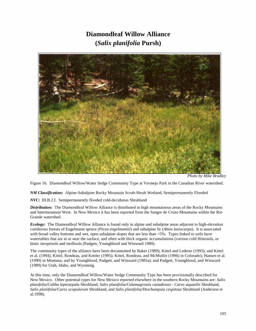
105
Diamondleaf Willow Alliance (Salix planifolia Pursh)
Photo by Mike Bradley
Figure 16. Diamondleaf Willow/Water Sedge Community Type at Vermejo Park in the Canadian River watershed. NM Classification: Alpine-Subalpine Rocky Mountain Scrub-Shrub Wetland, Semipermanently Flooded
NVC: III.B.2.f. Semipermanently flooded cold-deciduous Shrubland
Distribution: The Diamondleaf Willow Alliance is distributed in high mountainous areas of the Rocky Mountains and Intermountain West. In New Mexico it has been reported from the Sangre de Cristo Mountains within the Rio Grande watershed.
Ecology: The Diamondleaf Willow Alliance is found only in alpine and subalpine areas adjacent to high-elevation coniferous forests of Engelmann spruce (Picea engelmannii) and subalpine fir (Abies lasiocarpa). It is associated with broad valley bottoms and wet, open subalpine slopes that are less than <5%. Types linked to soils have watertables that are at or near the surface, and often with thick organic accumulations (various cold Histosols, or histic inceptisols and mollisols (Padgett, Youngblood and Winward 1989).
The community types of the alliance have been documented by Baker (1989); Kittel and Lederer (1993); and Kittel et al. (1994); Kittel, Rondeau, and Kettler (1995); Kittel, Rondeau, and McMullin (1996) in Colorado); Hansen et al. (1990) in Montana; and by Youngblood, Padgett, and Winward (1985a); and Padgett, Youngblood, and Winward (1989) for Utah, Idaho, and Wyoming. At this time, only the Diamondleaf Willow/Water Sedge Community Type has been provisionally described for New Mexico. Other potential types for New Mexico reported elsewhere in the southern Rocky Mountains are: Salix planifolia/Caltha leptosepala Shrubland, Salix planifolia/Calamagrostis canadensis - Carex aquatilis Shrubland, Salix planifolia/Carex scopulorum Shrubland, and Salix planifolia/Deschampsia cespitosa Shrubland (Anderson et al.1998).

106
Community Type Description:
Common Name Scientific Name
Diamondleaf Willow/Water Sedge CT Salix planifolia/Carex aquatilis CT
Acronym SALPLA/CARAQU Status: Provisional (NM) Rank: S4/G5 Distribution Upper Rio Grande Basin in northern New Mexico.
PROVISIONAL DESCRIPTION. Found high in the Rio Grande watershed, this type occurs very close to treeline at an approximate elevation of 11,550 ft (3,520 m). Forming small hummocks, this type occurs along small rivulets at the outflow or seeps of alpine and subalpine lakes, and borders wet boggy peatlands in flat, open expanses. Diamondleaf willow forms a low (rarely exceeds 3 ft (1 m) in height) and open shrub overstory canopy (30% total cover) in association with well-represented shrubby cinquefoil (Pentaphylloides floribunda). The understory is dominated by abundant to luxuriant growth of water sedge along with other sedges such as beaked sedge (C. rostrata) and smallwing sedge (C. microptera) and native grasses such as northern mannagrass (Glyceria borealis) and bluejoint reedgrass (Calamagrostis canadensis). Common forbs include elephanthead lousewort (Pedicularis groenlandica), marsh marigold (Caltha leptosepala), and arrowleaf groundsel (Senecio triangularis). Overall diversity is relatively low, with 35 species reported for the type. Soils are organic Histisols with clayey subsurface horizons below, and deep saturated layers of peat that usually overlie bedrock. Water remains perched at the surface for long periods, or at least remains close to the surface. Communities susceptible to extensive browsing by elk that may reduce the abundance of willow. Uplands are dominated by Engelmann spruce (Picea engelmannii). Although the type is considered provisional in New Mexico because of limited documentation, it has been previously described for the Rocky Mountains by Hansen et al. (1990), and Padgett, Youngblood, and Winward (1988 &1989), among others. REFERENCE SITE NAME. Glacier Lakes
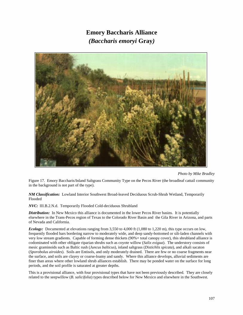
107
Emory Baccharis Alliance (Baccharis emoryi Gray)
Photo by Mike Bradley
Figure 17. Emory Baccharis/Inland Saltgrass Community Type on the Pecos River (the broadleaf cattail community in the background is not part of the type). NM Classification: Lowland Interior Southwest Broad-leaved Deciduous Scrub-Shrub Wetland, Temporarily Flooded
NVC: III.B.2.N.d. Temporarily Flooded Cold-deciduous Shrubland
Distribution: In New Mexico this alliance is documented in the lower Pecos River basins. It is potentially elsewhere in the Trans-Pecos region of Texas to the Colorado River Basin and the Gila River in Arizona, and parts of Nevada and California.
Ecology: Documented at elevations ranging from 3,550 to 4,000 ft (1,080 to 1,220 m), this type occurs on low, frequently flooded bars bordering narrow to moderately wide, and deep sandy-bottomed or silt-laden channels with very low stream gradients. Capable of forming dense thickets (90%+ total canopy cover), this shrubland alliance is codominated with other obligate riparian shrubs such as coyote willow (Salix exigua). The understory consists of mesic graminoids such as Baltic rush (Juncus balticus), inland saltgrass (Distichlis spicata), and alkali sacaton (Sporobolus airoides). Soils are Entisols, and only moderately drained. There are few or no coarse fragments near the surface, and soils are clayey or coarse-loamy and sandy. Where this alliance develops, alluvial sediments are finer than areas where other lowland shrub alliances establish. There may be ponded water on the surface for long periods, and the soil profile is saturated at greater depths.
This is a provisional alliance, with four provisional types that have not been previously described. They are closely related to the seepwillow (B. salicifolia) types described below for New Mexico and elsewhere in the Southwest.
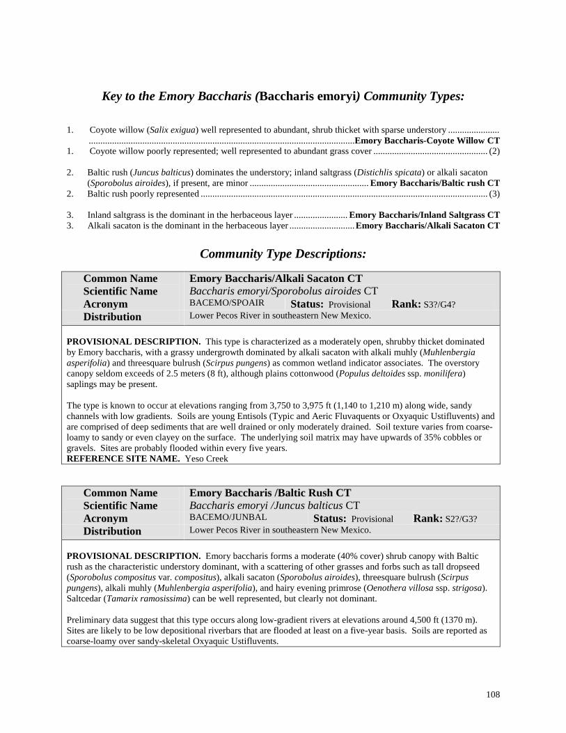
108
Key to the Emory Baccharis (Baccharis emoryi) Community Types: 1. Coyote willow (Salix exigua) well represented to abundant, shrub thicket with sparse understory ...................... ..................................................................................................................Emory Baccharis-Coyote Willow CT 1. Coyote willow poorly represented; well represented to abundant grass cover ................................................. (2) 2. Baltic rush (Juncus balticus) dominates the understory; inland saltgrass (Distichlis spicata) or alkali sacaton
(Sporobolus airoides), if present, are minor ................................................... Emory Baccharis/Baltic rush CT 2. Baltic rush poorly represented ........................................................................................................................... (3) 3. Inland saltgrass is the dominant in the herbaceous layer ....................... Emory Baccharis/Inland Saltgrass CT 3. Alkali sacaton is the dominant in the herbaceous layer ............................Emory Baccharis/Alkali Sacaton CT
Community Type Descriptions:
Common Name Scientific Name
Emory Baccharis/Alkali Sacaton CT Baccharis emoryi/Sporobolus airoides CT
Acronym BACEMO/SPOAIR Status: Provisional Rank: S3?/G4? Distribution Lower Pecos River in southeastern New Mexico.
PROVISIONAL DESCRIPTION. This type is characterized as a moderately open, shrubby thicket dominated by Emory baccharis, with a grassy undergrowth dominated by alkali sacaton with alkali muhly (Muhlenbergia asperifolia) and threesquare bulrush (Scirpus pungens) as common wetland indicator associates. The overstory canopy seldom exceeds of 2.5 meters (8 ft), although plains cottonwood (Populus deltoides ssp. monilifera) saplings may be present. The type is known to occur at elevations ranging from 3,750 to 3,975 ft (1,140 to 1,210 m) along wide, sandy channels with low gradients. Soils are young Entisols (Typic and Aeric Fluvaquents or Oxyaquic Ustifluvents) and are comprised of deep sediments that are well drained or only moderately drained. Soil texture varies from coarse-loamy to sandy or even clayey on the surface. The underlying soil matrix may have upwards of 35% cobbles or gravels. Sites are probably flooded within every five years. REFERENCE SITE NAME. Yeso Creek
Common Name Scientific Name
Emory Baccharis /Baltic Rush CT Baccharis emoryi /Juncus balticus CT
Acronym BACEMO/JUNBAL Status: Provisional Rank: S2?/G3? Distribution Lower Pecos River in southeastern New Mexico.
PROVISIONAL DESCRIPTION. Emory baccharis forms a moderate (40% cover) shrub canopy with Baltic rush as the characteristic understory dominant, with a scattering of other grasses and forbs such as tall dropseed (Sporobolus compositus var. compositus), alkali sacaton (Sporobolus airoides), threesquare bulrush (Scirpus pungens), alkali muhly (Muhlenbergia asperifolia), and hairy evening primrose (Oenothera villosa ssp. strigosa). Saltcedar (Tamarix ramosissima) can be well represented, but clearly not dominant. Preliminary data suggest that this type occurs along low-gradient rivers at elevations around 4,500 ft (1370 m). Sites are likely to be low depositional riverbars that are flooded at least on a five-year basis. Soils are reported as coarse-loamy over sandy-skeletal Oxyaquic Ustifluvents.

109
Common Name Scientific Name
Emory Baccharis-Coyote Willow CT Baccharis emoryi-Salix exigua CT
Acronym BACEMO-SALEXI Status: Provisional Rank: S3?/G3? Distribution Pecos Basin in southeastern New Mexico.
PROVISIONAL DESCRIPTION. Emory Baccharis forms dense, shrub thickets in association with coyote willow. Canopies can exceed 85% cover, and reach up to 2.5 meters (8 ft) in height. The herbaceous layer is moderate in cover and dominated by threesquare bulrush (Scirpus pungens). Other wetland indicators that may be present include common spikerush (Eleocharis palustris), alkali muhly (Muhlenbergia asperifolia), and smooth horsetail (Equisetum laevigatum). Preliminary data suggest that this type occurs at elevations ranging from 3,550 to 3,650 ft (1,080 to 1,110 m) along low-gradient streams and rivers with sandy bottomed channels. Soils are reported as weakly developed Aquic Ustipsamments and Oxyaquic Torrifluvents that are comprised of deep sandy sediments that are well drained. Occasionally, they may have a thin, clayey surface layer that retains greater moisture. Underlying layers have less than 35% cobbles or gravels. REFERENCE SITE NAME. Cottonwood Draw
Common Name Scientific Name
Emory Baccharis /Inland Saltgrass CT Baccharis emoryi /Distichlis spicata CT
Acronym BACEMO/DISSPI Status: Provisional Rank: S3?/G3? Distribution Pecos River in southeastern New Mexico.
PROVISIONAL DESCRIPTION. Emory baccharis forms an open canopied shrub layer with a distinctively grassy herbaceous layer. Inland saltgrass is abundant and dominates the understory with a scattering of other grasses and forbs, including alkali muhly (Muhlenbergia asperifolia), saltmarsh bulrush (Scirpus maritimus), and threesquare bulrush (Scirpus pungens). Saltcedar (Tamarix ramosissima) can be a significant invader and shrub codominant. Preliminary data suggest that this type occurs at elevations around 3,675 ft (1,120 m) along low gradient streams and rivers with sandy bottomed channels. Soils are reported as weakly developed Aquic Torrifluvents with sandy textures.

110
River Birch Alliance (Betula occidentalis Hook.)
Photo by Mike Bradley
Figure 18. River Birch-Redosier Dogwood Community Type on the banks of the Rio Pueblo in the Rio Grande watershed. NM Classification: Montane Rocky Mountain Broad-leaved Deciduous Scrub-Shrub Wetland, Temporarily Flooded
NVC: III.B.2.N.d. Temporarily Flooded Cold-deciduous Shrubland
Distribution: The River Birch Alliance is distributed in mountainous regions of the Rocky Mountains in Colorado and Utah. In New Mexico, the alliance is known from the Sangre de Cristo Mountains of the Upper Rio Grande watershed.
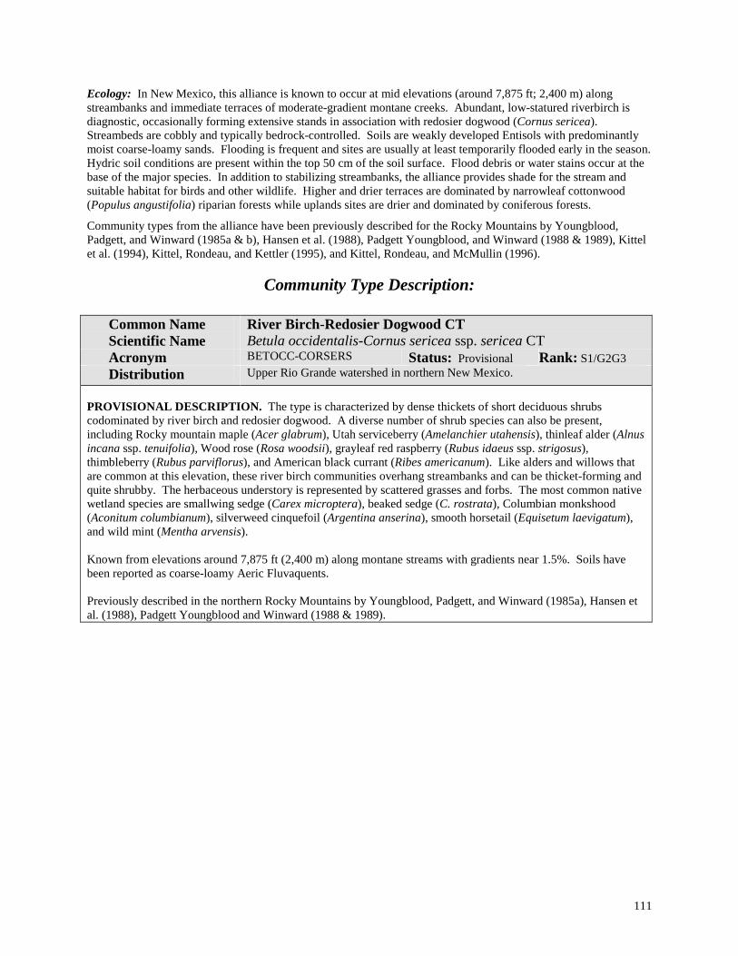
111
Ecology: In New Mexico, this alliance is known to occur at mid elevations (around 7,875 ft; 2,400 m) along streambanks and immediate terraces of moderate-gradient montane creeks. Abundant, low-statured riverbirch is diagnostic, occasionally forming extensive stands in association with redosier dogwood (Cornus sericea). Streambeds are cobbly and typically bedrock-controlled. Soils are weakly developed Entisols with predominantly moist coarse-loamy sands. Flooding is frequent and sites are usually at least temporarily flooded early in the season. Hydric soil conditions are present within the top 50 cm of the soil surface. Flood debris or water stains occur at the base of the major species. In addition to stabilizing streambanks, the alliance provides shade for the stream and suitable habitat for birds and other wildlife. Higher and drier terraces are dominated by narrowleaf cottonwood (Populus angustifolia) riparian forests while uplands sites are drier and dominated by coniferous forests.
Community types from the alliance have been previously described for the Rocky Mountains by Youngblood, Padgett, and Winward (1985a & b), Hansen et al. (1988), Padgett Youngblood, and Winward (1988 & 1989), Kittel et al. (1994), Kittel, Rondeau, and Kettler (1995), and Kittel, Rondeau, and McMullin (1996).
Community Type Description:
Common Name Scientific Name
River Birch-Redosier Dogwood CT Betula occidentalis-Cornus sericea ssp. sericea CT
Acronym BETOCC-CORSERS Status: Provisional Rank: S1/G2G3 Distribution Upper Rio Grande watershed in northern New Mexico.
PROVISIONAL DESCRIPTION. The type is characterized by dense thickets of short deciduous shrubs codominated by river birch and redosier dogwood. A diverse number of shrub species can also be present, including Rocky mountain maple (Acer glabrum), Utah serviceberry (Amelanchier utahensis), thinleaf alder (Alnus incana ssp. tenuifolia), Wood rose (Rosa woodsii), grayleaf red raspberry (Rubus idaeus ssp. strigosus), thimbleberry (Rubus parviflorus), and American black currant (Ribes americanum). Like alders and willows that are common at this elevation, these river birch communities overhang streambanks and can be thicket-forming and quite shrubby. The herbaceous understory is represented by scattered grasses and forbs. The most common native wetland species are smallwing sedge (Carex microptera), beaked sedge (C. rostrata), Columbian monkshood (Aconitum columbianum), silverweed cinquefoil (Argentina anserina), smooth horsetail (Equisetum laevigatum), and wild mint (Mentha arvensis). Known from elevations around 7,875 ft (2,400 m) along montane streams with gradients near 1.5%. Soils have been reported as coarse-loamy Aeric Fluvaquents. Previously described in the northern Rocky Mountains by Youngblood, Padgett, and Winward (1985a), Hansen et al. (1988), Padgett Youngblood and Winward (1988 & 1989).
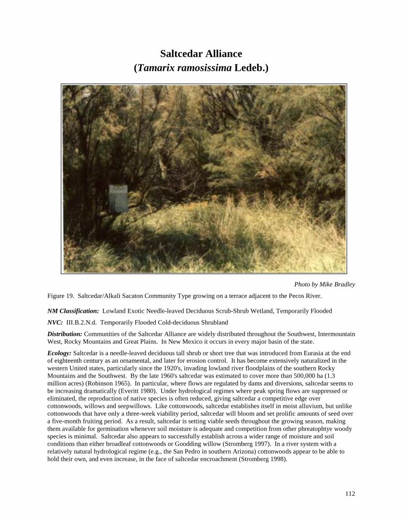
112
Saltcedar Alliance (Tamarix ramosissima Ledeb.)
Photo by Mike Bradley
Figure 19. Saltcedar/Alkali Sacaton Community Type growing on a terrace adjacent to the Pecos River. NM Classification: Lowland Exotic Needle-leaved Deciduous Scrub-Shrub Wetland, Temporarily Flooded
NVC: III.B.2.N.d. Temporarily Flooded Cold-deciduous Shrubland
Distribution: Communities of the Saltcedar Alliance are widely distributed throughout the Southwest, Intermountain West, Rocky Mountains and Great Plains. In New Mexico it occurs in every major basin of the state.
Ecology: Saltcedar is a needle-leaved deciduous tall shrub or short tree that was introduced from Eurasia at the end of eighteenth century as an ornamental, and later for erosion control. It has become extensively naturalized in the western United states, particularly since the 1920's, invading lowland river floodplains of the southern Rocky Mountains and the Southwest. By the late 1960's saltcedar was estimated to cover more than 500,000 ha (1.3 million acres) (Robinson 1965). In particular, where flows are regulated by dams and diversions, saltcedar seems to be increasing dramatically (Everitt 1980). Under hydrological regimes where peak spring flows are suppressed or eliminated, the reproduction of native species is often reduced, giving saltcedar a competitive edge over cottonwoods, willows and seepwillows. Like cottonwoods, saltcedar establishes itself in moist alluvium, but unlike cottonwoods that have only a three-week viability period, saltcedar will bloom and set prolific amounts of seed over a five-month fruiting period. As a result, saltcedar is setting viable seeds throughout the growing season, making them available for germination whenever soil moisture is adequate and competition from other phreatophtye woody species is minimal. Saltcedar also appears to successfully establish across a wider range of moisture and soil conditions than either broadleaf cottonwoods or Goodding willow (Stromberg 1997). In a river system with a relatively natural hydrological regime (e.g., the San Pedro in southern Arizona) cottonwoods appear to be able to hold their own, and even increase, in the face of saltcedar encroachment (Stromberg 1998).

113
Plant species diversity is relatively poor in saltcedar communities, although this appears to vary with the density of the stands and substrates. For example, Stromberg (1998) reports southern Arizona higher in vascular plant diversity in saltcedar stands than in nearby cottonwood communities, perhaps as a function high clay soils under the saltcedar. Based on our data from New Mexico, native herbaceous species richness on a plot ranged from one to 15 species for saltcedar and one to 26 for cottonwood, with averages that did not differ by much (3.6 species for saltcedar and 3.9 for cottonwood). It is in very dense, older stands of saltcedar that the lack of native herbaceous diversity and abundance is most striking, and of concern. These stands often contain only two or three scattered herbaceous species and very low overall herbaceous cover (< 1.0%), while the density of saltcedar stems makes them nearly impenetrable. In contrast, mature cottonwood stands are usually not nearly as sparse, nor low in diversity, both in terms of species and overall structure. Unfortunately these dense stands of saltcedar are becoming the most prevalent in lowland floodplains of the Southwest as saltcedar has spread and aged. In severe cases, saltcedar effectively displaces the native riparian communities and alters the hydrology of many sites it invades (Campbell and Dick-Peddie 1964; Evirett 1980; Carman and Brotherson 1982; Malanson 1993; Busch and Smith 1995). This is particularly the case below major dams and diversions where monotypic stands of saltcedar can dominate long stretches of river in extensive, uninterrupted and nearly monotypic stands.
Taxonomically, there are four species of saltcedar reported for New Mexico according to Kartesz (1994). Tamarix ramosa is what we encountered most, but T. chinensis (five-stamen tamarisk), T. gallica (French tamarisk), and T. parviflora (smallflower tamarisk) are also possible. T. ramosa and T. chinesis are very similar and very possibly hybridize with each other (Baum 1967). Horton and Campbell (1974) also suggest that the differentiation of these species is not warranted because they are inconsistent in their features. Furthermore, Everitt (1980) proposed that in ecological studies they be treated together because their taxonomic differentiation in the field is difficult at best and ecological differences are not readily apparent. Hence, we have grouped them together under a single Saltcedar Alliance labeled by T. ramosa.
In New Mexico, communities from the alliance range in elevation from 3,250 to 6,100 ft (990 to 1,860 m). They occur mostly on higher alluvial terraces and bars of lowland streams and rivers, and in deltas leading to reservoirs. They call also flourish on alkali flats, or in and around playas. Soils range from relatively wet Aquic Ustifluvents and Aquic Camborthid, to moderate Oxyaquic Torrifluvents and Oxyaquic Ustifluvents, to relatively dry Typic Torrifluvents and Typic Haplotorrerts.
With respect to classification, Brown, Lowe, and Pase (1979) recognized a Salt Cedar Disclimax Series within three of their biotic communities: Interior Southwest Warm Temperate Swamp and Riparian (Tamarix chinensis-mixed deciduous Association), Plains and Great Basin Swamp and Riparian Scrub (Tamarix chinensis Association), and within their Sonoran Deciduous Swamp and Riparian Scrub (Tamarix chinensis Association and Tamarix chinensis-mixed scrub Association). Dick-Peddie (1993) also recognized a Saltcedar Series within his Successional-Disturbance Riparian type. A Tamarix spp. Temporarily Flooded Shrubland Alliance is also recognized in the national classification (Anderson et al. 1998) as occurring in most of the western states and northern Mexico (except Washington, Oregon and Idaho). Because communities of the Saltcedar Alliance are dominated by exotics, they are considered semi-natural communities. Hence, they are globally ranked for biodiversity conservation purposes as either GM (modified) where there may still be significant native components in the understory, or GW (weedy) where exotics completely dominate both shrub and herbaceous strata. In New Mexico, we have identified eight community types for the Alliance.
Key to the Saltcedar (Tamarix ramosissima) Community Types: 1. Buffalograss (Buchloe dactyloides) at least abundant; playa lake bottoms ...............Saltcedar/Buffalograss CT 1. Not as above ...................................................................................................................................................... (2) 2. False quackgrass (Elymus pseudorepens) the dominant grass .......................... Saltcedar/False Quackgrass CT 2. False quackgrass poorly represented or absent .................................................................................................. (3) 3. Coyote willow (Salix exigua) well represented to abundant .................................Saltcedar-Coyote Willow CT 3. Coyote willow poorly represented or absent...................................................................................................... (4) 4. Inland saltgrass (Distichlis spicata) the dominant grass ..................................... Saltcedar/Inland Saltgrass CT 4. Inland saltgrass poorly represented or absent .................................................................................................... (5)

114
5. Alkali sacaton (Sporobolus airoides) well represented to abundant, and the dominant grass ................................ ............................................................................................................................... Saltcedar/Alkali Sacaton CT 5. Alkali sacaton poorly represented, or absent .................................................................................................... (6) 6. Pickleweed (Allenrolfea occidentalis) the dominant understory shrub........................Saltcedar-Pickleweed CT 6. Pickleweed scarce or absent .............................................................................................................................. (7) 7. Redtop (Agrostis gigantea) well represented to abundant, and dominant in grassy undergrowth ......................... ............................................................................................................................................Saltcedar/Redtop CT 7 Redtop poorly represented; undergrowth sparse................................................................. Saltcedar/Sparse CT
Community Type Descriptions:
Common Name Scientific Name
Saltcedar/Alkali Sacaton CT Tamarix ramosissima/Sporobolus airoides CT
Acronym TAMRAM/SPOAIR Status: Established Rank: SM/GM Distribution Widespread in the Pecos and Rio Grande basins in central and southern New
Mexico. VEGETATION. The saltcedar forms moderate shrub canopies with 40 to 60% cover, other shrubs are few and scattered. The understory is characteristically grassy and is strongly dominated by abundant to luxuriant alkali sacaton, a bottomland bunchgrass. Inland saltgrass (Distichlis spicata) can be present, but clearly not codominant. Eighteen other grasses have been recorded for the type, but most are minor constituents. The most common and abundant are sandbur (Cenchrus carolinianus), streambed bristlegrass (Setaria leucopila), or plains bristlegrass (Setaria macrostachya), giant sacaton (Sporobolus wrightii), and spike dropseed (Sporobolus contractus). Forbs are also scattered and variable with only two of the 19 species recorded as occurring more than once. ENVIRONMENT. This community occurs at elevations ranging from 3,825 to 5,050 ft (1,170 to 1,540 m). Primarily, it can be found along the broad valley floors of larger river corridors, but it can also occur in narrow, isolated canyons, and on alluvial flats and around playas. Flooding in these stands is infrequent, and is estimated to occur every seven to twelve years. Stands are probably maintained by watertables that occur within one to two meters of the surface. Soils are comprised of coarse loams or fine silts and very fine clays that overlie alternating layers of coarser or finer alluvial sediments and without underlying rock fragments, at least near the surface. There are indicators (mottles) that soils are periodically moist within one meter of the surface during most years. COMMENTS. The community thrives in disturbed southwestern riparian habitats, but stands lack diversity. When saltcedar occurs at higher densities, the grasses, forbs and shrubs drop out of the stand, leading to even less diversity, thence to monotypic and nearly impenetrable stands. The community is typically situated on the first terrace of alluvial floodplains adjacent to other cottonwood-dominated forests. Campbell and Dick-Peddie (1964) report a tamarisk and screwbean community (Class III) with alkali sacaton as the dominant in the undergrowth in the lower Rio Grande of New Mexico. This CT was given a global rarity rank of GM because of its exotic elements, and, hence, is not tracked for biodiversity conservation purposes. NMNHP DATA PLOTS. 93DT255, 93DT265, 93DT288, 93 MP073, 93NR004, 93PD027, 93PD046,
93PD047, 94PD069, 94PD092, 97GH087 REFERENCE SITE NAME. Baldy Mountain ELEVATION. ft. (m.) Ave.: 4,435 (1,350m) Min.: 3,820 (1,170m) Max.: 5,050 (1,540m) HYDROLOGY.
Rosgen Channel Types: B5c, C5, E6 Flow Regimes: P1, P7 Ave. Discharge Ratio: 4.7 Recurrence Interval (Yrs.): 8.6

115
SOILS. Soil Families Coarse-loamy/clayey Aquic Camborthid
Fine-loamy/sandy Oxyaquic Torrifluvent Clayey/fine-loamy or clayey/sandy Oxyaquic Ustifluvent Coarse-loamy Typic Ustifluvent
Ave. Plant Avail. Water (%): 8 Ave. Soil Wetness Rank: 8
Common Name Scientific Name
Saltcedar/Buffalograss CT Tamarix ramosissima/Buchloe dactyloides CT
Acronym TAMRAM/BUCDAC Status: Provisional Rank: SM/GM Distribution Lower Pecos River basin in southeastern New Mexico (Chaves Co.).
PROVISIONAL DESCRIPTION. This is a perimeter playa lake type that is characterized by an open canopy of saltcedar with a grassy turf of abundant to luxuriant buffalograss. Other undergrowth species may include scattered Texas blueweed (Helianthus ciliaris), green prairie coneflower (Ratibida tagetes), vine mesquite (Panicum obtusum), and alkali sacaton (Sporobolus airoides). The type is known from about an elevation of 3,600 ft (1100 m). Soils are reported as clayey Typic Haplotorrerts containing shrink-swell clays. This CT was given a global rarity rank of GM because of its exotic elements, and, hence, it is not tracked for biodiversity conservation purposes.
Common Name Scientific Name
Saltcedar-Coyote Willow CT Tamarix ramosissima/Salix exigua CT
Acronym TAMRAM/SALEXI Status: Provisional Rank: SM/GM Distribution Upper Rio Grande basin in north-central New Mexico (Taos Co.).
PROVISIONAL DESCRIPTION. Coyote willow and saltcedar codominate canopies ranging in total cover from 25 to 90%. Where saltcedar is clearly subordinate to coyote willow (where cover rations exceed 2:1), see the Coyote Willow Alliance. Preliminary data suggest that the undergrowth is somewhat sparse and represented by a range of grasses and forbs that may include such wetland indicators as horsetails (Equisetum arvense and E. laevigatum), common spikerush (Eleocharis palustris), American bugleweed (Lycopus americanus), silverweed cinquefoil (Argentina anserina), and largeleaf avens (Geum macrophyllum). This community is known from island bars that frequently flooded (one- to two-year recurrence intervals) along regulated rivers. This CT was given a global rarity rank of GM because of its exotic elements, and, hence, is not tracked for biodiversity conservation purposes.

116
Common Name Scientific Name
Saltcedar/False Quackgrass CT Tamarix ramosissima/Elymus pseudorepens CT
Acronym TAMRAM/ELYPSE Status: Provisional Rank: SM/GM Distribution Rio Grande basin in north-central New Mexico (Taos Co.).
PROVISIONAL DESCRIPTION. Saltcedar forms a dense canopy, with only scattered coyote willows (Salix exigua) present. False quackgrass is abundant and dominates what is otherwise a rather sparse understory. Sites range from frequently flooded sidebars to less frequently flooded lower terraces. Elevations are around 6,050 ft (1,850 m). Soils are reported as loamy Aquic Ustifluvents. This CT was given a global rarity rank of GM because of its exotic elements, and, hence, is not tracked for biodiversity conservation purposes.
Common Name Scientific Name
Saltcedar/Inland Saltgrass CT Tamarix ramosissima/Distichlis spicata CT
Acronym TAMRAM/DISSPI Status: Provisional Rank: SM/GM Distribution Rio Grande and Pecos River basins in central and southern New Mexico, and in
the San Juan River Basin in northwestern New Mexico. PROVISIONAL DESCRIPTION. This community is characterized by a moderate to dense canopy of saltcedar (30-80%) and a grassy understory dominated by saltgrass (Distichlis spicata). Alkali muhly (Muhlenbergia asperifolia) and threesquare bulrush (Scirpus pungens), both wetland indicator species, can be well represented to abundant. The type occurs at elevations roughly ranging between 3,800 and 5,500 ft (1,160 and 1,680 m) along lowland river floodplains and playa margins. Sites are frequently flooded alluvial bars and lower terraces. Soils are reported as relatively moist and clayey Aeric Fluvaquents, and somewhat drier coarse-loamy over sandy-skeletal Oxyaquic Ustifluvents. This CT was given a global rarity rank of GM because of its exotic elements, and, hence, is not tracked for biodiversity conservation purposes. REFERENCE SITE NAME. Baldy Mountain
Common Name Scientific Name
Saltcedar-Pickleweed CT Tamarix ramosissima-Allenrolfea occidentalis CT
Acronym TAMRAM/ALLOCC Status: Provisional Rank: SM/GM Distribution Tularosa basin, south-central New Mexico.
PROVISIONAL DESCRIPTION. This type is characterized by open to moderate canopies of saltcedar (15 to 70% cover) with scattered pickleweed shrubs. The herb layer ranges from a sparse to moderate grass cover (15%) of alkali sacaton (Sporobolus airoides). Overall forb and grass diversity is low with only six species reported for the type. Known from low stabilized gypsum dunes, gypsic flats and playas at elevations between 3,870 and 3,990 ft (1,180 and 1,220 m). This CT was given a global rarity rank of GM because of its exotic elements, and, hence, is not tracked for biodiversity conservation purposes.

117
Common Name Scientific Name
Saltcedar/Redtop CT Tamarix ramosissima/Agrostis gigantea CT
Acronym TAMRAM/AGRGIG Status: Provisional Rank: SW/GW Distribution Rio Grande basin in north-central New Mexico.
PROVISIONAL DESCRIPTION. Saltcedar forms dense canopies (60-80% cover) and strongly dominates the shrub layer. Other shrubs may be present such as coyote willow (Salix exigua) and New Mexico olive (Forestiera pubescens var. pubescens), but clearly not dominant or codominant. The exotic grass redtop (Agrostis gigantea) is well represented to abundant and dominates the understory. Twenty-five other scattered grasses and forbs have been reported for the type, 19 of which are native. Preliminary data suggest that this type occurs on infrequently flooded bars and lower terraces along lowland, low-gradient rivers at elevations of around 6,050 ft (1,850 m). Soils are reported as coarse-loamy Aquic Ustifluvents with indications that the water table is within one to two meters of the surface.
Common Name Scientific Name
Saltcedar/Sparse CT Tamarix ramosissima/Sparse CT
Acronym TAMRAM/SPARSE Status: Established Rank: SW/GW Distribution Widespread in the Canadian, Pecos, and Rio Grande basins throughout the state.
Known from the Great Plains of Colorado. VEGETATION. Saltcedar forms dense stands, often with closed canopies of 70% or more cover. Coyote willow can be present, but clearly not codominant. Undergrowth cover is low (<3%, commonly less that 1%), and diversity is usually low with scattered grasses and forbs (15 herbs have been recorded for the type). ENVIRONMENT. This community occurs along the broad lowland river floodplains, and in smaller but still low-gradient streams at elevations ranging from 3,300 to 6,050 ft (1,010 to 1,840 m). The streams can be deeply entrenched. Sites range from frequently flooded bars to infrequently flooded low terraces. Soils are comprised of fine or very fine alluvial sediments with no underlying coarser rock fragments near the surface. COMMENTS. Species diversity in these communities is characteristically poor and stands are nearly impenetrable. The community is commonly situated on the first terrace of alluvial floodplains adjacent to cottonwood-dominated forests. NMNHP DATA PLOTS. 92RW037, 93PD056, 97GH023, 97GH043, 97GH085, 97MB008 REFERENCE SITE NAME Mills Canyon Campground ELEVATION. ft. (m.) Ave.: 4,665 (1,420m) Min.: 3,290 (1,010m) Max.: 6,040 (1,840m) HYDROLOGY.
Rosgen Channel Types: C4, F6 Flow Regimes: P1, P7 Ave. Discharge Ratio: 4 Recurrence Interval (Yrs.): 13
SOILS. Soil Families Fine-silty Aquic Ustifluvent
Very fine clayey Typic Torrifluvent Ave. Plant Avail. Water (%): 10 Ave. Soil Wetness Rank: 9
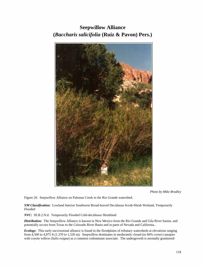
118
Seepwillow Alliance (Baccharis salicifolia (Ruiz & Pavon) Pers.)
Photo by Mike Bradley
Figure 20. Seepwillow Alliance on Palomas Creek in the Rio Grande watershed. NM Classification: Lowland Interior Southwest Broad-leaved Deciduous Scrub-Shrub Wetland, Temporarily Flooded
NVC: III.B.2.N.d. Temporarily Flooded Cold-deciduous Shrubland
Distribution: The Seepwillow Alliance is known in New Mexico from the Rio Grande and Gila River basins, and potentially occurs from Texas to the Colorado River Basin and in parts of Nevada and California..
Ecology: This early successional alliance is found in the floodplains of tributary watersheds at elevations ranging from 4,500 to 4,975 ft (1,370 to 1,520 m). Seepwillow dominates in moderately closed (to 60% cover) canopies with coyote willow (Salix exigua) as a common codominant associate. The undergrowth is normally graminoid-
119
dominated understory that includes threesquare bulrush (Scirpus pungens) or the grass prairie wedgescale (Sphenopholis obtusata). These shrublands develop along small, bouldery, intermittent or perennial rivers or creeks with cobbly and sandy streambeds. The alliance has a willow-like character, reaching canopy heights of 3 to 12 ft (1-4 m). Like coyote willow, Baccharis is especially well adapted to periodic flooding. Coarser alluvial sediments partially bury its basal stems, and seepwillow can tolerate hot, open, dry sites on exposed cobble bars or somewhat shady site conditions. Soils are young Entisols, often scoured and consisting solely of loose and non-cohesive sand deposits mixed with large amounts of gravels and cobbles. Some are stratified with a layer of sand over cobbles. They are well drained and the water table is close to or at the surface at some point during the year.
A Baccharis salicifolia Intermittently Flooded Shrubland Alliance has been identified for Texas by Anderson et al. (1998), and is represented by the Baccharis salicifolia/Muhlenbergia rigens Association. In addition, a Baccharis sarothroides - Baccharis salicifolia Shrubland Association has been identified for Arizona, and a Baccharis salicifolia - Baccharis neglecta /Eustoma exaltatum Association in Texas. For New Mexico we have identified only two provisional community types, and additional information is needed on the composition and ecology of this and other types in the West.
Key to the Seepwillow (Baccharis salicifolia) Community Types: 1. Understory dominated by threesquare bulrush (Scirpus pungens) and other mesic graminoids............................. .................................................................................................................Seepwillow/Threesquare Bulrush CT 1. Understory mostly annual forbs and grasses; frequently flooded riverbars and riverwash..................................... .................................................................................................................................. Seepwillow/Gravel Bar CT
Community Type Descriptions:
Common Name Scientific Name
Seepwillow/Gravel Bar CT Baccharis salicifolia/Gravel Bar CT
Acronym BACSAL/GRABAR Status: Provisional Rank: S3?/G4? Distribution Lower Rio Grande (Animas and Palomas Creeks), and the San Francisco River
watershed in southwestern New Mexico. PROVISIONAL DESCRIPTION. This type is represented by open to moderately closed canopies of seepwillow, and undergrowths that, although moderately diverse (27 species recorded for the type), are low in cover. Sites commonly have a weedy component represented by species such as Canadian horseweed (Conyza canadensis), annual rabbitsfoot grass (Polypogon monspeliensis), curly dock (Rumex crispus), and prairie wedgescale (Sphenopholis obtusata). Several native herbaceous wetland indicators can be present such as common spikerush (Eleocharis palustris), poverty rush (Juncus tenuis), irisleaf rush (Juncus xiphioides), field horsetail (Equisetum arvense), seep monkeyflower (Mimulus guttatus), whitewater crowfoot (Ranunculus aquatilis), and American speedwell (Veronica americana). Tree reproduction is common for Arizona alder (Alnus oblongifolia), Arizona sycamore (Platanus wrightii), and Fremont cottonwood (Populus fremontii). These are young successional stands that occur on low gravel river bars in, or adjacent to, the active channel that have gradients ranging from 0.2 to 1.2%. They are probably flooded every year or two, and remain well watered throughout the growing season. Frequent flooding reduces vegetative cover and can remove tree seedlings. Soils are undeveloped gravelly and sandy riverwash. These are generally lowland communities that are known to occur from 4,700 to 4,800 ft (1,430 to 1,460 m).

120
Common Name Scientific Name
Seepwillow/Threesquare Bulrush CT Baccharis salicifolia/Scirpus pungens CT
Acronym BACSAL/SCIPUN Status: Provisional Rank: S3?/G4? Distribution San Francisco River watershed in southwestern New Mexico.
PROVISIONAL DESCRIPTION. This type is characterized by an open canopy of seepwillow underlain by a luxuriant graminoid cover strongly dominated by threesquare bulrush. Other herbaceous wetland indicators known from the type are smallwing sedge (Carex microptera), knotgrass (Paspalum distichum), smooth horsetail (Equisetum laevigatum), and broadleaf cattail (Typha latifolia). Preliminary data suggest this type occurs along low-gradient streams (0.4%) and rivers at elevations around 4,500 ft (1,370 m). It is known from depositional side bars that are within or near the level of bankfull discharge. Hence, they are likely to be flooded on an annual basis. Soils are reported as sandy-skeletal Typic Fluvaquents.

121
Thinleaf Alder Alliance (Alnus incana ssp. tenuifolia (Nutt.) Breitung)
Photo by Mike Bradley
Figure 21. Thinleaf Alder Alliance on the banks of the Pecos River. NM Classification: Montane Rocky Mountain Broad-leaved Deciduous Scrub-Shrub Wetland, Temporarily Flooded
NVC: III.B.2.N.d. Temporarily Flooded Cold-deciduous Shrubland
Distribution: The Thinleaf Alder Alliance is distributed throughout mountainous regions of the Rocky Mountains and Great Basin. In New Mexico, the alliance primarily occurs in the Sangre de Cristo Mountains of the Rio Grande, Pecos, and Canadian watersheds and is patchy in the Zuni Mountains.
Ecology: The alliance is represented by moderately open to very dense shrublands (90%+ total canopy cover) dominated by thinleaf alder. A widespread tall shrub or small tree of the Rocky Mountains and Intermountain West, thinleaf alder can form conspicuous dense thickets with a wide variety of shrubs. Redosier dogwood (Cornus sericea ssp. sericea) and bluestem willow (Salix irrorata) are common sub-canopy associates. This alliance is known only from mountainous areas ranging in elevation from 6,300 to 8,800 ft (1,920 to 2,680 m). It occurs along perennial streams in narrow, deeply cut ravines, and occasionally in wider canyons on low alluvial terraces and bars. Undisturbed stands are diverse, both botanically and structurally. Site characteristics are more mesic than nearby sites, and the alliance is at least temporarily flooded during most years. Soils are commonly moist, well-drained Entisols with upwards of 35% rocks and cobbles that provide good aeration and rapid movement of water through the soil profile.
Community types from this alliance have been reported previously by Miller (1976) in Idaho; Evenden (1990) in Oregon; Padgett, Youngblood, and Winward (1988 & 1989) Youngblood, Padgett, and H. Winward (1985a) for Utah and Idaho; and Kittel and Lederer (1993), Kittel, Rondeau and Kettler (1995),
122
Kittel, Rondeau, and McMullin (1996) for Colorado; Manning and Padgett (1995) for California and Nevada; and Muldavin, Sims and Johnson (1993) in New Mexico.
Key to the Thinleaf Alder (Alnus incana ssp. tenuifolia) Community Types:
1. Redosier dogwood (Cornus sericea ssp. sericea) well represented to abundant and a shrub codominant ............. ............................................................................................................... Thinleaf Alder-Redosier Dogwood CT 1. Redosier dogwood poorly represented or absent .................................................................................................... ........................................................................................................................................................................... (2) 2. Bluestem willow (Salix irrorata) abundant and codominant.................................................................................. .................................................................................................................. Thinleaf Alder-Bluestem Willow CT 2. Bluestem willow poorly represented or absent .................................................................................................. (3) 3. Pacific willow (Salix lucida ssp. Lasiandra) well represented; undergrowth poorly developed ............................ ...................................................................................................................... Thinleaf Alder-Pacific Willow CT 3. Pacific willow poorly represented; grasses dominate the undergrowth .Thinleaf Alder/Canada Reedgrass CT
Community Type Descriptions:
Common Name Scientific Name
Thinleaf Alder-Bluestem Willow CT Alnus incana ssp. tenuifolia-Salix irrorata PA
Acronym ALNINCT-SALIRR Status: Established Rank: S3/G3 Distribution This community type is common in mountainous portions of the upper watersheds
of the Rio Grande, Pecos, and Canadian watersheds in northern New Mexico. VEGETATION. Thinleaf alder and bluestem willow are abundant to luxuriant and dominate a dense, diverse shrub layer. Other willows such as Bebb willow (S. bebbiana), Booth willow (S. boothii), yellow willow (S. lutea), and mountain willow (S. monticola) may also be well represented. Other common shrubs are Wood rose (Rosa woodsii) and whitestem gooseberry (Ribes inerme). Mature trees are infrequent or absent, yet narrowleaf cottonwood (Populus angustifolia) reproduction may occur beneath the canopy. The herbaceous undergrowth is lush and diverse with 148 graminoids and forbs recorded for the type (30 of which are exotic). Taller wetland forbs such as cutleaf coneflower (Rudbeckia laciniata), water hemlock (Cicuta douglasii), and cow parsnip (Heracleum maximum) are prominent in many stands. Among the 42 herbaceous wetland indicators recorded for the type, the most present and common are smallwing sedge (Carex microptera), owlfruit sedge (C. stipata), fowl mannagrass (Glyceria striata), Baltic rush (Juncus balticus), Rocky Mountain rush (J. saximontanus), leafybract aster (Aster foliaceus), hairy willowherb (Epilobium ciliatum), field horsetail (Equisetum arvense), smooth horsetail (E. laevigatum), largeleaf avens (Geum macrophyllum), wild mint (Mentha arvensis), Franciscan bluebells (Mertensia franciscana), Fendler cowbane (Oxypolis fendleri), and American speedwell (Veronica americana). Exotic grasses such as redtop (Agrostis gigantea), creeping bentgrass (A. stolonifera), Kentucky bluegrass (Poa pratensis), and timothy (Phleum pratense) may invade from surrounding meadows and can be abundant. ENVIRONMENT. This montane community occurs at elevations ranging from 6,375 to 8,775 ft (1,940 to 2,680 m) along small perennial streams with moderate to steep gradients. It occurs primarily on depositional bars and streambanks composed of sands, gravels and cobbles. The sites within and along channels are flooded on a yearly basis. Some sites have aggraded with the accumulation of sediment and flooding is less frequent (five- to ten-year intervals). Soils are moist and have coarse-loamy surfaces that overlie deeper sandy-skeletal layers consisting of cobbles and gravel. The soil matrix may be upwards of 80% rock fragments. Soils may at some point in the season be dry at the surface, but tend to be moist at shallow depths and through the top 10 to 25 cm (4 - 10 in.) of the soil profile during most years.

123
COMMENTS. Seasonally high water tables allow continued reproduction of the alders, willows and cottonwoods along with the numerous other obligate riparian shrubs and herbs. To maintain the structure of the community, disturbance from recreation and livestock usage should be discouraged. Severe alterations of the hydrology or upland conditions can contribute to loss of valuable habitat and biodiversity. Adjacent upper terraces can be dominated by narrowleaf cottonwood forests bordered by grassy meadows and aspen groves. Uplands are dominated by pinyon pine/juniper woodlands on dry open slopes and ponderosa pine forests on opposite, cooler slopes. Previously described by Muldavin (1991). NMNHP DATA PLOTS. 92EM018, 92RW007, 92RW008, 92RW010, 92RW017, 92RW018, 92HK002,
92HK012, 92HK013, 93PD002, 94PD033, 97MB015, 97MB029 REFERENCE SITE NAME. Agua Caliente, Middle Ponil
ELEVATION. ft. (m.) Ave.: 7,575 (2,310m) Min.: 6,375 (1,940m) Max.: 8,775 (2,680m) HYDROLOGY.
Rosgen Channel Types: A3, B3, B3a, C2, D3, E4b Flow Regimes: P1 Ave. Discharge Ratio: 1.0 Recurrence Interval (Yrs.): 3
SOILS. Soil Families Loamy-skeletal and sandy-skeletal Aeric Fluvaquent
Coarse-loamy/sandy skeletal Oxyaquic Udifluvent Loamy skeletal and sandy skeletal Typic Fluvaquents
Ave. Plant Avail. Water (%): 4 Ave. Soil Wetness Rank: 3
Common Name Scientific Name
Thinleaf Alder/Canada Reedgrass CT Alnus incana ssp. tenuifolia/Calamagrostis canadensis CT
Acronym ALNINCT/CALCAN Status: Provisional Rank: S1?/G3? Distribution Pecos River Basin in north-central New Mexico.
PROVISIONAL DESCRIPTION. This type is characterized by an open canopy of thinleaf alder, and a grassy herbaceous layer dominated by Canada reedgrass with tall mannagrass (Glyceria elata) or fowl mannagrass (Glyceria striata) as well-represented to abundant associates. In the herbaceous layer an additional 22 native wetland indicators have been recorded for the type, of which the most abundant are smallwing sedge (Carex microptera), owlfruit sedge (C. stipata), field horsetail (Equisetum arvense), smooth horsetail (Equisetum laevigatum), cow parsnip (Heracleum maximum), cutleaf coneflower (Rudbeckia laciniata), California false hellebore (Veratrum californicum) and Missouri violet (Viola missouriensis). Preliminary data suggest that this type occurs on lower depositional bars along montane streams of moderate gradient (0.8%) at elevations of around 8,600 ft (2,620 m). Sites are probably flooded anywhere from yearly to every ten years. Soils are reported as loamy Mollic Fluvaquents, reflecting the grassy dominance. The type reportedly occurs in Montana (Anderson et al. 1998).
Common Name Scientific Name
Thinleaf Alder-Pacific Willow CT Alnus incana ssp. tenuifolia-Salix lucida ssp. lasiandra CT
Acronym ALNINCT-SALLUCL Status: Provisional Rank: S3?/G3? Distribution Northwestern New Mexico and Southwestern Colorado. In New Mexico: Little
Colorado watershed; Little Water Creek, and Bowl Canyon in the Chuska Mountains, and the Rio Nutria watershed in the Zuni Mountains.
PROVISIONAL DESCRIPTION. ,Thinleaf alder and Pacific willow are both abundant and form closed canopied tall thickets (9 to 12 ft;3 to 4 m). Other common to well-represented shrubs include redosier dogwood (Cornus sericea ssp. sericea), bluestem willow (Salix irrorata), Bebb willow (Salix bebbiana), wax currant (Ribes

124
cereum), and skunkbush sumac (Rhus trilobata). The herbaceous layer is characterized by well-represented to abundant graminoids and a wide diversity of scattered forbs (45 forbs have been recorded for the type). Native graminoid wetland indicators species that are often present are fowl mannagrass (Glyceria striata), shortawn foxtail (Alopecurus aequalis), common spikerush (Eleocharis palustris), Rocky Mountain rush (Juncus saximontanus) and Baltic rush (Juncus balticus). Among native forbs, there are 17 wetland indicators, of which the most common are western water hemlock (Cicuta douglasii), hairy willowherb (Epilobium ciliatum), field horsetail (Equisetum arvense), Rocky Mountain iris (Iris missouriensis), wild mint (Mentha arvensis), common selfheal (Prunella vulgaris), alkali buttercup (Ranunculus cymbalaria), cutleaf coneflower (Rudbeckia laciniata), and mountain blue-eyed grass (Sisyrinchium montanum). Exotic grasses such as redtop (Agrostis gigantea), or meadow fescue (Festuca pratensis) are often abundant invaders of the undergrowth. This community type occurs at higher elevations ranging from 7,100 to 7,680 ft (2170 to 2,340 m). Developing as thickets along banks and bars bordering very narrow cobbly stream channels of wider mountainous valleys, these shrublands are conspicuous in the landscape. The channels are usually bedrock controlled, confined, and of moderate to steep gradients (2.5% average). Soils are coarse and sandy in texture with high amounts of cobble and rock. Soils are reported as either Typic Fluvaquents or Oxyaquic Ustifluvents. Due to the low-position floodplain along the streambank, soils may be wet or moist at the surface, but are generally well drained. Reduced aquic conditions often start from 50 to 100 cm (20 to 39 in) below the surface. The alder and willow canopy provide forage and habitat for wildlife and livestock. With heavy browsing, the willows become umbrella shaped and less vigorous than in undisturbed stands. Native herbs are replaced in the understory by exotic grasses and forbs that withstand heavy grazing. As elevation decreases, thinleaf alder tends to decrease in dominance. Eventually it drops out of the stands, resulting in a community dominated by Pacific willow with an understory of mesic graminoids. Adjacent upper terraces are dominated by narrowleaf cottonwood forests with chokecherry or skunkbush sumac shrub understories. The uplands are often ponderosa pine (Pinus ponderosa) with Gambel oak (Quercus gambelii) and Rocky Mountain juniper (Juniperus scopulorum). The type was reported for northern New Mexico by Muldavin (1991). In Colorado, Kittel and Lederer 1993, Kittel et al. (1994), and Kittel, Rondeau, and Kettler (1995) report a Alnus incana - Salix (monticola, lucida, and ligulifolia) Shrubland from southwestern Colorado that is probably synonymous with this type.
Common Name Scientific Name
Thinleaf Alder-Redosier Dogwood CT Alnus incana ssp. tenuifolia-Cornus sericea ssp. sericea CT
Acronym ALNINCT-CORSERS Status: Established Rank: S3S4/G3G4 Distribution Widely distributed in the western United States. In New Mexico known from the
upper watersheds of the Pecos, Little Colorado, and Rio Grande in northern New Mexico.
VEGETATION. In this type thinleaf alder forms dense shrubby thickets with canopies from 50 to 90% cover or more, and heights of 3 to 5 m. (9 to 15 ft). Stands are codominated by redosier dogwood, a shorter thicket-forming shrub that often sprawls among other shrubs. Young narrowleaf cottonwood (Populus angustifolia) may be present, but mature trees are infrequent. Willows may be present, but they usually poorly represented. Other common associated shrubs include Wood rose (Rosa woodsii), blackberry (Rubus strigosus), whitestem gooseberry (Ribes inerme), raspberry (Rubus deliciosus) and bearberry honeysuckle (Lonicera involucrata) are well represented. A well-developed and diverse herbaceous layer can be present beneath the shrub canopy (93 herbaceous species have been recorded for the type). Native forbs are more consistently represented than graminoids, and include 24 wetland indicators. These include Columbian monkshood (Aconitum columbianum), leafybract aster (Aster foliaceus), hairy willowherb (Epilobium ciliatum), field horsetail (Equisetum arvense), Smooth horsetail (Equisetum laevigatum), largeleaf avens (Geum macrophyllum), cow parsnip (Heracleum maximum), Franciscan bluebells (Mertensia franciscana), Fendler cowbane (Oxypolis fendleri), common selfheal

125
(Prunella vulgaris), graceful buttercup (Ranunculus inamoenus), and cutleaf coneflower (Rudbeckia laciniata). Exotic grasses such as redtop (Agrostis gigantea), or meadow fescue (Festuca pratensis) are often abundant invaders of the undergrowth. ENVIRONMENT. This community is a major riparian shrubland that occurs in narrow valleys and canyons of mountainous regions along moderate-sized streams . It occurs at upper elevations ranging from 7,725 to 8,825 ft (2,350 to 2,690 m). Typically, it occurs along banks of bedrock-controlled, moderate-gradient streams (0.8 to 2%) that alternate between rapids and deep pools that are created by bedrock and large boulders and cobbles that line the riverbed and banks. Depositional features are limited through steeper reaches, but vegetated bars and terraces can develop to a limited extent as the river channel cuts through wider canyons and the gradient flattens. Small overflow channels can dissect the larger bars. Sites are frequently flooded, commonly on a yearly basis up to five years. Woody debris carried by high-energy flows often become lodged among boulders, the streambanks, or on bars. Alluvial sediments are generally very coarse and sandy and soils are characterized by coarse-loamy layers over sandy layers, with deeper skeletal layers of cobbles and gravel. The soil matrix may have as much as 80% rock fragment. Soils may at some point in the season be dry at the surface, but tend to be moist at shallow depths and through the top 10 to 50 cm (4 to 20 in) of the soil profile during most years. COMMENTS. Vegetation overhangs the banks somewhat, providing valuable cover for fish habitat. The type relies on an intact hydrological regime for reproduction, growth, and maintenance. Seasonally high water tables allow continued reproduction of the alders and dogwood and associated shrubs and herbs. Minimal recreation and livestock disturbance maintain the biodiversity and good condition of the community. Severe alterations of stream hydrology or upland conditions can contribute to loss of valuable habitat. Adjacent floodplains can be very narrow along the river. The coniferous tree blue spruce becomes more dominant at upper elevations and mixes with thinleaf alder on the streambanks. In wider valleys at lower elevations, narrowleaf cottonwood becomes more prevalent and will dominate higher and drier terraces. In these stands, shrubs generally decrease, although junipers or introduced grasses from nearby hay meadows increase. Uplands are typically dominated by mixed coniferous forests of spruce and fir on cooler north-facing aspects, or ponderosa pine on drier slopes. This type is reported from all the western states except Arizona (Anderson et al. 1998), and described in detail for the Rocky Mountains by Kittel and Lederer (1993), Kittel, Rondeau, and Kettler (1995), Kittel, Rondeau, and McMullin (1996); Manning and Padgett (1995); Muldavin, Sims, and Johnson (1993), and Padgett, Youngblood, and Winward (1989) NMNHP DATA PLOTS. 92HK003, 92HK009, 92HK010, 94PD085, 96PD037 REFERENCE SITE NAME. Terrero, Upper Chama ELEVATION. ft. (m.) Ave.: 7,970 (2,430m) Min.: 7,720 (2,350m) Max.: 8,220 (2,510m) HYDROLOGY.
Rosgen Channel Types: A3, B3c, C2, C3, F2 Flow Regimes: P1, P2 Ave. Discharge Ratio: 2 Recurrence Interval (Yrs.): 2.3
SOILS. Soil Families Loamy-skeletal Typic Fluvaquent
Coarse-loamy Oxyaquic Udifluvent Coarse-loamy/sandy skeletal Aeric Fluvaquent and Aquic Dystrochrept
Ave. Plant Avail. Water (%): 3 Ave. Soil Wetness Rank: 3
126
Persistent Emergent (Herbaceous) Wetlands Alliance Classification
Persistent Emergent Wetland Alpine-Subalpine Rocky Mountain
Semipermanently Flooded Mud Sedge Alliance
Montane Western Semipermanently Flooded
Northern Mannagrass Alliance Seasonally Flooded
Beaked Sedge Alliance Water Sedge Alliance Woolly Sedge Alliance
Lowland Western Semipermanently Flooded
Broadleaf Cattail Alliance Softstem Bulrush Alliance Threesquare Bulrush Alliance
Seasonally Flooded Baltic Rush Alliance
Common Spikerush Alliance Reed Canarygrass Alliance Vine Mesquite Alliance Spreading Yellow Cress
Temporarily Flooded Inland Saltgrass Alliance
Key to Persistent Emergent (Herbaceous) Wetland Alliances 1. Mud sedge (Carex limosa) dominates a luxuriant herbaceous layer; subalpine-alpine boggy peatlands and
wetlands; semipermanently flooded. ....................................................................................Mud Sedge Alliance 1. Not as above, mud sedge scarce or absent ......................................................................................................... (2) 2. Inland saltgrass (Distichlis spicata) abundant to luxuriant, and/or dominant .............. Inland Saltgrass Alliance 2. Inland saltgrass poorly represented, not dominant............................................................................................ (3) 3. Northern mannagrass (Glyceria borealis) abundant to luxuriant, and/or dominant; pond shorelines ..................... ........................................................................................................................... Northern Mannagrass Alliance 3. Northern mannagrass poorly represented, not dominant ................................................................................... (4) 4. Reed canarygrass (Phalaris arundinacea) dominant ................................................Reed Canarygrass Alliance 4. Reed canarygrass poorly represented, not dominant.......................................................................................... (5) 5. Vine Mesquite (Panicum obtusum) well represented to abundant and dominant; playas and swales with heavy
soils................................................................................................................................. Vine Mesquite Alliance 5. Not as above, Vine Mesquite poorly represented or absent............................................................................... (6) 6. Spreading yellowcress (Rorippa sinuata) well represented to abundant; and/or dominant; playas........................ .......................................................................................................................... Spreading Yellowcress Alliance 6. Spreading yellowcress poorly represented, not dominant.................................................................................. (7)
127
7. Woolly sedge (Carex lanuginosa) abundant to luxuriant, dominant or codominant in the herb layer ................... ..........................................................................................................................................Woolly Sedge Alliance 7. Woolly sedge poorly represented, or if abundant, not dominant ....................................................................... (8) 8. Beaked sedge (Carex rostrata) abundant to luxuriant, and/or dominant ......................... Beaked Sedge Alliance 8. Beaked sedge poorly represented, or if abundant, not dominant ....................................................................... (9) 9. Water sedge (Carex aquatilis) abundant and/or dominant ................................................ Water Sedge Alliance 9. Water sedge poorly represented, or if abundant, not dominant ....................................................................... (10) 10. Baltic rushes (Juncus balticus) or other rushes abundant, dominant .................................. Baltic Rush Alliance 10. Baltic rushes poorly represented, or if abundant, not dominant....................................................................... (11) 11. Softstem bulrush (Scirpus tabernaemontani) abundant; streambanks, sluggish channels, oxbows, or abandoned
channels ..................................................................................................................... Softstem Bulrush Alliance 11. Softstem bulrush absent or poorly represented ................................................................................................ (12) 12. Broadleaf cattail (Typha latifolia) abundant and dominant ....................................... Broadleaf Cattail Alliance 12. Broadleaf cattail absent or poorly represented................................................................................................. (13) 13. Threesquare bulrush (Scirpus pungens) abundant ...............................................Threesquare Bulrush Alliance 13. Common spikerush (Eleocharis palustris) or other spikerushes well represented and/or dominant....................... ............................................................................................................................... Common Spikerush Alliance
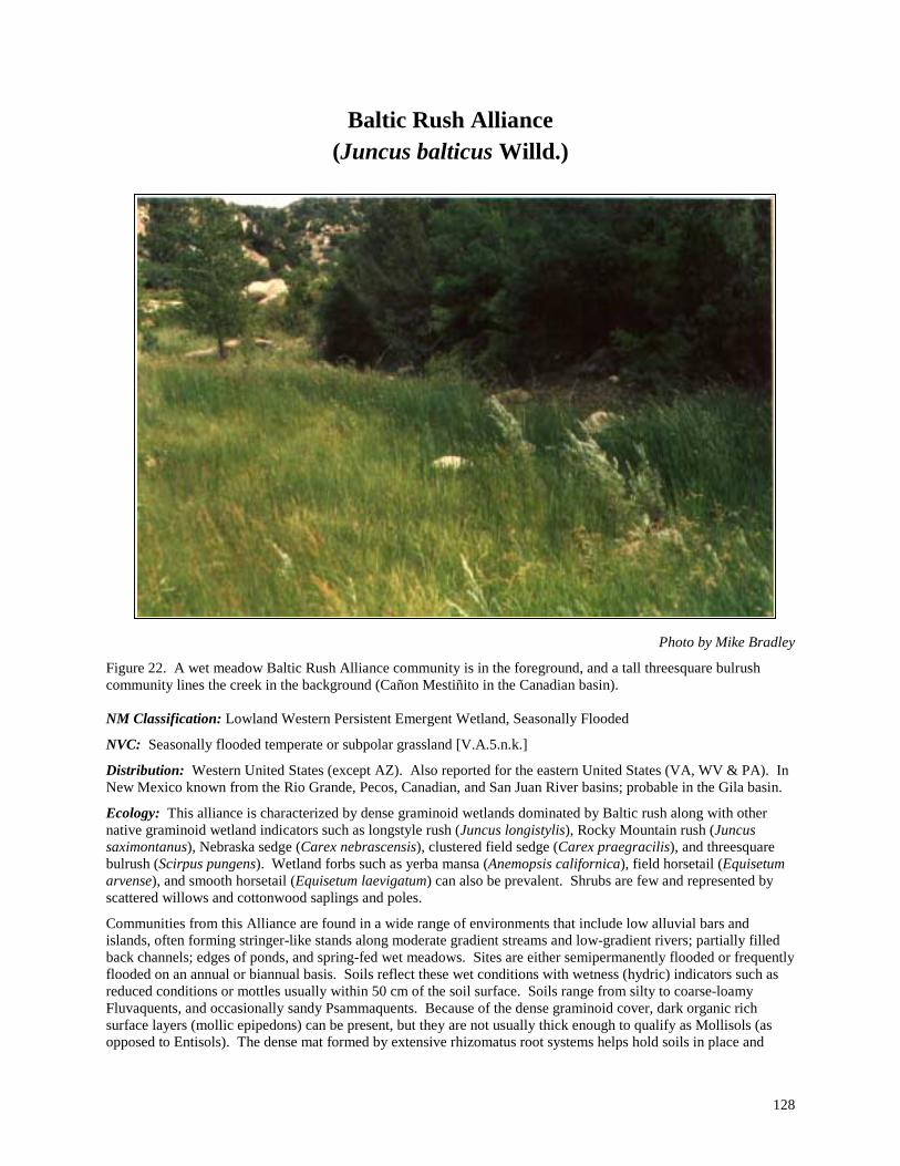
128
Baltic Rush Alliance (Juncus balticus Willd.)
Photo by Mike Bradley
Figure 22. A wet meadow Baltic Rush Alliance community is in the foreground, and a tall threesquare bulrush community lines the creek in the background (Cañon Mestiñito in the Canadian basin). NM Classification: Lowland Western Persistent Emergent Wetland, Seasonally Flooded
NVC: Seasonally flooded temperate or subpolar grassland [V.A.5.n.k.]
Distribution: Western United States (except AZ). Also reported for the eastern United States (VA, WV & PA). In New Mexico known from the Rio Grande, Pecos, Canadian, and San Juan River basins; probable in the Gila basin.
Ecology: This alliance is characterized by dense graminoid wetlands dominated by Baltic rush along with other native graminoid wetland indicators such as longstyle rush (Juncus longistylis), Rocky Mountain rush (Juncus saximontanus), Nebraska sedge (Carex nebrascensis), clustered field sedge (Carex praegracilis), and threesquare bulrush (Scirpus pungens). Wetland forbs such as yerba mansa (Anemopsis californica), field horsetail (Equisetum arvense), and smooth horsetail (Equisetum laevigatum) can also be prevalent. Shrubs are few and represented by scattered willows and cottonwood saplings and poles.
Communities from this Alliance are found in a wide range of environments that include low alluvial bars and islands, often forming stringer-like stands along moderate gradient streams and low-gradient rivers; partially filled back channels; edges of ponds, and spring-fed wet meadows. Sites are either semipermanently flooded or frequently flooded on an annual or biannual basis. Soils reflect these wet conditions with wetness (hydric) indicators such as reduced conditions or mottles usually within 50 cm of the soil surface. Soils range from silty to coarse-loamy Fluvaquents, and occasionally sandy Psammaquents. Because of the dense graminoid cover, dark organic rich surface layers (mollic epipedons) can be present, but they are not usually thick enough to qualify as Mollisols (as opposed to Entisols). The dense mat formed by extensive rhizomatus root systems helps hold soils in place and

129
decreases their erodibilty. Elevations range between 4,925 and 7,840 ft (1,500 and 2,390 m), and probably extend down to 4,500 ft (1,370 m) and up to 9,000 ft (2,740 m).
In some communities, grazing is thought to increase the abundance of Baltic rush and exotic sod-forming pasture grasses such as redtop or creeping bentgrass (Agrostis gigantea or A. stolonifera), or Kentucky bluegrass (Poa pratensis) at the expense of other native wetland species. Communities from this alliance have been reported extensively in the western United States: Mutel (1973), Rector (1979), Hess (1981), Baker (1984), Kittel (1993) and Kittel and Lederer (1993), Kittel et al. (1994) in Colorado; Padgett, Youngblood, and Winward (1989) in Colorado; Hansen, Chadde, and Pfister 1988, and Hansen et al. (1990) in Montana, and Padgett (1982) in Oregon. A Juncus balticus Association was designated by Brown, Lowe, and Pase (1979) as an example of a Rush Series within their Rocky Mountain and Subalpine Marshland.
In New Mexico, we have provisionally identified five community types
Key to the Baltic Rush (Juncus balticus) Community Types:
1. Yerba mansa (Anemopsis californica) a dominant herbaceous species ............... Baltic Rush-Yerba Mansa CT 1. Yerba mansa absent; or if present, a minor component within the vegetative community............................... (2) 2. Threesquare bulrush (Scirpus pungens) codominates the herbaceous community with Baltic rush....................... ................................................................................................................Baltic Rush-Threesquare Bulrush CT 2. Threesquare bulrush absent; or if present, a minor component within the vegetative community .................... (3) 3. Clustered field sedge (Carex praegracilis) and Baltic rush are dominant graminoids among a diverse
graminoid community; horsetails (Equisetum spp.) may be common ... Baltic Rush-Clustered Field Sedge CT 3. Clustered field sedge scarce............................................................................................................................... (4) 4. Baltic rush, common reed (Phragmites australis), witchgrass (Panicum capillare) and smooth horsetail
(Equisetum laevigatum) are well represented in a luxuriant herbaceous community ............................................. .......................................................................................................................Baltic Rush-Smooth Horsetail CT 4. Redtop (Agrostis gigantea) dominant or codominant.....................................................Baltic Rush-Redtop CT
Community Type Descriptions
Common Name Scientific Name
Baltic Rush-Clustered Field Sedge CT Juncus balticus-Carex praegracilis CT
Acronym JUNBAL-CARPRA Status: Provisional Rank: S3?/G4? Distribution Upper Rio Grande basin (Embudo Creek) in north central New Mexico.
PROVISIONAL DESCRIPTION. This type is a lush wet meadow type dominated by abundant Baltic rush and clustered field sedges in association with Nebraska sedge (Carex nebrascensis) and common spikerush (Eleocharis palustris). Shrubs and trees are usually absent or found at the margins. Preliminary data suggest that this type occurs along low-gradient side channels of lower montane streams at elevations around 6,000 ft (1,830 m). Soils have been reported as coarse-loamy Typic Fluvaquents.
Common Name Scientific Name
Baltic Rush-Redtop CT Juncus balticus-Agrostis gigantea CT
Acronym JUNBAL-AGRGIG Status: Provisional Rank: SM/GM Distribution Rio Grande, Pecos, Canadian, and San Juan watersheds in northern New Mexico.
PROVISIONAL DESCRIPTION. This lush herbaceous wetland type is codominated by abundant Baltic rush and the exotic grass redtop. Several native wetland graminoid indicators can also be common to abundant:

130
shortawn foxtail (Alopecurus aequalis), porcupine sedge (Carex hystericina), Nebraska sedge (Carex nebrascensis), clustered field sedge (Carex praegracilis), common spikerush (Eleocharis palustris), longstyle rush (Juncus longistylis), Rocky Mountain rush (Juncus saximontanus), and alkali muhly (Muhlenbergia asperifolia). With respect to forbs, 57 have been reported for the type, of which 39 are natives, and 10 are native wetland indicators. Willow and cottonwood reproduction is scattered. Known from low bars and channel edges of low- to moderate-gradient streams and rivers. Flood frequency varies from two to twenty-five years, at elevations ranging from 5,675 to 7,850 ft (1,730 to 2,390 m). Soils, because of the dense graminoid cover, often have rich organic surface layers (incipient mollic epipedons), but these layers are not thick enough to qualify the soils as Mollisols. Soils have been classified as young Typic or Mollic Fluvaquents with silty to coarse-loamy textures, and on occasion as very sandy Mollic Psammaquents. Evidence of significant livestock grazing is common in this type, and may be responsible in part for the abundance of exotic grass species. This CT was given a global rarity rank of GM because of its exotic elements, and, hence, is not tracked for biodiversity conservation purposes. REFERENCE SITE NAME. Rio Truchas
Common Name Scientific Name
Baltic Rush-Smooth Horsetail CT Juncus balticus-Equisetum laevigatum CT
Acronym JUNBAL-EQULAE Status: Provisional Rank: S4?/G4? Distribution Middle Rio Grande basin in northern New Mexico.
PROVISIONAL DESCRIPTION. This type is characterized by the codominance of well-represented Baltic rush and smooth horsetail. Common reed (Phragmites australis) can also be present. Shrubs and other herbaceous species are uncommon. Preliminary data suggest that the type is found on seasonally flooded low bars and river banks at elevations around 4,900 ft (1,490 m). Soils are reported as sandy over loamy Aeric Fluvaquents.
Common Name Scientific Name
Baltic Rush-Threesquare Bulrush CT Juncus balticus-Scirpus pungens CT
Acronym JUNBAL-SCIPUN Status: Provisional Rank: S4?/G5? Distribution San Juan basin (Animas River), and upper Pecos River watershed (Glorieta
Creek) in northern New Mexico. PROVISIONAL DESCRIPTION. This type is a dense herbaceous wetland strongly dominated by very abundant Baltic rush and threesquare bulrush. Scattered willow regeneration may be present. Other forbs and grasses are poorly represented. Preliminary data suggest that this types occurs on low bars and channel edges of moderate- gradient streams and partially infilled back-channels of larger rivers. Elevations range from 5,690 to 6,720 ft (1,730 to 2,050 m). Soils are reported as fine-loamy Typic Fluvaquents and riverwash.
Common Name Scientific Name
Baltic Rush-Yerba Mansa CT Juncus balticus-Anemopsis californica CT
Acronym JUNBAL-ANECAL Status: Provisional Rank: S3?/G3? Distribution Upper Pecos River watershed in northern New Mexico.
PROVISIONAL DESCRIPTION. This community type has a luxuriant herbaceous layer of yerba mansa and associated graminoids including Baltic rush and creeping muhly (Muhlenbergia repens). Herbaceous litter is abundant. Preliminary data suggest that this type occurs at elevations around 6,700 ft (2,040 m) on mid sidebars that are flooded every five to ten years.
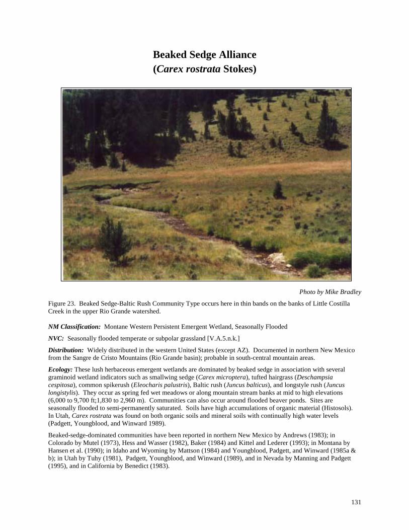
131
Beaked Sedge Alliance (Carex rostrata Stokes)
Photo by Mike Bradley
Figure 23. Beaked Sedge-Baltic Rush Community Type occurs here in thin bands on the banks of Little Costilla Creek in the upper Rio Grande watershed. NM Classification: Montane Western Persistent Emergent Wetland, Seasonally Flooded
NVC: Seasonally flooded temperate or subpolar grassland [V.A.5.n.k.]
Distribution: Widely distributed in the western United States (except AZ). Documented in northern New Mexico from the Sangre de Cristo Mountains (Rio Grande basin); probable in south-central mountain areas.
Ecology: These lush herbaceous emergent wetlands are dominated by beaked sedge in association with several graminoid wetland indicators such as smallwing sedge (Carex microptera), tufted hairgrass (Deschampsia cespitosa), common spikerush (Eleocharis palustris), Baltic rush (Juncus balticus), and longstyle rush (Juncus longistylis). They occur as spring fed wet meadows or along mountain stream banks at mid to high elevations (6,000 to 9,700 ft;1,830 to 2,960 m). Communities can also occur around flooded beaver ponds. Sites are seasonally flooded to semi-permanently saturated. Soils have high accumulations of organic material (Histosols). In Utah, Carex rostrata was found on both organic soils and mineral soils with continually high water levels (Padgett, Youngblood, and Winward 1989).
Beaked-sedge-dominated communities have been reported in northern New Mexico by Andrews (1983); in Colorado by Mutel (1973), Hess and Wasser (1982), Baker (1984) and Kittel and Lederer (1993); in Montana by Hansen et al. (1990); in Idaho and Wyoming by Mattson (1984) and Youngblood, Padgett, and Winward (1985a & b); in Utah by Tuhy (1981), Padgett, Youngblood, and Winward (1989), and in Nevada by Manning and Padgett (1995), and in California by Benedict (1983).

132
For New Mexico we have identified a single provisional Beaked Sedge-Baltic Rush (Carex rostrata-Juncus balticus) Community Type for the alliance.
Community Type Description:
Common Name Scientific Name
Beaked Sedge-Baltic Rush CT Carex rostrata-Juncus balticus CT
Acronym CARROS-JUNBAL Status: Provisional Rank: S4/G5 Distribution Rio Grande and Canadian River basins (Sangre de Cristo Mountains) in northern
New Mexico. PROVISIONAL DESCRIPTION. This community type is characterized by a dense graminoid canopy (80% cover) dominated by abundant beaked sedge. Other graminoids such as smallwing sedge (Carex microptera), tufted hairgrass (Deschampsia cespitosa), common spikerush (Eleocharis palustris), Baltic rush (Juncus balticus), and longstyle rush (Juncus longistylis) can be well represented to abundant. The shrubby cinquefoil (Pentaphylloides floribunda) can be scattered along the periphery. Preliminary data suggest that the type can be found at elevations ranging from 7,850 to 9,700 ft (2,390 to 2,960 m) along small, perennial streams or rivulets with low gradients. Sites are seasonally or semi-permanently flooded. Soils are rich organic Histosols that are saturated and poorly drained, restricting the growth of most woody species.

133
Broadleaf Cattail Alliance (Typha latifolia L.)
Photo by Mike Bradley
Figure 24. Broadleaf Cattail Alliance on a ponded segment of the Black River in the Pecos watershed.
NM Classification: Lowland Western Persistent Emergent Wetland, Semipermanently Flooded
NVC: V.A.5.n.l. Semipermanently Flooded Temperate or Subpolar grassland
Distribution: Widely distributed in the western, mid-western, and southern United States. Known from the Pecos and Rio Grande basins; probable in all watersheds of the state.
Ecology: The alliance occurs around springs; the margins of ponds, lakes, or reservoirs; backwater areas; and in small side channels and ditches of lowland river corridors. Some stands are dense, and monotypic (only cattails) with up to 100% canopy cover, while others can have moderate diversity with several other native wetland indicators (14 have been reported for the alliance in New Mexico).
The abundant, wind-dispersed cattail seed can quickly colonize bare, mineral soils. Cattails require a high water table that creates ponded conditions at depths of one to two feet with dark, poorly drained anaerobic soils. Soils are classified as Entisols (Fluvaquents with gleyed mineral surface horizons that overlie layers of saturated loams, sandy loams, or finer silts). Like bulrushes (Scirpus spp.), cattails grow in the lowest areas of the floodplain and are typically flanked by cottonwoods (Populus spp.) and willows (Salix spp.) which occur on slightly higher and drier sites. Cattails may also become established in low places where water collects in urban and agricultural landscapes.
For the Southwest, Brown, Lowe, and Pase (1979) identify a Typha latifolia Association and Series as part of their Plains Interior Marshlands Biome. Dick-Peddie suggested both a Cattail-Waterparsnip (Berula erecta) Series and a Cattail-Rush (Juncus)-Bulrush (Scirpus) Series. In the Rocky Mountain region cattail-dominated communities have

134
been reported by Baker (1984) in Colorado; by Hansen et al. (1990) in Montana; by Jones and Walford (1995) in Montana; and by Padgett, Youngblood, and Winward (1989) in Montana.
Community Type Description:
Common Name Scientific Name
Broadleaf Cattail-Threesquare Bulrush CT Typha latifolia-Scirpus pungens CT
Acronym TYPLAT-SCIPUN Status: Established Rank: S5/G5 Distribution Widespread in the Pecos and Rio Grande basins; probable throughout New Mexico.
Widespread elsewhere in the western and mid-western United States. VEGETATION. This emergent wetland type is dominated by tall (>1 m), open to dense stands of broadleaf cattail (Typha latifolia). Threesquare bulrush is well represented to abundant and occurs as either a band in shallower water or in scattered pockets. Other common wetland indicators include softstem bulrush (Scirpus tabernaemontani), toad rush (Juncus bufonius), poverty rush (Juncus tenuis), Torrey rush (Juncus torreyi), common spikerush (Eleocharis palustris), alkali muhly (Muhlenbergia asperifolia), knotgrass (Paspalum distichum), inland saltgrass (Distichlis spicata), rice cutgrass (Leersia oryzoides), and common reed (Phragmites australis). Plains cottonwood (Populus deltoides) reproduction, coyote willow (Salix exigua), and Emory falsewillow (Baccharis emoryi) can occur along the drier fringes of the community. ENVIRONMENT. Elevations for this type range from 3,650 to 6,720 ft (1,110 to 2,050 m). Stands are typically located around springs, pond or lake margins, backwater areas, and former channels. The high water table creates ponded conditions at depths of one to two feet. Soils are anaerobic, dark, and poorly drained. They generally have a gleyed mineral horizon beneath the surface and have thick organic accumulations at the surface which overlie layers of saturated loams, sandy loams, or finer silts. COMMENTS. Cattails produce abundant, wind-dispersed seeds that make them quick colonizers of bare soils. This early successional community depends on prolonged periods of flooding for maintenance, but can tolerate drier periods late in the season. As water recedes and the site dries out, the peripheral forbs and grasses are able to take hold and spread. Lowering the water table may also dry the sites, making them susceptible to invasion by saltcedar or other exotic plant communities. Reported previously by Baker 1984; Hansen et al. 1990 Padgett, Youngblood, and Winward 1989, and Jones and Walford (1995). NMNHP DATA PLOTS. 93PD042, 93PD059, 93PD060, 93PD061,94YC007, 94PD021, 97RW005 REFERENCE SITE NAME. Yeso Creek ELEVATION. ft. (m.) Ave.: 5,190 (1,580m) Min.: 3,660 (1,130m) Max.: 6,720 (2,050m) HYDROLOGY.
Rosgen Channel Types: B4c, C4, E6 Flow Regimes: P1, P2, P3, P7 Ave. Discharge Ratio: 0.9 Recurrence Interval (Yrs.): 2
SOILS. Soil Families Ponded
Fine-loamy/sandy-skeletal Aeric Fluvaquent Sandy-skeletal Typic Fluvaquent
Ave. Plant Avail. Water (%): 5 Ave. Soil Wetness Rank: 2

135
Common Spikerush Alliance (Eleocharis palustris (L.) Roemer & J.A. Schultes)
Photo by Mike Bradley
Figure 25. Common Spikerush Alliance on the upper San Francisco River of the Gila River watershed. NM Classification: Lowland Western Persistent Emergent Wetland, Seasonally Flooded
NVC: Seasonally flooded temperate or subpolar grassland [V.A.5.n.k.]
Distribution: Widely distributed in lowland areas of the Rocky Mountains and Intermountain West. Known in New Mexico from the Gila, Rio Grande, and Pecos basins.
Ecology: This emergent herbaceous wetland alliance is characterized by an abundant to luxuriant graminoid cover dominated by common spikerush with chufa flatsedge (Cyperus esculentus), Rocky Mountain rush (Juncus saximontanus), rice cutgrass (Leersia oryzoides), knotgrass (Paspalum distichum), threesquare bulrush (Scirpus pungens), and vine mesquite (Panicum obtusum) as important associates. Also important are the forbs yerba mansa
136
(Anemopsis californica), field horsetail (Equisetum arvense), smooth horsetail (Equisetum laevigatum), blueweed sunflower (Helianthus ciliaris), alkali mallow (Malvella leprosa), povertyweed (Iva axillaris), and common selfheal Prunella vulgaris). Of the 90 species recorded for the alliance so far, 30 are wetland indicators. Cottonwood reproduction is common in some community types, but generally trees and shrubs are either scattered or absent.
Communities occur on sites subject to seasonal flooding, and generally develop as low, narrow, stringers along streambanks, or along the shores of reservoirs, lakes, and playa lakes. Elevations range from 3,600 to 6,500 ft (1,100 to 1,980 m). Soils vary according to site conditions. Soils associated with playas are Vertisols (Typic Haplotorrerts comprised of heavy, poorly drained clays), while soils along streambanks are Entisols (Fluvaquents comprised of coarser, well-drained sands underlain by gravels and cobbles). Along streams and rivers, willow shrublands dominate nearby alluvial bars, and cottonwood forests (Populus spp.) dominate terraces. Along playas, bulrushes (Scirpus spp.) may form adjacent types.
Vegetation communities dominated by common spikerush have been reported in the western U.S. by Ramaley (1919), Ramaley (1942), Baker (1984), Baker and Kennedy (1985), Brotherson, J. D. (1987), Hansen, Chadd, and Pfister (1988), Hansen et al. (1988), Hansen et al. (1990), Kittel and Lederer (1993), Kovalchik (1987), Mutel (1973), Mutel and Marr (1973), Padgett, Youngblood, and Winward (1988 & 1989), and Youngblood, Padgett, and Winward (1985a).
The seven provisional community types for the alliance have been identified in New Mexico
Key to the Common Spikerush (Eleocharis palustris) Community Types: 1. Yerba mansa (Anemopsis californica) a dominant herbaceous species .................................................................. ............................................................................................................... Common Spikerush/Yerba Mansa CT 1. Yerba mansa absent; or if present, a minor component within the vegetative community............................... (2) 2. Smooth horsetail (Equisetum laevigatum) and common spikerush codominate..................................................... .........................................................................................................Common Spikerush/Smooth Horsetail CT 2. Smooth horsetail scarce or absent...................................................................................................................... (3) 3. Rice cutgrass (Leersia oryzoides) codominates with common spikerush............................................................... .............................................................................................................. Common Spikerush-Rice Cutgrass CT 3 Rice cutgrass scarce or absent ........................................................................................................................... (4) 4. Knotgrass (Paspalum distichum) codominates with common spikerush.....Common Spikerush-Knotgrass CT 4. Knotgrass scarce or absent................................................................................................................................. (5) 5. Povertyweed (Iva axillaris) a dominant forb ................ Common Spikerush-Vine Mesquite-Povertyweed CT 5. Poverty weed absent, or if present, minor; Alkali mallow (Malvella leprosa) well represented ............................ ..............................................................................................................Common Spikerush-Alkali Mallow CT

137
Community Type Descriptions:
Common Name Scientific Name
Common Spikerush-Alkali Mallow CT Eleocharis palustris-Malvella leprosa CT
Acronym ELEPAL-MALLEP Status: Provisional Rank: S2?/G3? Distribution Playas within the lower Pecos River basin in southeastern New Mexico.
PROVISIONAL DESCRIPTION. In this playa community type common spikerush is dominant, and abundant to luxurious in cover. The forbs alkali mallow and blueweed sunflower (Helianthus ciliaris) are well represented and diagnostic. Preliminary data indicate this type lies within the wetter portions of playa bottoms with elevations around 3,600 ft (1,100 m). Sites are probably wet during the late summer growing season in most years. Soils are reported as Typic Haplotorrerts with shrink shrink-swell clays. Alkali sacaton (Sporobolus airoides) and mesquite (Prosopis glandulosa) may dominate the adjacent drier bottomland.
Common Name Scientific Name
Common Spikerush-Knotgrass CT Eleocharis palustris-Paspalum distichum CT
Acronym ELEPAL-PASDIS Status: Provisional Rank: S2?/G3? Distribution Gila River basin in southwestern New Mexico.
PROVISIONAL DESCRIPTION. This type is characterized by a very abundant to luxurious cover of knotgrass in association with well-represented to abundant common spikerush. Fremont cottonwood (Populus fremontii) and Goodding willow (Salix gooddingii) reproduction can be present along with scattered seepwillow (Baccharis salicifolia) and coyote willow (Salix exigua). Other wetland indicators that can be present are chufa flatsedge (Cyperus esculentus), rice cutgrass (Leersia oryzoides), softstem bulrush (Scirpus tabernaemontani), field horsetail (Equisetum arvense), and American speedwell (Veronica americana). Preliminary data suggest that this type occurs at around 3,880 ft (1,180 m) on some of the lowest bars in the floodplain. Sites are frequently flooded (at least every two years) and soils are usually fully saturated during the growing season. Adjacent wetland communities may be dominated by either Goodding or coyote willows, or, on higher sites, by netleaf hackberry (Celtis laevigata).
Common Name Scientific Name
Common Spikerush-Rice Cutgrass CT Eleocharis palustris-Leersia oryzoides CT
Acronym ELEPAL-LEEORY Status: Provisional Rank: S2?/G3? Distribution Middle Rio Grande basin in north-central New Mexico.
PROVISIONAL DESCRIPTION. This graminoid-dominated community is codominated by very abundant common spikerush and rice cutgrass. Several other native herbaceous wetland indicators have been reported for the type and include American sloughgrass (Beckmannia syzigachne), water sedge (Carex aquatilis), Baltic rush (Juncus balticus), Rocky Mountain rush (Juncus saximontanus), threesquare bulrush (Scirpus pungens), softstem bulrush (Scirpus tabernaemontani), silverweed cinquefoil (Argentina anserina), hairy willowherb (Epilobium ciliatum), smooth horsetail (Equisetum laevigatum), alkali buttercup (Ranunculus cymbalaria), arumleaf arrowhead (Sagittaria cuneata), and broadleaf cattail (Typha latifolia). The exotic creeping bentgrass (Agrostis stolonifera) can also be abundant. Plains cottonwood (Populus deltoides) and Goodding willow (Salix gooddingii) reproduction can be present along with scattered coyote willow (Salix exigua). Preliminary data indicate that this community type can be found around 5,520 ft (1680 m) in elevation on lower portions of island or sidebars that are frequently flooded (at least every three years). Soils are reported as sandy-skeletal Aeric Fluvaquents.

138
Common Name Scientific Name
Common Spikerush-Smooth Horsetail CT Eleocharis palustris-Equisetum laevigatum CT
Acronym ELEPAL-EQULAE Status: Provisional Rank: S4?/G5? Distribution Upper Rio Grande basin in northern New Mexico.
PROVISIONAL DESCRIPTION. Abundant to very abundant common spikerush and smooth horsetail codominate this emergent herbaceous wetland. Several other herbaceous wetland indicators have been reported from the type and include lamp rush (Juncus effusus var. solutus), poverty rush (Juncus tenuis), alkali muhly (Muhlenbergia asperifolia), threesquare bulrush (Scirpus pungens), hairy willowherb (Epilobium ciliatum), field horsetail (Equisetum arvense), and Nuttall sunflower (Helianthus nuttallii). Preliminary data suggest this type occurs at around 6,500 ft (1,980 m) along river channels or in spring-fed, marshy meadows. Soils are either ponded, or frequently flooded, weakly developed Aeric Fluvaquents that have sandy and rocky textures.
Common Name Scientific Name
Common Spikerush-Vine Mesquite-Povertyweed CT Eleocharis palustris-Panicum obtusum-Iva axillaris CT
Acronym ELEPAL-PANOBT-IVAAXI Status: Provisional Rank: S2?/G3? Distribution Pecos River basin in southeastern New Mexico.
PROVISIONAL DESCRIPTION. This playa wetland is codominated by well represented common spikerush and vine mesquite grass, plus povertyweed, an abundant perennial forb. Alkali mallow (Malvella leprosa) may be present but clearly not codominant. Shrubs and trees are absent. Initial data suggest that this community type can form the inner zone of vegetation around standing water in a playa. Elevation is reported at around 4,000 ft (1,220 m). Soils are reported as Typic Haplotorrerts with shrink-swell clays.
Common Name Scientific Name
Common Spikerush-Yerba Mansa CT Eleocharis palustris-Anemopsis californica CT
Acronym ELEPAL-ANECAL Status: Provisional Rank: S2?/G3? Distribution Gila River basin in southwestern New Mexico.
PROVISIONAL DESCRIPTION. Yerba mansa and common spikerush codominate this luxuriant herbaceous community. The forbs field horsetail (Equisetum arvense) and common selfheal (Prunella vulgaris) can also be well represented he exotic meadow grass creeping bentgrass (Agrostis stolonifera) may be abundant. Young narrowleaf cottonwoods (Populus angustifolia) may also be present along with scattered New Mexico olive (Forestiera pubescens ssp. pubescens) shrubs. Preliminary data suggest that this type occurs at around 6,500 ft (1,980 m) on stream bars that are frequently flooded. Soils are saturated within 25 cm (10 in) of the surface and reported as Typic Fluvaquents with loamy-skeletal textures.
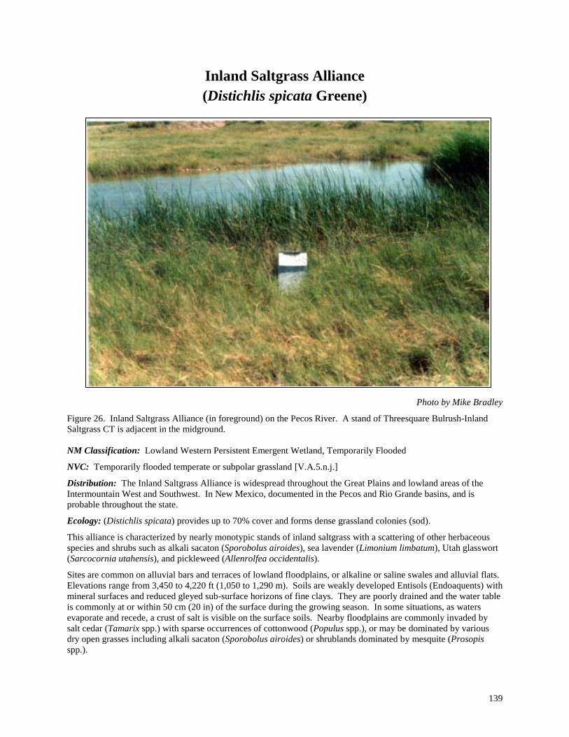
139
Inland Saltgrass Alliance (Distichlis spicata Greene)
Photo by Mike Bradley
Figure 26. Inland Saltgrass Alliance (in foreground) on the Pecos River. A stand of Threesquare Bulrush-Inland Saltgrass CT is adjacent in the midground. NM Classification: Lowland Western Persistent Emergent Wetland, Temporarily Flooded
NVC: Temporarily flooded temperate or subpolar grassland [V.A.5.n.j.]
Distribution: The Inland Saltgrass Alliance is widespread throughout the Great Plains and lowland areas of the Intermountain West and Southwest. In New Mexico, documented in the Pecos and Rio Grande basins, and is probable throughout the state.
Ecology: (Distichlis spicata) provides up to 70% cover and forms dense grassland colonies (sod).
This alliance is characterized by nearly monotypic stands of inland saltgrass with a scattering of other herbaceous species and shrubs such as alkali sacaton (Sporobolus airoides), sea lavender (Limonium limbatum), Utah glasswort (Sarcocornia utahensis), and pickleweed (Allenrolfea occidentalis).
Sites are common on alluvial bars and terraces of lowland floodplains, or alkaline or saline swales and alluvial flats. Elevations range from 3,450 to 4,220 ft (1,050 to 1,290 m). Soils are weakly developed Entisols (Endoaquents) with mineral surfaces and reduced gleyed sub-surface horizons of fine clays. They are poorly drained and the water table is commonly at or within 50 cm (20 in) of the surface during the growing season. In some situations, as waters evaporate and recede, a crust of salt is visible on the surface soils. Nearby floodplains are commonly invaded by salt cedar (Tamarix spp.) with sparse occurrences of cottonwood (Populus spp.), or may be dominated by various dry open grasses including alkali sacaton (Sporobolus airoides) or shrublands dominated by mesquite (Prosopis spp.).

140
It is well documented in Colorado by Baker (1984), Kittel et al. (1994), and Kittel and Lederer (1993); in Montana by Hansen et al. (1990); in Wyoming by Jones and Walford (1995), and for the Southwest by Brown, Lowe, and Pase (1979).
The Inland Saltgrass Alliance is provisional and additional information is needed on the composition and ecology of the types in the West. The two community types that follow are minor and require more data to fully develop a description.
Key to the Inland Saltgrass (Distichlis spicata) Community Types:
1. Catchfly Prairie Gentian (Eustoma exaltatum) common .......... Inland Saltgrass-Catchfly Prairie Gentian CT 1. Catchfly Prairie Gentian scarce or absent.......................................................................................................... (2) 2. Utah glasswort (Sarcocornia utahensis) a dominant herbaceous species ............................................................... ..................................................................................................................Inland Saltgrass-Utah Glasswort CT 2. Utah glasswort absent; or if present, a minor component within the vegetative community............................. (3) 3. Alkali Sacaton (Sporobolus airoides) well represented to abundant ..........Inland Saltgrass-Alkali Sacaton CT 3. Alkali Sacaton poorly represented ..................................................................... Inland Saltgrass/Monotype CT
Community Type Descriptions:
Common Name Scientific Name
Inland Saltgrass-Alkali Sacaton CT Distichlis spicata-Sporobolus airoides CT
Acronym DISSPI-SPOAIR Status: Provisional Rank: S3?/G4? Distribution Tularosa basin, south-central New Mexico (Otero Co.)
PROVISIONAL DESCRIPTION. Inland saltgrass and alkali sacaton codominate these grasslands of lowland alluvial flats that are seasonally flooded. Scattered pickleweed (Allenrolfea occidentalis) and Trans-Pecos sea lavender (Limonium limbatum) may be present, but shrubs are generally conspicuous. Initial data suggest that this type occurs at the bottom of closed basins at elevations of around 4,220 ft (1,285 m).
Common Name Scientific Name
Inland Saltgrass-Catchfly Prairie Gentian CT Distichlis spicata-Eustoma exaltatum CT
Acronym DISSPI-EUSEXA Status: Provisional Rank: S2?/G3? Distribution Tularosa basin, south-central New Mexico (Otero Co.)
PROVISIONAL DESCRIPTION. Inland saltgrass is abundant to luxuriant, forming nearly monotypic stands with a scattering of other grasses and forbs. Catchfly prairie gentian and limewater brookweed (Samolus ebracteatus ssp. cuneatus) are diagnostic wetland indicators reflecting the relatively mesic conditions of these annually flooded grasslands. Preliminary data suggest that this type occurs in closed basin bottoms at elevations of around 4,160 ft (1,270 m).

141
Common Name Scientific Name
Inland Saltgrass Monotype Distichlis spicata/Monotype
Acronym DISSPI/MONTYP Status: Provisional Rank: S5/G5 Distribution Tularosa basin and Pecos River basin in southern New Mexico.
PROVISIONAL DESCRIPTION. Inland saltgrass is luxuriant and dominates this grassland to the near exclusion of other species. Preliminary data suggest that this type occurs in closed basin bottoms and on river bars and terraces. Elevations range from 3,400 to 4,200 ft (1,040 to 1,280 m). Soils are reported as weakly developed Typic Endoaquents with fine clay textures.
Common Name Scientific Name
Inland Saltgrass-Utah Glasswort CT Distichlis spicata-Sarcocornia utahensis CT
Acronym DISSPI-SARUTA Status: Provisional Rank: S4?/G5? Distribution Tularosa and lower Pecos River basin in southeastern New Mexico.
PROVISIONAL DESCRIPTION. In this community type Utah glasswort is very abundant and codominates with inland saltgrass. Trans-Pecos sea lavender (Limonium limbatum) along with spreading alkaliweed (Cressa truxillensis) may also be common. Initial data indicate that this type occurs in lowland closed-basin swales and elevated terraces along lowland rivers. Elevations range from 3,440 to 4,060 ft (1,050 to 1,240 m). Soils are reported as weakly developed Typic Endoaquents with fine clay textures.

142
Mud Sedge Alliance (Carex limosa L.)
Photo by Mike Bradley
Figure 27. Mud Sedge-Fewflower Spikerush Community Type at Vermejo Park in the Canadian watershed. NM Classification: Alpine-Subalpine Rocky Mountain Persistent Emergent Wetland, Semipermanently Flooded
NVC: V.A.5.n.l. Semipermanently Flooded Temperate or Subpolar grassland
Distribution: Northern Rocky Mountains (ID, MT, UT & WY), and California. In New Mexico, documented from the Sangre de Cristo Mountains near the Colorado border.
Ecology: This high-elevation emergent wetland is strongly dominated by mud sedge with a scattering of other wetland graminoids such as water sedge (Carex aquatilis), beaked sedge (Carex rostrata), Rocky Mountain sedge (Carex saximontana) and fewflower spikerush(Eleocharis quinqueflora). The alliance occurs in the upper montane to subalpine zone on floating mats of peat. The flooded organic soils (Histosols) are mucky and saturated to the

143
surface. Adjacent drier areas are dominated by water sedge (Carex aquatilis) and willow (Salix planifolia) communities while uplands are dominated by Engelmann spruce (Picea engelmannii) and subalpine fir (Abies lasiocarpa) forests.
One provisional community type has been identified for New Mexico.
Community Type Description:
Common Name Scientific Name
Mud Sedge-Fewflower Spikerush CT Carex limosa-Eleocharis quinqueflora CT
Acronym CARLIM-ELEQUI Status: Provisional Rank: S3?/G4? Distribution Canadian River basin in northeastern New Mexico.
PROVISIONAL DESCRIPTION. Mud sedge (Carex limosa) codominates this lush emergent herbaceous wetland with fewflower spikerush (Eleocharis quinqueflora). Other sedges such as water sedge (Carex aquatilis), beaked sedge (Carex rostrata), and Rocky Mountain sedge (Carex saximontana) may be present, but clearly not codominant. Also present are elephanthead lousewort (Pedicularis groenlandica) and tall cottongrass (Eriophorum angustifolium). The type is considered stable due to its unique site conditions coupled with the rhizomatus and robust qualities of the sedge. It occurs on floating mats of peat with flooded organic soils (Histosols) (see Padgett, Youngblood, and Winward 1989). REFERENCE SITE NAME. Glacier Lakes

144
Northern Mannagrass Alliance (Glyceria borealis (Nash) Batchelder)
Photo by Mike Bradley
Figure 28. Northern Mannagrass-Beautiful Spikerush Community Type in the Chuska Mountains. NM Classification: Montane Western Persistent Emergent Wetland, Semipermanently Flooded
NVC: V.A.5.n.l. Semipermanently Flooded Temperate or Subpolar grassland
Distribution: Northern Rocky Mountains and the Southwest. In New Mexico, known only from the Chuska Mountains.
Ecology: Northern mannagrass, a native, perennial, hydrophytic grass of cold temperate climates (Brown, Lowe, and Pase 1979) dominates this wetland community with slenderbeak sedge (Carex athrostachya) and beautiful spikerush (Eleocharis bella) as common associates. In New Mexico, these wetlands border high-elevation, shallow, catchment lakes above 8,500 ft (2,590 m) and depend on an annual snowpack for development and maintenance.
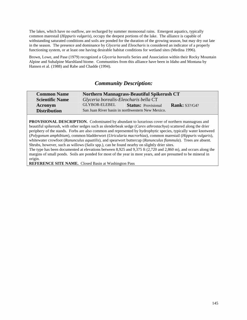
145
The lakes, which have no outflow, are recharged by summer monsoonal rains. Emergent aquatics, typically common marestail (Hippuris vulgaris), occupy the deepest portions of the lake. The alliance is capable of withstanding saturated conditions and soils are ponded for the duration of the growing season, but may dry out late in the season. The presence and dominance by Glyceria and Eleocharis is considered an indicator of a properly functioning system, or at least one having desirable habitat conditions for wetland sites (Medina 1996).
Brown, Lowe, and Pase (1979) recognized a Glyceria borealis Series and Association within their Rocky Mountain Alpine and Subalpine Marshland biome. Communities from this alliance have been in Idaho and Montana by Hansen et al. (1988) and Rabe and Chadde (1994).
Community Description:
Common Name Scientific Name
Northern Mannagrass-Beautiful Spikerush CT Glyceria borealis-Eleocharis bella CT
Acronym GLYBOR-ELEBEL Status: Provisional Rank: S3?/G4? Distribution San Juan River basin in northwestern New Mexico.
PROVISIONAL DESCRIPTION. Codominated by abundant to luxurious cover of northern mannagrass and beautiful spikerush, with other sedges such as slenderbeak sedge (Carex athrostachya) scattered along the drier periphery of the stands. Forbs are also common and represented by hydrophytic species, typically water knotweed (Polygonum amphibium), common bladderwort (Utricularia macrorhiza), common marestail (Hippuris vulgaris), whitewater crowfoot (Ranunculus aquatilis), and spearwort buttercup (Ranunculus flammula). Trees are absent. Shrubs, however, such as willows (Salix spp.), can be found nearby on slightly drier sites. The type has been documented at elevations between 8,925 and 9,375 ft (2,720 and 2,860 m), and occurs along the margins of small ponds. Soils are ponded for most of the year in most years, and are presumed to be mineral in origin. REFERENCE SITE NAME. Closed Basin at Washington Pass

146
Reed Canarygrass Alliance (Phalaris arundinacea L.)
Photo by Mike Bradley
Figure 29. Reed Canarygrass Alliance in a marsh along the Rio San Jose in the Rio Grande watershed. NM Classification: Lowland Western Persistent Emergent Wetland, Seasonally Flooded
NVC: Seasonally flooded temperate or subpolar grassland [V.A.5.n.k.]
Distribution: Widespread in lowland areas of the Rocky Mountains. In New Mexico, found in the Pecos, Rio Grande, and San Juan River basins. Also known from the northeastern to mid-western United States.
Ecology: The alliance is dominated by reed canarygrass, a tall and stout native grass, that forms moderate to dense stands in low marshes or sloughs bordering secondary channels of wide floodplains. Stands can be nearly monotypic, or have a wide variety of wetland graminoids and forbs (of the 46 species reported for the alliance in New Mexico, 26 are wetland indictors). The most prominent are fowl mannagrass (Glyceria striata), water speedwell (Veronica anagallis-aquatica), and porcupine sedge (Carex hystericina). Total canopy covers can exceed 90%. The alliance is found in both wide, lowland valleys and narrower foothill floodplains at elevations ranging from 5,500 to 7,500 ft (1,680 to 2,290 m). Soils are saturated, dark, anaerobic, and mucky (Entisols, which are classified as Mollic Fluvaquents that are comprised of fine loams) which experience long periods of prolonged ponded conditions. Although the surface water usually recedes later in the growing season, the water table remains near the surface. The alliance is one of many marsh grasses that provide valuable cover and food for wildlife. Although a native, reed cannarygrass is also a common constituent of hay mixtures that escapes into wetlands.
Communities from the alliance are well documented in Colorado by Baker (1984) and Kittel (1993); in Idaho by Padgett, Youngblood, and Winward (1989); and Rabe and Chadde (1994); in Montana by Hansen et al. (1990); and in Wyoming by Jones and Walford (1995).
Two provisional community types have been identified in New Mexico for the alliance.

147
Key to the Reed Canarygrass (Phalaris arundinacea) Community Types: 1. Fowl mannagrass (Glyceria striata) well represented ..................... Reed Canarygrass-Fowl Mannagrass CT 1. Fowl mannagrass absent; or if present, a minor component within the vegetative community.............................. .............................................................................................................................. Reed Canarygrass Monotype
Community Type Descriptions:
Common Name Scientific Name
Reed Canarygrass-Fowl Mannagrass CT Phalaris arundinacea-Glyceria striata CT
Acronym PHAARU-GLYSTR Status: Provisional Rank: S3?/G4? Distribution Upper Pecos (Gallinas River) basin in northeastern New Mexico.
PROVISIONAL DESCRIPTION. Reed canarygrass and fowl mannagrass codominate this luxuriant herbaceous wetland that supports a diversity of native wetland graminoids and forbs including porcupine sedge (Carex hystericina), owlfruit sedge (Carex stipata), Rocky Mountain rush (Juncus saximontanus), panicled bulrush (Scirpus microcarpus), softstem bulrush (Scirpus tabernaemontani), western water hemlock (Cicuta douglasii), Hornemann willowherb (Epilobium hornemannii), field horsetail (Equisetum arvense), cow parsnip (Heracleum maximum), wild mint (Mentha arvensis), northern green orchid (Platanthera hyperborea var. hyperborea), common selfheal (Prunella vulgaris), cutleaf coneflower (Rudbeckia laciniata), broadleaf cattail (Typha latifolia), and water speedwell (Veronica anagallis-aquatica). Occasional willows (Salix exigua, S. lutea, and S. monticola) and thinleaf alder (Alnus incana ssp. tenuifolia) may be present. Preliminary data suggest that this type occurs at around 7,480 ft (2,280 m) on low streamside bars. Sites are seasonally flooded and soils are likely to be saturated within 50 cm (20 in) of the surface. The high grass cover can lead to significant accumulations of organic matter in the surface horizons of the soils (incipient mollic epipedons). Hence, soils have been reported as loamy Mollic Fluvaquents. Uplands support blue spruce (Picea pungens) and ponderosa pine (Pinus ponderosa). Beaver activity through dams may be a major maintenance feature of this type.
Common Name Scientific Name
Reed Canarygrass Monotype Phalaris arundinacea Monotype
Acronym PHAARU/MONTYP Status: Provisional Rank: S4?/G4? Distribution San Juan River basin (Animas River) in northwestern New Mexico, and the Rio
San Jose of the Rio Grande basin. Likely to occurs elsewhere throughout the state.
PROVISIONAL DESCRIPTION. This herbaceous wetland is strongly dominated by dense stands of canarygrass to the near exclusion of other species. Initial data indicate the type occurs along ponded back channels of lowland rivers at around 5,500 ft (1,675 m) Beaver or muskrat activity may be responsible for perennially flooded/saturated conditions.

148
Softstem Bulrush Alliance (Scirpus tabernaemontani K.C. Gmel.)
Photo by Mike Bradley
Figure 30. Softstem Bulrush-Broadleaf Cattail Community Type bordering the channel of Oak Creek in the Canadian watershed. NM Classification: Lowland Western Persistent Emergent Wetland, Semipermanently Flooded
NVC: V.A.5.n.l. Semipermanently Flooded Temperate or Subpolar grassland
Distribution: Widely distributed in the Rocky Mountains and Southwest. Widespread in New Mexico and can be found in the Canadian, Gila, and Rio Grande basins.
Ecology: These emergent herbaceous wetlands are characterized by the high cover and dominance of softstem rush, a widespread wetland species in North America. Stands can also have a wide variety of other wetland graminoids and forbs such as sedge (Carex hystericina), beaked sedge (Carex rostrata), Rocky Mountain rush (Juncus
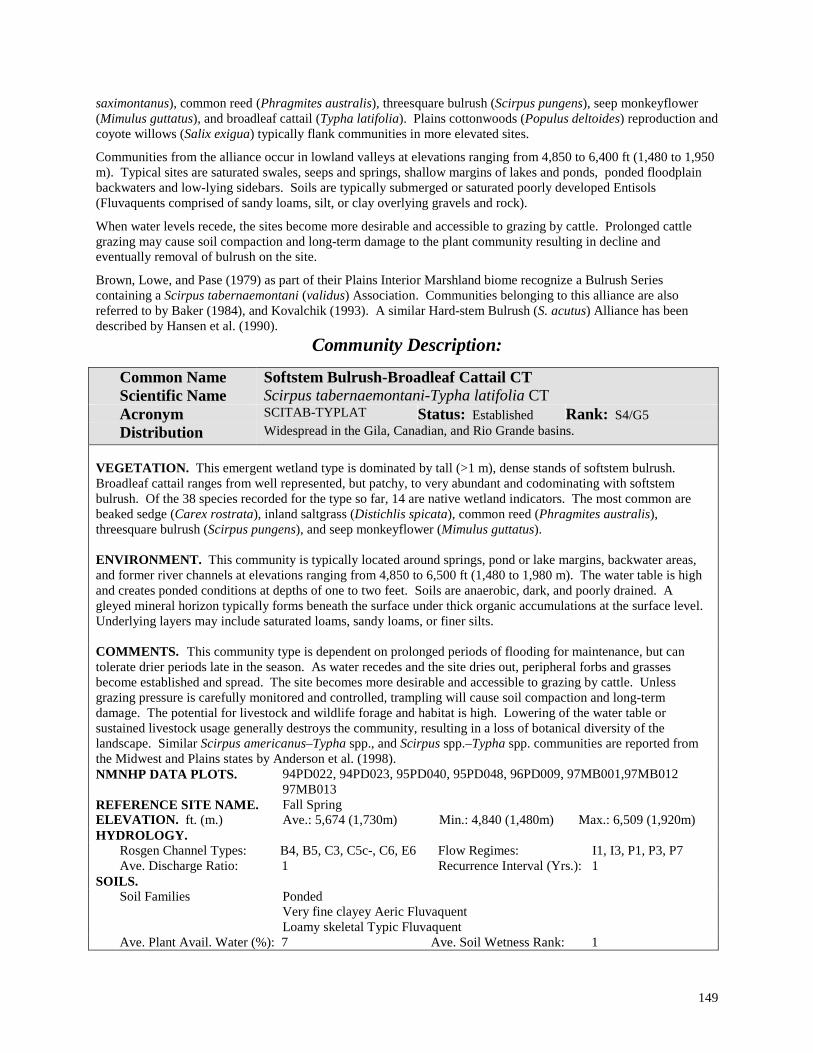
149
saximontanus), common reed (Phragmites australis), threesquare bulrush (Scirpus pungens), seep monkeyflower (Mimulus guttatus), and broadleaf cattail (Typha latifolia). Plains cottonwoods (Populus deltoides) reproduction and coyote willows (Salix exigua) typically flank communities in more elevated sites.
Communities from the alliance occur in lowland valleys at elevations ranging from 4,850 to 6,400 ft (1,480 to 1,950 m). Typical sites are saturated swales, seeps and springs, shallow margins of lakes and ponds, ponded floodplain backwaters and low-lying sidebars. Soils are typically submerged or saturated poorly developed Entisols (Fluvaquents comprised of sandy loams, silt, or clay overlying gravels and rock).
When water levels recede, the sites become more desirable and accessible to grazing by cattle. Prolonged cattle grazing may cause soil compaction and long-term damage to the plant community resulting in decline and eventually removal of bulrush on the site.
Brown, Lowe, and Pase (1979) as part of their Plains Interior Marshland biome recognize a Bulrush Series containing a Scirpus tabernaemontani (validus) Association. Communities belonging to this alliance are also referred to by Baker (1984), and Kovalchik (1993). A similar Hard-stem Bulrush (S. acutus) Alliance has been described by Hansen et al. (1990).
Community Description:
Common Name Scientific Name
Softstem Bulrush-Broadleaf Cattail CT Scirpus tabernaemontani-Typha latifolia CT
Acronym SCITAB-TYPLAT Status: Established Rank: S4/G5 Distribution Widespread in the Gila, Canadian, and Rio Grande basins.
VEGETATION. This emergent wetland type is dominated by tall (>1 m), dense stands of softstem bulrush. Broadleaf cattail ranges from well represented, but patchy, to very abundant and codominating with softstem bulrush. Of the 38 species recorded for the type so far, 14 are native wetland indicators. The most common are beaked sedge (Carex rostrata), inland saltgrass (Distichlis spicata), common reed (Phragmites australis), threesquare bulrush (Scirpus pungens), and seep monkeyflower (Mimulus guttatus). ENVIRONMENT. This community is typically located around springs, pond or lake margins, backwater areas, and former river channels at elevations ranging from 4,850 to 6,500 ft (1,480 to 1,980 m). The water table is high and creates ponded conditions at depths of one to two feet. Soils are anaerobic, dark, and poorly drained. A gleyed mineral horizon typically forms beneath the surface under thick organic accumulations at the surface level. Underlying layers may include saturated loams, sandy loams, or finer silts. COMMENTS. This community type is dependent on prolonged periods of flooding for maintenance, but can tolerate drier periods late in the season. As water recedes and the site dries out, peripheral forbs and grasses become established and spread. The site becomes more desirable and accessible to grazing by cattle. Unless grazing pressure is carefully monitored and controlled, trampling will cause soil compaction and long-term damage. The potential for livestock and wildlife forage and habitat is high. Lowering of the water table or sustained livestock usage generally destroys the community, resulting in a loss of botanical diversity of the landscape. Similar Scirpus americanus–Typha spp., and Scirpus spp.–Typha spp. communities are reported from the Midwest and Plains states by Anderson et al. (1998). NMNHP DATA PLOTS. 94PD022, 94PD023, 95PD040, 95PD048, 96PD009, 97MB001,97MB012
97MB013 REFERENCE SITE NAME. Fall Spring ELEVATION. ft. (m.) Ave.: 5,674 (1,730m) Min.: 4,840 (1,480m) Max.: 6,509 (1,920m) HYDROLOGY.
Rosgen Channel Types: B4, B5, C3, C5c-, C6, E6 Flow Regimes: I1, I3, P1, P3, P7 Ave. Discharge Ratio: 1 Recurrence Interval (Yrs.): 1
SOILS. Soil Families Ponded
Very fine clayey Aeric Fluvaquent Loamy skeletal Typic Fluvaquent
Ave. Plant Avail. Water (%): 7 Ave. Soil Wetness Rank: 1

150
Spreading Yellowcress Alliance (Rorippa sinuata (Nutt.) A. S. Hitchc.)
Photo by Sarah Wood
Figure 32. The Spreading Yellowcress Alliance occurs in playas and depresions within the short-grass prairie of northeastern New Mexico. NM Classification: Lowland Western Persistent Emergent Wetland, Seasonally Flooded
NVC: V.A.5.n.k. Seasonally flooded temperate or subpolar grassland
Distribution: Short-grass prairie grasslands and playa lake region of northeastern New Mexico; possible in other playa lake regions in southeastern Colorado, southwestern Kansas, west Texas, and western Oklahoma. Ecology: This playa wetland is characterized by abundant yellowcress in association with various wetland graminoids in moderate stands that usually do not exceed 30% total cover. Yellowcress is most prevalent toward the center of the playas and, once established, can spread vegetatively through rhizomes. Grasses are more abundant near the drier edges of the playa. Stands are found in isolated playas of the rolling, gently sloping plains topography at elevations that range between 5,000 and 7,000 ft (1,525 and 2,130 m). Communities occur on most soils near the center of playas that are periodically inundated with shallow water. Soils are underlain by thick, impermeable layers of Randall clays that are typical of playa basin floors, and that create the conditions for ponding during the rainy season. The alliance has not been described elsewhere and the two community types described here are considered provisional.

151
Key to the Spreading Yellowcress (Rorippa sinuata) Community Types: 1. Common Spikerush (Eleocharis palustris) present; western wheatgrass (Pascopyrum smithii) is absent or
under 1% cover .......................................................................Spreading Yellowcress-Common Spikerush CT 1. Common Spikerush absent or at low cover; western wheatgrass is strongly represented, sometimes with higher
cover than spreading yellowcress ......................................... Spreading Yellowcress-Western Wheatgrass CT
Community Type Descriptions
Common Name Scientific Name
Spreading Yellowcress-Western Wheatgrass CT Rorippa sinuata-Pascopyrum smithii CT
Acronym RORSIN-PASSMI Status: Provisional Rank: S3?/G3? Distribution Playas in northeastern New Mexico.
PROVISIONAL DESCRIPTION. Spreading yellowcress and western wheatgrass are codominants at covers between 3 and 10%. Relative covers may depend on habitat: in non-manipulated playas, spreading yellowcress has higher cover than wheatgrass; in manipulated playas (where a stock tank has been excavated), yellowcress has a lower cover compared to wheatgrass. Other species present include buffalo grass (Buchloe dactyloides) and pricklyleaf dogweed (Thymophylla acerosa), but overall diversity is relatively low. This type occurs near the center of playas on heavy Randall clays at elevations between 5,800 and 6, 200 ft (1,770 and 1,890 m).
Common Name Scientific Name
Spreading Yellowcress-Common Spikerush CT Rorippa sinuata-Eleocharis palustris CT
Acronym RORSIN-ELEPAL Status: Provisional Rank: S3?/G3? Distribution Playas in northeastern New Mexico.
PROVISIONAL DESCRIPTION. Spreading yellowcress and common spikerush usually codominate; western wheatgrass (Pascopyrum smithii) may be present, but clearly subordinate. Diversity is very low. This community occurs near the center of playas on heavy Randall clays, and is probably frequently inundated. It occurs more often on playas that have not been excavated for a stock tank and are, therefore, periodically inundated with shallow water from precipitation or run-off.

152
Threesquare Bulrush Alliance (Scirpus pungens Vahl.)
Photo by Esteban Muldavin
Figure 32. A Threesquare Bulrush Alliance community bordering the streambank along a portion of the upper Rio Grande. NM Classification: Lowland Western Persistent Emergent Wetland, Semipermanently Flooded
NVC: V.A.5.n.l. Semipermanently Flooded Temperate or Subpolar grassland
Distribution: Widespread in the Rocky Mountains and Southwest. In New Mexico it occurs in every major basin of the state including watersheds of the Gila, Pecos, San Juan, Canadian and Rio Grande.
Ecology: This emergent herbaceous wetland is characterized by the dominance of threesquare bulrush (includes Scirpus pungens, S. americanus, and S. olneyi) in association with a wide variety of wetland graminoids to form a luxurious canopy of up to 90% total cover. Of the 150 species recorded for the alliance, 59 are wetland indicators. The most abundant are common spikerush (Eleocharis palustris), inland saltgrass (Distichlis spicata), hardstem bulrush (Scirpus acutus), knotgrass (Paspalum distichum), Baltic rush (Juncus balticus), Rocky Mountain rush (Juncus saximontanus), alkali muhly (Muhlenbergia asperifolia), water sedge (Carex aquatilis), field horsetail (Equisetum arvense), and smooth horsetail (Equisetum laevigatum). Willows (Salix exigua and S. irrorata),and seepwillow (Baccharis salicifolia) are common along with scattered reproduction of overstory trees such as narrowleaf cottonwood (Populus angustifolia), Fremont cottonwood (Populus fremontii), Arizona sycamore (Platanus wrightii), boxelder (Acer negundo), and Arizona alder (Alnus oblongifolia). The exotic hay meadow grasses, bentgrass or redtop (Agrostis gigantea or A. stolonifera), can also be well represented to abundant.
Communities of this alliance typically occur as narrow stringer-like wetlands on lower alluvial bars along borders of relatively wide rivers. Gradients are low and river beds are predominantly gravel beds mixed with small cobbles and sand. Stands are also found along sandy secondary or overflow channels, or former channels now permanently

153
flooded and fed by seasonal overflows. Additional habitats include ponds, lake reservoir margins, and small spring-fed marshes. Elevations range from 2,925 to 7,650 ft (890 to 2,330 m); however, most stands are found above 5,000 ft (1,530 m) and below 7,000 ft (2,130 m). Most sites have perennial, unregulated flows except in some side channels where flows are intermittent. Soils are moist, weakly developed Entisols (Fluvaquents with fine sandy loams or coarser sands and a matrix of gravels and cobbles that comprise up to 90% of the soil profile). The water table is either at or near the surface, receding only as the growing season progresses.
Threesquare bulrush communities can be found in an ecological complex with more elevated scrub-shrub and forested wetlands dominated by willows (Salix spp.) or cottonwoods (Populus spp.), respectively. The dense graminoid cover also helps to initially stabilize streambanks and young bars by trapping alluvial sediments and flood debris, and their presence is indicative of wetland functionality. Threesquare bulrush may not be highly palatable to livestock, but livestock will utilize these sites when upland forage is not readily available (Hanson et al. 1990).
Communities from this alliance have been reported by Baker (1984) in Colorado, by Hansen et al. (1990) and Jones and Walford (1995) for Wyoming. Anderson et al. (1998) report several Scirpus americanus and S. pungens communities from the Great Plains and Western states. In New Mexico we have identified two established and three provisional types.
Key to the Threesquare Bulrush (Scirpus pungens) Community Types: 1 Common spikerush (Eleocharis palustris) well represented to luxuriant, and codominant ................................... ..................................................................................................Threesquare Bulrush-Common Spikerush CT 1. Common spikerush scarce, or if present not codominant ................................................................................. (2) 2. Smooth horsetail (Equisetum laevigatum) well represented to luxuriant, and codominant .................................... ..................................................................................................... Threesquare Bulrush-Smooth Horsetail CT 2. Smooth horsetail scarce, or if present not codominant ...................................................................................... (3) 3. Inland saltgrass (Distichlis spicata) well represented to abundant, and codominant.............................................. ........................................................................................................ Threesquare Bulrush-Inland Saltgrass CT 3. Inland saltgrass scarce or absent ........................................................................................................................ (4) 4. Knotgrass (Paspalum distichum) well represented to abundant and codominant ................................................... .................................................................................................................. Threesquare Bulrush-Knotgrass CT 4. Knotgrass scarce or absent minor along with most grasses and forbs ............. Threesquare Bulrush Monotype
Community Type Descriptions:
Common Name Scientific Name
Threesquare Bulrush-Common Spikerush CT Scirpus pungens-Eleocharis palustris PA
Acronym SCIPUN-ELEPAL Status: Established Rank: S3/G2G4 Distribution Widespread in the Rocky Mountain region of Colorado and Montana. Known in
New Mexico from the Pecos, Rio Grande, Gila, Canadian, and San Juan basins. VEGETATION. This graminoid-dominated herbaceous wetland is characterized by the codominance of threesquare bulrush and common spikerush in association with a wide variety of wetland graminoids and forbs. Of the 91 herbaceous species reported for the community, 37 are native wetland indicators and include the graminoids hardstem bulrush (Scirpus acutus), alkali muhly (Muhlenbergia asperifolia), Baltic rush (Juncus balticus), longstyle rush (Juncus longistylis), broadleaf cattail (Typha latifolia), Rocky Mountain rush (Juncus saximontanus), Torrey rush (Juncus torreyi). The forbs alkali buttercup (Ranunculus cymbalaria), American bugleweed (Lycopus americanus), field horsetail (Equisetum arvense), smooth horsetail (Equisetum laevigatum), seep monkeyflower (Mimulus guttatus), silverweed cinquefoil (Argentina anserina), western water hemlock (Cicuta douglasii), rough bugleweed (Lycopus asper), water knotweed (Polygonum amphibium), willow dock

154
(Rumex salicifolius), and wild mint (Mentha arvensis) are also included. Mature trees and shrubs are absent, but there are occasional seedlings and saplings. ENVIRONMENT. This type occurs primarily on low-lying, frequently flooded bars adjacent to low-gradient (<1%) streams and rivers, or occasionally in backwater areas or depressions where water is ponded to between 30 to 60 cm (1 to 2 ft). Elevations range from 3,300 to 6,650 ft (1,010 to 2,030 m). Soils are typically poorly-drained and saturated for periods longer than one week during the growing season. They are weakly developed Entisols (Fluvaquents), that can have dark, rich, organic layers of silts or clays on the surface overlying sandy or loamy and coarse gravelly sediments. Occasionally these soils may be periodically dry at the surface, but moist and saturated at very shallow depths. COMMENTS. This type has been found in an ecological complex with seepwillow scrub-shrub wetlands and Fremont cottonwood-Arizona Alder communities in southwestern New Mexico. A Scirpus americanus/Eleocharis spp. Community has been reported for Colorado, Kansas, Oklahoma, Texas, Montana, and Utah (Anderson et al 1998; Hansen et al. 1990).
NMNHP DATA PLOTS 92RW001, 92RW011, 92EM016, 93PD064, 94PD016, 94PD107, 95PD033, 95PD046, 95PD049, 96PD012, 97MB011, 97MB010
REFERENCE SITE NAME. Cook Arroyo at Aztec, Fall Spring, Lower Palomas ELEVATION. ft. (m.) Ave.: 4,980 (1,520m) Min.: 3,300 (1,010m) Max.: 6,660 (2,030m) HYDROLOGY.
Rosgen Channel Types: B4c, C3, C4, E5 Flow Regimes: P1, P3, I1 Ave. Discharge Ratio: 0.9 Recurrence Interval (Yrs.): 0.9
SOILS. Soil Families Ponded
Fine-loamy, sandy-skeletal, or very fine clayey Mollic Fluvaquent Loamy-skeletal or sandy-skeletal Typic Fluvaquent
Ave. Plant Avail. Water (%): 7 Ave. Soil Wetness Rank: 2
Common Name Scientific Name
Threesquare Bulrush-Inland Saltgrass CT Scirpus pungens-Distichlis spicata CT
Acronym SCIPUN-DISSPI Status: Provisional Rank: S3?/G4? Distribution Canadian and Pecos River basins in eastern New Mexico.
PROVISIONAL DESCRIPTION. Inland saltgrass and threesquare bulrush are abundant and codominate this lush herbaceous streamside community. Common native wetland graminoids also include common spikerush (Eleocharis palustris), smooth horsetail (Equisetum laevigatum), Baltic rush (Juncus balticus), alkali muhly (Muhlenbergia asperifolia), and sweetscent (Pluchea odorata var. odorata). Preliminary data suggest that communities are located in lowland river valleys at elevations between 2,930 and 5,120 ft (890 and 1,560 m). Sites are low lying sidebars or infilled side channels that are frequently flooded. Soils are reported as loamy or sandy skeletal Typic and Mollic Fluvaquents.
Common Name Scientific Name
Threesquare Bulrush-Knotgrass CT Scirpus pungens-Paspalum distichum CT
Acronym SCIPUN-PASDIS Status: Provisional Rank: S3?/G4? Distribution Pecos River watershed near Santa Rosa, in eastern New Mexico.
PROVISIONAL DESCRIPTION. Threesquare bulrush and knotgrass are abundant and codominate this emergent herbaceous wetlands community. Other native wetland indicators reported from the type include Rocky Mountain rush (Juncus saximontanus), smooth horsetail (Equisetum laevigatum), hardstem bulrush (Scirpus acutus), smooth horsetail (Equisetum laevigatum), spreading yellowcress (Rorippa sinuata), and broadleaf cattail (Typha latifolia).

155
Initial data indicate that sites are found at elevations of around 4,600 ft (1,400 m), on frequently flooded gravel bars adjacent to channels. Soils are reported as coarse-loamy Sulfic Fluvaquents.
Common Name Scientific Name
Threesquare Bulrush Monotype Scirpus pungens Monotype
Acronym SCIPUN/MONTYP Status: Provisional Rank: S3?/G3? Distribution Gila River Basin in southwestern New Mexico.
PROVISIONAL DESCRIPTION. This community type is strongly dominated by threesquare bulrush (S. pungens, S. americana, or S. olneyi) to the near exclusion of other species. Other species such as alkali muhly (Muhlenbergia asperifolia) may be present, but are inconspicuous and subordinate. Preliminary data suggest that this type occurs at elevations of around 3,660 ft (1,115 m) in very low-gradient braided streams. Sites are often either flooded or ponded for much of the year.
Common Name Scientific Name
Threesquare Bulrush-Smooth Horsetail CT Scirpus pungens-Equisetum laevigatum PA
Acronym SCIPUN-EQULAE Status: Established Rank: S4/G4 Distribution Widespread in the Rocky Mountain region of Colorado and Montana; widespread
in New Mexico in the Pecos, Rio Grande, Gila, and San Juan basins. VEGETATION. Threesquare bulrush and smooth horsetail are abundant and codominate this emergent herbaceous wetland. Overall species richness is high, with 86 species reported for the type. Of these, 36 are native wetland indicators and most commonly include common spikerush (Eleocharis palustris), Baltic rush (Juncus balticus), Rocky Mountain rush (Juncus saximontanus), knotgrass (Paspalum distichum), softstem bulrush (Scirpus tabernaemontani), western water hemlock (Cicuta douglasii), hairy willowherb (Epilobium ciliatum), field horsetail (Equisetum arvense), and alkali buttercup (Ranunculus cymbalaria). Mature trees and shrubs are absent, but can be present as seedlings and saplings. ENVIRONMENT. This community is associated with low-lying bars and partially filled back channels of streams and rivers at elevations from 4,675 to 7,650 ft (1,420-2,330 m). Sites are flooded seasonally to every five years. Soils are weakly developed Entisols, coarse-loamy sediments overlying deposits of sand and gravels. Occasionally, the dense graminoid cover has led to the development of a richly organic surface layer (incipient mollic epipedon). Occasionally these soils are dry at the surface, but moist and saturated at very shallow depths. NMNHP DATA PLOTS 92RW004, 93PD044, 94PD034, 94PD063, 95PD019, 95PD039, 95PD044,
96PD003 REFERENCE SITE NAME. Embudo, Frisco Hot Spring ELEVATION. ft. (m.) Ave.: 6,162 (1,880m) Min.: 4,670 (1,420m) Max.: 7,655 (2,330m) HYDROLOGY.
Rosgen Channel Types: B4c, C3, C4, D4, E5, F4 Flow Regimes: P1, P3, P7 Ave. Discharge Ratio: 0.9 Recurrence Interval (Yrs.): 2
SOILS. Soil Families Fine-loamy, coarse-loamy, or sandy-skeletal Typic Fluvaquent
Coarse-loamy/sandy or sandy-skeletal Aeric Fluvaquent and Mollic Fluvaquent Ave. Plant Avail. Water (%): 4 Ave. Soil Wetness Rank: 2

156
Vine Mesquite Alliance (Panicum obtusum Kunth)
Photo by Mike Bradley
Figure 33. Vine Mesquite-Blueweed Sunflower Community Type (in foreground and bordering the playa lake) in the lower Pecos basin. NM Classification: Lowland Western Persistent Emergent Wetland, Seasonally Flooded
NVC: Seasonally flooded temperate or subpolar grassland [V.A.5.n.k.]
Distribution: Known from New Mexico; probable in elsewhere in the Southwest region.
Ecology: This alliance is represented by playa wetlands dominated by abundant to very abundant vine mesquite grass up to 60% or more cover. Blueweed sunflower (Helianthus ciliaris), alkali swainsonpea (Sphaerophysa salsula), and buffalograss (Buchloe dactyloides) are common associates. The alliance is known only from lowland swales and playas. Elevations range from 4,925 to 5,150 ft (1,500 to 1,570 m). Soils of playa sites are classified as Vertisols (Typic Haplotorrerts). These heavy and clayey soils tend to shrink or swell depending on moisture conditions, and display deep surficial cracks upon drying. Communities are capable of withstanding prolonged periods of ponded conditions, but can also tolerate drying.

157
Community Type Description:
Common Name Scientific Name
Vine Mesquite-Blueweed Sunflower CT Panicum obtusum-Helianthus ciliaris CT
Acronym PANOBT-HELCIL Status: Provisional Rank: S2?/G2? Distribution Lower Pecos watershed in southeastern New Mexico, and in the southwestern
“bootheel region” of the state. PROVISIONAL DESCRIPTION. Vine mesquite (Panicum obtusum) is dominant and forms dense sod. Blueweed sunflower (Helianthus ciliaris) is well represented and other forbs are scattered. The type occurs on flats, swales and seeps, or borders playa lakes at lower elevations ranging from 4,925 to 5,150 ft (1,500 to 1,570 m). Sites are wet and soils are heavy, clayey Vertisols (one stand was classified as a Typic Haplotorrert). REFERENCE SITE NAME. Arroyo Serrano Lake

158
Water Sedge Alliance (Carex aquatilis Wahlenb.)
Photo by Mike Bradley
Figure 34. The Water Sedge-Pointed Sedge Community Type is the grassy region bordering this lake in Vermejo Park (Canadian River watershed). NM Classification: Montane Western Persistent Emergent Wetland, Seasonally Flooded
NVC: Seasonally flooded temperate or subpolar grassland [V.A.5.n.k.]
Distribution: Mountainous regions of the Rocky Mountains and Intermountain West. In New Mexico, limited to the Sangre de Cristo Mountains of the Rio Grande, Pecos, and Canadian basins.
Ecology: This herbaceous wetland alliance is characterized by a dense graminoid layer (up to 90% total cover) dominated by water sedge in association with other sedges and rushes such as pointed sedge (Carex muricata), Nebraska sedge (Carex nebrascensis), clustered field sedge (Carex praegracilis), beaked sedge (Carex rostrata),

159
analogue sedge (Carex simulata), Baltic rush (Juncus balticus), slender rush (Juncus dudleyi), longstyle rush (Juncus longistylis), Rocky Mountain rush (Juncus saximontanus), hardstem bulrush (Scirpus acutus), threesquare bulrush (Scirpus pungens), and common spikerush (Eleocharis palustris). Of the 103 species recorded for the alliance, 46 are native wetland indicators. The most common wetland forbs are Hornemann willowherb (Epilobium hornemannii), field horsetail Equisetum arvense), smooth horsetail (Equisetum laevigatum), and whitewater crowfoot (Ranunculus aquatilis). Although communities are primarily herbaceous, scattered willows and cottonwood regeneration can occur.
Communities from the alliance occur on very wet sites at upper elevations ranging from 7,000 to 11,550 ft (2,140 to 3,520 m). In narrow canyons, the stands border stream channels with cobbly beds, and develop as long, narrow strands on moist sandy alluvial bars overlying deposits of gravels and cobbles. Under these conditions, soils are weakly developed Entisols, derived from sediments deposited during frequent overbank flooding. Communities can also develop at the edges of lakes, ponds, and along the periphery of boggy peatlands (in subalpine areas). Boggy sites have Histosol soils with where a thick spongy layer of peat moss on the surface is maintained by water levels at or near the surface (histic epipedon).
Communities from this alliance have been extensively documented in the western U.S. (Ramaley 1919, Ramaley 1920, Cox 1933, Johnson 1936, Johnson 1939, Langenheim 1962, Wilson 1969, Hall 1971, Bierly 1972, Bunin 1975, Giese 1975, Komarkova 1976, Tuhy 1981, Hess 1981, Hess and Wasser 1982, Baker 1984, Briggs and MacMahon 1983, Mattson 1984, Baker and Kennedy 1985, Youngblood et al. 1985a & b, Johnston 1987, Hansen, Chadde, and Pfister. 1988, Padgett, Youngblood, and Winward 1988, Padgett, Youngblood, and Winward 1989, Hansen et al. 1990, Kettler and McMullen 1996, Kittel and Lederer 1993, Kovalchik 1993). Also reported from the upper Midwest (Anderson et al. 1998).
Key to the Water Sedge (Carex aquatilis) Community Types:
1. Analogue Sedge (Carex simulata) common to well represented.................. Water Sedge-Analogue Sedge CT 1 Analogue Sedge scarce or absent....................................................................................................................... (2) 2. Pointed sedge (Carex muricata) well represented; sites are on periphery of still water (sub-alpine lakes)............ .......................................................................................................................... Water Sedge-Pointed Sedge CT 2. Pointed sedge scarce or absent........................................................................................................................... (3) 3. Threesquare bulrush (Scirpus pungens) common to well represented.................................................................... .............................................................................................................. Water Sedge-Threesquare Bulrush CT 3. Threesquare bulrush scarce or absent ................................................................................................................ (4) 4. Common spikerush (Eleocharis palustris) common to well represented; dominant over smooth horsetail
(Equisetum laevigatum) if present .......................................................... Water Sedge-Common Spikerush CT 4. Smooth horsetail (Equisetum laevigatum) common to well represented; Common spikerush scarce or absent, or
sub-dominant ...............................................................................................Water Sedge-Smooth Horsetail CT

160
Community Type Descriptions:
Common Name Scientific Name
Water Sedge-Analogue Sedge CT Carex aquatilis-Carex simulata CT
Acronym CARAQU-CARSIM Status: Provisional Rank: S3?/G5? Distribution Upper Pecos basin in north-central New Mexico.
PROVISIONAL DESCRIPTION. Water sedge and analogue sedge codominate this dense herbaceous wetland. Coyote willow (Salix exigua) may be common, but not dominant over the herbaceous layer. Seven other wetland indicators have been reported as well represented to abundant in the type: clustered field sedge (Carex praegracilis), common spikerush (Eleocharis palustris), hardstem bulrush (Scirpus acutus), Hornemann willowherb (Epilobium hornemannii), New Mexico checkermallow(Sidalcea neomexicana), and broadleaf cattail (Typha latifolia). Preliminary data suggest that this type occurs on frequently flooded, low-lying alluvial bars along moderate gradient streams at around 7,000 ft (2,130 m). Soils are reported as very moist, sandy-skeletal, Typic Endoaquents.
Common Name Scientific Name
Water Sedge-Common Spikerush CT Carex aquatilis-Eleocharis palustris CT
Acronym CARAQU-ELEPAL Status: Provisional Rank: S3?/G5? Distribution Pecos River basin in north-central New Mexico.
PROVISIONAL DESCRIPTION. Diverse herbaceous wetland is characterized by abundant water sedge and spikerush in association with several other graminoid wetland indicators that are common to well-represented: beaked sedge (Carex rostrata), fowl mannagrass (Glyceria striata), Baltic rush (Juncus balticus), longstyle rush (Juncus longistylis), Rocky Mountain rush (Juncus saximontanus), and poverty rush (Juncus tenuis). Common wetland forbs include Hornemann willowherb (Epilobium hornemannii), field horsetail (Equisetum arvense), smooth horsetail (Equisetum laevigatum), northern green orchid (Platanthera hyperborea var. hyperborea), cutleaf coneflower (Rudbeckia laciniata), and American speedwell (Veronica americana). Pacific willow (Salix lucida ssp. lasiandra) may be scattered among the rushes and sedges. Preliminary data indicate that this type is associated with seasonally to semi-permanently flooded bogs and fens fed by springs and flood waters of montane streams at elevations of around 7,320 ft (2,230 m). Soils have been described as coarse-silty over sandy-skeletal Aeric Fluvaquents with wetness (hydric) indicators within 50 cm (20 in) of the surface.
Common Name Scientific Name
Water Sedge-Pointed Sedge CT Carex aquatilis-Carex muricata CT
Acronym CARAQU-CARMUR Status: Provisional Rank: S1/G1 Distribution Sangre de Cristo Mountains in northern New Mexico.
PROVISIONAL DESCRIPTION. This graminoid-dominated wetland community is characterized by abundant water sedge and well-represented pointed sedge. Other common herbs include Canada reedgrass (Calamagrostis canadensis), Rocky Mountain rush (Juncus saximontanus), white marshmarigold (Caltha leptosepala), arrowleaf groundsel (Senecio triangularis), and whitewater crowfoot (Ranunculus aquatilis). It occurs around the periphery of subalpine lakes at elevations near 11,550 ft (3,520 m). Soils are reported as Histosols with rich organic surface layers. It occurs in discontinuous patches alternating between densely vegetated, barren, or rocky.

161
Common Name Scientific Name
Water Sedge-Smooth Horsetail CT Carex aquatilis-Equisetum laevigatum CT
Acronym CARAQU-EQULAE Status: Provisional Rank: S3?/G5? Distribution Pecos and Rio Grande basins in north-central New Mexico.
PROVISIONAL DESCRIPTION. This graminoid-dominated wetland is characterized by very abundant water sedge in association with well-represented horsetails (Equisetum laevigatum and E. arvense). Nebraska sedge (Carex nebrascensis) can also be abundant. Coyote willows (Salix exigua) can also be common, particularly near the periphery. Initial data suggest that this type is found on low-lying alluvial bars along perennial streams and rivers at elevations ranging between 6,300 and 6,775 ft (1,920 and 2,070 m). Sites are frequently flooded, particularly early in the growing season. Soils have been described as Typic Fluvaquents and somewhat drier Oxyaquic Ustifluvents of coarse loams that overlie deposits of sand, with a mixture of gravels and cobbles that comprise up to 35% of the underlying soil matrix. During most years, soils are moist and saturated near the surface for several weeks. Willow (Salix spp.) shrublands dominate adjacent alluvial bars, while cottonwood forests (Populus spp.) occupy higher terraces. REFERENCE SITE NAME. Middle Chama
Common Name Scientific Name
Water Sedge-Threesquare Bulrush CT Carex aquatilis-Scirpus pungens CT
Acronym CARAQU-SCIPUN Status: Provisional Rank: S3?/G5? Distribution Rio Chama in north-central New Mexico.
PROVISIONAL DESCRIPTION. Very abundant water sedge and threesquare bulrush strongly dominate this emergent herbaceous wetland. Smooth horsetail (Equisetum laevigatum) may be common to well-represented, but not codominant. Scattered coyote willows (Salix exigua) and narrowleaf cottonwood (Populus angustifolia) also occur. Found on the banks of perennial streams in the lower montane regions at around 6,400 ft (1,950 m) oils have been described as coarse-loamy Typic Fluvaquents that have wetness (hydric) conditions within 25 cm (10 in) of the surface.
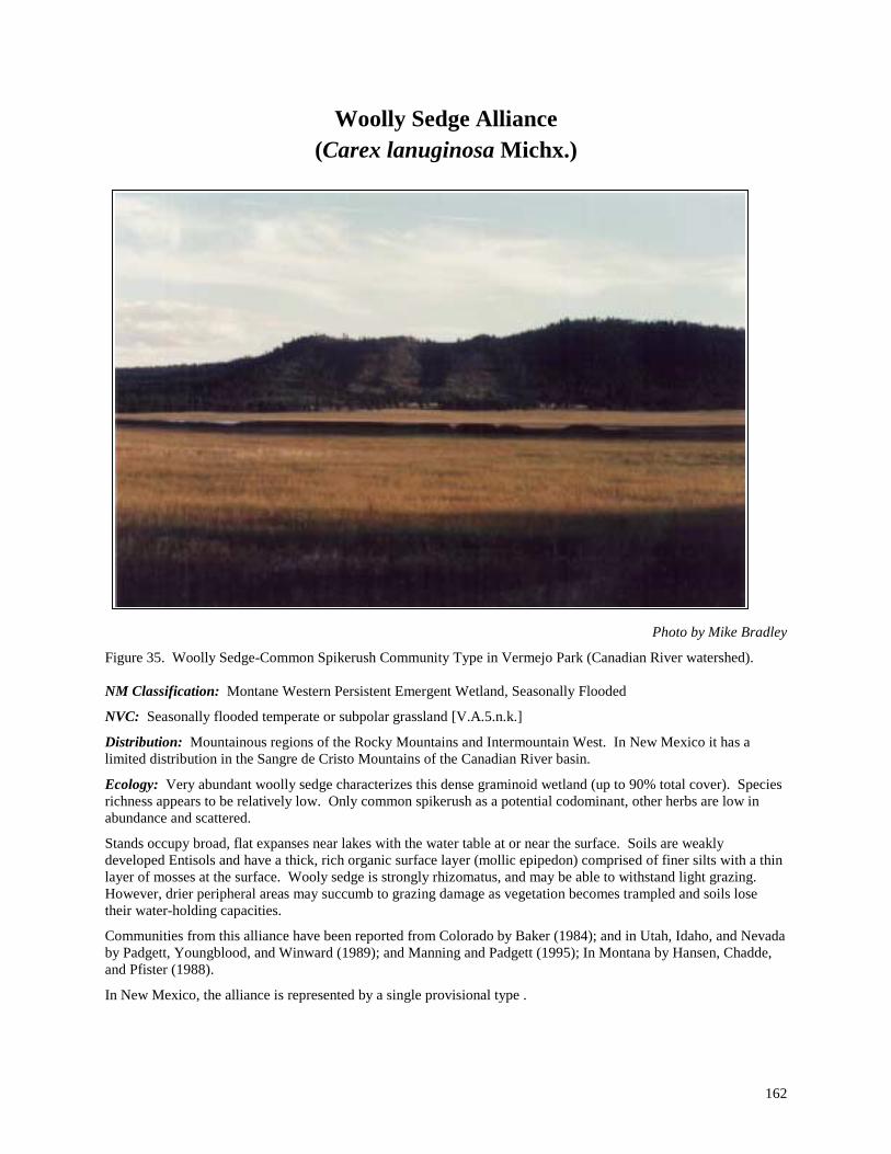
162
Woolly Sedge Alliance (Carex lanuginosa Michx.)
Photo by Mike Bradley
Figure 35. Woolly Sedge-Common Spikerush Community Type in Vermejo Park (Canadian River watershed). NM Classification: Montane Western Persistent Emergent Wetland, Seasonally Flooded
NVC: Seasonally flooded temperate or subpolar grassland [V.A.5.n.k.]
Distribution: Mountainous regions of the Rocky Mountains and Intermountain West. In New Mexico it has a limited distribution in the Sangre de Cristo Mountains of the Canadian River basin.
Ecology: Very abundant woolly sedge characterizes this dense graminoid wetland (up to 90% total cover). Species richness appears to be relatively low. Only common spikerush as a potential codominant, other herbs are low in abundance and scattered.
Stands occupy broad, flat expanses near lakes with the water table at or near the surface. Soils are weakly developed Entisols and have a thick, rich organic surface layer (mollic epipedon) comprised of finer silts with a thin layer of mosses at the surface. Wooly sedge is strongly rhizomatus, and may be able to withstand light grazing. However, drier peripheral areas may succumb to grazing damage as vegetation becomes trampled and soils lose their water-holding capacities.
Communities from this alliance have been reported from Colorado by Baker (1984); and in Utah, Idaho, and Nevada by Padgett, Youngblood, and Winward (1989); and Manning and Padgett (1995); In Montana by Hansen, Chadde, and Pfister (1988).
In New Mexico, the alliance is represented by a single provisional type .

163
Community Type Description:
Common Name Scientific Name
Woolly Sedge-Common Spikerush CT Carex lanuginosa-Eleocharis palustris CT
Acronym CARLAN-ELEPAL Status: Provisional Rank: S4?/G5? Distribution Canadian River Basin in northeastern New Mexico.
PROVISIONAL DESCRIPTION. Very abundant woolly sedge forms a dense graminoid canopy with common spikerush (Eleocharis palustris) as an abundant codominant. Overall species diversity is low. Preliminary data indicate that this type occurs as wet meadows, “park-like” expanses bordering open water. Elevations are around 8,250 ft (2,520 m). The water table is at or near the surface. Soils have been described as fine-silty Mollic Fluvaquents with a rich organic surface layer that is a function of the high graminoid cover. Towards open water sites occur adjacent to monotypic stands of bulrush (Scirpus spp.) or cattails (Typha spp.).
The community dominates sites frequented by wildlife (e.g., elk, and various birds). The larger animals avoid wetter mucky interior areas and instead remain closer to the periphery, while interior sites are ponded and visited by birds. REFERENCE SITE NAME. Van Bremmer Park
164
References Alexander, B.G., E.L. Fitzhugh, F. Ronco, and J.A. Ludwig. 1987. A classification of forest habitat types of the
northern portion of the Cibola National Forest, New Mexico. USDA Forest Service General Technical Report RM-143. Ft. Collins, CO: USDA Forest Service, Rocky Mountain Forest and Range Experiment Station.
Allred, K.W. 1993. A Field Guide to the Grasses of New Mexico. Department of Agricultural Communications, College of Agriculture and Home Economics, New Mexico State University, Las Cruces, NM.
Anderholm, S.K., M.J. Radell, and S.F. Ritchey.1995. Water quality assessment of the Rio Grande valley study unit, Colorado, New Mexico, and Texas—analysis of selected nutrient, suspended-sediment, and pesticide data. U.S.G.S. Water-Resources Investigations Report 94–4061. Albuquerque, NM.
Anderson, M., P. Bougeron, M.T. Bryer, R. Crawford, L. Engelking, D. Faber-langendoen, M. Gallyoun, K. Goodin, D.H. Grossman, S. Landaal, K. Metzler, K.D. Patterson, M. Pyne, M. Reid, L. Sneddon, and A.S. Weakly (1998). Terrestrial Vegetation of the United States. Volume II. The National Vegetation Classification System: List of types. The Nature Conservancy, Arlington VA. 502p.
Andrews, T. 1983. Subalpine meadow and alpine vegetation of the upper Pecos River. USDA. Forest Service Report RM-51. Southwest Region, Albuquerque, NM.
Asplund, K.K. and M.T. Gooch. 1988. Geomorphology and the distributional ecology of Fremont cottonwood (Populus fremontii) in a desert riparian canyon. Desert Plants 9(1):17–27, University of Arizona, Boyce Thompson Southwestern Arboretum, Superior, AZ.
Bailey, R.G., P.E. Avers, T. King, and W.H. McNab. 1994. Ecoregions and subregions of the United States (map). Washington, DC: US Geological Survey. Scale 1:7,500,000; colored. Accompanied by a supplementary table of map unit descriptions compiled and edited by W.H. McNab and R.G. Bailey. Prepared for the US Department of Agriculture, Forest Service.
Baker, W.L. 1984. A preliminary classification of the natural vegetation of Colorado. Great Basin Naturalist 44(4):647–676.
Baker, W.L. 1986. Riparian vegetation of the montane and subalpine zones in west-central and southwestern Colorado: Final report. Prepared for The Nature Conservancy and CNAP, Boulder, CO.
Baker, W.L. 1989. Classification of the riparian vegetation of the montane and subalpine zones in western Colorado. The Great Basin Naturalist 49(2):214–228.
Baker, W. L. and S. C. Kennedy. 1985. Presettlement vegetation of part of northwestern Moffat County, Colorado, described from remnants. Great Basin Naturalist 45:747-777.
Barnes, H.H., Jr. 1967. Roughness characteristics of natural channels. USGS Water-Supply Paper 1849, USDI Geological Survey, Washington, DC.
Bassett, D., M Larson, W. Moir. 1987. Forest and woodland habitat types of Arizona south of the Mogollon Rim and southwestern New Mexico
Baum, B.R. 1967. Introduced and naturalized tamarisks in the United States and Canada. Quart. Jour. Hort. Taxonomy 15(1):19-25.
Baum, B.R. 1978. The Genus Tamarix. The Israel Academy of Sciences and Humanities. Jerusalem.
Benedict, N.B. 1983. Plant associations of subalpine meadows, Sequoia National Park, California. Arctic and Alpine Research 15(3):383-396.
Bierly, K. F. 1972. Meadow and fen vegetation in Big Meadows, Rocky Mountain National Park. Unpublished thesis, Colorado State University, Fort Collins. 102 p.
Bock, J.H. and C.E. Bock. 1985. The development of Southwestern riparian gallery forests. In: Johnson, R.R., C.D. Ziebell, D.R. Patton, P.F. Ffolliott, and R.H. Hamre (tech. coordinators). Riparian Ecosystems and Their Management: Reconciling Conflicting Uses. First North American Riparian Conference. USDA Forest

165
Service General Technical Report RM-120. 523pp. Rocky Mountain Forest and Range Experiment Station. Fort Collins, CO.
Bogan, M.A., C.D. Allen, E.H. Muldavin, S.P. Platania, J.N. Stuart, G.H. Farley, P. Mehlhop, and J. Belnap. 1998. Southwest. Pp. 543–592 In: Mac, J.P., P.A. Opler, P. Huckett, and P.D. Doran. Status and Trends of the Nation's Biological Resources. 2 vols. U.S. Dept. of Interior, U.S. Geological Survey, Reston VA.
Boles, P.H. and W.A. Dick-Peddie. 1983. Woody riparian vegetation patterns on a segment of the Mimbres River in southwestern New Mexico. Southwestern Naturalist 28:81–87.
Brady, W., D.R. Patton, and J. Paxson. 1985. The development of southwestern riparian gallery forest. pp.39-43. In: Johnson, R.R., C.D. Ziebell, D.R. Patton, R.F. Ffolliot, and R.H. Hamre (tech. coordinators). Riparian Ecosystems and Their Management: Reconciling Conflicting Uses. First North American Riparian Conference. USDA Forest Service General Technical Report RM–120. 523pp. Rocky Mountain Forest and Range Experiment Station. Fort Collins, CO.
Brian, N. 1982. A preliminary study of riparian coyote willow communities along the Colorado River in Grand Canyon National Park. Unpublished masters thesis, Northern Arizona University, Flagstaff, AZ.
Briggs, G. M. and J. A. MacMahon. 1983. Alpine and subalpine wetland plant communities of the Uinta Mountains, Utah. The Great Basin Naturalist 43(4):523-530.
Brock, J.H. 1994.Phenology and stand composition of woody riparian plants in the southwestern United States. Desert Plants 11(1):23-31.
Brotherson, J. D. 1987. Plant community zonation in response to soil gradients in a saline meadow near Utah Lake, Utah County, Utah. Great Basin Naturalist 47(2):322-333.
Brown, D.E., C.H. Lowe, C.P. Pase. 1979. A digitized classification system for the biotic communities of North America, with community (series) and association examples for the Southwest. Desert Plants 4(1–4):302–315.
Bullard, T.F. and S.G. Wells. 1992. Hydrology of the middle Rio Grande from Velarde to Elephant Butte Reservoir, New Mexico. Resource publ. no. 179, U.S. Dept. of Interior, Fish and Wildlife Service, Washington, D.C.
Bunin, J. E. 1975. The vegetation of the west slope of the Park Range, Colorado. Unpublished dissertation, University of Colorado, Boulder, CO. 235 p.
Busch, D.E. and S.D. Smith. 1995. Mechanisms associated with decline of woody species in riparian ecosystems of the southwestern U.S. Ecological Monographs 65(3):347–370.
Campbell, C.J. and W.A. Dick-Peddie. 1964. Comparison of the phreatophyte communities on the Rio Grande in New Mexico. Ecology 45(3):492–502.
Carman, J.G. and J.D. Brotherson. 1982. Comparisons of sites infested and not infested with saltcedar (Tamarix pentandra) and Russian olive (Elaeagnus angustifolia). Weed Science 30:360–364.
Cowardin, L.M., V. Carter, F.C. Golet, and E.T. LaRoe. 1979. Classification of Wetlands and Deepwater Habitats of the United States. FWS/OBS–79/31. USDI Fish and Wildlife Service, Washington, DC.
Crawford, C.S., A.C. Cully, R. Leutheuser, M.S. Sifuentes, L.H. White, and J.P. Wilber. 1993. Middle Rio Grande ecosystem: bosque biological management plan. R. Robino, technical coordinator. USDI Fish and Wildlife Service, Albuquerque, NM.
Chronic, H. 1987. Roadside Geology of New Mexico. Mountain Press Publishing Co., Missoula, MT.
Cox, C. F. 1933. Alpine plant succession on James Peak, Colorado. Ecological Monograph 3:299-372.
DeVelice, R.L., J.A. Ludwig, W.H. Moir, and F. Ronco, Jr. 1986. A classification of forest habitat types of northern New Mexico and southern Colorado. Gen. Tech. Rep. RM-131. USDA Forest Service, Rocky Mountain Forest and Range Experiment Station. Fort Collins, CO. 59p
Dick-Peddie, W.A., J.K. Meents, and R. Spellenberg. 1984. Vegetation resource analysis for the Velarde Community Ditch Project, Rio Arriba and Santa Fe counties, New Mexico. Unpublished final report prepared for the USDI Bureau of Reclamation, Southwestern Region, Amarillo, TX.

166
Dick-Peddie, W.A. and contributors. 1993. New Mexico Vegetation − Past, Present and Future. University of New Mexico Press, Albuquerque, NM.
Donahue, R.L., R.W. Miller, and J.C. Shickluna. 1983. Soils: An Introduction to Soils and Plant Growth. Fifth Ed. Prentice-Hall, Inc., Englewood Cliffs, NJ.
Durkin, P., E. Muldavin, P. Mehlhop, and M. Bradley. 1994a. A riparian/wetland vegetation community classification of New Mexico: Pecos River basin. Unpublished final report prepared by the New Mexico Natural Heritage Program, University of New Mexico, Department of Biology, Albuquerque, NM and submitted to the New Mexico Environment Department, Surface Water Quality Bureau, Santa Fe, NM.
Durkin, P., M. Bradley, E. Muldavin, and P. Mehlhop 1994b. Classification of lacustrine water bodies and associated ecological communities of the Bureau of Land Management Roswell Resource Area. Unpublished report by The New Mexico Natural Heritage Program and the University of New Mexico, Albuquerque, NM.
Durkin, P., M. Bradley, S.E. Carr, E. Muldavin, and P. Mehlhop. 1995a. Riparian/wetland vegetation communities of the Rio Grande: A classification and site evaluation. Unpublished final report prepared by the New Mexico Natural Heritage Program, University of New Mexico, Department of Biology, Albuquerque, NM, and submitted to the New Mexico Environment Department, Surface Water Quality Bureau, Santa Fe, NM.
Durkin, P., E. Muldavin, M. Bradley, S.E. Carr, A. Metcalf, R.A. Smartt, S.P. Platania, C. Black, and P. Mehlhop. 1995b. The biodiversity of riparian ecosystems of the Ladder Ranch. Unpublished final report prepared by The Nature Conservancy, New Mexico Field Office, Santa Fe, NM and the New Mexico Natural Heritage Program, University of New Mexico, Department of Biology, Albuquerque, NM.
Durkin, P., M. Bradley, E. Muldavin, and P. Mehlhop. 1996. Riparian/wetland vegetation communities of New Mexico: Gila, San Francisco, and Mimbres watersheds. Unpublished final report submitted to New Mexico Environment Department, Surface Water Quality Bureau, Santa Fe, NM.
Durkin, P., M. Bradley, E. Muldavin, and P. Mehlhop. 1997. Wetland/Riparian Vegetation Communities of New Mexico: Volume II Final Report Draft Handbook of Wetland/Riparian Vegetation Communities of New Mexico (San Juan and Little Colorado Watersheds Only). Unpublished final report submitted to New Mexico Environment Department, Surface Water Quality Bureau, Santa Fe, NM.
Eckenwalder, J.E. 1977. North American cottonwoods (Populus, Salicaceae) of sections Abaso and Aigeiros. Journal of the Arnold Arboretum 58(3):193–208.
Ellis, L.M., M.C. Molles, Jr., C.S. Crawford. 1999. Influence of experimental flooding on litter dynamics in a Rio Grande riparian forest, New Mexico. Restoration Ecology 7(2):193-204.
Elmore, W. and R.L. Beschta. 1987. Riparian areas: perceptions in management. Rangelands 87(6):260–265.
EPA 1988. America’s wetlands: our vital link between land and water. Environmental Protection Agency. OPA–87–016.
Environmental Laboratory. 1987. Corps of Engineers wetlands delineation manual. Technical Report Y-87-1 (on-line), U.S. Army Engineer Waterways Experiment Station, Vicksburg, MS. NTIS No. AD A176 912
Evenden, A.G. 1990. Ecology and distribution of riparian vegetation in the Trout Creek Mountains of southeastern Oregon. Ph.D. dissertation. Oregon State Univ., Corvallis OR. 156 pp.
Everitt, B.L. 1980. Ecology of saltcedar—a plea for research. Environ Geol 3:77–84.
Federal Geographic Data Committee–Vegetation Subcommittee. 1996. FGDC Vegetation Classification and Information Standards. USGS MS 590 National Center. Reston, VA.
Fitzhugh, L.E., W.H. Moir, J.A. Ludwig, and F. Ronco. 1987. Forest habitat types in the Apache, Gila and part of the Cibola National Forests in Arizona and New Mexico. USDA Forest Service General Technical Report RM–145. Ft. Collins, CO: USDA Forest Service, Rocky Mountain Forest and Range Experiment Station.
Freeman, C.E. and W.A. Dick-Peddie.1970. Woody riparian vegetation in the Black and Sacramento mountain ranges, New Mexico. Southwestern Naturalist 15:145–164.

167
Giese, T. G. 1975. The ecology of the Middle Blue River Valley, Summit County, Colorado, with an analysis of modifications due to powerline construction. Unpublished thesis, University of Colorado, Boulder. 109 pp.
Grant, G.E., J.E. Duval, G.J. Koerper and J.L. Fogg. 1992. XSPRO: A Channel Cross Section Analyzer. USDI Bureau of Land Management and USDA Forest Service, Technical Note 387, BLM/SC/PT–92/001 + 7200, Denver, CO.
Grossman, D.H., D. Faber-Langendoen, A.S. Weakley, M. Anderson, P. Bourgeron, R. Crawford, K. Goodin, S. Landaal, K. Metzler, K. Patterson, M. Pyne, M.Reid, and L. Sneddon. 1998. International classification of ecological communities: terrestrial vegetation of the United States. Volume 1. The National Vegetation Classification System: development, status, and applications. The Nature Conservancy, Arlington, VA
Hall, H. H. 1971. Ecology of a subalpine meadow of the Aquarius Plateau, Garfield and Wayne Counties, Utah. Unpublished dissertation, Brigham Young University, Provo, Utah.
Hansen, P.L., S.W. Chadde, and R.D. Pfister. 1988. Riparian dominance types of Montana. University of Montana Misc. Pub. 49. Montana Forest and Conservation Experiment Station, Missoula, MT. 411p.
Hansen, P., S. Chadde, R. Pfister, J. Joy, D. Svoboda, J. Pierce, and L. Myers. 1988. Riparian site types, habitat types, and community types of southwestern Montana, draft version 1. Montana Riparian Association, School of Forestry, University of Montana at Missoula, MT.
Hansen, P., K. Boggs, R. Pfister, and J. Joy. 1990. Classification and management of riparian and wetland sites in central and eastern Montana. Unpublished draft version 2, Montana Riparian Association, Montana Forest and Conservation Experiment Station, School of Forestry, University of Montana, Missoula, MT.
Hardesty, J. V. 1985. Riparian vegetation of Three Sites along the Gila River in Southwestern New Mexico. M.S. Thesis. New Mexico State University, Las Cruces, NM 101p.
Heede, B.H. 1985. Interactions between streamside vegetation and stream dynamics. pp.54–58. In: Johnson, R.R., C.D. Ziebell, D.R. Patton, P.F. Ffolliott, and R.H. Hamre (tech. coordinators), Riparian Ecosystems and Their Management: Reconciling Conflicting Uses. First North American Riparian Conference. USDA Forest Service General Technical Report RM-120. 532pp. Rocky Mountain Forest and Range Experiment Station, Fort Collins, CO.
Hess, K. 1981. Phyto-edaphic study of habitat types of the Arapaho-Roosevelt National Forest, Colorado. Unpublished dissertation, Colorado State University, Fort Collins, CO. 558 pp.
Hess, K. and C.H. Wasser. 1982. Grassland, shrubland, and forestland habitat types of the White River-Aprapho National Forest. Unpublished final report to Region II. USDA, Forest Service, Region II. 335p.
Hess, K., and R.R. Alexander.1986. Forest vegetation of the Arapaho and Roosevelt National Forests in north-central Colorado: a habitat type classification. Res. Pap. RM-266. Fort Collins, CO: U.S. Department of Agriculture, Forest Service, Rocky Mountain Forest and Range Experiment Station. 48 p.
Hildebrant, T.D. and R.D. Ohmart. 1982. Biological resource inventory (vegetation and wildlife) Pecos River basin, New Mexico and Texas. Final Report to Bureau of Reclamation Contract No, 9-07-57-V0567. 160p + maps.
Hink, V.C. and R.D. Ohmart. 1984. Middle Rio Grande biological survey. Unpublished final report submitted in fulfillment of Army Corps of Engineers Contract No. DACW47-81-0015.
Hitchcock, A.S. and A. Chase 1950. Manual of the Grasses of the United States Vol. I and II. 2nd Edition. Edited by A. Chase. USDA Misc. Pub No. 200. Washington, D.C. 1051p.
Horton , J.S. and C.J. Campbell. 1974. Management of phreatophyte and riparian vegetation for maximum multiple use values. U.S.D.A. Forest Service Res. Paper RM-117. 23p. Rocky Mountain Forest and Range Experiment Station, Fort Collins, CO.
Horton, J.S., F.C. Mounts, and J.M. Kraft.1960. Seed germination and seedling establishment of phreatophyte species. USDA Forest Service Res. Pap. RM-48. 26. Rocky Mount
Houghton, F. 1971. Soils survey of Eddy Area, New Mexico. U.S.D.A. Soil Conservation Service in cooperation with the New Mexico Agricultural Experiment Station.

168
Houghton, F. 1981. Soils survey of San Miguel Area, New Mexico. U.S.D.A. Soil Conservation Service in cooperation with the New Mexico Agricultural Experiment Station.
Howe, W.H. and F.L. Knopf. 1991. On the imminent decline of Rio Grande cottonwoods in central New Mexico. The Southwestern Naturalist 36(2):218–224.
Hupp, C.R., and W.R. Osterkamp. 1985. Bottomland vegetation distribution along Passage Creek, Virginia, in relation to fluvial landforms. Ecology 66:670–681.
Hupp, C.R. 1992. Riparian vegetation recovery patterns following stream channelization: a geomorphic perspective. Ecology 73(4):1209–1226.
Johnson, K. R. 1936. Ecology of a glacial lake in central Colorado. University of Colorado Studies 23(3):235-243.
Johnson, K. R. 1939. Plant ecology of northwestern Colorado lakes and surrounding areas. Unpublished dissertation, University of Colorado, Boulder. 138 p.
Johnson. R.R. and C.H. Lowe. 1985. On the development of riparian ecology. In: Riparian ecosystem and their Management: Reconciling Conflicting Uses (R.R. Johnson, C.D. Ziebell, D.R. Patton, P.F. Ffolliott, and R.H. Hamre tech. coord.) USDA Forest Service General Technical Report RM–120.
Johnston, B.C. 1987. Plant associations of Region 2, edition 4. USDA Forest Service, Rocky Mountain Region, R2–ECOL–87–2, 429 p.
Jones, G.P. and G.M. Walford. 1995. Major riparian vegetation types of Eastern Wyoming. Unpublished draft report submitted to the Wyoming Department of Environmental Quality, Water Quality Division. Wyoming Natural Diversity Database, Laramie, WY.
Kartesz, J. 1994. A synonymized checklist of the vascular flora of the United States, Canada, and Greenland. Second Edition. Biota of North America Program of the North Carolina Botanical Garden. Timber Press, Portland, OR.
Kittel, G. 1993. A preliminary classification of the riparian vegetation of the White River basin. Unpublished draft report, Colorado Natural Heritage Program, Boulder, CO.
Kittel, G. and N. Lederer. 1993. A preliminary classification of the riparian vegetation of the Yampa and San Miguel/Dolores River basins. Unpublished draft report, The Nature Conservancy’s Colorado Program, Boulder, CO.
Kittel, G., R. Rondeau, N. Lederer, and D. Randolph. 1994 (revised). A classification of the riparian vegetation of the White and Colorado river basins, Colorado. Unpublished final report to the Colorado Dept. of Natural Resources and the Environmental Protection Agency, Region VIII. Prepared by the Colorado Natural Heritage Program, University of Colorado Museum, Boulder, CO.
Kittel, G., R. Rondeau, and S. Kettler. 1995. A Classification of the riparian vegetation of the Gunnison River Basin, Colorado. Unpublished final report to the Colorado Dept. of Natural Resources and the Environmental Protection Agency, Region VIII. Prepared by the Colorado Natural Heritage Program, Colorado State University, Ft. Collins, CO.
Kittel, G., R. Rondeau, and A. McMullin. 1996. A Classification of the riparian vegetation of the Lower South Platte and parts of the Upper Arkansas River Basins, Colorado. Unpublished final report to the Colorado Dept. of Natural Resources and the Environmental Protection Agency, Region VIII. Prepared by the Colorado Natural Heritage Program, Colorado State University, Ft. Collins, CO.
Knopf, F.L., R.R. Johnson, T. Rich, F.B. Samson, and R.C. Szaro. 1988. Conservation of riparian ecosystems in the United States. Wilson Bulletin 100:272–284.
Kollmorgen Corporation. 1975. Munsell Soil Color Charts. Macbeth Division of Kollmorgen Corporation, Baltimore, MD.
Komarkova, V. 1976. Alpine vegetation of the Indian Peaks Area, Front Range, Colorado Rocky Mountains. Unpublished dissertation, University of Colorado, Boulder. 655 pp.

169
Komarkova, V., R.R. Alexander, and B.C. Johnston. 1988. Forest vegetation of the Gunnison and parts of the Umcompahgre National Forests: A preliminary habitat type classification. General Technical Report. Fort Collins. U.S. Department of Agriculture, Forest Service, Rocky Mountain Forest and Range Experiment Station. [manuscript in preparation].
Kovalchik, B.L. 1987. Riparian zone associations – Deschutes, Ochoco, Fremont and Winema National Forests. USDA Forest Service Technical Paper 279–87 Pacific Northwest Region, Portland, OR. 171 pp.
Kovalchik, B.L. 1993. Riparian plant associations on the National Forests of eastern Washington - Draft version 1. USDA Forest Service, Colville National Forest, Colville, WA. 203 pp.
Krueper, D.J. 1996. Effects of livestock management on Southwestern riparian ecosystems. Pp 281–301. In: Desired future conditions for southwestern riparian ecosystems: bringing interests and concerns together. Sept. 18–22, 1995; Albuquerque, NM (D.W. Shaw and D.M. Finch, tech. coords.). General Technical Report RM–GTR–272. Ft. Collins, CO: USDA Forest Service, Rocky Mountain Forest and Range Experiment Station.
Langenheim, J.H. 1962. Vegetation and environmental patterns in the Crested Butte area, Gunnison County, Colorado. Ecological Monographs 32:249-285.
Laurenzi, A.W., R.D. Ohmart, and V.C. Hink. 1983. Classification of mixed broadleaf riparian forest in Tonto National Forest. Pp 72–81 In: Proceedings of the Workshop on Southwestern Habitat Types. USDA Forest Service, Rocky Mountain region and Southwestern region, Rocky Mountain Forest and Range Experiment Station, Albuquerque, NM.
Leonard, S.G., G.J. Staidl, K.A. Gebhardt, and D.E. Prichard. 1992. Viewpoint: Range site/ecological site information requirements for classification of riverine riparian ecosystems. Journal of Range Management 45:431–435.
Lindauer, I.E. 1983. A comparison of the plant communities of the South Platte and Arkansas River Drainages in eastern Colorado. The Southwestern Naturalist 28(3):249–259.
Lowe, C.H., R.R. Johnson, and P.S. Bennett. 1986. Riparian lands are wetlands: the problems of applying eastern North American concepts and criteria to environments in the North American Southwest. Pp 119–122. In: Vol. 16, Hydrology and water resources in Arizona and the Southwest, Proc. 1986 meetings of the Arizona section−American Water Resources Association, Hydrology section−Arizona−Nevada Academy of Sciences and the Arizona Hydrology Society. 19 April. Glendale, AZ.
Marriott, H.J. and G.P. Jones. 1989. Special status plant surveys and plant community surveys in the Trapper Creek and Medicine Lodge Wilderness Study Areas and the Spanish Point Karst ACEC. Report submitted to the Bureau of Land Management, Worland District.
Malanson, G.P. 1993. Riparian Landscapes. Cambridge University Press, New York, NY.
Manning, M.E. and W.G. Padgett. 1995. Riparian community type classification for Humboldt and Toiyabe National Forests, Nevada and Eastern California. USDA Forest Service Intermountain Region tech. report R4–Ecol–95–01, Ogden, UT.
Martin, W.C. and C.R. Hutchins. 1980. A Flora of New Mexico – Volumes 1 and 2. A.R. Gantner Verlag K.G., FL–9490 Vaduz, Germany.
Mattson, D.J. 1984. Classification and environmental relationships of wetland vegetation in central Yellowstone National Park. Unpublished thesis, University of Idaho, Moscow. 409p.
Maybury, K.P. (ed.).1999. Seeing the Forest and the Trees: Ecological Classification for Conservation. The Nature Conservancy, Arlington, VA. 37p.
McNab, W.H. and Avers, P.E. 1994. Ecological subregions of the United States: section descriptions. Prepared in cooperation with regional compilers and the ECOMAP team of the Forest Service. USDA Forest Service, Ecosystem Management. Washington, DC.
Medina, A.L. 1986. Riparian plant communities of the Fort Bayard watershed in southwestern New Mexico. The Southwestern Naturalist 31(3):345–359.

170
Medina, A.L. 1996. Native aquatic plants and ecological condition of southwestern wetlands and riparian areas. Pp. 329–335. In: Shaw, D.W. and D.M. Finch (tech. coords.). Desired future conditions for Southwestern riparian ecosystems: bringing interests and concerns together. General Technical Report RM–GTR–272. Ft. Collins, CO: USDA Forest Service, Rocky Mountain Forest and Range Experiment Station.
Miller, T. B. 1976. Ecology of riparian communities dominated by white alder in western Idaho. Unpublished thesis, University of Idaho, Moscow. 154 pp.
Minckley, W.L. and D.E. Brown. 1982. Wetlands. pp.273–287 In: Brown, D.E. (ed.), Biotic Communities of the American Southwest – United States and Mexico. Desert Plants 4:273–287.
Minckley, W.L. and J.N. Rinne. 1985. Large woody debris in hot-desert streams: a historical review. Desert Plants 7:142–153.
Moir, W.H. and J.A. Ludwig. 1979. A classification of spruce-fir and mixed conifer habitat types of Arizona and New Mexico. USDA Forest Service Research Paper RM–207. Ft. Collins, CO: USDA Forest Service, Rocky Mountain Forest and Range Experiment Station.
Moir, W.H. and J.A. Ludwig. 1984. Methods of Forest Habitat Type Classification Pages 5–10 In: Proceedings of the Workshop on Southwestern Habitat Types. W.H. Moir and L. Hendzel, Technical Coordinators. USDA Forest Service, Southwest Region, Albuquerque, NM
Mueller-Dombois, D. and H. Ellenberg. 1974. Aims and Methods of Vegetation Ecology. John Wiley and Sons, New York, NY.
Muldavin, E. 1991. Riparian and wetlands survey: Pecos National Historical Park. Unpublished final report prepared by the New Mexico Natural Heritage Program and the University of New Mexico Biology Department for the National Park Service, Albuquerque, NM.
Muldavin, E., B. Sims, and L. Johnson. 1993. Pecos wild and scenic river instream flow report. Unpublished final report, New Mexico Natural Heritage Program, Albuquerque, NM.
Muldavin, E., R. Wallace, and P. Mehlhop. 1993. Riparian ecological site inventory for New Mexico: Bureau of Land Management lands − Year 1, Demonstration of methods. Unpublished final report prepared by the New Mexico Natural Heritage Program submitted to BLM New Mexico State Land Office, Santa Fe, NM.
Mutel, C.F. 1973. An ecological study of the plant communities of certain montane meadows in the Front Range of Colorado. Unpublished thesis, University of Colorado, Boulder, CO. 77p.
Mutel, C.F. and J.W. Marr. 1973. A vegetative study of three montane herbaceous basins. Journal of the Colorado-Wyoming Academy of Science 7(4):28. (Abstract).
National Wetlands Inventory. 1998. A system for mapping riparian Areas in the western United States. U.S. Fish and Wildlife Service, National Wetlands Inventory Homepage document: http://www.nwi.fws.gov/Riparian.htm.
New Mexico Water Quality Control Commission. 1994. Water quality and water pollution control in New Mexico. Report prepared for submission to the Congress of the United States by the State of New Mexico pursuant to section 305(b) of the Federal Water Pollution Control Act. Santa Fe, NM.
Olson, D.F., Jr. 1974. Elaeagnus L. Elaeagnus. In: Seeds of woody plants in the United States. USDA Forest Service Agricultural Handbook No. 450. Pp. 376–379.
Omernik, J.M. and A.L. Gallant. 1987. Ecoregions of the South Central States. [map] Environmental Research Laboratory, U.S. Environmental Protection Agency, Corvallis, OR.
Padget, W.G. 1982. Ecology of riparian plant communities in the southern Malhuer National Forest. Unpublished thesis, Organ State University, Corvalis, OR. 143p.
Padgett, W.G., A.P. Youngblood, and A.H. Winward. 1988. Riparian community type classification of Utah. USDA Forest Service Intermountain Region Publication R4–Ecol–88–01. Ogden, UT.
Padgett, W.G., A.P. Youngblood, and A.H. Winward. 1989. Riparian community type classification of Utah and southeastern Idaho. USDA Forest Service, Intermountain region. R4–ECOL–89–01.

171
Parham, T.L., R.P. Paetzold and C.E. Souders. 1979. Soil Survey of Grant County, New Mexico: Central and Southern Parts. USDA Soil Conservation Service and Forest Service, in cooperation with New Mexico Agricultural Experiment Station.
Prichard, D., H. Barrett, J. Cagney, R. Clark, J. Fogg, K. Gebhardt, P.L. Hansen, B. Mitchell, and D. Tippy. 1995. Riparian Area Management: Process for Assessing Proper Functioning Condition. Technical Reference 1737–9. US Dept. of Interior, Bureau of Land Management, Denver Service Center. Denver CO.
Rabe, F.W. and S.W. Chadde. 1994. Classification of aquatic and semiaquatic wetland natural areas in Idaho and western Montana. Natural Areas Journal 14(3):175–187.
Ramaley, F. 1919. The role of sedges in some Colorado plant communities. American Journal of Botany 6:120-130.
Ramaley, F. 1920. Subalpine lake-shore vegetation in north- central Colorado. American Journal of Botany 7:57-74.
Ramaley, F. 1942. Vegetation of the San Luis Valley in southern Colorado. University of Colorado Studies, Series D, 1:231–277.
Rechenbacher, F.W. 1984. Ecology and evaluation of south-western riparian plant communities. Desert Plants 6:15-22.
Rector, C.D. 1979. Lower Gunnison River Basin wetland inventory and evaluation. Unpublished thesis. University of Colorado, Boulder, CO. 71p.
Reed, P.B. 1988. National list of plant species that occur in wetlands: Southwest (region 7). US Fish and Wildlife Service Biological Report 88 (26.7).
1997. Revision of the national list of plant species that occur in wetlands. US Fish and Wildlife Service, National Wetlands Inventory Center, Ecology Section, St. Petersburg, FL.
Reynolds, H.G. and R.R. Alexander. 1974. Tamaricaceae-Tamarix family. Tamarix pentandra Pall. Five-stamen tamarisk. In: Seeds of Woody Plants in the United States. USDA Forest Service Agricultural Handbook No. 450. Pp. 794–795.
Richard, C.,G. Kittel and S. Kettler. 1996. A Classification of Riparian Vegetation of the San Juan National Forest. Draft 1 report. Colorado Natural Heritage Program, Colorado State University, Ft. Collins, Co.
Robinson, T.W. 1965. Introduction, spread, and areal extent of Saltcedar (Tamarix) in the western states. U.S. geological Survey Professional Paper 491–1. 12p.
Rosgen. D.L. 1996. Applied River Morphology. Wildland Hydrology, Pagosa Springs, CO.
Shafroth, P.B., G.T. Auble, and M.L. Scott. 1995. Germination and establishment of the native Plains Cottonwood (Populus deltoides Marshall subsp. monilifera) and the exotic Russian olive (Elaeagnus angustifolia L.). Conservation Biology 9(5): 1169–1175.
Siegel, R.S. and J.H. Brock. 1990. Germination requirements of key southwestern woody riparian species. Desert Plants. University of Arizona, Boyce Thompson Southwestern Arboretum 10(1):3–8.
Soil Conservation Service. 1980. Soil survey of San Juan County, New Mexico. USDA Soil Conservation Service. In cooperation with USDI Bureau of Indian Affairs and Bureau of Reclamation and the New Mexico Agricultural Experiment Station.
Soil Conservation Service. 1991. National Soils Handbook. USDA Soil Conservation Service. Washington, DC.
Soil Survey Staff. 1992. Keys to Soil Taxonomy. SMSS Tech. Monograph, Fifth Ed. Pocahontas Press, Inc., Blacksburg, VA.
Strahan, J. 1984. Regeneration of riparian forests of the central Valley. In: Warner, R.E., and K.M. Hendrix (eds.) California Riparian Ecosystems: Ecology, Conservation, and Productive Management. University of California Press, Berkeley, CA.
Stromberg, J.C. 1997. Growth and survivorship of Fremont cottonwood, Goodding willow, and saltcedar seedlings after large floods in central Arizona. Great Basin Naturalist 57:198–208.

172
Stromberg, J.C. 1998. Dynamics of Fremont cottonwood (Populus fremontii) and Saltcedar (Tamarix chinensis) populations along the San Pedro River, Arizona. Journal of Arid Environments 40(2):133–155.
Stromberg, J.C. and D.T. Patten. 1991. Instream flow requirements for cottonwoods at Bishop Creek, Inyo County, California. Rivers 2(1):1–11.
Stromberg, J.C. and D.T. Patten. 1992. Mortality and age of Black cottonwood stands along diverted and undiverted streams in the eastern Sierra Nevada, California. Madroño 39(3): 205–223.
Stromberg, J.C., B.D. Richter, D.T. Patten, and L.G. Wolden. 1993. Response of a Sonoran riparian forest to a 10–year return flood. Great Basin Naturalist 53(2):118–130.
Stromberg, J.C., R. Tiller, and B. Richter. 1996. Effects of groundwater decline on riparian vegetation of semiarid regions: the San Pedro, Arizona. Ecological Applications 6(1):113–131.
Stuever, M. 1997. Fire induced mortality of Rio Grande cottonwood. Master thesis. University of New Mexico, Albuquerque, NM. 85p.
Stuever, M. and J. Hayden, ed. 1997. Plant Associations of Arizona and New Mexico, Volume 1: Forests. Edition 3, USDA Forest Service, Southwestern Region.
Szaro, R.C. 1989. Riparian forest and scrubland community types of Arizona and New Mexico. Desert Plants. University of Arizona, Boyce Thompson Southwestern Arboretum, 9(3–4), Superior, AZ.
Tiner, R.W. 1984. Wetlands of the United States: Current Status and Recent Trends. National Wetlands Inventory. U.S. Fish and Wildlife Service. U.S. Government Printing Office, Washington, DC.
The Nature Conservancy. 1997. Designing a Geography of Hope: Guidelines for Ecoregion-based Conservation in The Nature Conservancy. The Nature Conservancy, Arlington, VA.
Tuhy, J.S. 1981. Stream bottom community classification of the Sawtooth Valley, Idaho. Unpublished thesis, University of Idaho, Moscow, ID. 230p.
U.S. Bureau of Reclamation. 1995. Hydrologic and hydraulic analysis for a riparian and wetland vegetation classification. Unpublished report prepared by the USDI Bureau of Reclamation Technical Assistance to States Program, Albuquerque Projects Office for the New Mexico Environment Department, Santa Fe, NM, and the New Mexico Natural Heritage Program, Albuquerque, NM.
U.S. Geological Survey. 1974. Hydrologic unit map−1974, State of New Mexico. Prepared in cooperation with the U.S. Water Resources Council and the U.S. Dept. of the Interior, Denver, CO.
Vepraskas, M.J. 1992. Redoximorphic features for identifying aquic conditions. Technical Bulletin 301, North Carolina Agricultural Research Service, North Carolina State University, Raleigh, NC.
Walford ,G.M. and W.L. Baker. 1995. Classification of the riparian vegetation along a 6-km reach of the Animas River, southwestern Colorado. The Great Basin Naturalist: 55(4): 287–303.
Waltemeyer, S.D. 1986. Techniques for estimating flood-flow frequency for unregulated streams in New Mexico. Water-Resources Investigation Report 86–4104. US Geological Survey, Albuquerque, NM.
Wilson, H. C. 1969. Ecology and successional patterns of wet meadows, Rocky Mountain National Park, Colorado. Unpublished dissertation, University of Utah, Salt Lake City. 99 p.
Woodbury, A. M., S.D. Durrant and S. Flowers. 1961. A survey of vegetation in the Navajo Reservoir basin. University of Utah Anthropological Papers 51, Salt Lake City. 99 p.
Youngblood, A.P., W. G. Padgett, and A.H. Winward 1985a. Riparian community type classification of eastern Idaho - western Wyoming. USDA Forest Service, Intermountain Region, R4–Ecol–85–01. Ogden, UT.
Youngblood, A.P., W. G. Padgett, and A.H. Winward 1985b. Riparian community type classification of northern Utah and adjacent Idaho. Unpublished prepared for the USDA Forest Service Intermountain region, Ogden, UT. 104 p.

A-1
Appendix A
Plant Species List
for the
New Mexico Wetland Community Classification
Listed here are all plants identified in the course of the development of New Mexico Wetland Vegetation Classification. All voucher specimens are archived at the University of New Mexico Herbarium of the Museum of Southwestern Biology. Species are ordered alphabetically by lifeform (trees, shrubs, graminoids, and forbs), with authority and common name. Taxonomic nomenclature and common names generally follow Kartesz (1994), but on occasion, alternative names have been used variously following Eckenwalder (1977), Baum (1978), Martin and Hutchins (1980), Hitchcock and Chase (1950), or Allred (1993). Whether a species is native (n) or introduced (i) to the Southwest is indicated. Also provided is the wetland indicator group of a species as listed by Reed (1988 and 1997) for Region 7 (Arizona and New Mexico) (definitions of the five wetland groups are provided in Table A-1). In a few cases we considered some "NI" and "FACU" species designated by Reed (1997) wetland indictors in New Mexico based on the distribution of the species in the state (e.g., Forestiera pubescens). Hence, we have marked with an "x" those species which we consider wetland indicators for the purpose of this report.
________________________________________________________________________________ Table A-1. Wetland plant species indicator definitions (Reed 1988 and 1997). OBL Obligate Wetland Plants Occur almost always (estimated probability of >99%) in wetlands,
but occasionally are found in non-wetlands (estimated probability of <1%).
FACW Facultative Wetland Plants Usually occur in wetlands (estimated probability of 67 to 99%), but occasionally are found in non-wetlands (estimated probability 1 to 33%). *
FAC Facultative Plants Share an equal likelihood (estimated probability 33 to 67% of occurring in either wetlands or non-wetlands. *
FACU Facultative Upland Plants Usually occur in non-wetlands (estimated probability 67 to 99%), but occasionally are found in wetlands (estimated probability 67 to 99%), but occasionally are found in wetlands (estimated probability 1 to 33%). *
UPL Obligate Upland Plants Occur almost always (estimated probability >99%) in non-wetlands;
NI No indicator status Unable to determine indicator status
* Species in the facultative categories can be further assigned a plus (+) or minus (-) sign to indicate those species with a higher or lower affinity to be associated with wetlands.
________________________________________________________________________________________________

A-2
Table A-2. New Mexico Wetlands Classification Species List. The following species list consists of 895 records comprised of 850 taxa. Records are ordered first by lifeform (L) where 1 = trees, 2 = shrubs and woody vines, 3 = graminoids (includes grasses (Poaceae) and grass-like plants belonging to the sedge family (Cyperaceae) or the rush family (Juncaceae), and 4 = forbs and herbaceous vines. Within lifeform, records are then ordered alphabetically by scientific name. The header ‘O’ indicates the origin of the taxa where N = native to North America and I = introduced. Status refers to wetland indicator status according to Reed (1998). "I " designates whether a species is considered a wetland indicator for the purposes of this report (indicator status of either OBL or FACW (see Table A-1)). The header ‘CS’ refers to species counts or occurrences of the taxa per plot. The Acronym refers to a 6 or 7 letter NMNHP database code based on the first 3 letters of the genus and species name plus a tie-breaker. Trees, in most cases, are further designated with a number (3 for mature, 2 for sapling, 1 for young regeneration, and 0 for seedling).
L Species Name Authority Common Name Family Acronym O Status I CS
TREES
1 Abies concolor - advanced regeneration (Gord. & Glend.) Lindl. ex Hildebr. white fir Pinaceae ABICON2 N NI 31 Abies concolor - mature (Gord. & Glend.) Lindl. ex Hildebr. white fir Pinaceae ABICON3 N NI 131 Abies concolor - young regeneration (Gord. & Glend.) Lindl. ex Hildebr. white fir Pinaceae ABICON1 N NI 31 Acer negundo - advanced regeneration L. box elder Aceraceae ACENEG2 N FACW- x 401 Acer negundo - mature L. box elder Aceraceae ACENEG3 N FACW- x 421 Acer negundo - yng regen L. boxelder Aceraceae ACENEG1 N FACW- x 211 Ailanthus altissima - mature (P. Mill.) Swingle tree of heaven Simaroubaceae AILALT3 I FACU 31 Ailanthus altissima - yng regen (P. Mill.) Swingle tree of heaven Simaroubaceae AILALT1 I FACU 11 Alnus incana ssp. tenuifolia - adv regen (Nutt.) Breitung thinleaf alder Betulaceae ALNINC2 N FACW x 181 Alnus incana ssp. tenuifolia - mature (Nutt.) Breitung thinleaf alder Betulaceae ALNINC3 N FACW x 301 Alnus incana ssp. tenuifolia - seedling (Nutt.) Breitung thinleaf alder Betulaceae ALNINC0 N FACW x 11 Alnus incana ssp. tenuifolia - yng regen (Nutt.) Breitung thinleaf alder Betulaceae ALNINC1 N FACW x 31 Alnus oblongifolia - adv regen Torr. Arizona alder Betulaceae ALNOBL2 N FACW+ x 221 Alnus oblongifolia - mature Torr. Arizona alder Betulaceae ALNOBL3 N FACW+ x 251 Alnus oblongifolia - yng regen Torr. Arizona alder Betulaceae ALNOBL1 N FACW+ x 71 Betula occidentalis Hook. water birch Betulaceae BETOCC N FACW x 31 Catalpa bignonioides - adv regen Walt. southern catalpa Bignoniaceae CATBIG2 I UPL 11 Catalpa bignonioides - mature Walt. southern catalpa Bignoniaceae CATBIG3 I UPL 11 Celtis laevigata var. reticulata (Torr.) L. Benson netleaf hackberry Ulmaceae CELLAER N FACU 11 Celtis laevigata var. reticulata - adv regen (Torr.) L. Benson netleaf hackberry Ulmaceae CELLAR2 N FACU 121 Celtis laevigata var. reticulata - mature (Torr.) L. Benson netleaf hackberry Ulmaceae CELLAR3 N FACU 231 Celtis laevigata var. reticulata - yng regen (Torr.) L. Benson netleaf hackberry Ulmaceae CELLAR1 N FACU 21 Chilopsis linearis - adv regen (Cav.) Sweet desert willow Bignoniaceae CHILIN2 N FACU 11 Chilopsis linearis - mature (Cav.) Sweet desert willow Bignoniaceae CHILIN3 N FACU 81 Elaeagnus angustifolia - adv regen L. Russian olive Elaeagnaceae ELAANG2 I FACW- x 441 Elaeagnus angustifolia - mature L. Russian olive Elaeagnaceae ELAANG3 I FACW- x 561 Elaeagnus angustifolia - yng regen L. Russian olive Elaeagnaceae ELAANG1 I FACW- x 61 Fraxinus velutina - adv regen Torr. velvet ash Oleaceae FRAVEL2 N FAC+ 11

Table A-2. New Mexico Wetlands Classification Species List (continued). L Species Name Authority Common Name Family Acronym O Status I CS
A-3
1 Fraxinus velutina - mature Torr. velvet ash Oleaceae FRAVEL3 N FAC+ 111 Fraxinus velutina - yng regen Torr. velvet ash Oleaceae FRAVEL1 N FAC+ 41 Gleditsia triacanthos - adv regen L. honeylocust Fabaceae GLETRI2 I FAC 11 Gleditsia triacanthos - mature L. honeylocust Fabaceae GLETRI3 I FAC 11 Gleditsia triacanthos - yng regen L. honeylocust Fabaceae GLETRI1 I FAC 11 Juglans major - adv regen (Torr.) Heller Arizona walnut Juglandaceae JUGMAJ2 N FACW- x 111 Juglans major - mature (Torr.) Heller Arizona walnut Juglandaceae JUGMAJ3 N FACW- x 261 Juglans major - yng regen (Torr.) Heller Arizona walnut Juglandaceae JUGMAJ1 N FACW- x 181 Juniperus deppeana - adv regen Steud. alligator juniper Cupressaceae JUNDEP2 N NI 21 Juniperus deppeana - mature Steud. alligator juniper Cupressaceae JUNDEP3 N NI 131 Juniperus deppeana - yng regen Steud. alligator juniper Cupressaceae JUNDEP1 N NI 31 Juniperus erythrocarpa Cory redberry juniper Cupressaceae JUNERY N NI 11 Juniperus monosperma - adv regen (Engelm.) Sarg. oneseed juniper Cupressaceae JUNMON2 N NI 161 Juniperus monosperma - mature (Engelm.) Sarg. oneseed juniper Cupressaceae JUNMON3 N NI 451 Juniperus monosperma - seedling (Engelm.) Sarg. oneseed juniper Cupressaceae JUNMON0 N NI 11 Juniperus monosperma - yng regen (Engelm.) Sarg. oneseed juniper Cupressaceae JUNMON1 N NI 61 Juniperus osteosperma - mature (Torr.) Little Utah juniper Cupressaceae JUNOST3 N NI 11 Juniperus scopulorum - adv regen Sarg. Rocky Mountain juniper Cupressaceae JUNSCO2 N NI 181 Juniperus scopulorum - mature Sarg. Rocky Mountain juniper Cupressaceae JUNSCO3 N NI 381 Juniperus scopulorum - yng regen Sarg. Rocky Mountain juniper Cupressaceae JUNSCO1 N NI 51 Malus sylvestris P. Mill. apple Rosaceae MALSYL I NI 21 Morus alba - adv regen L. white mulberry Moraceae MORALB2 I NI 41 Morus alba - mature L. white mulberry Moraceae MORALB3 I NI 51 Picea engelmannii Parry ex Engelm. Engelmann spruce Pinaceae PICENG3 N FAC- 51 Picea engelmannii - adv regen Parry ex Engelm. Engelmann spruce Pinaceae PICENG2 N FAC- 21 Picea pungens Engelm. blue spruce Pinaceae PICPUN N FAC 11 Picea pungens - adv regen Engelm. blue spruce Pinaceae PICPUN2 N FAC 41 Picea pungens - mature Engelm. blue spruce Pinaceae PICPUN3 N FAC 151 Picea pungens - yng regen Engelm. blue spruce Pinaceae PICPUN1 N FAC 21 Pinus aristata - mature Engelm. bristlecone pine Pinaceae PINARI3 N NI 31 Pinus edulis - adv regen Engelm. pinyon pine Pinaceae PINEDU2 N NI 41 Pinus edulis - mature Engelm. pinyon pine Pinaceae PINEDU3 N NI 61 Pinus edulis - seedling Engelm. pinyon pine Pinaceae PINEDU0 N NI 11 Pinus edulis - yng regen Engelm. pinyon pine Pinaceae PINEDU1 N NI 21 Pinus flexilis - mature James limber pine Pinaceae PINFLE3 N NI 11 Pinus ponderosa - adv regen P. & C. Lawson ponderosa pine Pinaceae PINPON2 N FACU 51 Pinus ponderosa - mature P. & C. Lawson ponderosa pine Pinaceae PINPON3 N FACU 391 Pinus ponderosa - yng regen P. & C. Lawson ponderosa pine Pinaceae PINPON1 N FACU 4

Table A-2. New Mexico Wetlands Classification Species List (continued). L Species Name Authority Common Name Family Acronym O Status I CS
A-4
1 Platanus wrightii - adv. regen S. Wats. Arizona sycamore Platanaceae PLAWRI2 N FACW- x 151 Platanus wrightii - mature S. Wats. Arizona sycamore Platanaceae PLAWRI3 N FACW- x 211 Platanus wrightii - yng regen S. Wats. Arizona sycamore Platanaceae PLAWRI1 N FACW- x 61 Populus angustifolia - adv regen James narrowleaf cottonwood Salicaceae POPANG2 N FACW x 471 Populus angustifolia - mature James narrowleaf cottonwood Salicaceae POPANG3 N FACW x 761 Populus angustifolia - yng regen James narrowleaf cottonwood Salicaceae POPANG1 N FACW x 151 Populus deltoides ssp. monilifera - adv regen (Ait.) Eckenwalder plains cottonwood Salicaceae POPDEM2 N FACU- x 91 Populus deltoides ssp. monilifera - mature (Ait.) Eckenwalder plains cottonwood Salicaceae POPDEM3 N FACU- x 351 Populus deltoides ssp. monilifera - yng regen (Ait.) Eckenwalder plains cottonwood Salicaceae POPDEM1 N FACU- x 181 Populus deltoides ssp. wislizeni - adv regen (S. Wats.) Eckenwalder Rio Grande cottonwood Salicaceae POPDEW2 N FACU- x 351 Populus deltoides ssp. wislizeni - mature (S. Wats.) Eckenwalder Rio Grande cottonwood Salicaceae POPDEW3 N FACU- x 861 Populus deltoides ssp. wislizeni - seedling (S. Wats.) Eckenwalder Rio Grande cottonwood Salicaceae POPDEW0 N FACU- x 21 Populus deltoides ssp. wislizeni - yng regen (S. Wats.) Eckenwalder Rio Grande cottonwood Salicaceae POPDEW1 N FACU- x 161 Populus fremontii - adv regen S. Wats. Fremont cottonwood Salicaceae POPFRE2 N FACW x 231 Populus fremontii - mature S. Wats. Fremont cottonwood Salicaceae POPFRE3 N FACW x 401 Populus fremontii - seedling S. Wats. Fremont cottonwood Salicaceae POPFRE0 N FACW x 11 Populus fremontii - yng regen S. Wats. Fremont cottonwood Salicaceae POPFRE1 N FACW x 141 Populus tremuloides - adv regen Michx. quaking aspen Salicaceae POPTRE2 N FACU 21 Populus tremuloides - mature Michx. quaking aspen Salicaceae POPTRE3 N FACU 101 Populus x acuminata - adv regen Rydb. lanceleaf cottonwood Salicaceae POPACU2 N FACW x 31 Populus x acuminata - mature Rydb. lanceleaf cottonwood Salicaceae POPACU3 N FACW x 151 Pseudotsuga menziesii - mature (Mirbel) Franco Douglas fir Pinaceae PSEMEN3 N NI 71 Quercus emoryi - adv regen Torr. Emory oak Fagaceae QUEEMO2 N FAC 11 Quercus emoryi - mature Torr. Emory oak Fagaceae QUEEMO3 N FAC 31 Quercus emoryi - yng regen Torr. Emory oak Fagaceae QUEEMO1 N FAC 11 Quercus gambelii - adv regen Nutt. Gambel oak Fagaceae QUEGAM2 N NI 181 Quercus gambelii - mature Nutt. Gambel oak Fagaceae QUEGAM3 N NI 221 Quercus gambelii - yng regen Nutt. Gambel oak Fagaceae QUEGAM1 N NI 31 Quercus grisea - mature Liebm. gray oak Fagaceae QUEGRI3 N NI 51 Quercus grisea - yng regen Liebm. gray oak Fagaceae QUEGRI1 N NI 21 Quercus hypoleucoides A. Camus silverleaf oak Fagaceae QUEHYP N NI 11 Robinia neomexicana Gray New Mexico locust Fabaceae ROBNEO N NI 71 Robinia pseudoacacia L. black locust Fabaceae ROBPSE3 I UPL 11 Salix amygdaloides - adv regen Anderss. peachleaf willow Salicaceae SALAMY2 N FACW x 91 Salix amygdaloides - mature Anderss. peachleaf willow Salicaceae SALAMY3 N FACW x 41 Salix babilonica - mature L. weeping willow Salicaceae SALBAB3 N FACW- x 11 Salix gooddingii - adv regen Ball Goodding willow Salicaceae SALGOO2 N OBL x 281 Salix gooddingii - mature Ball Goodding willow Salicaceae SALGOO3 N OBL x 351 Salix gooddingii - seedling Ball Goodding willow Salicaceae SALGOO0 N OBL x 1

Table A-2. New Mexico Wetlands Classification Species List (continued). L Species Name Authority Common Name Family Acronym O Status I CS
A-5
1 Salix gooddingii - yng regen Ball Goodding willow Salicaceae SALGOO1 N OBL x 91 Ulmus pumila - adv regen L. Siberian elm Ulmaceae ULMPUM2 I NI 51 Ulmus pumila - mature L. Siberian elm Ulmaceae ULMPUM3 I NI 121 Ulmus pumila - yng regen L. Siberian elm Ulmaceae ULMPUM1 I NI 4 SHRUBS
2 Acacia greggii Gray catclaw acacia Fabaceae ACAGRE N UPL 12 Acacia neovernicosa Isley viscid acacia Fabaceae ACANEO N NI 82 Acer glabrum var. glabrum Torr. Rocky Mountain maple Aceraceae ACEGLAG N FAC 22 Ageratina herbacea (Gray) King & H.E. Robbins fragrant snakeroot Asteraceae AGEHER N NI 22 Alnus incana ssp. tenuifolia (Nutt.) Breitung thinleaf alder Betulaceae ALNINCT N FACW x 42 Aloysia wrightii Heller ex Abrams Wright beebrush Verbenaceae ALOWRI N NI 12 Amelanchier utahensis ssp. utahensis Koehne Utah serviceberry Rosaceae AMEUTAU N NI 22 Amorpha fruticosa L. desert indigobush Fabaceae AMOFRU N FACW+ x 112 Arctostaphylos pungens Kunth pointleaf manzanita Ericaceae ARCPUN N NI 32 Arctostaphylos uva-ursi (L.) Spreng. kinnikinnick Ericaceae ARCUVA N UPL 12 Artemisia filifolia Torr. sand sagebrush Asteraceae ARTFIL N NI 132 Artemisia tridentata Nutt. big sagebrush Asteraceae ARTTRI N NI 202 Atriplex canescens (Pursh) Nutt. fourwing saltbush Chenopodiaceae ATRCAN N UPL 52 Baccharis emoryi Gray Emory falsewillow Asteraceae BACEMO N FACW x 192 Baccharis pteronioides DC. yerba de pasmo Asteraceae BACPTE N NI 12 Baccharis salicifolia (Ruiz & Pavon) Pers. seepwillow Asteraceae BACSAL1 N FACW x 562 Baccharis salicina Torr. & Gray false willow Asteraceae BACSAL N FAC x 102 Baccharis thesioides Kunth Arizona baccharis Asteraceae BACTHE N NI x 12 Bothriochloa saccharoides (Sw,) Rydb. Silver beardgrass Poaceae BOTSAC N NI 22 Brickellia brachyphylla (Gray) Gray plumed brickellbush Asteraceae BRIBRA N NI 12 Brickellia californica (Torr. & Gray) Gray California brickellbush Asteraceae BRICAL N FACU+ 272 Brickellia grandiflora (Hook) Nutt. tasselflower brickellbush Asteraceae BRIGRA N NI 72 Brickellia rusbyi Gray stinking brickellbush Asteraceae BRIRUS N NI 12 Ceanothus fendleri Gray Fendler ceanothus Rhamnaceae CEAFEN N NI 12 Cercocarpus montanus Raf. true mountain mahogany Rosaceae CERMON N NI 112 Chrysothamnus nauseosus (Pallas ex. Prush) Britt. rubber rabbitbrush Asteraceae CHRNAU N NI 572 Chrysothamnus viscidiflorus ssp. lanceolatus (Nutt.) Hall & Clements green rabbitbrush Asteraceae CHRVISL N NI 42 Clematis ligusticifolia Nutt. western white clematis Ranunculaceae CLELIG N FAC 502 Cornus sericea L. redosier dogwood Cornaceae CORSER N FACW x 22 Cornus sericea ssp. sericea L. redosier dogwood Cornaceae CORSERS N FACW x 272 Crataegus erythropoda Ashe cerro hawthorn Rosaceae CRAERY N FAC 22 Dasylirion wheeleri S. Wats. common sotol Agavaceae DASWHE N NI 12 Ephedra trifurca Torr. ex S. Wats. longleaf jointfir Ephedraceae EPHTRI N NI 2

Table A-2. New Mexico Wetlands Classification Species List (continued). L Species Name Authority Common Name Family Acronym O Status I CS
A-6
2 Ericameria laricifolia (Gray) Shinners turpentine bush Asteraceae ERILAR N FACU 12 Fallugia paradoxa (G. Don) Endl. ex Torr. Apache-plume Rosaceae FALPAR N NI 262 Fendlera rupicola Gray cliff fendlerbrush Hydrangeaceae FENRUP N NI 12 Forestiera pubescens var. pubescens Nutt. New Mexico olive Oleaceae FORPUBP N FACU x 562 Fouquieria splendens Engelm. ocotillo Fouquieriaceae FOUSPL N NI 22 Frangula californica ssp. ursina (Greene) Kartesz & Gandhi California buckthorn Rhamnaceae FRACALU N NI 12 Garrya wrightii Torr. Wright silktassel Garryaceae GARWRI N NI 12 Gutierrezia microcephala (DC.) Gray Threadleaf snakeweed Asteraceae GUTMIC N NI 12 Gutierrezia sarothrae (Pursh) Britt. & Rusby broom snakeweed Asteraceae GUTSAR N NI 352 Gymnosperma glutinosum (Spreng.) Less gumhead Asteraceae GYMGLU N NI 12 Holodiscus dumosus (Nutt. ex Hook.) Heller rock-spirea Rosaceae HOLDUM N NI 12 Hymenoclea monogyra Torr. & Gray ex Gray singlewhorl burrobush Asteraceae HYMMON N NI 92 Isocoma pluriflora (Torr. & Gray) Greene southern jimmyweed Asteraceae ISOPLU N NI 52 Isocoma tenuisecta Greene burroweed Asteraceae ISOTEN N NI 32 Jamesia americana Torr. & Gray cliffbush Hydrangeaceae JAMAME N FACU 22 Juglans microcarpa Berl. little walnut Juglandaceae JUGMIC N FAC 12 Juniperus communis L. common juniper Cupressaceae JUNCOM N NI 92 Larrea tridentata (Sesse & Moc. ex DC.) Coville creosotebush Zygophyllaceae LARTRI N NI 52 Lonicera involucrata Banks ex Spreng. twinberry honeysuckle Caprifoliaceae LONINV N FACU 172 Lycium berlandieri Dunal Berlandier wolfberry Solanaceae LYCBER N NI 12 Lycium pallidum Miers pale wolfberry Solanaceae LYCPAL N NI 92 Mahonia repens (Lindl.) G. Don Oregon grape Berberidaceae MAHREP N NI 82 Mahonia trifoliata (Moric.) Fedde algerita Berberidaceae MAHTRI N NI 22 Morus microphylla Buckl. Texas mulberry Moraceae MORMIC N FACU 22 Opuntia engelmannii Salm-Dyck cactus apple Cactaceae OPUENG N NI 12 Opuntia imbricata (Haw.) DC. tree cholla Cactaceae OPUIMB N NI 112 Opuntia kleiniae DC. candle cholla Cactaceae OPUKLE N NI 52 Opuntia macrocentra var. macrocentra Engelm. redjoint pricklypear Cactaceae OPUMACM N NI 12 Opuntia phaeacantha Engelm. tulip pricklypear Cactaceae OPUPHA N NI 192 Parthenocissus quinquefolia var. quinquefolia (L.) Planch. Virginia creeper Vitaceae PARQUIQ N FAC 552 Paxistima myrsinites (Pursh.) Raf. myrtle boxleaf Celastraceae PAXMYR N NI 32 Pentaphylloides floribunda (Pursh) A. Love shrubby cinquefoil Rosaceae PENFLO N FACW- x 132 Peraphyllum ramosissimum Nutt. squaw apple Rosaceae PERRAM N NI 12 Philadelphus occidentalis A. Nels. mockorange Hydrangeaceae PHIOCC N NI 12 Phoradendron macrophyllum ssp. macrophyllum (Engelm.) Cockerell Colorado Desert mistletoe Viscaceae PHOMACM N NI 12 Physocarpus monogynus (Torr.) Coult. mountain ninebark Rosaceae PHYMON N FACU 12 Pluchea sericea (Nutt.)Cav. arrowweed Asteraceae PLUSER N FAC 12 Prosopis glandulosa Torr. honey mesquite Fabaceae PROGLA N FACU 312 Prosopis velutina Woot. velvet mesquite Fabaceae PROVEL N FACU 2
Table A-2. New Mexico Wetlands Classification Species List (continued). L Species Name Authority Common Name Family Acronym O Status I CS
A-7
2 Prunus americana Marsh. American plum Rosaceae PRUAME N FACU 12 Prunus serotina Ehrh. black cherry Rosaceae PRUSER N FACU 42 Prunus virginiana L. common chokecherry Rosaceae PRUVIR N FAC 132 Prunus virginiana var. melanocarpa (Nels.) Sarg. western black chokecherry Rosaceae PRUVIRM N FAC 42 Psorothamnus scoparius (Gray) Rydb. broom dalea Fabaceae PSOSCO N NI 12 Ptelea trifoliata (Benth.) M.E. Jones common hoptree Rutaceae PTETRI N FACU 72 Purshia tridentata (Pursh) DC. antelope bitterbrush Rosaceae PURTRI N NI 42 Quercus undulata Torr. wavyleaf oak Fagaceae QUEUND N NI 12 Rhus copallinum L. flameleaf sumac Anacardiaceae RHUCOP N NI 62 Rhus glabra L. smooth sumac Anacardiaceae RHUGLA N NI 12 Rhus microphylla Engelm. ex Gray littleleaf sumac Anacardiaceae RHUMIC N NI 72 Rhus trilobata Nutt. skunkbush sumac Anacardiaceae RHUTRI N UPL 532 Ribes americanum P. Mill. American black currant Grossulariaceae RIBAME N FAC 102 Ribes cereum Dougl. wax currant Grossulariaceae RIBCER N FAC 102 Ribes inerme Rydb. whitestem gooseberry Grossulariaceae RIBINE N FACW- x 192 Ribes leptanthum Gray trumpet gooseberry Grossulariaceae RIBLEP N NI 82 Ribes mescalarium Coville Mescalero currant Grossulariaceae RIBMES N NI 22 Rosa woodsii Lindl. Woods’ rose Rosaceae ROSWOO N FACU 592 Rubus deliciosus Torr. delicious raspberry Rosaceae RUBDEL N NI 42 Rubus idaeus ssp. strigosus (Michx.) Maxim. grayleaf red raspberry Rosaceae RUBIDAS N FAC 162 Rubus leucodermis Dougl. ex Torr. & Gray whitebark raspberry Rosaceae RUBLEU N NI 72 Rubus neomexicana Gray New Mexico raspberry Rosaceae RUBNEO N NI 12 Salix bebbiana Sarg. Bebb willow Salicaceae SALBEB N FACW x 122 Salix boothii Dorn Booth willow Salicaceae SALBOO N FACW x 32 Salix exigua Nutt. coyote willow Salicaceae SALEXI N OBL x 1832 Salix irrorata Anderss. bluestem willow Salicaceae SALIRR N FACW+ x 512 Salix lucida ssp. caudata (Nutt.) E. Murr. greenleaf willow Salicaceae SALLUCC N NI x 12 Salix lucida ssp. lasiandra (Benth.) Murr. Pacific willow Salicaceae SALLUCL N FACW+ x 132 Salix lutea Nutt. yellow willow Salicaceae SALLUT N OBL x 242 Salix monticola Bebb mountain willow Salicaceae SALMON N FACW+ x 22 Salix planifolia Pursh diamondleaf willow Salicaceae SALPLA N OBL x 52 Salvia pinguifolia (Fern.) Woot. & Standl. rock sage Lamiaceae SALPIN N NI 12 Sambucus racemosa L. scarlet elderberry Caprifoliaceae SAMRAC N FACU 32 Sapindus saponaria L. wingleaf soapberry Sapindaceae SAPSAP N FACU 12 Sarcobatus vermiculatus (Hook.) Torr. greasewood Chenopodiaceae SARVER N FACU+ 42 Shepherdia argentea (Pursh) Nutt. silver buffaloberry Elaeagnaceae SHEARG N NI 22 Solidago wrightii Gray Wright goldenrod Asteraceae SOLWRI N NI 22 Sorbus dumosa Greene Arizona mountain ash Rosaceae SORDUM N NI 12 Symphoricarpos oreophilus Gray whortleleaf snowberry Caprifoliaceae SYMORE N UPL 12

Table A-2. New Mexico Wetlands Classification Species List (continued). L Species Name Authority Common Name Family Acronym O Status I CS
A-8
2 Tamarix ramosissima - adv regen Ledeb. saltcedar Tamaricaceae TAMRAM2 I FACW x 462 Tamarix ramosissima - mature Ledeb. saltcedar Tamaricaceae TAMRAM3 I FACW x 882 Tamarix ramosissima - seedling Ledeb. saltcedar Tamaricaceae TAMRAM0 I FACW x 12 Tamarix ramosissima- yng regen Ledeb. saltcedar Tamaricaceae TAMRAM1 I FACW x 132 Thymophylla acerosa (DC.) Strother pricklyleaf dogweed Asteraceae THYACE N NI 12 Toxicodendron radicans (L.) Kuntze poison ivy Anacardiaceae TOXRAD N FACW x 262 Vitis arizonica Engelm. canyon grape Vitaceae VITARI N FAC 452 Yucca baccata Torr. banana yucca Agavaceae YUCBAC N NI 12 Yucca elata (Engelm.) Engelm. soaptree yucca Agavaceae YUCELA N NI 4 GRAMINOIDS (Grass-like Plants)
3 Aegilops cylindrica Host jointed goatgrass Poaceae AEGCYL I NI 13 Agropyron cristatum (L.) Gaertn. crested wheatgrass Poaceae AGRCRI I NI 13 Agrostis exarata Trin. spike bentgrass Poaceae AGREXA N FACW x 73 Agrostis gigantea Roth. redtop Poaceae AGRGIG I FACW x 963 Agrostis scabra Willd. rough bentgrass Poaceae AGRSCA N FAC 33 Agrostis stolonifera L. creeping bentgrass Poaceae AGRSTO I FACW x 833 Allium drummondii Regel Drummond onion Liliaceae ALLDRU N NI 13 Alopecurus aequalis Sobol. shortawn foxtail Poaceae ALOAEQ N OBL x 83 Andropogon glomeratus (Walt.) B.S.P. bushy bluestem Poaceae ANDGLO N FACW x 23 Aristida divaricata Humb. & Bonpl. ex Willd. poverty threeawn Poaceae ARIDIV N NI 23 Aristida purpurea Nutt. purple threeawn Poaceae ARIPUR N NI 163 Aristida ternipes Cav. spidergrass Poaceae ARITER N FAC 83 Aristida ternipes var. hamulosa (Henr.) Trent threeawn Poaceae ARITERH N NI 33 Avena fatua L. wild oats Poaceae AVEFAT I NI 13 Beckmannia syzigachne (Steud.) Fern. American sloughgrass Poaceae BECSYZ N OBL x 53 Blepharoneuron tricholepis (Torr.) Nash pine dropseed Poaceae BLETRI N NI 43 Bothriochloa laguroides (DC.) Herter silver beardgrass Poaceae BOTLAG N NI 23 Bothriochloa laguroides ssp. torreyana (Steud.) Allred & Gould silver beardgrass Poaceae BOTLAGT N NI 253 Bouteloua barbata Lag. sixweeks grama Poaceae BOUBAR N NI 23 Bouteloua curtipendula (Michx.) Torr. sideoats grama Poaceae BOUCUR N NI 303 Bouteloua gracilis (Willd. ex Kunth) Lag. ex Griffiths blue grama Poaceae BOUGRA N NI 163 Bouteloua hirsuta Lag. hairy grama Poaceae BOUHIR N NI 93 Bromus anomalus Ruprecht ex Fournier nodding brome Poaceae BROANO N NI 13 Bromus carinatus Hook. & Arn. California brome Poaceae BROCAR N NI 103 Bromus catharticus Vahl rescuegrass Poaceae BROCAT I NI 133 Bromus ciliatus L. fringed brome Poaceae BROCIL N FAC 353 Bromus inermis Leyss. smooth brome Poaceae BROINE I NI 383 Bromus japonicus Thunb. ex Murr. Japanese brome Poaceae BROJAP I FACU 45

Table A-2. New Mexico Wetlands Classification Species List (continued). L Species Name Authority Common Name Family Acronym O Status I CS
A-9
3 Bromus lanatipes (Shear) Rydb. woolly brome Poaceae BROLAN N NI 13 Bromus rubens L. foxtail brome Poaceae BRORUB I UPL 23 Bromus sterilis L. poverty brome Poaceae BROSTE I NI 13 Bromus tectorum L. cheatgrass Poaceae BROTEC I NI 533 Buchloe dactyloides (Nutt.) Engelm. buffalograss Poaceae BUCDAC N FACU 93 Calamagrostis canadensis (Michx.) Beauv. Canada reedgrass Poaceae CALCAN N OBL x 43 Calamagrostis stricta var. inexpansa (Gray) C.W. Greene northern reedgrass Poaceae CALSTRI N FACW x 63 Calamovilfa longifolia (Hook.) Scribn. prairie sandreed Poaceae CALLON N NI 13 Carex aquatilis Wahlenb. water sedge Cyperaceae CARAQU N OBL x 283 Carex athrostachya Olney slenderbeak sedge Cyperaceae CARATH N FACW x 13 Carex bolanderi Olney Bolander sedge Cyperaceae CARBOL N FACW x 43 Carex disperma Dewey softleaf sedge Cyperaceae CARDIS N OBL x 13 Carex emoryi Dewey Emory sedge Cyperaceae CAREMO N OBL x 13 Carex foenea Willd. dryspike sedge Cyperaceae CARFOE N UPL 33 Carex geophila Mackenzie White Mountain sedge Cyperaceae CARGEO N NI 63 Carex hystericina Muhl. ex Willd. porcupine sedge Cyperaceae CARHYS N OBL x 33 Carex lanuginosa Michx. woolly sedge Cyperaceae CARLAN N OBL x 123 Carex lenticularis var. lipocarpa (Holm) L.A. Standley Kellogg sedge Cyperaceae CARLENL N OBL x 13 Carex limosa L. mud sedge Cyperaceae CARLIM N OBL x 13 Carex microptera Mackenzie smallwing sedge Cyperaceae CARMIC N FACW x 183 Carex muricata L. pointed sedge Cyperaceae CARMUR N NI 13 Carex nebrascensis Dewey Nebraska sedge Cyperaceae CARNEB N OBL x 103 Carex occidentalis Bailey western sedge Cyperaceae CAROCC N NI 23 Carex oreocharis Holm grassyslope sedge Cyperaceae CARORE N NI 13 Carex praegracilis W. Boott clustered field sedge Cyperaceae CARPRA N FACW+ x 73 Carex rostrata Stokes beaked sedge Cyperaceae CARROS N OBL x 163 Carex saximontana Mackenzie Rocky Mountain sedge Cyperaceae CARSAX N NI 23 Carex scoparia Schkuhrex ex Willd. broom sedge Cyperaceae CARSCO N FACW x 13 Carex simulata Mackenzie analogue sedge Cyperaceae CARSIM N OBL x 13 Carex stipata Muh. ex Willd. owlfruit sedge Cyperaceae CARSTI N OBL x 183 Carex vulpinoidea Michx. fox sedge Cyperaceae CARVUL N OBL x 23 Cenchrus incertus Curtis sandbur Poaceae CENINS N NI 133 Chloris cucullata Bisch hooded windmill grass Poaceae CHLCUC N NI 63 Chloris verticillata Nutt. tumble windmill grass Poaceae CHLVER N NI 33 Chloris virgata Sw. feather fingergrass Poaceae CHLVIR N NI 13 Cinna latifolia (Trev. ex Goepp.) Grised. drooping woodreed Poaceae CINLAT N FACW+ x 23 Cladium mariscus ssp. jamaicense (Crantz) Kukenth. Jamaica swamp sawgrass Cyperaceae CLAMARJ N OBL x 23 Cortaderia selloana (Schultes) Aschers. & Graebn. Pampasgrass Poaceae CORSEL I NI 23 Cynodon dactylon (L.) Pers. Bermuda grass Poaceae CYNDAC I FACU 23
Table A-2. New Mexico Wetlands Classification Species List (continued). L Species Name Authority Common Name Family Acronym O Status I CS
A-10
3 Cyperus esculentus L. chufa flatsedge Cyperaceae CYPESC N FACW x 73 Cyperus fendlerianus Boeckl. Fendler flatsedge Cyperaceae CYPFEN N FAC 53 Cyperus niger Ruiz & Pavon black flatsedge Cyperaceae CYPNIG N FACW+ x 23 Cyperus retroflexus Buckl. oneflower flatsedge Cyperaceae CYPRET N NI 43 Cyperus squarrosus L. bearded flatsedge Cyperaceae CYPSQU N OBL x 63 Dactylis glomerata L. orchardgrass Poaceae DACGLO I FACU+ 283 Danthonia parryi Scribn. Parry Danthonia Poaceae DANPAR N NI 13 Deschampsia cespitosa (L.) Beauv. tufted hairgrass Poaceae DESCES N FACW- x 63 Dichanthelium oligosanthes (J.A. Schultes) Gould Heller rosette grass Poaceae DICOLI N FACU 23 Digitaria cognata var. cognata (J.A. Schultes) Pilger fall witchgrass Poaceae DIGCOGC N NI 13 Digitaria sanguinalis (L.) Scop. hairy crabgrass Poaceae DIGSAN N FACU 23 Distichlis spicata (L.) Greene inland saltgrass Poaceae DISSPI N FACW x 393 Echinochloa crus-galli (L.) Beauv. barnyardgrass Poaceae ECHCRU I FACW- x 293 Eleocharis atropurpurea (Retz.) J. & K. Presl. purple spikerush Cyperaceae ELEATR N FACW x 13 Eleocharis bella (Piper) Svens. beautiful spikerush Cyperaceae ELEBEL N FACW x 33 Eleocharis palustris (L.) Roemer & Shultes common spikerush Cyperaceae ELEPAL N OBL x 793 Eleocharis quinqueflora (F. X. Hartmann) Schwarz fewflower spikerush Cyperaceae ELEQUI N OBL x 13 Elymus bakeri (E. Nels.) A. Love Baker wheatgrass Poaceae ELYBAK N NI 23 Elymus canadensis L. Canada wildrye Poaceae ELYCAN N FAC 863 Elymus elymoides (Raf.) Swezey bottlebrush squirreltail Poaceae ELYELY N UPL 223 Elymus glaucus Buckl. blue wildrye Poaceae ELYGLA N FACU 83 Elymus lanceolatus (Scribn. & J.G. Sm.) Gould streambank wheatgrass Poaceae ELYLAN N NI 13 Elymus lanceolatus ssp. lanceolatus (Scribn. & J.G. Sm.) Gould thickspike wheatgrass Poaceae ELYLANL N FAC 23 Elymus trachycaulus (Link.) Gould ex Shinners slender wheatgrass Poaceae ELYTRA N FAC 393 Elymus x pseudorepens (Scribn. & J.G. Sm.) Barkworth & D false quackgrass Poaceae ELYPSE N NI x 153 Elytrigia elongata (Host) Nevski tall wheatgrass Poaceae ELYELO I NI 53 Elytrigia intermedia (Host) Nevski intermediate wheatgrass Poaceae ELYINT I NI 43 Elytrigia repens var. repens (L.) Desv. ex B.D. Jackson quackgrass Poaceae ELYREPR N FACU- 93 Eragrostis cilianensis (All.) Lut. ex Janchen stinkgrass Poaceae ERACIL I FACU+ 73 Eragrostis hypnoides (Lam.) B.S.P. creeping lovegrass Poaceae ERAHYP N OBL x 13 Eragrostis intermedia Hitchc. plains lovegrass Poaceae ERAINT N NI 23 Erioneuron pulchellum (Kunth) Tateoka fluffgrass Poaceae ERIPUL N NI 13 Eriophorum angustifolium Honckeny tall cottongrass Cyperaceae ERIANG N OBL x 13 Festuca arizonica Vasey Arizona fescue Poaceae FESARI N NI 33 Festuca arundinaceae Schreb. tall fescue Poaceae FESARU I NA 53 Festuca idahoensis Elmer Idaho fescue Poaceae FESIDA N NI 13 Festuca pratensis Huds. meadow fescue Poaceae FESPRA I FACU 703 Festuca rubra L. red fescue Poaceae FESRUB N FACW- 33 Glyceria borealis (Nash) Batchelder northern mannagrass Poaceae GLYBOR N OBL x 5

Table A-2. New Mexico Wetlands Classification Species List (continued). L Species Name Authority Common Name Family Acronym O Status I CS
A-11
3 Glyceria elata (Nash. ex Rydb.) M. E. Jones tall mannagrass Poaceae GLYELA N OBL x 13 Glyceria grandis S. Wats. American mannagrass Poaceae GLYGRA N OBL x 13 Glyceria striata (Lam.) A.S. Hitchc. fowl mannagrass Poaceae GLYSTR N OBL x 213 Hilaria jamesii (Torr.) Benth. galleta grass Poaceae HILJAM N NI 23 Hordeum jubatum L. foxtail barley Poaceae HORJUB N FACW- x 313 Hordeum pusillum Nutt. little barley Poaceae HORPUS N FAC 543 Juncus acuminatus Michx. tapertip rush Juncaceae JUNACU N OBL x 13 Juncus balticus Willd. Baltic rush Juncaceae JUNBAL N OBL x 543 Juncus bufonius L. toad rush Juncaceae JUNBUF N OBL x 133 Juncus confusus Coville Colorado rush Juncaceae JUNCON N FACW x 13 Juncus dudleyi Wieg. slender rush Juncaceae JUNDUD N NI 33 Juncus effusus L. common rush Juncaceae JUNEFF N OBL x 13 Juncus effusus var. solutus Fern. & Wieg. lamp rush Juncaceae JUNEFFS N NI x 13 Juncus filiformis L. thread rush Juncaceae JUNFIL N OBL x 13 Juncus interior Wieg. inland rush Juncaceae JUNINT N FAC 73 Juncus longistylis Torr. longstyle rush Juncaceae JUNLON N FACW x 83 Juncus saximontanus A. Nels. Rocky Mountain rush Juncaceae JUNSAX N FACW x 443 Juncus tenuis Willd. poverty rush Juncaceae JUNTEN N FACW- x 163 Juncus torreyi Coville Torrey rush Juncaceae JUNTOR N FACW x 173 Juncus xiphoides E. Mey. irisleaf rush Juncaceae JUNXIP N OBL x 43 Koeleria macrantha (Ledeb.) Schultes prairie Junegrass Poaceae KOEMAC N NI 53 Leersia oryzoides (L.) Sw. rice cutgrass Poaceae LEEORY N OBL x 103 Leptochloa dubia (Kunth) Nees green sprangle-top Poaceae LEPDUB N NI 13 Lolium perenne ssp. multiflorum (Lam.) Husnot perennial ryegrass Poaceae LOLPERM I FACU 23 Luzula parviflora (Ehrh.) Desv. smallflowered woodrush Juncaceae LUZPAR N FAC 33 Lycurus phleoides Kunth common wolfstail Poaceae LYCPHL N NI 63 Melica porteri Scribn. Porter melicgrass Poaceae MELPOR N NI 13 Muhlenbergia arenacea (Buckl.) A.S. Hitchc. ear muhly Poaceae MUHARE N NI 23 Muhlenbergia asperifolia (Nees & Meyen ex Trin.) Parodi alkali muhly Poaceae MUHASP N FACW x 393 Muhlenbergia brevis C.O. Goodding short muhly Poaceae MUHBRE N NI 13 Muhlenbergia filiformis (Thurb. ex S. Wats.) Rydb. pullup muhly Poaceae MUHFIL N OBL x 13 Muhlenbergia minutissima (Steud.) Swallen annual muhly Poaceae MUHMIN N FACU- 13 Muhlenbergia montana (Nutt.) Hitchc. mountain muhly Poaceae MUHMON N UPL 13 Muhlenbergia porteri Scribn. ex Beal bush muhly Poaceae MUHPOR N NI 33 Muhlenbergia racemosa (Michx.) B.S.P. marsh muhly Poaceae MUHRAC N FACW x 123 Muhlenbergia rigens (Benth.) A.S. Hitchc. deergrass Poaceae MUHRIG N FACU 73 Muhlenbergia wrightii Vasey ex Coult. spike muhly Poaceae MUHWRI N FACU 23 Nassella viridula (Trin.) Barkworth green needlegrass Poaceae NASVIR N NI 13 Oryzopsis hymenoides (Roemer & Schultes) Ricker ex Piper Indian ricegrass Poaceae ORYHYM N FACU- 14

Table A-2. New Mexico Wetlands Classification Species List (continued). L Species Name Authority Common Name Family Acronym O Status I CS
A-12
3 Oryzopsis micrantha (Trin. &Rupr.) Thurb. littleseed ricegrass Poaceae ORYMIC N NI 23 Panicum capillare L. witchgrass Poaceae PANCAP N FAC 163 Panicum hallii Vasey Hall panicgrass Poaceae PANHAL N FACU 23 Panicum obtusum Kunth vine mesquite Poaceae PANOBT N FAC 213 Panicum virgatum L. switchgrass Poaceae PANVIR N FAC+ 93 Pascopyrum smithii (Rydb.) Love western wheatgrass Poaceae PASSMI N FAC- 313 Paspalum distichum L. knotgrass Poaceae PASDIS N OBL x 183 Phalaris arundinacea L. reed canarygrass Poaceae PHAARU N OBL x 143 Phleum alpinum L. alpine timothy Poaceae PHLALP N FACW- x 43 Phleum pratense L. timothy Poaceae PHLPRA I FACU 423 Phragmites australis (Cav.) Trin. ex Steud. common reed Poaceae PHRAUS N FACW+ x 103 Piptochaetium fimbriatum (H.B.K.) Hitchc. pinyon ricegrass Poaceae PIPFIM N NI 13 Poa compressa L. Canada bluegrass Poaceae POACOM I FACU 223 Poa fendleriana (Steud.) Vasey muttongrass Poaceae POAFEN N UPL 133 Poa leptocoma Trin. bog bluegrass Poaceae POALEP N OBL 13 Poa palustris L. fowl bluegrass Poaceae POAPAL N FAC x 13 Poa pratensis L. Kentucky bluegrass Poaceae POAPRA N FACU 993 Poa secunda J. Presl. Sandberg bluegrass Poaceae POASEC N FACU+ 23 Polypogon monspeliensis (L.) Desf. annual rabbitsfoot grass Poaceae POLMON I FACW+ x 433 Polypogon viridis (Gouan) Breistroffer beardless rabbitsfoot Poaceae POLVIR I FACW+ x 73 Pseudoroegneria spicata ssp. spicata (Pursh) A. Love bluebunch wheatgrass Poaceae PSESPIS N UPL 13 Schedonnardus paniculatus (Nutt.) Trel. tumblegrass Poaceae SCHPAN N NI 13 Schizachyrium scoparium (Michx.) Nash little bluestem Poaceae SCHSCO N FACU 63 Scirpus acutus Muhl. ex Bigelow hardstem bulrush Cyperaceae SCIACU N OBL x 93 Scirpus maritimus L. saltmarsh bulrush Cyperaceae SCIMAR I OBL x 53 Scirpus microcarpus J. & K. Presl. panicled bulrush Cyperaceae SCIMIC N OBL x 103 Scirpus pungens Vahl. threesquare bulrush Cyperaceae SCIPUN N OBL x 953 Scirpus tabernaemontani K.C. Gmel. softstem bulrush Cyperaceae SCITAB N OBL x 273 Scleropogon brevifolius Phil. burrograss Poaceae SCLBRE N NI 23 Setaria grisebachii Fourn. Grisebach bristlegrass Poaceae SETGRI N NI 13 Setaria leucopila (Scrib. & Merr.) K. Schum. streambed bristlegrass Poaceae SETLEU N NI 183 Setaria macrostachya Kunth plains bristlegrass Poaceae SETMAC N NI 13 Setaria pumila (Poir.) Roemer & Schultes yellow bristlegrass Poaceae SETPUM I NI 43 Setaria viridis (L.) Beauv. green bristlegrass Poaceae SETVIR I NI 23 Sorghastrum nutans (L.) Nash Indiangrass Poaceae SORNUT N UPL 113 Sorghum halepense (L.)Pers. johnsongrass Poaceae SORHAL I FACU+ 43 Sphenopholis obtusata (Michx.) Scribn. prairie wedgescale Poaceae SPHOBT N FAC 143 Sporobolus airoides (Torr.) Torr. alkali sacaton Poaceae SPOAIR N FAC 463 Sporobolus compositus var. compositus (Beauv.) Kunth tall dropseed Poaceae SPOCOMC N UPL 3

Table A-2. New Mexico Wetlands Classification Species List (continued). L Species Name Authority Common Name Family Acronym O Status I CS
A-13
3 Sporobolus contractus Hitchc. spike dropseed Poaceae SPOCON N NI 83 Sporobolus cryptandrus (Torr.) Gray sand dropseed Poaceae SPOCRY N FACU- 553 Sporobolus flexuosus (Thurb.) Rydb. mesa dropseed Poaceae SPOFLE N FACU- 33 Sporobolus giganteus Nash giant dropseed Poaceae SPOGIG N UPL 23 Sporobolus wrightii Munro giant sacaton Poaceae SPOWRI N NI 103 Stipa comata Trin. & Rupr. needle and thread Poaceae STICOM N NI 13 Stipa lettermannii Vasey Letterman needlegrass Poaceae STILET N NI 13 Stipa robusta (Vasey) Scribn. sleepygrass Poaceae STIROB N NI 63 Tridens albescens (Vasey) Woot. & Standl. white tridens Poaceae TRIALB N FACU 33 Tridens muticus (Torr.) Nash slim tridens Poaceae TRIMUT N NI 13 Triglochin maritimum L. seaside arrowgrass Juncaginaceae TRIMAR N OBL x 33 Trisetum montanum Vasey Rocky Mountain trisetum Poaceae TRIMON N NI 13 Vulpia octoflora var. octoflora (Walt.) Rydb. sixweeks fescue Poaceae VULOCTO N FACU 3 FORBS
4 Achillea millefolium L. common yarrow Asteraceae ACHMIL N FACU 604 Aconitum columbianum Nutt. Columbian monkshood Ranunculaceae ACOCOL N FACW x 144 Acroptilon repens (L.) DC. Russian knapweed Asteraceae ACRREP I NI 64 Actaea rubra (Ait.) Willd. red baneberry Ranunculaceae ACTRUB N NI 54 Adiantum capillus-veneris L. common maidenhair Adiantaceae ADICAP N FACW+ x 24 Agrimonia striata Michx. roadside agrimony Rosaceae AGRSTR N FAC- 184 Allionia incarnata L. trailing windmills Nyctaginaceae ALLINC N NI 24 Allium cernuum Roth nodding onion Liliaceae ALLCER N NI 84 Amaranthus retroflexus L. redroot pigweed Amaranthaceae AMARET I FACU 64 Ambrosia artemisiifolia L. annual ragweed Asteraceae AMBART N FACU 614 Ambrosia psilostachya DC. Cuman ragweed Asteraceae AMBPSI N FAC 284 Ambrosia tomentosa Nutt. skeletonleaf burr ragweed Asteraceae AMBTOM N NI 14 Ambrosia trifida L. great ragweed Asteraceae AMBTRI N FACW- x 64 Anaphalis margaritacea (L.) Benth. & Hook. f. western pearlyeverlasting Asteraceae ANAMAR N NI 24 Anemonastrum narcissiflorum ssp. zephyrum (L.) Holub zephyrum (Nelson) Weber Narcissus anemone Ranunculaceae ANENARZ N NI 14 Anemone canadensis L. Canada anemone Ranunculaceae ANECAN N FACW- x 14 Anemone cylindrica Gray candle anemone Ranunculaceae ANECYL N NI 24 Anemopsis californica (Nutt.) Hook. & Arn. yerba mansa Saururaceae ANECAL N OBL x 84 Antennaria microphylla Rydb. littleleaf pussytoes Asteraceae ANTMIC N NI 14 Antennaria parvifolia Nutt. smallleaf pussytoes Asteraceae ANTPAR N NI 44 Antennaria rosea Greene rosy pussytoes Asteraceae ANTROS N NI 24 Antennaria umbrinella Rydb. umber pussytoes Asteraceae ANTUMB N FACU- 24 Aphanostephus ramosissimus DC. plains dozedaisy Asteraceae APHRAM N NI 24 Aphanostephus skirrhobasis (DC.) Trel. Arkansas dozedaisy Asteraceae APHSKI N NI 1

Table A-2. New Mexico Wetlands Classification Species List (continued). L Species Name Authority Common Name Family Acronym O Status I CS
A-14
4 Apocynum androsaemifolium L. spreading dogbane Apocynaceae APOAND N NI 164 Apocynum cannabinum L. Indianhemp Apocynaceae APOCAN N FAC+ 324 Aquilegia chrysantha Gray golden columbine Ranunculaceae AQUCHR N FACW x 14 Aquilegia coerulea James Colorado columbine Ranunculaceae AQUCOE N FACW- x 14 Arabis drummondii Gray Drummond rockcress Brassicaceae ARADRU N FACU 24 Arctium minus Bernh. lesser burdock Asteraceae ARCMIN I NI 94 Argemone hispida Gray prickly poppy Papaveraceae ARGHIS N NI 14 Argentina anserina (L.) Rydb. silverweed cinquefoil Rosaceae ARGANS N OBL x 354 Artemesia biennis Willd. biennial wormwood Asteraceae ARTBIE N FACW x 14 Artemisia campestris L. field sagewort Asteraceae ARTCAM N FAC 14 Artemisia campestris ssp. pacifica (Nutt.) Hall & Clements Pacific wormwood Asteraceae ARTCAMP N NI 14 Artemisia carruthii Wood ex Carruth. Carruth sagewort Asteraceae ARTCAR N NI 74 Artemisia dracunculus L. wormwood Asteraceae ARTDRA N NI 84 Artemisia franserioides Greene ragweed sagebrush Asteraceae ARTFRA N NI 14 Artemisia frigida Willd. fringed sagewort Asteraceae ARTFRI N NI 84 Artemisia ludoviciana Nutt. Louisiana sagewort Asteraceae ARTLUD N UPL 204 Artemisia ludoviciana ssp. mexicana (Willd. ex Spreng.) Keck Mexican white sagebrush Asteraceae ARTLUDM N UPL 184 Asclepias incarnata L. swamp milkweed Asclepiadaceae ASCINC N OBL x 114 Asclepias subverticillata (Gray) Vail whorled milkweed Asclepiadaceae ASCSUB N FACU 114 Asparagus officinalis L. garden asparagus Liliaceae ASPOFF I FACU 104 Aster eatonii (Gray) T. J. Howell Eaton aster Asteraceae ASTEAT N FAC 64 Aster ericoides L. heath aster Asteraceae ASTERI N FACU 144 Aster foliaceus Lindl. ex DC. leafybract aster Asteraceae ASTFOL N FACW x 194 Aster laevis L. smooth aster Asteraceae ASTLAE N NI 44 Aster lanceolatus ssp. hesperius (Gray) Semple & Chmielewski Siskiyou aster Asteraceae ASTLANH N OBL x 14 Aster praealtus Poir. willowleaf aster Asteraceae ASTPRA N FACW- x 114 Astragalus mollissimus Torr. woolly milkvetch Fabaceae ASTMOL N NI 14 Bacopa rotundifolia (Michx.) Wettst. disk waterhyssop Scrophulariaceae BACROT N OBL x 14 Bahia dissecta (Gray) Britt. ragleaf bahia Asteraceae BAHDIS N NI 64 Baileya multiradiata Harvey & Gray ex Gray desert marigold Asteraceae BAIMUL N NI 14 Barbarea orthocereus Ledeb. American yellowrocket Brassicaceae BARORT N OBL x 14 Berberis fendleri Gray Colorado barberry Berberidaceae BERFEN N NI 34 Berula erecta (Huds.) Coville cutleaf waterparsnip Apiaceae BERERE I OBL x 184 Besseya plantaginea (James) Rydb. White River coraldrops Scrophulariaceae BESPLA N FACW- x 24 Bidens bipinnata L. spanish-needles Asteraceae BIDBIP N NI 24 Bidens cernua L. nodding beggar-ticks Asteraceae BIDCER I OBL x 74 Bidens frondosa L. devil’s beggar-ticks Asteraceae BIDFRO N FACW x 24 Bidens tenuisecta Gray slimlobe beggar-ticks Asteraceae BIDTEN N FACW x 14 Boehmeria cylindrica (L.) Sw. rough false nettle Urticaceae BOECYL N OBL x 2
Table A-2. New Mexico Wetlands Classification Species List (continued). L Species Name Authority Common Name Family Acronym O Status I CS
A-15
4 Boerhaavia coccinea P. Mill. scarlet spiderling Nyctaginaceae BOECOC N NI 14 Brassica juncea (L.) Czern. India mustard Brassicaceae BRAJUN I NI 24 Brassica nigra (L.) W.D.J. black mustard Brassicaceae BRANIG I NI 14 Caltha leptosepala DC. white marshmarigold Ranunculaceae CALLEP N OBL x 34 Calylophus hartwegii (Benth.) Raven Hartweg sundrops Onagraceae CALHAR N NI 24 Calystegia sepium (L.) R. Br. hedge false bindweed Convolvulaceae CALSEP N FAC 14 Campanula parryi Gray Parry bellflower Campanulaceae CAMPAR N FAC- 64 Campanula rotundifolia L. bluebell bellflower Campanulaceae CAMROT N FAC 124 Cannabis sativa L. marijuana Cannabinaceae CANSAT I FAC+ 14 Capsella bursa-pastoris (L.) Medik. shepherd’s purse Brassicaceae CAPBURP I FAC 34 Cardamine cordifolia Gray heartleaf bittercress Brassicaceae CARCOR N OBL x 64 Cardaria draba (L.) Desv. hoary cress Brassicaceae CARDRA I NI 34 Carduus nutans L. nodding plumeless thistle Asteraceae CARNUT I NI 14 Castilleja integra Gray wholeleaf Indian paintbrush Scrophulariaceae CASINT N NI 14 Castilleja linariifolia Benth. Wyoming Indian paintbrush Scrophulariaceae CASLIN N FAC 84 Castilleja miniata Dougl. ex Hook. scarlet Indian paintbrush Scrophulariaceae CASMIN N FAC 64 Castilleja rhexiifolia Rydb. splileaf Indian paintbrush Scrophulariaceae CASRHE N FAC 14 Centaurea biebersteinii DC. spotted knapweed Asteraceae CENBIE I NI 24 Centaurium calycosum Buckl. Fern. Arizona centaury Gentianaceae CENCAL N FACW+ x 24 Cerastium arvense L. mouseear chickweed Caryophyllaceae CERARV N FACW x 34 Cerastium nutans Raf. nodding chickweed Caryophyllaceae CERNUT N FACU 64 Chamaesyce maculata (L.) Small spotted spurge Euphorbiaceae CHAMAC N FACU 14 Chamaesyce micromera (Boiss.) Woot. & Standl. Sonoran sandmat Euphorbiaceae CHAMIC N NI 14 Chamaesyce serpens (Kunth) Small matted sandmat Euphorbiaceae CHASER N UPL 164 Chamaesyce serpyllifolia (Pers.) Small thymeleaf sandmat Euphorbiaceae CHASER2 N NI 14 Chenopodium album L. lambsquarters Chenopodiaceae CHEALB N FAC- 124 Chenopodium berlandieri var. berlandieri Moq. Berlandier goosefoot Chenopodiaceae CHEBERB N NI 14 Chenopodium capitatum (L.) Aschers. blite goosefoot Chenopodiaceae CHECAP N NI 14 Chenopodium fremontii S. Wats. Fremont goosefoot Chenopodiaceae CHEFRE N UPL 194 Chenopodium graveolens Willd. fetid goosefoot Chenopodiaceae CHEGRA N NI 24 Chenopodium leptophyllum (Moq.) Nutt. ex S. Wats. narrowleaf goosefoot Chenopodiaceae CHELEP N FACU 24 Chenopodium murale L. nettleleaf goosefoot Chenopodiaceae CHEMUR N NI 24 Chenopodium rubrum L. red goosefoot Chenopodiaceae CHERUB N FACW x 14 Cichorium intybus L. chicory Asteraceae CICINT I NI 74 Cicuta douglasii (DC.) Coult. & Rose western water hemlock Apiaceae CICDOU N OBL x 464 Circaea alpina L. small enchanter’s nightshade Onagraceae CIRALP N FAC 14 Cirsium arvense (L.) Scop. Canada thistle Asteraceae CIRARV I FACU- 124 Cirsium neomexicana Gray New Mexico thistle Asteraceae CIRNEO N UPL 94 Cirsium pallidium Woot. & Standl. pale thistle Asteraceae CIRPAL N FACW x 4

Table A-2. New Mexico Wetlands Classification Species List (continued). L Species Name Authority Common Name Family Acronym O Status I CS
A-16
4 Cirsium undulatum (Nutt.) Spreng. wavyleaf thistle Asteraceae CIRUND N UPL 124 Cirsium vulgare (Savi) Ten. bull thistle Asteraceae CIRVUL I FACU 234 Clematis drummondii Torr. & Gray Drummond clematis Ranunculaceae CLEDRU N NI 44 Cleome serrulata Pursh Rocky Mountain beeplant Capparaceae CLESER N FAC 124 Clinopodium vulgare L. wild basil Lamiaceae CLIVUL N NI 24 Clitoria mariana L. butterfly pea Fabaceae CLIMAR N NI 24 Coeloglossum viride var. virescens (Muhl. ex Willd.) Luer longbract bog orchid Orchidaceae COEVIRV N NI 14 Commelina erecta L. whitemouth dayflower Commelinaceae COMERE N NI 14 Conium maculatum L. poison hemlock Apiaceae CONMAC I OBL x 94 Convolvulus arvensis L. field bindweed Convolvulaceae CONARV I NI 44 Conyza canadensis (L.) Cronq. Canadian horseweed Asteraceae CONCAN N FACU 974 Coreopsis tinctoria Nutt. golden tickseed Asteraceae CORTIN N FAC 24 Corydalis aurea ssp. aurea Willd. golden smoke Fumariaceae CORAURA N NI 14 Cosmos parviflorus (Jacq.) Pers. southwestern cosmos Asteraceae COSPAR N FAC- 14 Cressa truxillensis Kunth spreading alkaliweed Convolvulaceae CRETRU N FACW- x 14 Croton fruticulosus Engelm. ex Torr. bush croton Euphorbiaceae CROFRU N NI 14 Croton texensis (Klotzsch) Muell.-Arg. Texas croton Euphorbiaceae CROTEX N NI 114 Cryptantha cinerea var. jamesii Cronq. James’ catseye Boraginaceae CRYCINJ N NI 14 Cucurbita foetidissima Kunth Missouri gourd Cucurbitaceae CUCFOE N NI 154 Cuscuta cuspidata Engelm. cusp dodder Cuscutaceae CUSCUS N NI 34 Cyclanthera dissecta (Torr. & Gray) Am. cutleaf cyclanthera Cucurbitaceae CYCDIS N NI 24 Cynoglossum officinale L. hound’s tongue Apiaceae CYNOFF I NI 74 Cystopteris fragilis (L.) Bernh. brittle fern Dryopteridaceae CYSFRA N FACU+ 24 Dalea candida var. candida Willd. white prairieclover Fabaceae DALCANC N NI 84 Dalea lanata var. terminalis (M. E. Jones) Barneby woolly prairieclover Fabaceae DALLANT N NI 54 Datura wrightii Regel sacred thornapple Solanaceae DATWRI N NI 134 Delphinium nuttallianum var. nuttalliana Pritz. ex Walp. Nuttall larkspur Ranunculaceae DELNUTN N NI 24 Descurainia incana ssp. incisa (Engelm.) Kartez & Gandhi mountain tanseymustard Brassicaceae DESINCI N NI 14 Descurainia pinnata ssp. halictorum (Cockerell) Detling western tanseymustard Brassicaceae DESPINH N NI 14 Descurainia sophia (L.) Webb ex Prantl herb sophia Brassicaceae DESSOP I NI 54 Desmanthus illinoensis (Michx.) MacM. ex Robbins & Fern. prairie bundleflower Fabaceae DESILL N UPL 34 Dimorphocarpa wislizeni (Engelm.) Rollins spectacle pod Brassicaceae DIMWIS N NI 44 Dipsacus fullonum L. Fuller teasel Dipsacaceae DIPFUL I NI 74 Dipsacus fullonum ssp. sylvestris (Huds.) Clapham Fuller teasel Dipsacaceae DIPFULS I NI 14 Dodecatheon pulchellum (Raf.) Merr. darkthroat shootingstar Primulaceae DODPUL N FACW x 24 Dugaldia hoopesii (Gray) Rydb. Orange sneezeweed Asteraceae DUGHOO N FAC+ 24 Epilobium angustifolium L. fireweed Onagraceae EPIANG N FAC 14 Epilobium brachycarpum K. Presl willowherb Onagraceae EPIBRA N UPL 34 Epilobium ciliatum Raf. hairy willowherb Onagraceae EPICIL N FACW x 46

Table A-2. New Mexico Wetlands Classification Species List (continued). L Species Name Authority Common Name Family Acronym O Status I CS
A-17
4 Epilobium hornemannii Reichenb. Hornemann willowherb Onagraceae EPIHOR N FACW x 124 Epilobium spp. (depauperate) L. willowherb Onagraceae EPILOB N FACW x 14 Epipactis gigantea Dougl. ex Hook giant helleborine Orchidaceae EPIGIG N OBL x 14 Equisetum arvense L. field horsetail Equisetaceae EQUARV N FACW- x 864 Equisetum laevigatum A. Braun smooth horsetail Equisetaceae EQULAE N FACW x 1114 Erigeron bellidiastrum Nutt. western daisy fleabane Asteraceae ERIBEL N NI 34 Erigeron coulteri Porter large mountain fleabane Asteraceae ERICOU N FACW x 14 Erigeron divergens Torr. & Gray spreading fleabane Asteraceae ERIDIV N NI 254 Erigeron eximius Greene sprucefir fleabane Asteraceae ERIEXI N NI 24 Erigeron flagellaris Gray trailing fleabane Asteraceae ERIFLA N FAC- 174 Erigeron formosissimus Greene beautiful fleabane Asteraceae ERIFOR N FAC 54 Erigeron speciosus (Lindl.) DC. aspen fleabane Asteraceae ERISPE N NI 104 Eriogonum annuum Nutt. annual buckwheat Polygonaceae ERIANN N NI 34 Eriogonum jamesii Benth. James’ buckwheat Polygonaceae ERIJAM N NI 24 Eriogonum jamesii var. flavescens S. Wats. sulfur flower Polygonaceae ERIJAMF N NI 24 Eriogonum polycladon Benth. sorrel buckwheat Polygonaceae ERIPOL N NI 14 Erodium cicutarium (L.) L’Her. ex Ait. redstem stork’s bill Geraniaceae EROCIC I NI 24 Erysimum asperum (Nutt.) DC. plains wallflower Brassicaceae ERYASP N NI 34 Erysimum capitatum (Dougl. ex Hook.) Greene sanddune wallflower Brassicaceae ERYCAP N NI 24 Euphorbia brachycera Engelm. horned spurge Euphorbiaceae EUPBRA N NI 14 Euphorbia chamaesula Boiss. mountain spurge Euphorbiaceae EUPCHA N NI 14 Euphorbia dentata Michx. toothed spurge Euphorbiaceae EUPDEN N NI 64 Eustoma exaltum (L.) Salisb. ex Don catchfly prairie gentian Gentianaceae EUSEXA N OBL x 14 Euthamia occidentalis Nutt. western goldenrod Asteraceae EUTOCC N FACW x 124 Evolvulus sericeus Sw. silver dwarf morningglory Convolvulaceae EVOSER N UPL 34 Flaveria campestris J. R. Johnston alkali yellowtops Asteraceae FLACAM N FAC 14 Flaveria chlorifolia Gray clasping yellowtop Asteraceae FLACHL N FACW x 24 Fragaria vesca ssp. americana (Porter) Staudt woodland strawberry Rosaceae FRAVESA N NI 154 Frasera speciosa Dougl. ex Griseb. showy frasera Gentianaceae FRASPE N UPL 54 Gaillardia pulchella Foug. firewheel Asteraceae GAIPUL N NI 64 Galium aparine L. stickywilly Rubiaceae GALAPA N FACU 204 Galium boreale L. Northern bedstraw Rubiaceae GALBOR N FAC- 44 Galium trifidum L. threepetal bedstraw Rubiaceae GALTRI N FACW x 14 Gaura coccinea Nutt. ex Pursh scarlet beeblossom Onagraceae GAUCOC N NI 124 Gaura parviflora Dougl. ex Lehm. velvetweed Onagraceae GAUPAR N UPL 84 Gentianopsis thermalis (Kuntze) Iltis Rocky Mountain Gentianaceae GENTHE N OBL x 34 Geranium caespitosum James pineywoods geranium Geraniaceae GERCAE N NI 384 Geranium richardsonii Fisch. & Trautv. Richardson geranium Geraniaceae GERRIC N FAC 354 Geum aleppicum Jacq. yellow avens Rosaceae GEUALE N FAC- 2
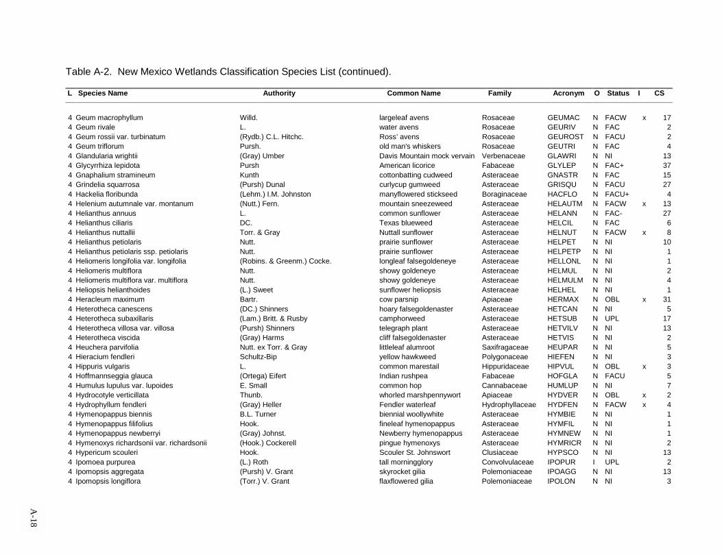
Table A-2. New Mexico Wetlands Classification Species List (continued). L Species Name Authority Common Name Family Acronym O Status I CS
A-18
4 Geum macrophyllum Willd. largeleaf avens Rosaceae GEUMAC N FACW x 174 Geum rivale L. water avens Rosaceae GEURIV N FAC 24 Geum rossii var. turbinatum (Rydb.) C.L. Hitchc. Ross’ avens Rosaceae GEUROST N FACU 24 Geum triflorum Pursh. old man's whiskers Rosaceae GEUTRI N FAC 44 Glandularia wrightii (Gray) Umber Davis Mountain mock vervain Verbenaceae GLAWRI N NI 134 Glycyrrhiza lepidota Pursh American licorice Fabaceae GLYLEP N FAC+ 374 Gnaphalium stramineum Kunth cottonbatting cudweed Asteraceae GNASTR N FAC 154 Grindelia squarrosa (Pursh) Dunal curlycup gumweed Asteraceae GRISQU N FACU 274 Hackelia floribunda (Lehm.) I.M. Johnston manyflowered stickseed Boraginaceae HACFLO N FACU+ 44 Helenium autumnale var. montanum (Nutt.) Fern. mountain sneezeweed Asteraceae HELAUTM N FACW x 134 Helianthus annuus L. common sunflower Asteraceae HELANN N FAC- 274 Helianthus ciliaris DC. Texas blueweed Asteraceae HELCIL N FAC 64 Helianthus nuttallii Torr. & Gray Nuttall sunflower Asteraceae HELNUT N FACW x 84 Helianthus petiolaris Nutt. prairie sunflower Asteraceae HELPET N NI 104 Helianthus petiolaris ssp. petiolaris Nutt. prairie sunflower Asteraceae HELPETP N NI 14 Heliomeris longifolia var. longifolia (Robins. & Greenm.) Cocke. longleaf falsegoldeneye Asteraceae HELLONL N NI 14 Heliomeris multiflora Nutt. showy goldeneye Asteraceae HELMUL N NI 24 Heliomeris multiflora var. multiflora Nutt. showy goldeneye Asteraceae HELMULM N NI 44 Heliopsis helianthoides (L.) Sweet sunflower heliopsis Asteraceae HELHEL N NI 14 Heracleum maximum Bartr. cow parsnip Apiaceae HERMAX N OBL x 314 Heterotheca canescens (DC.) Shinners hoary falsegoldenaster Asteraceae HETCAN N NI 54 Heterotheca subaxillaris (Lam.) Britt. & Rusby camphorweed Asteraceae HETSUB N UPL 174 Heterotheca villosa var. villosa (Pursh) Shinners telegraph plant Asteraceae HETVILV N NI 134 Heterotheca viscida (Gray) Harms cliff falsegoldenaster Asteraceae HETVIS N NI 24 Heuchera parvifolia Nutt. ex Torr. & Gray littleleaf alumroot Saxifragaceae HEUPAR N NI 54 Hieracium fendleri Schultz-Bip yellow hawkweed Polygonaceae HIEFEN N NI 34 Hippuris vulgaris L. common marestail Hippuridaceae HIPVUL N OBL x 34 Hoffmannseggia glauca (Ortega) Eifert Indian rushpea Fabaceae HOFGLA N FACU 54 Humulus lupulus var. lupoides E. Small common hop Cannabaceae HUMLUP N NI 74 Hydrocotyle verticillata Thunb. whorled marshpennywort Apiaceae HYDVER N OBL x 24 Hydrophyllum fendleri (Gray) Heller Fendler waterleaf Hydrophyllaceae HYDFEN N FACW x 44 Hymenopappus biennis B.L. Turner biennial woollywhite Asteraceae HYMBIE N NI 14 Hymenopappus filifolius Hook. fineleaf hymenopappus Asteraceae HYMFIL N NI 14 Hymenopappus newberryi (Gray) Johnst. Newberry hymenopappus Asteraceae HYMNEW N NI 14 Hymenoxys richardsonii var. richardsonii (Hook.) Cockerell pingue hymenoxys Asteraceae HYMRICR N NI 24 Hypericum scouleri Hook. Scouler St. Johnswort Clusiaceae HYPSCO N NI 134 Ipomoea purpurea (L.) Roth tall morningglory Convolvulaceae IPOPUR I UPL 24 Ipomopsis aggregata (Pursh) V. Grant skyrocket gilia Polemoniaceae IPOAGG N NI 134 Ipomopsis longiflora (Torr.) V. Grant flaxflowered gilia Polemoniaceae IPOLON N NI 3

Table A-2. New Mexico Wetlands Classification Species List (continued). L Species Name Authority Common Name Family Acronym O Status I CS
A-19
4 Iris missouriensis Nutt. Rocky Mountain iris Iridaceae IRIMIS N FACW x 164 Iva axillaris Pursh povertyweed Asteraceae IVAAXI N FAC 14 Kochia scoparia L. Schrad common kochia Chenopodiaceae KOCSCO I FAC 24 Lactuca serriola L. prickly lettuce Asteraceae LACSER I FAC 314 Lactuca tartarica var. pulchella (Pursh) Breitung blue lettuce Asteraceae LACTARP N FAC 54 Lappula occidentalis (Gray) Higgens flatspine stickseed Boraginaceae LAPOCC N NI 34 Lathryus eucosmus Butters & St. John bush peavine Fabaceae LATEUC N NI 14 Lathyrus graminifolius (Wats.) White grassleaf peavine Fabaceae LATGRA N NI 24 Lemna minor L. common duckweed Lemnaceae LEMMIN N OBL x 34 Lepidium alyssoides Gray mesa pepperweed Brassicaceae LEPALY N NI 14 Lepidium latifolium L. perennial pepperweed Brassicaceae LEPLAT I FAC 104 Lepidium montanum Nutt. mountain pepperweed Brassicaceae LEPMON N UPL 24 Lesquerella purpurea (Gray) Wats. rose bladderpod Brassicaceae LESPUR N NI 14 Leucanthemum vulgare Lam. oxeyedaisy Asteraceae LEUVUL I NI 224 Ligusticum porteri Coult. & Rose Porter licoriceroot Apiaceae LIGPOR N FAC 184 Limonium limbatum Small Transpecos sealavender Plumbaginaceae LIMLIM N FACW x 24 Linanthus floribundus (Gray) Greene ex Milliken manyflowered deserttrumpets Polemoniaceae LINFLO N NI 14 Linaria vulgaris P. Mill. butter and eggs Scrophulariaceae LINVUL I NI 34 Linum lewisii Pursh prairie flax Linaceae LINLEW N NI 14 Lithospermum multiflorum Torr. ex Gray manyflowered gromwell Boraginaceae LITMUL N NI 14 Lobelia cardinalis L. cardinalflower Campanulaceae LOBCAR N OBL x 54 Lotus wrightii (Gray) Greene Wright deervetch Fabaceae LOTWRI N NI 14 Lupinus argenteus Pursh silvery lupine Fabaceae LUPARG N UPL 44 Lupinus caudatus ssp. cutleri (Eastw.) Hess. & Dunn lupine Fabaceae LUPCAUC N NI 14 Lycopus americanus Muhl. ex Bart. American bugleweed Lamiaceae LYCAME N OBL x 194 Lycopus asper Greene rough bugleweed Lamiaceae LYCASP N OBL x 104 Lythrum californicum Torr. & Gray California loosestrife Lythraceae LYTCAL N OBL x 24 Machaeranthera asteroides (Torr.) Greene New Mexico tansyaster Asteraceae MACAST N NI 14 Machaeranthera biglovii (Gray) Greene Bigelow tansyaster Asteraceae MACBIG N NI 54 Machaeranthera canescens (Pursh) Gray hoary aster Asteraceae MACCAN N FAC 64 Machaeranthera gracilis (Nutt.) Shinners slender goldenweed Asteraceae MACGRA N NI 34 Machaeranthera grindelioides (Nutt.) Shinners rayless aster Asteraceae MACGRI N NI 24 Machaeranthera pinnatifida ssp. pinnatifida var.
pinnatifida (Nutt.) lacy tansyaster Asteraceae MACPINP N NI 1
4 Machaeranthera tanacetifolia (Kunth) Nees tanseyleaf aster Asteraceae MACTAN N NI 24 Macromeria viridiflora DC. giant trumpets Boraginaceae MACVIR N NI 24 Macroptilium gibbosifolium (Ortega) Delgado variableleaf bushbean Fabaceae MACGIB N NI 14 Maianthemum racemosum ssp. amplexicaule (Nutt.) La Frankie feathery false Solomon’s seal Liliaceae MAIRACA N NI 14 Maianthemum stellatum (L.) Link starry false Solomon’s seal Liliaceae MAISTE N FACU 19
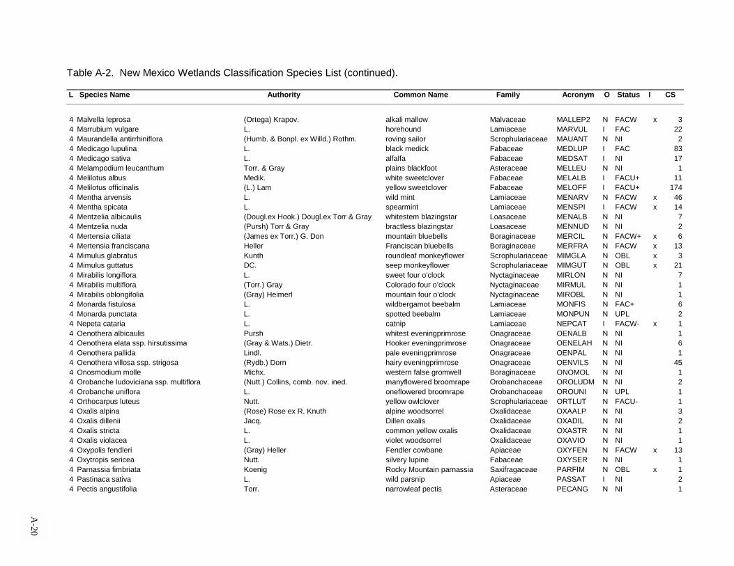
Table A-2. New Mexico Wetlands Classification Species List (continued). L Species Name Authority Common Name Family Acronym O Status I CS
A-20
4 Malvella leprosa (Ortega) Krapov. alkali mallow Malvaceae MALLEP2 N FACW x 34 Marrubium vulgare L. horehound Lamiaceae MARVUL I FAC 224 Maurandella antirrhiniflora (Humb. & Bonpl. ex Willd.) Rothm. roving sailor Scrophulariaceae MAUANT N NI 24 Medicago lupulina L. black medick Fabaceae MEDLUP I FAC 834 Medicago sativa L. alfalfa Fabaceae MEDSAT I NI 174 Melampodium leucanthum Torr. & Gray plains blackfoot Asteraceae MELLEU N NI 14 Melilotus albus Medik. white sweetclover Fabaceae MELALB I FACU+ 114 Melilotus officinalis (L.) Lam yellow sweetclover Fabaceae MELOFF I FACU+ 1744 Mentha arvensis L. wild mint Lamiaceae MENARV N FACW x 464 Mentha spicata L. spearmint Lamiaceae MENSPI I FACW x 144 Mentzelia albicaulis (Dougl.ex Hook.) Dougl.ex Torr & Gray whitestem blazingstar Loasaceae MENALB N NI 74 Mentzelia nuda (Pursh) Torr & Gray bractless blazingstar Loasaceae MENNUD N NI 24 Mertensia ciliata (James ex Torr.) G. Don mountain bluebells Boraginaceae MERCIL N FACW+ x 64 Mertensia franciscana Heller Franciscan bluebells Boraginaceae MERFRA N FACW x 134 Mimulus glabratus Kunth roundleaf monkeyflower Scrophulariaceae MIMGLA N OBL x 34 Mimulus guttatus DC. seep monkeyflower Scrophulariaceae MIMGUT N OBL x 214 Mirabilis longiflora L. sweet four o’clock Nyctaginaceae MIRLON N NI 74 Mirabilis multiflora (Torr.) Gray Colorado four o’clock Nyctaginaceae MIRMUL N NI 14 Mirabilis oblongifolia (Gray) Heimerl mountain four o’clock Nyctaginaceae MIROBL N NI 14 Monarda fistulosa L. wildbergamot beebalm Lamiaceae MONFIS N FAC+ 64 Monarda punctata L. spotted beebalm Lamiaceae MONPUN N UPL 24 Nepeta cataria L. catnip Lamiaceae NEPCAT I FACW- x 14 Oenothera albicaulis Pursh whitest eveningprimrose Onagraceae OENALB N NI 14 Oenothera elata ssp. hirsutissima (Gray & Wats.) Dietr. Hooker eveningprimrose Onagraceae OENELAH N NI 64 Oenothera pallida Lindl. pale eveningprimrose Onagraceae OENPAL N NI 14 Oenothera villosa ssp. strigosa (Rydb.) Dorn hairy eveningprimrose Onagraceae OENVILS N NI 454 Onosmodium molle Michx. western false gromwell Boraginaceae ONOMOL N NI 14 Orobanche ludoviciana ssp. multiflora (Nutt.) Collins, comb. nov. ined. manyflowered broomrape Orobanchaceae OROLUDM N NI 24 Orobanche uniflora L. oneflowered broomrape Orobanchaceae OROUNI N UPL 14 Orthocarpus luteus Nutt. yellow owlclover Scrophulariaceae ORTLUT N FACU- 14 Oxalis alpina (Rose) Rose ex R. Knuth alpine woodsorrel Oxalidaceae OXAALP N NI 34 Oxalis dillenii Jacq. Dillen oxalis Oxalidaceae OXADIL N NI 24 Oxalis stricta L. common yellow oxalis Oxalidaceae OXASTR N NI 14 Oxalis violacea L. violet woodsorrel Oxalidaceae OXAVIO N NI 14 Oxypolis fendleri (Gray) Heller Fendler cowbane Apiaceae OXYFEN N FACW x 134 Oxytropis sericea Nutt. silvery lupine Fabaceae OXYSER N NI 14 Parnassia fimbriata Koenig Rocky Mountain parnassia Saxifragaceae PARFIM N OBL x 14 Pastinaca sativa L. wild parsnip Apiaceae PASSAT I NI 24 Pectis angustifolia Torr. narrowleaf pectis Asteraceae PECANG N NI 1

Table A-2. New Mexico Wetlands Classification Species List (continued). L Species Name Authority Common Name Family Acronym O Status I CS
A-21
4 Pectis filipes Harvey & Gray fivebract cinchweed Asteraceae PECFIL N NI 14 Pedicularis groenlandica Retz. elephanthead lousewort Scrophulariaceae PEDGRO N OBL x 34 Pedicularis procera Gray giant lousewort Scrophulariaceae PEDPRO N FACU 24 Penstemon barbatus (Cav.) Roth. beardlip penstemon Scrophulariaceae PENBAR N NI 194 Penstemon pseudospectabilis Jones desert penstemon Scrophulariaceae PENPSE N NI 54 Penstemon rydbergii A. Nels. Rydberg penstemon Scrophulariaceae PENRYD N FAC 14 Penstemon strictus Benth. beardtongue Scrophulariaceae PENSTR N NI 14 Penstemon whippleanus Gray Whipple penstemon Scrophulariaceae PENWHI N FACU+ 14 Pericome caudata Gray mountain leaftail Asteraceae PERCAU N NI 54 Phacelia congesta Hook. caterpillars Hydrophyllaceae PHACON N NI 14 Phlox nana Nutt. Santa Fe phlox Polemoniaceae PHLNAN N NI 14 Phyla cuneifolia (Torr.) Greene frogfruit Verbenaceae PHYCUN N FACW x 24 Phyla lanceolata (Michx.) Greene lanceleaf frogfruit Verbenaceae PHYLAN N OBL x 44 Physalis heterophylla Nees clammy groundcherry Solanaceae PHYHET N NI 14 Physalis virginiana Mill. Virginia groundcherry Solanaceae PHYVIR N NI 24 Phytolacca americana L. pokeweed Phytolaccaceae PHYAME N FACU 14 Picradeniopsis oppositifolia (Nutt.) Rydb. ex Britt. oppositeleaf bahia Asteraceae PICOPP N NI 24 Plantago lanceolata L. English plantain Plantaginaceae PLALAN I FAC 224 Plantago major L. common plantain Plantaginaceae PLAMAJ I FACW x 774 Plantago patagonica Jacq. woolly plantain Plantaginaceae PLAPAT N UPL 14 Platanthera hyperborea var. hyperborea (L.) Lindl. northern green orchid Orchidaceae PLAHYPH N FACW x 64 Platanthera sparsiflora var. sparsiflora (Wats.) Schlechter canyon bog orchid Orchidaceae PLASPAS N FACW x 34 Pluchea odorata var. odorata (L.) Cass. sweetscent Asteraceae PLUODOO N FACW+ x 14 Polanisia dodecandra ssp. trachysperma (Torr. & Gray) Iltis sandyseed clammyweed Capparidaceae POLDODT N FACU- 14 Polemonium foliosissimum Gray towering Jacob’s ladder Polemoniaceae POLFOL N FAC 24 Polygala alba Nutt. white milkwort Polygalaceae POLALB N NI 34 Polygonum amphibium L. water knotweed Polygonaceae POLAMP N OBL x 44 Polygonum amphibium var. emersum Michx. longroot smartweed Polygonaceae POLAMPE N OBL x 14 Polygonum aviculare L. prostrate knotweed Polygonaceae POLAVI I FACW x 24 Polygonum convolvulus L. black bindweed Convolvulaceae POLCON I FACU- 14 Polygonum douglasii Greene Douglas’ knotweed Polygonaceae POLDOU N UPL 14 Polygonum lapathifolium L. curlytop knotweed Polygonaceae POLLAP N OBL x 364 Polygonum persicaria L. Lady’s thumb Polygonaceae POLPER I FACW+ x 94 Portulaca oleracea L. common purslane Portulacaceae POROLE I FAC 44 Potamogeton crispus L. curly pondweed Potamogetonacea POTCRI I OBL x 14 Potentilla diversifolia Lehm. varileaf cinquefoil Rosaceae POTDIV N FACW x 14 Potentilla hippiana Lehm. woolly cinquefoil Rosaceae POTHIP N NI 124 Potentilla norvegica L. Norwegian cinquefoil Rosaceae POTNOR N FAC 84 Potentilla pulcherrima Lehm. beautiful cinquefoil Rosaceae POTPUL N NI 19

Table A-2. New Mexico Wetlands Classification Species List (continued). L Species Name Authority Common Name Family Acronym O Status I CS
A-22
4 Potentilla rivalis var. rivalis Nutt. brook cinquefoil Rosaceae POTRIVR N OBL 24 Potentilla thurberi Gray scarlet cinquefoil Rosaceae POTTHU N FACW+ x 14 Proboscidea parviflora (Woot.) Woot. & Standl. doubleclaw Pedaliaceae PROPAR N NI 14 Prunella vulgaris L. common selfheal Lamiaceae PRUVUL N FACW- x 294 Pseudocymopterus montanus (Gray) Coult. & Rose alpine false springparsley Apiaceae PSEMON N NI 34 Pseudostellaria jamesiana (Torr.) Weber & Hartman tuber starwort Caryophyllaceae PSEJAM N NI 14 Psilostrophe tagetina (Nutt.) Greene woolly paperflower Asteraceae PSITAG N NI 24 Psilostrophe tagetina var. tagetina (Nutt.) Greene woolly paperflower Asteraceae PSITAGT N NI 14 Pteridium aquilinum (L.) Kuhn. western brackenfern Dennstaestiaceae PTEAQU N FACU 34 Pterospora andromedea Nutt. woodland pinedrops Monotropaceae PTEAND N NI 14 Pyrrhopappus pauciflorus (D. Don) DC. desert chicory Asteraceae PYRPAU N NI 34 Ranunculus aquatilis L. whitewater crowfoot Ranunculaceae RANAQU N OBL x 104 Ranunculus cymbalaria Pursh alkali buttercup Ranunculaceae RANCYM N OBL x 234 Ranunculus flammula L. spearwort buttercup Ranunculaceae RANFLA N FACW x 14 Ranunculus inamoenus Greene graceful buttercup Ranunculaceae RANINA N FACW x 44 Ranunculus macranthus Scheele large buttercup Ranunculaceae RANMAC N FACW x 34 Ranunculus scleratus L. celeryleaf buttercup Ranunculaceae RANSCL N OBL x 14 Ratibida columnifera (Nutt.) Woot. & Standl. upright prairie coneflower Asteraceae RATCOL N NI 154 Ratibida tagetes (James) Barnh. green prairie coneflower Asteraceae RATTAG N NI 134 Reverchonia arenaria Gray sand reverchonia Euphorbiaceae REVARE N NI 14 Rorippa nasturtium-aquaticum (L.) Hayek watercress Brassicaceae RORNASA I OBL x 194 Rorippa sinuata (Nutt.) Hitchc. spreading yellowcress Brassicaceae RORSIN N FACW x 54 Rorippa sphaerocarpa (Gray) Britt. roundfruit yellowcress Brassicaceae RORSPH N OBL x 44 Rubus parviflorus Nutt. thimbleberry Rosaceae RUBPAR N FAC 54 Rudbeckia hirta L. black-eyed Susan Asteraceae RUDHIR N FACU 114 Rudbeckia laciniata L. cutleaf coneflower Asteraceae RUDLAC N FACW- x 704 Rumex acetosella L. common sheep sorrel Polygonaceae RUMACE I FACW x 254 Rumex altissimus Wood pale dock Polygonaceae RUMALT N FAC+ 94 Rumex crispus L. curly dock Polygonaceae RUMCRI I FACW x 414 Rumex maritimus L. golden dock Polygonaceae RUMMAR N FACW x 24 Rumex salicifolius Weinm. willow dock Polygonaceae RUMSAL N FACW x 74 Rumex verticillatus L. swamp dock Polygonaceae RUMVER N FACW x 14 Sagitaria cuneata Sheldon hooded arrowhead Alismataceae SAGCUN N OBL x 34 Salsola kali L. prickly Russian thistle Chenopodiaceae SALKAL I FACU 304 Salvia farinacea Benth. mealycup sage Lamiaceae SALFAR N NI 14 Salvia reflexa Hornem. lanceleaf sage Lamiaceae SALREF N NI 44 Salvia subincisa Benth. sawtooth sage Lamiaceae SALSUB N NI 34 Samolus ebracteatus ssp. cuneatus (Small) R. Kunth limewater brookweed Primulaceae SAMEBRC N OBL x 14 Sarcocornia utahensis (Tides.) A.J. Scott Utah glasswort Chenopodiaceae SARUTA N FACW x 2

Table A-2. New Mexico Wetlands Classification Species List (continued). L Species Name Authority Common Name Family Acronym O Status I CS
A-23
4 Sarcostemma cynanchoides ssp. cynanchoides Dcne. fringed twinevine Asclepiadaceae SARCYNC N FAC- 14 Saxifraga odontoloma Piper brook saxifrage Saxifragaceae SAXODO N FACW- x 24 Schistophragma intermedia (Gray) Pennell harlequin spiralseed Scrophulariaceae SCHINT N NI 14 Schoenocrambe linearifolia (Gray) Rollins slimleaf plainsmustard Brassicaceae SCHLIN N NI 34 Scrophularia parviflora Woot. & Standl. pineland figwort Scrophulariaceae SCRPAR N NI 14 Scutellaria galericulata L. hooded skullcap Lamiaceae SCUGAL N OBL x 14 Scutellaria tessellata Epling Huachuca Mountain skullcap Lamiaceae SCUTES N NI 14 Sedum rhodanthum Gray rose crown Crassulaceae SEDRHO N FAC- 34 Senecio bigloviii Gray nodding ragwort Asteraceae SENBIG N NI 14 Senecio fendleri Gray Fendler ragwort Asteraceae SENFEN N NI 54 Senecio flaccidus Less. threadleaf ragwort Asteraceae SENFLA N NI 14 Senecio flaccidus var. douglasii (DC.) B.L. Turner & T.M. Barkl. Douglas groundsel Asteraceae SENFLAD N NI 24 Senecio multicapitatus Greenem. ex Rydb. ragwort groundsel Asteraceae SENMUL N NI 24 Senecio neomexicanus Gray New Mexico groundsel Asteraceae SENNEO N NI 14 Senecio sanguisorboides Rydb. burnet ragwort Asteraceae SENSAN N NI 74 Senecio spartioides Torr. & Gray broom groundsel Asteraceae SENSPA N NI 14 Senecio triangularis Hook. arrowleaf triangularis Asteraceae SENTRI N OBL x 24 Senecio wootonii Greene Wooton ragwort Asteraceae SENWOO N NI 14 Senna roemeriana (Scheele) Irwin & Barneby twoleaf wild sensitive plant Fabaceae SENROE N NI 14 Sidalacea candida Gray white checkermallow Malvaceae SIDCAN N FAC 144 Sidalcea neomexicana Gray New Mexico checkermallow Malvaceae SIDNEO N FACW x 34 Silene laciniata Cav. Mexican campion Caryophyllaceae SILLAC N NI 14 Silene noctiflora L. nightflowering catchfly Caryophyllaceae SILNOC I NI 14 Silene scouleri ssp. pringlei (Wats.) Hitchc. & Maguire Scouler campion Caryophyllaceae SILSCOP N NI 44 Sisymbrium altissimum L. tall tumblemustard Brassicaceae SISALT I FAC 14 Sisymbrium irio L. Londonrocket Brassicaceae SISIRI I NI 14 Sisyrinchium demissum Greene dwarf blueeyed grass Iridaceae SISDEM N OBL x 34 Sisyrinchium montanum Greene mountain blueeyed grass Iridaceae SISMON N FACW x 114 Solanum elaeagnifolium Cav. silverleaf nightshade Solanaceae SOLELA N NI 174 Solanum ptychanthum Dunal nightshade Solanaceae SOLPTY N FAC 34 Solanum rostratum Dunal buffalobur nightshade Solanaceae SOLROS N NI 44 Solidago canadensis L. Canada goldenrod Asteraceae SOLCAN N FACU 494 Solidago nemoralis var. decemflora (DC.) Fern. goldenrod Asteraceae SOLNEMD N NI 14 Solidago rigida L. stiff goldenrod Asteraceae SOLRIG N FACU 24 Solidago velutina DC. threenerve goldenrod Asteraceae SOLVEL N NI 24 Sonchus arvensis (Britt. ex Arsene) G.N. Jones field sowthistle Asteraceae SONARV I FACU 154 Sonchus asper (L.) Hill spiny sowthistle Asteraceae SONASP I FACW x 124 Sonchus oleraceus L. common sowthistle Asteraceae SONOLE I UPL 34 Sparganium angustifolium Michx. narrowleaf burreed Sparganiaceae SPAANG N OBL x 1

Table A-2. New Mexico Wetlands Classification Species List (continued). L Species Name Authority Common Name Family Acronym O Status I CS
A-24
4 Sphaeralcea angustifolia (Cav.) G. Don copper globemallow Malvaceae SPHANG N NI 14 Sphaeralcea coccinea (Nutt.) Rydb. scarlet globemallow Malvaceae SPHCOC N NI 24 Sphaeralcea fendleri Gray Fendler globemallow Malvaceae SPHFEN N NI 304 Spiranthes romanzoffiana Cham. hooded ladies tresses Orchidaceae SPIROM N OBL x 14 Stachys coccinea Jacq. scarlet hedgenettle Lamiaceae STACOC N NI 14 Stachys palustris ssp. pilosa (Nutt.) Epling marsh hedgenettle Lamiaceae STAPALP N NI 14 Stanleya pinnata (Pursh) Britt. desert princesplume Brassicaceae STAPIN N NI 14 Stellaria longifolia Muhl. ex Willd. longleaf starwort Caryophyllaceae STELON1 N FAC 24 Stellaria longipes Goldie longstalk starwort Caryophyllaceae STELON2 N FACW x 24 Stellaria media (L.) Vill. common chickweed Caryophyllaceae STEMED I UPL 24 Stenactis strigosus (Muhl.) de Candolle daisy fleabane Asteraceae STESTR N NI 14 Streptanthella longirostris (S. Wats.) Rydb. longbeak streptanthella Brassicaceae STRLON N NI 14 Taraxacum officinale G.H. Weber ex Wiggers common dandelion Asteraceae TAROFF N FACU 704 Tetraneuris argentea (Gray) Greene perkysue Asteraceae TETARG N NI 14 Teucrium canadense L. Canada germander Lamiaceae TEUCAN N FACW x 14 Thalictrum alpinum L. alpine meadowrue Ranunculaceae THAALP N FACW x 14 Thalictrum fendleri Engelm. ex Gray Fendler meadowrue Ranunculaceae THAFEN N FACU- 454 Thelesperma megapotamicum (Spreng.) Kuntze Hopi tea greenthread Asteraceae THEMEG N NI 54 Thermopsis rhombifolia var. montana (Nutt.) Isely mountain thermopsis Fabaceae THERHOM N NI 94 Thlaspi arvense L. field pennycress Brassicaceae THLARV I UPL 44 Townsendia eximia Gray tall townsendia Asteraceae TOWEXI N NI 14 Tradescantia occidentalis (Britt.) Symth prairie spiderwort Commelinaceae TRAOCC N FACU 24 Tragopogon dubius Scpo. yellow salsify Asteraceae TRADUB I NI 24 Tragopogon pratensis L. meadow salsify Asteraceae TRAPRA I NI 344 Tribulus terrestris L. goathead Zygophyllaceae TRITER I NI 14 Trichostema arizonicum Gray Arizona bluecurls Lamiaceae TRIARI N NI 14 Trifolium fragiferum L. strawberry clover Fabaceae TRIFRA I NI 34 Trifolium hybridum L. alsike clover Fabaceae TRIHYB I FAC 14 Trifolium pratense L. red clover Fabaceae TRIPRA I FACU 314 Trifolium repens L. white clover Fabaceae TRIREP I FACU 754 Tripterocalyx carnea var. wootonii (Standl.) L.A. Gal. Wooton sandpuffs Nyctaginaceae TRICARW N NI 14 Typha latifolia L. broadleaf cattail Typhaceae TYPLAT N OBL x 534 Urtica doica L. stinging nettle Urticaceae URTDIO N NI 84 Urtica gracilenta Greene mountain nettle Urticaceae URTGRA N NI 74 Utricularia macrorhiza Le Conte common bladderwort Lentibulariaceae UTRMAC N OBL x 24 Vaccinium myrtillus L. whortleberry Ericaceae VACMYR N UPL 34 Valeriana edulis Nutt. ex Torr. & Gray edible valerian Valerianaceae VALEDU N FAC 14 Veratrum californicum Dur. Calif. false hellebore Liliaceae VERCAL N OBL x 34 Verbascum thapsus L. common mullein Scrophulariaceae VERTHA I NI 94

Table A-2. New Mexico Wetlands Classification Species List (continued). L Species Name Authority Common Name Family Acronym O Status I CS
A-25
4 Verbena bracteata Lag. & Rodr. bigbract verbena Verbenaceae VERBRA N FAC 54 Verbena macdougalii Heller MacDougal verbena Verbenaceae VERMAC N FACU- 134 Verbena perennis Woot. pinleaf vervain Verbenaceae VERPER N NI 14 Verbena scabra Vahl sandpaper vervain Verbenaceae VERSCA N OBL x 34 Verbesina encelioides (Cav.) Benth. & Hook. f. ex Gray golden crownbeard Asteraceae VERENC N FAC 94 Veronica americana Schwein. ex Benth. American speedwell Scrophulariaceae VERAME N OBL x 234 Veronica anagallis-aquatica L. water speedwell Scrophulariaceae VERANAA N OBL x 144 Vicia americana Muhl. ex Willd. American vetch Fabaceae VICAME N FACU 244 Viola canadensis L. Canadian white violet Violaceae VIOCAN N NI 174 Viola missouriensis Greene Missouri violet Violaceae VIOMIS N FACW+ x 44 Viola nephrophylla var. arizonica (Greene) Kearney & Peebles Arizona bog violet Violaceae VIONEPA N NI 14 Vitis vulpina L. frost grape Vitaceae VITVUL N FAC 14 Wyethia scabra Hook. badlands wyethia Asteraceae WYESCA N UPL 24 Xanthium strumarium L. rough cocklebur Asteraceae XANSTR N FAC 974 Zannichellia palustris L. horned pondweed Zannichelliaceae ZANPAL N OBL x 1
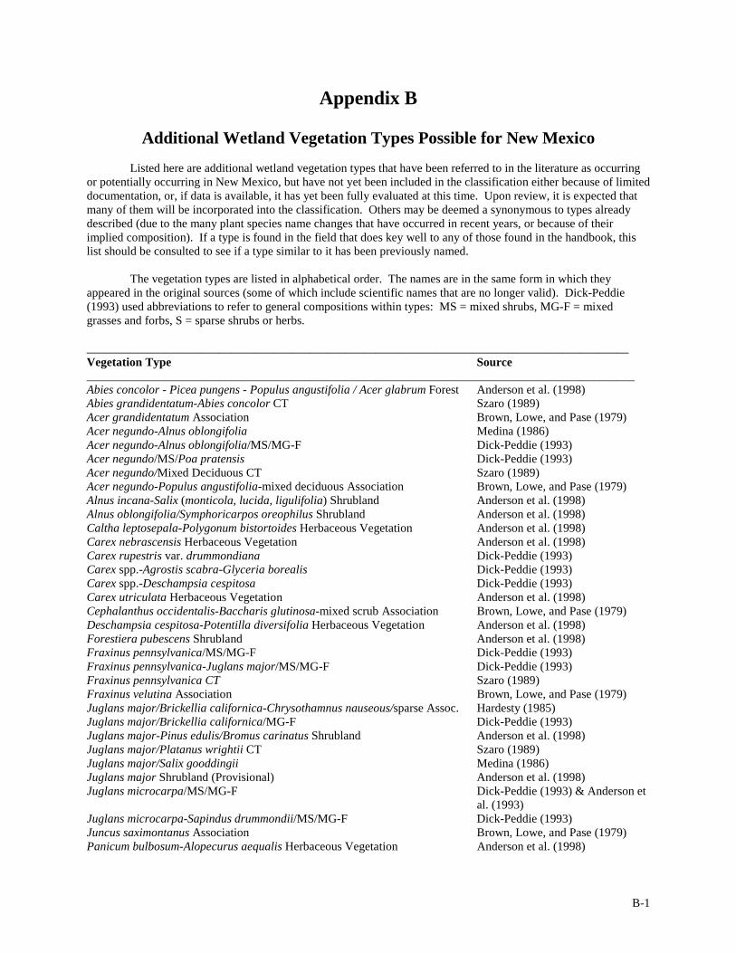
B-1
Appendix B
Additional Wetland Vegetation Types Possible for New Mexico Listed here are additional wetland vegetation types that have been referred to in the literature as occurring or potentially occurring in New Mexico, but have not yet been included in the classification either because of limited documentation, or, if data is available, it has yet been fully evaluated at this time. Upon review, it is expected that many of them will be incorporated into the classification. Others may be deemed a synonymous to types already described (due to the many plant species name changes that have occurred in recent years, or because of their implied composition). If a type is found in the field that does key well to any of those found in the handbook, this list should be consulted to see if a type similar to it has been previously named. The vegetation types are listed in alphabetical order. The names are in the same form in which they appeared in the original sources (some of which include scientific names that are no longer valid). Dick-Peddie (1993) used abbreviations to refer to general compositions within types: MS = mixed shrubs, MG-F = mixed grasses and forbs, S = sparse shrubs or herbs. __________________________________________________________________________________________ Vegetation Type Source ___________________________________________________________________________________________ Abies concolor - Picea pungens - Populus angustifolia / Acer glabrum Forest Anderson et al. (1998) Abies grandidentatum-Abies concolor CT Szaro (1989) Acer grandidentatum Association Brown, Lowe, and Pase (1979) Acer negundo-Alnus oblongifolia Medina (1986) Acer negundo-Alnus oblongifolia/MS/MG-F Dick-Peddie (1993) Acer negundo/MS/Poa pratensis Dick-Peddie (1993) Acer negundo/Mixed Deciduous CT Szaro (1989) Acer negundo-Populus angustifolia-mixed deciduous Association Brown, Lowe, and Pase (1979) Alnus incana-Salix (monticola, lucida, ligulifolia) Shrubland Anderson et al. (1998) Alnus oblongifolia/Symphoricarpos oreophilus Shrubland Anderson et al. (1998) Caltha leptosepala-Polygonum bistortoides Herbaceous Vegetation Anderson et al. (1998) Carex nebrascensis Herbaceous Vegetation Anderson et al. (1998) Carex rupestris var. drummondiana Dick-Peddie (1993) Carex spp.-Agrostis scabra-Glyceria borealis Dick-Peddie (1993) Carex spp.-Deschampsia cespitosa Dick-Peddie (1993) Carex utriculata Herbaceous Vegetation Anderson et al. (1998) Cephalanthus occidentalis-Baccharis glutinosa-mixed scrub Association Brown, Lowe, and Pase (1979) Deschampsia cespitosa-Potentilla diversifolia Herbaceous Vegetation Anderson et al. (1998) Forestiera pubescens Shrubland Anderson et al. (1998) Fraxinus pennsylvanica/MS/MG-F Dick-Peddie (1993) Fraxinus pennsylvanica-Juglans major/MS/MG-F Dick-Peddie (1993) Fraxinus pennsylvanica CT Szaro (1989) Fraxinus velutina Association Brown, Lowe, and Pase (1979) Juglans major/Brickellia californica-Chrysothamnus nauseous/sparse Assoc. Hardesty (1985) Juglans major/Brickellia californica/MG-F Dick-Peddie (1993) Juglans major-Pinus edulis/Bromus carinatus Shrubland Anderson et al. (1998) Juglans major/Platanus wrightii CT Szaro (1989) Juglans major/Salix gooddingii Medina (1986) Juglans major Shrubland (Provisional) Anderson et al. (1998) Juglans microcarpa/MS/MG-F Dick-Peddie (1993) & Anderson et al. (1993) Juglans microcarpa-Sapindus drummondii/MS/MG-F Dick-Peddie (1993) Juncus saximontanus Association Brown, Lowe, and Pase (1979) Panicum bulbosum-Alopecurus aequalis Herbaceous Vegetation Anderson et al. (1998)

B-2
Appendix B. Miscellaneous Vegetation Types for New Mexico (Continued) __________________________________________________________________________________________ Vegetation Type Source ___________________________________________________________________________________________ Panicum bulbosum-Lycurus phleoides Herbaceous Vegetation Anderson et al. (1998) Panicum obtusum-Panicum hallii Herbaceous Vegetation Anderson et al. (1998) Panicum obtusum-Panicum hirsutum Herbaceous Vegetation Anderson et al. (1998) Picea engelmannii/Heracleum maximum Forest Anderson et al. (1998) Picea pungens/Amelanchier alnifolia-Cornus sericea Forest Anderson et al. (1998) Picea pungens/Cornus sericea Woodland Anderson et al. (1998) Picea pungens/Cornus stolonifera/MG-F Dick-Peddie (1993) Platanus wrightii-Fraxinus velutina Forest Anderson et al. (1998) Platanus wrightii-Fraxinus velutina-Populus fremontii-mixed deciduous Association Brown, Lowe, and Pase (1979) Platanus wrightii-Fraxinus pennsylvanica CT Szaro (1989) Platanus wrightii-Juglans major Forest Anderson et al. (1998) Populus acuminata/MS/MG-F Dick-Peddie (1993) & Brown, Lowe, and Pase (1979) Populus acuminata/Salix exigua Medina (1986) Populus acuminata-Populus fremontii/MS/MG-F Dick-Peddie (1993) Populus angustifolia-Acer negundo/MS/MG-F Dick-Peddie (1993) Populus angustifolia-Alnus oblongifolia-Acer negundo/MS/MG-F Dick-Peddie (1993) Populus angustifolia/Cornus sericea Woodland Anderson et al. (1998) Populus angustifolia-Juglans major/MS/MG-F Dick-Peddie (1993) Populus angustifolia-Juniperus deppeana/Brickellia californica Woodland Freeman & Dick-Peddie (1970) Populus angustifolia-Juniperus scopulorum Woodland Anderson et al. (1998) Populus angustifolia-Pinus ponderosa Woodland Anderson et al. (1998) Populus angustifolia-Populus fremontii/MS/MG-F Dick-Peddie (1993) Populus angustifolia/Prunus serotina/Salix bonplandiana CT Medina (1996) Populus deltoides ssp. wislizeni/Baccharis sarothroides Forest Anderson et al. (1998) Populus deltoides ssp. wislizeni/Muhlenbergia asperifolia Forest Anderson et al. (1998) Populus deltoides ssp. wislizeni/Rhus trilobata Woodland Anderson et al. (1998) Populus fremontii/Acer negundo Forest Anderson et al. (1998) Populus fremontii-Celtis reticulata/MS/MG-F Dick-Peddie (1993) Populus fremontii-Celtis laevigata var. reticulata/Salvia pinguifolia Forest Anderson et al. (1998) Populus fremontii/Forestiera neomexicana/MG-F Dick-Peddie (1993) Populus fremontii-Fraxinus pennsylvanica CT Szaro (1989) Populus fremontii-Fraxinus pennsylvanica-Salix gooddingii/MS/S Dick-Peddie (1993) Populus fremontii-Platanus wrightii-Celtis reticulata/Baccharis glutinosa/MG-F Dick-Peddie (1993) Populus fremontii-Platanus wrightii-Juglans major/MS/MG-F Dick-Peddie (1993) Populus fremontii-Platanus wrightii-Salix gooddingii/MS/MG-F Dick-Peddie (1993) Populus fremontii-Prosopis pubescens/MS/MG-F Dick-Peddie (1993) Populus fremontii/Salix exigua Forest Anderson et al. (1998) Populus fremontii-Salix gooddingii Woodland Anderson et al. (1998) Populus fremontii-Salix gooddingii-Juglans major/MS/MG-F Dick-Peddie (1993) Populus fremontii-Salix gooddingii/Prosopis pubescens/MG-F Dick-Peddie (1993) Populus tremuloides/MS/MG-F Dick-Peddie (1993) Populus tremuloides-Acer grandidentatum/MS/MG Dick-Peddie (1993) Populus tremuloides Canyon Formation Forest Anderson et al. (1998) Populus tremuloides/Quercus gambelii/Symphoricarpos oreophilus Forest Anderson et al. (1998) Prosopis glandulosa/Atriplex canescens/MF Dick-Peddie (1993) Prosopis glandulosa/MS/MG-F Dick-Peddie (1993) Rhus trilobata-Prunus serotina Shrubland Anderson et al. (1998) Salix amygdaloides/MS/MG-F Dick-Peddie (1993)
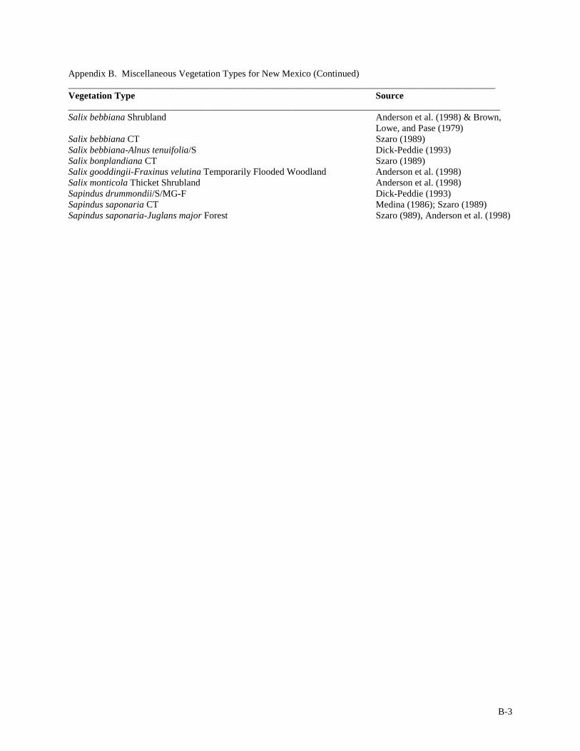
B-3
Appendix B. Miscellaneous Vegetation Types for New Mexico (Continued) __________________________________________________________________________________________ Vegetation Type Source ___________________________________________________________________________________________ Salix bebbiana Shrubland Anderson et al. (1998) & Brown, Lowe, and Pase (1979) Salix bebbiana CT Szaro (1989) Salix bebbiana-Alnus tenuifolia/S Dick-Peddie (1993) Salix bonplandiana CT Szaro (1989) Salix gooddingii-Fraxinus velutina Temporarily Flooded Woodland Anderson et al. (1998) Salix monticola Thicket Shrubland Anderson et al. (1998) Sapindus drummondii/S/MG-F Dick-Peddie (1993) Sapindus saponaria CT Medina (1986); Szaro (1989) Sapindus saponaria-Juglans major Forest Szaro (989), Anderson et al. (1998)

C-1
APPENDIX C
New Mexico Wetland Vegetation Community Classification Updates The wetland vegetation community types are used in the wetlands conservation planning process to summarize overall plant biodiversity at a site. Hence, as complete and comprehensive a community classification as possible will help insure that no element of biodiversity is inadvertently overlooked. In the classification presented above we expect that there are community types that are either under-documented or missing. To address these gaps and further develop the classification and associated reference site database, we need the help of both the scientific and lay communities. In particular, information is needed on community types listed as either “provisional,” or those needing confirmation (see Appendix B), newly identified or overlooked. In addition, information is welcome on exemplary examples of established types. As an aid to this process, we have provided two forms that can be used to submit information to the New Mexico Natural Heritage Program (NMNHP). The use of these forms is optional; similar data submitted in another form is welcome. The forms focus on the description sites (Site Summary Form) and the individual occurrences of communities at those sites (Plant Community Description Form). The Site Summary Form outlines the overall character of a site, and includes a list of community types that are present and their quality. Typically, a "site" is defined by hydrological and landscape features such as a reach of river with a more or less uniform gradient and channel characteristics, or an isolated wetland fed by a hillslope spring. Within a site there are occurrences of one or more community type, e.g., a site might contain an occurrence of the Plains Cottonwood/Coyote Willow Community Type as represented by a grove of trees or set of groves that occur on low terraces along the river, and the site might also contain a Broadleaf Cattail/Threesquare Bulrush occurrence in a back channel area. In this type of situation, the Plant Community Description Form can be used to provide detailed information of plant composition and stand condition of typical stands at a site. Photos can also enhance a description significantly and are welcome. To include them in the photo database it is helpful to have information on photographer, location, date, and the subject of the photo (e.g., "looking N across bulrush wetland"). The data and photos will then be used as the basis for detailed site and community type descriptions and updates. To ensure timely and effective use of the classification for everyone, updates will be periodically posted by NMNHP to the Web (http://nmnhp.unm.edu), along with acknowledgements. We appreciate the time and effort it takes to make a contribution to the database, and we would like to sincerely thank collaborators in this effort to enhance our understanding of the state's wetland resources. Please return completed forms or other information to: New Mexico Natural Heritage Program Biology Department University of New Mexico Albuquerque, NM 87131 ATTN: Data Management If you have any questions or comments, please contact us at the address above, or at our web page at http://nmnhp.unm.edu.

C-2
New Mexico Wetland Vegetation Community Classification Update
Instructions and Forms Site Summary Form This is a summary form to give general information on the data collector(s), site location, listing of the community types encountered, and their status. Only one Site Summary Form needs to be submitted for each general area with its list of target plant community types. There are no "required" fields, but the more information provided the better the development and updating of community type descriptions. When detailed information and data is available on the individual target community types listed here, please either complete the supplemental “Plant Community Description Data Form" or attach a copy of your data to this form. Data Fields Name(s): Include the name of the contact person, and others involved in collecting the data. Date: Date the form was completed. Site Name: Assign each site a unique name. Try to use the a generally accepted name from previous work, a local place name, or a name based on a feature on a topographic map. Do not use alliance or community type names in the site name. Also, please avoid names that are too generalized such as “Spring Site” or “Flat Top Mountain.” Good examples: “Upper Rio Grande at Embudo Station,” “Animas Canyon Main Spring.” Date Last Visited: Please include the last date when information was collected at the site. Survey Location/Directions: Provide directions to the site. Please try to be as specific as possible, giving mileage estimates and names of roads or trails used to access the area. When applicable describe landmarks. USGS Quad Name: If you have located the site on a USGS topographic quadrangle map or other standard map, please include the name of map sheet. If possible, give the Township, Range and Section location information from the Public Land Survey System (PLSS) on the maps. For example: Township 21N, Range 2E, the SE ¼ of the SE ¼ of Section 13. Alternatively, use UTM's (see UTM below). UTM/LAT/LONG: As an alternative to the PLSS (see above) enter the Northing and Easting UTM coordinates and Zone, or Latitude and Longitude, either from a topographic map or from a GPS. Accuracy: Indicate the level of accuracy in the UTM or Lat/Long locational data. High accuracy is within 30 meters and usually determined by a differential GPS. Second (") accuracy is mappable within a three-second radius or 100 meters. Minute (') accuracy is mappable within a one-minute radius (approximately two kilometers or one mile). General accuracy is mappable to quad or place name precision only (precision within about 8 km or 5 miles). Ownership: Indicate if the site is private or public, and which agency and administrative unit is responsible for management. Current Management/Landuse: Indicate what type of management and landuse is occurring on the site, such as multiple use with fuelwood utilization, wilderness with grazing, protected research natural area, recreation/fishing area, etc. Plant Communities: List each community type you encountered at this site. When data is available, please attach a “Plant Community Description Data Form,” or copies of data sheets for each community type listed. Enter the names in the boxes and indicate the size, condition and landscape context. Size of Occurrence: Estimate the size of the area covered by each element occurrence. Please be sure to indicate the

C-3
units such as hectares or acres. Alternatively, indicate if the occurrence is Very Large, Large, Moderate, or Small relative to other known, viable examples of the type. Condition: Status with respect to composition, structure, biotic interactions within the occurrence, e.g. diversity, exotics, disease, use impacts, etc. (E = Excellent, G = Good, F = Fair, P = Poor). Context: Status of landscape-level pattern and processes, e.g. fire regimes, hydrology, fragmentation, etc. (E = Excellent, G = Good, F = Fair, P = Poor). Data (Y/N): Are there vegetation data available for the community type at the site? Sketch Map: On the back of the form is a block for a sketch map to help locate and describe the site. Additional details on patterns of community types are welcome (the reference numbers from community type list can be used as a shorthand). Alternatively, a USGS topographic map can be used as a base and the boundaries of the site and locations of elements mapped directly onto a the quadrangle map, and a photocopy of the map then attached. Comments: Please include any additional comments you think are important. This can include information on site impacts, and general conditions and issues in the watershed. Plant Community Description Data Form This form can be used to provide detailed descriptions of the target community types listed on the Site Summary Form. If similar data is available in another format, either in hard copy or digital, feel free to attach it instead. Date Fields Surveyor Name, Site Name: Please use the same names and site as on the Site Summary Form. Survey Date: Day the data were taken on. Vegetation Community Type: Cross reference the name to the Summary Form list. Ref. No.: Enter reference number from community type list on the Summary Form, if available Criteria for naming the type: Did this occurrence key out to a vegetation community type described in this manual? Indicate “Yes” or “No.” If no, please indicate the source for the name, such as other literature or if it is your own assignment based specific characteristics. Occurrence Size: Estimate the size of the occurrence at the site (as defined in the Site Summary) in either acres or hectares. Photos: Indicate if ground photos were taken of the occurrence and their availability. Also indicate if aerial photography was used. Vegetation Description: Indicate the dominants, common associates, structure and overall character of the occurrence. Hydrology: Comment on hydrological features; estimates flooding frequency; diversions, inpoundments not listed in the Site Summary. Elevation: Include the units such as meters or feet. Aspect: Enter the azimuth (0-360 degrees) of the slope aspect, or the downstream direction. If an azimuth was not measured, estimate the general slope aspect using cardinal directions (N, NW, etc.).

C-4
Slope: Enter the angle of the slope, or stream gradient in percent. If not measured, provide a general estimate such as none, low (gentle), moderate or steep. Geology/Soils: Describe the dominant surface rock or soil type. Examples of general rock types are “igneous ” (e.g., granite), or "metamorphic" (e.g., schist), or "sedimentary " (e.g., sandstone). More detailed answers might include names such as “quartz monzonite” or “biotite schist." If the site is composed primarily of sediments, indicate the texture such as sandy, loamy, clay, etc. or other soil characteristics. Topography: Describe the general geomorphology and topography of the site, e.g., streamside bar, terrace, pond or depression, backwater channel, etc. Disturbances: Describe disturbances both natural and otherwise. Include information on their extent, intensity and time frame. For example, discuss livestock grazing utilization and impacts; the number of roads in the area and their distance relative to the element occurrence; logging and fuelwood cutting; building and obstructions. Indicate degree of fragmentation, i.e., reduced patch size and corridors. Fire: Describe any indications of fire history, such as presence of charred material or trees with multiple fire scars. Include knowledge of previous fires in the area. Comment on potential fire factors including fuels and potential for ignition. Adjacent community types/patterns on landscape: Indicate surrounding community types and the spatial relationships (is the occurrence a matrix or patch community?). Indicate the width of ecotones and evident successional relationships. What are the adjacent upland community types? Overall quality and viability: Indicate the condition of the stand in terms of overall biodiversity, exotics, impacts, and the probability that the occurrence is sustainable and viable for the long-term. Comments: Include other comments such as presence and extent of animal use, exotic species, diseases such as mistletoe, etc., or other observations. Please indicate your level of confidence in plant identification and cover values. Indicate how complete this data is; an example might be “only identified plants with dominant cover,” or “data is from 30-meter vegetation transects.” Reference any standard data collection method, such as data collected via “Greenline Inventory, USDA BLM”. Species Data Quantitative data on the occurrence is the best information for confirming the composition and structure of the community type. If it is available, either attach it to this form or fill out the vegetation data form provided. Please list the species identified in the element occurrence by strata/lifeform category (trees, shrubs, graminoids, and forbs). Include vines, cactus, and yucca in the “shrub” category. You may wish to follow this classification in determining “trees” vs. “shrubs,” however, this is not a critical decision. Graminoids include grasses and grass-like plants such as sedges, rushes, etc. Notes on plants such as ferns or mosses can be included in the “forb” category. For each strata/lifeform category (trees, shrubs, graminoids, and forbs) estimate the total cover by percent. List each species individually within lifeform category, preferably by scientific name. If common names are used, please include a crosswalk showing the proper scientific name for each common name. You can use the six-letter acronyms provide in the species list of Appendix A as a shorthand. If you use a different form, and are using acronyms other than the six-letter codes, please include a list or reference for your codes. Estimate of the percent leafy canopy for each species within a plot or stand. Either provide the actual percent cover ("%"), or use the cover codes provided at the bottom of the form. If you have your own scale, feel free to use it, but please provide the definitions for your codes. This information can be included under the column headed “Code” or percent estimates, under the column headed “%.” Cover information by species is not essential, but appreciated.

Wetland Vegetation Communities of New Mexico Site Summary Form
Use this form to provide general information for a wetland/riparian site. When possible, attach Plant Community Description
Data Forms or other supplementary data and photos that may be available for the listed target community types.
Name(s): ___________________________________________________________________________ Date______________
Contact Information (affiliation, address, phones, and email):_____________________________________________________
______________________________________________________________________________________________________
______________________________________________________________________________________________________
Site Name:_________________________________________________________________Date Last Visited:____________
Survey Location/Directions:_______________________________________________________________________________
______________________________________________________________________________________________________
______________________________________________________________________________________________________
USGS Quad name:__________________________ Township ____ Range ____Section_______________________________
UTM: Easting _________________ Northing _______________ Zone ____ Accuracy ________Lat_________Long_______
Ownership_____________________________________________________________________________________________
Current Management/Landuse:____________________________________________________________________________
Plant Communities: Please list the plant community element occurrences encountered at this site. Indicate if there is quantitative data on the community type. If possible, attach the data or complete a Plant Community Description Data Form.
Quality/Viability Community Types Size Condition Context
Data (Y/N)
1
2
3
4
5
6
Size: estimate occurrence extent in acres/ ha, or indicate if it is Very Large, Large, Moderate, or Small relative to other known, viable examples of the type.
Condition: status with respect to composition, structure, biotic interactions within the occurrence, e.g. diversity, exotics, disease, use impacts, etc. (E = Excellent, G = Good, F = Fair, P = Poor).
Context: status of landscape-level pattern and processes, e.g. fire regimes, hydrology, fragmentation, etc. (E = Excellent, G = Good, F = Fair, P = Poor).
Comments on composition, quality, and overall landscape character and impacts, etc.

Sketch Map. Indicate the shape and location of the site and associated community type occurrences in relation to major landmarks, OR attach a USGS topo map photocopy with site boundaries delineated and location of element occurrences:
Additional Information:

Wetland Vegetation Communities of New Mexico Plant Community Description Data Form
Please attach this form, or other available data for targeted plant community types, to the appropriate Site Summary Form.
Surveyor Name(s):_________________________________________ Site Name:_____________________________ Ref. No. __________ Vegetation Community Type: ________________________________________________________________________________________ Criteria for naming the type: Dichotomous Key (Y/N) ____ Other _____________________________________________________________ Occurrence Size (ac/ha): __________ Photos:_____________________________________________________________________________ Vegetation description:_______________________________________________________________________________________________ __________________________________________________________________________________________________________________ __________________________________________________________________________________________________________________ __________________________________________________________________________________________________________________ Hydrology:_________________________________________________________________________________________________________ Elevation: __________Aspect: __________Slope %:________Geology/Soils:____________________________________________________ Topography: _______________________________________________________________________________________________________ Disturbances:_______________________________________________________________________________________________________ Fire:______________________________________________________________________________________________________________ Adjacent community types/patterns in the landscape:________________________________________________________________________ __________________________________________________________________________________________________________________ Overall quality and viability: __________________________________________________________________________________________ Other Comments: ___________________________________________________________________________________________________ __________________________________________________________________________________________________________________ Species Data: list species observed in the stand or plot by lifeform category (trees, shrubs, graminoids, and forbs), and, if possible, estimate the abundance of each, either in % cover or using the cover scale at the bottom of the form. Plot size:____________ _______________________________________________________________________________________________ |TREES Total Cov____% | ACRONYM |CODE| % || FORBS Total Cover____% | ACRONYM |CODE| % | |-------------------------|---------|----|----||--------------------------|---------|----|----| |T1_______________________|_________|____|____||F1________________________|_________|____|____| |T2_______________________|_________|____|____||F2________________________|_________|____|____| |T3_______________________|_________|____|____||F3________________________|_________|____|____| |T4_______________________|_________|____|____||F4________________________|_________|____|____| |T5_______________________|_________|____|____||F5________________________|_________|____|____| |-------------------------|---------|---------||F6________________________|_________|____|____| |SHRUBS Total Cov____ % | ACRONYM |CODE| % ||F7________________________|_________|____|____| |-------------------------|---------|----|----||F8________________________|_________|____|____| |S1_______________________|_________|____|____||F9________________________|_________|____|____| |S2_______________________|_________|____|____||F10_______________________|_________|____|____| |S3_______________________|_________|____|____||F11_______________________|_________|____|____| |S4_______________________|_________|____|____||F12_______________________|_________|____|____| |S5_______________________|_________|____|____||F13_______________________|_________|____|____| |S6_______________________|_________|____|____||F14_______________________|_________|____|____| |S7_______________________|_________|____|____||F15_______________________|_________|____|____| |-------------------------|---------|----|----||F16_______________________|_________|____|____| |GRAMINOIDS Tot Cov____ % | ACRONYM |CODE| % ||F17_______________________|_________|____|____| |-------------------------|---------|----|----||___ ______________________|_________|____|____| |G1_______________________|_________|____|____||___ ______________________|_________|____|____| |G2_______________________|_________|____|____||___ ______________________|_________|____|____| |G3_______________________|_________|____|____||___ ______________________|_________|____|____| |G4_______________________|_________|____|____||___ ______________________|_________|____|____| |G5_______________________|_________|____|____||___ ______________________|_________|____|____| |G6_______________________|_________|____|____||___ ______________________|_________|____|____| |G7_______________________|_________|____|____||___ ______________________|_________|____|____| ----------------------------------------------------------------------------------------------- CODES: "+"<1% cover,"1"=1-5%, "2"=5-25%, "3"=25-50%, "4"=50-75%, "5" > 75% cover, "D"= Dominant,"CD" Codominant, "R"= Regeneration
